lectures on hurricanes chanh q. kieu department of atmospheric and oceanic science university of...
Post on 21-Dec-2015
216 views
TRANSCRIPT

Lectures on Hurricanes Lectures on Hurricanes
Chanh Q. KieuDepartment of Atmospheric and Oceanic ScienceUniversity of Maryland
AOSC400, Fall 2008
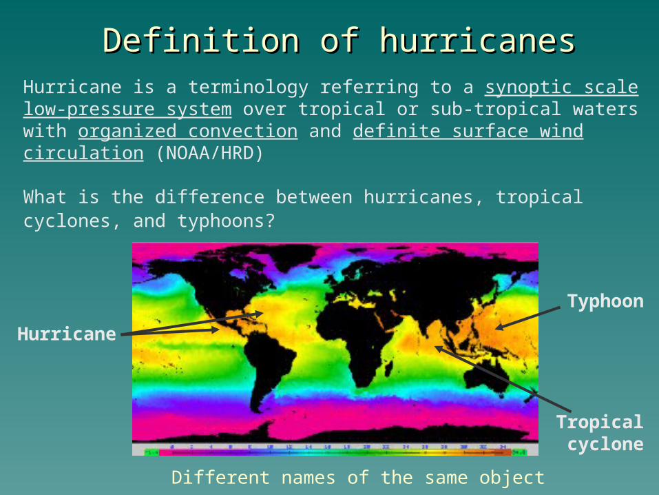
Definition of hurricanesDefinition of hurricanes
What is the difference between hurricanes, tropical cyclones, and typhoons?
Hurricane is a terminology referring to a synoptic scale low-pressure system over tropical or sub-tropical waters with organized convection and definite surface wind circulation (NOAA/HRD)
Hurricane
Tropical cyclone
Typhoon
Different names of the same object
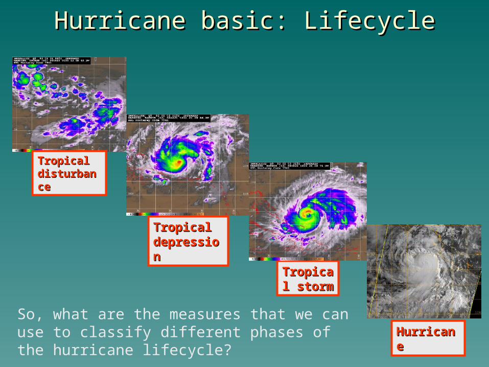
Hurricane basic: LifecycleHurricane basic: Lifecycle
Tropical Tropical stormstorm
Tropical Tropical disturbancedisturbance
Tropical Tropical depressiondepression
HurricaneHurricaneSo, what are the measures that we can use to classify different phases of the hurricane lifecycle?
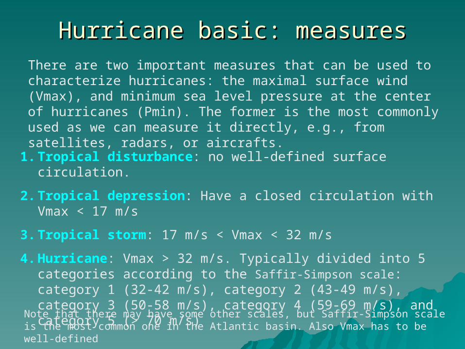
Hurricane basic: measuresHurricane basic: measuresThere are two important measures that can be used to characterize hurricanes: the maximal surface wind (Vmax), and minimum sea level pressure at the center of hurricanes (Pmin). The former is the most commonly used as we can measure it directly, e.g., from satellites, radars, or aircrafts.
1. Tropical disturbance: no well-defined surface circulation.
2. Tropical depression: Have a closed circulation with Vmax < 17 m/s
3. Tropical storm: 17 m/s < Vmax < 32 m/s
4. Hurricane: Vmax > 32 m/s. Typically divided into 5 categories according to the Saffir-Simpson scale: category 1 (32-42 m/s), category 2 (43-49 m/s), category 3 (50-58 m/s), category 4 (59-69 m/s), and category 5 (> 70 m/s)
Note that there may have some other scales, but Saffir-Simpson scale is the most common one in the Atlantic basin. Also Vmax has to be well-defined
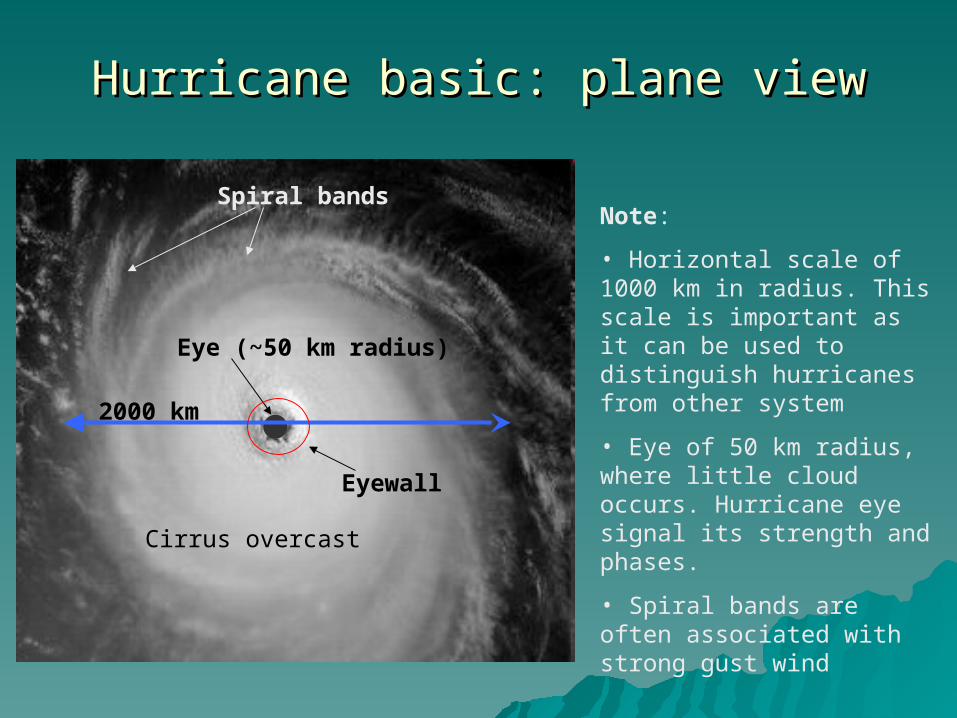
Hurricane basic: plane viewHurricane basic: plane view
2000 km
Eye (~50 km radius)
Spiral bands
Cirrus overcast
Note:
• Horizontal scale of 1000 km in radius. This scale is important as it can be used to distinguish hurricanes from other system
• Eye of 50 km radius, where little cloud occurs. Hurricane eye signal its strength and phases.
• Spiral bands are often associated with strong gust wind
Eyewall
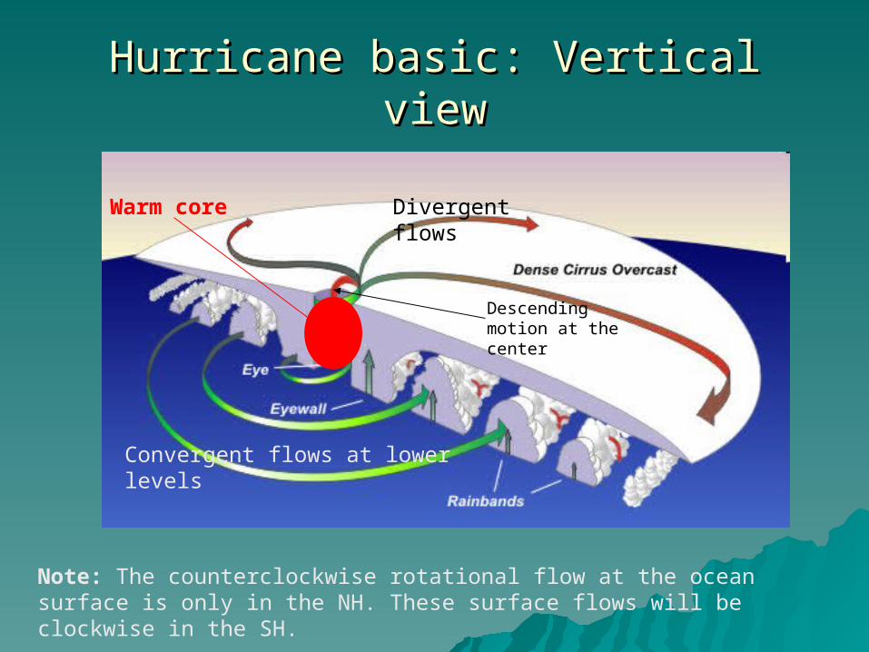
Hurricane basic: Vertical viewHurricane basic: Vertical view
Divergent flows
Convergent flows at lower levels
Descending motion at the center
Note: The counterclockwise rotational flow at the ocean surface is only in the NH. These surface flows will be clockwise in the SH.
Warm core

Formation of hurricanes: necessary conditionFormation of hurricanes: necessary condition
In order for hurricanes to form, they need the following ingredients:
• A pre-existing disturbance; • Warm ( > 27ºC) ocean water with a depth of about 50 m;• Light upper level winds;• 5º latitude away from the equator
These conditions are by no mean sufficient. There are many occasions these conditions are met, but just a small number of times can hurricanes form. This is one of the active directions in hurricane research right now.
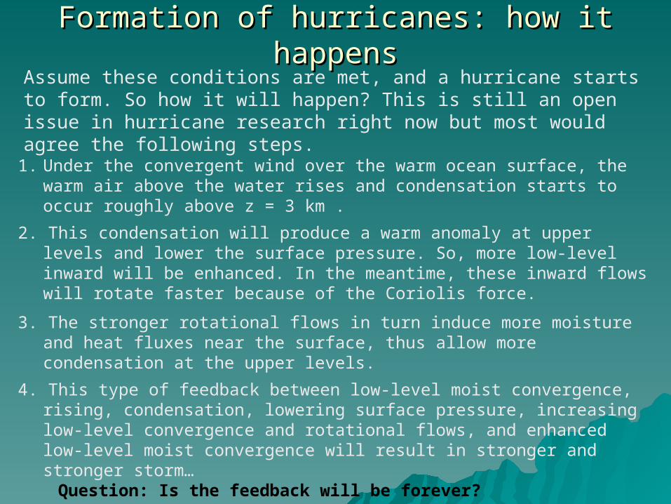
Formation of hurricanes: how it happensFormation of hurricanes: how it happensAssume these conditions are met, and a hurricane starts to form. So how it will happen? This is still an open issue in hurricane research right now but most would agree the following steps.
1. Under the convergent wind over the warm ocean surface, the warm air above the water rises and condensation starts to occur roughly above z = 3 km .
2. This condensation will produce a warm anomaly at upper levels and lower the surface pressure. So, more low-level inward will be enhanced. In the meantime, these inward flows will rotate faster because of the Coriolis force.
3. The stronger rotational flows in turn induce more moisture and heat fluxes near the surface, thus allow more condensation at the upper levels.
4. This type of feedback between low-level moist convergence, rising, condensation, lowering surface pressure, increasing low-level convergence and rotational flows, and enhanced low-level moist convergence will result in stronger and stronger storm…
Question: Is the feedback will be forever?
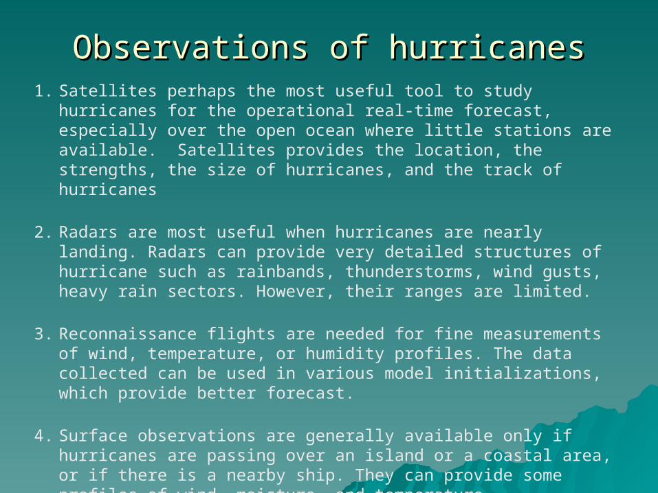
Observations of hurricanesObservations of hurricanes1. Satellites perhaps the most useful tool to study hurricanes for the
operational real-time forecast, especially over the open ocean where little stations are available. Satellites provides the location, the strengths, the size of hurricanes, and the track of hurricanes
2. Radars are most useful when hurricanes are nearly landing. Radars can provide very detailed structures of hurricane such as rainbands, thunderstorms, wind gusts, heavy rain sectors. However, their ranges are limited.
3. Reconnaissance flights are needed for fine measurements of wind, temperature, or humidity profiles. The data collected can be used in various model initializations, which provide better forecast.
4. Surface observations are generally available only if hurricanes are passing over an island or a coastal area, or if there is a nearby ship. They can provide some profiles of wind, moisture, and temperature.
Theory of hurricanesTheory of hurricanes
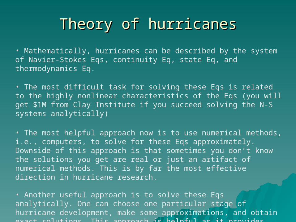
• Mathematically, hurricanes can be described by the system of Navier-Stokes Eqs, continuity Eq, state Eq, and thermodynamics Eq.
• The most difficult task for solving these Eqs is related to the highly nonlinear characteristics of the Eqs (you will get $1M from Clay Institute if you succeed solving the N-S systems analytically)
• The most helpful approach now is to use numerical methods, i.e., computers, to solve for these Eqs approximately. Downside of this approach is that sometimes you don’t know the solutions you get are real or just an artifact of numerical methods. This is by far the most effective direction in hurricane research.
• Another useful approach is to solve these Eqs analytically. One can choose one particular stage of hurricane development, make some approximations, and obtain exact solutions. This approach is helpful as it provides correct behaviors and deeper understanding to the system, but various approximations limit its range of application.
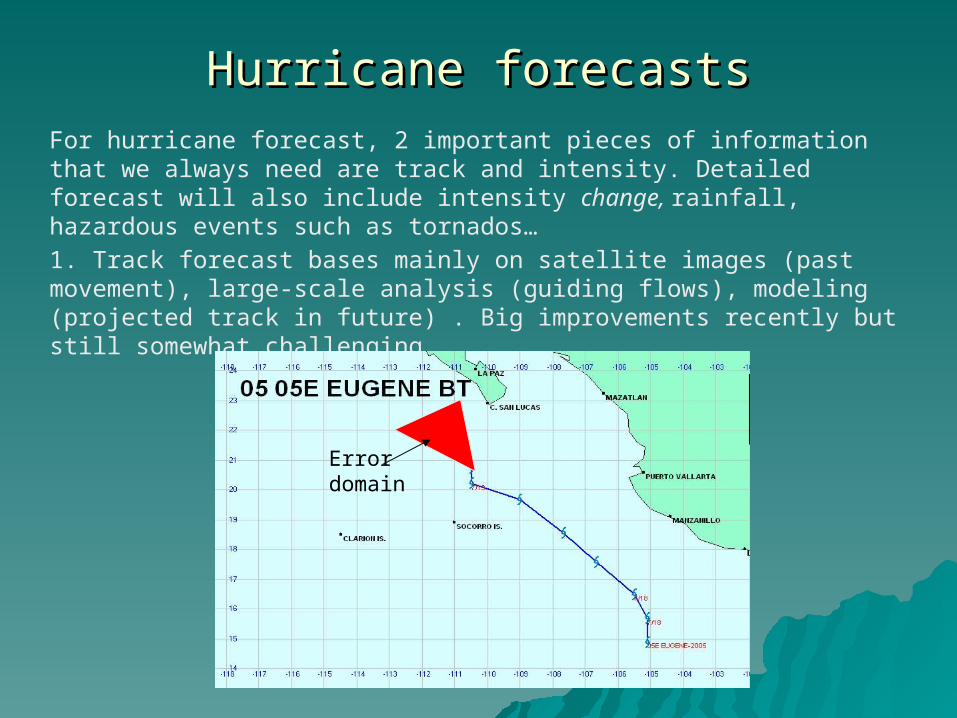
Hurricane forecastsHurricane forecastsFor hurricane forecast, 2 important pieces of information that we always need are track and intensity. Detailed forecast will also include intensity change, rainfall, hazardous events such as tornados…
1. Track forecast bases mainly on satellite images (past movement), large-scale analysis (guiding flows), modeling (projected track in future) . Big improvements recently but still somewhat challenging
Error domain
Hurricane forecasts (Cont’d)Hurricane forecasts (Cont’d)
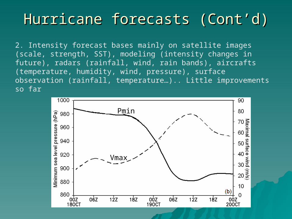
2. Intensity forecast bases mainly on satellite images (scale, strength, SST), modeling (intensity changes in future), radars (rainfall, wind, rain bands), aircrafts (temperature, humidity, wind, pressure), surface observation (rainfall, temperature…).. Little improvements so far
Pmin
Vmax
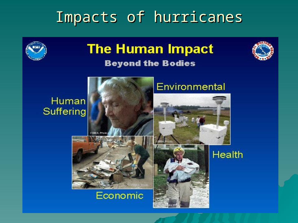
Impacts of hurricanesImpacts of hurricanes

Impacts of hurricanes: humanImpacts of hurricanes: human

Impacts of hurricanes: economicsImpacts of hurricanes: economics
Question: So, are hurricanes always bad?
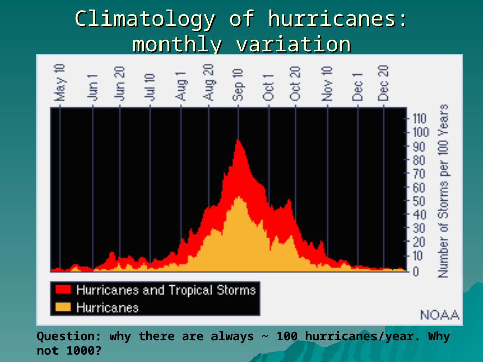
Climatology of hurricanes: monthly variationClimatology of hurricanes: monthly variation
Question: why there are always ~ 100 hurricanes/year. Why not 1000?
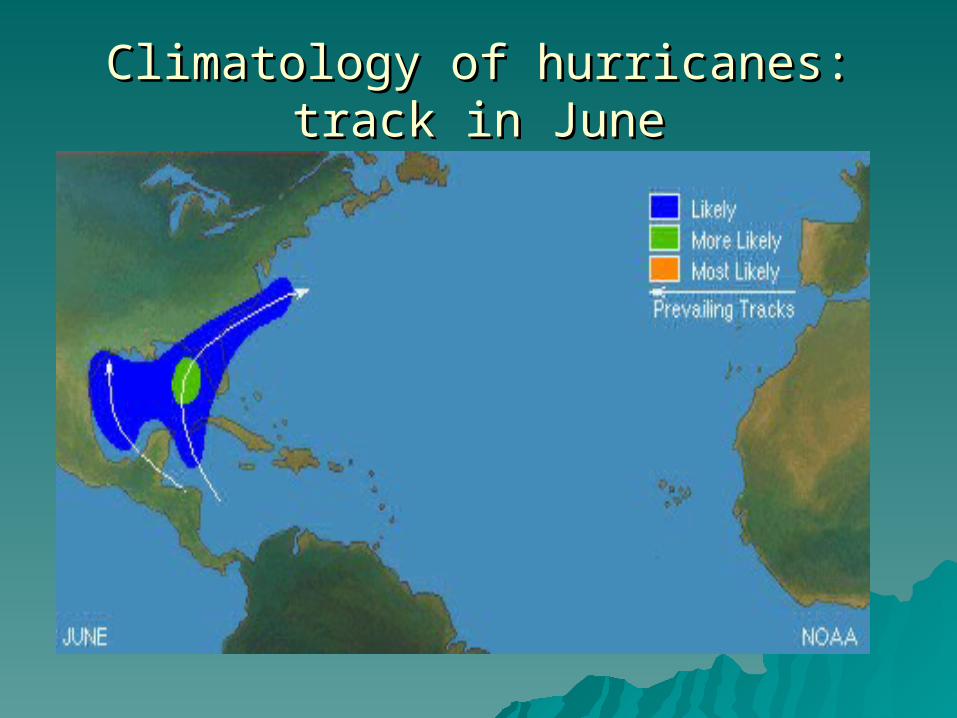
Climatology of hurricanes: track in JuneClimatology of hurricanes: track in June
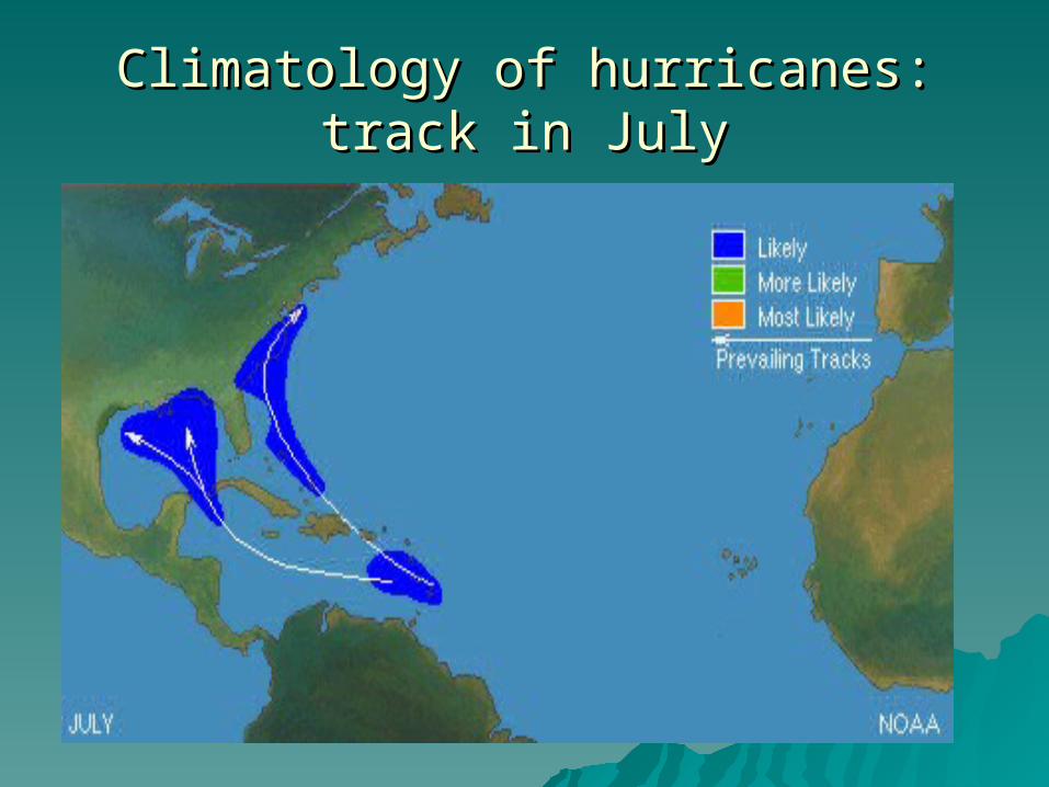
Climatology of hurricanes: track in JulyClimatology of hurricanes: track in July
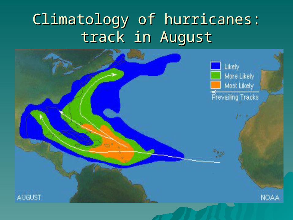
Climatology of hurricanes: track in Climatology of hurricanes: track in AugustAugust

Climatology of hurricanes: track in Climatology of hurricanes: track in SeptemberSeptember

Climatology of hurricanes: track in Climatology of hurricanes: track in OctoberOctober

Thank you, question?Thank you, question?