lct 11: farmed moorland edge - aberdeenshire
TRANSCRIPT
Aberdeenshire Council Strategic Landscape Capacity Assessment for Wind Energy
IronsideFarrar 80 7933/ Final Report March 2014
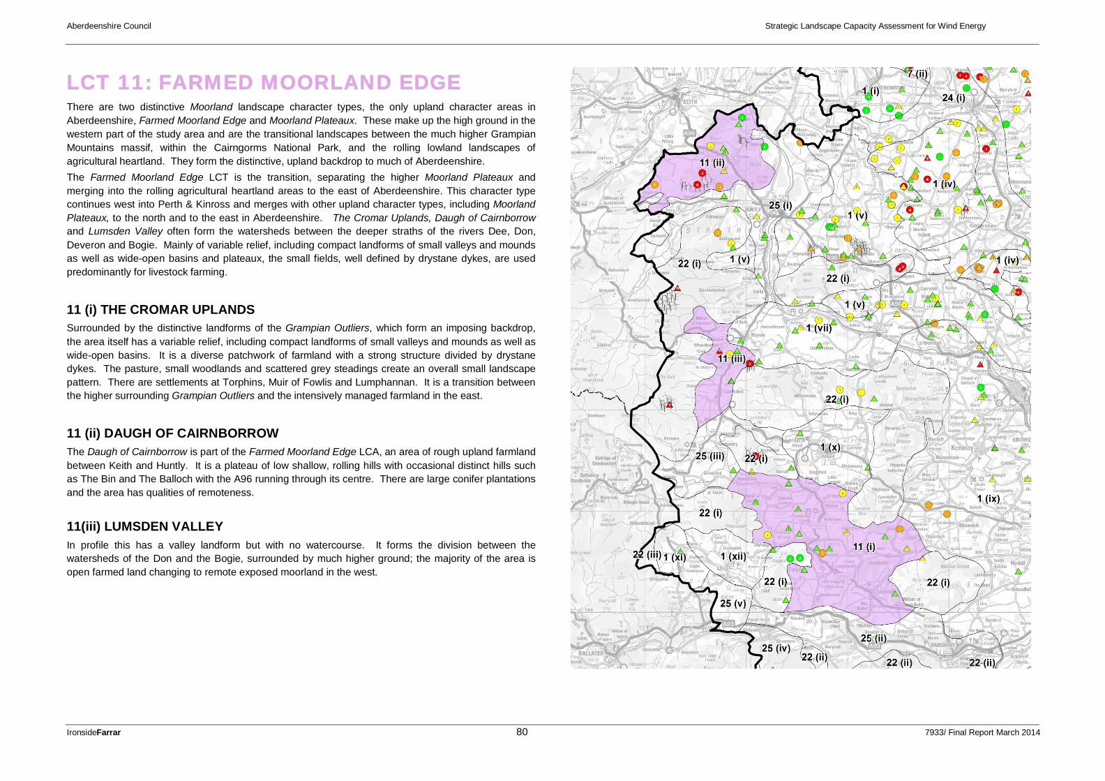
LCT 11: FARMED MOORLAND EDGE There are two distinctive Moorland landscape character types, the only upland character areas in Aberdeenshire, Farmed Moorland Edge and Moorland Plateaux. These make up the high ground in the western part of the study area and are the transitional landscapes between the much higher Grampian Mountains massif, within the Cairngorms National Park, and the rolling lowland landscapes of agricultural heartland. They form the distinctive, upland backdrop to much of Aberdeenshire. The Farmed Moorland Edge LCT is the transition, separating the higher Moorland Plateaux and merging into the rolling agricultural heartland areas to the east of Aberdeenshire. This character type continues west into Perth & Kinross and merges with other upland character types, including Moorland Plateaux, to the north and to the east in Aberdeenshire. The Cromar Uplands, Daugh of Cairnborrow and Lumsden Valley often form the watersheds between the deeper straths of the rivers Dee, Don, Deveron and Bogie. Mainly of variable relief, including compact landforms of small valleys and mounds as well as wide-open basins and plateaux, the small fields, well defined by drystane dykes, are used predominantly for livestock farming.
11 (i) THE CROMAR UPLANDS Surrounded by the distinctive landforms of the Grampian Outliers, which form an imposing backdrop, the area itself has a variable relief, including compact landforms of small valleys and mounds as well as wide-open basins. It is a diverse patchwork of farmland with a strong structure divided by drystane dykes. The pasture, small woodlands and scattered grey steadings create an overall small landscape pattern. There are settlements at Torphins, Muir of Fowlis and Lumphannan. It is a transition between the higher surrounding Grampian Outliers and the intensively managed farmland in the east.
11 (ii) DAUGH OF CAIRNBORROW The Daugh of Cairnborrow is part of the Farmed Moorland Edge LCA, an area of rough upland farmland between Keith and Huntly. It is a plateau of low shallow, rolling hills with occasional distinct hills such as The Bin and The Balloch with the A96 running through its centre. There are large conifer plantations and the area has qualities of remoteness.
11(iii) LUMSDEN VALLEY In profile this has a valley landform but with no watercourse. It forms the division between the watersheds of the Don and the Bogie, surrounded by much higher ground; the majority of the area is open farmed land changing to remote exposed moorland in the west.

Aberdeenshire Council Strategic Landscape Capacity Assessment for Wind Energy
IronsideFarrar 81 7933/ Final Report March 2014
Table 6.1(h): Summary of Landscape Capacity, Cumulative Effects and Guidance for Future Wind Energy Development: Farmed Moorland Edge
LANDSCAPE CHARACTER TYPE: 11. FARMED MOORLAND EDGE Key: No Capacity Low Capacity Medium Capacity High Capacity Turbine Size: Small/Medium=15-<30m; Medium=30-<50m; Medium/Large=50-<80m; Large=80m+; Very Large=125m+
BASE LANDSCAPE CAPACITY (ie. not taking account of current wind energy development)
CURRENT CONSENTED DEVELOPMENT
PROPOSED LIMITS TO FUTURE DEVELOPMENT (ie. proposed acceptable level of wind energy development)
Landscape Sensitivity to Wind Energy Development
Landscape Capacity (Related to turbine size)
Existing/ Consented Developments
Current Wind Energy Landscape Type(s)
Future Wind Energy Landscape Type(s)
Remaining Landscape Capacity (Related to turbine size)
Current Applications Analysis & Guidelines (Refer to Detailed Guidance for Further Information on Siting and Design )
Land
scap
e C
hara
cter
Se
nsiti
vity
Visu
al
Se
nsiti
vity
Land
scap
e Se
nsiti
vity
Land
scap
e
Valu
e
S/M
M
M/L
L VL
S/M
M
M/L
L VL
11 (i) Landscape Character Areas: The Cromar Uplands
Med/ High
Med Med Med/ High
Currently four medium and fourteen small/medium turbines consented within this LCA.
Farmed Moorland Edge with No Wind Turbines/ Farmed Moorland Edge with Occasional Wind Turbines
Farmed Moorland Edge with Occasional Wind Turbines
Two medium/large and three medium turbines are proposed
Landscape Analysis: This type is unsuitable for large scale turbines due to its small scale, complex pattern and high value.
There is potential for very occasional small groups of small/medium or single turbines sited in less prominent areas with landform/ tree backclothing. Discourage development of turbines on prominent ridge/hilltop locations. Allow adequate separation between turbines.
Comments on Consented and Proposed Turbines: There is residual capacity left in this area.
Max. Numbers in Group
1-3
Min Group Separation Distances (km)
4-6

Aberdeenshire Council Strategic Landscape Capacity Assessment for Wind Energy
IronsideFarrar 82 7933/ Final Report March 2014
LANDSCAPE CHARACTER TYPE: 11. FARMED MOORLAND EDGE Key: No Capacity Low Capacity Medium Capacity High Capacity Turbine Size: Small/Medium=15-<30m; Medium=30-<50m; Medium/Large=50-<80m; Large=80m+; Very Large=125m+
BASE LANDSCAPE CAPACITY (ie. not taking account of current wind energy development)
CURRENT CONSENTED DEVELOPMENT
PROPOSED LIMITS TO FUTURE DEVELOPMENT (ie. proposed acceptable level of wind energy development)
Landscape Sensitivity to Wind Energy Development
Landscape Capacity (Related to turbine size)
Existing/ Consented Developments
Current Wind Energy Landscape Type(s)
Future Wind Energy Landscape Type(s)
Remaining Landscape Capacity (Related to turbine size)
Current Applications Analysis & Guidelines (Refer to Detailed Guidance for Further Information on Siting and Design )
Land
scap
e C
hara
cter
Se
nsiti
vity
Visu
al
Se
nsiti
vity
Land
scap
e Se
nsiti
vity
Land
scap
e
Valu
e
S/M
M
M/L
L VL
S/M
M
M/L
L VL
11 (ii) Landscape Character Areas: Daugh of Cairnborrow
Med/ High
Med Med Med Two medium turbines and four small/medium turbines.
Adjacent wind farms at Kildrummy 8 x large and Clashindarroch 18 x large in adjoining LCAs influence these areas although they are clearly in a separate LCA.
Farmed Moorland Edge with no Wind Turbines/ Farmed Moorland Edge with Occasional Wind Turbines
Farmed Moorland Edge with Occasional Wind Turbines
An application has been submitted for a wind farm of nine large turbines and four large turbines at Daugh of Cairnbarrow, together with three medium/large turbines, two medium and one small/medium.
Landscape Analysis: This area is suitable for turbines due to its medium scale and simple pattern. There is potential for small groups or single small/medium, medium or medium/large turbines sited in less prominent areas with landform/ tree backclothing. Discourage development of turbines on prominent ridge/hilltop locations.
Comments on Consented and Proposed Turbines: An application has been submitted for a wind farm of nine large turbines and four large turbines at Daugh of Cairnbarrow, together with three medium/large turbines, this would exceed capacity. The proximity of consented turbines in neighbouring areas of Moray also limits capacity in this area
Max. Numbers in Group
1-3 1-3 1
Min Group Separation Distances (km)
4-6 6-8 5-10
11 (iii) Landscape Character Areas: Lumsden Valley
Med/ High
Med Med/ High
Med Six large turbines and four small/medium.
Adjacent wind farms at Kildrummy 8 x large and Clashindarroch 18 x large in adjoining LCAs influence these areas although they are clearly in a separate LCA.
Farmed Moorland Edge with no Wind Turbines/ with Occasional Wind Turbines/ with Wind Turbines
Farmed Moorland Edge with no Wind Turbines/ with Occasional Wind Turbines
Five large turbines and two medium.
Adjacent wind farms proposed at Tibberchindy 6 x large in adjoining LCA could visually influence this area, although they are clearly in a separate LCA.
Landscape Analysis: This area is unsuitable for large-scale turbines due to its small scale, complex small-scale pattern and visual sensitivity.
There was potential for very occasional small groups or single medium turbines sited in less prominent areas with landform/ tree backclothing, however existing development has utilised all underlying capacity in this area.
Comments on Consented and Proposed Turbines: The Lumsden Valley is at capacity with consented development.
An application has been submitted for a wind farm of five large turbines this would exceed capacity.
Max. Numbers in Group
Min Group Separation Distances (km)

Aberdeenshire Council Strategic Landscape Capacity Assessment for Wind Energy
IronsideFarrar 83 7933/ Final Report March 2014
GUIDANCE: LCT 11: FARMED MOORLAND EDGE 11 (i) THE CROMAR UPLANDS Proposed Limits to Future Development: Farmed Moorland Edge with Occasional Wind Turbines Turbine Sizes: 15-<30m (small/medium); Group Sizes: 1-3 (small/medium); Separation Distances: 4-6km (small/medium). This area is unsuitable for large-scale turbines due to its medium scale, complex small-scale pattern and visual sensitivity. The Cromar Uplands can only accommodate small/medium turbines up to 30m. There is potential for very occasional small groups or single turbines sited in less prominent areas with landform/ tree backclothing. Discourage development of turbines on prominent ridge/hilltop locations.
11(i) An existing small/medium turbine located on a field boundary and although visible on the skyline it does not dominate the complex small-scale landscape pattern.
Positioning of turbines should relate clearly to landscape features such as field boundaries and larger farm buildings and woodland blocks. Separation between turbine groupings should be sufficient to ensure that the landscape is not dominated and that clear intervisibility between turbine groupings is infrequent. This may be achieved through selecting appropriate turbine sizes and separation distances and through exploiting the rolling landform to screen views.
11 (ii) DAUGH OF CAIRNBORROW Proposed Limits to Future Development: Farmed Moorland Edge with Occasional Wind Turbines Turbine Sizes: 15-<30m (small/medium); 30-<50m (medium); 50-<80m (medium/large); Group Sizes: 1-3 (small/medium); 1-3 (medium); 1 (medium/large); Separation Distances: 4-6km (small/medium); 6-8km (medium); 5-10km (medium/large). This area is suitable for turbines due to its medium scale and simple pattern. Discourage development of turbines on prominent ridge/hilltop locations. The proximity of consented turbines in neighbouring areas of Moray also limits capacity in this area The Daugh of Cairnborrow can accommodate small/medium, medium and medium/large turbines. Medium/large turbines should be sited away from key hills such as The Bin, Little Balloch and Meikle Balloch and also the boundaries. These boundary areas are the setting for the smaller scale, more sensitive valleys such as the Haugh of Glass, River Deveron and the route down to Keith. Positioning of small/medium and medium turbines should relate clearly to landscape features such as field boundaries, in particular the head dyke, larger farm buildings and woodland blocks. Separation between turbine groupings should be sufficient to ensure that the landscape is not dominated and that clear intervisibility between turbine groupings is infrequent. This may be achieved through selecting appropriate turbine sizes and separation distances and through exploiting the rolling topography. Allow adequate separation between turbines of different sizes.
Daugh of Cairnborrow – the rolling hill tops cannot accommodate larger turbines without adverse scale effects. However small/medium medium or medium/large size turbines sited in the farmland at lower points will not dominate the landforms, and turbine groups can be visually separated.