late quaternary climate variability in the indian monsoon domain
TRANSCRIPT

Praveen Kumar Mishra
Fachbereich Geowissenschaften, Freie Universität, Berlin
December 2014
LATE QUATERNARY CLIMATE
VARIABILITY IN THE
INDIAN MONSOON DOMAIN


Late Quaternary climate variability in the
Indian monsoon domain (Spät-quartäre klimavariabilität im Gebiet des Indischen monsun)
Dissertation
zur Erlangung des akademischen Grades
Doktor der Naturwissenschaften (Dr. rer. nat.)
am Fachbereich Geowissenschaften
der Freien Universität Berlin
vorgelegt von
Praveen Kumar Mishra
Berlin, 2014

Als Dissertation angenommen vom Fachbereich Geowissenschaften der Freien
Universität Berlin.
auf Grund der Gutachten
Erstgutachter: Dr. (Habil) Sushma Prasad
Zweitgutachter: Prof. Dr. Ulrich Cubasch
Datum der Verteidigung: den 07 Mai 2015, Berlin

Statement of Authorship
The thesis entitled “Late Quaternary climate variability in the Indian monsoon domain”
has been submitted for the degree of Doctor in Natural Sciences. I hereby declare that:
I have fully acknowledged and referenced the ideas and work of others, whether
published or unpublished, in my thesis.
This dissertation has not been submitted for the award of any other degree or
diploma in any other institution.
Praveen Kumar Mishra
Berlin, 2014


Acknowledgements
I would like to express my deepest gratitude to my advisor, PD Dr. Sushma Prasad, for
her excellent guidance, motivation, encouragement during my research. Additionally, I
would like to acknowledge Prof. Achim Brauer, for permitting access to laboratory
facilities and providing a positive working atmosphere during my stay in the section. I
would also like to thank Dr. Peter Dulski, Dr. Birgit Plessen, Dr. Georg Schettler and
Mr. Rudolf Naumann for training and permitting me to use their laboratories for
sample analysis. Without their help and guidance, it would not have been possible to
generate and interpret such a large data set.
My grateful thanks are due to other members of the research team, Dr. Birgit Gaye, Dr.
A. Anoop, Dr. Philip Menzel, Dr. Elisabeth Dietze, Dr. Stefan Polanski, Dr. Martin
Wiesner. My investigations would not been possible without the scientific knowledge
and active participation of the Indian partners, especially Prof. A.R. Yousuf, Dr. Arshid
Jehangir (Kashmir University), and Prof. N. Basavaiah and Dr. K. Deendayalan
(Indian Institute of Geomagnetism, Mumbai). Thanks again to Dr. A. Anoop and Dr.
Philip Menzel for their helpful and critical comments on this thesis.
In addition, I would like to extend special thanks to Ms. Sylvia Pinkerneil and Ms.
Christine Gerschke for helping me in navigating though the complicated administrative
matters. I owe additional thanks to Dr. Birgit Plessen and Ms Pinkerneil for their help
in laboratory and the fieldwork. I would also like to acknowledge Mr. Dieter Berger,
Ms. Gabi Arnold and Mr. Brian Brademann for their help during the laboratory work,
and Ms. Ursula Kegel for assisting me during the grain size analysis. My sincere thanks
to Mr. Andreas Hendrich for helping me with the beautification of figures and graphs
for the manuscripts. I express my warm thanks to Mr. Marcus Günzel and Mr.
Matthias Köppl for their help with computer related technical matters. I would also like
to thank Arun, Bernhard and the students of Potsdam University, who provided their
valuable help during sample processing.
My study would not have been possible without Mr. Richard Niederreiter, Mr.
Michael Köhler, and Mr. Daniel Niederreiter who were responsible for raising the
cores from the Tso Moriri Lake in difficult weather conditions.

I thank to all my friends from our ‘Potsdam Gang’ for the unforgettable fun time in
Potsdam’s Balzac coffee house’ and enjoyable discussions on various aspect of science,
politics and culture. I warmly thank Tarique and Chiranjit for helping me with the
editing of the thesis. Additionally, special thanks go to Dharmu, JD bhai, Nishant,
Rajak bhai, Sandeep, Somu, Varun, and Vinay for their wonderful and unforgettable
friendship, and their encouragement for doing research.
Finally, I express my sincere thanks to my father Mr. R.K. Mishra, my mother Mrs.
Shila Mishra, and all my family members, for their constant encouragement and
support in untold ways.
This Ph.D. study has been carried out as part of the research unit “Himalaya: Modern
and Past Climates (HIMPAC)” (FOR 1380) which is funded by the
“DeutscheForschungsGemeinschaft”.
Praveen Kumar Mishra

Table of Contents
List of Figures ............................................................................................................................................... I
List of Tables ............................................................................................................................................... II
Abstract ...................................................................................................................................................... III
Kurzfassung ................................................................................................................................................ IV
Chapter 1: Introduction .............................................................................................................................. 1
1.1. INTRODUCTION .................................................................................................................................... 1
1.1.1. The modern climate system ......................................................................................................... 2
1.1.2. Forcing factors and teleconnections ............................................................................................ 5
1.2. STATE OF THE ART ............................................................................................................................... 8
1.2.1. Literature review: Palaeomonsoon studies .................................................................................. 9
1.3. MOTIVATION AND OBJECTIVES.......................................................................................................... 13
1.4. STUDY AREA ...................................................................................................................................... 15
1.4.1. Tso Moriri Lake, NW Himalaya ............................................................................................... 15
1.4.2. Lonar Lake, central India .......................................................................................................... 16
1.5. ORGANISATION OF THESIS ................................................................................................................. 18
Chapter 2: Limnology and modern sedimentation patterns in high altitude Tso Moriri Lake, NW
Himalaya – implications for proxy development ..................................................................................... 20
ABSTRACT ................................................................................................................................................ 20
Chapter 3: Reconstructed late quaternary hydrological changes from Lake Tso Moriri, NW-
Himalaya ..................................................................................................................................................... 47
ABSTRACT ................................................................................................................................................ 47
3.1. INTRODUCTION .................................................................................................................................. 48
3.2. STUDY AREA ...................................................................................................................................... 50
3.2.1. Regional climate ........................................................................................................................ 50
3.2.2. Geology ..................................................................................................................................... 50
3.2.3. Hydrology .................................................................................................................................. 50
3.2.4. Modern vegetation ..................................................................................................................... 51
3.3. METHODOLOGY ................................................................................................................................. 51
3.3.1. Coring and core correlation ....................................................................................................... 51
3.3.2. Chronology ................................................................................................................................ 53
3.3.3. Laboratory methods ................................................................................................................... 53
3.4. RESULTS ............................................................................................................................................ 55
3.4.1. Lithology ................................................................................................................................... 55
3.4.2. Radiocarbon dating ................................................................................................................... 56
3.4.3. Geochemistry and mineralogy ................................................................................................... 56
3.4.4. Grain-size distribution ............................................................................................................... 58
3.5. DISCUSSION ....................................................................................................................................... 58
3.5.1. Chronology ................................................................................................................................ 58
3.5.2. Proxies for palaeoenvironmental changes ................................................................................. 59
3.5.3. Palaeohydrological reconstruction using a multiproxy approach .............................................. 61
3.5.4. Regional comparison of hydrological changes (westerlies derived snow melt vs Indian
monsoon) ........................................................................................................................................... 63
3.6. CONCLUSIONS ................................................................................................................................... 67
3.7. ACKNOWLEDGEMENTS ...................................................................................................................... 68
TABLE ...................................................................................................................................................... 69

Chapter 4: Carbonate isotopes from high altitude Tso Moriri Lake (NW Himalayas) provide clues to
late glacial and Holocene moisture source and atmospheric circulation changes ................................ 71
ABSTRACT ................................................................................................................................................ 71
4.1. INTRODUCTION .................................................................................................................................. 72
4.2. STUDY AREA ...................................................................................................................................... 72
4.2.1. Hydrology and hydrochemistry ................................................................................................. 74
4.2.2. Core description and chronology ............................................................................................... 75
4.2.3. Core mineralogy and pollen data ............................................................................................... 77
4.3. METHODOLOGY ................................................................................................................................. 78
4.3.1. Analytical methods .................................................................................................................... 78
4.4. RESULTS ............................................................................................................................................ 78
4.4.1. Late glacial and Holocene changes in carbonate isotopic composition and siliciclastic influx . 78
4.5. DISCUSSION ....................................................................................................................................... 79
4.5.1. Possible factors influencing the isotopic composition of the lacustrine carbonates .................. 79
4.5.2. Interpretation of isotopic signal from endogenic carbonates ..................................................... 80
4.5.3. Late glacial and Holocene changes in source water .................................................................. 82
4.5.4. Regional comparison and implications for atmospheric circulation reorganisation .................. 84
4.6. CONCLUSIONS ................................................................................................................................... 86
4.7. ACKNOWLEDGEMENTS ...................................................................................................................... 87
Chapter 5: Linking Holocene drying trends from Lonar Lake in monsoonal central India to North
Atlantic cooling events ............................................................................................................................... 89
ABSTRACT ................................................................................................................................................ 89
5.1. INTRODUCTION .................................................................................................................................. 90
5. 2. STUDY SITE ....................................................................................................................................... 92
5.3. METHODS AND MATERIAL ................................................................................................................. 94
5.3.1. Sampling.................................................................................................................................... 94
5.3.2. Analytical methods .................................................................................................................... 94
5.3.3. Statistical method ...................................................................................................................... 96
5.3.4. Chronology ................................................................................................................................ 96
5.3.5. Mineralogical and biogeochemical proxies ............................................................................... 97
5.4. RESULTS AND DISCUSSION ............................................................................................................... 103
5.4.1. Large scale Holocene climate transition .................................................................................. 103
5.4.2. Centennial scale Holocene climate variability ........................................................................ 108
5.4.3. Implication for the archaeological history ............................................................................... 116
5.5. CONCLUSIONS ................................................................................................................................. 118
5.6. ACKNOWLEDGEMENTS .................................................................................................................... 119
TABLE .................................................................................................................................................... 120
Chapter 6: Conclusions and future perspectives ................................................................................... 122
6.1. CONCLUSIONS ................................................................................................................................. 122
6.2. FUTURE PROSPECTS ......................................................................................................................... 124
References ................................................................................................................................................. 126
Appendix ................................................................................................................................................... 149
List of publications ................................................................................................................................... 152


List of Figures
[I]
List of Figures
1.1: Topographical map of Indian subcontinent with different wind regimes 4
1.2: Regional comparison between different climate records from ISM and westerlies domain 10
1.3: Study areas- Tso Moriri, NW Himalaya and Lonar Lake, central India 17
3.1: Hemispherical distribution of airflow on Indian subcontinent and geological map of Tso Moriri
Lake
49
3.2: Litholog and chronology of Tso Moriri Lake sediment profile 52
3.3: Temporal variation in geochemical, mineralogical and sedimentological profile from Tso Moriri
core sediment
57
3.4: Regional comparison between Tso Moriri climate data with other palaeoclimatic records 65
4.1: Overview map showing selected sites from arid central Asia and monsoon Asia 73
4.2: Compiled water isotopic data from Tso Moriri and other Tibetan Lake area 75
4.3: Comparison between isotopic and geochemical data from the Tso Moriri Lake and mean annual
precipitation inferred from pollen data
76
4.4: Plots of δ18O and δ13C for carbonates from Tso Moriri core sediments 81
4.5: Regional comparison of Tso Moriri data with other sites from different wind regimes 85
5.1: Regional overview and location of Lonar Lake 92
5.2: Lithology and geochemical profile of Lonar Lake sediment 105
5.3: Ternary diagram showing grain size percentage of the Lonar core sediment 106
5.4: Long term Holocene climate trend at Lonar Lake 108
5.5: Comparison of our data (C/N, Ox/Anox, LI, δ15N, δ13Corg) with North Atlantic cold events 110
5.6: Comparison between Bioclastic Climate Index (BCI) with the Bond events 114
5.7: Powerspectrum indicating the most prominent periodicities within the Bioclastic Climate Index
data set
116

List of Tables
[II]
List of Tables
3.1: Radiocarbon dates for the samples from Tso Moriri composite profile 69
5.1: Radiocarbon dates from the Lonar Lake sediment profile 120

Abstract
[III]
Abstract
The Indian subcontinent is characterised by a variety of climate zones ranging from the
alpine climate in Himalaya, tropical climates in central India, to arid regions in the NW
India. A variety of precipitation regimes (the SW and NE monsoon, and the winter
westerlies) and glacial meltwater contribute to the regional hydrological balance – long
term data on their variability is essential for infrastructural planning and securing food
supplies in a global warming scenario.
The present work on the lake sediments from the NW Himalaya (Tso Moriri
Lake) and the central India (Lonar Lake) involved reconstructing late Quaternary
palaeoclimate in these two diverse climate regions. The Tso Moriri Lake is located in the
climatically sensitive zone of NW Himalayas and is affected by both mid-latitude
westerlies and Indian summer monsoon (ISM), whereas Lonar Lake situated in the core
monsoon zone of India and receives moisture only from the Indian summer monsoon
(ISM). The present work involved (i) testing of climate-sensitive proxies that are useful
for climate reconstruction in high altitude regions; (ii) based on the identified proxies,
reconstruction of late Quaternary palaeoclimate, and; (iii) regional comparison to
identify spatio-temporal changes in precipitation regimes and, meltwater contributions
(for the high altitude Tso Moriri Lake).
The present work indicates that the early Holocene intensification was visible in
both NW Himalaya and central India, though the wettest phase ended earlier in the
former (ca. 8.5 cal ka) as compared to the latter (ca. 6 cal ka). The central Indian record
showed evidence of multiple abrupt events throughout the Holocene, as well as two
periods of extended drought during the late Holocene. These “extremes” do not appear to
be recorded in the high altitude Tso Moriri Lake. While chronological uncertainties
could clarify some of the differences, one possible explanation for the apparent
insensitivity of the NW Himalayan region to the “extremes” seen in peninsular India is
probably due to the buffering effect of snowmelt, westerlies, and weaker ISM during the
late Holocene.

Kurzfassung
[IV]
Kurzfassung
Der Indische Subkontinent ist charakterisiert durch eine Vielzahl an Klimazonen, welche
von alpinem Klima im Himalaya über tropisches Klima in Zentralindien bis zu ariden
Regionen in NW-Indien reichen. Eine Vielzahl an Niederschlagsregimes (der SW- und
NO-Monsun sowie die winterliche Westwinddrift) und glaziale Schmelzwasser tragen
zum regionalen hydrologischen Gleichgewicht bei – eine langzeitliche Datengrundlage
über dessen Variabilität ist notwendig für infrastrukturelle Planungen und die
Sicherstellung der Nahrungsversorgung in einem Szenario globaler Erderwärmung.
Diese Arbeit über Seesedimente aus dem NW-Himalaya (Tso Moriri Lake) und
dem zentralen Indien (Lonar Lake) beschäftigt sich mit der Rekonstruktion des
spätquartären Paläoklimas in diesen beiden sehr verschiedenen Klimaregionen. Der Tso
Moriri Lake befindet sich in der klimatisch sensitiven Zone des NW-Himalayas und wird
sowohl von den Westwinden der mittleren Breiten als auch dem Indischen
Sommermonsun (ISM) beeinflusst, während sich der Lonar Lake im Kernbereich der
monsunal beeinflussten Zone Indiens befindet und demnach Feuchtigkeit nur vom
Indischen Sommermonsun erhält. Diese Arbeit umfasst (i) die Untersuchung geeigneter
klima-sensitiver Proxies für die Klimarekonstruktion in höher gelegenen Regionen, (ii)
basierend auf den identifizierten Proxies die Rekonstruktion des spätquartären
Paläoklimas und (iii) einen regionalen Vergleich zur Identifikation räumlich-zeitlicher
Veränderungen in Niederschlagsregimes und Schmelzwasserspenden (für den Tso Moriri
Lake in höherer Gebirgslage).
Die Ergebnisse in dieser Arbeit zeigen, dass die frühholozäne Intensivierung
sowohl im NW-Himalaya als auch in Zentral-Indien sichtbar war, jedoch endete die
feuchteste Phase in ersterem früher (etwa 8,5 cal ka) als in letzterem (etwa 6 cal ka). Die
Daten über Zentral-Indien zeigen mehrere plötzliche Ereignisse während des Holozäns
sowie zwei Perioden mit zeitlich ausgedehnten Trockenphasen während des späten
Holozäns. Diese „Extreme“ zeigen sich nicht in den Daten des höher gelegenen Tso
Moriri Lakes. Während chronologische Unsicherheiten einige der Abweichungen
erklären könnten, ist eine weitere mögliche Erklärung für die offensichtliche
Unsensitivität der NW-Himalaya Region gegenüber dieser “Extreme” auf dem
halbinselförmigen Indischen Subkontinent ein Puffereffekt durch die Schneeschmelze,
westwinddrift sowie ein schwächerer ISM während des späten Holozäns.


Chapter 1: Introduction
[1]
Chapter 1: Introduction
1.1. Introduction
A large part of the Indian subcontinent is under the influence of the Indian summer
monsoon. Monsoon, derived from the Arabic word "mausim" (meaning season), is
defined as the seasonal reversal of the wind systems caused by the annual variation of
incoming solar radiation (Agnihotri et al., 2002; Gadgil, 2003). Monsoon may also be
associated with dry (NE monsoon) or wet (SW monsoon or commonly known as ISM)
weather. The NE monsoon brings limited rains to the southern parts of India and Sri
Lanka (Fig. 1.1a and 1.1c). However, the ISM bringing in a significant amount of rainfall
(Fig. 1.1a-b) is the driving force behind the agricultural productivity and hence the total
economy of the country (agriculture contributed 14% of total GDP of India during 2013
to 2014, source: Ministry of Agriculture, India). ISM variability, therefore has a
significant impact not only on the economy, but also on the largely rural fabric of the
Indian subcontinent, home to ca. 23% of the world’s population (World bank report-
2013). The socioeconomic importance of ISM variability is clearly demonstrated by
either recent floods in Mumbai (2005), Uttarakhand (2013), Kashmir (2014) (Singh et
al., 2014), or the drought in NE India, Bihar and Jharkhand in 2013 (Indian
Meteorological Department report, 2013). Historically, several famines and the mass
mortality in the last millennium were also linked to the droughts in the Indian
subcontinent (Deotare, 2006). The analyses of modern meteorological data indicated that
(i) the frequency of extreme ISM events has increased in recent decades (Goswami et al.,
2006); and (ii) there is spatial heterogeneity in the occurrence of extreme events
(Rajendran and Kitoh, 2008; Ghosh et al., 2011). However, such studies on extreme
events are based on the instrumental records covering only a few decades. Longer high-
resolution palaeoclimate records are essential for understanding the monsoon variability
on longer time scales.
Recent studies (Ponton et al., 2012; Anoop et al., 2013b; Menzel et al., 2014;
Prasad et al., 2014) have shed light on the Holocene ISM variability in the core monsoon
zone (Gadgil, 2003) of the central India. These records demonstrate extreme climate
events (centennial scale intervals of weaker ISM) during the late Holocene. The limited
palaeoclimate data from the Himalayas, which is under the influence of both the winter
westerlies and ISM precipitation, also indicates climate variability during the late

Chapter 1: Introduction
[2]
Quaternary (Hedrick et al., 2011; Anoop et al., 2013a; Leipe et al., 2014a). The NW
Indian lakes from Rajasthan and surrounding regions indicate an interval of enhanced
westerly precipitation between 7.2 and 6 cal ka (Prasad and Enzel, 2006). The stalagmite
data for the last millennium (Sinha et al., 2005) indicates decadal scale droughts in
northeastern India and the probable westerly influence during the late Holocene
(Berkelhammer et al., 2012). However, though the relative influence of these moisture
pathways has shown considerable variations in intensity and spatial extent in the past
(e.g., Herzschuh, 2006; Chen et al., 2008; Demske et al., 2009), the contribution of such
fluctuations, and the extent of ISM contribution to local hydrology in the Himalayan
region is not yet well documented.
In the following sections, I present an overview of the factors governing ISM
variability (Section 1.1.1 and 1.1.2), and summarises the available palaeoclimate
literature from the Indian subcontinent (Section 1.2.1) to lay the groundwork for my
investigations on lake sediments from the Indian subcontinent.
1.1.1. The modern climate system
The modern climate system in the Indian subcontinent is mainly controlled by two major
wind regimes. First, the Indian summer monsoon (ISM) and secondly, the mid-latitude
westerlies. Additionally, some amount (ca. 20%) of rainfall is contributed by the NE
monsoon in the southern part of the Indian subcontinent (Prasad and Enzel, 2006).
Monsoon is the seasonal reversal of the wind system caused by annual variation
of the solar insolation. In 1686, Edmund Halley first proposed the mechanism of
monsoon circulation visualizing it as a giant land-sea breeze triggered by the differential
heating of the Indian subcontinent and oceanic regions, which reverses its direction twice
a year (Kelkar, 2009). However, Simpson (1921) has criticized the giant land-sea breeze
concept, and pointed out that there was no relation between the monsoon precipitation
and the land-sea thermal contrast, as ISM is strongest in July and not in the hottest month
(i.e. May), or that the hottest regions of north-west India get limited monsoon rain
(Gadgil, 2003).
A second hypothesis links the origin of monsoon with the seasonal migration of
the intertropical convergence zone (ITCZ) over the latitude of maximum insolation
(Charney, 1969; Gadgil, 2003). During summer (June to September) due to the

Chapter 1: Introduction
[3]
maximum insolation at 23.5°N (Tropic of Cancer), the ITCZ shifts towards the low
pressure area, resulting in surface winds bringing significant amounts of precipitation
from the Indian Ocean (Arabian Sea and Bay of Bengal) to the continental parts of India
(Fig. 1.1a-b). The Arabian Sea branch first strikes the Western Ghats of India, where its
orography governs the spatial variability in the monsoon precipitation, resulting in
windward slope of the mountain range receiving heavy precipitation, whereas the
leeward side remains almost dry. After first encounter with the Western Ghats,
monsoonal winds from the Arabian Sea continue their journey towards the low-pressure
area over the Indian peninsula. The Bay of Bengal branch brings moisture to the NE
India and further moves towards the Indo-Gangetic plain following the low pressure area
extending from the Bay of Bengal to the northwestern part of India (Gadgil, 2003) (Fig.
1.1a-b). During winter (October to February) the ITCZ shift towards the low pressure
area in the south (10°N) as a result, north easterly winds (NE monsoon) bring cold and
relatively dry air into the large parts of the Indian subcontinent (Gadgil, 2007). NE
monsoon is also termed as the retreating monsoon season or the post-monsoon season in
which the zone of maximum rainfall migrates to the southern part of India (Fig. 1.1a and
1.1c).
Limited amount of precipitation is brought to the northern and northwestern parts
of India by the mid-latitude cyclones steered by the westerlies. Along with the tropical
cyclones, westerly winds move towards east and bring moisture from the Mediterranean
Sea and the Atlantic Ocean (Benn and Owen, 1998; Kotlia et al., 2014). Upon reaching
Asia, the westerlies bifurcate into two branches due to mechanical barrier of the
Himalaya and the Tibetan Plateau (Pang et al., 2014) (Fig. 1.1a). During summer, the
westerly jet stream over north India slowly weakens and disintegrates, causing the main
westerly flow to move north into Central Asia. However, during winter the southern
branches of the subtropical westerly jet stream reforms over the northern parts of the
South Asia, bringing winter precipitation (Lockwood, 1974; Pant and Rupa Kumar,
1997).

Chapter 1: Introduction
[4]
Fig
. 1
.1:
(a)
La
rge
sca
le t
op
og
rap
hic
al
ma
p w
ith
do
min
an
t se
aso
na
l h
emis
ph
eric
al
air
flow
s (m
od
ifie
d a
fter
Pra
sad
and
En
zel,
20
06
; R
ehfe
ld e
t a
l.,
20
12),
(b
-c)
sea
son
al
pre
cip
ita
tio
n d
uri
ng
19
58
to
200
7.

Chapter 1: Introduction
[5]
1.1.2. Forcing factors and teleconnections
Multiarchive, multiproxy palaeoclimate reconstructions on different timescales (decadal
to millennial) have indicated the role of various external (solar forcing) and internal (e.g.
ocean-atmospheric teleconnections) factors influencing ISM variability on different time
scales (e.g. Overpeck et al., 1996; Gupta et al., 2005; Menzel et al., 2014; Prasad et al.,
2014). A brief description of these forcing factors is given below.
a) Forcing factors:
Climate forcing factors can be either external (e.g. solar variability) or internal (e.g.
ocean circulation or land-sea thermal contrast) which operate at interannual (e.g. changes
in atmospheric composition) to million year timescales (e.g. land-sea distribution).
There are two principal components of external forcing – one related to orbital
forcing and second related to changes in solar irradiance. Milankovitch (1930) described
different orbital forcings - these include Earth’s movement around the Sun (eccentricity)
and its own axis (obliquity and precession) (see also Beer et al., 2000). Both the
obliquity and precession affect the hemispheric distribution of solar insolation over
different time scales which in turn plays a key role in the global climatic change (e.g.
Mayewski et al., 2004; Yuan et al., 2004). Another important feature of the external
forcing is the solar irradiance produced by the Sun. Due to the advanced technology
available now, direct measurement of solar activity is possible for recent times.
However, for reconstruction of past solar activity, proxy indicators e.g. cosmogenic
radionuclides (14C and 10Be) have been used (Wanner et al., 2008; Muscheler et al.,
2014). The high-resolution palaeo-data from the ISM realm indicated that solar forcing is
one of the critical factors controlling ISM precipitation on millennial time scales (Prell
and Kutzbach, 1992; Neff et al., 2001; Agnihotri et al., 2002; Gupta et al., 2005,
Hiremath et al., 2014).
Internal forcing factors for ISM variability include snow cover, changes in
atmospheric composition, volcanic activity, and land-sea distribution. In connection with
the external forcing, these factors are responsible for the climate variation at decadal to
million year time scales. Snow cover has the ability to alter the surface albedo, thereby
regulating the atmospheric temperature and its moisture content (Cohen and Entekhabi,
2001). Several models suggested that there is an inverse relationship between the

Chapter 1: Introduction
[6]
Eurasian snow cover and ISM (Dickson, 1984; Shukla 1987; Bamzai and Shukla, 1999).
Increase in snow cover over Eurasia leads to a relatively colder temperature on land
during summer because some fraction of solar energy is used for the melting snow and
evaporating water rather than heating the surface leading to weaker ISM.
Changes in the atmospheric composition can be caused by both natural (volcanic
gases, CO2, methane) and anthropogenic (fossil fuels, industrial) processes. This is one
of the significant factors that affects the global climate by varying (increasing or
decreasing) the atmospheric temperature (Officer and Drake, 1983; Pickering and Owen,
1994). The small but constant rate of increasing CO2 due to land-cover, and SST changes
are responsible for a slight increase in global mean temperature since 8000 years
(Wanner et al., 2008). However, since mid-20th the increase in global temperature due to
the greenhouse gases (GHGs) is dominantly caused by human influence (Stocker et al.,
2013). Additionally, volcanic activity also has the ability to increase the mean global
temperature due to addition of GHGs in the atmosphere (Pickering and Owen, 1994). In
contrast, dominance of sulphur dioxide emission favours global cooling phenomenon
(Officer and Drake, 1983).
Another important factor, which controls the Asian monsoon circulation on
million year timescales is land-sea distribution. The uplift of the Tibetan Plateau due to
collision of Indian-Asian plate, and the closing of Paratethys (<52 myr; Rowley, 1996),
resulted in the initiation of monsoon circulation in the Asian subcontinent (Kutzbach et
al., 1993; Ruddimann and Kutzbach, 1989). Additionally, the closing of oceanic
gateways also affects the monsoon circulation (Wang et al., 2005). The weakening of the
Asian monsoon due to decreased SSTs in the Indian Ocean is attributed to the shifting of
the Australian plate, which resulted due to switching of the Indonesian throughflow from
the warm south Pacific to cold north Pacific waters (Cane and Molnar, 2001; Wang et
al., 2005).
b) Teleconnections:
The ISM is an active component of the global climate. It has the ability to interact with
other modes of climate variability. Amongst them, the most important teleconnections
linked to ISM variability are the El Niño Southern Oscillation (ENSO), Indian Ocean
dipole (IOD), active/break cycles (tropical mid-latitude interactions), and the North

Chapter 1: Introduction
[7]
Atlantic Oscillation (NAO) (Krishnan et al., 2009; Menzel et al., 2014; Prasad et al.,
2014).
The El-Niño/Southern Oscillation (ENSO) is a coupled system between easterly
trade winds, westerly upper atmospheric winds, and equatorial thermocline system in the
tropical Pacific Ocean (Sikka, 1980; Gadgil, 2003). The link between ENSO and ISM
influences the interannual variability of summer monsoon rainfall over India. Earlier it
was thought that in the Indian subcontinent the poor monsoon is associated with the El
Niño years (Goswami, 2005; Gupta, 2010; Gadgil, 2014). However, this relationship has
not been constant over a period of time ‒ recent studies have shown monsoon
precipitation can be normal even during intense El Niño events (e.g. in 1963 AD and
1997 AD), probably due to the influence of Indian Ocean Dipole (IOD) mode in Indian
Ocean (Gadgil, 2014; Krishnaswamy et al., 2014). IOD is the anomalous state of the
ocean-atmosphere system (Saji et al., 1999; Vinayachandran et al., 2007), in which there
is an east-west temperature gradient in the Indian Ocean (Saji et al., 1999; Ashok et al.,
2001; Krishnaswamy et al., 2014). A positive IOD is characterised by higher
precipitation over the south Asia, whereas the negative IOD is linked to weaker monsoon
(Krishnan et al., 2011).
The interaction between mid-latitude westerlies and the ISM winds leads to sub-
seasonal or intraseasonal variations of the monsoon precipitation (Prasad and Enzel,
2006; Krishnan et al., 2009; Rajeevan et al., 2010). This variability is referred to as
active/break cycle (Krishnamurti and Bhalme 1976; Sikka, 1980). In central India,
during ‘active cycle’ the monsoonal rainfall increases whereas, during ‘break cycle’
weak rainfall is observed even in the peak monsoon period (Blanford, 1886). The
phenomenon of ‘breaks’ has been more important because of its relationship with the
interseasonal variability of monsoonal precipitation. During the break monsoon, the
interaction between westerlies and the monsoon in northwestern and central India pushes
the low pressure trough towards the foothills of the Himalaya, resulting in a decrease in
rainfall all over India except the Himalaya region. During a normal monsoon season,
frequent break cycles can affect crop production and lead to drought (Gadgil et al., 2003;
Rajeevan et al., 2010).
Bond et al., (in 1997 and 2001) have documented a high correlation between
solar output (production rates of the cosmogenic nuclides i.e. C14 and Be10) and short-

Chapter 1: Introduction
[8]
term cold events (inferred from higher concentrations of ice-rafted debris in sediments)
in the North Atlantic Ocean during the Holocene. The impact of these short-lived cooling
events was globally felt (Gupta et al., 2003; Hong et al., 2003; Fleitmann et al., 2007;
Feng and Hu, 2008; Marzin et al., 2013; Menzel et al., 2014). The North Atlantic cooling
events may have influenced the ISM by indirectly influencing the Eurasian snow cover
(Fleitmann et al., 2003). In the Indian subcontinent the millennial-scale monsoon
variability is well correlated with North Atlantic warming/cooling events (Gupta et al.,
2003; Hong et al., 2003; Fleitmann et al., 2007; Menzel et al., 2014). Additionally, the
marine core from the Arabian Sea shows that the ISM variability during MWP (Medieval
Warm Period) and LIA (Little Ice Age) was linked with the North Atlantic warm/cold
events, respectively (Gupta et al., 2003).
1.2. State of the art
A large database of marine and terrestrial climate reconstructions on ISM variability is
available from the South Asian region (Borgaonkar et al., 1996; Sinha et al., 2005; Gupta
et al., 2005; Juyal et al., 2006; Demske et al., 2009; Mischke and Zhang, 2010; Rashid et
al., 2011; Anoop et al., 2013a and 2013b; Döberschutz et al., 2013; Prasad et al., 2014;
Sridhar et al., 2014). The high-resolution tree ring and speleothem data are valuable
archives for the climate variability at centennial to decadal time scales. But the
reconstruction of moisture availability on the basis of δ18O (Sinha et al., 2005; Yadava
and Ramesh, 2005; Tiwari et al., 2011) can be complicated by changes in storm tracks
and moisture sources (Dayem et al., 2010).
On longer time scales, both marine and lake records can provide the information
about past climate variability. The marine records from the Arabian Sea and Bay of
Bengal indicate the climate variability on millennial to centennial time scales. Sediment
cores from the Arabian Sea shows asynchronicity in their palaeo-records. The
reconstructed ISM wind strength from the western Arabian Sea (based on the percentage
of planktonic foraminifer Globigerina bulloides) is not always correlatable with
continental monsoon precipitation (Prasad and Enzel, 2006).
High-resolution lake sediments have the potential to provide information about
moisture availability and moisture sources on millennial to decadal time scales (Gasse et
al., 1996; Demske et al., 2009; Mischke and Zhang, 2010; Anoop et al., 2013a;

Chapter 1: Introduction
[9]
Döberschutz et al., 2013; Leipe et al., 2014a; Prasad et al., 2014). Lake sediments
contain a wide variety of physical, chemical and biological proxies that can be used for
the palaeoclimate reconstruction. These proxies can provide the information about past
environmental conditions that, in turn are related to the climate variability. However,
each proxy has its own limitation and a different response time to the environmental
forcing (Lotter, 2014). Therefore, the investigations of lake sediments using a multiproxy
approach can provide several independent lines of evidence for environmental
reconstruction. Various proxy investigations, such as mineralogy (detrital, authigenic
evaporitic) and sedimentology can also provide the information on catchment geology,
shoreline proximity, and energy of the transporting medium. Additionally, authigenic
carbonates and pollen studies are also useful in reconstructing past hydrology identifying
moisture sources and changing vegetation (Schoell, 1978; van Zeist and Woldring, 1978;
Rashid et al., 2011) in the region.
1.2.1. Literature review: Palaeomonsoon studies
ISM variability in the south Asian continent during the Holocene epoch is evident from
several marine (Overpeck et al., 1996; Gupta et al., 2003; Staubwasser et al., 2006;
Rashid et al., 2011) and terrestrial records (Enzel et al., 1999; Phadtare, 2000; Kar et al.,
2002; Sinha et al., 2005; Yadava and Ramesh, 2005; Herzschuh, 2006; Prasad and Enzel,
2006; Chen et al., 2008; An et al., 2011; Anoop et al., 2013b; Döberschütz et al., 2013;
Leipe et al., 2014a; Prasad et al., 2014). These records show a complex interaction
between the ISM and mid-latitude westerlies in northern India, which leads to
hydrological changes on different time scales. However, due to the proxy limitation,
and/or a complex process of moisture transport by the two branches of the ISM (Arabian
Sea and the Bay of Bengal) and westerlies, differences in temporal resolution of the
samples, and/or uncertainty in radiocarbon dates (Prasad and Enzel, 2006; Fleitmann et
al., 2007; Wang et al., 2010; Mischke et al., 2013), the timing and extent of the monsoon
precipitation during the Holocene from the Asian continent is not always synchronous
with the nearby records (Fig. 1.2).

Chapter 1: Introduction
[10]
Fig. 1.2: Spatio-temporal patterns of effective-moisture change from ISM domain and central Asia during
the Holocene: (a to f) Record from the central Asia (Chen et al., 2008); (g) Nal Sarovar (Prasad et al.,
1997); (h) Lunkaransar (Enzel et al., 1999); (i) Didwana Lake (Wasson et al., 1984); (j) Qunf cave
(Fleitmann et al., 2007); (k) Arabian Sea (Gupta et al., 2003); (l) Lonar Lake (Prasad et al., 2014); (m)
Tso Kar Lake (Demske et al., 2009), and; (n) Nam Co Lake (Döberschutz et al., 2013)

Chapter 1: Introduction
[11]
The spatio-temporal variability of regional monsoon precipitation during the
Holocene is discussed below. In the following section, I have used the subdivision of
Holocene recommended by the working group of INTIMATE (Integration of ice-core,
marine and terrestrial records) and ICS (International Commission on Stratigraphy)
(Walker et al., 2012) ‒ here the calendar ages are referred to as ka BP (1000 yr. before
present). For the sake of consistency, I have used cal ka throughout for calendar ages.
(a) Early Holocene (11-8.2 cal ka)
The climate variability obtained from several palaeo-records on different time scales
from the monsoon dominated regions indicate strengthened monsoon during the early
Holocene (Van Campo and Gasse, 1993; Gupta et al., 2003; Hong et al., 2003; Fleitmann
et al., 2007; Demske et al., 2009; Rashid et al., 2011; Anoop et al., 2013a; Döberschütz
et al., 2013; Leipe et al., 2014a), whereas the proxy records from the westerlies domain
(arid central Asia and NW India) shows relatively less moisture availability in the region
(Fig. 1.2a-n) (Swain et al., 1983; Enzel et al., 1999; Herzschuh, 2006; Prasad and Enzel,
2006; Chen et al., 2008).
The multiproxy investigations on the lake sediments from the Lonar Lake in the
core monsoon zone of India (Gadgil, 2003), provided the evidence of relatively wetter
Holocene interval, during 11 to 6.2 cal ka (Prasad et al., 2014) then today (Fig. 1.2l).
Similarly, in NW Himalaya and Tibetan Plateau, palaeoclimate reconstructions based on
the geomorphological, geochemical and palynological studies indicated an early
Holocene wet phase (Bookhagen et al., 2005; Herzschuh et al., 2006; Demske et al.,
2009; Anoop et al., 2013a; Döberschutz et al., 2013; Leipe et al., 2014b). The records
from the Arabian Sea (Gupta et al., 2005) and Oman stalagmites (Fleitmann et al., 2007)
linked solar forcing with Holocene monsoon precipitation (Agnihotri et al., 2002; Gupta
et al., 2003; Wang et al., 2010). However, most of the records from the south Asian
region indicate early Holocene intensification (wet phase), the period of intensification is
not always synchronous with the nearby records (Gasse et al., 1996; Herzschuh, 2006;
Demske et al., 2009; Mischke and Zhang, 2010; Wang et al., 2010). This asynchronicity
in the palaeo-records could be explaind by (i) dating uncertainties, (ii) climate sensitivity
of the proxies, and (iii) interaction between different wind regimes (Gupta et al., 2003;
Fleitmann et al., 2007; Demske et al., 2009; Mischke and Zhang, 2010; Wang et al.,
2010; Döberschutz et al., 2013; Prasad et al., 2014) (Fig. 1.2j-n).

Chapter 1: Introduction
[12]
In contrast, the palaeo-record from the central Asia and NW India indicates
relatively less moisture. Based on geochemistry, mineralogy, and sedimentology of the
Didwana Lake sediments, Wasson et al., (1984) have suggested a moderately deep lake
with fluctuating lake levels. This is in agreement with the investigations on the
Lunkaransar Lake sediments (Fig. 1.2h) (Enzel et al., 1999) which also indicated
moderately dry conditions during the early Holocene. Similarly, the palaeo-records from
the arid central Asia also show relatively drier condition in the region (see Chen et al.,
2008) (Fig. 1.2a-f).
(b) Mid-Holocene (8.2 to 4.2 cal ka)
During the mid-Holocene, the records from the central India and NW Himalaya show
reduced moisture due to the weaker ISM precipitation (Demske et al., 2009; Rashid et
al., 2011; Anoop et al., 2013a; Achyuthan et al., 2014; Prasad et al., 2014). However, in
NW India, the centennial scale reconstruction from the sediments of Lunkaransar (ca. 7.2
to 6.0 cal ka) and Nal Sarovar Lakes (ca. 7.2 to 6.1 cal ka) inferred early to mid-
Holocene wetter climate compared to the present day (Fig. 1.2g-h). This discrepancy is
attributes to the influence of mid-latitude westerlies bringing in the winter rains during
the mid-Holocene in NW India (Prasad and Enzel, 2006). Similarly, the out of phase
relationship between the palaeo-records from the arid central Asia (ACA) and monsoonal
Asia, indicated that the ACA was wettest during the mid-Holocene (Fig. 1.2a-f)
(Herzschuh, 2006; Chen et al., 2008). The palaeo-records from the monsoon dominated
regions showed that the strength of the ISM is related to northern hemisphere insolation
maxima (Gupta et al., 2003; Herzschuh, 2006; Demske et al., 2009; Wünneman et al.,
2010). However, the moisture variability in the westerly dominated regions was
determined largely by North Atlantic Sea surface temperatures, and regional uplift and
descent of air masses (Herzschuh, 2006; Chen et al., 2008; Lauterbach et al., 2014).
(c) Late Holocene (4.2 cal ka to recent)
The isotope investigations on the speleothem from the central India indicated the drier
condition during 3.4 to 1.9 ka and 0.7 to 0.3 ka, Gupteswar (Yadava and Ramesh, 2005;
Tiwari et al., 2009) and Dandak cave (Berkelhammer, 2010), respectively. Additionally,
the lacustrine record, based on the isotopic composition of the authigenic carbonate from
the Lonar Lake (central India) showed similar drying phase during 4.6 to 3.9 cal ka and 2
to 0.6 cal ka (Anoop et al., 2013b) (Fig. 1.2l). Similarly, the palaeo-records from the

Chapter 1: Introduction
[13]
Tibetan Plateau also showed the reduced moisture availability during the late Holocene
compare to the early or mid-Holocene (Gasse et al., 1996; Demske et al., 2009; Mischke
and Zhang, 2010; Döberschutz et al., 2013) (Fig. 1.2m-n). The cold event at lake
Ximencuo (Mischke and Zhang, 2010) between 4.2 and 2.8 cal ka is coeval with other
records from Garhwal Himalaya (Phadtare, 2000), Bangong Co and Sumxi Co (Gasse et
al., 1996), and Guliya ice core (Yao et al., 1997).
During the late Holocene, the climate records from the Indian subcontinent show
substantial changes on centennial to sub-centennial time scales (Fig. 1.2g-n). For
example, based on the dendroclimatic records from the Himalayan region, a decreasing
trend of atmospheric temperatures in the Himalayan region as compared to the increaing
global temperatures is observed during the late 20thcentury (Esper et al., 2002; Tiwari et
al., 2011). Additionally, the lack of LIA (Little Ice Age) from the western Himalaya as
compared to the central Himalaya and the other sites from the Tibetan Plateau also
indicated significant difference in the past climatic record (Tiwari et al., 2009; Mischke
et al., 2013).
1.3. Motivation and Objectives
The importance of seasonal precipitation and meltwater to the social and economic well-
being of Indian society cannot be overstated. My work largely focuses on the Tso Moriri
Lake in the high altitude Indian Himalayas. Solving the riddle past hydrological changes,
and the role of seasonal precipitation and meltwater on the large water resources stored
in this 105 m deep lake can provide clues to understanding the impact of climate change
on local hydrology. Additionally, I have also worked on the Lonar Lake in peninsular
central India to decouple the regionality of seasonal precipitation during the Holocene.
My specific objectives were
Establishing a link between modern lake sediment properties and environmental
conditions to identify climate sensitive proxies.
Using the identified proxies to reconstruct ISM and westerlies variability on
millennial to decadal timescales.
Identifying the impact of seasonal precipitation and meltwater to the local
hydrological balance in the Tso Moriri Lake
To achieve these objectives my work is divided into the following three levels.

Chapter 1: Introduction
[14]
(a) Modern investigations: “Present is the key to the past”, the famous quote, by James
Hutton, emphasises the importance of modern environmental conditions as key to
understanding past environmental changes. A crucial prerequisite for palaeo-
reconstruction is the identification of sensitive proxies. The modern investigations on the
high altitude NW Himalaya and the peninsular India involved (i) site selection; (ii)
modern limnological investigations; and (iii) identifying climate sensitive proxies.
(i) Site selection from climatically sensitive regions: In view of the spatial
heterogeneity in the modern climate and precipitation sources over India (Section
1.1), I have focussed on two lakes from different climate zones. The first site, the
Tso Moriri Lake, lies in the transitional zone between westerlies and the ISM
regime in the high altitude Himalayas. The water balance in the lake is
maintained by meltwater from glaciers and seasonal precipitation (ca. 250 mm/y)
(New et al., 2002) and relatively high evaporation (Srivastava et al., 2013). The
second site is the Lonar Lake, which is situated in the core monsoon zone of
India (Gadgil, 2003). The regional hydrology of the lake is sustained dominantly
by ISM precipitation and limited ground water discharge (Anoop et al., 2013b;
Menzel et al., 2014; Prasad et al., 2014).
(ii) Identifying modern end members and limnological investigations: Investigation
of lake physico-chemical parameters (limnology), identification of water and
sediment sources, understanding the major factors controlling the hydrochemistry
and the isotopic composition of the feeder streams and the lake water.
(iii) Proxy identification: Geochemical, sedimentological, and mineralogical analyses
of catchment and surface lake sediments to understand transport and
sedimentation processes within the lake basin in order to identify
environmentally sensitive proxies (isotopes, mineralogy, weathering indices).
(b) Reconstruction of the past hydrology (climate): Based on the identified proxies,
the reconstruction of the past hydrological conditions, and identification of periods of
extreme changes.
(c) Regional intercomparison to determine spatio-temporal variation of the past
moisture sources, and infers probable forcing mechanisms.

Chapter 1: Introduction
[15]
1.4. Study area
1.4.1. Tso Moriri Lake, NW Himalaya
Tso Moriri (78°14’-78°25’E and 32°40’-33°02’N, >4500 m asl) is one of the largest
lakes situated in the Changthang region of Ladakh region (Chandan et al., 2008). It
extends 27 km in NS direction and 5-7 km in an EW direction (Fig. 1.3b). The lake lies
within the rain shadow region of the NW Himalaya with cold-arid to semi-arid climate
and an annual maximum temperature fluctuating between +30°C (in summer) and -40°C
(during winter) (Mishra and HumbertDroz, 1998). Annual precipitation of the Tso Moriri
region is very low, varies around ca. 250 mm (New et al., 2002). Modern data (1998-
2007) indicates that the western part of the Himalaya (Indus catchment) receives 50% of
the discharge from monsoonal rainfall during summer and the remaining 50% from snow
melt (Bookhagen and Burbank, 2010).
Tso Moriri Lake has a watershed area of approximately 2,361 km2 and a lake
surface area of approximately 150 km2 (Leipe et al., 2014b). The lake is closed
(endorheic), fresh to brackish water (<5.85 g/l NaCl measured in mid-summer) and
oligotrophic in nature (Chandan et al., 2008). The lake is fed by two major streams
(Gyoma from the north and Phirse Phu from south) and several ephemeral streams,
which contribute in the lake water budget.
The modern vegetation in the catchment of the lake is characterised by desert-
steppe, alpine/high and alpine steppe plant communities (e.g. Artemisia,
Chenopodiaceae, Polygonum, Oxytropis, Poaceae, Cyperaceae) (Hutchinson, 1937;
Mishra and Humbert-Droz, 1998; Chandan et al., 2008; Leipe et al., 2014a, 2014b). The
Kurzok village, situated along the northwestern shore of the lake, is one of the highest
places of the world where agriculture is practiced (Hutchinson, 1937). The main
cultivated crops are barley (Hordeum), wheat (Triticum), buckwheat (Fagopyrum) and
millet (Panicum) (Bhattacharyya, 1991; Hartmann, 1999; Leipe et al., 2014b). The
shallow part of the lake basin (up to 10 m of water depth) is characterised by the aquatic
plant from Potamogeton sp. (Potamogeton pectinatus, Potamogeton perfoiatus), and
Ranunculus natans (Chandan et al., 2008).
Geologically, the lake catchment is dominated by carbonate-bearing rocks in
south and east-west extension of the lake basin (Fig. 1.3b) (Steck et al., 1998). The

Chapter 1: Introduction
[16]
northern part of the lake is surrounded by metamorphosed gneissic complex with
characteristics ultra-high pressure (UHP) eclogite rocks, whereas the south-west part is
covered by massive, unfoliated, coarse grained granitic body (Rupshu granite) (Fuchs et
al., 1996).
1.4.2. Lonar Lake, central India
The Lonar (76°30’E and 19°58’N, ~480 m asl) is a crater lake formed by the meteoric
impact at around 570 ka (Jourdan et al., 2011) (Fig. 1.3c). The lake is closed, hyposaline
and alkaline in nature, with a mean diameter of ~1.2 km. The catchment is characterised
by Deccan basalt, intertrappean palaeosols, and Quaternary deposits (Maloof et al., 2010;
Basavaiah et al., 2013) (Fig. 1.3c). Climatically, the lake is situated in the core monsoon
zone (Gadgil, 2003) of India, and receives moisture only from the SW monsoon (ISM).
The average precipitation during the monsoon (June to September) ranges around ~680
mm, whereas the temperature during pre-monsoon period (March to June) varies around
31°C. During the monsoon and the post monsoon period the temperature ranges from 23
to 25°C (Anoop et al., 2013b).
The modern vegetation of the Lonar crater is dominated by tropical dry
deciduous forest (Champion and Seth, 1968). Based on the abundance of different plant
species the vegetation is roughly divided into three zones. The dry deciduous forest
vegetation comprising, Azadirachta indica (local name: Neem), Tectona grandis (local
name: Sagaun), Cassia fistula (local name: Amaltas), and Wrightia tinctoria, at the outer
rim of the Lonar crater (Prasad et al., 2014). The shore region is exclusively dominated
by Prosopis juliflora (local name: Babool), whereas the region between the outer rim of
the crater and shore region is dominated by Ficus benghalesis (local name: Bargad),
Trewia nudiflora (local name: Gutel), Alangium salviifolium, etc. (Prasad et al., 2014). In
the NE part of the lake, swamp vegetation is dominant near to the mouth of Dhara
stream, whereas in the distal part of the stream large area of alluvial fan is used for the
crop plantation and cattle grazing (Fig. 1.3c). The lake is highly eutropic, which is
indicated by the dominance of phytoplankton biomass in the lake epilimnion
(Satyanaraya and Chaudhari, 2007). The common algal assemblage in the lake water is
dominated by mainly cynophyceae followed by bacillariophyceae as well as
euglenophyceae and chlorophyceae (Malu 2001; Satyanaraya and Chaudhari, 2007).
The microscopic organisms (Zooplanktons) are dominated by rotifer species (Malu,

Chapter 1: Introduction
[17]
2001). The lake is also characterised by thermophilic, halophilic and alkalophilic bacteria
with an important role in nutrient cycling and food web (Joshi et al., 2008).
F
ig.
1.3
: (a
) T
op
og
rap
hic
al
ima
ge
of
Ind
ian
su
bco
nti
nen
t in
dic
ati
ng
th
e st
ud
y a
rea
, a
nd
th
e g
eolo
gic
al
ma
p o
f (b
) T
so M
ori
ri L
ake
, N
W
Him
ala
ya,
and
(c)
Lon
ar
La
ke,
cen
tra
l In
dia

Chapter 1: Introduction
[18]
1.5. Organisation of thesis
The organisation of my thesis is based on the investigations on modern and core
sediments from the Tso Moriri, NW Himalaya and the Lonar Lake, central India. With
the former, I have identified environment (climate) sensitive proxies, which were used
for palaeo-investigations on core sediments.
Chapter 2: “Limnology and modern sedimentation patterns in high altitude Tso
Moriri Lake, NW Himalaya – implications for proxy development” This study deals
with the geochemical and sedimentological investigations on catchment and surface lake
sediments from the Tso Moriri Lake, NW Himalaya, and evaluates the potential of
measured parameters for palaeoenvironmental (climate) reconstruction i.e. proxy
identification.
Chapter 3: “Reconstructed late Quaternary hydrological changes from Tso Moriri
Lake, NW Himalaya” provides high-resolution data from the Tso Moriri Lake, NW
Himalayas The geochemical, mineralogical and sedimentological investigations on the
core sediments reveal the climate forced hydrological variability i.e. ([Precipitation+Melt
water=I]/[Evaporation=E] (I/E) balance and lake level changes since glacial period (~26
cal ka). This reconstruction was then compared with available literature from the ISM
and westerly dominated regions to obtain the information on their spatial and temporal
variability during the Holocene in the ISM realm.
Chapter 4: “Carbonate isotopes from high altitude Tso Moriri Lake (NW
Himalayas) provide clues to late glacial and Holocene moisture source and
atmospheric circulation changes”- high-resolution isotopic (δ18O and δ13C)
investigations on authigenic carbonates (calcite/aragonite) from the Tso Moriri Lake,
NW Himalaya provide insights into the changing precipitation sources during selected
time slices during the past 15.5 cal ka.
Chapter 5: “Linking Holocene drying trends from Lonar Lake in monsoonal central
India to North Atlantic cooling events- this chapter deals with palaeoclimatic
reconstruction on centennial scale from the Lonar Lake using biogeochemistry,
mineralogy and grain size data. The centennial scale variability indicated the climate
deterioration occurred at 6.2 – 5.2, 4.6 – 3.9, and 2.0 – 0.6 cal ka, linked with the North
Atlantic cold events.


Chapter 2: Limnology and modern sedimentation patterns in Tso Moriri Lake
[20]
Chapter 2: Limnology and modern sedimentation patterns in
high altitude Tso Moriri Lake, NW Himalaya – implications
for proxy development
Praveen K Mishra1, A. Anoop2, A. Jehangir3, Sushma Prasad4, P. Menzel5, G. Schettler1, R.
Naumann1, S. Weise6, N. Andersen7, A.R. Yousuf 3, B. Gaye5
1 Helmholtz Centre Potsdam, GFZ German Research Centre for Geosciences, Potsdam, Germany 2 Department of Earth Sciences, Indian Institute of Science Education and Research, Kolkata, India 3 Department of Environmental Science and Centre of Research for Development, University of Kashmir,
India 4 Institute for Earth- and Environmental Science, University of Potsdam, Karl-Liebknecht-Straße 24-25,
14476 Potsdam, Germany 5 Universität Hamburg, Institute of Biogeochemistry and Marine Chemistry, Hamburg, Germany 6 UFZ Centre for Environmental Research, Dept. Catchment Hydrology, Halle, Germany 7 Kiel University, Leibniz Laboratory for Radiometric Dating and Stable Isotope Research, Kiel,
Germany
Manuscript status: Published in Fundamental and Applied Limnology, DOI:
http://dx.doi.org/10.1127/fal/2014/0664 (for full acess of this chapter please refer to
given DOI).
Abstract
We report the results of our investigations on the catchment area, lake surface
sediments, and hydrology of the high altitude alpine Tso Moriri Lake, NW Himalayas
(India). Our results indicate that the lake is currently alkaline, and thermally stratified
with an oxic bottom layer. Results from hydrochemistry and isotopic composition (δ18O
and δD) of inflowing streams and lake waters show that Tso Moriri Lake is an
evaporative lake with contribution from both westerly source (snow melt) and Indian
summer monsoon precipitation. Geochemical and mineralogical investigations on the
catchment and lake surface sediments reveal the presence of authigenic aragonite in
modern lake sediment. The lithogenic components reflect the inflow and sorting
processes during transport into the lake, whereas the authigenic carbonate fraction can
be linked to the changes in ([precipitation+meltwater]/evaporation) (I/E) balance within
the lake. The spatial variability in grain size distribution within the lake surface
sediments shows that the grain size data can be utilised as a proxy for transport energy
and shoreline proximity in the lake basin. We have evaluated the applicability of
commonly applied environmentally sensitive proxies (isotopes, mineralogy, weathering
indices) for palaeoenvironmental reconstruction in the Tso Moriri Lake. Our results
show that the commonly used weathering index (Rb/Sr) is not applicable due to Sr
contribution from authigenic carbonates. The useful weathering indices in Tso Moriri
Lake are the Si/Al and the Chemical Proxy of Alteration (CPA). Since the carbonates are
formed by evaporative processes, their presence and isotopic values can be used as
indicators of I/E changes in the lake.
Keywords: Geochemistry; Lake Sediments; Palaeoenvironmental proxies; Tso Moriri
Lake; Weathering indices


Chapter 3: Reconstructed late Quaternary hydrological changes from Lake Tso Moriri
[47]
Chapter 3: Reconstructed late Quaternary hydrological
changes from Lake Tso Moriri, NW-Himalaya
Praveen K. Mishra1+, A. Anoop2, G. Schettler1, Sushma Prasad3, A. Jehangir4, P. Menzel5, R.
Naumann1, A. R. Yousuf 4, N. Basavaiah6, K. Deenadayalan6, M. G. Wiesner5, B. Gaye5
1Helmholtz Centre Potsdam GFZ German Research Centre for Geosciences, Potsdam, Germany 2Department of Earth Sciences, Indian Institute of Science Education and Research, 741252, Kolkata,
India 3Institute for Earth- and Environmental Science, University of Potsdam, Karl-Liebknecht-Straße 24-25,
14476 Potsdam, Germany 4Limnology and Fisheries Laboratory, Centre of Research for Development, University of Kashmir, India 5Universität Hamburg, Institute of Biogeochemistry and Marine Chemistry, Hamburg,
Germany
6Indian Institute of Geomagnetism, Navi Mumbai, India
Manuscript status: Published in Quaternary International. DOI:
http://dx.doi.org/10.1016/j.quaint.2014.11.040
Abstract
We present the results of our investigations on the radiocarbon dated core sediments
from the Lake Tso Moriri, NW-Himalaya aimed at reconstructing palaeohydrological
changes in this climatically sensitive region. Based on the detailed geochemical,
mineralogical and sedimentological analysis, we recognise several short-term
fluctuations superimposed upon seven major palaeohydrological stages identified in this
lake since ~26 cal ka. Stage I (>20.2 cal ka): shallow lake characterised by input of
coarse-grained detrital sediments; Stage II (20.2-16.4 cal ka): lake deepening and
intensification of this trend ca. 18 cal ka; Stage III (16.4 -11.2 cal ka): rising lake levels
with a short-term wet phase (13.1-11.7 cal ka); Stage IV (11.2-8.5 cal ka): early
Holocene hydrological maxima and highest lake levels inferred to have resulted from
early Holocene Indian monsoon intensification, as records from central Asia indicate
weaker westerlies during this interval; Stage V (8.5-5.5 cal ka): mid-Holocene climate
deterioration; Stage VI (5.5-2.7 cal ka): progressive lowering of lake level; Stage VII
(2.7-0 cal ka): onset of modern conditions. The reconstructed hydrological variability in
Lake Tso Moriri is governed by temperature changes (meltwater inflow) and monsoon
precipitation (increased runoff). A regional comparison shows considerable differences
with other palaeo-records from peninsular India during late Holocene.
Keywords: Authigenic carbonates; Holocene; Indian summer monsoon; Lake
Sediments; Tso Moriri Lake; Westerlies.

Chapter 3: Reconstructed late Quaternary hydrological changes from Lake Tso Moriri
[48]
3.1. Introduction
The modern climate in the Asian region is influenced by the Asian monsoon in the east
(East Asian monsoon) and south Asia (Indian summer monsoon), the mid-latitude
westerlies in central Asia, the orographic influence of the Tibetan Plateau, and the
Siberian Anticyclone (Raymo and Ruddiman, 1992; Gong and Ho, 2002; Herzschuh,
2006; Anoop et al., 2013a). The relative influence of the moisture pathways (westerlies
and the Asian monsoon) in these regions has shown considerable variations in intensity
and spatial extent in the past (e.g., Herzschuh, 2006; Chen et al., 2008; Demske et al.,
2009). The hydrological budget of the Himalayan lakes and rivers is controlled by both
the snowmelt and monsoon rainfall contribution. Modern data (1998-2007) indicates that
the western part of the Himalaya (Indus catchment) receives 50% of the discharge from
monsoonal rainfall during summer and the remaining 50% from summer melting of
snow precipitated during winter (Bookhagen and Burbank, 2010). However, the
contribution of seasonal precipitation and snowmelt to the hydrological balance of lakes
over longer time scales is not yet well documented. Additionally, prolonged droughts
have been reported from central and NE India during the late Holocene (Prasad et al.,
2014) though their impact, if any, in the NW-Himalayan region is unknown. These
lacunae need to be urgently addressed as a major percentage of the Asian population is
directly or indirectly dependent on the freshwater supplied from the Himalayan region.
In this study, we investigate core sediments from Lake Tso Moriri, NW-
Himalaya, India (78°14’-78°25’E and 32°40’-33°02’N, >4500 m asl) as a
palaeoenvironmental archive. Lakes in these high altitude regions respond to modest
environmental changes (Herzschuh et al., 2009; Mischke and Zhang, 2010; Wünnemann
et al., 2010), and are less influenced by the local human impact. Leipe et al., (2014a)
have shown that higher Artemisia percentages in the pollen spectra and higher
Artemisia/Chenopodiaceae (A/C) values in Lake Tso Moriri sediments are linked to
increased moisture availability and have reconstructed a mean annual precipitation
(MAP) curve for the Holocene. However, the relative role of seasonality of precipitation
or meltwater to the Lake Tso Moriri hydrology is yet unknown. Our study is aimed at
palaeohydrological reconstruction using geochemical, mineralogical, and
sedimentological proxies from a composite core raised from the Lake Tso Moriri. We

Chapter 3: Reconstructed late Quaternary hydrological changes from Lake Tso Moriri
[49]
compare our reconstruction with other records in the monsoon and westerly domains for
a better understanding of the moisture sources (Fig. 3.1a).
Fig
. 3
.1:
Geo
gra
ph
ica
l se
ttin
g o
f th
e L
ake
Tso
Mo
riri
: (a
) L
arg
e sc
ale
mo
rph
olo
gic
al
map
wit
h d
om
inan
t se
aso
na
l h
emis
ph
eric
al
air
flo
ws
(mo
dif
ied
aft
er P
rasa
d a
nd
En
zel,
200
6;
Pra
sad
et
al.
, 2
01
4)
an
d d
iffe
ren
t p
ala
eocl
ima
tic
site
s d
iscu
ssed
in
th
e te
xt,
(A)
Tso
Mo
riri
(th
is s
tud
y),
(B)
Tso
Ka
r
(Dem
ske
et a
l.,
20
09
), (
C)
Lon
ar
La
ke (
An
oo
p e
t a
l.,
20
13
b;
Pra
sad
et
al.
, 20
14
), (
D)
Nam
Co
La
ke (
Dö
ber
sch
ütz
et
al.
, 2
014
), (
E)
Qu
nf
cave
, O
man
(Fle
itm
an
n e
t a
l.,
20
03
), (
F)
Ara
bia
n S
ea (
Gu
pta
et
al.
, 2
00
3);
(b)
Geo
log
ica
l m
ap
of
Tso
Mo
riri
La
ke c
atc
hm
ent
(mo
dif
ied
aft
er F
uch
s a
nd
Lin
ner
,
19
96;
Ste
ck e
t a
l.,
199
8;
de
Sig
oye
r et
al.
, 20
04).
Th
e st
ar
rep
rese
nts
th
e lo
cati
on
of
the
com
po
site
co
re (
TM
D).

Chapter 3: Reconstructed late Quaternary hydrological changes from Lake Tso Moriri
[50]
3.2. Study area
3.2.1. Regional climate
Lake Tso Moriri lies within the rain shadow region of the NW-Himalaya with summer
and winter temperature variations between 0 to +30C and -40 to -10C, respectively
(Mishra and Humbert-Droz, 1998). Annual precipitation in the Tso Moriri region is ca.
250 mm (Leipe et al., 2014a). Modern climate data suggest that the Lake Tso Moriri is
situated in a transitional zone affected by both the Indian summer monsoon and the mid-
latitude westerlies (Bookhagen et al., 2005; Bookhagen and Burbank, 2010).
3.2.2. Geology
The Lake Tso Moriri is situated in the Tso Moriri crystalline complex (Steck et al., 1998;
de Sigoyer et al., 2004), which is bounded by NW-SE trending belt (Zildat ophiolite
mélange of Indus-Tsangpo suture zone) to the north (Berthelsen, 1953) and sedimentary
rocks of the Tethyan Himalaya to the south (Singh et al., 2013). The northern boundary
of the lake catchment is characterised by the Puga gneiss complex comprising of
Quartzo-feldspathic augen gneiss as well as boudins of eclogites and discontinuous
layers of metasedimentary schists (Steck et al., 1998). The northeastern part of the lake is
dominated by the Lamayuru Formation (Mesozoic age), consisting of interbedded marls,
limestone, dolomites, shales and sandstone (Steck et al., 1998) (Fig. 3.1b). The lower
Proterozoic to Cambrian sediments of the Haimanta group with dominant carbonate
lithology are exposed in the southern boundary of the catchment. To the south of the
Kurzok village, the Haimanta group has been intruded by the unfoliated, coarse-grained
Rupshu granite (Fig. 3.1b) (Fuchs and Linner, 1996).
The geomorphology in the Tso Moriri catchment is dominated by glacial and
fluvial landforms; most common Quaternary sediments are characterised by alluvial and
moraine deposits (Hedrick et al., 2011). Cosmogenic 10Be dating of moraine deposits
suggested that the glacial advance in Kurzok valley (~3.6±1.1 ka) is synchronous with
the glacial advancement in northern Puga valley (4.2±2.2 ka) (Hedrick et al., 2011).
3.2.3. Hydrology
Tso Moriri is one of the largest lakes situated in the Changthang region of Ladakh
(Chandan et al., 2006) with an N-S length of 27 km and E-W extent of 5-7 km. The lake
has a watershed area of ca. 2,350 km2 and a surface area of approximately 150 km2. The

Chapter 3: Reconstructed late Quaternary hydrological changes from Lake Tso Moriri
[51]
modern lake is closed (endorheic) and oligotrophic (Hutchinson, 1937; Chandan et al.,
2006). Bathymetric mapping carried out during summer 2011, revealed a maximum lake
water depth of 105 m. Interannual lake level fluctuations of 1-3 m have been observed
during the last decade with high lake stands observed during June/July with contributions
from both meltwater inflow and monsoon rainfall (Leipe et al., 2014b; Mishra et al.,
2014). Lake Tso Moriri is fed by two major perennial streams, namely Gyoma in the
north, and Phirse Phu in the south (Fig. 3.1b). Additionally, several ephemeral streams,
prominent among them being the streams located in the eastern (Lungpo, Skyidlung, and
Chur Chu stream), and northwestern (Kurzok) part of the basin, also contribute to the
surface water inflow into the lake (Fig. 3.1b). The meltwater in eastern streams is
contributed by Chamser Kangri (6600 m asl) and Lungser Kangri glaciers (6650 m asl),
whereas Mentok I (6250 m asl) and II (6210 m asl) are the source of the meltwater for
streams in the western part (Leipe et al., 2014b).
3.2.4. Modern vegetation
The modern vegetation in the vicinity of Lake Tso Moriri is characterised by desert-
steppe and alpine/high, alpine steppe plant communities (Hutchinson, 1937; Mishra and
Humbert-Droz, 1998; Chandan et al., 2008; Leipe et al., 2014a and 2014b), commonly
comprising Artemisia, Chenopodiaceae, Polygonum, Oxytropis, Poaceae, Cyperaceae
(Chandan et al., 2008; Dvorský et al., 2011). Kurzok village, situated along the
northwestern shore of the lake, is one of the highest places of the world where
agriculture is practised (Hutchinson, 1937). The main cultivated crops are barley
(Hordeum), wheat (Triticum), buckwheat (Fagopyrum) and millet (Panicum)
(Bhattacharyya, 1991; Hartmann, 1999; Leipe et al., 2014b). Chandan et al., (2008), have
documented the presence of aquatic plants (Potamogeton pectinatus, Potamogeton
perfoiatus, and Ranunculus natans) on the lake bottom down to 10 m depth.
3.3. Methodology
3.3.1. Coring and core correlation
During the field expedition in June/July 2011, we retrieved two long parallel sediment
cores (Fig. 3.1b) in 2 m core sections, in 9 cm diameter liners. A 7.28 m long composite
sediment profile was developed by correlating these two long parallel core sequences
using visible macroscopic marker layers (e.g., mica and sand) and µ-XRF data from core
scanning (Fig. 3.2a-b). Additionally, to better capture the water-saturated sediment

Chapter 3: Reconstructed late Quaternary hydrological changes from Lake Tso Moriri
[52]
surface, several short (ca. 15-30 cm long) cores were also recovered from the lake basin
using a gravity corer (Mishra et al., 2014).
Fig
.3.
2:
(a)
Lit
ho
log
of
the
com
po
site
co
re;
(b)
Co
rrel
ati
on
usi
ng
µ-X
RF
da
ta (
Ca
, co
un
ts p
er s
eco
nd
) an
d m
ark
er l
aye
rs (
da
shed
lin
es);
(c)
Ag
e-
dep
th m
od
el o
f th
e co
re.

Chapter 3: Reconstructed late Quaternary hydrological changes from Lake Tso Moriri
[53]
3.3.2. Chronology
Due to limited amount of terrestrial organic fragments, analysis of bulk organic material
or available submerged macrophytes was the only option for dating (Hou et al., 2012).
The dating of the Lake Tso Moriri core sediment is based on AMS-14C dates on seven
bulk sediment samples, five macroscopic Potamegeton remains, and a terrestrial twig
fragment (Table 3.1; Fig. 3.2c). The samples were dated in the Poznan AMS dating
laboratory in Poland. Additionally, bulk sediment samples from the top (0-1 cm depth) of
the composite core and leaves of Potamogeton pectinatus growing in the modern lake
were radiocarbon dated to estimate the “reservoir effect” in the lake. Since the 14C
content in the modern atmosphere has been changed significantly by the admixture of
large amounts of fossil fuel derived CO2 (Hou et al., 2012), calibrated 14C ages of the
modern samples were calculated for the year of material formation/deposition (i.e. 2011
AD) and not for the 14C concentration of the atmosphere in 1950 AD (Mischke et al.,
2013). For the conversion of the older 14C dates into calendar ages, we used the online-
version of the OxCal 4.2 radiocarbon calibration program (Bronk Ramsey, 2008) using
the INTCAL 13 calibration curve (Reimer et al., 2013) (Table 3.1).
3.3.3. Laboratory methods
Geochemical (quantitative and scanning X-ray fluorescence (XRF)), mineralogical, and
sedimentological analysis were conducted on the core samples. The high-resolution X-
ray fluorescence scans were done at 1 mm resolution. Furthermore, 95 samples (1 cm
sample slices at 10-15 cm interval resolution until 415 cm, and 0.5 cm sample slices at
10 cm intervals in the lower part of the core) have been analysed for quantitative XRF,
X-ray diffraction (XRD), and grain-size distribution.
Continuous down-core XRF scanning of the sediment cores was performed using
the ITRAX core scanner. The sediment surface was carefully cleaned and covered with a
thin ultra-clean film prior to analysis. In the case of the Lake Tso Moriri sediments, the
scan was conducted using Cr-tube with a tube voltage of 30 kV, a current of 30 mA, and
an exposure time of 10 seconds. The resulting data are semi-quantitative and provide
relative down-core fluctuations in element composition as counts per second (cps).
The chemical composition of freeze-dried and powdered sediment samples was
quantitatively determined by XRF (PANalytical AXIOS) advanced analytical system.
The samples (0.35 g) were mixed with 6.65 g Fluxana and 0.5 g NH4NO3. The mixture

Chapter 3: Reconstructed late Quaternary hydrological changes from Lake Tso Moriri
[54]
was gradually heated and melted on five different burners to prepare melted glass discs,
which were used for the analysis. A Panalytical Axios Advanced wavelength-dispersive
spectrometer and matrix correction programs were used to calculate concentrations.
Powder X-ray patterns were collected using a PANalytical Empyrean powder
diffractometer with Cu Kα radiation, automatic divergent and anti-scatter slits and a
PIXcel3D detector. The diffraction data were recorded from 5° to 85° 2θ via a
continuous scan with a step-size of 0.013° and a scan time of 60 s per step. Semi-
quantitative mineral contents of the samples were determined using the
AUTOQUAN/BGMN software (Bergmann et al., 1998).
The grain-size distribution of lake and catchment sediments was determined
using the Malvern Mastersizer 2000 analyser. Sample pre-treatment included the wet-
oxidation of organic matter at room temperature. Ten ml H2O2 (30%) was added in two
steps to approximately 0.3 g sample-aliquots in 50-ml centrifuge tubes (Sarstedt). The
excess oxidising agent was removed by repeated washing with Millipore water (18.2
MΩcm), centrifugation (6000 rpm, 5 min), and suction of the supernatant. The solid
residues were suspended in 20 ml Millipore water without chemical additions. Particle
aggregates were disintegrated by hand shaking combined with a 15 min treatment in an
ultrasonic bath. A homogenous suspension aliquot was transferred into the ‘Small
Volume Sample Dispersion Unit’ of the instrument. The instrument measured the grain-
size distribution of the suspended particles from 0.02 to 2000 µm for 100 grain-size
classes. In the case of (coarse) sandy samples, the >200 µm particle fraction was
separated by sieving prior to carrying out the Laser-Particle grain-size analyses. The
content of coarse particles in the core sediment between 0 and 310 cm is generally low.
The presence of a few coarse particles (>200 µm) in the suspension aliquots used for the
Laser-Particle measurements of these samples cannot be representative for the entire
sample. Therefore, we re-calculated primary analytical data of the grain-size distribution
for the particle size fraction 0.02 to 200 µm. The average Relative Standard Deviations
(RSDs) of five single measurements of the Volume-weighted-means (D[4,3]) was
~0.5%.

Chapter 3: Reconstructed late Quaternary hydrological changes from Lake Tso Moriri
[55]
3.4. Results
3.4.1. Lithology
The Tso Moriri core sediments can be broadly divided into three dominant lithounits.
The bottom (728.6-585 cm) of the composite core is sandy, and is overlain by silt mixed
with variable amount of macroscopic macrophyte remains (585-425 cm). The remaining
part of the core (425-0 cm) contains largely calcareous silty clay with variable degree of
laminations. However, based on visual observations of degree and type of laminations,
and macrophyte content a more detailed classification into nine lithounits (LU) has been
made (Fig. 3.2a).
LU-IX (728.6-585 cm): Dominated by sand with micaceous silt layer between
673 and 585 cm.
LU-VIII (585-485.9 cm): Medium silt sized calcareous sediment, with
macroscopic macrophyte fragments.
LU-VII (485.9-471.3 cm): Micaceous sand.
LU-VI (471.3-425 cm): Similar to LU VIII, but characterised by well-defined
mica-rich lamination and abundance of macroscopic macrophyte fragments.
LU-V (425-391.4 cm): Light grey medium size silt, with both indistinct and
clearly visible mica-rich laminations (1-5 mm thick). Mica laminations are more
prominent relative to LU IV.
LU-IV (391.4-274.6 cm): Discontinuous lamination and disseminated mica in
medium grained silt.
LU-III (274.6-190.3 cm): This unit was dominated by silty clay with continuous
black and light grey laminations (2-10 mm).
LU-II (190.3-12.3 cm): Light to dark grey medium silt dominated sediment with
discontinuous and diffuse black and light grey laminations. Occasionally shell
fragments (<1 mm length) were found.
LU-I (12.3-0 cm): Light brown silty sediment with alternating dark and light
laminations. The thickness of the individual laminations varies between 2 and 8
mm.

Chapter 3: Reconstructed late Quaternary hydrological changes from Lake Tso Moriri
[56]
3.4.2. Radiocarbon dating
The dates on bulk organic matter and macroscopic organic remains from Lake Tso
Moriri sediments are shown in Table 3.1; Fig. 3.2c. The radiocarbon age (3319±35 yr)
for the top sediment from the composite core (Table 3.1, sample TM 1) indicates that
there is a significant “reservoir effect” in the Lake Tso Moriri. However, 14C dating of
the modern Potamogeton shows a radiocarbon age of 741±40 yr (Table 3.1, sample M1).
3.4.3. Geochemistry and mineralogy
Titanium (Ti) shows a positive correlation with Al, K and Fe (r = 0.80, 0.88, 0.82
respectively) for the entire continuous µ-XRF data set. However, Si is positively
correlated with Ti (r= 0.83) only for sediments between 0-425 cm. Below this depth
there is an inverse correlation between Ti and Si (r= -0.36) (Fig. 3.3a and 3.3b).
Similarly, there is a strong inverse correlation between Ca and Ti (r= -0.83) between 0
and 425 cm depth which is absent in the lower part of the core (425-728.6 cm) (r= -
0.045) (Fig. 3.3a and 3.3c). The CaO variability determined by discontinuous
quantitative elemental data, and the carbonates (calcite and aragonite) based on
mineralogical analysis, parallels the high-resolution scanned XRF profile of Ca (Figs.
3.3c, d and f) indicating that Ca is largely contributed by the carbonates.
The dominant mineral components, quartz, muscovite, and carbonates show large
variability in the composite profile (Fig. 3.3f). In the lower part of the composite profile
(>425 cm; >16.4 cal ka), quartz and muscovite dominate. The carbonates comprise
aragonite, calcite, and small amounts of dolomite (~1-4%). Aragonite was not found in
the lake’s catchment and is an authigenic component (Mishra et al., 2014). Aragonite and
calcite are dominant in sediments between ca. 425-310 cm (~16.4-11.2 cal ka) and ca.
197-0 cm (~8.5-0 cal ka). Between ca. 310-197 cm (~11.2-8.5 cal ka) the sediments are
nearly non-calcareous. Along most of the composite core, calcite and aragonite co-vary
(Fig. 3.3f) suggesting that most of the calcite is also of authigenic origin. There are a few
sections at around 660 cm (ca. 23.5 cal ka), between 388 and 330 (13.1 to 11.7 cal ka),
and 197-84.5 cm (ca. 8.5-2.7 cal ka), where aragonite is not detectable.

Chapter 3: Reconstructed late Quaternary hydrological changes from Lake Tso Moriri
[57]
Fig
. 3
.3:
Tem
po
ral
vari
ati
on
in
(a
-f)
geo
chem
ica
l a
nd
min
era
log
ica
l d
ata
; (
g-i
) m
iner
al
rati
os;
(j)
cla
y-,
fin
e-,
med
ium
-, c
oa
rse-
silt
an
d f
ine-
san
d p
erce
nta
ges
in
the
< 2
00
µm
fra
ctio
n o
f th
e bu
lk s
edim
ent;
(k)
vo
lum
e w
eig
hte
d m
ean
D[4
,3]
of
the
gra
in-s
ize
dis
trib
uti
on
(<
20
0 µ
m f
ract
ion
); (
l) S
um
mer
so
lar
inso
lati
on
at
30
ºN
(Ber
ger
an
d L
ou
tre,
19
91
).

Chapter 3: Reconstructed late Quaternary hydrological changes from Lake Tso Moriri
[58]
The deeper part of the composite core (>477 cm) shows large variability in the
non-calcareous detrital component. The quartz/muscovite (Qtz/Ms) ratio in the sediments
of the upper section of core (<477 cm) closely varies around 0.5. However, in the lower
sediments (below 477 cm), Qtz/Ms is highly variable and can increase up to 12 (Fig.
3.3g). High Qtz/Ms ratios are typical for sediments from local granitic terrains (north and
south-west) of the lake. Above ca. 477 cm, the quartz/plagioclase (Qtz/Plg) ratio varies
around a base value of 2.8 but in deeper sediments ratios up to 8.4 occur (Fig. 3.3h).
Similarly, the muscovite/chlorite ratio (Ms/Chl) shows distinct offsets above a base level
(4.3) to 19.4 (Fig. 3.3i).
3.4.4. Grain-size distribution
Figure 3.3j, displays the grain-size data of the <200 µm fraction for 5 different grain-size
classes that roughly correspond to the German classification of clay, fine-, medium-,
coarse silt, and fine sand (Müller, 1967). The variation of the volume-weighted mean
D[4,3] values in sediments below 425 cm (~37 µm), is much higher than in the upper
part of core (average= 13 µm) (Fig. 3.3k).
3.5. Discussion
3.5.1. Chronology
A variety of potential sources of error in organic radiocarbon ages exist, the most
important being (1) the “reservoir effect”, caused by a disequilibrium between the
atmosphere and the lake waters 14C; and (2) inflow of “dead” DIC to lakes and that can
result in old 14C ages for lake waters (Björck and Wohlfarth, 2001; Wu et al., 2010;
Mischke et al., 2013). Both (1) and (2) can result in “old ages” for modern aquatic
organic material (sample M1 in Table 3.1); and (3) contamination of samples with
reworked organic matter from the catchment (sample TM 1 in Table 3.1). The difference
in 14C ages for the living Potamegaton and modern sediment is likely due to a mixture of
allochthonous and autochthonous organic carbon present in sediments. Assuming no
change in the reservoir effect, we have used a reservoir correction of 3319 yr. for bulk
samples, and 741 yr. for macroscopic Potamegaton remains in the core. The 14C ages for
the Lake Tso Moriri sediments after correction for reservoir effect are stratigraphically
consistent (Fig. 3.2c). No reservoir correction has been carried out for the dated
terrestrial twig (TM 4 in Table 3.1) that grows in equilibrium with the ambient
atmospheric 14C activity. The age-depth model of core is derived by linear interpolation

Chapter 3: Reconstructed late Quaternary hydrological changes from Lake Tso Moriri
[59]
between the calibrated ages. The radiocarbon ages are available only down to a depth of
671 cm (top of the LU-IX). In view of the lithological similarity of the sediments below
this depth (728.6-671 cm) with the upper section of LU-IX, an age extrapolation for the
basal part was done using the sedimentation rate in the upper section of the LU-IX. The
core top (0-1 cm) has been confirmed to be modern using 137Cs dating method (Mishra et
al., 2014)
We acknowledge that due to the variable detrital content, as evidenced in the
lithological changes (section 4.1), the reworked organic content could have varied in the
past and the “reservoir correction” may not have remained unchanged. Therefore, the age
model proposed here can only be considered as accurate on millennial scale and not be
used for detailed correlation of short-term (centennial or decadal) events.
3.5.2. Proxies for palaeoenvironmental changes
We examine changes in the authigenic (calcite and aragonite) and lithogenic
components, variation in the grain-size distribution, and macrophyte data to infer
changes in past lake level/hydrology. A brief summary of their significance is outlined
below.
(a) Detrital input (mineralogy and grain size)
The chemical and mineralogical composition of the lithogenic (allochthonous)
component of lake sediments documents the fluvial and surface run-off from the
catchment (Konig et al., 2003; Limmer et al., 2012; Whitlock et al., 2012). Intense
precipitation and seasonal melting of snow and ice can supply large amounts of detrital
material and dissolved ions into lakes (Peng et al., 2005; Anoop et al., 2013a). The grain-
size distribution of lake sediments varies depending on the proximity to the shoreline and
the river inlet, changes in river discharge, and lake water depth (Magny et al., 2012;
Anoop et al., 2013a). In the composite profile of Lake Tso Moriri sediments, the high
positive correlation between Al, K, and Fe, with Ti for the entire continuous XRF data
set indicates that Ti can be considered to be representative of the bulk siliciclastic input.
Quartz, muscovite, dolomite, feldspars (orthoclase, albite), chlorite, and possibly some
fraction of the calcite in the deeper sections (>585 cm; >20.2 cal ka) are of allochthonous
origin (Whitlock et al., 2012). The presence of unweathered mica-rich laminations in
lower sections of the core sediment (LU IX- below 585 cm) indicates short distance

Chapter 3: Reconstructed late Quaternary hydrological changes from Lake Tso Moriri
[60]
transport towards the coring site (Fig. 3.3f). The chemical and mineralogical composition
of the allochthonous detrital sediment can document variable contributions from local
and remote sources (Limmer et al., 2012). In the case of the Lake Tso Moriri, which fills
a basin that is surrounded by different geological units, mineralogical and geochemical
fingerprints of the sediment can potentially help to identify the local source of the detrital
deposition at the coring site (Fuchs and Linner, 1996; Steck et al., 1998; Morrill et al.,
2006).
The mineral ratios Qtz/Plg, Qtz/Ms, and Ms/Chl show variability in the lower
part of the core (>477 cm, >18 cal ka) and display only minor variations in the fine
sediments deposited after 18 cal ka (Fig. 3.3g-i). The high variability in the mineral
ratios in the older section can be linked to (i) the limited fractionation during the fluvial
transport into the lake; and (ii) distinct variability in the grain-size distribution of the
core sediments (Fig. 3.3j-k). This is consistent with the coarser grain-size distribution in
the section where the mineralogical variability is highest, suggesting deposition in a
shallow lacustrine environment (Magny, 2004; Magny, et al., 2012; Mishra et al., 2014).
Subsequently (<18 cal ka), the sediments tend to be finer and the authigenic carbonate
shows the largest variability.
(b) Authigenic carbonates
The strong inverse correlation between Ca and Ti (r= -0.83) between 0 and 425 cm depth
indicates authigenic origin of the carbonates. However, the relative lack of correlation in
the deeper sections between Ca and Ti (r= -0.045) implies some contribution from
detrital calcite. Precipitation of calcite and aragonite requires an increase in Ca2+ and
CO32- in lake waters to achieve supersaturation for carbonate mineral precipitation
(Stumm and Morgan, 1981). Our data on stream inflow show that these ions are brought
in into the lake by meltwater fed streams (Mishra et al., 2014). Subsequently, the
enrichment of these ions proceeds by evaporation. Beside evaporative enrichment,
photosynthetic uptake of CO2 increases the concentration of CO32-
by shifting the CO32--
HCO3- equilibrium towards CO3
2- and yields to precipitation of low-Mg CaCO3 that
increases the Mg/Ca ratio of the lake water (White, 2013). In the modern oligotrophic
Tso Moriri Lake, (Hutchinson, 1937; Chandan et al., 2006) biogenic uptake of CO2 is
less important and evaporative enrichment can be considered as a forcing factor for
carbonate precipitation.

Chapter 3: Reconstructed late Quaternary hydrological changes from Lake Tso Moriri
[61]
Calcite is the first carbonate mineral to precipitate in the course of evaporative
enrichment in response to high temperature (Eugster and Hardie, 1978). Precipitation of
calcite results in a relative enrichment of Mg2+ versus Ca2+ in the lake water - enrichment
of Mg in the lake inhibits the crystallisation of the calcite within the lake (Mucci and
Morse, 1983). With progressive evaporation, aragonite begins to precipitate in response
to an increase in the Mg/Ca ratio (Morse et al., 1997). Stein et al., (1997) document
aragonite precipitation for Mg/Ca ≥ 4; Lippmann (1973) and Möller and Kubanek (1976)
report onset of its precipitation for Mg/Ca > 3.5 and > 1.5. Beside evaporative
enrichment, authigenic carbonates needs the influx of Ca2+ and CO32- from the
catchment. The largely coincident increase in calcite and aragonite from 20.2 cal ka to
present documents steady influx of dissolved Ca and carbonate under a strong summer
evaporative regime.
3.5.3. Palaeohydrological reconstruction using a multiproxy approach
We hypothesise that a coincident increase in detrital influx and changes in authigenic
carbonate precipitation is related to monsoon strength, warming and associated
meltwater release, that are recorded as hydrological changes within the sediments.
Between 23.5-20.2 cal ka, detrital input was high (Fig. 3.3a), and coarse sandy-
silt sediments with highly variable mineralogy (indicated by Qtz/Ms, Qtz/Plg, Ms/Chl)
were deposited indicating a shallow lake. The relatively low values for authigenic
carbonates (calcite + aragonite) prior to 16.4 cal ka (average ~11%) are likely related to
the regional colder temperatures (Thompson et al., 1997) during this period that inhibited
calcite precipitation (Haberzettl et al., 2005; Haberzettl et al., 2007), and/or reduced
chemical weathering and inflow (and hence ions) into the lake. We also note the
appearance of few macrophytes remains (P. pectinatus) ca. 20.2 cal ka accompanied by
an increase in pelagic sedimentation suggesting increasing water depth. This trend
intensifies after ca. 18 cal ka and continues until 16.4 cal ka during which macrophytes
flourished, detrital input begins to decrease, and sediments become finer in response to
increased distance from the shoreline and greater water depths (Peng et al., 2005).
Potamogeton pectinatus prefers shallow, still, clear water and can grow up to a
maximum water depth of 10 m (Kantrud, 1990) indicating that an increase in lake level
relative to the preceding stage resulted in conditions favourable for the growth of

Chapter 3: Reconstructed late Quaternary hydrological changes from Lake Tso Moriri
[62]
macrophytes. We propose that between ca. 20.2-16.4 cal ka, a shallow lake was
established but the detrital input was still significant (Fig. 3.3a and 3.3f).
The period between ca. 16.4-11.2 cal ka is characterised by a high carbonate
content (average sum of calcite and aragonite is ~36%), fine-grained sediments, absence
of macrophytes, and relatively low siliciclastic component in the sediments (Fig. 3.3a
and 3.3f) – all these characteristics point towards a rise in lake level, but the evaporative
conditions persist. This apparent contradiction is linked to increasing summer insolation
resulting in an increased meltwater inflow, coincident with higher summer evaporation
(Fig. 3.3l). This is consistent with modern environment where the water chemistry data
clearly shows that, unlike inflowing meltwater streams, the Mg/Ca ratio is high (>10) in
lake waters and is suitable for authigenic aragonite precipitation (Mishra et al., 2014).
Modern study of the lake sediments show aragonite percentages of up to 65% (Mishra et
al., 2014). A short interval of decline in the authigenic calcite content, absence of
aragonite, accompanied by an increased detrital influx (Fig. 3.3a and 3.3f) is seen
between ca. 13.1-11.7 cal ka - this interval documents a freshening of the lake that could
have been caused by a combination of stronger monsoon (first intensification) and
increased meltwater inflow. There is a retreat to previous
([precipitation+meltwater=I]/evaporation=E) (I/E) following this short wet event.
The period between ca. 11.2-8.5 cal ka is characterised by a decline in
precipitation of authigenic carbonates and higher detrital input resulting from increased
meltwater inflow and runoff (Fig. 3.3a and 3.3f). We propose that this period
corresponds to intensified Indian summer monsoon, synchronous with an increase in
meltwater inflow that resulted in freshening of the lake (highest I/E in the studied
interval) and increased influx of siliciclastics during the early Holocene warming.
Summer rains would have decreased the evaporation efficiency resulting in lower lake
water salinity. Subsequently, the period between 8.5-5.5 cal ka was characterised by the
re-appearance of authigenic calcite which resulted from a decrease in freshwater
(monsoon?) inflow and a shift in hydrological balance to lower I/E (Fig. 3.3f).
After ca. 5.5 cal ka there is a further reduction in detrital input coincident with an
increase in calcite precipitation that reaches a stable maxima around 3.7 cal ka (Fig. 3.3a
and 3.3f) that persists until 2.7 cal ka when aragonite re-appears. This indicates a
decreased but largely stable inflow between 5.5-2.7 cal ka, in combination with high

Chapter 3: Reconstructed late Quaternary hydrological changes from Lake Tso Moriri
[63]
evaporation, caused an increase in Mg/Ca favouring aragonite precipitation. From 2.7 cal
ka to present, the conditions largely remain similar to today.
Summarising, the authigenic carbonates provide qualitative information on the I/E
ratio in the lake. This, in combination with sedimentological and mineralogical data
enables identification of the following hydrological stages in the study area. Stage I:
period of lake establishment (ca. 728-585 cm; >20.2 cal ka) – increased coarse-grained
detrital input with high mineralogical variability indicating a shallow lake level.
Relatively low values for authigenic carbonates are linked to the cooler conditions during
the glacial period; Stage II: deepening of the lake (ca. 585-425 cm; 20.2-16.4 cal ka) –
characterised by climate amelioration and the growth of macrophytes; Stage III: rising
lake level caused by increased meltwater input in an evaporative regime resulting in an
increase in carbonate precipitation (ca. 425-310 cm; 16.4-11.2 cal ka); Stage IV: high
lake levels during the early Holocene wet phase (ca. 310-197 cm; 11.2-8.5 cal ka) –
characterised by absence of aragonite and low authigenic calcite. The high fine-grained,
detrital content and low mineralogical variability likely relates to increased surficial
erosion and pelagic sedimentation in a deep lake. The high input of detrital matter is
likely caused by surficial erosion during an intensified summer monsoon; Stage V: mid
Holocene climate deterioration (ca. 197-168 cm; 8.5-5.5 cal ka) – gradual weakening of
summer monsoon with reduced detrital influx and decreasing I/E; Stage VI: (168-84.5
cm; 5.5-2.7 cal ka) -lower, but stable I/E with reduced surficial erosion and calcite
maxima; Stage VII: onset of present day conditions (ca. 84.5-0 cm; 2.7-0 cal ka) –
marked by a further decrease in lake level (lower I/E) indicated by the onset of aragonite
precipitation that continues until today.
3.5.4. Regional comparison of hydrological changes (westerlies derived snow melt vs
Indian monsoon)
In the following, we compare the reconstructed hydrological changes (I/E) from Lake
Tso Moriri with other continental and marine records from the westerlies and Indian
monsoon domains.
The Tso Moriri sediments before 20.2 cal ka are characterised by high detrital
input and low authigenic carbonate precipitation indicating colder climate and deposition
in a shallow lake. Only a few climate records are available from the Indian summer
monsoon and mid-latitude westerly domains for this interval. These records indicate

Chapter 3: Reconstructed late Quaternary hydrological changes from Lake Tso Moriri
[64]
cooler and drier climatic conditions are related to a weakened summer monsoon during
insolation minima (An et al., 1991; Berger and Loutre, 1991; Herzschuh, 2006; Rashid et
al., 2011).
The period between ca. 20.2-16.4 cal ka in Lake Tso Moriri shows climate
amelioration with conditions favourable for shallow lacustrine sedimentation coincident
with increasing insolation (Fig. 3.3l). Following the termination of the glacial maxima,
the warming resulting from a steadily increasing insolation was sufficient to trigger an
enhanced meltwater inflow into the lake (Zhang and Mischke, 2009). The climate
amelioration inferred from our record is in line with several reconstructed palaeo-records
from the Tibetan Plateau (e.g., Herzschuh, 2006; Zhang and Mischke, 2009).
In Lake Tso Moriri, the period between ca. 16.4-11.2 cal ka is marked by
increased meltwater inflow, though evaporation remains dominant factor influencing the
I/E. This interval of drier climate in Lake Tso Moriri is in agreement with palaeoclimate
data from the NW-Himalaya, Tibetan Plateau (Herzschuh, 2006; Demske et al., 2009)
and the Bay of Bengal (Rashid et al., 2011). However, within this interval there is a
short-term wetter phase during ~13.1-11.7 cal ka marked by increased detrital influx and
absence of aragonite. Many records from the monsoonal central Asia demonstrate that
the first strong intensification of the Asian monsoon circulation took place at the
beginning of the interval broadly coincident with the Bølling/Allerød warm period (Zhou
et al., 1999; Herzschuh, 2006). In view of the limited dates and reservoir correction
uncertainties associated with our record, a detailed regional correlation of short-term
events is not possible at this stage (see also section 3.5.1). However, we note that the
succession of events (older to younger): wetter (13.1-11.7) - drier (11.7-11.2 cal ka) –
early Holocene wet phase (11.2-8.5 cal ka) could be correlatable with Bølling/Allerød
(wetter)–Younger Dryas (drier)-early Holocene (wetter) periods.
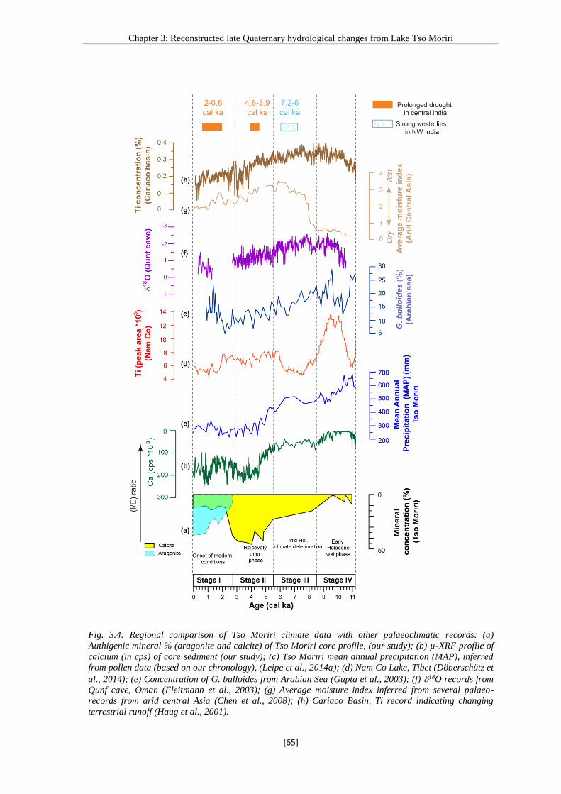
Chapter 3: Reconstructed late Quaternary hydrological changes from Lake Tso Moriri
[65]
Fig. 3.4: Regional comparison of Tso Moriri climate data with other palaeoclimatic records: (a)
Authigenic mineral % (aragonite and calcite) of Tso Moriri core profile, (our study); (b) µ-XRF profile of
calcium (in cps) of core sediment (our study); (c) Tso Moriri mean annual precipitation (MAP), inferred
from pollen data (based on our chronology), (Leipe et al., 2014a); (d) Nam Co Lake, Tibet (Döberschütz et
al., 2014); (e) Concentration of G. bulloides from Arabian Sea (Gupta et al., 2003); (f) 18O records from
Qunf cave, Oman (Fleitmann et al., 2003); (g) Average moisture index inferred from several palaeo-
records from arid central Asia (Chen et al., 2008); (h) Cariaco Basin, Ti record indicating changing
terrestrial runoff (Haug et al., 2001).

Chapter 3: Reconstructed late Quaternary hydrological changes from Lake Tso Moriri
[66]
The onset of the wettest interval in the Tso Moriri record at ca. 11.2 cal ka
coincides with the summer monsoon intensification resulting from the northward shift of
the intertropical convergence zone (Haug et al., 2001) (Fig. 3.4h) that resulted in
increased runoff and the higher detrital influx into the lake. The monsoon precipitation
also changed the I/E balance, resulting in reduced authigenic carbonate precipitation.
This shift towards intensified monsoon is synchronous with the vegetation shift (increase
in Artemisia/Chenopodiaceae ratio) and increased moisture in the catchment of Lake Tso
Moriri and Lake Tso Kar (Demske et al., 2009; Leipe et al., 2014a) (Fig. 3.4c). This
timing of onset of the wet phase in Lake Tso Moriri is also largely comparable with the
palaeoclimate records from the Tibetan Plateau (Van Campo and Gasse, 1993;
Herzschuh et al., 2006; Mischke and Zhang, 2010; Dietze et al., 2013; Döberschütz et al.,
2014) (Fig. 3.4d). The early Holocene monsoon intensification is also in agreement with
central India (Prasad et al., 2014), the Arabian Sea (Sirocko et al., 1993; Fleitmann et al.,
2003; Gupta et al., 2003) (Fig. 3.4e and f), the Indus catchment (Limmer et al., 2012),
and the Bay of Bengal records (Govil and Naidu, 2011; Rashid et al., 2011). The increase
in precipitation ca. 11.2 cal ka in Lake Tso Moriri coincides with the summer insolation
maximum at 30°N (Fig. 3.3l). Our data provides further evidence that changes in solar
insolation, that caused the northward shift of the intertropical convergence zone, have
been the primary trigger for the early Holocene monsoon intensification. We exclude the
possibility of intensified westerlies during the early Holocene as the records from
westerlies influenced arid central Asia (Fig. 3.4g) (Chen et al., 2008) indicate that the
lakes in the westerly influenced regions were dry or were very shallow before 8 cal ka.
In Lake Tso Moriri, the period after 8.5 cal ka was characterised by an increase in
calcite precipitation indicating decreasing I/E, coincident with decreasing solar insolation
and the southward movement of the intertropical convergence zone (Haug et al., 2001).
The gradual weakening of the summer monsoon precipitation in Lake Tso Moriri
beginning ca. 8.5 cal ka is in phase with available regional data (Van Campo and Gasse,
1993; Van Campo et al., 1996; Demske et al., 2009; Dietze et al., 2013). However, in the
period after 8 cal ka, the intensified westerlies influence in arid central Asia (Chen et al.,
2008) does not appear to have made a strong impact in the NW-Himalayas (Fig. 3.4g).
Also, stronger westerlies between 7.2-6 cal ka in NW India (Enzel et al., 1999; Prasad
and Enzel, 2006), and between 6-4 cal ka in the regions north (central Asia) of Tso

Chapter 3: Reconstructed late Quaternary hydrological changes from Lake Tso Moriri
[67]
Moriri (Wang et al., 2010), did not have a strong impact in the Tso Moriri region
indicating spatio-temporal variability in precipitation seasonality (Fig. 3.4). Interestingly,
the short-term events reported from peninsular India e.g., the 4.2 ka event from NW and
central India (Anoop et al., 2013b; Dixit et al., 2014), or the impact of prolonged Indian
summer monsoon droughts, seen in the central India (Prasad et al., 2014), was not felt in
the Himalayan region probably because of (i) the southward shift of the intertropical
convergence zone had already limited the impact of monsoon weakening on the regional
hydrology; and/or (ii) the attenuating impact of westerlies and continuing meltwater
inflow.
The decrease in I/E in the Lake Tso Moriri is correlatable with the other records
from the Tibetan Plateau (Mischke and Zhang, 2010; Dietze et al., 2013), NW-Himalaya
(Demske et al., 2009; Leipe et al., 2014a), NW India (Enzel et al., 1999; Prasad and
Enzel, 2006) and central India (Anoop et al., 2013b). In Lake Tso Moriri, the final lower
I/E value characterised by the presence of aragonite sets in ca. ~2.7 cal ka and is
synchronous with the glacier advancement in the Kurzok valley (~3.6±1.1 ka) (Hedrick
et al., 2011), indicating strongly reduced meltwater input (I/E) in the lake.
3.6. Conclusions
The geochemical, mineralogical and sedimentological investigations on Lake Tso
Moriri core reveal orbital forcing on hydrology (I/E) since ~26 cal ka.
Evaporative enrichment was a forcing factor for authigenic carbonate (aragonite
and calcite) precipitation within the lake and can be used to infer past
hydrological variability (I/E) in the region.
We have identified the following stages in Lake Tso Moriri - Stage I: period of
lake establishment (>20.2 cal ka); Stage II: deepening of the lake (20.2-16.4 cal
ka); Stage III: rising lake levels (16.4-11.2 cal ka); Stage IV: early Holocene wet
phase (11.2-8.5 cal ka); Stage V: mid Holocene climate deterioration (8.5-5.5 cal
ka); Stage VI: relatively lower but stable I/E, detrital input decreases indicates
reduced surficial erosion (5.5-2.7 cal ka); Stage VII: onset of modern conditions
(2.7-0 cal ka).
The reconstructed hydrological changes in Lake Tso Moriri are largely insolation
forced and are correlatable with regional records during the early Holocene.
However, they show significant differences with other records from peninsular

Chapter 3: Reconstructed late Quaternary hydrological changes from Lake Tso Moriri
[68]
India during the late Holocene, most likely related to different forcing
mechanisms governing regional hydrology.
Except during the early Holocene when the Indian summer monsoon played a
major role in higher I/E, the hydrological budget of Lake Tso Moriri has largely
been controlled by meltwater inflow.
3.7. Acknowledgements
This project is being funded by the DeutscheForschungsGemeinschaft under the
coordinated programm “Himalaya: Modern and Past Climates” (HIMPAC, FOR 1380).
The Tso Moriri coring and field expeditions have also received financial and logistic
support from the Deutsches GFZ Potsdam, the Kashmir University, and the Indian
Institute of Geomagnetism. We are grateful to S. Pinkerneil, B. Shehzad, C. Leipe, B.
Wünnemann for their help during the field work. The hard work invested by R.
Niederreiter, D. Niederreiter and M. Köhler for raising the core is gratefully
acknowledged. Special thanks to E. Dietze for the useful discussion and suggestions
during the manuscript writing. We also thank to B. Zimmerman and Mrs U. Kegel for
assistance in the laboratory. The scanning XRF data was provided by Dr. P. Dulski. The
help extended by the Jammu & Kashmir Wildlife Department during the coring
programme, especially by the Chief Wildlife Warden and Regional Wildlife Warden,
Leh and their field staffs at Tso Moriri Lake is gratefully acknowledged.

Chapter 3: Reconstructed late Quaternary hydrological changes from Lake Tso Moriri
[69]
Table
Table 3.1: Radiocarbon dates for the samples from Tso Moriri composite profile (TMD).
Calibaration was performed using online version of OxCal 4.2 calibaration program
(Bronk Ramsey, 2008; Reimer et al., 2013) (M1: Modern plant from the lake; TM 4:
Terrestrial plant fragment)
14C sample name Sample
code
Bulk/Organic
material (OM)
Composite
depth (cm)
14C age (yr) Reservoir corrected
age 14C age (yr)
Calibrated
reservoir
corrected 14C
age (cal a)
Modern plant M1 Modern plant n.a.* 741±40 n.a* n.a*
TM-10 TM 1 Bulk 0 3319±35 0 -61
TMD-1 (0-1) TM 2 Bulk 6 3800±35 481±35 521±21
TMD1 (47.5-47.8) TM 3 Bulk 53.2 5050±40 1731±40 1643±51
TMD-3 (30.5) TM 4 Twig** 171 4920±35 4920±35 5648±37
TMD-3 (48-49) TM 5 Bulk 189 10780±100 7461±100 8266±98
TMD-8 (32.3-32.6) TM 6 Bulk 390.5 14590±80 11271±80 13141±77
TMD-9(31.4) TM 7 OM 440.5 15420±80 14679±80 17860±113
TMD-9(39.8) TM 8 OM 448.9 15490±80 14749±80 17947±115
TMD-10 (12.8-13.4) TM 9 OM 459.9 15560±90 14819±90 18034±123
TMD-10 (40) TM 10 OM 486.8 15620±80 14879±80 18097±113
TMD-10 (45) TM 11 OM 491.8 15670±80 14929±80 18148±114
TMD-11 (75.7-76) TM 12 Bulk 560.2 19160±110 15841±110 19123±146
TMD-15(5-6) TM 13 Bulk 671.7 23250±170 19931±170 23981±211
*n.a. Not applicable
**Reservoir correction is not required for twig of terrestrial origin


Chapter 4: Carbonate isotopes from Tso Moriri Lake sediments
[71]
Chapter 4: Carbonate isotopes from high altitude Tso Moriri
Lake (NW Himalayas) provide clues to late glacial and
Holocene moisture source and atmospheric circulation changes
Praveen K. Mishra1, Sushma Prasad 2, A. Anoop3, B. Plessen1, A. Jehangir4, B. Gaye5, Philip
Menzel 5, S. M. Weise 6, A.R. Yousuf 4
1 Helmholtz Centre Potsdam GFZ German Research Centre for Geosciences, Potsdam, Germany 2Institute for Earth- and Environmental Science, University of Potsdam, Karl-Liebknecht-Straße 24-25,
14476 Potsdam, Germany 3Indian Institute of Science Education and Research, Kolkata, India 4Limnology and Fisheries Laboratory, Centre of Research for Development, University of Kashmir, India 5Universität Hamburg, Institute of Biogeochemistry and Marine Chemistry, Hamburg,
Germany 6UFZ Helmholtz Centre for Environmental Research, Dept. Catchment Hydrology, Halle, Germany
Manuscript status: Published in Palaeogeography, Palaeoclimatology, Palaeoecology.
DOI: http://dx.doi.org/10.1016/j.palaeo.2015.02.031
Abstract
High resolution isotopic (δ18O and δ13C) investigations on endogenic carbonates
(calcite/aragonite) from Tso Moriri Lake, NW Himalaya show dramatic fluctuations
during the late glacial and the early Holocene, and a persistent enrichment trend during
the late Holocene. Changes in this lake are largely governed by the [input
(meltwater+monsoon precipitation)/evaporation] (I/E) ratio, also reflected in changes in
the carbonate mineralogy with aragonite being formed during periods of lowest I/E.
Using new isotopic data on endogenic carbonates in combination with the available data
on geochemistry, mineralogy, and reconstructed mean annual precipitation, we
demonstrate that the late glacial and early Holocene carbonate δ18O variability resulted
from fluctuating Indian summer monsoon (ISM) precipitation in NW Himalaya. This
region experienced increasing ISM precipitation between ca. 13.1-11.7 cal ka and
highest ISM precipitation during the early Holocene (11.2-8.5 cal ka). However, during
the late Holocene, evaporation was the dominant control on the carbonate δ18O.
Regional comparison of reconstructed hydrological changes from Tso Moriri Lake with
other archives from the Asian summer monsoon and westerlies domain shows that the
intensified westerly influence that resulted in higher lake levels (after 8 cal ka) in central
Asia was not strongly felt in NW Himalaya.
Key words: Carbonates; Holocene; Indian summer monsoon; Isotopes, Tso Moriri Lake

Chapter 4: Carbonate isotopes from Tso Moriri Lake sediments
[72]
4.1. Introduction
The Indian summer monsoon (ISM) is an important branch of the Asian monsoon and
today governs the livelihood of more than a billion people over a variety of timescales.
Long palaeo-reconstructions for ISM are available only from the marine sediments
(Schulz et al., 1998; Govil and Naidu, 2011) and do not always coincide with the
reconstructed continental hydrological maxima, which show significant spatiotemporal
variability related to precipitation seasonality and evaporation (e.g., Prasad and Enzel,
2006). The situation is particularly complicated in the Himalayan region where some of
the largest reservoirs of freshwater are stored. The precipitation in this region is provided
by both the winter westerlies and ISM (Benn and Owen, 1998; Anoop et al., 2013a;
Leipe et al., 2014a). Though the relative influence of these moisture pathways has shown
considerable variations in intensity and spatial extent in the past (e.g., Herzschuh, 2006;
Chen et al., 2008; Demske et al., 2009; Mishra et al., 2015), the contribution of such
fluctuations in the Himalayan region is not yet well documented.
Here we focus on the high altitude, pristine Tso Moriri Lake in the NW Himalaya
(Fig. 4.1). The lake is little influenced by the anthropogenic activity making it a key site
to understand past hydrological and climate variability. In this study we explore the
possibility of using the isotopic data from the endogenic carbonates found in the upper
4.15 m (ca. 15.5 cal ka) of a 7.28 m long core, in combination with previously available
sedimentological, mineralogical (Mishra et al., 2015) and pollen data (Leipe et al.,
2014a), to infer late glacial and Holocene changes in ISM precipitation in this high
altitude cold desert.
4.2. Study area
Tso Moriri is one of the largest high altitude lakes situated in the eastern part of Ladakh
region (7814’-7825’E and 3240’-3302’N, 4600 m.a.s.l) with a N-S extension of 27
km and E-W extension of 5-7 km. The catchment area (~2,350 km2) of the Tso Moriri
Lake is dominated by mainly schist, gneisses and boudins of eclogite bearing Puga
gneiss complex, Proterozoic to Cambrian metasediments, intrusive granitic body
(Rupshu granite) and marine Tethys sediments (Fuchs et al., 1996; Steck et al., 1998;
Steck, 2003; de Sigoyer et al., 2004; Singh et al., 2013) (Fig. 4.1). Annual precipitation
in the Tso Moriri region is <250 mm (http://indiawaterportal.org/met_data/).

Chapter 4: Carbonate isotopes from Tso Moriri Lake sediments
[73]
Fig
. 4
.1:
(a)
Ove
rvie
w m
ap
sh
ow
ing
th
e si
tes
sele
cted
in
th
is s
tud
y fr
om
ari
d c
entr
al
Asi
a (
AC
A)
(yel
low
sq
ua
res)
an
d m
on
soon
al
Asi
a (
wh
ite
sq
ua
res)
, a
nd
the
do
min
an
t w
ind
reg
imes
. D
ash
ed l
ine
ind
ica
tes
the
mo
der
n m
on
soo
n l
imit
(C
hen
et
al.
, 2
00
8).
Sit
es i
nfl
uen
ced
by
bo
th w
este
rlie
s a
nd
IS
M a
re (
1)
Tso
Mo
riri
(th
is
stu
dy)
; (2
) Su
mxi
Co
; (3
) B
ang
on
g C
o;
(4)
Na
m C
o;
(5)
Sel
in C
o.
Lo
na
r L
ake
(6
) is
in
flu
ence
d o
nly
by
the
ISM
. Q
uin
gh
ai
La
ke (
7)
is i
nfl
uen
ced
bo
th b
y th
e E
ast
Asi
an
Mo
nso
on
(E
AS
M)
and
th
e w
este
rlie
s. A
CA
sit
es
use
d t
o d
evel
op
th
e A
CA
in
dex
(C
hen
et
al.
, 20
08)
sho
wn
in
Fig
ure
5 a
re n
um
ber
ed a
s (8
) C
asp
ian
Sea
; (9
)
Ara
l S
ea;
(10)
Issy
k K
ul;
(1
1)
Bo
sten
La
ke;
(12
) W
ulu
n L
ake
; (1
3)
Juya
n L
ake
; (1
4)
Tel
men
La
ke;
(15
) B
aya
n N
uu
r; (
16
) H
ovs
go
l N
uu
r; (
17
) G
un
Nu
ur;
(1
8)
Hulu
n
Nu
ur.
(b
) G
eolo
gic
al
ma
p o
f T
so M
ori
ri L
ake
wit
h t
he
loca
tio
n o
f th
e lo
ng (
TM
D)
core
.

Chapter 4: Carbonate isotopes from Tso Moriri Lake sediments
[74]
4.2.1. Hydrology and hydrochemistry
The maximum lake water depth is ca. 105 m. The lake is fed by a number of small
glacier streams with the major streams Gyoma in the north, Phirse Phu stream in the
south and the Korzong Chu in the west. Because the lake presently has no permanent
outlet the lake level is governed by the balance between evaporation and inflow from
precipitation, as well as long and short-term changes in melt water discharge from snow
and glaciers during the summer months (De Terra and Hutchinson, 1934; Srivastava et
al., 2013). Modern investigations using ICESat/GLAS (The Ice Cloud and Land
Elevation Satellite carrying the Geoscience Laser Altimeter System) reveal that Tso
Moriri Lake level was falling at the rate of 0.119 m/y during 2003-2009 AD (Srivastava
et al., 2013) due to higher evaporation (Lesher, 2011). A large alluvial fan to the south
limits the lake level (Leipe et al., 2014b), and a former outlet in the south has been
reported by Gujja et al., (2003) and Panigrahy et al., (2012). This, combined with the
facts that Tso Moriri is not a saline lake and a higher palaeoshoreline exists ca. 7 m
above the present lake level (Leipe et al., 2014b), suggests that the past lake level could
have been affected either through overflow or groundwater loss.
In the study area (Fig. 4.2), the westerlies derived snow has 18O and D values
of -16‰ and -120‰ respectively. The melt water streams show average 18O and D
values of -16.6‰ and -122‰, similar to the snow, indicating derivation from snow melt.
In summer the 18O and D of lake waters is ca. -3‰ and -49‰. Similar trends (Fig. 4.2)
are also seen in other high altitude Tibetan lakes in this region (Bangong Co, Sumxi Co,
and Longmu Lake) indicating significant evaporative enrichment in response to the
atmospheric dryness (Gasse et al., 1991; Fontes et al., 1993; Fontes et al., 1996). The
isotopically enriched rainwater samples from the study area follow the global meteoric
water line (GMWL), whereas snow and lake water display highly depleted values (Fig.
4.2).
Hydrochemistry of feeder springs (Mishra et al., 2014) shows that the lithology of
the catchment area controls the water ionic and isotopic composition, whereas
evaporation processes control the lake water chemistry. Although the inflowing waters
are low in Mg/Ca (<1), the lake waters in summer show average Mg/Ca value of 10
(Mishra et al., 2014) which is conducive to the precipitation of endogenic aragonite.

Chapter 4: Carbonate isotopes from Tso Moriri Lake sediments
[75]
Fig. 4.2: Compiled hydroisotopic data from Tso Moriri (Mishra et al., 2014); Longmu Lake (Fontes et al.,
1993); Bangong Lake (Fontes et al., 1996); Sumxi Co Lake (Gasse et al., 1991). The lake waters show
evaporitic enrichment in response to the atmospheric dryness. The snow and rain data are from isolated
events.
4.2.2. Core description and chronology
A ca. 7.28 m long core (TMD) was raised from the Tso Moriri Lake at a water depth of
105 m and radiocarbon dated (Mishra et al., 2015). A summary of these results is
presented here. The bottom (7.28-4.71 m) part of the core is sandy with intervening
occasional visible macrophyte remains, and is overlain by clayey sediment (4.71-4.25 m)
rich in visible macrophyte fragments deposited in a shallow lake (Mishra et al., 2015).
The remaining part of the core (4.25-0 m) contains largely calcareous clay with variable
degree of lamination deposited in a deep lake. Absent or limited endogenic carbonates
between 3.10-1.97 m (11.2-8.5 cal ka, Figure 4.3) indicates lowest salinity and highest
I/E. For this study we have focused only on the upper 4.15 m of the core that contains
endogenic carbonates (Fig. 4.3) identified using a combination of XRD, selected thin
sections, and inter relationships between geochemical parameters (Mishra et al., 2015).
Investigations on modern sediments indicate since the carbonates are formed by
evaporative processes, their occurrence and isotopic values can be used as indicators of
I/E changes in the lake (Mishra et al., 2014).

Chapter 4: Carbonate isotopes from Tso Moriri Lake sediments
[76]
Fig
. 4
.3:
Ca
rbon
ate
iso
top
e (t
his
stu
dy)
(p
an
els
a,
b),
geo
chem
ica
l (c
), m
iner
alo
gic
al
(d)
(Mis
hra
et
al.
, 2
01
5),
rec
on
stru
cted
MA
P (
e),
an
d p
oll
en (
f) d
ata
(L
eip
e et
al.
,
20
14a
) fr
om
th
e T
so M
ori
ri c
ore
. A
rtem
isia
/Ch
eno
po
dia
cea
e (A
/C)
valu
es i
n a
rid
and
sem
i-a
rid
en
viro
nm
ents
are
lin
ked
to
in
crea
sed
mo
istu
re a
vail
ab
ilit
y (
Lei
pe
et a
l.,
20
14a
). P
rog
ress
ive
dec
rea
se i
n I
/E r
esu
lts
in t
he
form
ati
on
of
eva
po
rati
ve c
alc
ite
foll
ow
ed b
y a
rago
nit
e (p
an
el d
) in
res
po
nse
to
an
in
crea
se i
n M
g/C
a o
f la
ke w
ate
rs.
Gre
en a
rea
s in
dic
ate
wh
ere
bo
th c
alc
ite
and
ara
go
nit
e a
re p
rese
nt.
δ18O
sh
ow
s en
rich
men
t (d
eple
tio
n)
du
ring
in
terv
als
wit
h l
ow
er (
hig
her
) I/
E.
Th
e ho
rizo
nta
l g
rey
ba
rs
ind
ica
te p
rom
inen
t in
terv
als
(A
, B
, C
1 a
nd
C2
) o
f is
oto
pic
ch
an
ges
in
th
e T
so M
ori
ri c
ore
.

Chapter 4: Carbonate isotopes from Tso Moriri Lake sediments
[77]
The core chronology is based on radiocarbon dating of reservoir corrected bulk
organic matter and macrophyte plant remains, and terrestrial fragments (Mishra et al.,
2015). The radiocarbon dates were converted into calendar age using INTCAL 13
calibration curve (Reimer et al., 2013) and linear interpolation was used to determine
dates of intervening samples. The core top (0-1) has been confirmed to be modern using
137Cs dating method (Mishra et al., 2014).
Due to the variable detrital content (Mishra et al., 2015) the reworked organic
content could have varied in the past and the “reservoir correction” may not have
remained unchanged. Therefore, the age model used here can only be considered as
accurate on millennial scale and not be used for detailed correlation of short-term events.
4.2.3. Core mineralogy and pollen data
The positive correlation between Al, K and Fe with Ti (r = 0.80, 0.88, 0.82 respectively)
for the entire (7.28 m) continuous µ-XRF data set of TMD (Mishra et al., 2015) indicates
that Ti can be considered to be representative of the bulk siliciclastic input. In the upper
4.15 m of the core there is a strong inverse correlation between Ca and Ti (r=-0.83) that,
in combination with the mineralogical data, indicates an endogenic origin for the
carbonates. In an evaporative lake, calcite is the first carbonate mineral to precipitate in
the course of evaporative enrichment (Eugster and Hardie, 1978). With progressive
evaporation, aragonite begins to precipitate in response to an increase in the Mg/Ca ratio
(Morse et al., 1997) indicating reduced input (I) (inflow+precipitation) and increased
evaporation (E) i.e. (I/E).
Leipe et al., (2014a) have shown that higher Artemisia percentages in the pollen
spectra and higher Artemisia/Chenopodiaceae (A/C) values in arid and semi-arid
environments are linked to increased moisture availability. Based on this a mean annual
precipitation (MAP) curve for the Holocene from the Tso Moriri Lake has been
reconstructed by Leipe et al., (2014a) using the relationship between the A/C ratio and
mean annual precipitation derived from the dataset from New et al., (2002) (Fig. 4.3).

Chapter 4: Carbonate isotopes from Tso Moriri Lake sediments
[78]
4.3. Methodology
4.3.1. Analytical methods
The core was sub-sampled in the laboratory at a continuous interval of 0.5 cm until a
depth of 3.25 m (average sampling resolution ca. 20 years between 0-11.6 cal ka) and
subsequently at an interval of 1cm until 4.15 m (average sampling resolution ca. 50 years
between 11.6-15.5 cal ka).
The stable isotope (13Ccarb and 18Ocarb) compositions of bulk carbonates (calcite
and/or aragonite) were determined in continuous flow mode using a Finningan
GasBenchII with a carbonate option coupled to a DELTAplusXL mass spectrometer at
the GeoForschungsZentrum Potsdam. From each sample, depending on carbonate
content, 200 to 1000 mg was loaded into 10-mL Labco Exetainer vials. After
automatically flushing with He, the carbonate samples were reacted with phosphoric acid
(100%) at 75˚C for 60 min, following the analytical procedure described by Spötl and
Vennemann (2003). The isotope compositions were given relative to the VPDB standard
in the conventional delta notation, and were calibrated against two international
reference standards (NBS19 and NBS18). The standard deviation (1 sigma) for reference
analyses was ±0.06‰ for δ13C and ±0.08‰ for 18O.
4.4. Results
4.4.1. Late glacial and Holocene changes in carbonate isotopic composition and
siliciclastic influx
The stable isotope composition of bulk carbonates of the core sediment ranges from +2.1
to +5.7‰ (average ca. +3.9‰) for δ13Ccarb, and -10.1 to +3.4‰ (average ca. -3.6‰) for
δ18Ocarb. The δ13Ccarb and δ18Ocarb show a strong correlation (r=0.89) for the investigated
upper 4.15 m of the core where endogenic carbonates are present.
Plots (Figs. 4.3 and 4.4) of the isotope (δ13Ccarb and δ18Ocarb) data together with
the siliciclastic (Ti, indicator of inflow, Mishra et al., 2015), endogenic carbonate
(indicator of lower I/E, Mishra et al., 2015), and pollen (A/C) reveal interesting patterns.
While the broader phases of lake evolution inferred from endogenic mineral data
(increasing carbonates and appearance of aragonite indicating progressively lower I/E
and vice versa) are also reflected in isotopic enrichment, the isotopic data shows high
amplitude changes (up to 10‰ for δ18O, and 5‰ for δ13C) that are abrupt during the late
glacial and early Holocene but gradual during the late Holocene (Fig. 4.3). Highest

Chapter 4: Carbonate isotopes from Tso Moriri Lake sediments
[79]
siliciclastic (Ti) influx is seen between 13.1-11.7 cal ka and early Holocene (11.2-8.5 cal
ka). Generally, the trends in isotopic variability and siliciclastic influx are opposite with
depleted δ18Ocarb intervals being characterised by higher Ti (Fig. 4.4). Interestingly, while
the re-appearance of endogenic calcite ca. 8.8 cal ka indicates reduced I/E, this change is
not unambiguously reflected in the δ18O. The reconstructed MAP (Leipe et al., 2014a),
after an initial peak between 11.5-9 cal ka, shows a rather gradual reduction until 5.5 cal
ka but low values thereafter (Fig. 4.3).
We identify the following prominent intervals (Figs. 4.3 and 4.4) of isotopic
changes in the Tso Moriri core.
Interval A (13.1-11.7 cal ka): is characterised by endogenic calcite, absence of aragonite,
and high siliciclastic influx. Though data points are limited, the 18Ocarb is lower (-7‰)
than the preceding interval. 18Ocarb and 13Ccarb showa high (0.91) correlation (Fig. 4.4).
Interval B (11.2-8.5 cal ka): is characterised by very low or absent endogenic carbonates,
and high siliciclastic influx. Limited 18Ocarb isotopic data show significantly depleted
(upto 10‰) values compared to the preceding interval.
Interval C (5.5-0 cal ka): clearly differs from intervals A and B as the isotopic
enrichment trend is gradual, coupled with decreasing siliciclastic influx, and increasing
calcite percentages (interval C1) followed by the re-appearance of endogenic aragonite at
ca. 2.7 cal ka (interval C2). Here too a strong correlation (0.89) between 18Ocarb and
13Ccarb is seen.
4.5. Discussion
4.5.1. Possible factors influencing the isotopic composition of the lacustrine carbonates
Contamination by detrital carbonates is a major concern in lakes with carbonate rich
catchments, especially in the Tso Moriri region where carbonate rocks are exposed in the
southern and eastern parts. However, our investigations on isotopic composition of
catchment rocks (Mishra et al., 2014) clearly indicate that these, unlike the core
sediments, show lower isotopic values (+1.6 to +0.1‰ for δ13Ccarb and -3.8 to -7.7‰ for
δ18Ocarb) as compared to the investigated core top (+4.6‰ for δ13Ccarb and -1.7‰ for
δ18Ocarb) indicating that the possibility of detrital carbonate contamination is low. In the
investigated core sediments the strong correlation (0.89) between δ13Ccarb and δ18Ocarb
suggests an evaporative origin in a closed basin (Talbot, 1990; Fontes et al., 1996; Leng

Chapter 4: Carbonate isotopes from Tso Moriri Lake sediments
[80]
and Marshall, 2004). Additionally, the intervals (A and B) of most depleted isotopic
values during the late glacial and early Holocene also coincide with reduced/absent
carbonates (Fig. 4.3) further excluding any possibility of contamination by detrital
carbonate.
Leipe et al., (2014b) have raised the possibility of outflow/overflow from the
Lake Tso Moriri in Holocene and even recent times. The latter has not been confirmed
by the authors’ (AJ and ARY) observations in this region. As discussed in Section 2.1,
either sporadic lake overflow and/or loss by groundwater leakage during the entire
interval under consideration are likely. However, we note that the high correlation (0.89)
between δ18O and δ13C records of endogenic carbonates (see section 4.1 above) clearly
indicates that the loss did not affect the isotopic record.
4.5.2. Interpretation of isotopic signal from endogenic carbonates
The δ18O and δ13C records of endogenic carbonates can potentially provide
palaeoenvironmental information about biological and hydrological changes (Stuiver,
1975; Leng and Marshall, 2004). The carbon isotopic composition of lacustrine
carbonates is controlled by (i) variations in 13C/12C values of the dissolved inorganic
carbon; (ii) CO2 exchange between the atmosphere and the lake water (Whiticar et al.,
1986; Talbot, 1990; Valero- Garcés et al., 1999); (iii) photosynthesis, which selectively
removes 12C, resulting in enrichment of 13C in the dissolved inorganic carbonate. Since
Tso Moriri is an oligotrophic lake (<2% total organic carbon for the upper investigated
4.15 m of core), we conclude that the role of phytoplankton productivity in influencing
the isotopic composition of the 13CTDIC is minimal.
The δ18O of lake water (and endogenic carbonates formed therein) in closed lakes
is controlled by the isotopic composition of inflowing water and precipitation
(temperature-dependent δ18O values in precipitation and continental effects related to
moisture source history), altitude, and hydrological effects including evaporative
enrichment (Talbot, 1990; Leng and Marshall, 2004; Yu et al., 1997; Hren et al., 2009).
The δ18O of aragonite is about 0.6‰ more positive than the δ18O of calcite formed under
same conditions (Land, 1980; Leng and Marshall, 2004).

Chapter 4: Carbonate isotopes from Tso Moriri Lake sediments
[81]
Fig. 4.4: Plots of δ18O (a) and δ13C (b) for carbonates from Tso Moriri core show correlation in interval A,
C1 and C2 indicating evaporative origin. The intervals A, C1 and C2 also show inverse covariance
between δ18O and Ti (c) indicating that stronger ISM (depleted δ18O) is also accompanied by increased
surficial erosion (higher Ti). Carbonates (d) were largely absent in interval B resulting in limited data.
The amplitude (upto 12‰ for δ18O and 5‰ for δ13C) of isotopic changes in Tso
Moriri core sediments during the past 15.5 cal ka could be due to (i) changes in
temperature; (ii) different sources of precipitation; and/or (iii) changing I/E (Fontes et al.,
1996; Wei and Gasse, 1999; Leng and Marshall, 2004).
In the high altitude Himalayan region, the temperature effect cannot be completely

Chapter 4: Carbonate isotopes from Tso Moriri Lake sediments
[82]
excluded over the time scales under discussion. Indeed, temperature has been considered
to be the major source of isotopic variability in the Dunde Ice Cap in the Qilian Shan and
the Guliya glacier in the West Kunlun Mountains (Thompson et al., 1997). However,
temperature changes cannot singly explain the magnitude of changes in the Tso Moriri
record. General circulation model (GCM) simulations (Kutzbach and Guetter, 1986)
indicate a warming of ca. 3-5oC between 15-9 ka in the Tibetan Plateau. Assuming an
average δ18O -ground temperature coefficient of ca. 0.6‰/oC (Van der Straaten and
Mook, 1983), this warming coincides with an isotopic shift of about +2 to +3‰ in
precipitation (Wei and Gasse, 1999) which would also be amplified by higher
evaporation during warmer periods. On the contrary, in the Tso Moriri record, a
depletion of ca. 8 to 10‰ is seen in this interval.
Since the temperature and mineralogical effects are minor (temperature-
dependent aragonite–water and calcite–water fractionations are similar (0.24‰/°C;
Epstein et al., 1953), changes in isotopic composition could have been singly or jointly
caused by changing sources, and/or hydrological balance (I/E). On the times scales under
consideration, monsoon strengthening should also be considered in the changing isotopic
composition of meteoric water.
4.5.3. Late glacial and Holocene changes in source water
A comparison of the isotopic composition of the snow, stream melt water, modern ISM
precipitation, and the lake waters clearly indicates that the glacial melt is the dominant
source of water in the modern Tso Moriri Lake and is subjected to evaporative
enrichment (Fig. 4.2, and Mishra et al., 2014). Several studies have shown that in the
monsoonal domain, δ-values of precipitation are correlated with the amount of summer
monsoon precipitation which is strongly depleted in heavy isotopes (Wei and Gasse,
1999; Li et al., 2009; Joswiak et al., 2010). An additional indirect effect of stronger
(weaker) summer monsoon precipitation will also be the reduction (increase) in summer
evaporation efficiency that will further augment (reduce) the depletion of δ18O in
carbonates.
To investigate the possibility of intensified westerlies during intervals A and B,
we have checked the records from westerlies influenced arid central Asia (ACA) (Fig.
4.5) (Chen et al., 2008). Many lakes, including Bosten Lake, Bayan Nuur, Juyan Lake,
Gun Nuur and Hulun Nuur, were dry or were very shallow during the early Holocene

Chapter 4: Carbonate isotopes from Tso Moriri Lake sediments
[83]
before 8 ka. Large deep lakes, such as the Aral Sea, Issyk-Kul, and Lake Van showed
low lake levels (references in Chen et al., 2008). In view of this, we rule out increased
westerly precipitation as a factor in the δ18O depletion during intervals A and B.
Based on our own data and the available literature, we assume that (i) endogenic
carbonates form in lake surface waters close to isotopic equilibrium with summer
temperatures and water composition (Leng and Marshall, 2004) – this assumption is
reasonable as, even accounting for the small enrichment resulting from the presence of
aragonite, the measured number (δ18O =-1.7‰ for the top 0.5cm of the Tso Moriri core)
is close to the calculated (following Anderson and Craig, 1983) value of the endogenic
calcite δ18O value (-2.01‰); (ii) surficial erosion is highest during periods of intensified
monsoon in the poorly vegetated areas of higher Himalayas and Tibet (Fontes et al.,
1996; Anoop et al., 2013a; Doberschütz et al., 2014); (iii) intensified monsoon
precipitation in north India is associated with greater δ18O depletion (Joswiak et al.,
2010).
Thus, the δ18O depletion observed in intervals A and B could have been caused
by either reduced evaporation (of isotopically depleted meltwater from pre-existing
glaciers/snow) or increased (isotopically depleted) ISM contribution to the lake. Both the
scenarios are consistent with positive hydrological balance, and reduced/absent
endogenic carbonates (Fig. 4.3). However, during both these shifts, isotopic depletion is
accompanied by an abrupt increase in siliciclastic contribution (Ti) into the lake (Fig.
4.4) indicating increased surficial erosion. Interval B (11.2-8.5 cal ka) was also marked
by highest summer insolation (Berger and Loutre, 1991) which should have led to
increased evaporation (more endogenic carbonates) and enriched δ18O values. On the
contrary endogenic carbonates are low/absent, and δ18O shows the lowest values, MAP is
high (Leipe et al., 2014a) signifying that interval B represents highest I/E during the past
15.5 cal ka as intensified ISM would have also reduced the summer evaporation
efficiency. Since the westerlies influence was weak prior to 8 cal ka (Chen et al., 2008),
we rule out increased westerly precipitation in the δ18O depletion during intervals A and
B. On the contrary, other archives from the ISM and/or east Asian summer monsoon
(EASM) influenced regions show early Holocene increase in moisture availability (Fig.
4.5) supporting our hypothesis of additional intensified ISM resulting in depleted δ18O
during these intervals.

Chapter 4: Carbonate isotopes from Tso Moriri Lake sediments
[84]
Between 8.5-5.5 cal ka there is a re-appearance of endogenic carbonates
indicating a weakening of the ISM precipitation with a slight decrease in Ti (Fig. 4.4),
while the δ18O does not show significant change indicating a stable period of relatively
high lake levels.
For the interval C there is a gradual trend of isotopic enrichment in the
carbonates, accompanied by decreasing Ti, increasing endogenic calcite (interval
C1=5.5-3 cal ka), and the re-appearance of aragonite ca. 2.7 cal ka (interval C2=3-0 cal
ka), and largely unchanged mean annual precipitation (MAP) (Leipe et al., 2014a). We
interpret this interval to have a long term interval of progressively decreasing I/E caused
by increasing evaporation.
4.5.4. Regional comparison and implications for atmospheric circulation reorganisation
The monsoon strengthening seen during intervals A and B has also been reported from
other ISM (Sinha et al., 2005; Govil and Naidu, 2011) and EASM influenced regions
indicating these to be common to the entire Asian monsoon realm. The succession of
hydrological changes (wetter followed by drier, succeeded by early Holocene wettest
period) coincides with the first strong intensification of the Asian monsoon circulation
(Lister et al., 1991; Gasse et al., 1991; Wei and Gasse, 1999; Zhou et al., 1999; Sinha et
al., 2005; Herzschuh, 2006; Zech et al., 2014). During 11.2 to 8.5 cal ka, a major
negative shift in δ18Ocarb (ca. 8‰) is observed. Increase in siliciclastic (Ti) input during
this period, and almost negligible amount of endogenic carbonate (higher I/E) is
consistent with the increase in solar insolation, which suggested the intensification of
Holocene moisture input (Mishra et al., 2015). Millennial-scale coupling between the
Asian monsoons and higher latitudes has previously been suggested for interglacials
(e.g., Schulz et al., 1998; Wang et al., 2001; Yuan et al., 2004) and could be manifested
through northward shifts in the mean position of the intertropical convergence zone
(Chiang et al., 2003; Lea et al., 2003) leading to deeper ISM penetration in the
Himalayan region (Sinha et al., 2005) during warmer intervals.

Chapter 4: Carbonate isotopes from Tso Moriri Lake sediments
[85]
Fig
. 4
.5:
Reg
iona
l co
mp
ari
son
of
Tso
Mo
riri
da
ta (
pa
nel
s b
an
d c
) w
ith
oth
er s
ites
fro
mth
e IS
M(L
on
ar
La
ke,
pan
el a
; P
rasa
d e
t a
l.,
20
14),
IS
M+
west
erli
es
(pa
nel
s b
: T
soM
ori
ri L
ake
, M
ish
ra e
t a
l.,
20
15
; c:
th
is s
tudy;
d:
Su
mxi
Co
, F
on
tes
et a
l.,
19
93
; e:
Sel
in C
o,
Ga
sse
et a
l.,
19
96
; f:
Na
mC
o,
Do
ber
sch
ütz
et
al.
,
20
14),
EA
SM
+w
este
rly
(pa
nel
g:
Qin
gh
ai
La
ke,
Lis
ter
et a
l.,
19
91
), a
nd
wes
terl
y (
AC
A,
pa
nel
h:
reg
ion
al
com
po
site
fro
m C
hen
et
al.
, 2
00
8)
infl
uen
ced
sit
es.
Su
mm
er i
nso
lati
on
at
30
°N i
s sh
ow
n i
n p
an
el i
(B
erg
er a
nd
Lo
utr
e, 1
99
1).
Hig
her
Ti
(pea
k a
rea
) fr
om
Na
m C
o i
s in
dic
ati
ve o
f h
igh
er e
rosi
on
in
res
po
nse
to
incr
ease
dm
ois
ture
su
pp
ly.
Th
e is
oto
pic
ch
an
ges
in
Tso
Mo
riri
La
ke,
in s
elec
ted
in
terv
als
(g
rey
ba
rs)
iden
tifi
ed i
n t
his
stu
dy,
are
co
mp
are
d w
ith
oth
er r
egio
nal
reco
rds.

Chapter 4: Carbonate isotopes from Tso Moriri Lake sediments
[86]
The period after 8.5 cal ka, was characterised by re-appearance of endogenic
calcite, slight enrichment (average +1.2‰) in δ18Ocarb, reduced surficial inflow (Ti),
indicating a gradual weakening of ISM coincident with decreasing solar insolation and
the southward movement of the intertropical convergence zone (Haug et al., 2001). This
inference is also confirmed by lower MAP (Fig. 4.3) and is also seen in other monsoonal
archives (Lister et al., 1991; Wei and Gasse, 1999; Demske et al., 2009; Chen et al.,
2008). Interestingly, the post 8 cal ka intensified westerlies influence (Fig. 4.5) in arid
central Asia (Chen et al., 2008) does not appear to have made a strong impact in the NW
Himalayas as the Tso Moriri Lake shows decreasing I/E after 8.5 cal ka. The decreasing
I/E trend intensifies after 2.7 cal ka is largely due to increasing evaporation as the MAP
does not show any significant change after 5 cal ka (Leipe et al., 2014a).
Recent studies (Berkelhammer et al., 2012; Prasad et al., 2014; Dixit et al., 2014)
have also discussed the role of ocean atmosphere teleconnections (El Niño-Southern
Oscillation, Indian Ocean Dipole) in causing late Holocene ISM weakening in peninsular
India. The intervals of prolonged ISM drought (4.6-3.9 cal ka and 2-0.6 cal ka) reported
from central ISM regions (Anoop et al., 2013b; Prasad et al., 2014) at a first glance, do
not appear to had made any impact in NW Himalayas, probably due to the buffering
effect of glacial meltwater on the hydrological balance. We note that highest endogenic
calcite values are reached between 5.5-2.7 cal ka and highest aragonite values are
reached ca. 2.1 cal ka. However, the MAP (Leipe et al., 2014a) does not show any major
change suggesting that the mineralogical changes could have been a result of an increase
in evaporation rather than ISM variability.
4.6. Conclusions
The isotopic composition of endogenic carbonates in the Tso Moriri Lake provides
insights into the changing hydrological (I/E) during the past ca. 15.5 cal ka. We provide
evidence of (i) stepwise pattern of late glacial/Holocene transition caused by shifts in I/E
balance in NW Himalaya. This pattern is characterised by abrupt fluctuations in ISM
precipitation; (ii) the early (11.2-8.5 cal ka) Holocene warm period was characterised by
the highest I/E during the past ca. 15.5 cal ka caused by increased ISM precipitation; (iii)
The ISM began to weaken ca. 8.5 cal ka, with a stepwise intensification of the decreasing
I/E trend at ca. 5.5 and 2.7 cal ka; (iv) the westerlies precipitation never attained the level
of positive I/E balance as during the ISM intensification between 11.2-8.5 cal ka; (v) the
Chapter 4: Carbonate isotopes from Tso Moriri Lake sediments
[87]
NW Himalayan region is less sensitive to droughts seen in peninsular India, probably
due to the buffering effect of snow melt, and weaker late Holocene ISM in the NW
Himalaya relative to the early Holocene.
4.7. Acknowledgements
This project is being funded by the DeutscheForschungsGemeinschaft under the
coordinated programme “Himalaya: Modern and Past Climates” (HIMPAC, FOR 1380).
The help extended by the Jammu & Kashmir Wildlife Department during the coring
programme, especially by the Chief Wildlife Warden and Regional Wildlife Warden,
Leh and their field staff at Tso Moriri Lake is gratefully acknowledged. The Tso Moriri
coring and field expeditions have also received financial and logistic support from the
Deutsches GFZ Potsdam, the Kashmir University, and the Indian Institute of
Geomagnetism. We are grateful to S. Pinkerneil, B. Shehzad, C. Leipe, and B.
Wünnemann for their help during the field work. The hard work invested by R.
Niederreiter, D. Niederreiter and M. Köhler for raising the core is gratefully
acknowledged. The authors confirm that they have no conflict of interest.


Chapter 5: Linking Holocene drying trend from Lonar Lake to North Atlantic cooling events
[89]
Chapter 5: Linking Holocene drying trends from Lonar Lake
in monsoonal central India to North Atlantic cooling events
Philip Menzel a, Birgit Gaye a, Praveen K. Mishra b, Ambili Anoop b, Nathani Basavaiah c,
Norbert Marwan d, Birgit Plessen b, Sushma Prasad e, Nils Riedel f, Martina Stebich f, Martin G.
Wiesner a
a Institute of Geology, University of Hamburg, Bundesstr. 55, 20146 Hamburg, Germany b Helmholtz-Centre Potsdam - German Research Centre for Geosciences (GFZ), Telegrafenberg, 14473
Potsdam, Germany c Indian Institute of Geomagnetism, Plot 5, Sector 18, New Panvel, Navi Mumbai - 410218, India d Potsdam-Institute for Climate Impact Research, Telegrafenberg A 51, 14412 Potsdam, Germany e Institute of Earth- and Environmental Science, University of Potsdam, Karl-Liebknecht-Str. 24-25, 14476
Potsdam-Golm, Germany
f Senckenberg Research Station of Quaternary Palaeontology, Am Jakobskirchhof 4, 99423 Weimar,
Germany
Manuscript status: Published in Palaeogeography, Palaeoclimatology, Palaeoecology. DOI:
http://dx.doi.org/10.1016/j.palaeo.2014.05.044
Abstract
We present the results of biogeochemical and mineralogical analyses on a sediment core
that covers the Holocene sedimentation history of the climatically sensitive, closed,
saline, and alkaline Lonar Lake in the core monsoon zone in central India. We compare
our results of C/N ratios, stable carbon and nitrogen isotopes, grain-size, as well as
amino acid derived degradation proxies with climatically sensitive proxies of other
records from South Asia and the North Atlantic region. The comparison reveals some
more or less contemporaneous climate shifts. At Lonar Lake, a general long term climate
transition from wet conditions during the early Holocene to drier conditions during the
late Holocene, delineating the insolation curve, can be reconstructed. In addition to the
previously identified periods of prolonged drought during 4.6 – 3.9 and 2.0 – 0.6 cal ka
that have been attributed to temperature changes in the Indo Pacific Warm Pool, several
additional phases of shorter term climate alteration superimposed upon the general
climate trend can be identified. These correlate with cold phases in the North Atlantic
region. The most pronounced climate deteriorations indicated by our data occurred
during 6.2 to 5.2, 4.6 to 3.9, and 2.0 to 0.6 cal ka. The strong dry phase between 4.6 and
3.9 cal ka at Lonar Lake corroborates the hypothesis that severe climate deterioration
contributed to the decline of the Indus Civilisation about 3.9 ka.
Keywords: Lake sediment; Indian Monsoon; Holocene; climate reconstruction; stable
carbon isotope; amino acid

Chapter 5: Linking Holocene drying trend from Lonar Lake to North Atlantic cooling events
[90]
5.1. Introduction
The increasing demand for reliable climate projections due to the challenges related to
global warming calls for enhanced investigation of the relationship between climate
change and its effect on the environment. To assess future interaction between climate
and environment, it is necessary to understand their interactions in the present and past.
But, while modern observations are increasing rapidly and cover almost the whole world
in high spatial and temporal resolution, the identification and investigation of suitable
sites for palaeoclimate reconstruction is more difficult and requires great effort. Hence,
several regions still lack a sufficient cover of investigated areas to help the scientific
community in reconstructing the past climate and its influence on the former
environment. One of these regions is India, which highly depends on the annual rainfall
delivered by the Indian summer monsoon (ISM). This meteorological phenomenon
affects a human population of more than one billion and is highly sensitive to climate
change. In order to assess and to interpret potential future modifications of the Indian
monsoon system, the knowledge of Holocene monsoon variability, its extremes, and
their underlying causal mechanisms is crucial. And while terrestrial palaeo-records are
available from the northern Indian subcontinent and the Himalayan region (Gasse et al.,
1991; Gasse et al., 1996; Enzel et al., 1999; Denniston et al., 2000; Thompson et al.,
2000; Bookhagen et al., 2005; Prasad and Enzel, 2006; Clift et al., 2008; Demske et al.,
2009; Wünnemann et al., 2010; Alizai et al., 2012), the number and length of comparable
records from central and south India are limited (Yadava and Ramesh, 2005; Caner et al.,
2007; Sinha et al., 2007; Berkelhammer et al., 2010). To address this issue, we have
investigated the Holocene sedimentation history of Lonar Lake from central India with a
special focus on centennial scale palaeoclimate reconstruction.
Based on mineralogical, palynological, and biogeochemical investigations on the
ca. 10 m long sediment core, the longest, well dated palaeoclimate archive from India’s
core monsoon zone, Prasad et al., (2014) reconstructed the broad, Holocene climatic
development of the Lonar Lake region, identified two millennial scale dry phases, and
discussed the stability of the ISM – El Niño Southern Oscillation (ENSO) links and the
influence of shifts in the position of the Indo Pacific Warm Pool (IPWP) on the
prolonged droughts in the ISM realm. Here we present stable carbon and nitrogen
isotope data from Prasad et al., (2014) as well as new data from amino acid, sediment

Chapter 5: Linking Holocene drying trend from Lonar Lake to North Atlantic cooling events
[91]
composition, and grain-size analysis and interpret them with respect to centennial scale,
Holocene climate variability and its tele-connections with the North Atlantic climate.
Bond et al., (2001) hypothesised a connection between North Atlantic cooling
events and cosmogenic nuclide production rates, the latter indicating small changes in
solar output. Additionally, they found virtually synchronous “quasi-periodic” ~ 1500
year cyclicity in both their palaeo-record and nuclide production rates. Thus, they
postulated a reaction of climate to small changes in solar output, which would not be
limited to the North Atlantic region but which would affect the global climate system
(Bond et al., 2001). Correlations between the high and the mid-latitude climate, as
reconstructed from Greenland ice cores (Johnsen et al., 2001; Stuiver and Grootes, 2000)
and ice-rafted debris in North Atlantic deep sea records (Bond et al., 1997), and the low
latitude tropical climate have been found in various climate reconstructions (Haug et al.,
2001; Gupta et al., 2003; Hong et al., 2003; Dykoski et al., 2005; Wang et al., 2005;
Fleitmann et al., 2007; Koutavas and Sachs, 2008) supporting the assumption that
different climate systems react to the same cause, like solar output variation, (Bond et al.,
2001; Soon et al., 2014) either independently or via tele-connections. However, since
many palaeoclimate investigations concerning the correlations between tropical climate
and North Atlantic climate were carried out in peripheral ISM regions (Hong et al., 2003;
Fleitmann et al., 2007), these records could not indicate if the change in moisture
availability was exclusively linked to an alteration in monsoonal summer rainfall rather
than to altered winter westerly precipitation. Lonar Lake is one of the very few natural
lakes located in the core monsoon zone in central India, and it is fed exclusively by
precipitation of the Indian summer monsoon and stream inflow that is closely linked to
monsoon rainfall (Anoop et al., 2013b). Additionally, available precipitation data from
the region close to Lonar Lake indicate a good correlation with the all India rainfall
record of the last century (1901 – 2002). Correlation between the all India rainfall record
(ftp://www.tropmet.res.in/pub/data/rain/iitm-regionrf.txt) and the annual precipitation
data of the meteorological stations in Buldhana, Jalna, Hingoli, and Washim
(http://www.indiawaterportal.org/met_data/) varies between 0.62 and 0.69 (p < 0.001),
making Lonar Lake a key site to investigate the connection between Indian monsoon
strength and its connection to North Atlantic climate change.

Chapter 5: Linking Holocene drying trend from Lonar Lake to North Atlantic cooling events
[92]
5. 2. Study site
Lonar Lake is a closed basin lake situated at the floor of a meteorite impact crater
that formed during the Pleistocene (~ 570 ± 47 ka) on the Deccan Plateau basalts
(Jourdan et al., 2011). The lake is located at Buldhana District in Maharashtra, central
India at 19.98° N and 76.51° E (Fig. 5.1). The meteorite crater has a diameter of ca. 1880
m, and the almost circular lake covers an area of about 1 km². The modern crater floor is
located at ca. 470 m above sea level, which is around 140 m below the rim crest
elevation. The inner rim wall is fairly steep with slopes of 15° – 18° in the east and up to
~ 30° in the west and south-west (Basavaiah et al., 2014).
Fig. 5.1: A) Regional overview and location of Lonar Lake; B) Study area showing the coring site
Lonar Lake is located in the ‘core monsoon zone’ of the Indian summer monsoon
(Gadgil, 2003). The south-west monsoon from June to end of September is characterised
by strong winds and brings in average rainfall of ~ 700 mm. Precipitation during
December to April occurs only in rare cases. The temperature can exceed 40°C before
the onset of the monsoon and declines during the monsoon phase to an average of
approximately 27°C. The post monsoon from October to February is characterised by

Chapter 5: Linking Holocene drying trend from Lonar Lake to North Atlantic cooling events
[93]
relatively low temperatures at an average of 23°C (http://indiawaterportal.org/met_data/).
The lake is fed by surface runoff during the monsoon season and three perennial streams
that are closely linked to monsoon rainfall as indicated by tritium dating (Anoop et al.,
2013b). Two of them, the Dhara stream and the Sitanahani stream are entering the crater
from the north-east. They have formed the Dhara Canyon, an erosive incision, and have
built up an alluvial fan into the lake. Today this fan is used for agricultural plantation.
The Ramgaya stream, the third stream feeding the lake, springs from the inner crater wall
and enters the lake from the eastern shore. Nowadays the three streams are diverted
towards the Dhara fan to irrigate the agricultural fields. Water discharge is only
conducted by evapotranspiration; no outflowing stream is present and no loss due to
seepage occurs as the lake level is below the local groundwater level (Nandy and Deo,
1961).
The modern lake is ca. 6 m deep, brackish, alkaline, and eutrophic with
permanent bottom water anoxia (Basavaiah et al., 2014). The eutrophication promotes
phytoplankton blooms especially during and subsequent to the monsoon when nutrients
are washed into the lake. The algal assemblage is primarily made up of cyanophyceae
(Badve et al., 1993). Thermophilic, halophilic, and alkalophilic bacteria in numbers of
102 to 104 viable cells/ml (Joshi et al., 2008) and methanogenic archaea (Surakasi et al.,
2007) were reported from Lonar Lake. The lake lacks most zooplankton species and
higher organisms. The zooplankton community within the lake consists of ciliates,
culicid larvae, and rotifers (Mahajan, 2005). Only few exemplars of the ostracod Cypris
subglobosa and the gastropod Lymnea acuminate have been observed in the lake (Badve
et al., 1993).
The vegetation of the inner crater walls changes from the upper part near the rim
crest to the bottom part close to the lake shore. The upper part of the inner crater walls is
covered by drought tolerant grass and thorn shrub species, further down grows teak
(Tectona grandis) dominated dry deciduous forest, and the bottom part of the inner crater
walls is overgrown by semi evergreen forests. The alluvial fan, which has formed due to
riverine erosion in the north-east of the lake, is used for crop plantation and cattle
grazing. The fan is characterised by vegetation cover of grasses, sedges, and crop plants
like banana (Musa x paradisiaca), millet (Setaria italica), corn (Zea mays), custard-
apple (Annona reticulata), and papaya (Carica papaya) (Menzel et al., 2013).

Chapter 5: Linking Holocene drying trend from Lonar Lake to North Atlantic cooling events
[94]
5.3. Methods and material
5.3.1. Sampling
Two parallel ca. 10 m long cores were retrieved in May-June 2008 at 5.4 m water depth
using a UWITEC sediment piston corer. The cores were opened in the laboratory; a
composite core was constructed and sub-sampled in 0.5 cm resolution using L-channel
sampling procedure. All samples despite those for grain-size analyses were freeze-dried
and ground manually in an agate mortar.
5.3.2. Analytical methods
The total carbon (TC), total nitrogen (TN), and total organic carbon (TOC) contents and
the δ15N and δ13Corg isotopic composition were determined using an elemental analyser
(NC2500 Carlo Erba) coupled with a ConFlowIII interface on a DELTAplusXL mass
spectrometer (ThermoFisher Scientific). The isotopic composition is given in the delta
(δ) notation indicating the difference, in per mil (‰), between the isotopic ratios of the
sample relative to an international standard: δ (‰) = [(Rsample / Rstandard) – 1] x 1000. The
ratio and standard for carbon is 13C/12C and VPDB (Vienna PeeDee Belemnite) and for
nitrogen 15N/14N and air N2, respectively.
For TC, TN and δ15N determination, around 20 mg of sample material was loaded
in tin capsules and burned in the elemental analyser. The TC and TN contents were
calibrated against acetanilide whereas for the nitrogen isotopic composition two
ammonium sulphate standards (e.g. IAEA N-1 and N-2) were used. The results were
proofed with an internal soil reference sample (Boden3). Replicate measurements
resulted in a standard deviation better than 0.1% for N and 0.2‰ for δ15N.
The TOC contents and δ13Corg values were determined on in situ decalcified
samples. Around 3 mg of sample material was weighted into Ag-capsules, dropped with
20% HCl, heated for 3 h at 75°C, and finally wrapped into the Ag-capsules and measured
as described above. The calibration was performed using elemental (Urea) and certified
isotopic standards (USGS24, IAEA CH-7) and proofed with an internal soil reference
sample (Boden3). The reproducibility for replicate analyses is 0.1% for TOC and 0.2‰
for δ13Corg.
Inorganic carbon (IC) was defined as the difference between TC and TOC. IC was
converted to carbonate by multiplying with 8.33, since calcium carbonate was the only

Chapter 5: Linking Holocene drying trend from Lonar Lake to North Atlantic cooling events
[95]
carbonate phase detected in the sediments despite three distinct zones of the core where
gaylussite crystals were found (1.58 to 4.22 m, 6.42 to 7.60 m, 9.10 to 9.25 m). These
crystals were handpicked under microscope prior to analyses. The percentage of
lithogenic material in the sediments was calculated using the formula:
Lith (%) = 100% – (total organic matter [%] + carbonate [%])
Analyses of AA and HA were carried out on a Biochrom 30 Amino Acid
Analyser according to the method described by Lahajnar et al., (2007). Briefly, after
hydrolysis of the samples with 6 mol L-1 HCl for 22h at 110°C under a pure argon
atmosphere, HCl was removed from an aliquot by repeated evaporation using a vacuum
rotating evaporator (Büchi 011) and subsequent dissolution of the residue in distilled
water. After evaporating the aliquot three times, the residue was taken up in an acidic
buffer (pH: 2.2) and injected into the analyser. The individual monomers were separated
with a cation exchange resin and detected fluorometrically according to the procedure
described by Roth and Hampaĭ, (1973). Duplicate analysis of a standard solution
according to this method results in a relative error of 0.1 to 1.3% for the concentration of
individual AA monomers. Duplicate measurement of a sediment sample revealed a
relative error of < 1% for AA and HA concentrations, < 10% for molar contribution of
low concentrated (< 1 mol%) AA monomers, and < 2.5% for higher concentrated (> 1
mol%) AA monomers.
Grain-size distribution of the core samples was determined using a Malvern
Mastersizer 2000 analyser. The pre-treatment of sediments included the wet-oxidising of
the organic matter and the chemical dissolution of carbonates at room temperature. Ca.
0.3 g freeze-dried sample aliquots were treated with 10 ml H2O2 (30%) which was added
in two steps. The excess oxidising agent was removed by repeated washing with
Millipore water (18.2 MΩcm), centrifugation (6000 rpm, 5 min), and suction of the
supernatant. The carbonates of the solid residues were dissolved by the addition of 3.5
ml 1 M HCl overnight. The solid residues were repeatedly washed (see above) and
suspended in 20 ml Millipore water. The de-acidified samples were kept in an ultrasonic
vibrator for 15 min to disaggregate all grains. The instrument measured the grain-size of
the suspended particles from 0.02 to 2000 µm for 100 grain-size classes. The content of
coarse particles (> 200 µm) in the small aliquots exposed to measurement cannot be
representative for the entire sample. Therefore, we re-calculated the volume-percentage

Chapter 5: Linking Holocene drying trend from Lonar Lake to North Atlantic cooling events
[96]
for the grain-size fraction 0.02 to 200 µm.
5.3.3. Statistical method
To assess the interrelation of climatic changes in central India and the North Atlantic
region as well as the concurrence of climate changes in central India and the solar output
we have calculated the major frequencies in our climate proxy data as well as the
correlation between our proxy and the 14C production rate. Before the spectral analysis,
the long term climate trend was removed from the whole time series by applying a
Gaussian kernel based filter with a kernel bandwidth of 500 years. The spectral analysis
is then performed as the Fourier transform of the auto-correlation function. Since the
sampling of the time series is irregular, the auto-correlation estimation is also based on a
Gaussian kernel (bandwidth of 0.5 years), allowing us to directly apply this method
without preceding interpolation (Rehfeld et al., 2011). A statistical test was performed to
create a confidence interval for the found spectrum. For the test, we have fitted an auto-
regressive process of first order (AR1) to the unfiltered original time series, created
10,000 realisations of this AR1 process, and applied the same kernel based high-pass
filter as for the original time series. From these 10,000 realisations, we calculated the
power spectra by Fourier transform of the auto-correlation function and estimated the
90% confidence interval (software NESToolbox for MATLAB used).
5.3.4. Chronology
The age model for the core is based on 19 AMS 14C dated samples of wood, leaves,
gaylussite crystals, and bulk organic matter (Table 5.1; Prasad et al., 2014). The oldest
dated sample of the core shows an age of 11016 ± 161 cal a, suggesting that the core
covers the complete Holocene sedimentation history of Lonar Lake. The radiocarbon
dating was carried out at Poznan radiocarbon laboratory, Poland. Since the catchment
geology comprises carbonate free basaltic rocks of the Deccan Traps, no correction for
hard water effect was conducted. However, the elevated salinity and pH in combination
with stratification of the water body led to an ageing of the bulk organic matter samples
(Prasad et al., 2014). Calibration of the 14C dates was carried out using the program
OxCal, interpolating with the INTCAL04 and NH3 calibration curves (Bronk Ramsey,
2008).

Chapter 5: Linking Holocene drying trend from Lonar Lake to North Atlantic cooling events
[97]
5.3.5. Mineralogical and biogeochemical proxies
Our reconstruction of the climatic history of the Lonar Lake region and its comparison to
the North Atlantic region is mainly based on lithogenic contribution to the sediments,
grain-size, atomic organic carbon to total nitrogen ratio (C/N), δ13Corg, δ15N, and amino
acid derived indices. The C/N, δ13Corg, and δ15N data were reported and interpreted with
respect to climate variability and climatic tele-connections of the Lonar Lake region with
the Pacific by Prasad et al., (2014). Additionally, the occurrence of evaporitic gaylussite
crystals in the sediments, as reported by Anoop et al., (2013b), was used for the climate
reconstruction. The mechanisms driving the changes in the parameters are shortly
summarised in the following sections.
a) Lithogenic contribution
The lithogenic contribution to lake sediments mostly depends on the erosion that takes
place in the catchment area, transport energy, and shore line proximity (Koinig et al.,
2003; Magny et al., 2012). The intensity of erosion at a lake, which is not affected by
temperatures below the freezing point, is mostly driven by the amount of rainfall, the
occurrence of heavy rainfall events, and the density of vegetation that prevents erosion
(Kauppila and Salonen, 1997; Anoop et al., 2013a). Human interferences like
deforestation, agricultural land use, and construction activity must be considered as
potential causes of enhanced erosion especially in the younger past (Wilmshurst, 1997).
Counterintuitive, phases of enhanced precipitation potentially triggering stronger erosion
do not necessarily coincide with elevated lithogenic percentages in the lake sediments.
This is due to the spreading of vegetation during climatically wet phases, but can also be
controlled by changes in lake level. During wet phases, the lake level increases, which
also increases the distance between a sampling site and the lake shore. Thus, high
proportions of the eroded material from the catchment are deposited relatively close to
the shore in shallow water and do not reach the deeper sampling site. These mechanisms
seem to dominate at Lonar Lake, since time slices of the Lonar core that show strong
evidence of dry climate coincide with high lithogenic contribution to the sediments.
Thus, the lithogenic contribution seems to be a good proxy for the climate
reconstruction at Lonar Lake with high values indicating low lake level during drier
climate and low values indicating high lake level during wetter climate.

Chapter 5: Linking Holocene drying trend from Lonar Lake to North Atlantic cooling events
[98]
b) Grain-size
The grain-size of lake sediments depends much on the source of the sediment load. But if
the source of the sediments does not change, the grain-size can give information about
changes in the hydrodynamics of inflowing streams, the amount of precipitation, the
occurrence of heavy rainfall events, seasonality, shore line or sediment source (e.g., river
mouth) proximity, changes in the internal hydrodynamics (e.g., currents), and external
factors affecting the catchment erosion (McLaren and Bowles, 1985; Sun et al., 2002;
Peng et al., 2005). The sorting of the sediments can be used to reconstruct the transport
distance and the rate of deposition.
The grain-size data are particularly useful for the broad, Holocene climate
reconstruction at Lonar Lake since they depend on changes in monsoon strength.
However, for the reconstruction of smaller scale climate variability, the resolution of
grain-size data might not be high enough, especially in the lower part of the core, where
sedimentation rates are low.
c) C/N
The C/N ratio is often used to determine the source of organic matter (OM) in lake and
coastal sediments (Meyers, 1997). Since aquatic OM is relatively enriched in nitrogen
rich proteins, and vascular plant OM is relatively enriched in nitrogen depleted lignin
and cellulose, the ratio of carbon to nitrogen is much lower in aquatic OM than in OM of
terrestrial origin. C/N ratios of 4-10 indicate the origin of aquatic OM source, whereas
C/N ratios of >20 typically indicate dominant contribution of terrestrial plants (Meyers
and Ishiwatari, 1993). However, the use of C/N ratios as OM source indicator can be
biased since C/N ratios can be altered during degradation. This can shift the C/N ratio to
higher values if the degraded OM is enriched in labile nitrogen rich compounds like
proteins, peptides, and free amino acids, which are most abundant in planktonic OM. On
the other hand, OM of terrestrial origin tends to become relatively depleted in carbon
during degradation, since nitrogen deficient components like carbohydrates and lipids are
preferentially decomposed (Meyers and Lallier-Vergès, 1999). Nevertheless, these
alterations are usually of minor magnitude; hence, the source information of the C/N
ratio is mainly preserved.
At the modern Lonar Lake, soils show a tendency towards low C/N ratios
(Menzel et al., 2013). This is related to the aforementioned preferential degradation of

Chapter 5: Linking Holocene drying trend from Lonar Lake to North Atlantic cooling events
[99]
nitrogen depleted components in combination with the immobilisation of re-mineralised
nitrogen, which can be absorbed by clay minerals in the form of NH4+ (Mengel, 1996;
Sollins et al., 1984). This effect has the strongest influence on sediments that show low
TOC contents.
The C/N ratio does not provide much direct information for the climate
reconstruction. It is particularly useful for determining the OM source, which is not
much climate dependent. During wet conditions, more terrestrial OM might be washed
into the lake due to denser vegetation and stronger rainfall, but this could also cause
more nutrient in-wash into the lake promoting the production of aquatic OM. Thus, the
C/N ratio cannot be used as a climate proxy but identifies changes in OM source and
supports the interpretation of other palaeoclimate proxies that are affected by changes in
OM source.
d) δ13Corg
δ13Corg in lake sediments is influenced by the abundances of land plant OM and aquatic
OM in the sediments. The δ13C of terrestrial OM is mainly driven by the percentage of
plants using the C3 pathway and plants using the C4 pathway of CO2 assimilation. C3
plants show δ13C values of -23 to -35‰, whereas C4 plants have δ13C values of -10 to -
16‰ (O'Leary, 1988). C3 plants are more abundant during wet conditions whereas C4
plants usually spread during phases of dry climate (Tieszen et al., 1979).
δ13C of the aquatic OM depend on the δ13C of dissolved inorganic carbon (DIC)
and on the concentration of CO2(aq.) in the photic zone. Lower pCO2(aq.) leads to
reduced fractionation during CO2 uptake by phytoplankton, and thus to 13C enrichment in
aquatic OM (Lehmann et al., 2004). The factors controlling the isotopic composition of
DIC in Lonar Lake are i) the aquatic productivity driven by nutrient supply to the lake,
ii) redox conditions of surface sediments and lake water, determining the mechanisms
and inorganic products of OM decomposition, iii) the pH of lake water, shifting the
equilibrium of the three types of DIC (CO2(aq.), HCO3-, and CO3
2-), iv) the development
and stability of lake stratification, affecting the exchange of DIC between the photic and
aphotic zones, and v) CO2 degassing caused by lake level decline during climatically dry
phases. Generally, factors enriching the DIC in 13C are linked to eutrophication, dryer
climate, and lake stratification. In highly productive lakes, 13C deficient OM is

Chapter 5: Linking Holocene drying trend from Lonar Lake to North Atlantic cooling events
[100]
transported into the sediments, leaving the DIC in the photic zone enriched in 13C
(Hodell and Schelske, 1998). This effect can be expedited by strong lake stratification,
hampering the convection of lake water, and thus the transport of 13C depleted CO2,
which is produced during OM degradation mostly in the aphotic zone, into the photic
zone. Additionally, eutrophic conditions and lake stratification support the development
of anoxia in deep waters. This causes the production of highly 13C depleted methane
during OM degradation, which can escape the lake system in gaseous state if it is not re-
oxidised. Methanogenesis in anoxic sediments is accompanied by the release of 13C
enriched CO2 at the expense of 13C depleted methane. Thus, if methane is degassed from
the lake water and not re-oxidised, anoxia leads to enriched δ13C values of lake water
DIC (Gu et al., 2004). In response to dryer climate, evaporation intensifies and the lake
level lowers; this increases the salinity, and thus the alkalinity and pH of lake water.
Under highly alkaline conditions, the equilibrium of the three types of DIC shifts
towards HCO3- and CO3
2-, which are enriched in 13C compared to CO2(aq.) (Zhang et al.,
1995). Under these CO2(aq.) depleted conditions, the growth of phytoplankton capable
of using HCO3- as carbon source is promoted producing 13C enriched aquatic OM
(Stuiver, 1975). Additionally, exceeding evaporation can cause supersaturation of
carbonate in the lake water, and consequently CO2 degassing, which is accompanied by
an increase in δ13C of DIC (Lei et al., 2012).
Since δ13C increases under dry conditions in both aquatic OM and terrestrial OM,
it is a good climate proxy in our record. The only limitation is the influence of lake water
anoxia, which more likely occurs in a deeper lake during wet conditions or as a
consequence of eutrophication. The anoxia can cause a change in δ13C of aquatic OM
due to methane degassing or methane oxidation, factors that disappear in a shallow oxic
lake.
e) δ15N
The introduction and cycling of nitrogen in lakes involves several dissolved inorganic
nitrogen (DIN) species and transformation processes, associated with more or less strong
isotopic fractionation. Thus, δ15N of OM in lakes can exhibit highly diverse values,
linked to several processes. Usually, plankton discriminates against 15N during DIN
uptake, with the exception of plankton that is capable of fixing molecular nitrogen
(Talbot and Lærdal, 2000). Hence, phases of intense phytoplankton blooms are

Chapter 5: Linking Holocene drying trend from Lonar Lake to North Atlantic cooling events
[101]
associated with increased δ15N values of DIN in the photic zone. Comparable to carbon
uptake, low concentrations of DIN lead to reduced isotopic fractionation of plankton,
amplifying the increase of δ15N during phases of high aquatic productivity (Peterson and
Fry, 1987). However, the most important processes in determining the δ15N values of
DIN, and thus in δ15N of aquatic OM are the conversion processes of the different DIN
species. The most prominent processes are nitrification, denitrification, and ammonia
volatilisation, which are associated with strong fractionation factors. Nitrification occurs
under oxic conditions and results in 15N depleted nitrate and 15N enriched ammonium,
whereas denitrification, occurring under anoxic conditions, leads to 15N enrichment of
nitrate at the expense of 15N depleted molecular nitrogen. The strongest fractionating
process most probably affecting the DIN pool of Lonar Lake is ammonia volatilisation.
This process becomes important in aquatic environments showing high pH values (>9).
Under these conditions, the equilibrium between ammonium and ammonia shifts towards
ammonia, which is significantly depleted in 15N compared to ammonium (20-35‰) and
can escape the water column in gaseous state (Casciotti et al., 2011). Thus, ammonia
volatilisation leads to increasing δ15N values of the remaining DIN in lake water.
Even though terrestrial OM does not contribute as much to the δ15N variability in
lake sediments as to δ13Corg due to the fact that terrestrial OM has much lower nitrogen
contents than aquatic OM, changes in δ15N during phases of low aquatic productivity and
high terrestrial OM contribution to the sediments can indicate shifts in the vascular plant
and soil nitrogen isotopic composition. In general, δ15N of soil and terrestrial plant OM
increases with increasing temperature and decreasing precipitation (Amundson et al.,
2003).
The use of δ15N as a proxy for climate reconstruction at Lonar Lake is limited
since δ15N values of aquatic OM depend on the redox conditions of lake water with high
values occurring under anoxic conditions but also increasing due to high pH. And
whereas anoxic water is more likely accompanying high lake levels during wet
conditions, the pH increases during dry conditions when ions become concentrated in the
shrinking water body. Additionally, terrestrial OM shows a wide range of δ15N values
due to different nitrogen uptake mechanisms, making it difficult to interpret in terms of
climate variability.

Chapter 5: Linking Holocene drying trend from Lonar Lake to North Atlantic cooling events
[102]
f) Amino acids
The monomeric distribution of the amino acids is commonly used to determine the state
of OM degradation in sediments. For the assessment of the OM degradation state, we
have calculated the Lonar degradation index (LI), which was first calculated for modern
Lonar Lake sediments on the basis of the molar percentages of 19 amino acids (Menzel
et al., 2013). The LI compares the amino acid assemblage of the core samples with the
data set of Menzel et al., (2013), which includes fresh OM like plankton and vascular
plants, moderately degraded sediment trap and surface sediment samples, and highly
degraded soil samples from Lonar Lake and its catchment. The calculation of the LI
follows the approach of the degradation index (DI) calculation developed by Dauwe and
Middelburg (1998) and Dauwe et al., (1999):
i
i i
ii fac.coef.STDvar
AVGvarvarLI
where, vari is the original mole percentage of each amino acid in the sample, AVGvari
and STDvari are the arithmetic average and the standard deviation and fac.coef.i is the
factor coefficient of the first axis of a principle component analysis (PCA) of the
individual amino acids in the data set of Menzel et al., (2013). Negative values indicate
less degraded and positive values more degraded state of the OM compared to the
average of the reference data set.
The second amino acid derived proxy we used is a ratio of individual amino acids
that are relatively enriched during aerobic degradation and amino acids that are relatively
enriched during anaerobic degradation, named Ox/Anox:
Phe Tyr Leu Ile Met Ser
Lys Aba- Ala- Glu AspOx/Anox
This ratio has been applied to the modern Lonar Lake sediments (Menzel et al.,
2013) to evaluate the redox conditions during OM degradation and is based on a study of
Cowie et al., (1995).
The amino acid derived indices seem to be good proxies for climate
reconstruction as they can be used to identify phases of aerobic degradation within the
sediments. Especially during wet phases that induce a deep anoxic lake, elevated values

Chapter 5: Linking Holocene drying trend from Lonar Lake to North Atlantic cooling events
[103]
of theses indices identify relatively short-term, dry anomalies. Highest values are most
probably related to subaerial degradation, and thus to phases of lake desiccation. In rare
cases, the indices could be biased by input of eroded soils, which would cause elevated
values. In addition, eutrophication causes low LI and Ox/Anox values due to strong
aquatic production and the consequent development of lake water anoxia.
5.4. Results and discussion
The results of our investigation of the biogeochemical and lithological properties of the
Holocene sediments from Lonar Lake are shown in Fig. 5.2. The percentages of the
different grain-size classes indicate sediments dominated by clayey silt with few
exceptions showing sandy silt (Fig. 5.3). The sandy silt samples are from 863 to 900 cm
depth (10.5 to 7.8 cal ka). Based on the changes in biogeochemical properties, lithology,
and sedimentation rate, Prasad et al., (2014) have identified the large scale climate
development over the whole Holocene as well as two phases of prolonged drought. Here
we present several shorter phases of climate changes superimposed on the large scale
trend. The identified phases of drier and wetter climate can be correlated with other
Asian palaeomonsoon records and palaeoclimate records from the North Atlantic region.
A detailed description is given below (section 5.4.2) after a summary of the large scale
climate development with additional remarks regarding the grain-size and amino acid
data.
5.4.1. Large scale Holocene climate transition
The general long term palaeoclimate trend at the climatically sensitive Lonar Lake
reconstructed by Prasad et al., (2014) starts with a drying period that probably coincides
with the Younger Dryas at ~ 11.4 cal ka, which marks a dry period prior to the beginning
of the Holocene in many geological records of India and adjacent regions (Overpeck et
al., 1996; Bar-Matthews et al., 1997; Wei and Gasse, 1999; Gasse, 2000; Wang et al.,
2001; Morrill et al., 2003; Sharma et al., 2004; Dykoski et al., 2005; Demske et al.,
2009). Median grain-size of this section is low indicating low energy transport, which is
probably due to dry conditions with reduced sediment input by run-off and precipitation
fed streams and enhanced aeolian deposition. High LI values indicate strongly degraded
OM in these sediments, and the high Ox/Anox ratios point to subaerial decomposition of
the OM. Thus, the bottommost sediment section most likely represents a palaeosol.

Chapter 5: Linking Holocene drying trend from Lonar Lake to North Atlantic cooling events
[104]
The beginning of the Holocene is marked by a transition from dry to wet climate
with an abrupt increase in monsoon strength after ~11.4 cal ka (Prasad et al., 2014). The
phase of monsoon onset and strengthening is reflected in the sediments by high
lithogenic input, which was eroded from the sparsely vegetated crater walls and
transported to the dried out lake bed. The values of the biogeochemical parameters and
the grain-sizes are comparable to those of the underlying soil, and thus indicate high
contribution of eroded soil material to the sediments. On top of this section, few
gaylussite crystals can be found, denoting a drier phase at ~ 11.1 cal ka.
Subsequently, the early Holocene between 11.1 and 6.2 cal ka is characterised by
wet conditions (Fig. 5.4). The sediments of this section show low lithogenic contribution,
and consequently low sedimentation rates. Thus, the section represents a deep lake with
less eroded material reaching the sampling site. A deep lake developed quickly after 11.1
cal ka as is obvious from seasonally laminated sediments (Prasad et al., 2014). The
median grain-size values indicate a shift to medium silt, and thus to slightly coarser
material. This might be due to higher energy transport during strong rainfall events. The
aquatic productivity was low during this phase, as shown by the high C/N ratios (mean =
30.1), which denote dominant contribution of terrestrial OM. Since 9.9 cal ka the δ13Corg
values stabilised on a relatively low level (mean = -20.9‰) indicating a C3 dominated
vegetation in the catchment of the lake. The predominantly low LI and Ox/Anox values
of the section and the increasing δ15N values between 9.1 and 6.2 cal ka point to
extended anoxia in the water column and the sediments.

Chapter 5: Linking Holocene drying trend from Lonar Lake to North Atlantic cooling events
[105]
Fig
. 5
.2:
Su
mm
ary
of
the
an
aly
tica
l re
sult
s: A
) S
chem
ati
c li
tho
log
y o
f th
e L
ona
r L
ake
co
re a
nd
do
wn
-co
re v
ari
ati
on
in
lit
ho
gen
ic c
on
trib
uti
on
; B
) C
/N r
ati
o;
am
ino
aci
d d
eriv
ed i
nd
ices
C)
Ox/
An
ox
an
d D
) L
I; E
) st
ab
le n
itro
gen
; a
nd
F)
carb
on
is
oto
pic
ra
tio
s o
f b
ulk
org
an
ic m
att
er;
and
G)
med
ian
gra
in-s
ize.
C/N
, δ
13C
org
, a
nd
δ15N
wer
e re
po
rted
by
Pra
sad
et
al.
, (2
01
4);
ga
ylu
ssit
e cr
ysta
l o
ccu
rren
ce w
as
rep
ort
ed b
y A
no
op
et
al.
, (2
01
3b
). E
rro
r b
ars
in
dic
ate
th
e st
an
da
rd d
evia
tio
n r
an
ge
(2σ)
of
cali
bra
ted
ra
dio
carb
on
da
tes.

Chapter 5: Linking Holocene drying trend from Lonar Lake to North Atlantic cooling events
[106]
Fig. 5.3: Ternary diagram showing the percentages of the different grain-size classes (clay, silt, sand) of the
analysed sediment samples of the Lonar Lake core sediment.
The time slice between 6.2 and 3.9 cal ka is regarded as being a transitional phase
between wet climate during the early Holocene and dry climate during the late Holocene. This
time slice shows two drying phases accompanied by strong water body reduction between 6.2
and 5.2 cal ka and between 4.6 and 3.9 cal ka, respectively. The former drying phase is most
obvious from high δ13Corg and δ15N values, whereas the latter shows elevated lithogenic
contribution and gaylussite crystal precipitation (Fig. 5.4), which indicates strongest lake level
decline.
Following the climate transition between 6.2 and 3.9 cal ka, evidence of relatively dry
climate persists until today. Elevated δ13Corg values, lithogenic contribution, Ox/Anox ratios,
and finer median grain-sizes indicate drier conditions compared to the early Holocene. The
lithogenic contribution and the Ox/Anox ratios denote a shallow lake, and the δ13Corg values
imply a dominance of C4 catchment vegetation. The grain-size data indicate weaker monsoon
rains causing lower transport energy. Additionally, the alluvial fan in the north-east of the
lake might have been exposed due to the lower lake level, possibly reducing the velocity of
the streams that enter the lake from the north-east and east. Probably, this effect has also
reduced the distance between the sampling site and the source of fine sediment (alluvial
fan/stream mouth) causing a shift to finer grain-sizes and increasing the sedimentation rate. A
phase of exceedingly dry conditions is indicated by the reoccurrence of evaporitic gaylussite
crystals between 2.0 and 0.6 cal ka (Anoop et al., 2013b; Prasad et al., 2014). The climate

Chapter 5: Linking Holocene drying trend from Lonar Lake to North Atlantic cooling events
[107]
information of the younger part of the core might be mirrored to some extent due to
anthropogenic interferences, as for example eutrophication and deforestation. A persistent
decrease in C/N ratio since 1.3 cal ka indicates permanently elevated nutrient supply to the
lake, which cannot be observed in the older parts of the core. Thus, a natural source of these
additional nutrients seems unlikely. Since ca. 0.8 cal ka strong anthropogenic interference is
evident from several near shore temples that have been built during the Yadavan rule
approximately in the 12th century (Malu et al., 2005).
In general, the impact of long term Holocene climate change on palaeolimnology
becomes notably obvious from the δ13Corg, lithogenic contribution, and grain-size values in
our record and quite well delineates the insolation curve since the end of the Younger Dryas
(Fig. 5.4), which additionally seems to drive the position of the summer Inter-Tropical
Convergence Zone (ITCZ), and thus the strength and northwards extent of the summer
monsoon rainfall (Fleitmann et al., 2007). One point that might be questioned is the
characteristic of the climate deterioration at 6.2 cal ka, which is reflected in the Lonar Lake
record by a sharp increase in δ13Corg, and thus points to an abrupt change, which was also
reported from other records (Morrill et al., 2003). Nevertheless, we believe that this abrupt
change is related to short-term climate variability and that the sudden increase in δ13Corg at 6.2
cal ka most likely represents the transgression of a threshold in annual precipitation that led to
the decline in terrestrial C3 plant vegetation and the increase in C4 plant contribution. Also,
the changes in lake level as displayed by the lithogenic content in the sediments show a
relatively smooth transition from a deep to a shallow lake. Additionally, the relatively short-
term of the interval of drying between 6.2 and 3.9 cal ka is obvious from the subsequent
change to wetter conditions indicated by subaquatic sedimentation and the disappearance of
the gaylussite minerals. Thus, the transition from generally wet to drier climate after the
Holocene climate optimum seems to occur gradually, and abrupt changes in the
biogeochemical parameters are due to relatively short-term climate anomalies as postulated by
Fleitmann et al., (2007) and reported from several regions (Hodell et al., 1999; Gupta et al.,
2003; Hong et al., 2003; Gupta et al., 2005; Demske et al., 2009; Wünnemann et al., 2010).

Chapter 5: Linking Holocene drying trend from Lonar Lake to North Atlantic cooling events
[108]
Fig. 5.4: Long term Holocene climate trend at Lonar Lake as interpreted from our data: Comparison of median
grain-size (A); lithogenic contribution (B); δ13Corg values (C) (Prasad et al., 2014); and summer (JJA) insolation
at 20° N (D) (Berger and Loutre, 1991). Error bars indicate the standard deviation range (2σ) of calibrated
radiocarbon dates.
5.4.2. Centennial scale Holocene climate variability
Besides the large scale millennial climate trend, several smaller centennial scale climate
variations can be reconstructed from the Lonar Lake bioclastic record. While the role of
ENSO and shifts in the position of the Indo Pacific Warm Pool (IPWP) in causing the
prolonged droughts during 4.6 to 3.9 and 2.0 to 0.6 cal ka have been discussed by Prasad et
al., (2014), the short-term climate variability identified in our new dataset cannot be explained
by the same mechanism necessitating the search for alternative causal mechanisms. Several
studies have identified links between Asian monsoon and North Atlantic palaeoclimate with
cold events in the North Atlantic region, as identified by ice-rafted debris in deep sea cores
(Bond et al., 1997 and 2001), being linked to decreases in monsoon strength over Asia (Gupta
et al., 2003; Hong et al., 2003; Dykoski et al., 2005; Fleitmann et al., 2007; Wang et al.,

Chapter 5: Linking Holocene drying trend from Lonar Lake to North Atlantic cooling events
[109]
2005). Nearly all Bond events are isochronally reflected by indications of short-term changes
in monsoon strength in the proxies from Lonar Lake sediment core (Fig. 5.5). Since the
centennial scale climate variations at Lonar Lake are reflected in different proxies and not all
proxies show every phase of climate change, we calculated a Bioclastic Climate Index (BCI)
that combines the Holocene course of the independent and climatically sensitive δ13Corg,
lithogenic contribution, and combined amino acid proxy values. Since the variations in δ15N
and C/N values within the Lonar Lake record seem not to be predominantly driven by climate
change or at least are considerably biased by other processes (see sections 5.3.5. (c) and (e)),
we did not include them into the BCI calculation. The BCI shows the deviation from the mean
values given in percent of the maximum variation of the respective proxy in the data set
according to the formula:
3
(%)]Ox/Anox (%) LI[ x 0.5 (%)lith (%) C (%) BCI
org
13
with high values indicating drier and low values indicating wetter conditions. We used half of
the sum of the LI and Ox/Anox values to not overstate the variability in amino acid data as
both values are calculated from the same data set, and thus are not fully independent. Further,
linearly interpolated values for the amino acid derived proxies were used as these proxies
were measured in a lower resolution than δ13Corg and lithogenic contribution. Since the BCI
also shows the long term palaeoclimate trend, a detrended curve was calculated to emphasise
the centennial scale palaeoclimate variations (Fig. 5.6). The applicability of the BCI in
reconstructing changes in precipitation is corroborated by its negative correlation (-0.55; p <
0.01), despite human interferences at Lonar Lake in modern times, with the all India rainfall
record (ftp://www.tropmet.res.in/pub/data/rain/iitm-regionrf.txt) by applying a low-pass filter
to the rainfall data and the Gaussian kernel based correlation analysis (NESToolbox for
MATLAB used; Rehfeld et al., 2011). In addition to the BCI, the occurrence of evaporitic
gaylussite crystals (Anoop et al., 2013b) was used to interpret the climatic changes at Lonar
Lake since the gaylussite crystals exclusively indicate changes in Lonar Lake hydrology
related to reduced available effective moisture.

Chapter 5: Linking Holocene drying trend from Lonar Lake to North Atlantic cooling events
[110]
Fig. 5.5: Comparison of our data of lithogenic contribution (A), C/N ratio (B), Ox/Anox ratio (C), LI (D), δ15N
(E), and δ13Corg (F) to the percentage of haematite stained grains (G) in core MC52, a climate record from the
North Atlantic region (Bond et al., 2001). C/N, δ13Corg, and δ15N were reported by Prasad et al., (2014);
gaylussite crystal occurrence was reported by Anoop et al., (2013b). Numbers 0 – 8 designate cold events in the
North Atlantic region (Bond events). Grey shaded intervals denote periods that are interpreted to be phases of
climate deterioration at Lonar Lake. Error bars indicate the standard deviation range (2σ) of calibrated
radiocarbon dates.

Chapter 5: Linking Holocene drying trend from Lonar Lake to North Atlantic cooling events
[111]
Largely, the changes in the de-trended BCI are coincident with the intervals of
increased ice rafted debris in the North Atlantic (Bond et al., 2001). The oldest of the
Holocene cooling events in the North Atlantic region, the Bond event 8, can be correlated
with the occurrence of gaylussite crystals in the Lonar Lake core on top of the section that
represents the phase of climate transition and monsoon onset after the soil formation (Fig.
5.5). The Bond event 7 is concurrently correlated to a double-peaked increase in δ13Corg and to
an increase in lithogenic contribution. The δ13Corg increases are interpreted as changes in
terrestrial vegetation to more C4 plant abundance, indicating drier conditions. The subsequent
decrease in δ13Corg denotes the transition to C3 plant domination, and thus wetter conditions
during the early Holocene. A concurrent climate variation to Bond event 6 is indicated by
elevated LI and Ox/Anox values as well as high δ15N values (Fig. 5.5). The amino acid based
indices reveal an increase in oxygen supply to the sediments at 9.15 cal ka, and the pollen
record points to a dry phase, during which the whole sediment section of this subunit became
exposed to oxic or even subaerial conditions, since only few pollen that are resistant to
aerobic decomposition are preserved in the sediments older than 9.2 cal ka (Riedel & Stebich,
in preparation). Enhanced oxygen supply could also be responsible for the elevated δ15N
values, since an increase in δ15N during aerobic degradation was reported from in vitro
(Lehmann et al., 2002) as well as from in vivo (Freudenthal et al., 2001) investigations. A
drying trend in the Asian tropical region during this so called 9.2 ka event was reported before
and also related to a cooling trend in the North Atlantic region (Dykoski et al., 2005;
Fleitmann et al., 2008). Elevated LI, Ox/Anox, and lithogenic contribution values in the Lonar
Lake core comparable to the values at 9.2 cal ka can be found during 8.2 – 7.7 cal ka (Fig.
5.5). This phase correlates within dating uncertainties with a cool phase in the North Atlantic
situated at the early stage of Bond event 5. The relatively short cool phase during the early
stage of Bond event 5 is also known as the 8.2 ka event. Similar to the 9.2 ka event, a cooling
trend in the North Atlantic region was accompanied by a drying trend in monsoon-influenced
Asia (Alley et al., 1997; Wang et al., 2005). It is widely accepted that the cooling during the
8.2 ka event was caused by a pulse of freshwater that burst out of the Lakes Agassiz and
Ojibway through the Hudson Straight, which weakened the thermohaline Atlantic meridional
overturning circulation, thus leading to the climate anomaly (Barber et al., 1999; Teller et al.,
2002; Kendall et al., 2008). The peak at the later stage of Bond event 5 is correlated with
elevated δ13Corg values and an increase in lithogenic contribution (Fig. 5.5). Elevated LI,
Ox/Anox, and lithogenic contribution at 6.45 cal ka correlate within dating uncertainties with

Chapter 5: Linking Holocene drying trend from Lonar Lake to North Atlantic cooling events
[112]
a cool phase at the beginning of Bond event 4. The following intensification of the North
Atlantic cold spell (Bond event 4) and the Bond event 3 are reflected by the most obvious
centennial scale climate changes shown by our data. These two phases constitute the climate
transition from generally wet to generally drier conditions during the mid-Holocene (see
section 5.4.1) at 6.2 – 5.2 cal ka and 4.6 – 3.9 cal ka, respectively, which is consistent with
reports of southward migration of the ITCZ, monsoon weakening, and related drying trends
from various locations of the Asian monsoon realm (Enyel et al., 1999; Morrill et al., 2003;
Parker et al., 2004; Prasad and Enzel, 2006; Staubwasser and Weiss, 2006; Fleitmann et al.,
2007; Demske et al., 2009; V. Prasad et al., 2014). The older phase, concordant with Bond
event 4, is characterised by a strong increase in δ13Corg with two sudden shifts, the first by ~
8‰ at about 6.2 cal ka and the second by ~ 4‰ at about 5.7 cal ka. The second shift in δ13Corg
is accompanied by an increase in δ15N of ~ 2‰. The increase in δ13Corg is most likely linked
to two major factors. A shift in terrestrial vegetation from C3 dominance to more C4
contribution seems to explain the increase in δ13Corg at 6.2 cal ka since S. Sarkar (in
preparation) found an increase in δ13C of long chain n-alkanes. The second increase in δ13Corg
at 5.8 cal ka results in δ13Corg values that even exceed the values of C4 land plants, and thus
the second shift cannot be explained by a further change in the terrestrial fraction of the OM
alone. Hence, the elevated δ13Corg values seem to be related to a change in the aquatic system.
A reasonable explanation is an increase in pH, as a result of an increased salt concentration in
the water during lake level decline in response to relatively dry conditions, and a related shift
in the dominant photosynthetic inorganic carbon source from CO2 to HCO3- (Prasad et al.,
2014). The assumption that elevated pH is responsible for the δ13Corg increase is corroborated
by the concurrent increase in δ15N. In anoxic waters, which most probably were present
during the related time as indicated by the low Ox/Anox ratios, high pH causes ammonia
volatilisation that leads to a δ15N increase of aquatic OM (Casciotti et al., 2011). After 5.2 cal
ka, the δ13Corg and δ15N values gradually decrease, which could indicate a slightly wetter
period from 5.2 to 4.6 cal ka but which could also be due to the disappearance of the anoxic
water layer as a response to further lake level decline. Subsequently, the dry phase between
4.6 and 3.9 cal ka, which has been correlated with an expansion of the IPWP (Prasad et al.,
2014) but also partly correlates with Bond event 3, does not show as elevated δ13Corg and δ15N
values as the previous dry episode. This seems to be related to the disappearance of the anoxic
water layer, and hence the lack of ammonia volatilisation, producing 15N enriched
ammonium, and the lack of methanogenesis, producing 13C enriched CO2. The strongest
indications for dry climate during this period are the occurrence of evaporitic gaylussite

Chapter 5: Linking Holocene drying trend from Lonar Lake to North Atlantic cooling events
[113]
crystals throughout this zone (Anoop et al., 2013b) and the elevated lithogenic content in the
sediments indicating low lake level. However, the decreased δ13Corg values are responsible for
the lower BCI values during this time slice even though the occurrence of gaylussite crystals
indicates drier conditions compared to the time slice 6.2 to 5.2 cal ka (Fig. 5.6). Subsequently,
the only Bond event that does not show a marked complement in the Lonar Lake record is
Bond event 2 between ca. 3.5 and 2.7 cal ka. This might be due to the fact that generally drier
conditions had been established after the very dry period correlated with Bond events 4 and 3.
Thus, the wetter period during ca. 3.9 to 3.5 cal ka did not provide enough excess in
precipitation over evaporation to establish a high lake level with strong anoxic hypolimnion
and vegetation dominated by C3 plants. Hence, if the period between 3.5 and 2.7 cal ka was
drier at Lonar Lake compared to the period 3.9 to 3.5 cal ka, no significant changes in our
proxies could be expected as long as the lake does not desiccate. Nevertheless, two minor
positive shifts in δ13Corg and contemporaneous increases in the amino acid derived indices
result in two BCI peaks that possibly indicate drier conditions at Lonar Lake corresponding to
the double-peaked North Atlantic cooling event during Bond event 2 (Fig. 5.6). The following
period of strong evidence of climate deterioration at Lonar Lake is again marked by evaporitic
gaylussite crystals and was dated at an age of 2.0 – 0.6 cal a (Anoop et al., 2013b; Prasad et
al., 2014). Thus, it can be correlated with Bond event 1 but exceeds the time span of the Bond
event by about 500 years, which is in accordance with the report of decadal scale famines in
India during the 14th and 15th century (Sinha et al., 2007). However, this strong drying event
is also coincident with an increase in ENSO like conditions (Moy et al., 2002; Rein et al.,
2005) in the Pacific (Prasad et al., 2014) suggesting complex links to the North Atlantic and
to the Pacific forcings. The dry climate of this period, as indicated by the gaylussite
precipitation, is not well reflected in the BCI. This is due to the eutrophication, which causes
the development of lake water anoxia and a related descent of the amino acid derived proxy
values. The BCI indicates an abrupt transition to wet climate at 1.3 cal ka (Fig. 5.6), which is
due to the biased amino acid indices. Thus, the BCI values during the phase of strongest
anoxia between 1.3 and 0.3 cal ka, as indicated by the Ox/Anox ratio, are shifted to lower
values, hence indicating wetter climate than actually prevailed. Finally, Bond event 0 is
concurrently correlated to increased δ13Corg and lithogenic contribution values between 440
and 240 cal a (Fig. 5.5). Again, anthropogenic interference cannot be ruled out here in the
younger part of the core. But, since the two-step increase in δ13Corg at 440 and 260 – 245 cal a
and the subsequent decrease in δ13Corg correlate with two minima in solar activity, the Spörer
Minimum and the Maunder Minimum, and a subsequent increase in solar activity, it seems

Chapter 5: Linking Holocene drying trend from Lonar Lake to North Atlantic cooling events
[114]
likely that these changes are driven by monsoon strength weakening during the ‘Little Ice
Age’ (Bond event 0) and the subsequent climate amelioration (Anderson et al., 2002;
Agnihotri et al., 2008).
Fig. 5.6: Comparison between the Bioclastic Climate Index (BCI) (A), the detrended BCI (B), the climate record
from the North Atlantic Region (C), and the detrended and smoothed 14C production rate (D) (Bond et al., 2001).
Detrending of the BCI was performed by applying a Gaussian kernel based filter with a kernel bandwidth of 500
years to the values of the time slice <11.14 cal ka The values of the time slice ≥ 11.14 cal ka were adjusted by
subtracting the lowest value of this time slice from the data since a rapid shift in BCI values at 11.14 cal ka
occurs. Red and blue colour fills indicate relatively dry and wet phases, respectively. Error bars indicate the
standard deviation range (2σ) of calibrated radiocarbon dates.
Multiple proxies (Prasad et al., 2014; this study) indicate that there are both tropical
and high latitude influences on the ISM that can be finally linked to solar variability. The fact
that all phases of climate cooling in the North Atlantic region identified by Bond et al., (2001)
are largely contemporaneously (within dating uncertainties) accompanied by climate

Chapter 5: Linking Holocene drying trend from Lonar Lake to North Atlantic cooling events
[115]
deteriorations at Lonar Lake, as inferred from changes in BCI and evaporative gaylussite
crystal precipitation, indicates that the North Atlantic and the Indian monsoon climate
systems were linked during the Holocene. Evidence for contemporaneous climate variability
in the Asian tropics and the North Atlantic region during the Holocene has also been reported
from annually laminated, precisely dated stalagmites (Liu et al., 2013). A reasonable
explanation for such a concurrent linkage is an atmospheric tele-connection, which has the
potential to connect the two systems without substantial delay. Coupled ocean-atmosphere
climate simulations could show that cooling of the northern hemisphere results in reduced
summer monsoon rainfall over India (Broccoli et al., 2006; Pausata et al., 2011). This is due
to the development of an asymmetric Hadley cell accompanied by a southwards shift of the
ITCZ, which causes an enhanced net energy (heat) transport from the tropics to the cooled
northern hemisphere (Broccoli et al., 2006). Such a southwards shift of the ITCZ would lead
to weaker-than-normal Asian summer monsoon, and thus might be the mechanism
responsible for the Asian-North Atlantic climate connection indicated by our data. Another
mechanism that might have contributed to the connection could be the effect of northern
hemisphere cooling on Eurasian snow cover if the cold phases recorded in the North Atlantic
region have caused enhanced snow accumulation over Eurasia. Modern observations and
model calculations show that extent and duration of Eurasian snow cover affect the Asian
monsoon system (Bamett et al., 1989; Bamzai and Shukla, 1999). Prolonged Eurasian snow
cover during spring cools the overlying air since energy is used to melt the snow and to
evaporate the melt water instead of warming the land surface, thus having a downwind effect
on South Asian landmasses and weakening the thermal gradients between land and ocean,
which causes a weaker-than-normal summer monsoon (Barnett et al., 1989).
The reason for the North Atlantic cooling events might be reduction in insolation
triggered by reduced solar output. This was postulated by Bond et al., (2001) who found that
the North Atlantic cooling events correlate with smoothed and detrended 14C and 10Be
production rates (14C shown in Fig. 5.6), which are inversely correlated with solar output
(Beer, 2000). They also found a ca. 1500 year periodicity of the palaeoclimate variation in
their record, which is in agreement with palaeoclimate variations reconstructed from other
records (see Mayewski et al., 2004) and the link between periodicities in climate archives and
solar activity (Soon et al., 2014). To compare these findings with our data, we have calculated
the major frequencies in our climate proxy data as well as the correlation between the BCI
and the 14C production rate. Before the spectral analysis, the long term climate trend was
removed from the whole time series by applying a Gaussian kernel based filter with a kernel

Chapter 5: Linking Holocene drying trend from Lonar Lake to North Atlantic cooling events
[116]
bandwidth of 500 years. The correlation between the detrended 14C production rate (Bond et
al., 2001) and the detrended BCI is relatively high (0.63), thus supporting the hypothesis that
climate variability in India is influenced by changes in solar irradiance (Gupta et al., 2005).
The power spectral analysis revealed a 1519 year periodicity besides 120 year, 274 year, 435
year, and 822 year periodicities in our data set (Fig. 5.7). Thus, a periodicity in climate
variability similar to the “1500-year cycle” observed by Bond et al., (2001) is present in our
record and corroborates the connection of the North Atlantic and the Indian monsoon
palaeoclimates. The other periodicities seem to be related to solar cycles. The periodicities of
120 and 435 years equal eccentricity periodicities (122 and 432 years), whereas the 822 year
cycle might be related to precession and obliquity cycles of 840 years (Loutre et al., 1992).
Due to the difference, it is questionable if the 274 year cycle in our data set is related to the
245 year cycle of eccentricity, obliquity, and precession (Loutre et al., 1992), but the
possibility should not be excluded. In summary, we conclude that while IPWP forcings are
important in causing millennial scale periods of prolonged dryness during the mid and late
Holocene in central India (Prasad et al., 2014), the subtle short-term changes identified by the
BCI indicate the presence of North Atlantic forcings as well.
Fig. 5.7: Powerspectrum indicating the most prominent periodicities within the Bioclastic Climate Index data
set. The blue line represents the 90% confidence level of statistical significance.
5.4.3. Implication for the archaeological history
Our palaeoclimate reconstruction from Lonar Lake gives some clues according to the ongoing
discussion about the role of mid-Holocene climate change on the de-urbanisation and
abandonment of most Mature Harappan cities in the Indus valley region and the dislocation of
settlements during the Late Harappan phase after 3.9 cal ka especially to the western Ganga

Chapter 5: Linking Holocene drying trend from Lonar Lake to North Atlantic cooling events
[117]
Plains (Possehl, 1997). Singh, (1971) postulated that the development and expansion of the
Harappan Civilisation was strongly related to favourable climate conditions and to severe
climate deterioration during its decline. However, Possehl, (1997) and Enzel et al., (1999)
proposed that the influence of climate to the fate of the Harappan Civilisation was minimal or
absent. But, since the capture of rivers that contributed to the water supply of the Harappan
cities caused by tectonic activity during the time of Harappan decline could not be confirmed
(Clift et al., 2012) and since almost all of these rivers were monsoon fed (Tripathi et al., 2004;
Giosan et al., 2012) vulnerability of the urban Harappan sites to weakened monsoon seems
likely. And while Staubwasser and Weiss (2006) argue for a direct link between the decline of
the Harappan Civilisation and the relatively short dry episode at about 4.2 cal ka, others
hypothesise that the gradual climatic decline between ~ 5 and 4 cal ka caused an adaption of
the cultivation methods to reduced summer monsoon rainfall (Gupta et al., 2006; Madella and
Fuller, 2006; MacDonald, 2011) and related diminution in seasonal flooding (Giosan et al.,
2012).
Our data support the view that the rise of the Harappan Civilisation did not occur
during a phase of wettest climate (Enzel et al., 1999) but that the development of the huge
cultural centres was more likely linked to the climate deterioration during the transition from
the wetter early Holocene towards the drier late Holocene. A similar development was
reconstructed for the rise and fall of the Mayan cities in Central America where the spread of
urban centres coincided with a phase of declining humidity between 1.3 and 1.15 ka and the
abandonment started subsequently at ~ 1.15 ka probably due to persistent dry conditions
(Kennett et al., 2012). The development of highly populated centres in the Indus Valley was
possibly due to the reduction of annual rainfall and the concentration of cultivable acreage
along the rivers that provided enough water for agriculture in the form of seasonal flooding to
supply the resident population. The fact that diminished available effective moisture at Lonar
Lake between 4.6 and 3.9 cal ka correlates well with other records from the Asian monsoon
realm (Hong et al., 2003; Gupta et al., 2005; Demske et al., 2009; Wünnemann et al., 2010)
displays the supra-regional character of this drying trend and corroborates the assumption that
the climatically sensitive sites especially in the relatively dry regions of the western Harappan
territories were forced to adapt to severe shortages in water supply as for example to rivers
that became ephemeral. A consequent change in agricultural strategy towards cultivation of
crops that called for a more extensive land use and could not support the highly populated
centres seems to be a reasonable explanation for the gradual decline of the Harappan
Civilisation.

Chapter 5: Linking Holocene drying trend from Lonar Lake to North Atlantic cooling events
[118]
5.5. Conclusions
The analyses of the C/N, δ13Corg, δ15N, lithogenic contribution, grain-size, and amino acid
degradation indices LI and Ox/Anox ratio values in combination with the evaporitic
gaylussite crystals from the sediment core samples of the climatically sensitive Lonar Lake
revealed several environmental and hydrological changes during the Holocene that can be
related to climate shifts.
The long term Holocene climate development at Lonar Lake shows three phases. The
first phase is characterised by dry conditions at about 11.4 cal ka followed by a transition to
wetter conditions during the time of monsoon onset and strengthening (~ 11.4 – 11.1 cal ka).
The second phase comprises the early Holocene and shows wet conditions with high lake
level and C3 dominated catchment vegetation. A subsequent transition to drier conditions
occurs between ca. 6.2 and 3.9 cal ka. The late Holocene represents the third phase, which is
characterised by relatively dry conditions as indicated by lower lake level and terrestrial
vegetation with high C4 plant contribution. Comparison of these findings with other climate
records from South Asia and the North Atlantic region displays a strong similarity, with
strong monsoon phases in Asia correlating with warm periods in the North Atlantic region
and weak monsoon correlating with colder climate in the North Atlantic region (Johnsen et
al., 2001). These climatic conditions seem to be closely related to the northern hemisphere
insolation, which additionally seems to drive the position of the ITCZ, and thus the
northwards extent of the summer monsoon rainfall (Fleitmann et al., 2007).
The long term climate trend is superimposed by several shorter term climate
fluctuations. Some of these fluctuations have also been observed in other high-resolution
climate records from Asia, and they can be correlated with the North Atlantic Bond events
(Bond et al., 1997 and 2001). The correlation is the same as observed for the long term trend
with cold periods in the North Atlantic correlating with dry periods over South Asia and vice
versa. All the 9 Bond events during the Holocene are isochronally (within dating
uncertainties) reflected in the Lonar Lake record. This point to a connection between the two
climate systems or to an identical trigger of climate variability. The fact that the Bioclastic
Climate Index (BCI) quite well delineates the solar output proxy 14C production rate (Bond et
al., 2001) corroborates the assumption that variations in solar activity triggered centennial
scale variability of the Indian monsoon climate during the Holocene. However, the amplitude
of the BCI not solely depends on the centennial climate variability but is also influenced by
the long term Holocene climate variability, other tele-connections (e.g., Pacific climate;

Chapter 5: Linking Holocene drying trend from Lonar Lake to North Atlantic cooling events
[119]
Prasad et al., 2014), local climate phenomena, changes in environmental conditions, and
anthropogenic interferences. Thus, the amplitude of the BCI curve does not always reliably
display the absolute strength of climate variability.
With respect to the archaeological record from India and Pakistan, our results support
the hypothesis that the rise of the Harappan Civilisation was linked to the climate
deterioration during the transition from wetter climate of the early Holocene to drier climate
of the late Holocene. We believe that the decline of the urban centres especially in the western
Harappan territories might best be explained by a gradual reduction of summer monsoon
between ~ 4.6 and 3.9 cal ka and a consequent adoption of new agricultural practices and
crops that demanded a social adjustment.
5.6. Acknowledgements
The authors like to thank R. Niederreiter of UWITEC in Mondsee, Austria and K.
Deenadayalan and Md. Arif of the IIG in Mumbai for their support during field work, F.
Langenberg and N. Lahajnar of the IfGeo in Hamburg and U. Kegel of the GFZ for their
assistance during laboratory analyses. Special thanks go to S. Pinkerneil of the GFZ for
sample preparation and elemental and stable isotope measurements. We thank two
anonymous reviewers, who provided very informative comments, and thus helped to improve
the quality of the article. We gratefully acknowledge the cooperation by the Forest and
Wildlife Department of Maharashtra State, India. Funding was provided by the German
Research Foundation (Grants: GA 755/7-1; PR 755/7-2) within the framework of the project
“Himalaya: Modern and Past Climates” (HIMPAC; FOR 1380).

Chapter 5: Linking Holocene drying trend from Lonar Lake to North Atlantic cooling events
[120]
Table
Table 5.1: Radiocarbon ages from the Lonar Lake core; first published by Prasad et al.,
(2014). Calibration of the 14C dates was carried out using the program OxCal, interpolating
with the INTCAL04 and NH3 calibration curves (Bronk Ramsey, 2008).
Lab No. Material Composite Depth
(cm)
14C date (2σ)
(14C yr)
Calendar age range
(2σ)
(cal yr)
Poz 44133 Bulk 0 116.79 ± 0.84 -55 to -59
Poz 44142 Wood 20 143.51 ± 0.0086 -16 to -28
Poz 44143 Bulk 107.88 ± 0.76
Poz 27189 Wood 163.5 564 ± 60 669 to 505
Poz 41602 Bulk 760 ± 360
Poz 41605 Gaylussite crystal 266 1105 ± 60 1076 to 944
Poz 27190 Wood 266.5 1105 ± 60 1079 to 947
Poz 41603 Bulk 1075 ± 60
Poz 41604 Wood 267.5 1100 ± 60 1086 to 950
Poz 41607 Wood 383.5 1840 ± 70 1924 to 1624
Poz 27236 Wood 482 2315 ± 70 2696 to 2192
Poz 44141 Bulk 511.5 2680 ± 70 2944 to 2580
Poz 44226 Bulk 612 3470 ± 70 3867 to 3531
Poz 27237 Wood 778 4185 ± 70 4911 to 4583
Poz 27191 Wood 820 4600 ± 120 5479 to 4867
Poz 41611 Wood 870 7420 ± 80 8396 to 8096
Poz 27193 Wood 870.5 7460 ± 180 8412 to 8104
Poz 27194 Wood 872 7410 ± 200 8476 to 8100
Poz 27373 Wood 882.5 8880 ± 120 10197 to 9529
Poz 27253 Wood 899 8990 ± 160 10707 to 9867
Poz 27238 Leaf 902 9740 ± 100 11274 to 10670
Poz 27192 Wood 904 9570 ± 200 11338 to 10694


Chapter 6: Conclusions and Future Perspectives
[122]
Chapter 6: Conclusions and Future Perspectives
6.1. Conclusions
My thesis is a compilation of four separate manuscripts, dealing with the monsoon variability
during the late Quaternary period. The primary aim was to identify climate sensitive proxies,
and apply them to reconstruct palaeo-environment/climate for developing a better
understanding of the monsoon-westerlies dynamics in the ISM realm. Specifically, the
following objectives were addressed:
1. Establishing a link between modern lake sediment properties and environmental conditions
to identify climate sensitive proxies.
My study dealt with the geochemical, organic, mineralogical and sedimentological
investigations of the catchment and the lake surface sediments from the Tso Moriri Lake,
(NW Himalayas), and evaluated the potential of measured parameters for
palaeoenvironmental reconstruction i.e. proxy identification. Additionally, hydrochemical
analysis of the lake and feeder stream waters and investigation of surface sediments was
undertaken to obtain information on the present limnological status and factors controlling the
modern sedimentation processes within the lake. The Tso Moriri Lake basin showed a distinct
thermal stratification and an oxygenated bottom, which could be linked to the mixing of the
lake waters. Hydrochemistry of feeder springs showed that the lithology of the catchment area
controls the water ionic composition, whereas evaporation processes control the lake water
chemistry. The influence of evaporation is evident from the presence of authigenic aragonite
in lake surface sediments, and enrichment of stable isotopes (δD and δ18O) in the lake waters
when compared to the inflow streams and precipitation. Based on our investigations, several
independent proxies have been developed for the palaeoenvironmental reconstruction.
The authigenic carbonates and Sr/Ca ratio can be used to infer changes in salinity.
Distinction between authigenic and allochthonous organic matter based solely on C/N
values is difficult in this oligotrophic lake, limiting the application of organic isotopes
for palaeoenvironmental reconstruction.
Grain size variability within the lake basin reflects the energy and mode of transport
and can also be used as an indicator of shoreline proximity during shallow lake
phases.
Due to dynamic transport processes within the lake and the variation in the grain size
of the sediments, Si/Al and CPA (Chemical Proxy of Alteration) were selected as
useful weathering indices.

Chapter 6: Conclusions and Future Perspectives
[123]
2. Using the identified proxies to reconstruct ISM and westerlies variability on millennial to
decadal timescales.
My results provided a high-resolution palaeoclimate reconstruction from the Tso Moriri Lake,
NW Himalaya. The geochemical, mineralogical and sedimentological investigations on the
core sediments revealed the climate forced hydrological variability i.e. ([Precipitation+Melt
water=I]/[Evaporation=E]) (I/E) and lake level changes since glacial period (~26 cal ka).
Based on, autochthonous and allochthonous mineralogy, abundances of macrophytes and
grain size variability, multiple hydrological stages were identified in the Tso Moriri Lake
(Chapter 3).
My work indicated that the early Holocene intensification was visible in both NW
Himalaya and central India though the wettest phase ended earlier in the former (ca. 8.5 cal
ka) as compared to the latter (ca. 6 cal ka). The central Indian Lonar Lake record showed
evidence of multiple abrupt events throughout the Holocene, as well as two periods of
extended drought (4.6-3.9 cal ka and 2.0-0.6 cal ka) during the late Holocene. These
“extremes” do not appear to be recorded in the high altitude Tso Moriri Lake, probably due to
the buffering effect of snowmelt, stronger westerlies, and/or weaker ISM influence in the NW
Himalaya during the late Holocene.
3. Identifying the impact of seasonal precipitation and meltwater to the local hydrological
balance.
The selection of two lakes from climatically different regimes enabled an interesting
comparison. The lake level in Tso Moriri is controlled by meltwater and limited seasonal
precipitation. The Lonar Lake lies in the core monsoon zone, and the lake level is primarily
governed by ISM and limited groundwater inflow. As discussed above, while the early
Holocene ISM intensification could be seen in both the lakes, the meltwater plays a prominent
role in governing the hydrological balance in the high altitude Tso Moriri Lake. Even during
the early Holocene wet phase when the ISM impact was strongest in the Himalayan region,
the reconstructed mean annual precipitation of ca. 600-700 mm (Leipe et al., 2014a) is not
sufficient to sustain a deepwater lake in this region.
Regional comparison of reconstructed hydrological changes from Tso Moriri Lake
with other archives from the Asian summer monsoon and westerlies domain shows that the
intensified westerly influence that resulted in higher lake levels (after 8 cal ka) in central Asia
was not strongly felt in NW Himalaya. Additionally, during the late Holocene, the droughts
Chapter 6: Conclusions and Future Perspectives
[124]
and events observed in monsoon dominated region are not unambiguously visible in the NW,
Himalaya.
6.2. Future Prospects
Identifying the regional impact of past climate change, inferring their causal mechanisms,
with a view to prediction in a global warming scenario, is one of the key challenges of the
21st century, with serious implications for future economic development, societies, and the
environment. An extensive database of well dated, long term climate record is essential to
reduce uncertainty in climate predictions by testing and refining climate models. My work on
two lakes has highlighted several additional points to be pursued in future:
Increasing the spatial coverage of the palaeo-data in the ISM realm for obtaining a
better understanding of the past climate variability. These, in turn, should be compared
to the database from the East Asian monsoon realm to understand overall Asian
monsoon variability.
Marine-terrestrial comparison to understand the role of teleconnections in causing
extreme events.
Monitoring: Quantification of palaeo-data using modern monitoring (sediment traps
and hydro-meteorological data).
Palaeoclimate simulations of different duration and different time slices are needed to
understand the typical circulation anomalies responsible for the occurrence of
extremes (floods and droughts) and identify the physical causal mechanisms.


References
[126]
References
Achyuthan, H., Nagasundaram, M., Gourlan, A. T., Eastoe, C., Ahmad, S. M.,
Padmakumari, V. M., 2014. Mid-Holocene Indian Summer Monsoon variability
off the Andaman Islands, Bay of Bengal. Quaternary International 349, 232-244.
Adhikari, D. P., 2011. Paleolimnology of Lake Yamanaka as reflected on particle-size
distribution. Bulletin of the Department of Geology 14, 35-42.
Agnihotri, R., Dutta, K., Bhushan, R., Somayajulu, B. L. K., 2002. Evidence for solar
forcing on the Indian monsoon during the last millennium. Earth and Planetary
Science Letters 198, 521-527.
Agnihotri, R., Kurian, S., Fernandes, M., Reshma, K., D'Souza, W., Naqvi, S.W.A.,
2008. Variability of subsurface denitrification and surface productivity in the
coastal eastern Arabian Sea over the past seven centuries. The Holocene 18, 755-
764.
Alizai, A., Hillier, S., Clift, P.D., Giosan, L., Hurst, A., VanLaningham, S., Macklin, M.,
2012. Clay mineral variations in Holocene terrestrial sediments from the Indus
Basin. Quaternary Research 77, 368-381.
Alley, R.B., Mayewski, P.A., Sowers, T., Stuiver, M., Taylor, K.C., Clark, P.U., 1997.
Holocene climatic instability: A prominent, widespread event 8200 yr ago.
Geology 25, 483-486.
Amundson, R., Austin, A.T., Schuur, E.A.G., Yoo, K., Matzek, V., Kendall, C.,
Uebersax, A., Brenner, D., Baisden, W.T., 2003. Global patterns of the isotopic
composition of soil and plant nitrogen. Global Biogeochemical Cycles 17, 1031.
An, Z., Kukla, G.J., Porter, S.C., Xiao, J., 1991. Magnetic susceptibility evidence of
monsoon variation of the Loess Plateau of Central China during the last 130,000
years. Quaternary Research 36, 29–36.
An, Z., Clemens, S. C., Shen, J., Qiang, X., Jin, Z., Sun, Y., Prell, W. L., Luo, J., Wang,
S., Xu, H., Cai, Y., Zhou, W., Liu, X., Liu, W., Shi, Z., Yan, L., Xiao, X., Chang,
W., Wu, F., Ai, L., Lu, F., 2011. Glacial-interglacial Indian summer monsoon
dynamics. Science 333, 719-723.
Anderson, T.F., Arthur, M.A., 1983. Stable isotopes of oxygen and carbon and their
application to sedimentological and palaeoenvironmental problems, in: Arthur,
M.A., Anderson, T.F., Kaplan, I.R., Veizer, J., Land, L.S. (Eds.), Stable Isotopes
in Sedimentary Geochemistry. Society of Economic Palaeontologists and
Mineralogists Short course 10, 1–151.
Anderson, D.M., Overpeck, J.T., Gupta, A.K., 2002. Increase in the Asian southwest
monsoon during the past four centuries. Science 297, 596-599.
Anoop, A., Prasad, S., Krishnan, R., Naumann, R., Dulski, P., 2013a. Intensified
monsoon and spatiotemporal changes in precipitation patterns in the NW
Himalaya during the early-mid Holocene. Quaternary International 313-314, 74-
84.

References
[127]
Anoop, A., Prasad, S., Plessen, B., Naumann, R., Menzel, P., Basavaiah, N., Weise, S.,
Gaye, B., Brauer, A., 2013b. Palaeoenvironmental implications of evaporative
Gaylussite crystals from Lonar lake, Central India. Journal of Quaternary Science
28, 349–359.
Ashok, K., Guan, Z. and Yamagata, T., 2001. Impact of the Indian Ocean dipole on the
relationship between the Indian monsoon rainfall. Geophys. Res. Lett. 28, 4499-
4502.
Badve, R.M., Kumaran, K.P.N., Rajshekhar, C., 1993. Eutrophication of Lonar Lake,
Maharashtra. Current Science 65, 347-351.
Bamzai, A. S., Shukla J., 1999 Relation between Eurasian Snow Cover, Snow Depth,
and the Indian Summer Monsoon: An Observational Study. J. Climate 12, 3117-
3132.
Barber, D.C., Dyke, A., Hillaire-Marcel, C., Jennings, A.E., Andrews, J.T., Kerwin,
M.W., Bilodeau, G., McNeely, R., Southon, J., Morehead, M.D., Gagnon, J.M.,
1999. Forcing of the cold event of 8,200 years ago by catastrophic drainage of
Laurentide lakes. Nature 400, 344-348.
Bar-Matthews, M., Ayalon, A., Kaufman, A., 1997. Late Quaternary paleoclimate in the
eastern Mediterranean region from stable isotope analysis of speleothems at
Soreq Cave, Israel. Quaternary Research 47, 155-168.
Barnett, T.P., Dümenil, L., Schlese, U., Roeckner, E., Latif, M., 1989. The effect of
Eurasian snow cover on regional and global climate variations. Journal of the
Atmospheric Sciences 46, 661-685.
Basavaiah, N., Wiesner, M., Anoop, A., Menzel, P., Riedel, N., Gaye, B., Brauer, A.,
Stebich, M., Prasad S., 2014. Environmental implications of surface sediments
from the monsoonal Lonar Lake, Central India. Fundamental and Applied
Limnology 184, 51-68.
Beer, J., 2000. Long-term indirect indices of solar variability. Space Science Reviews 94,
53-66.
Beer, J., Mende, W., Stellmacher, R., 2000. The role of the sun in climate forcing.
Quaternary Science Reviews 19, 403-415.
Benn, D.I., Owen, L. A., 1998. The role of the Indian summer monsoon and the mid-
latitude westerlies in Himalayan glaciation: review and speculative discussion.
Journal of the Geological Society, London 155, 353-363.
Berger, A., Loutre, M.F., 1991. Insolation values for the climate of the last 10 million
years. Quaternary Science Reviews 10, 297-317.
Bergmann, J., Friedel, P., Kleeberg, R., 1998. BGMN-a new fundamental parameters
based Rietveld program for laboratory X-ray sources, its use in quantitative
analysis and structure investigations. CPD Newsletter 20, 5–8.
Berkelhammer, M., Sinha, A., Mudelsee, M., Cheng, H., Edwards, R.L., Cannariato, K.,
2010. Persistent multidecadal power of the Indian Summer Monsoon. Earth and
Planetary Science Letters 290, 166-172.

References
[128]
Berkelhammer, M., Sinha, A., Stott, L., Cheng, H., Pausata, F. S. R., Yoshimura, K.,
2012. An abrupt shift in the Indian monsoon 4000 years ago. Climates,
Landscapes, and Civilizations, 75-88.
Berthelsen, A., 1953. On the geology of the Rupshu District, N.W. Himalaya: A
contribution to the Problem of the Central Gneisses. Meddelelser fra Dansk
Geologisk Forening 12, 350-415.
Bhattacharyya, A., 1991. Ethnobotanical observations in the Ladakh region of Northern
Jammu and Kashmir state, India. Economic Botany 45, 305-308.
Björck, S., Wohlfarth, B., 2001. 14C chronostratigraphic techniques in palaeolimnology.
In: Last, W.M., Smol, J.P. (Eds), Tracking environmental change using lake
sediments, vol 1: basin analysis, coring, and chronological techniques. Kluwer,
Dordrecht, pp 205–245.
Blanford H.F., 1886. Rainfall of India.Mem. India Meteorol. Dep. 2, 217–448.
Bond, G., Showers, W., Cheseby, M., Lotti, R., Almasi, P., deMenocal, P., Priore, P.,
Cullen, H., Hajdas, I., Bonani, G., 1997. A pervasive millennial-scale cycle in
North Atlantic Holocene and glacial climates. Science 278, 1257-1266.
Bond, G., Kromer, B., Beer, J., Muscheler, R., Evans, M.N., Showers, W., Hoffmann, S.,
Lotti-Bond, R., Hajdas, I., Bonani, G., 2001. Persistent solar influence on North
Atlantic climate during the Holocene. Science 294, 2130-2136.
Bookhagen, B., Thiede, R.C., Strecker, M.R., 2005. Late Quaternary intensified
monsoon phases control landscape evolution in the northwest Himalaya. Geology
33, 149-152.
Bookhagen, B., Burbank, D.W., 2010. Towards a complete Himalayan hydrological
budget: the spatiotemporal distribution of snowmelt and rainfall and their impact
on river discharge. Journal of Geophysical Research-Earth Surface 115, 2003-
2012.
Borgaonkar, H.P., Pant, G.B., Rupa Kumar, K., 1996. Ring-width variations in
Cedrusdeodara and its climatic response over the western Himalaya. Int. J.
Climatol. 16, 1409–1422.
Broccoli, A.J., Dahl, K.A., Stouffer, R.J., 2006. Response of the ITCZ to Northern
Hemisphere cooling. Geophysical Research Letters 33, L01702.
Bronk Ramsey, C., 2008. Deposition models for chronological records. Quaternary
Science Reviews 27, 42-60.
Buggle, B., Glaser, B., Hambach, U., Gerasimenko, N., Marković, S., 2011. An
evaluation of geochemical weathering indices in loess–paleosol studies.
Quaternary International 240, 12-21.
Cane, M. A., Molner, P., 2001. Closing of the indonesian seaway as a precursor to east
African aridification around 304 million years ago. Nature 411, 157–162.
Caner, L., Lo Seen, D., Gunnell, Y., Ramesh, B.R., Bourgeon, G., 2007. Spatial
heterogeneity of land cover response to climatic change in the Nilgiri highlands
(Southern India) since the last glacial maximum. The Holocene 17, 195-205.

References
[129]
Casciotti, K.L., Buchwald, C., Santoro, A.E., Frame, C., 2011. Assessment of nitrogen
and oxygen isotopic fractionation during nitrification and its expression in the
marine environment, in: Klotz, M.G. (Ed.), Methods in Enzymology: Research
on nitrification and related processes, Vol 486, Part A. Elsevier Academic Press
Inc, San Diego, pp. 253-280.
Champion, H. G., Seth, S. K., 1968. A Revised Survey of the Forest Types of India.
Government of India, New Delhi.
Chandan, P., Gautam, P., Chatterjee, A., 2006. Nesting sites and breeding success of
black-necked crane Grus nigricollis in Ladakh, India. In: Boere, G.C., Galbraith,
C.A., Stroud, D.A. (Ed.), Waterbirds around the World. Edinburgh, UK, pp. 311–
314.
Chandan, P., Chatterjee, A., Gautam, P., 2008. Manadement Planning of Himalayan high
altitude wetlands. A case study of Tso Moriri and Tso Kar wetlands in Ladakh,
India. In Sengupta, M., Dalwani, R., (Eds.), Proceedings of Taal 2007: The 12th
World Lake Conference, pp-1446-1452.
Charney JG. 1969. The intertropical convergence zone and the hadley circulation of the
atmosphere. Proc. WMO/IUCG Symp. Numer.Weather Predict. Jpn. Meteorol.
Agency III:73–79
Chen, F., Yu, Z., Yanag, M., Ito, E., Wang, S., Madsen, D.B., Huang, X., Zhao, Y., Sato,
T., Birks, J.B., Boomen, I., Chen, J., An, C., Wünnemann, B., 2008. Holocene
moisture evolution in arid central Asia and its out-of-phase relationship with
Asian monsoon history. Quaternary Sciences Reviews 27, 351-364
Chiang, J.C.H., Biasutti, M., Battisti, D.S., 2003. Sensitivity of the Atlantic ITCZ to Last
Glacial Maximum boundary conditions. Paleoceanography 18, 1094–1112.
Clift, P.D., Giosan, L., Blusztajn, J., Campbell, I.H., Allen, C., Pringle, M., Tabrez, A.R.,
Danish, M., Rabbani, M.M., Alizai, A., Carter, A., Lückge, A., 2008. Holocene
erosion of the Lesser Himalaya triggered by intensified summer monsoon.
Geology 36, 79-82.
Clift, P.D., Carter, A., Giosan, L., Durcan, J., Duller, G.A.T., Macklin, M.G., Alizai, A.,
Tabrez, A.R., Danish, M., VanLaningham, S., Fuller, D.Q., 2012. U-Pb zircon
dating evidence for a Pleistocene Sarasvati River and capture of the Yamuna
River. Geology 40, 211-214.
Cohen, J., and Entekhabi, D., 2001. The Influence of Snow Cover on Northern
Hemisphere Climate Variability. Atmosphere-Ocean 39, 35 – 53.
Cowie, G.L., Hedges, J.I., Prahl, F.G., de Lange, G.J., 1995. Elemental and major
biochemical changes across an oxidation front in a relict turbidite: An oxygen
effect. Geochimica et Cosmochimica Acta 59, 33-46.
Cuven, S., Francus, P., Lamoureux, S. F., 2010. Estimation of grain size variability with
micro X-ray fluorescence in laminated lacustrine sediments, Cape Bounty,
Canadian High Arctic. Journal of Paleolimnology 44, 803-817.
Dasch, E. J., 1969. Strontium isotopes in weathering profiles, deep-sea sediments and
sedimentary 5 rocks. Geochim. Cosmochim. Acta. 33, 1521–1552.

References
[130]
Dauwe, B., Middelburg, J.J., 1998. Amino acids and hexosamines as indicators of
organic matter degradation state in North Sea sediments. Limnology and
Oceanography 43, 782-798.
Dauwe, B., Middelburg, J.J., Herman, P.M.J., Heip, C.H.R., 1999. Linking diagenetic
alteration of amino acids and bulk organic matter reactivity. Limnology and
Oceanography 44, 1809-1814.
Dayem, K. E., Molnar, P., Battisti, D. S., Roe, G. H., 2010. Lessons learned from oxygen
isotopes in modern precipitation applied to interpretation of speleothem records
of paleoclimate from eastern Asia. Earth and Planetary Science Letters 295, 219-
230.
De Choudens-Sanchez, V., Gonzalez, L. A., 2009. Calcite and aragonite precipitation
under controlled instantaneous supersaturation: elucidating the role of CaCO3
saturation state and Mg/Ca ratio on calcium carbonate polymorphism. Journal of
Sedimentary Research 79, 363-376.
de Sigoyer, J., Guillot, S., Dick, P., 2004. Exhumation of the ultrahigh pressure Tso
Morari unit in eastern Ladakh (NW Himalaya): A case study. Tectonics 23,
TC3003.
de Terra, H., Hutohinson, G. E., 1934. Evidence of Recent Climatic Changes. Shown by
Tibetan Highland Lakes. Geogr. Jour. LXXXIV, 311-320.
Demske, D., Tarasov, P.E., Wünnemann, B., Riedel, F., 2009. Late glacial and Holocene
vegetation, Indian monsoon and westerly circulation in the Trans-Himalaya
recorded in the lacustrine pollen sequence from Tso Kar, Ladakh, NW India.
Palaeogeography, Palaeoclimatology, Palaeoecology 279, 172-185.
Denniston, R.F., González, L.A., Asmerom, Y., Sharma, R.H., Reagan, M.K., 2000.
Speleothem evidence for changes in Indian summer monsoon precipitation over
the last ~2300 years. Quaternary Research 53, 196-202.
Deotare, B.C., 2006. Late Holocene Climatic Change: Archaeological Evidence from the
Purna Basin, Maharashtra. Journal Geological Society of India 68, 517-526.
Dickson R.R., 1984. Eurasian snow cover and India monsoon rainfall-an extension of the
Hahn-Shukla results. J. Climate Appl. Meteor. 23, 171–173.
Dietze, E., Wünnemann, B., Hartmann, K., Diekmann, B., Jin, H., Stauch, G., Yang, S.,
Lehmkuhl, F., 2013. Early to mid-Holocene lake high-stand sediments at Lake
Donggi Cona, northeastern Tibetan Plateau, China. Quaternary Research 79, 325-
336.
Dixit, Y., Hodell, D.A., Petrie, C.A., 2014. Abrupt weakening of the summer monsoon in
northwest India ~4100 ago. Geology 42, 339-342.
Döberschütz, S., Frenzel, P., Haberzettl, T., Kasper, T., Wang, J., Zhu, L., Daut, G.,
Schwalb, A., Mäusbacher, R., 2014. Monsoonal forcing of Holocene
paleoenvironmental change on the central Tibetan Plateau inferred using a
sediment record from Lake Nam Co (Xizang, China). Journal of Paleolimnology
51, 253-266.

References
[131]
Dreybrodt, W., 1999. Chemical kinetics, speleothem growth and climate. Boreas 28,
347-356.
Dubay, C. I., Simmons, G. M., 1979. The contribution of macrophytes to the
metalimnetic oxygen maximum in a montane, oligotrophic lake. American
Midland Naturalist 101, 108-117.
Dykoski, C.A., Edwards, R.L., Cheng, H., Yuan, D.X., Cai, Y.J., Zhang, M.L., Lin, Y.S.,
Qing, J.M., An, Z.S., Revenaugh, J., 2005. A high-resolution, absolute-dated
Holocene and deglacial Asian monsoon record from Dongge Cave, China. Earth
and Planetary Science Letters 233, 71-86.
Dvorský, M., Doležal, J., de Bello, F., Klimešová, J., Klimeš, L., 2011. Vegetation types
of East Ladakh: species and growth form composition along main environmental
gradients. Applied Vegetation Science 14, 132-147.
Enzel, Y., Ely, L.L., Mishra, S., Ramesh, R., Amit, R., Lazar, B., Rajaguru, S.N., Baker,
V.R., Sandler, A., 1999. High-resolution Holocene environmental changes in the
Thar Desert, northwestern India. Science 284, 125-128.
Epard, J.-L., Steck, A., 2008. Structural development of the Tso Morari ultra-high
pressure nappe of the Ladakh Himalaya. Tectonophysics 451, 242–264.
Epstein, S., Buchsbaum, R., Lowenstam, H.A., Urey, H.C., 1953. Revised carbonate-
water temperature scale. Bulletin of the Geological Society of America 64, 1315–
1326.
Esper J, Cook, E. R., Schweingruber, F. H., 2002. Low frequency signals in long tree-
ring chronologies for reconstructing past temperature variability. Science 295,
2250–2253.
Eugster, H.P., Hardie, L.A., 1978. Saline lakes. In: Lerman, A. (Ed.), Lakes: Chemistry,
Geology, Physics, Saline lakes. Springer, New York, pp. 237–293.
Feng, S., Hu, Q., 2008. How the North Atlantic Multidecadal Oscillation may have
influenced the Indian summer monsoon during the past two millennia, Geophys.
Res. Lett. 35, L01707.
Fleitmann, D., Burns, S.J., Mudelsee, M., Neff, U., Kramers, J., Mangini, A., Matter, A.,
2003. Holocene forcing of the Indian monsoon recorded in a stalagmite from
southern Oman. Science 300, 1737–1739.
Fleitmann, D., Burns, S.J., Mangini, A., Mudelsee, M., Kramers, J., Villa, I., Neff, U.,
Al-Subbary, A.A., Buettner, A., Hippler, D., Matter, A., 2007. Holocene ITCZ
and Indian monsoon dynamics recorded in stalagmites from Oman and Yemen
(Socotra). Quaternary Science Reviews 26, 170-188.
Fleitmann, D., Mudelsee, M., Burns, S.J., Bradley, R.S., Kramers, J., Matter, A., 2008.
Evidence for a widespread climatic anomaly at around 9.2 ka before present.
Paleoceanography 23.
Fontes, J. Ch., Melieres, F., Gibert, E., Liu, Q., Gasse, F., 1993. Stable isotope and
radiocarbon balances of two Tibetan lakes (Sumxi Co, Longmu Co) from 13,000
yr BP. Quaternary Science Reviews 12, 875 – 887.

References
[132]
Fontes, J.-C., Gasse, F., Gibert, E., 1996. Holocene environmental changes in Lake
Bangong basin (Western Tibet). Part 1: Chronology and stable isotopes of
carbonates of a Holocene lacustrine core. Palaeogeography, Palaeoclimatology,
Palaeoecology 120, 25-47.
Freudenthal, T., Wagner, T., Wenzhöfer, F., Zabel, M., Wefer, G., 2001. Early
diagenesis of organic matter from sediments of the eastern subtropical Atlantic:
Evidence from stable nitrogen and carbon isotopes. Geochimica et
Cosmochimica Acta 65, 1795-1808.
Fuchs, G., Linner, M., 1996. On the geology of the Suture Zone and Tso Morari Dome in
Eastern Ladakh (Himalaya). Jahrbuch der Geologischen Bundesanstalt 139, 191
– 207.
Gadgil S., 2007. The Indian Monsoon: Physics of the monsoon. Resonance, 12, 4–20.
Gadgil, S., 2003. The Indian monsoon and its variability. Annual Review of Earth and
Planetary Sciences 31, 429-467.
Gadgil, S., 2014. El Niño and the summer monsoon of 2014. Current science 106, 1335-
1336.
Gasse, F., Arnold, M., Fontes, J.C., Fort, M., Gilbert, E., Huc, A., Li, B., Li, Y., Liu, Q.,
Melieres, F., Van Campo, E., Wang, F., Zhang, Q., 1991. A 13,000-year climate
record from western Tibet. Nature 353, 742-745.
Gasse, F., Fontes, J.-C., Van Campo, E., Wei, K., 1996. Holocene environmental
changes in Bangong Co basin (Western Tibet). Part 4: Discussion and
conclusions. Palaeogeography, Palaeoclimatology, Palaeoecology 120, 79-92.
Gasse, F., 2000. Hydrological changes in the African tropics since the Last Glacial
Maximum. Quaternary Science Reviews 19, 189-211.
Ghosh, S., Das, D., Kao, S.C., Ganguly, A.R., 2011. Lack of uniform trends but
increasing spatial variability in observed Indian rainfall extremes. Nature Climate
Change 2, 86-91.
Gibbs, R. J., 1970. Mechanisms controlling world water chemistry. Science 170, 1088-
1090.
Giosan, L., Clift, P.D., Macklin, M.G., Fuller, D.Q., Constantinescu, S., Durcan, J.A.,
Stevens, T., Duller, G.A.T., Tabrez, A.R., Gangal, K., Adhikari, R., Alizai, A.,
Filip, F., VanLaningham, S., Syvitski, J.P.M., 2012. Fluvial landscapes of the
Harappan civilization. Proceedings of the National Academy of Sciences 109,
E1688-E1694.
Gong, D.Y., Ho, C.H., 2002. The Siberian high and climate change over middle to high
latitude Asia. Theoretical and Applied Climatology 72, 1-9.
Goswami, B. N., 2005. South Asian Summer Monsoon: An overview: in the global
monsoon System: Research and Forecast Edited by C.-P. Chang, Bin Wang,
Ngar-Cheung Gabriel Lau, Chapter 5, pp 47
Goswami, B. N., Venugopal, V., Sengupta, D., Madhusoodanan, M. S., Xavier, P. K.,
2006. Increasing trend of extreme rain events over India in a warming
environment. Science 314, 1442-1445.

References
[133]
Govil, P., Naidu, P.D., 2011. Variations of Indian monsoon precipitation during the last
32 kyr reflected in the surface hydrography of the Western Bay of Bengal,
Quaternary Science Reviews 30, 3871-3879.
Gu, B.H., Schelske, C.L., Hodell, D.A., 2004. Extreme 13C enrichments in a shallow
hypereutrophic lake: Implications for carbon cycling. Limnology and
Oceanography 49, 1152-1159.
Guillot, S., de Sigoyer, J., Lardeaux, J. M., Mascle, G., 1997. Eclogitic metasediments
from the TsoMorari area (Ladakh, Himalaya): evidence for continental
subduction during India-Asia convergence. Contributions to Mineralogy and
Petrology 128, 197–212.
Gujja, B., Chatterjee, A., Gautam, P., Chandan, P., 2003.Wetlands and lakes at the top of
the World. Mountain Research and Development 23 (3), 219-221.
Gupta, A.K., Anderson, D.M., Overpeck, J.T., 2003. Abrupt changes in the Asian
southwest monsoon during the Holocene and their links to the North Atlantic
Ocean. Nature 421, 354–357.
Gupta, A.K., Das, M., Anderson, D.M., 2005. Solar influence on the Indian summer
monsoon during the Holocene. Geophysical Research Letters 32, L17703.
Gupta, A.K., Anderson, D.M., Pandey, D.N., Singhvi, A.K., 2006. Adaptation and
human migration, and evidence of agriculture coincident with changes in the
Indian summer monsoon during the Holocene. Current Science 90, 1082-1090.
Gupta, S. M., 2010. Indian monsoon cycles through the last twelve million years. e-
Journal Earth Science, India
Haberzettl, T., Fey, M., Lücke, A., Maidana, N., Mayr, C., Ohlendorf, C., Schäbitz, F.,
Schleser, G.H., Wille, M., Zolitschka, B., 2005. Climatically induced lake level
changes during the last two millennia as reflected in sediments of Laguna Potrok
Aike, southern Patagonia (Santa Cruz, Argentina). Journal of Paleolimnology 33,
283-302.
Haberzettl, T., Corbella, H., Fey, M., Janssen, S., Lücke, A., Mayr, C., Ohlendorf, C.,
Schäbitz, F., Schleser, G.H., Wille, M., Wulf, S., Zolitschka B., 2007. Lateglacial
and Holocene wet—dry cycles in southern Patagonia: chronology, sedimentology
and geochemistry of a lacustrine record from Laguna Potrok Aike, Argentina.
The Holocene 17, 297-310.
Halley E., 1686. An historical account of the trade winds and monsoons, observable in
the seas between and near the tropics with an attempt to assign the physical cause
of the said winds. Philosophical Transactions, Royal Society, London 16,153-
168.
Hartmann, H., 1999. Studien zur Flora und Vegetation im östlichen Transhimalaya von
Ladakh (Indien). Candollea 54, 171-230 (in English with German abstract).
Haug, G. H., Hughen, K. A., Sigman, D. M., Peterson, L. C., Röhl, U., 2001. Southward
migration of the Intertropical Convergence Zone through the Holocene. Science
293, 1304-1308.

References
[134]
Hedrick, K.A., Seong, Y.B., Owen, L.A., Caffee M.W., Dietsch C., 2011. Towards
defining the transition in style and timing of Quaternary glaciation between the
monsoon-influenced greater Himalaya and the semi-arid Transhimalaya of
Northern India. Quaternary International 236, 21–33.
Herzschuh, U., 2006. Palaeo-moisture evolution in monsoonal Central Asia during the
last 50,000 years. Quaternary Science Reviews 25, 163-178.
Herzschuh, U., Winter, K., Wünnemann, B., Li, S., 2006. A general cooling trend on the
central Tibetan Plateau throughout the Holocene recorded by the Lake Zigetang
pollen spectra. Quaternary International 154-156, 113-121.
Herzschuh, U., Kramer, A., Mischke, S., Zhang, C., 2009. Quantitative climate and
vegetation trends since the late glacial on the northeastern Tibetan Plateau
deduced from Koucha Lake pollen spectra. Quaternary Research 71, 162-171.
Hiremath, K. M., Manjunath, H., Soon, W., 2014. Indian summer monsoon rainfall:
Dancing with the tunes of the sun. New Astronomy 35, 8-19.
Hodell, D.A., Schelske, C.L., 1998. Production, sedimentation, and isotopic composition
of organic matter in Lake Ontario. Limnology and Oceanography 43, 200-214.
Hodell, D.A., Brenner, M., Kanfoush, S.L., Curtis, J.H., Stoner, J.S., Song, X.L., Wu, Y.,
Whitmore, T.J., 1999. Paleoclimate of Southwestern China for the past 50,000 yr
inferred from lake sediment records. Quaternary Research 52, 369-380.
Hong, Y.T., Hong, B., Lin, Q.H., Zhu, Y.X., Shibata, Y., Hirota, M., Uchida, M., Leng,
X.T., Jiang, H.B., Xu, H., Wang, H., Yi, L., 2003. Correlation between Indian
Ocean summer monsoon and North Atlantic climate during the Holocene. Earth
and Planetary Science Letters 211, 371-380.
Hou, J., D’Andrea, W.J., Liu, Z., 2012. The influence of 14C reservoir age on
interpretation of paleolimnological records from the Tibetan Plateau. Quaternary
Science Reviews 48, 67-79.
Hren, M.T., Bookhagen, B., Blisniuk, P.M., Booth, A.L., Chamberlain, C.P., 2009. δ18O
and δD of streamwaters across the Himalaya and Tibetan Plateau: implications
for moisture sources and paleoelevation reconstructions. Earth and Planetary
Science Letters 288, 20–32.
Hutchinson, G.E., 1937. Limnological studies in Indian Tibet. International Review of
Hydrobiology 35, 134-177.
Johnsen, S.J., Dahl-Jensen, D., Gundestrup, N., Steffensen, J.P., Clausen, H.B., Miller,
H., Masson-Delmotte, V., Sveinbjörnsdottir, A.E., White, J., 2001. Oxygen
isotope and palaeotemperature records from six Greenland ice-core stations:
Camp Century, Dye-3, GRIP, GISP2, Renland and NorthGRIP. Journal of
Quaternary Science 16, 299-307.
Joshi, A.A., Kanekar, P.P., Kelkar, A.S., Shouche, Y.S., Vani, A.A., Borgave, S.B.,
Sarnaik, S.S., 2008. Cultivable bacterial diversity of alkaline Lonar Lake, India.
Microbial Ecology 55, 163-172.

References
[135]
Joswiak, D.R., Yao, T.D., Wu, G.J., Zheng, W., 2010. A 70-yr record of accumulation
and oxygen-18 variability in the Tanggula Mountains, central Tibetan Plateau.
Climate of the Past 6, 219-227.
Jourdan, F., Moynier, F., Koeberl, C., Eroglu, S., 2011. 40Ar/39Ar age of the Lonar
crater and consequence for the geochronology of planetary impacts. Geology 39,
671-674.
Juyal, N., Chamyal, L. S., Bhandari, S., Bhushan, R., Singhvi, A. K., 2006. Continental
record of the southwest monsoon during the last 130ka: evidence from the
southern margin of the Thar Desert, India. Quaternary Science Reviews 25, 2632-
2650.
Kantrud, H.A., 1990. Sago pondweed (Potamogeton pectinatus L.): a literature review.
Fish and Wildlife Resource Publication 176, 89.
Kar, R., Ranhotra, P.S., Bhattacharyya, A., Sekar, B., 2002. Vegetation vis-à-vis climate
and glacial fluctuations of the Gangotri glacier since the last 2000 years. Current
Science 82, 347–351.
Kauppila, T., Salonen, V.-P., 1997. The effect of Holocene treeline fluctuations on the
sediment chemistry of Lake Kilpisjärvi, Finland. Journal of Paleolimnology 18,
145-163.
Kelkar, R. R., 2009. Monsoon prediction. B.S. Publications Hyderabad, India.
Kendall, R.A., Mitrovica, J.X., Milne, G.A., Törnqvist, T.E., Li, Y.X., 2008. The sea-
level fingerprint of the 8.2 ka climate event. Geology 36, 423-426.
Kennett, D.J., Breitenbach, S.F.M., Aquino, V.V., Asmerom, Y., Awe, J., Baldini,
J.U.L., Bartlein, P., Culleton, B.J., Ebert, C., Jazwa, C., Macri, M.J., Marwan, N.,
Polyak, V., Prufer, K.M., Ridley, H.E., Sodemann, H., Winterhalder, B., Haug,
G.H., 2012. Development and Disintegration of Maya Political Systems in
Response to Climate Change. Science 338, 788-791.
Kiel, A., Berking, J., Mügler, I., Schütt, B., Schwalb, A., Steeb, P., 2010. Hydrological
and geomorphological basin and catchment characteristics of Lake Nam Co,
South-Central Tibet. Quaternary International 218, 118-130.
Konig, K. A., Shotyk, W., Lotter, A. F., Ohlendorf, C., Sturm, M., 2003. 9000 years of
geochemical evolution of lithogenic major and trace elements in the sediment of
an alpine lake- the role of climate vegetation and land/use history. Journal of
Paleolimnology 30, 307-320.
Kotlia, B. S., Singh, A. K., Joshi, L. M., Dhaila, B. S., 2014. Precipitation variability in
the Indian Central Himalaya during last ca. 4,000 years inferred from a
speleothem record: Impact of Indian Summer Monsoon (ISM) and Westerlies.
Quaternary International (in press).
Koutavas, A., Sachs, J.P., 2008. Northern timing of deglaciation in the eastern equatorial
Pacific from alkenone paleothermometry. Paleoceanography 23, PA4205.
Krishnamurti, T.N., Bhalme, H.N., 1976. Oscillation of a monsoon system, Part I:
observational aspects. J.Atmos. Sci. 33, 1937-1954.

References
[136]
Krishnan, R., Sundaram, S., Swapna, P., Kumar, V., Ayantika, D.C., Mujumdar, M.,
2011. The crucial role of ocean-atmosphere coupling on the Indian monsoon
anomalous response during dipole events. Climate Dynamics 37, 1-17
Krishnan, R., Vinay Kumar, V., Sugi M., Yoshimura J., 2009. Internal feedbacks from
monsoon-midlatitude interactions during droughts in the Indian summer
monsoon. Journal of Atmospheric Sciences 66, 553-578.
Krishnaswamy, J., Vaidyanathan, S., Rajagopalan, B., Bonell, M., Sankaran, M., Bhalla,
R. S., Badiger, S., 2014. Non-stationary and non-linear influence of ENSO and
Indian Ocean Dipole on the variability of Indian monsoon rainfall and extreme
rain events. Climate Dynamics. DOI 10.1007/s00382-014-2288-0.
Kutzbach, J.E., Guetter, P.J., 1986. The influence of changing orbital parameters and
surface boundary-conditions on climate simulations for the past 18,000 years.
Journal of the Atmospheric Sciences 43, 1726–1759.
Kutzbach, J. E., Prell, W. L., Ruddiman W. F., 1993. Sensitivity of eurasian climate to
surface uplift of the tibetan plateau. J. of Geol. 101, 177–190.
Lahajnar, N., Wiesner, M.G., Gaye, B., 2007. Fluxes of amino acids and hexosamines to
the deep South China Sea. Deep-Sea Research Part I: Oceanographic Research
Papers 54, 2120-2144.
Land, L.S., 1980. The isotopic and trace element geochemistry of dolomite: the state of
the art, in: Zenger, D.H. (Eds.), Concepts and Models of Dolomitisation. SEPM
Special Publication 28, 87–110.
Lauterbach, S., Witt, R., Plessen, B., Dulski, P., Prasad, S., Mingram, J., Gleixner, G.,
Hettler-Riedel, S., Stebich, M., Schnetger, B., Schwalb, A., Schwarz, A., 2014.
Climatic imprint of the mid-latitude Westerlies in the Central Tian Shan of
Kyrgyzstan and teleconnections to North Atlantic climate variability during the
last 6000 years. The Holocene. DOI: 10.1177/0959683614534741.
Lea, D.W., Pak, D.K., Peterson, L.C., Hughen, K.A., 2003. Synchroneity of tropical and
high-latitude Atlantic temperatures over the last glacial termination. Science 301,
1361–1364
Lehmann, M.F., Bernasconi, S.M., Barbieri, A., McKenzie, J.A., 2002. Preservation of
organic matter and alteration of its carbon and nitrogen isotope composition
during simulated and in situ early sedimentary diagenesis. Geochimica et
Cosmochimica Acta 66, 3573-3584.
Lehmann, M.F., Bernasconi, S.M., McKenzie, J.A., Barbieri, A., Simona, M., Veronesi,
M., 2004. Seasonal variation of the δ13C and δ15N of particulate and dissolved
carbon and nitrogen in Lake Lugano: Constraints on biogeochemical cycling in a
eutrophic lake. Limnology and Oceanography 49, 415-429.
Lei, Y.B., Yao, T.D., Sheng, Y.W., Zhang, E.L., Wang, W.C., Li, J.L., 2012.
Characteristics of δ13CDIC in lakes on the Tibetan Plateau and its implications
for the carbon cycle. Hydrological Processes 26, 535-543.

References
[137]
Leipe, C., Demske D., Tarasov P., 2014a. A Holocene pollen record from the
northwestern Himalayan lake Tso Moriri: Implications for palaeoclimatic and
archaeological research. Quaternary International 348, 93-112.
Leipe, C., Demske, D., Tarasov, P. E., Wünnemann, B., Riedel, F., 2014b. Potential of
pollen and non-pollen palynomorph records from Tso Moriri (Trans-Himalaya,
NW India) for reconstructing Holocene limnology and human-environmental
interactions. Quaternary International 348, 113-129.
Leng, M., J., Marshall, J. D., 2004. Palaeoclimate interpretation of stable isotope data
from lake sediment archives. Quaternary Science Reviews 23, 811-831.
Leng, M. J., Jones, M. D., Frogley, M. R., Eastwood, W. J., Kendrick, C. P., Roberts, C.
N., 2010. Detrital carbonate influences on bulk oxygen and carbon isotope
composition of lacustrine sediments from the Mediterranean. Global and
Planetary Change 71, 175-182.
Lesher, S.R., 2011. Climate change impacts to a high altitude lake in the Indian
Himalaya. Dissertation Thesis, San Diego State University.
Li, J.B., Cook, E.R., Chen, F.H., Davi, N., D’Arrigo, R., Gou, X.H., Wright, W.E., Fang,
K.Y., Jin, L.Y., Shi, J.F., Yang, T., 2009. Summer monsoon moisture variability
over China and Mongolia during the past four centuries. Geophysical Research
Letters 36, L22705.
Limmer, D. R., Böning, P., Giosan, L., Ponton, C., Köhler, C. M., Cooper, M. J., Tabrez,
A. R., Clift, P.D., 2012. Geochemical record of Holocene to Recent
sedimentation on the Western Indus continental shelf, Arabian
Sea. Geochemistry, Geophysics, Geosystems 13, Q01008.
Lippmann, F., 1973. Sedimentary Carbonate Minerals. New York, Springer-Verlag, pp.
228.
Lister, G.S., Kelts, K., Chen Ke, Z., Yu, J.-Q., Niessen, F., 1991. Lake Qinghai, China:
closed basin lake levels and the oxygen isotope record for Ostracoda since the
latest Pleistocene. Palaeogeography, Palaeoclimatology, Palaeoecology 84, 141–
162.
Liu, Y.H., Henderson, G.M., Hu, C.Y., Mason, A.J., Charnley, N., Johnson, K.R., Xie,
S.C., 2013. Links between the East Asian monsoon and North Atlantic climate
during the 8,200-year event. Nature Geoscience 6, 117-120.
Lockwood, J.G., 1974. World Climatology. The English language book society and
Edward Arnold, London, 330 pp.
Lopez, P., Navarro, E., Marce, R., Ordoñez, J., Caputo, L., Armengol, J., 2006.
Elemental ratios in sediments as indicators of ecological processes in Spanish
reservoirs. Limentica 25, 499-512.
Lotter, A. F., 2014. Multi-Proxy climatic reconstructions. In: Birks, J., Battarbee, R., &
Mackay, A. (Eds.) Global change in the Holocene. Routledge.
Loutre, M.F., Berger, A., Bretagnon, P., Blanca, P.L., 1992. Astronomical frequencies
for climate research at the decadal to century time scale. Climate Dynamics 7,
181-194.

References
[138]
MacDonald, G., 2011. Potential influence of the Pacific Ocean on the Indian summer
monsoon and Harappan decline. Quaternary International 229, 140-148.
Madella, M., Fuller, D.Q., 2006. Palaeoecology and the Harappan Civilisation of South
Asia: A reconsideration. Quaternary Science Reviews 25, 1283-1301.
Magny, M., 2004. Holocene climate variability as reflected by mid-European lake-level
fluctuations and its probable impact on prehistoric human settlements.
Quaternary International 113, 65-79.
Magny, M., Joannin, S., Galop, D., Vannière, B., Haas, J. N., Bassetti, M., Bellintani, P.,
Scandolarf, R., Desmet, M., 2012. Holocene palaeohydrological changes in the
northern Mediterranean borderlands as reflected by the lake-level record of Lake
Ledro, northeastern Italy. Quaternary Research 77, 382-396.
Mahajan, A.D., 2005. Preliminary survey of planktonic diversity in Lonar lake water, in:
Banmeru, P.K., Banmeru, S.K., Mishra, V.R. (Eds.), Biodiversity of Lonar crater.
Anamaya Publishers, New Delhi, India, pp. 58-62.
Maloof, A. C., Stewart, S. T., Soule, S. A., Weiss, B. P., Swanson-Hysell, N. L.,
Louzada, K. L., Garrick-Bethell, I., Poussart, P. M., 2009. Geology of Lonar
Crater, India. Geological Society of America Bulletin 122, 109 –126.
Malu, R.A., Kulkarni, K.M., Kodarkar, M.S., 2005. Conservation and management of
biotic environment in Lonar crater lake: An ecological wonder of India, in:
Banmeru, P.K., Banmeru, S.K., Mishra, V.R. (Eds.), Biodiversity of Lonar crater.
Anamaya Publishers, New Delhi, pp. 39-46.
Marzin, C., Kallel, N., Kageyama, M., Duplessy, J. C., Braconnot, P., 2013. Glacial
fluctuations of the Indian monsoon and their relationship with North Atlantic
climate: new data and modelling experiments. Clima. Past. 9, 2135-2151.
MATLAB and Statistics Toolbox Release 2010. The MathWorks, Incorporated. Natick,
Massachusetts, United States of America.
Mayewski, P.A., Rohling, E.E., Stager, J.C., Karlén, W., Maasch, K.A., Meeker, L.D.,
Meyerson, E.A., Gasse, F., van Kreveld, S., Holmgren, K., Lee-Thorp, J.,
Rosqvist, G., Rack, F., Staubwasser, M., Schneider, R.R., Steig, E.J., 2004.
Holocene climate variability. Quaternary Research 62, 243-255.
McLaren, P., Bowles, D., 1985. The effects of sediment transport on grain-size
distributions. Journal of Sedimentary Research 55, 457-470.
Mengel, K., 1996. Turnover of organic nitrogen in soils and its availability to crops.
Plant and Soil 181, 83-93.
Menzel, P., Gaye, B., Wiesner, M.G., Prasad, S., Stebich, M., Das, B.K., Anoop, A.,
Riedel, N., Basavaiah, N., 2013. Influence of bottom water anoxia on nitrogen
isotopic ratios and amino acid contributions of recent sediments from small
eutrophic Lonar Lake, central India. Limnology and Oceanography 58, 1061-
1074.
Menzel, P., Gaye, B., Mishra, P. K., Anoop, A., Basavaiah, N., Marwan, N., Plessen, B.,
Prasad, S., Riedel, N., Stebich, M., Wiesner, M. G., 2014. Linking Holocene
drying trends from Lonar Lake in monsoonal central India to North Atlantic

References
[139]
cooling events. Palaeogeography, Palaeoclimatology, Palaeoecology 410, 164-
178.
Meyers, P. A., Ishiwatari, R., 1993. Lacustrine organic geochemistry—an overview of
indicators of organic matter sources and diagenesis in lake sediments. Organic
geochemistry 20, 867-900.
Meyers, P.A., 1997. Organic geochemical proxies of paleoceanographic,
paleolimnologic, and paleoclimatic processes. Organic Geochemistry 27, 213-
250.
Meyers, P.A., Lallier-Vergès, E., 1999. Lacustrine sedimentary organic matter records of
Late Quaternary paleoclimates. Journal of Paleolimnology 21, 345-372.
Milankovitch, M., 1930. Mathematische Klimalehre und astronomische Theorie der
Klimaschwankungen. In W. Köppen, R. Geiger (Eds.), Handbuch der
Klimatologie, Bornträger, Berlin.
Minyuk, P. S., Borkhodoev, V. Y., Wennrich, V., 2013. Inorganic data from El'gygytgyn
Lake sediments: stages 6-11. Climate of the Past Discussions 9, 393-433.
Mischke, S., Zhang, C., 2010. Holocene cold events on the Tibetan Plateau. Global and
Planetary Change 72, 155-163.
Mischke, S., Weynell, M., Zhang, C., Wiechert, U., 2013. Spatial variability of 14C
reservoir effects in Tibetan Plateau lakes. Quaternary International 313-314, 147-
155.
Mishra, C., Humbert-Droz, B., 1998. Avifaunal survey of Tsomoriri Lake and adjoining
Nuro Sumdo Wetland in Ladakh, Indian trans-Himalaya. Forktail 14, 65-67.
Mishra, P. K., Anoop, A., Jehangir, A., Prasad, S., Menzel, P., Schettler, G., Naumann,
R., Weise, S., Anderson, N., Yousuf, A. R., Gaye, B., 2014. Limnology and
modern sedimentation patterns in high altitude Tso Moriri Lake, NW Himalaya –
implications for proxy development. Fundamental of Applied Limnology 185,
325-348.
Mishra, P. K., Anoop, A., Schettler, G., Prasad, S., Jehangir, A., Menzel, P., Naumann,
R., Yousuf, A.R., Basavaiah, A.R., Deenadayalan, K., Wiesner, M.G., Gaye, B.,
2015. Reconstructed late Quaternary hydrological changes from Tso Moriri Lake,
NW Himalaya. Quaternary International 371, 76-86.
Möller, P., Kubanek, B., 1976. Role of magnesium in nucleation processes of calcite,
aragonite and dolomite. Neues Jahrbuch für Mineralogie, Abhandlungen 126,
199–220.
Morrill, C., Overpeck, J.T., Cole, J.E., 2003. A synthesis of abrupt changes in the Asian
summer monsoon since the last deglaciation. The Holocene 13, 465-476.
Morrill, C., Overpeck, J.T., Cole, J.E., Liu, K.B., Shen, C., Tang, L. 2006. Holocene
variations in the Asian monsoon inferred from the geochemistry of lake
sediments in central Tibet. Quaternary Research 65, 232-243.
Morse, J.W., Wang, Q., Tsio, M.Y., 1997. Influences of temperature and Mg:Ca ratio on
CaCO3 precipitates from seawater. Geology 25, 85–87.

References
[140]
Moy, C.M., Seltzer, G.O., Rodbell, D.T., Anderson, D.M., 2002. Variability of El
Nino/Southern Oscillation activity at millennial timescales during the Holocene
epoch. Nature 420, 162-165.
Mucci, A., Morse, J.W., 1983. The incorporation of Mg2+ and Sr2+ into calcite
overgrowths: influences of growth rate and solution composition. Geochimica et
Cosmochimica Acta 47, 217-233.
Müller, G., 1967. Methods in Sedimentary Petrology. Hafner Publishing Company, New
York.
Müller, P. J., Suess, E., Ungerer, C. A., 1986. Amino acids and sugars of surface
particulate and sediment trap material from waters of the Scotia Sea. Deep Sea
Research 33, 819 – 838.
Muscheler, R., Adolphi, F. and Svensson, A., 2014. Challenges in 14C dating towards
the limit of the method inferred from anchoring a floating tree ring radiocarbon
chronology to ice core records around the Laschamp geomagnetic field
minimum. Earth and Planetary Science Letters 394, 209-215.
Nandy, N.C., Deo, V.B., 1961. Origin of the Lonar Lake and its alkalinity. Technical
Journal of the Tata Iron and Steel Company 8, 144 - 155.
Neff, U., Burns, S.J., Mangini, A., Mudelsee, M., Fleitmann, D., Matter, A., 2001.
Strong coherence between solar variability and the monsoon in Oman between 9
and 6 ka ago. Nature 411, 290–293
Nesbitt, H. W., Markovics, G., 1980. Chemical processes affecting alkalis and alkaline
earths during continental weathering. Geochimica et Cosmochimica Acta
44, 1659-1666.
New, M., Lister, D., Hulme, M., Makin, I., 2002. A high-resolution data set of surface
climate over global land areas. Climate Research 21, 1-25.
Officer, C.B., Drake, C.L., 1983. The Cretaceous-Tertiary transition. Science 219, 1383-
1390.
O'Leary, M.H., 1988. Carbon isotopes in photosynthesis. Bioscience 38, 328-336.
Overpeck, J.T., Anderson, D.M., Trumbore, S., Prell, W.L., 1996. The southwest Indian
Monsoon over the last 18000 years. Climate Dynamics 12, 213-225.
Pang, H., Hou, S., Kaspari, S., Mayewski, P. A., 2014. Influence of regional precipitation
patterns on stable isotopes in ice cores from the central Himalayas. The
Cryosphere 8, 289-301.
Panigrahy, S., Patel, J.G., Parihar, J.S., 2012. National Wetland Atlas: High Altitude
Lakes of India. Space Applications Centre, ISRO, Ahmedabad, India.
Pant, G. B., K. Rupa Kumar, 1997. Climates of South Asia. John Wiley and Sons,
Chichester, UK.
Parker, A.G., Eckersley, L., Smith, M.M., Goudie, A.S., Stokes, S., Ward, S., White, K.,
Hodson, M.J., 2004. Holocene vegetation dynamics in the northeastern Rub' al-
Khali desert, Arabian Peninsula: A phytolith, pollen and carbon isotope study. J.
Quat. Sci. 19, 665-676.

References
[141]
Pausata, F.S.R., Battisti, D.S., Nisancioglu, K.H., Bitz, C.M., 2011. Chinese stalagmite
δ18O controlled by changes in the Indian monsoon during a simulated Heinrich
event. Nature Geoscience 4, 474-480.
Peng, Y., Xiao, J., Nakamura, T., Liu, B., Inouchi, Y., 2005. Holocene East Asian
monsoonal precipitation pattern revealed by grain-size distribution of core
sediments of Daihai Lake in Inner Mongolia of north-central China. Earth and
Planetary Science Letters 233, 467-479.
Peterson, B.J., Fry, B., 1987. Stable isotopes in ecosystem studies. Annual Review of
Ecology and Systematics 18, 293-320.
Phadtare, N. R., 2000. Sharp Decrease in Summer Monsoon Strength 4000–3500 cal yr
B.P. in the Central Higher Himalaya of India Based on Pollen Evidence from
Alpine Peat. Quaternary Research 53, 122-129.
Pickering, K.T., Owen, L.A., 1994. An introduction to global environmental issues.
Routledge, London, 390pp.
Ponton, C., Giosan, L., Eglinton, T. I., Fuller, D. Q., Johnson, J. E., Kumar, P., Collett,
T. S., 2012. Holocene aridification of India. Geophysical Research Letters 39,
L03704.
Possehl, G.L., 1997. The transformation of the Indus Civilization. Journal of World
Prehistory 11, 425-472.
Prasad, S., Kusumgar, S., Gupta, S.K., 1997. A mid–late Holocene record of
palaeoclimatic changes from Nal Sarovar—A palaeodesert margin lake in
western India. Journal of Quaternary Science 12, 153–159.
Prasad, S., Enzel, Y., 2006. Holocene palaeoclimates of India. Quaternary Research 66,
442-453.
Prasad, S., Anoop, A., Riedel, N., Sarkar, S., Menzel, P., Basavaiah, N., Krishnan, R.,
Fuller, D., Plessen, B., Gaye, B., Röhl, U., Wilkes, H., Sachse, D., Sawant, R.,
Wiesner, M.G., Stebich, M., 2014. Prolonged monsoon droughts and links to
indo-Pacific warm pool: A Holocene record from Lonar Lake, central India.
Earth and Planetary Science Letters 391, 171-182.
Prasad, V., Farooqui, A., Sharma, A., Phartiyal, B., Chakraborty, S., Bhandari, S., Raj,
R., Singh, A., 2014. Mid–late Holocene monsoonal variations from mainland
Gujarat, India: A multi-proxy study for evaluating climate culture relationship.
Palaeogeography, Palaeoclimatology, Palaeoecology 397, 38-51.
Prell, W. L., Kutzbach, J. E., 1992. Sensitivity of the Indian monsoon to forcing
parameters and implications for its evolution. Nature 360, 647–653.
Rajeevan M., Gadgil S., Bhate J., 2010. Active and Break spells of the Indian summer
monsoon. J.Earth Syst. Sci. 119, 229-247.
Rajendran, K., Kitoh, A., 2008. Indian summer monsoon in future climate projection by
a super high resolution global model. Current Science 95, 1560-1569.
Rashid, H., England, E., Thompson, L., Polyak, L., 2011. Late glacial to Holocene
Indian summer monsoon variability based upon sediment. Terrestrial,
Atmospheric and Oceanic Sciences 22, 215-228.

References
[142]
Raymo, M.E., Ruddiman, W.F., 1992. Tectonic forcing of late Cenozoic climate. Nature
359, 117-122.
Rehfeld, K., Marwan, N., Heitzig, J., Kurths, J., 2011. Comparison of correlation
analysis techniques for irregularly sampled time series. Nonlinear Processes in
Geophysics 18, 389-404.
Reimer, P.J., Bard, E., Bayliss, A., Beck, J.W., Blackwell, P.G., Ramsey, C.B., Buck,
C.E., Cheng, H., Edwards, R.L., Friedrich, M., Grootes, P.M., Guilderson, T.M.,
Haflidason, H., Hajdas, I., Hatté, C., Heaton, T.J., Hoffmann, D.L., Hogg, A.G.,
Hughen K.A., Kaiser, K.F., Kromer, B., Manning, S.W., Niu, M., Reimer, R.W.,
Richards, D.A., Scott, E.M., Southon, J.R., Staff, R.A., Turney, C.S.M., van der
Plicht J., 2013. IntCal13 and Marine13 radiocarbon age calibration curves 0–
50,000 years cal BP. Radiocarbon 55, 1869-1887.
Rein, B., Lückge, A., Reinhardt, L., Sirocko, F., Wolf, A., Dullo, W.C., 2005. El Niño
variability off Peru during the last 20,000 years. Paleoceanography 20.
Roth, M., Hampaǐ, A., 1973. Column chromatography of amino acids with fluorescence
detection. Journal of Chromatography A 83, 353-356.
Rowley, D. B., 1996. Age of initiation of collision between India and Asia: A review of
stratigraphic data. Earth and Planetary Science Letters 145, 1-13.
Rozanski, K., Araguás-Araguás, L., Gonfiantini, R. 1993. Isotopic patterns in modern
global precipitation. Geophysical Monograph Series 78, 1-36.
Ruddiman, W.F., Kutzbach, J.E., 1989. Forcing of late Cenozoic northern hemisphere
climates by plateau uplift in southeast Asia and the American southwest. J.
Geophys. Res. 94, 18409-18427.
Saji, N.H., Goswami, B.N., Vinayachandran, P.N., Yamagata, T., 1999. A dipole mode
in the tropical Indian Ocean. Nature 401, 360-363.
Satyanaraya, S., Chaudhari, P. R., 2007. Lonar Lake: A unique ecosystem rich in salinity
tolerant phytoplankton community. 12th World Lake Conference, Oct 28 – Nov
2, 2007: Jaipur, Abstract No. SG 5.
Schoell, M., 1978. Oxygen Isotope Analyses on Authigenic Carbonates from Lake Van
Sediments and Their Possible Bearing on the Climate of the Past 10,000 Years. In
The Geology of Lake Van, edited by E.T. Degens and F. Kurtman, 92–7. Ankara:
The Mineral Research and Exploration Institute of Turkey
Schulz, H., von Rad, U., Erlenkeuser, H., 1998. Correlation between Arabian Sea and
Greenland climate oscillations of the past 110,000 years. Nature 393, 54-57.
Sharma, S., Joachimski, M., Sharma, M., Tobschall, H.J., Singh, I.B., Sharma, C.,
Chauhan, M.S., Morgenroth, G., 2004. Lateglacial and Holocene environmental
changes in Ganga plain, Northern India. Quaternary Science Reviews 23, 145-
159.
Shukla J., 1987. Interannual variability of monsoons, in Monsoons, edited by J.S. Fein
and P.L. Stephens, 399-464, John Willey and Sons.

References
[143]
Sikka, D. R., 1980. Some aspects of the large-scale fluctuations of summer monsoon
rainfall over India in relation to fluctuations in the planetary and regional scale
circulation parameters. Proc. Indian Acad. Sci. (Earth, Planet, Sci.) 89, 179.
Simpson, G., 1921. The South-West Monsoon. Quarterly Journal of the Royal
Meteorological Society 47, 151-171.
Singh, G., 1971. The Indus Valley culture: Seen in the context of post-glacial climatic
and ecological studies in north-west India. Archaeology & Physical
Anthropology in Oceania 6, 177-189.
Singh, P., Saikia, A., Pant, N.C., Verma, P.K., 2013. Insights into the P–T evolution path
of Tso Morari eclogites of the north-western Himalayas: Constraints on the
geodynamic evolution of the region. Journal of Earth System Science 122, 677-
698.
Singh, D., Tsiang, M., Rajaratnam, B., Diffenbaugh, N. S., 2014. Observed changes in
extreme wet and dry spells during the South Asian summer monsoon season.
Nature Climate Change. DOI: 10.1038/NCLIMATE2208.
Sinha, A., Cannariato, K. G., Stott, L. D., Li, H. C., You, C. F., Cheng, H., Edwards
R.L., Singh, I. B., 2005. Variability of Southwest Indian summer monsoon
precipitation during the Bølling-Ållerød. Geology 33, 813-816.
Sinha, A., Cannariato, K. G., Stott, L. D., Cheng, H., Edwards, R. L., Yadava, M. G.,
Ramesh, R., Singh, I. B., 2007. A 900‐year (600 to 1500 AD) record of the Indian
summer monsoon precipitation from the core monsoon zone of India.
Geophysical Research Letters 34, L16707.
Sirocko, F., Sarnthein, M., Erlenkeuser, H., Lange, H., Arnold, M., Duplessy, J. C.,
1993. Century-scale events in monsoonal climate over the past 24,000 years.
Nature 364, 322-324.
Sollins, P., Spycher, G., Glassman, C.A., 1984. Net nitrogen mineralization from light-
and heavy-fraction forest soil organic matter. Soil Biology and Biochemistry 16,
31-37.
Soon, W., Velasco Herrera, V.M., Selvaraj, K., Traversi, R., Usoskin, I., Chen, C.-T.A.,
Lou, J.-Y., Kao, S.-J., Carter, R.M., Pipin, V., Severi, M., Becagli, S., 2014. A
review of Holocene solar-linked climatic variation on centennial to millennial
timescales: Physical processes, interpretative frameworks and a new multiple
cross-wavelet transform algorithm. Earth-Science Reviews 134, 1-15.
Spötl C., Vennemann, T. W., 2003. Continuous flow isotope ratio mass spectrometric
analysis of carbonate minerals. Rapid communications in mass spectrometry 17,
1004-1006.
Sridhar, A., Laskar, A., Prasad, V., Sharma, A., Tripathi, J., Balaji, D., Maurya, D. M.,
Chamyal, L. S., 2014. Late Holocene flooding history of a tropical river in
western India in response to southwest monsoon fluctuations: A multi proxy
study from lower Narmada valley. Quaternary International (in press).

References
[144]
Srivastava, P., Bhambri, R., Kawishwar, P. & Dobhal, D. P., 2013: Water level changes
of high altitude lakes in Himalaya-Karakoram from ICESataltimetry. Journal of
Earth System Science 122, 1533-1543.
Staubwasser, M., Weiss, H., 2006. Holocene climate and cultural evolution in late
prehistoric–early historic West Asia. Quaternary Research 66, 372-387.
Steck, A., Epard, J.-L., Vannay, J.-C., Hunziker, J., Girard, M., Morard, A., Robyr, M.,
1998. Geological transect across the Tso Morari and Spiti areas-the nappe
structures of the Tethys Himalaya. Eclogae Geologicae Helvetiae 91, 103–121.
Steck, A., 2003. Geology of the NW Indian Himalaya. Eclogae Geologicae Helvetiae 98,
147–196.
Stein, M., Starinsky, A., Katz, A., Goldstein, L.S., Machlus, M., Schramm, A., 1997.
Strontium isotopic, chemical, and sedimentological evidence for the evolution of
lake Lisan and Dead Sea. Geochimica et Cosmochimica Acta 61, 3975–3992.
Stiller, M., Rounick, J. S., Shasha, S., 1985. Extreme carbon isotope enrichments in
evaporating brines. Nature 316, 434 – 435.
Stocker, T. F., Qin, D., Plattner, G. K., Tignor, M., Allen, S. K., Boschung, J., Nauels,
A., Xia, Y., Bex, V., Midgley, P. M., 2013. Climate change 2013: The physical
science basis." Intergovernmental Panel on Climate Change, Working Group I
Contribution to the IPCC Fifth Assessment Report (AR5) (Cambridge Univ
Press, New York).
Stuiver, M., 1975. Climate versus changes in 13 C content of the organic component of
lake sediments during the Quaternary. Quaternary Research 5, 251– 262.
Stuiver, M., Grootes, P.M., 2000. GISP2 oxygen isotope ratios. Quaternary Research 53,
277-284.
Stumm, W., Morgan, J.J., 1981. Aquatic Chemistry. John Wiley and Sons, New York.
Sun, D., Bloemendal, J., Rea, D.K., Vandenberghe, J., Jiang, F., An, Z., Su, R., 2002.
Grain-size distribution functions of polymodal sediments in hydraulic and aeolian
environments, and numerical partitioning of the sedimentary components.
Sedimentary Geology 152, 263-277.
Surakasi, V.P., Wani, A.A., Shouche, Y.S., Ranade, D.R., 2007. Phylogenetic analysis of
methanogenic enrichment cultures obtained from Lonar Lake in India: Isolation
of Methanocalculus sp. and Methanoculleus sp. Microbial Ecology 54, 697-704.
Swain, A.M., Kutzbach, J.E., Hastenrath, S., 1983. Estimates of Holocene precipitation
for Rajasthan, India, based on pollen and lake level data. Quaternary Research
19, 1–17
Talbot, M. R., 1990. A review of the palaeohydrological interpretation of carbon and
oxygen isotopic ratios in primary lacustrine carbonates. Chemical Geology:
Isotope Geoscience Section 80, 261-279.
Talbot, M.R., Lærdal, T., 2000. The Late Pleistocene-Holocene palaeolimnology of Lake
Victoria, East Africa, based upon elemental and isotopic analyses of sedimentary
organic matter. Journal of Paleolimnology 23, 141-164.

References
[145]
Teller, J.T., Leverington, D.W., Mann, J.D., 2002. Freshwater outbursts to the oceans
from glacial Lake Agassiz and their role in climate change during the last
deglaciation. Quaternary Science Reviews 21, 879-887.
Thakur, V. C., 1990. Indus Tsangpo suture zone in Ladakh-its tectonostratigraphy and
tectonics. Proc. Indian Acad. Sci. (Earth Planet. Sci.) 99, 169-185.
Thompson, L.G., Yao, T., Davis, M.E., Henderson, K.A., Thompson, E.M., Lin, P.N.,
Beer, J., Synal, H.A., Dai, J.C., Bolzan, J.F., 1997. Tropical climate instability:
The last glacial cycle from a Qinghai-Tibetan ice core. Science 276, 1821-1825.
Thompson, L.G., Yao, T., Mosley-Thompson, E., Davis, M.E., Henderson, K.A., Lin, P.-
N., 2000. A high-resolution millennial record of the South Asian Monsoon from
Himalayan ice cores. Science 289, 1916-1919.
Tieszen, L.L., Senyimba, M.M., Imbamba, S.K., Troughton, J.H., 1979. The distribution
of C3 and C4 grasses and carbon isotope discrimination along an altitudinal and
moisture gradient in Kenya. Oecologia 37, 337-350.
Tiwari, M., Managave, S., Yadava, M. G., Ramesh, R., 2009. Spatial and temporal
coherence of paleomonsoon records from marine and land proxies in the indian
region during the past 30 ka. In (Ed) N. Mukunda, Platinum Jubilee Special
Publication of the Indian Academy of Sciences pp. 517–535 Bangaluru, India,
2009.
Tiwari, M., Singh, A. K., Ramesh, R., 2011. High-resolution monsoon records since last
glacial maximum: a comparison of marine and terrestrial paleoarchives from
South Asia. Journal of Geological Research 2011, 1-12.
Tripathi, J.K., Bock, B., Rajamani, V., Eisenhauer, A., 2004. Is River Ghaggar,
Saraswati? Geochemical constraints. Current Science 87, 1141-1145.
Valero-Garcés, B. L., Delgado-Huertas, A., Ratto, N., Navas, A., 1999. Large 13C
enrichment in primary carbonates from Andean Altiplano lakes, northwest
Argentina. Earth and Planetary Science Letters 171, 236–266.
Van Campo, E., Gasse, F., 1993. Pollen-and diatom-inferred climatic and hydrological
changes in Sumxi Co Basin (Western Tibet) since 13,000 yr BP. Quaternary
Research 39, 300-313.
Van Campo, E., Cour, P., Sixuan, H., 1996. Holocene environmental changes in
Bangong Co basin (Western Tibet). Part 2: the pollen record. Palaeogeography,
Palaeoclimatology, Palaeoecology 120, 49-63.
Van der Straaten, C.M., Mook, W.G., 1983. Stable isotope composition of precipitation
and climatic variability, in Paleoclimate and Paleowaters. Collection of
Environmental Isotope Studies, Int. At. Energy Agency, Vienna, pp. 53-64.
Van Zeist, W., Woldring, H., 1978. A postglacial pollen diagram from Lake Van in East
Anatolia. Review of Palaeobo. Palynol. 26, 249-276.
Vinayachandran, P. N., Kurian, J., Neema, C. P., 2007. Indian Ocean response to
anomalous conditions in 2006. Geophysical Research Letters 34.

References
[146]
Vogel, H., Wessels, M., Albrecht, C., Stich, H.-B., Wagner, B., 2010. Spatial variability
of recent sedimentation in Lake Ohrid (Albania/Macedonia). Biogeosciences 7,
3333–3342.
Walker, M. J. C., Berkelhammer, M., Björck, S., Cwynar, L. C., Fisher, D. A., Long, A.
J., Lowe, J. J., Newnham, R. M., Rasmussen, S. O., Weiss, H., 2012. Formal
subdivision of the Holocene Series/Epoch: a Discussion Paper by a Working
Group of INTIMATE (Integration of ice‐core, marine and terrestrial records) and
the Subcommission on Quaternary Stratigraphy (International Commission on
Stratigraphy). Journal of Quaternary Science 27, 649-659.
Wang, Y.T., Cheng, H., Edwards, R.L., An, Z.S., Wu, J.Y., Shen, C.C., Dorale, J.A.,
2001. A high-resolution absolute-dated late Pleistocene monsoon record from
Hulu Cave, China. Science 294, 2345-2348.
Wang, P., Clemens, S., Beaufort, L., Braconnot, P., Ganssen, G., Jian, Z., Kershaw, P.,
Sarnthein, M., 2005. Evolution and variability of the asian monsoon system: state
of the art and outstanding issues. Quaternary Science Reviews 24, 592–629.
Wang, Y.J., Cheng, H., Edwards, R.L., He, Y.Q., Kong, X.G., An, Z.S., Wu, J.Y., Kelly,
M.J., Dykoski, C.A., Li, X.D., 2005. The Holocene Asian monsoon: Links to
solar changes and North Atlantic climate. Science 308, 854-857.
Wang, Y., Liu, X., Herzschuh, U., 2010. Asynchronous evolution of the Indian and East
Asian Summer Monsoon indicated by Holocene moisture patterns in monsoonal
central Asia. Earth-Science Reviews 103, 135-153.
Wanner, H., Beer, J., Buetikofer, J., Crowley, T. J., Cubasch, U., Flueckiger, J., Goosse,
H., Grosjean, M., Joos, F., Kaplan, J. O., Küttel, M., Müller, S. A., Prentice, I. C.,
Solomina, O., Stocker, T. F., Tarasov, P., Wagner, M., Widmann, M., 2008. Mid-
to Late Holocene climate change: an overview. Quaternary Science Reviews 27,
1791-1828.
Wasson, R.J., Smith, G.I., Agrawal, D.P., 1984. Late Quaternary sediments, minerals,
and inferred geochemical history of Didwana lake, Thar desert India.
Palaeogeography, Palaeoclimatology, Palaeoecology 46, 345–372
Wei, K., Gasse, F., 1999. Oxygen isotopes in lacustrine carbonates of west China
revisited: implications for post glacial changes in summer monsoon circulation.
Quaternary Science Reviews 18, 1315–1334.
Wennrich, V., Francke, A., Dehnert, A., Juschus, O., Leipe, T., Vogt, C., Brigham-
Grette, J., Minyuk, P. S., Melles, M., El'gygytgyn Science Party, 2013. Modern
sedimentation patterns in Lake El'gygytgyn, NE Russia, derived from surface
sediment and inlet streams samples. Climate of the Past 9, 135-148.
Wetzel, R., 2001. Limnology, Lake and River Ecosystems. Third Edition, Academic
press.
White, W.M., 2013. Geochemistry. John Wiley and Sons, New York.
Whiticar, M.J., Faber, E., Schoell, M., 1986. Biogenic methane formation in marine and
freshwater environments: CO2 reduction vs. acetate fermentation—isotope
evidence. Geochimica et Cosmochimica Acta 50, 693–709.

References
[147]
Whitlock, C., Dean, W.E., Fritz, S.C., Stevens, L.R., Stone, J.R., Power, M.J.,
Rosenbaum J.R., Pierce K.L., Bracht-Flyr, B.B., 2012. Holocene seasonal
variability inferred from multiple proxy records from Crevice Lake, Yellowstone
National Park, USA. Palaeogeography, Palaeoclimatology, Palaeoecology 331,
90-103.
Wilmshurst, J.M., 1997. The impact of human settlement on vegetation and soil stability
in Hawke's Bay, New Zealand. New Zealand Journal of Botany 35, 97-111.
Wu, Y., Li, S., Lücke, A., Wünnemann, B., Zhou, L., Reimer, P., Wang, S., 2010.
Lacustrine radiocarbon reservoir ages in Co Ngoin and Zigê Tangco, central
Tibetan Plateau. Quaternary International 212, 21-25.
Wulf, H., Bookhagen, B., Scherler, D., 2010. Seasonal precipitation gradients and their
impact on fluvial sediment flux in the Northwest Himalaya. Geomorphology 118,
13-21.
Wünnemann, B., Demske, D., Tarasov, P., Kotlia, B.S., Reinhardt, C., Bloemendal, J.,
Diekmann, B., Hartmann, K., Krois, J., Riedel, F., Arya, N., 2010. Hydrological
evolution during the last 15kyr in the Tso Kar lake basin (Ladakh, India), derived
from geomorphological, sedimentological and palynological records. Quaternary
Science Reviews 29, 1138-1155.
Yadava, M.G., Ramesh, R., 2005. Monsoon reconstruction from radiocarbon dated
tropical Indian speleothems. The Holocene 15, 48-59.
Yao, T., Thompson, L. G., Shi, Y., Qin, D., Jiao, K., Yang, Z., Lide, T., Thompson, E.
M., 1997. Climate variation since the last interglaciation recorded in the Guliya
ice core. Science in China Series D: Earth Sciences 40, 662-668.
Yu, Z., McAndrews, J.H., Eicher, U., 1997. Middle Holocene dry climate caused by
changes in atmospheric circulation patterns: Evidence from lake levels and stable
isotopes. Geology 25, 251–254.
Yuan, D., Cheng, H., Edwards, R. L., Dykoski, C. A., Kelly, M. J., Zhang, M., Qing, J.,
Yushi, L., Wang, Y., Wu, J., Dorale, J. A., An, Z., Cai, Y., 2004. Timing,
duration, and transitions of the last interglacial Asian monsoon. Science 304,
575-578.
Zech, M., Tuthorn, M., Zech, R., Schlütz, F., Zech, W., Glaser, B., 2014. A 16-ka δ18O
record of lacustrine sugar biomarkers from the High Himalaya reflects Indian
Summer Monsoon variability. Journal of Paleolimnology 51, 241-251
Zhang, C., Mischke, S., 2009. A Late glacial and Holocene lake record from the
Nianbaoyeze Mountains and inferences of lake, glacier and climate evolution on
the eastern Tibetan Plateau. Quaternary Science Reviews 28, 1970-1983.
Zhang, J., Quay, P.D., Wilbur, D.O., 1995. Carbon isotope fractionation during gas-
water exchange and dissolution of CO2. Geochimica et Cosmochimica Acta 59,
107-114.
Zhou, W., Head, M.J., Lu, X., An, Z., Jull, A.J.T., Donahue, D., 1999. Teleconnection of
climatic events between East Asia and polar, high latitude areas during the last
glaciation. Palaeogeography, Palaeoclimatology, Palaeoecology 152, 163–172.


Appendix
[149]
Appendix
Table S2.1: 137Cs activity from sediment core TM-10 (see Fig. 2.1a for sample location)
Depth_top
(cm)
Depth_base
(cm)
137Cs activity
(Bq/kg)
±137Cs error
(Bq/kg)
Sample
weight (g)
Measurement
time (days)
0 1 4.8 1.6 1.05 35
1 2 20.5 1.7 0.84 28.9
2 3 9.8 3.1 0.52 25
3 4 4.2 1.9 0.53 74.9
4 5 -0.1 3.2 0.36 49.1
9 10 1.3 3.7 0.6 13
14 15 -0.7 2.3 0.51 49
19 20 3.3 5.7 0.69 3.9
Table S2.2: CaCO3 free-based data was calculated from the raw data presented in main text
(Chapter 2)
(a) Mineralogy of catchment samples (CaCO3-free based)
Sample Quartz Muscovite Chlorite Orthoclase Plagioclase Musovite/Chlorite
L-35 57.7 10.1 4.1 3.7 24.4 2.5
L-21 64.8 9.4 3.5 5.4 16.9 2.7
L-36 66.0 9.9 3.5 4.8 15.8 2.8
TMS-7 61.8 6.9 1.7 9.1 20.6 4.0
TMS-9 54.9 19.0 0.0 6.8 19.3 --
L-23 51.5 18.8 7.3 5.2 15.3 2.6
L-24 72.0 0.0 7.2 3.9 16.9 0.0
L-26 59.8 20.1 6.2 3.8 10.1 3.2
TMS-21 47.0 23.1 9.6 9.0 11.2 2.4
L-31 55.5 12.8 5.2 7.3 19.2 2.5
TMS-14 51.5 26.6 7.5 0.0 14.4 3.6
L-33 56.7 16.5 7.2 5.0 10.2 2.3
L-41 55.5 20.7 6.5 3.9 13.3 3.2
L-38 61.0 13.9 4.9 4.9 15.3 2.8
L-17 50.6 20.6 6.6 4.0 18.2 3.1
L-8 50.7 8.2 4.3 7.0 29.7 1.9
L-13b 50.9 5.2 4.8 4.0 35.1 1.1
L-13c 42.2 13.5 6.3 5.8 30.3 2.1
TMS-3 46.3 12.0 14.4 3.9 20.2 0.8
TMS-29 57.9 16.0 4.8 7.1 14.2 3.3
L-44 57.7 18.6 6.2 7.6 9.9 3.0
Average 55.8 14.4 5.8 5.3 18.1 2.5
RSD (%) 12.4 44.6 48.7 38.4 37.0 37.5
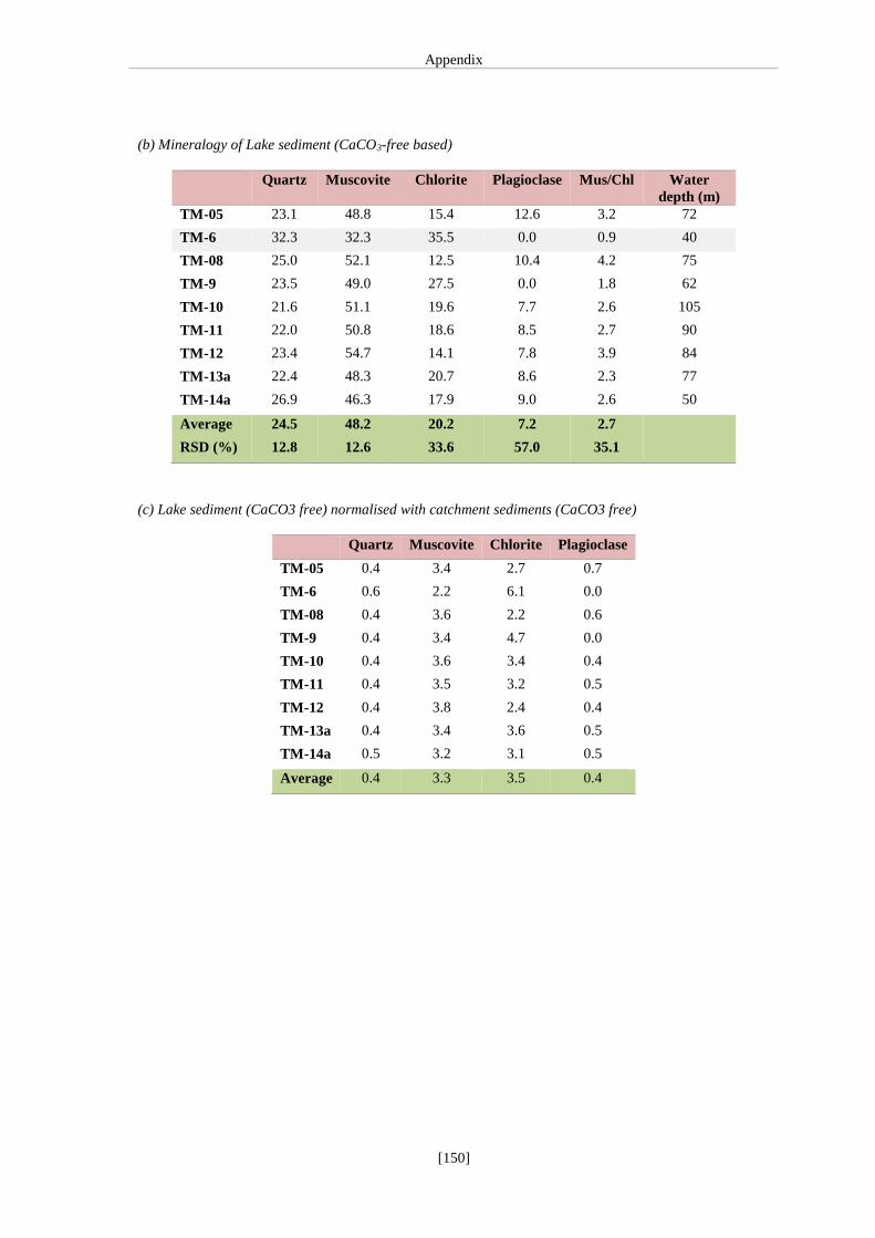
Appendix
[150]
(b) Mineralogy of Lake sediment (CaCO3-free based)
Quartz Muscovite Chlorite Plagioclase Mus/Chl Water
depth (m)
TM-05 23.1 48.8 15.4 12.6 3.2 72
TM-6 32.3 32.3 35.5 0.0 0.9 40
TM-08 25.0 52.1 12.5 10.4 4.2 75
TM-9 23.5 49.0 27.5 0.0 1.8 62
TM-10 21.6 51.1 19.6 7.7 2.6 105
TM-11 22.0 50.8 18.6 8.5 2.7 90
TM-12 23.4 54.7 14.1 7.8 3.9 84
TM-13a 22.4 48.3 20.7 8.6 2.3 77
TM-14a 26.9 46.3 17.9 9.0 2.6 50
Average 24.5 48.2 20.2 7.2 2.7
RSD (%) 12.8 12.6 33.6 57.0 35.1
(c) Lake sediment (CaCO3 free) normalised with catchment sediments (CaCO3 free)
Quartz Muscovite Chlorite Plagioclase
TM-05 0.4 3.4 2.7 0.7
TM-6 0.6 2.2 6.1 0.0
TM-08 0.4 3.6 2.2 0.6
TM-9 0.4 3.4 4.7 0.0
TM-10 0.4 3.6 3.4 0.4
TM-11 0.4 3.5 3.2 0.5
TM-12 0.4 3.8 2.4 0.4
TM-13a 0.4 3.4 3.6 0.5
TM-14a 0.5 3.2 3.1 0.5
Average 0.4 3.3 3.5 0.4


List of Publications
[152]
List of Publications
Peer reviewed
Mishra, Praveen, K., Prasad, S., Anoop, A., Plessen, B., Jehangir, A., Gaye, B.,
Menzel, P., Weise, S. M., Yousuf, A. R., 2015. Carbonate isotopes from high
altitude Tso Moriri Lake (NW Himalayas) provide clues to late glacial and
Holocene moisture variability and atmospheric circulation changes.
Palaeogeography, Palaeoclimatology, Palaeoecology 425, 76-83.
Mishra, Praveen, K., Anoop, A., Schettler, G., Prasad, S., Jehangir, A., Menzel,
P., Naumann, R., Yousuf, A.R., Basavaiah, N., Deenadayalan, K., Wiesner,
M.G., B. Gaye, B., 2015. Reconstructed late Quaternary hydrological changes
from Tso Moriri Lake, NW Himalaya. Quaternary International 371, 76-86.
Menzel, P., Gaye, B., Mishra, Praveen, K., Anoop, A., Basavaiah, N., Marwan,
N., Plessen, B., Prasad, S., Riedel, N., Stebich, M. Wiesner, M.G., 2014. Linking
Holocene drying trends from Lonar Lake in central India to North Atlantic
cooling events. Paleoclimatology Paleoecology Paleogeography. doi:
10.1016/j.palaeo.2014.05.044
Mishra, Praveen, K., Anoop, A., Jehangir, A., Prasad, S., Menzel, P., Schettler,
G., Naumann, R., Weise, S., Anderson, N., Yousuf, A. R., Gaye, B., 2014.
Limnology and modern sedimentation patterns in high altitude Tso Moriri Lake,
NW Himalaya – implications for proxy development. Fundamental of Applied
Limnology 185, 325-348.
Conference proceedings
Mishra, Praveen K., Prasad, S., Anoop, A., Menzel, P., Jehangir, A., Plessen,
B., Naumann, R., Gaye, B., Yousuf, A.R.. Mineralogical and isotopic data
provide clues to climate change during the late Quaternary – a case study from
Tso Moriri Lake, NW Himalaya (India). General Assembly European
Geosciences Union (Vienna, Austria 2014).
Mishra, Praveen K., Dietze, E., Schettler, G., Anoop, A., Menzel, P., Gaye, B.,
Jehnagir, A., Prasad, S. Multiproxy Investigations on Tso Moriri Lake, Indian

List of Publications
[153]
Himalayas provide clues to climate controlled lake level changes. Fall Meeting,
AGU, San Francisco, Calif., American Geophysical Union (AGU)-2013.
Mishra, Praveen, K., Dietze, E., Schettler, G., Plessen, B., Anoop, A., Menzel,
P., Gaye, B., Jehangir, A., Wiesner, S., Prasad, S. Multiproxy Investigations on
Tso Moriri Lake, Indian Himalayas – regional climate or a global signal ? 28th
Himalayan Karakorum Tibet workshop & International Symposium on Tibetan
Plateau (Tübingen, 2013).
Mishra, Praveen K., Anoop, A., Menzel, P., Gaye, B., Basavaiah, N., Jehangir,
A., Prasad, S., 2013. Holocene Climatic Variability in the Indian Monsoon
Domain. General Assembly European Geosciences Union (Vienna, Austria
2013).
Mishra Praveen, K., Anoop, A., Menzel, P., Basavaiah, N., Gaye, B.,
Wiesner, M. G., Riedel, N., Stebich, M., Brauer, A., Prasad, S. Holocene
climate variability in the Indian Subcontinent. GV & Sediment Meeting,
Hambug, Germany (23-28, Sep, 2012).