las vegas wash wildlife management planlas vegas wash wildlife management plan 3 management...
TRANSCRIPT

Las Vegas Wash Las Vegas Wash Wildlife Management Plan Wildlife Management Plan
Las Vegas Wash Coordination Committee
March 2008

Las Vegas Wash Wildlife Management Plan
SOUTHERN NEVADA WATER AUTHORITY Las Vegas Wash Project Coordination Team
Prepared for:
Las Vegas Wash Coordination Committee
Prepared by:
Seth A. Shanahan1, Deborah M. Van Dooremolen1, Thomas Sharp2, Spencer Martin2, Bryan Brown3
1Southern Nevada Water Authority
Las Vegas Wash Project Coordination Team 100 City Parkway, Suite 700
Las Vegas, Nevada 89109
2SWCA, Environmental Consultants 257 East 200 South, Suite 200
Salt Lake City, Utah 84111
31015 South 1400 East Salt Lake City, Utah 84105
March 2008

ii
ACKNOWLEDGEMENTS
We would like to thank the U.S. Bureau of Reclamation for providing funding to the Southern Nevada Water Authority under assistance agreement numbers 06FG300009 and 06FG300035 for the preparation of this document. Thanks to John Kanlund, Marissa Foster, and Tim Ricks for preparing the natural history accounts that are posted on the www.lvwash.org website and to Patty Emery for document formatting. We would like to thank David Bradford, Cris Tomlinson, Polly Conrad, Theresa Olson, Larry Neel and the members of the Research and Environmental Monitoring Study Team and Management Advisory Committee for reviewing this document and the Las Vegas Wash Coordination Committee for their continued support for this project and the implementation of the Las Vegas Wash Comprehensive Adaptive Management Plan.

iii
Las Vegas Wash Wildlife Management Plan
Table of Contents
Page No. Acknowledgements......................................................................................................................... ii Table of Contents........................................................................................................................... iii List of Tables ...................................................................................................................................v List of Figures ..................................................................................................................................v List of Acronyms and Abbreviations............................................................................................. vi List of Appendices ........................................................................................................................ vii 1.0 INTRODUCTION...................................................................................................................1
1.1 Purpose and Scope ......................................................................................................1 1.1.1 Relationship to the Nevada Wildlife Action Plan ...................................3
1.2 Management Area.......................................................................................................3 1.3 Management Objectives .............................................................................................5
2.0 OVERVIEW OF THE LAS VEGAS WASH .......................................................................5
2.1 Physical and Natural Setting......................................................................................5 2.2 Human Usage Prior to 1905 .......................................................................................6 2.3 Human Usage After 1905 ...........................................................................................7
2.3.1 Efforts to Restore Ecological Functions...................................................9 3.0 MANAGEMENT CONSIDERATIONS .............................................................................10
3.1 System Complexity....................................................................................................11 3.2 Desired Future Condition.........................................................................................12
3.2.1 Floodplain and Water Quality Features ................................................12 3.2.2 Wildlife Habitats ......................................................................................12 3.2.3 Wildlife Communities ..............................................................................12
3.3 Land Use and Ownership .........................................................................................13 3.4 Current and Planned Activities ...............................................................................16
3.4.1 Erosion Control ........................................................................................16 3.4.2 Clark County Wetlands Park .................................................................17 3.4.3 Alternate Discharge .................................................................................19
3.5 Water Quality............................................................................................................21 3.6 Laws, Regulations, and Statutes ..............................................................................23
4.0 HABITAT TYPES OF THE LAS VEGAS WASH ...........................................................24
4.1 Historical Habitat Types ..........................................................................................24

iv
Page No. 4.2 Current Habitat Types .............................................................................................25
4.2.1 Marshes .....................................................................................................27 4.2.2 Riparian Areas .........................................................................................27 4.2.3 Mesquite Bosques and Desert Washes ...................................................28 4.2.4 Mojave Warm Desert Scrub ...................................................................28
5.0 SUMMARY OF WILDLIFE OCCURRENCES ...............................................................29
5.1 Historical Information..............................................................................................29 5.1.1 Lawson 1961-1971 ....................................................................................29 5.1.2 Bradley and Niles 1973 ............................................................................30 5.1.3 Miller 1974 ................................................................................................31
5.2 Current Information Including Comments about Historical Changes ...............31 5.2.1 Amphibians...............................................................................................32 5.2.2 Birds ..........................................................................................................33
5.2.2.1 Southwestern Willow Flycatcher................................................34 5.2.2.2 Yuma Clapper Rail ......................................................................37 5.2.2.3 Yellow-Billed Cuckoo ..................................................................38 5.2.2.4 Historical Changes in the Status and Abundance of Birds ......38
5.2.3 Fishes .........................................................................................................44 5.2.4 Mammals ..................................................................................................45
5.2.4.1 Small Mammals............................................................................45 5.2.4.2 Large Mammals ...........................................................................47
5.2.5 Reptiles......................................................................................................48 5.2.5.1 Desert Tortoise .............................................................................50
6.0 RECOMMENDED ACTIONS FOR MANAGING WILDLIFE .....................................51
6.1 Conserve Wildlife Abundance and Diversity .........................................................51 6.2 Habitat Protection and Enhancement.....................................................................54 6.3 Increase Environmental Awareness ........................................................................54
7.0 REQUIREMENTS FOR SUCCESSFUL WILDLIFE MANAGEMENT.......................55
7.1 Coordination..............................................................................................................55 7.2 Prioritization .............................................................................................................57 7.3 Research.....................................................................................................................58 7.4 Effectiveness Monitoring..........................................................................................58 7.5 Funding ......................................................................................................................60 7.6 Reporting ...................................................................................................................61 7.7 Adaptive Management..............................................................................................61
8.0 LITERATURE CITED ........................................................................................................63

v
List of Tables Page No.
Table 1. List of the nine study teams that were developed by the Las Vegas Wash
Coordination Committee to address the various issues surrounding the Las Vegas Wash. ...........................................................................................................................11
Table 2. Hierarchy of the National Vegetation Classification System used to describe vegetation types along the Las Vegas Wash................................................................26
Table 3. List of amphibians that were recently and historically documented along Las Vegas Wash ............................................................................................................................32
Table 4. Abundance, frequency and breeding status for the 23 most abundant species detected along Las Vegas Wash by Braden et al. (2007) in 26 census events at 29 points from February 2005 through January 2006 ..........................................................................35
Table 5. Bird species that have been introduced and/or expanded their range to include the Las Vegas Wash within historic times, or are expected to arrive in the near future ..........40
Table 6. Relative abundance of select nesting summer resident birds detected by Miller (1974) compared to that detected by SWCA (2005) with estimated change in bird populations along Las Vegas Wash .............................................................................41
Table 7. Bird species detected by Miller (1974) and Lawson (undated) that appear to have changed status and/or abundance in the Las Vegas Wash...........................................42
Table 8 Nesting summer resident bird species not identified in Tables 5, 6, and 7 but nevertheless suspected to have increased in abundance in the previous century along the Las Vegas Wash due to anthropogenic changes to habitat and hydrology............43
Table 9. List of fishes that were recently and historically documented along Las Vegas Wash ............................................................................................................................44 Table 10. List of small mammals that were recently and historically documented along Las
Vegas Wash. Species are organized by family. Bat names and status follow Bradley et al. (2006) ..................................................................................................................46
Table 11. List of large mammals that were recently and historically documented along Las Vegas Wash .................................................................................................................48
Table 12. List of reptiles that were recently and historically documented along Las Vegas Wash ............................................................................................................................49
List of Figures
Figure 1. Location of the Las Vegas Wash in Clark County, Nevada ..........................................2 Figure 2. General boundary of the wildlife management area ......................................................4 Figure 3. Graph comparing population size and Las Vegas Wash discharge flow from 1905 to
2004................................................................................................................................8 Figure 4. Land ownership within and adjacent to the management area ....................................14 Figure 5. Zoned land uses within and adjacent to the management area ....................................15

vi
Page No.
Figure 6. Locations on and near erosion control structures where woody species should not be planted..........................................................................................................................18
Figure 7. Location of willow flycatcher, southwestern willow flycatcher, Yuma clapper rail, and yellow-billed cuckoo detections within the management area from 1998 to the present ..........................................................................................................................36
Figure 8. Location of desert tortoises documented in and adjacent to the management area .....52
List of Acronyms and Abbreviations
BOR U.S. Bureau of Reclamation CAMP Las Vegas Wash Comprehensive Adaptive Management Plan CCPR Clark County Parks and Recreation CFR Code of Federal Regulations COPC Chemicals of potential concern CWA Clean Water Act CWC Clean Water Coalition DDE Dichloro-diphenyl-dichloroethylene DDT Dichloro-diphenyl-trichloroethane EIS Environmental Impact Statement ESA Endangered Species Act FWS U.S. Fish and Wildlife Service GBBO Great Basin Bird Observatory GIS Geographic Information System LVWCC Las Vegas Wash Coordination Committee MAC Management Advisory Committee MBTA Migratory Bird Treaty Act NEPA National Environmental Policy Act NRS Nevada Revised Statues OHV Off-highway vehicle Project Team Las Vegas Wash Project Coordination Team REM Study Team Research and Environmental Monitoring Study Team SBCM San Bernardino County Museum SCOP Systems Conveyance and Operations Program SNWA Southern Nevada Water Authority Valley Las Vegas Valley Wash Las Vegas Wash Wash CIP Las Vegas Wash Capital Improvements Plan Wetlands Park Clark County Wetlands Park

vii
List of Appendices
Appendix A Clark County Parks and Recreation Rules and Regulations Appendix B List of the Laws, Regulations, and Statutes that were Considered to be Important for
Wildlife Management Appendix C List of Bird Species that were Recently and Historically Detected along the Las
Vegas Wash Appendix D Conclusions of the August 28, 2006, Biological Opinion for Wildlife Habitat
Enhancement Projects in the Management Area

Las Vegas Wash Wildlife Management Plan 1
1.0 INTRODUCTION The Las Vegas Wash (Wash) is the primary stream channel draining shallow groundwater and surface water from the Las Vegas Valley (Valley) in Clark County, Nevada (Figure 1). This channel is an essential component of the Valley’s water resource infrastructure that is relied upon by the nearly two million residents of Southern Nevada. For example, it is the primary conveyance for treated wastewater and stormwater flows from the Valley and it is critically important for this system to be perpetually managed for these purposes. Between the close of the Pleistocene epoch approximately 11,000 years ago and the mid-twentieth century, the Wash was primarily an ephemeral channel incapable of supporting perennial emergent wetlands. From the 1950s to the 1970s, rapid urban development in the Valley resulted in increased stormwater, urban runoff, and treated wastewater discharges that caused the establishment of extensive wetland and riparian areas along the Wash. By the 1980s, increasing base flows and periodic flood flows in the Wash contributed to extensive erosion, as well as loss of wetlands, loss of property, damage to infrastructure, excessive sediment transport to Lake Mead, and water quality degradation (LVWCC 2000). Wildlife and their habitats have also been impacted as the functional attributes of the Wash have changed. 1.1 Purpose and Scope In the late 1990s the Las Vegas Wash Coordination Committee (LVWCC), a collaboration of federal, state, and local agencies, businesses, environmental advocacy groups, and citizens, was formed by the Southern Nevada Water Authority (SNWA). In 2000, the LVWCC drafted the Las Vegas Wash Comprehensive Adaptive Management Plan (CAMP), which was prepared in order to facilitate long-term planning and implementation of actions designed to prevent further degradation of the Wash (LVWCC 2000). As part of the CAMP, various study teams drafted recommendations, or action items, regarding all aspects of Wash management. Channel stabilization and erosion control, public funding and outreach, and wetland establishment and restoration were among the action item topics. The development of a wildlife management plan was one of the CAMP action items recommended by the Environmental Resources Study Team (LVWCC 2000) and it is the purpose of this document to meet that recommendation. The CAMP specifies that a “long-term fish and wildlife management plan” be developed to direct conservation project implementation and to ensure that sufficient information is acquired to successfully manage these biological resources. The CAMP further states that the plan should:
1. Identify specific biological goals. 2. Establish a process for gathering baseline information. 3. Identify sources of disturbance and stress to the fish and wildlife community. 4. Develop a monitoring program. 5. Identify research needs.
Consequently, this plan details a strategy for managing vertebrate wildlife (Phylum Chordata; which includes fish) of the Wash and describes the technical, environmental, and administrative parameters within which management can be accomplished. Each of the five requirements outlined in the CAMP is addressed within the body of this plan. To allow for greater

Las Vegas Wash Wildlife Management Plan 2
Figure 1: Location of the Las Vegas Wash in Clark County, Nevada.

Las Vegas Wash Wildlife Management Plan 3
management flexibility and responsiveness to the ever-changing conditions on the Wash, this document does not identify specific biological goals, rather, it sets forth three general management objectives. These management objectives were approved by the Las Vegas Wash Management Advisory Committee (MAC) members in January 2006 (see Section 2.3.1 for a discussion on the MAC and its relationship to the Las Vegas Valley Watershed Advisory Committee). These objectives form the basis for recommended management actions described herein. Chapters 1-5 provide the context for these recommended actions. Chapter 1 describes the relationship of this plan to the Nevada Wildlife Action Plan, outlines the boundaries of the management area covered by this document, and presents the statement of management objectives. Chapter 2 provides an overview of the Wash including an abbreviated history of human activity in the area. Chapter 3 discusses general and specific considerations that must be addressed to effectively manage wildlife resources in the Wash. Chapters 4 and 5 compile historical and current data on wildlife occurrences and habitats of the Wash, and explore the effects of the changing ecological environment on target species. Chapter 6 contains specific management recommendations and suggestions for implementation. Finally, Chapter 7 illustrates the steps needed to successfully manage wildlife.
1.1.1 Relationship to the Nevada Wildlife Action Plan The State of Nevada prepared the Nevada Wildlife Action Plan (Wildlife Action Plan Team 2006) to guide wildlife conservation programs and funding in the state. This plan targets key habitats and species of concern and develops a series of strategies for conserving species in the key habitats. Four of the key habitats that are listed in the Comprehensive Wildlife Conservation Strategy are found along the Wash, as are several species of conservation priority. Although this plan was prepared to meet the specific management goals described below, it is the hope of the authors that this plan can also be used to help achieve Nevada’s wildlife conservation goals. 1.2 Management Area This plan was developed to manage wildlife resources within the management boundary of the MAC. This boundary is defined in the Las Vegas Wash Cooperative Agreement (2002) as the area between the City of Las Vegas Water Pollution Control Facility discharge point and the National Park Service boundaries within the riparian areas supported by flows in the Wash. For the purposes of this plan, the management area is expanded to include the adjacent upland drainages because of the connectivity that they provide for the wildlife and habitat resources near the Wash. The management area also includes the Clark County Wetlands Park (Wetlands Park; Figure 2), an approximately 2,900 acre area. This management plan is intended to be applied to federally or municipally owned land and to private property for which permission to carry out activities has been obtained, and thus does not directly or indirectly affect the rights of private property owners within the management area boundaries. Within this document, the management area as defined above is referred to as either the “Wash” or simply as the “management area”. Although this plan was specifically prepared for the defined area, the recommendations described in this document could also be used to manage wildlife in the adjoining reaches of the Wash (Figure 1).

Las Vegas Wash Wildlife Management Plan 4
Figure 2: General boundary of the wildlife management area.

Las Vegas Wash Wildlife Management Plan 5
1.3 Management Objectives In order to effectively manage wildlife within the specified area, management objectives were first identified. These objectives steer the direction of this plan and the management recommendations put forth in Chapter 6 are designed to help achieve these objectives. The management objectives were developed and approved by the Research and Environmental Monitoring (REM) Study Team, the study team tasked with ensuring biological resource-related action items outlined in the CAMP are carried out. After this approval, the management objectives were further approved in January 2006 by the MAC, the group that provides oversight and funding for LVWCC programs. The intention of this plan is not to diminish the flexibility of using the Wash as a conveyance for wastewater and stormwater; rather, the management objectives for this plan are as follows:
While considering the changes that may occur to the Wash in time, the objectives of this wildlife management plan are to conserve the abundance and diversity of native wildlife species that have been found along the Wash, protect and enhance wildlife habitats, and increase environmental awareness of these resources in the community.
The first tenet of this wildlife management plan is to conserve the abundance and diversity of native species that have been found along the Wash. This objective is not intended to manage the naturally occurring spatiotemporal changes in species abundance and diversity. Also, native species are those species that are native to the state of Nevada and have historically been found within the management area. 2.0 OVERVIEW OF THE LAS VEGAS WASH 2.1 Physical and Natural Setting The Wash is located in the southeast portion of the Valley in Clark County, Nevada (Figure 1). It is the primary drainage channel for the Valley (approximately 1,600 square miles) with perennial flows extending from Vegas Valley Drive for approximately 12 miles to Las Vegas Bay, at which point it empties into Lake Mead (LVWCC 2000), a reservoir on the lower Colorado River. The Valley is characterized as a relatively low-lying alluvium-filled valley surrounded by several steep mountain ranges. Much of the area between the Valley floor and the mountains consists of moderately sloped alluvial fan piedmont areas. The topography of the Valley trends generally west-to-southeast and consists of several tributaries, all of which drain into the Wash. The Valley, a hydrographic basin, is within the Basin and Range physiographic province and is surrounded by both large (i.e., the Spring Mountains to the west and Sheep Range to the north) and small mountain ranges (i.e., from east to south, the Muddy Mountains, the Black Mountains, and McCullough Range). The maximum elevation is more than 11,900 feet at Charleston Peak in the Spring Mountains, and the minimum elevation is approximately 1,500 feet at the southeastern edge of the Valley (Speck 1982). The geologic sediments of the Valley consist of erodible silts and clays with minor amounts of sand and gravel.
The Valley is in the hot, dry climate of the eastern Mojave Desert and temperatures fluctuate widely in the course of a year. According to records from 1971 through 2000, average low

Las Vegas Wash Wildlife Management Plan 6
temperatures were below 40°F during winter nights, and average high temperatures reached 104°F during summer days (National Oceanic and Atmospheric Administration 2005). Annually, the Valley averages less than five inches of rain and more than 250 days of sunshine. Although annual precipitation is low, flooding usually occurs in late summer (July through September) as a result of short but intensive storm events. The Valley rarely sees snow in the winter, but in the surrounding mountains as much as ten feet of snow may accumulate (National Oceanic and Atmospheric Administration 2005).
The Valley is located within a regional ecological province described by Bailey (1983) as Semi-Deserts and Deserts of Continental Climate. The province is within the Temperate Desert Division of the Dry Domain. Brown et al. (1998) prepared a similar ecological description of North American biotic communities as Bailey (1983), however, their geographic resolution is more detailed. Brown et al. (1998) described the Valley as part of the Mojave Desert Scrub of the broader Warm Temperate Desertlands classification. These areas are generally described by the following characteristics:
1. Arid climates. 2. More than 50% of the ground may lack vegetation cover. 3. Short freezing periods. 4. Potentially greater than 200-day growing season. 5. Characterized by the two most dominant plants observed, creosote bush (Larrea
tridentata) and white bursage (Ambrosia dumosa).
Bradley and Deacon (1965) prepared the most comprehensive description of the biotic communities found in Southern Nevada, with specific reference to the Wash. Bradley and Deacon (1965) classified the Wash as part of the Stream and Stream Riparian communities. These communities are also found along the Colorado River, Virgin River, Muddy River, and Meadow Valley Wash. Streamside vegetation typically found in these communities consists of trees such as Fremont cottonwoods (Populus fremontii), willows (Salix spp.), and salt cedar (Tamarix ramosissima), shrubs such as arrowweed (Pluchea sericea) and seep willow (Baccharis salicifolia), and grass-like plants such as cattails (Typha spp.) and tules (Schoenoplectus acutus). Bradley and Deacon (1965) list more than 230 vertebrates that are found in Stream and Stream Riparian communities. Only one other community, the Desert Springs and Marshes community, has greater vertebrate species richness.
Historical disturbance along the Wash has resulted in an increase in invasive species (Bickmore 2003) and a substantial change in native wetland and riparian habitats (LVWCC 2000). Two hundred species of birds, though fewer than in decades past, continue to use the remaining cover types as habitat (Appendix C). Nearly 70 mammal, reptile, amphibian, and fish species also use habitats within the management area (Pollard et al. 2002, Shanahan 2005, Shanahan 2005a, O’Farrell and Shanahan 2006, Larkin 2006, Rice 2007).
2.2 Human Usage Prior to 1905 There are several records of humans using the Wash prior to the modern settlement of Las Vegas in 1905. Prehistoric archaeological evidence suggests that humans have occupied the Valley for at least the last 11,000 years, since the end of the Pleistocene epoch. During this period, the Valley was much wetter with wetlands presumably occurring extensively at present day Indian Springs, Corn Creek Springs, Tule Springs, and along Las Vegas Creek (LVWCC 2000).

Las Vegas Wash Wildlife Management Plan 7
Although prehistoric usage of the Wash increased approximately 5,000 years ago, the post-Pleistocene climatic warming trend led to increased aridity of many of the Valley's channels and established the Wash as a dry, desert channel of intermittent flow. Prehistoric human usage of the Wash likely included some limited farming and horticulture (Roberts pers. comm.), but it was not until the arrival of European explorers like Antonio Armijo who visited the Wash between 1829 and 1830 that the Wash started to become more heavily used. Although Armijo was the first documented European explorer to travel through the Wash, others also used the Wash including Mormon missionaries in the 1850s, Lt. Joseph Ives in 1857-1858, and early ranchers/farmers, such as the Gass, Kiel, and Stewart families (von Till Warren et al. 2006).
2.3 Human Usage After 1905 Since 1905, residents of the Valley farmed, ranched and mined, and commerce was conducted mostly at a local or regional level. The establishment of the San Pedro, Los Angeles, and Salt Lake City railroads among others between 1900 and 1905 signaled the beginning of major land speculation and development and Las Vegas’ role as a major national city (LVWCC 2000). Major events of the first half of the twentieth century invariably resulted in more and more people moving to the Valley. These events include the construction of Hoover Dam in the 1930s, the mining boom and military weapons testing associated with World War II, and the rise of the entertainment and gaming industries in the 1950s. As the population in the Valley increased, flows in the Wash increased (Figure 3). The proliferation of impermeable surfaces such as roads, sidewalks, homes, and commercial buildings contributed increased urban runoff and stormwater flows to the Wash. Today, approximately ten percent of the flow is from urban runoff and shallow groundwater. By the 1950s, the population of the Valley was large enough to require new and improved sanitation infrastructure. This led to the construction of wastewater treatment facilities, which were designed to discharge into the Wash. The increasing volume of treated discharge finally turned the Wash into a channel with perennial flow (LVWCC 2000). Wetlands and riparian habitat expanded along the Wash corridor and had the added benefit of filtering the water as it passed through the Wash. In 1950, population in and around Las Vegas was approximately 47,000. The current population of Clark County is more than two million and growing rapidly. Essentially, the Valley's population has doubled every decade since 1950. Approximately 6,000 new residents move to Clark County each month, making Southern Nevada one of the fastest growing areas in the nation (Hardcastle 2006). The area is experiencing similar challenges as other major metropolitan areas, which are compounded by water quality and water availability issues characteristic of desert cities in the western U.S. The Wash, with its high conveyance of water (approximately 170 million gallons per day), exists in its present capacity as a consequence of urban population growth in the Valley (LVWCC 2000). The Wash is also the final link in the Valley’s water supply, as its discharge point, Lake Mead, is also the primary source of the Valley's drinking water. The Wash contributes less than 2% of the water in Lake Mead and approximately 85% of the Wash’s daily flows are comprised of highly treated wastewater (LVWCC 2000). Sediments from erosion are also carried by water in the Wash and deposited into Lake Mead.

Las Vegas Wash Wildlife Management Plan 8
0
50
100
150
200
250
300
1900 1910 1920 1930 1940 1950 1960 1970 1980 1990 2000
Year
Me
an
an
nu
al
str
ea
m f
low
(c
ub
ic f
ee
t p
er
se
co
nd
)
0
100,000
200,000
300,000
400,000
500,000
600,000
700,000
800,000
900,000
1,000,000
1,100,000
1,200,000
1,300,000
1,400,000
1,500,000
Po
pu
lati
on
Stream flow
Population
Figure 3: Graph comparing population size and Las Vegas Wash discharge flow from 1905 to 2004.
By 1969, stream flow had increased to the point that parts of the Wash began to erode. Headcutting (i.e., the upstream migration of channel bed erosion) first began at roadway culverts in the lower portions of the Wash while upstream areas had intact flourishing wetland and riparian habitats. By the 1980s, headcutting was quickly advancing upstream, and other portions of the Wash became subject to erosion. Also in the 1980s and 1990s, annual flash flood events typical of the climate, and which the Wash had conveyed successfully for thousands of years, were worsening erosion of the increasingly unstable Wash and removing riparian vegetation (LVWCC 2000). The extensive wetlands that had developed as a result of treated wastewater flows and which were providing water quality benefits to these shallow flows were replaced by a deep fast channel that aerated the water but provided little filtration. Through the end of the twentieth century, degradation of the Wash continued.

Las Vegas Wash Wildlife Management Plan 9
2.3.1 Efforts to Restore Ecological Functions Concurrent with the development of water resource management infrastructure in the last 30 years (e.g., bridges, dams, drinking water treatment plants, wastewater treatment plants, erosion control structures, etc.), numerous committees and agencies were formed to oversee and negotiate the characteristics, preservation, use, and reuse of the Valley's water supply. Among these groups were the Sewage and Wastewater Advisory Committee, Water Quality Study Board, Las Vegas Valley Water Quality Program, Clark County Regional Flood Control District, and others (LVWCC 2000). None of these groups could fully manage the increasing water resource issues of the Wash. Concerned citizens, as well as water and land management agencies and groups, attempted to address the severe degradation of the Wash and its effects on the environment and human population as soon as it became evident that the erosional trend was not going to reverse itself. In the 1970s, one of the first groups to take action was the Wash Development Advisory Committee. This group collaborated with Clark County Parks and Recreation (CCPR) and established a task force in the 1980s. Clark County established various management plans during this time in an attempt to preserve the Wash (LVWCC 2000).
In 1991, Nevada voters passed a bond measure funding the development of the Wetlands Park, which encompasses a portion of the Wash and adjacent wetland, riparian, and upland areas. The subsequent Wetlands Park Master Plan (Southwest Wetlands Consortium 1995) recommended the construction of erosion control structures in the Wash channel to deter erosion and decrease sediment loading, recognizing that a stabilized Wash was necessary for park development.
By the mid 1990s, several groups had been formed to deal with specific water resource issues, such as urban water quality and the ecological functioning of the Wash. In 1997, the Water Quality Citizens Advisory Committee was established by SNWA to evaluate water quality concerns within the Valley watershed. By 1998, this group had identified the Wash as an area of concern and recommended that SNWA form the LVWCC. The LVWCC comprises municipal, county, state, and federal agencies, members of the community, businesses, and environmental groups with an interest in the Wash (LVWCC 2000). The LVWCC quickly identified goals for managing the Wash and nine teams were established to evaluate and study Wash-related issues and to develop action items needed to meet the specified goals.
Less than two years after the LVWCC was formed, the CAMP was prepared. The CAMP is the primary document detailing management strategies for restoring and protecting the ecological functions of the Wash. Commonly, the term “ecological restoration” is defined as the process of assisting the recovery of an ecosystem that has been degraded, damaged, or destroyed (Society for Ecological Restoration International Science and Policy Working Group 2004). Furthermore, ecological functions are defined as the processes that take place within an ecosystem. Some of the important ecological functions of the Wash include stormwater conveyance and retention, water quality polishing, wildlife habitats, and opportunities for recreational enjoyment. The CAMP recognized that erosion was degrading several ecological functions of the Wash and it identified a process to reverse this trend. This strategy is described in the CAMP as a list of “action items” and they include stabilizing the Wash and monitoring for water quality and biological resources.

Las Vegas Wash Wildlife Management Plan 10
To facilitate action item implementation, SNWA, Clark County, Clark County Regional Flood Control District, Clark County Water Reclamation District, City of Henderson, City of Las Vegas, and the City of North Las Vegas entered into a cooperative agreement in 2002 to form the MAC. In 2006, the Clean Water Coalition (CWC) was added to the MAC as a non-voting member. In late 2007, the MAC was reorganized to form the Las Vegas Valley Watershed Advisory Committee (LVVWAC); however, since the duties of the MAC are consistent with the duties of the newly created LVVWAC, the term MAC is used herein for the purposes of historical continuity. The MAC was originally formed to effectuate long-term stabilization, enhancement, and management of the Wash. Importantly, the goals of the CAMP and the MAC are not to restore the magnitude of ecological functions that were observed at a previous point in time in the Wash. For example, the 2,000 acres of wetlands that were documented in the 1970s will not be restored. Rather, the intent of ecological restoration along the Wash is to correct the disequilibrium that has been caused by erosion. This would allow the system to have a new steady-state, not some previously observed steady-state. Annually, the MAC approves a detailed budget of activities that are conducted to meet the goals of the CAMP.
Since the LVWCC completed the CAMP, several on the ground activities have been completed to restore ecological functions to the Wash (LVWCC 2002, 2003, 2004, 2005, 2006, in prep.). These accomplishments include the construction of 10 erosion control structures of the 22 planned, planting more than 175 acres with native species, and removing approximately 200 acres of invasive species.
3.0 MANAGEMENT CONSIDERATIONS
The Wash, as degraded as it has become in recent decades, continues to be crucial not only to the ecology of the Valley but also to the large and growing human population in the Valley. Its role as a major riparian and water conveyance corridor will not lessen or disappear in the foreseeable future. The Wash will continue to be subject to varying flows, and to a lesser extent, varying water quality because of its use as a water conveyance corridor. A successful wildlife management plan will need to be adaptable to accommodate a wide range of flows through the Wash. For these reasons, before wildlife or any other restorative management actions can be successfully implemented, stabilization (as outlined in the CAMP; LVWCC 2000) must be accomplished to effectively halt the degradation of the Wash. Because the implementation of stabilization strategies over the last seven years has altered and will continue to alter the physical condition of the Wash, management objectives developed for wildlife and their habitats in this area must be flexible in order to accommodate these changes. For example, maintaining erosion control structures and bank protection facilities along the Wash may at times result in the loss of wildlife habitat. Yet, these structures provide a critical foundation for the habitat that exists within the channel and along its banks, and their continued maintenance is necessary in order to protect wildlife and their habitats over the long-term. The Wash, wildlife, and hydrophytic vegetation will need to be adaptable to changing flow conditions in order to establish a functional equilibrium. As outlined in the CAMP (LVWCC 2000), various action items will target specific functions of the Wash, and as many of these action items are being conducted simultaneously, the cumulative result will be a constant state of change (likely some of it unforeseen) in the Wash during its restoration. For this reason, and as explained further below, accomplishing the wildlife management objectives would be best conducted using adaptive strategies.

Las Vegas Wash Wildlife Management Plan 11
Study Team Topics Addressed Erosion and Stormwater (later known as Operations)
Effects of erosion, flood control, and engineering erosion control structures.
Shallow Groundwater Monitoring wells, water quality, and historical land use.
Alternate Discharge Alternate discharge options and implementation of options.
Clark County Wetlands Park Water resources needed to sustain the park, monitoring, funding, and interagency coordination.
Environmental Resources (later known as Research and Environmental Monitoring)
Water quantity and quality, soils, vegetation, fish and wildlife, and cultural resources.
Land Use Zone of influence, environmental review process, and education of developers.
Jurisdictional and Regulatory Local oversight, jurisdictional structure, and interagency coordination.
Public Outreach (later known as Administrative)
Implementing public outreach programs, generating interest, participation, and feedback, and communicating with elected officials.
Funding (later known as Administrative)
Existing, future, and potential funding sources, future funding needs, and mechanisms for continued funding.
Table 1: List of the nine study teams that were developed by the Las Vegas Wash Coordination Committee to address the various issues surrounding the Las Vegas Wash.
3.1 System Complexity As a human-made perennial stream in the dry Mojave Desert and the outflow of the Las Vegas Valley watershed, the Wash is a critical resource. Thus, any project attempting to alter the Wash must be complex, due not only to ecological factors but also geophysical, industrial, political/institutional, and economic factors. For example, in preparation of the CAMP, the LVWCC established nine study teams (Table 1) so that the complexities that surround the Wash could be adequately addressed (LVWCC 2000). Of these original study teams, three of them still meet regularly to address issues: the REM, Administrative, and Operations Study Teams. The multitude of topics evaluated by the LVWCC study teams and the action items that were included in the CAMP demonstrate that management of the Wash system is complex (LVWCC 2000). Moreover, the condition of the Wash and its wildlife resources at any given point in time will be affected by these external complexities. To simplify these complexities, this plan uses an adaptive management approach to help with decision making. Using an adaptive process for managing wildlife in the Wash will encourage better decision making because this process requires that both predictable and stochastic conditions inform future decisions.

Las Vegas Wash Wildlife Management Plan 12
3.2 Desired Future Conditions 3.2.1 Floodplain and Water Quality Features In order to plan for successful and sustainable management of wildlife along the Wash, it is important to identify the desired future conditions of the Wash ecosystem. As was recommended in the CAMP and is currently being implemented, channel bed and bank stabilization structures must first be constructed to prevent headcutting and bank erosion. These projects will both prevent floodplain habitat loss and contribute to the development of functionally superior replacement habitats as native plants are used during revegetation projects. Implementation of the Systems Conveyance and Operations Program (SCOP) will generally provide for reduced and more stable flow conditions in the Wash. Diurnal flow fluctuations that now have a peak flow that is 2.3 times the low flow will be nearly constant throughout the day. However SCOP needs for maintenance, emergencies, and management of water quality may occasionally cause flows that could vary between 400 and 900 cubic feet per second. These variations are still orders of magnitude smaller when compared with 100 year flood flows that could approach 20,000 cubic feet per second. A successful wildlife management plan will need to accommodate these conditions. The following list represents the future floodplain and water quality conditions desired along the Wash:
Predictable and consistent base flow. 0.05% to 0.15% channel slopes (down from 0.20-0.80% slopes). A stable low velocity channel (below eight cubic feet per second) that maintains
streambed stability and precludes headcutting. Stable stream banks. Sediment carrying capacity in equilibrium (i.e., sediment amount entering the system is
equal to the amount of sediment leaving the system). Predictable water temperatures, chemistry, and dissolved oxygen levels associated with
daily in-stream flows, wastewater flows, and stormwater flows. 3.2.2 Wildlife Habitats Once the floodplain is stabilized and water quality conditions in the Wash are relatively predictable, vegetation and habitat losses in and adjacent to the channel should be prevented. At minimum, the desired future conditions for vegetated and unvegetated wetland, riparian, and upland habitats are as follows:
Self sustaining habitats consisting of native plants. Mosaics of open water, shallow water, mudflats, and emergent vegetation in weir
impoundments. Habitats of variable physiognomy and floristic diversity. Large patches of unfragmented habitats.
3.2.3 Wildlife Communities The Wash in its current state is a perennial flowing stream that attracts a diversity of water-dependent wildlife. Obvious species of wildlife that benefit from these waters include fish and

Las Vegas Wash Wildlife Management Plan 13
several species of birds that forage in aquatic habitats. Although humans inadvertently created the modern hydrology of the Wash, future human usage may negatively impact the wildlife communities that are now dependent on this resource. For this reason, it is important to balance human and wildlife needs sustainably.
Observable changes in the diversity and abundance of wildlife and their habitats have occurred along the Wash since flows first became permanent in the 1950s. Often these changes were a result of anthropogenic activities; however, some changes occurred as a result of stochastic processes (i.e., flooding). Because channel and lateral erosion have decreased the extent of the active floodplain, riparian and wetland habitats are less extensive than in the past. Therefore, wildlife management along the Wash should not attempt to fully recreate community attributes or extents that were observed during historical periods. Rather, management efforts should focus on improving the quality of wildlife communities that currently occur or will occur under future management scenarios (see Section 3.4.3 for a discussion of how SCOP may alter existing flow conditions). Desired future conditions for the wildlife communities of the Wash are as follows:
Native wildlife communities of high richness and abundance (i.e., diversity). The re-appearance of native wildlife that were historically observed. The reduction of exotic and destructive wildlife of management concern.
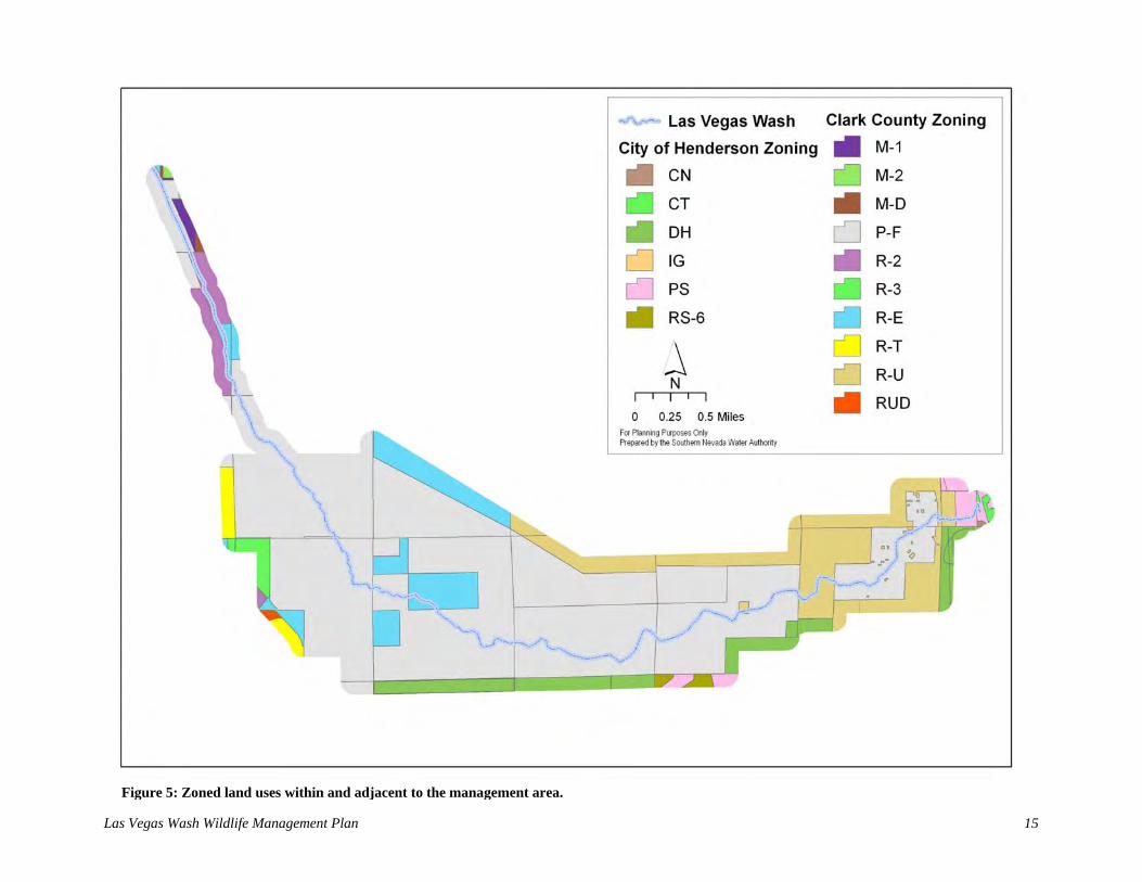
3.3 Land Use and Ownership The management area encompasses lands owned by private and public entities with CCPR and the U.S. Bureau of Reclamation (BOR) owning or administering most of the land (Figure 4). Moreover, CCPR hopes to purchase private in-holdings on a willing seller-willing buyer basis so that they can easily develop the Wetlands Park. Ancillary land ownership includes federally owned parcels to the north and privately, municipally, and federally owned parcels to the west, south, and east. Although land ownership within the management area is relatively secure, privately owned parcels do exist. Therefore, direct wildlife management actions that would require access to private property (e.g., improving habitats by removing exotic species and replacing them with native species) would need to be approved by the landowner. This management plan, therefore, is only intended to be applied on the portions of the management area that are federally or municipally owned and to private property for which permission to carry out activities has been obtained, and thus does not directly or indirectly affect the rights of private property owners within the management area boundaries. Future changes in ownership, however, may affect the implementation of wildlife management actions. Land use in the management area includes uses that are zoned by Clark County and the City of Henderson. Designated land uses (i.e., zoning) include public facilities (P-F), public/semipublic (PS), rural open land (R-U), designated holding (DH), medium density residential (R-2), multiple-family residential (R-3), rural estates residential (R-E), manufactured home residential (R-T), residential urban density (RUD), general industrial (IG), industrial (M-2), light manufacturing (M-1), and designed manufacturing (M-D; Figure 5). The residential zoning in adjacent areas has implications for the successful management of Wash wildlife. Several residential housing tracts now adjoin the boundary of the management area. Thus, there is likely to be an increase in domestic animals (e.g., dogs and cats) entering the area.

Las Vegas Wash Wildlife Management Plan 14
Figure 4: Land ownership within and adjacent to the management area.
Las Vegas Wash Wildlife Management Plan 15
Figure 5: Zoned land uses within and adjacent to the management area.

Las Vegas Wash Wildlife Management Plan 16
Unleashed animals could pose a threat to the wildlife in the Wash. Unleashed dogs have been observed entering the Wash and chasing birds (Van Dooremolen pers. obs.), and domestic and feral cats are known to hunt and kill wild birds. Conversely, Wash wildlife could also harm free-roaming pets. For example, coyotes are fairly common and could easily injure domestic cats that enter the management area. Besides the zoned land use designation, there are numerous other uses of the management area. The area is used extensively for authorized (see Wetlands Park Master Plan [Southwest Wetlands Consortium 1995]) and unauthorized activities (Appendix A). Some examples of authorized activities include hiking, riding horses, biking, and bird watching. Unauthorized activities include illegal off-highway vehicle (OHV) usage, dumping garbage, homeless encampments, shooting, and fishing among others. OHV usage is particularly problematic since historical OHV use in adjacent upland areas has resulted in a fragmented landscape of denuded vegetation and compacted soils. Besides erosion, unauthorized uses have resulted in the most extensive and chronic degradation of wildlife habitats along the Wash. Therefore, wildlife management planning must closely consider the consequences of both authorized and unauthorized uses. 3.4 Current and Planned Activities There are several current and planned activities for the Wash that may affect wildlife management decision making. The CAMP outlined several activities that should be implemented immediately and several of these activities are already underway. Some of these actions include stabilizing the Wash by installing erosion control structures, participating in and supporting planning activities for alternate wastewater discharge options, developing the Wetlands Park, and monitoring water quality conditions. The first item has already resulted in a physical alteration of the landscape and therefore must be considered critically. The following subsections discuss the physical and ecological changes that are likely to occur because of these activities. 3.4.1 Erosion Control Periodic flooding from the Valley can cause changes in the aquatic habitats of the Wash by eroding the bank and bottom of the stream channel and redistributing sediments downstream. Some flood flows are destructive enough to uproot emergent marsh and riparian vegetation from the stream channel and adjacent floodplain. Valuable bird habitat (e.g., emergent and open water areas, sandbars, mudflats, and riparian shrubs and trees) may be gained or lost during these flood events. Fortunately, erosion control structures are being built along the Wash to reduce the destructive results of flooding. Channel stabilization is one of the most important management actions recommended by the CAMP. To facilitate meeting this action item, SNWA prepares the Las Vegas Wash Capital Improvements Plan (Wash CIP) annually, and in it, a detailed description of future activities is outlined. Several topics are addressed in the Wash CIP including a general description and location of each planned facility, anticipated construction schedules, estimated costs, proposed funding mechanisms and forecasts, and a listing of SNWA operated and maintained facilities. The goals of the construction projects in the Wash CIP include promoting channel stabilization by decreasing channel bed downcutting, reducing stream bank erosion, armoring the channel

Las Vegas Wash Wildlife Management Plan 17
with vegetation, balancing sediment transport, and enhancing the ecosystem (SNWA 2003, 2004, 2005, 2006). In total, 22 erosion control structures (weirs) are planned for the Wash, and as of 2007, 10 weirs have been constructed. As sections of the channel are stabilized, riparian and wetland habitats are able to develop both naturally and through revegetation efforts (Kloeppel et al. 2006). Wetland habitats, for example, commonly form in the large water impoundments that are created by the weirs. Concomitant increases in riparian habitats are also created since weirs laterally expand the base flow floodplain. Moreover, weir construction has the added benefit of removing undesirable and invasive species, which meets weed management objectives for the Wash (Bickmore 2003) and further improves wildlife habitat quality. Since many of the weir structures are made of rock material, rock may be redistributed downstream of the weir during massive flood events causing the impounded water elevation to decline. Lowering surface water elevations may cause shifts in the types of plants that occur in the impoundment. This has already been observed at the temporary Demonstration Weir, where flooding has caused a decline in impounded surface water elevation and thus a shift from high quality (i.e., cattail dominated) to low quality (i.e., common reed dominated) wildlife habitats. Generally, weir construction will positively affect the distribution of wetland and riparian wildlife habitats. However, woody species should not be planted on the weir or in a portion of the upstream impoundment to ensure proper weir functioning (Figure 6). Woody species are problematic in these areas because they are inflexible and would contribute to an uneven distribution of flood flow across the weir crest. Uneven flood flows result in concentrated flows across the weir face and therefore higher erosion potentials. Because weir maintenance activities will periodically remove woody riparian species, wildlife habitats that depend on woody vegetation are ephemeral in these areas. The Wash CIP forecasts that the erosion control program will require several more years to be fully completed. Although these activities will initially promote the development of native wetland and riparian habitats, habitat extents may change depending on weir maintenance requirements or environmental factors (e.g., flooding). Because these areas are and will be used extensively by wildlife, wildlife management planning must be able to adapt to these changing conditions. 3.4.2 Clark County Wetlands Park In 1993, CCPR began preparation of a master plan for developing the Wetlands Park, an approximately 2,900 acre area. Initial funding ($13.3 million) for the park was provided from a 1991 wildlife and parks bond approved by Nevada voters. Several goals were identified in the master planning document:
1. Developing recreational and tourism opportunities that are compatible with the conservation/restoration of the Wash.
2. Creating social benefits for the Valley by providing opportunities for area residents to gain a sense of community pride and ownership of the park.
3. Creating educational opportunities to convey the importance and significance of the Wash through various media.

Las Vegas Wash Wildlife Management Plan 18
Figure 6: Locations on and near erosion control structures where woody species should not be planted.

Las Vegas Wash Wildlife Management Plan 19
4. Conserving and restoring natural resources by protecting and enhancing the ecological resources of the Wash.
5. Completing a master plan that will guide the design and development of the park’s recreational facilities and support infrastructure.
Since 1995, when the master plan was approved, several activities have been conducted within the Wetlands Park to meet these goals. Trails, educational kiosks, habitat enhancement areas, outdoor classrooms, and other park features have already been built. Moreover, several plans exist to expand the current trails, roads, and facilities so that they can accommodate more intensive public use, recreation, and education. As facilities in the Wetlands Park are constructed, alterations to wildlife habitat will result. However, changes should only impact a small portion of the available habitat within the park, and impacts from construction activities will be short term. Trails will be constructed on already disturbed land, and unauthorized social trails will be rehabilitated. Cumulative impacts resulting from park development should be positive. A key focus of park development is enhancing and expanding native wetland, riparian, and upland habitats, and CCPR is preparing a comprehensive wildlife habitat enhancement plan for the Wetlands Park to guide habitat enhancement and park construction activities to ensure that wildlife habitat values are considered. Activities to be conducted under Clark County’s habitat enhancement plan, this wildlife management plan, and the revegetation master plan that was prepared by Kloeppel et al. (2006) are expected to ultimately benefit wildlife in the management area. However, the simultaneous enhancement of natural resources and increased human use of the park may result in both positive and negative effects to the park's wildlife, which need to be considered during wildlife management planning. Thus, it is important to monitor cumulative effects of park development on wildlife and their habitats over both short and long time periods. Riparian habitat will be enhanced and become more suitable to a large variety of species, but the increased human use of the park may cause certain species with less tolerance of disturbance to avoid the park. Recognizing the potential for this to occur, CCPR has already taken steps to minimize human disturbance to wildlife by actively managing park visitor behavior through education and outreach. Signs educate visitors about the park’s wildlife and their habitats, as well as authorized and unauthorized uses of the park (see Appendix A). Park volunteers interact with visitors, showing them how to reduce their impacts to wildlife while enjoying the park. Also, as unauthorized uses such as target shooting, OHV travel, and illegal dumping cause greater negative impacts than authorized uses, Clark County Park Police enforcement of park ordinances helps reduce the impacts to wildlife of human use of the Wetlands Park. 3.4.3 Alternate Discharge Approximately 85% of the base flow in the Wash is from highly treated wastewater effluent that is discharged by the City of Henderson, City of Las Vegas, and Clark County Water Reclamation District. Treated wastewater base flows are expected to increase as the usage of water in the Valley increases. Although the Wash’s erosion control structures, which are sized to accommodate flood flow rates, will handle the increased flows, water quality conditions in the Las Vegas Bay could potentially become degraded. For this reason, alternatives for discharging treated wastewater to the Wash have been pursued. The CWC, which consists of the City of Las

Las Vegas Wash Wildlife Management Plan 20
Vegas, City of North Las Vegas, City of Henderson, and Clark County Water Reclamation District, was formed to implement alternate wastewater discharge options that would remove much of the wastewater discharge from the Wash. Moreover, the CWC oversees the SCOP, which was developed to maintain water quality standards and allow for flexible management of wastewater flows in the Valley. The purpose of SCOP is to plan, design, finance, construct, operate and maintain a regional system for the transportation of effluent from the three wastewater treatment facilities and other legal entities the CWC members approve to the Colorado River system. The selected outfall location for SCOP is at the Boulder Islands in Lake Mead (CWC 2006).
Regular operation of the SCOP will generally reduce the amount and variability of flow in the Wash, but maintenance and emergency situations, or other situations that result from meeting water quality management objectives may also vary flow conditions. This wildlife management plan must carefully consider the kinds of vegetation and wildlife that will function under these conditions. For example, SCOP may benefit the Wash environment by providing a management tool for maintaining consistent volume, rate, and quality of flows from the treated wastewater facilities. Moreover, SCOP has the ability to control flow characteristics; therefore, wetland and riparian areas that are dependent on this water could be managed for wildlife benefits. Conversely, as wastewater discharge provides approximately 85% of the base flows in the Wash, any program to reduce the volume, rate, or quality of the base flows may have impacts on habitat and wildlife. For example, reducing wastewater discharge volume and rate will make water in the Wash more saline. Salinity would increase because of the proportionally higher contribution of highly saline tributary water to the Wash. This scenario was recognized early in the SCOP planning process and therefore it was decided that a minimum of 30 million gallons per day of treated wastewater would be left in the Wash (Karafa, pers. comm.). Ultimately, flows in the Wash must meet the state’s requirements to maintain existing higher quality water for total dissolved solids (existing beneficial use criteria is 3,000 mg L-1). This, however, could be accomplished in many ways. For example, several satellite wastewater treatment facilities may be built along tributaries to the Wash and discharge from these facilities could help dilute salinity. Some facilities, like the Clark County Water Reclamation District’s Enterprise facility, may ultimately discharge a high volume of treated wastewater (e.g., 40 million gallons per day) while others would discharge much lower volumes.
As a result of SCOP, flows in the Wash will be altered; however, the frequency and magnitude of this alteration has not been completely determined. Some of the administrative and operational issues for SCOP that may affect base flow in the Wash include (Karafa, pers. comm.):
National Pollutant Discharge Elimination System permitting will allow for a range from all to no flows or any level between to be discharged to the Wash.
SCOP facilities will be designed to allow all or no flows to be discharged to the Wash (peak daily and hourly flows could reach 537 and 599 million gallons per day, respectively, by 2050).
Diurnal flow fluctuations will likely be carried through SCOP, leaving consistent flows in the Wash. Peak daily conditions, however, can be 2.3 times the lowest flows (e.g.,

Las Vegas Wash Wildlife Management Plan 21
potentially 260 to 599 million gallons per day peak hourly flow differences in the year 2050).
During a SCOP transmission interruption, flow would increase in the Wash.
SCOP facilities may be operated to enhance riparian and wetland functions in the Wash.
As wastewater has been and continues to be one of the major contributors of flows to the Wash, programs that alter these flows may alter the characteristics of wetland and riparian areas in the Wash. It is recognized that SCOP is not required to perform any action to benefit wildlife beyond those conservation measures for the razorback sucker (Xyrauchen texanus) and desert tortoise (Gopherus agassizii) outlined in the Biological Opinion issued by the FWS for the SCOP project (FWS 2007). However, implementing these measures will likely benefit other wildlife in the Wash, and if possible, other measures protective of wildlife and their habitats should be considered. As part of SCOP environmental compliance activities, the CWC is committed to developing a selenium management plan by July of 2009 that will consider alternatives to maintain selenium below the national standard of 5 µg L-1. Alternatives may consider a range of solutions from simple dilution with effluent, as is currently done, to treatment and removal of selenium at its sources.
3.5 Water Quality Many wildlife species found along the Wash use wetland and riparian habitats. Changes in water quality have the potential to alter vegetation types that are important components of these habitats and therefore alterations in wildlife populations may result. For example, if salt content in the Wash increases dramatically, salt tolerant plants may replace non-salt tolerant plants. This habitat conversion is extremely important since several native riparian woody plants including Goodding willow (S. gooddingii) and Fremont cottonwood with high habitat value are less salt tolerant then exotic invasive species such as salt cedar (Vandersande et al. 2001). Moreover, increased salinity could cause wetland areas dominated by bulrush (Schoenoplectus spp.) to be replaced by common reed (Phragmites australis), an invasive salt tolerant plant of poor habitat quality (Saltonstall 2002). Activities that are conducted in the watershed that increase the salt content of the Wash should be avoided or mitigated.
Although poor water quality has the potential to affect the quality and extent of wildlife habitats, there are chemicals of potential concern (COPC) in the Wash that may affect wildlife in other ways. High levels of COPCs may have direct effects on the health and reproductive fitness of wildlife exposed to Wash water. Organic COPCs include organochlorine pesticides, cyclodienes, and related chemicals. Other COPCs include metals, metalloids, and other inorganics. The presence of these compounds in water may be harmful to wildlife.
In order to evaluate the effects that water quality has on wildlife using the Wash, a bioassessment program was initiated in 2003 (SNWA 2001). Water, soil, fish, and bird eggs were collected and analyzed for more than 45 COPCs. Snyder (2006) evaluated these data and provided a screening level assessment of the potential ecotoxicological risk of these COPCs to wildlife. Snyder (2006) reported that the metalloid selenium “appears to demonstrate the strongest evidence of potential risk based on the information that was gathered in [the] analysis.” When dietary selenium levels exceed 4 µg L-1, which is nearly the level found in the Wash (Zhou et al. 2004), reproduction in birds can be impaired (Ohlendorf 1989). Importantly, however, the current

Las Vegas Wash Wildlife Management Plan 22
national recommended water quality criteria for selenium is set at 5 µg L-1 (chronic exposure). Although additional bioassessment monitoring will be conducted in the future, risks to wildlife must be considered when activities are conducted that alter water quality characteristics of the Wash. For wildlife management planning to be successful, stable water quality characteristics must be established and maintained.
Water quality and selenium monitoring have also been conducted in the Wetlands Park Nature Preserve (Kinney et al. 2000, Pollard et al. 2004, Pollard et al. 2007, Pollard et al. 2007a, Stave and Pollard undated). Samples of water, plants, benthic snails, aquatic insects, crayfish, and fish were collected and analyzed. As with the bioassessment program, the results from these studies indicate that selenium is a potential concern. Additional monitoring will be performed.
Establishing and maintaining stable water quality characteristics for the benefit of wildlife poses unique challenges given the nature of the flows in the Wash. All tributaries in the Valley discharge to the Wash. The flows in the tributaries are largely comprised of urban runoff with some shallow groundwater and make up approximately ten percent of the flows entering the Wash. Urban runoff carries contaminants such as motor oil, pesticides, and pet waste, and shallow groundwater is highly saline as a result of salts that are leached from soil. The water quality of these flows is also a product of surrounding land use and geology. For example, geology in certain drainages contains selenium. Water quality data has shown that 40% of the selenium in the Wash comes from the tributaries, and as described above, selenium can cause harm to wildlife once dietary levels exceed 4 µg L-1. As the Valley continues to grow, this growth may result in an increased volume of urban runoff in the watershed. Subsequent changes to urban runoff water chemistry are expected. Additionally, a portion of the treated wastewater flows will be removed from the Wash in the future as a result of SCOP. Treated wastewater dilutes the tributary flows as they enter the Wash, improving the Wash’s overall water quality. Consequently, if treated wastewater flows are reduced, it is likely that water quality in the Wash will be impacted.
As flows entering the Wash are generated from all over the Valley, from both point and non-point sources, water quality in the Wash is truly a watershed issue. Thus establishing and maintaining water quality characteristics in the Wash at levels safe for wildlife need to be addressed through the community stakeholder process so that collaborative solutions can be developed on a watershed level. Stable water quality characteristics within a range that does not cause harm to wildlife are necessary for the success of this plan. Fortunately, this should not be too difficult to accomplish since there are several laws, regulations, and statutes that are intended to protect wildlife. For example, pursuant to the Clean Water Act (CWA), the Environmental Protection Agency (EPA) periodically develops recommended water quality criteria that are protective of wildlife in the hope that states and tribes adopt them into their water quality standards. These and other data provide the foundation for states to establish water quality standards which contain three major components; the beneficial use of the water body, the water quality criteria (limits of chemicals allowed in the water body), and an antidegradation policy. Nevada’s State Environmental Commission (SEC) is responsible for adopting water quality standards into state law although their decisions are subject to approval by the EPA. Beneficial uses and standards have been set for Las Vegas Wash in Nevada Administrative Code 445A Sections 198-201. The CWA and other federal laws that are important for successful wildlife management to be accomplished are discussed further in the following section.

Las Vegas Wash Wildlife Management Plan 23
3.6 Laws, Regulations, and Statutes Many laws, regulations, and statutes must be considered for effective wildlife management planning to occur along the Wash (Appendix B). A comprehensive description of these laws, regulations, and statutes and how they relate to wildlife management is beyond the scope of this plan. Thus, only the more relevant laws, regulations, and statutes are described here. One of the most important laws that must be considered in managing wildlife along the Wash is the Endangered Species Act (ESA). Among other measures to protect species, the ESA prohibits the taking of threatened and endangered species. The definition of take is to harass, harm, hunt, shoot, wound, kill, trap, capture, collect, or attempt to engage in any such conduct. Several threatened and endangered species may occur along the Wash; however, only a few of these species are likely to occur for extended periods of time. For example, the endangered least tern (Sterna antillarum) has been observed along the Wash but only occurs there on an infrequent, accidental basis. The willow flycatcher (Empidonax traillii), a riparian bird species with an endangered subspecies (southwestern willow flycatcher; Empidonax traillii extimus), has been detected along the Wash in seven out of the last ten years and the endangered Yuma clapper rail (Rallus longirostris yumanensis), a wetland bird species, was detected in 1998, 2005, and 2006. Both of these species may find Wash habitats suitable for nesting in the future. Although nesting has not been documented for these species (SWCA 1999, 2000, 2001, 2002, 2003, 2005, 2006, 2007, in prep.; McKernan and Braden 2001, 2002), if they were to begin nesting along the Wash, habitat disturbing activities in wetland and riparian areas would need to incorporate protective measures determined through consultation with the FWS. Desert tortoise is an example of a threatened species that occurs along the Wash. However, this species is found only in upland habitats. Surveys conducted prior to 2002 did not document desert tortoise near the Wash, however, tortoise monitors working on a drinking water pipeline project in 2003 detected desert tortoise in the area. These observations facilitated re-consultation with the FWS to evaluate the potential for proposed project activities to affect desert tortoise (SWCA 2006a). The FWS responded with a Biological Opinion, which listed several activities that should be conducted to prevent desert tortoise take (FWS 2006). This list, as well as the recommendations provided by the FWS in a previous consultation (FWS 2001, SWCA 2000a), has been considered in the development of this wildlife management plan. Besides the ESA, other federal laws that are important to consider as part of wildlife management planning are the Migratory Bird Treaty Act (MBTA), National Environmental Policy Act (NEPA), and CWA. The MBTA makes it unlawful to harm migratory birds or collect their eggs, parts, or nests. Potential activities that disturb migratory birds or their habitat during the nesting period may be in violation of the MBTA. Although the time limits of the nesting season are species-specific and vary with environmental factors, for project planning purposes the nesting season along the Wash is considered to extend from March to October. Because this period is simply a general timeframe for nesting and some species occur in the Wash year round, project proponents must be diligent in preventing migratory bird take throughout the year. NEPA requires that federal agencies consider the environmental impacts of their proposed actions including impacts to wildlife and wildlife habitats. For example, an Environmental Impact Statement (EIS) was prepared for activities occurring within the Wetlands Park

Las Vegas Wash Wildlife Management Plan 24
(Southwest Wetlands Consortium 1998). The EIS, which was prepared on behalf of the BOR (the federal landowner within the Wetlands Park), evaluated the impact of park development activities on wildlife. The Final EIS met the NEPA requirements for the overall Wetlands Park program. However, site-specific NEPA requirements may still need to be met for future park related projects. The CWA aims to restore and maintain the chemical, physical, and biological integrity of the nation’s water. The CWA prevents the discharge of dredged or fill material into jurisdictional waters of the U.S. unless authorized by the U.S. Army Corps of Engineers. Along the Wash, open water and wetland areas are exceedingly important for wildlife. Impacts to these areas are moderated by CWA requirements because project activities must not result in the net loss of wetlands or degraded water quality. Wildlife may ultimately benefit as project related compensatory mitigation activities successfully improve wetland functions. Moreover, wildlife also benefit from the CWA’s requirements to maintain existing water quality. 4.0 HABITAT TYPES OF THE LAS VEGAS WASH Wildlife management is inextricably tied to habitat management, and therefore, management is often aimed at actions that influence habitats. Examples of these actions include controlling vegetation, soils, hydrology, human activities, and other wildlife (e.g. beaver) that influence habitat structure and function. The following sections describe the historical and current habitat types of the Wash to provide a foundation for recommending wildlife management actions. 4.1 Historical Habitat Types Few studies have been conducted that describe the habitat types historically found along the Wash. Historical information is often limited to a simple description of the dominant vegetation. Vegetation, however, is often the most important attribute of a terrestrial animal’s habitat. Therefore, these early accounts do provide clues to the habitats that were available to wildlife. The oldest known vegetation information comes from the notes and other personal records of early explorers and settlers in the Valley (Armijo 1829-1830, Steele 1855, Ives 1857-1858, and others). For example, while traveling along the Wash, Armijo mentioned that yerba mansa (Anemopsis californica) was present and Steele’s hand drawing of the Valley suggests that mesquites (Prosopis spp.) were common on the Wash. Early water resource reconnaissance studies performed by the U.S. Geological Survey are also helpful, since they describe the extent of phreatophytes in the Wash. Malmberg (1965) shows that mesquite, alkali sacaton (Sporobolus airoides), and salt grass (Distichlis spicata) were the dominant species that were present in 1905. Aerial photographs of the Wash were taken periodically in the 1950s and 1960s and provide a partial record of the vegetation that occurred along the Wash during that time. Since field-based surveys were not conducted during these flights and since the imagery is of low resolution, the ability to determine vegetation types from these photographs is limited. Nevertheless, a general description of historical vegetation types can be prepared by identifying the similarities observed between historical and recent aerial photography. This analysis reveals that the dominant floodplain vegetation types of the 1950s and 1960s were likely a combination of salt cedar woodlands and cattail, common reed, and tule emergent grasslands. Since patterns of hydrology in the vegetated areas adjacent to the floodplain would not have been altered in historical times, the vegetation found there would likely be the same as today. These areas

Las Vegas Wash Wildlife Management Plan 25
would therefore be dominated mostly by saltbush (Atriplex spp.) and creosote bush-white bursage shrublands.
The two most quantitative historical vegetation studies conducted along the Wash are by Bradley and Niles (1973) and Miller (1974). These studies, however, provide essentially the same information since Miller conducted his work alongside Bradley and Niles (Miller was a graduate student of W. Glen Bradley at the time). Bradley and Niles (1973) prepared an analysis of vegetation types from several study areas that were selected after an approximately two week period of general reconnaissance. Their study sites were chosen to represent the range of vegetative types and plant communities found along the Wash. Vegetation sampling was conducted by using belt transect and quadrat methodologies. Nine to 18 feet wide belt transects were placed randomly within homogeneous vegetation types.
Based upon the quantitative field data, Bradley and Niles (1973) and Miller (1974) classified the major vegetation types of the Wash. They include the desert scrub, shrub and woodland, and marsh vegetation types. These vegetation types differ mostly along gradients of hydrology and physiognomy. For example, the desert scrub vegetation type is characterized by shrub and subshrub vegetation typically less than five feet tall and a xeric hydrologic regime; whereas, the marsh vegetation type is characterized by the dominance of rooted aquatic grasses and forbs. The shrub and woodland vegetation type is a mixture of growth forms. Within each vegetation type, Bradley and Niles (1973) and Miller (1974) also classified discrete communities. Within the desert scrub vegetation type they classified one community, the creosote community. This community is the most arid and sparsely vegetated community described, and it is dominated by the creosote bush. The shrub and woodland vegetation type was the most diverse type with four communities classified: saltbush, mesquite, salt cedar, and pickle-weed (Allenrolfea occidentalis). Both the mesquite and salt cedar communities are woodland vegetation types whereas the saltbush and pickle-weed communities are shrub types. Moreover, the pickle-weed community is unique because it is found in areas of seasonally saturated and salty soils. The marsh vegetation type was broken into two communities: cattail and bulrush. The major difference between these two communities is that one community is dominated by the naturalized cattail and the other is dominated by the native bulrush.
4.2 Current Habitat Types Most vegetation types found along the Wash have changed tremendously with time, thus so have wildlife habitats. Plants that were dominant in the historical floodplain during the pre-settlement period are no longer dominant because of the drastic changes in hydrology that have occurred. Moreover, plants that became dominant during the post-hydric, pre-erosion period are not as extensive as they once were. This is because stream incision caused by erosion has lowered the surrounding water table, reducing the area suitable for hydrophytic vegetation. There are, however, areas of relict, deeply rooted facultative phreatophytic vegetation communities that are still able to survive. Most of the changes in habitat types within the study area have occurred in or adjacent to the historical Wash floodplain. Xeric upland areas have not changed as much as the areas that were affected by increasing surface water discharge. Most of these upland areas are dominated by desert shrubs and subshrubs. A comprehensive classification of the vegetation types found along the Wash is currently being prepared (Shanahan et al. in prep.). The classification is being prepared according to the

Las Vegas Wash Wildlife Management Plan 26
Classification Primary basis for classification Example System Terrestrial or aquatic vegetation
community Terrestrial
Class1 Growth form and structure of vegetation Woodland
Subclass1 Growth form characteristics, e.g., leaf phenology
Deciduous woodland
Group1 Leaf types, corresponding to climate Cold-deciduous woodland
Subgroup1 Relative human impact (natural/semi-natural, or cultural)
Natural/semi-natural
Formation1 Additional physiognomic and environmental factors, including hydrology
Temporarily flooded cold-deciduous woodland
Alliance2 Dominant/diagnostic species of uppermost or dominant stratum
Salix gooddingii temporarily flooded woodland alliance
Association2 Additional dominant/diagnostic species from any strata
Salix gooddingii woodland
1 Physiognomic levels. 2 Floristic levels.
Table 2: Hierarchy of the National Vegetation Classification System used to describe vegetation types along the Las Vegas Wash.
standard procedures described by the National Vegetation Classification System (Grossman et al. 1998). The classification structure incorporates both floristic and physiognomic information with the first five levels of the classification describing the physiognomy of the vegetation type and the last two levels describing the floristics of the vegetation type (Table 2). The intensive fieldwork conducted for this classification determined the presence of many vegetation types. The major vegetation types consist of the Tamarix ramosissima Shrubland Alliance, Phragmites australis Herbaceous Alliance, and the Larrea tridentata Shrubland Alliance. Once completed,
the classification will be the most comprehensive description of current vegetation types found along the Wash, and it will be the basis for evaluating habitat information as part of this management plan. However, since this vegetation description has not been completed yet and a current description of Wash habitats is required, a brief description of the major habitat types found in the Wash is provided. The naming convention for the Nevada Wildlife Action Plan key habitats was generally used to group the major Wash habitats.

Las Vegas Wash Wildlife Management Plan 27
4.2.1 Marshes Marshes on the Wash are saturated or inundated either permanently or for a substantial portion of the growing season. The presence of water encourages the growth of hydrophytic vegetation. Dominant species currently found in marshes along the Wash are similar to those found by Bradley and Niles (1973) and include bulrush, cattails, and common reed. Large open water areas interspersed with dense stands of these species occur in the impoundments of the weirs currently in place along the channel, and the weir faces themselves are thick with wetland plants. The channel banks also support extensive marsh vegetation. Unvegetated sandbars and mudflats also occur in the marshes along the Wash, providing substrate for benthic macroinvertebrates, an important food source for wildlife. The development of marsh habitat has been assisted through active revegetation, primarily of tules, but also other bulrush and species such as yerba mansa and spike rush (Eleocharis spp.). Although periodic flooding can scour out and remove sections of emergent wetlands, the Wash stabilization program should continue to increase the extent of the marsh habitat throughout the channel, with the main limiting factor being the width of the channel itself. 4.2.2 Riparian Areas Riparian areas (referred to by the Wildlife Action Plan Team [2006] as Mojave Rivers and Streams) along the Wash are dominated by the non-native, invasive salt cedar, which forms dense, often monotypic stands along the banks. Quailbush (A. lentiformis) and bassia (Bassia hyssopifolia) thickets occur in isolated openings in the stands and on the edge separating the salt cedar from the adjacent uplands. Small patches of native woody species including Fremont cottonwood, Goodding willow, honey mesquite (P. glandulosa var. torreyana), and screwbean mesquite (P. pubescens) exist in restoration sites (see Kloeppel et al. 2006). Additionally, Goodding willow and to a lesser extent Fremont cottonwood and screwbean mesquite have begun to naturally establish along the channel banks, weirs, and sandbars. Native shrubs (in addition to quailbush) that provide understory cover include sandbar willow (S. exigua), arrowweed, and seepwillow. Periodic flooding temporarily displaces or removes riparian vegetation along the Wash. However, several of the native species, including Fremont cottonwood, Goodding willow, sandbar willow, and seep willow, are adapted to and thrive after these episodic disturbances, which promote seed dispersal and regeneration and expansion through vegetative growth. Extensive removal of salt cedar (Bickmore 2003), which has been shown in some studies to provide lower quality habitat than native riparian species (Brown 1987), is ongoing along the channel in association with stabilization activities and grant-funded projects. These areas are revegetated with native plant species. To date, approximately 200 acres of salt cedar have been cleared and revegetated with native plants, and approximately 200 additional acres will undergo this process, re-creating valuable native habitats over the long term. However, several of the sites that will be cleared of salt cedar do not have the hydrology to support functionally equivalent (woody riparian) species, and it is important to note that many riparian nesting birds have adapted to using salt cedar as their native habitats have disappeared. Consequently, where possible, it would be desirable to have functionally equivalent habitat in place before the clearing of large stands of salt cedar.

Las Vegas Wash Wildlife Management Plan 28
4.2.3 Mesquite Bosques and Desert Washes Mesquite bosques and desert washes support denser, more lush vegetation than the adjacent upland areas and occur on sand dunes and in the linear washes that bisect the uplands. Mesquite bosques or woodlands, although apparently once extensive along the Wash, now occur in small isolated clumps. The dominant plant species is honey mesquite, and associated species include screwbean mesquite, alkali sacaton, inland saltgrass, and various saltbush species. The mature mesquite found in this habitat often host mistletoe (Phoradendron californicum), a fruit-bearing parasitic plant on which several species of bird, including the phainopepla (Phainopepla nitens), rely for food. Some of the bosques have also been invaded by salt cedar. Remnant mesquite bosques exist in the northwest corner of the management area and on the north bank of the Wash, and a few saline wet meadows dominated by saltgrass exist in adjacent areas. Desert washes drain storm flows from the mountains to the north of the management area, including Frenchman’s Mountain and the Rainbow Gardens range. Because these natural drainages convey water with greater frequency and retain the water for longer periods than the surrounding uplands, extensive phreatophytic vegetation is often able to establish. Dominant vegetation includes honey mesquite and catclaw (Acacia greggii). Other plant species also occur, including wolfberry (Lycium andersonii), saltbush, and creosote bush. The mature mesquite and catclaw found in this habitat also often host mistletoe. Revegetation efforts along the Wash have planted more than 25 acres with mesquite bosque and desert wash habitat. Likewise, future revegetation activities will increase the extent and quality of this habitat, creating connectivity with natural sites to help facilitate the spread of mistletoe from the adjacent uplands to the newly created mesquite sites along the Wash, further increasing the value of the habitat. Although these actions should increase the extent of this habitat, mesquite bosques and desert washes in the management area are threatened by unauthorized OHV use. Desert washes make easy routes for these vehicles, which then crush and denude the vegetation. OHV activity in the uplands adjacent to the Wash damages habitat by destroying vegetation, eroding soil, and collapsing animal burrows. This results in a landscape with small islands of intact habitat fragmented by vehicular travel corridors. The soil disturbance caused by OHV use may also encourage the spread of invasive plants. 4.2.4 Mojave Warm Desert Scrub Mojave warm desert scrub is characterized by sparse vegetative cover of low growing shrubs adapted to the arid conditions of the Mojave Desert. Two distinct scrub communities are found within this habitat type. Creosote bush scrub, dominated by creosote bush and white bursage, grows in the upland areas with dry, well-drained sandy soils. In contrast, saltbush scrub occurs on the more alkali, poorly drained soils, with shadscale (A. confertifolia), desert saltbush (A. polycarpa), and fourwing saltbush (A. canescens) dominated communities. Another saltbush scrub species, desert holly (A. hymenelytra) dominates the rocky talus slopes in the northeast corner of the management area. Lesser components of the two scrub communities include Mormon tea (Ephedra torreyana), desert senna (Senna armata), desert globemallow (Sphaeralcea ambigua), indigo bush (Psorothamnus fremontii), and others. Although the Mojave warm desert scrub is generally characterized by widely spaced shrubs resulting in low fire periodicity, in recent years, the space between plants has been invaded by non-native weeds. Species such as London rocket (Sisymbrium irio) and Mediterranean split

Las Vegas Wash Wildlife Management Plan 29
grass (Schismus sp.) are filling in these spaces, potentially increasing the threat of fire. This habitat has also been impacted by rampant OHV use and desert dumping. As with the other habitat types, Wash revegetation efforts are seeking to enhance the extent of the desert scrub habitat within the management area. 5.0 SUMMARY OF WILDLIFE OCCURRENCES Two hundred and sixty-eight species of vertebrate wildlife have recently been documented along the Wash (visit www.lvwash.org for natural history accounts) and an additional 92 species were detected in historical times. Historical and recent surveys show that the Wash provides suitable habitat for many of Nevada’s native wildlife species; however, some changes have occurred in these communities over time. The distribution and abundance of wildlife currently using the Wash will likely change as habitat conditions continue to change along the Wash. Moreover, there is inherent variability in the composition of the wildlife community using the Wash over space and time. 5.1 Historical Information Historical accounts on the presence of wildlife species occurring along the Wash are limited. Reconstructing the vertebrate communities that were present in the early 1900s, before the Wash was converted to a perennial river, is therefore difficult. There do not appear to be any comprehensive studies of wildlife in the Wash prior to the 1960s. There are, however, occasional records of species occurrences in the Wash that were reported by early investigators (e.g., see Gullion et al. 1959, Linsdale 1951, Klauber 1932). Moreover, C. Hart Merriam led the U.S. Department of Agriculture’s Death Valley Expedition in the 1890s, which cataloged biological resources across four states including parts of Nevada and the Wash. Merriam’s documentation however, is not detailed enough to determine where along the Wash species occurred. The most detailed studies describing the presence of wildlife along the Wash were conducted in the 1970s. Several of these studies were funded by the Las Vegas Valley Water District as part of Title II of the Colorado River Basin Salinity Control Act (1974). Studies by Lawson (1961-1971), Bradley and Niles (1973), and Miller (1974) are the most comprehensive. 5.1.1 Lawson 1961 – 1971 Lawson compiled a checklist of birds of the Wash and Las Vegas Bay that included records from 1961-1971 (Lawson undated). Information from Lawson’s bird surveys was mostly qualitative and anecdotal in nature. His information represents actual field observations by himself and others, and possibly records from published literature. Because Lawson’s study area included the Wash and Las Vegas Bay, only the information for the Wash is provided herein. Lawson defined his study area along the Wash as beginning north at the City of Las Vegas Sewage Treatment Plant (now known as the City of Las Vegas Water Pollution Control Facility) and ending to the south and east at Las Vegas Bay including all wastewater treatment plant discharge channels that discharged to the Wash; the Wash itself, including 400 yards of each bank; and the lower tailing ponds of Basic Metals Industries, Henderson, Nevada.
Lawson observed 234 species of birds along the Wash, of which 32 were presumed to nest in suitable habitats (Appendix C). Because Lawson's survey locations were much more extensive

Las Vegas Wash Wildlife Management Plan 30
than the areas that have been surveyed recently, Lawson’s checklist may include species that were detected outside of the management area. For the purposes of this management plan, however, the assumption was made that birds that were detected within Lawson’s study area would likely have also been detected within the management area.
5.1.2 Bradley and Niles 1973 As previously described, Bradley and Niles (1973) performed the most comprehensive historical inventory of wildlife found along the Wash. Bradley and Niles listed five objectives for their study:
1. Preparing species lists of vascular plants and vertebrates in the Wash. 2. Identifying the relative abundance and characteristics of habitats and biotic communities
present. 3. Identifying successional trends in these habitats and biotic communities. 4. Developing an ecological model that can be used to predict ecosystem development in
response to contemporary environmental changes. 5. Predicting future biotic communities resulting from habitat alterations under different
proposed water management plans.
Like Lawson, Bradley and Niles surveyed several locations outside of the management area. Their study area was defined as a 32-mile portion of the Wash and immediately adjacent areas beginning at Tule Springs and continuing to Northshore Road. (i.e., less than one mile from Las Vegas Bay), and included 13 study sites. These study sites included those used by Miller (1974; see Section 5.1.3). Field sampling occurred from January to December 1972 and the sampling methods used differed between vertebrate groups. Much of the distributional data for the animals reported was based on casual observations or non-standardized collections, either during or prior to the study period. Data on larger mammals was primarily observational or based upon sign such as tracks or scat. Bat occurrence information was relatively well known due to previous collections obtained by shooting and mist-netting techniques. Rodents were quantitatively sampled using snap traps. Quantitative data was typically lacking for lower vertebrates including amphibians, fish, and reptiles. Although these lists appear to be based on casual observations, snake records were based on distributional data as extrapolated from collection records for the Valley.
Vertebrate sampling efforts concentrated primarily on birds. Birds were sampled using line transect surveys, which were conducted at least twice per month at the 13 study sites. Birds that were visually or aurally detected along each transect were recorded to species as was the perpendicular distance of the bird from the transect centerline.
Bradley and Niles detected 161 bird species along the Wash (Appendix C). Permanent residents, winter residents, and summer residents made up 26%, 31%, and 8%, respectively, of the total. Transients, migrants, and visitors made up an additional 39% of the total. If the bird community were to be evaluated by species groups, approximately 40% of the 161 species were waterfowl, shorebirds or other water-dependent birds and approximately 50% were passerines.
Not including bird detections, more than 75 vertebrates were detected along the Wash. A total of 39 mammals were detected including 1 shrew, 10 bats, 16 rodents, 2 lagomorphs, 9 carnivores, and 1 ungulate. Twenty-eight reptile species including 1 tortoise, 12 lizards, and 15 snakes were

Las Vegas Wash Wildlife Management Plan 31
detected, as were 6 amphibian species. Only 2 fish were reported, however, they commented that there might be additional fish that have been introduced into the Wash.
5.1.3 Miller 1974 Miller (1974) evaluated the avian community structure of the Wash as part of his graduate studies at the University of Nevada, Las Vegas. Miller’s first year of study data was used in Bradley and Niles (1973); however, he also collected data during the following year. He analyzed bird communities within the following four vegetation types: desert scrub, shrub woodland, riparian, and shrub woodland marsh. Five attributes of bird use for different vegetation types were emphasized, including breeding, non-breeding, densities and biomass, consuming biomass and existence metabolism, and diversity. Birds were surveyed at each site at least twice per month using the line transect method. All birds seen on the transect line and within 328 feet on either side of it were recorded by species, numbers observed, and perpendicular distance from the base line when first observed. Although he surveyed 13 sites, only the nine study sites located on the lower portion of the Wash have been considered here.
Miller suggested that the Wash ecosystem probably represented the most diverse avian community in the eastern Mojave Desert. His work documented at least 159 species in the nine study sites on the lower portion of the Wash (Appendix C; it should be noted that only two, the cactus wren and sage thrasher, of the total species he identified at the 13 sites were not identified on the lower Wash). Miller (1974) provided status information for 156 of the 159 species. Fifty-eight species were listed as nesting (44 as permanent residents and 14 as summer residents. Another 97 species were identified as non-nesting winter residents or migrants, and there was one accidental species. Bird biomass, density, and diversity were highest in shrub woodland marsh habitats and lowest in desert scrub habitats.
5.2 Current Information Including Comments about Historical Changes Recent survey effort conducted by the Las Vegas Wash Project Coordination Team (Project Team) or contractors thereof has been the most comprehensive assessment of the occurrence and status of wildlife found along the Wash. These surveys were conducted as part of a coordinated resource inventory strategy developed by the LVWCC and described in the CAMP (LVWCC 2000). Discrete surveys were conducted for each vertebrate group, the results of which are described herein. Wildlife data reported from these studies represents direct field observations. Moreover, casual observations of wildlife along the Wash are also included to ensure that species lists are complete. Presumed species occurrence information derived from literature searches, habitat suitability, or other unconfirmed or undocumented reports are not included. The purpose of the discrete surveys was to determine the spatiotemporal occurrence of wildlife along the Wash and to document changes that have occurred to the historical wildlife communities. Other studies have been conducted during this same period; however, these studies are mostly focused on specific species and not broad taxonomic groups. The following sections describe both the methods used and the results derived from surveys that were conducted from 1998 to the present with specific emphasis on sensitive status animals and changes in abundance or occurrence. These data were collected to inform resource management decision making.

Las Vegas Wash Wildlife Management Plan 32
Scientific Name Common Name Recently
Documented Historically Documented
Ambystoma tigrinum Tiger salamander x Bufo punctatus Red spotted toad x Bufo woodhousii Woodhouse's toad x x Hyla regilla Pacific tree-frog x x Rana catesbeiana Bullfrog x x Rana pipiens Leopard frog x 3 6
Table 3: List of amphibians that were recently and historically documented along Las Vegas Wash.
5.2.1 Amphibians Systematic surveys to determine the presence of amphibians along the Wash were conducted in 2004 and 2005 by Rice (2007). Visual encounter surveys (see Crump and Scott 1994) were used to determine the presence of amphibian, particularly anuran, species in the Wash. Two species of amphibians were detected during these surveys (Table 3), and an additional species, the Pacific tree frog (Hyla regilla), was detected while conducting surveys for other taxa (Van Dooremolen, pers. obs.). Several other amphibian species that were historically present in the Valley and surrounding areas (Stebbins 2003, Bradford et al. 2005) were not observed during these surveys. Considering that Bradley and Niles (1973) detected six amphibians along the Wash, it appears that species richness has declined since the 1970s (Table 3). This decline could be the result of habitat degradation, predation, or competition facilitated by changes in hydrology. The most abundant amphibian in the Wash is the non-native bullfrog (Rana catesbeiana). The bullfrog is most often detected in slow moving backwater areas behind erosion control structures. They have also been documented, although to a lesser extent, in off channel areas of low to moderate salinity. As future weirs are constructed in the Wash, backwater habitats that are suitable for the bullfrog will expand and a concomitant increase in bullfrog populations is expected.
Although several native anurans historically occurred along the Wash, they were not detected during the most recent inventories. Their extirpation may have been partially caused by competition with and predation by bullfrogs. Moyle (1973) observed that introduced bullfrogs replaced native anurans in the San Joaquin Valley of California. This suggests that similar effects could have occurred in the Wash. Woodhouse’s toads (Bufo woodhousii) are the second most abundant amphibian; however, they are substantially less common than bullfrogs. This contrasts with earlier investigations by Bradley and Niles (1973) who suggested that the leopard frog (Rana pipiens) was the most

Las Vegas Wash Wildlife Management Plan 33
common anuran in the Wash. Interestingly, Bradley and Niles (1973) did not observe the Arizona toad (Bufo microscaphus), which was the only toad found in the Valley in the early 1900s (Slevin 1928). By the 1970s, the Arizona toad was completely replaced by the Woodhouse’s toad or Arizona/Woodhouse's hybrids with mostly Woodhouse’s traits (Bradford et al. 2005). 5.2.2 Birds In support of the Wetlands Park EIS, Titus (1997) compiled a bird list of 168 species that had been identified in the Wash, and the list has been updated periodically since that time (Titus 2004). This was the first such list created for the area since the 1970s. However, as it did not distinguish between species identified in the past and those identified more recently, the composition of the current avian community was still relatively unknown when Wash project efforts began ten years ago. Since then, numerous bird surveys have been conducted. The first of these was initiated in 1998 to determine the occurrence of the federally endangered southwestern willow flycatcher before the onset of Wash erosion control construction activities. In subsequent years, surveys for the federally endangered Yuma clapper rail and candidate yellow-billed cuckoo (Coccyzus americanus) were also initiated. During these species-specific surveys, general checklists of birds observed during the survey period were also compiled. These checklists provide documentation of species occurrence during the breeding season from the late 1990s to the present, documenting 113 bird species along the Wash (Appendix C). Of these, 66 species were presumed to be nesting (SWCA 1998, 1999, 2000, 2001, 2002, 2003, 2005, 2006, in prep.). Given the sensitive status of the southwestern willow flycatcher, Yuma clapper rail, and yellow-billed cuckoo, these species and the surveys conducted to determine their occurrence in the management area are described in further detail in Sections 5.2.2.1 through 5.2.2.3.
Prior to 2005, the most detailed assessment documenting the temporal variability of bird occurrence along the Wash was completed by Van Dooremolen (2005). The 2005 report includes a list of 128 species, of which 68 were presumed nesting. Bird censuses were initiated in 2000 with the assistance of the Red Rock Audubon Society and were conducted using a modified area search method, an intensive method where observers search for birds within a predefined area. Van Dooremolen (2005) summarized survey data collected between 2000 and 2003 and analyzed the data by calculating species richness, attributing status and abundance measures for species detections (following Titus 2004) and comparing the checklist of species with three historical bird studies from the 1970s to determine the extent of change in the bird community over an approximately 30-year interval. Of the three historical bird studies, Miller’s (1974) data was most comparable to Van Dooremolen’s (2005) effort. Several families of birds, including herons, grebes, swallows, wood warblers, and emberizids were identical or similar in both species richness and composition between Miller (1974) and Van Dooremolen (2005). There was, however, a noticeable decrease in species of certain aquatic foraging families, such as waterfowl and shorebirds (plovers and sandpipers); species richness in these families declined by at least 38%. Of the 128 species detected in the three-year period, 49 were permanent residents, 24 were winter residents, 19 were summer residents, 31 were migrants, 2 were accidental, and 3 were introduced. Field data collection was completed in 2006 and a final report is being prepared (Van Dooremolen in prep.). Cumulatively, the study resulted in the identification of 140 species (Appendix C), including birds detected outside of the study area on survey days.

Las Vegas Wash Wildlife Management Plan 34
Since 2005, San Bernardino County Museum (SBCM) has been contracted by SNWA to conduct point count surveys along the Wash (Braden et al. 2007). These surveys represent the most quantitative inventory of spatiotemporal bird occurrence and habitat usage ever conducted in the management area. Data are collected using a standard five-minute fixed radius (328 feet) point count methodology (Ralph and Scott 1981, Ralph et al. 1995), primarily designed to monitor passerines. Censuses are conducted biweekly at approximately 30 census points. These points are distributed along the Wash to capture the spatiotemporal variability of bird occurrence in existing and anticipated future habitats associated with stabilization and revegetation efforts. To quantify changes in habitat through time, SBCM collects vegetation and other habitat data annually at each point. In the first year of the study, 114 species were documented at census points and an additional 15 were reported as flyovers or off-point observations (Braden et al. 2007). Ninety species were present in the breeding season, and 66 were present in the non-breeding season. Species richness was fairly constant, with an average of 33 species detected per census event. Abundances varied more greatly and were highest from May through August and lowest from February through April. A total of 1,281 individuals were detected during the year. The six most abundant species represented more than 36% of the total abundance, while the top 23 species accounted for more than 73% (Table 4). Five species were detected at all 29 points showing the widest distribution in Wash habitats, while a total of 21 species (including crissal thrasher and orange-crowned warbler) were detected at more than 75% of the points (Table 4). Included in the most abundant and widely distributed species are 15 nesting species, some of which are thought to be in decline throughout the western U.S. Unfortunately, the brown-headed cowbird, a brood parasite shown to impact the nesting success of several riparian bird species, was also one of the most common and widely distributed birds on the Wash.
Attributing status to the 129 total species, there were 54 permanent residents, 25 winter residents, 25 summer residents, and 25 migrants. Twenty-one species were confirmed as breeding, while an additional 41 were identified as likely or possibly breeding (Braden et al. 2007). Including preliminary data gathered through the second year and a portion of the third year, 154 species have now been identified by the SBCM study (Appendix C). As a brief habitat note, vegetation data show that salt cedar accounts for the majority of habitat currently found at the census points.
5.2.2.1 Southwestern Willow Flycatcher There are no known historical detections of the federally endangered southwestern willow flycatcher, a subspecies of the willow flycatcher, in the management area. However, Lawson (undated) observed the willow flycatcher to be an abundant migrant. Since 1998, SWCA has been contracted to conduct field surveys to determine the occurrence of the southwestern willow flycatcher in areas adjacent to the Wash and to assess existing potentially suitable nesting habitat (SWCA 1998). The three-visit survey protocol described by Sogge et al. (1997) was initially used, but was modified to the five-visit protocol in 2002 (FWS 2000). In general, one or two individuals were detected each year (although no individuals were detected in 1999, 2001, or 2005). However, in 2004, a survey conducted in May yielded 18 detections representing 16 individuals (SWCA 2005; Figure 7). These individuals were not detected during subsequent surveys, so it was concluded that they were migrants. This is typical of Wash detections. In all years but 2007, individuals were detected in either or both the first

Las Vegas Wash Wildlife Management Plan 35
Common Name Scientific Name
Overall Abundance Abs.1(Rel.)2
Overall Frequency
Abs.3 (Rel.)4 Breeding Status5
Red-winged Blackbird Agelaius phoeniceus 132 (10.3) 22 (75.9) Y Mourning Dove Zenaida macroura 98 (7.6) 27 (93.1) Y Abert’s Towhee Pipilo aberti 75 (5.8) 29 (100) Y Yellow-rumped Warbler Dendroica coronata 59 (4.6) 29 (100) N White-crowned Sparrow Zonotrichia leucophrys 54 (4.2) 27 (93.1) N Lucy’s Warbler Vermivora luciae 46 (3.3) 27 (93.1) Y Song Sparrow Melospiza melodia 44 (3.4) 29 (100) Y Yellow-headed Blackbird Xanthocephalus
xanthocephalus 40 (3.1) 3 (10.3) Y
Wilson's Warbler Wilsonia pusilla 38 (3.0) 22 (75.9) N Ruby-crowned Kinglet Regulus calendula 34 (2.7) 29 (100) N American Pipit Anthus rubescens 32 (2.5) 17 (58.6) N Brown-headed Cowbird Molothrus ater 30 (2.3) 28 (96.6) Y Common Yellowthroat Geothlypis trichas 30 (2.3) 27 (93.1) Y Yellow-breasted Chat Icteria virens 29 (2.3) 26 (89.7) Y Bewick’s Wren Thryomanes bewickii 28 (2.2) 28 (96.6) Y American Coot Fulica americana 27 (2.1) 17 (58.6) Y Blue Grosbeak Passerina caerulea 23 (1.8) 28 (96.6) Y Marsh Wren Cistothorus palustris 23 (1.8) 27 (93.1) Y Gadwall Anas strepera 21 (1.6) 9 (31.0) N Black Phoebe Sayornis nigricans 20 (1.6) 29 (100) Y Gambel’s Quail Callipepla gambelii 20 (1.6) 22 (75.9) Y Black-tailed Gnatcatcher Polioptila melanura 18 (1.4) 27 (93.1) Y Verdin Auriparus flaviceps 16 (1.2) 27 (93.1) Y 1 Total number of individuals detected. 2 Percentage of individuals detected per species relative to the total number of individuals detected. 3 Total number of census points where a species was detected. 4 Percentage out of 29 census points where a species was detected. 5 Preliminary breeding status based on one year of data collection: Y-visually confirmed or extremely high likelihood, N-highly unlikely. Table 4: Abundance, frequency and breeding status for the 23 most abundant species detected along Las Vegas Wash by Braden et al. (2007) in 26 census events at 29 points from February 2005 through January 2006.

Las Vegas Wash Wildlife Management Plan 36
Figure 7: Location of willow flycatcher, southwestern willow flycatcher, Yuma clapper rail, and yellow-billed cuckoo detections within the management area from 1998 to the present.

Las Vegas Wash Wildlife Management Plan 37
and second of the five surveys conducted over the course of the breeding season. The individuals exhibited no nesting behavior and were not considered to be summer residents. Consequently, they could not be confirmed as the endangered subspecies. However, in 2007 an individual was detected during the third survey period, in late June. Although only the one individual was detected, and it was only detected the one time, it was the first instance since surveys began that a willow flycatcher was identified during the third survey period (SWCA in prep.). Federal protocol states that all migrants should have arrived on their breeding grounds by this time, so an individual detected during this survey period should be considered a potential breeder (Sogge et al. 1997) and thus of the endangered southwestern subspecies.
The salt cedar-dominated habitats present along the Wash in 1998 were identified as marginal for nesting southwestern willow flycatchers (SWCA 1998), and several of these habitat areas burned between the 2001 and 2002 field seasons, eliminating nearly one-third of the potential nesting habitat in the eastern portion of the study area. In 2005 and 2006, SWCA observed that salt cedar clearing conducted for revegetation and construction of erosion control weirs had further reduced the availability of potentially suitable nesting sites (SWCA 2006, 2007). However, erosion control structures and associated native riparian restoration efforts will serve in the long term to increase the overall extent and quality of potentially suitable habitat and may eventually attract nesting southwestern willow flycatchers. Collaborative solutions should be pursued to ensure that if nesting southwestern willow flycatchers are documented along the Wash that this situation does not restrict usage of the Wash as the Valley’s primary conduit for stormwater and treated wastewater.
Another aspect of habitat suitability, somewhat independent of vegetative structure, involves factors associated with other members of the Wash's avian community. True colonization of the study area by the southwestern willow flycatcher would eventually require successful reproduction. But breeding within the study area may prove difficult for southwestern willow flycatchers due to their susceptibility to brood parasitism by the brown-headed cowbird, which has been shown by some studies to significantly reduce the nesting success of the species (Brown 1994, Sogge et al. 1997, FWS 1995). All ten survey years have shown cowbirds to be abundant within the study area.
5.2.2.2 Yuma Clapper Rail Two records exist of clapper rail detections in the vicinity of the Wash prior to 1998. Alcorn (1988) states that, in early September 1959, eight clapper rails were detected in the Las Vegas Sewage disposal ditch (currently known as the City of Las Vegas Water Pollution Control Facility discharge channel), which discharges to the Wash at the northernmost boundary of the management area, and another individual was recorded just one week later. These birds were undoubtedly of the now endangered subspecies, Yuma clapper rail, given the proximity to that population, which is restricted to the lower Colorado River system and the Salton Sea (Anderson and Ohmart 1985).
The next detections occurred nearly four decades later when SWCA documented two incidental observations of the Yuma clapper rail just upstream of Pabco Road during the 1998 southwestern

Las Vegas Wash Wildlife Management Plan 38
willow flycatcher surveys (SWCA 1998). Despite systematic surveys conducted for the species in 2000 and 2001 by SBCM (McKernan and Braden 2001, 2002) and those carried out by SWCA in 2002, 2003, 2004, 2006, and 2007 (SWCA 2002, 2003, 2005, 2007, in prep.), only two more clapper rails have been detected within the management area since 1998. The third Yuma clapper rail was detected during the 2005 southwestern willow flycatcher surveys in the marsh upstream of the Demonstration Weir. The fourth Yuma clapper rail was detected in June 2006 in the C-1 channel (SWCA 2007), a tributary to the Wash that drains runoff from adjacent developments and that was dominated by cattails at the time of the detection (Figure 7). Qualitative observations of habitat conditions indicate that the construction of erosion control structures has continued to increase the quantity of potential Yuma clapper rail habitat within the boundaries of the park. With continued construction of erosion control weirs and expected growth of emergent marsh vegetation upstream of the weirs, potential Yuma clapper rail habitat should continue to increase in both extent and quality. Presently, the Wash still provides only marginal nesting habitat for Yuma clapper rails due to the small patch sizes (i.e., less than nine acres) and continued channelization of the area. Collaborative solutions should be pursued to ensure that if nesting Yuma clapper rails are documented along the Wash that this situation does not restrict usage of the Wash as the Valley’s primary conduit for stormwater and treated wastewater. 5.2.2.3 Yellow-Billed Cuckoo Information on the status of yellow-billed cuckoo along the Wash prior to 1998 is lacking. In 1998, a yellow-billed cuckoo was detected near the Nature Preserve (SWCA 1998; Figure 7). The surveys conducted along the Wash in 2000 and 2001 (McKernan and Braden 2001, 2002) represent the first systematic surveys for this species within the boundaries of the management area, during which no migrant or resident yellow-billed cuckoos were detected. SWCA continued the systematic surveys in 2002, 2003, and 2004, still with no migrant or resident yellow-billed cuckoo detections (SWCA 2002, 2003, 2005), at which time surveys were ended.
Potentially suitable yellow-billed cuckoo habitat along the Wash appears to be of marginal quality and has not improved since 2004. Although cuckoos are known to use salt cedar in Arizona and New Mexico (Howe 1986, Corman and Magill 2000), the patch size and stature of the salt cedar presently within the management area appear suboptimal. In addition, some of the best potential yellow-billed cuckoo habitat was destroyed by wildfire between the 2001 and 2002 surveys and still has not regenerated. The Wash has the potential for developing suitable cuckoo habitat in the future, provided that revegetation efforts for cottonwood and willow are successful and that the creation of suitable vegetation units exhibiting a large patch size is stressed. It is possible that with some of the young cottonwood groves below Pabco Road, potentially suitable cuckoo habitat may be present in the Wash in the near future.
5.2.2.4 Historical Changes in the Status and Abundance of Birds The systematic surveys described above and incidental observations have detected 200 species during the past ten years. An additional 65 species were reported by researchers in the early 1970s (Lawson undated, Bradley and Niles 1973, Miller 1974). Of the total 265 species detected, 171 species (65%) are shared between the studies (Appendix C). Twenty-nine species detected in recent surveys were not detected in the 1970s. Variability in avian communities is

Las Vegas Wash Wildlife Management Plan 39
not unusual given the highly mobile nature of the taxonomic group. For example, Rosenberg et al. (1991) found the avian communities at any given site along the lower Colorado River to have a turnover rate as high as 40% from one year to the next. Van Dooremolen (2005) found similar turnover rates at sites along the Wash as well. In addition, the large number of species Lawson (undated) reported from 1961 to 1971 may result in part from the larger study area and the use of published data in addition to confirmed field observations. These and other regional data show that habitat alterations and other anthropogenic and natural changes influencing the avian community along the Wash have resulted in known or suspected modifications to the status and abundance of at least 47 bird species within approximately the last century and are discussed here on two different time scales. The first encompasses approximately the preceding century, from the early 1900s when the Wash was still a relatively undisturbed intermittent channel up to the present (Tables 5 and 8). No organized, systematic studies of the birds of the Wash exist for the period prior to the 1970s, thus changes from pre-settlement times were estimated from the literature and from the authors’ judgment based on changes in habitat. The second time scale encompasses the approximately 30-year period from the early 1970s to the present (Tables 6 and 7). These modifications can be categorized as follows:
Native bird species that have expanded their ranges within the last century on a large-scale, regional basis to now include the Wash (N = 8; Table 5).
Non-native bird species introduced into North America that have expanded their ranges within the last century on a large-scale, continental basis to now include the Wash (N = 3; Table 5) or are soon expected along the Wash (Eurasian collared-dove; Table 5).
Native bird species expected to continue a contemporary, regional range expansion and likely colonize the Wash within the near future (bronzed cowbird; Table 5).
Native nesting bird species whose abundance has increased substantially since the findings of Miller (1974) apparently due to habitat changes or other local events in or adjacent to the Wash (N = 15; Table 6).
Native bird species detected by Miller (1974) and Lawson (undated) that appear to have changed status and/or abundance in the Wash (N = 3; Table 7).
Native bird species not included in any of the above categories but whose abundance is suspected to have increased substantially in the Wash due to riparian, marsh, or aquatic habitat changes within the management area during the last century (N = 16; Table 8).
Miller (1974) served as a baseline against which to compare the qualitative relative abundance of selected bird species within the management area during the period 2002-2005 (SWCA 2002, SWCA 2003, SWCA 2005, SWCA 2006; Table 6). Selected species included those that occurred on a regular basis during the period 2002-2005 and those for which adequate comparative data existed from both studies. The finding was reported as an “increase” only if a species’ relative abundance varied by two categories between studies (i.e., rare in the 1970s and common in 2005). It is notable that apparently no nesting species decreases were evident between the 1970s and 2005 (Table 6), and in fact many species, including riparian and marsh obligates, actually appear to have increased in abundance. This is interesting given the dramatic impacts that Wash
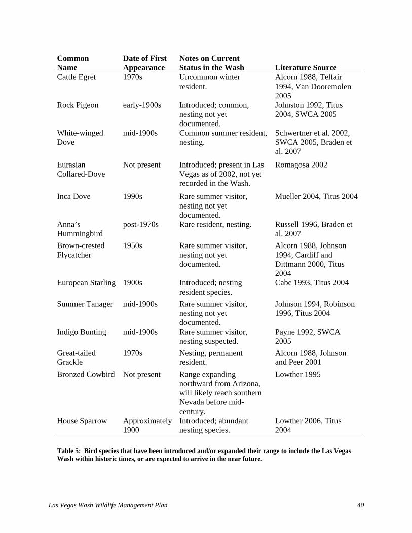
Las Vegas Wash Wildlife Management Plan 40
Common Name
Date of First Appearance
Notes on Current Status in the Wash Literature Source
Cattle Egret 1970s Uncommon winter resident.
Alcorn 1988, Telfair 1994, Van Dooremolen 2005
Rock Pigeon early-1900s Introduced; common, nesting not yet documented.
Johnston 1992, Titus 2004, SWCA 2005
White-winged Dove
mid-1900s Common summer resident, nesting.
Schwertner et al. 2002, SWCA 2005, Braden et al. 2007
Eurasian Collared-Dove
Not present Introduced; present in Las Vegas as of 2002, not yet recorded in the Wash.
Romagosa 2002
Inca Dove 1990s Rare summer visitor, nesting not yet documented.
Mueller 2004, Titus 2004
Anna’s Hummingbird
post-1970s Rare resident, nesting. Russell 1996, Braden et al. 2007
Brown-crested Flycatcher
1950s Rare summer visitor, nesting not yet documented.
Alcorn 1988, Johnson 1994, Cardiff and Dittmann 2000, Titus 2004
European Starling 1900s Introduced; nesting resident species.
Cabe 1993, Titus 2004
Summer Tanager mid-1900s Rare summer visitor, nesting not yet documented.
Johnson 1994, Robinson 1996, Titus 2004
Indigo Bunting mid-1900s Rare summer visitor, nesting suspected.
Payne 1992, SWCA 2005
Great-tailed Grackle
1970s Nesting, permanent resident.
Alcorn 1988, Johnson and Peer 2001
Bronzed Cowbird Not present Range expanding northward from Arizona, will likely reach southern Nevada before mid-century.
Lowther 1995
House Sparrow Approximately 1900
Introduced; abundant nesting species.
Lowther 2006, Titus 2004
Table 5: Bird species that have been introduced and/or expanded their range to include the Las Vegas Wash within historic times, or are expected to arrive in the near future.

Las Vegas Wash Wildlife Management Plan 41
Miller (1974)1 SWCA (2005)2
Common Name
N3
%4
Relative Abundance 1972-19735
Relative Abundance 2002-20056
Estimated Change in Relative Abundance
Mallard 1 2 Rare Common Increase Gambel’s Quail 12 22 Rare Common Increase Black-crowned Night-Heron 5 9 Rare Uncommon No Change American Coot 23 43 Uncommon Abundant Increase Killdeer 9 17 Rare Common Increase Spotted Sandpiper 2 4 Rare Common Increase Mourning Dove 43 80 Abundant Abundant No Change Black Phoebe 2 4 Rare Common Increase Say’s Phoebe 7 13 Rare Common Increase Ash-throated Flycatcher 1 2 Rare Common Increase Northern Rough-winged Swallow
6
11
Rare
Common
Increase
Verdin 28 52 Common Common No Change Bewick’s Wren 19 35 Uncommon Common No Change Marsh Wren 25 46 Uncommon Common No Change Northern Mockingbird 31 57 Common Uncommon No Change European Starling 6 11 Rare Absent Unknown Lucy’s Warbler 5 9 Rare Common Increase Yellow Warbler 13 24 Rare Common Increase Common Yellowthroat 36 67 Common Common No Change Yellow-breasted Chat 13 24 Rare Common Increase Abert’s Towhee 25 46 Uncommon Common No Change Song Sparrow 34 63 Common Common No Change Blue Grosbeak 14 26 Uncommon Common No Change Red-winged Blackbird 22 41 Uncommon Common No Change Yellow-headed Blackbird 12 22 Rare Common Increase Brown-headed Cowbird 21 39 Uncommon Abundant Increase House Finch 8 15 Rare Abundant Increase
1 Findings adjusted to correlate with SWCA (2005) findings by only evaluating Miller’s (1974) data from May, June, and July, 1972-1973. Only data from the nine study plots along the lower Wash were used. 2 Unlike Miller’s (1974) data, SWCA (2005) data on bird status and abundance were gathered as a secondary goal to the primary goal of conducting presence-absence surveys for Yuma clapper rail, yellow-billed cuckoo, and southwestern willow flycatcher. 3 The number of surveys (out of a total of 54) that each species was detected by Miller (1974). 4 The percentage of surveys (out of a total of 54) that each species was detected by Miller (1974). 5 Four categories were assigned to Miller’s (1974) relative abundance values. They are as follows: 1-25% = rare; 26-50% = uncommon; 51-75% = common; and 76-100% = abundant. 6 Relative abundance categories and definitions of SWCA (2005) were as follows: abundant (>50 individuals easily detected daily), common (2-50 individuals detected daily), uncommon (regularly detected in small numbers, but not necessarily every day), rare (detected irregularly in small numbers), absent, and unknown. Table 6: Relative abundance of select nesting summer resident birds detected by Miller (1974) compared to that detected by SWCA (2005) with estimated change in bird populations along Las Vegas Wash.

Las Vegas Wash Wildlife Management Plan 42
Common Name
Year of Change Notes1
Western Grebe Unknown Clark’s Grebe Unknown
These 2 species were formerly lumped together as the western grebe; present in 1972-1973 as uncommon winter residents with no May-July records (Miller 1974); non-nesting was corroborated by Lawson (undated) in 1960s or 1970s who described them as uncommon migrants. Both apparently now nest within the management and/or immediately adjacent areas.
Sora Unknown Reported only four times by Miller (1974), with no detections during the nesting season of May-July. Lawson (undated) corroborates the sora’s non-nesting status by identifying it as an abundant winter resident. SWCA (2005) reports sora as an uncommon summer resident that is suspected to nest.
1 Several species were not detected by Miller (1974) and were detected by SWCA (2005); yet these species were apparently present in surveys conducted in the 1960s and/or 1970s by Lawson (undated). These species have not been included in the above list of species whose status is known to have changed within historic times, and are listed as follows: (1) osprey were not detected by Miller (1974) but were described by Lawson (undated) as “occasionally encountered” (i.e., uncommon) migrants. (2) Although not detected by Miller (1974), Bell’s vireo was described by Lawson (undated) as “occasionally encountered” (i.e., uncommon) as a summer resident along the Wash within the area of the Clark County Wetlands Park during his bird surveys that occurred in the 1960s or 1970s. Table 7. Bird species detected by Miller (1974) and Lawson (undated) that appear to have changed status and/or abundance in the Las Vegas Wash.
habitats have undergone over the last few decades. This may be due to the fact that species that were not found regularly from 2002-2005 and those for which adequate comparison data did not exist were not used in the comparison, thus biasing the results. More waterbird species (i.e., waterfowl, shorebirds, gulls, and terns) were identified by Lawson (undated) and Miller (1974) than by the recent survey efforts (Appendix C). The reduction in open water and mud flat habitat that occurred as a result of erosion from the 1970s through the late 1990s is likely the cause. The impoundments created behind weirs and the subsequent increase in open water and mudflats are increasing potential habitat for these species. Waterbird species formerly found in the Wash continue to migrate through and overwinter at the Henderson Bird Viewing Preserve, less than one mile from the Wash. Consequently, the preserve could serve as a potential source for birds to re-colonize the management area. However, it should be noted that the point count method utilized in the SBCM study is designed to monitor passerines and thus increases in aquatic birds may be overlooked by current survey efforts. Several secretive marsh bird species (e.g. bitterns and rails) appear to have undergone changes in status and abundance since the 1970s including, for example, sora (Table 7) and least bittern. The least bittern was not detected in the 1970s. However, the species has recently become an uncommon summer resident that is likely nesting in the Wash (Braden et al. 2007). As with aquatic birds, secretive marsh birds are generally under-detected by more traditional monitoring methods, like the area search and point count methods used in the recent survey efforts on the Wash. A targeted protocol designed specifically to detect these birds is required to ensure they are not

Las Vegas Wash Wildlife Management Plan 43
Common Name1 Habitat Association Literature Source Cinnamon Teal Open water, marsh, riparian SWCA 2005 Ruddy Duck Open water SWCA 2005 Pied-billed Grebe Open water SWCA 2005 Eared Grebe Open water SWCA 2005 Double-crested Cormorant Open water SWCA 2005 Great Blue Heron Open water SWCA 2005 Great Egret Open water SWCA 2005 Snowy Egret Open water SWCA 2005 Green Heron Open water, marsh SWCA 2005 White-faced Ibis Open water, marsh SWCA 2005 Virginia Rail Marsh SWCA 2005 Common Moorhen Open water, marsh SWCA 2005 Black-necked Stilt Open water, mudflat SWCA 2005 American Avocet Open water, mudflat SWCA 2005 White-winged Dove Riparian SWCA 2005 Blue-gray Gnatcatcher Riparian SWCA 2005 1 Species included here lack rigorous scientific documentation for assumed increases in abundance due to lack of appropriate historical data or use of different historical methodology. The rationale for their inclusion here as species suspected of increased abundance is that their required nesting habitat was previously (early 1900s) either absent or present in very small amounts as compared to the larger extent of contemporary habitats. Table 8: Nesting summer resident bird species not identified in Tables 5, 6, and 7 but nevertheless suspected to have increased in abundance in the previous century along the Las Vegas Wash due to anthropogenic changes to habitat and hydrology.
adequately monitored (Conway 2005). These species are wetland dependent, if obligate, so data on their abundance and distribution along the Wash would provide information on the quality of marsh habitat and the success of wetland restoration efforts. Additionally, fewer Mojave warm desert scrub and desert wash species have been detected in recent years than in the 1970s. Examples of these species include cactus wren and Scott’s oriole. While this could be the result of a loss of these species from the management area, it may also result from the fact that survey efforts from 1998 to the present have had few sites in desert wash and Mojave warm desert scrub habitat, which may have caused species found in these habitats to be missed or undercounted. Additional changes in bird status and abundance in the management area can be expected to continue to occur in the future. The Wash bird community will be perpetually adjusting to new habitats created by active, on-site habitat management and from natural or anthropogenic forces occurring at regional, continental, and hemispheric scales.

Las Vegas Wash Wildlife Management Plan 44
Scientific Name Common Name Recently
Documented Historically Documented
Ameiurus melas Black bullhead x Cyprinella lutrensis Red shiner x Cyprinus carpio Common carp x x Gambusia affinis Mosquitofish x x Hypostomus plecostomus Suckermouth catfish x Lepomis cyanellus Green sunfish x Micropterus salmoides Largemouth bass x Pimephales promelas Fathead minnow x Poecilia mexicana Shortfin molly x 9 2
Table 9: List of fishes that were recently and historically documented along Las Vegas Wash.
5.2.3 Fishes Shanahan (2005) conducted the most recent inventory of fishes in the Wash using direct capture techniques which included using minnow traps, hoop nets, and seines. From this inventory, seven fish species were observed in the Wash. Two additional species were detected outside of this effort. In 2006, the shortfin molly (Poecilia mexicana) was first observed to be locally abundant in shallow ponded areas adjacent to the Pabco Road Weir, and in 2007, a small school of largemouth bass (Micropterus salmoides) was observed in the impoundment of the Bostick Weir (Ricks pers. comm.; Table 9). Pollard et al. (2002) also conducted fish sampling on the Wash and in the Wetlands Park Nature Preserve. On the Wash, the researchers used a combination of electroshocking and minnow traps and detected six of the seven species found by Shanahan (2005) with the exception of the suckermouth catfish (Hypostomus plecostomus). Within the Nature Preserve, Pollard et al. (2002) used a combination of minnow traps, gill nets, and seine hauls and found four species: red shiner (Cyprinella lutrensis), common carp (Cyprinus carpio), mosquitofish (Gambusia affinis), and green sunfish (Lepomis cyanellus). These data contrast the data reported by Bradley and Niles (1973) which shows that common carp and mosquitofish were the only fish present at the time. It appears that the fish community in the Wash has increased in species richness since several fish that weren’t observed by Bradley and Niles (1973) were observed by Shanahan (2005) and Pollard et al. (2002). The dramatic changes in stream morphology and flow may have contributed to this change. Moreover, since several of the fish observed by Shanahan (2005) and Pollard et al. (2002) are common aquarium or bait fish, these species may have been introduced by human action.
Fishes that have been identified in the Wash are not native to Nevada nor are they native to the lower Colorado River and its tributaries. However, the species in the Wash are commonly found in the lower Colorado, Muddy, and Virgin Rivers. The likely explanation for their occurrence in the Wash is that they migrated from Lake Mead to the Wash as flow conditions became
favorable. Other sources of introductions may be attributed to direct human intervention (i.e., accidental release, stocking, etc.). Native fish were not historically found in the Wash (Bradley and Niles 1973), but if they did occur there, the non-natives likely replaced them by the 1970s.

Las Vegas Wash Wildlife Management Plan 45
5.2.4 Mammals Bradley and Niles (1973) give a list of 39 mammal species found adjacent to the Wash (Tables 10 and 11). Data from several sources were used to confirm species presence along the Wash. For example, some species were detected by simple passive observation, whereas others were detected by active capture, and yet other species (i.e., bats) were listed based upon adjacent inventory and historical occurrence information. Since the Bradley and Niles (1973) inventory, mammal occurrence along the Wash has been well documented. Because of the wide range in body sizes, behaviors, and physical abilities for the mammals that were expected to occur along the Wash, taxa specific studies were recently conducted (Herndon 2004, Larkin 2006, O’Farrell and Shanahan 2006). For example, small mammals (less than one pound) mostly of the Order Rodentia and Insectivora were detected by using standard capture techniques and passive observations. Bats were detected by recording echolocation calls produced by these animals and then comparing the calls with a standard library of confirmed call types. Finally, large mammals (greater than one pound) were detected by the passive observation of individuals or sign. 5.2.4.1 Small Mammals Three non-volant small mammal studies have been conducted along the Wash between 2002 and 2006. Two of these studies (Herndon 2004, Larkin 2006) were performed concurrently and for the same general purpose of determining small mammal richness (Gerstenberger et al. 2004). Larkin (2006) examined the status of small mammal populations in the dominant terrestrial habitat types found along the Wash by using a mark-recapture survey. This investigation evaluated capture frequency, diversity, and richness of seven rodent species in habitats dominated by creosote bush, saltbush, and salt cedar. A fluctuation in the number of rodents captured was observed to be temperature-dependent. Several rodent species made substantial use of salt cedar habitat. Desert wood rat (Neotoma lepida) and cactus mouse (Peromyscus eremicus) appeared dependent on salt cedar habitats, whereas desert pocket mouse (Chaetodipus penicillatus) and long-tailed pocket mouse (Perognathus formosus) were generalists that were found in all habitat types. The Merriam kangaroo rat (Dipodomys merriami) and little pocket mouse (Perognathus longimembris) were most abundant in saltbush and creosote bush habitats, respectively. Herndon (2004) prepared a detailed assessment of habitat usage by small mammals that were observed by Larkin (2006). Herndon (2004) found that desert wood rat was dependent upon the foliage litter of salt cedar vegetation and ecotone boundaries appeared to be the most important factor affecting the Merriam kangaroo rat. Distribution for the cactus mouse appeared to be vegetation density dependent. Desert pocket mouse was consistently associated with dense, seed-bearing vegetation. Herndon (2004) recommended that long-term management strategies for rodents should account for diverse habitat requirements and the dependence of certain species on non-native vegetation. Herndon (2004), Larkin (2006), and Shanahan (2005a, pers. obs.) observed 11 small non-volant mammals (Order Rodentia and Insectivora) along the Wash and Bradley and Niles (1973) observed 16 (Table 10). Using the values reported for the total number of individuals trapped and trap nights in the desert scrub, shrub-woodland, and woodland-marsh habitats as reported by Bradley and Niles (1973) and trap data for all habitats reported by Gerstenberger et al. (2004), it

Las Vegas Wash Wildlife Management Plan 46
Scientific Name Common Name Recently
Documented Historically Documented
Thomomys umbrinus Pocket gopher x Chaetodipus penicillatus Desert pocket mouse x Dipodomys deserti Desert kangaroo rat x Dipodomys merriami Merriam's kangaroo rat x x Perognathus formosus Long-tailed pocket mouse x x Perognathus longimembris Little pocket mouse x x Eumops perotis Greater western mastiff bat x Nyctinomops macrotis Big free-tailed bat x x Tadarida brasiliensis Brazilian free-tailed bat x x Mus musculus House mouse x x Neotoma lepida Desert woodrat x x Ondatra zibethica Muskrats x Onychomys torridus Southern grasshopper mouse x x Peromyscus boylii Brush mouse x Peromyscus crinitus Canyon mouse x Peromyscus eremicus Cactus mouse x x Peromyscus maniculatus Deer mouse x Reithrodontomys megalotis Western harvest mouse x Macrotus californicus California leaf-nosed bat x x Ammospermophilus leucurus White-tailed antelope squirrel x x Spermophilus tereticaudus Round-tailed ground squirrel x x Notiosorex crawfordi Desert shrew x x Antrozous pallidus Pallid bat x x Corynorhinus townsendii townsendii Townsend’s big-eared bat x Eptesicus fuscus Big brown bat x x Idionycteris phyllotis Allen’s big-eared bat x Lasionycteris noctivagans Silver-haired bat x x Lasiurus blossevillii Western red bat x Lasiurus borealis Red bat x Lasiurus cinereus Hoary bat x x Lasiurus xanthinus Western yellow bat x Myotis californicus California myotis x x Myotis ciliolabrum Western small-footed myotis x Myotis thysanodes Fringed myotis x Myotis yumanensis Yuma myotis x Pipistrellus hesperus Western pipistrelle x x 28 27 Table 10: List of small mammals that were recently and historically documented along Las Vegas Wash. Species are organized by family. Bats names and status follow Bradley et al. (2006).

Las Vegas Wash Wildlife Management Plan 47
appears that some species have declined in relative abundance since the 1970s, and others were not even observed in the more recent inventories (Table 10). For example, Gerstenberger et al. (2004) and Shanahan (2005a) did not collect the brush mouse (Peromyscus boylii), canyon mouse (Peromyscus crinitus), deer mouse (Peromyscus maniculatus), or western harvest mouse (Reithrodontomys megalotis), all of which were listed by Bradley and Niles (1973) as occurring along the Wash. The house mouse (Mus musculus) exhibited the greatest decline in relative abundance while the white-tailed antelope squirrel (Ammospermophilus leucurus) was not even reported by Gerstenberger et al. (2004). Since Bradley and Niles (1973) found the western harvest mouse and the house mouse most often in woodland-marsh habitats (e.g., relative abundance was greater than 47 individuals per 1,000 trap nights), and Gerstenberger et al. (2004) had limited sampling locations within this habitat type, the decline reported herein may not reflect actual changes in relative abundance. Rather, these data show that the status of small mammals in marsh like environments is currently unknown. As for the white-tailed antelope squirrel, Gerstenberger et al. (2004) did not have an adequate sampling technique for capturing these animals because these animals appear to be locally common (Shanahan pers. obs.). Another notable recent change from the historical small mammal community is the occurrence of desert pocket mouse. Bradley and Niles (1973) did not report this species, but Gerstenberger et al. (2004) reported it as having the second greatest relative abundance of all animals trapped. Other small mammal studies along the Wash have concentrated on recording the echolocation calls of bats (O’Farrell and Shanahan 2006). Seventeen bat species were recorded during 2004 and 2005 (Table 10). Although spatial and temporal activity patterns varied among species, five of the 17 species had never been documented in the Valley. Eight species reported by O’Farrell and Shanahan (2006) were not reported in the 1970s. The reason for this increase may be attributed to the dramatic technological advances that have occurred in the past 30 years, namely the use of acoustic monitoring survey methods. Historical estimates of occurrence were limited because they were conducted with active capture techniques that were typically confined to isolated drinking, foraging, or roosting areas. New technologies have allowed for the continuous monitoring of bats and likely greater species detections. 5.2.4.2 Large Mammals Large mammals were observed along the Wash while conducting surveys for other taxa and during other routine visits. These direct observations and observations of sign (i.e., scat, burrows, tracks, etc.) were used to establish occurrence along the Wash (Table 11). The largest mammal that is found along the Wash is the bighorn sheep (Ovis canadensis). Between 1998 and 2006 only two bighorn sheep were observed (Perkins pers. comm.) which suggests that they are rarely found along the Wash. The two bighorn sheep rams were observed on the same day upstream of the Rainbow Gardens Weir within an area revegetated with willows, cottonwoods, and tules. Coyote (Canis latrans) is another large mammal found along the Wash. Detailed demographic information is not known, but coyote pups are routinely observed in the spring (Shanahan pers. obs.). Two lagomorphs are common to the Wash and are regularly observed; they are the Audubon cottontail (Sylvilagus audubonii) and the black-tailed jack rabbit (Lepus californicus). The beaver (Castor canadensis), the largest member of Order Rodentia, is native to the Wash but can be a nuisance species, cutting down willows and cottonwoods at revegetation sites. Between 2001 and 2004, beavers were negatively affecting the success of

Las Vegas Wash Wildlife Management Plan 48
some revegetation efforts. Since then, willows have rapidly germinated throughout the Wash making beaver impacts less noticeable. In 2002, several salt cedar plants were observed to be cut down by beaver (Shanahan pers. obs.). Other large mammals that have been detected along the Wash include the kit fox (Vulpes macrotis), ringtail (Bassariscus astutus), bobcat (Lynx rufus), and raccoon (Procyon lotor). Several kit fox burrows have been observed in the northern portion of the management area; however, this animal has not been directly observed. There is only one reporting of a ringtail along the Wash, at the Lake Las Vegas Resort (Weber pers. comm.). Also, in 2007, Project Team staff identified a bobcat on the south bank of the Wash just upstream of Bostick Weir, and perhaps the same animal was observed further downstream within the same week (Anthony pers. comm.). Raccoons, however, have been observed throughout the Wash. The bighorn sheep is the only protected large mammal found within the management area. In Nevada, it is unlawful to kill or possess a bighorn sheep (NRS 501.376) unless a permit has been acquired from the Nevada Department of Wildlife. 5.2.5 Reptiles Many different reptiles occur along the Wash including snakes, lizards, and tortoises. Inventory work conducted by Shanahan (2005a) determined the presence of many lizards but only a few snakes. Species richness reported by Shanahan (2005a, pers. obs.) was substantially less than what was reported by Bradley and Niles (1973; Table 12). Shanahan (2005a) conducted an intensive trapping effort for reptiles along the Wash from 2001 to 2003. The sampling technique was a drift fence array trapping methodology (see Corn 1994) similar to that of Fisher et al. (2002), which included pitfall traps, funnel traps and coverboards. The design of the arrays, however, was specifically modified for use in the 2001-2003 efforts. Drift fence arrays were installed in a variety of habitat types including creosote bush-white bursage, mesquite-saltbush,
Scientific Name Common Name Recently
Documented Historically Documented
Ovis canadensis Bighorn sheep x x Canis latrans Coyote x x Urocyon cinereoargenteus Gray fox x Vulpes macrotis Kit fox x x Castor canadensis Beaver x Lynx rufus Bobcat x x Lepus californicus Black-tailed jack rabbit x x Sylvilagus audubonii Desert cottontail x x Mephitis mephitis Striped skunk x Spilogale gracilis Spotted skunk x Taxidea taxus Badger x Bassariscus astutus Ring-tailed cat x x Procyon lotor Racoon x x 9 12 Table 11: List of large mammals that were recently and historically documented along Las Vegas Wash.

Las Vegas Wash Wildlife Management Plan 49
Scientific Name Common Name Recently
Documented Historically Documented
Chionactis occipitalis Western shovel-nosed snake x Hypsiglena torquata Spotted night snake x Lampropeltis getula Common king snake x x Masticophis flagellum piceus Red racer x x Phyllorhynchus decurtatus Spotted leaf-nosed snake x Pituophis catenifer deserticola Great Basin gopher snake x x Rhinocheilus lecontei Long-nosed snake x Salvadora hexalepis Western patch-nosed snake x Sonora semiannulata Western ground snake x Trimorphodon biscutatus (=lambda) Arizona lyre snake x Crotaphytus bicinctores Great Basin collared lizard x x Gambelia wislizenii Long-nosed leopard lizard x x Coleonyx variegatus Western banded gecko x x Heloderma suspectum Gila monster x Dipsosaurus dorsalis Desert iguana x x Sauromalus obesus Chuckwalla x Leptotyphlops humilis Western blind snake x x Callisaurus draconoides Zebra-tailed lizard x x Phrynosoma platyrhinos Desert horned lizard x x Sceloporus magister Desert spiny lizard x x Urosaurus graciosus Long-tailed brush lizard x Uta stansburiana Side blotched lizard x x Arizona elegans Glossy snake x Aspidosceles tigris tigris Great Basin whiptail lizard x x Apalone spinifera Spiny softshell turtle x Trachemys scripta elegans Red-eared slider x Gopherus agassizii Desert tortoise x x Crotalus cerastes cerastes Mojave desert sidewinder x x
Crotalus mitchellii pyrrhus Southwestern speckled rattlesnake x x
Crotalus scutulatus Mojave rattlesnake x Xantusia vigilis vigilis Yucca night lizard x x 19 29 Table 12: List of reptiles that were recently and historically documented along Las Vegas Wash.
saltbush-salt cedar, mixed saltbush, mixed riparian, and salt cedar. Fourteen species (10 lizards and 4 snakes) were captured and the tracks of another snake were observed.

Las Vegas Wash Wildlife Management Plan 50
Relative capture frequency (relative frequency) values were calculated yearly for each species. Relative frequency was determined by dividing the number of captured individuals of a species by the total number of individuals for all species found over a period of time. Relative frequency values provide a measure of how often species were captured during the study and clues towards their relative abundance. The most abundant reptile species trapped during the study was the Great Basin whiptail lizard (Aspidosceles tigris tigris) and the side-blotched lizard (Uta stansburiana), which is consistent with other studies of reptile abundance in the southwestern U.S. and in reference texts (Hirsch et al. 2002, Stebbins 2003, Szaro and Belfit 1986). Shanahan’s (2005a) survey provides an initial species inventory and insight on relative abundance measures for reptiles adjacent to the Wash. Since the 2002-2003 study, an additional snake has been observed along the Wash, the speckled rattlesnake (Crotalus mitchellii). In 2006, Van Dooremolen (pers. obs.) observed a speckled rattlesnake on the north side of the Wash within a patch of salt cedar near the proposed Lower Narrows Weir location. Again in 2006, Van Dooremolen (pers. obs.) observed one early in the morning sunning itself on a boulder on the north side of the Wash upstream of the Historic Lateral Weir. Yearly variation in numbers and abundance of species is a characteristic of arid systems (Jones 1986), and spatial and temporal variability of primary productivity, particularly of annual vegetation, is a characteristic of the Mojave Desert (Beatley 1974; Smith et al. 1997). Primary productivity is likely a major factor in insect populations, which likely influences the abundance of the reptiles (mostly lizards) that prey upon these insects. Therefore, rainfall patterns may have an influence on spatiotemporal abundance of reptiles near the Wash. Most of the reptiles expected to occur along the Wash appear to be well documented by Shanahan (2005a); however, large bodied snakes and some lizards were not adequately surveyed by the drift fence array method. For example, desert tortoise (Gopherus agassizii) are surveyed by pedestrian transects, and chuckwalla (Sauromalus obesus) are surveyed by focused habitat searches. Thus, neither of these species would likely have been encountered by Shanahan (2005a). Fortunately, additional survey work has been completed within the management area. SWCA (2006a) recently surveyed upland areas of the Wetlands Park for desert tortoise and tortoise sign (see below for discussion). 5.2.5.1 Desert Tortoise Desert tortoises are protected by the ESA and are listed as threatened in the U.S. They are found throughout Clark County in valley bottoms and bajadas at low to moderate elevations. Desert tortoises are often found in areas vegetated with creosote bush. Along the Wash, the most suitable desert tortoise habitat is located in the areas towards the north and southeast. As part of preparing environmental compliance documents, desert tortoise surveys were first conducted along the Wash in 1994 (SWCA 1998a). Surveys focused on upland areas immediately north, northeast, and southeast of the Wash. Some of the surveyed locations were outside of the management area. Survey methods followed the FWS and U.S. Bureau of Land Management protocols (FWS 1992, Eagen undated). During these surveys, two desert tortoises and three burrows were observed within the surveyed area. The two tortoises that were observed were found within their burrows and outside of the Wetlands Park boundary towards the southeast. The third burrow that was found was towards the northeast side of the park. Other tortoise survey activities that have been conducted along the Wash (i.e., between 2002 and 2003) were

Las Vegas Wash Wildlife Management Plan 51
done as part of right of way requirements as stipulated to SNWA for the 170-A pipeline project. The 170-A project consisted of installing approximately seven miles of 78-inch diameter pipe below ground from near the River Mountains to the intersection of Hollywood Boulevard and Desert Inn Road. This alignment crosses the Wash upstream of the Rainbow Gardens Weir and generally follows the northern boundary of the Wetlands Park. Along the pipeline alignment, pre-construction clearance surveys were conducted, and tortoise fencing was installed adjoining the right of way boundary. During the project, three tortoises were observed during surveys along the tortoise fence (Figure 8). In 2005, tortoise surveys were also conducted (SWCA 2006a, SNWA 2006a). Surveys conducted by SWCA (2006a) were done for Clark County and the BOR as part of an ESA section seven informal consultation with the FWS. SWCA (2006a) found 12 burrows within the Wetlands Park, a carcass, a piece of scat, and 5 other burrows outside of the park. The FWS ultimately did not concur with the BOR that the proposed Clark County activities were not likely to adversely affect the desert tortoise; therefore, FWS recommended that the BOR request formal consultation. This was a direct result of the recent tortoise reports within the park in addition to SWCA’s (2006a) survey work. FWS responded with a biological opinion (FWS 2006) that included an incidental take statement, jeopardy determination, and a listing of reasonable and prudent measures to follow to minimize desert tortoise take. 6.0 RECOMMENDED ACTIONS FOR MANAGING WILDLIFE The recommended actions provided herein have been specifically prepared to meet the management objectives outlined in Chapter 1 which are: (1) to conserve the abundance and diversity of native wildlife species that have been found along the Wash, (2) protect and enhance wildlife habitats, and (3) increase environmental awareness of these resources in the community. Recommended actions are listed for each objective statement and they were prepared in consideration of the information provided in Chapters 2 through 5. Who will be responsible for implementing and providing funding for these actions has yet to be determined and will be an important step in the prioritization process, which is described in Section 7.2. Given the potential costs, several recommended actions may only move to the implementation phase if grant funding is obtained. Fortunately, many of the actions recommended in the following sections are either already being conducted or can be conducted by staff from LVWCC member agencies, including staff from the Project Team. The actions outlined in Sections 6.1 – 6.3 are recommended, not required. The plan was prepared for the MAC but is intended to be used as a resource by all groups conducting activities along the Wash and for those who are interested in wildlife stewardship. The MAC determines which projects are authorized to move forward as part of the LVWCC’s efforts. However, if other groups working on the Wash obtain funding from grants or other sources to complete any of the recommended actions, those projects could move forward without MAC approval. 6.1 Conserve Wildlife Abundance and Diversity This section includes recommended actions that were prepared to satisfy the following objective statement: to conserve the abundance and diversity of native wildlife species that have been found along the Wash.

Las Vegas Wash Wildlife Management Plan 52
Figure 8: Location of desert tortoises documented in and adjacent to the management area.
Las Vegas Wash Wildlife Management Plan 53
Recommended Action: Work to prevent activities that would lead to degraded water quality conditions that would not support healthy wildlife populations. Recommended Action: Continue to implement a bioassessment monitoring study to evaluate the effect that water quality has on wildlife. If COPCs are identified as having a negative effect on wildlife then actions should be taken to correct water quality concerns. Recommended Action: Conduct baseline inventories to establish the abundance and diversity of wildlife that were not documented in the surveys performed between 1998 and 2007. Emphases should include inventorying marsh and rocky habitats and using taxa specific inventory methods. Recommended Action: Continue to prevent the usage of firearms and hunting in the management area. For the portion of the management area within the Wetlands Park boundary, carrying, possessing or discharging any firearms, firecrackers, rockets, torpedoes or other fireworks, air guns, slingshot, boomerangs or martial arts paraphernalia, and associated materials is prohibited by Clark County Code (see Appendix A). Recommended Action: Continue to prevent fishing in the Wetlands Parks, per the authority of the Director of CCPR as established by Clark County Code (see Appendix A). Recommended Action: Continue to prevent disturbing migratory bird habitat during the nesting season. Recommended Action: Continue working to prevent unleashed dogs, other pets, and feral cats from entering the management area. This includes working to prevent people from discarding unwanted pets, such as aquarium fish and snakes, within the area. For the portion of the management area within the Wetlands Park boundary, all unleashed pets are prohibited from entering the park by Clark County Code (see Appendix A), and all pets, leashed or unleashed are currently prohibited from entering the Wetlands Park Nature Preserve. Recommended Action: Continue to implement the terms and conditions of the August 28, 2006, Biological Opinion prepared by the FWS to protect the federally threatened desert tortoise from project activities within the management area (Appendix D). Recommended Action: Continue to monitor macroinvertebrate communities as they are important food resources and indicators of water quality. Recommended Action: Regularly monitor the abundance and diversity of wildlife. Recommended Action: Continue to conduct threatened and endangered bird species surveys annually to comply with FWS recommendations. Recommended Action: Where feasible, remove non-native, invasive wildlife species from the management area. Recommended Action: Monitor and mitigate the impacts of nuisance native wildlife species.

Las Vegas Wash Wildlife Management Plan 54
Recommended Action: Re-introduce native wildlife species formerly found in the management area taking into consideration changes in Wash habitats and increases in potential or known predators. 6.2 Habitat Protection and Enhancement This section includes recommended actions that were prepared to satisfy the following objective statement: to protect and enhance wildlife habitats. Recommended Action: Maximize the type and distribution of aquatic habitats including pools, riffles, runs, and mudflats. Recommended Action: Continue working to prevent unauthorized OHV usage in the management area with particular emphasis on protecting more vulnerable habitats. Recommended Action: Continue to implement a comprehensive invasive plant management program. This program should address the prevention of exotic plant invasions by monitoring for new species and eradicating them early on. Where feasible, existing areas of infestation should be removed and replaced with functionally equivalent or superior native species. No net loss policies for functional habitat types should be pursued. Recommended Action: Continue to implement a comprehensive native plant revegetation and enhancement program focused on planting native species in areas that have been disturbed by anthropogenic activities. Planting size, density, structure, and floristics should: complement historical vegetation types, adjacent native plant communities, and regional reference sites; incorporate specific parameters known to be important to the Wash’s native wildlife; and consider substrate and hydrologic conditions. Recommended Action: Conserve and incorporate remnant native plant communities into revegetation efforts where possible. Recommended Action: Sustain natural processes important to the maintenance and propagation of native habitats. Recommended Action: Continue to monitor the effectiveness of invasive plant removal and native plant revegetation at enhancing wildlife habitats by evaluating changes in the abundance and diversity of the wildlife using those habitats. If large declines in abundance and richness are observed, limit invasive plant removal until successful or functional replacement habitat is available. 6.3 Increase Environmental Awareness This section includes recommended actions that were prepared to satisfy the following objective statement: to increase environmental awareness of these resources in the community.
Recommended Action: Continue to prepare and distribute print material that describes the habitats and wildlife found along the Wash and their importance.

Las Vegas Wash Wildlife Management Plan 55
Recommended Action: Prepare a list of the activities prohibited in the management area. Prohibited activities should at minimum include using firearms, hunting, fishing, allowing unleashed dogs, littering, and driving off designated roads. Signs should be clearly posted listing the prohibited activities and consequences of non compliance. For the portion of the management area within the Wetlands Park boundary, Clark County Code already prohibits the majority of these activities (see Appendix A). Recommended Action: Develop and distribute educational materials encouraging local residents to keep their domestic cats indoors to protect birds and other wildlife and educating them regarding the negative impacts of releasing unwanted pets into the management area. Recommended Action: Clearly mark the boundaries of the management area. Recommended Action: Continue to actively enforce prohibited activities. Recommended Action: Implement a comprehensive wildlife education and outreach program. The program should incorporate field trips, tours, classroom or other indoor presentations, community outreach events, volunteer events, workshops, training events, and other educational outreach activities. Reporting should also be included. Recommended Action: Support the development of wildlife research, education, and outreach facilities. Recommended Action: Pursue collaborative wildlife education and outreach activities with community stakeholders and other parties. Recommended Action: Continue to contribute data to local, state, and national wildlife research, education, and outreach programs. Recommended Action: Monitor the effectiveness of wildlife education and outreach programs. 7.0 REQUIREMENTS FOR SUCCESSFUL WILDLIFE MANAGEMENT 7.1 Coordination Salafsky et al. (2001) note that most conservation work "requires a wide range of skills, including managing staff, dealing with boards, funders, and bosses, communicating with stakeholders, and understanding the biology and culture of the places in which you work." This is certainly true of the plan to restore ecological functions to the Wash. Restoration and maintenance of the Wash is going to be a long-term environmental project requiring constant cooperation not only among the 29 members of the LVWCC, but also among Wash advocates, elected officials, and the general public. In fact, coordination has been a key to the success of the development and implementation of the CAMP.
Regularly occurring public meetings are held to facilitate coordination among the LVWCC membership and the general public. There are several levels of coordinated activities that must be conducted to achieve successful wildlife management, and they should follow the framework

Las Vegas Wash Wildlife Management Plan 56
developed for the CAMP. These activities include informal (e.g., working meetings, phone calls, written messages, emails, facsimiles, etc.) and formal (e.g., public meetings) correspondences.
The Project Team has been conducting extensive wildlife monitoring programs along the Wash for the past seven years. Moreover, this group has been responsible for transferring wildlife resource information to the LVWCC membership and the public. Because this group has expert knowledge about the management area, they should continue to be central in facilitating coordination activities.
The LVWCC and the MAC hold quarterly meetings open to the public to discuss and coordinate Wash and other watershed issues. Quarterly meetings are also held for two subcommittees of the LVWCC: the Administrative Study Team and the REM Study Team. Moreover, the Operations Study Team, another subcommittee of the LVWCC, meets periodically to discuss and evaluate the erosion control program. These meetings provide the framework for wildlife management coordination activities.
The MAC is the official oversight and decision making (i.e. with approval by their respective board and counsel members) committee that directs implementation of the CAMP. Decisions by the MAC are typically based on the results of the LVWCC meetings. MAC members include representatives from the City of Henderson, City of Las Vegas, City of North Las Vegas, Clark County, Clark County Regional Flood Control District, Clark County Water Reclamation District, CWC, and SNWA. Since the MAC members fund the Wash program by annually authorizing the budget, their approval for wildlife management activities within the LVWCC framework is required. As for the LVWCC, this group should direct wildlife management activities that are derived at the study team level.
The REM Study Team was originally developed by the LVWCC to identify research needs and guide monitoring and analysis studies. Because of the expertise of this team, they should be the primary oversight group for the implementation of the first two management objectives. Additional wildlife biologists, however, should be solicited for representation on this subcommittee.
The LVWCC developed the Administrative Study Team to coordinate public outreach efforts among the member entities and to identify grant funding opportunities for Wash stabilization, enhancement and outreach activities. This study team should be the primary group that deals with the third management objective. They will need to work closely with the Wetlands Park Interpretive Planning Committee, a group that developed and is carrying out a comprehensive interpretive plan for the Wetlands Park, to coordinate the implementation of recommended actions.
The Operations Study Team is another critical coordinating group that needs to be used to successfully implement wildlife management actions. For example, threatened and endangered species information helps direct erosion control project design and construction requirements. Erosion control projects also provide the greatest opportunity to improve degraded wildlife habitats by removing exotic species and replacing them with native species (see Chapter 2).
Clearly, successful wildlife management will involve considerable coordination over a long period. The framework that the LVWCC developed is ideal for managing these resources.

Las Vegas Wash Wildlife Management Plan 57
7.2 Prioritization Although the number of recommendations to conserve species, protect and enhance habitats, and educate the public are many, the limiting factors of time and money restrict what can realistically be accomplished. Therefore, recommended actions must be prioritized. To prioritize when actions should be implemented, there are several important factors that must be considered. These factors include, but are not limited to, the following: regulatory requirements, responsible party, funding, feasibility of implementing the action, the greatest good to the greatest number of species, economy of scale by completing complimentary actions, in-kind support from agencies, and institutional capabilities or expertise. Given the coordination framework described in the previous section and the intentional generality of the recommended actions, prioritizing actions related to the first two management objectives and the third management objective should be conducted by the REM and Administrative Study Teams, respectively, with oversight from the MAC. The following paragraphs, however, detail specific actions that are highest priority. The highest priority must be given to the actions which fall under the regulatory requirement guideline. For example, recommended actions that are consistent with stipulations from an ESA consultation process are mandatory. Presently there are two endangered species that occur in the management area. The endangered Yuma clapper rail has been detected in the Wash, as has the willow flycatcher and its endangered subspecies, the southwestern willow flycatcher. There is also one threatened species which has been detected in the Wash, the desert tortoise. Potential impacts to these species and their habitats along the Wash must be mitigated as required by federal regulations. In order to prioritize the remaining action items, the REM and Administrative Study Teams, along with local wildlife experts, should work to develop a prioritization system. For example, a simple matrix can be developed which shows a list of species that will benefit from a recommended action. Recommended actions that result in the greatest number of species benefited would be given a high priority. Simple tools like these may assist the REM and Administrative Study Teams. Other factors that should be considered during prioritization include types of species benefited (i.e., conservation status, rarity in the management area, etc.), whether the species has or have been surveyed in recent years, cost effectiveness of the action, and feasibility of the action considering multiple use goals (e.g., consistency with water quality goals and flexibility for stormwater conveyance and wastewater discharge). Wildlife biologists that have expert knowledge of the management area and its resources will then need to develop consensus on the results of any prioritization list that is developed. As stated in Section 6.0, an important component of the prioritization process will include determining who is responsible for implementing each action, the duration for which they are responsible, and what funding sources will be used. For example, certain recommended actions may be the responsibility of the MAC but only for the time period during which Wash stabilization construction activities are ongoing. Once the stabilization program is fully implemented, all facilities will be turned over to Clark County, and any maintenance activities that may be required would need to consider the actions recommended in this plan. As funding is a limiting factor, several recommended actions may only progress to the implementation phase if grant funding is obtained. However, as stated previously, many of the recommended actions are currently conducted by staff from the LVWCC members and the Project Team. The process

Las Vegas Wash Wildlife Management Plan 58
of setting priorities will begin in the study teams, but the ultimate decision to implement a project will reside with the MAC. 7.3 Research Recent research studies along the Wash have focused on evaluating water quality and biological resources. These resources are not static and stable but are subject to modification through both management action and natural events. This is particularly evident in dynamic riparian and riverine ecosystems where climax habitats typically do not exist because perennial successional conditions are brought on by frequent and regular flooding. To address this, management decisions must consider the potential for both long- and short-term cycles of change in the Wash ecosystem. There will always be a need for current information on the various factors influencing wildlife populations within the Wash. Future alterations in the Wash environment due to habitat restoration, channel stabilization, changing anthropogenic pressures, and even climate change will continually, and perhaps unpredictably, influence wildlife. As the Wash undergoes these biological and physical changes, it will become necessary to conduct repetitive and new research to document changes that may have occurred. New research on topics as wide-ranging as wildlife ecology, patterns of human recreational impact, and fluvial geomorphology, to name a few, may become necessary. Relevant management, therefore, will be required to adapt to information and resource needs that may be in a long-term state of flux. Conserving wildlife biodiversity in an ecosystem is largely about managing wildlife habitat. The goal of balancing species needs for habitat and human needs for recreation, wastewater discharge, and flood conveyance will need to be revisited regularly over the years. It is likely that management adjustments will be necessary in the future. As new wildlife data are acquired, either from monitoring within the adaptive management process or from separate related studies, new management strategies can be formulated based on contemporary interpretation of that data within the context of the whole ecosystem. The tools and technology utilized for wildlife research are constantly improving. For example, the LVWCC uses sophisticated electronic equipment to collect water quality parameters, the latest GIS software for mapping and modeling, and photo comparison techniques to observe real-time ecological changes. These and other available state-of-the-art techniques should be employed to evaluate Wash resources to facilitate informed decision making. 7.4 Effectiveness Monitoring The success of this management plan will be measured by the characteristics of the wildlife communities and habitats that are found along the Wash and the attitudes and behaviors of the community about these resources. Quantitative data will be the most beneficial information for measuring success; however, qualitative data may be adequate. Prior to actual effectiveness monitoring, baseline inventories still need to be carried out for some underrepresented wildlife species and habitats. Because these monitoring efforts establish baseline information for which effectiveness monitoring results will be compared, they are included as part of this section. Once the remaining baseline inventories are completed, effectiveness monitoring should use these data as well as the data that is already established to document the spatiotemporal changes in wildlife

Las Vegas Wash Wildlife Management Plan 59
and wildlife habitats that occur as recommended actions are implemented. Moreover, monitoring the attitudes and behaviors of the community will be important measures of management success. The following monitoring studies are recommended to document the baseline occurrence of wildlife in the management area. These surveys are recommended because current monitoring efforts lack adequate information on wildlife occurrence. Baseline Monitoring Conduct upland desert scrub and desert wash bird monitoring. Conduct aquatic bird counts with the methods described by the GBBO et al. (2004). Conduct small mammal trapping in marsh habitats for the western harvest mouse. Conduct night searches for snakes. Conduct chuckwalla and long-tailed brush lizard surveys. Conduct surveys for large mammals with camera trap, active search, or other appropriate
monitoring techniques. Effectiveness monitoring is a valuable tool for measuring the success of a management action. Once the aforementioned baseline surveys have been completed, periodic monitoring of wildlife communities and their habitats will document trends in the abundance and diversity of species and the aerial extent and characterization of species habitats. Conserving the abundance and diversity of wildlife, protecting and enhancing wildlife habitats, and observing positive indicators of community awareness will be the measures by which this management plan will be determined a success. The following monitoring activities should be conducted to measure the effectiveness of the recommended actions. Monitoring frequency and duration will likely vary depending on the importance of the species, critical need based on impending or active threats, evaluation of ongoing actions, prioritization, and institutional motivation. Although frequency and duration estimates are generally provided, these attributes should be further evaluated by wildlife biologists during the coordination process. Effectiveness Monitoring – Wildlife and Habitats Conduct an assessment of OHV impacts on wildlife habitats. Conduct a one time study to determine the impact of brown-headed cowbird brood
parasitism. Conduct an annual passerine point-count study with vegetation monitoring at each point to
evaluate species diversity, abundance, habitat usage, and changes in habitat.

Las Vegas Wash Wildlife Management Plan 60
Conduct upland desert scrub and desert wash bird monitoring every five years. Conduct annual secretive marsh bird (i.e., bitterns, rails – including the Yuma clapper rail,
and other secretive marsh species) monitoring with the methods developed by Conway (2005).
Conduct annual aquatic bird counts with the methods described by the GBBO et al. (2004). Conduct a wildlife forage resource study by monitoring for benthic macroinvertebrates every
five years. Conduct annual acoustic monitoring for bats. Conduct a one time study to determine the effect that removing salt cedar and replacing it
with native riparian plants has on western banded gecko abundance. Conduct rodent, shrew, reptile, amphibian, and large mammal monitoring every five years to
document changes in abundance and diversity and to evaluate the effects of habitat enhancement.
Acquire high resolution (≤ 1 foot pixel size) aerial photography annually and document
changes in habitats with time. Document on the ground conditions by taking photographs annually of the habitat types,
stream reaches, and enhancement efforts. Annually monitor native plant communities that have been enhanced. Effectiveness Monitoring – Community Awareness Tally the number of attendees that participate in field trips, tours, classroom or other indoor
presentations, community outreach events, volunteer events, workshops, training events, and other educational outreach activities as a method for evaluating community awareness.
Tally the number of individuals that receive printed material about wildlife and habitats of
the Wash. Prepare and distribute a time series questionnaire for homeowners near the Wash to
determine their awareness of this resource. Prepare a questionnaire to be used during, or as a follow up to, outreach events to determine
the awareness of the environmental resources of the Wash within the community. 7.5 Funding In order for this management plan to be successful, funding must be provided to implement the recommended actions. Funding in the form of in-kind assistance and cash are equally beneficial.

Las Vegas Wash Wildlife Management Plan 61
In fact, recent wildlife monitoring activities have been funded through in-kind assistance from the LVWCC member agencies and cash from the MAC member agencies, and federal and state grants. Because of the tremendous success that the LVWCC has achieved with the current funding arrangement and since this management plan is a component of that process, the current funding schema should continue to be used. The Administrative Study Team should continue to be used to search out and secure grant funding. Moreover, in-kind assistance by the Project Team should continue to be used to prepare grant proposals. Priority actions that result from the coordination process or as a result of grant funds that have been received will need to be approved by the MAC members during the annual budget process. 7.6 Reporting Regular reports of the progress in the implementation of this management plan should be prepared and submitted to the coordinating members and the general public. Reports should describe the results of effectiveness monitoring activities and the implementation of the recommended actions. Individual summary reports for studies and cumulative programmatic reports should be prepared. Information appropriate for the individual reports include descriptions of the materials, methods, statistical analyses, and summarized data for each study. Highly technical information that is useful for professional wildlife biologists should be included. Programmatic reports should be prepared to compliment the individual reports. These reports should summarize the effectiveness of this management plan and be written for the general public. Considering that year-end reports are already prepared by the Project Team for the LVWCC members and MAC to document the progression of the CAMP, programmatic reporting for this management plan should be included in that year-end report. 7.7 Adaptive Management Environmental monitoring is an important step in the adaptive management process and was recommended by the study teams and outlined in the CAMP (LVWCC 2000) because it is a critical tool for informing future decision making. The volume of monitoring studies that have been conducted is reflective of the importance of having current and accurate information to inform the adaptive process. Considering the successful usage of adaptive management by the LVWCC and since this management plan is tiered from the CAMP, adaptive management principles should be used to effectuate the recommended actions described herein. The key tenets of adaptive management and the nine steps that are used in the process are briefly described in the following paragraphs. Experimentation, monitoring and evaluating the results of management actions, and adjusting those actions accordingly, are features of adaptive ecological management that distinguish it from conventional ecological management, which has tended to rely on basic (rather than applied) research and ecological theory (Walters 1986). According to Smith (2002), adaptive management "has the attributes of being flexible, encouraging public input, and monitoring the results of actions for the purpose of adjusting plans and trying new or revised approaches." Walters (1986) explains the niche that adaptive management fills in accomplishing frequently elusive ecological conservation goals. He states that it begins “with the central tenet that management involves a continual learning process that cannot conveniently be separated into functions like research and ongoing regulatory activities, and probably never converges to a state of blissful equilibrium involving full knowledge and optimum productivity.”

Las Vegas Wash Wildlife Management Plan 62
Many conservation practitioners find that the typical division of conservation projects into design, management, and monitoring phases, while logical and understandable to stakeholders, is not sufficient for achieving a desired future condition for the target ecosystem. For maximum results, learning and adaptation must also be incorporated into the project design. Moreover, adaptive management is typically more effective over time and is flexible enough to remain relevant to the target ecosystem as it undergoes change.
Adaptive management was first developed in the late 1960s as an academic research concept and has since been utilized under various names. In the field of ecosystem management and conservation, it generally proceeds as follows (Salafsky et al. 2001; Smith 2002):
1. Establish a clear, common, and specific purpose. 2. Identify/isolate key indicators, elements, and relationships within the system, and bound
the system. 3. Design an explicit model of (or find a means of otherwise representing) your system as
you currently understand it. 4. Develop a management plan that accomplishes your purpose but also contains policies to
maximize tangible results, learning, and understanding. 5. Develop a monitoring plan to test the assumptions inherent in the model and the results of
management. 6. Implement the management and monitoring plans. 7. Analyze and evaluate data and results. 8. Use the results to gain a better, more accurate understanding of the ecosystem. 9. Adjust your management actions to better accomplish your purpose.
This plan outlines a strategy for managing wildlife resources of the Wash. The first four components of the adaptive management process described above can be found in this document, and a method to complete the last five components has been described herein. Successful wildlife management along the Wash must incorporate these adaptive management principles.

Las Vegas Wash Wildlife Management Plan 63
8.0 LITERATURE CITED Alcorn, J.R. 1988. The birds of Nevada. Fairview West Publishing, Fallon, Nevada. Anderson B.W., and R.D. Ohmart. 1985. Habitat use by clapper rails in the Lower Colorado River Valley. Condor 87:116-126. Bailey, R.G. 1983. Delineation of ecosystem regions. Environmental Management 7:365-373. Beatley, J.C. 1974. Phenological events and their environmental triggers in the Mojave Desert ecosystems. Ecology 55:856-863. Bickmore, E. 2003. Integrated weed management plan for the lower Las Vegas Wash. Southern Nevada Water Authority, Las Vegas, Nevada. Braden, G.T., L. Crew, and A. Miller. 2007. Avian diversity, vegetation composition, and vegetation structure of the Las Vegas Wash: Year one – final report. Final report to the Southern Nevada Water Authority, Las Vegas, prepared by San Bernardino County Museum, Redlands, California. Bradford, D.F., J.R. Jaeger, and S.A. Shanahan. 2005. Distributional changes and populations status of amphibians in the eastern Mojave Desert. Western North American Naturalist 65:462-472. Bradley, P.V., M.J. O’Farrell, J.A. Williams, J.E. Newmark. Editors. 2006. The revised Nevada bat conservation plan. Nevada Bat Working Group, Reno, Nevada. Bradley, W.G., and J.E. Deacon. 1965. The biotic communities of Southern Nevada. Desert Research Institute, Reno, Nevada. Bradley, W.G., and W.E. Niles. 1973. Study of the impact on the ecology of Las Vegas Wash under alternative actions in water quality management. University of Nevada, Las Vegas, Nevada. Brown, B.T. 1987. Ecology of riparian breeding birds along the Colorado River in Grand Canyon, Arizona. Dissertation. University of Arizona, Tucson, Arizona. Brown, B.T. 1994. Rates of brood parasitism by brown-headed cowbirds on riparian passerines in Arizona. Journal of Field Ornithology 65:160-168. Brown, D.E., F. Reichenbacher, and S.E. Franson. 1998. A classification of North American biotic communities. The University of Utah Press, Salt Lake City, Utah. Cabe, P.R. 1993. European starling (Sturnus vulgaris). In the birds of North America, No. 48 (A. Poole and F. Gill, eds.). The Birds of North America, Inc., Philadelphia, Pennsylvania.

Las Vegas Wash Wildlife Management Plan 64
Cardiff, S.W., and D.L. Dittmann. 2000. Brown-crested flycatcher (Myiarchus tyrannulus). In The Birds of North America, No. 496 (A. Poole and F. Gill, eds.). The Birds of North America, Inc., Philadelphia, Pennsylvania. Conway, C.J. 2005. Standardized North American marsh bird monitoring protocols. Wildlife Research Report #2005-4, U.S. Geological Survey, Arizona Cooperative Fish and Wildlife Research Unit, Tucson, Arizona. Corman, T.E., and R.T. Magill. 2000. Western yellow-billed cuckoo in Arizona: 1998 and 1999 survey report. Arizona Game and Fish, Technical Report 150. Corn, P.S. 1994. Straight-line drift fences and pitfall traps. Pages 109-117 in W.R. Heyer, M.A. Donnelly, R.W. McDiarmid, L.C. Hayek, and M.S. Foster, editors. Measuring and monitoring biological diversity, standard methods for amphibians. Smithsonian Institution Press, Washington, D.C. Crump, M.L. and M.J. Scott. 1994. Visual encounter surveys. Pages 84-92 in W.R. Heyer, M.A. Donnelly, R.W. McDiarmid, L.C. Hayek, and M.S. Foster, editors. Measuring and monitoring biological diversity: standard methods for amphibians, Smithsonian Institution Press, Washington, D.C. CWC (Clean Water Coalition). 2006. Systems Conveyance and Operations Program environmental impact statement, final, October 2006. Clean Water Coalition, Las Vegas, Nevada. Eagen, T.B. undated. Desert tortoises and the Bureau of Land Management, a biological consultant’s guide: endangered species act compliance, biological survey protocol and biological assessment format. U.S. Bureau of Land Management, Barstow, California. Fisher, R.N., Suarez, A.V. and T.J. Case. 2002. Spatial patterns in the abundance of the coastal horned lizard. Conservation Biology 16:205-215. FWS (U.S. Fish and Wildlife Service). 1992. Field survey protocol for any federal action that may occur within the range of the desert tortoise. United States Fish and Wildlife Service, Portland, Oregon. FWS (U.S. Fish and Wildlife Service). 1995. Final rule determining endangered status for the Southwestern Willow Flycatcher. Federal Register 60: 10694. FWS (U.S. Fish and Wildlife Service). 2000. Southwestern willow flycatcher protocol revision. FWS (U.S. Fish and Wildlife Service). 2001. Informal section 7 consultation for proposed projects to develop the Las Vegas Wash Wetlands Park, Clark County, Nevada. File No. 1-5-01-I-428. U.S. Fish and Wildlife Service, Reno, Nevada.

Las Vegas Wash Wildlife Management Plan 65
FWS (U.S. Fish and Wildlife Service). 2006. Biological opinion for 12 proposed projects in the Clark County Wetlands Park, Clark County, Nevada. File No. 1-5-06-F-515. U.S. Fish and Wildlife Service, Las Vegas, Nevada. FWS (U.S. Fish and Wildlife Service). 2007. Biological opinion for Systems Conveyance and Operations Program for the discharge of municipal wastewater into Lake Mead, Clark County, Nevada. File No. 1-5-07-F-433. U.S. Fish and Wildlife Service, Las Vegas, Nevada. GBBO (Great Basin Bird Observatory), U.S. Geological Survey, B. Bauman, P. Bradley, J. Jeffers, C. Tomlinson, J. Williams, E. Campbell, S. Canning, J. Eidel, H. Judd, R. Haley, M. Boyles, B. Henry, K. Kritz, J. MacKay, D. McNinch, D. McIvor, W. Molini, C. Mortimore, L. Neel, L. Oring, N. Saake, J. Sellman, J. Swett, and G. Wilson. 2004. Aquatic bird count sites and procedures for Nevada. Great Basin Bird Observatory Technical Report No. 04-02, Reno, Nevada. Gerstenberger, S.L., C.L. Cross, and D. Divine. 2004. An investigation of small mammal diversity, population estimates and vegetative characteristics in the Las Vegas Wash. University of Nevada, Las Vegas, Nevada. Grossman, D.H., D. Faber-Langendoen, A.S. Weakley, M. Anderson, P.S. Bourgeron, R. Crawford, K. Goodin, S. Landaal, K. Metzler, K. Patterson, M. Pyne, M. Reid, and L. Sneddon. 1998. International classification of ecological communities: terrestrial vegetation of the United States. Volume I. The national vegetation classification system: development, status, and applications. The Nature Conservancy, Arlington, Virginia. Gullion, G.W., W.M. Pulich, and F.G. Evenden. 1959. Notes on the occurrence of birds in southern Nevada. Condor 61:278-297. Hardcastle, J. 2006. Nevada county population estimates July 1, 1990 to July 1, 2006 includes cities and towns. Nevada Department of Taxation, Reno, Nevada. Herndon, C.T. 2004. Vegetation characteristics associated with small mammal populations in the Las Vegas Wash. Thesis. University of Nevada, Las Vegas, Nevada. Hirsch, R., S. Hathaway, and R. Fisher. 2002. Herpetofauna and small mammal surveys on the marine corps air ground combat center, Twentynine Palms, CA March 1999-October 2001. Howe, W.H. 1986. Status of the yellow-billed cuckoo (Coccyzus americanus) in New Mexico. New Mexico Department of Game and Fish, Share With Wildlife Program, Contract No. 516. Johnson, K., and B.D. Peer. 2001. Great-tailed grackle (Quiscalus mexicanus). In the birds of North America, No. 576 (A. Poole and F. Gill, eds.). The Birds of North America, Inc., Philadelphia, Pennsylvania. Johnson, N.K. 1994. Pioneering and natural expansion of breeding distributions in western North American birds. Studies in Avian Biology 15:27-44.

Las Vegas Wash Wildlife Management Plan 66
Johnston, R.F. 1992. Rock dove (Columba livia). In the birds of North America, No. 13 (A. Poole, P. Stettenheim, and F. Gill, eds.). The birds of North America, Inc., Philadelphia, Pennsylvania. Jones, K.B. 1986. Deserts. Pages 123-147 in A.Y. Cooperrider, R.J. Boyd, and H.R. Stuart, editors. Inventory and monitoring of wildlife habitat. U.S. Department of the Interior, Bureau of Land Management, Denver, Colorado. Kinney, W.L., J.E. Pollard, and K.A. Stave. 2000. Monitoring plan for the Nature Center at the Clark County Wetlands Park. Harry Reid Center for Environmental Studies, University of Nevada, Las Vegas, Nevada and Environmental Studies Department, University of Nevada, Las Vegas, Nevada. Klauber, L.M. 1932. Amphibians and reptiles observed enroute to Hoover Dam. Copeia 3:118-128. Kloeppel, H., A. Hadley, F. Phillips, and S.A. Shanahan. 2006. Las Vegas Wash revegetation master plan. Southern Nevada Water Authority, Las Vegas, Nevada. Larkin, J. 2006. An evaluation of small mammal populations in the Las Vegas Wash. Thesis. University of Nevada, Las Vegas, Nevada. Lawson, C.S. undated. A survey of the aviafauna of Las Vegas Wash and Las Vegas Bay, Lake Mead, Clark County, Nevada. Jones and Stokes Associates, Sacramento, California. Linsdale, J.M. 1951. A list of the birds of Nevada. Condor 53:228-249. Lowther, P.E. 1995. Bronzed cowbird. (Molothrus aeneus). In the birds of North America, No. 144 (A. Poole and F. Gill, eds.). The Birds of North America, Inc., Philadelphia, Pennsylvania. Lowther, P.E. 2006. House sparrow. (Passer domesticus). The birds of North America (A. Poole, Ed.). Ithaca: Cornell Laboratory of Ornithology. Retrieved from the American Online database: http://bna.birds.cornell.edu/BNA/account/House_Sparrow. LVWCC (Las Vegas Wash Coordination Committee). 2000. Las Vegas Wash Comprehensive Adaptive Management Plan. Las Vegas Wash Project Coordination Team, Southern Nevada Water Authority, Las Vegas, Nevada. LVWCC (Las Vegas Wash Coordination Committee). 2002. Year-End Report. Southern Nevada Water Authority, Las Vegas, Nevada. LVWCC (Las Vegas Wash Coordination Committee). 2003. Year-End Report. Southern Nevada Water Authority, Las Vegas, Nevada. LVWCC (Las Vegas Wash Coordination Committee). 2004. Year-End Report. Southern Nevada Water Authority, Las Vegas, Nevada.

Las Vegas Wash Wildlife Management Plan 67
LVWCC (Las Vegas Wash Coordination Committee). 2005. Year-End Report. Southern Nevada Water Authority, Las Vegas, Nevada. LVWCC (Las Vegas Wash Coordination Committee). 2006. Year-End Report. Southern Nevada Water Authority, Las Vegas, Nevada. LVWCC (Las Vegas Wash Coordination Committee). in prep. Year-End Report. Southern Nevada Water Authority, Las Vegas, Nevada. MAC (Las Vegas Wash Management Advisory Committee). 2002. Las Vegas Wash Cooperative Agreement. Signed by the Southern Nevada Water Authority Board on June 20, 2002. Malmberg, G. 1965. Available water supply of the Las Vegas groundwater basin, Nevada. U.S. Geological Survey Water Supply Paper 1780. McKernan, R. L., and G. T. Braden. 2001. The status of Yuma clapper rail and yellow-billed cuckoo along portions of Virgin River, Muddy River, and Las Vegas Wash, Southern Nevada, 2001. Final report to the U.S. Fish and Wildlife Service and Southern Nevada Water Authority, Las Vegas, prepared by San Bernardino County Museum, Redlands, California. McKernan, R. L., and G. T. Braden. 2002. The status of Yuma clapper rail and yellow-billed cuckoo along portions of Virgin River, Muddy River, and Las Vegas Wash, Southern Nevada, 2001. Final report to the U.S. Fish and Wildlife Service and Southern Nevada Water Authority, Las Vegas, prepared by San Bernardino County Museum, Redlands, California. Miller, J.S. 1974. The avian community structure of Las Vegas Wash, Clark County, Nevada. Thesis. University of Nevada, Las Vegas, Nevada. Monson, G., and A.R. Phillips. 1981. Annotated checklist of the birds of Arizona, second edition. University of Arizona Press, Tucson, Arizona. Moyle, P. 1973. Effects of introduced bullfrogs, Rana catesbeiana, on native frogs of San Joaquin Valley, California. Copeia 1:18-22. Mueller, A.J. 2004. Inca dove (Columbina inca). In the birds of North America, No. 28 (A. Poole, ed.). Ithaca: Cornell Laboratory of Ornithology; retrieved from the birds of North America Online database, 9 December 2005: http://bna.birds.cornell.edu/BNA/account/inca/ dove. National Oceanic and Atmospheric Administration. 2005. Monthly normals, Las Vegas Nevada, period of record: 1971-2000. Available at http://www.wrh.noaa.gov/vef/climate/page1. php. Viewed 15 March 2007. O’Farrell, M.J. and S.A. Shanahan. 2006. Las Vegas Wash bat survey, 2004-2005. Southern Nevada Water Authority, Las Vegas, Nevada.

Las Vegas Wash Wildlife Management Plan 68
Ohlendorf, H.M. 1989. Bioaccumulation and effects of selenium in wildlife. Pages 133-177 in L.W. Jacob, editor. Selenium in agriculture and the environment. ASA-SSSA Inc., Madison, Wisconsin. Payne, R.B. 1992. Indigo bunting (Passerina cyanea). In the birds of North America, no. 4 (A. Poole, P. Stettenheim, and F. Gill, eds.). The Birds of North America, Inc., Philadelphia, Pennsylvania. Pollard, J., R. Hicks, and J. Sjoberg. 2002. Mosquito management plan for the Nature Preserve at the Clark County Wetlands Park. Harry Reid Center for Environmental Studies, University of Nevada, Las Vegas, Nevada; Clark County Vector Control, Las Vegas, Nevada; and Nevada Division of Wildlife, Las Vegas, Nevada. Prepared for Clark County Parks and Community Services, Las Vegas, Nevada. Pollard, J., J. Cizdziel, and V. Sheppe. 2004. Evaluation of selenium levels in plant tissue from the Nature Preserve at the clark County Wetlands Park: Final project report. Harry Reid Center for Environmental Studies, University of Nevada, Las Vegas, Nevada. Pollard, J., J. Cizdziel, K. Stave, and M. Reid. 2007. Selenium concentrations in water and plant tissues of a newly formed arid wetland in Las Vegas, Nevada. Environmental Monitoring and Assessment 135: 447-457. Pollard, J.E., M. Reid, K. Stave, and M. Hopper. 2007a. Evaluation of selenium in the aquatic food chain within the Clark County Wetlands Park Nature Preserve 2004 – 2005: Interim project report. Harry Reid Center for Environmental Studies and Department of Environmental Studies, University of Nevada, Las Vegas, Las Vegas, Nevada. Ralph, C.J. and J.M. Scott. 1981. Estimating the numbers of terrestrial birds. Studies in avian biology 6. Cooper Ornithological Society, Lawrence, Kansas. Ralph, C.J., S. Droege, and J.R. Sauer. 1995. Managing and monitoring birds using point counts: Standards and applications. Pages 161-168 in C.J. Ralph, J.R. Sauer, and S. Droege, editors. Monitoring bird populations by point counts, USDA Forest Service, Pacific Southwest Research Station, General Technical Report PSW-GTR-149. Rice, N.A. 2007. Las Vegas Wash amphibian survey, 2004-2005. Southern Nevada Water Authority. Robinson, W.D. 1996. Summer tanager (Piranga rubra). In the birds of North America, No. 248 (A. Poole and F. Gill, eds.). The birds of North America, Inc., Philadelphia, Pennsylvania. Romagosa, C. M. 2002. Eurasian collared-dove (Streptopelia decaocto). In the birds of North America, No. 630 (A. Poole and F. Gill, eds.). The birds of North America, Inc., Philadelphia, Pennsylvania.

Las Vegas Wash Wildlife Management Plan 69
Rosenberg, K.V., R.D. Ohmart, W.C. Hunter, and B.W. Anderson. 1991. Birds of the Lower Colorado Valley. University of Arizona Press, Tucson, Arizona. Russell, S. M. 1996. Anna’s Hummingbird (Calypte anna). In the birds of North America, no. 226 (A. Poole and F. Gill, eds.). The Academy of Natural Sciences, Philadelphia, and The American Ornithologists’ Union, Washington, D.C. Salafsky, N., R. Margoluis, and K. Redford. 2001. Adaptive management: a tool for conservation practitioners. http://www.fosonline.org/site_docs/adaptivemanagementtool.pdf. Viewed 15 March 2007. Saltonstall, K. 2002. Cryptic invasion by a non-native genotype of the common reed, Phragmites australis, into North America. Proceedings of the National Academy of Sciences of the United States of America 99:2445-2449. Schwertner, T.W., H.A. Mathewson, J.A. Roberson, M. Small, and G.L. Waggerman. 2002. White-winged dove (Zenaida asiatica). In the birds of North America, No. 710 (A. Poole and F. Gill, eds.). The Birds of North America, Inc., Philadelphia, Pennsylvania. Shanahan, S.A. 2005. Las Vegas Wash fish survey summary report, 2002-2003. Southern Nevada Water Authority, Las Vegas, Nevada. Shanahan, S.A. 2005a. Las Vegas Wash reptile survey summary report, 2001-2003. Southern Nevada Water Authority, Las Vegas, Nevada. Shanahan, S.A., A. Ehrenberg, and D. Silverman. in prep. Landcover types of the Las Vegas Wash, Nevada. Southern Nevada Water Authority, Las Vegas, Nevada. Slevin, J.R. 1928. The amphibians of western North America. Occasional Papers of the California Academy of Sciences 16:1-152. Smith S.D., R.K. Monson, and J.E. Anderson. 1997. Physiological ecology of the North American deserts. Springer, New York, New York. Smith, C. 2002. Adaptive Management. http://oregonstate.edu/instruction/anth481/ectop/ ecadm.html. Viewed 18 March 2007. SNWA (Southern Nevada Water Authority). 2001. Bioassessment monitoring plan for the Las Vegas Wash and tributaries. Southern Nevada Water Authority, Las Vegas, Nevada. SNWA (Southern Nevada Water Authority). 2003. Las Vegas Wash capital improvements program. Southern Nevada Water Authority, Las Vegas, Nevada. SNWA (Southern Nevada Water Authority). 2004. Las Vegas Wash capital improvements program. Southern Nevada Water Authority, Las Vegas, Nevada.

Las Vegas Wash Wildlife Management Plan 70
SNWA (Southern Nevada Water Authority). 2005. Las Vegas Wash capital improvements program. Southern Nevada Water Authority, Las Vegas, Nevada. SNWA (Southern Nevada Water Authority). 2006. Las Vegas Wash capital improvements program. Southern Nevada Water Authority, Las Vegas, Nevada. SNWA (Southern Nevada Water Authority). 2006a. Informal consultation form: east diversion channel soil stockpile location. Southern Nevada Water Authority, Las Vegas, Nevada. Snyder, E.M. 2006. Las Vegas Wash monitoring and characterization study: ecotoxicologic screening assessment of selected contaminants of potential concern in sediment, whole fish, bird eggs, and water, 2000-2003. INTERTOX, Inc., Boulder City, Nevada. Society for Ecological Restoration International Science and Policy Working Group. 2004. The SER International Primer on Ecological Restoration. www.ser.org and Tucson: Society for Ecological Restoration International. Sogge, M. K., R. M. Marshall, S. J. Sferra, and T. J. Tibbitts. 1997. A southwestern willow flycatcher natural history summary and survey protocol. Technical Report NPS/NAUCPRS/NRTR-97/12, Colorado Plateau Research Station, Northern Arizona University, Flagstaff, Arizona. Southwest Wetlands Consortium. 1995. Clark County Wetlands Park: Master plan. Prepared for Clark County Parks and Recreation and Comprehensive Planning, Las Vegas, Nevada. Southwest Wetlands Consortium. 1998. Final program environmental impact statement for the Clark County Wetlands Park. U.S. Bureau of Reclamation, Boulder City, Nevada. Speck, R.L. 1982. Soil survey of Las Vegas Valley area Nevada: part of Clark County. U.S. Department of Agriculture, Soil Conservation Service, Las Vegas, Nevada. Stave, K. and J. Pollard. undated. Water quality monitoring and public outreach at the Nature Preserve in the Clark County Wetlands Park: Final project report 2001 – 2004. Combined Technical Report for Grant Numbers: 1425-00-FG-30-0073 and 1425-00-FG-30-0074. Department of Environmental Studies and Harry Reid Center for Environmental Research, University of Nevada, Las Vegas, Nevada. Stebbins, R.C. 2003. A field guide to western reptiles and amphibians, 3rd ed. Houghton Mifflin Company, New York, New York. SWCA. 1998. Survey for southwestern willow flycatchers along Las Vegas Wash, Clark County Wetlands Park, Nevada. SWCA Environmental Consultants, Salt Lake City, Utah. SWCA. 1998a. Threatened Species, Figure 3.5-2. Page 3.5-11-3.5-12 in Southwest Wetlands Consortium. Final Program Environmental Impact Statement for the Clark County Wetlands Park. U.S. Bureau of Reclamation, Boulder City, Nevada.

Las Vegas Wash Wildlife Management Plan 71
SWCA. 1999. Survey for southwestern willow flycatchers along Las Vegas Wash, Clark County Wetlands Park, Nevada. SWCA Environmental Consultants, Salt Lake City, Utah. SWCA. 2000. Survey for southwestern willow flycatchers along Las Vegas Wash, Clark County Wetlands Park, Nevada. SWCA Environmental Consultants, Salt Lake City, Utah. SWCA. 2000a. Programmatic biological assessment for Clark County Wetlands Park, master plan, Las Vegas, Nevada. SWCA Environmental Consultants, Salt Lake City, Utah. SWCA. 2001. Survey for southwestern willow flycatchers along Las Vegas Wash, Clark County Wetlands Park, Nevada. SWCA Environmental Consultants, Salt Lake City, Utah. SWCA. 2002. A survey for Yuma clapper rails, yellow-billed cuckoos and southwestern willow flycatchers along Las Vegas Wash, Clark County Wetlands Park, Nevada. SWCA Environmental Consultants, Salt Lake City, Utah. SWCA. 2003. Survey for Yuma clapper rails, yellow-billed cuckoos, and southwestern willow flycatchers along Las Vegas Wash in Clark County, Nevada. SWCA Environmental Consultants, Salt Lake City, Utah. SWCA. 2005. Survey for Yuma clapper rails, yellow-billed cuckoos, and southwestern willow flycatchers along Las Vegas Wash in Clark County, Nevada. SWCA Environmental Consultants, Salt Lake City, Utah. SWCA. 2006. Survey for southwestern willow flycatchers in 2005 along Las Vegas Wash in Clark County, Nevada. SWCA Environmental Consultants, Salt Lake City, Utah. SWCA. 2006a. Biological assessment, Clark County Wetlands Park, Clark County, Nevada. SWCA Environmental Consultants, Las Vegas, Nevada. SWCA. 2007. 2006 survey for Yuma clapper rails and southwestern willow flycatchers along Las Vegas Wash in Clark County, Nevada. SWCA Environmental Consultants, Salt Lake City, Utah. SWCA. in prep. 2007 survey for Yuma clapper rails and southwestern willow flycatchers along Las Vegas Wash in Clark County, Nevada. SWCA Environmental Consultants, Salt Lake City, Utah. Szaro, R.C. and S.C. Belfit. 1986. Herpetofaunal use of a desert riparian island and its adjacent scrub habitat. Journal of Wildlife Management 50:752-761. Telfair, R.C. II. 1994. Cattle egret (Bubulcus ibis). In the birds of North America, No. 113 (A. Poole and F. Gill, eds.). The birds of North America, Inc., Philadelphia, Pennsylvania. Titus, C.K. 1997. Red Rock Audubon Society bird list of the Las Vegas Wash. Red Rock Audubon Society, Las Vegas, Nevada.

Las Vegas Wash Wildlife Management Plan 72
Titus, C.K. 2004. Red Rock Audubon Society bird list of the Las Vegas Wash. Red Rock Audubon Society, Las Vegas, Nevada. Vandersande, M.W., E.P Glenn, and J.L. Walworth. 2001. Tolerance of five riparian plants from the lower Colorado River to salinity, drought, and inundation. Journal of Arid Environments 49:147-159. Van Dooremolen, D.M. 2005. Las Vegas Wash bird census summary report, 2000-2003. Southern Nevada Water Authority, Las Vegas, Nevada. Van Dooremolen, D.M. in prep. Las Vegas Wash bird census summary report, 2000-2006. Southern Nevada Water Authority, Las Vegas, Nevada. Von Till Warren, E., D. Valentine, and A. Borchardt. 2006. The history of Clark County Wetlands Park, Henderson, Nevada. HRA, Inc., Las Vegas, Nevada. Walters, C. 1986. Adaptive management of renewable resources. Macmillan Publishing, New York, New York. Wildlife Action Plan Team. 2006. Nevada wildlife action plan. Nevada Department of Wildlife, Reno, Nevada. Zhou, X., P. Roefer, and K. Zikmund. 2004. Las Vegas Wash monitoring and characterization study: results for water quality in the wash and tributaries. Southern Nevada Water Authority, Las Vegas, Nevada.

Appendix A Clark County Parks and Recreation Rules and Regulations

CLARK COUNTY PARKS AND RECREATION RULES AND REGULATIONS
CLARK COUNTY CODE 19.04.080
1. The Director of Parks and Recreation or his/her designee reserves the right to take necessary actions to protect the public, the safety and property as related to the usage of Clark County Parks and Recreation facilities, employees and programs.
2. Approval must be received from the Director of Parks and Recreation or his/her designee to have amplified music in County parks or recreation facilities. Excessively loud music from external or internal vehicle speakers or portable radios is prohibited. Excessively loud music is defined as music at a level, which annoys other park users or park neighbors and/or businesses.
3. The only animals allowed in parks are dogs and cats under physical control of a handler and on a leash no longer than 6 feet. Pet owners are responsible for cleaning up after their animals. Any individual(s) engaged in conducting animal shows, events, or obedience schools must acquire permission from the Director of Parks and Recreation or his /her designee to schedule such events at any Clark County facility with the exception of Dog Fancier’s Parks. No animals (except seeing eye dogs) are allowed in buildings.
4. No motor vehicles are allowed or permitted off roadways or parking lots in the parks except with written permission from the Director of Parks and Recreation or his/her designee. Bicycle and moped operators will adhere to all traffic regulations governing motor vehicles and their operation.
5. The location of special equipment, i.e. dunk tanks, beer trucks, etc., requires prior approval by the Director of Parks and Recreation or his/her designee. Parking is permitted in designated areas only.
6. The carrying, possessing or discharging of any firearms, firecrackers, rockets, torpedo’s or other firework, air guns, slingshot, boomerangs or martial arts paraphernalia within any County facility or park without written approval from the Director of Parks and Recreation or his/her designee is prohibited.
7. All glass containers are prohibited. 8. All fires are prohibited except in approved picnic stoves, grills, braziers or fire pits
provided for that purpose or as approved by the Director of Parks and Recreation or his/her designee.
9. Camping overnight within Clark County Parks is prohibited unless authorized by the Director of Parks and Recreation or his/her designee.
10. All person(s) wishing to sell or barter goods other than alcoholic beverages in Clark County facilities must have the approval of the Director of Parks and Recreation or his/ her designee.
11. Persons or groups wishing to sell alcoholic beverages must have the approval of the Board of County Commissioners. Application for permission to sale or barter must be made through the Director of Parks and Recreation or his/her designee at least sixty (60) days prior to the event. NOTE: The sale of alcoholic beverages requires a license under Clark County Code, Chapter 8.20. The sale of alcoholic beverages is strictly prohibited except in areas designated by the Director of Parks and Recreation or his/her designee.
12. Consumption of alcoholic beverages is strictly prohibited except in designated picnic areas only. It is prohibited to consume alcoholic beverages on roadways, parking lots, playgrounds, swimming pools, athletic fields, tennis courts, and at youth events.

13. Park hours are from 6:00 a.m. to 11:00 p.m. and all persons shall leave the park facility no later than 11:00 p.m. except with the approval of the Director of Parks and Recreation or his/her designee.
14. Reserved picnic areas must be left clean and all trash must be put in appropriate trash receptacles. Any or all of the cleaning / repair deposits may be retained by the Department if the area is not left in an acceptable condition.
15. Park Use Request Forms (organized groups) will be processed under Clark County Code, Section 19.04.050.
16. All Groups of 300 or more require security officers as indicated below. Groups in excess of 1,000 will be required to have an additional uniformed guard on duty for each additional 500 (or part thereof) expected attendance. Security service charges are set by the Board of County Commissioners.
Size of Group: Minimum Security Required:
1 – 299 0 Security Officer 300 – 499 1 Security Officer 500 – 999 2 Security Officers
17. Any group that exceeds the number of participants registered on the request form by more than 15% as determined by a Clark County Parks and Recreation representative will forfeit the cleaning / repair deposit. This may be grounds for future refusal of permits.
18. All groups will confine themselves to their reserved area except for the recreational activities. Absolutely no equipment may be moved from or into the area without permission from the Director of Parks and Recreation or his/her designee.
19. Horseshoe use and swimming are permitted in designated areas only. 20. No golfing, driving or putting in any County Park is allowed. 21. A permit, available from the Parks and Recreation office, is required for practice of
athletic events on scheduled game fields. 22. Special facilities, i.e., archery range, model boats, model cars, model aircraft, etc., have
rules designed and posted for those particular areas. Please refer and adhere to posted rules.
23. Any vehicle left overnight in any County park is subject to a citation and may be towed. 24. In addition to possible misdemeanor penalties under Clark County Code, Section
19.04.080, any violations of a facility rule may result in cancellation of permits and forfeiture of all service charges and deposits.

Appendix B List of the Laws, Regulations, and Statutes that were Considered to be Important for Wildlife Management

Federal mandates:
Bureau of Reclamation (BOR) Right of Entry Temporary Use Letter BOR Land Use License Clean Air Act (attainment/non-attainment, NAAQS) Clean Water Act (Section 303 and Section 319 point/nonpoint source pollution, Section
305, Section 401, Section 402 NPDES, Section 404 permits, Section 405) Endangered Species Act (Section 7 consultation for bald eagle, peregrine falcon,
Southwestern willow flycatcher, yellow-billed cuckoo, Yuma clapper rail, desert tortoise, razorback sucker, and bonytail; Section 10, Clark County Multiple Species Habitat Conservation Plan)
Federal Land Policy and Management Act (FLPMA) Floodplain Management FLPMA Construction Area Permit General Stormwater Permit for Construction Activities Invasive Species Migratory Bird Treaty Act (surveys, vegetation clearing, etc.) National Environmental Policy Act and CEQ regulations, upon federal agency
involvement NPDES Temporary Discharge Permit Pollution Prevention Act Prevention of Significant Deterioration Authority to Construct Permit Protection of Wetlands Resource Conservation and Recovery Act Safe Drinking Water Act
State mandates:
Clean Water Action Plan Hazardous Materials Permit or Roving Permit Hazardous Materials Storage Permit/Nevada Combined Agency Permit/Tier II Nevada Administrative Code (NAC) 534, Regulations for Water Well and Related
Drilling NAC 535, Regulations for Dams and Other Obstructions NAC 555, Control of Insects, Pests, and Noxious Weeds Nevada Department of Environmental Protection/Bureau of Land Management/U.S.
Forest Service Nevada Guidelines for Successful Revegetation Nevada Department of Transportation (NDOT) Right-of-way (ROW) Encroachment
Permit NDOT Traffic Barricade Plan Approval Nevada Division of Forestry List of Protected Species

Nevada Division of Forestry, Southern Region, Conditional Permit for Disturbance or Destruction of State Critically Endangered Species
Nevada Division of State Lands approval of projects that occur on State property Nevada Division of Wildlife Scientific Collection Permit Nevada Revised Statutes (NRS) 278, Planning and Zoning NRS 501, Wildlife Administration and Enforcement (including Protected Species) NRS 527, Protection and Preservation of Timbered Lands, Trees and Flora (including
Protected Species) NRS 532, State Engineer NRS 533, Adjudication of Vested Water Rights; Appropriation of Public Waters NRS 534, Underground Water and Wells NRS 534A, Geothermal Resources NRS 535, Dams and Other Obstructions NRS 536, Ditches, Canals, Flumes and Other Conduits NRS 538, Interstate Waters, Compacts and Commissions NRS 540, Planning and Development of Water Resources NRS 543, Control of Floods Safe Drinking Water Act Source Water Assessment Program Southern Nevada Public Land Management Act (SNPLMA) State Air Quality Permitting – The Bureau of Air Pollution Control has jurisdiction over
all county air quality programs in the state except Washoe and Clark Counties. Temporary Permit for Working in Waterways (formerly known as a "Rolling Stock
Permit") Utility Environmental Protection Act
Clark County mandates:
Capital Improvement Program Coordination Drainage Study Review Clark County 208 Water Quality Management Plan Clark County Carbon Monoxide Air Quality Implementation Plan Clark County Comprehensive Plan Clark County Department of Air Quality Management Dust Control Permit Clark County Department of Development Services Drainage Study Approval Clark County Department of Development Services Encroachment Permit Clark County Department of Development Services Encroachment Permit (Discharge
Water) Clark County Department of Development Services Soils Report Submittal Federal Emergency Management Agency Flood Insurance Rate Maps Check
Municipal mandates:
City of Henderson City Council Interlocal Contract

City of Henderson Department of Building and Safety Grading (Floodplain) Permit City of Henderson Department of Public Works, Land Development Excavation Permit City of Henderson Department of Public Works, Land Development Plans Check City of Henderson Department of Public Works, Land Development Revocable Permit
and Encroachment Plan Approval City of Las Vegas Department of Public Works, Flood Control Section Drainage Study
Review and Approval City of Las Vegas Department of Public Works, Land Development Services Plans
Check City of Las Vegas Department of Public Works, Land Development Services Excavation
Permit City of Las Vegas Department of Public Works, Land Development Services Soils
Report Submittal City of Las Vegas Department of Public Works, Land Development Services
Construction Permit City of North Las Vegas, Development and Flood Control Division Drainage Study
Review and Approval City of North Las Vegas, Development and Flood Control Division Plans Check
Land use and other mandates:
Clark County Multiple Species Habitat Conservation Plan compliance Clark County Regional Flood Control District Master Plan Clark County Wetlands Park (CCWP) Master Plan Environmental Assessment for the Pabco Road Erosion Control Structure (CCWP) Environmental Assessment for the Sunrise Mountain Trailhead Construction at the
CCWP Final Environmental Assessment for the Nature Center at the CCWP Final Environmental Impact Statement for the Glen Canyon Dam Adaptive Management
Program Final Program Environmental Impact Statement for CCWP Las Vegas Valley NPDES Municipal Stormwater Discharge Permit Las Vegas Watershed and Wastewater Needs Assessment Study Lower Colorado River Multi-Species Conservation Program Programmatic Biological Assessment for the CCWP Southern Nevada Regional Policy Plan (SNRPP) Southern Nevada Water Authority Occupancy Permit

Appendix C List of Bird Species that were
Recently and Historically Detected along the Las Vegas Wash

This following list represents a compilation of all species known to have been detected in the Wash by all investigators. A column was given to each investigator and an “x” was placed in the column if the investigator detected the species. Lawson (undated), Bradley and Niles (1973), and Miller (1974) include only those data presented in their reports. SWCA, Project Team, and SBCM species lists include data summarized in reports for the specific surveys (SWCA [1998, 1999, 2000, 2001, 2002, 2003, 2005, 2006, 2007, in prep.], Van Dooremolen [2005], and Braden at al. [2007]), as well as raw data that were accessible to the authors of this plan.
Status, abundance, and nesting information are included for each species. In addition to the survey reports and raw data described above, Alcorn (1988) and Titus (2004) were used as sources for this information. The status and abundance of many species has apparently changed since a particular study was completed. Therefore, our assessment of contemporary status and abundance has been identified here. In addition, our evaluation of status and abundance categories for some species differs from that of other investigators for the following reasons: (1) we had access to a wider range of data than previous individual investigators, (2) some differences reflect purely semantic category changes for the purpose of scientific consistency, and (3) we were unsure of the exact boundaries of the Wash “study area” as defined by some previous investigators. We attempted to remain as consistent as possible with the findings of previous investigations unless there was overwhelming evidence that change of status and abundance was necessary.
Common names and phylogenetic order conform to ornithological standards established by the American Ornithologists' Union (1998) and subsequent revisions. Definitions of status and abundance terms have been modified after Monson and Phillips (1981) and Rosenberg et al. (1991).
Status [Note: status categories refer to the presence of the species, not the individual] R Resident: Species is present yearlong, usually nesting. S Summer: Species is a summer resident or visitor, usually nesting. W Winter: Species is a winter resident or visitor. M Migrant: Species occurs only as passage birds during spring and/or fall
migration, including transient individuals that may occur briefly at other times of year.
A Accidental: Species is far (usually >200 miles) from its normal nesting, migration, or wintering range and is not expected to be seen again.
Ca Casual: Species is out of its normal nesting, migration, or wintering range (usually <200 miles) and may be seen again.
I Introduced Species is not native. - Insufficient information. * Nesting Species: the species is known to nest based on discovery of active nests, recently-fledged young, or adult behavior indicating nesting. [*] Potentially-Nesting Species: the species is thought to nest based on the presence of adults and/or other evidence during the nesting season; or the species is known to nest in

adjacent portions of Clark County and adults have been recorded along Las Vegas Wash during the nesting season. Relative Abundance [Note: abundance categories apply to the season of year when the species is most numerous.] a Abundant: Species is easily detected in large numbers (>50) on a daily basis. c Common: Species is easily detected on a daily basis, but not in large numbers (2-50).
Includes the category “fairly common.” u Uncommon: Species regularly detected in very small numbers, although not necessarily
every day. r Rare: Species detected irregularly in very small numbers. n/a Not applicable. - Insufficient information.

Common Name Scientific Name StatusRelative
AbundanceUndated -
Lawson1
1973 - Bradley &
Niles1
1974 -
Miller1
1998 - 2007 - SWCA
2000 - 2007 -Project
Team2
2005 - 2007 - SBCM
Total -1970s
Total - 1998-2007
Waterfowl AnatidaeCanada Goose Branta canadensis W r x x x x x xSnow Goose Chen caerulescens W r x xTundra Swan Cygnus columbianus W r x xWood Duck Aix sponsa W r x x x xGadwall[*] Anas strepera W c x x x x x x x xAmerican Wigeon Anas americana W c x x x x x x xMallard* Anas platyrhynchos R c x x x x x x x xBlue-winged Teal* Anas discors R r x x x x x x xCinnamon Teal* Anas cyanoptera R c x x x x x x x xNorthern Shoveler Anas clypeata W u x x x x x x xNorthern Pintail Anas acuta W u x x x x x x xGreen-winged Teal Anas carolinensis W c x x x x x x xCanvasback Aythya valisineria W u x x x xRedhead* Aytha americana W u x x x x x xRing-necked Duck Aythya collaris W u x x xLesser Scaup Aythya affinis W u x x x xWhite-winged Scoter Melanitta fusca M r x xBufflehead Bucephala albeola W c x x x x x xCommon Goldeneye Bucephala clangula W c x x x x x x xHooded Merganser Lophodytes cucullatus W r x x x x xCommon Merganser Mergus merganser W c x x x x x x x xRed-breasted Merganser Mergus serrator W r x x x xRuddy Duck* Oxyura jamaicensis R r x x x x x x x
New World Quail OdontophoridaeGambel’s Quail* Callipepla gambelii R c x x x x x x x x
Loons GaviidaeCommon Loon Gavia immer W r x x x
Grebes Podicipedidae xPied-billed Grebe* Podilymbus podiceps R c x x x x x x xHorned Grebe Podiceps auritus W r x xEared Grebe[*] Podiceps nigricollis W c x x x x x x x xWestern Grebe[*]3 Aechmophorus occidentalis W r x x x x x x x xClark's Grebe[*] Aechmophorus clarkii W r x x x

Common Name Scientific Name StatusRelative
AbundanceUndated -
Lawson1
1973 - Bradley &
Niles1
1974 -
Miller1
1998 - 2007 - SWCA
2000 - 2007 -Project
Team2
2005 - 2007 - SBCM
Total -1970s
Total - 1998-2007
Pelicans PelecanidaeAmerican White Pelican Pelecanus erythrorhynchos M r x x x x x x
Cormorants PhalacrocoracidaeDouble-crested Cormorant[*] Phalacrocorax auritus R c x x x x x x x x
Bitterns & Herons ArdeidaeAmerican Bittern Botaurus lentiginosus M r x x x xLeast Bittern* Ixobrychus exilis S u x x x xGreat Blue Heron Ardea herodias R c x x x x x x x xGreat Egret Ardea alba R u x x x x x x x xSnowy Egret Egretta thula R u x x x x x x x xLittle Blue Heron Egretta caerulea A n/a x x xGreen Heron* Butorides virescens R c x x x x x x x xBlack-crowned Night-Heron* Nycticorax nycticorax R u x x x x x x x x
Ibises ThreskiornithidaeWhite-faced Ibis Plegadis chihi M c x x x x x x x x
New World Vultures CathartidaeTurkey Vulture Cathartes aura S u x x x x x x x x
Hawks AccipitridaeOsprey Pandion haliaetus M r x x x x x xNorthern Harrier Circus cyaneus R c x x x x x x x xSharp-shinned Hawk Accipiter striatus R u x x x x x x x xCooper’s Hawk* Accipiter cooperii R r x x x x x x x xNorthern Goshawk Accipiter gentilis Ca n/a x xRed-shouldered Hawk Buteo lineatus W r x xSwainson's Hawk Buteo swainsoni M r x x x x xRed-tailed Hawk[*] Buteo jamaicensis R c x x x x x x x xFerruginous Hawk Buteo regalis Ca n/a x xRough-legged Hawk Buteo lagopus W r x xGolden Eagle Aquila chrysaetos R r x x4 x x
Falcons FalconidaeAmerican Kestrel Falco sparverius R c x x x x x x x xMerlin Falco columbarius M r x x xPeregrine Falcon Falco peregrinus R r x x x x x x

Common Name Scientific Name StatusRelative
AbundanceUndated -
Lawson1
1973 - Bradley &
Niles1
1974 -
Miller1
1998 - 2007 - SWCA
2000 - 2007 -Project
Team2
2005 - 2007 - SBCM
Total -1970s
Total - 1998-2007
Prairie Falcon Falco mexicanus R c x x x x x x x
Rails, Gallinules & Coots RallidaeClapper Rail Rallus longirostris M r x x xVirginia Rail* Rallus limicola R u x x x x x x x xSora* Porzana carolina M u x x x x x x x xCommon Moorhen* Gallinula chloropus R u x x x x x x x xAmerican Coot* Fulica americana R a x x x x x x x x
Cranes Gruidae
Sandhill Crane Grus canadensis M r x4 x
Plovers CharadriidaeBlack-bellied Plover Pluvialis squatarola M u x xAmerican Golden-Plover Pluvialis dominica M r x xSnowy Plover Charadrius alexandrinus M u x x x xSemipalmated Plover Charadrius semipalmatus M u x x x x x xKilldeer* Charadrius vociferous R c x x x x x x x xMountain Plover Charadrius montanus A n/a x x
Stilts & Avocets RecurvirostridaeBlack-necked Stilt* Himantopus mexicanus S u x x x x x x x xAmerican Avocet* Recurvirostra americana S u x x x x x x x x
Sandpipers ScolopacidaeGreater Yellowlegs Tringa melanoleuca M c x x x x x x x xLesser Yellowlegs Tringa flavipes M u x x x x x xSolitary Sandpiper Tringa solitaria M u x x x x x xWillet Catoptrophorus semipalmatus M u x x xSpotted Sandpiper* Actitis macularia S c x x x x x x x xUpland Sandpiper Bartramia longicauda A n/a x xWhimbrel Numenius phaeopus M r x xLong-billed Curlew Numenius americanus M u x x x xMarbled Godwit Limosa fedoa M u x x x xRed Knot Calidris canutus M r x xSemipalmated Sandpiper Calidris pusilla M r x x x xWestern Sandpiper Calidris mauri M c x x x x x x xLeast Sandpiper Calidris minutilla M c x x x x x xBaird’s Sandpiper Calidris bairdii M u x x x x x x

Common Name Scientific Name StatusRelative
AbundanceUndated -
Lawson1
1973 - Bradley &
Niles1
1974 -
Miller1
1998 - 2007 - SWCA
2000 - 2007 -Project
Team2
2005 - 2007 - SBCM
Total -1970s
Total - 1998-2007
Pectoral Sandpiper Calidris melanotos M u x x x xDunlin Calidris alpina M r x xStilt Sandpiper Calidris himantopus M r x x xShort-billed Dowitcher Limnodromus griseus M r x xLong-billed Dowitcher Limnodromus scolopaceus M c x x x x x x xWilson's Snipe Gallinago delicata M c x x x x x x xWilson’s Phalarope Phalaropus tricolor M c x x x xRed-necked Phalarope Phalaropus lobatus M c x x x x x xRed Phalarope Phalaropus fulicarius A n/a x x
Gulls LaridaeBonaparte’s Gull Larus philadelphia M u x x xRing-billed Gull Larus delawarensis R c x x x x x x xCalifornia Gull Larus californicus R u x x x xHerring Gull Larus argentatus W r x x x xCaspian Tern Sterna caspia M u x x xCommon Tern Sterna hirundo M r x xForster’s Tern Sterna forsteri M c x x x x x xLeast Tern Sterna antillarum A n/a x x4 x xBlack Tern Chlidonias niger M u x x x
Doves ColumbidaeRock Pigeon* Columbia livia I c x x x xWhite-winged Dove* Zenaida asiatica S c x x x x x xMourning Dove* Zenaida macroura R a x x x x x x x xCommon Ground-Dove Columbina passerina Ca n/a x xRuddy Ground-Dove Colunbina talpacoti A n/a x4 x
Roadrunners CuculidaeYellow-billed Cuckoo Coccyzus americanus S r x xGreater Roadrunner* Geococcyx californianus R c x x x x x x x x
Barn Owls TytonidaeBarn Owl[*] Tyto alba M r x x x x x
Typical Owls StrigidaeWestern Screech Owl Megascops kennicottii R r x xGreat Horned Owl[*] Bubo virginianus R r x x x x x4 x x

Common Name Scientific Name StatusRelative
AbundanceUndated -
Lawson1
1973 - Bradley &
Niles1
1974 -
Miller1
1998 - 2007 - SWCA
2000 - 2007 -Project
Team2
2005 - 2007 - SBCM
Total -1970s
Total - 1998-2007
Burrowing Owl* Athene cunicularia R u x x x4 x xLong-eared Owl* Asio otus R r x xShort-eared Owl Asio flammeus W r x x x xNorthern Saw-whet Owl Aegolius acadicus M r x x
Nightjars CaprimulgidaeLesser Nighthawk* Chordeiles acutipennis S c x x x x x x x xCommon Nighthawk Chordeiles minor M r x xCommon Poorwill Phalaenoptilus nuttallii S r x4 x
Swifts ApodidaeVaux's Swift Chaetura vauxi M u x x x x xWhite-throated Swift Aeronautes saxatalis S c x x x x x x x x
Hummingbirds TrochilidaeBlack-chinned Hummingbird* Archilochus alexandri S u x x x x x xAnna's Hummingbird[*] Calypte anna R r x x x xCosta's Hummingbird[*] Calypte costae R r x x x x xBroad-tailed Hummingbird Selasphorus platycercus M r x x x x x x xRufous Hummingbird Selasphorus rufus M r x x
Kingfishers AlcedinidaeBelted Kingfisher Ceryle alcyon M u x x x x x x x x
Woodpeckers PicidaeLewis's Woodpecker Melanerpes lewis M r x xRed-naped Sapsucker5 Sphyrapicus varius W u x x x xLadder-backed Woodpecker Picoides scalaris M u x x x x x xDowny Woodpecker Picoides pubescens A n/a x4 xHairy Woodpecker Picoides villosus W r x xNorthern Flicker6 Colaptes auratus W c x x x x x x x
Tyrant Flycatchers TyrannidaeOlive-sided Flycatcher Contopus cooperi M r x x x x x x xWestern Wood-Pewee Contopus sordidulus M r x x x x x x x xWillow Flycatcher Empidonax trailli M r x x x xHammond’s Flycatcher Empidonax hammondii M r x x xGray Flycatcher Empidonax wrightii M r x x x x

Common Name Scientific Name StatusRelative
AbundanceUndated -
Lawson1
1973 - Bradley &
Niles1
1974 -
Miller1
1998 - 2007 - SWCA
2000 - 2007 -Project
Team2
2005 - 2007 - SBCM
Total -1970s
Total - 1998-2007
Dusky Flycatcher Empidonax oberholseri M u x x x x x xWestern-type Flycatcher Empidonax difficilis M r x x x x x xBlack Phoebe* Sayornis nigricans R c x x x x x x x xSay’s Phoebe* Sayornis saya R c x x x x x x x xVermilion Flycatcher Pyrocephalus rubinus W r x xAsh-throated Flycatcher* Myiarchus cinerascens S u x x x x x x xBrown-crested Flycatcher[*] Myiarchus tyrannulus S r x xCassin’s Kingbird Tyrannus vociferans M r x x x x x xWestern Kingbird* Tyrannus verticalis S c x x x x x x x xEastern Kingbird Tyrannus tyrannus A n/a x xScissor-tailed Flycatcher Tyrannus forficatus A n/a x x x x
Shrikes LaniidaeLoggerhead Shrike* Lanius ludovicianus R u x x x x x x x xNorthern Shrike Lanius excubitor A n/a x x x
Vireos VireonidaeBell's Vireo[*] Vireo bellii S r x x x x xYellow-throated Vireo Vireo flavifrons A n/a x xPlumbeus Vireo7 Vireo solitarius M r x x x x x x xHutton's Vireo Vireo huttoni M u x xWarbling Vireo Vireo gilvus M r x x x x x x xRed-eyed Vireo Vireo olivaceus M r x x
Crows & Jays CorvidaeWestern Scrub-Jay Aphelocoma californica Ca n/a x x x x x xPinyon Jay Gymnorhinus cyanocephalus Ca n/a x x x xClark's Nutcracker Nucifraga columbiana Ca n/a x xAmerican Crow Corvus brachyrhynchos W r x xCommon Raven[*] Corvus corax R c x x x x x x x x
Larks AlaudidaeHorned Lark* Eremophila alpestris R c x x x x x x x
Swallows HirundinidaePurple Martin Progne subis M r x x xTree Swallow Tachycineta bicolor M c x x x x x x xViolet-green Swallow Tachycineta thalassina M c x x x x x x x xNorthern Rough-winged Swallow* Stelgidopteryx serripennis S c x x x x x x x x

Common Name Scientific Name StatusRelative
AbundanceUndated -
Lawson1
1973 - Bradley &
Niles1
1974 -
Miller1
1998 - 2007 - SWCA
2000 - 2007 -Project
Team2
2005 - 2007 - SBCM
Total -1970s
Total - 1998-2007
Bank Swallow Riparia riparia M u x x x x x xCliff Swallow* Petrochelidon pyrrhonota S c x x x x x x x xBarn Swallow Hirundo rustica M c x x x x x x x x
Verdins RemizidaeVerdin* Auriparus flaviceps R c x x x x x x x x
Bushtits AegithalidaeBushtit Psaltriparus minimus W u x x x x x x x x
Nuthatches SittidaeRed-breasted Nuthatch Sitta canadensis Ca n/a x x x xWhite-breasted Nuthatch Sitta carolinensis Ca n/a x x4 x x
Creepers CerthiidaeBrown Creeper Certhia americana W r x x
Wrens TroglodytidaeCactus Wren Campylorhynchus brunneicapillus R r x x x xRock Wren* Salpinctes obsoletus R c x x x x x xCanyon Wren[*] Catherpes mexicanus R u x x xBewick’s Wren* Thryomanes bewickii R c x x x x x x x xHouse Wren Troglodytes aedon W r x x x x x xWinter Wren Troglodytes troglodytes M r x x x x xMarsh Wren* Cistothorus palustris R c x x x x x x x x
Kinglets RegulidaeGolden-crowned Kinglet Regulus satrapa W r x x x x x xRuby-crowned Kinglet Regulus calendula W c x x x x x x x
Gnatcatchers SylviidaeBlue-gray Gnatcatcher* Polioptila caerulea R u x x x x x x x xBlack-tailed Gnatcatcher* Polioptila melanura R c x x x x x x x x
Thrushes TurdidaeWestern Bluebird Sialia mexicana W r x x x x x xMountain Bluebird Sialia currucoides W r x x x x x xTownsend’s Solitaire Myadestes townsendi W r x x x xSwainson's Thrush Catharus ustulatus M r x x

Common Name Scientific Name StatusRelative
AbundanceUndated -
Lawson1
1973 - Bradley &
Niles1
1974 -
Miller1
1998 - 2007 - SWCA
2000 - 2007 -Project
Team2
2005 - 2007 - SBCM
Total -1970s
Total - 1998-2007
Hermit Thrush Catharus guttatus M u x x x x x x xAmerican Robin Turdus migratorius W u x x x x x x x
Mockingbirds & Thrashers MimidaeNorthern Mockingbird* Mimus polyglottos R c x x x x x x x xSage Thrasher Oreoscoptes montanus M r x x x xBendire's Thrasher[*] Toxostoma bendirei S r x x xCrissal Thrasher* Toxostoma crissale R c x x x x x x x xLe Conte's Thrasher[*] Toxostoma lecontei R r x x x x
Starlings SturnidaeEuropean Starling* Sturnus vulgaris I c x x x x x x
Pipits MotacillidaeAmerican Pipit Anthus rubescens W c x x x x x x x
Waxwings BombycillidaeBohemian Waxwing Bombycilla garrulus A n/a x x xCedar Waxwing Bombycilla cedrorum W r x x x x x x
Silky Flycatchers PtilogonatidaePhainopepla* Phainopepla nitens R c x x x x x x x x
Wood-Warblers ParulidaeOrange-crowned Warbler Vermivora celata W u x x x x x x xNashville's Warbler Vermivora ruficapilla M r x x x xVirginia's Warbler Vermivora virginiae M r x x x xLucy’s Warbler* Vermivora luciae S c x x x x x x x xYellow Warbler* Dendroica petechia S c x x x x x x x xYellow-rumped Warbler8 Dendroica coronata M c x x x x x x xBlack-throated Gray Warbler Dendroica nigrescens M r x x x xTownsend’s Warbler Dendroica townsendi M r x x x x x xPalm Warbler Dendroica palmarum M r x xAmerican Redstart Setophaga ruticilla M r x xMacGillivray’s Warbler Oporornis tolmiei M r x x x x x x x xCommon Yellowthroat* Geothlypis trichas S c x x x x x x x xWilson’s Warbler Wilsonia pusilla M c x x x x x x x xYellow-breasted Chat* Icteria virens S c x x x x x x x x

Common Name Scientific Name StatusRelative
AbundanceUndated -
Lawson1
1973 - Bradley &
Niles1
1974 -
Miller1
1998 - 2007 - SWCA
2000 - 2007 -Project
Team2
2005 - 2007 - SBCM
Total -1970s
Total - 1998-2007
Tanagers ThraupidaeSummer Tanager[*] Piranga rubra S r x x x x xWestern Tanager Piranga ludoviciana M r x x x x x x x
Emberizids EmberizidaeGreen-tailed Towhee Pipilo chlorurus M r x x x x x xSpotted Towhee9 Pipilo maculatus W r x x x x xCanyon Towhee Pipilo fuscus - - x xAbert's Towhee* Pipilo aberti R c x x x x x x x xRufous-crowned Sparrow Aimophila ruficeps - - x xAmerican Tree Sparrow Spizella arborea W r x xChipping Sparrow Spizella passerina M r x x x x x x x xBrewer's Sparrow[*] Spizella breweri R c x x x x x x x xVesper Sparrow Pooecetes gramineus M r x x x x xLark Sparrow Chondestes grammacus M u x x x x xBlack-throated Sparrow[*] Amphispeza bilineata S r x x x x x x x xSage Sparrow Amphispeza belli W r x x x xSavannah Sparrow Passerculus sandwichensis W c x x x x x x xFox Sparrow Passerella iliaca M r x xSong Sparrow* Melospiza melodia R c x x x x x x x xLincoln's Sparrow Melospiza lincolnii W c x x x x x x xSwamp Sparrow Melospiza georgiana M r x xWhite-throated Sparrow Zonotrichia albicollis M r x xHarris's Sparrow Zonotrichia querula W r x xWhite-crowned Sparrow Zonotrichia leucophrys W c x x x x x x xGolden-crowned Sparrow Zonotrichia atricapilla W r x xDark-eyed Junco10 Junco hyemalis W u x x x x x xLapland Longspur Calcarius lapponicus A n/a x x
Cardinals, Grosbeaks & Buntings Cardinalidae
Rose-breasted Grosbeak Pheucticus ludovicianus M r x4 xBlack-headed Grosbeak Pheucticus melanocephalus M r x x x x x x x xBlue Grosbeak* Passerina caerulea S c x x x x x x x xLazuli Bunting Passerina amoena M r x x x x x x x xIndigo Bunting[*] Passerina cyanea S r x x x x x

Common Name Scientific Name StatusRelative
AbundanceUndated -
Lawson1
1973 - Bradley &
Niles1
1974 -
Miller1
1998 - 2007 - SWCA
2000 - 2007 -Project
Team2
2005 - 2007 - SBCM
Total -1970s
Total - 1998-2007
Blackbirds IcteridaeBobolink Dolichonyx oryzivorus M r x x x xRed-winged Blackbird* Agelaius phoeniceus R a x x x x x x x xWestern Meadowlark* Sturnella neglecta R u x x x x x x xYellow-headed Blackbird* Xanthocephalus xanthocephalus S c x x x x x x x xBrewer’s Blackbird Euphagus cyanocephalus W c x x x x x x xGreat-tailed Grackle*11 Quiscalus mexicanus R c x x x x x xBrown-headed Cowbird* Molothrus ater S a x x x x x x x xHooded Oriole Icterus cucullatus S r x x x xBullock’s Oriole Icterus bullockii S r x x x x x xScott’s Oriole Icterus parisorum M r x x x x
Finches FringillidaePurple Finch Carpodacus purpureus - - x xHouse Finch* Carpodacus mexicanus R a x x x x x x x xRed Crossbill Loxia curvirostra Ca n/a x xPine Siskin Carduelis pinus W u x x x x xLesser Goldfinch Carduelis psaltria R u x x x x x x x xLawrence's Goldfinch Carduelis lawrencei A n/a x4 xAmerican Goldfinch Carduelis tristis W u x x4 x x
Old World Sparrows PasseridaeHouse Sparrow* Passer domesticus I a x x x x x x x
Total 232 158 12 160 12 113 152 154 236 200Footnotes
4 Species was not identified during the 2000-2006 Project Team/RRAS census or during travel to and from the census site, but instead was detected by Project Team staff or other highly trained observers while conducting other activities along the Wash.
3 Previously a single species, western grebe, but now split into the western and the Clark's grebes. It is likely that Lawson (undated), Bradley and Niles (1973) and Miller (1974) detected both, but since it is unknown, only the western grebe is marked as occurring.
1 Species names and phylogenetic order follow the A.O.U. Checklist for North American Birds (1998), including all supplements to date, for all species. The original species lists for Lawson (undated), Bradley and Niles (1973) and Miller (1974) follow the 1957 A.O.U. Checklist for North American Birds. Several species names have changed since 1957. Sometimes this resulted from the lumping of previously separate species into a single species and occasionally this resulted from the splitting of a single species into two or more species. Where the change is significant or may be called into question, a footnote describes the change. 2 This list includes species detected during the Project Team's 2000-2006 cooperative bird census with the RRAS, as well as species detected in the management area by staff and other highly trained observers while conducting other activities. Incidental detections are footnoted.

12 The authors of these studies state that they observed a greater number of species than listed here, but when reviewing their data, only those species actually referred to in the document were marked here as present on the survey. Also, as mentioned in prior footnotes, some bird species have been lumped together and split apart since these documents were published. This results in a discrepancy between what we report and what they list in their text as being the number of species detected.
8 Previously considered two separate species, Myrtle's warbler and Audubon's warbler, both of which were found by Lawson (undated), Bradley and Niles (1973) and Miller (1974). These are now considered subspecies of the yellow-rumped warbler and both still occur today, although the Audubon's is more common.
10 Once considered five separate species, three of which were reported by Lawson (undated) and Miller (1974): Slate-colored junco, Oregon junco, and gray-headed junco.
9 Once considered conspecific with the eastern towhee under the name rufous-sided towhee. Lawson (undated) reports detecting the rufous-sided towhee. Given the range of the spotted towhee compared to the eastern towhee and that the spotted towhee is currently considered to be a rare winter visitor on the Wash, this is most likely the species Lawson (undated) detected.
6 This species currently has two subspecies, yellow-shafted flicker and red-shafted flicker, that were once considered distinct species. The red-shafted flicker was identified by Lawson (undated), Bradley and Niles (1973) and Miller (1974). This is also the subspecies found in the Wash in present times.
5 Previously a single species, yellow-bellied sapsucker, but now split into the yellow-bellied, red-naped, and red-breasted sapsuckers. The red-naped sapsucker has been found in the management area in recent years. However, the red-breasted sapsucker has also been identified recently in the nearby Henderson Bird Viewing Preserve. It is possible that Lawson (undated), Bradley and Niles (1973) and Miller (1974) observed both, or just one or the other of the red-naped and red-breasted sapsuckers. For simplicity, the red-naped sapsucker was marked as the detected species. It is unlikely that they found what is now considered to be the yellow-bellied sapsucker as this is generally restricted to the eastern United States.
7 Previously considered a subspecies with two others, Cassin's and blue-headed, of the solitary vireo. The solitary vireo was detected by Lawson (undated), Bradley and Niles (1973) and Miller (1974). Given the range differences and the fact that the plumbeous vireo has been detected by the recent surveys along the Wash, the plumbeous vireo is the most likely of the former subspecies of the solitary vireo to have been present in the 1970s.
11 Once conspecific with the boat-tailed grackle. Lawson (undated) reports detecting the boat-tailed grackle. However, considering the differences in range and habitat preference and the range expansion the great-tailed grackle experienced following the 1960s, it was most likely the great-tailed grackle that Lawson observed.

Appendix D Conclusions of the August 28, 2006 Biological Opinion for
Wildlife Habitat Enhancement Projects in the Management Area

Director File No. 1-5-06-F-515
VI. Conclusion
After reviewing the current status of the desert tortoise, the environmental baseline for the actionarea, the effects of the proposed project, and the cumulative effects, it is the Service's biologicalopinion that the project, as proposed and analyzed, is not likely to jeopardize the continuedexistence of the threatened desert tortoise (Mojave population). This conclusion is primarilybased on the following:
1. ground disturbances would occur mostly within areas unsuitable for desert tortoises;2. desert tortoises are either absent or occur in very low densities; and3. measures have been proposed by Reclamation to substantially minimize the effects of the
proposed action.
C. INCIDENTAL TAKE STATEMENT
Section 9 of the Act, as amended, prohibits take (harass, harm, pursue, hunt, shoot, wound, kill,trap, capture or collect, or attempt to engage in any such conduct) of listed species of fish orwildlife without a special exemption. "Harm" is further defined to include significant habitatmodification or degradation that results in death or injury to listed species by significantlyimpairing behavioral patterns such as breeding, feeding, or sheltering (50 CFR § 17.3). "Harass"is defined as actions that create the likelihood of injury to listed species to such an extent as tosignificantly disrupt normal behavior patterns which include, but are not limited to, breeding,feeding, or sheltering (50 CFR § 17.3). Incidental take is any take of listed animal species thatresults from, but is not the purpose of, carrying out an otherwise lawful activity conducted by theFederal agency or applicant. Under the terms of sections 7(b)(4) and 7(o)(2) of the Act, takingthat is incidental to and not intended as part of the agency action is not considered a prohibitedtaking provided that such taking is in compliance with the terms and conditions of this incidentaltake statement.
The terms and conditions may include: (1) restating measures proposed by Reclamation;(2) modifying the measures proposed by Reclamation; or (3) specifying additional measuresconsidered necessary by the Service. Where these terms and conditions vary from or contradictthe minimization measures proposed under the Description of the Proposed Action,specifications in these terms and conditions shall apply. The measures described below arenondiscretionary and must be implemented by Reclamation so that they become bindingconditions of any project, contract, grant, or permit issued by Reclamation as appropriate, inorder for the exemption in section 7(o)(2) to apply. The Service's evaluation of the effects of theproposed actions includes consideration of the measures developed by Reclamation, and repeatedin the Description of the Proposed Action portion of this biological opinion, to minimize theadverse effects of the proposed action on the desert tortoise. Any subsequent changes in theminimization measures proposed by Reclamation may constitute a modification of the proposedaction and may warrant reinitiation of formal consultation, as specified at 50 CFR § 402.16.
25

Director File No. 1-5-06-F-515
These reasonable and prudent measures are intended to clarify or supplement the protectivemeasures that were proposed by Reclamation as part of the proposed action.
Reclamation has a continuing duty to regulate the activity that is covered by this incidental takestatement. If Reclamation fails to adhere to the terms and conditions of the incidental takestatement through enforceable terms that are added to the permit or grant document, and/or failsto retain oversight to ensure compliance with these terms and conditions, the protective coverageof section 7(o)(2) may lapse.
I. Amount of Take
Based on the analysis of effects provided above, measures proposed by Reclamation, andanticipated project duration the Service anticipates that the following take could occur as a resultof the proposed action:
1. To ensure that the protective measures are effective and are being properlyimplemented, Reclamation shall contact the Service immediately if a desert tortoise iskilled or injured. The Service estimates that no more than two desert tortoises would bekilled or injured as a result of the proposed project including visitor use afterconstruction and implementation of the projects. Upon locating a dead or injured deserttortoise within the action area, notification must be made to the Ecological ServicesDivision of the Service, Southern Nevada Field Office at (702) 515-5230. At that time,the Service and Reclamation will review the circumstances surrounding the incident todetermine whether reinitiation of consultation or additional protective measures arerequired. Project activities may continue pending the outcome of the review, providedthat the protective measures and any appropriate terms and conditions of this biologicalopinion have been and continue to be fully implemented.
2. All desert tortoises found in harm's way will be harassed by capture and removal fromthe proposed project area. Based on low density habitat as determined by projectsurveys, the Service estimates that no more than two desert tortoises may beincidentally taken by non-lethal means as a result of development activities and publicuse of the Park.
3. No desert tortoise eggs are anticipated to be destroyed in the project area.
4. An unknown number of desert tortoises are anticipated to be taken in the form ofindirect mortality through predation by ravens and other subsidized predators drawn totrash in the project area.
5. An unknown number of desert tortoises may be taken indirectly in the form of harmthrough increased noise and ground vibrations associated with use of heavy equipmentand other project activities. Due to the low density of tortoise in the area potentially
26

Director File No. 1-5-06-F-515
affected by noise associated with the project, the Service estimates that only a few, ifany, desert tortoises would be adversely affected by project noise.
II. Effect of the Take
In the accompanying biological opinion, the Service determined that this level of anticipated takeis not likely to result in jeopardy to the species.
III. Reasonable and Prudent Measures
The Service believes that the following reasonable and prudent measures are necessary andappropriate to minimize take of desert tortoise:
1. Reclamation shall implement measures to minimize injury or mortality of desert tortoisesas a result of project activities.
2. Reclamation shall implement measures to minimize predation on desert tortoises bypredators drawn to the project area.
3. Reclamation shall implement measures to minimize destruction of desert tortoise habitat,such as soil compaction, erosion, introduction of non-native invasive plants, or crushedvegetation, due to project activities.
4. Reclamation shall implement measures to ensure compliance with the reasonable andprudent measures, terms and conditions, reporting requirements, and reinitiationrequirements in this biological opinion.
IV. Terms and Conditions
In order to be exempt from the prohibitions of section 9 of the Act, Reclamation must fullycomply with the following terms and conditions, which implement the reasonable and prudentmeasures described above.
1. To implement Reasonable and Prudent Measure Number 1, Reclamation shall fullyimplement the following measures to minimize injury or mortality of desert tortoises as aresult of the proposed action:
a. All firearms, with the exception of law enforcement personnel, and unleasheddogs shall be prohibited from the project area.
27

Director File No. 1-5-06-F-515
b. A maximum speed limit of 15 miles per hour shall be maintained while travelingon the project sites, unpaved access roads, and storage areas. Roadways shall bewell marked with speed limit signs and enforced by Park and local authorities.
c. Following construction, a selected number of access roads that are subject topublic vehicle use shall be closed.
d. A desert tortoise education program shall be presented to all personnel onsiteduring construction of the proposed project. The program will includeinformation on the biology and distribution of the desert tortoise, its legal statusand occurrence in the proposed project area, the definition of "take" andassociated penalties, the measures designed to minimize the effects ofconstruction activities, methods employees can use to implement the measures,and reporting procedures to be used when desert tortoises are encountered. Theprogram shall instruct participants to report all observations of listed species andtheir sign during construction activities to an authorized biologist.
e. In accordance with Procedures for Endangered Species Act Compliance for theMojave Desert Tortoise (Service 1992), an authorized desert tortoise biologistshould possess a bachelor's degree in biology, ecology, wildlife biology,herpetology, or closely related fields as determined by the Service. The biologistmust have demonstrated prior field experience using accepted resource agencytechniques to survey for desert tortoises and tortoise sign, which should include aminimum of 60 days field experience. In addition, the biologist shall have theability to recognize and accurately record survey results.
All tortoise biologists shall comply with the Service-approved handling protocol(Desert Tortoise Council 1994, revised 1999) and must be familiar with the termsand conditions of the biological opinion. Such individuals shall complete theQualifications Form (Attachment A) and submit it to the Service for review andfinal approval as appropriate. Allow 30 days for Service review and response.
f. No more than 24 hours prior to the commencement of surface-disturbing projectactivities, an authorized desert tortoise biologist shall do a 100-percent coveragedesert tortoise survey of the project area. This clearance survey is required onlywithin upland habitat identified in Figure 2 of the January 2006 biologicalassessment.
g. An authorized desert tortoise biologist shall act as a biological monitor and bepresent during all activities that require the use of heavy equipment or that mayresult in ground disturbance during the active season for the desert tortoise inupland habitat. Alternatively, temporary tortoise-proof fencing shall be installed
28

Director File No. 1-5-06-F-515
prior to ground-disturbing activities following current Service-approvedstandards.
h. All potential desert tortoise burrows found within areas proposed for disturbance,whether occupied or vacant, shall be excavated by an authorized biologist andcollapsed or blocked to prevent desert tortoise re-entry. All such burrows will beexcavated with hand tools to allow removal of desert tortoises. All desert tortoisehandling and excavations will be conducted by an authorized desert tortoisebiologist in accordance with Service-approved protocol (Desert Tortoise Council1994, revised 1999).
i. If a desert tortoise appears in the action area, project activities that threaten thedesert tortoise shall cease until the desert tortoise moves out of harm's way or ismoved out of harm's way by an authorized biologist. The Clark County DesertTortoise Pick-up Service (702-593-9027) shall be called immediately. A pair ofnew, disposable latex gloves will be used for each tortoise that must be handled.Any tortoise located will be placed individually in a clean cardboard box and keptin a cool predator-free location until taken by the Clark County Desert TortoisePick-up Service. To minimize stress to the tortoise, the box will be covered andkept upright. Each box will be used only once and will then be discarded. Thetortoise will be released the next day as specified above.
j. Desert tortoises shall be treated in a manner to ensure that they do not overheat,exhibit signs of overheating (e.g., gaping, foaming at the mouth, etc.), or areplaced in a situation where they cannot maintain surface and core temperaturesnecessary to their well-being. Unless the tortoise is in imminent danger, no deserttortoise shall be captured, moved, transported, released, or purposefully caused toleave its burrow for whatever reason when the ambient air temperature is above95°F (35°C) or if the ambient air temperature is anticipated to exceed 95°F (35°C)before handling can be completed. Ambient air temperature shall be measured inthe shade, protected from wind, at a height of 2 inches (5 centimeters) above theground surface.
k. Any fuel or hazardous waste leaks or spills shall be contained immediately andcleaned up at the time of occurrence. Contaminated soil will be removed anddisposed of at an appropriate facility.
2. To implement Reasonable and Prudent Measure Number 2, Reclamation shall fullyimplement the following measure to minimize predation on desert tortoises by predatorsdrawn to the project area:
Reclamation shall implement a litter-control program to reduce the attractivenessof the area to opportunistic predators such as desert kit fox, coyotes, and common
29

Director File No. 1-5-06-F-515
ravens. Trash and food items will be disposed of properly in predator-proofcontainers with re-sealing lids. Trash containers will be emptied and projectwaste will be removed from the project area as needed and disposed of in anapproved landfill.
3. To implement Reasonable and Prudent Measure Number 3, Reclamation shall fullyimplement the following measures in upland habitat to minimize destruction of deserttortoise habitat, such as soil compaction, erosion, or crushed vegetation:
a. Clearing and grading limits shall be minimized in the project design.
b. The limits of clearing shall be clearly marked in the field prior to construction.All disturbances will be confined to the marked boundary.
c. For excavation projects, topsoil shall be removed to a depth of 2 to 4 inches in allareas of potential native, non-invasive seed-bearing soil. This topsoil will bestockpiled and used in combination with native plants to restore temporary workareas immediately following completion of construction.
d. Disturbed areas shall be stabilized with appropriate treatments immediatelyfollowing project facility construction until the areas can be seeded with site-specific mixes during the next appropriate planting period.
e. Dependent upon soil types, disturbed natural vegetation communities may beseeded with appropriate seed mixes during the proper planting period.
f. Erosion and run-off shall be controlled.
g. Law enforcement personnel shall be used to monitor visitor activity leading to theunauthorized creation of trails and other disturbances.
h. Weeds species identified by the State of Nevada shall be monitored, as well as foradditional species specified by Clark County during a given year. Should suchspecies be found during monitoring, control and eradication efforts shall beimplemented following County control procedures.
i. Signage delineating trail type and use shall be installed to avoid trampling byhorses.
j. Where feasible, disturbance shall be avoided by moving the trail footprint aroundsensitive areas. If disturbance is unavoidable, Reclamation shall, if possible,either minimize the area of disturbance or replace affected vegetation in-kindonsite.
30

Director File No. 1-5-06-F-515
k. Cross-country travel outside the project area shall be prohibited.
1. Prior to surface disturbing activities associated with the proposed project,Reclamation shall pay or ensure payment of remuneration fees to be depositedinto the Desert Tortoise Public Lands Conservation Fund (account number730-9999-2315) (section 7 Account) for compensation of desert tortoise habitatloss.
The fee will be assessed at the rate of $705 per acre of disturbance. These feeswill be indexed for inflation based on the Bureau of Labor Statistics ConsumerPrice Index for All Urban Consumers (CPI-U). Information on the CPI-U can befound on the internet at:
http://stats.bls.gov/news.release/cpi.nws.htm.
The rate for March 1, 2006, through February 28, 2007, is $705 per acre ofdisturbance. The next adjustment will occur on March 1, 2007. Clark Countyserves as the administrator of the funds, but does not receive any benefit fromadministering these funds. These funds are independent of any other feescollected by Clark County under the MSHCP. None of these funds shall be usedto develop a habitat conservation plan.
The payments shall be accompanied by the enclosed Section 7 Fee Payment Form(Attachment B), and completed by the payee. The project proponent or applicantmay receive credit for payment of such fees and deduct such costs from deserttortoise impact fees charged by local government entities. Payment shall be bycertified check or money order payable to Clark County and delivered to:
Clark County Desert Conservation Programc/o Dept. of Air Quality and Environmental ManagementClark County Government Center500 S. Grand Central Parkway, first floor (front counter)Las Vegas, Nevada 89106(702)455-5821
4. To implement Reasonable and Prudent Measure Number 4, Reclamation shall fullyimplement the following measures to ensure compliance with the reasonable and prudentmeasures, terms and conditions, reporting requirements, and reinitiation requirements inthis biological opinion:
The onsite biologist will record each observation of desert tortoise handled.Information will include the following: location, date and time of observation;whether tortoise was handled, general health and whether it voided its bladder;
31

Director File No. 1-5-06-F-515
location tortoise was moved from and location moved to; and unique physicalcharacteristics of each tortoise. A final report will be submitted to the Service'sSouthern Nevada Field Office in Las Vegas, Nevada, within 90 days ofcompletion of construction.
V. Conclusion
The Service believes that no more than two desert tortoise will be accidentally injured or killedand two tortoises may be taken by capture and moved out of harm's way during the project; anunknown number of desert tortoises are anticipated to be taken in the form of indirect mortalitythrough predation by ravens drawn to the project area; and no desert tortoise eggs or nests areanticipated to occur in areas proposed for disturbance.
In addition, up to 103 acres of low-density desert tortoise habitat may be lost as a result of projectactivities. The reasonable and prudent measures, with their implementing terms and conditions,are designed to minimize the impact of incidental take that might otherwise result from theproposed action. If, during the course of the action, the level of incidental take or loss of habitatidentified is exceeded, such incidental take and habitat loss represents new information requiringreinitiation of consultation and review of the reasonable and prudent measures provided.Reclamation must immediately provide an explanation of the causes of the taking and reviewwith the Service the need for possible modification of the reasonable and prudent measures.
VI. Reporting Requirements
Upon locating a dead or injured endangered or threatened species, initial notification must bemade to the Service in Las Vegas, Nevada at (702) 515-5230. Care should be taken in handlingsick or injured desert tortoises to ensure effective treatment and care should be taken for thehandling of dead specimens to preserve biological material in the best possible state for lateranalysis of cause of death. In conjunction with the care of sick or injured desert tortoises orpreservation of biological materials from a dead animal, the finder has the responsibility to carryout instructions provided by the Service to ensure that evidence intrinsic to the specimen is notunnecessarily disturbed. All deaths, injuries, and illnesses of desert tortoises, whether associatedwith project activities or not, will be summarized in an annual report.
The following actions should be taken for injured or dead tortoises if directed by the Service:
1. Injured desert tortoises shall be delivered to any qualified veterinarian for appropriatetreatment or disposal.
2. Dead desert tortoises suitable for preparation as museum specimens shall be frozenimmediately and provided to an institution holding appropriate Federal and Statepermits per their instructions.
32

Director File No. 1-5-06-F-515
3. Should no institutions want the desert tortoise specimens, or if it is determined that theyare too damaged (crushed, spoiled, etc.) for preparation as a museum specimen, thenthey may be buried away from the project area or cremated, upon authorization by theService.
4. Reclamation shall bear the cost of any required treatment of injured desert tortoises,euthanasia of sick desert tortoises, or cremation of dead desert tortoises.
5. Should sick or injured desert tortoises be treated by a veterinarian and survive, they maybe transferred as directed by the Service.
D. CONSERVATION RECOMMENDATIONS
Section 7(a)(l) of the Act directs Federal agencies to use their authorities to further the purposesof the Act by carrying out conservation programs for the benefit of endangered and threatenedspecies. Conservation recommendations are discretionary agency activities to minimize or avoidadverse effects of a proposed action on listed species or critical habitat, to help implementrecovery plans, or to develop information.
The Service has no conservation recommendations at this time.
E. REINITIATION
This concludes formal consultation on the actions outlined in your request received May 2, 2006.As required by 50 CFR § 402.16, reinitiation of formal consultation is required wherediscretionary Federal agency involvement or control over an action has been retained (or isauthorized by law) and if: (1) the amount or extent of incidental take is exceeded; (2) newinformation reveals effects of the agency action that may affect listed species or critical habitat ina manner or to an extent not considered in this opinion; (3) the agency action is subsequentlymodified in a manner that causes an effect to the listed species or critical habitat that was notconsidered in this opinion; or (4) a new species is listed or critical habitat designated that may beaffected by the action. In instances where the amount or extent of incidental take is exceeded,any operations causing such take must cease pending reinitiation.
If we can be of any further assistance, please contact Michael Burroughs in the Southern NevadaField Office, at (702) 515-5230.
Robert D. WilliamsV"
Attachments (2)cc:Reptile Biologist, Nevada Department of Wildlife, Las Vegas, NevadaSenior Resident Agent, Division of Law Enforcement, Fish and Wildlife Service, Boise, Idaho
33