lane-wendson no. 1 transmission line rebuild project
TRANSCRIPT

Lane-Wendson No. 1 Transmission Line Rebuild Project Final Environmental Assessment 1
In cooperation with the Bureau of Land Management
Lane-Wendson No. 1 Transmission Line Rebuild Project
Final Environmental Assessment
DEPARTMENT OF ENERGY
Bonneville Power Administration
DOE/EA-1952
April 2016
This document is the final Environmental Assessment (EA) for the proposed Lane-Wendson
No. 1 Transmission Line Rebuild Project. Bonneville Power Administration (BPA) prepared this
document as an abbreviated final EA because there have been no substantial changes to the
proposed action, alternatives, or environmental analysis presented in the draft EA. This
abbreviated final EA provides changes made to the text of the draft EA, as well as comments
received on the draft EA and BPA’s responses to the comments. This final EA should be used as a
companion document to the draft EA (DOE/EA-1952, dated November 2015), which contains
the full text describing the project, its potential environmental impacts, and mitigation measures
to reduce impacts. The draft EA is available on the project webpage at
www.bpa.gov/goto/LaneWendson.
Summary BPA proposes to rebuild its Lane-Wendson No. 1 transmission line, which runs from Eugene to
Florence, Oregon. The aging, 41.3-mile-long 115-kilovolt (kV) line requires replacement of its
wood-pole structures and other line components and needs improvements to its access road
system, the roads that provide access to the transmission line right-of-way for ongoing
operations and maintenance.
BPA released the draft EA on November 30, 2015 for public comment; the comment period ran
until January 4, 2016. The EA describes the project, its potential environmental impacts, and
mitigation measures to reduce these impacts. BPA sent the draft EA to agencies and interested
parties and notified other potentially affected parties about the availability of the draft EA, as
well as how to request a copy. (For further information regarding the comment period and
comments received, see the section titled Comments Received on draft EA and BPA’s
Responses at the end of this document.)
_____________________________________________________________________________________________________

Lane-Wendson No. 1 Transmission Line Rebuild Project Final Environmental Assessment 2
Changes to the EA A number of minor changes were made since the draft EA and are presented below by the
chapter and section in which they appear in the draft EA. Where text has been modified, deleted
text is indicated as “strikethrough” format and new text is underlined.
_____________________________________________________________________________________________________
Changes to Table of Contents
The list of appendices has been revised from the draft EA to reflect the addition of Appendix C as
follows:
Appendix C. Description of Proposed Action Work on USFS Land
_____________________________________________________________________________________________________
Changes to Chapter 1—Purpose of and Need for Action
1.4 Cooperating Agencies
The last sentence of the third paragraph in Section 1.4 (page 1-4) has been revised from the
draft EA as follows:
An Oregon Department of State Lands Removal/Fill Authorization and a US Army Corps
of Engineers Section 404 Authorization are both required as a result of impacts from the
Proposed Action to wetlands and waters. BPA is in the process of preparing a joint
removal fill permit for this project, which would be reviewed by the USACE and DSL.
_____________________________________________________________________________________________________
Changes to Chapter 2—Proposed Action and Alternatives
2.1 Proposed Action
The second bullet point in Section 2.1 (page 2-1) has been revised from the draft EA as follows:
Replacement of existing conductors (electric wires) and fiber optic cable
The seventh bullet point in Section 2.1 (page 2-1) has been revised from the draft EA as follows:
Removal of some trees and other vegetation along the transmission line right-of-way and
access roads
The following rows in Table 2-1 (pages 2-2 to 2-3) have been revised from the draft EA table as
follows:

Lane-Wendson No. 1 Transmission Line Rebuild Project Final Environmental Assessment 3
Table 2-1. Proposed Action Description
Proposed Description Quantity
Access Road Work Associated with Proposed Action2
Total length of access road activities 70.8 70.7 miles
Direction of Travel 15.2 15.1 miles
Culverts 72 78
New 15 20
Repair 16
Replace 41 42
Fords 9 10
Remove 1
Section 2.1.1 Rights-of-way and Easements
The first paragraph in Section 2.1.1 (page 2-2) has been revised from the draft EA as follow:
The project area crosses private property, state-owned land, and BLM and USFS
land. BPA has or is in the process of acquiring easements or other authorizations from
underlying landowners for all of the transmission line right-of-way and for most access
roads. Most of the line is located in a shared 212.5-foot wide right-of-way with the
Lane-Wendson No. 2 line; the Proposed Action does not include reconstruction of the
Lane-Wendson No. 2 line. Approximately 9.5 miles of the line is in its own 100-foot wide
right-of-way. The rebuilt transmission line would remain in the existing transmission
line right-of-way. A description of Proposed Action work on USFS land is included in
Appendix. C.
Lane-Wendson No. 1 Transmission Line Rebuild Project Final Environmental Assessment 4
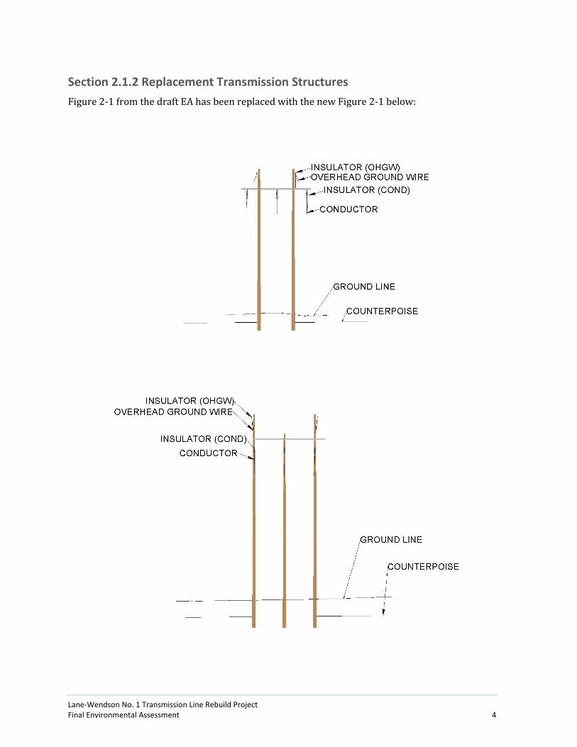
Section 2.1.2 Replacement Transmission Structures
Figure 2-1 from the draft EA has been replaced with the new Figure 2-1 below:

Lane-Wendson No. 1 Transmission Line Rebuild Project Final Environmental Assessment 5
The heading for Section 2.1.3 (page 2-6) has been revised from the draft EA as follows:
Section 2.1.3 Conductors, and Overhead Groundwire , and Fiber Optic Cable
The second paragraph in Section 2.1.3 (page 2-7) has been revised from the draft EA as follows:
For safety reasons, the National Electric Safety Code (NESC) establishes minimum
conductor heights. BPA requires the conductors to be at least 24 30 feet from the
ground, which exceeds NESC’s minimum conductor height of 18.6 24.9 feet for 115-kV
construction, for most of the transmission line because of past safety and landform
variation concerns.
The fourth paragraph in Section 2.1.3 (page 2-7) has been revised from the draft EA as follows:
Replacement components would be compliant with the Suggested Practices for Avian
Protection on Power Lines prepared by the Avian Power Line Interaction Committee
(20061). Bird diverters would be placed on the conductors or and/or overhead ground
wires (if they are present) in locations on spans where an increased risk of bird strikes
exists (e.g., near wetlands and rivers), and where technically feasible. These locations
include:
Structure 1/2 to 3/1
Structure 25/6 to 26/1
Structure 33/6 to 33/7
The last paragraph in Section 2.1.3 (page 2-7) has been revised from the draft EA as follows:
The existing fiber optic cable that runs for the length of the line would be reused and
reinstalled on the new structures. The exsting transmission line does not carry fiber
optic cable and new fiber is not part of the rebuild project.
2.1.4 Staging Areas and Tensioning Sites
The first sentence of the second paragraph (page 2-7) has been revised from the draft EA as
follows:
Tensioning sites are used for pulling and tightening the conductor and fiber optic cable
to the correct tension once they are mounted on the transmission structures, as shown in
Figure 2-3.
2.1.5 Access Roads
Gates, Culverts, and Bridges
The second paragraph in the Gates, Culverts, and Bridges section (page 2-9) has been revised
from the draft EA as follows:
1 See Chapter 7 (References) of the Lane-Wendson No. 1 Transmission Line Rebuild Project Draft Environmental
Assessment for citations used in the Final EA.

Lane-Wendson No. 1 Transmission Line Rebuild Project Final Environmental Assessment 6
Fifteen Twenty new culverts would be installed at existing stream or drainage crossings,
42 41 existing culverts would be replaced, and 16 culverts would be repaired. One new
access road bridge would be constructed at an existing ford crossing, and one existing
access road bridge would be replaced to support construction equipment. Three Of the
four existing fords, one would be spanned with temporary construction bridges for
construction. replaced with a bridge, one would be improved, and two would be
removed.
2.1.6 Vegetation Removal
The second paragraph in Section 2.1.6 (page 2-12) has been revised from the draft EA as follows:
Danger trees are trees that are located adjacent to outside the transmission line
right-of-way and are a present or future hazard to the transmission line. Danger trees
could violate the Minimum Vegetation Clearance Distance (MVCD) by falling into,
bending into, or growing into the conductor or coming close enough to cause flashover of
current from the conductor. A swing-into danger tree is a tree that could cause contact
or flashover if the conductor swings out from its stationary position due to high winds.
Fall-into, bend-into, and swing-into danger trees or logging fringes can pose an imminent
threat based on the judgment of the person conducting a maintenance patrol and
conditions at the site. . othat have the potential to fall or grow into or grow too close to
the conductor and cause flash-overs or line outages. BPA estimates that up to 40 danger
trees could require removal, however the specific number and location of danger trees
would be identified after construction is complete when the relationship of the rebuilt
line to existing trees can be determined.
2.1.7 Construction Activities
The first paragraph in Section 2.1.7 (page 2-12 and 2-13) has been revised from the draft EA as
follows:
Construction would likely take two three constructions seasons, with the earliest start of
spring or starting in summer 2016. A typical construction crew for a wood-pole
structure replacement project consists of 50 to 80 people, including transmission line
and road construction workers, inspectors and administrative personnel, surveyors, and
other support personnel.
Anticipated Construction Schedule
The first paragraph in the Anticipated Construction Schedule section (page 2-13) has been
revised from the draft EA as follows:
The schedule for construction of the Proposed Action depends on a variety of factors,
including the completion and outcome of the environmental review process, including
the duration of regulatory agency reviews, and the timing of permit approvals. If the
Proposed Action is implemented, construction would likely begin in June the summer of
2016. Construction work would be done in phases, with construction occurring on more

Lane-Wendson No. 1 Transmission Line Rebuild Project Final Environmental Assessment 7
than one structure at a time in different parts of the transmission line right-of-way. Two
Three construction seasons (late spring to early fall 2016, and 2017, and 2018) would be
needed to complete the Proposed Action. If construction begins in June Summer 2016,
all major construction activities would likely be completed by December 2018 2017. All
phases of construction would be coordinated with the Wild Fish Timber Sale in T.17S,
R.7W., sections 27 and 33. All affected landowners would receive a letter indicating the
exact start date of BPA operations. BPA would pay landowners for any crop or property
damage, as appropriate, that could occur as a result of construction activities.
Changes to Chapter 3—Affected Environment, Environmental Consequences, and Mitigation Measures
3.1 Land Use and Recreation
3.1.1 Affected Environment
Land Ownership and Management
The first sentence in the first paragraph of the Land Ownership and Management section (page
3-4) has been revised from the draft EA as follows:
Land ownership in the project area is a mix of public and private ownership. Publicly
owned lands include parcels owned by ODFW, BLM, City of Eugene, Lane County, Oregon
State Board of Forestry, State of Oregon Department of Forestry, and USFS.
3.1.2 Environmental Consequences—Proposed Action
Agricultural and Forestry Uses
The third sentence in the second paragraph of the Agricultural and Forestry Uses section (page
3-6) has been revised from the draft EA as follows:
While construction would likely span two three growing seasons, individual landowners
would likely only be affected for one season as construction would be conducted in
phases and all construction activities along a given segment of the transmission line
would be conducted within a period of a few months.
3.1.3 Mitigation Measures
The following mitigation measures in Section 3.1.3 have been revised or added:
Schedule construction during periods when active farms along the corridor are likely to
be fallow, to the extent practicable, to minimize the potential for crop damage.
Leave gates as they were found to avoid disturbances to livestock.

Lane-Wendson No. 1 Transmission Line Rebuild Project Final Environmental Assessment 8
Work with USFS to identify appropriate mitigation measures for project construction
activities from access road, trail, or transmission line construction work on National
Forest land.
3.2 Geology and Soils
3.2.3 Mitigation Measures
The following mitigation measures in Section 3.2.3 have been revised or added:
Reseed disturbed areas with a native seed mix as soon as work in that area is completed.
On ODFW, BLM and National Forest land, coordinate with each agency prior to
construction to specify seed mixes that are acceptable to each agency and BPA.
Assist farm operators in restoring productivity of compacted soils for structure sites and
access roads on agricultural lands.
Stabilize permanently disturbed areas for new access roads with a top layer of pavement
or gravel for the roadway and revegetate the roadway shoulders.
3.3 Vegetation
3.3.1 Affected Environment
Special Status Plant Species
The following row in Table 3-4 (page 3-18) has been revised from the draft EA table as follows:
Table 3-4. Special status Species Potentially Occurring within Project Area
Scientific Name Common Name Federal Status State Status
Lomatium bradshawii Bradshaw's lomatium desert parsley E E
The third and fourth paragraphs in the Special Status Plant Species section (page 3-19) have
been revised from the draft EA as follows:
None of the 14 special-status species were found within the project area during surveys
of areas that would have the potential for these species. Surveys for special-status plant
species were conducted in the transmission line right-of-way and new access road areas
by qualified botanists during the appropriate flowering periods in 2011, and
documented in the Lane-Wendson Transmission Line Rebuild Threatened and Endangered
Plant Species and Fender’s Blue Butterfly Nectar Species Survey (Turnstone 2011).
Additional surveys were performed in 2014 within prairie habitat for federally-listed
threatened or endangered plant species—Kincaid’s lupine, Willamette daisy, and
Bradshaw’s lomatium. Of the 14 special-status species potentially occurring in the
project area, only one, Bradshaw’s lomatium, has been recently documented none of the
species were detected (see further discussions below regarding potential presence and
surveys for these species).

Lane-Wendson No. 1 Transmission Line Rebuild Project Final Environmental Assessment 9
Potential presence in the project area was determined by conducting plant surveys and
reviewing the Oregon Biodiversity Database (ORBIC) for records of special-status species
occurring within two miles of the transmission line (ORBIC 2015). Federally-listed plant
species that occur in Lane County include Willamette daisy (Erigeron decumbens var.
decumbens), Bradshaw’s lomatium desert parsley (Lomatium bradshawii), and Kincaid’s
lupine (Lupinus sulphureus ssp. kincaidii). All of these three federally-listed species are
confirmed to occur within one mile of the project area.
The section title text in the Bradshaw’s Desert Parsley section (page 3-19 and 3-20) has been
revised from the draft EA as follows:
Bradshaw’s Lomatium Desert Parsley
Bradshaw’s lomatium desert parsley (Lomatium bradshawii) is a perennial member of
the carrot family (Apiaceae). Once regarded as endemic to the Willamette Valley,
additional populations of Bradshaw’s lomatium desert parsley were located in Clark
County, Washington, in 1994. Exhibiting a narrow preference for habitat, Bradshaw’s
lomatium desert parsley is generally restricted to wet prairie environments, though the
species is occasionally found in lightly-wooded wetlands. The majority of extant
populations occur along seasonally inundated or saturated margins of waterways,
typically growing in poor draining clay soils. Bradshaw’s lomatium desert parsley does
not have designated critical habitat.
Multiple subpopulations of Bradshaw’s lomatium desert parsley occur near Coyote Creek
and along the north side of Neilson Road opposite the Lane Substation (ORBIC 2015).
These populations are associated with open tufted hairgrass, Hall’s aster (Aster hallii),
and Oregon coyote thistle (Eryngium petiolatum). Plant surveys were conducted during
the flowering window for the Bradshaw’s lomatium desert parsley flowering window in
2014 along access roads and within the right-of-way in wet prairie environments; no
new populations were observed (Turnstone 2014); however, the species was observed
by ODFW botanical contractors in 2013 on the south side of Coyote Creek along the
northern edge of the BPA right-of-way.
3.3.2 Environmental Consequences—Proposed Action
Special-status Plant Species
The first paragraph in the Special-status Plant Species section (page 3-22 and 3-23) has been
revised from the draft EA as follows:
All three of the federally listed vascular plant species that occur in or near project area
are imperiled primarily due to losses in prairie habitat. Once common in the Willamette
Valley, prairie habitats have been eliminated in 99 percent of their historic range (ODFW
2006). Project activities are unlikely to impact the sub-population of Bradshaw’s
lomatium present on the south bank of Coyote Creek, as the plants are located to the east
of proposed work areas; approximately 125 feet away from ground-disturbing activities
associated with the replacement of structure 3/2. There would be no impact to remnant
prairie habitat, ESA listed plants, or other special status species because none are known

Lane-Wendson No. 1 Transmission Line Rebuild Project Final Environmental Assessment 10
to occur within the project area and no new populations were found during plant
surveys.
3.3.3 Mitigation Measures
The following mitigation measures in Section 3.3.3 have been revised or added:
In areas near sensitive botanical resources—such as the population of documented
Bradshaw’s lomatium immediately adjacent to the BPA right-of-way—demarcate
vegetation clearing limits prior to disturbance.
Clearly mark trees identified for removal.
In areas near sensitive botanical resources or other sensitive natural resource areas—
such as the population of documented Bradshaw’s lomatium immediately adjacent to the
BPA right-of-way—delineate work areas around construction sites to prevent vehicle
turnaround, materials storage, or other disturbance outside designated construction
areas.
In or near sensitive areas, Place materials storage and staging areas in previously
disturbed areas if possible, away from wetlands/waterbodies.
There are no documented populations of special-status plant species within the project
area; however, if new populations of special-status plant species are discovered prior to
project implementation, then the following recommendations would be executed for
avoiding and minimizing impacts:
There is one documented population of a special-status plant species (Bradshaw’s
lomatium) within the project area; this and any new populations of special status plant
species that are discovered prior to project implementation would be protected by
adhering to the following recommendations for avoiding and minimizing impacts:
o Restrict equipment access to wood pole structures near the populations.
o Salvage special status species where possible and replant after construction.
Return temporarily disturbed areas to the original (pre-construction) contours and
conduct site restoration and revegetation measures as soon as practicable following
construction.
Revegetate disturbed areas with native grasses and forbs (or landowner-requested
species) to ensure appropriate vegetation coverage and soil stabilization prior to rainy
season (November 1).
Inspect seeded sites to verify adequate growth and implement contingency measures as
needed.
Inspect all vehicles before entering construction areas for weeds, and install and use
appropriate equipment cleaning measures and weed wash stations at selected locations
along the transmission line right-of-way to minimize the introduction and broadcast of

Lane-Wendson No. 1 Transmission Line Rebuild Project Final Environmental Assessment 11
weed seeds/propagules. Require all vehicles and equipment entering ODFW or City of
Eugene properties to use the wash station prior to entering the property.
Minimize disturbance to vegetation; only remove vegetation that would interfere with
the proposed construction activities.
Restore all temporarily disturbed soils according to BLM and Forest Service
requirements and agency Biological Opinions for seeding and mulching, to minimize
adverse impacts to vegetation.
Restore all temporarily disturbed soils according to requirements in the USFWS and
National Oceanic and Atmospheric Administration (NOAA) Fisheries biological opinions
for this project (USFWS 2015; NOAA 2016 [pending]), to minimize adverse impacts to
vegetation.
Replant native riparian species at specified bridge/culvert replacement locations during
the dormant season (November 1 to February 1).
In wetlands where there are temporary disturbances, salvage and stockpile selected
topsoil for replacement on cut/fill slopes to improve site restoration and plant
establishment.
Prior to construction, visit existing noxious weed infestations and conduct preemptive
measures to minimize transport and expansion of weed occurrences during
construction; flag infestations for avoidance (as practicable) during construction. Where
practicable, treat noxious weeds adjacent to access roads and structure sites. Perform
follow up monitoring and treat infestation areas after construction if needed. BPA would
not apply herbicides on BLM Eugene District lands. Vegetation management on BLM and
National Forest lands would not include the use of herbicides, unless approved in
advance by the appropriate agency.
BPA would coordinate with ODFW, BLM and Forest Service prior to construction to
specify seed mixes that are acceptable toeach agency and BPA for revegetation.
In or near sensitive areas, place materials storage and staging areas in previously
disturbed areas away from wetlands and waterbodies.
3.4 Streams and Fish
3.4.1 Affected Environment
Streams
Upper Willamette Subbasin
The second sentence in the Upper Willamette Basin section (page 3-25) has been deleted from
the draft EA as follows:
The Upper Willamette Subbasin is located in the southern and central portion of the
Willamette Basin. The Upper Willamette River drains into the Willamette River through
many tributaries; the closest to the project area is the Long Tom River. The subbasin’s

Lane-Wendson No. 1 Transmission Line Rebuild Project Final Environmental Assessment 12
1,197,000 acres are mostly in Lane, Linn, Benton, and Polk Counties and include six
watersheds, one of which is crossed by the project area: Long Tom River. Forty five
percent of the subbasin is forestland and 39 percent is grassland, pastureland, and
hayland. The remaining land supports orchards, vineyards, nursery stock, berries, and
development. Nine percent of land in the subbasin is publically owned (NRCS 2006).
3.4.2 Environmental Consequences—Proposed Action
Streams
The last sentence of the second paragraph in the Streams section (page 3-31) has been revised
from the draft EA as follows:
Further, erosion rates would likely return to their current levels once vegetation is
reestablished or would be reduced based on improvements to access roads and drainage
features.
Fish
The following rows in Table 3-10 (page 3-33 and 3-34) have been removed from the draft EA
table as follows:
Table 3-10. Proposed In-water Work on Fish-bearing Streams
Structure ID2
Work Proposed Stream Potential ESA Fish Present
In-water Work
Fish Salvage Likely Required
C-017-070 Replace ford with culvert
Small unnamed trib. to Fish Creek
No Yes Yes (if not dry)
C-032-010 Replace culvert Small unnamed trib. to Knowles Creek
No Yes Yes (if not dry)
3.4.3 Mitigation Measures
The following mitigation measures in Section 3.4.3 have been revised or added:
Install cross-drains long enough so that outlets extend beyond road fill.
Excavate cross-drain inlets to allow for initial sediment influx after construction.
Armor first 25 feet of ditch upgradient from cross-drain and catch basin with rock (e.g.,
pit-run/jaw rock or equivalent) to decrease the water’s energy and slow flow.
Armor cross-drain outlets (e.g., pit run/jaw rock, slash, or equivalent) to decrease the
water’s energy and slow flows.
Maintain emergency spill control materials, such as oil booms and spill response kits,
on-site at each each ford or culvert replacement stream crossing site where in-water
work would occur at all times and ready for immediate deployment.
Include small sorbent booms (sausage booms), sorbent sheets/pads and socks,
vermiculite/kitty litter, duct tape, heavy-duty garbage bags, zip ties, and nitrile gloves in
spill kits. Restock materials within 24 hours if used.
Lane-Wendson No. 1 Transmission Line Rebuild Project Final Environmental Assessment 13
Outfit heavy machinery (e.g., excavators) with fire extinguisher, shovel, first aid kits, and
caps and plugs for machine hydraulic lines and associated attachments (e.g.,
hammer/plate compactor, etc.).
Stockpile and make available large sorbent booms, straw bales, straw wattles, and
turbidity curtains at each specified bridge/culvert replacement site to quickly respond to
any spills or turbidity and erosion concerns during construction.
3.5 Wetland, Floodplains, and Groundwater
3.5.1 Affected Environment
Wetlands and Waters
The first sentence of the second paragraph in the Wetlands and Waters section (page 3-37) has
been revised from the draft EA as follows:
Wetland scientists conducted field investigations and identified 286 285 jurisdictional
wetlands and waters, which included 129 130 wetlands (totaling approximately 112
7.32 acres), 135 122 streams, 20 33 ditches, and 2 ponds that could be affected by
structure replacement and access road construction (MB&G 2015a).
The last sentence of the fourth paragraph in the Wetlands and Waters section (page 3-37) has
been revised from the draft EA as follows:
Because of this disturbance and because the project area is maintained free of trees, the
majority of the wetlands identified in the project area were classified as PEM (69 67
total), with some PSS (54 55 total) and PFO (6 total).
The last sentence of the fifth paragraph in the Wetlands and Waters section (page 3-38) has
been revised from the draft EA as follows:
The majority of vegetation communities associated with wetlands in the Willamette
Valley are generally maintained through a combination of transmission line maintenance
to remove trees and tall shrubs, grazing from livestock, and/or cultivation for
agricultural crops; however, some wetlands in the Willamette Valley are managed to
create and/or restore native wetland functions and values and sensitive species’
habitats.
3.5.2 Environmental Consequences—Proposed Action
Wetlands and Waters
The first sentence of the second paragraph in the Wetlands and Waters section (page 3-40) has
been revised from the draft EA as follows:
Replacement of transmission line structures would impact 70 74 wetlands and 66 67
ditches and streams throughout the project.
The last sentence of the fifth paragraph in the Wetlands and Waters section (page 3-41) has
been revised from the draft EA as follows:

Lane-Wendson No. 1 Transmission Line Rebuild Project Final Environmental Assessment 14
Temporary wetland and waters impacts from structure replacement would be expected
to total approximately 0.997 0.926 and approximately 0.008 acre, respectively.
The first sentence of the seventh paragraph in the Wetlands and Waters section (page 3-41) has
been revised from the draft EA as follows:
Temporary impacts from the Proposed Action are expected to total approximately 4.72
4.48 acres within wetlands and approximately 0.03 0.04 acre within waters.
Table 3-11 (page 3-41) has been revised from the draft EA table as follows:
Table 3-11. Approximate Impacts to Wetlands and Waters from the Proposed Action
Wetlands Waters
Permanent Temporary Permanent Temporary
Square Feet
Acres Square
Feet Acres
Square Feet
Acres Square
Feet Acres
Transmission tower replacement
978
908
0.022
0.021
43,450
40,347
0.997
0.926
0 0.000 350 0.008
Road construction 19,519
20,638
0.448
0.474
0 0.000 13 0.000
0.001
0 0.000
Road improvement 34,435
34,436
0.791 0 0.000 2,189
2,079
0.050
0.048
0 0.000
Road reconstruction 21,827
21,826
0.501 0 0.000 1,744 0.040 0 0.000
Culverts, drain dips, bridges, etc.
30,693
31,205
0.705
0.716
2,785
5,682
0.064
0.130
8,891
8,215
0.204
0.189
1,016
1,150
0.023
0.026
Temporary access 0 0.000 164,959
153,794
3.787
3.531
0 0.000 37
259
0.001
0.006
Total for Proposed Action
107,452
100,741
2.467
2.312
211,194
195,095
4.848
4.479
12,837
11,422
0.294
0.262
1,403
1,760
0.032
0.040
3.5.3 Mitigation Measures
The following mitigation measures in Section 3.5.3 have been revised or added:
Impacts to wetlands and waters would be minimized, to the extent technically feasible,
by narrowing road widths in wetlands and by complying with conditions in the
USACE/DSL Joint Removal-Fill Permit for the project.
Minimize impacts to wetlands and waters, to the extent technically feasible, by
narrowing road widths in wetlands and by complying with conditions in the Oregon
Department of State Lands Removal/Fill Authorization and a US Army Corps of
Engineers Section 404 Authorization. BPA would endeavor to limit impacts and
disturbance to an area within 25 feet of wood-pole structures; however, field conditions
and work and safety requirements may require areas to be disturbed in excess of 25 feet
away from structures. Impacts identified in these authorizations include construction

Lane-Wendson No. 1 Transmission Line Rebuild Project Final Environmental Assessment 15
within the City of Eugene’s Coyote Prairie North Wetland Mitigation Bank, a sensitive
habitat.
o Meet with the City of Eugene regarding construction within the Coyote Prairie
North Wetland Mitigation Bank before, during, and after construction to
coordinate tilling and restoration of the site; to identify the appropriate seed mix
to use for restoration of areas disturbed by construction; and to coordinate the
type, amount, and timing of any herbicide used.
o If feasible, construction within the Coyote Prairie North Wetland Mitigation Bank
would be limited to dry conditions. However, due to line outage scheduling, if
conditions during construction are not dry, wetland mats or low ground pressure
equipment would be used to avoid soil compaction and rutting.
Obtain and comply with applicable US Army Corps of Engineers Clean Water Act and
State of Oregon Removal/Fill permits for all work in wetlands or streams.
Identify and flag wetland boundaries before construction.
Install erosion-control measures prior to work in or near wetlands (e.g., silt fences, straw
wattles, and other sediment control measures) and reseed disturbed areas as required.
Deposit and stabilize all excavated material not reused in an upland area outside of
wetlands.
Avoid construction within wetlands to protect wetland functions and values, where
possible. Avoid using these areas for construction staging, equipment or materials
storage, or fueling of vehicles.
Use existing road systems, where possible, to access structure locations.
Remove all temporary fill and geotextile fabric and revegetate temporary roads built in
wetlands after use.
Restore all temporary disturbance areas to original contours and decompact, if
necessary.
Replant all temporary disturbance areas within wetlands with native species, as
specified in project permits.
Purchase wetland mitigation bank credits and/or in-lieu fee program mitigation credits,
and/or participate in payment-in-lieu programs, as mitigation for permanent wetland
impacts, as described in the Oregon Department of State Lands Removal/Fill
Authorization and a US Army Corps of Engineers Section 404 Authorization.
Use multi-layer barrier wraps around base of poles located in wetlands to help prevent
leaching of the preservative material into surrounding areas.

Lane-Wendson No. 1 Transmission Line Rebuild Project Final Environmental Assessment 16
3.6 Wildlife
3.6.3 Mitigation Measures
The following mitigation measures in Section 3.6.3 have been revised or added:
Leave a small percentage of cut and felled danger trees as snags in upland and wetland
areas within the transmission line as additional habitat/structure for wildlife,
particularly small mammals and amphibians.
Follow the measures, terms, and conditions outlined in the USFWS Biological Opinion
(July 23, 2015), which includes monitoring the response of streaked horned larks to
project construction activities and reporting results to the appropriate USFWS office.
o Conduct pre-construction surveys for streaked horned lark several weeks before
construction.
o Conduct three visits using point-count stations during the breeding season from
March through July, with the last survey conducted within two weeks prior to
construction.
o Begin surveys 30 minutes before sunrise and end at 11 am or sooner on hot days
(≥80°F) using five-minutes long observation periods at each point-count station.
o Locate observation points along planned/existing access roads spaced 200
meters apart.
o If larks are observed, triangulate lark vocalizations to identify the location.
Assume vocalizing larks during the breeding period are nesting, and do not
conduct nest searches due to the high probability of disturbing nesting and the
low probability of finding the actual nest.
Re-vegetate disturbed areas with weed-free seed mixes and plantings that include nectar
plants for Fender’s blue butterfly.
3.7 Cultural Resources
3.7.3 Mitigation Measures
The following mitigation measure in Section 3.7.3 has been added:
Develop an Inadvertent Discovery Plan that details crew member responsibilities for
reporting in the event of a discovery during construction.
3.9 Socioeconomic and Public Services
3.9.2 Environmental Consequences—Proposed Action
Public Services and Lodging
The first sentence of the second paragraph under in the Public Services and Lodging section
(page 3-68) has been revised from the draft EA as follows:

Lane-Wendson No. 1 Transmission Line Rebuild Project Final Environmental Assessment 17
The fiber optic cable attached for the length of the line, along with its associated
hardware (e.g., risers, junction boxes, etc.), would be transferred to the rebuilt
structures. Prior to construction, the underground telephone lines and natural gas lines
would need to be located, and coordination with utility companies would occur to avoid
impacts to these utility lines.
3.10 Noise, Public Health, and Safety
3.10.2 Environmental Consequences—Proposed Action
The notes on Table 3-20 (page 3-73), Table 3-21 (page 7-74) and Table 3-22 (page 3-75) have all
been revised from the draft EA as follows:
Values developed from BPA modeling programs and are based upon a 200-foot right-of-
way with 115kV and 230kV line.
3.10.3 Mitigation Measures
The following mitigation measure in Section 3.10.3 has been added:
Since there would be no significant changes to the electric and magnetic fields in the
vicinity of the line, and no impacts would result from operational activities, no
avoidance, minimization, or mitigation measures would be needed.
3.11 Transportation
3.11.3 Mitigation Measures
The following mitigation measures in Section 3.11.3 3 have been added:
Repair damage to roads caused by construction.
Keep construction activities and equipment clear of residential driveways to the extent
possible.
3.12 Air Quality
3.12.3 Mitigation Measures
The following mitigation measure in Section 3.12.3 has been added:
Drive vehicles at low speeds (less than 5 miles per hour) on access roads and the BPA
easement to minimize dust during high dust conditions.

Lane-Wendson No. 1 Transmission Line Rebuild Project Final Environmental Assessment 18
_____________________________________________________________________________________________________
Changes to Chapter 4—Environmental Consultation, Review, and Permit Requirements
4.2 Vegetation, Wildlife, and Fish
4.2.7 Oregon Fish and Wildlife Habitat Mitigation Policy
The second paragraph in Section 4.2.7 (page 4-3) has been revised from the draft EA as follows:
BPA has coordinated consulted with the ODFW and incorporated its biologist’s
recommendations to avoid and minimize potential impacts to fish and wildlife resources,
as well as provide offsetting mitigation. Several Twelve culverts would be reconstructed
to be fish passable as part of the Proposed Action. Additionally, several five existing ford
crossings would be replaced with fish passable culverts, one existing ford would be
replaced with a full-span bridge, and one bridge would be replaced. Three temporary
construction bridges and one new culvert would also be installed to minimize access
road impacts to streams. Site restoration measures would also be implemented after
project construction according to prescriptions for re seeding and mulching disturbed
areas, replanting trees and shrubs removed adjacent to culvert installations.
4.3 Water Resources
The first sentence of the last paragraph in Section 4.3 (page 4-5) has been revised from the draft
EA as follows:
An Oregon Department of State Lands Removal/Fill Authorization and a US Army Corps
of Engineers Section 404 Authorization are both required as a result of impacts from the
Proposed Action to jurisdictional waterbodies. BPA submitted applications for these
authorizations on February 23, 2016, and the Oregon Department of State Lands and US
Army Corps of Engineers are reviewing these applications. BPA joint removal-fill permit
for this project, which would be reviewed by the USACE and DSL.

Lane-Wendson No. 1 Transmission Line Rebuild Project Final Environmental Assessment 19
_____________________________________________________________________________________________________
Changes to Chapter 6—Glossary
The definition for Danger Tree (page 6-2) has been revised from the draft EA as follows:
Danger trees are trees that are located outside the transmission line right-of-way and are
a present or future hazard to the transmission line. Danger trees could violate the
Minimum Vegetation Clearance Distance (MVCD) by falling into, bending into, or growing
into the conductor or coming close enough to cause flashover of current from the
conductor. A swing-into danger tree is a tree that could cause contact or flashover if the
conductor swings out from its stationary position due to high winds. Fall-into, bend-into,
and swing-into danger trees or logging fringes can pose an imminent threat based on the
judgment of the person conducting a maintenance patrol and conditions at the site.
Trees (or high-growing brush) in or alongside the transmission line right-of-way that are
hazardous to the transmission line. These trees are identified by special crews and must
be removed to prevent tree-fall into the line or other interference with the conductors.
BPA’s Construction Clearing Policy requires that trees be removed that meet either one
of two technical categories: Category A is any tree that within 15 years will grow to
within about 18 feet of conductors when the conductor is at maximum sag (212ºF) and
swung by 6 pounds per square feet of wind (58 miles per hour); Category B is any tree or
high-growing brush that after a year of growth will fall within about 8 feet of the
conductor at maximum sag (176ºF) and in a static position.
The definition for Tensioning Sites (page 6-8) has been revised from the draft EA as follows:
Tensioning sites are used for pulling and tightening the conductor and fiber optic cable
to the correct tension once they are mounted on the transmission structures. Tensioning
sites are located within the right-of-way where possible or just outside of the
right-of-way where the line makes a turn or angle.

Lane-Wendson No. 1 Transmission Line Rebuild Project Final Environmental Assessment 20
____________________________________________________________________________________________________
Changes to Appendices—Appendix C
A new appendix has been added (Appendix C) entitled “Description of Proposed Action Work on USFS Land.”
Appendix C. Description of Proposed Action Work on Siuslaw National Forest land Note: In addition to the mitigation measures described
in Chapter 3, BPA will work with the Forest Service to identify and implement additional mitigation measure to protect resources on
National Forest land as appropriate.
Siuslaw NF Parcel number 1809070000100 180908000100 1810080000100 Total
Trail Construction 0.14 mile 0.08 mile 0.00 mile 0.22 mile
Road Construction 0.00 mile 0.07 mile 0.00 mile 0.07 mile
Road Reconstruction 0.25 mile 0.14 mile 0.08 mile 0.47 mile
Road Improvement 0.39 mile 0.46 mile 0.09 mile 0.94 mile
Road Direction of Travel 0.00 mile 0.00 mile 0.00 mile 0.00 mile
Total Road Work (- Trails) 0.64 mile 0.67 mile 0.17 mile 1.48 miles
Trees removed (>6” dbh) 21 0 0 21
Road Features Added or Improved
Culvert, Replace(1) No fish Ford, Existing (1) Gate, Replace (1) Landing, New (1) Waterbar, New (27)
Culvert, Repair (1) No fish Ford, Existing (1) Ditch Relief, New (1) Landing, New (7) Waterbar, New (7)
Waterbar, New (1)
2 Culverts 2 Fords 1 Gate 1 Ditch Relief 8 Landings 35 Waterbars
Transmission Line Structures
31/5 (3 poles, 6 guy anchors) 32/1 (2 poles) 32/2 (2 poles)
30/6 (3 poles, 6 guy anchors) 31/1 (3 poles, 6 guy anchors) 31/2 (2 poles) 31/3 (2 poles) 31/4 (3 poles, 6 guy anchors)
36/4 (2 poles) 9 Structures 22 Poles 24 Guy Anchors

Lane-Wendson No. 1 Transmission Line Rebuild Project Final Environmental Assessment 21
Wetland Impacts Trail Construction - 32ft2
Trail Construction - 62 ft2
Road Reconstruction - 550 ft2 Road Improvement - 24 ft2 Total Wetlands Impacted - 636 ft2 Wetlands in ROW (not impacted) - 10,293 ft2
None 668 ft2 Wetland Impacts
Northern Spotted Owl (NSO) Critical Habitat1
Trail Construction - 0.14 mileRoad Reconstruction - 0.25 mile Road Improvement - 0.39 mile Total - 0.78 mile
Trail Construction - 0.08 mile Road Construction - 0.07 mile Road Reconstruction - 0.14 mile Road Improvement - 0.46 mile Total - 0.75 mile
None
Trail Construction - 0.22 mile Road Construction - 0.07 mile Road Reconstruction - 0.39 mile Road Improvement - 0.85 mile Total - 1.530 miles
NSO Highly Suitable Habitat
Trail Construction - 0.004 mile Road Reconstruction - 0.06 mile Road Improvement - 0.06 mile Total - 0.124 mile
Road Improvement - 0.09 mile
None
Trail Construction - 0.004 mile Road Reconstruction - 0.06 mile Road Improvement -0.15 mile Total - 0.214 mile
NSO Suitable Habitat Road Improvement - 0.06 mile None Road Reconstruction - 0.02 mile Road Reconstruction - 0.02 mile Road Improvement - 0.06 mile Total - 0.080 mile
NSO Marginal Habitat
Trail Construction - 0.14 mile Road Reconstruction - 0.09 mile Road Improvement - 0.20 mile Total - 0.43 mile
Trail Construction - 0.007 mile Road Improvement - 0.21 mile Total - .0217 mile
None
Trail Construction - 0.147 mile Road Reconstruction - 0.09 mile Road Improvement -0.41mile Total - 0.647mile
Marbeled Murrelet (MAMU) Critical Habitat
Trail Construction - 0.14 mile Road Reconstruction - 0.25 mile Road Improvement - 0.39 mile Total - 0.78 mile
Trail Construction - 0.08 mile Road Construction - 0.07 mile Road Reconstruction - 0.14 mile Road Improvement - 0.46 mile Total - 0.75 mile
None
Trail Construction - 0.22 mile Road Construction - 0.07 mile Road Reconstruction - 0.39 mile Road Improvement - 0.85 mile Total - 1.530 miles

Lane-Wendson No. 1 Transmission Line Rebuild Project Final Environmental Assessment 22
Work in MAMU Suitable Habitat Zone B**
Trail Construction - 0.14 mile Road Reconstruction - 0.25 mile Road Improvement - 0.26 mile Total - 0.65 mile
Trail Construction - 0.08 mile Road Improvement - 0.46 mile Total - 0.54 mile
None
Trail Construction - 0.22 mile Road Reconstruction - 0.25mile Road Improvement - 0.72 mile Total - 1.19 miles
Work in MAMU Suitable Habitat Zone A**
Road Improvement - 0.13mile
Road Construction - 0.07 mile Road Reconstruction - 0.14 mile Road Improvement - 0.46 mile Total - 0.67 mile
Road Reconstruction - 0.08 mile Road Improvement - 0.09 mile Total - 0.17 mile
Road Construction - 0.07 mile Road Reconstruction - 0.22 mile Road Improvement - 0.68 mile Total - 0.97 mile
**MAMU (Marbled Murrelet) zones are defined as follows: Zone A- Areas where work would occur within 100 yards of known or potential marbled murrelet nesting habitat
Zone B- Areas where work would occur between 100 yards and .25 miles of known or potential marbled murrelet nesting habitat.

Lane-Wendson No. 1 Transmission Line Rebuild Project Final Environmental Assessment 23
_____________________________________________________________________________________________________
Comments Received on Draft EA and BPA’s Responses In order to solicit comments on the draft EA, BPA mailed the EA, or notification of its availability,
to over 150 government agencies, tribes, organizations, and individuals. In addition, BPA posted
the EA on the project website. The comment period ran from November 30, 2015, through
January 4, 2016, and six comments were received.
The comments were each assigned an identifying number. In some instances, the comments
were further subdivided by subject, and each subject was responded to individually. Table 1
provides the comment number and the associated author and affiliation. The comments are
reproduced in their entirety.
Table 1. Draft EA Comment Submittals
Comment Number Comment Author / Affiliation
LWTLR15 0001 Peabody
LWTLR15 0002 Wolf
LWTLR15 0003 ODFW
LWTLR15 0004 O’Neal
LWTLR15 0005 Rippee/THPO
LWTLR15 0006 Miller/City of Eugene Parks and Open Space
Comment LWTLR15 0001 Peabody
Will you be spraying herbicides or other chemicals once, periodically or at all? If so, what distance
from pole lines will this occur?
Response to Comment LWTLR15 0001 Peabody
As described in Section 3.3.3. of the EA, prior to construction activities for the rebuild, existing
noxious weed infestations would be treated adjacent to access roads and structure sites—this is
to help prevent potential weed spread due to project construction ground disturbance and
vehicle activity. Follow-up treatments may be performed if needed.
As described in Section 2.1.8 of the EA, BPA’s ongoing vegetation management along the right-
of-way occurs approximately every 3 to 4 years (or more frequently as needed) in accordance
with the BPA’s Transmission System Vegetation Management Program Final Environmental
Impact Statement and Record of Decision (DOE/EIS-0285). Herbicides may be used as part of
ongoing vegetation management, especially to help control noxious weeds or resprouting
deciduous trees, as appropriate.

Lane-Wendson No. 1 Transmission Line Rebuild Project Final Environmental Assessment 24
If you have specific questions regarding vegetation management and herbicides use along the
right-of-way across your property, please contact BPA’s local Natural Resource Specialist at
(541) 988-7433.
Comment LWTLR15 0002 Wolf
Just do it! Quit dinkin' around. TEP-TPP-1
Response to Comment LWTLR15 0002 Wolf
Thank you for your comment.
Comment LWTLR15 0003 ODFW
Re: Lane-Wendson No. 1 Transmission Line Rebuild Project Draft Environmental
Assessment
The purpose of this letter is to provide comments to the Lane-Wendson No. 1 Transmission Line
Rebuild Project Draft Environmental Assessment (November 2015). The Oregon Department of Fish
and Wildlife (ODFW) has three parcels that are within the planned project area, specifically tax
lots:1705360000503, 1805020000400, & 1805020000100. All parcels were purchased under the
ODFW/BPA Willamette Wildlife Mitigation Program (WWMP), as part of the Willamette River
Basin Memorandum of Agreement Regarding Wildlife Habitat Protection and Enhancement
between the State of Oregon and Bonneville Power Administration (BPA). Additionally, BPA holds
permanent conservation easements on the parcels.
While recognizing the importance of the proposed work and the rights of BPA within the
transmission Right-of-way (ROW), ODFW would like to stress the importance of minimizing
impacts to these parcels due to the substantial resources that have been allocated to protect and
enhance the conservation values attributed to them. Significant restoration efforts are planned and
underway as outlined in the Coyote Creek South Management Plan (2015).
The following excerpts of the draft EA are areas that ODFW would appreciate more information
and/or to provide feedback specifically to the aforementioned parcels:
1. Bird diverters
Bird diverters would be placed on the conductors and/or overhead ground wires on spans where an
increased risk of bird strikes exists (e.g., near wetlands and rivers), and where technically feasible.
(p.2-7)
ODFW requests installation of bird diverters if applicable.
2. Temporary staging
Temporary areas would be needed to store and stockpile materials, trucks, and other equipment
during construction. The staging areas would occupy approximately 30 acres each. Staging areas
would be identified by the construction contractor, prior to construction, and appropriate
environmental review and approval of the identified sites by BPA would be conducted. (p.2-7)
Please provide more information on locations if proposed on ODFW property.

Lane-Wendson No. 1 Transmission Line Rebuild Project Final Environmental Assessment 25
3. Land Ownership and Management
Land ownership in the project area is a mix of public and private ownership. Publicly-owned lands
include parcels owned by BLM, City of Eugene, Lane County, Oregon State Board of Forestry, State
of Oregon Department of Forestry, and USFS. Many of the privately-owned parcels along the
transmission line are owned by timber companies, such as Roseboro and Oxbow Timber. In
addition, The Nature Conservancy and the Oregon State University Foundation, both non-profit
organizations, own land in the project area. (p.3-4)
Please update ownership database to reflect ODFW ownership.
Adjacent to the Coyote Prairie site, the project area crosses land referred to as the Coyote Creek
property. This 310-acre property was acquired by The Nature Conservancy with the intent of
transferring it to ODFW to own, manage, and restore as wet prairie in coordination with the
adjacent Fern Ridge Wildlife Area (ODFW 2013). (p.3-4)
Please update to reflect that ODFW presently owns 310 acres (Coyote Creek South) to the
southwest and 225 acres (Coyote Creek North) to the north of the City of Eugene’s Coyote
Prairie Mitigation Bank. Both ODFW sites have conservation easements on them held by
BPA for conservation values.
4. Recreation Areas
East Coyote and West Coyote Units of the Fern Ridge Wildlife Area – Construction, reconstruction,
and improvements to certain segments of access road would take place at least 700 feet south and
east of the boundaries of the Fern Ridge Wildlife Area. Given the flat terrain of the area, this work
would likely be visible to recreational users, and noise and dust could temporarily affect
recreational users. (p.3-5)
Assuming access road is within tax lot 1805010000104; ODFW has concerns how
reconstruction and/or improvements will affect the hydrology of the area as it relates to
both completed and planned efforts to restore wet prairie habitats. More specific
information is requested on the type of improvements in this area and considerations to
limit impacts to natural hydraulic flow.
5. Special-status Plant Species
None of the 14 special-status species were found within the project area during surveys of areas
that would have potential habitat for these species. Surveys were conducted in the transmission line
right-of-way and new access road areas by qualified botanists during the appropriate flowering
periods in 2011, and documented in the Lane-Wendson Transmission Line Rebuild Threatened and
Endangered Plant Species and Fender’s Blue Butterfly Nectar Species Survey (Turnstone 2011).
Additional surveys were performed in 2014 within prairie habitat for federally-listed threatened or
endangered plant species—Kincaid’s lupine, Willamette daisy, and Bradshaw’s lomatium—none of
the species were detected (see further discussions below regarding potential presence and surveys
for these species).
Potential presence in the project area was determined by conducting plant surveys and reviewing
the Oregon Biodiversity Database (ORBIC) for records of special-status species occurring within

Lane-Wendson No. 1 Transmission Line Rebuild Project Final Environmental Assessment 26
two miles of the transmission line (ORBIC 2015). Federally- listed plant species that occur in Lane
County include Willamette daisy (Erigeron decumbens var. decumbens), Bradshaw’s desert parsley
(Lomatium bradshawii), and Kincaid’s lupine (Lupinus sulphureus ssp. kincaidii). All of these three
federally-listed species are confirmed to occur within one mile of the project area. (p.3-19)
ODFW has documented Bradshaw’s lomatium (see Coyote Creek South Management Plan)
immediately adjacent to the BPA ROW in the southwest corner on tax lot 1805020000400.
ODFW requests that measures are taken not to disrupt population.
6. Invasive Plants
Implement appropriate measures to minimize the introduction and broadcast of weed
seeds/propagules, including inspection of vehicles before entering construction areas, installation
and use of weed wash stations at selected locations along the transmission line right-of-way, and
other appropriate equipment cleaning measures. (p.3-24)
ODFW requests that equipment be washed prior to entry. Please provide more information
on locations of weed wash stations if proposed within ODFW property.
7. Reseeding/Seed Mixes
ODFW requests that BPA coordinate all seed mixes to ensure they are in line with
restoration efforts.
8. Access Road/Culverts (C-003-21-23)
ODFW requests that BPA provide more information on the following culverts as it relates to
the hydrology of the site.
9. Agriculture Impacts
ODFW presently leases portions of the proposed impacted parcels. More information
regarding impacts to farming practices and acreage is requested.
Response to Comment LWTLR15 0003 ODFW
1. BPA is planning to install bird flight diverters on the first two miles of the transmission line
between the Lane Substation and Coyote Creek. Section 2.1.3 of the EA has been revised to
describe the proposed location of bird flight diverters.
2. No temporary staging areas are proposed on ODFW property. Poles may be temporarily
placed on the ground next to the existing tower to be replaced for several days prior to
construction.
3. Section 3.1.1 of the EA has been revised to reflect that ODFW owns the property described in
the comment.
4. BPA plans to add gravel to the existing access road from Cantrell Road south to the ROW on
Tax Lot 1805010000104. BPA understands that ODFW may be looking at options for
removing or altering this road at some time in the future. BPA would work with ODFW to
arrive at an acceptable solution at that time.

Lane-Wendson No. 1 Transmission Line Rebuild Project Final Environmental Assessment 27
5. BPA would work with ODFW to identify the population in the field prior to construction and
would mark the area as a no entry area on photo maps and the Mitigation Implementation
Table that would be delevoped to specifically instruct construction workers to follow
mitigation measures during construction to minimize or avoid impacts to the environment.
BPA would also ensure that the population is flagged for avoidance in the field to prevent
vehicles or equipment from entering the area. Section 3.3 of the EA has been revised to
address Bradshaw’s lomatium.
6. As described in Section 3.3.3, BPA would use weed washing stations to help prevent the
spread of weed seed. BPA is proposing to locate a weed wash station at the intersection of
Cantrell Road and KR Nielsen Road. All vehicles and equipment entering ODFW or City of
Eugene properties would be required to use the wash station prior to entering the property.
7. BPA would coordinate with ODFW prior to construction to specify seed mixes that are
acceptable to both parties.
8. The culverts in question are located on a small section (135 feet) of new access road
proposed in the SW corner of the parcel. The access road generally cuts across the direction
surface and subsurface water is assumed to be flowing (towards Coyote Creek to the east).
BPA proposes to place five 18-inch culverts along this small section of access road to maintain
hydraulic connectivity of surface and near surface flow.
9. BPA plans to construct this section of line in late summer after crops have been harvested and
the ground is dry. No access road is planned in farmed areas; rather, equipment would travel
within the right-of-way to reach the towers (referred to as direction of travel).
Comment LWTLR15 0004 O’Neal
Please have your studies look at: The criteria used for improving access roads.
I need more information about: The specific segments of the rebuild project where access roads are
planned to be improved.
I live on the south side of the Fern Ridge Substation on Territorial Hwy, south of Veneta, Oregon.
This substation is managed by Lane Electric Cooperative. I lease the parcel of land owned by Lane
electric that is outside of the substation fencing. I also own the property located on the East side of
Lane Electric's ownership.
During this last summer (2015), I was contacted by the Portland BPA office requesting permission
to place rock across my ownership to facilitate year-round maintenance access. I said "NO" to that
request because I use that parcel for grazing my livestock and placing rock down for an access road
would take away a large portion of ground that could be used for growing grass.
As a result of that request, I contacted Lane Electric to see if they had been approached by BPA with
that same request across their ownership, (the parcel that I lease). They were not aware of any
such request and stated that since I was leasing land from them, they would support my decision
and request that "NO" rock be placed on their land as well for the purpose of improving access.
I have lived at my current location since 1976 and have never witnessed a BPA powerline
maintenance situation that would require a rocked access road across my property. Please note my

Lane-Wendson No. 1 Transmission Line Rebuild Project Final Environmental Assessment 28
comments on the previous page and get back to me with any additional information regarding
those topics.
Thank You, Ron O'Neal
Response to Comment LWTLR15 0004 O’Neal
BPA road engineers assess the suitability of access roads to accommodate the equipment
necessary to rebuild the line, including cranes, pole trucks, dump trucks, etc. As described in
Section 2.1.5 of the EA, there are four categories of access road work for this project:
Direction of Travel: No improvements needed. The ground surface, or existing road or
track can be used to access the ROW or structures without any additional work. In
wetland areas or when conditions are wet, low ground pressure equipment or crane
mats may need to be used in direction of travel areas.
Improve: Some minor improvement needed. The existing road prism or alignment is in
generally good condition and has the proper width, but the road surface may be soft or
slightly rutted. Usually improvement consists only of grading and/or adding gravel to
the road surface only (no work on road structure).
Reconstruct: Some major improvement needed. The existing road prism, alignment or
structure is in poor condition or is failing and needs to be reconstructed to reestablish
road width, slope, or drainage or correct other deficiencies.
New: An entirely new access road is needed where none currently exists.
In response to Mr. O’Neal’s request to not construct a road across his property, the road design
has been changed to show direction of travel only. Thus, BPA is not planning to place rock or
other permanent surfacing materials on Mr. O’Neal’s property or across Lane County Electric’s
property that is leased by Mr. O’Neal.
Comment LWTLR15 0005 Rippee/THPO
The Coquille Indian Tribe will defer assignment to the Confederated Tribes of Coos, Lower Umpqua,
and Siuslaw at this time.
Response to Comment LWTLR15 0005 Rippee/THPO
Thank you for letting us know.
Comment LWTLR15 0006 Miller/City of Eugene Parks and Open Space
1. The City of Eugene Parks and Open Space owns a parcel of property affected by the proposed
transmission line work. The property is a wetland mitigation bank site called Coyote Prairie
North (CPN-WMB). Our main concerns regarding the work are related to altering the
hydrology through soil compaction and even minor elevation changes, introduction of invasive
species, and removal of native wetland vegetation. Specific comments are below.

Lane-Wendson No. 1 Transmission Line Rebuild Project Final Environmental Assessment 29
We request pre-, during, and post construction meetings to discuss measures to avoid impacts
and measures needed to rehabilitate sensitive wetland habitat negatively affected by the
proposed work.
2. Potential rehabilitation measures include tilling to rehabilitate compacted soils. We would like
tilling to occur only after consultation with the City of Eugene.
3. Also, in areas in which revegetation may be needed, we request BPA coordinate with the City of
Eugene and use City-approved wetland seed mixes or compensate the City of Eugene to conduct
mutually agreed upon rehabilitation.
4. Section 3.2. The CPN-WMB should be considered a sensitive habitat and as mentioned in the
draft EA, disturbance should be limited to an area with a maximum of 25 ft. radius.
5. Also, we support removal and disposal of soils removed by auger.
6. Section 3.3. We support all measures to avoid PCP leaching into surrounding soils.
7. All work at CPN-WMB must be conducted during dry soil conditions to avoid impacts to
sensitive soils.
8. Any spraying of herbicide on City of Eugene property must be coordinated and approved by the
City.
9. Vehicles must be washed and clean immediately prior to entry to CPN-WMB to avoid
introduction of non-native and invasive species.
10. Section 3.5. The draft EA contains the following statement: “The vegetation communities
associated with wetlands in the Willamette Valley are generally maintained through a
combination of transmission line maintenance to remove trees and tall shrubs, grazing from
livestock, and/or cultivation for agricultural crops.” We don’t believe this statement reflects
actual wetland management practices in the Willamette Valley. Landowners and wetland
practitioners use a wide variety of tools to maintain and restore wetlands.
11. In the draft EA, an avoidance time frame has been identified for streaked horned lark. Please
identify methods you will use to identify nests. Thank you for the opportunity to comment. We
look forward to future conversations.
Response to Comment LWTLR15 0006 Miller/City of Eugene Parks and Open Space
1. Section 3.5.3 of the EA has been revised to reflect that BPA and the selected construction
contractor would ensure that meetings take place with the City before, during and after
construction.
2. Section 3.5.3 of the EA has been revised to reflect that BPA would work with the City to
coordinate tilling and restoration of the site.
3. Section 3.5.3 of the EA has been revised to reflect that BPA would coordinate with the City to
identify the appropriate seed mix to use for restoration of areas disturbed by construction.
4. Section 3.5.3 of the EA has been updated to reflect that the wetland bank area is considered
sensitive habitat. BPA would endeavor to limit impacts and disturbance to an area within

Lane-Wendson No. 1 Transmission Line Rebuild Project Final Environmental Assessment 30
25 feet of tower structures. However, field conditions and work and safety requirements
may require areas to be disturbed in excess of 25 feet away from structures.
5. BPA plans to remove augured soils from the City property.
6. As described in Section 3.5.3 of the EA, BPA plans use impermeable pole wraps on all poles
in wetland areas to prevent preservatives from leaching into surrounding soils.
7. Section 3.5.3 of the EA has been revised to reflect that BPA intends to construct on City of
Eugene property during dry conditions in the late summer and early fall. However, due to
line outage scheduling, if conditions during this time are not dry, BPA would continue
construction. If conditions are not dry, wetland mats or low ground pressure equipment
would be used to construct the project on City property so as to avoid soil compaction and
rutting.
8. Section 3.5.3 of the EA has been revised to reflect that BPA would work with the City to
coordinate the type, amount and timing of any herbicide spraying that may be needed.
9. As described in Section 3.3.3, BPA would use weed washing stations to help prevent the
spread of weed seed. BPA is proposing to locate a weed wash station at the intersection of
Cantrell Road and KR Nielsen Road. All vehicles and equipment entering ODFW or City of
Eugene properties would be required to use the wash station prior to entering the property.
10. This statement was directed at the majority of wetlands located in the Willamette Valley
which are not specifically maintained for wetland functional values, but instead are under
agricultural use. Section 3.5.1 of the EA has been updated to more accurately reflect
management for wetland functional values as well.
11. Section 3.6.3 of the EA has been revised to reflect that pre-construction surveys for streaked
horned lark would occur several weeks before construction. BPA would conduct three visits
using point-count stations during the breeding season from March through July, with the last
survey conducted within two weeks prior to construction. Surveys would begin 30 minutes
before sunrise and end at 11 am or sooner on hot days (≥80°F). Observation periods would
be five-minutes long at each point-count station. Observation points would be located along
BPA’s planned/existing access roads and spaced 200m apart. If larks are observed, then
biologists would triangulate lark vocalizations to identify the location. BPA would assume
vocalizing larks during the breeding period are nesting, and biologists would not conduct
nest searches due to the high probability of disturbing nesting and the low probability of
finding the actual nest.