landslide tsunamis - usgs · the papuanew guinea (png) tsunami 17 july 1998 •2200 people killed...
TRANSCRIPT
LECTURE 7
LANDSLIDE TSUNAMIS
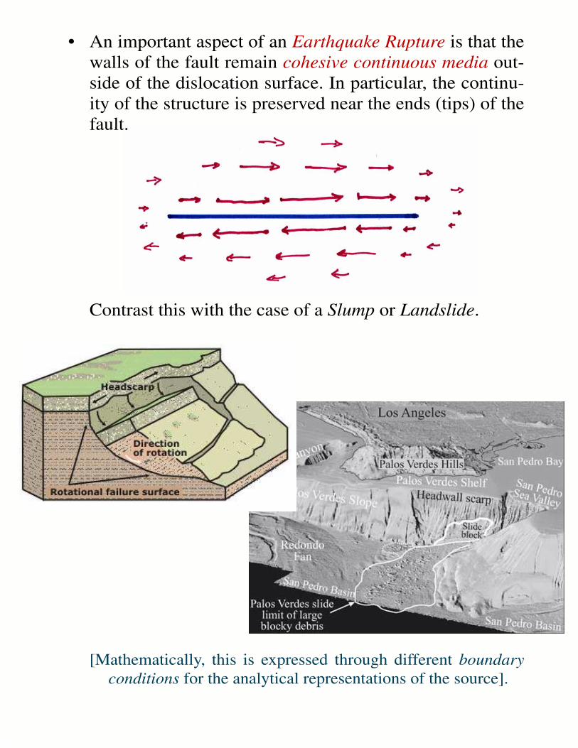
• An important aspect of an Earthquake Rupture is that thewalls of the fault remain cohesive continuous media out-side of the dislocation surface. In particular, the continu-ity of the structure is preserved near the ends (tips) of thefault.
Contrast this with the case of a Slump or Landslide.
[Mathematically, this is expressed through different boundaryconditions for the analytical representations of the source].
110˚
110˚
120˚
120˚
130˚
130˚
140˚
140˚
150˚
150˚
160˚
160˚
-40˚ -40˚
-30˚ -30˚
-20˚ -20˚
-10˚ -10˚
0˚ 0˚
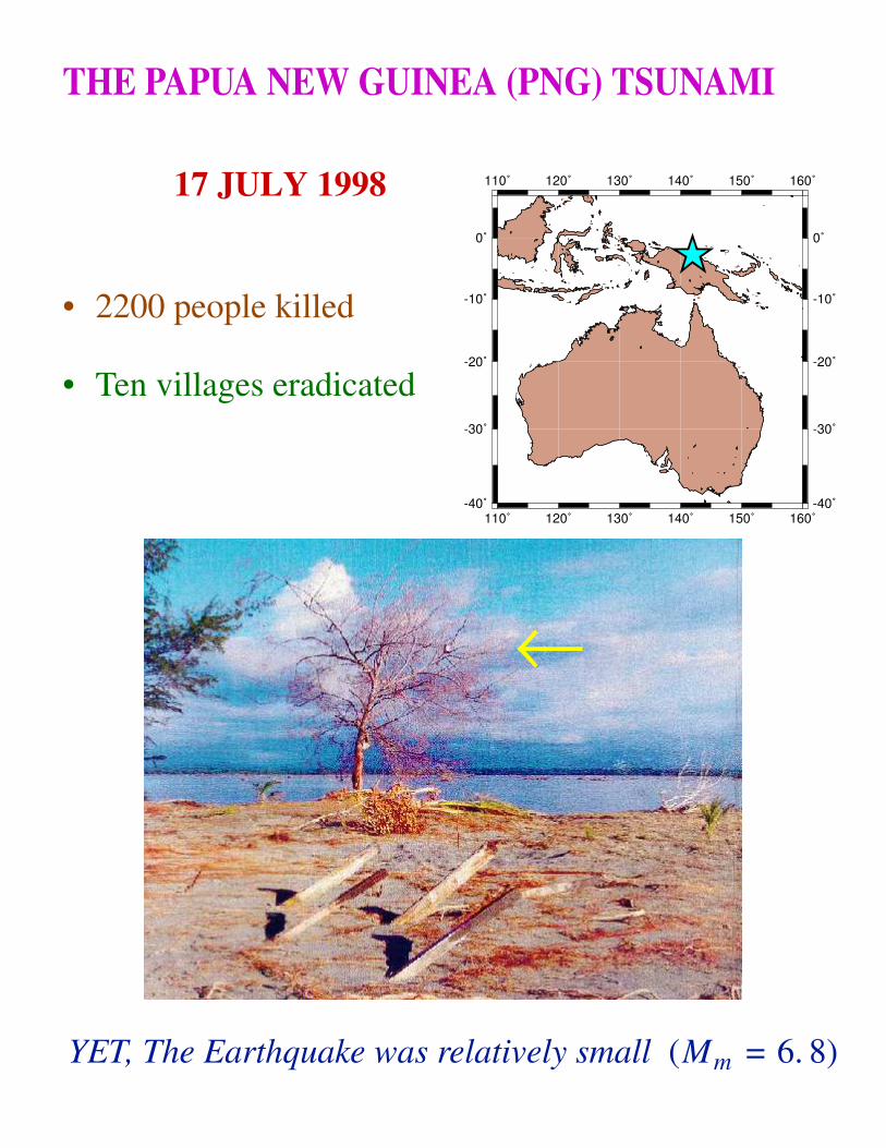
THE PAPUA NEW GUINEA (PNG) TSUNAMI
17 JULY 1998
• 2200 people killed
• Ten villages eradicated
←
YET, The Earthquake was relatively small (Mm = 6. 8)
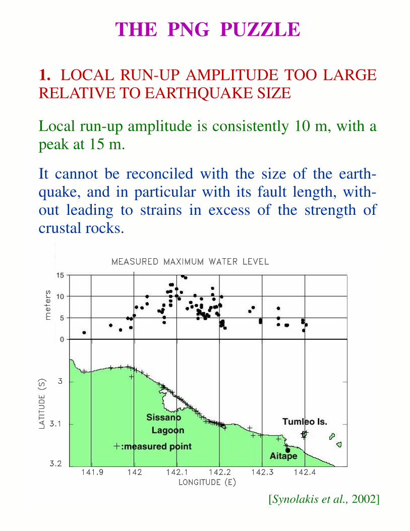
THE PNG PUZZLE
1. LOCAL RUN-UP AMPLITUDE TOO LARGERELATIVE TO EARTHQUAKE SIZE
Local run-up amplitude is consistently 10 m, with apeak at 15 m.
It cannot be reconciled with the size of the earth-quake, and in particular with its fault length, with-out leading to strains in excess of the strength ofcrustal rocks.
[Synolakis et al., 2002]

THE PNG PUZZLE (continued)
2. THE LARGE LOCAL RUN-UP AMPLITUDES ARECONCENTRATED ALONG TOO SHORT A SECTIONOF COAST (at most 30 km).
• Contrast with the run-up distribution for the 1992Nicaragua tsunami
The aspect ratio of the run-up distribution cannot be pre-dicted by dislocation models based on continuummechanics — they would require a strain release greaterthan the yield strain of rock.

THE PNG PUZZLE (continued)
3. THERE IS A STRONG DISCREPANCY INTSUNAMI AMPLITUDES BETWEEN THENEAR- AND FAR-FIELDS
Even though the tsunami was monstruous in thevicinity of the source, it was recorded onlymarginally in Japan (10 to 25 cm), and was notdetected at other Pacific locations (e.g., Hawaii).
Contrast this situation with transpacific tsunamis(1946, 1960) capable of inflicting heavy damageboth in the far and near fields.

THE PNG PUZZLE (continued)
4. THE TSUNAMI IS ABOUT 10 minutes LATE !!
Comprehensive interviews by Davies [1998] indicate that:
• In some areas (Malol), the tsunami did not arrive until after the "secondfelt shock" (main aftershock at 09:09 GMT);
• In other areas (Arop, Warapu), the tsunami arrived before the populationhad a chance to feel the main aftershock.
This essentially rules out the mainshock as a plausible source of thetsunami, and requires that its source take place
Some time between the mainshock (08:49) and the main aftershock (09:09).
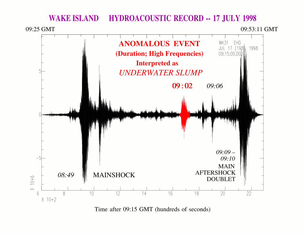
WAKE ISLAND HYDROACOUSTIC RECORD -- 17 JULY 1998
ANOMALOUS EVENT(Duration; High Frequencies)
Interpreted asUNDERWATER SLUMP
08:49 MAINSHOCKDOUBLET
AFTERSHOCKMAIN
09:09 –09:10
09 : 0209 : 02 09:06
09:25 GMT 09:53:11 GMT
Time after 09:15 GMT (hundreds of seconds)

f(H
z)f
(Hz)
f(H
z)
(a)
)(b
(c)
Time (s)
09:02 Event
Mainshock
09:40 Aftershock
09:02 HYDROACOUSTIC SIGNAL SMALL and LONGFr
eque
ncy
(Hz)

• In short, the event at 09:02 is
TOO WEAK FOR ITS DURATION
or
TOO LONG FOR ITS AMPLITUDE
→→ In other words, it
VIOLATES SCALING LAWS
which suggests that it must represent adifferent physical phenomenon.

IT IS THERE !!!
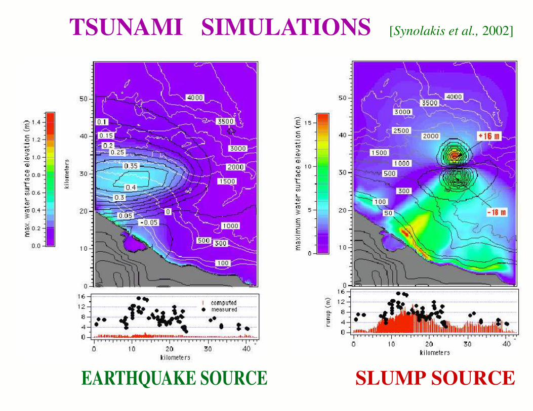
TSUNAMI SIMULATIONS
EARTHQUAKE SOURCE SLUMP SOURCE
[Synolakis et al., 2002]
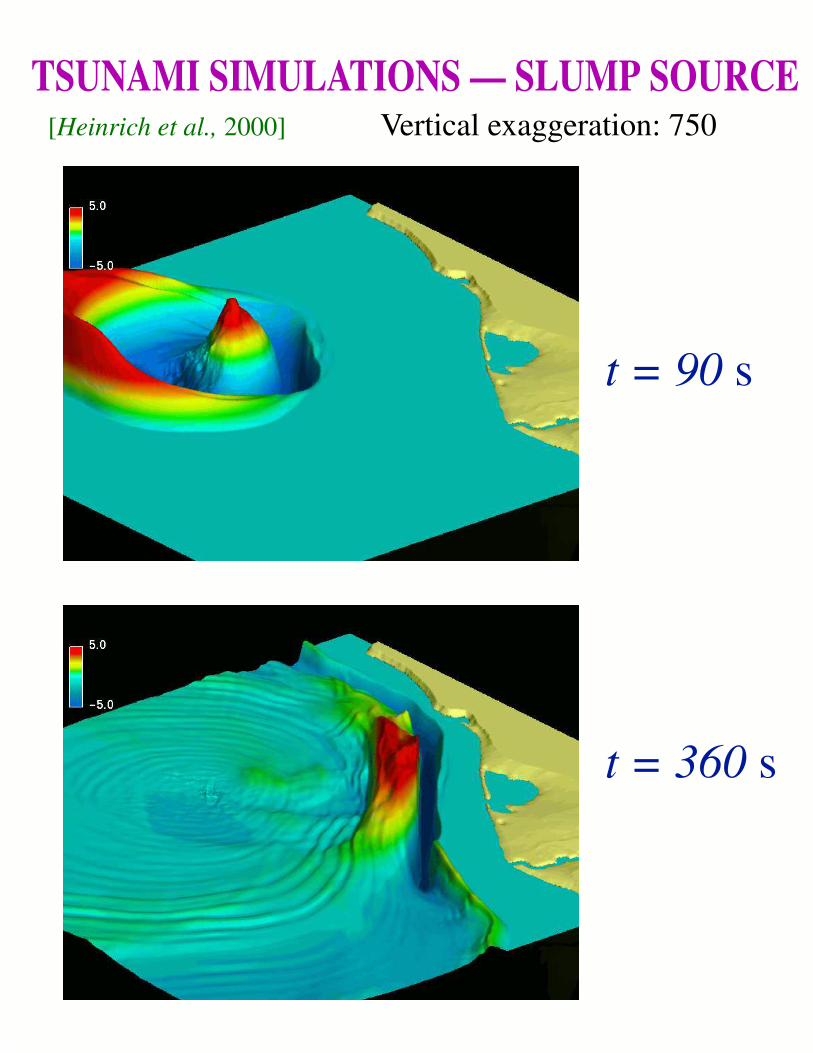
TSUNAMI SIMULATIONS — SLUMP SOURCE[Heinrich et al., 2000]
t = 90 s
t = 360 s
Vertical exaggeration: 750

PERSPECTIVE on LANDSLIDE TSUNAMIS
• As compared to earthquakes,
Landslides move SMALLER AMOUNTS ofmaterial over MUCH LARGER DISTANCES.
• Therefore, their tsunamis have
MUCH LARGER AMPLITUDES
MUCH SHORTER WAVELENGTHS
→ Hence, they will be MORE EFFICIENTLYDISPERSED during propagation.
• They may also become intrinsically unstableand BREAK (like surf) rather than propagate.
As a result, LANDSLIDE tsunamis are
DEVASTATING locally, but pose
LITTLE HAZARD in the FAR FIELD.

150˚
150˚
180˚
180˚
210˚
210˚
240˚
240˚
270˚
270˚
300˚
300˚
-30˚ -30˚
-15˚ -15˚
0˚ 0˚
15˚ 15˚
30˚ 30˚
218˚ 219˚ 220˚ 221˚ 222˚
-11˚
-10˚
-9˚
-8˚
-7˚
Fatu Hiva
Hiva Oa
Nuku Hiva
TSUNAMI GENERATION (ctd.)
LandslidesFatu Hiva, Marquesas Islands, 13 September 1999
The beachfront school house at Omoa was severely flooded bytwo "rogue" wav es which also destroyed the ice-making plantand several canoe shacks and copra-drying stands.
Miraculously, there were no victims, even though 85 childrenwere attending school.
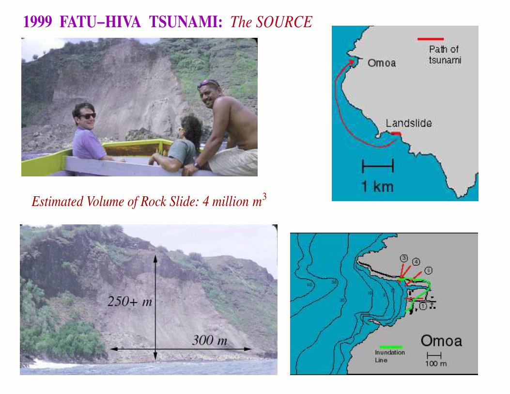
Estimated Volume of Rock Slide: 4 million m3
1999 FATU−HIVA TSUNAMI: The SOURCE

MODELING the 1999 FATU-HIVA LANDSLIDE
Note the refraction of the wav e around the promon-tory and into Omoa Bay (Plates D, E, F).
Note also the arrival of two principal wav es.[Okal et al., 2002]

LITUYA BAY , Alaska, 10 JULY 1958
Strike-slip earthquake on Fairweather Fault triggeredmassive aerial rock slide into local Bay, creating525−m high splash on oppposite mountain range.
ONE DEATH -- Did Not Penetrate Into Ocean
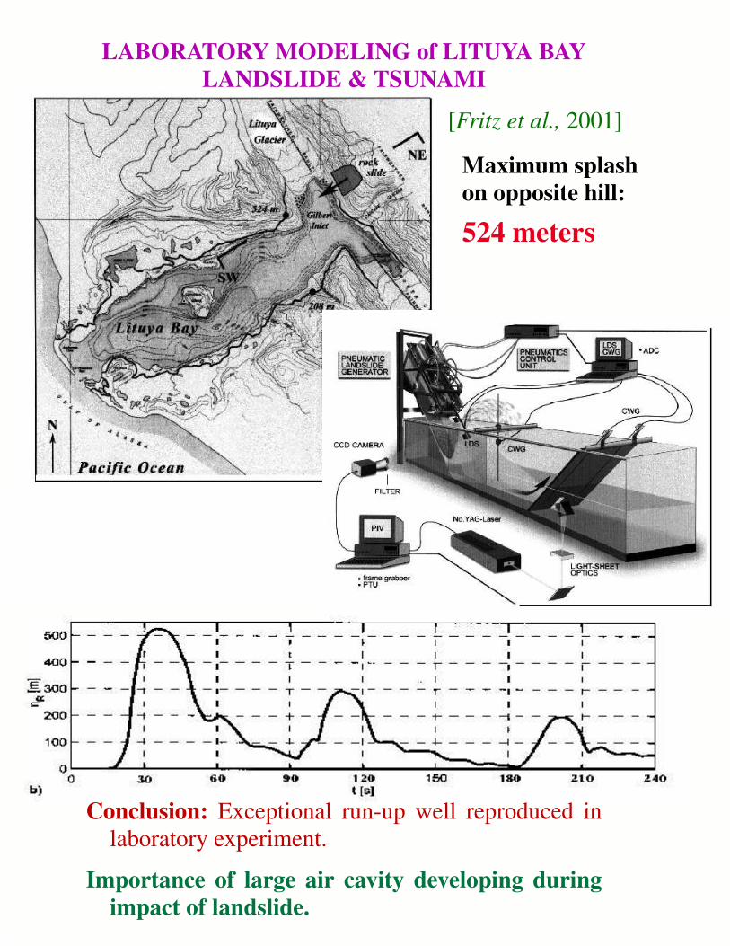
LABORATORY MODELING of LITUYA BAYLANDSLIDE & TSUNAMI
[Fritz et al., 2001]
Conclusion: Exceptional run-up well reproduced inlaboratory experiment.
Importance of large air cavity developing duringimpact of landslide.
Maximum splashon opposite hill:
524 meters

VOLCANIC LANDSLIDES at La Sciara, STROMBOLI
(Italy) — 30 DECEMBER 2002Run-up reached 10 m in nearby village
Miraculously, no victims
[La Rocca et al., 2004]

NEWFOUNDLAND — 18 NOVEMBER 1929
Earthquake (M = 7. 2) triggered tsunami throughlarge underwater slumps giving rise toTURBIDITY CURRENTS detected throughTELEGRAPHIC CABLE BREAKS
[Heezen and Ewing, 1952]

ORLEANSVILLE, Algeria, 09 SEPTEMBER 1954
A continental earthquake (M = 7) in Algeria generated a turbidity current in the Mediter-ranean and a small tsunami observed locally, in the Balearic Islands and in Spain.
This scenario was repeated during the El Asnam earthquake of 1980, and, 250 km to theEast during the 2003 Boumerdes earthquake.
[Heezen et al., 1955]
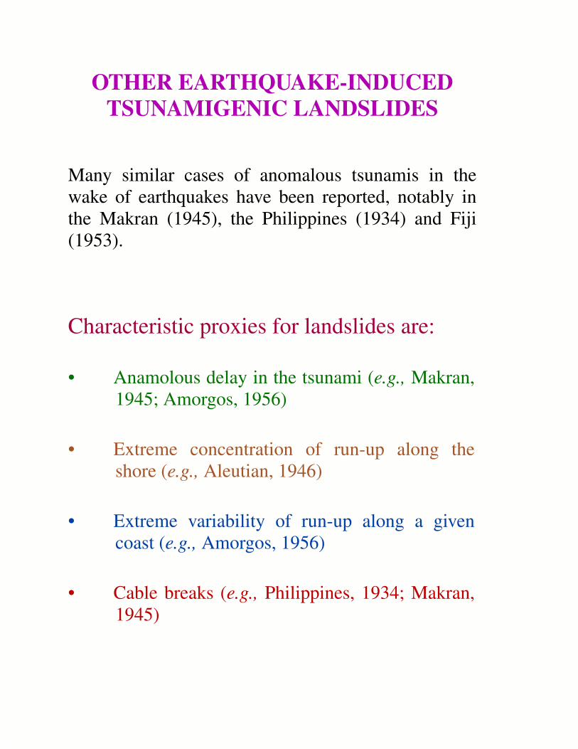
OTHER EARTHQUAKE-INDUCEDTSUNAMIGENIC LANDSLIDES
Many similar cases of anomalous tsunamis in thewake of earthquakes have been reported, notably inthe Makran (1945), the Philippines (1934) and Fiji(1953).
Characteristic proxies for landslides are:
• Anamolous delay in the tsunami (e.g., Makran,1945; Amorgos, 1956)
• Extreme concentration of run-up along theshore (e.g., Aleutian, 1946)
• Extreme variability of run-up along a givencoast (e.g., Amorgos, 1956)
• Cable breaks (e.g., Philippines, 1934; Makran,1945)
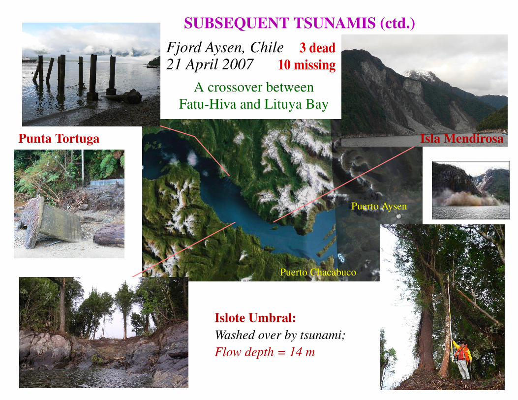
SUBSEQUENT TSUNAMIS (ctd.)Fjord Aysen, Chile21 April 2007
A crossover betweenFatu-Hiva and Lituya Bay
Puerto Aysen
Puerto Chacabuco
Islote Umbral:Washed over by tsunami;Flow depth = 14 m
Isla MendirosaPunta Tortuga
3 dead10 missing

PHYSICAL REPRESENTATION of LANDSLIDE
• Landslide modeled as SINGLE FORCErepresenting reaction by Earth to accelera-tion of sliding body.
[Hasegawa and Kanamori, 1987]
* Always nearly horizontal
* Zero impulse condition on Earth requires
∫+ ∞−∞
F(t) ⋅ dt = 0
* Contrast with Seismic Moment for earthquake source
M(t) = µ S ∆u(t)t → ∞
≈ M0 ⋅ H(t)

COMPARISON OF SPECTRAL AMPLITUDES(Rayleigh and Tsunami)
EARTHQUAKE LANDSLIDE
RATIO
Note:• Landslide Excitation
Deficient by 1.5 ordersof magnitude
• Landslide tsunami is
Higher-Frequency,
HENCE DISPERSIVE
Landslide excitation, [ f ⋅ u ], proportional to displacement,should be INTEGRAL of
Earthquake excitation, [ M : εM : ε ], proportional to strain.
→→ BUT, Source Time Function of Landslide is
SECOND DERIVATIVE of Earthquake Counterpart.
→→ Excitation by LANDSLIDE (SINGLE -FORCE)
is DERIVATIVE of that by
EARTHQUAKE (DOUBLE-COUPLE).
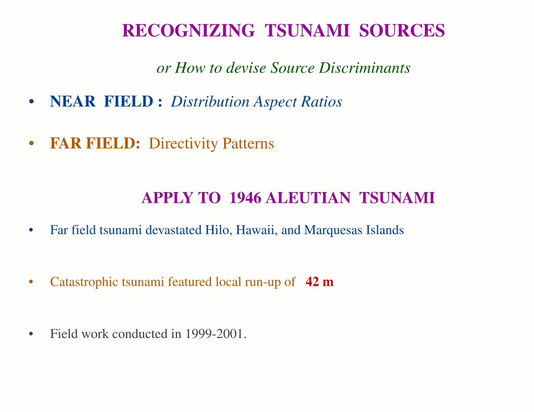
RECOGNIZING TSUNAMI SOURCES
or How to devise Source Discriminants
• NEAR FIELD : Distribution Aspect Ratios
• FAR FIELD: Directivity Patterns
APPLY TO 1946 ALEUTIAN TSUNAMI
• Catastrophic tsunami featured local run-up of 42 m
• Far field tsunami devastated Hilo, Hawaii, and Marquesas Islands
• Field work conducted in 1999-2001.

BUILDING A DISCRIMINANT in the NEAR FIELD
GENERAL IDEA
• The maximum run-up, b, along the beach should be controlled bythe maximum initial deformation of the ocean surface, η0 .
Which in turn should be controlled by the maximum seismic slipon the fault, ∆u.
• The width of the run-up distribution, a, should be controlled by thesize (length) of the fault, L.
→→ Thus, the aspect ratio, b/a of the run-up distribution, should becontrolled by the ratio ∆u / L, which is related to the STRAINRELEASE in the dislocation.
• For dislocations, the latter should be expected to be constant, as itreflects the strength of the rock.
But for landslides, it could be much larger.
We hint that b/a should be an INVARIANT for seismic dislocat-ions, and serve as a DISCRIMINANT of landslides.
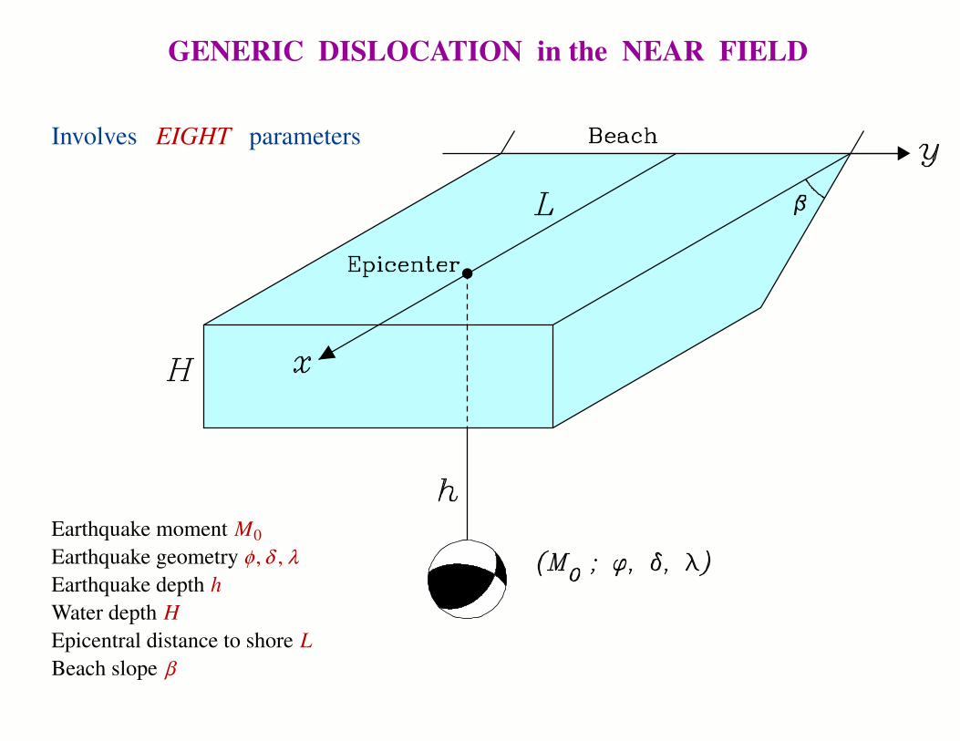
GENERIC DISLOCATION in the NEAR FIELD
Involves EIGHT parameters
Earthquake moment M0Earthquake geometry φ , δ , λEarthquake depth hWater depth HEpicentral distance to shore LBeach slope β

BEACH
Ocean
-300
-250
-200
-150
-100
-50
0
50
100
150
200
250
300S
km
N
-300
-250
-200
-150
-100
-50
0
50
100
150
200
250
300
S k
m N
-300 -250 -200 -150 -100 -50 0 50 100 150 200 250 300
-300 -250 -200 -150 -100 -50 0 50 100 150 200 250 300W km E
-300 -200 -150 -100 -50 -2 2 50 100 150 200 300
Amplitude (cm)
NEAR-FIELD: The Earthquake Dislocation• Compute Ocean-Bottom Deformation due to Dislocation
• Simulate Tsunami Propagation to Beach and Run-up
• Fit Bell Curve
ζ =b
x − ca
2
+ 1
• Retain aspect ratio I = b/a
• Vary source parameters: I no greater than 2. 3 × 10⁻⁵.

THE DIPOLAR SOURCE
Similarly involves a large numberof geometric parameters
HumpTroughLever
Distance to Beach...Shape of poles
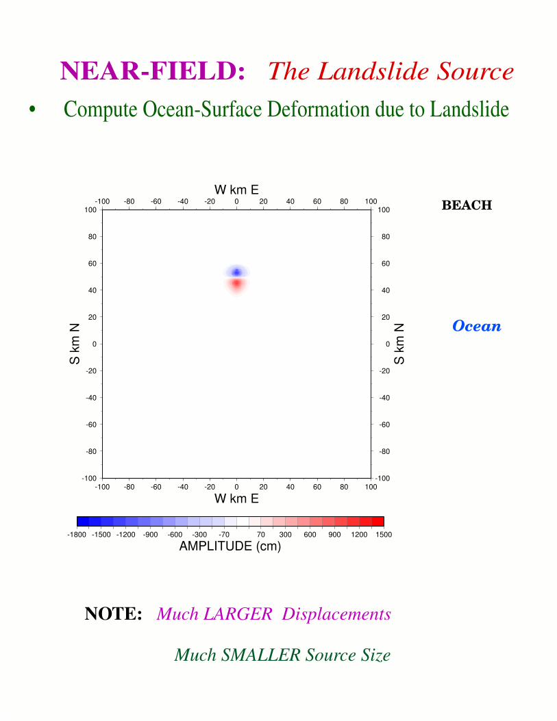
NOTE: Much LARGER Displacements
Much SMALLER Source Size
BEACH
Ocean
-100
-80
-60
-40
-20
0
20
40
60
80
100
S k
m N
-100
-80
-60
-40
-20
0
20
40
60
80
100
S k
m N
-100 -80 -60 -40 -20 0 20 40 60 80 100
W km E
-100 -80 -60 -40 -20 0 20 40 60 80 100W km E
-1800 -1500 -1200 -900 -600 -300 -70 70 300 600 900 1200 1500
AMPLITUDE (cm)
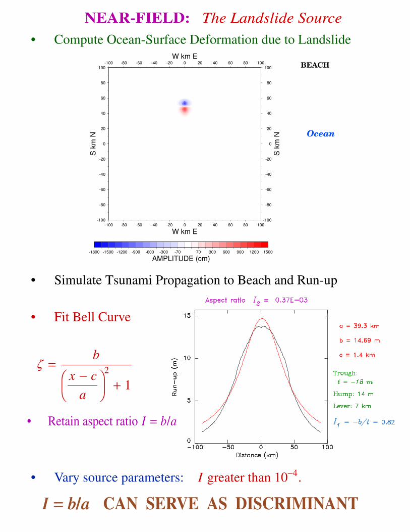
NEAR-FIELD: The Landslide Source• Compute Ocean-Surface Deformation due to Landslide
BEACH
Ocean
-100
-80
-60
-40
-20
0
20
40
60
80
100
S k
m N
-100
-80
-60
-40
-20
0
20
40
60
80
100
S k
m N
-100 -80 -60 -40 -20 0 20 40 60 80 100
W km E
-100 -80 -60 -40 -20 0 20 40 60 80 100W km E
-1800 -1500 -1200 -900 -600 -300 -70 70 300 600 900 1200 1500
AMPLITUDE (cm)
NEAR-FIELD: The Landslide Source• Compute Ocean-Surface Deformation due to Landslide
• Simulate Tsunami Propagation to Beach and Run-up
• Fit Bell Curve
ζ =b
x − ca
2
+ 1
• Retain aspect ratio I = b/a
• Vary source parameters: I greater than 10−4.
I = b/aI = b/a CAN SERVE AS DISCRIMINANT
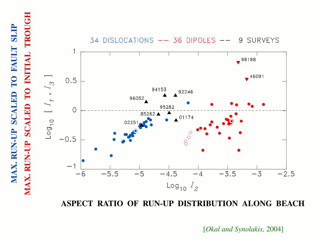
[Okal and Synolakis, 2004]
ASPECT RATIO OF RUN-UP DISTRIBUTION ALONG BEACH
MA
X. R
UN
-UP
SCA
LE
D T
OFA
ULT
SL
IP
MA
X. R
UN
-UP
SCA
LE
D T
OIN
ITIA
L T
RO
UG
H
135˚ 138˚ 141˚ 144˚ 147˚
-6˚
-4˚
-2˚
0˚
2˚
0 200 400
km
New Guinea
20021998
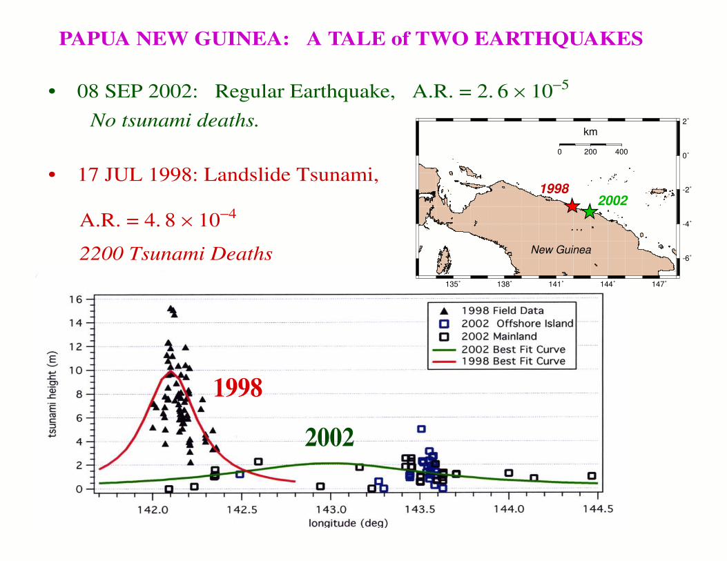
PAPUA NEW GUINEA: A TALE of TWO EARTHQUAKES
• 08 SEP 2002: Regular Earthquake, A.R. = 2. 6 × 10⁻⁵
No tsunami deaths.
• 17 JUL 1998: Landslide Tsunami,
A.R. = 4. 8 × 10⁻⁴
2200 Tsunami Deaths
2002
1998

FAR FIELD: THE BASICS of DIRECTIVITY[Ben Menahem, 1962]
If a source propagating a length L at velocity VR inthe direction x generates a wav e traveling at phasevelocity C observed at an angle φ from x, then theamplitude of the wav e is affected by a DIRECTIVITYfunction D
D =sin Y
Ywith Y =
ω L2 C
⋅
CVR
− cos φ
This formula simply expresses that the various ele-ments of the source always interact destructively athigh enough frequencies, except when the wave prop-agation compensates exactly the offset of source time
(sin Y / Y maximum requires Y = 0.)

• Tsunami generated by a landslide
Then, VR is always much SMALLER than C, and theinterference is always destructive (for long enoughsources).
The rupture is so slow (w/r respect to the wav e) that there are nodirections in which it can be compensated by the variations ofphase due to propagation.
LANDSLIDES CANNOT GENERATEFAR-FIELD DIRECTIVITY
D =sin Y
Ywith Y =
ω L2 C
⋅
CVR
− cos φ
-165˚
195˚ 00'
-164.5˚
195˚ 30'
-164˚
196˚ 00'
-163.5˚
196˚ 30'
-163˚
197˚ 00'
-162.5˚
197˚ 30'
-162˚
198˚ 00'
54˚ 30'
55˚ 00'
0 20 40
km
(a)
(b)
UNIMAK ISLAND IKATAN Pen.
ALASKAPENINSULA
Scotch Cap
ColdBay
KingCove
False Pass
Sanak PauloffCape
Lutke
Unimak Bight
Ikatan1,2
3,45,6
7
8
9 10
11 12
1314 15
16 17 18 19
20
21
22
23,24
25
2627
2829 SANAK
LONG I.
Hiva Oa
-139.20˚
220˚ 48'
-139.10˚
220˚ 54'
-139.00˚
221˚ 00'
-138.90˚
221˚ 06'
-138.80˚
221˚ 12'
-9˚ 51' -9.85˚
-9˚ 48' -9.80˚
-9˚ 45' -9.75˚
-9˚ 42' -9.70˚
-9.65˚
0 5 10
km
7.5Hanamenu
[3,4]
5.6Taaoa [14]
10.4Hanaiapa [5,6,7] 6.6
Hanatekuua [8]
6.7
Nahoe [9]
6.5Puamau[10,11]
5.3(8.1)Hanapaaoa
[12,13]
14.6 Tahauku [15]
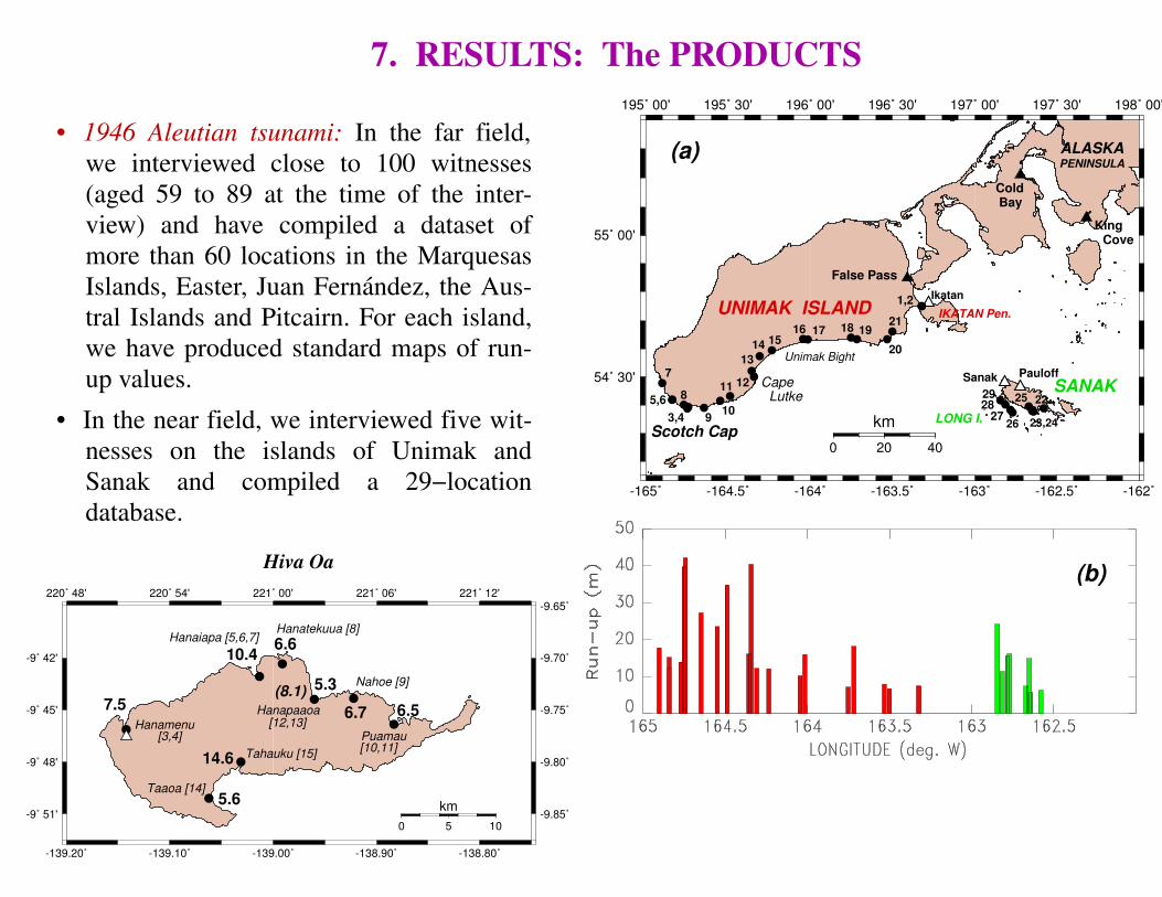
7. RESULTS: The PRODUCTS
• 1946 Aleutian tsunami: In the far field,we interviewed close to 100 witnesses(aged 59 to 89 at the time of the inter-view) and have compiled a dataset ofmore than 60 locations in the MarquesasIslands, Easter, Juan Fernandez, the Aus-tral Islands and Pitcairn. For each island,we have produced standard maps of run-up values.
• In the near field, we interviewed five wit-nesses on the islands of Unimak andSanak and compiled a 29−locationdatabase.
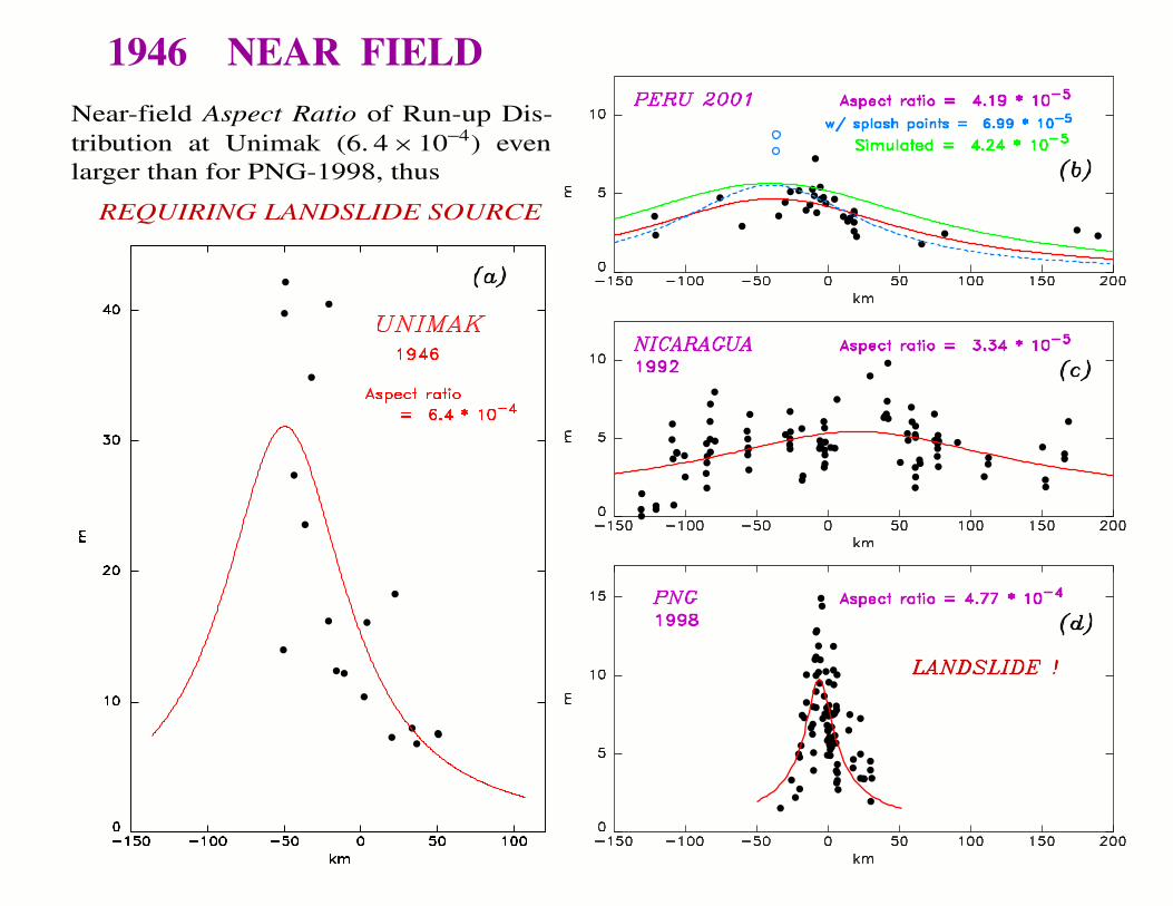
1946 NEAR FIELDNear-field Aspect Ratio of Run-up Dis-tribution at Unimak (6. 4 × 10⁻⁴) evenlarger than for PNG-1998, thus
REQUIRING LANDSLIDE SOURCE

HawaiiMarquesas
Austral
Juan FernandezEaster
WinterIsland
Valparaiso
DISLOCATION SOURCE
170˚ 190˚ 210˚ 230˚ 250˚ 270˚ 290˚-50˚
-40˚
-30˚
-20˚
-10˚
0˚
10˚
20˚
30˚
40˚
50˚
0.001 0.01 0.1 0.25 0.5 1.5 3. 6. 50.
AMPLITUDE (m)
LANDSLIDE SOURCE
170˚ 190˚ 210˚ 230˚ 250˚ 270˚ 290˚-50˚
-40˚
-30˚
-20˚
-10˚
0˚
10˚
20˚
30˚
40˚
50˚
(This projection is an oblique Mercator which is conformal)The directivity pattern is consistent with the theoretical radi-ation pattern expected from an earthquake source extendingalong the Aleutian Trench, in the geometry suggested by anindependent reassessment of the earthquake’s source extent.
LANDSLIDE SOURCES CANNOT REPLICATE THISSTRONG DIRECTIVITY
Conclusion:The far-field results require a strong earthquake source.
1946 -- FAR FIELD2.7 m
10 m
8 m

PRELIMINARY CONCLUSION of 1946 SURVEYS
• The exceptional amplitudes in the near field(42 m) require generation by an underwater land-slide.
• The far-field dataset features both amplitude anddirectivity requiring generation by a large seis-mic dislocation.
→ Numerical simulations adequately predict mostobservables using acceptable parameters for bothsources.