landslide project presentation landslide risk...
TRANSCRIPT

LANDSLIDE RISK ASSESSMENT MODEL FOR DISASTER
PREVENTION AND MITIGATION(LANDSLIDE)
Co-financed by the EU
In this Issue1. LANDSLIDE project presentation 2. Project activities and expected results 3. DG ECHO and the EU Civil Protection Programme at a glance 4. Project Launch5. The four test sites of the LANDSLIDE project
News & Upcoming EventsFor more information check out the LANDSLIDE project website at: www.landslide project.eu
LANDSLIDE project presentation
LANDSLIDE is a European project, financed by the Directorate General Humanitarian Aid and Civil Protection of the European Commission, with the aim to develop an innovative risk assessment tool to predict and evaluate landslide hazards.
Landslides occur in many different geological and environmental settings across Europe and are a major hazard in most mountainous and hilly regions. Every year landslides cause fatalities and large damage to infrastructure and property. Intense and/or long lasting rainfall represents the most frequent trigger of landslides in Europe, and is expected to increase in the future due to climate change.
Methods for landslide evaluation are today mainly based on scientific literature of geomorphologic studies and of historical landslide events which do not consider or underestimate the impact of climate change. Therefore, it is important to provide for new tools that can adapt to the new conditions by correctly evaluating and predicting landslide hazards which is a fundamental prerequisite for accurate risk mapping and assessment and for the consequent implementation of appropriate prevention measures.
The LANDSLIDE project, coordinated by the University of Camerino, is made up of 6 partner organisations coming from Italy, Bulgaria, Greece and Poland:• UniversityofCamerino(projectCoordinator),Italy• InstituteofInformationandCommunicationTechnologies-BulgarianAcademyofSciences,Bulgaria• NationalObservatoryofAthens-InstituteofGeodynamics,Greece• ProvinceofAncona,Italy• RegionalGovernmentofSmolyan,Bulgaria• Bielsko-BialaDistrict,Poland
This partnership will jointly develop a Landslide Hazard Assessment Model and Software that will be tested in four hydrographic basins selected as test sites. This model and software will be able to make completely automatic predictions of landslide hazards, on a day to day basis, as well as to correctly evaluate the impact of climate change, in a medium long term.

LANDSLIDE RISK ASSESSMENT MODEL FOR DISASTER
PREVENTION AND MITIGATION(LANDSLIDE)
Co-financed by the EU
Project activities and expected results
LANDSLIDE activities will be carried out through three different action phases:
The first action phase, actually being implemented, concerns the very development of the Landslide Hazard AssessmentModelandSoftware.Projectpartnershaveselectedthefourhydrographicbasins(testsites)andarecollecting both geomorphological and meteorological data needed to create a common framework for correct adaptationandfine-tuningofthemodeltotheselectedtestareas.
In the second phase the civil protection partners will, during a pilot phase, test and use the model and software within their daily risk mapping and assessment activities. This will be preceded by a training course for the civil protection staff of the partner territories involved. During the pilot phase a help desk will also be established to support partners in correctly using and applying the model and software.
Thethirdphaseconcernsthecreationofasustainableapproachtoriskprevention:tothisend“localcross-sectorrisk prevention platforms” will be established in each pilot territory to involve other relevant services and sectors concerned(agriculture,urban,etc.)tosharethenewriskmaps,informaboutriskscenariosandtomakeriskpreventionpartofdevelopmentpoliciesandplanscross-sectors.Aseriesofawarenessraisingeventswillfinallyalsobecarriedouttomakethepeople(residents,land-owners,farmers,industry,etc.)directlyconcernedbytheidentified risk, engage in risk prevention activities.
The main expected result is, of course, the Landslide Hazard Assessment Model and Software making it possible to obtain completely automatic evaluation of daily landslide hazards. The LANDSLIDE project will also:•improvethecapacitytoelaboratemorecorrectmediumandlong-termriskforecastsandriskscenariosandtoschedule more appropriate prevention and mitigation measures for potential elements at risk.•supportthetransferofexperiencetootherlocalandregionalauthorities,thankstoinstrumentsandtoolsalready tested and produced to facilitate the use and application of the model outside the partnership.•integrateriskpreventionandriskmanagementconsiderationsintoplanninganddevelopmentofpoliciescrosssectors. •improvethecapacityoftheriskgroupsidentifiedtoknowhowtoaccessriskinformationandhowtoengageinself-protectionandpreventionactivities.•fosteracultureofprevention,bothcross-sectorsandatdifferentlevels,i.e.alsoatprivateandindividuallevel.
DG ECHO and the EU Civil Protection Programme at a
glance
Naturalandman-madedisasters,actsofterrorism,technological, radiological and environmental acci-
dents know no borders. One country alone can be overburdened and experience shows that coopera-
tion in civil protection between European countries saves lives. For this reason EU assistance has been enshrinedintheTreatyofLisbonandsupported
by EU citizens as expression of European solidarity with any person or people in need.
LANDSLIDE RISK ASSESSMENT MODEL FOR DISASTER
PREVENTION AND MITIGATION(LANDSLIDE)
Co-financed by the EU
TheEuropeanCommission’sHumanitarianaidandCivilProtectiondepartment(ECHO)aimstosaveandpreserve life, prevent and alleviate human suffering and safeguard the integrity and dignity of populations affectedbynaturaldisastersandman-madecrises.ECHOisheadquarteredinBrusselsand,withaglobalnetwork of field offices, it ensures rapid and effective delivery of EU relief assistance through its two main instruments: humanitarian aid and civil protection. By bringing together the two under one roof in 2010, the Commission has built up a more robust and effective European mechanism for disaster response both inside and outside the EU. Since November 2014, ECHO operates under the mandate of Mr. Christos Stylianides, EU Commissioner for Humanitarian Aid and Crisis Management.
In the field of civil protection, the EU facilitates cooperation between the 28 EU Member States, Iceland, Norway,andtheformerYugoslavRepublicofMacedoniatowardsacommongoal:toprotectpeople,theenvironmentandproperty(includingculturalheritage)againstdisasters;however,theprimaryresponsibilityfor the protection of people, environment and property lies with the Member States. Consequently, it is the Member States who bear the financial costs of most civil protection actions. Whereas, the EU plays an “enabling role” to support, coordinate or supplement the actions of Member States in the prevention of, preparedness for, and response to disasters.
The EU’s financial support enables Member States and participating countries to work together effectively in the event of major disasters and to respond to emergencies quickly and efficiently. This is achieved by:• Awareness-raisingandeducatingonhowtoprepareforeventualdisasters• Trainingcivilprotectionstaffandvolunteers• Civilprotectionexercises• Improvingcross-bordercooperation• Developingnewtoolssuchasearlywarningsystemsandweatherforecastsystems
The Union Civil Protection Programme covers the three main aspects of civil protection activities:a) Preventionb) Preparednessc) Responsetodisasters
77 projects supporting prevention and preparedness measures across Europe have been co-financed by the EU since 2007; the budget for the implementation of the Union Civil Protection Programme for 2014-2020 is €368.4 million (€223.7 million allocated for prevention, preparedness and response actions inside the EU and €144.6 million for actions outside the EU). Civil Protection projects are co-financed up to a maximum 75%,and both national authorities and non-profit NGOs are eligible to submit proposals. A call for proposals is published once per year and it is available on the website of the European Commission’s Humanitarian Aid and Civil Protection department (ECHO) www.ec.europa.eu

LANDSLIDE RISK ASSESSMENT MODEL FOR DISASTER
PREVENTION AND MITIGATION(LANDSLIDE)
Co-financed by the EU
Project Launch
The thematic activities of the LANDSLIDE project were officially launched at the 1st Steering Committee meeting that took place on 12 and 13 February 2015 in Ancona, Italy. The agenda of the meeting included an overall presentation of the project and detailed discussion on project activities. Project partners also presented their territories focusing on the main problems connected to past landslide events occurred in their areas and highlighting civil protection competences of the organisations they represent.
A specific “methodological session” was dedicated to discuss the landslide risk assessment model and software to be developed. The University of Camerino, project coordinator and scientific partner responsible for the development of the model, illustrated the theoretical and practical content of the mathematical models that will be used to analyze soil moisture dynamics and to forecast water saturation of the land in the test areas of the project. Thus, partners hosting the test areas are responsible to provide the University of Camerino with meteorological data and geotechnical, geological and geomorphological parameters of the soil to contribute to the very development of the LANDSLIDE model.The meeting ended with a visit to the Operative Headquarter of the Civil Protection Department of the Marche RegionwhereLANDSLIDEpartnershadthepossibilitytoexchangeimpressionsandknowledgeonthetechnological instruments used for risk prevention and crisis management.
The 2nd Steering Committee Meeting, carried out via skype, on the 24 July 2015, was mainly dedicated to monitortheimplementationstatusofon-goingprojectactivitiesandtosharepartners’experienceofimplemented activities, such as mapping and collection of data and information, drilling operation, model development.
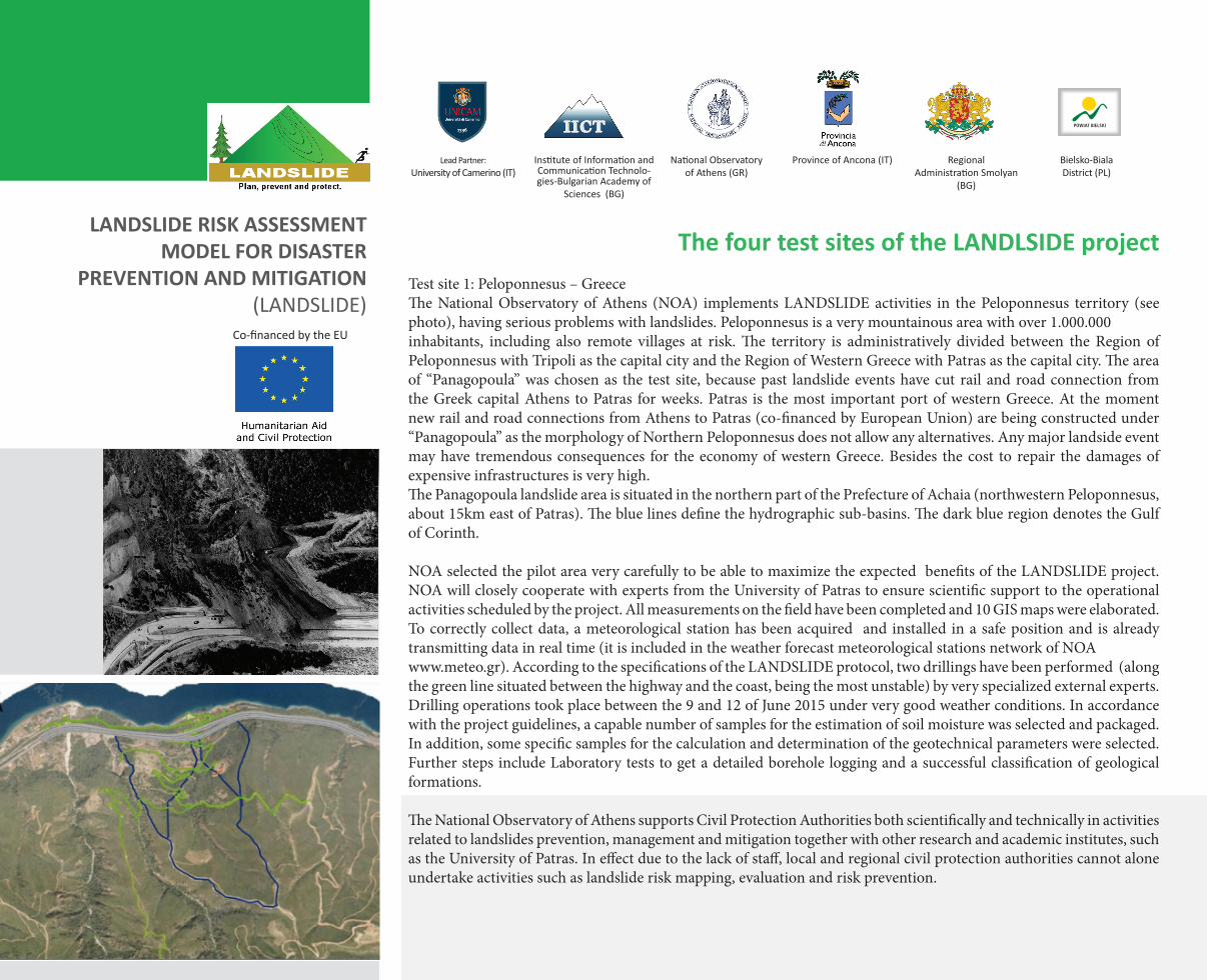
The four test sites of the LANDLSIDE projectTestsite1:Peloponnesus–GreeceTheNationalObservatoryofAthens (NOA) implementsLANDSLIDEactivities in thePeloponnesus territory (seephoto),havingseriousproblemswithlandslides.Peloponnesusisaverymountainousareawithover1.000.000inhabitants, including also remote villages at risk.The territory is administratively divided between theRegion ofPeloponnesuswithTripoliasthecapitalcityandtheRegionofWesternGreecewithPatrasasthecapitalcity.Theareaof “Panagopoula” was chosen as the test site, because past landslide events have cut rail and road connection from the Greek capital Athens to Patras for weeks. Patras is the most important port of western Greece. At the moment newrailandroadconnectionsfromAthenstoPatras(co-financedbyEuropeanUnion)arebeingconstructedunder“Panagopoula” as the morphology of Northern Peloponnesus does not allow any alternatives. Any major landside event may have tremendous consequences for the economy of western Greece. Besides the cost to repair the damages of expensive infrastructures is very high.ThePanagopoulalandslideareaissituatedinthenorthernpartofthePrefectureofAchaia(northwesternPeloponnesus,about15kmeastofPatras).Thebluelinesdefinethehydrographicsub-basins.ThedarkblueregiondenotestheGulfof Corinth.
NOA selected the pilot area very carefully to be able to maximize the expected benefits of the LANDSLIDE project. NOA will closely cooperate with experts from the University of Patras to ensure scientific support to the operational activities scheduled by the project. All measurements on the field have been completed and 10 GIS maps were elaborated. Tocorrectlycollectdata,ameteorologicalstationhasbeenacquired andinstalled inasafepositionandisalreadytransmittingdatainrealtime(itisincludedintheweatherforecastmeteorologicalstationsnetworkofNOAwww.meteo.gr).AccordingtothespecificationsoftheLANDSLIDEprotocol,twodrillingshavebeenperformed(alongthegreenlinesituatedbetweenthehighwayandthecoast,beingthemostunstable)byveryspecializedexternalexperts.Drilling operations took place between the 9 and 12 of June 2015 under very good weather conditions. In accordance with the project guidelines, a capable number of samples for the estimation of soil moisture was selected and packaged. In addition, some specific samples for the calculation and determination of the geotechnical parameters were selected. Further steps include Laboratory tests to get a detailed borehole logging and a successful classification of geological formations.
The National Observatory of Athens supports Civil Protection Authorities both scientifically and technically in activities related to landslides prevention, management and mitigation together with other research and academic institutes, such as the University of Patras. In effect due to the lack of staff, local and regional civil protection authorities cannot alone undertake activities such as landslide risk mapping, evaluation and risk prevention.
LANDSLIDE RISK ASSESSMENT MODEL FOR DISASTER
PREVENTION AND MITIGATION(LANDSLIDE)
Co-financed by the EU
Regional Administration Smolyan
(BG)
Bielsko-Biala District (PL)
Province of Ancona (IT) National Observatory of Athens (GR)
Lead Partner: University of Camerino (IT)
Institute of Information and Communication Technolo-gies-Bulgarian Academy of
Sciences (BG)

The four test sites of the LANDLSIDE project
Testsite2:ProvinceofAncona–ItalyThe pilot area selected for the test and implementation of the LANDSLIDE model in Italy is a hydrographic basin of 11,69 km2locatedinthemidpartoftheEsinoRiverbasin(i.e.inthecentralpartoftheterritoryoftheProvinceofAncona).Thetestareawaschosenasitisrepresentative,alsooftheotherhydrographicbasinsoftheProvinceofAncona:ineffectabout30%ofthewholetestareaisconcernedbylandslides(i.e.3,55km2)andalandslidehasrecentlydamaged and interrupted the provincial road connecting 3 municipalities. Furthermore, several meteorological stations are located in the test area and previous geological and geotechnical studies have already been carried out. Thus, the LANDSLIDE model will be successfully tested and implemented. Having identified the hydrographic basin, drilling and sampling operations are being implemented according to the protocol agreed among project partners, as well as geological and geomorphological data of the area, are being collected to elaborate GIS maps.
It is crucial to note that more than 300 km2(15.6%ofthewholeprovincialterritory)areafflictedbylandslides.AccordingtotheBasinAuthorityoftheMarcheRegion:outofatotalnumberof18815landslidesthatoccurredontheterritoryoftheMarcheRegion,5676arelandslidesoccurredonlyintheProvinceofAncona.The worst landslide ever occurred in the territory is the “Ancona big landslide”, a very large and deep soil movement (slippingsurfacewasidentifiedmorethan100metersdeepinthePlioceneclays)collapsedon13thDecember1982after a very rainy period. The area concerned by landslide, 3,5 km2 , affected and damaged two hospitals, one university building, 280 houses, the railway and more than 2,5 km of the main Adriatic road. 3 661 people were evacuated.
TheProvinceofAnconaisoneoffiveProvincesoftheMarcheRegionlocatedinthecentreofItaly,itcoversaterritoryof about 2000 km2 with an average height of 400m above sea level, and is home to 481.000 inhabitants, most of whom are concentrated near to the coast. The Eastern boundary is the Adriatic Sea, the western boundary is the Apennine chain featured of two parallel mountain ridges north west south east oriented, separated by hills and mainly formed bycretaceous-Paleocenelimestonesandmarls.EastoftheApenninechaintheterritorydescendstowardstheAdriaticseawithasystemofPliocene-Pleistoceneclayandsandhills.Thehillypartof the territory is themoreaffectedbylandslides. The coastal strip is very narrow and flat, except the eastern slopes of Mount Conero south of Ancona.
The Province is a Local Authority operating at intermediate level, between the regional administration and the local municipalities and is active in many fields such as environment, civil protection, land use, schools and roads management, gender equality, equal opportunities, local transport and school network planning. TheCivilProtectionServiceoftheProvinceofAnconabelongstotheCivilProtectionstructureoftheMarcheRegionand has the main following competences:•detection,collection,processandupdateofdataconcerninghazardandrisk(landslides,rivers,•interventionsforriskpreventionandmitigation.•cooperationwithotherprovincialservicesinthemaintenanceworkandemergencyservicesof•implementationofthesummerforestfirepreventionservice.•elaborationoftheProvincialPrevention,PreparednessandEmergencyPlans.•implementationofemergencymeasuresincaseofnaturaldisasters.•organizationandmanagementoftheOperationalRoomofCivilProtection.•managementofradionetworkcommunicationsduringcivilprotectionemergencies.
LANDSLIDE RISK ASSESSMENT MODEL FOR DISASTER
PREVENTION AND MITIGATION(LANDSLIDE)
Co-financed by the EU
Regional Administration Smolyan
(BG)
Bielsko-Biala District (PL)
Province of Ancona (IT) National Observatory of Athens (GR)
Lead Partner: University of Camerino (IT)
Institute of Information and Communication Technolo-gies-Bulgarian Academy of
Sciences (BG)

LANDSLIDE RISK ASSESSMENT MODEL FOR DISASTER
PREVENTION AND MITIGATION(LANDSLIDE)
Co-financed by the EU
The four test sites of the LANDLSIDE project
Testsite3:SmolyanRegion–Bulgaria
Тhe hydrographic basin selected for the test and implementation of the LANDSLIDE model in Bulgaria is located in Smolyan,anditisalandslidelocatedonroadII-86Sokolovtci-Smolyan-Srednogortci.Itisactive,coversaterritoryof8000 m2 and its depth is 10 m. The landslide is moving slowly and during the last three years, three times it covered part of the road. Having identified the hydrographic basin; drilling and sampling operations are now being further implementedaccordingtotheprotocolagreedamongprojectpartners;geologicalandgeomorphologicaldataoftheareaisalsobeingcollected to elaborate GIS maps.
The biggest landslide in Bulgaria was registered in 1923. It is located in the western suburbs of the very town of Smolyan. Ithasawidthof1kmandlengthof5km.Itisactive,withspeedofmovementof5-25cmperyear.Itsdepthis80m.Thelandslideismovingslowly,howeverifnomeasureswillbetakenitcouldaffectthemainroadoftheRegion,disconnecting the access to Smolyan.
SmolyanRegioncoversanareaof3192km2 , it has a permanent population of 120.456 people and is located in South BulgariainthecentralpartoftheRhodopeMountains.Theregionalterritoryischaracterizedbymountainsandseverallandslidesoccureveryyear;ineffect,87landslideshavebeenregisteredandoneoftheseisthebiggestlandslideeveroccurred in Bulgaria.
TheRegionalAdministrationSmolyanismanagedandrepresentedbytheRegionalGovernor,responsibleandaccountabletotheCouncilofMinisters.TheRegionalGovernorisresponsiblefor:
• the implementation of the state policy, the coordination of executive administrative bodies at regional level andrelationships with the local authorities.• the organization of Civil Defense includingmobilization and coordination of civil protection in case of naturaldisasters.Ineffect,theregionaldepartmentofCivilDefenseisacomponentofthenationalIntegratedRescueSystem, and it deals with prevention of disasters and protection of population during emergencies.
Regional Administration Smolyan
(BG)
Bielsko-Biala District (PL)
Province of Ancona (IT) National Observatory of Athens (GR)
Lead Partner: University of Camerino (IT)
Institute of Information and Communication Technolo-gies-Bulgarian Academy of
Sciences (BG)

LANDSLIDE RISK ASSESSMENT MODEL FOR DISASTER
PREVENTION AND MITIGATION(LANDSLIDE)
Co-financed by the EU
The four test sites of the LANDLSIDE project
Testsite4:Bielsko-BialaDistrict–PolandThe hydrographic basin has been set within the Small Beskid mountain range, and field studies are taking place in an inactive sandstone quarry in Kozy. The area of the quarry has been considered to be in danger of further movements judging by the results of physicochemical studies of the material gathered in the dump. It has been found that the major part of the slope is in a state close to an equilibrium border and even small changes in the distribution of stresses, caused for example by weather conditions, may lead to the development of landslide processes.
Landslides are among the most common geodynamic threats, often having the characteristics of a natural disaster. The floods which occurred in the southern Poland throughout the last twenty years resulted in the fact that many residents of the cataclysm area were affected by the phenomena of landslides combinedwith various losses (areadegradation, destruction of residential buildings together with road network, -sewerage system, -telecommunicationlines,-electriclines,-gaspipelines,-cropsand–forests).
Moreover, the areas exposed to the danger of landslide soil masses should be specifically defined in the Study of the Conditions and Directions of the Spatial Management of Communes located within the Bielsko-Biala District area,whereas the opinion on these documents should be expressed by the district geologist.
The first deformation processes within the Small Beskid area were already registered in 1968 in the quarry located in Kozy. The surface mass movements have been a continuous phenomenon, and their development have been constantly observed. In 2010 a total number of 437 landslides wereregistered(active,periodicallyactiveandinactive).
Bielsko-BialaislocatedinthesouthernpartofPoland,intheprovince of Silesia. Geographically, it is located in the eastern part of the Silesian Foothills of the outer part of the Western Carpathians, and in terms of morphology it is situated in the massif of Small Beskid and Silesian Beskid mountain ranges. In the areaofBielsko-BialaDistrict, one canobservenumerousmassmovements,whereon thebasis of the provisions by the Environmental Protection Act: the observations of areas endangered by mass movements of the land together with the terrains where these kind of movements occur, as well as keeping a register containing information about such areas, belongs to the responsibility of the Head of a district. The financing of the conducted observations regarding the areas threatened by the mass movement of land together with the terrains where these kind of movements occur, is one of the tasks of the District.
Regional Administration Smolyan
(BG)
Bielsko-Biala District (PL)
Province of Ancona (IT) National Observatory of Athens (GR)
Lead Partner: University of Camerino (IT)
Institute of Information and Communication Technolo-gies-Bulgarian Academy of
Sciences (BG)

The Landslide Bulletin addresses project partners and project target groups.It appears twice a year for the project duration in an email circulation.Internal Editors: Nina Dobrinkova, Pierluigi MaponiGraphical Editor: Dospi studioPhotos: Project PartnersIf you have any ideas or suggestions for the next edition, please let us know via:[email protected]:PierluigiMaponi–ProjectCoordinatorTel:+390737402508E-mail:[email protected]
LANDSLIDE RISK ASSESSMENT MODEL FOR DISASTER
PREVENTION AND MITIGATION(LANDSLIDE)
Co-financed by the EU