landscape ecology: the effect of pattern on process ecology/turner_1989.pdf · landscape ecology:...
TRANSCRIPT

Annu_ Rev_ Ecol. Syst_ 1989_ 20:171-97
LANDSCAPE ECOLOGY: The Effect of
Pattern on Process 1
Monica Goigel Turner
Environmental Sciences Division, Oak Ridge National Laboratory, Oak Ridge, TN 37831
INTRODUCTION A Historical Perspective Ecology and natural history have a long tradition of interest in the spatial patterning and geographic distribution of organisms. The latitudinal and altitudinal distribution of vegetative zones was described by Von Humboldt (154) , whose work provided a major impetus to studies of the geographic distribution of plants and animals (74) . Throughout the nineteenth century, botanists and zoologists described the spatial distributions of various taxa, particularly as they related to macroclimatic factors such as temperature and precipitation (e.g. 21, 82, 83, 156). The emerging view was that strong interdependencies among climate, biota, and soil lead to long-term stability of the landscape in the absence of climatic changes (95). The early biogeographical studies also influenced Clements' theory of successional dynamics, in which a stable endpoint, the climax vegetation, was determined by macroclimate over a broad region (14, 15).
Clements stressed temporal dynamics but did not emphasize spatial patterning. Gleason (36-38) argued that spatially heterogeneous patterns were important and should be interpreted as individualistic responses to spatial gradients in the environment. The development of gradient analysis (e.g. 17, 164) allowed description of the continuous distribution of species along environmental gradients. Abrupt discontinuities in vegetation patterns were believed to be associated with abrupt discontinuities in the physical environment (165), and the spatial patterns of climax vegetation were thought to reflect localized intersections of species responding to complex environmental gradients.
IThe us government has the right to retain a nonexclusive, royalty-free license in and to any copyright covering this paper.
171
Ann
u. R
ev. E
col.
Syst
. 198
9.20
:171
-197
. Dow
nloa
ded
from
arj
ourn
als.
annu
alre
view
s.or
gby
Tex
as T
ech
Uni
vers
ity -
Lub
bock
on
09/1
1/09
. For
per
sona
l use
onl
y.
172 TURNER
A revised concept of,yegetation patterns in space and time was presented by Watt (157). The distribution of the entire temporal progression of successional stages was described as a pattern of patches across a landscape. The orderly sequence of phases at each point in space accounted for the persistence of the overall pattern. The complex spatial pattern across the landscape
was constant, but this constancy in the pattern was maintained by the temporal changes at each point. Thus, space and time were linked by Watt ( 157) for the fIrst time at the broader scale that is now termed the landscape. The concept of the shifting steady-state mosaic (3), which incorporates natural disturbance processes, is related to Watt's conceptualization.
Consideration of spatial dynamics in many areas of ecology has received increased attention during the past decade (e.g. 1,89,99, 103, 135, 161). For example, the role of disturbance in creating and maintaining a spatial mosaic in the rocky intertidal zone was studied by Paine & Levin (99). Patch size could be predicted very well by using a model based on past patterns of disturbance and on measured patterns of mussel movement and recruitment. The dynamics of many natural disturbances and their effects on the spatial mosaic have received considerable study in a variety of terrestrial and aquatic systems (e.g. 103).
This brief overview demonstrates that a long history of ecological studies provides a basis for the study of spatial patterns and landscape-level processes. However, the emphasis previously was on describing the processes that created the patterns observed in the biota. The explicit effects of spatial patterns on ecological processes have not been well studied; the emphasis on pattern and process is what differentiates landscape ecology from other ecological disciplines. Therefore, this review focuses on the characterization of landscape patterns and their effects on ecological processes.
Landscape Ecology Landscape ecology emphasizes broad spatial scales and the ecological effects of the spatial patterning of ecosystems. Specifically, it considers (a) the development and dynamics of spatial heterogeneity, (b) interactions and exchanges across heterogenous landscapes, (c) the influences of spatial heterogeneity on biotic and abiotic processes, and (d) the management of spatial heterogeneity (107).
The term "landscape ecology" was first used by Troll (138); it arose from European traditions of regional geography and vegetation science (the historical development is reviewed in 90, 91). Many disciplines have contributed to the recent development of landscape ecology. For example, economists and geographers have developed many of the techniques to link pattern and process at broad scales (e.g. 53, 172), such as the development of spatial models to address questions of human geography (reviewed in 42). Landscape
Ann
u. R
ev. E
col.
Syst
. 198
9.20
:171
-197
. Dow
nloa
ded
from
arj
ourn
als.
annu
alre
view
s.or
gby
Tex
as T
ech
Uni
vers
ity -
Lub
bock
on
09/1
1/09
. For
per
sona
l use
onl
y.
LANDSCAPE ECOLOGY 173
ecology is well integrated into land-use planning and decision-making in Europe (e.g. 7, Ill, 112, 121, 151, 153, 169). In Czechoslovakia, for example, landscape-level studies serve as a basis for determining the optimal uses of land across whole regions (113). Landscape ecology is also developing along more theoretical avenues of research with an emphasis on ecological processes (e.g. 29, 61, 107, 140, 150), and a variety of practical applications are being developed concurrently (e.g. 2, 26, 48, 56, 93).
Landscapes can be observed from many points of view, and ecological processes in landscapes can be studied at different spatial and temporal scales (106). "Landscape" commonly refers to the landforms of a region in the aggregate (Webster'S New Collegiate Dictionary 1980) or to the land surface and its associated habitats at scales of hectares to many square kilometers. Most simply, a landscape can be considered a spatially heterogeneous area. Three landscape characteristics useful to consider are structure, function, and change (29). "Structure" refers to the spatial relationships between distinctive ecosystems, that is, the distribution of energy, materials, and species in relation to the sizes, shapes, numbers, kinds and configurations of components. "Function" refers to the interactions between the spatial elements, that is, the flow of energy, materials, and organisms among the component ecosystems. "Change" refers to alteration in the structure and function of the ecological mosaic through time.
Consideration of Scale
The effects of spatial and temporal scale must be considered in landscape ecology (e.g. 81, 86, 145, 150). Because landscapes are spatially heterogeneous areas (i.e. environmental mosaics), the structure, function, and change of landscapes are themselves scale-dependent. The measurement of spatial pattern and heterogeneity is dependent upon the scale at which the measurements are made. For example, Gardner et al (34) demonstrated that the number, sizes, and shapes of patches in a landscape were dependent upon the linear dimension of the map. Observations of landscape function, such as the flow of organisms, also depend on scale. The scale at which humans perceive boundaries and patches in the landscape may have little relevance for numberous flows or fluxes. For example, if we are interested in a particular organism, we are unlikely to discern the important elements of patch structure or dynamics unless we adopt an organism-centered view of the environment (165). Similarly, abiotic processes such as gas fluxes may be controlled by spatial heterogeneity that is not intuitively obvious nor visually apparent to a human observer. Finally, changes in landscape structure or function are scale-dependent. For example, a dynamic landscape may exhibit a stable mosaic at one spatial scale but not at another.
The scale at which studies are conducted may profoundly influence the
Ann
u. R
ev. E
col.
Syst
. 198
9.20
:171
-197
. Dow
nloa
ded
from
arj
ourn
als.
annu
alre
view
s.or
gby
Tex
as T
ech
Uni
vers
ity -
Lub
bock
on
09/1
1/09
. For
per
sona
l use
onl
y.

174 TURNER
conclusions: Processes and parameters important at one scale may not be as important or predictive at another scale. For example, most of the variance in litter decomposition rates at local scales is explained by properties of the litter and the decomposer community, whereas climatic variables explain most of the variance at regional scales (79, 80). The distribution of oak seedlings is also explained differently at different scales (92). Seedling mortality at local scales decreases with increasing precipitation, whereas mortality at regional scales is lowest in the drier latitudes. Thus, conclusions or inferences regarding landscape patterns and processes must be drawn with an acute awareness of scale.
CHARACTERIZING LANDSCAPE STRUCTURE Landscape structure must be identified and quantified in meaningful ways before the interactions between landscape patterns and ecological processes can be understood. The spatial patterns observed in landscapes result from complex interactions between physical, biological, and social forces. Most landscapes have been influenced by human land use, and the resulting landscape mosaic is a mixture of natural and human-managed patches that vary in size, shape, and arrangement (e.g. 5, 8, 28, 29, 61, 148). This spatial patterning is a unique phenomenon that emerges at the landscape level (59). In this section, current approaches to the analysis of landscape structure are reviewed.
Quantifying Landscape Patterns
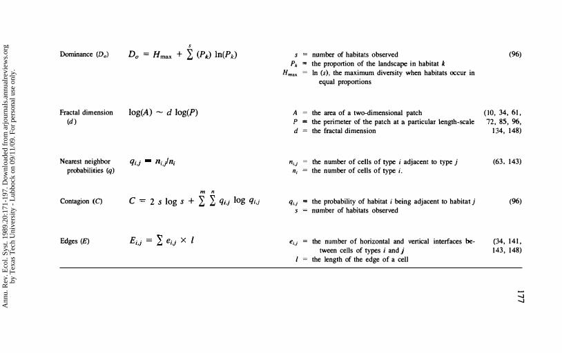
Quantitative methods are required to compare different landscapes, identify significant changes through time, and relate landscape patterns to ecological function. Considerable progress in analyzing and interpreting changes in landscape structure has already been made (for detailed methods and applications, sec 146; statistical approaches are reviewed in 149). Table 1 reviews several methods that have been applied successfully in recent studies.
Landscape indexes derived from information theory (Table 1) have been applied in several landscape studies . Indexes of landscape richness, evenness, and patchiness were calculated for a subalpine portion of Yellowstone N ational Park and related to the fire history of the site since 1600 (109, 110). The trends observed in the landscape pattern and the disturbance regime suggested that Yellowstone Park is a non-steady-state system characterized by long-term cyclic changes in landscape composition and diversity . Changes in landscape diversity were also hypothesized to have effects on species diversity, habitat use by wildlife, and the nutrient content and productivity of aquatic systems (110).
The indexes developed by Romme (09) were adapted by Hoover (51) and
Ann
u. R
ev. E
col.
Syst
. 198
9.20
:171
-197
. Dow
nloa
ded
from
arj
ourn
als.
annu
alre
view
s.or
gby
Tex
as T
ech
Uni
vers
ity -
Lub
bock
on
09/1
1/09
. For
per
sona
l use
onl
y.
LANDSCAPE ECOLOGY 175
applied to six study areas in Georgia. Landscape patterns in sites with relatively little human influence were compared along a gradient from the mountains to the coastal plain. Results showed that landscape diversity increased southward from the mountains to the coastal plain, whereas the diversity of plant species decreased. However, a study that included human land-use patterns revealed a general trend of decreasing landscape diversity from the mountains to the coastal plain of Georgia ( 148). This apparent contradiction illustrates the sensitivity of these indexes to the scheme that is used to classify the different components of the landscape.
Shapes and boundaries in the landscape have been quantified by using fractals, which provide a measure of the complexity of the spatial patterns. Fractal geometry (71, 72) was introduced as a method to study shapes that are partially correlated over many scales. Fractals have bcen used to compare simulated and actual landscapes (34, 141), to compare the geometry of different landscapes (61 , 85, 96, 148), and to judge the relative benefits to be gained by changing scales in a model or data set (10). It has been suggested that human-influenced landscapes exhibit simpler patterns than natural landscapes, as measured by the fractal dimension (61, 96, 148). Landscapes int1uenced by natural rather than anthropogenic disturbances may respond differently , with natural disturbances increasing landscape complexity . The fractal dimension has also been hypothesized to reflect the scale of the factors causing the pattern (61, 85). Landscape complexity has not been shown to be constant across a wide range of spatial scales (i .e . self-similarity) . This lack of constancy probably reflects the effects of processes that operate at different scales; however, it remains a focus of current research. Applying predictions made at one scale to other scales may be difficult if landscape structure varies with scale (84).
The use of three complementary landscape indexes (dominance, contagion, and fractal dimension) in the eastern United States discriminated between major landscape types, such as urban coastal, mountain forest, and agricultural areas (96). The three indexes also appeared to provide information at different scales, with the fractal dimension and dominance indexes reflecting broad-scale pattern and the contagion index reflecting the fine-scale attributes that incorporate the adjacency of different habitats . This type of scale sensitivity could prove useful in selecting measures of pattern that can be easily monitored through time (e.g. by means of remote sensing) and that can be related to different processes.
The size and distribution of patches in the landscape is another measure of landscape structure. These characteristics may be of particular importance for species that require habitat patches of a minimum size or specific arrangement [e.g. the spotted owl (Strix occidentalis) in the Pacific northwest (41)]. The potential effects that the changes in patch structure created by forest clear-
Ann
u. R
ev. E
col.
Syst
. 198
9.20
:171
-197
. Dow
nloa
ded
from
arj
ourn
als.
annu
alre
view
s.or
gby
Tex
as T
ech
Uni
vers
ity -
Lub
bock
on
09/1
1/09
. For
per
sona
l use
onl
y.

Table 1 Some measures of spatial pattern that have been applied in the analysis of landscape structure
Measure
Relative richness
(R)
Relative evenness
(E)
Relative patchiness
(P)
Diversity (H)
Equation
R
E=
H2
S
Smax x 100
H20)
H2(max) x 100
s
-In 1 pl2 i=\
N
L Di ;=\
p= -- x 100 N
s
H = - L (Pk) In(Pk) k=l
Conditions
Smax
number of different habitat types present maximum number of habitat types possible
H2(j) modified Simpson's dominance index (104) for land-scape j
H2 (max) maximum possible H2 for s community types
Pk proportion of total landscape area covered by habitat k s = number of habitats present
N Di
number of boundaries between adjacent cells dissimilarity value for the i th boundary between adja
cent cells
Pk the proportion of the landscape in habitat k s = the number of habitats observed
--..I 0\
Source
(109)
(109)
(109)
(96)
Ann
u. R
ev. E
col.
Syst
. 198
9.20
:171
-197
. Dow
nloa
ded
from
arj
ourn
als.
annu
alre
view
s.or
gby
Tex
as T
ech
Uni
vers
ity -
Lub
bock
on
09/1
1/09
. For
per
sona
l use
onl
y.
Dominance (Do)
Fractal dimension (d)
Nearest neighbor probabilities (q)
Contagion (C)
Edges (E)
s
Do = Hmax + 2: (Pk) In(Pk)
log(A) - d log(P)
qi,j n;jni
m n
c 2 slog s + 2: 2: qi,j log qi,j
Ei,} � e·· X I '" l,J
S
Pk Hmax
A P d
nj,j n,
q,.j
ej,j
number of habitats observed the proportion of the landscape in habitat k In (s), the maximum diversity when habitats occur in
equal proportions
the area of a two-dimensional patch the perimeter of the patch at a particular length-scale the fractal dimension
the number of cells of type i adjacent to type j the number of cells of type i.
the probability of habitat i being adjacent to habitat j number of habitats observed
the number of horizontal and vertical interfaces between cells of types i and j
the length of the edge of a cell
(96)
(10, 34, 61, 72,85,96,
134, 148)
(63, 143)
(96)
(34, 141, 143, 148)
--.I -.I
Ann
u. R
ev. E
col.
Syst
. 198
9.20
:171
-197
. Dow
nloa
ded
from
arj
ourn
als.
annu
alre
view
s.or
gby
Tex
as T
ech
Uni
vers
ity -
Lub
bock
on
09/1
1/09
. For
per
sona
l use
onl
y.

178 TURNER
cutting patterns have on the persistence of interior and edge species were analyzed by Franklin & Forman (32). Patch size and arrangement may also reflect environmental factors, such as topography or soil type. The size and isolation of forest patches in southern Wisconsin were correlated with groups of environmental variables-for example, soil type, drainage, slope, and disturbance regime (126). The pattern of pre settlement forests was closely related to topography and the pattern of natural disturbances, especially fire; the subsequent deforestation that accompanied human settlement was selective (126). Small patches of forest (i.e. woodlots) have also been studied as biogeographic islands for both flora and fauna (e.g. 5, 8 , 27, 47, 163).
A variety of other techniques are available for quantifying landscape structure. The amount of edge between different landscape elements may be important for the movement of organisms or materials across boundaries (e.g . 44, 73, 144, 168), and the importance of edge habitat for various species is well known (e.g . 62). Thus, it may be important to monitor changes in edges when one quantifies spatial patterns and integrates pattern with function. Fine-scale measures of adjacency patterns and the directionality of individual cover types can be quantified by using nearest neighbor probabilities. Nearest neighbor probabilities reflect the degree of fragmentation in the landscape and, indirectly, the complexity of patch boundaries. Directionality in the landscape pattern, which may reflect topographic or other physical constraints, can be measured by calculating nearest neighbor probabilities both vertically and horizontally (or even diagonally).
The quantitative measures reviewed here could be easily applied to remotely sensed data, which would permit broad-scale monitOring of landscape changes, and to data in a geographic information system (GIS). However, it is important to note that the value of any measurement is a function of how the landscape units were classified (e.g . land use categories vs successional stages) and the spatial scale of the analysis (e.g. grain and extent). "Grain" refers to the level of spatial or temporal resolution within a data set, and "extent" refers to the size or area of the study. For example, an analysis might be conducted for a 1O,OOO-ha study site (extent) by using data with a resolution of 1 ha (grain). Measurements of landscape pattern do not respond in the same way to changes in grain and extent. Therefore, both classification and scale must be carefully considered in analyses of landscape structure.
Important questions remain about landscape patterns and their changes. For example, what constitutes a significant change in landscape structure? Which measures best relate to ecological processes? How do the measurements of pattern relate to the scale of the underlying processes? Which measures of structure give the best indications of landscape change; that is, can any serve as "early warning" signals? Answers to these and other questions are necessary for the development of broad-scale experiments and for the design of strategies to monitor landscape responses to global change.
Ann
u. R
ev. E
col.
Syst
. 198
9.20
:171
-197
. Dow
nloa
ded
from
arj
ourn
als.
annu
alre
view
s.or
gby
Tex
as T
ech
Uni
vers
ity -
Lub
bock
on
09/1
1/09
. For
per
sona
l use
onl
y.

LANDSCAPE ECOLOGY 179
Predicting Changes in Landscape Structure
Models are necessary for landscape studies because experiments frequently cannot be performed at the ideal spatial or temporal scale. Because most ecological modeling has focused on temporal changes, spatial stimulation modeling is not yet well developed (16). Yet, the linking of models with geographic information systems and remote sensing technologies has begun (e.g. 9, 43,57), and functional models are being constructed. A review of simulation modeling as applied to landscape ecology is beyond the scope of this article (see 133), but some recent developments are highlighted.
Three general classes of ecological model are presently being applied in the prediction of changes in landscape structure: (a) individual-based models; (b) transition probability models; and (c) process models. Individual-based models incorporate the properties of individual organisms and the mechanisms by which they interact with their environment (52). The JAB OW A-FORET models used to predict forest succession are examples (4, 127). Multiple simulations can be done with these models to represent a variety of environmental conditions in the landscape (9, 129-131, 159). Individual-based models can be linked together spatially in a transect or grid-cell format to represent a heterogeneous landscape (e.g. 128), and methods are available to assess the error associated with the broad-scale applications (20). In a somewhat different application, Pastor & Post (101) combined an individual-based model with a nutrient cycling model and demonstrated that the patterns of soil heterogeneity in the landscape had a strong influence on forest responses to global climatic change.
Transition probability models have been used in a spatial framework to predict changing landscape patterns in natural (e.g. 43) and human-dominated landscapes (e.g. 50, 55, 141, 143). Transition models may be particularly useful when factors causing landscape change (e.g. socioeconomics) are difficult to represent mechanistically. Process-based simulation models are also being developed. For example, a model that combines hydrology, nutrient dynamics, and biotic responses into a grid-cell based spatial model has been used successfully to predict changes in a coastal landscape (132).
Simulation modeling will continue to play an important role in predicting landscape changes and in developing our understanding of basic landscape dynamics. The development of new computer architectures should facilitate the simulation of landscape dynamics (e.g. 12). In addition, many opportunities now exist for linking ecosystem models to geographic information systems to study landscape processes. For example, Burke et al (9) used a GIS to develop a regional application of an ecosystem model. The variability of soil organic carbon across the US central grasslands was studied through the use of a GIS model of macroclimate, soil texture, and management status. Soil organic carbon increased with precipitation, decreased with temperature, and was lowest in sandy soils. From a regional soils data base, regression
Ann
u. R
ev. E
col.
Syst
. 198
9.20
:171
-197
. Dow
nloa
ded
from
arj
ourn
als.
annu
alre
view
s.or
gby
Tex
as T
ech
Uni
vers
ity -
Lub
bock
on
09/1
1/09
. For
per
sona
l use
onl
y.

180 TURNER
analysis was used to examine predictive variables at different spatial scales. Net primary production was driven primarily by precipitation and exhibited a linear relationship. Predictions of soil organic matter, however, were driven by soil texture, and responses were nonlinear. The need to understand the spatial relationships between driving variables and output variables was demonstrated.
RELATING LANDSCAPE PATTERNS AND ECOLOGICAL PROCESSES Elucidating the relationship between landscape pattern and ecological processes is a primary goal of ecological research on landscapes. This goal is difficult to accomplish, however, because the broad spatial-temporal scales involved make experimentation and hypothesis testing more challenging. Thus, achieving this goal may require the extrapolation of results obtained from small-scale experiments to broad scales (e.g. 140). This section first reviews the use of neutral models to predict the effects of pattern or process and then examines current research addressing ecological processes for which landscape pattern is important.
Neutral Models of Pattern and Process
An expected pattern in the absence of a specific process has been termed a "neutral model" (13). The use of neutral models in landscape ecology is a promising approach for testing the relationship between landscape patterns and ecological processes (34).
Percolation theory (98, 134) was used by Gardner et al (34) to develop neutral models of landscape patterns. Methods developed from percolation theory provide a means of generating and analyzing patterns of twodimensional arrays, which are similar to maps of landscape patterns. A two-dimensional percolating network within an m by m array is formed by randomly choosing the occupation of the m
2 sites with probability p. This is analogous to generating a spatial pattern of sites occupied by a particular habitat , such as forest or grassland, at random. A "cluster" (i.e. patch) is defined as a group of sites of similar type that have at least one edge in common. The number, size distribution, and fractal dimension of clusters on these random maps vary as a function of the size of the map and the fraction of the landscape occupied by the habitat. Cluster characteristics change most rapidly near the critical probability, Po which is the probability at which the largest cluster will "percolate" or connect the map continuously from one side to the other (Pc= 0.5928 for very large arrays). Thus, for example, a hypothetical animal restricted to a single habitat type might be expected to disperse successfully across a random landscape if the probability of occurrence of habitat exceeded 0.5928.
Ann
u. R
ev. E
col.
Syst
. 198
9.20
:171
-197
. Dow
nloa
ded
from
arj
ourn
als.
annu
alre
view
s.or
gby
Tex
as T
ech
Uni
vers
ity -
Lub
bock
on
09/1
1/09
. For
per
sona
l use
onl
y.
LANDSCAPE ECOLOGY 181
Neutral models can be used as a baseline from which to measure the improvement in predicting landscape patterns that can be achieved when topographic, climatic, or disturbance effects are included. Neutral models need not be restricted to purely random maps. For example, maps with known connectivity, hierarchical structure, or patterns of environmental characteristics might be used. It is also possible to generate the expected patterns of other ecological phenomena, such as the spatial distribution of wildlife (e.g. 88), by using a neutral model approach.
Landscape Heterogeneity and Disturbance
The spread of disturbance across a landscape is an important ecological process that is influenced by spatial heterogeneity (e. g. 107, 109, 140) .
Disturbance can be defined as "any relatively discrete event in time that disrupts ecosystem, community, or population structure and changes resources, substrate availability, or the physical environment" (103). Ecological disturbance regimes can be described by a variety of characteristics, including spatial distribution, frequency, return interval, rotation period, predictability, area, intensity, severity, and synergism (e.g. 114, 162).
Disturbances operate in a heterogeneous manner in the landscapegradients of frequency, severity, and type are often controlled by physical and vegetational features. The differential exposure to disturbance, in concert with previous history and edaphic conditions, leads to the vegetation mosaic observed in the landscape. For examplc, a study of the disturbance history of old-growth forests in New England between 1905 and 1985 found that site susceptibility to frequent natural disturbances (e.g. windstorms, lightning, pathogens, and fire) was controlled by slope position and aspect (30). No evidence was found that the last 350 years have provided the stability, species dominance, or growth patterns expected in a steady-state forest (30). This result demonstrates the need for a better understanding of the geographic role of disturbance, not only in New England but elsewhere. It should be possible to determine susceptibility to disturbance across the landscape. For example, Foster has also shown that wind damage in forest stands produces predictable patterns based on the age of the trees (31). Similarly, mature coniferous forest stands in Yellowstone National Park are generally most susceptible to fire, whereas younger forests are least susceptible (l09, 110, 123).
Landscapes respond to multiple disturbances, and the interactive effects of disturbances are important but difficult to predict (e.g. 60, 144) . In forested landscapes of the southeastern United States, a low-level disturbance of individual pine trees (by lightning), may be propagated to the landscape level by bark beetles (llS). With this propagation, disturbance effects change from physiological damage of an individual tree to the creation of forest patches (bark beetle spots) in which gap phase succession is initiated. Under conditions favorable for the beetle (stressful conditions for the trees), the beetle
Ann
u. R
ev. E
col.
Syst
. 198
9.20
:171
-197
. Dow
nloa
ded
from
arj
ourn
als.
annu
alre
view
s.or
gby
Tex
as T
ech
Uni
vers
ity -
Lub
bock
on
09/1
1/09
. For
per
sona
l use
onl
y.
182 TURNER
populations can expand to become an epidemic with quite different effects on the landscape. Rykiel et al ( 1 15) suggests that the bark beetles are amplifying the original disturbance of lightning strikes.
Estimation of the cumulative impacts of disturbances in a landscape is important for protecting sensitive habitats or environmental quality. A comparison of the arctic landscape in 1949 and 1983 demonstrated that indirect impacts of anthropogenic disturbances may have substantial time lags; furthennore, the total area influenced by both direct and indirect effects can greatly exceed the area of planned development ( 155). This suggests a strong need for comprehensive landscape planning through the use of current technologies (e.g. geographic infonnation systems) to address such cumulative or synergistic disturbance effects.
The spatial spread of disturbance may be enhanced or retarded by landscape heterogeneity. In forests of the Pacific Northwest, increased landscape heterogeneity due to "checkerboard" clear-cutting patterns enhances the susceptibility of old growth forest to catastrophic windthrow (32). On a barrier island, the unusually close proximity of different habitats in the landscape appeared to enhance the disturbance effects that resulted from introduced ungulate grazers in mature maritime forest (144). Landscape heterogeneity may also retard the spread of disturbance. In some coniferous forests, heterogeneity in the spatial patterns of forest by age class tends to retard the spread of fires (e.g. 35). Other examples of landscape heterogeneity impeding the spread of disturbance include pest outbreaks and erosional problems in agricultural landscapes, in which disturbance is generally enhanced by homogeneity.
Can the relationship between landscape heterogeneity and disturbance be generalized? Disturbances can be further characterized by their mode of propagation: (a) those that spread within the same habitat type (e.g. the spread of a species-specific parasite through a forest); and (b) those that cross boundaries and spread between different habitat types (e.g. fire spreading from a field to a forest). Whether landscape heterogeneity enhances or retards the spread of disturbance may depend on which of these two modes of propagation is dominant. If the disturbance is likely to propagate within a community, high landscape heterogeneity should retard the spread of the disturbance. If the disturbance is likely to move between communities, increased landscape heterogeneity should enhance the spread of disturbance. Furthennore, the rate of disturbance propogation should be directly proportional to landscape heterogeneity for disturbances that spread between communities, but inversely proportional for disturbances that spread within the same community.
Another approach to generalizing the spread of disturbance across a heterogeneous landscape is to characterize the landscape in terms of habitat that is susceptible to the disturbance (e.g. pine forests susceptible to bark beetle
Ann
u. R
ev. E
col.
Syst
. 198
9.20
:171
-197
. Dow
nloa
ded
from
arj
ourn
als.
annu
alre
view
s.or
gby
Tex
as T
ech
Uni
vers
ity -
Lub
bock
on
09/1
1/09
. For
per
sona
l use
onl
y.

LANDSCAPE ECOLOGY 183
infestations) and habitat that is not susceptible to the disturbance (e.g. pine forest that is too young to be infested, hardwood forest, grassland, etc). A neutral model approach can then be used to provide predictions of the spread of disturbance that can be tested against observations, as by Turner et al (147). Disturbance was simulated as a function of (a) the proportion of the landscape occupied by habitat susceptible to the disturbance; (b) disturbance frequency, the probability of disturbance initiation; and (c) disturbance intensity, the probability that a disturbance, once initiated, would spread to an adjacent site. The propagation of disturbance and the associated effects on landscape pattern were qualitatively different when the proportion of the landscape occupied by disturbance-susceptible habitat was above or beyond the percolation threshold (Pc)' Habitats occupying less than Pc tended to be fragmented, with numerous, small patches, and low connectivity (34) . The spread of a disturbance was constrained by this fragmented spatial pattern, and the sizes and numbers of clusters were not substantially affected by the intensity of disturbance. Habitats occupying more the Pc tended to be highly connected, forming continuous clusters (34), and disturbances spread through the landscape even when frequency was relatively low.
The relationship between landscape pattern and disturbance regimes must be studied further, particularly in light of potential global climatic change. Disturbances operate at many scales simultaneously, and their interactions contribute to the observed landscape mosaic. The interactive effects of disturbances are not well known, partly because we often tend to study single disturbances in small areas rather than multiple disturbances in whole landscapes. Natural disturbances are likely to vary with a changing global environment, and altered disturbance frequency or intensity may be the proximal cause of substantial changes in the landscape. A better understanding of how disturbance regimes vary through time and space is needed.
Movement and Persistence of Organisms
The spatial patterns of biological diversity have long been of concern in ecology (e.g. 67, 68, 166), and biogeographical studies have examined the regional abundance and distribution patterns of many species (e.g. 92). Landscape ecological studies focus on the effects that spatial patterning and changes in landscape structure (e.g. habitat fragmentation) have on the distribution, movement, and persistance of species.
Landscape connectivity may be quite important for species persistence. The landscape can be considered as a mosaic of habitat patches and interconnections. For example, birds and small mammals in an agricultural landscape use fencerows between woodlots more than they travel across open fields, suggesting that well-vegetated fencerows may provide interconnections between patches of suitable habitat (158). It has been sug-
Ann
u. R
ev. E
col.
Syst
. 198
9.20
:171
-197
. Dow
nloa
ded
from
arj
ourn
als.
annu
alre
view
s.or
gby
Tex
as T
ech
Uni
vers
ity -
Lub
bock
on
09/1
1/09
. For
per
sona
l use
onl
y.

184 TURNER
gested that, because the survival of populations in a landscape depends on both the rate of local extinctions (in patches) and the rate of organism movement among patches (22) , species in isolated patches should have a lower probability of persistence. Several studies support this idea. Local extinctions of small mammals from individual forest patches were readily recolonized by animals from other patches when fencerows were present (49). In simulations and field studies, Fahrig & Merriam (24) demonstrated that the survival of populations in individual woody patches was enhanced when patches had more corridors connecting to other patches. Simulation of numerous possible network configurations further showed that one linkage with another patch accounted for most of the variance in survival and that more than two linkages had no significant effects, regardless of network configuration (24). Another study reported that small forest patches connected by a corridor to a nearby ;orest system were characterized by typical forest interior avifauna, whereas similar but isolated forests were not (69).
Within a neutral model framework, the effects of patch isolation were studied by Milne et al (88), who examined the effects of landscape fragmentation on the wintering areas of white-tailed deer (Odocoileus virginianus). A model was developed by using Bayesian probabilities conditional on 12 landscape variables, including soil type, canopy closure, and woody species composition. Deer habitat was predicted independently at each of 22,750 contiguous O.4-ha locations. Comparison of the predictions of the neutral model with observed habitat-use data demonstrated that sites containing suitable habitat but isolated from other suitable patches were not used by the deer (88) .
Modifications of habitat connectivity or patch sizes can have strong influences on species abundance and movement patterns. The effects of road development on grizzly bear movements within a 274-km2 area of the Rocky Mountains were studied for seven years (75). Bears used habitat within 100 m of roads significantly less than expected . Furthermore, avoidance of roads was independent of traffic volume. Because roads often followed valley bottoms, passing through riparian areas frequently used by grizzlies, the road development represented approximately an 8 .7% loss of habitat.
Theoretical approaches are being developed to identify scale-dependent patterns of resource utilization by organisms on a landscape. This approach may allow the connectivity of a landscape to be described for a variety of species. Minimal scales for resource utilization were predicted by O'Neill et al (97) by considering the spatial distribution of resources. The minimal requirement is that organisms be able to move across a landscape in a path of length n with a high probability of locating a resource. Every point need not contain a critical resource, but the resource must occur with high probability along the path . The path length will vary for different organisms (e .g. ants
Ann
u. R
ev. E
col.
Syst
. 198
9.20
:171
-197
. Dow
nloa
ded
from
arj
ourn
als.
annu
alre
view
s.or
gby
Tex
as T
ech
Uni
vers
ity -
Lub
bock
on
09/1
1/09
. For
per
sona
l use
onl
y.

LANDSCAPE ECOLOGY 185
and antelope would have different scales of resource utilization). Linear corridors stretching across the landscape would pennit percolation (i.e . resources spanning the landscape) at lower values of p. If resources are clumped, organisms must adjust their scale of resource utilization and operate at larger scales in order to move from one resource patch to another.
The size, shape, and diversity of patches also influence patterns of species abundance. In a study of forest fragments in an agricultural landscape, larger and more heterogeneous forests had more species and bird pairs, suggesting that regional conservation strategies should maximize both patch size and forest heterogeneity (33). Nonrandom use of patches by shrubsteppe birds was reported by Wiens (167). Studies of patch characteristics and use by two sparrows (Amphispiza belli and Spizella breweri) suggested that the birds may select relatively large patches for foraging. In areas containing large patches, use was indiscriminate with respect to size, but where smaller patches predominated, overall patch use was shifted to\vard the larger patches (167). Woodlot size was also found to be the best single predictor of bird species richness in the Netherlands (152).
The shape of patch may also influence patterns of species diversity within the patch. For example, more of the variance in the richness of woody plant species on peninsulas in Maine was explained by sample position in relation to the base of the peninsula than by distance from mainland (87). Another study demonstrated that revegetation patterns on reclaimed strip mines in Maryland and West Virginia differed, depending on whether the adjacent forest boundary was convex, concave, or straight. Mines near concave forest boundaries had 2.5 times more colonizing stems and greater evidence of browsing than mines adjacent to convex forest boundaries (46).
The interaction between dispersal processes and landscape pattern influences the temporal dynamics of populations. From their studies in the Netherlands, Van Dorp & Opdam (152) concluded that the distribution of forest birds in a landscape results from a combination of dispersal flow, governed by local and regional patch density, resistance of the landscape (i.e. barrier effects), and popUlation characteristics, such as birth rate and death rate. Wolff (170) suggested that southerly populations of the snowshoe hare (Lepus americanus) may not be cyclical because of habitat discontinuities resulting from the wide spacing of suitable habitat patches, which prevents interpatch dispersal . In contrast, in the cyclic northerly populations, patches of suitable habitat may provide refuges from predators during population crashes, protecting the local populations from extinction. A similar effect of landscape heterogeneity on cyclic populations of Microtus was also suggested by Hansson (45).
Local populations of organisms with large dispersal distances may not be as strongly affected by the spatial arrangement of habitat patches. The effect of
Ann
u. R
ev. E
col.
Syst
. 198
9.20
:171
-197
. Dow
nloa
ded
from
arj
ourn
als.
annu
alre
view
s.or
gby
Tex
as T
ech
Uni
vers
ity -
Lub
bock
on
09/1
1/09
. For
per
sona
l use
onl
y.

186 TURNER
spatial arrangement of host-plant patches on the local abundance of cabbage butterfly (Pieris rapae) was studied by Fahrig & Paloheimo (25) through the use of models and field experiments. Results suggested that if an organism disperses along corridors, then the spatial relationships between habitat patches are important. If, however, the organism disperses large distances in random directions from patches and does not detect patches from a distance, then the spatial arrangement of habitat will have less effect on population dynamics. In a study of revegetation of debris avalanches on Mount St. Helens, Dale (IS) reported that absolute distance to a seed source (Le. dispersal distance) did not correlate with either seed abundance or plant density in revegetated study sites.
Regional-scale studies of the dominance patterns of six native grass species in the central United States suggested that the spatial patterns of these grasses were limited primarily by dispersal processes or resistance barriers caused by competition from other grasses (6). Graphic and geographic migration models were used to examine the relationship between present dominance patterns and presumed source areas for the six species. The spatial patterns supported a migrating-wave hypothesis of grass species dominance and did not support the idea that grass species distributions were controlled primarily by climatic factors. Results also suggested that the Plains grasses are probably not yet in eqUilibrium with their environment.
The effect that the spatial structure of habitats has on populations is also a focus of conservation biology. For example, in an experimentally fragmented California winter grassland, species richness increased with habitat subdivision, whereas extinction, immigration, and turnover rates were relatively independent of habitat subdivision ( lOS). In an urban habitat, Dickman (23)
found that two small patches retained more species than one large patch of equal area. These results contrast with predictions that habitat subdivision necessarily results in greater rates of extinction. Experimental approaches (e.g. 108) would be extremely valuable in studies of landscape heterogeneity and species persistence. Furthermore, a blending of concepts developed in conservation biology and landscape ecology could yield much insight into these issues (e.g. 105). It remains a challenge to predict quantitatively the dynamic distribution of a species from the spatial arrangement of habitat patches and the landscape structure of the surrounding region.
Redistribution of Matter and Nutrients
The redistribution of matter and nutrients across heterogeneous landscape is not well known, although input-output studies of whole ecosystems and watersheds have been extensive. For example, it is well known that increased nutrient loadings in water bodies can result from agriculturakpractices, forestry, or urban development (e.g. 3, 160). However, few studies have ad-
Ann
u. R
ev. E
col.
Syst
. 198
9.20
:171
-197
. Dow
nloa
ded
from
arj
ourn
als.
annu
alre
view
s.or
gby
Tex
as T
ech
Uni
vers
ity -
Lub
bock
on
09/1
1/09
. For
per
sona
l use
onl
y.

LANDSCAPE ECOLOGY 187
dressed the influence that spatial pattern may have upon the flow of matter and nutrients, although there is increasing recognition that such influence is important (e.g. 39).
The horizontal flow of nutrients or sediment in surface waters of humanmodified landscapes may be affected by spatial patterning. Research has shown that riparian forests reduce sediment and nutrient loads in surface runoff (64, 118, 119). For example, Peter john & Correll (102) studied concentrations of nutrients (carbon, nitrogen and phosphorus) in surface runoff and shallow groundwater in an agricultural watershed that contained both cropland and riparian forest. Their study demonstrated that nutrient removal had occurred in the riparian forest. Nutrient removal is significant to receiving waters; the coupling of natural and managed systems within a watershed may reduce non-point-source pollution (102). Kesner (57) used a grid-cell model to study the spatial variability in the loss, gain, and storage of total nitrogen across an agricuItural landscape. Total nitrogen output (kg/ha) was subtracted from total nitrogen input for each cell in a geographic information system (GIS). Results indicated that upland agricultural areas were exporting nitrogen to the surface flow, whereas the riparian habitats were removing nitrogen from the surface flow.
Nutrients can be transported by grazing animals across landscapes and between patches (e . g . , 76-78, 122, 124, 125, 171). Large animals are important because they typically graze (and remove nutrients) from patches containing high-quality forage and may return nutrients (by means of defecation) to areas in which they rest or sleep. However, research has not explicitly addressed the effects that different spatial arrangements of habitat have on nutrient transport by grazers.
The flux of gases between the atmosphere and the biota may be influenced by spatial heterogeneity. The source-sink relationship between soils, microbes, and plants potentially alter gas flux across the landscape (40). New technologies such as Long-path Fourier-Transform Infrared Spectroscopy (FfIR) offer new, powerful methods to study fluxes between ecosystems, potential patterning of biological processes, and scale-dependent processes (40).
Landscape position also influences redistribution processes. Landforms such as sediment deposits or landslide areas influence the temporal and spatial patterns of material fluxes carried across landscapes by surface water (137) . Characteristics of water quality can vary with a lake's position in the landscape, as demonstrated in the Colorado alpine zone (11) and in Wisconsin forests (70). Lakes lower in the landscape had a higher specific conductance because their surface or groundwater supplies passed through more of the vegetation and soils, accumulating a greater concentration of dissolved material.
Ann
u. R
ev. E
col.
Syst
. 198
9.20
:171
-197
. Dow
nloa
ded
from
arj
ourn
als.
annu
alre
view
s.or
gby
Tex
as T
ech
Uni
vers
ity -
Lub
bock
on
09/1
1/09
. For
per
sona
l use
onl
y.

188 TURNER
Ecosystem Processes at the Landscape Level
Landscape-level estimates of ecosystem processes (e.g. primary production, evapotranspiration, and decomposition) that are influenced by spatial heterogeneity are difficult to obtain. Frequently, sampling cannot be done at the appropriate spatial scale, and studies may need to rely on data collected for other purposes. For example, Turner (142) used agricultural and forestry statistics to estimate net primary production (NPP) of the Georgia landscape over a 50-year interval. According to her study, NPP of the Georgia landscape increased from 2.5 to 6.4 Uha during the period from 1935 to 1982 (in comparison with a potential natural productivity of �16-18 Uha), but NPP varied among land uses and across physiographic regions.
Several recent studies have attempted to examine scale-dependent patterns of productivity, water balance, and biogeochemistry. Sala et al (116) demonstrated that the regional spatial pattern of aboveground net primary production (ANPP) in the grasslands region of the United States reflected the east-west gradient in annual precipitation. At the local scale, however, ANPP was explained by annual precipitation, soil water-holding capacity, and an interaction term. Sala et al concluded that, for a constant frame of reference, a model will need to include a large number of variables to account for the pattern of the same process as the scale of analysis becomes finer. This change in the ability of particular variables to explain variability as the spatial scale changes has also been demonstrated for other processes, such as decomposition (79, 80) and evapotranspiration (54). Regional trends in soil organic matters across 24 grassland locations in the Great Plains have also been predicted by using a few site-specific variables: temperature, moisture, soil texture, plant lignin content, and nitrogen inputs (100).
NPP has also been extensively studied at regional-scales through the use of remote sensing technology (e.g. 139). Although a review of this literature is beyond the scope of this article, it is important to note that remote sensing
technology offers considerable promise for the estimation of other ecological processes at broad scales. For example, evapotranspiration (ET) from forested landscapes can be estimated from remotely sensed data (e.g. 65, 66) . Estimates of forest canopy ET that are based on data from the Thermal Infrared Multispectral Scanner (TIMS) compared well with estimates made through energy balance techniques (65).
Because the spatial heterogeneity of many ecosystem processes is not well known, the extrapolation of site-specific measurements to regional scales is difficult. Schimel et al (117) demonstrated that the spatial pattern of soil and forage properties influences cattle behavior and hence urine deposition in grasslands, making large-scale estimates of nitrogen loss challenging. King et al (58) tested two methods of extrapolating site-specific models of seasonal terrestrial carbon dynamics to the biome level. The first method, a simple
Ann
u. R
ev. E
col.
Syst
. 198
9.20
:171
-197
. Dow
nloa
ded
from
arj
ourn
als.
annu
alre
view
s.or
gby
Tex
as T
ech
Uni
vers
ity -
Lub
bock
on
09/1
1/09
. For
per
sona
l use
onl
y.

LANDSCAPE ECOLOGY 189
extrapolation that assumed homogeneity in biotic , edaphic, and climatic patterns within a biome, was not adequate for biome-Ievel predictions . The second method explicitly incorporated spatial heterogeneity in the abiotic variables that drive carbon� dynamics, producing more reasonable results. Predictions were based on the mathematical expectation of simulated sitespecific exchanges for each region times the area of the region. Four main ingredients were required to extrapolate the site-specific models across heterogeneous regions: (a) the local site-specific model , (b) designation of the larger region of interest, (c) the frequency distribution of model parameters or variables that vary across the region and define the heterogeneity of the region, and (d) a procedure for calculating the expected value of the model . Methods such as those developed by King et al (58) show promise for dealing with this difficult problem, so theory development and empirical testing should continue. The problem of extrapolation of site-specific measurements to obtain regional estimates of ecological processes remains a challenge.
CONCLUSION Spatial pattern has been shown to influence many processes that are ecologically important. Therefore , the effects of pattern on process must be considered in future ecological studies, particularly at broad scales, and in resource management decisions.
Many land management activities (e.g. forestry practices, regional planning, and natural resource development) involve decisions that alter landscape patterns. Ecologists, land managers , and planners have traditionally ignored interactions between the different elements in a landscape-the elements are usually treated as different systems. Although this review has selectively emphasized the effects of spatial patterns on ecological processes, the landscape (like many ecological systems) represents an interface between social and environmental processes. Results from landscape ecological studies strongly suggest that a broad-scale perspective incorporating spatial relationships is a necessary part of land-use planning, for example, in decisions about the creation or protection of sustainable landscapes. A working method for landscape planning was presented by Steiner & Osterman (136) and applied to a case study of soil erosion.
The long-term maintenance of biological diversity may require a management strategy that places regional biogeography and landscape patterns above local concerns (93). With regional diversity and ecological integrity as the goal, the rarity criterion (for species management) may be most appropriately applied at regional/global scales (see also 120). Noss & Harris (94) present a conceptual scheme that evaluates not only habitat context within protected areas but also the landscape context in which each preserve exists . There
Ann
u. R
ev. E
col.
Syst
. 198
9.20
:171
-197
. Dow
nloa
ded
from
arj
ourn
als.
annu
alre
view
s.or
gby
Tex
as T
ech
Uni
vers
ity -
Lub
bock
on
09/1
1/09
. For
per
sona
l use
onl
y.

190 TURNER
remains a tremendous potential (and a necessity) for truly interdisciplinary cooperation among ecologists , geographers , landscape planners , and resource managers to develop an integrated approach to landscape management.
Landscape theory may have direct applications to the management of disturbance-prone landscapes. Franklin & Forman (32) presented a convincing argument for considering the ecological effects of spatial patterns of forest cutting patterns. The theoretical studies conducted by Turner et al (147) also have implications for landscape management. If a habitat type is rare (e.g. granite outcrops and remnant forests) , management should focus on the frequency of disturbance initiation; disturbances with low frequencies may have little impact, even at high intensities of disturbance propagation, if there is insufficient landscape connectivity. In contrast, high frequencies of disturbance initiation can substantially change landscape structure. If a habitat type is common, management must consider both frequency and intensity . The effects of disturbance can be predicted at the extreme ends of the ranges of frequency and intensity , but effects may be counterintuitive for intermediate levels of frequency and intensity. For example , large tracts of forest can be easily fragmented and qualitatively changed by disturbances of low to moderate intensity and low to high frequency.
New insights into ecological dynamics have emerged from landscape studies and have led to hypotheses that can be tested in a diversity of systems and at many scales . Several studies have suggested that the landscape has critical thresholds at which ecological processes will change qualitatively. A threshold level of habitat connectivity may demarcate different sorts of processes or phenomena. The number or length of edges in a landscape changes rapidly near the critical threshold (34); this change may have important implications for species persistance. Habitat fragmentation may progress with little effect on a population until the critical pathways of connectivity are disrupted; then. a slight change near a critical threshold can have dramatic consequences for the persistence of the population . Similarly, the spread of disturbance across a landscape may be controlled by disturbance frequency when the habitat is below the critical threshold, but it may be controlled by disturbance intensity when the habitat is above the critical threshold. Hypotheses regarding the existence and effects of critical thresholds in spatial patterns should be tested through the use of a diversity of landscapes, processes, and scales .
Current research suggests that different landscape indexes may reflect processes operating at different scales. The relationships between indexes, processes, and scale needs more study to understand (a) the factors that create pattern and (b) the ecological effects of changing patterns on processes. The broad-scale indexes of landscape structure may provide an appropriate metric for monitoring regional ecological changes. Such an application is of particu-
Ann
u. R
ev. E
col.
Syst
. 198
9.20
:171
-197
. Dow
nloa
ded
from
arj
ourn
als.
annu
alre
view
s.or
gby
Tex
as T
ech
Uni
vers
ity -
Lub
bock
on
09/1
1/09
. For
per
sona
l use
onl
y.

LANDSCAPE ECOLOGY 191
lar importance because changes in broad-scale patterns (e.g . i n reponse to global change) can be measured with remote-sensing technology, and an understanding of the pattern-process relationship will allow functional changes to be inferred.
A few variables may be adequate to predict landscape patterns. The relative
importance of parameters controlling ecological processes appears to vary with spatial scale. Several studies suggest that, at the landscape level, only a
few variables may be required to predict landscape patterns, the spread of disturbances, or ecosystem processes such as NPP or the distribution of soil organic matter. These observations could simplify the prediction of landscape
dynamics if a significant amount of fine-scale variation can be incorporated into a few parameters . A better understanding of the parameters necessary to predict patterns at different scales is necessary.
It is important to identify the processes, phenomena, and scales at which spatial heterogeneity has a significant influence. For example, the effect of landscape heterogeneity on the redistribution of materials is not well known. The spatial patterning of habitats may be important to predict nutrient distribution in landscapes of small extent (e.g . the watershed of a lower-order stream) but less important as extent increases (e.g. an entire river drainage basin). The identification of instances in which spatial heterogeneity can be ignored is as important as the identification of the effects of spatial pattern. Neutral models of various types will continue to be helpful in the identification of significant effects of spatial patterns.
Future research should be oriented toward testing hypotheses in actual landscapes. Methods for characterizing landscape structure and predicting changes are now available, but the broad-scale nature of many landscape questions requires creative solutions to experimental design. Theoretical and empirical work should progress jointly, perhaps through an iterative sequence of model and field experiments. Microcosms or mesocosms in which spatial pattern can be controlled by the experimenter may also prove useful. Natural experiments, such as disturbances that occur over large areas or regional development, also provide opportunities for hypothesis testing. Of paramount importance is the development and testing of a general body of theory relating pattern and process at a variety of spatial and temporal scales .
ACKNOWLEDGMENTS
The comments and suggestions of V . H. Dale , R . T . T . Forman , R . H . Gardner, A. W. King, B. T. Milne, and R. V . O'Neill . improved this manuscript, and I sincerely thank them for their thoughtful reviews . Funding was provided by the Ecological Research Division, Office of Health and Environmental Research, US Department of Energy, under Contract no. DE-AC05-840R21400 with Martin Marietta Energy Systems , Inc . , and by an
Ann
u. R
ev. E
col.
Syst
. 198
9.20
:171
-197
. Dow
nloa
ded
from
arj
ourn
als.
annu
alre
view
s.or
gby
Tex
as T
ech
Uni
vers
ity -
Lub
bock
on
09/1
1/09
. For
per
sona
l use
onl
y.

192 TURNER
Alexander Hollaender Distinguished Postdoctoral Fellowship, administered by Oak Ridge Associated Universities, to M. G. Turner. Publication No. 33 17 of the Environmental Sciences Divison, ORNL.
Literature Cited
I . Allen, T. F. H . , Starr, T. B . 1982. Hierarchy. Chicago; Univ. Chicago Press
2. Baker, W. L. 1989. Landscape ecology and nature reserve design in the Boundary Waters Canoe Area, Minnesota. Ecology 70:23-35
3. Bormann, F. H . , Likens, G. E. 1979. Pattern and Process in a Forested Ecosystem . New York: Springer-Verlag
4. Botkin, D. B . , Janak, J. F. , Wallis, J . R . 1 972. Some ecological consequences of a computer model of forest growth. J. Ecol. 60:849-72
5 . Bowen, G. W . , Burgess, R . L. 1 98 1 . A quantitative analysis of forest island pattern in selected Ohio landscapes. Rep. No. ORNLlTM-7759, Oak Ridge Nat! Lab . , Oak Ridge, Tenn.
6. Brown, D. A . , Gersmehl , P. 1. 1985 . Migration models for grasses in the American mid-continent. Ann. Assoc. Am. Geogr. 75:383-94
7 . Buchwald, K. Engelhart, W. , eds. 1968. lfandbuch jur landschaftpflege und naturschutz . Bd. I . Grundlagen. BLV Verlagsgesellschaft, Munich
8. Burgess, R. L. , Sharpe, D. M . , eds. 1 98 1 . Forest Island Dynamics in ManDominated Landscapes. New York: Springer-Verlag
9. Burke, I. c . , Schimel, D. S . , Yonker, C. M . , Parton, W. J . , Joyce, L. A. 1 989. Regional modeling of grassland biogeochemistry using GIS. Landscape Ecol. In press
10 . Burrough, P. A. 1 986. Principles of Geographic Information Systems for Land Resources Assessment. Oxford: Clarendon
I I . Caine, N. 1984. Elevational contrasts in comtemporary geomorphic activity in the Colorado Front Range. Studia Geomorphol. Carpatho-Balcanica 1 8 :5-3 1
1 2 . Casey, R . M . , Jameson, D . A . 1988. Parallel and vector processing in landscape dynamics. Appf. Math. Comput. 27:3-22
1 3 . Caswell, H. 1 976. Community structure: a neutral model analysis. Ecol. Monogr. 46:327-54
14. Clements, F. E. 1 9 1 6 . Plant succession: an analysis of the development of vegetation. Carnegie [nst. Wash. Publ. 242
I S . Clements, F. E. 1 936. Nature and structure of the climax. J. Ecof. 24:252-84
1 6 . Costanza, R . , Sklar, F. H. 1985. Articulation, accuracy, and effectiveness of mathematical models: a review of freshwater wetland applications. Ecol. Modelling 27:45-68
1 7 . Curtis, J. T. 1 959. The Vegetation of Wisconsin: An Ordination of Plant Communities. Madison: Univ. Wisconsin Press
1 8 . Dale, V. H. 1 989. Wind dispersed seeds and plant recovery on the Mount St. Helens debris avalanche. Can. J. Bot. In press
19 . Dale, V. H . , Gardner, R. H . 1987. Assessing regional impacts of growth declines using a forest succession model. 1. Environ . Manage. 24:83-93
20. Dale, V. H . , Jager, H. I . , Gardner, R. H., Rosen, A . E. 1 988. Using sensitivity and uncertainty analyses to improve predictions of broad-scale forest development. Ecol. Modelling 42: 1 65-78
2 1 . DeCandolle, A. P. A. 1 874. Constitution dans Ie regne vegetal de groupes physiologiques applicables a La geographie ancienne et moderne. Geneva: Archives des Science Physiques et Naturelles
22. Den B oer, P. J. 1 98 1 . On the survival of populations in a heterogeneous and variable environment. Oec% gica 50:39-53
23. Dickman , C. R. 1 987. Habitat fragmentation and vertebrate species richness in an urban environment. J. Appl. Ecol. 24:337-5 1
24. Fahrig, L. , Merriam, G. 1985. Habitat patch connectivity and popUlation survival . Ecology 66: 1 762-68
25. Fahrig, L. , Paloheimo, J. 1 988. Effect of spatial arrangement of habitat patches on local popUlation size. Ecology 69:468-75
26. Forman, R. T. T. 1 986. Emerging directions in landscape ecology and applications in natural resource managment. In Proc. Conf. on Sci. Natl. Parks, ed. R . Herrmann, T. Bostedt-Craig, p p . 59-88. Washington, DC: The George Wright Society
27. Forman , R. T. T. , Galli, A. E . , Leek, C. F. 1 976. Forest size and avian diversity in New Jersey woodlots with some land use implications. Oecologia 26:1-8
Ann
u. R
ev. E
col.
Syst
. 198
9.20
:171
-197
. Dow
nloa
ded
from
arj
ourn
als.
annu
alre
view
s.or
gby
Tex
as T
ech
Uni
vers
ity -
Lub
bock
on
09/1
1/09
. For
per
sona
l use
onl
y.

28. Forman, R. T. T . , Godron, M. 1 98 1 . Patches and structural components for a landscape ecology. BioScience 3 1 :733-40
29. Forman, R. T. T . , Godron, M. 1986. Landscape Ecology. New York: Wiley
30. Foster, D. R. 1 988. Disturbance history, community organization and vegetation dynamics of the old-growth Pisgah Forest, southwestern New Hampshire, USA. 1. Ecol. 76: 1 05-34
3 1 . Foster, D. R. 1988. Species and stand response to catastrophic wind in central New England, USA. 1. Ecol. 76: 135-5 1
32. Franklin, J. F. , Forman, R . T. T. 1 987. Creating landscape patterns by forest cutting: ecological consequences and principles. Landscape Ecol. 1 :5-1 8
3 3 . Freemark, K. E . , Merriam, H . G. 1986. Importance of area and habitat heterogeneity to bird assemblages in temperate forest fragments. Bioi. Conserv. 3 1 :95-105
34. Gardner, R. H . , Milne, B. T . , Turner, M. G . , O'Neill, R. V. 1987. Neutral models for the analysis of broad-scale landscape pattern. Landscape Ecol. 1 : 19-28
35. Givnish, T. J. 198 1 . Serotiny, geography, and fire in the Pine Barrens of New Jersey. Evolution 35: 101-23
36. Gleason, H. A. 1 9 1 7 . The structure and development of the plant association. Bull. Torrey Bot. Club 43:463-8 1
37. Gleason, H. A. 1926. The individualist concept of the plant association. Bull. Torrey Bot. Club. 53:7-26
38. Gleason, H. A. 1939. The individualistic concept of the plant association. Am. Midi. Natl. 2 1 :92-\ \0
39. Gosz, 1 . R. 1 986. Biogeochemistry research needs: observations from the ecosystem studies program of The National Science Foundation. Biogeochemistry 2: 101-12
40. Gosz, 1. R. Dahm, C. N . , Risser, P. G. 1988. Long-path FTIR measurement of atmospheric trace gas concentrations. Ecology 69: 1 326-30
4 1 . Gutierrez, R. J. , Carey, A. B . , eds. 1985. Ecology and Management of the Spotted Owl in the Pacific Northwest. Gen. Tech. Rep. PNW-185. USDA Forest Service, Pacific NW For. Range Exp. Sta . , Portland, OR
42. Haggett, P. , Cliff, A. D . , Frey, A. 1 977. Locational Analysis in Geography. New York: Wiley
43. Hall, F. G. , Strebel, D. E . , Goetz, S . J . , Woods, K . D . , Botkin, D. B . 1987. Landscape pattern and successional dynamics in the boreal forest. Proc. Int.
LANDSCAPE ECOLOGY 193
GeoScience Remote Sensing Symp. , pp. 473-82. Ann Arbor, Mich.
44. Hansen, A. J . , Di Castri, F. , Naiman, R. I. 1 988. Ecotones: what and why? In A New Look at Ecotones, ed. F. DiCastri, A. J . Hansen, M. M. Holland. Bioi. Int. Spec. Issue 1 7:9-46
45. Hansson, L. 1979. On the importance of landscape heterogeneity in northern regions for the breeding population densities of homeotherms: a general hypothesis. Oikos 3 3 : 182-89
46. Hardt, R. A. , Forman, R. T. T. Boundary form effects on woody colonization of reclaimed surface mines. Ecology. In pres
47. Harris , L. D. 1 984. The Fragmented Forest. Chicago: Univ. Chicago Press
48. Hayes, T. D . , Riskind, D. H . , Pace, W. L. III 1987. Patch-within-patch restoration of man-modified landscapes within Texas state parks. See Ref. 140, pp. 173-98
49. Henderson, M . T . , Merriam, G . , Wegner, J. 1985. Patchy environments and species survival: chipmunks in an agricultural mosaic. Bioi. Conserv. 3 1 :95-105
50. Hett, J. 197 1 . Land use changes in east Tennessee and a simulation model which describes these changes for 3 counties. Rep. No. ORNL-IBP-71-8, Oak Ridge Nat! Lab . , Oak Ridge, Tenn,
5 ! . Hoover, S. R. 1986. Comparative structure of landscapes across physiographic regions of Georgia. MS Thesis. Univ. Georgia, Athens
52. Huston, M . , DeAngelis, D . , Post, W. 1988. New computer models unify ecological theory. BioScience 38;682-91
53. Isard, W. 1975. Introduction to Regional Science. Englewood Cliffs , NJ: Prentice-Hall
54. Jarvis, P. G . , McNaughton, K. G. 1986. Stomatal control of transpiration: scaling up from leaf to region. Adv. Ecol. Res. 15: 1-49
55. Johnson, W. C . , Sharpe, D. M. 1 976. An analysis of forest dynamics in the north Georgia piedmont. For. Sci. 22:307-22
56. Joyce, L A. , Hoekstra, T. W . , A1ig, R. J . 1987. Regional multiresource models in a national framework. Environ. Manage. 10:761-71
57. Kesner, B. T. 1984. The geography of nitrogen in an agricultural watershed: a technique for the spatial accounting of nutrient dynamics. MS Thesis. Univ Georgia, Athens
58. King, A. W . , DeAngelis, D. L. , Post, W. M. 1987. The seasonal exchange of carbon dioxide between the atmosphere
Ann
u. R
ev. E
col.
Syst
. 198
9.20
:171
-197
. Dow
nloa
ded
from
arj
ourn
als.
annu
alre
view
s.or
gby
Tex
as T
ech
Uni
vers
ity -
Lub
bock
on
09/1
1/09
. For
per
sona
l use
onl
y.
194 TURNER
and the terrestrial biosphere: extrapolation from site-specific models to regional models. Rep. No. ORNLITM-10570. Oak Ridge Natl. Lab. , Oak Ridge, Tenn.
59. Klopatek, J. M . , Krummel, J. R . , Mankin, I. B . , O'Neill, R. V. 1983. A theoretical approach to regional environmental conflicts. 1. Environ. Manage. 16:1-15
60. Knight, D. H . 1987. Parasites, lightning, and the vegetative mosaic in wilderness landscapes. See Ref. 140, pp. 59--83
6 1 . Krummel, J. R . , Gardner, R. H. Sugihara, G . , O'Neill, R. V. , Coleman, P. R. 1987. Landscape patterns in a disturbed environment. Oikos 48:32 1-24
62. Leopold, A. S. 1933. Game Management. New York, Scribners
63. Lin, C . , Harbaugh. W. C. 1 984. Graphic Display of Two- and Three-Dimensional Markov Computer Models in Geology. New York: Van Nostrand Reinhold
64. Lowrance , R. R . , Todd, R. L. , Asmussen, L. E. 1984. Nutrient cycling in an agricultural watershed: I. Phreatic movement. 1. Environ. Qual. 1 3:22-27
65. Luvall, J. C . , Holbo, H. R. 1989. Measurements of short-term thermal responses of coniferous forest canopies using thermal scanner data. Remote Sens. Environ. 27: 1-10
66. Luvall, J. C., Holbo, H. R. 1990. Modeling forest canopy thermal response on a landscape scale using remotely sensed data. See Ref. 146. In press
67. MacArthur, R. H. 1972. Geographical Ecology: Patterns in the Distribution of Species. Philadelphia: Harper & Row
68. MacArthur, R. H . , Wilson, E. O. 1967. The Theory of Island Biogeography. Princeton: Princeton Univ. Press
69. MacClintock. L. , Whitcomb, R. F . , Whitcomb, B. L. 1 977. Island biogeography and "habitat islands" of eastern forest. II. Evidence for the value of corridors and minimization of isolation in preservation of biotic diversity. Am. Birds 3 1 :�12
70. Magnuson, J. J . Bowser, C. J . , Kratz, T. K. 1984. Long-term ecological research (LTER) on north temperate lakes of the United States. Verh. Int. Verein. Limnol.22:533-35
7 1 . Mandelbrot, B. B. 1 977. Fractals. Form, Chance and Dimension. San Francisco: Freeman
72. Mandelbrot, B . B . 1983. The Fractal Geometry of Nature. San Francisco: Freeman
73. McCoy, E. D . , Bell, S. S . , Walters, K. 1986. Identifying biotic boundaries along environmental gradients. Ecology 67:749--59
74. McIntosh, R. P. 1985. The Background of Ecology. Cambridge: Cambridge Univ. Press
75. McLellan, B . N . , Shackleton, D. M. 1985. Grizzly bears and resource extraction industries: effects of roads on behavior, habitat use and demography. 1. Appl. Ecol. 25:45 1-60
76. McNaughton, S. J. 1979. Grasslandherbivore dynamics. In Serengeti: Dynamics of an Ecosystem. ed. A. R. E. Sinclair, M. Norton-Griffiths, pp. 4�
S I . Chicago: Univ. Chicago Press 77. McNaughton, S. J. 1983. Serengeti
grassland ecology: the role of composite environmental factors and contingency in community organization. Ecol. Monogr. 53:291-320
78. McNaughton, S. J. 1985 . Ecology of a grazing ecosystem: the Serengeti. Ecol. Monogr. 55:259-94
79. Meentemeyer, V. 1978. Macroclimate and lignin control of litter decomposition rates. Ecology 59:465-72
SO. Meentemeyer, V. 1984. The geography of organic decomposition rated. Ann. Assoc. Am. Geogr. 74:55 1-60
S I . Meentemeyer, V . , Box, E. O. 1987. Scale effects in landscape studies. See Ref. 140, pp. 1 5-34
82. Merriam, C. H. 1890. Results of a biological survey of the San Francisco Mountain region and desert of the Little Colorado, Arizona. North Am. Fauna 3 : 1-136
83. Merriam, C. H. 1 898. Life zones and crop zones of the United States. USDA Bull. 10. Washington, DC
S4. Milne, G. T. 1987. Hierarchical landscape structure and the forest planning model: discussants comments . In FORPLAN: An evaluation of a forest planning tool, pp. 128-32. USDA Forest Service
85. Milne, B . T. 1988. Measuring the fractal dimension of landscapes . Appl. Math. Comput. 27:67-79
86. Milne, B . T. 1989. Heterogeneity as a multi-scale characteristic of landscapes. In Ecological Heterogeneity, ed. J . Kolasa, S . T . A. Pickett. New York: Springer-Verlag. In press
87. Milne, B . T., Forman, R. T. T. 1 986. Peninsulas in Maine: woody plant diversity. distance, and environmental pattern. Ecology 67:967-74
88. Milne, B . T. , Johnson, K. M . , Forman, R. T. T. 1 989. Scale-dependent proximity of wildlife habitat in a spatially-
Ann
u. R
ev. E
col.
Syst
. 198
9.20
:171
-197
. Dow
nloa
ded
from
arj
ourn
als.
annu
alre
view
s.or
gby
Tex
as T
ech
Uni
vers
ity -
Lub
bock
on
09/1
1/09
. For
per
sona
l use
onl
y.
neutral Bayesian model. Landscape Ecol. In press
89. Mooney, H. A . , Godron. M . , eds. 1983. Disturbance and Ecosystems. New York: Springer-Verlag
90. Naveh, Z. 1982. Landscape ecology as an emerging branch of human ecosystem science. Adv. Ecol. Res. 1 2 : 1 89-237
9 1 . Naveh, Z. , Lieberman, A. S. 1984. Landscape Ecology, Theory and Application. New York: Springer-Verlag
92. Neilson, R. P. , Wullstein, L. H. 1983. Biogeography of two southwest American oaks in relation to atmospheric dynamics. 1. Biogeogr. 10:275-97
93. Noss, R. F. 1983. A regional landscape approach to maintain diversity. BioScience 33:700-06
94. Noss, R. F., Harris, L. D. 1986. Nodes, networks, and MUMs: preserving diversity at all scales. Environ. Manage. 10:299-309
95. O'Neill, R. V . , DeAngelis, D. L. , Waide, J. B . , Allen, T. F. H. 1986. A Hierarchical Concept of Ecosystems. Princeton: Princeton Univ. Press
96. O'Neill, R. Y . , Krummel, J. R . , Gardner, R. H . , Sugihara, G . , Jackson, B . et al. 1988. Indices of landscape pattern. Landscape Ecol. 1 : 1 53-62
97. O'Neill, R. Y . , Milne, B. T. , Turner, M . G . , Gardner, R. H. 1988. Resource utilization scale and landscape pattern. Landscape Ecol. 2:63-69
98. Orbach, R. 1986. Dynamics of fractal networks. Science 231 :814-19
99. Paine, R. T., Levin, S. A. 198 1 . Intertidal landscapes: disturbance and the dynamics of pattern. Ecol. Monogr. 5 1 : 145-78
100. Parton, W. J . , Sehimel, D . S . , Cole, C. V., Ojima, D. S . 1987. Analysis of faetors controlling soil organic matter levels in Great Plains grasslands. Soil Sci. Soc. Am. 1. 5 1 : 1 173-79
101 . Pastor, J . , Post, W. M. 1988. Response of northern forests to C02'induced climate change. Nature 344:55-58
102. Peterjohn, W. T . , Correll, D. L. 1984. Nutrient dynamics in an agricultural watershed: observations on the role of a riparian forest. Ecology 65: 1466--75
1 03 . Pickett, S. T. A. , White, P. S . , eds. 1985. The Ecology of Natural Disturbance and Patch Dynamics. New York: Academic Press
104. Pielou, E. C. 1975. Ecological Diversity. New York: Wiley-Interscience
1 05 . Quinn, J. F., Hastings, A. 1 987. Extinction in subdivided habitats. Conserv. Bioi. 1 : 198-208
106. Risser, P. G. 1987. Landscape ecology:
LANDSCAPE ECOLOGY 195
state-of-the-art. See Ref. 140, pp. 3-14 107. Risser. P. G. , Karr, J. R., Forman, R.
T. T. 1984. Landscape Ecology; Directions and Approaches. Special Publ. No. 2. Ill. Nat. Hist. Surv., Champaign, Ill.
108. Robinson, G. R . , Quinn, J. F. 1988.
Extinction, turnover and species diversity in an experimentally fragmented California armual grassland. Oecologia 76:71-82
109. Romme, W. H. 1982. Fire and landscape diversity in subalpine forests of Yellowstone National Park. Ecot. Monogr. 52:199-221
1 10. Romme, W. H . , Knight, D. H. 1982. Landscape diversity: the concept applied to Yellowstone Park. BioScience 32:664-70
I l l . Ruzicka, M . 1987. Topical problems of landscape ecological research and planning. Ekologica-CSSR 5:233-38
1 I 2. Ruzicka, M . , Hrnciarova, T. , Miklos, L . , eds. 1988. Proc. VlIlth Int. Symp. Probs. Landsc. Ecol. Res., Vol . 1 . Inst. Exp. BioI. Ecol. CBES SAS, Bratislava, Czechoslovakia
1 I 3 . Ruzicka, M . , Kozova, M. 1988. Results achieved within the target-oriented project of the basic research, "Ecological optimization of the east Slovakian lowland utilization." See Ref. 1 I 2, pp. 349-58
1 14. Rykiel, E. J., Jr. 1985. Towards a definition of ecological disturbance . Aust. 1. Ecol. 10:361-65
1 I 5 . Rykiel, E. J . , Jr. , Coulson, R. N . , Sharpe, P . J. H . , Allen, T. F . H . , Flamm, R. O. 1988. Disturbance propagation by bark beetles as an episodic landscape phenomenon. Landscape Ecol. 1 : 1 29-39
1 16. Sala, O. E . , Parton, W. J . , Joyce, L . A . , Lauenroth, W. K. 1988. Primary production of the central grassland region of the United States. Ecology 69:40-45
1 1 7 . Schimel, D. S., Parton, W. J . , Adamsen, F. J . , Woodmansee, R. G. , Senft, R. L., et al. 1986. The role of cattle in the volatile loss of nitrogen from a shortgrass steppe. Biogeochemistry 2:39-52
1 1 8 . Schlosser, I. J . , Karr, J. R. 1 98 1 . Water quality in agricultural watersheds: impact of riparian vegetation during base flow. Water Res. Bull. 17:233-40
1 I 9. Schlosser, I. J . , Karr, J. R. 1 98 1 . Riparian vegetation and channel morphology impact on spatial patterns of water quality in agricultural watersheds. Environ. Manage. 5:233-43
120. Schoener, T. W. 1987. The geographic distribution of rarity. Oecologia 74: 161-73
Ann
u. R
ev. E
col.
Syst
. 198
9.20
:171
-197
. Dow
nloa
ded
from
arj
ourn
als.
annu
alre
view
s.or
gby
Tex
as T
ech
Uni
vers
ity -
Lub
bock
on
09/1
1/09
. For
per
sona
l use
onl
y.

196 TURNER
1 2 1 . Schreiber, K. F. 1 977. Landscape planning and protection of the environment. The contribution of landscape ecology. Appl. Sci. Dev. 9 : 128-39
1 22. Schwartz, C. C . , Ellis, J. E. 1 98 1 . Feeding ecology and niche separation in some ungulates on the shortgrass prairie. J. Appl. Ecol. 1 8:343-53
1 23 . Sellers, R. E . , Despain, D. G. 1976. Fire management in Yellowstone National Park. In Proc. Tall Timbers Fire Ecology Conj., No. 14. , pp. 99--1 1 3. Tall Timbers Res. Stat . , Tallahassee, Fla.
1 24. Senft, R. L . , Coughenour, M. B . , Bailey, D. W . , Rittenhouse, L. R . , Sala, O. E . , e t at. 1 987. Large herbivore foraging and ecological hierarchies. BioScience 37:789-99
1 25 . Senft, R. L. , Rittenhouse, L. R . , Woodmansee, R. G. 1985. Factors influencing patterns of grazing behavior on shortgrass steppe. J. Range Manage. 38:81-87
1 26. Sharpe, D. M . , Guntenspergen, G. R. , Dunn, C. P. , Leitner, L. A . , Steams, F. 1987. Vegetation dynamics in a southern Wisconsin agricultural landscape. See Ref. 140, pp. 1 39--58
1 27 . Shugart, H. H . 1984. A Theory of Forest Dynamics. New York: Springer-Verlag
1 28. Shugart, H. H. , Bonan, G. B . , Rastetter, E. B . 1 987. Niche theory and community organization. Can. J. Bot. 66:2634-39
1 29. Shugart, H. H . , Michaels, P. J . , Smith, T. M . , Weinstein , D. A . , Rastetter, E. B. 1988. Simulation models of forest succession. In Scales and Global Change, ed. T. Rosswall, R. G. Woodmansee, P. G. Risser, pp. 1 25-5 1 . New York: Wiley
1 30. Shugart, H. H . , Seagle, S. W. 1 985. Modeling forest landscapes and the role of disturbance in ecosystems and communities. See Ref. 103, pp. 353-68
1 3 1 . Shugart, H. H . , Smith, T. M. 1986. Computer models of terrestrial ecosystems. In CouplinK of Ecological Studies with Remote Sensing: Potentials at Four Biosphere Reserves in the United States, ed. M . I. Dyer, D . A. Crossley, Jr. , pp. 7 1-8 1 . U. S. Dep. State Publ. No. 2504, Washington, DC
1 32. Sklar, F. H . , Costanza, R. 1986. A spatial simulation of ecosystem succession in a Louisiana coastal landscape. In Proc. Summer Computer Simulation Conj., ed. R. Crosbie, P. Luker, pp. 467-72 Simulation Soc. Computer
1 3 3 . Sklar, F. H . , Costanza, R. 1 990. The development of spatial simulation mod-
eling for landscape ecology. See Ref. 146. In press
1 34. Stauffer, D. 1985 . Introduction to Percolation Theory. London: Taylor & Francis
1 3 5 . Steele, J . H . , ed. 1978. Spatial Pattern in Plankton Communities. New York: Plenum
1 36. Steiner, F. R . , Osterman, D. A. 1 988. Landscape planning: a working method applied to a case study of soil conservation. Landscape Ecol. 1 :2 1 3-26
1 37 . Swanson, F. J . , Kratz, T. K . , Caine, N . , Woodmansee, R. G. 1988. Landform effects on ecosystem patterns and processes. BioScience 38:92-98
1 38. Troll, C. 1939. Luftbildplan and okologische Bodenforschung, pp. 241-98. Z. Ges. Erdkunde, Berlin
1 39. Tucker, C. J . , Sellers, P. J. 1 986. Satellite remote sensing of primary production. Int. J. Remote Sens. 7 : 1 395-1 4 1 6
140. Turner, M . G . , ed. 1987. Landscape Heterogeneity and Disturbance. New York: Springer-Verlag
1 4 1 . Turner, M. G. 1 987. Spatial simulation of landscape changes in Georgia: a comparison of 3 transition models. Landscape Ecol. 1 :29-36
142. Turner, M. G. 1987. Land use changes and net primary production in the Georgia, USA, landscape: 1935-1982. Environ. Manage. 1 1 :237-47
143. Turner, M. G. 1988. A spatial simulation model of land use changes in a piedmont county in Georgia. Appl. Math. Comput. 27:39-5 1
144. Turner, M. G . , Bratton, S. P. 1987. Fire, grazing and the landscape heterogeneity of a Georgia barrier island. See Ref. 140, pp. 85- 1 0 1
1 4 5 . Turner, M . G . , Dale, V. H. , Gardner, R. H. 1 989. Predicting across scales: theory development and testing. Landscape Ecol. In press
146. Turner, M . G . , Gardner, R. H . , eds. 1990. Quantitative Methods in Landscape Ecology. The Analysis and Interpretation of Landscape Heterogeneity. New York: Springer-Verlag. In press
147. Turner, M . G . , Gardner, R. H. , Dale, V. H . , O'Neill, R. V. 1989. Predicting the spread of disturbance in heterogeneous landscapes. Oikos. 55: 1 2 1-29
148. Turner, M . G . , Ruscher, C. L. 1988. Changes in the spatial patterns of land use in Georgia. Landscape Ecol. 1 :241-5 1
149. Turner, S . J . , O'Neill, R . V . , Conley, W. 1990. Pattern and scale: statistics for
Ann
u. R
ev. E
col.
Syst
. 198
9.20
:171
-197
. Dow
nloa
ded
from
arj
ourn
als.
annu
alre
view
s.or
gby
Tex
as T
ech
Uni
vers
ity -
Lub
bock
on
09/1
1/09
. For
per
sona
l use
onl
y.

landscape ecology. See Ref 146. In press
1 50. Urban, D. L, O'Neill, R. V . , Shugart, H. H. 1 987. Landscape ecology. BioScience 37: 1 19--27
1 5 1 . Van der Maarel, E. 1 978. Ecological principles for physical planning. In The Breakdown and Restoration of Ecosystems, ed. M. W. Holgate, M. 1 . Woodman, pp. 4 1 3-50. NATO Conj. Ser. 1 (Ecology), Vol. 3. New York: Plenum
1 52. Van Dorp, D . , Opdam, P. F. M. 1 987. Effects of patch size, isolation and regional abundance on forest bird communities. Landscape Ecol. 1 :59--73
153. Vink, A. P. A. 1 983. Landscape ecology and Land Use. London: Longman
1 54. Von Humboldt, A . 1 807. Ideenzu einer geographie der pflangen nebat einem naturgernalde der tropenlander. rubingen
155 . Walker, D. A . , Webber, P. J . , Binnian, E. F. , Everett, K. R . , Lederer, N. D . , et al. 1 987. Cumulative impacts of oil fields on northern Alaskan landscapes. Science 238:757-61
1 56. Warming, E. 1 895. Plantesanifund grundtrak of den okologiska plantegeographi. Copenhagen: Philipsen
157, Watt, A. S. 1947 . Pattern and process in the plant community. J. Ecol. 35: 1-22
1 58. Wegner, 1 . , Merriam, G. 1 979. Movements by birds and small mammals between a wood and adjoining farm habitats. 1. Appl. Ecol. 16:349-57
1 59. Weinstein, D . A . , Shugart, H . H. 1 983 . Ecological modeling of landscape dynamics. See Ref. 89, pp. 29-45
1 60. White, F. c. , Hairston, J. R . , Musser, W. N . , Perkins, H. F. , Reed, 1. F. 1 98 1 . Relationship between increased crop acreage and nonpoint-source pollu-
LANDSCAPE ECOLOGY 197
tion: a Georgia case study. J. Soil Water Conserv. 36: 1 72-77
1 6 1 . White, P. S. 1 979. Pattern, process, and natural disturbance in vegetation. Bot. Rev. 45:229--99
1 62. White, P. S . , Pickett, S. T. A. 1 985. Natural disturbance and patch dynamics: an introduction. See Ref. 103, pp. 3-1 3
1 63 . Whitney, G. T. , Someriot, W. J. 1 985. A case study of woodland continuity and change in the American midwest. BioI. Conserv. 3 1 :265-87
1 64. Whittaker, R. H. 1 956. Vegetation of the Great Smoky Mountains. Ecol. Monogr. 26: 1-80
1 65 . Whittaker, R. H. 1 975. Communities and Ecosystems. New York: Macmillan
166. Wiens, J. A. 1 976. Population responses to patch environments. Annu. Rev. Ecol. Syst. 7:8 1 - 1 20
1 67. Wien�, J. A. 1 985. Vertebrate response� to environmental patchiness in arid and semiarid eco�ystems. See Ref. 1 03 , pp. 169-93
1 68. Wiens, J. A . , Crawford, C. S . , Gosz, J . R. 1 985. Boundary dynamics: a conceptual framework for studying landscape ecosystems. Oikos 45:421-27
169. Woebse, H. H. 1 975. Landschaftsokologie und Landschaftsplanung. Graz: R. B. Verlag
170. Wolff, J. O. 1 98 1 . The role of habitat patchiness in the popUlation dynamics of snowshoe hares. Eeol. Monogr. 50: 1 1 1-30
1 7 1 . Woodmansee, R. G. 1979. Factors influencing input and output of nitrogen in grasslands. in Perspectives in Grassland Ecology, ed. N . R. French, pp. 1 1 7-1 34. New York: Springer-Verlag
1 72 . Wrigley, N . , Bennett, R. 1 . , eds. 1 98 1 . Quantitative Geography: A British View. Boston: Routledge & Kegan Paul
Ann
u. R
ev. E
col.
Syst
. 198
9.20
:171
-197
. Dow
nloa
ded
from
arj
ourn
als.
annu
alre
view
s.or
gby
Tex
as T
ech
Uni
vers
ity -
Lub
bock
on
09/1
1/09
. For
per
sona
l use
onl
y.