landsat studying the earth from space ratko jagodic university of illinois at chicago
TRANSCRIPT

LandsatLandsatStudying the Earth from SpaceStudying the Earth from Space
Ratko JagodicRatko Jagodic
University of Illinois at ChicagoUniversity of Illinois at Chicago

University of Illinois at ChicagoUniversity of Illinois at ChicagoRatko JagodicRatko Jagodic
What is Landsat?What is Landsat?
Developed by NASA to take pictures of Developed by NASA to take pictures of Earth’s continental and coastal surfacesEarth’s continental and coastal surfaces
Satellites in space gathering, storing and Satellites in space gathering, storing and distributing imagesdistributing images
Started in 1972Started in 1972 7 satellites so far:7 satellites so far:
• Landsat 6 never made it Landsat 6 never made it • Landsat 5 still operational (20 years!)Landsat 5 still operational (20 years!)• Landsat 7 most recent oneLandsat 7 most recent one

University of Illinois at ChicagoUniversity of Illinois at ChicagoRatko JagodicRatko Jagodic
MotivationMotivation
Tracking global changes:Tracking global changes:• environmental monitoringenvironmental monitoring• geological and hydrological analysisgeological and hydrological analysis• land use classification and mappingland use classification and mapping• coastal resourcescoastal resources• land surface analysisland surface analysis

University of Illinois at ChicagoUniversity of Illinois at ChicagoRatko JagodicRatko Jagodic
Landsat 7Landsat 7 Launched 1999Launched 1999 Visible and IR Visible and IR
frequency recordingsfrequency recordings Zoom - Higher ground Zoom - Higher ground
resolution (30 m)resolution (30 m) Covers Earth in 16 Covers Earth in 16
days, orbits in 99 mindays, orbits in 99 min 365 GB solid state 365 GB solid state
storagestorage Many receiving Many receiving
stations around the stations around the worldworld

University of Illinois at ChicagoUniversity of Illinois at ChicagoRatko JagodicRatko Jagodic
How it worksHow it works
Passive remote sensingPassive remote sensing Detecting EM radiation Detecting EM radiation
(IR + Visible) emitted or (IR + Visible) emitted or reflected from Earthreflected from Earth
Enhanced Thematic Enhanced Thematic Mapper Plus (ETM+)Mapper Plus (ETM+)
Not a photograph but Not a photograph but electronic radiation electronic radiation detectiondetection
University of Illinois at ChicagoUniversity of Illinois at ChicagoRatko JagodicRatko Jagodic
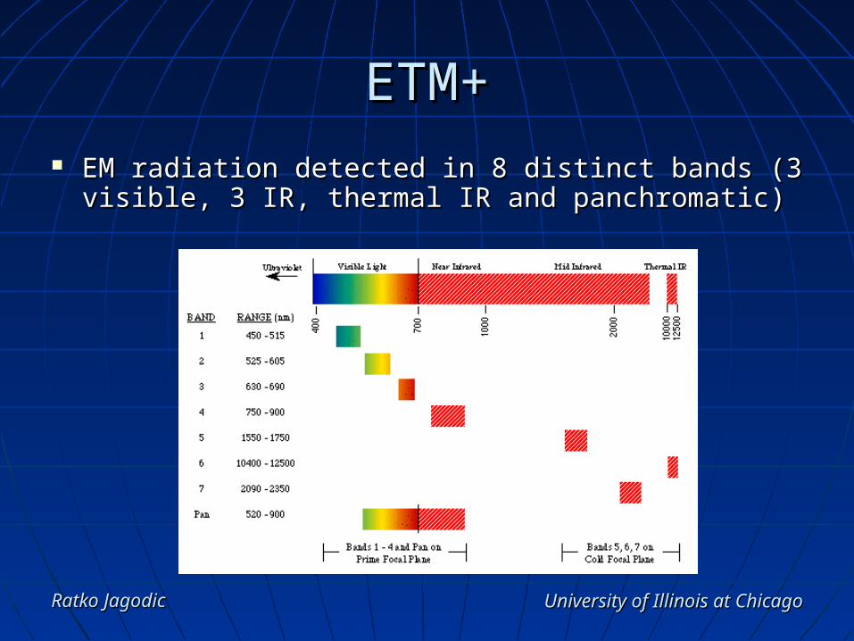
ETM+ETM+ EM radiation detected in 8 distinct bands (3 EM radiation detected in 8 distinct bands (3
visible, 3 IR, thermal IR and panchromatic)visible, 3 IR, thermal IR and panchromatic)

University of Illinois at ChicagoUniversity of Illinois at ChicagoRatko JagodicRatko Jagodic
ETM+ (contd.)ETM+ (contd.)
8 detectors (1/band) on 2 focal planes (cold and 8 detectors (1/band) on 2 focal planes (cold and primary)primary)

University of Illinois at ChicagoUniversity of Illinois at ChicagoRatko JagodicRatko Jagodic
Scanning ProcessScanning Process Orbits in North/South Orbits in North/South
direction (99min)direction (99min) Sweeps a 185 km Sweeps a 185 km
wide trackwide track Scans across track in Scans across track in
zigzag motionzigzag motion

University of Illinois at ChicagoUniversity of Illinois at ChicagoRatko JagodicRatko Jagodic
Data ProcessingData Processing
Across tracks are Across tracks are digitizeddigitized
Then composed into Then composed into 185 X 170km scenes 185 X 170km scenes (stored or transmitted (stored or transmitted real time)real time)

University of Illinois at ChicagoUniversity of Illinois at ChicagoRatko JagodicRatko Jagodic
Image ProcessingImage Processing Level 0 Reformatted (L0R) - raw dataLevel 0 Reformatted (L0R) - raw data Level 1 Radiometrically Corrected (L1R)Level 1 Radiometrically Corrected (L1R) Level 1 Geometrically Corrected (L1G) Level 1 Geometrically Corrected (L1G)

University of Illinois at ChicagoUniversity of Illinois at ChicagoRatko JagodicRatko Jagodic
ExamplesExamples
Deforestation in Amazon (1975 vs. 1992)Deforestation in Amazon (1975 vs. 1992)

University of Illinois at ChicagoUniversity of Illinois at ChicagoRatko JagodicRatko Jagodic
ExamplesExamples
Lake Chad in West Africa (1963 vs. 1997)Lake Chad in West Africa (1963 vs. 1997)

University of Illinois at ChicagoUniversity of Illinois at ChicagoRatko JagodicRatko Jagodic
ExamplesExamples
Las Vegas (1972 vs. 1992)Las Vegas (1972 vs. 1992)

University of Illinois at ChicagoUniversity of Illinois at ChicagoRatko JagodicRatko Jagodic
ExamplesExamples
Venice (imaging shallow waters)Venice (imaging shallow waters)

University of Illinois at ChicagoUniversity of Illinois at ChicagoRatko JagodicRatko Jagodic
ReferencesReferences
USGS Landsat ProjectUSGS Landsat Project• http://landsat7.usgs.gov/index.phphttp://landsat7.usgs.gov/index.php
Landsat 7 PageLandsat 7 Page• http://ls7pm3.gsfc.nasa.gov/mainpage.htmlhttp://ls7pm3.gsfc.nasa.gov/mainpage.html
NASA Landsat 7 PageNASA Landsat 7 Page• http://landsat.gsfc.nasa.gov/index.htmlhttp://landsat.gsfc.nasa.gov/index.html
University of Illinois at ChicagoUniversity of Illinois at ChicagoRatko JagodicRatko Jagodic