landmark navigation in desert ants
TRANSCRIPT

LUND UNIVERSITY
PO Box 117221 00 Lund+46 46-222 00 00
Visual navigation in desert ants Cataglyphis fortis: are snapshots coupled to acelestial system of reference?
Åkesson, Susanne; Wehner, Rüdiger
Published in:Journal of Experimental Biology
2002
Link to publication
Citation for published version (APA):Åkesson, S., & Wehner, R. (2002). Visual navigation in desert ants Cataglyphis fortis: are snapshots coupled toa celestial system of reference? Journal of Experimental Biology, 205(14), 1971-1978.http://jeb.biologists.org/cgi/content/abstract/205/14/1971
Total number of authors:2
General rightsUnless other specific re-use rights are stated the following general rights apply:Copyright and moral rights for the publications made accessible in the public portal are retained by the authorsand/or other copyright owners and it is a condition of accessing publications that users recognise and abide by thelegal requirements associated with these rights. • Users may download and print one copy of any publication from the public portal for the purpose of private studyor research. • You may not further distribute the material or use it for any profit-making activity or commercial gain • You may freely distribute the URL identifying the publication in the public portal
Read more about Creative commons licenses: https://creativecommons.org/licenses/Take down policyIf you believe that this document breaches copyright please contact us providing details, and we will removeaccess to the work immediately and investigate your claim.
Desert ants of the genus Cataglyphis returning from aforaging trip to the nest use both path integration and visuallandmarks as navigation tools for relocating the nest site(Wehner and Wehner, 1990; Collett, 1992; Wehner, 1992;Wehner et al., 1996). In its system of path integration, the antcomputes the net distance and direction from the nest at eachstage of its foraging journey and hence is, in principle, able tohome from any point along a direct route (Wehner, 1982,1992). To accomplish this task of path integration, the ant mustregister the courses selected as well as the distances travelledduring the foraging run (Müller and Wehner, 1988; Wehner,1992; Ronacher and Wehner, 1995; Hartmann and Wehner,1995). In addition to path integration, the ants navigate byusing familiar landmarks along the homing run as well as closeto the nest location (for reviews, see Collett and Cartwright,1983; Collett, 1992, 1996; Wehner, 1992; Wehner et al., 1996).Landmarks provide important information for pinpointing thenest when insects return after a foraging run (e.g. Wehner andRäber, 1979; Brunnert et al., 1994) and can be used for locatingfeeding sites (Cartwright and Collett, 1983, 1987; Cheng et al.,1987). Two-dimensional snapshots of landmark scenes havebeen shown to be retinotopically fixed (e.g. Wehner andMüller, 1985; Judd and Collett, 1998; see also Dill et al., 1993).
In the natural habitat of desert ants, foragers are regularlyforced to follow complex routes in a cluttered environment(Wehner et al., 1996). During such travels, the ants seem touse both global and local vectors defined by their pathintegration system, which interact with the availability and useof memorized landmarks (Collett et al., 1998). In familiarterrain, the ants seem to ignore the global vector that wouldlead them along a direct route back to the nest. Instead, theyrely on local vectors and stored familiar landmark scenes.However, when the ant leaves the familiar area, the globalvector assumes dominance and guides the ant back to the areaof the nest, where other guidance strategies take over.
If available, landmarks provide the most obviousnavigational cue used in the close vicinity of the nest. Toinvestigate whether stored landmark views are spatiallyoriented within a celestial system of reference, we studied thesearching behaviour of desert ants in relation to landmarksarranged around the nest (goal). The goal was locatedasymmetrically within a square array of four cylindricallandmarks so that there were four localities at which a storedsnapshot could be matched with the current retinal images.However, it was only at one of these positions that the snapshotand the current retinal image were in register with the celestial
1971The Journal of Experimental Biology 205, 1971–1978 (2002)Printed in Great Britain © The Company of Biologists Limited 2002JEB4074
Central-place foraging insects such as desert ants of thegenus Cataglyphis use both path integration andlandmarks to navigate during foraging excursions. Theuse of landmark information and a celestial system ofreference for nest location was investigated by trainingdesert ants returning from an artificial feeder to find thenest at one of four alternative positions locatedasymmetrically inside a four-cylinder landmark array.The cylindrical landmarks were all of the same size andarranged in a square, with the nest located in thesoutheast corner. When released from the compassdirection experienced during training (southeast), the antssearched most intensely at the fictive nest position. Wheninstead released from any of the three alternative
directions of approach (southwest, northwest ornortheast), the same individuals instead searched at two ofthe four alternative positions by initiating their search atthe position closest to the direction of approach whenentering the landmark square and then returning to theposition at which snapshot, current landmark image andcelestial reference information were in register. Theresults show that, in the ants’ visual snapshot memory, amemorized landmark scene can temporarily be decoupledfrom a memorized celestial system of reference.
Key words: navigation, visual navigation, landmark guidance,celestial reference system, learning, insect, ant, Cataglyphis fortis.
Summary
Introduction
Visual navigation in desert ants Cataglyphis fortis: are snapshots coupled to acelestial system of reference?
Susanne Åkesson* and Rüdiger Wehner†
Department of Zoology, Zürich University, Winterthurerstrasse 190, CH-8057 Zürich, Switzerland*Author for correspondence and present address: Department of Animal Ecology, Lund University, Ecology Building, SE-223 62 Lund,
Sweden (e-mail: [email protected])†Please send reprint requests to [email protected]
Accepted 23 April 2002

1972
system of reference. In these experiments, we used ants thathad returned from a foraging visit to a feeder located at adistant and fixed compass direction relative to the nest. Theants were released from four compass directions: from thetraining direction (0 °) and from three others of ±90 ° and 180 °from the training direction. In the latter three cases, the closesthypothetical nest positions given by the landmarks were inconflict with the directional information given by celestialinformation. Hence, the experiments are designed to provideinformation about the extent to which a memorized visualsnapshot scene can be coupled or decoupled from a celestialsystem of reference.
Materials and methodsExperimental subjects and study area
Desert ants of the species Cataglyphis fortisinhabiting opensalt-pan areas of the Saharan desert were used to investigatethe mechanism of landmark navigation close to the nest site.The experiments were performed in the ants’ natural habitatnear the village of Maharès in southeast Tunisia (34.58°N,10.50°E) in July–August 1997 and 1998. All ants used in theexperiments were individually marked so that the numbers offoraging visits by the ants to an artificial feeder could berecorded for each ant prior to the experiments. New unmarkedforagers were continuously captured at their first visit to thefeeder, then colour-marked and released. The colonies wereselected primarily on the basis of the absence of obviousnearby landmarks (the closest landmark, of maximum height0.5 m, was located more than 40 m away). In the firstexperiment, the ants were trained to visit a single feeder located16 m southeast of the nest (Fig. 1A). In the second experiment,the ants were trained to forage in four different compassdirections at feeders located 15 m away from the nest entranceand in directions of 10 ° relative to a north–south and east–westaxis respectively and with the nest located in the south–westcorner of the four cylinder landmark square (cf. Åkesson andWehner, 1997). In a third experiment we used the samelocations of the four feeders as above, but trained the ants tolocate the nest in the centre of the landmark square.
Observations at the feeder started prior to the time when thefirst ant appeared outside the nest entrance in the morning(between 08.00 and 08.30 h; Coordinated Universal Time+1 h)and continued until at least 16.00 h in the afternoon, whenforaging activity decreased.
Experimental arrangement and procedure
We arranged a four-cylinder landmark square around thenest entrance such that the nest entrance was locatedasymmetrically relative to the centre of the landmark square(Fig. 1A). The landmarks used in the experiments were plasticcylinders, covered with black paper, of height 40.5 cm anddiameter 22.5 cm. The side length of the landmark square was282 cm (as measured from the centre of the landmarks).Correspondingly, the diagonal distance was 400 cm. Two ofthe sides of the landmark square were arranged parallel to the
geographic north–south axis. The nest entrance was locatedinside the landmark square along a diagonal line 100 cmnorthwest from the landmark located in the southeast corner ofthe landmark square (Fig. 1A).
During the first 2 days of training, we captured as many antsas possible outside the nest entrance and marked them with aone-colour code (one colour for each day). On the followingdays, we marked the newly arriving ants individually withthree colour dots on the thorax and abdomen. The coloursallowed us to identify the experimental animals at a distancewithout capturing them. During the first day of marking ants,the four landmarks were installed around the nest. Two dayslater, we started to train individually marked ants to visit thefeeder. During the experimental period in 1998, a stationaryobserver was present at the single feeder for the full day andrecorded each visit by the individually marked ants at thefeeder. Food was presented at the feeder only when theobserver was present. This procedure allowed us to record thegreat majority of the foraging runs performed each day by allmarked ants that visited the feeder.
After the ants had visited the feeder, they were captured atthe nest, i.e. less than 1 m from the landmark closest to the nest(so-called zero-vector ants) and displaced inside a coveredglass vial to a nearby test field where the same landmarkarrangement as that present at the nest had been installed. Thetest field was located in an open area without any nearbylandmarks. It covered 30 m×30 m and contained a grid madeof thin white lines (grid width 1 m) painted on the ground. Thegrid was aligned parallel to the north–south axis.
S. Åkesson and R. Wehner
2m
NW NE
SW SE
N
15 m
N
F
N
BA
Fig. 1. Experimental arrangement used for training (A) and recording(B) the search trajectories during homebound runs in individuallymarked Cataglyphisants. The ants were all trained to visit a feeder(F) located 16 m southeast from the nest entrance. The searchtrajectories of individual ants were then recorded for ants released infour different compass directions (NW, NE, SW and SE in B) in aseparate test field. The nest (N) was located diagonally 100 cmnorthwest of the landmark in the southeast corner of the four-cylinder landmark square arrays. The side of the landmark squarecorresponded to a distance of 282 cm between the centres of thelandmarks. The diagonal distance between the landmarks was400 cm.

1973Landmark navigation in desert ants
In the test field, the first search trajectories of the markedants were recorded after the animals had visited the feederfive times. The ants were released from four differentcompass directions relative to the landmark array, one ofwhich coincided with the direction towards the feeder(southeast), while the others deviated by ±90 or 180 ° fromthis 0 ° direction (northeast, southwest, northwest). Therelease sites were located 2 m diagonally from the closestlandmark (Fig. 1B). Each ant was tested several times fromall four directions. The tests followed each other in randomorder, with three training-field foraging runs interspersedbetween individual tests. We released the ants with a pieceof biscuit to boost their motivation to home for the fictivenest. The ants’ search trajectories were recordedfor 3 min each by an observer constantly changinghis or her position relative to the searching antwhile recording the ants’ paths on graph paper.
Data analyses and statistics
The search trajectories of individual ants weredigitized on a computer tablet (MbasaSoft GEDIT;Antonsen, 1995). On the basis of the pooledtrajectories, the search density distributions werecalculated for a selected area (3 m×3 m) around thenest. In Figs 7 and 8, the search densitiespertaining to each experimental configuration arepresented both pooled and separated for all fourrelease sites. We also divided the 3-min trackingperiod into two half-periods (1.5 min each). Theproportion of the time spent searching wascomputed for each of these two half-periods.
We analysed the number of positions at whichthe ants searched for the fictive nest entrance, i.e.where distinct peaks in the search density profilesoccurred. Each search trajectory was evaluatedvisually, and the number of positions (0–4) atwhich the ant had searched for the nest wasclassified on the basis of the ants’ turningbehaviour. If the ant had stopped and turned at leastonce within a circle of 20 cm radius around theposition of the hypothetical nest given by thelandmark array at any of the four alternativepositions, this was counted as searching for thenest. The majority of the ants, however, turned anumber of times and returned several times to thesame position to search for the nest. The medianvalues resulting from these computations of thefour alternative positions given by the landmarkscene at which individual ants searched for the nestwere compared for different experiments using themedian test (Siegel and Castellan, 1988).
ResultsAs the goal was located asymmetrically within a
square array of four identical landmarks, its
geographical position was accompanied by three additionalpositions at which the ant could note its current landmarkimage with its stored one but could not place this in registerwith a celestial system of reference. By releasing the ants notonly from the training direction (southeast), from which theywould hit the (fictive) geographical location of the goal first,but also from these alternative directions (southwest,northwest, northeast), we were able to investigate the extent towhich the ants are able to couple or decouple a memorisedvisual snapshot scene from a celestial system of reference.
In total, we recorded the search trajectories of 27 individuallymarked ants (release sites given in Fig. 1B; northwest N=16,northeast N=18, southwest N=20, southeast N=22). On the basis
0 0.68% 0 0.87%
0 2.53%0 1.33%
NW NE
SW SE
Fig. 2. Search density distributions for a group of individually tracked desert antssearching for the fictive position of the nest located within a four-cylinderlandmark array. Search density distributions are given for releases from directionsidentical with (SE) or different from (NW, NE, SW) the training direction. If itlived long enough to complete the experimental period, each ant had been releasedfrom all four directions. An open circle depicts the position of the hypotheticalnest. The sides of the square are 282 cm between the centres of the landmarks. Thefour cylindrical landmarks are positioned in each of the four corners of the searchdensity square. Colour scales indicating the relative search densities in each20 cm×20 cm square pixel are given beneath the distribution for each group. N=16(NW), N=18 (NE), N=20 (SW) and N=22 (SE) ants.
1974
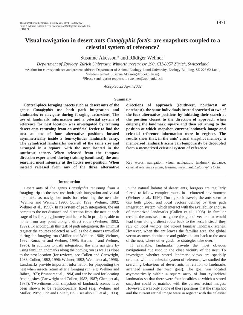
of these search trajectories, we calculated the relative searchactivities pertaining to all 225 20 cm×20 cm2 pixels of the four-cylinder landmark array (Fig. 2). The search densitydistribution given in Fig. 2 (southeast) corresponds to searchingperformed by ants captured and released in the direction ofapproach from the feeder during training. There is a single highsearch density peak. In contrast, the search density distributionsrecorded for ants released at any of the other directions (Fig. 2,northwest, northeast, southwest) resulted in two obvious peaks,one located at the hypothetical geographical position of the nestand a second peak at that of the three other snapshot-matchingsites that was closest to the site of release. The great majorityof the ants started to search for the nest at the closesthypothetical nest position during the first half of the trackingperiod (1.5 min) and searched at the correct geographicalposition of the nest given by celestial and landmark informationduring the second half of the test period (Fig. 3). This behaviourwas especially obvious in releases from southwest andnorthwest (Fig. 3). In three cases (northwest, southwest andsoutheast in Fig. 3), search intensities were slightly lowerduring the second half of the test period.
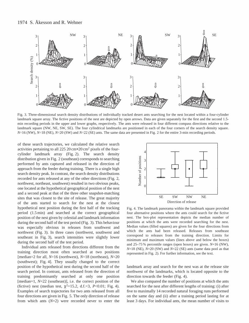
Individual ants released from directions different from thetraining direction most often searched at two positions[median=2 for all, N=16 (northwest), N=18 (northeast), N=20(southwest); Fig. 4]. They usually changed to the correctposition of the hypothetical nest during the second half of thesearch period. In contrast, ants released from the direction oftraining predominantly searched at only one position[median=1, N=22 (southeast)], i.e. the correct position of the(fictive) nest (median test, χ2=15.2, d.f.=3, P<0.01; Fig. 4).Examples of search trajectories for two ants released from allfour directions are given in Fig. 5. The only direction of releasefrom which ants (N=2) were recorded never to enter the
landmark array and search for the nest was at the release sitenorthwest of the landmarks, which is located opposite to thedirection towards the feeder (Fig. 4).
We also compared the number of positions at which the antssearched for the nest after different lengths of training: (i) afterfive to maximally 14 recorded natural foraging runs performedon the same day and (ii) after a training period lasting for atleast 3 days. For individual ants, the mean number of visits to
S. Åkesson and R. Wehner
0
1
2
3
0
1
2
3
0
1
2
3
0
1
2
3
0
1
2
3
0
1
2
3
NW NE SW SE
0
1
2
3
0
1
2
3Se
arch
den
sity
(%
)
Fig. 3. Three-dimensional search density distributions of individually tracked desert ants searching for the nest located within a four-cylinderlandmark square array. The fictive positions of the nest are depicted by open arrows. Data are given separately for the first and the second 1.5-min recording periods in the upper and lower graphs, respectively. The ants were released in four different compass directions relative to thelandmark square (NW, NE, SW, SE). The four cylindrical landmarks are positioned in each of the four corners of the search density square.N=16 (NW), N=18 (NE), N=20 (SW) and N=22 (SE) ants. The same data are presented in Fig. 2 for the entire 3-min recording periods.
0
1
2
3
4
SE SW NW NEDirection of release
Num
ber
of p
ositi
ons
Fig. 4. The landmark panorama within the landmark square providedfour alternative positions where the ants could search for the fictivenest. The box-plot representation depicts the median number ofpositions at which the ants were recorded searching for the nest.Median values (filled squares) are given for the four directions fromwhich the ants had been released. Releases from southeastcorrespond to releases from the training direction. Limits forminimum and maximum values (lines above and below the boxes)and 25–75 % percentile ranges (open boxes) are given. N=16 (NW),N=18 (NE), N=20 (SW) and N=22 (SE) ants (same data pool as thatrepresented in Fig. 2). For further information, see the text.

1975Landmark navigation in desert ants
the feeder was 29.2±27.1 (mean ±S.D.; N=29) per day (S.Åkesson and R. Wehner, in preparation). These experimentswith different lengths of training were performed to investigatewhether the coupling between landmarks and celestial compasscues becomes weaker as training time proceeds. Ants of thelong-training group, each trained to one of four differentfeeders, searched for the nest at more than one position whenreleased from the direction of training (median=3,minimum=1, maximum=4, N=26, Fig. 6) compared with antsof the short-training group (southeast, see above and Fig. 4;median test, χ2=13.5, d.f.=1, P<0.001). Furthermore, thenumber of positions at which the ants searched for the nest didnot depend on the location at which they had been released (inthe training direction or from any of the other three compassdirections) for the group of ants that had been allowed atraining period of at least 3 days (median test, χ2=0.007, d.f.=1,P>0.05).
In a companion training paradigm, the ants had to locate the
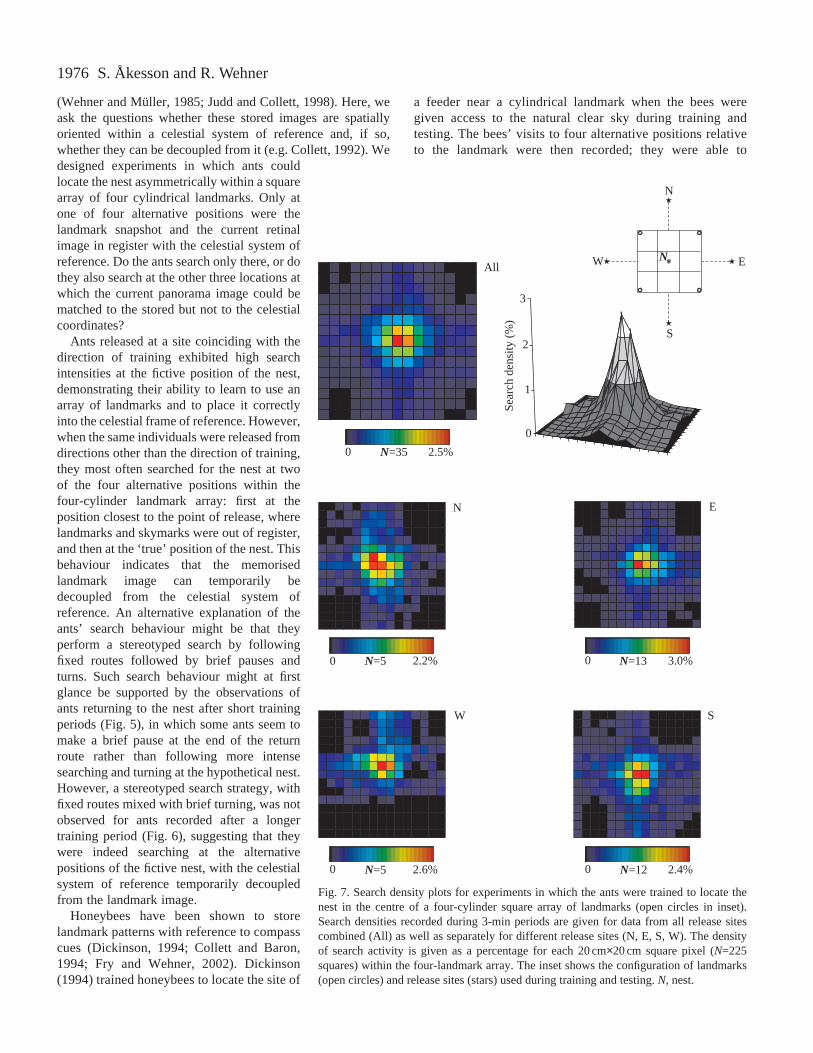
nest in the centre of a four-cylinder landmark square. Thisexperiment was designed to create an unambiguous landmarksituation and to test whether in such a situation an experimentalrotation of the landmark array relative to the celestial systemof reference had any effect. The ants searched intensely at the(only one) fictive position of the nest when released from anyof four alternative compass directions (training landmark arraydepicted in inset of Fig. 7; cf. Åkesson et al., 1998), and thesearch density profiles centred at the fictive position of the nestwere only slightly broader when the landmark arrays had beenrotated by 45 ° (Fig. 8).
DiscussionDesert ants returning from a foraging journey reliably rely
on landmark cues to pinpoint the nest entrance. Ants havealready been shown to use stored two-dimensional images,which are retinotopically fixed, to locate the nest entrance
NNW NE
SESW
NW NE
SESW
Ant 235 Ant 311
Fig. 5. Examples of searchingtrajectories for two ants recordedafter releases from four differentcompass directions after a shorttraining period (see text). Openblack circles indicate the positionsof the landmarks; stars represent thesites of release. The green linesindicate the search trajectories ofants released from southeast, i.e.from the direction from which theyhad approached the nest duringtraining. According to the criteriaused to define the number of searchpositions, ants 235 and 311 bothexhibited four search positions.
N
BAFig. 6. Examples of thetrajectories of eight ants (four inA and four in B) searching forthe nest within a four-cylinderlandmark array recorded afterreleases from four differentcompass directions. All antswere released from the directionof training after at least 3 days oftraining. Open circles indicatethe positions of landmarks; starsdenote the sites of release; theblack arrowheads at the edge ofthe grid point to the fictiveposition of the nest. Each searchtrajectory selected by anindividual ant is represented by acoloured line.
1976
(Wehner and Müller, 1985; Judd and Collett, 1998). Here, weask the questions whether these stored images are spatiallyoriented within a celestial system of reference and, if so,whether they can be decoupled from it (e.g. Collett, 1992). Wedesigned experiments in which ants couldlocate the nest asymmetrically within a squarearray of four cylindrical landmarks. Only atone of four alternative positions were thelandmark snapshot and the current retinalimage in register with the celestial system ofreference. Do the ants search only there, or dothey also search at the other three locations atwhich the current panorama image could bematched to the stored but not to the celestialcoordinates?
Ants released at a site coinciding with thedirection of training exhibited high searchintensities at the fictive position of the nest,demonstrating their ability to learn to use anarray of landmarks and to place it correctlyinto the celestial frame of reference. However,when the same individuals were released fromdirections other than the direction of training,they most often searched for the nest at twoof the four alternative positions within thefour-cylinder landmark array: first at theposition closest to the point of release, wherelandmarks and skymarks were out of register,and then at the ‘true’ position of the nest. Thisbehaviour indicates that the memorisedlandmark image can temporarily bedecoupled from the celestial system ofreference. An alternative explanation of theants’ search behaviour might be that theyperform a stereotyped search by followingfixed routes followed by brief pauses andturns. Such search behaviour might at firstglance be supported by the observations ofants returning to the nest after short trainingperiods (Fig. 5), in which some ants seem tomake a brief pause at the end of the returnroute rather than following more intensesearching and turning at the hypothetical nest.However, a stereotyped search strategy, withfixed routes mixed with brief turning, was notobserved for ants recorded after a longertraining period (Fig. 6), suggesting that theywere indeed searching at the alternativepositions of the fictive nest, with the celestialsystem of reference temporarily decoupledfrom the landmark image.
Honeybees have been shown to storelandmark patterns with reference to compasscues (Dickinson, 1994; Collett and Baron,1994; Fry and Wehner, 2002). Dickinson(1994) trained honeybees to locate the site of
a feeder near a cylindrical landmark when the bees weregiven access to the natural clear sky during training andtesting. The bees’ visits to four alternative positions relativeto the landmark were then recorded; they were able to
S. Åkesson and R. Wehner
0 N=35 2.5%
N E
W S
All
0
1
2
3
0 N=5 2.2%
0 N=5 2.6% 0 N=12 2.4%
0 N=13 3.0%
N
N
S
W E
Sear
ch d
ensi
ty (%
)
Fig. 7. Search density plots for experiments in which the ants were trained to locate thenest in the centre of a four-cylinder square array of landmarks (open circles in inset).Search densities recorded during 3-min periods are given for data from all release sitescombined (All) as well as separately for different release sites (N, E, S, W). The densityof search activity is given as a percentage for each 20 cm×20 cm square pixel (N=225squares) within the four-landmark array. The inset shows the configuration of landmarks(open circles) and release sites (stars) used during training and testing. N, nest.

1977Landmark navigation in desert ants
determine the fictive position of the feeder only whencelestial cues were available, but not when the sky wascompletely covered by clouds. These experiments indicatethat the bees are able to store landmark images relative to acelestial system of reference (Dickinson, 1994), as previouslysuggested by Lindauer (1960). However, Collett and Baron(1994) reported that honeybees were able to locate a feederrelative to landmarks even if celestial cues were absent aslong as magnetic cues were available. Theirexperiments suggest that the Earth’s magneticfield could also provide compass information forbees.
One could argue that the external system ofreference shown to be effective in ourexperiments was provided by distant landmarksrather than by skylight information. In the salt-panenvironment, in which the experiments wereperformed, this possibility can be almostcompletely ruled out. As seen from the nestentrance, the largest (isolated) landmarksubtended 0.7 °, and the few isolated landmarksthat could be seen in the test field were even lowerand in completely different positions. Hence, inall likelihood, it is a skymark system that the antsused as a frame of reference in our experiments.Distant landmark panoramas have been shown tobe used as a navigational guidemark by homingwood ants, Formica japonica(Fukushi, 2001).However, in these experiments, the upper skylineof the surrounding trees, which was the importantpart of the landmark scene, was much higher(subtending >20 °) than in our experiments(subtending <2 °, see also Wehner et al., 1996).Furthermore, in our experiments the configurationof the natural distant landmarks differed betweenthe training and test areas.
Cartwright and Collett (1983) made a detailedstudy of the characteristics of the reference systemby which honeybees use their memorisedlandmark panoramas to locate the site of a feeder.They rotated an asymmetrical array of threelandmarks by 30–90 ° and found that the beesresponded to these shifts by changing their searchposition only if the landmarks were rotated by asubstantial amount (>45 °) relative to the trainingconfiguration. The authors concluded that the beesdo define the landmark scene with respect toexternal coordinates, but that they do so with acertain degree of imprecision (Cartwright andCollett, 1983). Their findings agree well with ourobservations that the search density profilecentred above the fictive position of the nest wasonly slightly broader when the landmark array hadbeen rotated by 45 ° (Figs 7 and 8).
In conclusion, the most important result of thepresent experiment is that ants can store images
of panorama skylines with a celestial system of reference, butthat they are also able to decouple their snapshot memoriesfrom this frame of reference. The experiments further suggestthat this decoupling might be facilitated over time, such that,after some days of training, desert ants prioritize the currentlandmark memories and to a certain extent ignore theconflicting celestial information experienced when searchingfor the nest.
NW NE
SW SE
All
0
1
2
3
0 N=26 2.1%
0 N=7 2.6%
0 N=7 1.6% 0 N=7 2.4%
0 N=5 2.2%
NENW
SW SE
Sear
ch d
ensi
ty (%
)
N
Fig. 8. Same experimental paradigm as in Fig. 7 but with the landmark array usedfor testing rotated by 45 ° relative to the training situation (for the latter, see inset inFig. 7). N=27 ants each released from all four points of the compass. For furtherexplanation see Fig. 7. N, nest.

1978
We thank Franz-Xavier Dillier and Kirstin Kopp forassistance in the field. This project was financed by grants fromthe Swedish Natural Science Research Council and the SwedishResearch Council (both to S.Å.), the Swiss National ScienceFoundation (grant 31.43317-95), the Human Frontier ScienceProgram Organisation (grant RG 0084/97-B) and the Georgesand Antoine Claraz Foundations (the latter three to R.W.).
ReferencesÅkesson, S., Dillier, F.-X. and Wehner, R.(1998). The role of compass
information in the visual snapshot memory of desert ants, Cataglyphis fortis.In Proceedings of the 26th Neurobiology Conference Göttingen(ed. N.Elsner and R. Wehner), p. 220. Stuttgart: Georg Thieme Verlag.
Åkesson, S. and Wehner, R.(1997). Visual snapshot memory of desert ants,Cataglyphis fortis. In Proceedings of the 25th Neurobiology ConferenceGöttingen(ed. N. Elsner and H. Wässle), p. 482. Stuttgart: Georg ThiemeVerlag.
Antonsen, N. (1985). MbasaSoft GEDIT for Windows, v2.5. Zurich:Switzerland.
Brünnert, U., Kelber, A. and Zeil, J. (1994). Ground-nesting bees determinethe location of their nest relative to a landmark by other than angular sizecues. J. Comp. Physiol. A175, 363–369.
Cartwright, B. A. and Collett, T. S. (1983). Landmark learning in bees:experiments and models. J. Comp. Physiol. 151, 521–543.
Cartwright, B. A. and Collett, T. S. (1987). Landmark maps for honeybees.Biol. Cybern. 57, 85–93.
Cheng, K., Collett, T. S., Pickhard, A. and Wehner, R.(1987). The use oflandmarks by honeybees: Bees weight landmarks according to their distancefrom the goal. J. Comp. Physiol. A 161, 469–475.
Collett, M., Collett, T. S., Bisch, S. and Wehner, R.(1998). Local and globalvectors in desert ant navigation. Nature 394, 269–272.
Collett, T. S. (1992). Landmark learning and guidance in insects. Phil. Trans.R. Soc. Lond. B337, 295–303.
Collett, T. S.(1996). Insect navigation en route to the goal: multiple strategiesfor the use of landmarks. J. Exp. Biol. 199, 227–235.
Collett, T. S. and Baron, J.(1994). Biological compasses and the coordinateframe of landmark memories in honeybees. Nature 368, 137–140.
Collett, T. S. and Cartwright, B. A. (1983). Eidetic images in insects: theirrole in navigation. Trends Neurosci. 6, 101–105.
Dickinson, J. A. (1994). Bees link local landmarks with celestial compasscues. Naturwissenschaften 81, 465–467.
Dill, M., Wolf, R. and Heisenberg, M.(1993). Visual pattern recognition inDrosophila involves retinotopic matching. Nature 365, 751–753.
Fry, S. N. and Wehner, R. (2002). Honey bees store landmarks in anegocentric frame of reference. J. Comp. Physiol. A 187, 1009–1016.
Fukushi, T. (2001). Homing in wood ants, Formica japonica: use of theskyline panorama. J. Exp. Biol. 204, 2063-2072.
Hartmann, G. and Wehner, R.(1995). The ant’s path integration system: aneural architecture. Biol. Cybernetics 73, 483–497.
Judd, S. P. D. and Collett, T. S.(1998). Multiple stored views and landmarkguidance in ants. Nature 392, 710–714.
Lindauer, M. (1960). Time-compensated sun orientation in bees. Cold SpringHarb. Symp. Quant. Biol. 25, 371–377.
Müller, M. and Wehner, R. (1988). Path integration in desert ants,Cataglyphis fortis. Proc. Natl. Acad. Sci. USA85, 5287–5290.
Ronacher, B. and Wehner, R.(1995). Desert ants Cataglyphis fortisuse self-induced optic flow to measure distances travelled. J. Comp. Physiol. A 177,21–27.
Siegel, S. and Castellan, N. J., Jr(1988). Nonparametric Statistics for theBehavioural Sciences. New York: McGraw-Hill.
Wehner, R. (1982). Himmelsnavigation bei Insekten. Neurophysiologie undVerhalten. Neujahrsbl. Naturforsch. Ges. Zürich 184, 1–132.
Wehner, R. (1992). Arthropods. In Animal Homing(ed. F. Papi), pp. 45–144.London: Chapman & Hall.
Wehner, R., Michel, B. and Antonsen, P.(1996). Visual navigation ininsects: coupling of egocentric and geocentric information. J. Exp. Biol. 199,129–140.
Wehner, R. and Müller, M. (1985). Does interocular transfer occur in visualnavigation by ants? Nature315, 228–229.
Wehner, R. and Räber, F. (1979). Visual spatial memory in desertants, Cataglyphis bicolor (Hymenoptera: Formicidae). Experientia 35,1569–1571.
Wehner, R. and Wehner, S.(1990). Insect navigation: use of maps orAdriane’s thread? Ethol. Ecol. Evol. 2, 27–48.
S. Åkesson and R. Wehner