landmark assessment - granicus
TRANSCRIPT

A R C H I V E S & A R C H I T E C T U R E , L L C
PO Box 1332
San José, CA 95109-1332
http://www.archivesandarchitecture.com
LANDMARK ASSESSMENT Historic Ames/Landels Barn
210 Alta Vista Avenue
Los Altos, Santa Clara County, California
(APN #167-34-022, associated with 167-35-002 & 076)
Prepared for:
Soleio and Kater Cuervo
210 Alta Vista Avenue
Los Altos, CA 94022
09.06.2016, rev. 10.11.16
Historic Ames/Landels Barn – Landmark Assessment TABLE OF CONTENTS
A R C H I V E S & A R C H I T E C T U R E 2
TABLE OF CONTENTS
TABLE OF CONTENTS ................................................................................................................... 2
INTRODUCTION .............................................................................................................................. 3
Qualifications ................................................................................................................................ 4
Historical Evaluation Process ....................................................................................................... 5
Methodology of This Review ........................................................................................................ 6
Survey Status ............................................................................................................................... 6
Historical and Architectural Information ........................................................................................ 7
Integrity ....................................................................................................................................... 15
References ................................................................................................................................. 16
Locational Information ................................................................................................................ 17
Assessor’s Parcel Map ............................................................................................................... 17
REVIEW AND RECOMMENDATIONS .......................................................................................... 18
Cover image: View of Ames/Landels Barn from the east, July 2016
(Photograph by Leslie Dill, Archives & Architecture, LLC)

Historic Ames/Landels Barn – Landmark Assessment INTRODUCTION
A R C H I V E S & A R C H I T E C T U R E 3
SUMMARY OF FINDINGS
The early-twentieth-century barn within its immediate surrounding parcel addressed at
210 Alta Vista Ave. and located between Adobe Creek and Foothill Expressway (APN
167-34-022), meets the criteria for listing as a City of Los Altos Historic Resource. It is
understood that this report and its conclusions, including the accompanying California
Department of Parks & Recreation Forms 523 (DPR523) may be used to nominate the
property for local designation.
None of the buildings addressed at present at 210 Alta Vista Av.—the barn, the altered
1890s farmhouse, or the accessory buildings on the residential parcels—are currently
listed on the Los Altos Historical Resources Inventory (HRI). The 1890s main house was
initially surveyed in 1997 and identified as eligible for listing on the Historical Resources
Inventory for its associations with the agricultural context of the area “constructed prior
to the establishment of the town.” The HRI context continues, “All properties in this
context represent farmhouses of the area that were tied to some form of agriculture prior
to the influx of San Franciscans and other families after the town’s creation.” In the 2010
revised HRI, the property is noted as being “…no longer on the HRI,” because of
alterations to the property.
The barn was not identified in the inventory, as it was not linked to this address when
the property was originally documented in 1997. The barn has a separate history from
the farmhouse, dating from the early twentieth century, associated with “The Age of
Subdivision and Mass Transit” and its family farms, as described in the Los Altos HRI
Section II Contexts.
This report presents information that focuses on the barn and its parcel only. It provides
a small amount of shared background about the history of the front residential portion
of the property on parcels 167-35-002 and 167-35-076. The background of the barn parcel
includes the range of dates of its construction, directly associated and other known
property owners, character-defining features of the buildings, and an evaluation of
significance according to City of Los Altos historic significance criteria.
It is the professional opinion of the consultants that the barn meets the criteria for listing
as a City of Los Altos Historic Resource; therefore, modifications to the site should be
done in a sensitive way in order to retain the historic character of the buildings on the
site, and allowance can be offered to encourage its appropriate adaptive
reuse/rehabilitation.
INTRODUCTION
The barn at the rear (west) of the single family residential property located at 210 Alta
Vista Ave. in Los Altos is being proposed for adaptive reuse/rehabilitation in the near
future. The property owner has contracted with Archives & Architecture, LLC, to
prepare this report to update the information contained in the City’s Historic Resource
Inventory listing for the property, as the property formerly did not include the barn or

Historic Ames/Landels Barn – Landmark Assessment INTRODUCTION
A R C H I V E S & A R C H I T E C T U R E 4
its surrounding parcel, and the barn has not previously been evaluated. The report
provides an intensive-level historical investigation of the property, and evaluation
according to City of Los Altos historic significance criteria. The intent is to submit this
report to the City of Los Altos as a part of an application for entitlements involving
future construction on the property.
The historic significance criteria are defined in Los Altos Municipal Code Article 12.44
(Historical Preservation) and explained in Section I of the City’s Historic Resources
Inventory as adopted by the Los Altos City Council in 2011. The policy requires that this
review be done by a qualified preservation professional when a project involves a
historic resource listed on the Inventory.
Archives & Architecture, LLC, is a partnership of Leslie A.G. Dill, Historic Architect,
Franklin Maggi, Architectural Historian, and Charlene Duval, Public Historian. The
partners of the firm are preservation professionals. The firm was founded in 1989 by the
late Glory Anne Laffey, Historian, and has been constituted in its current partnership
since 2003.
This report is being prepared for review by staff of the Planning Division of the
Department of Community Development of the City of Los Altos, and may be
forwarded to the Los Altos Historical Commission for recommendation to staff on the
project.
Qualifications
The principal author of this report was Leslie A.G. Dill, Architect, who consults in the
field of historic architecture and architectural history. Ms. Dill has a Master of
Architecture with a Program Certificate in Historic Preservation from the University of
Virginia, Charlottesville, and is a licensed architect in the State of California.
Franklin Maggi, Architectural Historian, collaborated on the investigation and provided
historical research and guidance with the evaluation. Mr. Maggi has a professional
degree in architecture with an area of concentration in architectural history from the
University of California, Berkeley.
Both investigators, Leslie Dill and Franklin Maggi, are listed as qualified to do this work
within the California Historical Resources Information System (CHRIS). The Northwest
Information Center, Sonoma State University, Rohnert Park, operated under authority of
the California State Office of Historic Preservation, maintains a list of Historical
Resources Consultants who are qualified to do work in the area.
Leslie Dill and Franklin Maggi meet the Secretary of the Interior’s qualifications to
perform identification, evaluation, registration, and treatment activities within the field
of Architectural History and Historic Architecture respectively, in compliance with state
and federal environmental laws. CHRIS utilizes the criteria of the National Park Service
outlined in 36 CFR Part 61.

Historic Ames/Landels Barn – Landmark Assessment INTRODUCTION
A R C H I V E S & A R C H I T E C T U R E 5
Historical Evaluation Process1
Los Altos is a community that celebrates its history. This rich past has been incorporated
into the fabric of the City and provides a link to the community’s heritage and history.
The remaining sites and structures of architectural and/or historic significance enhance
the community’s unique character and contribute to a sense of place.
As outlined in the Los Altos General Plan, it is a goal of the City to preserve and enhance
historic and cultural structures and resources within the community. To support that
goal, the General Plan identified specific historic preservation policies:
Ensure that the integrity of historic structures and the parcels on which they are
located are preserved through the implementation of applicable design, building,
and fire codes.
The City shall regard demolition of landmark structures and historic structures listed
in the Historic Resources Inventory as a last resort. Demolition would be permitted
only after the City determines that the resource has lost its integrity, retains no
reasonable economic use, that demolition is necessary to protect health, safety and
welfare, or that demolition is necessary to precede with a new project where the
benefits of the new project outweigh the loss of the historic resource.
Work with property owners to preserve historic resources within the community.
These goals and policies are implemented through the City’s Historical Preservation
Ordinance. The primary purpose of the Ordinance is to ensure the protection of
irreplaceable historic resources, enhance visual character through architectural
compatibility, and encourage appreciation and recognition of the City’s past.
The Los Altos Historic Resources Inventory (HRI) is the official list of historic resources,
designated historic landmarks and designated historic districts that are significant at the
local level (contribute to the history of Los Altos). If a property is over 50 years old,
retains its integrity, and has association with one or more of the criteria of significance,
then it is eligible for designation as a Historic Resource.
The Los Altos historic evaluation process has been developed using the criteria outlined
in the State and National evaluation practices and is intended to coordinate the areas of
integrity, significance, and association between the California Register and the City of
Los Altos, in order to avoid conflicting information or interpretations. The evaluation
process consists of three steps, which are summarized below.
The first step is to determine whether or not the property is over fifty years of age –
buildings must, in most cases, be fifty years old or older to be considered historic
resources.
1 Policies excerpted from City of Los Altos Historical Resource Inventory, 2011.

Historic Ames/Landels Barn – Landmark Assessment INTRODUCTION
A R C H I V E S & A R C H I T E C T U R E 6
The next step is to determine whether the property retains enough original materials
and features to convey its value as a historic resource.
If a resource meets the age requirement and retains physical integrity, the next step is to
determine if the resource has been relocated and/or is associated with a person or event
of importance and therefore has significance with an Event, Person/People,
Architecture/Design, and/or Yields Important Information based on national, state or
local definition. Once it has been determined whether or not a property qualifies as a
historic resource, the final step is to assess how it is associated with an important historic
context. This context could be an association with a person, event or pattern of events
significant in local, state or national history or themes within these associative values. It
could be an association with a notable architect or an important architectural style or
method of construction. A building, structure or object could also be important for its
ability to provide information about prehistory. If a property is found to have a clear
association with an important historic context then it is determined to have significance
as a historic resource on a national, state or local level.
Methodology of This Review
1. This document is presented in a report format, and addresses the extant
agricultural building on the potential project site. The attached DPR523 series
forms provides the historical and architectural documentation specific to the
barn and its parcel. An earlier DPR523 recording by Patricia Leach (1997) for the
main house, was undertaken before the barn and its parcel were conveyed to
their current address.
2. The site was examined in July 2016 by Leslie Dill. Notes on the architecture,
characteristic features of the building, and the surrounding setting and
neighborhood context were made. Photographs of the barn and views of the
setting were taken at this time. Photographic documentation in the DPR523
forms was taken digitally by Leslie Dill.
Historical research was conducted by Leslie Dill and Franklin Maggi and included
review of historic maps, city directories, census enumerations, local histories, and vital
statistics. The research and historical investigation was prepared utilizing the
methodology recommended by the National Park Service, as outlined in Preservation
Briefs #17 -Architectural Character: Identifying the Visual Aspects of Historic Buildings as an
Aid to Preserving Their Character (1988), and #35 -Understanding Old Buildings: The Process
of Architectural Investigation (1994).
Survey Status
The property at 210 Alta Vista Ave. is not presently listed within the City of Los Altos
Historical Resources Inventory. It was identified during the initial survey as a historic
resource for its 1890s main house, a former farmhouse, but underwent subsequent

Historic Ames/Landels Barn – Landmark Assessment INTRODUCTION
A R C H I V E S & A R C H I T E C T U R E 7
alteration and was noted to be removed from the list of historic resources for the 2011
updated HRI.
The City of Los Altos Historic Resources Inventory lists the farmhouse on its properties
associated with the agricultural context of the area “constructed prior to the
establishment of the town.” It is noted that the property “has been demolished and/or is
no longer on the HRI.” The survey continues, “All properties in this context represent
farmhouses of the area that were tied to some form of agriculture prior to the influx of
San Franciscans and other families after the town’s creation.”
Historical and Architectural Information
Technical Description
The attached DPR523 forms includes a technical description of the barn and the rear
(west) parcel addressed at 210 Alta Vista Ave as follows:
The Ames/Landels Barn, although exhibiting considerable physical deterioration and
including some window alterations, is an uncommon local example of a gambrel-roofed
barn built in the first half of the twentieth century. The two-story structure features
distinctive board-and-batten siding, a prow-shaped hay hood, skip-roof sheathing, and
other intact historic elements. The barn is relatively small, indicating equestrian use
similar to a stable, with no space for carriages or for other large animals.
The English Gambrel style was employed for wood frame barns in the West starting
around the turn of the twentieth century. This barn was built when the rural-residential
development of Los Altos was intensifying after the Peninsular Railway spur was
constructed and the downtown established.
The Ames/Landels Barn is located on a triangular parcel between Adobe Creek and
Foothill Expressway, accessible by a footbridge that spans Adobe Creek from the rear
(west) of the currently associated residential parcel. The barn and residence are
generally north of downtown Los Altos, and west of San Antonio Road. The immediate
setting is naturalistic, featuring mature live oak trees and sparse local undergrowth,
interspersed with open ground mulched with naturally occurring oak leaves. The
expressway is separated from the property by a berm and sound wall along the
southwest property line. The berm is more densely covered with local vegetation,
approximating a chaparral hillside and concealing the roadway and wall. The residential
subdivision to the north is also concealed by heavy shrubbery and trees. The creek banks
on the two adjoining parcels are at a similar elevation, and the creek bed features local
riparian plants as well as some erosion control features. The setting feels essentially
unchanged since the aerial photos almost 70 years ago. There is one segment of wood
corral fencing extending north from a corner of the barn. A gate is connected to the barn
wall. The fencing consists of horizontal flat boards supported by closely placed vertical
posts. The fencing adds to the setting, but is a separate feature from the barn itself.

Historic Ames/Landels Barn – Landmark Assessment INTRODUCTION
A R C H I V E S & A R C H I T E C T U R E 8
The barn is a compact gambrel-roof structure, with unpainted wood siding and wood
shingle roofing. Original openings remain, while windows were added to the building
in the recent past after equestrian use ceased. The barn has a rectangular footprint,
oriented generally north-south. The west half of the barn features a raised wood floor
that rests on a concrete foundation, hinting at a 1920s structure or later. The east half of
the barn floor is a concrete slab. The building is balloon-framed at the side walls, with
the second story occupying the roof volume or attic space. The upper roof is topped by a
ridge board and supported on built-up trusses with ties that span the upper portion of
the gambrel. The lower roof rests on wall segments above the floor joists. The roof has
shallow eaves with exposed rafter tails and skip sheathing. The outer eaves feature a
fascia board, and the roof is covered with wood shingles.
The exterior walls are clad in vertical board-and-batten siding. A horizontal seam on
each end of the building demonstrates the use of a consistent length board around the
perimeter, topped by trimmed upper boards at the gambrel ends. There are no trim
boards at the walls (e.g., no corner boards or upper wall frieze boards).
The north elevation of the building, facing a formerly fenced area of the parcel, is
accented by the angular extension of the roof into a hay hood. Its outer point rests, not
on a ridge beam, but on a paired-board angle brace that also supports the tackle. At the
second story, centered below the hoist, is a paired hay door with strap hinges. The door
is built up of flat boards without battens. Below the hay door, offset slightly to the west
and raised because of the interior floor level, is a single door of similar board
construction and strap hinges. There is a pair of symmetrical window openings at the
second floor; one opening is open to the elements while the other includes a modern
aluminum slider window. A single window, near the east corner, is boarded up at the
first floor.
The west elevation, facing the railway originally and now the expressway, features three
window openings at the first floor. Two of the openings feature hinged doors, cut from
the board-and batten siding and supported on strap hinges, similar to the doors at the
north end, but including the battens. These were likely openings for the horse stalls. The
third window, near the northwest corner, is boarded up. This elevation is bowing
outward at the upper wall.
The south elevation has a single opening at the center of the upper gambrel, above the
seam in the wall boards. This opening is filled with a screen of turned, painted balusters.
This design feature is clearly not original. There is physical evidence that there was a
lean-to addition at the first floor of this wall; this addition has been removed.
The east elevation, facing the creek and the main house, has been altered by the
installation of three very large, non-original square, fixed windows at the first floor.
These windows appear to have been salvaged from other buildings, as they have
differing muntin patterns and appear from their construction to be of older origin. The
two more central windows feature 4x3 lites in a vertical orientation. The southern
window features a 2x4-lite pattern in a horizontal orientation. Toward the center of the

Historic Ames/Landels Barn – Landmark Assessment INTRODUCTION
A R C H I V E S & A R C H I T E C T U R E 9
wall, immediately to the north of the grouping of large windows, is a plywood door set
into what likely was a fourth, larger, window opening. The siding has been cut into dog
ears between the window sash and around the door opening. A boarded-up window is
located near the northeast corner at the first floor. Above this window, slightly offset, is
a small accent window at the second story. This opening features a 2x1 fixed sash set just
below the eaves. This elevation also is bowing outward at the upper wall.
The interiors include some original features, including open wood stairs, hay chutes,
feeding-boxes, and watering troughs. The wood flooring appears original, although
some has been covered. Most of the interior is exposed framing. Some of the interior was
clad in drywall. The building frame is currently supported by temporary shoring.
Much of the barn is in generally fair to poor physical condition. Much of the roofing
material has been lost, exposing the framing and interior finishes to the elements and
pests over the years. The structure appears to have been imperfectly designed, as
evidenced by the bowing walls. Meanwhile, the building is almost untouched by
alteration other than the addition of windows on some elevations.
Parcel History and Context
According to local accounts, the barn was built in the 1930s. Determination of the date of
construction was based on maps and written sources, and is identified in the DPR forms
as being built in the 1930s with firm documentation between 1908 and 1947. The
window alteration dates are unknown. The property was owned by W. R. Ames and
Harriet Maud (Whitham) Ames from the 1910s into the mid-century, and then owned by
their oldest daughter and her husband, Helen Jordan (Ames) Landels and Edward
Durley Landels, into the 1960s, so the barn is associated with the Ames family.
The small wooden barn sits on a landlocked triangle of land bounded by the
meandering centerline of Adobe Creek to the southwest, walled off from Foothill
Expressway to the southeast, and bordered by the back of a mid-century housing
development along the north property line. The land has been associated historically
with three larger adjacent properties over time. The structure was reportedly built in the
1930s, at a time when the property was surrounded by orchards and owned by the
Ames family (later Landels family). W. R. Ames was a manufacturer of agricultural
products in the South Bay Area, and moved to Los Altos with his family after the
construction of the spur railway and trolley line, when the city was first being
established.
The triangle of land containing the barn was originally the northeast corner of a larger,
roughly rectangular, property (Lot 37) subdivided from the historic Taaffe Rancho after
1900. The smaller subject parcel was orphaned in 1906 by the construction of the
Peninsular Railway, later replaced by Foothill Expressway.
Due east of the barn, across the creek, is a former farmstead owned by the Ames/Landels
family through much of twentieth century and associated in the nineteenth century with
the larger estate of J. L Riddle. After the Ames family acquired the small triangular

Historic Ames/Landels Barn – Landmark Assessment INTRODUCTION
A R C H I V E S & A R C H I T E C T U R E 10
property, they built the barn, in the early-to-mid-twentieth century. The family had at
least two houses on their residential property (240 Alta Vista Ave.); neither remains, and
a new residence has been built at that address. (APN 167-35-75)
To the southeast of the creek is a residential parcel (APN 167-35-002) also historically
associated with J. L. Riddle in the nineteenth century and owned by the Powers and
Love families in the twentieth century. This parcel encompasses an altered farmhouse
that can be first documented on the property in 1899, but was not directly associated
with the barn at that time. The barn parcel was conveyed to this property very recently,
in 1999, along with approximately half of the former Ames/Landels property, so the
barn is currently owned as a part of the expanded property addressed at 210 Alta Vista
Avenue. (APN 167-35-76).
Barn Parcel:
The barn is on a triangular parcel labeled "Portion of Lot 37 Taaffe Subdivision." It was
formed from the northeast corner of the Taaffe Rancho, a large landholding created in
1855 from an even larger Mexican land grant. The Taaffe Rancho was the southern
portion of the Rancho La Purísima Concepción, sold to Martin Murphy by Juana Briones
de Miranda. The northern boundary of the subject parcel is the easternmost segment of
the long east-west boundary between the Taaffe Rancho lands and the lands retained by
Juana Briones for her children, the Miranda family.
Rancho La Purísima Concepción covered a large, irregular, somewhat rounded footprint
reaching northwest into the foothills from Adobe Creek (formerly also known as San
Antonio Creek). These vast lands were given to José Gorgonio and his son José Ramon
by the Mexican governor in the early nineteenth century. Gorgonio and Ramon were
Ohlone Indians associated with the Santa Clara Mission. They sold the lands to Juana
Briones de Miranda prior to American rule. After the 1848 Treaty of Guadalupe Hidalgo,
the land was patented to Juana Briones de Miranda in the American courts. She owned
land throughout the San Francisco Bay Area when she divided the rancho and sold the
southern three-quarters to Martin Murphy in 1855. Murphy was one of the earliest
American pioneers to cross the Sierra Nevada Mountains, with the Stephens-Townsend-
Murphy Party. He was reportedly one of the largest landowners in early-American
California. He is still known for his historical ties to the City of Sunnyvale, as well as
having influence throughout the larger Santa Clara Valley. Murphy gave the former
Briones lands to his daughter Elizabeth Yuba (Murphy) Taaffe—considered “the first
American baby born in California”—and her husband, William Taaffe, as a wedding
gift. The Taaffes lived in the area where Foothill College is now, and their property is
considered the foundation of the City of Los Altos Hills.
The subject area appears as a rural and undeveloped part of the Rancho until 1906, when
Lot 37, a large rectangular subdivision, shows up clearly on the Los Altos tract map. The
barn parcel was cut off from the Taaffe lands when the Peninsular Railway was built,
around 1907-1909. The subject area continued to appear as open space, even as the
railroad was built and the City of Los Altos was starting to grow, into the middle of the
Historic Ames/Landels Barn – Landmark Assessment INTRODUCTION
A R C H I V E S & A R C H I T E C T U R E 11
twentieth century. In the post-World-War-II years, suburbia began to surround the
parcel with new subdivisions and arrays of ranch-style homes. Adobe Creek continues
to preserve a rural setting along the curving southeast border of the property, extending
its riparian habitat to the north and south of the barn.
East of the Creek:
The residential parcels across Adobe Creek from the barn share a nineteenth-century
history. This area was not in a patented rancho; it lay between Rancho San Antonio to
the south, Rancho de las Borregas to the northeast, and Rancho La Purísima
Concepción/Taaffe Rancho immediately across the creek. The shared background
property is a chunky “L” shaped parcel that spanned from approximately the locations
of current Edith Avenue to Yerba Santa Avenue, and from Adobe Creek to San Antonio
Road, with a northeastern square area belonging to others. The region was sometimes
known as Fremont Township and sometimes included in the area considered New
Mountain View.
The first American name associated with this larger property was James L. Riddle. He
was one of the first gold-rush-era auctioneers in San Francisco, where he lived from 1849
until he retired. He “took up his residence in Fremont township in the year 1869, where
he has a fine and comfortable residence near the foot-hills, on a good farm of one
hundred and sixty acres.” He was a widower by then, with one daughter. Riddle’s
house on the property is shown on the 1876 Thompson & West Map within a tight curve
of the creek southwest of the subject property, approximately where Cypress Drive is
now. The barn parcel remained outside the Riddle property and the barn does not have
the construction methods or materials that might indicate construction during this early
time frame. In 1888, the larger parcel is indicated as owned by the Estate of J. L. Riddle.
Late-nineteenth and early-twentieth-century development in the area is associated with
the development of local transportation routes, including the Peninsular Railway. The
Riddle land is owned briefly by A. Gordon around 1890, and, between 1894 and 1900,
Grace Otis Ensign, a resident of Ohio and apparent society matron, is recorded as
subdividing the property into smaller lots, including one lot that was still large enough
to contain both of the associated parcels and some other surrounding lands. This lot was
recorded as Lot 18 of the “Alta Mesa Ranch Subdivision.” Lot 18 was in the center of the
western border of the former Riddle property. On the east bank of Adobe Creek, it
extended to Los Altos Avenue, and spanned from approximately Mariposa Avenue to
Toyon Avenue. Grace Otis Ensign was the wife of John E. Ensign, an investor involved
in railway enterprises in Ohio and Pennsylvania. The couple were apparently
speculating on the potential for land development along the Peninsular Railway that
was under consideration by then. On the east side of the creek around this time, rural
roads were starting to be built along former property lines, including Edith Road, Mount
Hamilton Avenue, Los Altos Avenue, and Mariposa Avenues. Mariposa Avenue at that
time curved south and connected with Mount Hamilton near the creek, where a few
buildings are shown at the location of the former Riddle estate and scattered northward.
Historic Ames/Landels Barn – Landmark Assessment INTRODUCTION
A R C H I V E S & A R C H I T E C T U R E 12
The current farmhouse at 210 Alta Vista Avenue is likely one of the buildings that are
illustrated, as were the earlier houses at 240 Alta Vista Avenue, now gone.
In 1905, the San Francisco Chronicle reported that Grace Otis Ensign had sold 105 acres
to H. H. Madsen, who is identified as a capitalist [land investor] in 1907, and who lived
in San Jose in the early twentieth century. The San Francisco Call reported at that time:
“A number of prominent real estate men and capitalists have formed a corporation to build a
city in the western part of the valley, which will be called Elevada. The site is 10 miles west of
San Jose and about a mile west of the village of Cupertino. It is directly on the line of the
Peninsular railway, which company Is building an electric road from this city to San
Francisco. At Elevada the electric line will cross the new steam road which is to be built down
the valley. The location of Elevada Is excellent, being in the sightly foothills overlooking the
valley. The company will at once begin the work of building the streets, sewers and sidewalks
for the new-city. Elevada will be almost exclusively a residence community, for the better
class of homes and close restrictions will be put upon the property.”
Other accounts note that the area had also been planned to be a town named “Banks and
Braes,” but the Altos Land Company and the University Land Company were formed in
1907 and achieved success developing a new city called Los Altos. Paul Shoup,
considered the primary founder of the City of Los Altos, was not on the list of nine
investors associated with H. H. Madsen in 1905. The Peninsular Railway had first been
conceived and incorporated by private investors, and acquired by Southern Pacific
Railroad soon afterward.
The construction of the Peninsular Railway was in the planning stages by around 1904,
and, in the area of the subject property, was completed in 1908 while the Interurban
Trolley route was completed in 1910. The shared route of these two rail lines cut off the
southwest corner of the Alta Mesa Ranch subdivision, including the former Riddle
residence location, from the remainder of the subdivision. The construction also
landlocked the northeast corner of the former Taaffe Rancho between Adobe Creek and
the new roadbed, creating the future setting of the small barn. The railway construction
precipitated the sale of the Sarah Winchester Estate, between Adobe Creek and San
Antonio Road south of Edith Avenue, to the railroad and to developers. Her land was
subdivided and built into downtown Los Altos. By 1908, the city was on firm footing,
with a railway station at its hub and many new residences under construction. The
larger agricultural lands of the nineteenth century were being divided into smaller
farms, and the trains provided freight services as well as passenger services through the
western Santa Clara Valley. The barn site is illustrated as a small open hill next to the
railroad in a Los Altos promotional map from the early 1900s. The roads and parcels of
Los Altos were reconfigured over time, residential subdivisions were proposed and then
altered, while rural roads came and went. At some point in the early century, Lot 18 was
divided into two main properties with two owners, north and south.
By 1917, William Rolfe Ames and his wife, Harriet Maud (Whitham) Ames, and their
three daughters had moved to Los Altos, and were associated with the northern portion
Historic Ames/Landels Barn – Landmark Assessment INTRODUCTION
A R C H I V E S & A R C H I T E C T U R E 13
of this historically rural property, currently addressed as 240 Alta Vista Avenue, as well
as the former Taaffe parcel between the creek and railway. Born in Yugoslavia to
Canadian parents, W. R. Ames was already a successful piping manufacturer when the
family moved to Los Altos from the Palo Alto area. Earlier in the century, he had been a
miner living in San Francisco. In 1910, he and a partner incorporated the Ames Irvin
Company, manufacturing mining equipment. As the company evolved, Irvin moved on,
and the name of the business was changed in 1919 to the W.R. Ames Company. The
W.R. Ames Company was also relocated to the South Bay Area, to Sunnyvale, just after
the time that the Ames family moved to Los Altos. Although the company began as an
“assayers, chemists and ore testing works,” it became a major irrigation and piping
company over time, well-publicized for its participation in the home front during World
War II. A 1957 library reference journal refers to the company as the “oldest and largest
producer of aluminum irrigation equipment in the world…” The company had more
than one plant in the South Bay Area and others nationally. The company continued into
the late twentieth century, diversifying over time. It was publicly traded starting in the
1960s, and dissolved in 1979.
The Ames family farm embodies the agricultural and residential themes portrayed in the
City of Los Altos Context Statement, particularly as influenced by the transportation
development in the early twentieth century:
The majority of properties in the residential context are homes built in the 1920s and 30s,
reflecting the growth of the area.
By this period, the central business district had been established, roadways were more
complete, and working-class families could afford to move to “the county” and grow a few
apricot trees.
The time that the Ames family first lived on Alta Vista Avenue is referred to as the “Age
of Subdivision and Mass Transit”:
The 1920s saw the growth of the automobile suburb. Patterns of settlement began to change
drastically as the use of the automobile became more common. The streetcar settlement was
relatively compact with the best homes constructed within walking distance of rail
transportation. The presence of the auto allowed tracks of land between rail centers to be
developed. Los Altos was no exception to this pattern. The first subdivisions from the original
town layout (such as the Los Altos Park Subdivision of 1925) were further from town.
Although these subdivisions were laid out at the end of the 1920s, many were not built up
until after the Depression of the 1930s.
W. R. Ames lived in Los Altos until he died in 1936 at 67 years of age. Harriet M. Ames
lived 27 years after her husband’s death; she remained active in the company, according
to a family account, and is described as putting her sons-in-law in charge of the business
after her husband’s death. In 1940, the widow is recorded as living with her youngest
daughter in Monterey; however, from 1938 when the trust was settled, she continued to
own the property at 240 Alta Vista Ave., along with the barn property. Harriet Ames
passed away in Palo Alto in 1963.
Historic Ames/Landels Barn – Landmark Assessment INTRODUCTION
A R C H I V E S & A R C H I T E C T U R E 14
Before 1960, the Los Altos property passed to William and Harriet’s oldest daughter and
her husband, Edward Durley Landels. Helen Jordan (Ames) Landels was born in Palo
Alto in 1903, before her parents had moved to Los Altos. Edward Durley Landels was
born in 1899 in England. He attended Stanford University, participated in the First
World War, then completed Stanford law school in the early 1920’s. In 1930, Edward D.
and Helen J. Landels were living in Alameda, while Edward Landels started a law firm
in Oakland with a Stanford colleague. By 1938, after the death of Helen’s father, the firm
and the family had moved to San Francisco. Over the years Landels was a bank lobbyist
and member of the California Assembly, and, although they came to own the Los Altos
property, the family did not live full-time at the farm. Edward D. Landels has been
recognized for his generosity in California coastal preservation and plant research; a
state preserve in Big Sur is named for him (Landels-Hill Big Creek Preserve) and a
portion of the University of California Santa Cruz Arboretum is named for him (Edward
D. Landels New Zealand Garden).
At about the same time that the Ames family lived to the north, the southern property
was owned by the Robert Powers family. Powers was a physician, and he and his family
settled and lived in Palo Alto during the early-to-mid 1900s, and do not appear to have
ever lived in the nineteenth-century farmhouse. Their property extended to the south
into a triangular footprint along the railway right of way, along the current Lockhart
Lane. The Love family moved to Los Altos around 1935, likely moving to 210 Alta Vista
between 1938 and 1943. Love was an engineer who was a superintendent at a public
utilities company in 1935.
A 1947 map shows a rural area with the beginnings of developed roads along former
property lines. To the east of the subject property, a “C”-shaped loop includes Mariposa,
Los Altos, and Chamisal Avenues. The 1948 aerial views indicate rows of sheds within
these roads, likely fruit drying sheds, surrounded primarily by orchards and adjacent to
an extensive rural homestead. There were at least two houses on the Ames/Landels
property, facing Alta Vista, but the barn first appears definitively on a 1948 aerial view.
The subject area and farmhouse setting shows a more natural landscape with scattered
large oaks. The orchards are planted in a variety of regular patterns surrounding the
Ames/Landels property. The barn was, therefore, built between the construction of the
railroad in the 1910’s and the end of World War II, associating the barn with the
Ames/Landels family. A recently written history of Los Altos indicates that the barn was
built in the 1930s, further ascribing the structure to the family. Barn design history also
confirms that gambrel-roofed barns were the most common form of structure from
about 1900 into the 1930s.
During the ownership of the barn property by the Landels family, the suburban City of
Los Altos grew around it. By 1954, residential subdivisions had been completed on the
former orchard lands to the north (Blue Oak Lane) and on the former fruit sheds to the
east of Los Altos Avenue. Mariposa Avenue had been altered into a cul-de-sac, and new
subdivisions were being established on the southern property, as well as to the south of
the subject properties, on lands formerly owned by the Loves. In 1962, Foothill

Historic Ames/Landels Barn – Landmark Assessment INTRODUCTION
A R C H I V E S & A R C H I T E C T U R E 15
Expressway was built on the former railroad right-of-way, but the barn setting remained
relatively untouched.
In 1999 approximately half of the former Ames/Landels property, along with the barn
parcel, was sold to the southern neighbor, the former Love property, changing the
address of the barn from 240 Alta Vista Ave. to 210 Alta Vista Ave.
Barn context:
Although there are other historical barns in the Los Altos (and nearby Los Altos Hills)
area, this form and size of barn are not otherwise documented in the region. Earlier,
nineteenth-century, barns in the South Bay Area would commonly have been three-part
gabled-center barns with shed lean-to’s. The one notable local gambrel-roof barn is at
Westwind in Los Altos Hills. This is a much larger building than the subject barn. It is
still used as an equestrian facility by the public, and was also built in the first half of the
twentieth century (c. 1940). Urban stables and carriage houses of the turn of the century
would often have taken the design form of the residence. In the 1920s and beyond, cars
and their detached garages became the transportation context at residential
developments. Barns were being replaced by more utilitarian structures. This small barn
is a strong representation of the context identified as “gentlemen farmers” in the Los
Altos area. The owner was a businessman who built agricultural irrigation equipment,
providing additional associations for the structure. An Oregon historical context
expressed it this way: “Out of the design jumble of the early 20th century, the balloon
frame, gambrel-roofed barn emerged as the standard in barn construction.” The
Ames/Landels Barn is a representation of this design. Only one barn is currently
separately listed on the Los Altos Historic Resources Inventory, the Costello Barn on
Deep Well Lane, a nineteenth-century structure. 10 Yerba Buena Ave. includes a barn
and water tank.
Integrity
The property maintains most of its historic integrity per the National Register's seven
aspects of integrity. The barn maintains its original location within the former farmstead
of the Ames/Landels family. It remains centered in a small triangle of land originally
formed between the peninsular railway and Adobe Creek, and now between Foothill
Expressway and the creek. It sits in a greatly preserved immediate rural setting,
surrounded by a grove of mature oak trees and bounded by the natural riparian habitat
along Adobe Creek. Although some of the barn’s exterior has been altered by the
addition of windows; the building has obvious visiual integrity with its vernacular
English Gambrel Barn design. Its original unpainted siding, gambrel roof form, and
underlying structure are intact and represent the era’s workmanship and use of
materials. Its original character-defining materials have been preserved, including its
roof form, hay hood and angle brace, skip roof sheathing, board-and-batten siding,
board doors with strap hinges, window openings, stepped first floor, and second story
within the roof. The small barn continues to embody feelings of a rural twentieth-

Historic Ames/Landels Barn – Landmark Assessment INTRODUCTION
A R C H I V E S & A R C H I T E C T U R E 16
century family farm and continue to illustrate the property’s associations with the
Ames/Landels family and patterns of early Los Altos development.
The City of Los Altos uses five criteria for its determination of historical integrity:
design, setting, materials, workmanship, and feeling. These are a subset of the National
Register criteria presented above.
References
Brainard, Henry A. Santa Clara Valley No. 22: New Mountain View, 1886.
City of Los Altos.
Historic Resources Inventory Section II, April 2011.
Historic Resources Inventory Section IV, October 2012.
Ordinance Chapter 12.44 Historical Preservation
Cowan, Marlene. “Downtown history shrouded in myth: Rotary Club Presenter probes
Los Altos’s roots” Los Altos Town Crier. April 19, 2011.
Foote, H. S. Pen Pictures from the Garden of the World, 1888.
Herman, Dominique. “Love at first site” Los Altos Town Crier. February 25, 2003.
Letters of March 19, 2003.
Linn County Planning Department. Historic Context Statement: The Barns of Linn
County, Oregon, 1945-1945, 1977.
Miller, Louis Richard. History of the San Francisco & San Jose Railroad. June 1941.
Munro-Fraser, J. P. History of Santa Clara County, California, 1881.
National Park Service U.S. Department of the Interior. Technical Preservation Services.
Preservation Brief 20: The Preservation of Historic Barns. October 1989
Santa Clara County Archives. Recorder Map Books Collection. August 19, 2010.
Santa Clara County Map, 1890.
Santa Clara County Office of the Clerk-Recorder. Subdivision Records, Deeds and Maps.
Santa Clara County Surveyor’s Office. Historic School District Maps. 1943-1960.
Thompson and West. 1876 Historical Atlas of Santa Clara County. Reprinted by Smith
and McKay Printing Company, San José, 1973.
USGS. Palo Alto, 1899.
Wilson, Alia, Sunnyvale Sun. “Driving through history: Sunnyvale’s roots are traced
through its street signs” San Jose Mercury News. September 22, 2011.
http://www.abandonedrails.com/Vasona_Branch
https://ancestry.com (Various pages)
http://barnalliance.org/resources/barn-survey/state-by-state-barn-survey-agricultural-
study-guide/
http://www.cagenweb.com/santaclara/landgrants.shtml
http://www.dahp.wa.gov/barn-preservation
http://passerelleinvestments.com/blog/los-altos-rail-history
http://www.saratogahistory.com/History/PIrailroad.htm
Historic Ames/Landels Barn – Landmark Assessment INTRODUCTION
A R C H I V E S & A R C H I T E C T U R E 17
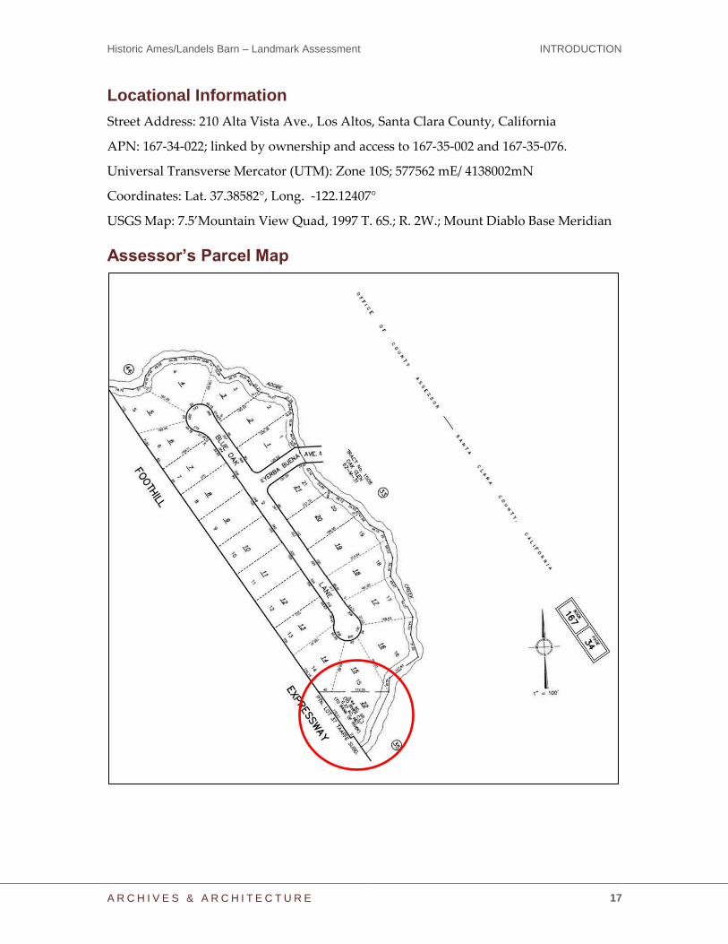
Locational Information
Street Address: 210 Alta Vista Ave., Los Altos, Santa Clara County, California
APN: 167-34-022; linked by ownership and access to 167-35-002 and 167-35-076.
Universal Transverse Mercator (UTM): Zone 10S; 577562 mE/ 4138002mN
Coordinates: Lat. 37.38582°, Long. -122.12407°
USGS Map: 7.5’Mountain View Quad, 1997 T. 6S.; R. 2W.; Mount Diablo Base Meridian
Assessor’s Parcel Map

Historic Ames/Landels Barn – Landmark Assessment REVIEW AND RECOMMENDATIONS
A R C H I V E S & A R C H I T E C T U R E 18
REVIEW AND RECOMMENDATIONS
Because the farmhouse at 210 Alta Vista Ave. in the City of Los Altos is not historically
associated directly with the subject barn and its parcel and it has been evaluated
elsewhere, this evaluation is focused solely on the barn and its immediate setting on the
parcel identified as APN 167-34-022, between Adobe Creek and Foothill Expressway.
As a part of this investigation and evaluation, the barn and its parcel were evaluated
according to the City of Los Altos Historic Preservation Ordinance, and the property
meets the criteria for designation as an Historic Resource according the Municipal Code
Section 12.44.040:
A. Age: The barn was built after the turn of the twentieth century and prior to 1948,
making it at least 68 years old, and likely older than 75, meeting the 50-year age
criteria;
B. Integrity: As noted above, the barn is substantially unchanged, retaining its
historical integrity although exhibiting physical deterioration from its age and
deferred maintenance over time. The majority of the character-defining features
remain, and the barn and its immediate setting reflect the original design, setting,
materials, workmanship, and feeling from the early twentieth century;
C. Significance: The barn was built within the context of the early-twentieth-century
land development that closely followed the construction of the Peninsular
Railway. It represents associations with the residential farmsteads of early Los
Altos. The property, therefore, has significance associated with a pattern of local
history or “events,” per 12.44.040.C.1. It also has significance based on its
“architecture/design” per 12.44.040.C.3, for embodying a twentieth-century
gambrel barn design uncommon in the region. Although the barn was built by a
family associated with American agricultural and manufacturing development in
the early twentieth centuries, the associations are not strong enough to provide
significance based on “person/people,” 12.44.040.C.2. Archeological significance
is not evaluated (12.44.040.C.4.)
It is the professional opinion of the consultants that the barn meets the criteria for listing
as a City of Los Altos Historic Resource; therefore, modifications to the site should be
done in a sensitive way in order to retain the historic character of the buildings on the
site, and allowance can be offered to encourage its appropriate adaptive
reuse/rehabilitation.

Historic Ames/Landels Barn – Landmark Assessment REVIEW AND RECOMMENDATIONS
A R C H I V E S & A R C H I T E C T U R E 19
Photographs
North Elevation, viewed facing southeast. (July 2016)
Hay Hood Detail – North Elevation, viewed facing west. (July 2016)

Historic Ames/Landels Barn – Landmark Assessment REVIEW AND RECOMMENDATIONS
A R C H I V E S & A R C H I T E C T U R E 20
West Elevation, viewed facing south. (July 2016)
Detail of Eaves – West Elevation, viewed facing east. (July 2016)

Historic Ames/Landels Barn – Landmark Assessment REVIEW AND RECOMMENDATIONS
A R C H I V E S & A R C H I T E C T U R E 21
South elevation, viewed facing northeast. (July 2016)
Detail of Gambrel End – South Elevation, viewed facing north. (July 2016)

Historic Ames/Landels Barn – Landmark Assessment REVIEW AND RECOMMENDATIONS
A R C H I V E S & A R C H I T E C T U R E 22
East Elevation, viewed facing south. Detail of Northeast Wall, viewed facing west.
(July 2016) (July 2016)
Detail of East Windows, viewed facing west. (July 2016)

Historic Ames/Landels Barn – Landmark Assessment REVIEW AND RECOMMENDATIONS
A R C H I V E S & A R C H I T E C T U R E 23
First Floor Interior, viewed facing south. Second Floor Interior, viewed facing north.
(July 2016) (July 2016)
First Floor Raised Floor Framing, viewed facing northwest. (July 2016)