landfill urbanism - university of pretoria
TRANSCRIPT
LANDFILL URBANISMRecovering resources - cultivating community at Hatherley landfill, Mamelodi
© University of Pretoria

Figure 1 - Landfill Urbanism (Author 2016)
© University of Pretoria

© University of Pretoria
4
University of Pretoria
2016
In accordance with Regulation 4(e) of the General Regulations (G.57) for
dissertations and theses, I declare that this thesis, which I hereby submit for
the degree Master of Landscape Architecture (Professional) at the University
of Pretoria, is my own work and has not previously been submitted by me for a
degree at this or any other tertiary institution.
I further state that no part of my thesis has already been, or is currently being,
submitted for any such degree, diploma or other qualification.
I further declare that this thesis is substantially my own work. Where reference
is made to the works of others, the extent to which that work has been used is
indicated and fully acknowledged in the text and list of references.
Mia Gowar
© University of Pretoria

5
Full dissertation title: Landfill Urbanism: Recovering resources - cultivating community at Hatherley landfill, Mamelodi
Submitted by: Mia Gowar
University: University of Pretoria
Faculty: Faculty of Engineering, Built Environment and Information Technology
Department: Department of Architecture
Degree: Master of Landscape Architecture (Professional)
Study leader: Graham Young
Studio Master: Johan Nel Prinsloo
Course coordinator: Dr. Arthur Baker
Site Location: Mkhatshlua St, Hatherley 331-Jr, Mamelodi, South Africa
GPS Coordinates: 25°44’5.84”S, 28°24’33.49”E
Site description: Municipal general waste landfill site
Client: Open Space Planning Department, City of Tshwane
Users: Waste reclaiming community and members of the surrounding neighbourhood
Research filed: Human settlements
Environmental potential
Submitted in fulfilment of part of the requirements for the degree
Magister of Landscape Architecture (Professional)
Department of Architecture, Faculty of Engineering, Built Environment
and Information Technology, University of Pretoria, South Africa
2016
© University of Pretoria

6
Special thanks to
ILASA for my bursary in association with the CBE, I am most grateful.
Graham and Johan for believing in my project and supporting me in seeing it through to completion.
Mom and Dad and Audrey and Onne for your love and support
Garth - There are no words that could describe the gratitude and love I have for you. You have sacrificed much time over the last five years to help me achieve my dream.
© University of Pretoria

7
Table of Contents
CHAPTER 1 - Introduction 14PREAMBLE 14
BACKGROUND AND CONTEXT 16
PROBLEM STATEMENT 16
HYPOTHESIS 17
RESEARCH QUESTIONS 17
AIMS AND OBJECTIVES 17
ASSUMPTIONS AND DELIMITATIONS 17
CHAPTER 2 - The context and surrounding landscape 20INTRODUCTION 20
LOCATION 20
THE UNDERLYING CONTEXT 22
THE SURFACE CONDITION - THE STATUS QUO 24
ANALYSIS 25
HOW THE LANDFILL OPERATES 28
CHAPTER 3 - Understanding Hatherley landfill and the waste reclaimer community 32INTRODUCTION 32
ACCESS TO PERFORM WASTE RECLAIMING AT THE LANDFILL 32
THE WASTE RECLAIMING PROCESS 32
LANDFILL COMMITTEES AND COMMUNITY 33
RESIDING AT THE LANDFILL 34
CONCLUSION 34
© University of Pretoria

8
CHAPTER 4 - Framework 38TSHWANE METROPOLITAN SPATIAL DEVELOPMENT FRAMEWORK 38
MAMELODI GAPP FRAMEWORK 38
STRATEGIC OUTCOMES OF THE FRAMEWORK 39
CONCLUSION 39
CHAPTER 5 - Theoretical Investigations 42INTRODUCTION 42
THEORY SECTION 1 - ESTABLISHING A SUITABLE APPROACH FOR THE LANDFILL DESIGN 43
THEORY SECTION 2 - DEVELOPING ENVIRONMENTS FOR WASTE RECLAIMERS 46
CONCLUSION 48
CHAPTER 6 - Design Guidelines and Concept 52VISION 52
DESIGN STRATEGIES 52
CONCEPTUAL APPROACH 55
CHAPTER 7 - Precedents Investigated 59 HIRIYA LANDFILL 59
VALL D’EN JOAN LANDFILL 61
FRESH KILLS 62
CONCLUSION 63
CHAPTER 8 - Design Development 67ITERATIONS 68
SYNTHESIS 71
Chapter 9 - Mater Plan 75PROGRAMMING AND STRATEGIES 75
© University of Pretoria

9
PHASING 82
MASTER PLAN 84
AREA FOCUS 85
SECTION 86
PERSPECTIVES 88
CHAPTER 10 - Technification 95STRATEGIES FOR THE COMMUNAL NODE 96
DETAIL PLAN 99
SECTIONS 100
PLANTING STRATEGY 101
LANDFILL PLANTING PALETTE 105
PLANTING STRATEGY FOR THE OPEN AIR COMMUNAL CLEANSING FACILITY 109
DETAILED PLAN OF THE CLEANSING FACILITY 110
PLANTING PALETTE FOR THE CLEANSING FACILITY 111
MATERIALITY - INVESTIGATING THE POTENTIALS OF WASTE AND RECYCLED MATERIALS 115
CONCLUSION 117
CONSTRUCTING ON FORMER LANDFILS 117
SANITATION OPTIONS 120
CHAPTER 11 - Conclusion 123CONCLUSION 123
BIBLIOGRAPHY 125
LIST OF FIGURES 129
© University of Pretoria

10
© University of Pretoria

11
Abstract
This dissertation considers the lives and rituals of a community of informal waste reclaimers living on an active landfill site just outside Mamelodi, Pretoria. Their living conditions are poor and yet they deliver an important service by reducing the amount of garbage buried and recycling otherwise wasted resources. The intention is to acknowledge the importance of the informal waste reclaiming community that has evolved into a network of intricate exchanges and trading which in turn provides economic opportunity in a country that has a large percentage of unemployed people.
Due to the evolving nature and scale of the project, the design approach considers a series of interventions that can be implemented during the various phases of the lifecycle of the landfill.
The proposal utilises landscape architecture as an intrinsic component to initiate the fundamental infrastructure that can establish the foundation for a habitable environment and future public spaces.
The initial phase considers an area where recycled materials can be processed and transformed after their extraction from the landfill. This creates an important node that supplements economic opportunities. It is here where a market space provides a platform for interactions and transactions between a variety of people passing through and working on the landfill site.
In conjunction with the economic upliftment proposed, the project needs to address the access to basic human rights of clean water and dignified sanitation. The design of a ‘water node’ provides the core around which daily rituals are organised.
To create a safe, stable environment where habitation may organically evolve, the strategy is to reorganise the way waste is buried at this landfill so that building rubble, demolition waste and inert materials are structured into platforms on a portion of the landfill site. Here waste reclaimers may construct their dwellings away from the dangers of earthmoving machinery, elevated out of the garbage whilst still maintaining surveillance over the incoming waste. The intention is to utilise principals of landscape architecture to harness natural resources whilst addressing the by-products of habitation in the structuring of the new terrain. The design seeks to achieve a pragmatic resolution with the intent of creating poetic moments within this harsh unforgiving landscape.
© University of Pretoria

Figure 2 - At the junction between Mamelodi and the landfill (Author 2016)
© University of Pretoria

1
© University of Pretoria

14
CHAPTER 1 - Introduction
PREAMBLE
The following is the authors initial experience of the Hatherley landfill site and sets the groundwork on which this dissertation is based.
5 December 2015
The Magaliesberg mountains that define the borders of Mamelodi are a hazed silhouette this summer’s day. Travelling along Solomon Mahlangu drive, a nearby mound of earth comes into view. It appears to be emitting puffs of dust contributing to the poor air quality. This two-lane road (which expands to four lanes during peak traffic periods) is one of two major routes into Mamelodi. It bares the usual heavy congestion of taxi’s, vehicles and an increasing number of cyclists. Additionally, the disadvantage of bakkies and trailers overladen with garden trimmings and building rubble compete with a regular flow of municipal waste trucks. Even without their presence this early on a Saturday morning, the evidence of their loads lay strewn as obstacles over the road.)
Long before the turnoff marker indicating the Hatherley dump site comes into view, a first-time visitor would not doubt their destination. As I wait my turn to cross the intersection, a group of young men start to untie my vehicle’s tarpaulin cover to claim any valuable products en route to the landfill. Disappointed with my cargo, I’m allowed to proceed. I take advantage of a momentary lull in the traffic to turn right into Mkhatshula Street and join what appears to be a funeral procession on the way to the Hatherley cemetery. This street is not bordered by a road reserve of this region’s natural Highveld grassland, but rather heaps of discarded rubbish that never made it to the landfill. I ask myself why this would happen if the landfill is in plain sight which is less than a kilometre away. People
appear from behind the rubbish on either side of the street, trying to entice me to stop in their self-made clearing to offload my rubbish - and I understand how the garbage reserve developed.
The funeral procession moves past the entrance to the landfill and I notice the open area between the landfill and cemetery is quickly filling with parked busses and vehicles. The deceased must have been important to many.
Driving into the landfill you are at once confronted with the vast scale below. This is not a desolate environment with a few earthmoving machines, but rather a hub of interactivity between human, machine and bird. Then the stench hits you… and intensifies as you descend into the landfill’s gut. The western boundary is defined by a 20m (approximately 6 storeys high) mound of soil covered garbage. People sorting through the garbage at its base are dwarfed by its immense size.
I park at random to offload my deposit. Immediately people have started to pull the waste off my vehicle in the hopes of finding something to sell to the recycling stations onsite or perhaps to demand a tip. Amidst this chaos there seem to be areas where paper and plastics are collected out of the new garbage arrivals. Along one edge of the landfill, man-sized bags filled with plastic garbage sorted according to colour, strain the seams of their constraints. Bordering the active dumping edge, a resident of the landfill is renovating his dwelling with a salvaged prefab sheet. Toxic clouds of smoke from the burning of plastic electronic waste reveal an otherwise hidden community of makeshift homes that blend in with their garbage landscape. This landfill is not just an area allocated to the forgotten, unwanted by-products of consumerism, but rather a place where resourcefulness can provide an income and shelter.
Figure 4 - Illegal dumping of waste on the side of the road (Author 2016) (above) Figure 3 - Rubbish strewn on the side of the road approaching the landfill (Author 2016 ) (Left)
© University of Pretoria

15
AN ANCIENT LANDFILL AS PRECEDENT FOR CONTEMPORARY LANDFILLS
Monte Testaccio, the ancient landfill of Rome was constructed only from shards of clay amphorae and tells an intriguing story dating back to 50 A.D. Located along the Tiber river this once 45m high mountain developed as a result of the olive oil trade, transporting nearly 25 million clay amphorae across the Mediterranean Sea to the heart of the Roman empire. These clay vessels could not be reused as the residual olive oil eventually turns rancid resulting in the odour permeating into the clay. Archaeological digs reveal that the amphorae were systematically packed into a terraced formation and it is considered to be one of the “largest and most highly engineered waste sites” during the third century (EZBAN, 2012, p. 3). However, as Ezban (2012) points out, the most interesting aspect about this manmade hill is the variety of programmes that have occurred on and around it’s slopes. Evolving through the centuries it has been used as a resource for ancient Roman road construction. It then became a civic space where carnivals saw enraged bulls charging down its slopes. Later, ritual processions up its’ slopes saw the erection of a silver cross and the terraced slopes becoming a stage where the annual passion play was enacted. Today it forms the back façade to several buildings which make use of its cooling properties to regulate internal temperatures (2012, pp. 13-15). The point the author wishes to highlight is “the malleability of its cultural identity” (2012, p. 20)
Are landfills today limited to becoming parks and golf courses? In this ancient example, the nature of this new topography became the core around which the civic space evolved. This serves as motivation for investigating the potential of the design of a contemporary landfill with specific consideration for public space that is contextually appropriate and rooted in its genius loci.
Figure 8 - Ventilation into landfill, Restaurant Flavio al Velavevodetto at Monte Testaccio. (Ezban 2015)
Figure 7- Monte Testaccio and the Tiber River. (Ezban 2012)
Figure 5 - Monte Testaccio (Ezban 2011)
Figure 6 - The sherds of ancient amphorae that form Monte Testaccio. (Ezban 2015).
© University of Pretoria

16
BACKGROUND AND CONTEXT
Waste generation is a process of growth. In living organisms, there is no growth without waste and so waste is pushed to the periphery of cell walls - cities are no different (BERGER, 2006a). Landfill sites are initially located at the periphery of urban development, but due to the nature of urban sprawl, often end up becoming a part of the urban fabric. In South Africa, landfills have a history of being located in the so-called buffer zones between the various race groupings typically due to the urban planning strategies of the apartheid government. This is referred to as ‘environmental racism’ by placing the burden of ineffective waste management, environmental pollution, and unsightly waste dumps on the black residents of these township areas, while white suburban areas were landfill free (CHAMANE, 2009).
Landfilling is the dominant method of waste management in South Africa as it is cheaper than other alternatives (GODFREY, 2015) Separation at source is still a relatively new concept here, thus resulting in the majority of waste landing up in the landfill as mixed waste. The bulk of the re-usable and recyclable waste is therefore lost to the recycling industry. This also contributes to the diminishing capacity of available landfill airspace (CSIR, 2011).
With urban growth comes population growth and a need for jobs. The current statistics reveal 2.4 million people in South Africa are actively seeking work (TRADING ECONOMICS, 2016). Landfills are providing a source of income through informal recycling opportunities, a report compiled on statistics in 2012 estimated R17 billion worth of resources were lost to the economy through disposal as waste to landfill (GODFREY, 2015). An informal waste reclaimer at Hatherley landfill, explains that “he is there, because he cannot afford to wait for the government to provide jobs, he and all the people working as waste reclaimers on the landfill are creating their own livelihoods, every day and doing so without expectancy from the state for job provision.” (REYNEKE, 2015, pp. 81-82). The landfill is perceived as a place that fulfils the role of a ‘stepping
stone’ (REYNEKE, 2012), but in observations and interviews this is seldom the case resulting in most of the waste reclaimers having worked there for more than 10, and in some cases even 30 years.
An initial study (Garstkloof, Pretoria) conducted in 2013 on a now closed landfill, estimated that of the 300-400 informal waste reclaimers working there, almost 200 of them were living on site in self-built shacks (REYNEKE, 2012). The formation of informal settlements on landfill sites does not comply with the City of Tshwane Municipality’s ideals and bylaws for waste management - but due to the important role the waste reclaimers provide in recycling and prolonging the landfills longevity, their presence has been tolerated (REYNEKE, 2015).
More landfill sites in Tshwane are rapidly reaching their capacity with the Hatherley site having the longest life expectancy of 20 years. However, acquiring suitable land for landfill sites is becoming more difficult as most available land is earmarked to sate the increasing housing demand. Therefore, ways of extending the life spans of existing landfill sites is important (CSIR, 2011)
PROBLEM STATEMENT
Living conditions: Constructing shelters in the landfill results in unstable and untenable living conditions. These dwellings need to be continually moved to accommodate landfilling operations whilst access to basic services is very limited. Section 24 of The Constitution of the Republic of South Africa (Act No. 108 of 1996) gives every person a right to an environment that is not harmful to their health or well-being.
Wasted resources: Building rubble and organic garden refuse comprise approximately 30% of the waste stream and end up buried in the landfill where any value is lost within the containment layers of the landfill liner.
Figure 9 - A harsh landscape (Author 2016)
© University of Pretoria

17
Waste terrain: The varied composition of waste matter in the landfill leads to various rates of decay, this results in an undeterminable settlement pattern creating an unpredictable, fluctuating terrain. Therefore, future programs for the site are limited to open space (DWAF (Department of Water Affairs and Forestry), 1998)
Rehabilitation: The current end use plan of the Hatherley landfill adds little value to the surrounding environment.
HYPOTHESIS
Landscape architecture becomes the integral layer that is able to negotiate between the social and environmental components in order to establish a habitable environment that will produce a sustainable place in the long term.
• The first hypothesis states that the waste reclaimers residing in Hatherley can remain on the landfill.
• The second hypothesis states that a new terrain can be sculpted from the incoming construction debris and inert materials, thus providing a stable foundation where improved living conditions can be created.
• The third hypothesis states that upon closure, the landfill’s end use plan can contribute positively by establishing an environment rich in opportunity and a new cultural identity.
RESEARCH QUESTIONS
How can landscape architecture facilitate a rich palimpsest of organic development over time at the Hatherley landfill, as seen at Monte Testaccio?
How should the form of this new terrain respond to the context and genius loci of the site?
Should the rehabilitated landfill blend in with the surrounding environment or should the form express the artificial nature of the site?
How can the site be designed for use during the evolving lifecycle of the landfill?
How can the site harvest the storm water potential efficiently?
AIMS AND OBJECTIVES
The intention of this project is to develop better environments where informal waste reclaimers can construct their dwellings elevated out of the waste; develop public open space that evolves to take advantage of the new terrain during the
landfills life cycle, providing platforms where new rituals may take place; and create a flexible design strategy that allows for organic growth of the settlement within defined parameters.
This is achieved by utilizing reclaimed resources within the landfill that can be developed using low-tech methods to construct new terrain. Here, better living environments are created by harnessing the environmental potential to provide basic goods and services for the new settlement. New residential areas can plug into the system by developing armatures of infrastructure.
ASSUMPTIONS AND DELIMITATIONS
The author does not advocate landfilling as the preferred method of waste management, but accepts that it is a current condition within the South African context. In addition, the author does not promote waste picking / reclaiming as the solution to waste management in landfills - separation at source is a preferred model. However, the author accepts that it is currently a reality which is providing a vital income to those living on the edge of society. To change the current system into a highly-mechanised process of waste to energy incineration would result in many being without what seems to be their last recourse at an income. Therefore, this dissertation doesn’t aim to change methods of waste management as that is outside the scope of landscape architecture. It does however attempt to address living conditions of those on the landfill by utilizing resources deemed as waste and harnessing environmental potential to envision a sustainable approach for creating a habitable environment.
It is assumed that the Hatherley landfill will continue to receive waste for the remainder of its lifespan or airspace. A sanitary landfill is a highly-engineered structure and the author does not attempt to redesign the landfill’s linear development pattern and therefore the author assumes that the engineered drawings are correct and the most efficient design for the Hatherley site.
The scope of the project focusses on creating new terrain on the portion of the site that has not yet been utilised for landfilling. The municipality’s proposed final form of the landfill can be challenged within the guidelines of landfill rehabilitation regulations. Although the site borders the informal settlement of Phumolong, the upgrading of the settlement is not part of the scope for this dissertation. To develop a framework for the site, two official frameworks from the City of Tshwane Municipality and GAPP Architects and Urban Planners were consulted to determine future development plans. The author assumes that these are still valid.
© University of Pretoria

Figure 10 - Landfill landscape showing the engineered storm water dam (Author 2016)
© University of Pretoria

2
© University of Pretoria

20
Figure 13 - Segregation City (Davies 1981)
Figure 12 - Main route and distance to Hatherley
INTRODUCTION
No one wants a landfill in their backyard, however they are a necessary evil and in South Africa it is the most practiced method of waste disposal. Landfill sites today are engineered structures that attempt to mitigate negative impacts on the surrounding neighbourhoods and environment - unlike the unlined dumpsites of past years.
This chapter sets the groundwork in which the Hatherley landfill is situated.
LOCATION
CHAPTER 2 - The context and surrounding landscape
The Hatherley landfill site is 24 km east of the Pretoria CBD. It is located just to the south of the Mamelodi township which is one of several areas developed under the apartheid regime. There, black Africans were relocated in accordance with the Group Areas Act (1950). The planning strategy sought to segregate racial groups as can be seen in the diagram of the Segregation City (Figure 13). The White Central Business District (CBD) was the intended core, around which a smaller peripheral Indian or Chinese CBD could be established. The industrial zones were located within White ownership, but were considered a mixed em-ployment area. The isolated residential areas were strategically placed, based on desirable locations and access to the CBD, with areas designated for mixing between them. This enabled racial diffusion (DAVIES, 1981).
Buffer zones and physical barriers were created to separate racial groupings. It is usually within these areas that the least desirable infrastructural services and land zoning is allocated; - such as rail yards, industrial areas, sewerage farms and
landfills. (DAVIES, 1981) depicts how the Model of the segregation city is applied to Pretoria (Figure 14) This illustrates how the fragmented groupings later con-solidated into the peripheral settlements on the east and west of Pretoria.
Figure 11 - Location map (Author 2016)
© University of Pretoria

21
Figure 15 - Racial self-identification in Pretoria (Frith 2011) (Edited by author)
Figure 14 - Social-Racial Spatial Rearrangement of Pretoria (Davis 1981) (Edited by author)
A more recent map obtained from 2011 cen-sus data (Figure 15) reveals that although there is some integration the spatial pattern still dominates. The current landfill locations were overlaid and thus concur with Cha-mane’s statement of ‘environmental racism’ (2009, p. 22).
© University of Pretoria

22
Figure 17 - Magaliesberg rock strata formation (Magaliesberg 2008) (Edited by Author)
Figure 16 - Google maps image of landfill locality depicting ‘environmental racism’ (Edited by Author 2016)
Figure 18 - Magaliesberg aspect (Magaliesberg Biosphere 2015)
GEOLOGY - THE UNDERLYING CONTEXT
Although the circumstances contributing to the establishment of Mamelodi are part of a tumultuous past, the area itself was a sought-after region that reveals iron age settlements and colonial settlers that took advantage of the micro climate and fertile geology of the Magaliesberg mountains.
The formation of the Magaliesberg occurred approximately 2 000 million years ago with a massive geological phenomenon during the Bushveld Complex. Deep beneath the earth’s surface, pressure began to build from a huge molten magma reservoir resulting in the liquid rock pushing up between all the sedimentary layers of what is known as the Transvaal Sequence. As the Transvaal Sequence subsided, slabs of rocks that were thousands of meters thick tilted into the molten magma, forming the quartzite and shale ridges around Pretoria today, as can be seen in Figure 17 (MAGALIESBERG, 2008).
© University of Pretoria

23
Figure 20 - Author’s interpretation of the highveld landscape (Author 2016)
Figure 19 - Representation of the previous agricultural nature of the site (Author 2016)
© University of Pretoria

24
Figure 21 - Author’s interpretation of the Magaliesberg ridge, you can see the gradual slope on the left covered in grass species and the steeper rocky slope on the right
Figure 22 - The informal condition (Author 2016)
The mountain range lies at the interface of two of South Africa’s largest biomes: the Highveld grassland and the Savannah bushveld which engender a landscape rich in biodiversity. Northern slopes are windswept and sun baked while cliffs
crown the southern aspect of the range and shelter the valley creating a unique micro climate (MAGALIESBERG BIOSPHERE, 2015) Figure 18.
THE SURFACE CONDITION - THE STATUS QUO
The Mamelodi township is a complex environment seeing the majority of its residents on a daily exodus to the CBD. It is comprised of older suburbs and RDP developments with informal infill. The main distinction between these areas is the access to resources and the type of construction material used for the dwellings. Informal dwellings are mostly assembled out of corrugated roof sheeting, prefab sheets or salvaged material which are not suited to the South African climate. However, when the occupants have available funds, these dwellings are upgraded and made more robust using brick or concrete to increase their permanence. In this way, it can be said that an informal settlement is an area in transition - initial dwellings are compact and cater to essential functions to allow the occupant a
basic foothold into society. At a later stage these can be expanded and ultimately formalised.
The township landscape is a sprawl of single storey, compact, box like dwellings (figure 22) which the vertical terrain of the landfill is an evolving landmark.
© University of Pretoria

25
ANALYSIS
1. Bio Climatic analysis
Pretoria has an altitude of 1 350 m and has a relatively high average temperature of 18.7° C. The hot temperature in summer can be attributed to the fact that the city nestles in a fertile, sheltered valley which protects it from the surrounding cool southerly and northern-easterly air masses throughout the year. Most of the annual rainfall in Pretoria happens during the hot summer months - winters are usually dry and experience drought-like conditions. Wind most often blows from a north easterly direction.
2. Hydrology and Topography
This map indicates the location of the landfill in terms of the terrain. The landfill is situated on a higher level than its surrounding topography and storm water runoff contributes to both of the nearby rivers - the Edendalspruit and Pienaars River. The transport networks of the main Solomon Mahlangu road and the rail network create physical barriers that frame the landfill. One of the main issues on the surrounding landscape is the illegal dumping that takes place on the properties adjacent to the landfill. This unregulated extra waste is exposed to the elements and the contaminants contribute to the poor water quality of the river systems.
3. Open green spaces and cultural significance
This map shows the public and open green space network highlighting some of the cultural facilities and tourist destinations in Mamelodi. The landfill is highlighted, indicating its size in comparison to the existing regional Moretele park. According to the City of Tshwane Open Space Framework (2005), the service space of a regional park should be between 4 and 40 Ha in size. Additionally, one regional park should be at least 10 Km away from another. The Hatherley landfill falls within this buffer zone and is larger than the maximum recommended size at 90 Ha. Therefore, simply remediating the landfill and transforming it into a regional park would be a potentially needless waste of valuable land which could serve a different purpose.
When the Heathery landfill was built and the new low cost housing development was constructed, several Ndebele archaeological sites dating to the Iron Age were discovered (PELSER & VAN VOLLENHOVEN, 2009). One of the intended goals outlined in the City of Tshwane vision for 2055 is to develop this archaeological site it into a tourist destination (CITY OF TSHWANE, 2013).
4. Transport & important nodes
There are two main transport routes in and out of Mamelodi - by vehicle via Solomon Mahlangu Drive or by rail. Both routes are heavily congested. It is important to note here that Solomon Mahlangu services the landfill.
Greenview is the newest built train station in the area and mainly facilitates the nearby informal settlement of Phumolong. There lies an opportunity to develop the land on both sides of the railway tracks at Greenview station to maximise the investment of the train station and the surrounding land.
Figure 23 - Average wind distribution (Windfinder.com 2016)
Figure 24 - Hydrology and topography of the region (Author 2016)
Figure 25 - Open space networks and cultural nodes of Mamelodi (Author 2016)
© University of Pretoria

26
As long as redevelopment is managed properly, it is feasible for a landfill to be developed for infrastructure and buildings (BOUAZZA & KAVAZANJIAN, 2011). Instead of creating a 96 Ha park, a more valuable alternative can be considered that responds to the surrounding communities.
5. Disturbed Zones
The image below illustrates the most disturbed sites in the area. Darker zones are more disturbed. According to the GAPP framework (GAPP/MMA CONSORTIUM, 2003) in the rehabilitation of the Pienaars River, the best practise would be to develop on disturbed areas.
The images above have been taken from Google and show a timeline of the increased population growth around this area. Dwellings have breached the 900m buffer zone around the landfill.
Figure 26 - Transport networks and suburbs of Mamelodi (Author 2016)
Figure 27 - Disturbed zones (Author 2016)
Figure 28- Google Maps timeline indicating rapid expansion around the landfill (Edited by author, 2016)
© University of Pretoria

27
7. Vegetation / biomes - ecotone
There are different biomes on either side of the Magaliesberg range. The north side consists of savannah whilst the south side is predominately grassland. Hatherley could therefore be considered an ecotone - because it has some of the characteristics of each biome (ENCYCLOPAEDIA BRITANNICA, 2012) - this means that it is very diverse and as a result the Cullinan Conservancy was developed to maintain the biodiversity.
In the map below, you can see a possible green connection between the two rivers that would run through the northern boundary of the landfill.
8. Visual analysis
Although the landfill is relatively small now with a current height of 20 m, it has an airspace permit for a total height of 45 m - more than double the current size. The landfill is already visible from the affluent and built up areas of Pretoria East and Mamelodi. It has also been observed that on most days there is a reddish haze surrounding the landfill due to the dust thrown up by earth moving equipment.
Figure 29 - Biomes and ecologically sensitive areas (Author 2016) Figure 30 - Visual analysis of the Hatherley landfill (Author 2016)
© University of Pretoria

28
HOW THE LANDFILL OPERATES
1. Waste generation in South Africa
South Africa generates large quantities of waste, with the Gauteng province responsible for the largest amount of waste generated - almost all of which is transported to landfills. Gauteng generates 761 Kg per capita per annum which is 45% of the total waste produced in the country. (DEPARTMENT OF ENVIRONMENTAL AFFAIRS, 2012)
A study of the composition of waste entering Tshwane’s landfills was done in 2011 and found the following ratios:
According to the Head of Landfill Management of the City of Tshwane municipality, Hatherley receives approximately 150 000 m³ of waste per month. This amounts to 1 800 000 m³ of waste per year.
2. Requirements for waste disposal in South Africa
According to the Minimum Requirements for Waste Disposal (DEPARTMENT OF WATER AFFAIRS & FORESTRY, 1998), the most relevant principles that meet the minimum requirements of waste disposal by landfill are:
• Waste is to be shaped into cells, the sides of which are formed by 1,5 m to 2 m high berms.
• Berms are constructed from soil, rubble or sloped waste.
• Waste is to be spread in thin layers and fully covered each day and then compacted by a purpose-built landfill compactor.
• Waste is deposited and worked up in a 1:3 m slope ratio
• Food and putrescible waste is to be immediately covered with soil at least 0,5 m thick to stop odours and scavenging
• Bases of trenches and cells must be designed so that water drains away from the deposited waste
• Waste is prohibited by the Department from being burned
• Should a fire break out, water should not be used - rather, burning waste is to be spread, covered and smothered.
• All litter must be contained within the landfill site
• All appropriate measures must be taken to keep the landfill free of vermin
• Dusty roads and unpaved areas should be regularly dampened with water to prevent dust from rising
• Although waste reclaimers are discouraged, permission can be obtained for them to work on the landfill from the City of Tshwane
• Waste reclaimers are not to be working in the same vicinity as compaction and covering activities
• Once full, a cell must be capped and vegetation established as soon as possible starting with screening berms.
• Final slopes of a capped cell must not be steeper than a 1:2.5 ratio
3. Odour and humidity
All the decomposing matter contributes to the microclimate increasing the level of humidity on the landfill and contributing to the odour.
4. Erosion
The landfill is designed to keep the general public out (except at the designated entrance to deposit waste) and to mitigate storm water within the landfill from contaminating the environment. However, these 2 m high berms are traversed by foot traffic daily from the surrounding settlements resulting in several eroded slopes.
5. Sanitation for waste reclaimers
The waste reclaimers working on the landfill do not have access to sanitation facilities. There is no municipal water available - water is bought from the spaza shops on the landfill.
Figure 32 - General landfill waste composition report by NWIBR (Tshwane 2011) (Edited by Author)
© University of Pretoria

29
6. Leachate
Municipal solid waste leachate is formed when chemical and biological products are released into solution, mainly as a result of the decomposition of the putrescible and organic fraction (QASIM & CHIANG, 1994). It may also carry harmful fluids such as oil, suspended solids, bacteria and viruses. Leachate is therefore highly toxic and needs to be managed carefully throughout the lifecycle of the landfill and well past its closure.
7. Closure and capping
Since 1990, upon closure, all landfills must be capped and have a layer of topsoil with vegetation. Drainage maintenance and leachate management must be in place. The quality of ground and surface water must be monitored throughout the operation of the landfill, and up to 30 years after closure.
The CSIR Municipal Waste Management Good Practices guidelines recommends that landfill gas and leachate need to be continuously monitored for many years past the closure of the landfill. In addition, they recommend that the landfill be rehabilitated cell-by-cell once a cell has been filled and capped. (CSIR, 2011)
© University of Pretoria
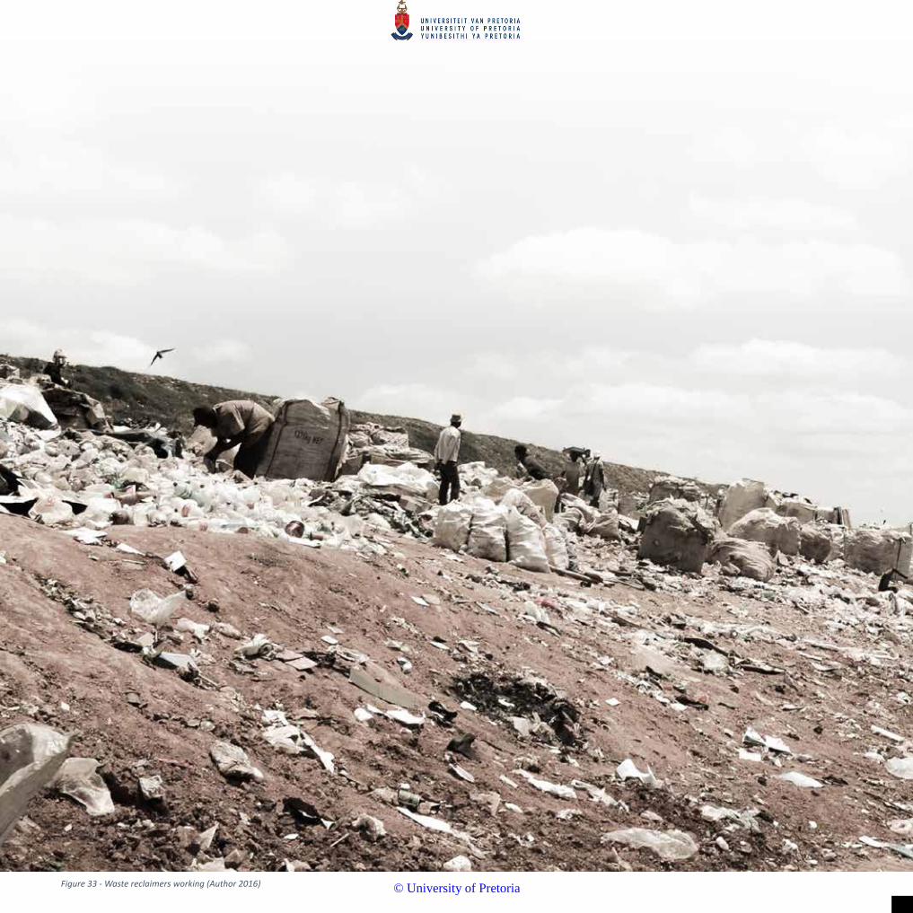
Figure 33 - Waste reclaimers working (Author 2016)
© University of Pretoria

3
© University of Pretoria

32
CHAPTER 3 - Understanding Hatherley landfill and the waste reclaimer community
INTRODUCTION
To develop a successful urban design, it is important to understand the clients (waste reclaimers in this case) who would inhabit the new environment. Information on the waste reclaimers was obtained in consultation with a current study done by Pierre Reyneke (2012) for the fulfilment of his master’s degree in anthropology. Since 2012, his study has followed the struggles of the waste reclaimers during the closure of the Garstkloof landfill (located in the historically white suburbs of Pretoria East) to relocating at the Hatherley landfill. Over the past three years he gained an in-depth knowledge of the diverse social networks and relationships that have formed at both landfills. The author has verified many of Reyneke’s observations through site visits, however waste reclaimers were never personally interviewed due to safety issues associated with the site. However, members of the municipality in charge of landfill operations were consulted.
ACCESS TO PERFORM WASTE RECLAIMING AT THE LANDFILL
A hierarchical social structure governs all who seek to reclaim waste at the Hatherley landfill. The City of Tshwane waste management department acknowledges the contribution the waste reclaimers make in reducing recyclables landing up in the landfill whilst simultaneously increasing the landfills lifespan. (SAMSON, 2010)
Due to the recent closure of 3 other landfills in Tshwane, Hatherley has been experiencing an influx of new waste reclaimers to the site. The municipality maintains order by insisting that waste reclaimers must be part of a committee and must be able produce ID documents (permits) to prove that they are allowed to work on the landfill. (REYNEKE, 2015) This attempts to illustrate the effort involved in being allowed to work at the landfill and the important role it fulfils as well as the organised structure of the waste reclaimers.
THE WASTE RECLAIMING PROCESS
The waste reclaimers help one another in sorting through the incoming waste. For example, if it is known that someone is collecting cans, and another waste reclaimer in the area finds a can in his area, he will deposit it in that person’s bag.
Once materials are sorted they are then weighed so that their monetary value can be determined. At the landfill, several recycling companies station containers and employees that accept and pay waste reclaimers for their materials. When certain materials are not collected by recycling companies on site, middlemen are contacted to collect a full load of these materials. These middlemen buy the waste from the reclaimers at a negotiated price and then sell it at a higher price to a recycling company (REYNEKE, 2015).
A striking component of landfill excursions is the unyielding exposure to sunlight due to the absence of trees and structures… It is about 12h00 in the day and Ali has already filled-up two large nylon bags with a mix of different kinds of plastic and white paper. He started waste-picking at 8h00… A new truck approaches and a number of people rush to acquire a position around the place where a new heap of waste is about to be dumped… As Ali and I make our way to join this group in the hope attaining a place to work at, he grabs me by the chest and pulls me out of the way of an oncoming compactor… [in the crowd] a man offers a spot in the front to a woman struggling to find one… the [dump] truck driver slowly starts pushing the waste out from the back container. The waste heap starts dropping to the ground and a few of the waste pieces are taken out before it hits the ground. Some are kept and others are passed on or rejected. From this it’s clear that each waste-picker knows exactly what type of waste they and those around them are looking for. It is simultaneously an individual and a group effort… waste-pickers work alone in filling up their bags; however, I witnessed two other ways in which they perform collective actions. While working their way through a pile of waste some individuals throw pieces of clothing found in the waste, backwards to the outer perimeter of the circle where a few women stand waiting to collect it… While picking through the heap Ali finds two aluminium cans, turns around and then drops it into a young man’s bag working right beside me. Ali is not collecting cans today, but he is well aware that this man is, and therefore performs this simple action saving the young man the trouble of having to pick it himself. As we continue I notice the same gesture performed by others, and I decide to do the same. This is welcomed and acknowledged with a quick nod or a smile from the receiver… the bag fills up fast and Ali indicates that it’s time to take the bag to his sorting area, a short distance away from the dumping zone… Ali’s sorting area serves as an ideal vantage point to observe the rhythms and flows of the dumping area. This rather small space of about 20 x 50m contains the highest concentration of people, trucks, compactors and waste, which forces everything’s movement to be negotiated in relation and awareness of everything else within this space. (2015, pp. 88-90)
© University of Pretoria

33
It is through these descriptions that the author intends to reveal the genius loci or spirit of the place that does justice to the nature of the waste reclaimers and the site.
LANDFILL COMMITTEES AND COMMUNITY
A network consisting of members of all the Tshwane landfills gathers at a monthly meeting attended by representatives from each landfill committee. Meetings are taken in turn to be hosted between the various landfills. The members of the individual landfill committees are asked to contribute towards the travel expenses of their delegates. Here strategies are discussed to increase the prices paid for their recyclables as well as to discuss any other landfill issues to be raised with the municipality. This demonstrates the waste reclaimers as part of a larger collective.
As mentioned previously, to work as a waste reclaimer at Hatherley you need to be registered with one of the three committees that controls access to the freshly
dumped waste (also referred to as ‘soft waste’). This consists of white paper, various plastics, cardboard and glass as well as scrap metals (REYNEKE, 2015). These are the more lucrative materials and newcomers not yet part of a co-operative have needed to develop new forms of ‘fringe reclaiming and recycling’. This is located where garden refuse and building rubble are set apart from the main dumping area to the eastern side of the landfill (2015, p. 52). The author would however like to point out that during site visits garden refuse and building rubble were often seen mixed in with the general dumping area. Here various income generating strategies have evolved such as the sale of ‘mamparra’ (recycled) bricks; discarded wood is fashioned into dog kennels, garden benches or sold to the landfill residents for firewood; even discarded plants are revived and sold.
Spaza shops have been established on the landfill to support the waste reclaimers. Some examples are the charging of cell phone batteries via power generated from solar panels; and renting out DVDs to watch on a TV installed in the shop. All these activities indicate the diverse range of economies benefiting from the waste stream at the Hatherley landfill
Figure 34 - Landfill dwelling (Author 2016)
© University of Pretoria

34
Just slightly removed from the main domestic waste dumping area is a collection of makeshift shelters, called mkhukhus . These serve as temporary accommodation whilst working at the landfill. Many of the waste reclaimers have homes elsewhere that are too far away or too costly to travel to every day. These shelters are constructed from anything available in the landfill. Polystyrene sheets are commonly saved for the base providing a waterproof floor that also elevates the structure slightly out of the waste. Roofs are almost always covered with plastic sheeting or an old carpet to achieve some sort of waterproofing. Their function is to provide a place to sleep sheltered from the elements and store a few items of clothing and cooking utensils. As a result, these structures are small, often having no windows or doors and seldom exceed a height 1.5m. “The waste pickers and their shacks are therefore exposed to the elements in all their intensity, and every change of season is experienced to its full extent” (2015, pp. 17-18).
The constant cycles and processes of the landfill influence the living conditions of the waste reclaimers, this is condensed down to a bare minimum allowing flexibility and mobility. “The theme of temporality is found underlying most actions performed on the site” (REYNEKE, 2012, p. 40). Living on the landfill affords limited access to water and sanitation. For many it is not a choice but a reality of desperate circumstances.
The terrain is constantly evolving to accommodate the waste volumes. This is a vast, open landscape with a monumental mound that dwarfs the people working beneath it. It is approximately a 20 m high berm, constructed from garbage,
acting as a buffer on the western edge, preventing garbage being blown into the neighbouring settlements. At the foot of this berm, bags of sorted reclaimed materials are waiting in rows ready to be sold to recycle merchants. The main road into the landfill is utilised by the waste reclaimers, vehicles and large earth-moving machinery. It is along this main corridor where vendors take advantage of the continual activity.
CONCLUSION
The landfill landscape experiences all the climatic conditions at the most extreme levels. Shade is hard to come by and most days are spent in the full sun. This escalates the decomposition process of the organic waste resulting in a more humid micro-climate, thus the stench emitted from the garbage intensifies. In Africa, rain is seen as a cleansing of the environment, washing off the dust and promising new life. However, within the landfill landscape there is no shelter from the elements and rainfall creates a toxic soup of nappies, rotting food and putrefaction. For this reason, those living in the landfill construct their dwellings on sheets of polystyrene to provide some sort of elevation out of the garbage
However, this is a very active environment full of life and opportunity. A diverse range of networks utilise the by-products society has deemed useless and repurpose them into useful income generating resources. Any successful intervention needs to enhance existing activities and provide a platform where
RESIDING AT THE LANDFILL
Figure 35 - Landfill tent dwelling (Author 2016)
© University of Pretoria

35
these economies can grow and prosper.
It has been noted that the waste reclaimers require an unobstructed view of the incoming garbage trucks as their livelihood depends on their timely reaction and acquisition of recyclable materials. Therefore, many chose to live on the landfill and not the vacant land bordering the dump site. Here people live from day-to-
day and are not able to create spaces with any permanence. The design should provide areas in the landfill where more permanent activities and even settlement can develop. Permanence gives rise to greater social cohesion.
Figure 36 - Dwelling elevated out of the waste on a salvaged polystyrene base (Author 2016)
Figure 37 - The monumental scale of the western periphery buffer zone (Author 2016
© University of Pretoria

Figure 38 - View of the recently completed Greenview train station (Author 2016)
© University of Pretoria

4
© University of Pretoria
38
CHAPTER 4 - Framework
The framework responds to the investigations in the previous chapter on the landfill and its immediate surroundings. It will focus on the following topics:
• Utilise the resources that are wasted or contaminated by the landfill
• Link the growing informal settlement to the train station
• Design the landfill to be a useful space during the operation phase and after closure (rather than just the common practice of basic remediation)
• Provide spaces to allow informal economies to grow and establish permanence
• Creating a water and sanitation node
• Making the lives of the waste pickers better by creating a more comfortable environment for them to operate and live.
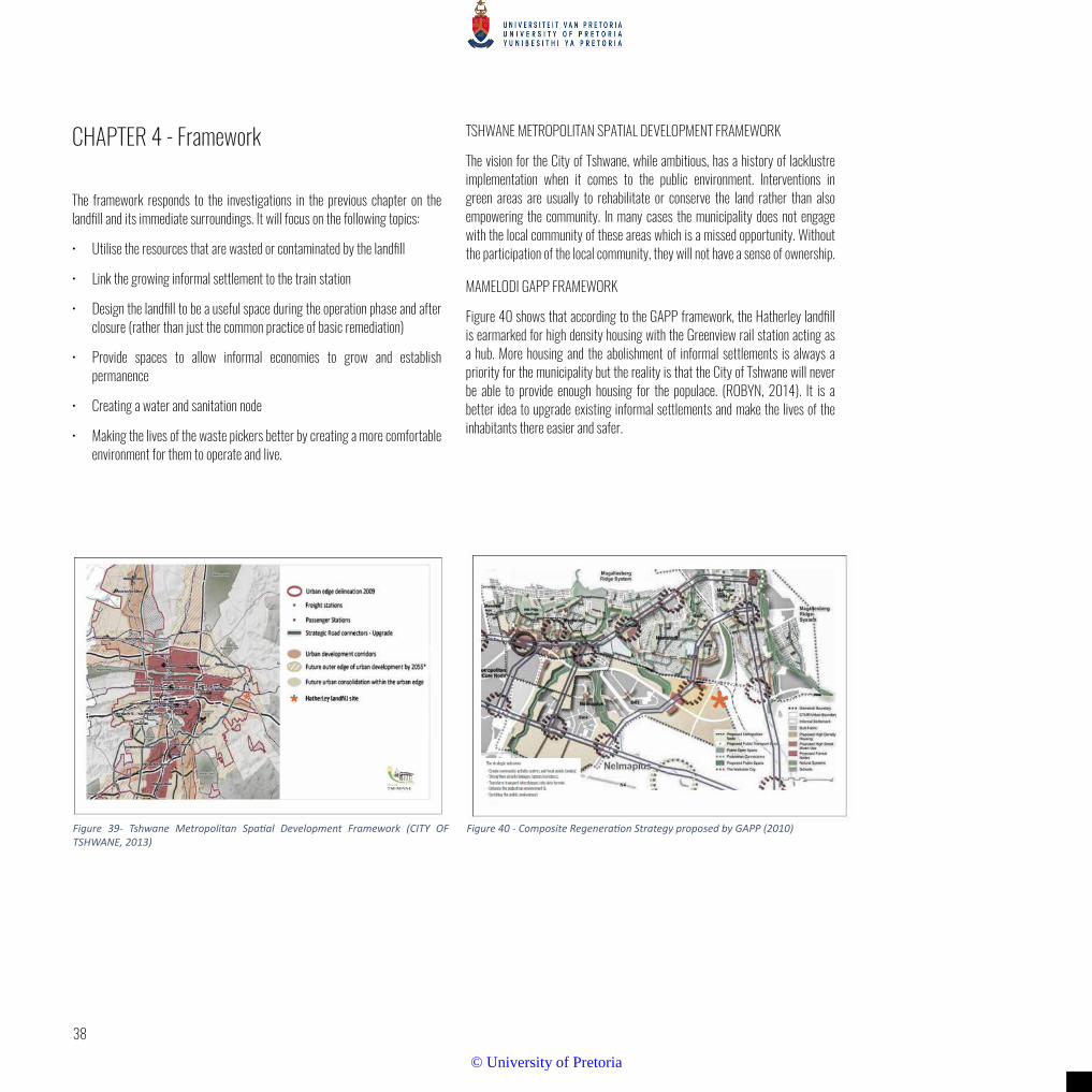
TSHWANE METROPOLITAN SPATIAL DEVELOPMENT FRAMEWORK
The vision for the City of Tshwane, while ambitious, has a history of lacklustre implementation when it comes to the public environment. Interventions in green areas are usually to rehabilitate or conserve the land rather than also empowering the community. In many cases the municipality does not engage with the local community of these areas which is a missed opportunity. Without the participation of the local community, they will not have a sense of ownership.
MAMELODI GAPP FRAMEWORK
Figure 40 shows that according to the GAPP framework, the Hatherley landfill is earmarked for high density housing with the Greenview rail station acting as a hub. More housing and the abolishment of informal settlements is always a priority for the municipality but the reality is that the City of Tshwane will never be able to provide enough housing for the populace. (ROBYN, 2014). It is a better idea to upgrade existing informal settlements and make the lives of the inhabitants there easier and safer.
Figure 39- Tshwane Metropolitan Spatial Development Framework (CITY OF TSHWANE, 2013)
Figure 40 - Composite Regeneration Strategy proposed by GAPP (2010)
© University of Pretoria

39
Figure 41 - Framework for landfill and the surrounding area (Author 2016)
The framework envisions nodal developments that instigate economic opportunity for Mamelodi, thereby providing the necessary catalysts to take the surviving communities to a thriving condition. The landfill vision that this thesis proposes has the opportunity to be a part of this goal through enhancing the economic possibilities and livelihoods associated with waste and recycling. The landfill is envisioned as a productive site now as well as in the future. Here, the landfill community is given the foundation on which to establish permanence and become the pioneers of the landfill - in line with the previous frameworks of high density development at this site. Through developing the ancient Iron Age archaeological site, a tourist connection can be incorporated with the rehabilitated landfill areas.
This allows for opportunities to acknowledge the intrinsic nature of the site and landfill communities.
STRATEGIC OUTCOMES OF THE FRAMEWORK:
• Create community activity centres - NODES;
• Strengthen activity linkages - SPINES/CORRIDORS;
• Transform transport interchanges into CIVIC TERMINI;
• Enhance the PEDESTRIAN environment and
• Enriching the PUBLIC environment. CONCLUSION
The City of Tshwane wants to take Mamelodi from surviving to thriving. The landfill vision that this thesis proposes has the opportunity to be a part of this goal by fostering tourism, becoming a productive space now as well as in the future, and safeguard the environment. Additionally, the landfill village is in line with Tshwane’s framework of establishing a housing community on the landfill site.
© University of Pretoria

Figure 42 - View of the Pienaarspoort from the landfill ridge (Author 2016)
© University of Pretoria

5
© University of Pretoria

42
CHAPTER 5 - Theoretical investigations
INTRODUCTION
This dissertation aims to design a new urban landfill landscape that is able to negotiate space between the incoming garbage, the required landfill processes as well as the people who occupy and capitalise this wasteland.
Waste reclaimers residing on landfills is a common occurrence within most developing countries (MARELLO & HELWEGE, 2014), however as to date there are no strategies that attempt to accommodate this phenomenon within the landfill landscape.
The design of this site needs to mediate between two specific conditions or
‘layers’ as is later described in the conceptual approach. Namely the operating landfill as an evolving landform and its relationship to the surrounding landscape followed by integrating the various requirements to establish a habitable environment for the waste reclaimers.
Therefore, the theory investigated was divided into two sections:
1) Establishing a suitable approach for the landfill design. The intention was to establish design guidelines for designing on landfills, considering remediation strategies and developing a productive landscape on a wasteland.
2) Developing strategies to provide a sustainable settlement. As there is no theory for developing habitable environments on landfills, their living conditions resemble informal settlements with regards to the access to basic water and sanitation infrastructure.
Figure 43 - Gods of the Waste(d) by Fabrice Monteiro highlighting Senegal’s pollution with garbage garments. © Fabrice Monteiro
© University of Pretoria

43
This art work showcases man’s effect on the environment, particularly in response to discarded waste. It seems as if the woman in the photo is the embodiment of waste and is marching towards a desecrated landscape. Mbeubeuss is Senegal’s largest waste dump which is home to a marginalised part of the population with its own laws and territorial demands, despite all the prevailing adverse conditions. (AZZARELLO, 2015)
THEORY SECTION 1 - ESTABLISHING A SUITABLE APPROACH FOR THE LANDFILL DESIGN.
1. Approaches to landfill remediation
The most common approach when designing or remediating a landfill is to hide it from view and public conscience. It is viewed as an eyesore which society would rather forget even existed. The author believes that camouflaging the landfill is not the best idea - society should acknowledge it exists, what its implications are, and why it is there. Additionally, to take such a large piece of land and turn it into a “green mound” with little value to the surrounding community is an irresponsible approach in the author’s opinion.
It is important to understand the role the landfill has played in people’s lives and that it is actually a productive environment. In the case of South Africa and many other developing countries, it is not just a place where waste is buried - it is last resource for unemployed, truly poverty stricken individuals.
As an active place, there are many related economies that have established. Responsive design needs to harness the energy and knowledge that the waste picking communities have gained through their experience and transform the landfill into a place that remains productive into the future.
According to Alan-Mozes (2009), landfills could be the ideal sites for a Landscape Architect to address problems of aesthetics as well as ecology, engineering and economics - but at the moment this isn’t really pursued.
Mira Engler (1995) is a landscape architect and researcher and has developed five concepts applying to the treatment of landfills. They are:
1. Romantic perception - reconstructing the previously pristine natural landscape of the site
2. Hiding the landfill’s past and developing it into a recreational space
3. Empowering the essence of the site as a monument
Creating place for personal investigation and discovery
4. An integrative approach where principles of ecology are combined with the philosophy of art
Engler states that landfills have been traditionally highly engineered spaces driven by economic, technical and health concerns with little consideration given to aesthetics or design - other than removing them from the public eye. In most cases the landfills are covered in parks to make then more acceptable. There is an opportunity to bring these sites back into the foreground of public consciousness using landscape architecture to highlight waste problems in today’s society. (1995, p. 11)
A new breed of waste-related design projects can highlight new formal, spatial, and programmatic possibilities for functional public spaces that truly make a difference. There are two goals in this approach - to forge public consciousness about waste and to promote new, meaningful public places where work and leisure coexist.
The 1960’s and 1970’s brought an awareness of environmental issues where designers and artists focused their attention on the links between the waste problem, failure to perceive waste, and landscape aesthetic.
Engler has coined the term “waste parks” and “waste museums”. These have been created recently due to some landscape architects joining their skills with those of environmental artists, engineers, and architects to satisfy both practical needs and new aesthetic paradigms. They have resulted in inviting and publicly accessible parks where waste is a common factor. They serve a multifaceted purpose - to fulfil traditional park recreation activities; facilitate sightseeing, engender social interaction; and comply with contemporary needs-land remediation, environmental education, wildlife reserve and recycling practices. These landfills have been transformed through art, design and innovative biotechnologies. (1995, p. 14)
There are eight approaches when it comes to contemporary waste-related design projects. They are: camouflage, restoration, recycling, mitigation, sustainable, educative, celebrative, and integrative. (1995)
Camouflage Approach:
Makes use of cloaking and screening techniques to conceal the waste facility. This falls in line with the traditional disguising of waste sites as established in the late 19th century. A problem with this approach is that by camouflaging waste sites, waste problems are hidden and removed from public perception. There is a missed opportunity to introduce new meanings along with spatial and aesthetic possibilities of shaping the landscape and bringing attention to it.
Restoration Approach:
This approach aims to return the damaged site to its previous state and conditions through rehabilitation. While restoration does create a new, viable landscape for wildlife it is erasing the waste and everything it represents from the public as if it never existed.
© University of Pretoria

44
Recycling Approach:
This reuses waste sites as a public amenity. Some examples are agricultural, recreational or private land development. Compaction, settling of soil and the production of gas prohibit the development of structure for several decades after the closure of the facility. Large parks are usually created during this time with the structures only being built much later. The waste still did not inform the park design and is still hidden from public perception.
Mitigation Approach:
A strong scientific solution is the driving force in the design of this approach. It tries to deal with and weaken the severity of polluted land and water and alleviate its effects on the environment. The designs are informed by the process at work which are based on the current understanding of how nature works.
Sustainable Approach:
This focuses heavily on the reuse of renewable waste resources. The design factors around economics, conservation, and self-sufficiency of the waste facility. The operation of the facility is visible and accessible to the public for both waste disposal and recreational activities.
Educative Approach:
Public awareness is emphasised through inviting people to experience the reality of waste generation and disposal. Existing waste facilities are opened to public tours.
Celebrative Approach:
Waste and it waste processing is dramatized and highlighted through works of art or special design features which provoking thought and meditation. Waste becomes a metaphor of refuse, excess, and resource. No screening or buffering exists in this approach - all operations are laid bare. Additionally, media such as videos show the otherwise hidden parts of the waste disposal operation that are not directly visible or accessible. It is meant to bridge the gap between people and their waste. Finally, it highlights the complex connections of waste systems which are both direct result of, and necessary to support, urban life.
Integrative Approach:
A multifaceted approach, combining elements of all the other strategies. Engler defines this approach:
“It integrates the principles of ecology with the philosophy of art-scientific rigor with expressive metaphors. It is layered with information and meaning that express the dynamic balance of nature and culture. The integrative strategy changes an abused site or waste facility while at the same time amplifying it reality.
It always accommodates public access and often includes an active production component or working facility to serve community needs. Creating visible connections is integral to this strategy.” (ENGLER, 1995, p. 20)
The focus of the integrative approach is to create a healthy, integrated human-nature ecosystem where work and leisure coexist and where all parts of the waste processing process are visible. It expresses fresh spatial conditions and aesthetic possibilities that help make waste and its consequence accessible to public perception. By allowing the public to see and use the facility, a public ownership and a sense of responsibility develops.
The needs and desires of the community are addressed through design. Beyond the obvious remediation of contaminated land and water, desirable community green spaces are created and the possibility of jobs creation follows. Two examples of this approach are a nature reserve incorporated into a sewage treatment plant for a secondary processing; or a recycling facility built next to a waste-to-energy plant.
Work and social life are brought together with this approach. New spaces can accommodate new social economic rituals connected with the disposal and recycling of waste. Human processes of filtering combined with natural processes of decay become a visible texture in the landscape. This highlights the ordered natural systems at work in processing the results of an apparently chaotic and dirty waste processing facility.
The integrated approach conspicuously displays the fact that “Garbage repositories are the largest monuments to our culture that humanity is building today” (ENGLER, 1995, p. 23) to the visitor.
With the exception of the camouflage and restoration approach, each of the individual approaches that make up the integrative approach do have their merits but fall short of providing workable, effective solutions on their own. Camouflaging and restoration are superficial responses to a larger problem. They hide away from sight and perpetuate the public’s historical shame of waste and waste facilities. They do not make the most of the critical role of environmental designers.
The recycling approach is a purely practical solution and immediately recovers the value of the land but it fails to retrieve any of its meanings. Similarly, the mitigation and sustainable approaches re-establish a healthy, balanced ecosystem but their systems are inconspicuous. They do not contribute to an increasing public knowledge or changing perception towards waste. The educative and celebrative approaches highlight waste problems in context and allow the public to engage in their social commentary. They fail to address any community needs though.
© University of Pretoria

45
The integrative approach brings all the other approaches together, strengthening their advantages and mitigating their weaknesses. It balances practical needs and programs with aesthetics and expressive metaphors; science with art; and public sensibilities with avant-garde aspirations.
Candlestick Point Park, by Hargreaves & Associates is described by Engler as an example of an integrative landfill design strategy. Construction fragments buried in the Candlestick landfill were excavated and conspicuously incorporated into the parks as functional and artistic features (HESS, 1992).
CONCLUSION
unities and apply the integrative strategy to the everyday environment at all city levels: the neighbourhood, the district, and the citywide facilities. A network of publicly accessible waste redemption and regeneration sites woven into the city fabric as a kind of “Open Waste System” network of parks can be developed (Engler and Crandell (quoted in Engler 1995)
Historical and popular public perception of waste is that of shame and even fear. These perceptions have made it necessary in the past to hide waste treatment facilities which makes them inaccessible, uncontrollable and therefore unsafe to the average person. Laurie Olin said that the forms and material palette available to landscape architects offered rich opportunities for expression, and it was only professional conventions and cultural norms (which deemed that landscapes should look like they were created only by natural processes) that limited their use (HERRINGTON, 2017)
Design has the capability to bring people closer to waste operations. Waste processing and its problems has forced us to rethink aesthetics. By overcoming social taboos and old fashioned conventions, environmental scientists, engineers, artists, and designers are able to create new landscapes that are strong in form, function, space, and meaning.
Engler (1995, p. 24) explains her view on the role of the landscape architect in designing the landscape to try to broaden public perception:
“As landscape architects, we need to re-examine our aesthetic biases and to continue to look for ways to generate new models that incorporate mundane, rejected places with every day and leisure environments. Landscape design should not be used to wipe out technological guilt. Rather, it should be used to move the public to new levels of awareness, concern, and commitment.”
Engler has mentioned designing for both visual and practical qualities by bringing them together and focusing on the waste treatment sites themselves. She does not mention what happens during the active operation of the site or the people that might be living in close proximity to the site. The reality of the South African context of waste reclaimers needing to live on the landfill while it is in operation was not explored. Public perception is still such that people who do not use the landfill as a source of income do not like to see it or live near it - in the case of Hatherley it is the nearby informal settlement. There needs to be a reconciliation between the informal settlement and waste reclaimers. The author proposes that a solution to the problem is to establish a buffer between the informal community and the landfill itself.
2. E. Meyer - Uncertain Parks: Disturbed sites, citizens and risk society
Meyer reinforces Engler’s views that hiding waste facilities eliminates them from the public eye. It is easy to assume that industry has polluted the land and lay blame on someone else, rather than accept culpability that waste is generated by each person and must be processed. A direct and visual correlation between individual human behaviour and collective identity needs to be made with larger industrial and ecological processes and this cannot be done simply by remediation or providing a purely recreational space. (MEYER, et al., 2007)
Meyer does criticise Engler’s integrative approach as focusing too heavily on the purely visual qualities of artful and celebratory forms; she does not acknowledge the inherent risk of waste landscapes or that meaning can be gained through experience and spatial practises in a public space. Taking this into account the author can design for that risk - by elevating the inhabitants of the landfill above the waste. They can still take part in the activities of the landfill but are separated enough from the dangers associated with the actual waste.
It is important to imagine the possible encounters, interaction and spaces in the landfill and inform the design and modelling accordingly. This may lead to increasing the value and interactivity of these spaces beyond merely acting as buffers. These interactions are important when designing on a large scale - “Large parks are unique cultural and environmental experiences that can make visible the unspoken and invisible relationships between abstract systems” (MEYER, et al., 2007, p. 80).
In conclusion, and in the words of Laurie Olin (1992):
Figure 44 - Candlestick Point Park, by Hargreaves & Associates (HESS, 1992)
© University of Pretoria

46
“It is the aesthetic endeavour that separates us [landscape architects] from social and natural scientists, from engineers and policy planners, from politicians and preservation administrators. We make things in the endeavour to produce environments that are more complex, more stimulating, more useful, and more beautiful than if we had not intervened.”
THEORY SECTION 2 - DEVELOPING ENVIRONMENTS FOR WASTE RECLAIMERS
The theory has yet to be written about developing environments for waste reclaimers living on landfills. The closest association which looks at similar conditions relates to informal settlements. The theory will investigate strategies using landscape architecture as the driver for establishing habitable environments. Due to the rapid growth of informal settlements, strategies often focus on upgrading the existing condition. However, the proposal of the landfill suggests establishing a new area where waste reclaimers can construct their dwellings that will allow more permanence than their current condition of perpetual relocation.
(HAMDI, 2010) advocates that the designer’s role is not of a provider, but an enabler. His strategy is to “provide to enable” and allow for adaptability and sustainability. A community within an informal settlement can move from a state of vulnerability to a state of self-reliance by making sure that anything that is provided is done in a way that can support and enhance existing structures. He suggests that whatever is provided, be they physical interventions or their intended effects on intangible networks, is durable and long lasting and therefore sustainable.
“Human beings are resourceful. Adaptiveness is the essential human quality, enabled by self-conscious intelligence. Where other animals can live only within a relatively narrow, biologically determined range of conditions, humans can modify either the conditions or themselves to such an extent that they can live at the extremes.
Someone residing in an informal settlement is not able to coast along. Everything is now, today, and each day is a new struggle for survival. The gains made yesterday were maybe enough, but they were consumed yesterday. Nothing carries over, except the needs.” (WOODS, 2008, p. 9)
According to Cilliers (2014, pp. 37-49), place-making is the process by which people transform the locations they inhabit into the places they live. Place-making is a wide concept including various dimensions of development. It is mainly focussed on public spaces and creating places to socialise and interact. The place making approach is based on the premise that successful public spaces are lively, secure and distinctive places that function for the people who use them
It’s not enough to have only one superior neighbourhood in a city, you need to provide spaces to people over the whole area of the city with opportunities to take pleasure in public life such as parks. It is not enough to have one liveable city or town in a region; you need a collection of interesting communities. The theory suggests that a well-designed place needs to have at least 10 activities to take part in, or 10 reasons to be there. These could range from social aspects, to recreational, to commercial aspects. Care must be taken to make sure that the needs of the local community are addressed and focus is given to uniqueness of the space. “These 10 great places should also define people’s experience of a city, and be dynamic enough to attract a range of user groups, keep people coming back, and continue evolving” PlacemakingChicago in (CILLIERS, 2014, p. 39).
This implies an integrated approach to planning, acknowledging the different factors, key attributes, intangibles and measurements that are (and possibly can be) present in a public space.
Project for Public Spaces formulated various principles to direct a strategy towards efficient place-making implementation which should guide the planning and development of public places. These principles are:
• acknowledging the community as the expert and including them in the planning and design process,
• envisioning and creating a place and not merely a design,
• focussing on from that supports function,
• rendering small changes and implement it progressively and
• continuously revising and updating plans and design to address changing needs of the communities.
Informal Armatures
Large disparities can be found between the developed and developing countries in the world. Alarming figures show that more than a billion residents worldwide live in informal settlements, self-constructed urban district that lack the same services, quality and infrastructures as the formal districts. Innovative approaches to urban planning are needed to address the living conditions in these settlements.
A self-constructed city, often referred to as informal settlement, often evolve without any prescribed design, planning or legal guidelines. These are settlements constructed by individual and communal initiatives, dynamic forms of urbanization that constantly are under transformation, rich in diverse socio-economic conditions often well adapted to local conditions. These are also places often associated with hazardous and problematic landscape conditions; urban areas where social and environmental problems are aggravated, large, complex
© University of Pretoria

47
urban realities which demand more than conventional methods.
Informal urbanism has long been a topic for urban planners in developing countries. Rapid urbanisation, poverty and inequality are often manifested as growth of informal settlements. David Gouverneur is an American scholar whose book, Planning and Design for Future Informal Settlements is a collection of lessons gained from his experiences in the informal settlements of Latin America. Gouverneur pinpoints strengths and weaknesses in urban planning practice dealing with informality and attempts to plan these places ahead. He proposes a model that he calls Informal Armatures. He argues that we have to promote favourable conditions for future informal cities; and this is done by addressing issues paramount in planning of formal cities, yet with innovative methods. This model stresses the importance of viewing the informal settlements as a vital physical structure that together with conscious design and management holds opportunities for a more resource efficient and qualitative way of living. (CILLIERS, 2014)
Informal urbanism has been a driver of urbanization throughout history. It’s when these self-constructed cities become too large and continue to expand that the resulting social and environmental hazards become evident. Historically, methods such as beautifying and streamlining a city have been used to try to control or change informal settlements. This top-down approach, where planned and designed solutions are imposed on to local conditions, reached its climax during the era of Modernism. Regulation by zoning and organisation of mono-functional areas were hallmarks of the Modernist Movement. This very controlled way of planning and designing was at complete odds with the mix-use and self-constructed fabric of a traditional city.
Informal armatures can be defined as is a set of principles that can be used as a guide of performative and physical development to bridge the gap between informal and formal cities and enable future informal settlement to be an
integrated part of sustainable cities. It aims to provide spatial, economic, ecological, infrastructural and managerial support that informal settlements usually lack. The model is built up by three components called corridors, patches and stewards.
These components can be further subdivided into the following:
Corridors attractors and protectors Patches receptor patches and transformer patches Stewards garden keepers
Corridors define the conditions of the public realm
• Protectors protect the environmental assets and archaeological sites, and other components that are essential for the well-being of the community.
• Attractors encourage occupation on areas where it is more suitable for settlement. These areas should be connected to existing infrastructure, transportation, and services, provide for future demands and gradually incorporate public spaces and services into larger metropolitan systems.
Patches are areas of urban infill that interact with the corridors and the existing formal city.
• Receptors are made available predominantly for self-construction of dwellings and communal service. They may range from random squatting to the implementation of site-and-services’ programs.
• Transformers are reserves of land capable of providing multiple uses in accordance with the changing needs of the community. Initially these uses probably will be of a survival/basic nature, such as recycling sites to extract low cost construction materials, or communal agricultural patches. Over
Figure 45 - David Gouverneur’s drawing depicting the armatures
© University of Pretoria
48
time they can be used for communal services such as schools or hospitals. Without Patches, the new informal settlement would end up being only predominantly residential communities lacking the more robust and complex urban services and uses of the formal city.
Stewards are public lands reserved for streets, open spaces, transportation systems and environmentally sensitive land.
• In formal planning these areas are zoned areas protected by legally binding provisions. In the informal city, these spaces would be covered with new self-constructed homes.
• It is proposed that the best way to protect these spaces is by using these sites to provide uses that are meaningful to the community in the different phases of evolution of the settlement.
• These spaces and uses should be accompanied by the presence of an actual steward - an agency, an institution, a NGO or even an individual that is respected by the community - who will assist in the gradual transformation of such spaces.
In formal cities, urban layouts follow conventional planning and zoning ordinances which determine the location of public spaces and infrastructure. Once the planning is complete, urban infill occurs. In informal settlements, urban infill of communal or individual occupation of land is the driving force for development without any planning or formalised structure beforehand. Therefore, the public realm is often neglected until the public sector intervenes and gradually introduces public spaces, infrastructure and services. The best way to protect land in the informal city is by using it - since by visually recognising it, it becomes defendable.
Gouverneur said the following on the advantage of informal settlements and how the principles they use could be applied to formal cities:
“If appropriately guided, the informal city can make significant
contributions to sustainable urban life, impacting large cities
of the developing world in a positive way. The informal city is
compact, pedestrian friendly, and socially cohesive. It is capable of
incorporating mixed uses at a neighbourhood scale. It consumes
little energy and produces relatively low quantities of solid waste
when compared to formal cities. All of these positive attributes
facilitate the task of creating a sustainable future for cities.”
(2014, p. 264)
© University of Pretoria

49
CONCLUSION
The site and theory was investigated within two distinct categories, namely the landscape and its evolving terrain and then specifically looking at the intricacies of the social environment. Similarly, a normative stance evolved along these ideas:
The designed landscape should have a positive influence with the intent to enrich both social and ecological systems thereby weaving man and nature together into a functioning ecosystem. Public spaces should be diverse in program and content whilst grounded in context and respond to the vernacular, thus establishing a resilient landscape adaptable to change.
Successful design is the result of thoughtful, purposeful interaction between the various landscape layers (tangible) and social layers (intangible) in order to create the unique identity of that place.
The first theory section provides general principles that, according to Miria En-gler, should be the basis for design on any waste sites. The author concurs that the integrated approach is indeed the approach that can and should be used for the final design. However, within the framework of a landfill, designers and engineers often propose an initial landform that complies with various by-laws or conditions specific to that context such as height restrictions, location and end use plan. It is the task of the landfill operations management team to guide that development within the parameters of the landfilling processes. Closure of a landfill (depending on its specific conditions) such as Hatherley can take up to 40 years to reach its maximum capacity and in that time many things within the surrounding context can change. At this site specifically, rapid growth of informal settlements causes them to expand over the space of a few months.
It is usually upon closure that a design is evaluated and then implemented utilizing a remediation strategy, much like the camouflage approach previously discussed.
From the theory it is clear we want a useful wonderful landfill landscape for all by the end of its lifespan, but what about the 20-40 years it may take to reach that end goal… what is the landfill during that operational time and what does it mean to the surrounding communities? Within the South African reality as well as many other developing countries it is evident that landfills have become places where life and settlement evolves while the landfill is still active.
Is it not a more responsible approach to integrate this new kind of informal community into this landfill landscape whilst trying to mitigate some of the awful conditions such people endure?
Often the stance on this condition is that no one should be living in a landfill, and the author agrees that it is not a humane environment. However, it has evolved out of a desperate need. The reality is that the government can never sate the housing demand. Looking at the theory of the designer as an enabler, it is with this attitude that the author believes with conviction that this landfill environment (however inappropriate it may be) can still provide a liveable environment through simple design strategies that attempt to mitigate the untenable conditions and utilise the tangible and intangible resources on offer.
© University of Pretoria

Figure 46 - The monumental scale of the landfill dwarfs the waste reclaimers working beneath it (Author 2016)
© University of Pretoria

6
© University of Pretoria

52
CHAPTER 6 - Design Guidelines and concept
VISION
The vision for the Hatherley landfill site is:
• To establish an economic hub around the Greenview station that centres around the recycling and resourceful nature of the waste reclaimers and surrounding informal communities.
• To ensure stability and promote new livelihoods within the waste reclaimer community so that recycling can reach its full potential at this site
• Develop a connection between the formal and informal utilising the Hatherley archaeological site and landfill proposal as an opportunity to create a platform where public and residents come together in a shared space that celebrates a new cultural identity
• Enhance the landfill landscape through successional planting strategies so that new ecosystems can develop over time in a sustainable manner.
DESIGN STRATEGIES
1. 19 Ha Living Platforms
If 20% of waste entering landfills in Tshwane is made up of construction and demolition waste, then it can be estimated how large an area to accommodate for settlement purposes.
2. 12.5 Ha Composting area
If the organic waste stream is removed from the landfill waste body, then an area could be justified for the proposal of composting facility and biodigester.
Figure 48 - Distinguishing wasted resources (construction debris and garden refuse) in terms of their incoming quantity versus landfill area allocation.
Figure 47- Author’s vision for the Hatherley region (2016)
© University of Pretoria

53
3. 1 Ha Storm Water Retention
Accurate storm water calculations need to be done. Therefore, initial designs utilise the already existing storm water facility as a minimum.
4. 240 m2 meeting / gathering space
Currently approximately 800 waste pickers are working at Hatherley. To factor in a growth of 50% with the new possibilities of employment, you could estimate gatherings of about 1 200 people. 5 people / m2 is a recommended formula for outdoor gathering space.
The waste reclaimers already belong to a strong cohesive community with an organised structure and various committees. They have regular meetings, preferably in the shade of trees. Sometimes all the waste reclaimer communities of a region will gather and have general meetings so these can become quite large. Since the landfill has very little shelter, a public space big enough to accommodate a large crowd needs to be designed that can cater for large meetings.
5. Revealing the landfill
The intention is not to camouflage the landfill through remediation thereby removing it from public conscience, but to rather acknowledge the landfill. Through design and planting strategies the landfill landscape should appear man-
made instead of the most practiced method of blending the artificial terrain into the existing landscape. This is done by shaping the landfill and adjacent platforms to have a defined geometric appearance instead of the proposed gradual sloping mound. The planting further has an opportunity to create a pattered terrain that changes with the seasons. It should be a place that catches the eye and piques curiosity resulting in people visiting the landfill and opening up the opportunity for tourism to the area.
6. Creating productive space now and in the future
By allocating areas that waste reclaimers can utilize for processing the waste they sell for recycling ensures that this economy can grow instead of their current circumstances being shuffled from one area on the landfill to another. If designed well it will grow and transform with the landfill evolvement and the proposed recycle centre by previous project (Freimond, 2015) which will ensure that the landfill remains productive during its active operation and after it has been capped.
7. Improving working conditions of waste reclaimers
The waste reclaimers work in dry, hostile conditions. They are exposed to sun the whole day and do not have access to sanitation or clean water. All the sorting and processing is done out in the open. The design intervention would be to provide a dedicated processing area away from the earth moving machinery and landfill stench. Here there would be access to clean water.
Figure 49 - A view of the dry, hot conditions of the landfill (Author 2016)
© University of Pretoria

54
8. Views over the landfill
Although there is land available directly adjacent to the landfill, the waste reclaimers choose not to live where they cannot see the waste. It has been emphasised that there is a need to maintain visual access over the incoming waste that has not yet been processed. The platforms for living are therefore designed to be orientated towards the landfill so that the landfill and its activities will always be in view.
9. An Elevated platform above the garbage
The people residing on the landfill selvage thick polystyrene material to use as a base on which to construct their dwellings or ‘Makuku’s’ in order to elevate themselves as much as possible above the waste. This was a main informant for creating the elevated building rubble platforms for living on.
10. Separating incoming building rubble
Construction and demolition waste accounts for 20% of the total volume of waste in the landfill. This needs to be collected and stored separately so that it can be used to construct the new terrain of the platforms.
11. Allowing a direct and safe route through the landfill
Currently, pedestrians are moving diagonally through the landfill from south east to north west as well as from the informal settlement in Phumolong (north) along the perimeter berm. With the rapidly expanding informal settlement in the south east and the new development of the Greenview station, one can pre-empt the desire for the most direct route accommodating pedestrian and bicycle traffic.
This proposed diagonal axis is 3km long which would take an estimated 15 - 20 min to walk. Therefore, the design should facilitate alternative means of transport opportunities along this spine that could stimulate growth and economic benefit to the community.
The proposed road should be able to limit vehicular traffic on a given day to facilitate a recyclable materials auction . Designed elements must enhance
ease of movement for the waste reclaimers dragging or pushing heavy and cumbersome loads of recycled material to the auction and market spaces, the processing areas and in the future the recycle centre facility.
Areas of interest or pause nodes should promote interactions and transactions between the public moving along the spine and the waste reclaimers
12. Stormwater separation and treatment
Since there is no access to water or sanitation on the landfill the design guideline is to harvest and clean water for use on the landfill. The stormwater that runs through the landfill is separated and contained. Here the new proposed road can serve as a buffer containing contaminated stormwater. The stormwater
running on the capped areas of the landfill is harvested in the existing stormwater channel and treated through a wetland phytoremediation system.
Figure 51 - Here polystyrene is also used as a wall, any large sheets of plastic or carpeting serve a waterproofing layer.
Figure 50 - A polystyrene platform onto which the tent or ‘Makuku’ is fixed
Figure 52 - Proposing a new road through the landfill
Figure 53 - Water harvesting strategy
© University of Pretoria

55
13. Cleansing facility
Since there is no access to clean water, the program should include a central facility that can allow for the treated stormwater to be used for bathing. The design should accommodate an area for washing hands and feet; washing dishes; washing laundry; and a shower facility for men and women.
14. Market / processing spaces
The idea of waste reclaimers living on the landfill is not a unique phenomenon to the Hatherley site, or South Africa. When waste reclaimer communities form, market spaces develop organically. These sell the waste that the reclaimers could not sell for recycling but have repurposed into useful tools or goods. Supporting markets develop where food is sold and a diverse economy evolves. Designating
an area for the markets to grow organically would eliminate the municipal authorities removing them from the main road into the landfill. Part of a previous dissertation looked at creating a recycle centre located at the closest point to the Greenview train station (Freimond, 2015). This would be an ideal location to propose a processing space where it becomes the initial recycling area that can evolve into the formalised facility in years to come. once built, will be near to the processing area.
The design must acknowledge the fact that the waste reclaimers are living on the landfill because they need to survive and this is their only means at earning an income. They live there because they are trying to save money or they have no other alternative. Therefore, the most important component to this project is maximising their economic opportunities.
Figure 54 - Master plan guidelines and strategies
© University of Pretoria
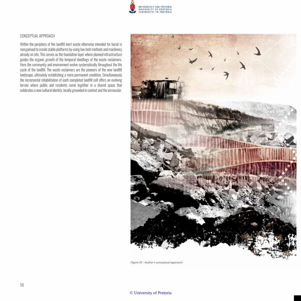
56
CONCEPTUAL APPROACH
Within the periphery of the landfill inert waste otherwise intended for burial is reorganised to create stable platforms by using low tech methods and machinery already on site. This serves as the foundation layer where planned infrastructure guides the organic growth of the temporal dwellings of the waste reclaimers. Here the community and environment evolve systematically throughout the life cycle of the landfill. The waste reclaimers are the pioneers of the new landfill landscape, ultimately establishing a more permanent condition. Simultaneously the incremental rehabilitation of each completed landfill cell offers an evolving terrain where public and residents come together in a shared space that celebrates a new cultural identity, locally grounded in context and the vernacular.
Figure 55 - Author’s conceptual approach
© University of Pretoria

57
Normative stance:
Successful design is the result of thoughtful, purposeful interaction between the various
landscape layers (tangible) and social layers (intangible) in order to create a unique
identity of that place.
© University of Pretoria
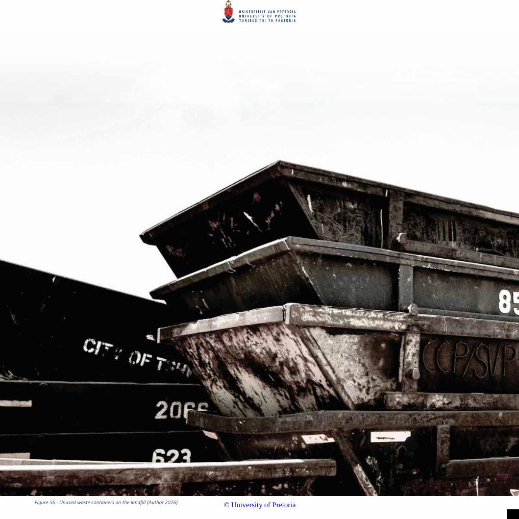
Figure 56 - Unused waste containers on the landfill (Author 2016)
© University of Pretoria

7
© University of Pretoria

60
CHAPTER 7 - Precedents investigated
HIRIYA LANDFILL
Figure 57 - Rendered perspective for the Hiriya landfill to become the Ariel Sharon Park
The Hiriya landfill in Tel Aviv, Israel was a project developed by landscape architects Latz + Partner. It started in 2004 and commenced in 2010. This landfill is 118 hectares in size and over 80 meters tall and is a prime example of post closure landfill remediation. The landfill was in operation from 1952 - 1988. Very successful recycling facilities were used during the operation, recycling approximately 80% of the incoming waste. The remediated landfill is protected against wind and water erosion by a layer of crushed concrete. It is capped in layers of liners and clay. Water collects in a series of ditches above the cap and is directed to underground gravel depots. This water is used to sustain groves of small trees. A special retention system keeps evaporation to a minimum. A building with a restaurant, large terrace and educational video room is built on a strong and stable concrete slab that was used to clean refuse trucks and was built up, layer by layer, as the landfill grew in height. A shallow ramp provides access to pedestrian traffic and shuttle services to a visitor centre offering information on the benefits of recycling and the reclamation of the landfill. The surrounding landscape and cities of Tel Aviv are densely populated. There is a need for public green spaces and the restoration of the Hiriya landfill was a deemed a success. The landfill is frequented by visitors, school and tour groups, and is a popular recreational park.
Figure 58 - The Hiriya landfill is over 80m high
This precedent has may positive attributes to emulate with regards to the programs and new public terrain that was created on the landfill. However, this project’s conception happened after the landfill had ceased operation and in terms of the Hatherley project the most important component is how to design the landfill now in order to make the lives and working conditions better for the waste reclaimers before landfill closure.
© University of Pretoria

61
VALL D’EN JOAN LANDFILL
Figure 61- The Vall d’en Joan landfill restoration project
The Vall d’en Joan landfill in Garraf, Spain, is located within the Parc Del Garraf national park. Therefore the landscape architects, Batlle i Roig proposed a succession type of remediation project that covers an area of 70 hectares and a height of 80 meters. The main goal is for the nature reserve to eventually absorb the landfill. This will be achieved by incorporating the surrounding forests local biomass into the landfill. By using the correct vegetation, fertile soil can be created to allow the local ecology to take over. Terraces were designed to harvest water to irrigate the indigenous plant species. Batlle i Roig believe that by developing local ecosystems on the landfill, they will then eventually adapt to the environment of the buried waste. The restoration project was initiated while the landfill was still operational and was completed 3 years after its closure. The
landfill’s proximity to urban areas will ensure regular visitors and it was therefore designed as a gateway to the rest of Parc Del Garraf.
This project successfully considers an integrative approach to reclaiming the landfill. The geometric design elements and gabions filled with waste clearly acknowledge the landfill site. This project fits in perfectly with its context - the nature reserve - by utilising ecological succession. However, unlike the Hatherley landfill it does not have the challenge of incorporating the social issue of the waste reclaimers.
Figure 59 - The pergolaed overlook at Ariel Sharon Park
Figure 60 - The park has been designed to include a restaurant and pond on top of the landfill
© University of Pretoria

62
Figure 62 - The plan indicating the irrigation dams, planting terraces and circulation pathways Figure 63 - The irrigation dams
Figure 65 - Gabions filled with recycled waste
Figure 64 - The planting terraces
© University of Pretoria
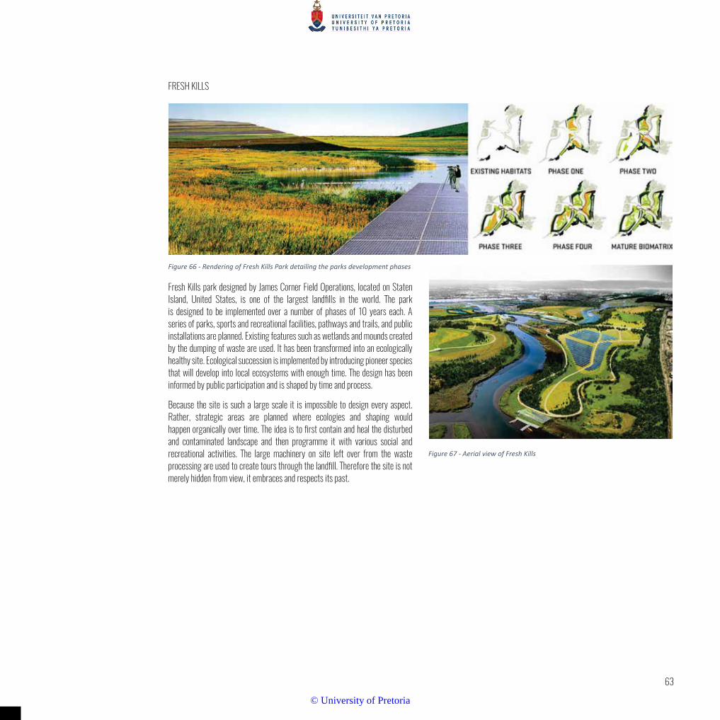
63
FRESH KILLS
Figure 66 - Rendering of Fresh Kills Park detailing the parks development phases
Fresh Kills park designed by James Corner Field Operations, located on Staten Island, United States, is one of the largest landfills in the world. The park is designed to be implemented over a number of phases of 10 years each. A series of parks, sports and recreational facilities, pathways and trails, and public installations are planned. Existing features such as wetlands and mounds created by the dumping of waste are used. It has been transformed into an ecologically healthy site. Ecological succession is implemented by introducing pioneer species that will develop into local ecosystems with enough time. The design has been informed by public participation and is shaped by time and process.
Because the site is such a large scale it is impossible to design every aspect. Rather, strategic areas are planned where ecologies and shaping would happen organically over time. The idea is to first contain and heal the disturbed and contaminated landscape and then programme it with various social and recreational activities. The large machinery on site left over from the waste processing are used to create tours through the landfill. Therefore the site is not merely hidden from view, it embraces and respects its past.
Figure 67 - Aerial view of Fresh Kills
© University of Pretoria

64
Figure 68 - Kayak recreational tour in Fresh Kills
CONCLUSION
As mentioned by Engler earlier in chapter 5, the integrated approach to landfill design is indeed a worthy goal for any waste landscape to aspire to. However, these strategies are mostly afterthoughts that are implemented when the landfill has already reached its maximum capacity, as in the examples above. The landfills had reached the end of their lifespan or were close to it when remediation strategies were implemented. In the Fresh Kills and Hiriya examples and somewhat in Vall d’en Joan, the designs focus on attracting visitors for recreational and educational activities. The Hatherley landfill’s main design strategies however, focus more on uplifting the waste reclaimer community while accommodating areas and strategies for living on the landfill. While these three precedents and the theory from Engler all have merit in their own specific context, they offer little in the way of guidelines to implement at Hatherley, except for the ecological succession approach that was used in both Fresh kills and Vall d’en Joan.
© University of Pretoria

65
© University of Pretoria
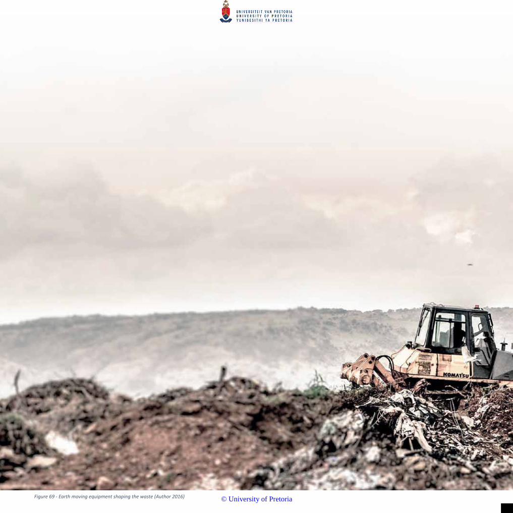
Figure 69 - Earth moving equipment shaping the waste (Author 2016)
© University of Pretoria

8
© University of Pretoria

68
CHAPTER 8 - Design development
A landfill is not a humane environment. However, living on a landfill has evolved out of a desperate need. The reality is that the government can never sate the housing demand, but by utilising the theory of the designer as an enabler the author believes with conviction that this landfill environment (however inappropriate it may be) can still provide a liveable environment through simple design strategies that attempt to mitigate the untenable conditions and utilise the tangible and intangible resources on offer.
Figure 70 - Early investigations sought to understand the potential of the landfill terrain and opportunities to make visible that which is intended invisible (Author 2016)
© University of Pretoria

69
Figure 75 - A further iteration manipulating the flour to explore the spatial implications of the landfill and living platforms. It was realised that waste trucks would need to take building rubble to the far side of the landfill and would travel through the activity node.(Author 2016)
Figure 76 - An investigation into creating a bridge to join the landfill to the living platforms in order to help the waste trucks deliver building rubble .(Author 2016)
Figure 73 - The terrain is manipulated to investigate the possibilities in shaping the landfill and the building rubble platforms. Ideas were looked at creating access routes and incorporating the proposed recycling centre. A road winding up the building rubble was created. Houses could then be built on the sides of this route. (Author 2016)
Figure 71- Flour model developed from the proposed municipal drawings for the final form of the landfill .(Author 2016)
Figure 74 - A core in the landfill was identified which could act as an active public space. The route to the train station would lead to this node allowing for a pause space. (Author 2016)
Figure 72 - Site analysis showed that the nearby expanding formal settlement was encroaching on the landfill and pedestrians were walking across it. Desire lines were heading in the direction of the train station. The first proposal looks at creating a formalised route / activity spine by parting the flour. (Author 2016)
ITERATIONS
Due to the nature of ever evolving waste terrain, a medium that could be easily and quickly manipulated was required in which to explore potential designs. The following models were shaped from cake flour on a site plan and then photographed from various angles to develop an understanding of potential landforms within the environment as well as the spatial experiences on the users.
© University of Pretoria

70
Figure 77 - Terraces are explored as a means to create an interesting landform terraces in the flour focusing whilst emphasising the linear development of landfill (Author 2016)
Figure 78 - The northern slopes that don’t face the landfill were investigated as steeper terraces for agricultural planting (Author 2016)
Figure 79 - Here the eastern slope of the landfill that is the most visible to commuters along Solomon Mahlangu was investigated. The intention was to create an interesting terraced slope that could catch and filter stormwater. (Author 2016)
The following iterations focus on the building rubble terrain designed into living areas.
© University of Pretoria

71
Figure 80 - An exploration of the flour terraces in foam Oasis Figure 81 - Relating the terraces into a plan
Figure 83 - The landfill development plan (left)
Figure 82 - Perspective of the terraced platforms
Figure 84 - Investigating the terraces at a master plan level (above)
The flour models served as conceptual explorations that proved to be very temporal. These ideas were then further investigated through other more ridged mediums.
© University of Pretoria

72
Due to the irregular nature of building it would not likely conform to angular or linear forms. The flour model revealed a realistic representation of a more rugged terrain. The master plan followed from this.
SYNTHESIS
The previous investigations revealed that the flour terraces were too complicated to implement in a linear pattern that would correspond with the linear cell development of the landfill. To simply the concept, larger terraces were investigated that offer a more practical solution. The figure below shows an initial idea of assessing which orientation would best accommodate views towards the landfill whilst addressing stormwater flow.
Figure 85 - Investigating the orientation of the platforms
Figure 88 - Final synthesis using flour to create the terrain. A combination of the previous two investigations (Author 2016)
Figure 86 - Here the building rubble is placed from the south to the north and then expanding towards the east (Author 2016)
Figure 87 - Building rubble Is places in the opposite orientation with expansion towards the east(Author 2016)
© University of Pretoria

73
© University of Pretoria

Figure 89 - Earth moving machinery on the landfill (Author 2016)
© University of Pretoria

9
© University of Pretoria

76
Chapter 9 - Mater Plan
From the research, four main themes were identified.
1. Enhancing economic opportunities
2. Developing building rubble platforms for living
3. Creating a communal space with shared infrastructure
4. Water harvesting strategies
Figure 90 - Programming and Strategies for Economic Activities
© University of Pretoria

77
Figure 91 - images depicting the complexities such waste recycling & repurposing places look like in other parts of Africa
© University of Pretoria

78
Figure 92 - Programming and Strategies for Living platforms
© University of Pretoria

79
Figure 93 - These images explore the potential of what the proposed building rubble terraces could become.
© University of Pretoria

80
Figure 94 - Programming and Strategies for Water Strategies
© University of Pretoria

81
Figure 95 - The images depict the ideas behind the waste water treatment and ablution facility - the cleansing space to be addressed in detail later
© University of Pretoria

82
Figure 96 - Phase one over the first 5 years
© University of Pretoria

83
Figure 98 - Phase 3 achievable over 15 years
Figure 97- Phase 2 achievable over 10 years
© University of Pretoria

84
Figure 99 - Master plan
© University of Pretoria

85
Figure 100 - Area of focus
© University of Pretoria

86
Figure 101 - Cross section A-A
© University of Pretoria

87
© University of Pretoria

88
Figure 102 - Perspective from Greenview station walking towards the landfill
PERSPECTIVES
© University of Pretoria

89
Figure 103 - Perspective looking northwards along the stormwater channel
© University of Pretoria

90
Figure 104 - Perspective of the communal, open air outdoor cleansing facility
© University of Pretoria

91
© University of Pretoria
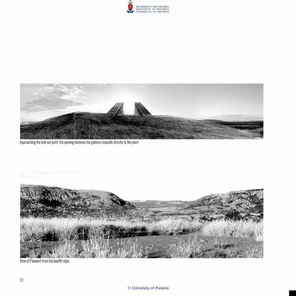
92
© University of Pretoria
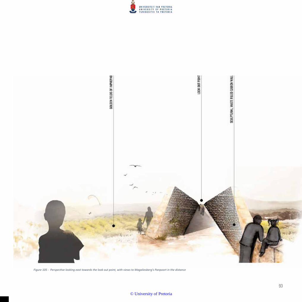
93
Figure 105 - Perspective looking east towards the look out point, with views to Magaliesberg’s Panpoort in the distance
© University of Pretoria
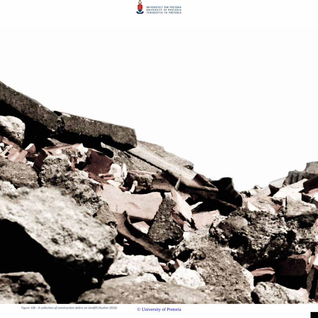
94Figure 106 - A collection of construction debris on landfill (Author 2016)
© University of Pretoria

95
10
© University of Pretoria
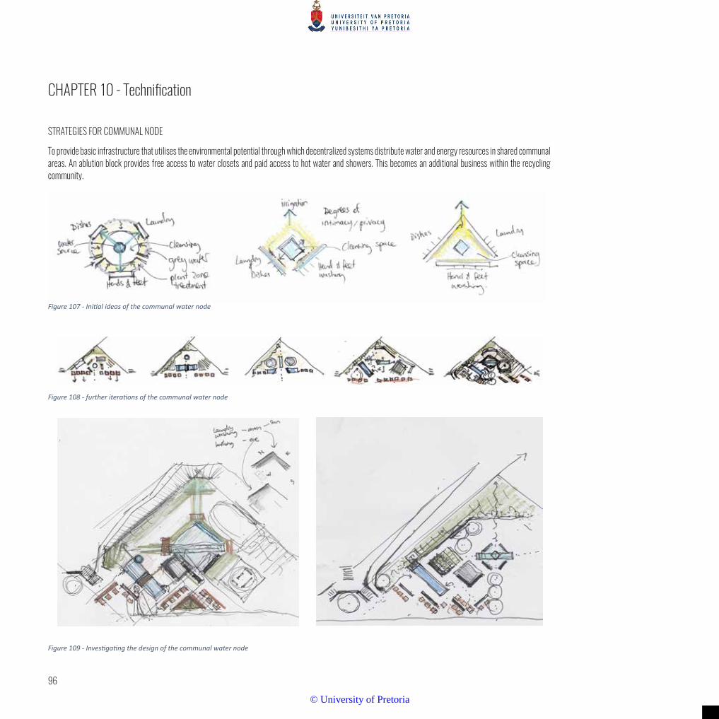
96
Figure 109 - Investigating the design of the communal water node
CHAPTER 10 - Technification
STRATEGIES FOR COMMUNAL NODE
To provide basic infrastructure that utilises the environmental potential through which decentralized systems distribute water and energy resources in shared communal areas. An ablution block provides free access to water closets and paid access to hot water and showers. This becomes an additional business within the recycling community.
Figure 107 - Initial ideas of the communal water node
Figure 108 - further iterations of the communal water node
© University of Pretoria
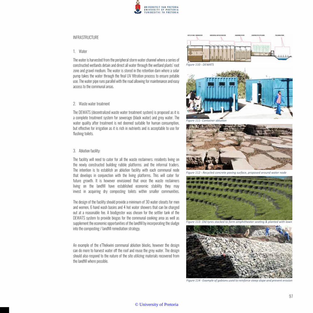
97
Figure 110 - DEWATS
Figure 111- Container ablution
Figure 112 - Recycled concrete paving surface, proposed around water node
Figure 113- Old tyres stacked to form amphitheater seating & planted with lawn
Figure 114 - Example of gabions used to reinforce steep slope and prevent erosion
INFRASTRUCTURE
1. Water
The water is harvested from the peripheral storm water channel where a series of constructed wetlands detain and direct all water through the wetland plants’ root zone and gravel medium. The water is stored in the retention dam where a solar pump takes the water through the final UV filtration process to ensure potable use. The water pipe runs parallel with the road allowing for maintenance and easy access to the communal areas.
2. Waste water treatment
The DEWATS (decentralized waste water treatment system) is proposed as it is a complete treatment system for sewerage (black water) and grey water. The water quality after treatment is not deemed suitable for human consumption, but effective for irrigation as it is rich in nutrients and is acceptable to use for flushing toilets.
3. Ablution facility:
The facility will need to cater for all the waste reclaimers; residents living on the newly constructed building rubble platforms; and the informal traders. The intention is to establish an ablution facility with each communal node that develops in conjunction with the living platforms. This will cater for future growth. It is however envisioned that once the waste reclaimers living on the landfill have established economic stability they may invest in acquiring dry composting toilets within smaller communities. The design of the facility should provide a minimum of 30 water closets for men and women, 6 hand wash basins and 4 hot water showers that can be charged out at a reasonable fee. A biodigester was chosen for the settler tank of the DEWATS system to provide biogas for the communal cooking area as well as supplement the economic opportunities of the landfill by incorporating the sludge into the composting / landfill remediation strategy.
An example of the e’Thekwini communal ablution blocks, however the design can do more to harvest water off the roof and reuse the grey water. The design should also respond to the nature of the site utilizing materials recovered from the landfill where possible.
© University of Pretoria

98
© University of Pretoria

99
Figure 115 - Detail plan of the communal space
© University of Pretoria

100
Figure 116- Section B-B through building rubble slope
© University of Pretoria

101
Figure 117 - Elevation and section C-C through gabion at open air outdoor shower facility
© University of Pretoria

102
Figure 118 - Conceptual idea of the planting strategy
© University of Pretoria

103
Figure 122 - An example of a striking pattern using native grass and rock to establish a gateway to the Auckland international airport. (SurfaceDesign, 2016)
Figure 119 - Trenches dug along contours in a staggered pattern to accumulate soil and create areas for plant growth. (ACF, 2010)
Figure 120 - Half moons for water harvesting. After the first rains a soil layers is added and mulch applied. (ACF, 2010)
Figure 121 - The “Zaï” system, can be built up or reinforced with rocks. (ACF, 2010)
© University of Pretoria

104
Figure 123 - Plan indicating the various areas where planting strategies should be implemented
© University of Pretoria

105
Figure 125 - Sections through the landfill levels
Figure 124 - Diagrams explaining the different planting areas with each ones planting units’ and requirements
© University of Pretoria
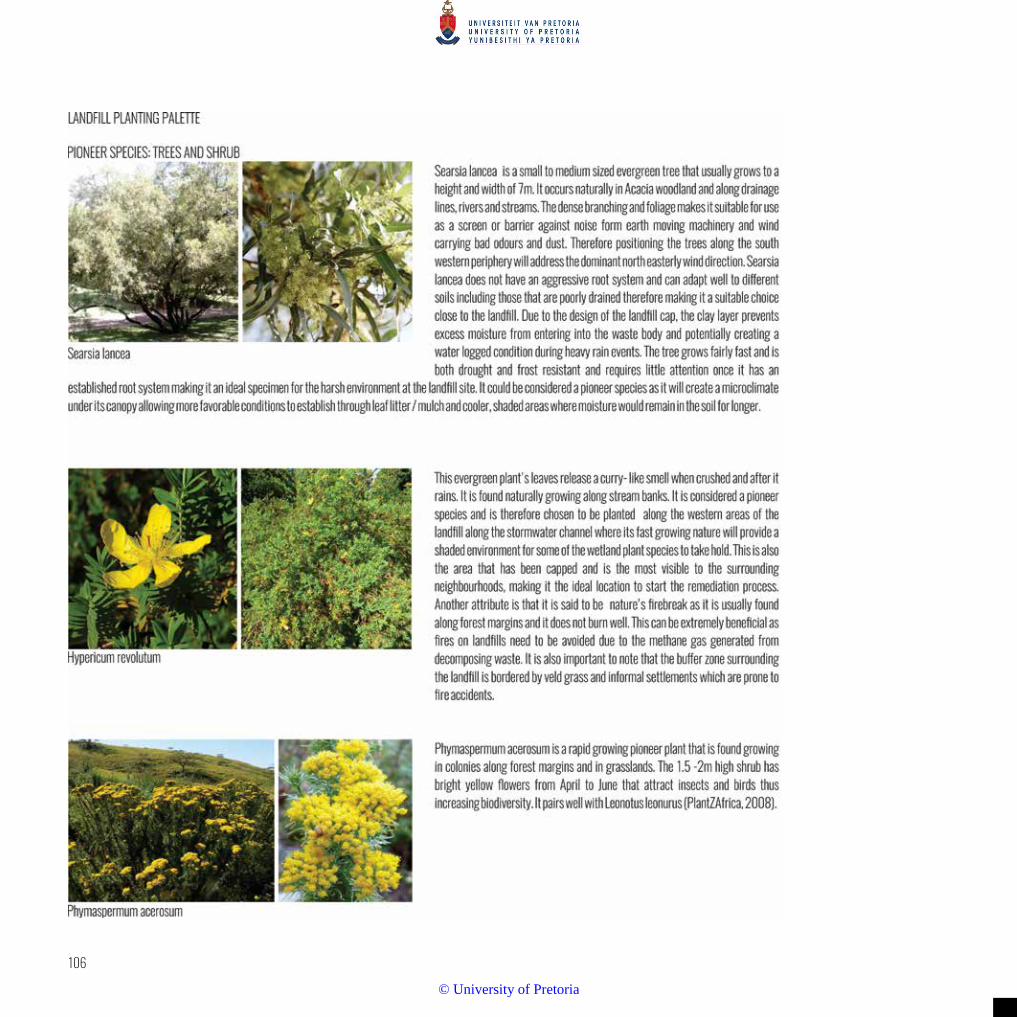
106
© University of Pretoria

107
© University of Pretoria

108
© University of Pretoria

109
© University of Pretoria

110
Figure 126 - Section explaining the positioning of the selected plant species
© University of Pretoria

111
Figure 127 - Perspective of entrance into cleansing area with planting positions
Figure 128 - Detailed plan of the open air outdoor cleansing facility
© University of Pretoria

112
© University of Pretoria
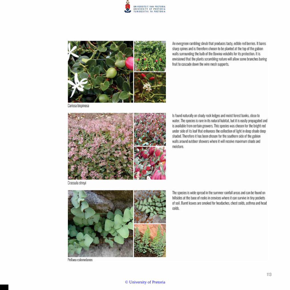
113
© University of Pretoria

114
© University of Pretoria

115
© University of Pretoria

116
Figure 129 - Stereotomic materials
© University of Pretoria

117
Figure 130 - Tectonic materials
© University of Pretoria

118
CONCLUSION
From investigating these various waste materials and their application it can be concluded that it’s the repetition of similar elements, size, shape, colour and or material that form an aesthetic quality. Recycled objects extracted from the landfill are often not in the same state of deterioration and their conditions and colours can vary dramatically. Some of these materials in the precedents are a source of income for the waste pickers so they would be more likely to sell them than collect them for construction material unless an incentive is provided. Bottle caps and other small items would take a substantial amount of time to collect, however this can be seen as an ongoing project where the landfill resident weave waste materials together to create overhead shade structures - ultimately adding to the character and identity of their environment. Therefore, the material pallet will be dominated by building rubble that is organised into sizes or crushed with heavy machinery on site. Tyres that are found at the landfill can be incorporated into retaining walls or seating.
CONSTRUCTING ON FORMER LANDFILLS
There are two types of uses when considering constructing on a landfill site:
Soft Use - large recreational spaces such as athletic fields, golf courses and amphitheatres. Hard Use - infrastructure and buildings such as stores, office buildings, residential buildings.
Inert waste landfills are the simplest types of landfills to develop. The probability of environmental contamination is minimal (although still need to be monitored and managed); and they can be stabilised using conventional geotechnical ground improvement techniques. (BOUAZZA & KAVAZANJIAN, 2011)
Hazardous landfills have a much higher degree of environmentally damaging material but there are well established containment techniques and systems that can be used to develop these types of landfills for soft uses. (COLLINS, et al., 1998).
Municipal waste sites have elements of both inert and hazardous waste along with an increased level of settlement and gas and leachate generation.
The main limiting factor of constructing buildings on a municipal landfill is the large level of subsidence that occurs which would cause structural damage to the buildings and the landfill cap. Additionally, the landfill cap has a relative-ly low bearing capacity (BOUAZZA & KAVAZANJIAN, 2011) which limits development to light weight, low-rise buildings. Heavier weight buildings are possible but require deep foundations. Raft foundations are recommended for light weight structures, while driven piles should be used to support larger structures.
SETTLEMENT OF WASTE
The following figures were obtained from the proceedings of the Construction on Former Landfills (BOUAZZA & KAVAZANJIAN, 2011) regarding the mechan-
Figure 131 - Retail store on top of a landfill Figure 132 - Shows the waste fill settling away from the building
© University of Pretoria

119
ics and metrics of the settlement of waste.
Mechanical settlement due to compression of the waste from overburden effects is 10 to 100 days and usually complete before closure of the landfill.
Long term settlement occurs due to waste undergoing biodegradation over the course of many years. Rainfall and moisture in the waste heavily influences the rate of biodegradation with a dry climate taking much longer to degrade. Careful analysis is needed to accurately predict the rate of settlement. However, observation has shown that long term settlement will be between 15 - 20% of the waste mass thickness. In the case of the Hatherley site, this means a subsidence of 6.75 m - 9 m over the course of a few decades.
Since soft-use development of landfills involves large amount of vegetation that needs to be irrigated, care should be taken that the extra water not be allowed to penetrate the landfill cap. Any extra moisture will accelerate decomposition of the waste and will increase subsidence and gas generation.
Differential settlement occurs “due to non-uniformity of waste composition and changing boundary conditions” (BOUAZZA & KAVAZANJIAN, 2011). This settlement is typically half of the total settlement, or 7.5 - 10% of the total waste mass thickness at various points of the landfill.
When using piles in the foundation, downdrag could occur due to the settlement process. “Downdrag or negative skin friction occurs when the settlement of the aterial surrounding the pile exceeds the downward movement of the pile shaft” (BOUAZZA & KAVAZANJIAN, 2011). Certain techniques can mitigate the downdrag phenomenon such as coating the piles in a friction reducing coting e.g. bitumen.
LANDFILL GAS
Controlling landfill gas migration, venting and collection is very important due to the health risks associated with breathing in the gas and the chance of explosion. Gas can be controlled, and the dangers mitigated by employing the following methods:
• Passive venting systems
• Active gas collection
• Physical barriers
• Pneumatic barriers
• Ventilation of underfloor subspace
• An alarm system
PRECEDENTS OF POST-CLOSURE LANDFILL DEVELOPMENT
Tecnoparc de Montreal, Montreal, Canada (BOUAZZA & KAVAZANJIAN, 2011)
Movie studios, storage facilities and administrative buildings were developed on a landfill site which was active from the 1870s - 1960s
Total area of development: 1 Ha
Foundation used: piles and geomembrane membrane
Gas mitigation: vacuum pump on each building; bituminous geomembrane attached to concrete structures; 37 methane detectors
Redwood City Office Park, California, USA (MILLER & MCLAUGHLIN, 2007)
A 20-building office park developed on a 34 Ha landfill site which was active from the 1940s to 1970s
Total area of development: 9.3 Ha
Foundations used: deep pile
Gas mitigation: subfloor membrane, automated gas sensors, subsurface gas migration barriers, venting systems
Figure 133 - Shows the potential foundation alternative in the waste body
© University of Pretoria

120
CONCLUSION
Japan has redeveloped 67% of their closed landfills (BOUAZZA & KAVAZANJIAN, 2011). There has been an increasing number of successful developments on closed landfill sites. Although challenging, with proper investigation, planning and management, it is feasible to develop a landfill for both hard and soft uses.
With this in mind and the proposed development around the Greenview station it would be wise to consider strategies of development on the actual landfill itself, seeing as the landfill is still in its early satge of development. The proposed design of the landfill terraces or plateaus at 10m height intervals can allow for a variety of programs to take place. Ramps and circulation were coinsidered to 1:15 slopes with the roads being an average of 10m wide.
Figure 134 - A remedial system under a building on a landfill
SANITATION OPTIONS
The waste reclaimers currently residing and working on the landfill do not have access to any form of sanitation. Clean water is sold from some spaza shops on the site and the reclaimers use this to drink and to wash their recyclable materials.
The author proposes a DEWATS (Decentralised Wastewater Treatment) system be installed on the landfill site. This system is flexible, efficient and cost effective requiring little operational or maintenance skills.
Typical DEWATTS treatment steps: (GUTTERER, et al., 2009):
• Primary treatment in sedimentation pools, septic tanks or biodigester (the author recommends a biodigester be used for the Hatherley site)
• Secondary treatment in anaerobic baffled filters or reactors; or facultative pond systems
• Secondary aerobic treatment in horizontal gravel filters
• Post treatment in aerobic polishing ponds
The system needs to be emptied of sludge periodically and is usually handled by the municipality. The sludge is most often treated at a municipal sewerage or sludge treatment plant, however there is an economic opportunity here at the Hatherley landfill to integrate the sludge either into the leachate remediation or into the composting facility proposed for the organic waste stream at the landfill.
This in turn is added to the remediation process of the landfill and is used as a soil conditioner where planting is proposed on the slopes and as well as the onsite nursery proposal.
The DEWATS system is suitable for the treatment of sewerage and grey water and when incorporating a biodigester into the system the combustible gas can be captured and utilised for cooking and heating. As mentioned previously, the effluent can be used as a fertiliser and the treated water can be for irrigation purposes.
© University of Pretoria
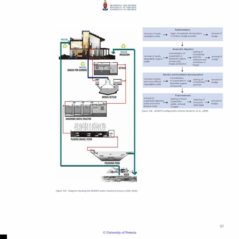
121
Figure 136 - DEWATS configuration scheme (Gutterer, et al., 2009)
Figure 135 - Diagram showing the DEWATS water treatment process (CDD, 2016)
© University of Pretoria
122Figure 137 - A young boy playing on the berm of the landfill at sunset (Author 2016)
© University of Pretoria

123
© University of Pretoria

124
CONCLUSION
This dissertation’s intention was to reveal the importance of waste, and its recy-cling possibilities within a marginalised community. There are intricate networks and economies that rely on this resource; and through design, greater possibilities can evolve - creating a more robust community.
There are people living on the landfall and their numbers are likely in increase. Design should pre-empt this expansion, providing more suitable places for living.
Landscape architects are brought in towards the end of the landfills closure to rehabilitate the environment, but why is there no consideration for design during its operation? Landscape architects can become the integral component that ne-gotiate between the social and environmental aspects in order to establish a place for people to live and work and where economic opportunities can grow. This will produce a sustainable environment in the long term. Doing so will rehabilitate not only the landfill but improve the waste reclaiming community as well.
© University of Pretoria

125
© University of Pretoria

126
BIBLIOGRAPHY
ACF INTERNATIONAL, 2010. Low Inputs Agricultural. [Online]
Available at: http://www.actionagainsthunger.org/sites/default/files/publications/Low_Inputs_Agriculture09.2013.pdf
[Accessed 5 11 2016].
ALON-MOZES, T., 2009. The International Competition for the Reclamation of the Hiriya Landfill: A National Israeli Symbol in the ‘Global’ Arena. Landscape Review, 13(1), pp. 31-46.
AZZARELLO, N., 2015. Fabrice monteiro shows senegal's pollution with garbage garments. [Online]
Available at: http://www.designboom.com/art/fabrice-monteiro-prophecy-senegal-pollution-photography-09-21-2015/
[Accessed 19 September 2016].
BERGER, A., 2006a. Drosscape. Wasting Land in Urban America. New York: Princeton Architectural Press.
BERGER, A., 2006b. Drosscape. In The Landscape Urbanism Reader edited by WALDHEIM, C.. New York: Princeton Architectural Press.
BOUAZZA, A. & KAVAZANJIAN, E. J., 2011. Construction on former landfills. Newcastle, s.n., pp. 467-482.
CDD SOCIETY, 2016. Decentralised Wastewater Treatment Systems. [Online]
Available at: http://www.cddindia.org/dewats.html
[Accessed 22 11 2016].
CHAMANE, M., 2009. South Africa's waste pickers: Creating jobs and fighting poverty. South African Labour Bulletin, Issue June/July, pp. 22-24.
CILLIERS, E. J., 2014. From Spaces to Lively Places. Durban, South African Planning Institute.
CITY OF TSHWANE, 2005. Tshwane Open Space Framework. Pretoria: s.n.
CITY OF TSHWANE, 2013. Tshwane Vision 2015 Remaking South Africa's Capital City, Pretoria: City of Tshwane.
COLLINS, P., NG, A. & RAMANUJAM, R., 1998. Civil Engineering. Superfund Success, Superfast, 68(12), pp. 42-45.
CSIR, 2011. Municipal waste management - good practices. Edition 1. Pretoria: CSIR.
DAVIES, R., 1981. The Spatial Formation of the South African City. GeoJournal Supplementary, Issue 2, pp. 59-72.
DEPARTMENT OF ENVIRONMENTAL AFFAIRS, 2012. National Waste Information Baseline Report. Pretoria: Government Printer.
DEPARTMENT OF SCIENCE AND TECHNOLOGY, 2013. An analysis of the formal private and public waste sector in South Africa. A National Waste RDI Roadmap for South Africa: Phase 1 Status Quo Assessment, Pretoria: Department of Science and Technology.
DEPARTMENT OF WATER AFFAIRS & FORESTRY, 1998. Waste Management Series. Minimum Requirements for Waste Disposal by Landfill. Second ed. Pretoria: Department of Water Affairs & Forestry.
DWAF (Department of Water Affairs and Forestry), 1998. Minimum Requirements for Waste Disposal by Landfill, 2nd Edition. Pretoria: DWAF.
© University of Pretoria
127
ENCYCLOPAEDIA BRITANNICA, 2012. ENCYCLOPAEDIA BRITANNICA. [ONLINE]
Available at: https://global.britannica.com/science/ecotone
[Accessed 5 May 2016].
ENGLER, M., 1995. Waste Landscapes: Permissible Metaphors in Landscape Architecture. Landscape Journal, 14(1), pp. 10-25.
EZBAN, M., 2012. The Trash Heap of History. [Online]
Available at: https://placesjournal.org/article/the-trash-heap-of-history/#
[Accessed 9 March 2016].
GAPP/MMA CONSORTIUM, 2003. Salvokop Development Framework - draft development framework, Pretoria: s.n.
GODFREY, L., 2015. Finding value in waste: Identifying opportunities for growth in a secondary resources economy. [Online]
Available at: http://researchspace.csir.co.za/dspace/bitstream/10204/8452/1/Godfrey_2015.pdf
[Accessed 07 September 2016].
GOUVERNEUR, D., 2014. Planning and Design for Future Informal Settlements. s.l.:Routledge.
GUTTERER, B., SASSE, L., PANZERBIETER, T. & RECKERZÜGEL, T., 2009. Decentralised Wastewater Treatment Systems (DEWATS) and Sanitation in Developing Countries: A Practical Guide. Leicestershire: Water, Engineering and Development Centre.
HAMDI, N., 2010. The Placemaker's Guide to Building Community. London: Earthscan.
HERRINGTON, S., 2017. Landscape Theory in Design. New York: Routledge.
HUBA, E. & LEBOFA, M., 2011. Sanitation Technology Options in Lesotho. Maseru, s.n.
LIG LANDFILL INTEREST GROUP, 2014. The Landfill and Waste Treatment Interest Group. [Online]
Available at: http://www.iwmsa.co.za/downloads/Construction%20of%20Landfill%20Facilities.pdf
[Accessed 06 September 2016].
MAGALIESBERG BIOSPHERE, 2015. The journey to where it all began. [Online]
Available at: http://magaliesbergbiosphere.org.za/index.php/about
[Accessed 2 August 2016].
MAGALIESBERG, 2008. The Mountain Range of Magaliesberg. [Online]
Available at: http://www.magaliesberg.co.za/mountain.html
[Accessed 2 August 2016].
MARELLO, M. & HELWEGE, A., 2014. Solid Waste Management and Social Inclusion of Waste Pickers: Opportunities and Challenges, Boston: GEGIboston.
© University of Pretoria

128
MCNEIL, T., 2015. Rehabilitation for future generations. ReSource: Prompting Integrated Resource management, Issue November, pp. 41-43.
METHA, B. & DASTUR, A., 2008. Approaches to Urban Slums. [Online]
Available at: https://www.citiesalliance.org/sites/citiesalliance.org/files/CA_Images/Approaches_to_Urban_Slums_WBI.pdf
[Accessed 10 September 2016].
MEYER, E., CZERNIAK, J., HARGREAVES, G. & BEARDSLEY, J., 2007. Large Parks. New York: Princeton Architectural Press.
MILLER, J. & MCLAUGHLIN, M., 2007. Commercial Redevelopment of Closed Landfills. [Online]
Available at: http://www.renewalredevelopment.com/magazine/article/4374/Commercial-Redevelopment-of-Closed-Landfills
[Accessed 16 August 2016].
PELSER, A. J. & VAN VOLLENHOVEN, A., 2009. A Final Report On The Archaeological Investigation Of A Late Iron Age (ndebele) Stone Walled Settlement On The Remainder Of Hatherley 331 Jr, Near Mamelodi, Gauteng, Marshalltown: Archaetnos.
QASIM, S. & CHIANG, W., 1994. Sanitary Landfill Leachate: Generation, Control and Treatment. Lancaster: Technomic Publishing Company.
REYNEKE, P., 2012. Gartskloof Landfill: The Micro-Organisation of Waste pickers. [Online]
Available at: https://www.academia.edu/6723658/Gartskloof_Landfill_The_Micro-Organisation_of_Waste_pickers
[Accessed 15 June 2016].
REYNEKE, P., 2015. Dumpsite bricolage: The urban waste precariat’s responses to the formalisation and privatisation of waste management in the City of Tshwane. s.l.:University of Pretoria.
ROBYN, J., 2014. informal Settlements as Great Places. Durban, s.n.
SAMSON, M., 2010. WEIGO. [Online]
Available at: http://wiego.org/sites/wiego.org/files/publications/files/Samson_WIEGO_OB5.pdf
[Accessed 14 May 2016].
SOUTH AFRICA GOV, 2014. National Environmental Management: Waste Amendment Act. Cape Town: Government Printer.
SURFACEDESIGN INC, 2016. Auckland Airport Gateway. [Online]
[Accessed 3 12 2016].
TRADING ECONOMICS, 2016. Trading Economics. [Online]
Available at: http://www.tradingeconomics.com/articles/05092016113625.htm
VAN OUDTSHOORN, F., 2012. Guide to grasses of Southern Africa. Pretoria: Briza.
VAN WYK, B., VAN OUDTSHOORN, B. & GERICKE, N., 2013. Medicinal Plants of South Africa. Pretoria: Briza.
VISSER, W. &. A. T., 2014. The Landfill and Waste Treatment Interest Group. [Online]
Available at: http://www.iwmsa.co.za/downloads/wspguidelines.pdf
© University of Pretoria

129
[Accessed 06 September 2016].
WOODS, L., 2008. SLUMS: What to do?. [Online]
Available at: https://lebbeuswoods.wordpress.com/2008/01/28/slums-what-to-do/
[Accessed 5 September 2016].
ZOH, K., 2000. A Reflection on Contemporary Landscape Design. International Journal of Urban Sciences, Volume 4:2, pp. 259-268.
© University of Pretoria

130
List of figures
Figure 1 - Landfill Urbanism (Author 2016) 2
Figure 2 - At the junction between Mamelodi and the landfill (Author 2016) 12
Figure 3 - Rubbish strewn on the side of the road approaching the landfill (Author 2016 ) 14
Figure 4 - Illegal dumping of waste on the side of the road (Author 2016) 14
Figure 5 - Monte Testaccio (Ezban 2011) 15
Figure 6 - The sherds of ancient amphorae that form Monte Testaccio. (Ezban 2015). 15
Figure 7 - Monte Testaccio and the Tiber River. (Ezban 2012) 15
Figure 8 - Ventilation into landfill, Restaurant Flavio al Velavevodetto at Monte Testaccio. (Ezban 2015) 15
Figure 9 - A harsh landscape (Author 2016) 16
Figure 10 - Landfill landscape showing the engineered storm water dam (Author 2016) 18
Figure 12 - Main route and distance to Hatherley 20
Figure 11 - Location map (Author 2016) 20
Figure 13 - Segregation City (Davies 1981) 20
Figure 14 - Social-Racial Spatial Rearrangement of Pretoria (Davis 1981) (Edited by author) 21
Figure 15 - Racial self-identification in Pretoria (Frith 2011) (Edited by author) 21
Figure 16 - Google maps image of landfill locality depicting ‘environmental racism’ (Edited by Author 2016) 22
Figure 17 - Magaliesberg rock strata formation (Magaliesberg 2008) (Edited by Author) 22
Figure 18 - Magaliesberg aspect (Magaliesberg Biosphere 2015) 22
Figure 19 - Representation of the previous agricultural nature of the site (Author 2016) 23
Figure 20 - Author’s interpretation of the highveld landscape (Author 2016) 23
Figure 22 - The informal condition (Author 2016) 24
Figure 23 - Average wind distribution (Windfinder.com 2016) 25
Figure 24 - Hydrology and topography of the region (Author 2016) 25
Figure 25 - Open space networks and cultural nodes of Mamelodi (Author 2016) 25
Figure 26 - Transport networks and suburbs of Mamelodi (Author 2016) 26
Figure 27 - Disturbed zones (Author 2016) 26
Figure 28 - Google Maps timeline indicating rapid expansion around the landfill (Edited by author, 2016) 26
© University of Pretoria

131
Figure 29 - Biomes and ecologically sensitive areas (Author 2016) 27
Figure 30 - Visual analysis of the Hatherley landfill (Author 2016) 27
Figure 32 - General landfill waste composition report by NWIBR (Tshwane 2011) (Edited by Author) 28
Figure 33 - Waste reclaimers working (Author 2016) 30
Figure 34 - Landfill dwelling (Author 2016) 33
Figure 35 - Landfill tent dwelling (Author 2016) 34
Figure 36 - Dwelling elevated out of the waste on a salvaged polystyrene base (Author 2016) 35
Figure 37 - The monumental scale of the western periphery buffer zone (Author 2016 35
Figure 38 - View of the recently completed Greenview train station (Author 2016) 36
Figure 39 - Tshwane Metropolitan Spatial Development Framework (CITY OF TSHWANE, 2013) 38
Figure 42 - View of the Pienaarspoort from the landfill ridge (Author 2016) 40
Figure 43 - Gods of the Waste(d) by Fabrice Monteiro highlighting Senegal’s pollution with garbage garments. © Fabrice Monteiro 42
Figure 44 - Candlestick Point Park, by Hargreaves & Associates (HESS, 1992) 45
Figure 45 - David Gouverneur’s drawing depicting the armatures 47
Figure 46 - The monumental scale of the landfill dwarfs the waste reclaimers working beneath it (Author 2016) 50
Figure 48 - Distinguishing wasted resources (construction debris and garden refuse) in terms of their incoming quantity versus landfill area allocation. 52
Figure 47 - Author’s vision for the Hatherley region (2016) 52
Figure 49 - A view of the dry, hot conditions of the landfill (Author 2016) 54
Figure 52 - Proposing a new road through the landfill 54
Figure 50 - A polystyrene platform onto which the tent or ‘Makuku’ is fixed 54
Figure 51 - Here polystyrene is also used as a wall, any large sheets of plastic or carpeting serve a waterproofing layer. 54
Figure 53 - Water harvesting strategy 55
Figure 54 - Master plan guidelines and strategies 55
Figure 55 - Author’s conceptual approach 56
Figure 56 - Unused waste containers on the landfill (Author 2016) 58
Figure 57 - Rendered perspective for the Hiriya landfill to become the Ariel Sharon Park 60
Figure 58 - The Hiriya landfill is over 80m high Figure 59 - The pergolaed overlook at Ariel Sharon Park 61
© University of Pretoria

132
Figure 60 - The park has been designed to include a restaurant and pond on top of the landfill 61
Figure 61 - The Vall d’en Joan landfill restoration project 61
Figure 62 - The plan indicating the irrigation dams, planting terraces and circulation pathways 62
Figure 63 - The irrigation dams 62
Figure 64 - The planting terraces 62
Figure 65 - Gabions filled with recycled waste 62
Figure 66 - Rendering of Fresh Kills Park detailing the parks development phases 63
Figure 67 - Aerial view of Fresh Kills 63
Figure 68 - Kayak recreational tour in Fresh Kills 64
Figure 69 - Earth moving equipment shaping the waste (Author 2016) 66
Figure 70 - Early investigations sought to understand the potential of the landfill terrain and opportunities to make visible that which is intended invisible (Author 2016) 68
Figure 71 - Flour model developed from the proposed municipal drawings for the final form of the landfill .(Author 2016) 69
Figure 72 - Site analysis showed that the nearby expanding formal settlement was encroaching on the landfill and pedestrians were walking across it. Desire lines were heading in the direction of the train station. The first proposal looks at creating a formalised route / activity spine by parting the flour. (Author 2016) 69
Figure 73 - The terrain is manipulated to investigate the possibilities in shaping the landfill and the building rubble platforms. Ideas were looked at creating access routes and incorporating the proposed recycling centre. A road winding up the building rubble was created. Houses could then be built on the sides of this route. (Author 2016) 69
Figure 74 - A core in the landfill was identified which could act as an active public space. The route to the train station would lead to this node allowing for a pause space. (Author 2016) 69
Figure 75 - A further iteration manipulating the flour to explore the spatial implications of the landfill and living platforms. It was realised that waste trucks would need to take building rubble to the far side of the landfill and would travel through the activity node.(Author 2016) 69
Figure 76 - An investigation into creating a bridge to join the landfill to the living platforms in order to help the waste trucks deliver building rubble .(Author 2016) 69
Figure 77 - Terraces are explored as a means to create an interesting landform terraces in the flour focusing whilst emphasising the linear development of landfill (Author 2016) 70
Figure 78 - The northern slopes that don’t face the landfill were investigated as steeper terraces for agricultural planting (Author 2016) 70
Figure 79 - Here the eastern slope of the landfill that is the most visible to commuters along Solomon Mahlangu was investigated. The intention was to create an interesting terraced slope that could catch and filter stormwater. (Author 2016) 70
Figure 80 - An exploration of the flour terraces in foam Oasis 71
Figure 81 - Relating the terraces into a plan 71
Figure 82 - Perspective of the terraced platforms 71
© University of Pretoria

133
Figure 83 - The landfill development plan (left) 71
Figure 84 - Investigating the terraces at a master plan level (above) 71
Figure 85 - Investigating the orientation of the platforms 72
Figure 86 - Here the building rubble is placed from the south to the north and then expanding towards the east (Author 2016) 72
Figure 87 - Building rubble Is places in the opposite orientation with expansion towards the east(Author 2016) 72
Figure 88 - Final synthesis using flour to create the terrain. A combination of the previous two investigations (Author 2016) 72
Figure 89 - Earth moving machinery on the landfill (Author 2016) 74
Figure 90 - Programming and Strategies for Economic Activities 76
Figure 91 - images depicting the complexities such waste recycling & repurposing places look like in other parts of Africa 77
Figure 92 - Programming and Strategies for Living platforms 78
Figure 93 - These images explore the potential of what the proposed building rubble terraces could become. 79
Figure 94 - Programming and Strategies for Water Strategies 80
Figure 95 - The images depict the ideas behind the waste water treatment and ablution facility - the cleansing space to be addressed in detail later 81
Figure 96 - Phase one over the first 5 years 82
Figure 97 - Phase 2 achievable over 10 years 83
Figure 98 - Phase 3 achievable over 15 years 83
Figure 99 - Master plan 84
Figure 100 - Area of focus 85
Figure 101 - Cross section A-A 86
Figure 102 - Perspective from Greenview station walking towards the landfill 88
Figure 103 - Perspective looking northwards along the stormwater channel 89
Figure 104 - Perspective of the communal, open air outdoor cleansing facility 90
Figure 105 - Perspective looking east towards the look out point, with views to Magaliesberg’s Panpoort in the distance 93
Figure 106 - A collection of construction debris on landfill (Author 2016) 94
Figure 107 - Initial ideas of the communal water node 96
Figure 108 - further iterations of the communal water node 96
Figure 109 - Investigating the design of the communal water node 96
Figure 110 - DEWATS 97
© University of Pretoria

134
Figure 111 - Container ablution 97
Figure 112 - Recycled concrete paving surface, proposed around water node 97
Figure 113 - Old tyres stacked to form amphitheater seating & planted with lawn 97
Figure 114 - Example of gabions used to reinforce steep slope and prevent erosion 97
Figure 115 - Detail plan of the communal space 99
Figure 116 - Section B-B through building rubble slope 100
Figure 117 - Elevation and section C-C through gabion at open air outdoor shower facility 101
Figure 118 - Conceptual idea of the planting strategy 102
Figure 119 - Trenches dug along contours in a staggered pattern to accumulate soil and create areas for plant growth. (ACF, 2010) 103
Figure 120 - Half moons for water harvesting. After the first rains a soil layers is added and mulch applied. (ACF, 2010) 103
Figure 121 - The “Zaï” system, can be built up or reinforced with rocks. (ACF, 2010) 103
Figure 122 - An example of a striking pattern using native grass and rock to establish a gateway to the Auckland international airport. (SurfaceDesign, 2016) 103
Figure 123 - Plan indicating the various areas where planting strategies should be implemented 104
Figure 124 - Diagrams explaining the different planting areas with each ones planting units’ and requirements 105
Figure 125 - Sections through the landfill levels 105
Figure 126 - Section explaining the positioning of the selected plant species 110
Figure 127 - Perspective of entrance into cleansing area with planting positions 111
Figure 128 - Detailed plan of the open air outdoor cleansing facility 111
Figure 129 - Stereotomic materials 116
Figure 130 - Tectonic materials 117
Figure 131 - Retail store on top of a landfill 118
Figure 132 - Shows the waste fill settling away from the building 118
Figure 133 - Shows the potential foundation alternative in the waste body 119
Figure 134 - A remedial system under a building on a landfill 120
Figure 135 - Diagram showing the DEWATS water treatment process (CDD, 2016) 121
Figure 136 - DEWATS configuration scheme (Gutterer, et al., 2009) 121
Figure 137 - A young boy playing on the berm of the landfill at sunset (Author 2016) 122
© University of Pretoria

© University of Pretoria

© University of Pretoria

© University of Pretoria

© University of Pretoria