land use zoning regulations
TRANSCRIPT

INTRODUCTION
SPATIAL EXTENT OF LAND USE ZONING REGULATIONS
The regulation applies to the Bangalore Metropolitan Area, also defined as the Local Planning Area (LPA) for the city of
Bangalore and its environs as declared under KTCP Act,1961
LAND USE ZONE CATEGORIES
A. The entire Local Planning Area is conceptually organized into three main
Rings for consideration of zoning and regulations.
CATEGORIES
RESIDENTIAL (R)
i. Areas coming within the Core Ring Road : Ring I
ii. Areas coming between the Core Ring road and the Outer Ring Road: Ring II
iii. Areas coming beyond the Outer Ring Road and within the LPA: Ring III
iv. The above rings are equivalent to Zone-A, Zone-B and Zone-C for TDR
Purposes
COMMERCIAL (C)
INDUSTRIAL (I)
PUBLIC AND SEMI PUBLIC (P&SP)
TRAFFIC AND TRANSPORTATION (T&T)
PUBLIC UTILITIES (PU)
PARK AND OPEN SPACE (P)
UNCLASSIFIED (UC)
AGRICULTURE LAND (AG)

LIST OF LAND USE CATEGORIES PERMISSIBLE IN VARIOUS ZONES
Residential
LIST OF LAND USE CATEGORIES PERMISSIBLE IN VARIOUS ZONES
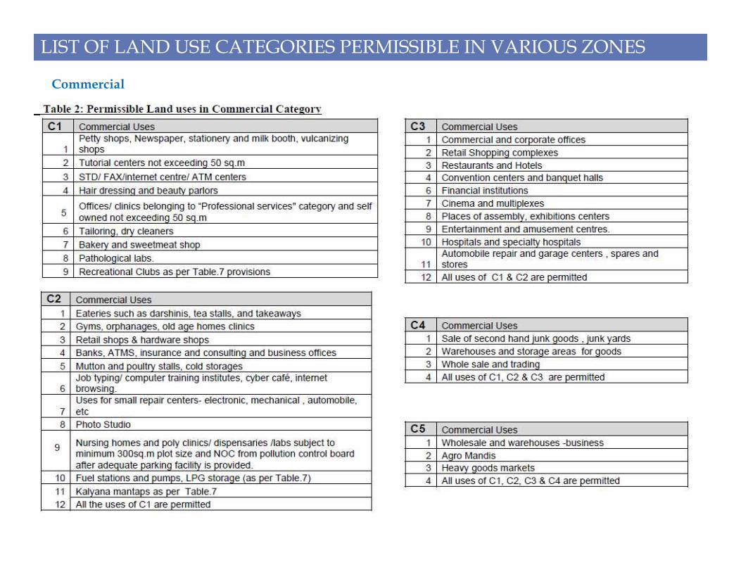
Commercial

LIST OF LAND USE CATEGORIES PERMISSIBLE IN VARIOUS ZONES
Industrial

LIST OF LAND USE CATEGORIES PERMISSIBLE IN VARIOUS ZONES
Transportation

LIST OF LAND USE CATEGORIES PERMISSIBLE IN VARIOUS ZONES
Public and Semi Public

REGULATIONS APPLICABLE TO ALL ZONES
SETBACKS:
Front and Rear setback shall be with reference to depth of the site.
i. The left and right setback shall be with reference to width of the site.
ii. Up to 11.5 m height, the setbacks are calculated as percentages of depth and width of the plot, as per Table.8.
iii. Table.9 shall be referred for Buildings which are more than 11.5 m in height to fix the setbacks.
iv. In case of irregular plots, the setbacks are to be calculated according to the depth or the width at the point where the depths or
widths are varying and average setbacks shall not be considered in such cases.
v. The setbacks shall be provided in the owners plot. Public open spaces or conservancies should not be considered as setbacks.
vi. Wherever the building lines are fixed, in such cases the front setback or the building line which ever is higher shall be considered
as the front setback to the building.
vii. In case of corner site, both the sides facing the road shall be treated as front side and regulations applied accordingly to maintainvii. In case of corner site, both the sides facing the road shall be treated as front side and regulations applied accordingly to maintain
the building line on these roads and for providing better visibility.
viii. In case of building facing more than two roads, the plot should be considered as corner plot taking two wider roads into
consideration.
ix. In case of site facing roads both in front and rear, both the sides facing roads shall be treated as front and other two sides not
facing roads should be treated as right and the setbacks be applied accordingly.

REGULATIONS APPLICABLE TO ALL ZONES
WIDTHOF THE ROAD:
i. While determining the width of the road the distance between the boundaries of a road including foot path, drains measured at
right angles at the center of the plot.
ii. In case of roads having service roads in addition to the main roads, the width of the roads shall be aggregate width of service
roads and main roads for determining the FAR.
FAR or Floor Area Ratio
i) The ratio of the Floor area to the plot area is FAR. However, it includes escalators, open balconies, staircase and corridors.
ii) The floor area ratio shall exempt the floor area used for purposes such as parking space, main stair case room, lift shaft, lift wells,
and lift machine rooms, ramps, ventilation ducts, sanitary ducts and overhead tanks.
iii) When the site does not face the road of required width noted against each, then the FAR applicable to the corresponding width of
the roads shall apply.

iv) Where a plot faces a wider road than the one prescribed against it, the FAR shall be restricted only to the limit prescribed for the
area of the plot.
v) Additional FAR: With a view to encourage redevelopment in old/core areas, additional floor area ratio(FAR) as an incentive is
proposed for properties located within I & II rings(lands falling under 100 & 200 series planning district plans) which are
amalgamated or reconstituted only after the date of approval of Revised Master Plan 2015. Details of additional FAR are as follows;
REGULATIONS APPLICABLE TO ALL ZONES
Ground coverage:
The total area covered by building immediately above the plinth level. Swimming pool, sump tank, pump house and electric
substation, utilities are not included.
Two or more buildings on the site:
i. For more than one building on a given site, the distance between the buildings shall be 1/2 the height of the tallest building,
between the buildings under consideration.
ii. In case, two or more buildings with different heights are proposed on a single site, then setbacks shall be applied with reference to
the tallest building.

REGULATIONS APPLICABLE TO ALL ZONES
Means of access:
i. The means of exclusive access which would be other than through public roads or streets shall not be more than 30.0 m in length
from the existing public road and the minimum width of such access shall be 3.5 m. If the width of access road is less than 3.5 mtrs,
then max floor area permitted in such cases shall not exceed 150 sq mtrs and 50 sq mtrs in residential and commercial zones
respectively irrespective of the sital area.
ii. FAR and height of the building shall be regulated according to the width of public street or road only.
iii. The means of exclusive access which would be other than through public roads or streets having more width than the public road
or street, but less than 30.0 m in length, then width of the public road or street shall be considered for reckoning FAR.
iv. Access rights needs to be obtained before applying for any sanction/permission for development. Documents to support the
rights obtained needs to be submitted along with the plan.Basement:
i. Means storey which is partly or wholly below the average ground level and with a height not exceeding a projection of 1.2 mi. Means storey which is partly or wholly below the average ground level and with a height not exceeding a projection of 1.2 m
above the average ground level and overall height of the basement under any circumstances should not exceed 4.5 m between the
floor and the ceiling of the basement in case of normal parking. In case of stacked/ mechanical parking the height of the basement
may be permitted up to a maximum of 4.5m
ii. If a site is measuring less than 200sqm, then car parking shall not be permitted in the basement floor.
iii. If the minimum setback is more than 2.0 m, then the basement may be extended on all sides except the side abutting the road,
provided the minimum setback between the basement and property boundary is minimum 2.0 m.
iv. Basement floors up to a maximum of 5 (five) levels may be permitted for car parking.
v. Permissible uses in the Basement for buildings other than 3 star and above category:
• Dark rooms for X ray and storage of light sensitive materials
• Bank Safes/ Strong room included in the FAR
• Air condition handling units/equipment, utilities and services connected with the building.
• Parking

REGULATIONS APPLICABLE TO ALL ZONES
Ramps
i) Provision for ramp shall have a minimum width of 3.5 m and a slope of not less than 1 in 10 and 1 in 8 in special cases. The ramp
and the driveway in the basement shall be provided after leaving a clear gap of minimum 2.0 m from the common property line. The
slope of the ramp shall commence from 1.5 m of the edge of property line.
ii) Ramps for the physically challenged shall be provided in all Public buildings.
Projections:
i. Projection into open spaces: Every open spaces provided either interior or exterior shall be kept free from any erection there on and
shall be open to the sky and no cornice roof or weather shade more than 0.75 m wide or 1/3 rd of open space/setback which ever is
less shall overhang or project over the said open space.
ii. No projection shall over hang/project over the minimum setback area either in cellar floor or at the lower level of ground floor.
iii. Cantilever Portico of 3.0 m width (maximum) and 4.50 m length (maximum) may be permitted within the side setback. No accessiii. Cantilever Portico of 3.0 m width (maximum) and 4.50 m length (maximum) may be permitted within the side setback. No access
is permitted to the top of the portico to use it as a sit out place and the height of the portico shall be not be less than 2.00 m from
the plinth level. The portico is allowed only on the side where the setback/open space left exceeds 3.00 m width.
iv. Balcony: Balcony projection should not exceed 1/3 rd of the setback on that side subject to a maximum of 1.10m in the first floor
and 1.75 m beyond the second floor. No balcony is allowed in the ground floor.

REGULATIONS FOR MAIN LAND USE ZONES: Residential (Main)
The areas of the city which have predominantly residential land use pattern is considered for the Residential (Main) zone. This includes
many old areas of the city such as Parts of Malleswaram, Richmond Town, Vasant Nagar, Jayanagar, Vijayanagar, Visveswarapura,
Rajajinagar, RT Nagar, etc.
1. PERMISSIBLE LAND USES:
FFMain Land use : R & T1
FF Ancillary Land use category: C2, I-2 & U3
FF Ancillary use is allowable to 20% of the total built up area
or 50 sq.m which ever is higher.
FF If the Plot size is more than 240 sq.m, having a frontage of
10.0 m or more, and the abutting road is more than 18.0 m 10.0 m or more, and the abutting road is more than 18.0 m
width, then ancillary uses can be used as main use.
a) Setbacks shall be in accordance with Table.8 or Table.9 depending on the height of proposed building and the plot size.
b) If the road width is less than 9.0 m, then the maximum height is restricted to 11.5 meters or Stilt +GF+2 floors (whichever is
less) irrespective of the FAR permissible
c) Multi dwelling units (Apartments) shall be allowed only on plot sizes of above 360 sq.m in the I and II Ring and on plots above
750 sq.m in the III Ring. In both cases, the road width shall be more than 9.0m.
d) TDR is applicable as per rules.
2. NOTES

REGULATIONS FOR MAIN LAND USE ZONES: Residential (Mixed)
Main features of ‘Mixed Land Use’ areas are those where employment, shopping and residential land uses will be integrated in a
compact urban form, at higher development intensities and will be pedestrian-oriented and highly accessible by public transit.
Mixed use areas will foster community interaction by providing focus on community facilities.
• The design and development of mixed use activity areas provide opportunities to create and/or maintain a special community identity and a
focal point for a variety of city wide, community and neighbourhood functions.
• Mixed activity areas address the demand for employment, shopping and residential areas within the city.
1. PERMISSIBLE LAND USES:
Permissible land uses:
• Main land use category: R
• Ancillary land use category: C3, I-2,T2 and U4• Ancillary land use category: C3, I-2,T2 and U4
• Ancillary land use is permissible up to 30 % of
the total built up area
a) Buildings with a floor area not exceeding 100
sqm are exempted from providing car parking.
However, equivalent parking fee shall be levied as
determined by the authority from time to time.
This is applicable only for areas coming within I
Ring.
2. PARKING

REGULATIONS FOR MAIN LAND USE ZONES: Commercial (Central)
The Historic and commercial core of Bangalore as delineated on the map mainly comprising of Petta area such as Chickpet, Cubbonpet, Cotton
pet, etc and parts of Shivajinagar around the Russell Market area.
1. PERMISSIBLE LAND USES:
88Main Land use category: C4
FF Other land uses permissible (as main land
use): R, I-3, T3 & U4
Notes:
i. Setbacks need not be insisted except on the front side up to a size of 150 sq.m, and for plots ranging between 150 sqm to 500 sqm,
no setbacks on rear and side shall be insisted.no setbacks on rear and side shall be insisted.
In all other cases setbacks shall be in accordance with Table. 8 or Table. 9 depending on the height of the proposed building and the
plot size.
i. Buildings with a floor area not exceeding 100sqm are exempted from providing car parking. However, equivalent parking fee shall
be levied as determined by the authority from time to time. Parking fee shall be credited to a separate head of account and it shall be
used for providing parking facilities.
2. PARKING

REGULATIONS FOR MAIN LAND USE ZONES: Commercial (Business)
This zone comprises of areas in between MG Road, Brigade Road, Residency Road, Madras Bank Road and St Marks Road and also
areas between the traffic island of Mayo hall, Magrath Road and Residency Road, Manipal Centre between MG Road and Ulsoor Road.
Some pockets in the III Ring have been demarcated as Commercial (Business) zone, with the objective of supporting formation of secondary
centres.
1. PERMISSIBLE LAND USES:
FFMain land use category: C3
FF Other land uses permissible (as main land use): R, I-3, T3
& U4
FF If the road width is less than 12.0m and plot area is less
than 240sq.m then, C2, I-2, R and U4 only are allowed.than 240sq.m then, C2, I-2, R and U4 only are allowed.
Notes
a) TDR is applicable as per rules.
b) Setbacks shall be in accordance with Table-8 or Table-9
depending on the height of the proposed building and the
plot size.

REGULATIONS FOR MAIN LAND USE ZONES: Mutation Corridors
The radial corridors and main arteries/ corridors of the city are designated as Mutation Corridor Zones.
FF Plots facing the corridors shall have a minimum frontage of
12m.
FF The maximum depth for zone consideration in case of sub
divided layout is two property depth(if they are amalgamated),
subject to the condition that entry and exit are provided from the
front road only(abutting the Mutation corridor), so that the
residential area on the rear side is insulated from the effects of
commercial activity. In case the applicant cannot come up with the
FFMain Land use category: C4
FF Other land uses permissible (as main land use): R, I-3, T3
& U4
1. PERMISSIBLE LAND USES:2. ELIGIBILITY OF THE ZONE
commercial activity. In case the applicant cannot come up with the
reconstituted /amalgamated plot, then, only one property depth
shall be allowed.
Decision of the authority in this regard is final.
FF In case of lands that have no plotted development, a maximum
of one property depth (as per the document which existed prior to
the approval of Revised Master Plan
2015) may be allowed. Decision of the authority in this regard is
final.
FF For the purpose of claiming benefit under Mutation Corridor, if
access is provided for the rear property using another property
abutting the Mutation Corridor, then the Mutation Corridor benefits
shall not be allowed.
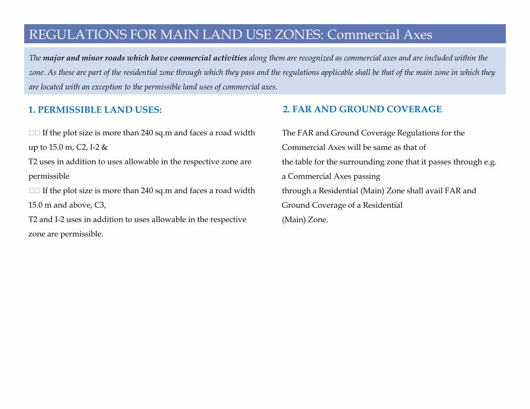
REGULATIONS FOR MAIN LAND USE ZONES: Commercial Axes
The major and minor roads which have commercial activities along them are recognized as commercial axes and are included within the
zone. As these are part of the residential zone through which they pass and the regulations applicable shall be that of the main zone in which they
are located with an exception to the permissible land uses of commercial axes.
FF If the plot size is more than 240 sq.m and faces a road width
up to 15.0 m, C2, I-2 &
T2 uses in addition to uses allowable in the respective zone are
permissible
FF If the plot size is more than 240 sq.m and faces a road width
15.0 m and above, C3,
1. PERMISSIBLE LAND USES:
The FAR and Ground Coverage Regulations for the
Commercial Axes will be same as that of
the table for the surrounding zone that it passes through e.g.
a Commercial Axes passing
through a Residential (Main) Zone shall avail FAR and
Ground Coverage of a Residential
2. FAR AND GROUND COVERAGE
15.0 m and above, C3,
T2 and I-2 uses in addition to uses allowable in the respective
zone are permissible.
Ground Coverage of a Residential
(Main) Zone.

REGULATIONS FOR MAIN LAND USE ZONES: Industrial (General)
This zone supports the establishment of all types of industries.
FFMain land use category: I-5
FF Ancillary land use category: R, C4, U2 & T3
FF Ancillary use allowable up to 10 % of the total land
area.
FF If the road width is more than 15 mtrs, T3 may be
allowed as main land use.
1. PERMISSIBLE LAND USES:
Notes:
a) After leaving minimum setbacks as per the above table if the remaining portion of the plot cannot be used for erecting a
meaningful building, the Authority may insist for set backs as in table.8 or table.9
b) All lands/sites allotted by government agencies like KIADB, KSIIDC etc, for industrial use shall not be permitted to be utilised
for any other use, without the NOC from such departments/ agencies as case may be.
c) TDR is applicable as per rules.

REGULATIONS FOR MAIN LAND USE ZONES: Industrial (Hi-Tech)
This is a priority area for establishment of activities associated with new technologies: IT, IT Enabled Services, BT, electronics, telecom and other
emerging areas and as well as services sector organised in industry format (Back offices, etc). This zone also enables work- home – play
relationship.
FFMain land use category: I-3
FF Ancillary Land use: R, C3, T2 & U4
FF Ancillary use allowable up to 40 % of the total built
up area
Wherever the road width is less than 12m, then on such
1. PERMISSIBLE LAND USES:
lands residential developments may be permitted as
main use.

REGULATIONS FOR MAIN LAND USE ZONES:Public and Semi Public (P&SP)
This zone includes Government owned complexes and civic amenities and large infrastructure facilities of health, education, sports, cultural and
social institutions.
• Main land use category: U4
This shall include Government administrative centres,
district offices, law courts, jails, police stations,
institutional offices, health facilities (including health
1. PERMISSIBLE LAND USES:
tourism), educational, cultural and religious
institutions, community halls, working hostel facilities,
convention centres of non-commercial nature, utilities
and all uses permissible in parks and open spaces.
• Ancillary land use category: R, C2 & T2
• Ancillary uses to the main use shall not exceed 20%
of sital area.

REGULATIONS FOR MAIN LAND USE ZONES:Traffic and Transportation (T&T
Transportation zones are reserved for Transport and Transport related activities such as railway yards, railway station, bus
stands, bus shelters, Road and transport depots, parking areas, airport, special warehousing, cargo terminals and transfer of
cargo between different types of transport (rail, road, air).
• Main land use category: T4 (for MLCP, refer
note below)
• Ancillary land uses: R, U2, C2, I-3
• Ancillary land uses permissible subject to a
condition that the built up area shall not exceed
1. PERMISSIBLE LAND USES:
condition that the built up area shall not exceed
300 sq.m or 5% whichever is higher.
• If the road width abutting the land is less than
12m then I-2, U2 or C2 may be allowed as main
land use or as independent land use.
Note:
• i. When Multi Level Car Parking (MLCP) is proposed on a plot as independent activity, there shall not be any limitation of FAR or
height of building subject to condition that it satisfies fire and airport authority restrictions where ever applicable.
• ii. TDR is applicable as per rules.

REGULATIONS FOR MAIN LAND USE ZONES: Public Utilities (PU)
Public utilities include energy, water, telecommunication, sub stations, gas and gas lines, transformers, and microwave towers and solid waste
management facilities such as land fill sites.
• Notes:
1. The buffer created for accommodating the utilities such as Power, Water Pipeline, Oil pipelines, and High Voltage lines,
gas lines and any other utilities. Each “buffer” is dictated by technical standards specified by the competent authority.
2. The regulations for the above will be decided by the Authority.
3. In case of new developments, these shall remain as non buildable areas and remain as reservations and marked for the
purpose intended. They may be considered for calculation of open spaces within the schemes while approving
building/development and layout plans.building/development and layout plans.
4. For electrical networks, KPTCL standards are followed.

REGULATIONS FOR MAIN LAND USE ZONES: Park and Open Space (P)
The natural and man made features meant for environmental conservation and preservation, including water bodies, forests and drains; parks,
playgrounds, burial grounds and crematoria.
• i. Uses permissible include: Sports grounds,
stadium, playgrounds, parks, swimming
• pools, cemeteries, garden land and crematoria.
• ii. Uses permissible under special circumstances by
the authority: Open air theatres,
• indoor recreational uses, dwelling for watch and
ward, sports clubs, libraries, milk
1. PERMISSIBLE LAND USES:
• Within the demarcated buffer for the valley the following uses are
allowed:
• i. Sewerage Treatment Plants and Water treatment plants
• ii. Roads, pathways, formation of drains, culverts, bridges, etc which
will not obstruct the water course, run offs, channels.
• iii. In case of water bodies a 30.0 m buffer of ‘no development zone’
is to be maintained around the lake (as per revenue records) with
2. VALLEY / DRAIN
ward, sports clubs, libraries, milk
• booths, HOPCOMS, the area of such use shall not
exceed 5% of the total area and shall
• not be more than G+ 1 floor in any case.
• iii. Setbacks for the above will be decided by the
Authority taking into account the
• surrounding development and traffic scenario in
that area.
is to be maintained around the lake (as per revenue records) with
exception of activities associated with lake and this buffer may be
taken into account for reservation of park while sanctioning plans.
• iv. If the valley portion is a part of the layout/ development plan,
then that part of the valley zone could be taken into account for
reservation of parks and open spaces both in development plan and
under subdivision regulations subject to fulfilling section 17 of
• KTCP Act, 1961 and sec 32 of BDA Act, 1976.
• v. Any land falling within the valley for which permission has been
accorded either by the Authority or Government, and then such
permission shall be valid irrespective of the land use classification in
the RMP 2015. Fresh permissions for developments shall not
• be accorded in valley zone.

REGULATIONS FOR MAIN LAND USE ZONES: Agricultural Land (AG)
The area outside the conurbation limits.
FF Agro processing units using locally produced agriculture
produce as raw materials.
FF Urban amenities such as burial grounds, education and health
institutions, sports grounds, stadium, playgrounds, parks and
garden land.
FF Public utilities such as solid waste land fills, water treatment
plants, power plants, fuel stations and other highway amenities
such as weigh bridges, check posts, toll gates, having access to
1. PERMISSIBLE LAND USES:
FF 20 % of the sital area of the land may be used for
educational and health purposes and a building height of
G+1 floor only shall be permitted.
FF For Golf courses on land area which is above 40 ha,
ancillary uses can be permitted up to a maximum of 20 %
of site area subject to a building height of G+1 floor only.
FF For uses other than education, health and Golf
courses, 5% of sital area of the land may be permitted
2. COVERAGE
major roads.
FF Agriculture, Horticulture, Dairy, Milk Chilling centres, Farm
houses and accessory not exceeding 250 sq.m of plinth area within
the plot area limitation of 1.2 Ha limited to G+ 1 floor.
FF Clubs, cultural buildings, exhibition centres, storage and sale of
farm products.
FF Service and repairs of farm machinery.
FF Piggeries and poultry farms, livestock rearing.
FF Brick Kilns.
FF When the land is more than 40.0 ha in extent, Golf course along
with ancillary uses like administrative office, guest rooms/guest
houses and dining facilities are permissible.
subject to a building height of G+1 floor only.
FF Set backs as per Table 8.
Within a radius of 250m from the gramathana (as defined
in the note below) developments required for the natural
growth of the village may be permitted with the following
regulations:
1) FAR : 1.0
2) Maximum no of floors: G+1
3) Setbacks and coverage for the respective uses: As per
Table no 8
3. REGULATION FOR RURAL DEVELOPMENT

REGULATIONS FOR MAIN LAND USE ZONES: Unclassified (UC)
(i) Many of the areas on the planning district maps are under unclassified use and these include Defence and notified
lands. If any discrepancies are observed regarding the boundaries, land use and extent, the authority may take appropriate
decisions. Any disputes shall be referred to the Government and the decision of the Government shall be final.
(ii) In case, any private property is included within the boundary of unclassified and if the owner can establishes that the
ownership of land vests with him/her, the land use adjoining the land shall be assigned to the land in question (to be
decided by the Authority Only )

SUBDIVISION REGULATIONS
a. Road widths: The minimum width of road shall not be less than 9.0 m and the road widths shall not be less than the plot widths
facing the respective road. Every Fourth road in a layout shall have a minimum of 12.0 m width.
b. Area for Residential development: Apart from the provision for amenities and open spaces, the area for residential development
shall be up to a maximum of 55 % of the total land area.
c) Parks / Open spaces and Playgrounds: Parks / Open spaces and Playgrounds shall not be less than 15 % of the total land area.
d) Civic amenities and Roads:
i) After making provision for Parks and roads in the layout, the balance portion of land shall be earmarked for civic amenity site
only. Such CA site shall be relinquished to BDA free of cost and free of encumbrance.
ii) If the area that remains after making provision for road and park is less in extent, then the authority shall have the discretion to
earmark such land for park.earmark such land for park.
iii) When ever the total area proposed for formation of layout exceeds 10 acres, then adequate extent of land may be earmarked for
provision/installation of utilities like transformer, sewage treatment plant, overhead water tank, bus bay/shelter etc.
iv) CA sites owned by Bangalore Development Authority (BDA) could be used for any purpose irrespective of the land use
classification in the Revised Master Plan-2015.
Exemptions:
On request from the land owner, reservations for Parks and Civic Amenities as per subdivision regulations may be dispensed with
by collecting the guideline value of equivalent converted land, in case the land is less than 4,000 sq.m
In case of residential layouts proposed for development by individuals wherein the extent of land is more than 10.0 ha, commercial
uses up to 3 % of total land may be permitted within the permissible percentage of 55 % in one or two blocks only

SUBDIVISION REGULATIONS
General conditions applicable for sub division, amalgamation and Bifurcation of plot:
i. Subdivision
FF The Authority reserves the right to modify the layout submitted by the applicant / owner and may impose any condition either
from planning point of view or in the interest of public.
FF 60 % of the sites shall be released upon issue of work order based on the draft plan. The sites to be released are to be clearly
indicated on the plan along with the phase wise development. The release of sites is subject to relinquishment of civic amenity sites
/ parks & open spaces and roads to the authority free of cost by way of a registered relinquishment deed. 40 % of the sites shall be
released only after the layout is fully developed in terms of utilities and infrastructure. The entire process shall be as per the
government order issued in this regard.
FF The approval of Layout Plan is subject to the condition that the proposal satisfies all the requirements stipulated under section 17
of K.T.C.P Act, 1961 and section 32 of BDA Act, 1976.of K.T.C.P Act, 1961 and section 32 of BDA Act, 1976.
ii.Amalgamation
FF In the case of amalgamation, the proposed sites shall have the same land use.
FF Ownership of the amalgamated plot could be in single or multiple names/family members/ company. But, amalgamation shall
not be considered if the plots are under lease agreement.
FF Development controls for the amalgamated plot shall be with reference to new dimensions.
iii. Bifurcation;
FF In the case of all bifurcations, whether corner site or intermediate site, front setback for the resulting site abutting the road shall
be the same as that of the original site and not that of the subdivided site.
FF A Plot/ Site which is a part of the sub division plan/layout/scheme duly approved by the authority maybe further bifurcated
with prior permission of Authority and the sub divided plot shall not be less than the prescribed size.
FF Bifurcated plot shall not be less than 50 sq mt. Bifurcated plot shall have a minimum of 3.0 m access.
FF The bifurcated plot shall have a minimum of 6.0 m frontage.

REGULATIONS FOR RESIDENTIAL AND NON RESIDENTIAL DEVELOPMENT PLAN
Regulations for Residential Development Plan:
1. 10 % of the land shall be reserved for Park & Open space. The open space (park) shall be relinquished to the authority free of cost
and the same may be allowed to be maintained by the local residents association (registered), if the Authority so desires.
2. A minimum 5 % of total plot area shall be provided for Civic amenities and the owner or developer shall develop such civic
amenities which finally shall be handed over to the local residents association for maintenance. The mode of such handing over shall
be decided by the authority.
3. FAR is calculated on the total land area after deducting Civic amenity site.
4. Parking area requirements shall be as applicable vide Table no: 23
5. Roads as shown in the Revised Master Plan 2015 shall be incorporated within Plan and shall be handed over to the authority free
of cost

REGULATIONS FOR RESIDENTIAL AND NON RESIDENTIAL DEVELOPMENT PLAN
Regulations for Non Residential Development Plan and Flatted Factories
The non residential development plan and flatted industries are approved on the following conditions:
a. 10% of the total area shall be reserved for Parks and Open Spaces, which shall be maintained by the owner to the satisfaction of the
Authority.
b. Parking area requirements shall be as applicable vide Table no: 23. An additional 5% of the plot area shall be reserved for surface
parking.
c. FAR is calculated based on entire sital area excluding the area reserved for Park and Open Spaces.
d. Roads as shown in the Revised Master Plan 2015 shall be incorporated within Plan and shall be handed over to the Authority free
of cost.
e. The FAR and coverage shall be as per Table no 21, below

REGULATIONS FOR RESIDENTIAL AND NON RESIDENTIAL DEVELOPMENT PLAN
Regulation for Integrated Township
‘Integrated Township’ concept is gaining more importance in the
recent times. To give impetus to economic growth and to retain
the vibrancy and dynamism of the urban form for a city like
Bangalore, the concept of ‘Integrated Township’ with minimum
40 Ha of land having access from minimum 18 m road width is a
good approach for the future of
Bangalore.
Permissible in Residential / Commercial / Hi Tech / Industrial
zones
a) Minimum area required - 40 Ha (100 acres).
Other Regulations for approval of integrated town
ship
i. 10% of the total area shall be reserved for parks & open space.
ii. 5% of the site area shall be reserved for public & semi-public
use / CA sites for development for specified C.A. either to the
developer or others on lease basis.
iii. The FAR is calculated on entire area excluding area reserved
for CA.
iv. Road shown in by Revised Master Plan 2015 shall be
incorporated with in the plan and shall be handed over to the
a) Minimum area required - 40 Ha (100 acres).
b) Permissible Land Use
i. Residential
ii. High Tech
iii. Industrial
iv. Commercial
c) Permissible usage (% of allowable usage)
i. Residential - 40%
ii. Non-Residential
;; High-Tech (IT, BT related activities) - 55%
;; Commercial (to support the township) - 05%
d) MinimumRoad width required - 18 Mtrs
authority free of cost.

PARKING REQUIREMENTS AND NORMS

PARKING REQUIREMENTS AND NORMS
(a) Parking provision through building on stilts:
i) Parking provided on the ground floor with the building on stilts, parking area shall be exempt from the calculation of FAR.
ii) All sides of the stilt parking shall be open.
iii) When stilt parking is provided the height shall not exceed 2.4mtrs and the height shall be considered for calculating the total
height of the building
iv) Any place used for parking is not included in the calculation of FAR.
v) In case, additional car parking is provided as part of parking complex or parking lot in excess of required car parking, such area
shall be exempt from reckoning the FAR.
notes
Parking provision on multi level or on any number of floors:
i) Access Ramps, elevators, escalators to the upper floors or terrace floor shall not be provided in the setback area and ramps to be
within the plinth area of the building and shall be exempt from FAR calculation.
ii) Car Parking shall not be provided in the setback areas. If provided, a minimum of 3.0 m shall be left free from the building in case
of G+3 buildings and a minimum of 6.0 m in case of buildings which are G+4 or more.
iii) When Multi Level Car Parking (MLCP) is proposed on a plot as independent activity, there shall not be any limitation for FAR or
height of building subject to condition that they satisfy fire and airport authority restrictions where ever applicable.

FIRE PROTECTION REQUIREMENTS & SAFETY MEASURES AGAINST EARTHQUAKE
The Planning design and construction of any building shall be such as to ensure safety from fire. For this purpose, unless otherwise specified in
these Regulations, the provisions of Part-IV, Fire Protection Chapter and National Building Code shall apply.
For multi-storeyed, high rise and special buildings, additional provisions relating to fire protection contained in Annexure C of NBC shall also
apply. The approach to the building and open spaces on all sides up to 6mtrs width and their layout shall conform to
the requirements of the Chief Officer. They shall be capable of taking the weight of a fire engine weighing up to 18 tonnes. These open spaces shall
be free of any obstruction and shall be motorable
Exits.- Every building meant for human occupancy shall be provided with exits sufficient to permit safe escape of its occupants in
case of fire or other emergency for which the exits shall conform to the following:
i. Types. – Exits should be horizontal or vertical. A horizontal exit may be a door-way, a corridor, a passage-way to an internal
stairway or to an adjoining building, a ramp, a verandah, or a terrace which has access to the street or to the roof of a building. A
vertical exit may be a staircase or a ramp, but not a lift.
ii. General requirement – Exits from all the parts of the building, except those not accessible for general public use, shalla.
provide continuous egress to the exterior of the building or to an exterior open space leading to the street;
b. be so arranged that, except in a residential building, they can be reached without having to cross another occupied unit;
c. be free of obstruction;
d. be adequately illuminated;
e. be clearly visible, with the routes reaching them clearly marked and signs posted to guide any person to the floor concerned;
f. be fitted, if necessary, with fire fighting equipment suitably located but not as to obstruct the passage, clearly marked and with its
location clearly indicated on both sides of the exit way;
g. be fitted with a fire alarm device, if it is either a multi-storeyed, high use or a special building so as to ensure its prompt
evacuation;
h. remain unaffected by any alteration of any part of the building so far as their number, width, capacity and protection thereof is
concerned;

FIRE PROTECTION REQUIREMENTS & SAFETY MEASURES AGAINST EARTHQUAKE
i. be so located that the travel distance on the floor does not exceed the following limits:
1. Residential, educational, institutional and hazardous occupancies: 22.5mtrs.
2. Assembly, business, mercantile, industrial and storage building: 30mtrs.
Note: The travel distance to an exit from the dead end of a corridor shall not exceed half the distance specified above. When more
than one exit is required on a floor, the exits shall be as remote from each other as possible: Provided that for all multi-Storeyed high
rise and special buildings, a minimum of two enclosed type staircases shall be provided, at least one of them opens directly to the
exterior to an interior open space or to any open place of safety.
(iii) Number and width of exits – The width of an exit, stairway / corridor and exit door to be provided at each floor in occupancies
of various types shall be as shown in columns 3 & 5 of Table 23. Their number shall be calculated by applying to every 100 sq. m. of
the plinth or covered area of the occupancy,
SafetyMeasures against Earthquake
Buildings with ground plus four floors and above or buildings with a height of 15 mtrs. and above shall be designed and constructed
adopting the norms prescribed in the National Building Code and in the “Criteria for earthquake resistant design of structures”
bearing No. IS 1893-2002 published by the Bureau of Indian Standards, making the buildings resistant to earthquake. The
supervision certificate and the completion certificate of every such building shall contain a certificate recorded by the Registered
Engineer / Architect that the norms of the National Building Code and I.S. 1893-2002 have been followed in the design and
construction of buildings for making the buildings resistant to earthquake.

FIRE PROTECTION REQUIREMENTS & SAFETY MEASURES AGAINST EARTHQUAKE

TRANSFER OF DEVELOPMENT RIGHTS (TDR)
When an area with in the local planning area is required for public purpose (i.e. road, widening of road, parks, etc.) the
owner of any site or land which comprises of such area surrenders it free of cost and hands over possession of the same to the
planning authority /Local Authority free of cost and encumbrance. The Planning Authority / Local Authority permits
development rights in the form of additional floor area which shall be equal to one and half times the area surrendered. The
development rights so permitted may be utilised either at the remaining portion of the area after surrender or any where in
the LPA, either by himself or by transfer to any other person.