land use dynamics and floral diversity of southern...
TRANSCRIPT
Land use dynamics and Floral diversity of Southern Montane Wet Temperate Forests in
Chikmagalur, Central Western Ghats, India.
Gouri Kulkarni1, Sudarshan P. Bhat1, G.R. Rao1, C. Balachandran1, Vishnu Mukri1, Sreekanth Naik 1
Bharath Settur1, M.D. Subash Chandran 1, Ramachandra T.V1,2,3
¹ Energy & Wetlands Research Group, Centre for Ecological Sciences [CES]
² Centre for Sustainable Technologies (astra) 3 Centre for infrastructure, Sustainable Transportation and Urban Planning [CiSTUP]
Indian Institute of Science, Bangalore, Karnataka, 560 012, India
Author for correspondence: [email protected]
The Western Ghats is rich biodiversity region considered as one of the 35 biodiversity hotspots
(also one among eight hottest hotspots of biodiversity) of the world (http://www.conservation.org).
The region with a wide forest types ranging from tropical wet evergreen forests to grasslands is a
repository of flora and fauna evident from the occurrence of over 4,000 species of flowering plants
(38% endemics), 330 butterflies (11% endemics), 156 reptiles (62% endemics), 508 birds (4%
endemics), 120 mammals (12% endemics), 289 fishes (41% endemics) and 135 amphibians (75%
endemics). The forests of Western Ghats, in view of their floristic diversity and numerous
multipurpose species, are considered as storehouse of economically important plants. The tropical
climate complimented by heavy precipitation from southwest monsoon and favorable edaphic
factors create an ideal condition for the rich biodiversity, which can be seen only in few parts of
the world. These forests which lost their earlier aura of sacredness (during community-based
management regime) did not get any special consideration from the state and were subjected to
routine forestry operations to meet state needs, harming their special biodiversity preserved
through ages.
The stretch of Central Western Ghats ranges from 12° to 15° covering areas of Coorg district,
Hassan, Chikmagalur, Shimoga upto south of Uttara Kannada. Chikmagalur district of Karnataka
state is situated in the heart of the Western Ghats region. The Malanad region consists of Western
Ghats chain from where many rivers originate and the inland plain region of Deccan plateau. Such
regions always have high priority for conservation, primarily for the diversity and for the provision
of the ecosystem goods and services.
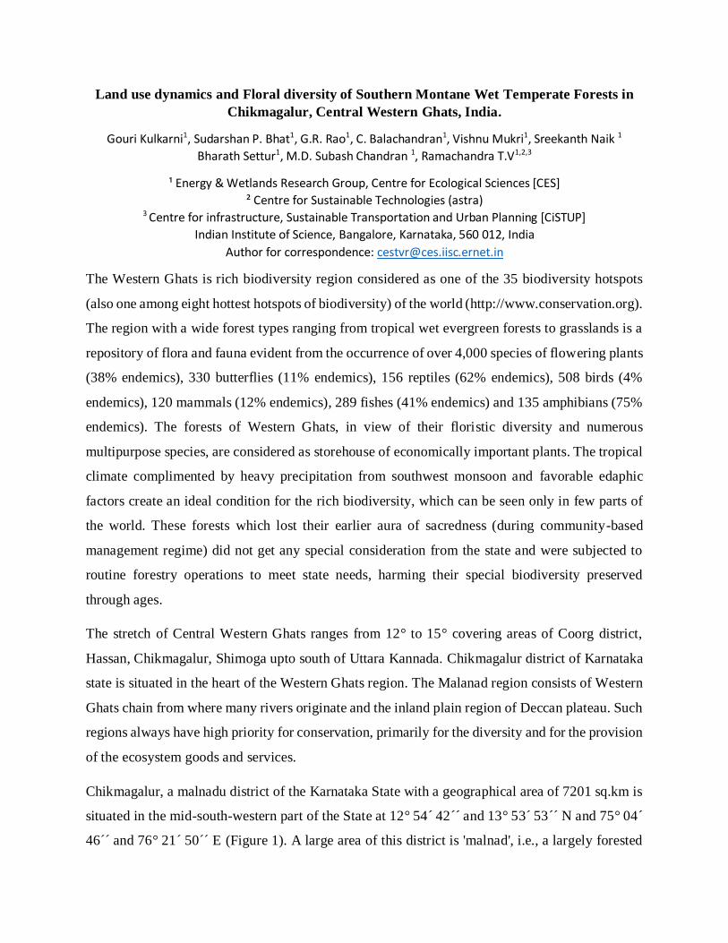
Chikmagalur, a malnadu district of the Karnataka State with a geographical area of 7201 sq.km is
situated in the mid-south-western part of the State at 12° 54´ 42´´ and 13° 53´ 53´´ N and 75° 04´
46´´ and 76° 21´ 50´´ E (Figure 1). A large area of this district is 'malnad', i.e., a largely forested
hilly region of heavy rainfall. Its greatest length from east to west is about 138.4 kilometers and
from north to south 88.5 kilometers. It is bounded on the east by the Tumkur district, on the south
by the Hassan district, on the west by the Western Ghats which separate it from the Dakshina
Kannada district, on the north east by the Chitradurga district and on the north by the Shimoga
district. The district takes its name from the headquarters town of Chikmagalur, which literally
means younger daughter's town- Chikka Magala Ooru (in Kannada). Situated in a fertile valley
south of the Baba-Budan hill range is the headquarters town of the district. The town enjoys
ahealthy climate. The average annual rainfall of 1772 mm. Kadur taluk receives the lowest rainfall
of 620 mm whereas Sringeri receives the highest rainfall amounting to 3773 mm.
Figure 1: Study region - Chikmagalur district, Karnataka State, India
Landscape Dynamics and fragmentation
Landscape refers to the heterogeneous land features composed of sets of interacting ecosystems
and is characterized essentially by its dynamics that are partly governed by human activities
(Ramachandra et al., 2012). Human induced land cover and land use changes are considered as
one of the pervasive sources of alteration on Earth’s surface (Houet et al., 2010). Land cover and
land use (LULC) changes essentially influenced by the enhanced anthropogenic activities.
12° 54´ 42´́ N
76° 21´ 50´´ E
13° 53´ 53´´N
75° 04´ 46´´ E
0 10 20 30 405Kilometers

Consequences of land use changes poses a serious threat to
ecological sustainability of the region (Ramachandra and Uttam Kumar, 2011).
Fragmentation in landscape and especially in forests is a serious threat. Fragmentation implies
division of landscape into smaller parts which results in uneven
separation, size and disconnectivity between population and similar ecosystems (Forman 1995;
Griffiths et al, 2000). Fragmentation of an ecosystem tends to cause constriction of patch area and
terminate the flow of resources among the patches (Rutledge 2003).
Forest fragmentation is process of isolation of forest patches which results in change of
composition, structure, extent and spatial patterns through human induced activities (Roy et al.,
2013). Fragmentation of landscape have been quantified by change in spatial characteristics and
configuration of remaining patches (Saunders et al. 1987). Various ecological effect of forest
fragmentations are loss of species populations, increased isolation of remnant populations,
inbreeding (Laurance et al. 1998, Boyle 2001), enhanced human-animal conflicts, decline in
ecosystem goods and services, etc. This necessitates understanding of the causes of forest and
habitat fragmentations, in order to evolve effective management strategies for conservation.
Remote sensing (RS) data acquired through space borne sensors available post 70’s at regular
intervals can be used as one of the major tools to understand LULC dynamics and quantify the
extent of forest fragmentation (Gustafson 1998; Turner & Gardner 1991). Remotely sensed (RS)
data in conjunction with geographic information systems have been successfully utilized to
quantify forest loss as well as forest fragmentation (Jha et al., 2005). Temporal analysis of the
spatial data provides an idea of the extent of changes happening in the landscape. Land use
details derived from temporal RS data offer potential for assessing the changes in land uses,
forest fragmentation and its impact on ecology and biodiversity (Ramachandra et al., 2011).
Categorization and understanding of forest fragmentation using spatial data (RS data)
provides a picture of the degree and extent of fragmentation, which are useful for conservation of
the affected habitat fragments (O’Neill et al., 1997).
The satellite data of Landsat series Multispectral sensor, thematic mapper and IRS LISS III
sensors for four decade period (1976 to 2009) were acquired from Global Land Cover Facility
(GLCF), (United States Geological Survey (USGS), Earth Explorer, Glovis websites and Bhuvan
website as indicated in Table 1.

Table 1: Details of the data used in the analysis
Data used Resolution Acquisition
data Purpose
Landsat Series Multispectral sensor
57.5m 17/11/1976 Land cover, Land use analysis and Fragmentation analysis
Landsat Series Thematic mapper
28.5m
02/01/1991
and 20/12/2000
Land cover, Land use analysis and
Fragmentation analysis
IRS LISS III 23.5m 15/12/2009 Land cover, Land use analysis and Fragmentation analysis
Survey of India (SOI) toposheets of 1:50000 and 1:250000 scales
To Generate boundary and Base layer maps.
Field visit data –captured using GPS
For geo-correcting and generating validation dataset
Google earth and Bhuvan For digitizing various attribute data and as validation input
Assessment of landscape dynamics involved (i) Temporal analysis of
land cover and land use using remote sensing data, (ii) Quantification of natural forests, (iii)
Assessment of extent of forest fragmentation due to encroachment (subsequent changes in land
uses). The procedure followed to assess landscape dynamics is outlined in Figure 2.
Spatiotemporal changes of land cover and land use (LULC) were analysed using temporal remote
sensing data with geospatial techniques. Spatial data acquired through space borne sensors at
regular intervals since 1970’s aid in monitoring of large areas and enable the change analyses at
local, regional scales over time (Wilkie and finn, 1996). Remote sensing data along with field
data collection using pre-calibrated GPS (Global Positioning system) help in effective land use
analysis (Ramachandra et al., 2012).
The remote sensing data obtained were geo-referenced, rectified and cropped pertaining to the
study area. Geo-registration of remote sensing data (Landsat data) has been done using ground
control points collected from the field using GPS and also from known points (such as road
intersections, etc.) collected from geo-referenced topographic maps published by the Survey of
India.
Remote sensing data requires preprocessing like atmospheric correction and geometric correction
in order to enable correct area measurements, precise localization and multi-source data process
of referencing an image to a geographic location (real earth surface positions) using GCP’S
(ground control points). Landsat satellite 1976 data have a spatial resolution of 57.5 m
x 57.5 m (nominal resolution) were resampled to 28.5 m comparable to the 1991- 2009 data
which are 28.5 m x 28.5 m (nominal resolution).
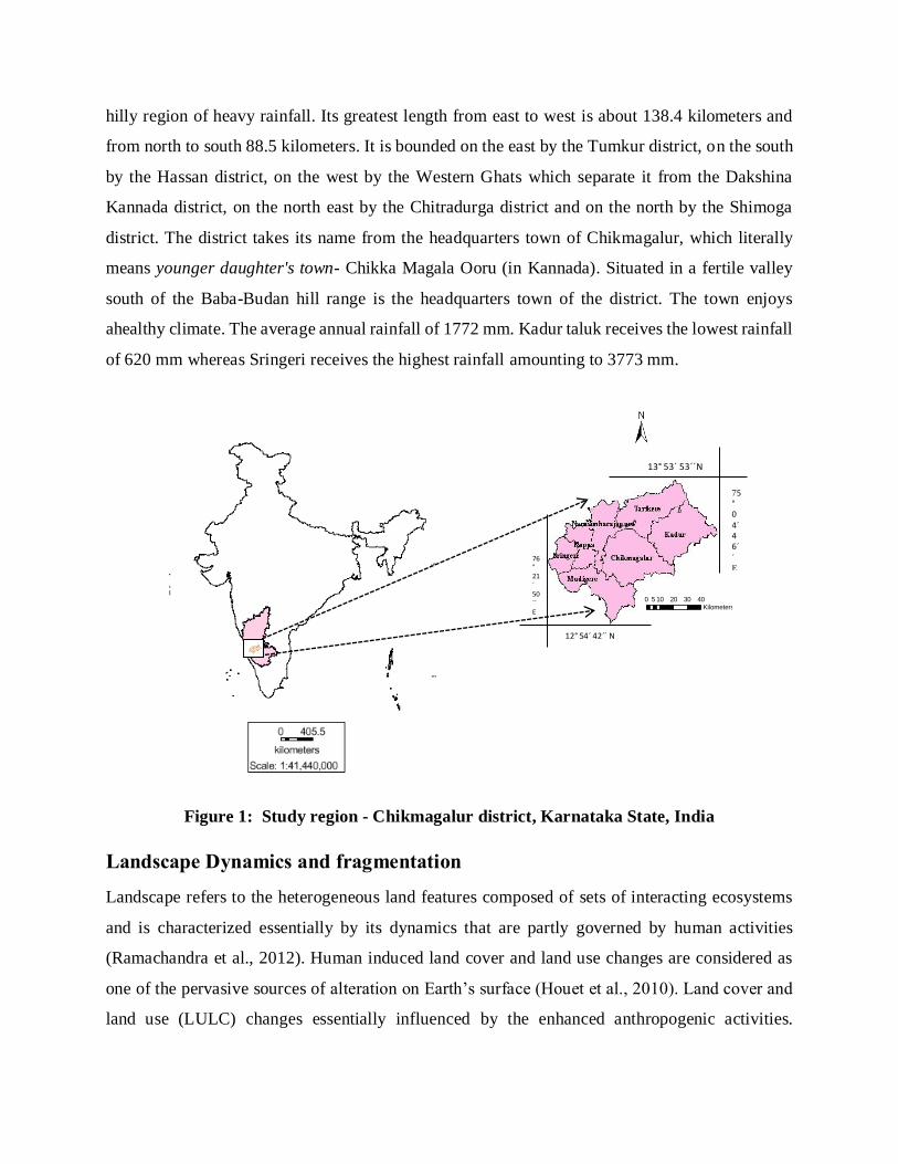
LAND COVER ANALYSIS Land cover is the first level of classification method that
helps in understanding land cover types of the region broadly. The vegetation indices indicate the
extent of the vegetation and soil in the region. In this study, the Normalized Difference Vegetation
Index (NDVI) was used to calculate the land
cover types. The vegetation change analysis for multi-temporal data can be done using NDVI
(Ramachandra et al 2009, Ramachandra et al., 2011). NDVI is calculated using Near Infrared
and Red Bands data using equation (1), NDVI values ranges from -1 to 1. The negative value
indicates the non-vegetation and presence of built-up, water, sand etc. The increasing positive
value from 0 indicates the presence of vegetation, higher value close to 1 indicates thick vegetation.
NDVI =NIR−IR
NIR+IR………. (1)
LAND USE ANALYSIS
This involved i) generation of False Color Composite (FCC) of remote sensing data (bands – green,
red and NIR). This helped in locating heterogeneous patches in the landscape ii) selection of
training polygons (these correspond to heterogeneous patches in FCC) covering 15% of the study
area and uniformly distributed over the entire study area, iii) loading these training polygons co-
ordinates into pre-calibrated GPS, iv) collection of the corresponding attribute data (land use types)
for these polygons from the field. GPS helped in locating respective training polygons in the field,
v) supplementing this information with Google Earth, vi) 60% of the training data has been used
for classification, while the balance is used for validation or accuracy assessment.
The land use analysis was carried out with training data using supervised classification technique
based on Gaussian Maximum Likelihood algorithm. The supervised classification approach
preserves the basic land use characteristics through statistical classification techniques using a
number of well-distributed training pixels. Gaussian Maximum Likelihood classifier (GMLC) is
appropriate and efficient technique based on “ground truth” information for classifier learning.
Supervised training areas are located in regions of homogeneous cover type. All spectral classes
in the scene are represented in the various subareas and then clustered independently to determine

their identity. The following classes of land use were examined: built-up, water, cropland, open
space or barren land, and forest. Such quantitative assessments, will lead to a deeper and more
robust understanding of land-use changes for an appropriate policy intervention. GRASS
GIS (Geographical Analysis Support System), a free and open source software having the robust
support for processing both vector and raster files accessible at
http://wgbis.ces.iisc.ernet.in/grass/index.phpis used for the analysis.
Figure 2: LULC and fragmentation analysis
Forest fragmentation analysis was performed to quantify the type of forest in the study area patch,
transitional, edge, perforated and interior based on the classified images of Chikmagalur
district. Forest fragmentation statistics and the total extent of forest (pf) and its occurrence as
adjacent pixels (pff) is computed through fixed-area window (3x3) considering central pixel and
its surrounding pixels (Riitters et al., 2000, Ramachandra et al., 2011). The result is stored at the
location of the central pixel. Thus, a pixel value in the derived map refers to between-pixel
Land use classified
data
Grass
Reclassification of
categories
Fragmentation
Analysis
Analysis of results
Landsat/IRS Image Downloads (GLCF,
GLOVIS and Earth Explorer)
Geo-rectification
Band extraction
Sub-setting of images using study area
Land cover analysis using NDVI
Image classification
Maximum likelihood
Classification
Accuracy assessment and error
matrix generation
Training data Collection
Interpretation of results
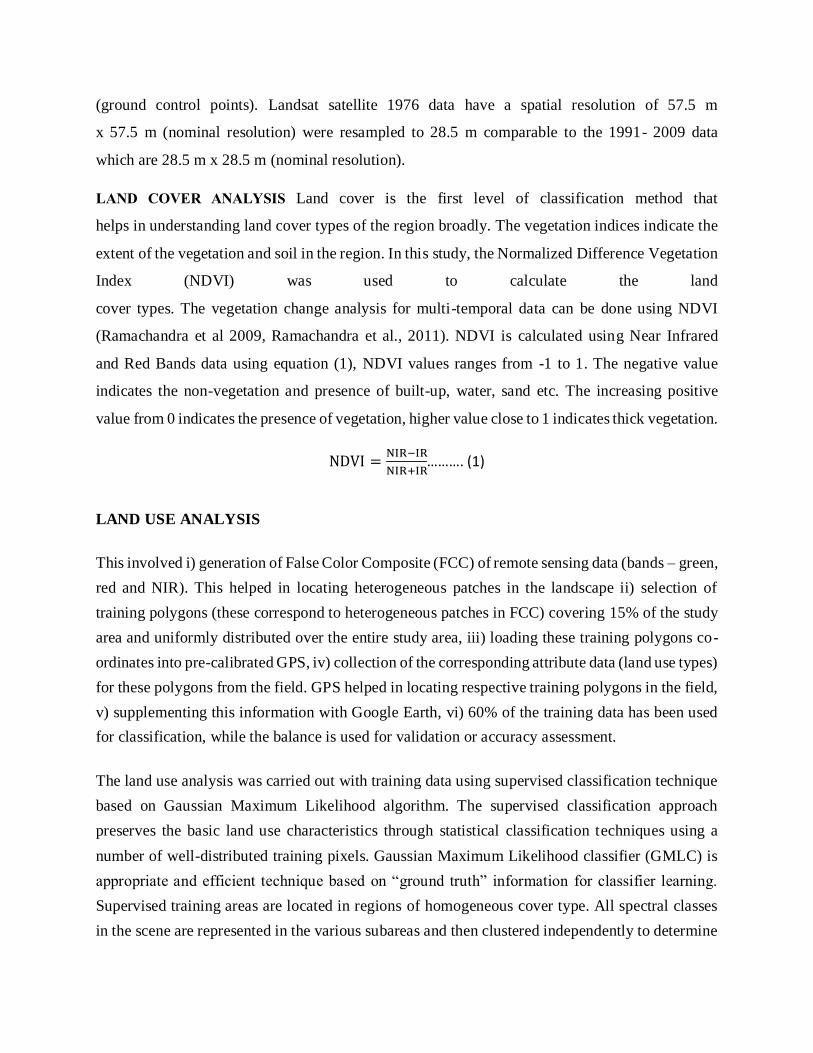
fragmentation around the corresponding forest location. Forest fragmentation category at pixel
level is computed through Pf (the ratio of pixels that are forested to the total non-water pixels in
the window) and Pff (the proportion of all adjacent (cardinal directions only) pixel pairs that
include at least one forest pixel, for which both pixels are forested). Pff estimates the conditional
probability that given a pixel of forest, its neighbor is also forest. Based on the knowledge of Pf
and Pff, six fragmentation categories derived (Figure 3) are (i) interior, when Pf= 1.0, (ii)
Patch, when Pf < 0.4; (iii) transitional, when 0.4 < Pf < 0.6; (iv) edge, when Pf > 0.6 and Pf –
Pff> 0; (v) perforated, when Pf > 0.6 and Pf– Pff< 0, and (vi) underestimated, when Pf > 0.6 and
Pf = Pff.
1976
1991
2000
2009
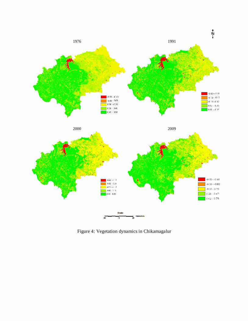
Figure 4: Vegetation dynamics in Chikamagalur

Figure 3: Forest Fragmentation using PF and PFF
Land cover analysis: Land cover analysis through NDVI shows the percentage of area under
vegetation and non-vegetation. NDVI is based on the principle of spectral difference based on
strong vegetation absorbance in the red and strong reflectance in the near-infrared part of the
spectrum. Figure 3.3 and Table 3.2 illustrates the spatio-temporal changes in the land cover of
the region, which highlight the decline of vegetation cover from 96.62 (1976) to 93.6% (2009).
Table 2: Extent of vegetation cover during 1976, 1990, 2002 and 2009
Land cover (%)
Year Vegetation Non-vegetation
1976 96.62 3.38
1991 94.43 5.57
2000 94.28 5.72
2009 93.60 6.40
Land use analysis: The changes in the land uses at landscape level during 1976 to 2009 are
highlighted in the Figure 5 and Table 3. This shows the decline of forests from 50.74% (1976)
to 36% (2009). Table 4 lists category wise land uses in percentage and Table 5 provides the
accuracy assessment details.
Table 3: Land use statistics in Hectares
Land use categories (Hectares)
Years Forest Urban Plantation Agriculture Water bodies
Others
1976 365,541.08 365.88 89,105.83 243,307.46 8781.52 14,894.00
1991 344,445.96 1228.60 102,724.69 231,948.04 12,534.45 26,889.70
2000 299,549.97 1548.91 150,583.68 228,137.15 14,240.50 25,790.61
2009 261,520.87 1783.18 171,558.74 238,985.04 13,339.59 32,486.38
Table 4: Land use statistics in Percentage
Land use categories (percentage)
Years Forest Urban Plantation Agriculture Water bodies Others
1976 50.74 0.05 12.35 33.61 1.21 2.06
1991 47.85 0.17 14.27 32.23 1.74 3.74
2000 41.61 0.21 20.09 31.69 1.98 3.58
2009 36.33 0.25 23.84 33.20 1.85 4.51
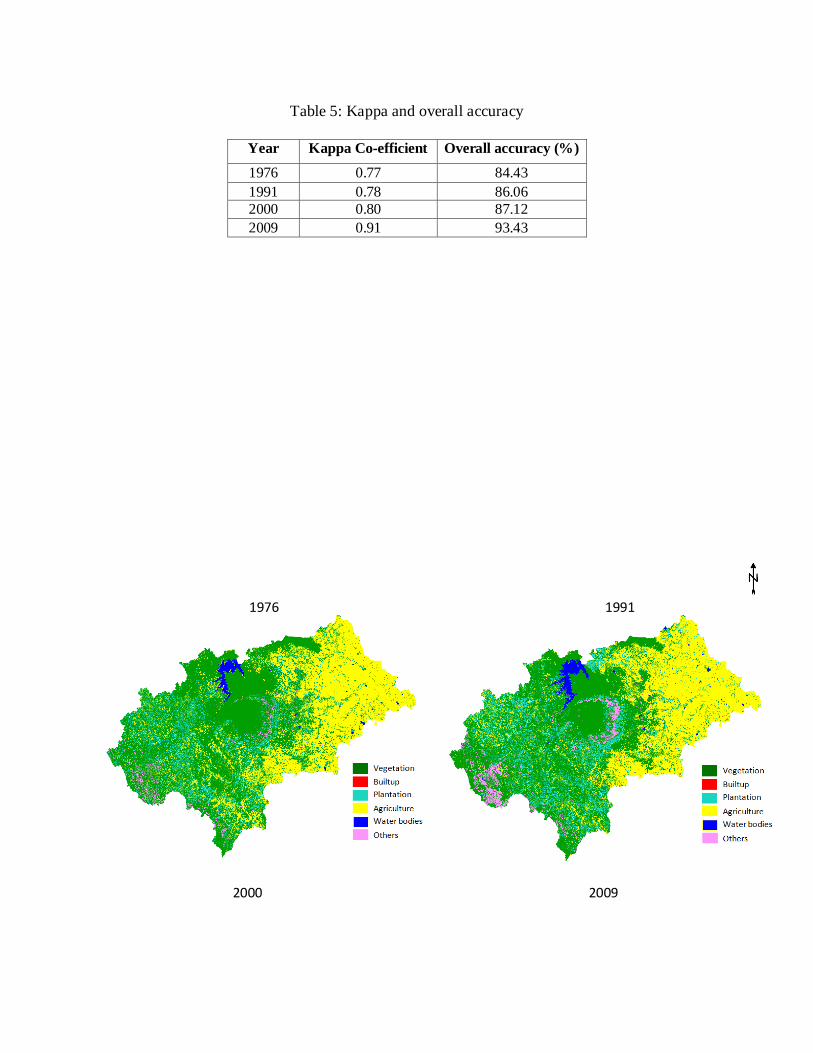
Table 5: Kappa and overall accuracy
Year Kappa Co-efficient Overall accuracy (%)
1976 0.77 84.43
1991 0.78 86.06
2000 0.80 87.12
2009 0.91 93.43
1976
1991
2000 2009
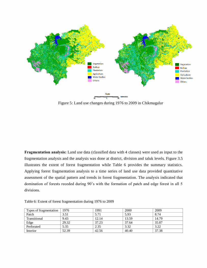
Figure 5: Land use changes during 1976 to 2009 in Chikmagalur
Fragmentation analysis: Land use data (classified data with 4 classes) were used as input to the
fragmentation analysis and the analysis was done at district, division and taluk levels. Figure 3.5
illustrates the extent of forest fragmentation while Table 6 provides the summary statistics.
Applying forest fragmentation analysis to a time series of land use data provided quantitative
assessment of the spatial pattern and trends in forest fragmentation. The analysis indicated that
domination of forests receded during 90’s with the formation of patch and edge forest in all 5
divisions.
Table 6: Extent of forest fragmentation during 1976 to 2009
Types of fragmentation 1976 1991 2000 2009
Patch 3.51 5.71 5.93 8.74
Transitional 9.43 12.14 13.59 14.79
Edge 29.32 37.23 37.64 35.87
Perforated 5.35 2.35 3.32 3.22
Interior 52.39 42.56 40.40 37.38

Forests in Chikmagalur district are administered through five divisions – Chikmagalur, Koppa,
Bhadravathi, Kudremukh National park and Bhadra Wildlife Sanctuary. The quantification of
extent of forest fragmentation has been done division-wise for the past four decades to enable the
respective division administration to undertake appropriate forest restoration measures to
minimize fragmentation of ecologically important ecosystems. Land use changes from forests to
non-forests with intensified human interference had been very high especially in Bhadravathi,
Chikmagalur division. Interior forest decreased by 94.48 (1976) to 74.4 (2009). In Bhadravathi
division interior forest decreased by 52.54 (1976) to 34.31 (2009) and patch increased by 5.73
(1976) to 13.52 (2009). Chikmagalur division interior forest was about of 39.68 in 1976 which
was decreased to 23.75 in 2009. Interior forest in Koppa decreased by 52.82 (1976) to 32.27
(2009) and in Kudremukh interior forest decreased by 42.72 (1976) to 35.05 (2009). Figure 7
to Figure 11 represents the forest fragmentation and Table 7 to Table 11 gives
statistics for extent of forest fragmentation division wise.
Similarly, the forests of Chikmagalur district are administered through seven taluks –
Chikmagalur, Koppa, Kadur, Narasimharajapura, Mudigere, Sringere and Tarikere. Figure 12
to Figure 18 represents the forest fragmentation taluk wise and Table 12 to Table 18
gives statistics for extent of forest fragmentation. In taluk level forest fragmentation analysis, the
interior forest in Chikmagalur taluk decreased by 55.74 (1976) to 38.68% (2009). In Kadur taluk,
the interior forest decreased by 15.74 (1976) to 13.34% (2009) and Patch forest increased by
19.76 (1976) to 27.43% (2009). In Koppa taluk interior forest decreased by 45.09 (1976) to
22.83% (2009) and Patch increased by 1.31 (1976) to 10.46% (2009) due to human induced
activities. In Mudigere, interior forest decreased by 40.72 (1976) to 27.48% (2009). The
Narasimharajapura taluk had massive changes in edge forest due to agricultural activities.
Sringere had 46.87% interior forest in 1976 which decreased to 28.55% in 2009 and Tarikere had
interior forest of about 60.60% which decreased to 48.51%.
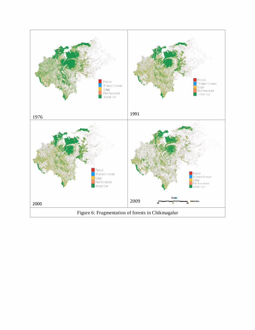
1976
1991
2000
2009
Figure 6: Fragmentation of forests in Chikmagalur
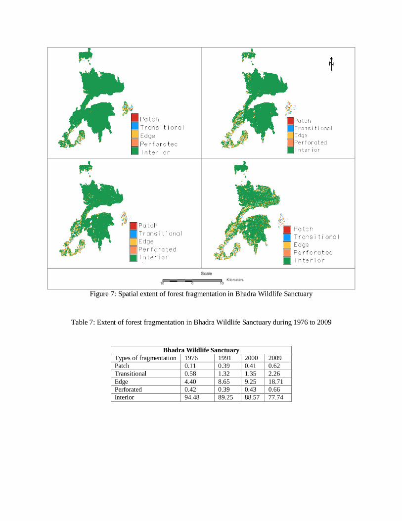
Figure 7: Spatial extent of forest fragmentation in Bhadra Wildlife Sanctuary
Table 7: Extent of forest fragmentation in Bhadra Wildlife Sanctuary during 1976 to 2009
Bhadra Wildlife Sanctuary
Types of fragmentation 1976 1991 2000 2009
Patch 0.11 0.39 0.41 0.62
Transitional 0.58 1.32 1.35 2.26
Edge 4.40 8.65 9.25 18.71
Perforated 0.42 0.39 0.43 0.66
Interior 94.48 89.25 88.57 77.74
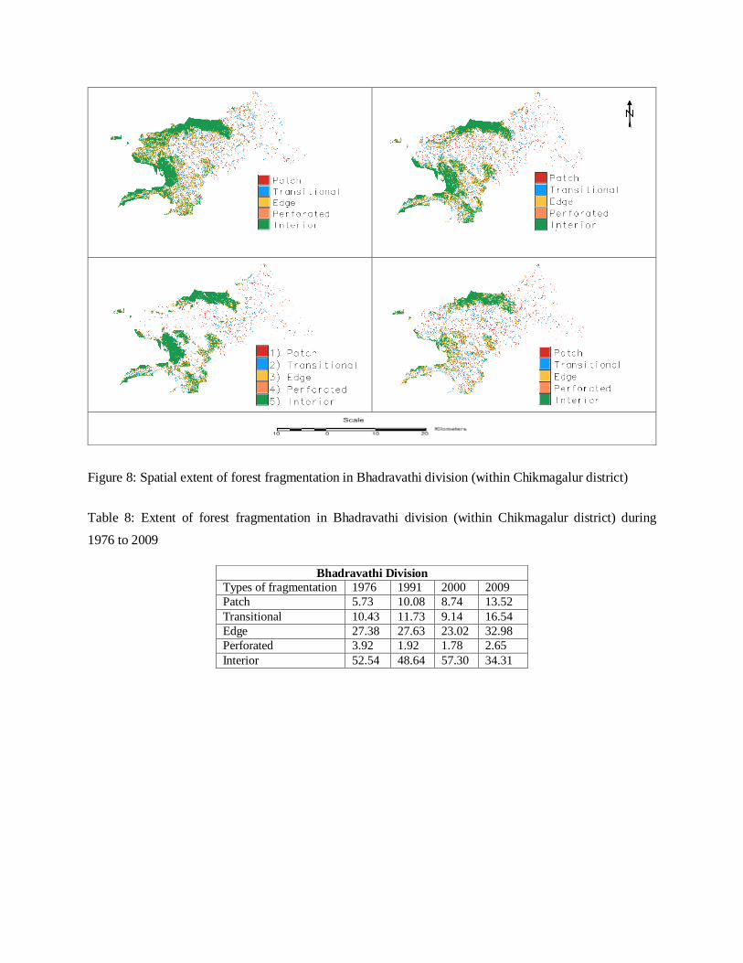
Figure 8: Spatial extent of forest fragmentation in Bhadravathi division (within Chikmagalur district)
Table 8: Extent of forest fragmentation in Bhadravathi division (within Chikmagalur district) during
1976 to 2009
Bhadravathi Division
Types of fragmentation 1976 1991 2000 2009
Patch 5.73 10.08 8.74 13.52
Transitional 10.43 11.73 9.14 16.54
Edge 27.38 27.63 23.02 32.98
Perforated 3.92 1.92 1.78 2.65
Interior 52.54 48.64 57.30 34.31
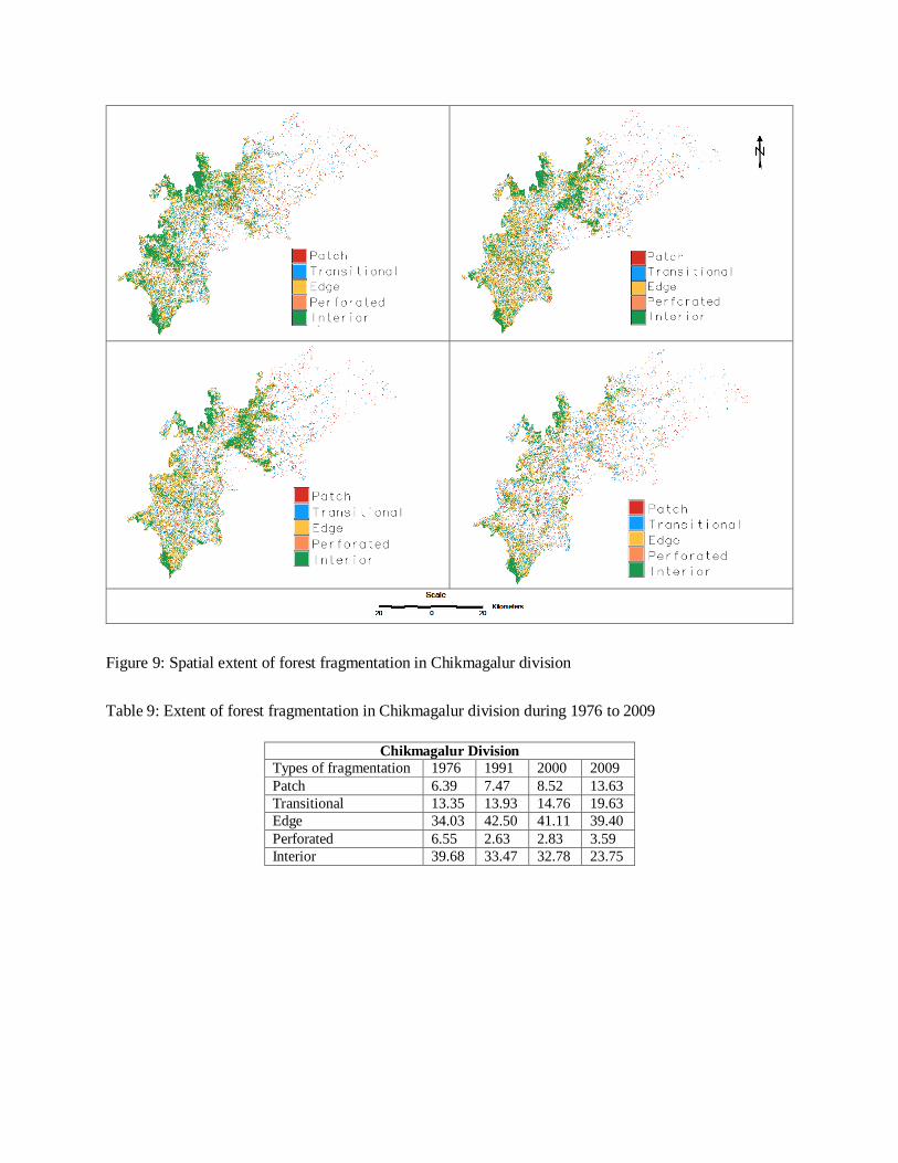
Figure 9: Spatial extent of forest fragmentation in Chikmagalur division
Table 9: Extent of forest fragmentation in Chikmagalur division during 1976 to 2009
Chikmagalur Division
Types of fragmentation 1976 1991 2000 2009
Patch 6.39 7.47 8.52 13.63
Transitional 13.35 13.93 14.76 19.63
Edge 34.03 42.50 41.11 39.40
Perforated 6.55 2.63 2.83 3.59
Interior 39.68 33.47 32.78 23.75

Figure 10: Spatial extent of forest fragmentation in Koppa division
Table 10: Extent of forest fragmentation in Koppa during 1976 to 2009
Koppa Division
Types of fragmentation 1976 1991 2000 2009
Patch 1.41 4.36 4.97 6.98
Transitional 8.27 13.70 13.99 15.18
Edge 30.77 42.68 42.21 38.65
Perforated 6.72 2.65 2.51 3.92
Interior 52.82 36.62 36.31 35.27

Figure 11: Spatial extent of forest fragmentation in Kudhremukh division
Table 11: Extent of forest fragmentation in Kudhremukh Division during 1976 to 2009
Kudremukh Division
Types of fragmentation 1976 1991 2000 2009
Patch 1.81 4.40 4.18 4.73
Transitional 9.44 13.62 12.88 13.44
Edge 41.63 46.41 46.53 42.88
Perforated 4.33 3.35 2.91 3.90
Interior 42.79 32.22 33.51 35.05
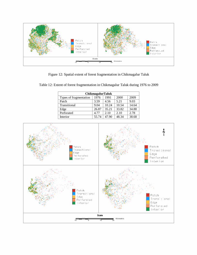
Figure 12: Spatial extent of forest fragmentation in Chikmagalur Taluk
Table 12: Extent of forest fragmentation in Chikmagalur Taluk during 1976 to 2009
ChikmagalurTaluk
Types of fragmentation 1976 1991 2000 2009
Patch 3.59 4.56 5.21 9.03
Transitional 9.04 10.24 10.54 14.64
Edge 26.87 35.21 33.82 34.88
Perforated 4.77 2.10 2.10 2.78
Interior 55.74 47.90 48.34 38.68

Figure 13: Spatial extent of forest fragmentation in Kadur Taluk
Table 13: Extent of forest fragmentation in Kadur taluk during 1976 to 2009
Figure 14: Spatial extent of forest fragmentation in Koppa Taluk
Table 14: Extent of forest fragmentation in Koppa taluk during 1976 to 2009
KadurTaluk
Types of fragmentation 1976 1991 2000 2009
Patch 19.76 23.83 22.92 27.43
Transitional 23.04 20.12 18.03 23.87
Edge 33.65 31.88 31.20 31.10
Perforated 7.81 2.54 3.31 4.22
Interior 15.74 21.64 24.55 13.37
KoppaTaluk
Types of fragmentation 1976 1991 2000 2009
Patch 1.31 7.15 8.13 10.46
Transitional 9.79 19.66 20.25 20.92

Figure 15: Spatial extent of forest fragmentation in Mudigere Taluk
Table 15: Extent of forest fragmentation in Mudigere taluk during 1976 to 2009
Edge 34.31 48.68 48.19 39.69
Perforated 9.51 2.90 2.97 6.10
Interior 45.09 21.61 20.46 22.83
MudigereTaluk
Types of fragmentation 1976 1991 2000 2009
Patch 2.87 4.28 5.20 8.68
Transitional 11.82 14.29 15.55 17.86
Edge 38.03 48.95 47.96 42.45
Perforated 6.56 2.92 3.04 3.54
Interior 40.72 29.55 28.25 27.48

Figure 16: Spatial extent of forest fragmentation in Narasimharajapura Taluk
Table 16: Extent of forest fragmentation in Narasimharajapura taluk during 1976 to 2009
NarasimharajapuraTaluk
Types of fragmentation 1976 1991 2000 2009
Patch 1.05 1.64 1.93 3.08
Transitional 4.66 6.23 6.39 7.98
Edge 20.70 27.91 27.29 32.77
Perforated 2.55 1.96 1.60 1.91
Interior 71.03 62.27 62.78 54.27

Figure 17: Spatial extent of forest fragmentation in Sringere Taluk
Table 17: Extent of forest fragmentation in Sringeri Taluk during 1976 to 2009
Sringere Taluk
Types of fragmentation 1976 1991 2000 2009
Patch 0.88 5.17 5.56 6.45
Transitional 7.70 16.54 15.41 15.90
Edge 37.28 50.77 50.10 43.90
Perforated 7.28 3.33 2.91 5.21
Interior 46.87 24.20 26.02 28.55

Figure 18: Spatial extent of forest fragmentation in Tarikere Taluk
Table 18: Extent of forest fragmentation in Tarikere taluk during 1976 to 2009
Temporal Land cover analysis emphasized the decline of forest cover from 96.62 (1976) to
93.60% (2009). Spatio-temporal land use analysis indicated the increase of built-up patches from
0.05 to 0.25% (2009). The results also showed the conversion of forest areas for agricultural and
development activities which reflects the fragmentation of forest patches.
Forest fragmentation analysis showed the decline in interior forests from 1976 to 2009 and
domination of edge and patch forest in all division. Land use changes from forests to non-forests
with intensified human interference had been very high especially in Bhadravati and
Chikmagalur division. Koppa showed more fragmented forest patches with increased edge and
patch forest. The extent of interior forest declined in last few years in Kudhremukh National Park
due to mining/ quarrying activities. Bhadra wild life Sanctuary also showed decline in forest
cover.
Forest fragmentation analysis at taluk level showed increased decline in forests in Chikmagalur,
Kadur, Sringeri taluk. Koppa and Narasimharajapura taluk with increased Transitional and Patch
forests due to human alterations in between the forest areas. Decline of interior forest in
Mudigere is due to mining activities. Tarikere taluk also showed degraded forests with time.
Tarikere Taluk Types of fragmentation 1976 1991 2000 2009
Patch 4.66 7.91 6.29 9.95
Transitional 8.73 9.30 6.63 12.36
Edge 22.73 21.66 16.87 27.16
Perforated 3.29 1.49 1.31 2.01
Interior 60.60 59.64 68.89 48.51

The Chikmagalur district forest consists of evergreen and semi-evergreen climax forests and their
degradation types and deciduous climax forests and their degradation types (Pascal et.al, 1982).
The evergreen and semi-evergreen climax forests and degradation type consists following
categories: Dipterocarpus indicus-Humboldia brunonis-Poeciloneuron indicum type,
Dipterocarpus indicus-Diospyrus candolleana-Diospyros oocarpa type, Dipterocarpus indicus-
Persea macrantha type, Persea macrantha-Diospyros spp.- Holigarna spp. type, Diospyros spp.-
Dysoxylum malabaricum-Persea macrantha Kan forest type of low elevation (0-850m) Mesua
ferrea-Palaquium ellipticum type, Palaquium ellipticum Poeciloneuron indicum-Hopea
canarensis type of medium elevation (800-1400 m) and Schefflera spp.-Gordonia obtusa-
Meliosma arnottiana type. The secondary or degraded type contains secondary Evergreen, Semi-
evergreen and moist deciduous forests. The Deciduous climax forests consist of moist deciduous
type-Lagerstoemia microcarpa-Tectona grandis Dillenia pentagyne type and dry deciduous-
Anogeissus latifolia–Tectona grandis-Terminalia tomentosa type (Figure 2). The areas of different
types of forests are given in Table 19 and spatial distribution is given in Figure 19.
Table 19: Spatial extent of different classes of forests (Pascal et.al, 1982)
Forest Type Area in Hectares
Evergreen Forest 3138.66
Semi-Evergreen Forest 3747.03
Evergreen and Semi-
Evergreen Degraded Forest
42839.96
Moist Deciduous Forest 88723.98
Dry Deciduous Forest 52022.39
Dry Deciduous Shrubs 34185.53
Degraded Shrubs 57211.47
Total 281869.02

Figure 19: Forest types in the district (Source: Pascal et.al, 1982)
According to Champion (1936), the area falls under the category “Western tropical evergreen”.
The vegetation broadly falls into 4 types (Figure 20):
Dry deciduous hill type
Moist deciduous type
The Evergreen type and
The Sholas and Grassland type
Dry deciduous hill type: This type of forests is characteristic around hills of lower elevations
(below 750 m) where the annual rainfall ranges from 160-200 cm. It is seen around some parts of
forests of Charmadi Ghats, Muthodi, Mudigere, Hebbegiri, Kigga, Narasimharajapura and Bhadra
Sanctuary. The tree species of this type of forests are Albizia lebeck, Anogeissus latifolia,
Bridelia retusa, Cassia fistula, Diospyros montana, Grewia tiliifolia, Mitragyna parviflora,
Terminalia arjuna, Terminalia bellirica, Terminalia paniculata. The shrubs of this region are
Flacourtia indica, Maytenus heyneana, Ziziphus oenoplia and Ziziphus xylopyrus.
Moist deciduous type: These are found in regions where the altitude ranges from 600-1200 m and
rainfall from 200 to 300 cm. They are seen in certain parts of forests of Charmadi Ghats, Muthodi,
Bhadra Sanctuary, Sringeri, Aldur, Balehonnur, Mudigere and Kigga. Trees like
Anogeissus latifolia, Dalbergia, Pterocarpus marsupium, Antidesma diandrum, Erinocarpus
nimmonii, Grewia hirsuta, Kydia calycina, Nothapodytes foetida, Oroxylum indicum, Sterculia
guttata and Stereospermum personatum occur here.
Evergreen type: These forests are common around the hills and valleys of Charmadi Ghat,
Bhyrapura, Samse, Gagamula, Bhagavathi and Kemmangundi where the altitude ranges from 500
to 1500m and the rainfall ranges from 250-450cm. The layers or tiers of vegetation, each with its
characteristic floral composition can be recognized depending upon the height attained by mature
trees:
a) Top layer or the emergent layer (30-40 m tall): Trees like Artocarpus hirsutus,
Chukrasia tabularis, Elaeocarpus tuberculatus, , Hopea parviflora, Mesua nagassarium,
Mimusops elengi and Vateria indica are found here usually covered with epiphytic orchids, aroids
and ferns.

b) Canopy layer (15 to 25 m tall): This layer comprises of medium sized trees which adapt
themselves to the more shady condition forming a second storey. Some of the important trees
include Abarema bigemina, Bischofia javanica, Garcinia morella, Humboldtia
brunonis, Meliosma simplifolia, Microtropis latifolia, Myristica dactyloides and Sapindus
laurifolia.
c) Sub-canopy layer or third layer (3-10 m tall): Innumerable woody shrubs and small trees form
this layer such as Agrostistachys indica, Allophylus serratus, Antidesma menasu,
Apodytes dimidiata, Beilschmiedia wightii, Callicarpa tomentosa, Celastrus paniculatus,
Cinnamomum zeylanicum, Euonymous angulatus, Macaranga indica, Madhuca
neriifolia, Mallotus tetracoccus, and Microcos paniculata.
d) Ground layer: The vegetation where the light can enter is thick formed by a dense carpet of
herbs and shrubs including ferns. The herbs are Adenosma capitatum, Aeginetia
indica, Apama siliquosa, Asystasia chelonoides, Begonia malabarica, Curcuma
aromatica, Elatostemma lineolatum, Rauvolfia serpentina etc.
Figure 20: Vegetation distribution of Chikmagalur district (classification as per Champion and
Seth, 1968)
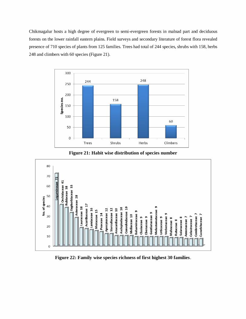
Chikmagalur hosts a high degree of evergreen to semi-evergreen forests in malnad part and deciduous
forests on the lower rainfall eastern plains. Field surveys and secondary literature of forest flora revealed
presence of 710 species of plants from 125 families. Trees had total of 244 species, shrubs with 158, herbs
248 and climbers with 60 species (Figure 21).
Figure 21: Habit wise distribution of species number
Figure 22: Family wise species richness of first highest 30 families .
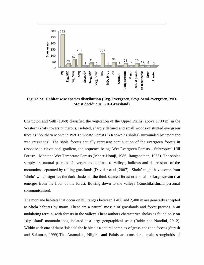
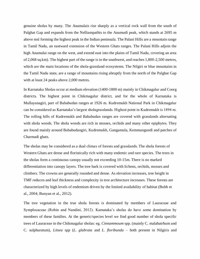
Figure 23: Habitat wise species distribution (Evg-Evergreen, Sevg-Semi-evergreen, MD-
Moist deciduous, GR-Grassland).
Champion and Seth (1968) classified the vegetation of the Upper Plains (above 1700 m) in the
Western Ghats covers numerous, isolated, sharply defined and small woods of stunted evergreen
trees as ‘Southern Montane Wet Tempeate Forests.’ (Known as sholas) surrounded by ‘montane
wet grasslands’. The shola forests actually represent continuation of the evergreen forests in
response to elevational gradient, the sequence being: Wet Evergreen Forests - Subtropical Hill
Forests - Montane Wet Temperate Forests (Meher-Homji, 1986; Ranganathan, 1938). The sholas
simply are natural patches of evergreens confined to valleys, hollows and depressions of the
mountains, separated by rolling grasslands (Davidar et al., 2007). ‘Shola’ might have come from
‘chola’ which signifies the dark shades of the thick stunted forest or a small or large stream that
emerges from the floor of the forest, flowing down to the valleys (Kunchikrishnan, personal
communication).
The montane habitats that occur on hill ranges between 1,400 and 2,400 m are generally accepted
as Shola habitats by many. These are a natural mosaic of grasslands and forest patches in an
undulating terrain, with forests in the valleys These authors characterize sholas as found only on
‘sky island’ mountain-tops, isolated at a large geographical scale (Robin and Nandini, 2012).
Within each one of these ‘islands’ the habitat is a natural complex of grasslands and forests (Suresh
and Sukumar, 1999).The Anamalais, Nilgiris and Palnis are considered main strongholds of
genuine sholas by many. The Anamalais rise sharply as a vertical rock wall from the south of
Palghat Gap and expands from the Nelliampathis to the Anamudi peak, which stands at 2695 m
above msl forming the highest peak in the Indian peninsula. The Palani Hills are a mountain range
in Tamil Nadu, an eastward extension of the Western Ghats ranges. The Palani Hills adjoin the
high Anamalai range on the west, and extend east into the plains of Tamil Nadu, covering an area
of 2,068 sq.km). The highest part of the range is in the southwest, and reaches 1,800-2,500 metres,
which are the main locations of the shola-grassland ecosystems. The Nilgiri or blue mountains in
the Tamil Nadu state, are a range of mountains rising abruptly from the north of the Palghat Gap
with at least 24 peaks above 2,000 metres.
In Karnataka Sholas occur at medium elevation (1400-1800 m) mainly in Chikmagalur and Coorg
districts. The highest point in Chikmagalur district, and for the whole of Karnataka is
Mullayanagiri, part of Bababudan ranges at 1926 m. Kudremukh National Park in Chikmagalur
can be considered as Karnataka’s largest sholagrasslands. Highest point in Kudremukh is 1894 m.
The rolling hills of Kudremukh and Bababudan ranges are covered with grasslands alternating
with shola woods. The shola woods are rich in mosses, orchids and many other epiphytes. They
are found mainly around Bababudangiri, Kudremukh, Gangamula, Kemmangundi and patches of
Charmadi ghats.
The sholas may be considered as a dual climax of forests and grasslands. The shola forests of
Western Ghats are dense and floristically rich with many endemic and rare species. The trees in
the sholas form a continuous canopy usually not exceeding 10-15m. There is no marked
differentiation into canopy layers. The tree bark is covered with lichens, orchids, mosses and
climbers. The crowns are generally rounded and dense. As elevation increases, tree height in
TMF reduces and leaf thickness and complexity in tree architecture increases. These forests are
characterized by high levels of endemism driven by the limited availability of habitat (Bubb et
al., 2004; Bunyan et al., 2012).
The tree vegetation in the true shola forests is dominated by members of Lauraceae and
Symplocaceae (Robin and Nandini, 2012). Karnataka’s sholas do have some domination by
members of these families. At the generic/species level we find good number of shola specific
trees of Lauraceae in the Chikmagalur sholas: eg. Cinnammoum spp. (mainly C. malabatrhum and
C. sulphuratum), Litsea spp (L. glabrata and L. floribunda – both present in Nilgiris and

Anamalais) and Neolitsea sp. Symplocos gardneriana of Symplocaceae, characteristic of Nilgiris
and Anamalais has been reported from Bababudan shola forests. S. villosa has been reported for
first time from Karnataka from Kerkeatte of Chikmagalur.
Some other typical high altitude shola trees of southern Western Ghats present in Chikmagalur are
Microtropis latifolia and M. stocksii of Celastraceae, Mastixia arborea, a streamside tree of
Cornaceae, Elaeocarpus munronii of Elaeocarpaceae, Schefflera rostrata of Araliaceae,
Glochidion neilgherrense of Euphorbiaceae, Hydnocarpus alpina of Flacourtiaceae,
Noothapodytes nimmoniana of Icacinaceae, Michelia nilagirica of Magnoliaceae, Memecylon
malabaricum of melastomaceae, Prunus ceylanica of Rosaceae, Meliosma pinnnata and M.
simplicifolia of Sabiaceae, Salix tetrasperma of Salicaceae, Gordonia obtusa of Theaceae etc.
Among the true shola trees what seems to be strikingly absent in the Chikmagalur-coorg sholas
are Rhododendron arboreum var. nilagiricum, Mahonia leshenaultii (Berberidaceae),
Rhodomyrtus tomentosa of Myrtaceae etc.
Compared to the plains the sholas of Chikmagalur have several shrubs of Rosaceae which are also
present in the cooler high altitude sholas of southern Western Ghats. These are notably Rosa
leschenaultiana, Rubus ellipticii and R. fockei. Other typical shola shrubs are Strobilanthus
sessilis of Acanthaceae, Indigofera cassioides and Sophora wightii of Fabaceae, Hypericum
mysorense of Hypericaceae, Solanum denticulatum and S. indicum of Solanaceae, Vaccinium
neilgherrense of Vacciniaceae. Notable absence shrub level is Berberis tinctoria. Numerous herbs
are common to the sholas of Karnataka and high altitude sholas-grasslands. These include
Heracleum candolleana of Apiaceae, Cardamine africana, C. trichocapra of Brassicaceae,
Droseara bumanni and D. peltata of Droseraceae, Desmodium repandum of Fabaceae, Gentiana
quadrifaria of Gentianaceae, Leucas marrubioides and teuucrium tomentosum of Lamiaceae,
Lobelia nicotianifolia of Lobeliaceae etc.
Vegetation succession in shola grasslands of Western Ghats is poorly understood, because of the
short-term nature of most studies. Human activities have historically influenced these grasslands
and will continue to do so in more intensive manner. Threats to these grasslands include habitat
loss, fragmentation, fires, and invasive species (Thomas and Palmer, 2007). Many of Karnataka’s
sholas have more tropical forest elements than temperate/Himalayan elements unlike sholas of
Nilgiris and Anamalais. Rhododendron, which can be considered the remains of a glacial age

surviving in the coolness of the high altitudes of southern Western Ghats. Nilgiri tahr (mountain
goat) is yet another remarkable species whose close relatives are in the Himalayas. Members from
some of the predominantly evergreen families of Western Ghats like Ebenaceae, found mainly in
the plains and lower altitudes, are absent in the Nilgiri Anamalai sholas, but occur in the lesser
altitude sholas of Karnataka, including Chikmagalur.
Diospyros saldanhae and D. Montana are instances of the same (Yoganarasimhan et al., 1981).
Interestingly the pan-tropical genus Diospyros with 600 species is hardly represented in Europe
and higher altitudes of Himalayas. Gradual isolation of the ancestral Ebenaceae is considered to
have given rise to mainly high altitude shola families Theaceae, Symplocaceae, Ternstroemiaceae,
Ericaceae etc. (Singh, 2005). Notably Symplocos gradneriana of Symplocaceae, reported from
Bababudan sholas also occurs in Nilgiris and Anamalais. The high altitude sholas of Nilgiris and
Anamalais have exclusive species such as S. gardneriana, S. foliosa, S. microphylla, S.
anamallayana, S. pendula etc. (Gamble, 1921). Gordonia obtusa is the lone Theaceae species from
Chikmagalur, a connecting link between still more higher altitude species (Ternstroemia japonica
and the tea plant Thea sinensis). A comparative account of species of common occurrence in the
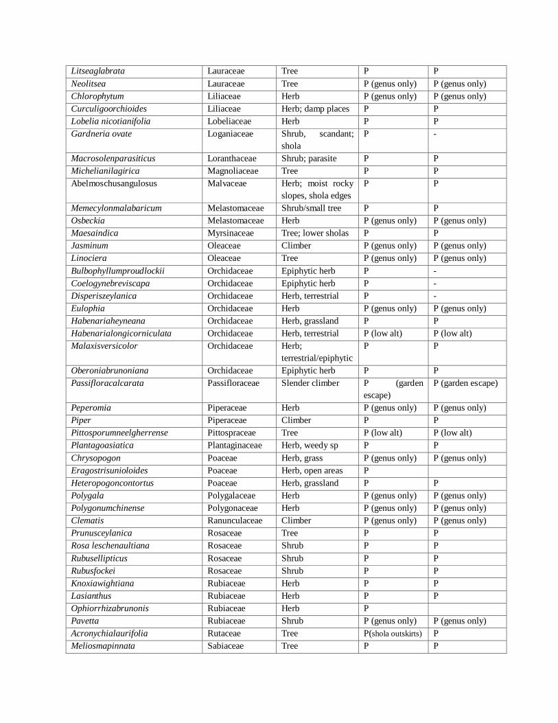
sholas of Chikmagalur, Nilgiris and Anamalais is given in Table 4.1.
Table 4.1: Flowering plant taxa shared between sholas of Chikmagalur with those of
Nilgiris and Anamalais
CHIKMAGALUR SHOLA/
GRASSLAND SPECIES
FAMILY HABIT/HABITA
T
PRESENCE
(P) NILGIRI
SHOLAS
PRESENCE (P)
ANAMALAI
SHOLAS
Justicia simplex Acanthaceae Herb; open places P P
Strobilanthussessilis-Bababudan Acanthaceae Shrubs P P
Heracleumcandolleanum Apiaceae Herb, in open P P
Pimpinella Apiaceae Herb, in open P P
Schefflerarostrata Araliaceae Tree; shola P P
Ceropegia Asclepiadaceae Herb P (genus only) P (genus only)
Centrantherum Asteraceae Herb P (genus only) P (genus only)
Dichrocephalaintegrifolia Asteraceae Herb; in the open P, in downs P, in downs
Emilia sonchifolia Asteraceae Herb; in open P P
Erigeron Asteraceae Herb P (genus only) P (genus only)
Galinsongaparviflora Asteraceae Herb P, weed
Gnaphalium Asteraceae Herb, open P (genus only) P (genus only)
Launaeaacaulis Asteraceae Herb P -
Vernonia Asteraceae Shrub/tree P (genus only) P (genus only)
Impatiens chinensis Balsaminaceae Herb; moist slopes P P

Cardamineafricana Brassicaceae Succulent herb,
marshy places
>1200m
P P
Cardaminetrichocarpa Brassicaceae Herb in high alti.
rocky places
P P
Celastruspaniculatus Celastraceae Woody climber P (low alt) P (low alt)
Microtropislatifolia Celastraceae Shrub/small tree P P
Microtropisstocksii Celastraceae Tree P P
Cassia mimosoides Caesalpiniaceae Amidst grasses,
shaded roadsides
- P
Commelina Commelinaceae Herb P (genus only) P (genus only)
Mastixiaarborea Cornaceae Tree P P
Zehneriamaysorensis Cucurbitaceae Climbibg herb P P
Fimbristylis Cyperaceae Herb P (genus only) P (genus only)
Kyllinga Cyperaceae Herb P (genus only) P (genus only)
Droseraburmanni Droseraceae Herb P P
Droserapeltata Droseraceae Herb P P
Elaeocarpusserratus Elaeocarpaceae Tree P (low alt) P (low alt)
Elaeocarpusmunronii Elaeocarpaceae Tree P P
Elaegnuskologa Elaegnaceae Straggler, in sholas P P
Eriocaulon Eriocaulaceae Herb, wet places P (genus only) P (genus only)
Euphorbia laeta Euphorbiaceae Herb P P
Glochidionneilgherrense Euphorbiaceae Tree P P
Glochidionvelutinum Euphorbiaceae Tree P (low alt) P (low alt)
Phyllanthus simplex Euphorbiaceae Herb P P
Crotalaria albida Fabaceae Herb - P
Crotalaria calycina Fabaceae Herb - P
Crotalaria leischenaultii Fabaceae Herb P P
Desmodiumrepandum Fabaceae Herb; moist slopes P P
Flemingea Fabaceae Herb P (genus only) P (genus only)
Indigoferacassioides Fabaceae Shrub, open places P P
Sophorawightii Fabaceae Shrub/tree P P (low alt)
Hydnocarpusalpina Flacourtiaceae Tree P P
Gentianaquadrifaria Gentianaceae Herb, grassland P -
Aeschynanthusperottetii Gesneriaceae Epiphyte, shrub P P
Ophiopogonintermedius Haemodoraceae Herb P P
Hydrocotylenepalensis Hydrocotylaceae Herb; moist places P P
Hpericummysurense Hypericaceae Shrub; open areas P P
Nothapodytesfoetida Icacinaceae Tree; sholas P P
Juncus Juncaceae Herb P (genus only) P (genus only)
Leucasmarrubioides Lamiaceae Herb P P
Plectranthus Lamiaceae Herb P (genus only) P (genus only)
Pogostemon Lamiaceae Herb P (genus only) P (genus only)
Teucriumtomentosum Lamiaceae Herb P P
Cinnamomum spp. Lauraceae Tree P (genus only) P (genus only)
Cinnamomummalabathrum Lauraceae Tree
Litsea floribunda Lauraceae Tree P P
Litseaglabrata Lauraceae Tree P P
Neolitsea Lauraceae Tree P (genus only) P (genus only)
Chlorophytum Liliaceae Herb P (genus only) P (genus only)
Curculigoorchioides Liliaceae Herb; damp places P P
Lobelia nicotianifolia Lobeliaceae Herb P P
Gardneria ovate Loganiaceae Shrub, scandant;
shola
P -
Macrosolenparasiticus Loranthaceae Shrub; parasite P P
Michelianilagirica Magnoliaceae Tree P P
Abelmoschusangulosus Malvaceae Herb; moist rocky
slopes, shola edges
P P
Memecylonmalabaricum Melastomaceae Shrub/small tree P P
Osbeckia Melastomaceae Herb P (genus only) P (genus only)
Maesaindica Myrsinaceae Tree; lower sholas P P
Jasminum Oleaceae Climber P (genus only) P (genus only)
Linociera Oleaceae Tree P (genus only) P (genus only)
Bulbophyllumproudlockii Orchidaceae Epiphytic herb P -
Coelogynebreviscapa Orchidaceae Epiphytic herb P -
Disperiszeylanica Orchidaceae Herb, terrestrial P -
Eulophia Orchidaceae Herb P (genus only) P (genus only)
Habenariaheyneana Orchidaceae Herb, grassland P P
Habenarialongicorniculata Orchidaceae Herb, terrestrial P (low alt) P (low alt)
Malaxisversicolor Orchidaceae Herb;
terrestrial/epiphytic
P P
Oberoniabrunoniana Orchidaceae Epiphytic herb P P
Passifloracalcarata Passifloraceae Slender climber P (garden
escape)
P (garden escape)
Peperomia Piperaceae Herb P (genus only) P (genus only)
Piper Piperaceae Climber P P
Pittosporumneelgherrense Pittospraceae Tree P (low alt) P (low alt)
Plantagoasiatica Plantaginaceae Herb, weedy sp P P
Chrysopogon Poaceae Herb, grass P (genus only) P (genus only)
Eragostrisunioloides Poaceae Herb, open areas P
Heteropogoncontortus Poaceae Herb, grassland P P
Polygala Polygalaceae Herb P (genus only) P (genus only)
Polygonumchinense Polygonaceae Herb P (genus only) P (genus only)
Clematis Ranunculaceae Climber P (genus only) P (genus only)
Prunusceylanica Rosaceae Tree P P
Rosa leschenaultiana Rosaceae Shrub P P
Rubusellipticus Rosaceae Shrub P P
Rubusfockei Rosaceae Shrub P P
Knoxiawightiana Rubiaceae Herb P P
Lasianthus Rubiaceae Herb P P
Ophiorrhizabrunonis Rubiaceae Herb P
Pavetta Rubiaceae Shrub P (genus only) P (genus only)
Acronychialaurifolia Rutaceae Tree P(shola outskirts) P
Meliosmapinnata Sabiaceae Tree P P

Meliosmasimplicifolia Sabiaceae Tree P P
Salix tetrasperma Salicaceae Tree P P
Allophylluscobbe Sapindaceae Shrub
Parnassiamysorensis- Saxifragaceae Herb P P
Datura Solanaceae Shrub P (genus only) P (genus only)
Solanumdenticulatum Solanaceae Shrub P P
Solanumindicum Solanaceae Shrub P P
Symplocosgardneriana-
bababudan
Symplocaceae Tree P P
Symplocosvillosa- Symplocaceae
Gordonia obtuse Theaceae Tree P P
Gnidiaglauca Thymeliaceae Tree; in lower
sholas
P P
Celtiscinnamomea Ulmaceae Tree P (low alt) -
Elatostemmalineolatum Urticaceae Herb; damp, shaded P P
Elatostemmasurculosum Urticaceae Herb, damp, shaded P P
Vacciniumneilgherrense Vacciniaceae Shrub P P
Curcuma neilgherrensis Zingiberaceae Herb; grasslands;
near river
P -
Shola forests are of high ecological significance in protecting head waters of rivers. Every shola
gives rise to a spring; such springs are main contributors for Karnataka’s rivers like Tunga, Bhadra,
Nethravathi, Kumaradhara and Kaveri. Shola forests have high percentage of endemism of
Western Ghats. About 30% of the species in the Palani hills are endemic to Western Ghats
(Somasundaram and Vijayan, 2010). There is also high percentage of bird endemism (20-23%) in
the shola forests, as bird endemism of the Western Ghats as such is much lower (Nameer, 2001).
Sholas have also high amount of amphibian diversity (Inger et al., 1987).
Shola fragments contain species of both tropical and temperate affinities. The grasslands of the
Western Ghats, according to Karunakaran et al. (1998), show more biogeographic similarity with
Western Himalayan species than TMF in Sri Lanka.Typically temperate genera of sholas are
Eurya, Daphiphyllum and Rubus Sub-tropical elements are: Rhododendron, Berberis and Mahonia
of Himalayan origin. Of Indo-Malayan origin are families of flowering plants Lauraceae,
Rubiaceae, Symplocaceae, Myrtaceae, Myrsinaceae and Oleaceae while dicotyledonous under-
story species are dominated by Asteraceae, Fabaceae and Acanthaceae
Conservation: Sholas and grasslands of Karnataka have been subjected to relentless developmental
pressures. Mining in Kudremukh and Kemmangundi created severe havoc on this mountain top
ecosystem. Coffee and tea cultivation had already taken heavy toll on shola vegetation. Mining
areas are afflicted with severe forms of soil erosion and siltation of water bodies. Continuity of the
shola forests is at stake as an estimated 50% of such forests have been lost from the Western Ghats
since 1850 (Sukumar et al. 1995). Acacias, Eucalyptus and pines were introduced in the South
Indian sholas over a century ago creating substantial replacement of native flora of shola-grassland

complexes. The non-regenerating and fast receding shola community is called ‘living fossil’
community (Vishnu-Mittre and Gupta, 1968).
Kumara and Sinha (2009) encountered 24 groups of the endangered primate Lion-tailed Macaque
having total population of 378 individuals inhabiting Kudremukh NP and Someshwara WLS.
Praveen and Kuriakose (2006) sighted the Near Threatened Black and Orange Flycatcher Fecidula
nigrorufa, endemic to the shola forests of southern Western Ghats, a range extension of the bird
to Kudremukh and Bababudangiri ranges in Chikmagalur.
Rhacophorus lateralis, an endangered tree frog reported from isolated pockets of southern Western
Ghats was reported as occurring in the vicinity of Kudremukh NPP (Dinesh et al., 2010).
Dinesh et al. (2008) discovered a new species of endemic frog called wrinkled night frog
Nyctobatrachus dattatreyaensis from shola streams of Bababudan range. It is one among the 16
nominal species from the world. Dinesh et al (2007) discovered a new species of frog
Nyctibatrachus karnatakensis from a torrential stream in Kudremukh NP.
Sholas are in urgent need of conservation. Shola recovery into their potential zones, if they are
degraded by anthropogenic activities, except perhaps farming, is essential. Corridors between
shola patches should be carefully re-established through selection of appropriate species. Fire
control in the adjoining grasslands is essential until the shola species establish successfully.
Reference:
1. Boyle, T.J.B. 2001. Interventions to enhance the conservation of biodiversity. 82-101. In: J. Evans (ed.), The Forest Handbook.Blackwell Science. Oxford, U.K.
2. Forman, R.T.T. 1995. Some general principles of landscape and regional ecology. Landscape Ecology, 10: 133-142.
3. Forman, R.T.T. 1997. Land Mosaics: The Ecology of Landscapes and Regions. Cambridge University Press, New York.
4. Griffiths, G.H., Lee J. &Eversham, B.C., 2000. Landscape pattern and species richness, regional scale analysis from remote sensing.International Journal of Remote Sensing, 21: 2685-2704.
5. Gustafson, E.J. 1998. Quantifying landscape spatial pattern: what is the state of the art? Ecosystems 1:143-156
6. Houet, T, Verburg, P, H. 2010. Monitoring and modelling landscape dynamics. Landscape Ecology
vol. 25:163–167.
7. Jha, C.S., L. Goparaju, A. Tripathi, B. Gharai, A.S. Raghubanshi & J.S. Singh. 2005. Forest
fragmentation and its impact on species diversity: an analysis using remote sensing and GIS. Biodiversity and Conservation 14: 1681-1698.
8. Laurance, W.F., Laurance S.G. & Delamonica P., 1998. Worldwide forest campaign news: Tropical forest fragmentation and greenhouse gas emissions. Forest Ecology and Management 110: 173-180.
9. O’Neill, R.V., C.T. Hunsaker, K.B. Jones, K.H. Riitters, J.D. Wickham, P.M. Schwartz, I.A. Goodman, B.L. Jackson & W.S. Baillargeon. 1997. Monitoring environmental quality at the
landscape scale. Bioscience 47: 513-519. 10. Ramachandra T. V., Uttam Kumar, Diwakar P. G. and JoshiN. V., 2009.Land cover Assessment
using À Trous Wavelet fusion and K-Nearest Neighbour classification Proceedings of the 25th

Annual In-House Symposium on Space Science and Technology, 29 - 30 January 2009, ISRO - IISc Space Technology Cell, Indian Institute of Science, Bangalore.
11. Ramachandra. T.V and Uttam Kumar, 2011. Characterisation of Landscape with Forest Fragmentation Dynamics, Journal of Geographic Information System, 3:242-254
12. Ramachandra T.V and Bharath A.H., Spatio-Temporal Pattern of Landscape Dynamics in Shimoga, Tier II City, Karnataka State, India, International Journal of Emerging Technology and Advanced Engineering, vol 2(9), pp. 563 – 576, 2012.
13. Ramachandra. T.V and Uttam Kumar, 2011. Characterisation of Landscape with Forest Fragmentation Dynamics, Journal of Geographic Information System, 3:242-254
14. Riitters, K., J. Wickham, R. O'Neill, B. Jones, and E. Smith. 2000. Global-scale patterns of forest fragmentation. Conservation Ecology 4(2):1-28.
15. Rutledge, D. T. (2003). Landscape indices as measures of the effects of fragmentation: can pattern
reflect process?
16. Roy D.P, Lewis P.E. & Justice C.O., 2002. Burned area mapping using multi-temporal moderate spatial resolution data a bi-directional reflectance model-based expectation approach, Remote
Sensing of Environment 83:263–286. 17. Saunders, D.A., Arnold, G.W., Burbridge, A.A. & Hopkins A.J.M., 1987.Nature Conservation, the
Role of Remnants of Native Vegetation, Surrey Beatty. Chiiping Norton, Sydney, Australia. 18. Turner, M.G & R.H. Gardner. 1991. Quantitative Methods in Landscape Ecology. Springer-Verlag,
New York, USA. 19. Vogelmann, J.E. 1995. Assessment of forest fragmentation in southern New England using remote
sensing and geographic information system technology. Conservation Biology, 9(2):439-449.
20. Wickham, J.D., K.B. Jones, K.H. Riitters, T.G. Wade and R.V. O’Neill. 1999. Transitions in forest fragmentation: implications for restoration opportunities at regional scales. Landscape Ecology14: 137-145.
21. Wilkie, D.S, & Finn, J.T, 1996. Remote Sensing Imagery for Natural Resources Monitoring. Columbia University Press, New York. Page 295.
22. Champion, H. and Seth, S. 1968. A Revised Survey of the Forest Types of India, Government of India Publications, New Delhi.
23. Bahulikar, R.A., Lagu, M.D., Kulkarni, B.G., Pandit, S.S., Suresh, H.S., Rao, M.K.V., Ranjekar, P.K., and Gupta, V.S. 2004. Genetic diversity among spatially isolated populations of Eurya
nitida Korth. (Theaceae) based on inter-simple sequence repeats. Current Science 86(6), 824- 831.
24. Bande, M. B. and Chandra, S. E. Early Tertiary vegetational reconstructions around NagpurChindwara and Mandla, central India. Palaeobotanist, 38, 196–208.
25. Birdlife International, 2014. Avibase - Bird Checklists of the World: Kudremukh National Park. http://avibase.bsc-eoc.org/checklist.jsp
26. Bubb, P., May, O., Miles, I., and Sayer, J. 2004. “Cloud Forest Agenda,” UNEP-WCMC, Cambridge, 2004.
27. Bunyan, M., Bardhan, S. and Jose, S. 2012. The Shola (Tropical Montane Forest)-Grassland Ecosystem Mosaic of Peninsular India: A Review. American Journal of Plant Sciences, 3, 1632- 1639
28. Davidar, P., Mohandass, D. and Vijayan S.L. 2007. Floristic inventory of woody plants in a tropical montane (shola) forest in the Palni hills of the Western Ghats, India. Tropical Ecology
48(1), 15-25. 29. Dinesh, K. P., Radhakrishnan, C., Reddy, A.H.M and Gururaja, K.V. 2007. Nyctibatrachus
karnatakaensis nom. nov., a replacement name for the giant wrinkled frog from the Western Ghats. Current Science. 93: 246–250.
30. Dinesh, K. P., Radhakrishnan, C., and Bhatta, G. 2008. 'A new species of Nyctibatrachus
Boulenger (Amphibia: Anura: Nyctibatrachidae) from the surroundings of Bhadra Wildlife Sanctuary, Western Ghats, India. Zootaxa, 1914, 45-56.
31. Dinesh, K.P., Radhakrishnan, C., Gururaja, K.V. and Zacariya, A. 2010. New locality records of Rhacophorus lateralis Boulenger, 1883 (Amphibia: Anura: Rhacophoridae), in Western Ghats, India. Journal of Threatened Taxa, 2(6), 986-989.
32. Gamble, J.S. 1921. Flora of the Presidency of Madras Vol. II. Reprint, 1986: Bishen Singh Mahendra Pal Singh, Dehra Dun.
33. Inger, R., Shaffer, H., Koshy, M. and Bakde, R. 1987. Ecological structure of a herpetological assemblage in South India. Amphibia–Reptilia, 8, 189–202.
34. Jose, F.C. 2012. The ‘living fossil’ shola plant community is under threat in Upper Nilgiris. Curr.
Science, 102(8), 1091-92. 35. Karunakaran, P.V., Rawat, G.S. and Unyal, V.K. 1998. Ecology and Conservation of the
Grasslands of Eravikulam National Park and the Western Ghats. Wildlife Institute of India, Dehradun.
36. Kumara, H.N. and Sinha, A. 2009. Decline of the endangered lion-tailed macaque in the Western Ghats, India. Oryx 43, 292-298.
37. Legris, P and Blasco, F. 1969. Legris P, Blasco F. 1969. 'Variabilité des fracteurs du climat: Cas des montagnes du Sud de l'Inde et de Ceylan. Inst. Fr. Pondicherry. Tr. Sect. Sci. Tech 8, 1-195.
38. Meher-Homji, V. M., 1972. Himalayan plants on south Indian hills: Role of Pleistocene glaciation vs long distance dispersal. Sci. Cult., 38, 8–12
39. Nameer, P. 2001. Richness of avifauna in the Sholas of Munnar, Idukki District. In: Shola Forests
of Kerala: Environment and Biodiversity (eds Nair, K., Khanduri, S. and Balasubramanyan, K.), Kerala Forest Department and Kerala Forest Research Institute, Trichur p. 365.
40. Praveen, J. and Kuriakose, G. 2006. A review of the northern distribution range of Near Threatened Black-and –Orange Flycatcher, Fecidula nigrorufa in the Western Ghats. Zoos-Print
Journal 21(12), 2516-2517. 41. Robin, V.V., Sukumar, R. and Theollay, J.M. 2006. Status and distribution of the White-bellied
Shortwing Brachypteryx major in the Western Ghats of Karnataka and Goa, India. Bird Conservation International 16:345–351.
42. Robin, V.V. and Nandini, R. 2012. Shola habitats on sky islands: status of research on montane forests and grasslands in southern India. Current Science 103(12), 1427-1437.
43. Singh, V. 2005. Monograph on Indian Diospyros L. (Persimmon, Ebony) Ebenaceae. Botanical Survey of India, Calcutta.
44. Somasundaram, S. and Vijayan, L. 2010. Plant diversity and phenological pattern in the montane wet temperate forests of the southern Western Ghats, India. For. Stud. China 12, 116–125.
45. Sudhakara, K. 2001. Inventory and computerized herbarium of higher plants in the sholas of Munnar, Idukki district. In: Nair, K.K.N., Khanduri, S.K. and Balasubramanyam, K. (eds.) Shola
Forests of Kerala: Environment and Biodiversity, Kerala Forest Research Institute, Peechi, pp 179-208.
46. Sukumar, R., Suresh, H. S. and Ramesh, R. 1995. Climate change and its impact on tropical montane ecosystems in southern India. J. Biogeogr, 22, 533–536.
47. Suresh, H. and Sukumar, R. 1999. Phytogeographical affinities of flora of Nilgiri Biosphere Reserve. Rheedea, 1999, 9, 1–21.
48. Thomas, S.M. and Palmer, M.W. 2007. The montane grasslands of the Western Ghats, India: Community Ecology and Conservation, 8, 67-73.
49. Vishnu-Mittre and Gupta, H.P. 1968. Current Science 37, 671-672.
50. Yoganarasimhan, S.N., Subramanyam, K. and Razi, B.A. 1981. Flora of Chikmagalur District,
Karnataka, India. International Book Distributors, Dehra Dun.
51. Ranganathan, C.R., 1938. Studies in the ecology of shola-grassland vegetation of the
Nilgiri plateau. Indian For., 64: 523-541.
1. http://www.chickmagalur.nic.in/
2. Champion, H.G and Seth. S.K. (1968). A revised Survey of the forest types of India.
Government of India Publications, New Delhi.
3. Pascal, J.P., Sunder, S.S. and Meher-Homji, M.V. (1982), Forest Map of South-India,
Shimoga. Karnataka and Kerala Forest Departments and the French Institute, Pondicherry.
4.