land surveying education in the 21st … surveying education in the 21st century dr. bill hazelton,...
TRANSCRIPT

LAND SURVEYING EDUCATION IN THE 21ST CENTURY
Dr. Bill Hazelton, SCSU Land Surveying and Mapping Science Program

ABOUT THIS PRESENTATION
Education of the next generations of professionals in our field
Background, issues, problems, directions in the profession
Possibilities, choices, possible consequences
Background, issues, problems, directions in education
Possibilities, choices, possible consequences

A SURVEYING REVOLUTION…
Consider a time before some major changes occur in surveying:
How do you, as an established surveyor, deal with rapid and unprecedented change?
How do you deal with changes to your whole world as a consequence of these changes?

IT IS THE YEAR 1550…
The most powerful surveying instrument is the gromaTopographic mapping and simple property surveys are the height of surveying, plus a little constructionThe limits of math needed are basic arithmetic, and more artistic skills are required for map drawingThere aren’t many surveyors aboutThis has been the state of surveying since Roman times
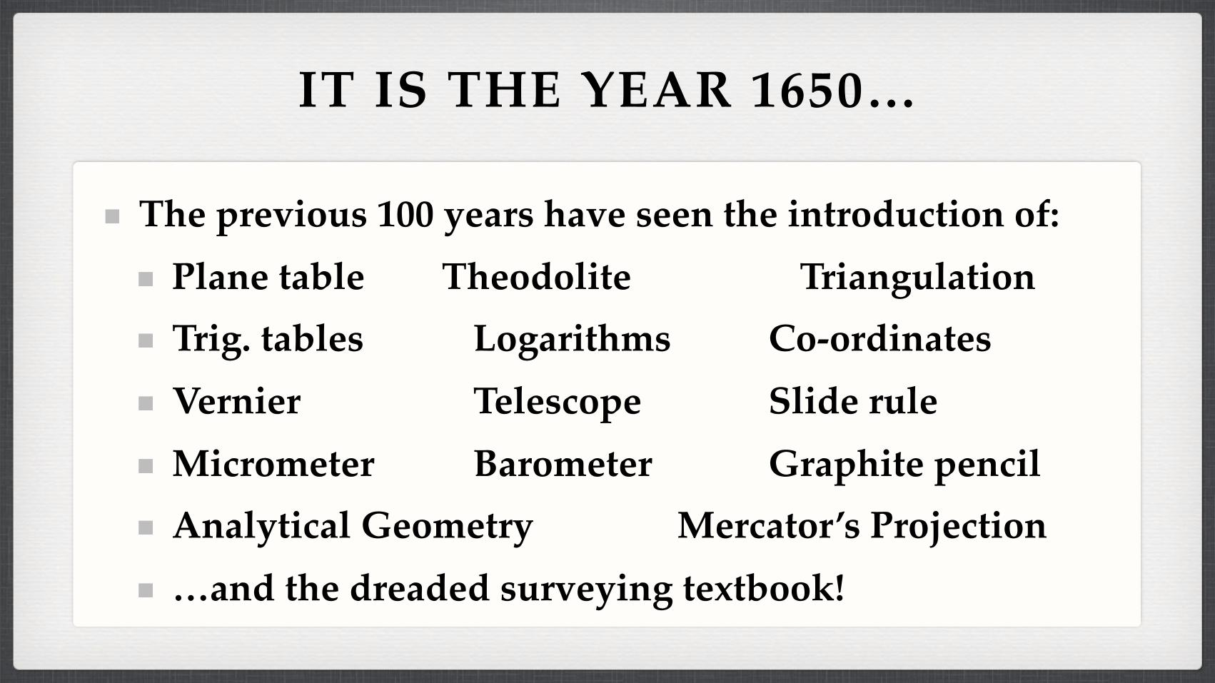
IT IS THE YEAR 1650…
The previous 100 years have seen the introduction of:Plane table Theodolite TriangulationTrig. tables Logarithms Co-ordinatesVernier Telescope Slide ruleMicrometer Barometer Graphite pencilAnalytical Geometry Mercator’s Projection…and the dreaded surveying textbook!

IT IS THE YEAR 1650…
Surveying is now very mathematical — trigonometry is essential knowledge
Small, local surveys are small business — geodesy is big and surveyors are now Earth measurers (géomètres)
Triangulation knits together regions, nations and continents — no survey needs to be isolated
Mapping is now precise and navigation much simpler and more reliable — a sea-based empire is possible

IT IS THE YEAR 1650…
Calculus is still almost 50 years away…
Clocks good enough for longitude determination (and erasers) are still 130 years away…
Least squares and meters are still 150 years away…
Photogrammetry and telegraphy are still 200 years away…
EDM is still 300 years away…
GPS is still 340 years away…

CONTRAST…
Surveyors in 1550 with surveyors in 1650
Their education, their mindset, their worldview
The role of surveying in the world in 1550 with its role in 1650
From village-based to planet-orientedFrom drawing-based to measurement-focused
Surveying was part of the scientific revolution

IT IS THE YEAR 2020…
A client calls…

IT IS THE YEAR 2020…
That survey’s done! What’s the next job?

IT IS THE YEAR 2009…
USDA Natural Resources and Conservation Service aims to get a 1 m to 1.5 m DEM of all of Wyoming
For $95 per square mile, using LIDAR
Well over 10 million vehicle GPS navigation systems
Even more handheld GPS devices, including phones
Apple sold 4.3 million G3 iPhones last quarter
30+ million digital cameras sold per year

IT IS THE YEAR 2009…
Vehicle-based scanning system using 6 lasers collects 1.5 million points per second
Lidar collects 10,000 to 40,000 points per second, and 200,000 to 400,000 points per square mile, i.e., a square mile every 5 to 40 seconds at 10 ft spacing, with 4" to 6" vertical precision, for $100 to $800 per square mile
Digital photogrammetry can produce well over 1,000 points/minute at centimeter-level precision

IT IS THE YEAR 2009…
Airborne scanners are producing more precise digital maps than aerial film cameras, e.g., Leica ADS40
Terabyte drives are the norm for newer technologies doing field data collection
The point cloud is the data set
‘Cloud computing’ is the computing and storage system

IT IS THE YEAR 2009…
Measurement is becoming ubiquitous and almost free
GPS embedded in all manner of mobile devices
Cameras embedded in all manner of mobile devices
Scanners, fluxgate compasses, inclinometers: shrinking
Mobile computational power and digital data storage now almost infinite through cloud computing

IT IS THE YEAR 2009…
Who has ‘control’ of spatial measurement?
Everyone … and no-one
What does ‘control’ mean?
Does ‘control’ matter?
Ubiquitous spatial measurement capability means lower demand for professional services and less recognition of specialist skills

“Social relations are closely bound up with productive forces. In acquiring new productive forces, men change their mode of production; and in changing their mode of production, in changing their way of earning their living, they change all their social relations.”
Karl Marx, 1846

“We are the measurement experts”
This is a dead-end as a professional model
This is a dead-end as an educational model

EMPLOYMENT TRENDS
As an employer, the information sector of the economy peaked in the 1980sCriteria for entry to the information sector keep getting higher, more expensive, more stringentLower-skills jobs disappearingJob requirements keep expanding as technological change gets fasterInformation collection, manipulation, management and dissemination are becoming ubiquitous

THE INFORMATION CYCLE
Where in the information cycle should you be working?
What skills will you need to work there?
The Real World
DataMeasurement
Structure andTransformations
Information
Pattern RecognitionComputer VisionDecision Making
KnowledgeUnderstandingand
WisdomExper ience
InsightJudgment
Management

STORY TIME…

AND THE MORAL IS…
Solve clients’ problems, don’t just give them a map (data and measurements)
Move into the clients’ knowledge domain to understand their real needs and to adapt (engineer) your information to their needs
Multi-disciplinary teams and skills are required

We are our information products

Surveying is an information industry
Employment levels are fallingEntry-level requirements are risingJob requirements are expandingAdding value to data is profitable, measuring it isn’tWill surveying be part of the information revolution?

EDUCATION ISSUES
US Surveying programs all at state universities
State universities are short on funds!
Little imagination in fund-raising
Surveying programs are not always popular
Low enrollment
Low research income
High costs

EDUCATION ISSUES
Few US surveyors with PhDs to become faculty
Generalists vs SpecialistsProgram splits: Maine, Florida, OSU
Silos of expertise, e.g., CaGIS leaving ACSM
No MS/PhD programs for surveyors, only specialists
Many faculty are from overseas (at least 10 in major US programs, nearly all PhDs)

EDUCATION ISSUES
Students no longer are truly full-time; most work
Individualized programs are the norm
Distance education is increasing rapidly
Rush to graduate so can work and pay off loans
Short-change the future to get through the present

EDUCATION ISSUES
The decreasing importance of measurement brings into question the role of technicians and 2-year programs in the long-term
The roles of cloud computing and distance education raise the question of where information processing and education take place
Off-shoring, anyone?

RECRUITMENT ISSUES
Poor ‘brand recognition’ for surveying
Deep confusion in the surveying profession over why the profession exists
The US has no Len Beadell
US surveying has no-one like James Herriot, no equivalent to legal and medical dramas on TV

RECRUITMENT ISSUES
Role model problems:Very few female students (50% of population)
Very few minority students (30+% of population)
Very few dyslexic students (up to 20% of population)
We are ignoring most of the potential student pool
We get proportionally fewer of the ‘best and brightest’
DEFINITION ISSUES
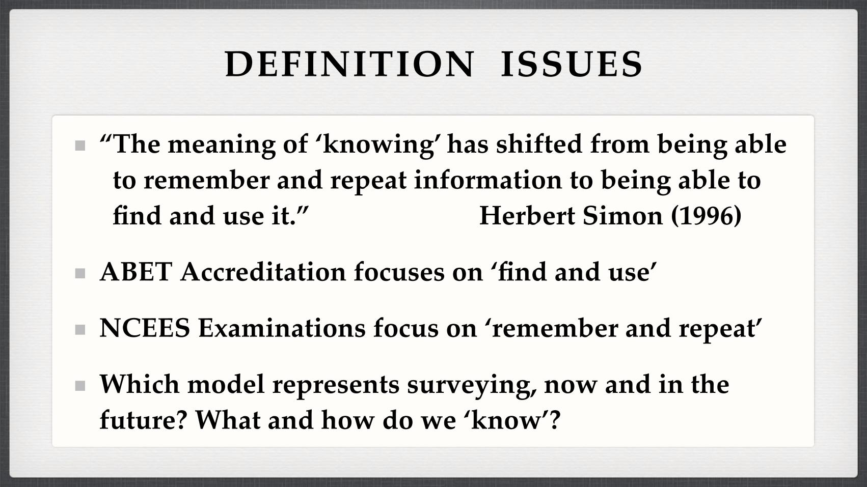
“The meaning of ‘knowing’ has shifted from being able to remember and repeat information to being able to find and use it.” Herbert Simon (1996)
ABET Accreditation focuses on ‘find and use’
NCEES Examinations focus on ‘remember and repeat’
Which model represents surveying, now and in the future? What and how do we ‘know’?

WHAT IS A PROFESSION?
Professions involve:
Systematized theoretical knowledge and demonstrated proficiency, based on extensive education
Ethical standards
Professional closure (restricted entry)
Indeterminacy of knowledge, based on experience
Public service and altruism

WHAT IS TO BE DONE
We have major choices ahead of us as a profession and as educators
Neither group can really go it alone to create a future
If we can’t agree on what the profession is about, we can’t educate the next generation of professionals
If we can’t agree on where we are going, we’ll end up somewhere else

SKILLS REQUIRED IN 40 YEARS
Learning these is the goal of a professional education
Fundamental understanding of the processes by which one’s profession operates
Understanding of decision-making process, and how to support them with spatial information
Understanding how other people use spatial information

COLLEGE EDUCATION
Focus on theory (15–20 year half-life) ahead of technology and techniques (5–7 year half-life)
Focus on professional skills ahead of technical skills
Focus on problem-solving and decision-making
Focus on over-arching concepts ahead of disconnected detail
Focus on breadth and possibilities, rather than one prescribed path
AFTER COLLEGE…
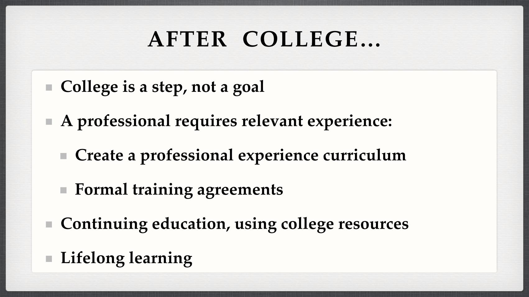
College is a step, not a goal
A professional requires relevant experience:
Create a professional experience curriculum
Formal training agreements
Continuing education, using college resources
Lifelong learning

Good luck in the future!
Thank you for your attention!