land subsidence and earth fissures in west kallada …
TRANSCRIPT

LAND SUBSIDENCE AND EARTH FISSURES IN WEST KALLADA
AREA OF KOLLAM DISTRICT
Dr. VIJITH H
Mr. PRADEEP G.S
Ms. PARVATHY S
Dr. SEKHAR LUKOSE KURIAKOSE (Ed)
Approved by: PROF. DR. KESHAV MOHAN, DIRECTOR, IDLM
Hazard, Vulnerability and Risk Assessment (HVRA) Cell
Department of Revenue and Disaster Management, Govt. of Kerala 2nd Floor, Institute of Land and Disaster Management
PTP Nagar, Thiruvananthapuram 695038 Tel/Fax: 0471-2364424. Email: [email protected]
Web: disasterlesskerala.org
A collaborative research laboratory of

INTRODUCTION
Land subsidence is a slow settlement of the ground surface due to natural or human
induced causes. It is reported from many parts of the world and it causes substantial loss
to property. This phenomenon can concern areas of various extensions, variable time
periods and it can induce different consequences. Subsidence is observed to have resulted
from natural causes, such as tectonic motion and sea level rise. Natural subsidence is very
slow and develops in long term geological periods. In historical periods (hundreds of
years) natural subsidence effects are not serious. On the contrary anthropogenic causes
such as the heavy withdrawal of groundwater, geothermal fluids, oil and gas or the
extraction of coal, sulphur, gold and other solids through mining or by tunnelling or from
other mixed causes such as the hydro-compaction of loosely deposited sediments,
oxidation and shrinkage of organic deposits or the development of sinkholes in karstic
terrain. These are more rapid and its effects are more evident in the short term. Natural
subsidence and anthropogenic one operate on different time scales (millions to thousands
of years and hundreds to tens of years, respectively).
Location information
West Kallada village, which is naturally enclosed between Kallada River in the
southwest and Sasthamkotta Lake in the northeast between 90 00’ 30” to 90 02’ 30” N and
760 35’ 45” to 760 39’ 00” E (Fig. 1) forms part of Kollam district, covering an area of 13.37
km2 approximately. West Kallada is primarily an agricultural village, with 80% of the total
area covered by floodplain deposits of river Kallada and rest of the area is shared by
wetlands and lateritic mounds. Geologically the area is made up of crystalline rocks of
Archean age and is covered with sedimentary formations of Miocene to recent ages. The
major geomorphological features of the area include residual mounds, valley fills and
flood plain. Land cover types of the area vary from mixed vegetation in the lateritic
residual mounds and agricultural crops in the valley fills and flood plains. The main
occupation, of this area traditionally has been paddy cultivation. In some areas rubber
plantation is dominating over mixed plantation and paddy cultivation. But socio-
environmental changes over time have made half the arable land suitable for growing
mixed crops. The excavation of clay from the fields for brick industries has rendered the
land unfit for farming and is a health hazard because of the high acidity in the water that
collects in the trenches after the clay has been removed. Excessive clay mining has already

damaged the local environment. The area receives an annual average rainfall of 2600 mm.
The temperature of the area varies from 28 to 360 C with minimum of 200 C.
Figure 1. Map showing the study area with location of land subsidence and earth
fissures.
This investigation was carried out based on the press report on 09/3/2013 about
the land surface cracking and house collapses in Vilanthara area of West Kallada village
(Fig. 2& 3). It was reported as an anomalous event which caused damages to more than 10
houses in which two houses were severely damaged. These houses were totally cracked
and walls were separated. The investigation was carried out on 12th March, 2013 by Dr.
Vijith H, Sr. GIS Specialist (Scientific Officer), Mr. Pradeep G.S. and Ms. Parvathy S.,
Researchers, HVRA Cell, ILDM, Dept. of Revenue and Disaster Management.

Description of the event investigated
The in the Vilanthara area of West Kallada Village occurred on 7th March, 2013
around 5 am. The victims of the event described the process as “following a huge sound of
blasting, associated with minor vibration in the ground”. Most of them were frightened
and ran out of house. After the event, they observed walls and floors of the houses were
cracked and the ground fractured with slight disposition in level (few mm). Water in the
wells rapidly fluctuated and turbidity was observed. More severe damages were observed
in houses which are located in elevated areas (slightly higher than
Figure 2 & 3: Newspaper cuttings of the West Kallada events reported.
3
2

Figure 4: Earth fissures in Vilanthara area the area.
Figure 5: Showing the width of earth fissures (3.5 cm approx.).
Figure 6: Wall crack developed due to land subsidence
Figure 7: Measuring strike of ground fractures developed
Figure 8: Cracked and collapsed wall of newly built house
Figure 9: Block separation in the wall cracked

the surrounding areas) and were noted in the western and eastern side of Vilanthara. The
earth fissures seen in the Vilanthara area have shown a general strike of East-West and
East South East-West North West directions with several hundreds of meters in length
(200 to 400 mts). In some areas the fissures showed non-continuous and curvilinear
character (Fig. 10).
The measured width of earth fissures varied from few mm to more than 4 cm and
the visible depth varied from few cm to 2 meters. Due to the undulating nature of the
terrain the continuity and depth of the fissures were not traceable. Houses with damages
are located in the west and east ends of the fissures, where the terrain is showing elevation
differences compared to the other areas. The fracture pattern seen on the walls and floors
of the houses indicate the evidences of land subsidence in the region. It was also noticed
that, the wells in the region shows rapid fluctuation in water level and one well had
collapsed partly.
Figure 10: Strike extension map of ground fissures and damaged houses in Vilanthara area of West Kallada village in Kollam district.

Figure 13: Well with concrete ring collapsed during the land subsidence (Western side of the valley)
Figure 14: Unaltered wooden debris recovered from the collapsed well. It seen as mixed with clay
Figure 15: Water quality altered and water level lowered in the well (middle portion of the valley)
Figure 16: Totally dried in the month of February (This was first time in the area)
Figure 11: House cracked during the subsidence event
Figure 12: Curvilinear extension of ground fractures

Findings of the investigation
The characteristic features of the reported event in Vilanthara area of West Kallada,
were investigated and following inferences were made. As reported by the newspapers,
the event was not a consequence of earthquake/earth tremors. The fractures and cracks
seen in the houses and on the ground surface were not bearing the signature of earthquake
generated cracks. The close examination of these ground fissures and fractures, pointed
towards the vertical displacement of ground surface which made the fractures/cracks in
buildings and ground. The development of earth fissures and subsequent land subsidence
are characterised by a horizontal differential compaction and consolidation of sediments
along a linear strike. These differential compaction and consolidation give raise to
subsidence of land in an inhomogeneous manner leading to severe damages in houses in
the area. The houses damaged by earth fissure development and land subsidence were
situated in the flanks of a lateritic mound and adjoining valleys. Though the fissures show
an extension of 200 to 400 meters with a general trend of east-west, most of it was covered
by paddy fields. Houses situated in the flanks of the laterite mounds had undergone
severe damage. The area affected by the development of earth fissures and subsequent
land subsidence was mapped with detailed characteristics and is given in figure 19.
Figure 17: Continuous extension of ground facture seen in the Eastern side of the valley
Figure 18: Large boulders deposited in the stream bed
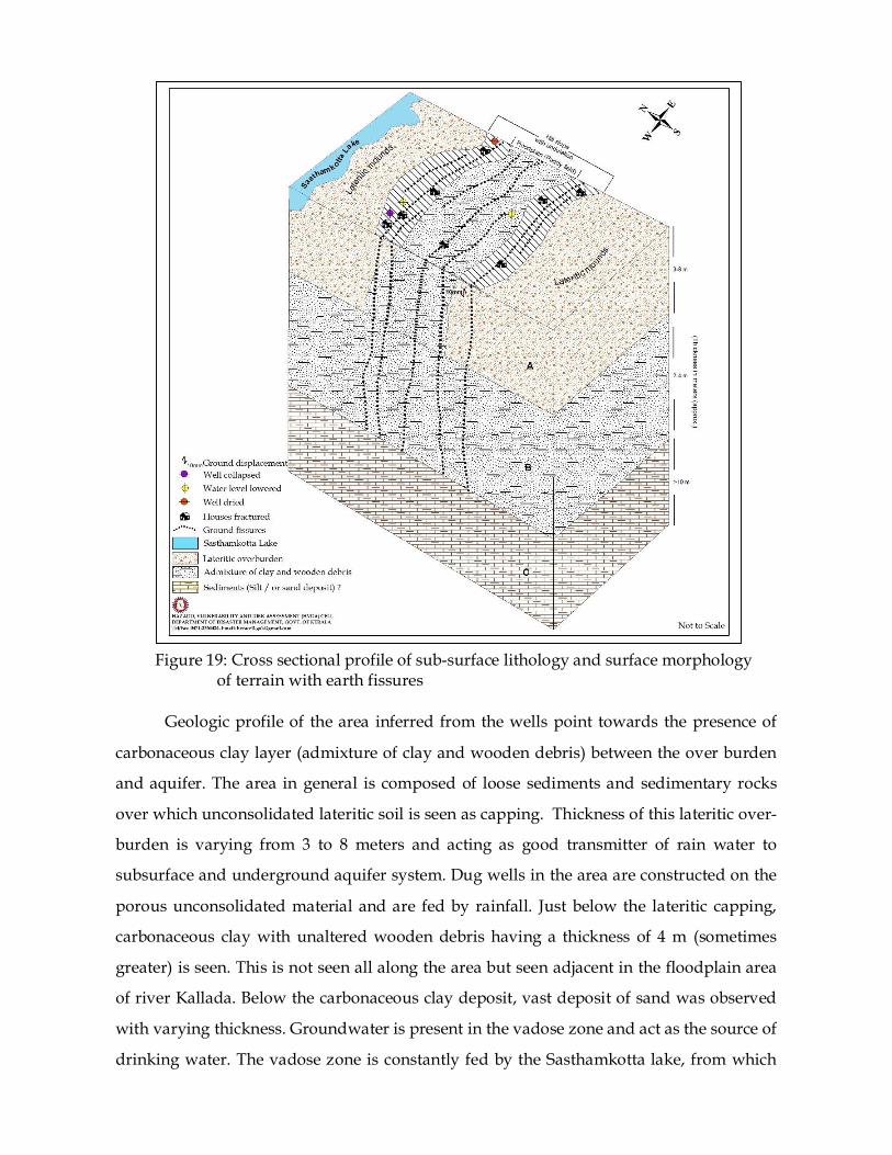
Geologic profile of the area inferred from the wells point towards the presence of
carbonaceous clay layer (admixture of clay and wooden debris) between the over burden
and aquifer. The area in general is composed of loose sediments and sedimentary rocks
over which unconsolidated lateritic soil is seen as capping. Thickness of this lateritic over-
burden is varying from 3 to 8 meters and acting as good transmitter of rain water to
subsurface and underground aquifer system. Dug wells in the area are constructed on the
porous unconsolidated material and are fed by rainfall. Just below the lateritic capping,
carbonaceous clay with unaltered wooden debris having a thickness of 4 m (sometimes
greater) is seen. This is not seen all along the area but seen adjacent in the floodplain area
of river Kallada. Below the carbonaceous clay deposit, vast deposit of sand was observed
with varying thickness. Groundwater is present in the vadose zone and act as the source of
drinking water. The vadose zone is constantly fed by the Sasthamkotta lake, from which
Figure 19: Cross sectional profile of sub-surface lithology and surface morphology of terrain with earth fissures
water is extracted to meet the increased domestic and agricultural demand of Kollam City
and parts of Sasthamkotta, Sooranadu (South), West Kallada and Manrothuruthu
panchayats in Kollam district. The well inventory carried out in the area pointed towards
prolonged dry spell during the year (___________), which was contributed by deficiency
of rainfall followed by severe drought and over exploitation of groundwater. A recent
investigation by the Centre for Earth Science Studies (CESS) had revealed that the lake was
losing its water level at an alarming rate of 1 cm per day due to deficiency in normal
rainfall. Due to this Kerala Water Authority had to stop operating a few pumping stations,
which was heavily depended by Kollam corporation and adjoining panchayaths.
Continuous groundwater extraction during a long period of time, when discharge greatly
exceeded recharge may have caused the vadose zone to completely dry out resulting in
the non-reversible consolidation of the materials in the respective zone. During this
period, the deep aquifer may have experienced considerable loss of artesian pressure and
increase in effective stress, and subsequent strain and deformation resulting in ground
fracture development and land subsidence. Lowering of water table caused by severe
drought and over exploitation of groundwater along with the over burden weight may
have forced the loose, unconsolidated subsurface layer to compact slightly, which resulted
in ground facture development and subsequent land subsidence.
This is supported by the field observation that many dried wells were found in the
floodplain and valley portion, which point towards the lowering of groundwater table due
to excessive extraction of groundwater from the aquifer system. The effective reduction in
the quantity of groundwater exploitation from deep aquifer would guarantee the natural
recovery of the aquifer system and reduce the additional load on the aquifer and its
adjacent strata, thereby slowing down the speed of land subsidence.
Recommendations
1. The Dept. of Irrigation and Kerala Water Authority should prepare a water
extraction calendar for Sasthamkotta Lake.
2. If the district experiences a rainfall shortage of 1 to 15% of the long period average
for a given month (based on IMD data), the target extraction from borewells and
open wells in the area may continue.
3. If the district experiences a rainfall shortage of 15 to 26% of the long period average
for a given month (based on IMD data), the target extraction from borewells and
open wells in the area should be reduced by 5%.
4. If the district experiences a rainfall shortage of >26% of the long period average for
a given month (based on IMD data), the target extraction from borewells and open
wells in the area should be reduced by 15%.
5. The district Ground Water Department may be directed to setup 10 ground water
monitoring wells in the immediate vicinity of the area affected by the phenomenon.
6. The Irrigation Department may be directed to setup at least 5 weather stations
(preferably automated weather stations) in the immediate vicinity of the lake.
7. The stage monitoring of the lake water level may be made regular and the data may
be made available to Tahasildars and Village Officers of the Taluks that boarder the
lake, on a weekly. The Tahasildars and Village Officers of the concerned Taluks
shall meet once in a month under the chairpersonship of the ADM/Deputy
Collector (DM) of the district to review the lake level and evaluate the need of any
intervention from the perspective of Disaster Risk Reduction.
8. The water level in the lake and the threats to the lake shall be reviewed routinely in
the once in 3 months District Disaster Management Authority meetings that are to
be scheduled by the District Collector as per the specific direction in this regards in
the District Collectors Conference held in October 2013 at Govt. Guest House,
Thiruvananthapuram.