land development plan - archive.org
TRANSCRIPT

C4-
C2 North Carolina State Library
Raleigh
fa
d c p
LAND DEVELOPMENT PLAN
Z E B U L 0 N
NORTH C A R 0 L I N A


LAND DEVELOPMENT PLAN
Z E B U L 0 N
NORTH CA ROLINA

Digitized by the Internet Archive in 2010 with funding from
State Library of North Carolina
http://www.archive.org/details/landdevelopmentp08nort

PREPARED FOR:
THE TOWN OF ZEBULON, NORTH CAROLINA December 1962
T. E. Hales, Mayor
TOWN BOARD OF COMMISSIONERS
G. K. Corbett J. R. Alford P. 0. Farmer T. B. Hepler Mrs. Elizabeth Ellett
TOWN PLANNING BOARD
Amos C. Estes, Chairman Thomas F. Monk J. M. Potter, Jr. C. C. Creech R. F. Hendricks Sidney C. Eddins John H. Hilliard Robert E. Horton
PREPARED BY
State of North Carolina
Department of Conservation and Development Division of Community Planning
ADMINISTRATIVE STAFF:
Robert D. Barbour Administrator
John Voorhees Assistant Administrator
PROJECT STAFF:
George J. Monaghan Project Planner
Bennett Napier Draftsman
Anne Jones Typist


TABLE OF CONTENTS
INTRODUCTION
CHAPTER I THE PRESENT USE OF LAND
PAGE
Land Use in the Entire City A comparison with Raeford and Maxton Land Use in the Downtown Area
CHAPTER II POPULATION TRENDS
Past Growth of Zebu Ion's Population Future Growth of Zebulon's Population Natural Increase vs Migration Population Loss in the Rural Area outside Zebulon
CHAPTER III ECONOMIC TRENDS
Employment Types of Employment Income Zebulon as a Trade and Service Center Guidelines for Future Economic Growth
9 9
10 12 12
CHAPTER IV HOUSING CONDITIONS
Value of Homes Ownership of Homes Condition of Homes Improving. Housing Conditions
13 13 13 15
CHAPTER V UTILITIES AND IMPROVEMENTS
The Water Supply System The Sewerage System Street Improvements Sidewalks Curb and Gutter Traffic Signs and Signals Street Lights Street Trees
18 19 19 21 21 22 22 23
CHAPTER VI LAND DEVELOPMENT PLAN
Purpose of the Plan Future Land Requirements Residential Uses Social and Cultural Uses Business Uses Industrial Uses Thoroughfare Plan Minor Streets
24 24 25 25 2b 2K 2q
30


introduction


Since the start of the industrial revolution, there has been a continued trend toward increased urbanization. More cities and bigger cities have been needed to serve as the distribution and production centers of an industrialized nation. In its own small way, Zebulon has taken part in this trend. The population of the surrounding rural area has been de- clining, while Zebulon itself has maintained a steady growth . The recent addition to Zebulon of a textile mill and a shopping center are
local evidence of nationwide trends.
In most cities across the nation this growth has been chaotic. Homes and industries were intermingled to the disadvantage of both. Inadequate provision was made for major roads to serve the expanding city. Older areas of the City were let to decline while those who could affort to, moved out into the suburbs. Downtown areas failed to provide the convenience and services now provided in outlying shopping centers. In limited degrees, all of these urban shortcomings can also be found in
Zebulon.
Recent years have seen a changed attitude toward urban development. No longer are cities a battlefield where conflicting social and economic forces struggle for dominance. In city after city these forces are being directed to achieve community-wide objectives. Industries are being located in separate industrial areas where the services and facilities they need can be found, and where they will not create a nuisance to residential areas. In the larger cities, mile upon mile of slums are being leveled and replaced by safe, sanitary, and well-designed housing. Limited access highways are being constructed to provide bypasses and cross-town connections that relieve the traffic congestion in downtown areas. New urban development is being guided, in most large cities, by a plan for the city. Codes and ordinances to achieve a more acceptable
urban environment are being enacted and enforced.
While the urban problems of Zebulon, N. C. are smaller in scale than those of metropolitan centers, they are essentially similar. But the small town does not have the large city's financial resources or technical staff to study its problems and guide its future growth. The plight of the small town was finally recognized in the Federal Housing Act of 1954. It provided financial assistance to towns that wanted to analyze existing conditions, study past and future trends, and draw up
a plan for future growth.
In January 1962, the Planning Board of Zebulon began the studies and analysis basic to a plan for the Town. Assisted by the Division of Community Planning of the N. C. Department of Conservation and Develop- ment, this work progressed steadily during the ensuing eight months and was culminated by the preparation of a Land Development Plan for the Town. This report presents the findings and recommendations resulting
from that work.


A. Land Use in the Entire City
A long range plan for the growth of Zebulon must be based on the City as it is developed now. Present population and economic trends can be ex- tended into the future to give an indication of the growth that can be expected. By analyzing the way recent subdivisions and commercial estab- lishments use land, this growth can be stated in terms of land area that will be needed for each future use. The proper location for each of these future uses in Zebulon is largely determined by the pattern of uses that now exist.
At the present time there are approximately 570 acres inside the City limits. Of this total, 303 acres (53%) are developed in some use and the remainder is vacant land. Such a high percentage of vacant land within the City is not unusual. A land use survey in Raeford found vacant land to be 52% of the total City, while one in Maxton found 41% of the City to be vacant land. At the turn of the century, cities and towns had to be compact since the distance between home, work and shop- ping was often traveled on foot. The new age of the automobile has meant that homes and places of employment can be more dispersed. Consequently, cities have within their limits a greater amount of vacant land between land uses.
The relative amount of land found in each use in Zebulon can be seen
from the pie chart on the next page. Of the 303 acres that are developed, almost half are being used for single family dwellings. Within the City as a whole, the residential density is 3.5 dwellings per acre. While there is not much difference in the lot sizes in the older parts of Zebulon and in the newer areas, there are many more homes in the newer areas that occupy two lots instead of just one. This pattern can be seen in the development west of Arendell Avenue and north of Glenn Street. The popularity of ranch style homes and the emphasis now given to outside landscaping should mean a continuation of that pattern. The location of the park and schools to the north of Zebulon will serve as focal points for future residential development.
After single family dwellings, the next largest use of land in Zebulon is for the transportation system of streets and railroad right-of-way. Thirty seven percent of all developed land in Zebulon is devoted to street and railroad use. While planned subdivisions and commercial areas use only 25 to 30% of their area for this purpose, 37% is not unusual for unplanned urban growth. For example, the many short blocks that can be found east of Poplar Street use an excessive amount of land for street right-of-way that is not needed to provide adequate circulation in that area.
In Zebulon, 14 acres are being used for production and manufacturing. This is 4.6% of the developed land in Town. With the exception of the Devil Dog Plant, all of this land use is close to the Norfolk and Southern Railroad, along Vance, Horton, and Barbee Streets. Those uses which involve heavy truck traffic, noise, and the signs and exterior lighting necessary to industrial uses seem to have naturally grouped together in Zebulon. The City is fortunate in this, for the residential areas of Zebulon thus remain free of uses that would be incompatible in a pleasant residential environment.


LAND USE IN ZEBULON
Total Area Inside City ACRES 570
Total Developed 303
Single Family Dwellings Transportation Production and Manufacturing Services Social and Cultural Retail Trade Other Uses
139 112 14 L2 II 7 9
3 -


Z E B U L O N, N.C
DETAILED LAND USE

Services make up 3.9% of Zebulon's existing land use, and range from consumer services such as the Hotel Clayton on Arendell Avenue and the Econ-O-Wash Laundromat on Vance Street to the professional services provided by the People's Bank and Trust Company and the Armory, and to the services of a business nature performed by the Zebu Ion Record and the many garages in Town. Service establishments in Zebulon are more dispersed around Town than was true of the manufacturing uses.
Social and Cultural uses in Zebulon make up 3.6% of all developed land and include the Wake Ion School, the churches, library, park and lodge building. The fact that the hospital, Shepard School, and the cemetery are all located outside the City makes the total amount of social and cultural land use in Town relatively low.
Retail trade accounts for seven acres of land use in Zebulon, 2.3% of the total developed acreage. Outside of those retail uses related to the automobile, virtually all of this use is found in the downtown area. The major exception to this is the Piggly-Wiggly supermarket and its adjacent shops.
All other lesser uses of land in Zebulon, such as multi-family dwellings, vacant structures, lots used for trailers, and wholesale trade estab- lishments total only 9 acres, or 2.9% of all developed land in the City.
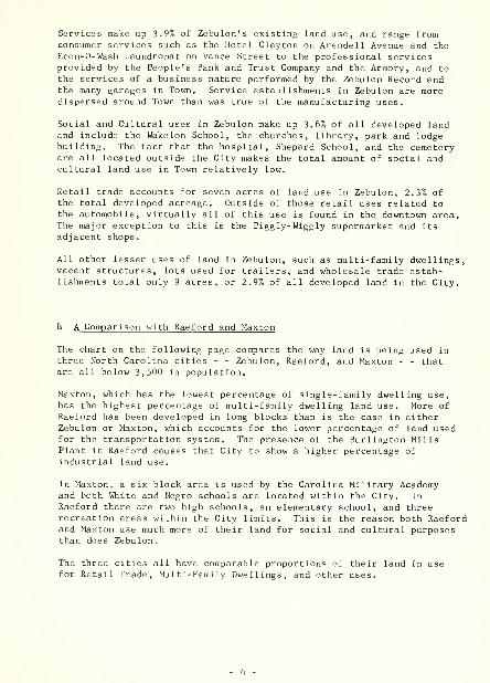
B A Comparison with Raeford and Maxton
The chart on the following page compares the way land is being used in three North Carolina cities - - Zebulon, Raeford, and Maxton - - that are all below 3,500 in population.
Maxton, which has the lowest percentage of single-family dwelling use, has the highest percentage of multi-family dwelling land use. More of Raeford has been developed in long blocks than is the case in either Zebulon or Maxton, which accounts for the lower percentage of land used for the transportation system. The presence of the Burlington Mills Plant in Raeford causes that City to show a higher percentage of industrial land use.
In Maxton, a six block area is used by the Carolina Military Academy and both White and Negro schools are located within the City. In Raeford there are two high schools, an elementary school, and three recreation areas within the City limits. This is the reason both Raeford and Maxton use much more of their land for social and cultural purposes than does Zebulon.
The three cities all have comparable proportions of their land in use for Retail Trade, Multi-Family Dwellings, and other uses.


PERCENT OF DEVELOPED LAND
SINGLE FAMILY DWELL.
TRANSPORTATION
PRODUCTION 8 MFG.
SERVICES
SOCIAL 8 CULTURAL
RETAIL TRADE 3
MULTI-FAMILY DWELL. ]
OTHER USES
0%
LEGEND BKB ZEBULON (SEED RAEFORD mm MAXTON
10% 20% 30% 40%


C. Land Use in the Downtown Area
If we consider Zebulon's downtown as that property fronting on Arendell Avenue from Cannon Avenue to the railroad, we find a diversity of business uses located there. Most essential to the economic vitality of the area are those shops that sell comparison shopping goods such as clothing, shoes, jewelry, gifts, and sporting goods. When purchasing such items as these, shoppers often like to compare quality, fit and price in a number of stores before making a purchase. That is why these uses generally cluster together in the downtown area within convenient walking distance of one another. Experience has shown that when such uses as these locate too far away from others of their kind they have difficulty in surviving. These shops are known as primary retail estab- lishments, and in Zebulon there are 13 such shops. It is interesting to note that 12 of these are located in the two blocks between Vance and Sycamore Streets. Only Nan's Fabric Shop lies outside this area. There are 1.17 acres in this use in the downtown shopping blocks.
Stores that sell higher bulk (and generally more expensive) items than the primary retail establishments are known as secondary retail outlets. These include stores selling appliances, floor coverings, furniture, automobiles, hardware, farm supply and auto parts stores. People pur- chasing these goods are very likely to be "one stop" shoppers and not inclined to walk the downtown streets comparing these goods in each store. Therefore, such uses do not have a vital need for a downtown location. As a city grows and the land value in the downtown increases, these secondary establishments generally sell their locations to primary trade stores and relocate either on the periphery of the downtown area or out along a major road approach to the Town. There are 11 secondary trade stores in Zebulon's downtown, four of which are located out of the two block area between Vance and Sycamore Streets where the primary trade shops are clustered. Three are located on the south side of Vance Street: Whitley Furniture Company, Whitley and Scarboro Farm Supply, and Duke's Auto Parts. As might be expected because of the high bulk items they merchandise, the secondary trade stores use 2.15 acres of land as compared to 1.17 acres for the primary trade uses.
The third, and final, functional category of retail establishments are convenience trade stores that cater to the personal needs of customers. Among those stores that are considered to be dealing in convenience trade goods are drug stores, bakeries, food or fish stores, liquor stores, and service stations. In Zebulon, convenience trade outlets are more dispersed than either primary or secondary trade stores. There are eight such establishments, five in the two blocks between Vance and Sycamore Streets. They use 1.07 acres of land in the downtown area.
Consumer service establishments (restaurants, laundromats, dry cleaning, barber shops, etc.) use 1.08 acres in the downtown, while all other commercial and professional uses of land make up 1.76 acres in the area.
It is interesting to note that within this area there remain 1.20 acres being used for dwellings and 1.09 acres vacant of any use. Thus, within the downtown area there is still room for some expansion and intensification of business uses.
- 5


• !•]•


A. Past Growth of Zebulon's Population
The Town of Zebulon has experienced a steady growth in population from 1,070 in 1940 to 1,378 in 1950, and to 1,534 in 1960, including annex- ation . It can be seen from the table below that while the nonwhite population of Zebulon has increased by 100 people between 1940 and 1960, the white population increased by 364. This was a 34% increase in non- white population, and a 46% increase in the white population.
Population Increase in Zebulon, 1940-60 1940 1950 1960
White 781 1,006 1,145 Nonwhite 289 372 389 Total 1,070 1,378 1,534
When Zebulon's population increase is compared with other nearby towns, an interesting distinction emerges. Zebulon, Wendell, and Apex all have a similar growth pattern. All three towns lost population between 1920 and 1930, but have gained slowly since that time.
1920 1930 1940 1950 1960 Zebulon 953 860 1,070 1,378 1,534 Wendell 1,239 980 1,132 1,253 1,620 Apex 926 863 977 1,065 1,368 Cary 645 909 1,141 1,446 3,356 Garner 376 476 768 1,180 3,451
Cary and Garner, on the other hand, have a distinctive growth pattern all their own. Both towns increased population gradually up until 1950. Since 1950, they have been hit by a wave of suburban development from Raleigh that more than doubled the population of Cary and almost tripled that of Garner.
B. Future Growth of Zebulon's Population
Apex is now on the threshold of the same sort of growth experienced by Cary and Garner. Should the demand for suburban residential sites out- side Raleigh continue for the next decade or two, it is not unlikely that both Wendell and Zebulon will enter into a period of rapid growth. The improvement of US 64 will tend to channel growth in that direction.
Zebulon's future population can only be forecast based on the past rate of growth. Since a sizable increase in population due to Raleigh's suburban expansion has not been a factor in Zebulon's past growth, this unknown factor must be excluded from the forecast. Should Zebulon continue to grow at the same rate as during recent decades, the town will have a population of 1,920 in 1970 and 2,340 in 1980. This assumes that annexation policy in the future will be similar to that in recent years.


The Zebulon Planning Area (the Town plus its built-up periphery and Wakefield community) had a population of 2,080 in 1960. With a continuation of past trends, the Zebulon Planning Area will have a population of about 2,500 by 1970 and 3,000 by 1980.
C. Natural Increase vs Migration
The population of a town can change in five different ways - - people are born, people die, people move to town, people leave town, or the town itself expands to include more people. The first four of these changes are taking place every day of the year in most towns. There are few sizable towns that do not annex at least some territory from one decennial census to the next. It is useful to examine just how these different ways of change worked in Zebulon, while the total population was increasing by 156 people from 1950 to 1960.
Population Change in Zebulon, 1950 - 1960
Actual Expected Actual Differences Between Age 1950 1960 1960 1960 Expected and
Group Population Population Population 1960 Actual Population
0-4 155 170 154 -16 5-14 213 305 304 - 1 15-24 229 212 202 JJ) 25-34 269 228 181 -47 35-44 191 266 222 -_UU 45-54 135 187 202 +15 55-64 111 130 114 -16 65+ 75 154 155 +- 1
TOTAL 1,378 1,633 1,534 -99
When the births and deaths that occurred between 1950 and 1960 are added and subtracted from the 1950 population, an "expected" 1960 population is obtained. This expected population excludes the changes that took place because of people moving into town, people leaving town, and annexation. In the table above we see that there was a net out-migration of 99 people from Zebulon during the 1950- 60 decade. We also note that the greatest loss of people was in the age group 25 to 44. A loss of population in these ages is particu- larly detrimental to a town's economy because the major expenditures of a lifetime - - for homes, autos, and other costly items - - are made during those years.


D. Population Loss in the Rural Area outside Zebulon
A 45 square mile rural area surrounding Zebulon is included in Wake County census tract 43. This census tract had a population of 4,184 in 1960, excluding the Town of Zebulon. During the past 10 years,
this area has been declining in population, due to outmigration. Most outmigrants are farm people whose marginal, low-income, and labor-intensive farming provided an inadequate living and led them to seek urban employment. Nation-wide trends of farm consolidation and farm mechanization have also eliminated many small farm holdings. One-fourth of the population that was in the area in 1950 - -1,400 persons - - left the area during the next 10 years. Over half of them were Negroes.
While the future trend will be toward continued outmigration, the employment opportunities found in Zebulon are a stabilizing in- fluence on that outmigration. Many men from this area are employ- ed at Beck Brothers Veneer Plant, many women at the Devil Dog Apparel Plant, and many teen-agers in other local businesses.


A. Employment
Within Wake County census tract 43, (Zebulon plus a 45 square mile rural area surrounding it) there were 3,821 people 14 years of age or older in 1960. 52% of these people (1,987) were either employed or available for employment. This was slightly below the average of 55.6% for all the rural-nonfarm areas of North Carolina and is believed to be due to a higher number of elderly adults in Zebulon than is found in most rural- nonfarm areas of the State.
As can be seen in the table below, 1,885 out of the 1,987 people avail- able for employment were actually employed. Within the census tract there is a decided lack of employment opportunities for nonwhites (particularly women). This is a basic cause for the out-migration that
Labor Force in Census Tract 43, 1960 White Nonwhite TOTAL
Male Female Pop. Age 14+ 1,147 1,275 In Labor Force 840 421 % in Labor Force 73.2% 33.0%
Employed 808 405 Unemployed 32 16 % Unemployed 3.8% 3.8%
Nonwhite Male Female 674 725 492 234
73.0% 32.3%
459 213 33 21
6.7% 9.0%
3,821 1,987 52.0%
1,885 102
5.1%
is taking place in the rural portion of the census tract. The unemploy- ment rate of 5.1% in the census tract was slightly above the rate for all rural-nonfarm areas in the State where a rate of 4.8% was found.
B. Types of Employment
Within the census tract, 531 persons - - 28.5% of all those employed - - worked at agriculture in 1960. If local, state, and national trends in agricultural employment continue, this number may drop by a third by 1970.
The table below shows the importance, to the Zebulon census tract, of various types of nonagricultural employment. It shows that the two most important types of employment in the area in 1960 were manufacturing and retail trade. Manufacturing gave jobs to 22.7% of all the non- agriculturally employed, while retail trade gave jobs to 16.9%.


Zebulon Area Employment by Industry, 1960
Zebulon Area Employment State Difference between Industry Number Percent Percent Zebulon P
and State 1,885
531 1,354 100.0%
22.7
100.0%
36.5 308 -13.8
85 6.3 2.7 3.6 68 5.0 2.4 2.6 84 6.2 5.8 0.4 71 5.2 25.6 -20.4
140 10.3 7.3 3.0 55 4.1 5.3 -1.2 176 13.0 9.3 3.7 679 30.1 58.4 -8.3
133 9.8 11.1 -1.3 107 7.9 3.6 4.3 228 16.9 15.3 1.6 73 5.4 3.1 2.3
Total Employment Agriculture Nonagricu1ture Manufacturing
Machinery Apparel Wood Products All other
Construction Trans-Commun-Util Personal Services
Blue Collar Subtotal
Professional Services Public Administration
Retail Trade Wholesale Trade
White Collar subtotal 541 40.0 33.1 6.9
All Other Industries 134 9.9 8.5 1.4
The table also compares the amount of employment found in each category in the Zebulon area with the amount found in each category in all of North Carolina. It shows that the Zebulon area is stronger in machinery manufacture, apparel manufacture, construction, personal services, public administration, and wholesale trade than is the State as a whole. The area's major shortcoming, compared to the State as a whole is a general lack of manufacturing employment. It is interesting to note that the Zebulon census tract has a higher percentage of people employed in white collar jobs (40.0%) than does the State (33.1%). Some of these major employment opportunities for census tract residents are found in the Town of Zebulon. This is true of wholesale and retail trade, apparel manufacturing, personal services, and construction. Others, such as machinery manufacture and public administration are found primarily in Raleigh. Of all nonfarm workers living in the Zebulon census tract in 1960, 36.1% worked in Raleigh.
Income
Average family income in the Zebulon census tract in 1959 was $4,459 for white families and $1,858 for nonwhite families. The overall average was $3,565. The table on the next page shows that Zebulon compared unfavorably with other areas considered.


Average Family Income for Selected Areas, 1959
Area
ZEBULON AREA Wendell Area
Rolesville Area Knightdale Area
City of Raleigh
Rest of County
North Carolina
United States
Total White Nonwhite
$3,565 $4,459 $1,858 4,056 4,789 2,078
4,178 4,750 2,319 4,573 5,285 1,968
6,615 7,505 3,293 4,781 5,518 2,254
4,838 5,440 2,477 6,615 6,925 3,864
The rural area around Zebulon is now characterized by widespread poverty; 85% of all Negro families and 39% of all white families earned less than $3,000 and accounted for a bare fifth of total area income. 30% of Negro families and 14% of white families had incomes under $1,000! It is no surprise that large numbers of these people move out to seek opportunities
elsewhere. This picture may be expected to improve in years to come as a balance in reached between the population remaining in the area and the number of modern, profitable farms the area can support.
DISTRIBUTION OF FAMILY INCOME, 1959
PERCENT OF AREA FAMILIES
6.6
13.6
8 8
49.3
54.6J| „,„„„„„„,
» ' ,. 37 1
INCOME CLASS
ZEBULON
NORTH CAROLINA
83,000 - 87,999
ZEBULON
NORTH CAROLINA
UNDER 83,000
ZEBULON
NORTH CAROLINA
PERCENT OF AREA INCOME
i: 23 9
6 1 Tift 3
fill!:'! ;.:!'■' i,. !.i> 5
giipiliilimn !''" 21.6
If 111 II 9


D. Zebulon as a Trade and Service Center
The brighter side of the income picture is that the top 6.6% of Area families (with income of $8,000 or more) accounted for 23.9% of total personal income, and the 38.8% with moderate ($3,000 to $7,999) incomes accounted for 54.5% of total income. Out-migration of large numbers of low-income families from the Area does not destroy the local business structure so long as families with adequate incomes continue to live and do business in Zebulon. Although a decline in low-income rural customers reduces business for firms selling staples (groceries, every- day clothing, and the like), increases in per family incomes of the remaining farm families will increase demand for more quality goods and services. Since Zebulon is already a major center for equipment and supplies, greater mechanization and consolidation of farms may be a good thing.
The map on the next page indicated the area from which people are likely to come to shop for most of their needs in Zebulon.
Given a total census tract income of $4,813,000, in 1959, what is the sales performance record of local retail farms? A Zebulon Chamber of Commerce survey of local firms in 1958 confirms that Zebulon is more than holding its own. Retail sales were approximately 85% of total area income, indicating considerable spending by non-area residents, primarily those from rural areas in adjacent counties. The State proportion of 1958 retail sales to 1959 income, by comparison, was only 66.8%. Particularly high sales were registered by firms selling farm equipment, gasoline (due to Zebulon's location at intersections of several major highways), and food (one area in which the many low-income families were important contributors). Furniture, lumber, and hardware, and automobile sales were about normal. Sales were low, relatively, for drugs, eating places, general merchandise, apparel, and specialized goods, presumably representing shopping being done in Raleigh.
E. Guidelines for Future Economic Growth
Future efforts at economic development in the Zebulon area should be concentrated on specialized firms serving the Raleigh metropolitan area - - such as wholesale houses, large volume retail outlets, and components manufacturers. Such firms often require convenient access to the City they serve but wish to avoid the disadvantages of an urban location - - high land costs, traffic congestion, higher wages and construction costs.
While labor - intensive industries - - apparel, electronic wiring, etc., - - would bolster Zebulon's employment and income figures, long range stability could better be achieved by attracting firms that complement rather than compete with Raleigh's economic specialities.
Maintaining a high level of municipal utilities and services and encouraging quality standards in subdivision development will foster Zebulon's attraction as a residential center in the Raleigh metropolitan area.


RAOE AREA ZEBULON & VICINITY


A. Value of Homes
According to data collected by the 1960 census, the average value of owner-occupied homes in Zebulon is $10,500. This compares favorably with the other towns in the area that have not yet had a significant amount of construction for the "suburban market" of Raleigh.
Average Value of Owner - Occupied Homes, 1960
Garner $13,000 Cary 12,100 Zebulon 10,500 Wendell 9,000 Apex 8,500
The value of homes in Garner and Cary is unusually high for towns of this size. Of the 156 towns in North Carolina that have populations between 1,000 and 2,500, only 39 of them have average home values over $9,000.
B. Ownership of Homes
Of all homes occupied in Zebulon during the census, 59.0% were occupied by the owner. Zebulon has about the same degree of home ownership as the State of North Carolina. In the entire State 60.1% of occupied homes were owner occupied in 1960. Urban areas of the State have more rental homes than do rural areas, as is evident from the 55.1% owner occupancy rate for North Carolina urban areas compared to the 64.0% rate for rural areas.
Zebulon has a slightly lower owner occupancy rate than most surrounding towns. Garner and Cary, with their many residential subdivisions for commuters to Raleigh, have unusually high rates.
Percent of Homes Occupied by Owner, 1960
Garner 74, ,8% Cary 72, ,9% Zebu Ion 5C< ,0% Wendel1 65, ,3% Apex 59, ,7%
C. Condition of Homes
During January of 1962, a survey was made of the external appearance of the homes in Zebulon. Since it was made from a car, no allowance could be made for cases in which poor external appearance is offset by good maintenance inside the house.
- 13


During the survey, all houses were classified into one of four categories:
-Standard - Good housing,well maintained.
Minor Repair Needed - Homes in need of minor maintenance
such as painting, repair of windows, repair of steps, etc.
Major Repair Needed - Homes in need of major repairs such as replacing poor foundation, roofing, replacing siding, etc. When a number of minor repairs were required, the home was considered to be in need of major repair.
Clearance - Homes that do not now provide safe and sanitary housing and whose original construction would not justify the number of major repairs needed.
By far, most of the homes in Zebulon are in good condition or "standard". "In need of minor repairs" was the next most frequent condition found. These two categories contained a total of 88% of all homes in town. The remaining 12% either needed major repairs or were beyond repair.
Housing Appearance in Zebulon, 1962
Number Percent Standard 322 66 Minor Repair Needed 106 22 Major Repair Needed 37 8 Clearance 18 4
Total 483 100
When the housing conditions in Zebulon are analyzed as to the race of the occupants, we find that half of the homes needing major repair and virtually all of those beyond repair are occupied by Negroes. It is also pertinent that the category "Minor repair needed" far exceeds all others for Negro housing. Minor repairs that are put off for a number of years accumulate and worsen into major repair needs.
Housing Appearance by Race of Occupants
White Nonwhite Standard 302 20 Minor Repair Needed 69 37 Major Repair Needed 18 19 Clearance 3 L5
Total 392 91
- 14


As the Housing Appearance map shows, all of the homes east of Poplar Street and north of Glenn Street are standard, with the exception of one home in need of minor repair. From Glenn Street south to Gannon Avenue (east of Poplar Street) the homes are still predominantly standard, but a scattering of homes in need of minor or major repairs is found in the area.
South of Gannon Avenue, housing appearance is much more mixed. On Sycamore, Horton, and Vance Street can be found homes in each of the top three categories. In the three western-most blocks of Horton
Street there are 15 standard homes, 12 in need of minor repair, 5 in need of major repair, and 6 homes beyond repair.
Not only is Zebulon's worse category of housing predominantly occupied by Negroes, but it is largely located in only one Negro residential area - - Barbee Street. In that three block portion of Barbee Street now occupied by Negroes there are 12 of Zebulon's 18 homes that are beyond repair. Barbee Street contrasts in this respect with the Negro residential area east of U.S. 64 and north of U.S. 264. In that entire area there are but two homes beyond repair. There are also 18 homes in that area that are standard.
Negro Housing Areas in Zebulon
Barbee Street Area Pitt Street Area Standard 1 18 Minor Repair Needed 19 16 Major Repair Needed 11 8 Clearance 12 _2 Total 43 44
D. Improving Housing Conditions
There is a broad range of techniques that the people of Zebulon could use to improve housing, conditions in the town. Not only does the condition of each house determine the treatment most appropriate for it, but each section of town also has to be considered individually. Making minor improvements to a house in an area of predominant "clearance" condition is simply a waste of effort, unless it is part of an overall program for upgrading the area.
1. The town should do all in its power to have those few homes that are unsafe and unsanitary vacated and torn down. Where this is not done voluntarily by the property owner, the town should use its powers of condemnation to bring it about. As the public housing units now planned for Zebulon become available, the families occupying "clearance' homes could be given first consideration for the new units.
15


ZEBULON, N.C
HOUSING APPEARANCE


Many towns are now using the federally-assisted urban renewal program to renew blighted residential areas. Under this program, an area where a clearance condition exists is purchased from its owners and is wholly or partially cleared according to a plan for reusing the area. The vacant land is then resold to private developers who utilize the land for its planned use. The difference between what the city paid to acquire and clear the land and what it obtained from the resale of the land is known as the "net project cost". The federal government pays 3/A of this net project cost. The program is most appropriately used where there is a clear need for reusing the property, either for commercial or residential development. This does not seem to be the case in Zebulon's "clearance area", unless a builder could be found who would build medium cost homes in the area at a relatively low profit.
2. While removing "clearance" homes is simple and more direct, solving the problem posed by homes needing minor and major repairs is a more challenging assignment. Unless the trend toward dilapidation evident in these homes can be stopped, they will gradually deteriorate into "clearance" condition, and once standard residential areas will become a municipal burden and a community eyesore.
Before the Housing Act of 1954, mortgage insurance in older areas of a
city was generally available only through convential loans requiring a one-third downpayment. Section 221 of that Housing Act has opened up new possibilities for saving older sections from dilapidation. Under it, F.H.A. is authorized to make mortgage insurance available for im- proved housing on terms as good as or better than the terms available for new housing. Thus, it is now possible for someone desiring to sell a home in the older part of town to deal with a buyer on the same terms as a builder in the suburbs. For a town to be eleigible for this Section 221 financing, certain administrative steps must be taken. It is a particularly useful tool to rehouse families displaced by condem- nation of unsafe homes, highway construction, or other governmental action when those families wish to buy their homes.
In addition to Section 221, the Housing Act also authorized F.H.A to insure loans made to finance alterations, repairs, and improvements to existing structures. This insurance enables the borrower to find a lower interest rate than would be available on a conventional loan. Loans to improve a single-family house may be for sums up to $10,000 and may be repaid over a twenty year period. The same sort of facilitated borrowing for home improvements is made available in some cities by raising a "fight blight" fund from local sources. This money is used to provide easy credit for property owners who want to restore their homes to standard condition.


3. In many large cities, Housing Codes are used to bring unsafe, unsanitary homes up to standard. Zebulon could adopt such a code and require the improvement of housing conditions. But in a town such as Zebulon much better results could probably be obtained through a community-wide program sponsored by local civic clubs and through persuading property owners to make needed improvements. The North Carolina Residential Building Code should be carefully enforced, however, to insure that new construction is standard. It's of little value to eliminate existing slum housing when new slum buildings can be built to take their place.
4. To encourage home improvements, the Zebulon Town Commissioners or a Zebulon Civic Club could give annual awards for property improvement efforts. These awards could be monetary, or could simply be public recognition for private efforts at improving housing conditions.
Those who live in clearance housing conditions do not do so through choice. They live there because it is the best housing they can find for the money they have to spend. Their money comes from the work they do in Zebulon's industries, stores, and homes. Their efforts are an integral part of the local economy. There is a community responsibility to see that all who share the work of the community share in its advantages - - certainly to the point of a safe and sanitary place to live. The diseases and criminal attitudes that are bred in slum housing conditions are not limited in their effect to the buildings where they were formed.
17 -


Within the City limits of Zebulon millions of dollars have been invested in public improvements of one sort or another. The water treatment plant and storage tank, miles of water and sewer lines, paved streets, sidewalk, curb and gutter have all been purchased by the people of Zebulon to make their town a more healthful, safe place to live. It is useful, therefore, to occasionally take stock of those improvements and discuss their present condition and possible future extensions.
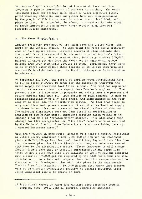
A. The Water Supply System
Zebulon presently gets most of its water from the Little River just north of the Wendell bypass. At that point the river has a tributary area of 55.1 square miles. Historic records of flow indicate that the runoff from this area will be adequate to serve Zebulon1s future water requirements. At the present time, Zebulon gets about 200,000 gallons of water per day from the river and an additional 75,000 gallons from four deep wells located in Town. Zebulon has about five miles of major water mains: three-fourths of it in six inch pipe and one-fourth in eight inch pipe. In itself, this system is believed to be adequate.
On September 11, 1962, the people of Zebulon voted overwhelming (203 to 11) to issue $392,000 in bonds for the purpose of improving the water supply and treatment facilities in town. The need for new water facilities was made clear in a report from Zebulon1s engineer. J/ The present plant is inadequate to properly and safely meet the present and future demands made upon it. Upon periods of peak demands, it must be operated practically on a 24 hour basis, and supplemented by the four deep wells tied into the distribution system. The fact that there is only one filter unit poses a constant threat of curtailment of supply for domestic and fire use in case of functional failure of this unit. The existing plant layout does not lend itself to modification or addition of new filter units, increased settling basin volume or in- creased clear well or "treated water" storage. This also means that storage for fire emergencies, or "fire flow" requirements as required by the National Board of Fire Underwriters is not available, causing increased insurance rates."
With the $392,000 in bond funds, Zebulon will improve pumping facilities at Little River, construct a new 1,000,000 gallon per day treatment plant with 200,000 gallon clear well facilities, lay a 12 inch line from the treatment plant (at Little River) into town, and make some needed additions to the distribution system. These improvements will change Zebulon from a town that is woefully unprepared for any large fire - - there is now a five hour fire flow capacity of 128,125 gallons compared with a flow of 3 75,000 gallons required by the NBFU for a town the size of Zebulon - - to a town well prepared both for fire emergencies and for the residential development that will take place in the next decade. The new fire flow capacity of 500,000 gallons also means that Zebulon will be in a better competitive position to attract desirable water- using industrial plants to locate in town.
1/ Preliminary Report on Water and Sanitary Facilities for Town of Zebulon, Sept. 1961, John A. Edwards, Consulting Engineer.


B. The Sewerage System
Zebulon's present sewerage system consists of a network of collectors feeding into two outfall lines that join and continue on for 1,200 feet before discharging the sewage into Little Creek. The outfall system
is now at capacity, and at times of peak flow sewage spills out of manholes along the line.
The flow volume in Little Creek is insufficient to dilute the sewage entering it to a sanitary degree. While the stream has received a low "D" classification from the State Stream Sanitation Committee, sewage treatment is required to meet the requirements of that classification.
On September 11, the people of Zebulon also voted (202 to 12) to meet the community responsibility for sewage treatment. $166,000 has been authorized to construct a new 18" outfall line to relieve the overflow condition on the present line and to construct a sewage treatment plant with a capacity of 500,000 gallons per day. The plant is designed so that it can be inexpensively expanded to double that capacity when the need develops. The plant will provide both primary treatment (of solid wastes) and secondary treatment (of liquid wastes), and will meet the sanitation standard set by the Stream Sanitation Committee of the N. C. Department of Water Resources.
Since a commonly recommended standard for sewage treatment capacity is 100 gallons per capita per day, the new treatment plant will provide the sewage treatment capacity for Zebulon to double its population in the decades ahead, provided that capacity is available to handle peak loads.
The sewage system that now serves Zebulon is completely a gravity flow system. Unlike many towns, Zebulon does not have a heavy investment in pumping stations and their operation. It would be desirable if future development around Zebulon were to be located in the same drainage divides that are now serviced. Then, although sewerage may not be available at the time of construction, it can be provided as the system expands in future years.
C. Street Improvements
It is evident from a glance at the Street Improvements Map that Zebulon's City Street System is in very good condition. There are very few streets
Street Conditions in Zebulon
Mi les of Street % of Total Paved 10.06 73.6 Stone or Soil Surfaced .52 4.5 Unimproved .81 6.0 Platted, Not Open 2.15 15.9 Total 13.54 100.0
in Town that are as yet unpaved. This is particularly true when you eliminate from consideration those platted but unopened streets that
19


do not serve any present development. In fact, the primary shortcoming of Zebulon's street system is the existing and platted roads that are either not needed to serve development or are platted in wrong locations. For example:
1. There is an opened, but unimproved road connecting Glenn and North Streets, between Wakefield and Church Streets that is not needed to serve development and could readily be abandoned as a public right-of-way and given back to the adjoining property owners.
2. Glenn Street is platted to continue past Poplar Street to U.S. 64. Should this road be connected through, it would seriously complicate the traffic flow pattern at the U.S. 64-Pitt Street intersection. This platted connection should be abandoned.
3. The same thing is true of Oak Street, a one block platted road that would also start at the U.S. 64 - Pitt Street intersection. This road should never be opened at that location. As long as the road is platted, lots could be sold off and developed at any time. The elimination of this platted road would also eliminate the name duplication with a platted Oak Street south of Barbee Street.
4. Bell Street, just south of U.S. 264 between Gill Avenue and
Whitley Street is a good example of a publicly maintained road that serves little purpose. While it is paved, it provides access to only one undeveloped lot and creates a "block" of only two small lots. It also intersects Gill Avenue too close to U.S. 264.
5. Used judiciously, and with a proper regard for the topography, the gridiron street system of right angle intersections and rectangular blocks can be useful and attractive. Unfortunately a gridiron system once begun is often continued long past the point where the topography or traffic circulation requirements demand it be abandoned. An example of this can be seen in the platting of Oak Street beside and to the rear of the Armory. Rectangular blocks and lots have been laid off even though the topography is steep and a creek would make most of the lots very poor building sites. As it is presently platted, Oak Street will do more to forestall residential development in that area than to encourage it.
6. The same continuation of the gridiron system regardless of an adjoining creek occurs where Glenn Street is platted be- tween Arendell and Poplar Streets.
The only unpaved section of road in Zebulon for which there appears to be a clear need of paving is on Horton Street. This road should be paved out as far as the present development occurs, a distance of approximately 600 feet to the City Limits and 300 feet beyond.
- 20 -


0
ZEBULON, NC
STREET IMPROVEMENTS
JO n»"""'"" '-" r


D. Sidewalks
As a general policy, sidewalks should be installed wherever the pedestrian use of the public right-of-way is heavy enough to create
a safety hazard on the road. This is true in the downtown area, and around schools, public buildings and major employment centers. It is also true in residential areas along heavily traveled thoroughfares. In Zebulon, sidewalks are found on both sides of Arendell Avenue in the downtown area, on one side of Arendell Avenue out to the Wakelon School and on both sides of heavily traveled U.S. 64 and 264. Locations in which additions to Zebulon's system of sidewalk would be justified are:
1. On the east side of Arendell Avenue, between Sycamore and Gannon Street, to complete the sidewalk in the downtown area.
2. Around on U.S. 64 from the U.S. 64 - 264 intersection to the Piggly-Wiggly supermarket.
3. Out U.S.64 to the Shepard School.
4. Across the railroad right-of-way on both sides of Arendell Avenue, as far as Barbee Street and on the east side of Arendell Avenue out to the Armory.
5. Out U.S.264 from Arendell Avenue to the Devil Dog Plant.
6. On the east of Church Street between Mclver and Judd Street and along Judd Street to the Wakelon School.
7. And as secondary recommendations, down Vance Street west of Arendell Avenue to serve the existing businesses, and east
of Arendell Avenue on this future business street.
Curb and Gutter
The recently constructed curb and gutter along Vance Street is actually the only significant amount of that improvement in Zebulon apart from Arendell Avenue in the downtown area and along U.S. 64-264. Beside greatly improving the appearance of an area, curb and gutter eliminates the maintenance and safety problem created by roadside ditches.
In these days of high costs and necessarily high taxes, such luxuries as sidewalks and curb and gutter have a way of being indefinitely postponed in favor of more crucial utilities and improvements. It would seem to be good municipal policy to set aside a small amount of money each year for both of these items. Then, while the amount of curb and gutter or sidewalk that is installed in any one year will be small, each year will find the city to be slightly ahead in these improvements. Adding only one block of sidewalk or curb and gutter per year would make Zebulon a significantly better Town in a few short years.
21 -


B. Signs and Signals
The Traffic Signs and Signals Map shows all traffic lights, stop signs and yield right-of-way signs in and around Zebulon. Two intersections in Zebulon seem to be in definite need of signal-
ization: the intersection of Arendell and Vance Streets and the intersection of U.S. 64 and 264. The problem at Arendell and Vance Streets is not so much the control of the flow of traffic as it is the elimination of confusion and uncertainty on the part of drivers entering the intersection, particularly from the heavily signalized blocks of Arendell Avenue. Many drivers pause at Vance Street searching for some traffic control signal or sign.
At the intersection of U.S. 64 and 264, the objective of the traffic signal would be to give an opportunity to the cars going west on 264 to enter the intersection when traffic is heavy on 64. With this in mind, that signal might be semi-actuated by cars approaching on 264. This would reduce the delay to U.S. 64 traffic that a fully automatic
signal would cause.
Considering the heavy traffic that flows on Arendell Avenue, it is evident that stop signs are needed at the intersection of Arendell Avenue with Mclver, Franklin, Lee and Glenn Streets. At the time this study was made these intersections had no traffic signs of any sort in either direction. While most residents of Zebulon would know to be cautious when entering Arendell Avenue from a side street, stop signs are needed for the safety of all the public and as a clarification of the right-of-way at those intersections. These stop signs have since
been installed.
Stop signs would also seem to be in order at Liberty Street and Gannon Avenue, at North Street and U.S. 64, at Gill Avenue and U.S. 264, and at Oak Street and Wakefield Street. Generally speaking, stop signs are in order where a minor road intersects a major road, two major roads intersect, or the sight distance is bad. All other intersections should use a yield sign.
As an exception to the above general rule, it is better to use a yield sign where the intersecting streets are at an angle of less than 60 degrees, since stop signs often prove ineffective in such location. The intersections of Pitt Street and U.S. 64, and of the Poplar Street and U.S. 64 both are such intersections. A yield sign is also required at the intersection of Poplar Street and Vance Street.
Street Lights
The Street Trees and Lighting Map shows the location of all street lights, trees that shade the street, and trees or bushes that block sight distance at an intersection. Street lights are not a municipal improvement in the same sense that paving, curb and gutters or traffic signals are. Street


ZEBULON, N C
TRAFFIC SIGNS AND SIGNALS

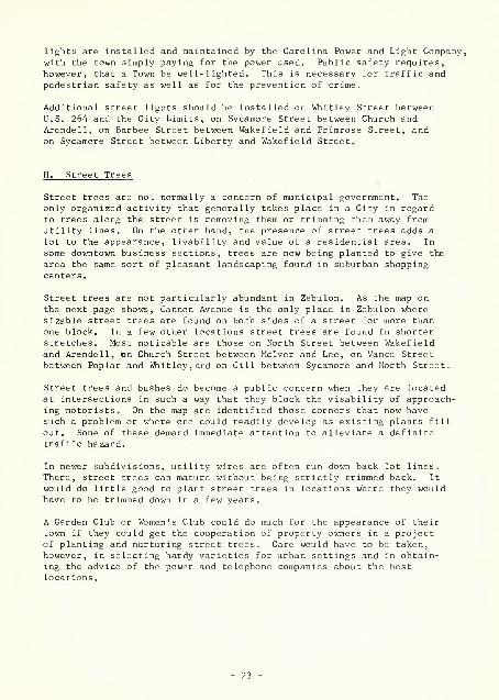
lights are installed and maintained by the Carolina Power and Light Company, with the town simply paying for the power used. Public safety requires, however, that a Town be well-lighted. This is necessary for traffic and pedestrian safety as well as for the prevention of crime.
Additional street lights should be installed on Whitley Street between U.S. 264 and the City Limits, on Sycamore Street between Church and Arendell, on Barbee Street between Wakefield and Primrose Street, and on Sycamore Street between Liberty and Wakefield Street.
H. Street Trees
Street trees are not normally a concern of municipal government. The only organized activity that generally takes place in a City in regard to trees along the street is removing them or trimming them away from utility lines. On the other hand, the presence of street trees adds a lot to the appearance, livability and value of a residential area. In some downtown business sections, trees are now being planted to give the area the same sort of pleasant landscaping found in suburban shopping centers.
Street trees are not particularly abundant in Zebulon. As the map on the next page shows, Gannon Avenue is the only place in Zebulon where sizable street trees are found on both sides of a street for more than one block. In a few other locations street trees are found in shorter stretches. Most noticable are those on North Street between Wakefield and Arendell, on Church Street between Mclver and Lee, on Vance Street between Poplar and Whitley,and on Gill between Sycamore and North Street.
Street trees and bushes do become a public concern when they are located at intersections in such a way that they block the visability of approach- ing motorists. On the map are identified those corners that now have such a problem or where one could readily develop as existing plants fill out. Some of these demand immediate attention to alleviate a definite traffic hazard.
In newer subdivisions, utility wires are often run down back lot lines. There, street trees can mature without being strictly trimmed back. It would do little good to plant street trees in locations where they would have to be trimmed down in a few years.
A Garden Club or Women's Club could do much for the appearance of their town if they could get the cooperation of property owners in a project of planting and nurturing street trees. Care would have to be taken, however, in selecting hardy varieties for urban settings and in obtain- ing the advice of the power and telephone companies about the best locations.


ZEBULON, N C
STREET TREES AND LIGHTING


A. Purpose of the Plan
The Land Development Plan is a general guide for the future growth of Zebulon. It identifies the best location for each of the different uses of land that will be needed as Zebulon grows, and it ties these areas of future use together with a system of major thoroughfares that will take care of the traffic those uses generate.
To the greatest extent possible, the future uses shown on the plan are in locations where they can be served by existing or proposed utilities, Development of these areas should be encouraged to minimize the need for costly pipeline extensions and pumping stations.
The plan also attempts to keep separated those uses of land that are incompatible with one another. Just as residential property values would be hurt by the location of a noisy industry in the middle of a subdivision, so the availability of prime industrial areas (which are limited in any town) would be destroyed by scattered residential development. Each use of land has requirements and characteristics all its own. The modern city must not only find the best place for each of its uses, but must be sure those locations are compatible with one another.
B. Future Land Requirements
In planning for the future land needs of any existing city we can be assured of one thing: when the population doubles, the use of land, in all categories, will more than double. Existing cities were founded and had their early growth during decades when the horse and buggy or "shank's mare" were the primary means of local transportation. Develop- ment was closer together than it needs to be in these days of the automobile. Other factors contribute to the recent dispersion of urban development. Popularity of the ranch-style home and generous land- scaping has brought about larger residential lots. Retail businesses have come to realize that the lack of adequate off-street parking space can drive customers away in search of more convenient places to shop. Industries, too, have shared in this spreading out of cities. Modern assembly-line processes require si,ngle-story construction, and the two and three story mill of yesteryear often stands vacant today.
This current trend toward dispersal means that any plan for future years must make generous provision for all land uses. The fact that Zebulon now uses 139 acres to house a population of 1,534 people cannot be taken to mean that 139 acres will be needed for the next 1,500 people. Allowing safety factors of 25% for larger lots and 25% for subdivision streets, the next 1,500 people are likely to need 209 acres for residential use.
24 -


C. Residential Uses
In deciding on areas best used for residential purposes in future years,
Zebulon has one definite opportunity at hand. There are now about 32 acres of close-in residential lots that have been bypassed by development. Should Zebulon make a concerted effort to have these lots built upon in preference to opening up new residential areas around the city? There would be advantages in such a policy. These close-in lots would not require the costly extension of streets, water or sewer mains, street lights, or other municipal utilities. They could be more readily protected from the central fire and police station than development that is further out. The close-in lots would be in easier walking distance of existing stores, schools, and parks. Since the lots are in estab- lished residential areas there would probably be a greater variety of home types and even ages of residents than one generally finds in a new subdivision.
What steps could be taken to bring about the development of these by- passed lots? First of all, realtors could maintain a list of such available lots that could be readily consulted by a newcomer to Town. Second, various attractions could be provided the in-town builder by the property owner or by the City. A lower purchase price if construction takes place immediately, or free water and sewer service for a year would be two possible attractions.
This is not to suggest that Zebulon should prohibit all new subdivisions until the existing vacant lots are filled. Enough residential construct- ion takes place from year to year to make such a choice unnecessary. Ways and means should be found to make in-town construction more attractive
than it evidently is at the present time.
The Land Development Plan shows these vacant in-town lots being utilized. New residential development is shown taking place primarily around the focal points provided by the schools and park on the northern side of the city. The proposed by-pass should also have the effect of pulling development in that direction. Other areas around town should be preserved for residential development, as shown on the plan, to provide a choice of home sites, and to fill out areas where residential develop- ment has already begun.
A total of 209 acres is expected to be required for residential use as the population of Zebulon doubles in the decades ahead. Approximately 139 acres of this will be in White residential areas and 70 acres in Negro residential areas.
D. Social and Cultural Uses
Most "Social and Cultural" uses of land are compatible with residential development and might occur anywhere in the residential areas of a city. Schools, parks, churches, cemeteries, and hospitals are often found in residential areas. To some extent, this was a more acceptable pattern
- 25


ZEBULON, N.C
LAND DEVELOPMENT PLAN
•■•&■:::... u


of land use in past decades than nowadays. The traffic generated by a large school or hospital can have a detrimental effect in an otherwise residential area and careful site planning is needed to minimize that effect.
Many of Zebulon's future social and cultural uses of land will occur in residential areas, but some particularly appropriate areas can now be identified for these uses. An area near the hospital might best be preserved for hospital-related facilities such as a nursing home, rehabilitation clinic, or health center. An area near the Armory might also be set aside for the expansion of these facilities in future years.
The Land Development Plan also shows a proposed area of future "Social and Cultural" use between the cemetery and U.S. 64 in the vicinity of the old town landfill. Once this landfill has been covered it might best be seeded, planted with trees, and used for a neighborhood park and playground to serve that side of Town. This would put to profitable public use an area that could not be used for building sites for a number of years to come.
The final"Social and Cultural" use indicated on the Plan is shown on church-owned property next to the Zebulon Baptist Church where it is believed the church plans an expansion in years to come.
A total of 17 acres is expected to be required for this use as Zebulon's population doubles.
Business Uses
As noted in the Present Use of Land chapter, there are 1.20 acres being used for dwellings and 1.09 acres vacant within Zebulon's present down- town area. As the demand for business locations increases in future years, these areas should definitely be converted to business use. Once the frontage on Arendell Avenue between Gannon Avenue and the railroad has been filled, however, Zebulon faces some clear alternatives:
1. Should business uses expand on Arendell Avenue across Gannon Avenue toward the Wake Ion School?
2. Should business uses expand east and west on Horton and Sycamore Streets from Arendell Avenue?
3. Should a new direction be given to business development by guiding it along Vance Street east of the Town Office?
4. Or finally, should the future expansion of Zebulon's downtown area be discouraged in preference to possible outlying shopping centers?
If our objective for Zebulon's future is to strengthen the downtown area and make it a convenient, attractive place to shop, the first alternative would be definitely unacceptable. The essence of a downtown area lies in the clustering together of comparison shopping goods stores that deal with the pedestrian customer. Gannon Avenue will always be an obstacle


to the easy flow of pedestrian shoppers up Arendell Avenue. This is particularly true with the three gas stations and the Baptist Church
located at that intersection, for these uses are what is known commercially as "dead space" that pedestrians dislike crossing to get to other stores. Expansion of business uses up Arendell Avenue would
also be an intrusion into that essentially residential area.
Expansion of business east and west on Horton and Sycamore Streets would be a much more acceptable solution. It would at least preserve the sense of a "center" for shopping and keep the stores as close together as possible. The major objection to this would be the intrusion of business uses into the residential areas on either side of downtown, and the introduction of more traffic back on these
residential streets.
The third alternative of making a new business street out of Vance Street east of the Town office would not create a conflict with established
residential development since there are only three homes in the two block area between Arendell Avenue and Whitley Street. Vance Street is an unusually wide street for Zebulon, and already has curb and gutter down to Poplar Street. The disadvantage of this alternative lies in the fact that the south side of Vance Street is largely occupied by semi-industrial uses that would weaken the street's effectiveness as a business location.
The fourth alternative (of an outlying shopping center) is a choice that is being made in many larger cities often to the detriment of the City. Where the suburban shopping center is being constructed to serve a newly-developed residential area, the center does not harm the down- town area. But where the center has to draw on the customers who normally shop downtown, then the downtown decays as the center flourishes. While Zebulon has grown steadily in recent decades, that growth has not been sizable enough to outstrip the shopping opportunities in the down- town area. This is particularly true since a sizable part of Zebulon's shopping for specialty items probably takes place in Raleigh.
If there is to be a shopping center in the Zebulon area - - complete with adequate off-street parking, modernized store fronts, and some trees and benches - - that shopping center should be downtown Zebulon. If the Town and its downtown merchants desire to do so, the downtown area could be made into a much more convenient and attractive place to shop. It is much better to improve the existing shopping facilities in Town than to abandon them and start afresh, in a suburban location. Of the four alternatives in future commercial expansion open to Zebulon, this is the least attractive from a planning point of view. Business expansion down Vance Street east of the Town Office, or business expansion on Horton and Sycamore Streets east and west of Arendell Avenue, are alternatives that would strengthen rather than weaken Zebulon's downtown area - - and are much to be preferred. These alternatives are shown on the Land Development Plan.
A total of 18 acres for Services and 11 acres for Retail Trade are expected to be required as Zebulon's population doubles in the years ahead.


The suburban business locations shown on the Plan are intended for those Secondary Trade uses that do not need a downtown location. Auto garages,
tractor sales and repair, feed and seed stores, and similar uses can be located out of the downtown area since they do not require locations close to other like uses. Located in the downtown area, these uses just add to the demand for parking space and come between those Primary Trade shops that must be close together to survive. As a City grows, Secondary Trade establishments naturally tend to leave the downtown area. When they are being replaced by Primary Trade uses this is an indication of the downtown's economic vitality.
F. Industrial Uses
The Land Development Plan shows those general locations that might best be used for industrial purposes as Zebulon grows. A variety of sites - - different in size, different in utility service, and different in price - should be kept available for this use to meet the future industrial needs of the community.
The plan shows future industrial use filling in those sites along Vance Street - - particularly to the west - - that are vacant but adjacent to industrial uses. While it is not likely that a major industrial plant could use the small lots on Vance Street, wholesale outlets and small industrial firms might find it a satisfactory location. Care should be taken to limit industrial uses in that location to uses that will be
reasonably compatible with the nearby residential development.
As a more important location for future industrial use, the plan shows the area east of the Devil Dog Plant between U.S. 264 and the railroad. Because of its relatively flat topography, the possibility of rail access, the present availability of sewer service, and its presently undeveloped condition, this location is a prime industrial location in Zebulon. Another area for future industrial use is proposed south of Barbee Street and west of Wakefield Street. Carolina Power and Light Company is currently expanding their facilities at one corner of this area.
When the U.S. 64 Bypass is constructed, there might well be some prime industrial locations along it. This will depend on the location finally selected for the highway and on the topography of the adjacent sites. The long-range plan for a water main following the bypass to the Wake- field Community will facilitate industrial development along the Bypass. Care should be taken, however, to insure that the industrial development is far from the Wake Ion School since land in that area is better used for residential development.
With the variety and amount of land shown for future industrial use on the Plan, Zebulon's industrial land requirements should be satisfied for the next 20 or 30 years. But if Zebulon would like to see those sites occupied by industries, a more detailed study of the sites and the improvements that should be made on them should be undertaken. A total of 25 acres is expected to be required for industry as Zebulon's popula- tion doubles in the years ahead.


G. Thoroughfare Plan
A typical city street with two lanes of moving traffic (one each way) and curb parking has a capacity of about 7,500 vehicles per day. The Traffic Volume Map on the next page indicates that Zebulon does not have a serious traffic problem. This does not mean, however, that the existing streets will be adequate for the traffic of future years. Only a carefully plan- ned system of major roads can keep Zebulon free of traffic congestion.
The U.S. 64 Bypass of Zebulon that is currently being studied by Highway Commission engineers will relieve the traffic congestion on Gannon Avenue, particularly at its intersections with Arendell Avenue and U.S. 264. The residential character of Gannon Avenue that was threatened by the high volume of through traffic, will be strengthened when the Bypass is built.
In addition to a bypass to take through traffic out of Town, all cities have other thoroughfare, requirements. They need radial connections from the center of Town out into the residential and rural areas served by the Town. Zebulon has a good system of radial roads at the present time. U.S. Highways 64 and 264, and N. C. Highways 96 and 97 are Zebulon's
major radial roads. No additional radial connections are believed to be necessary.
Cities also need circumferential connections so that traffic can get from one quadrant of the City to another without going into the downtown area. Like most Cities, whose streets have been extended with little thought to overall City needs, Zebulon lacks circumferential roads. People liv- ing in Wakefield or in.the vicinity of Wakelon School should have some way to get to the Hospital and to the Devil Dog Plant without going into Gannon Avenue. People coming into town on the Wendell bypass should have some convenient way to get to N.C. 96 south of Town without coming into Zebulon. The Land Development Plan shows a proposed circumferential road connecting Judd Street to the Wendell Bypass just beyond the Hospital, and continuing around south of Zebulon to a future industrial area beyond the Devil Dog Plant. From the industrial area, the circumferential road would continue north, crossing U.S. 64 in the vicinity of the James E. Shepard School and tieing in with the platted extension of Judd Street.
A City's thoroughfare system should also contain crosstown connectors, providing in-town access from one part of Town to another. The roads created by the gridiron road pattern used in many Towns are adaptable for use as crosstown connectors. This is the case in Zebulon, where Wakefield Street and Poplar Street are adaptable for that use. While it is unlikely that this connection could be made in the1, next few years, the Land Development Plan shows Poplar Street connected across the railroad to the existing platted right-of-way on Hawthorn Street, thence behind the armory to the circumferential road mentioned earlier. A connection such as this would relieve Arendell Avenue of a certain amount of traffic - - particularly those cars entering town on U.S. 64 from the east that are going to destinations south of Zebulon. An additional crosstown connection would result if Barbee Street were extended, along the creek, to join with Horton Street south of the railroad.


ZEBULON, NC DAILY TRAFFIC VOLUMES
I960 ANNUAL AVERAGE


None of the proposed roads shown on the Land Development Plan would be heavily-traveled thoroughfares. None would necessitate rights-of-way in excess of 60 feet or paving widths of 35 feet. The important thing is that access be provided in the general area and direction of those proposed roads as Zebu Ion grows.
Minor Streets
Most of the roads that will be built in and around Zebulon in the next two decades are not shown on the Land Development Plan. The reason for this is that these roads serve only the property adjacent to them and are not part of a city-wide system. Their location depends on the individual property owners who are subdividing land. This does not mean, however, that Zebulon has no interest in how and where those roads are built. Any minor roads built anywhere in the area shown on the Land Development Plan may ultimately be a part of Zebulon. If the base has been poorly prepared or if the road location is unsuited to the topography, these are facts that the residents of Zebulon will have to live with. Poorly planned minor roads can actually stymie the development of an area. It is in the interest of all the people of Zebulon that a competent job be done when tracts are subdivided. The higher initial cost will pay off in more saleable lots and a more attractive community. Careful enforcement of Zebulon's subdivision regulations, adopted in March, 1962, will insure that minimum develop-
ment standards are being met.
- 30 -

3 3091 00747 9165

The preparation of this report was financed in part through an urban planning grant from the Housing and Home Finance Agency, under the provisions of section 701 of the Housing
Act of 1954. as amended.
