land cover and biometry measurements globe expedition 2015 meelis välba, alex zernov, jako aimsalu,...
TRANSCRIPT

Land Cover and Biometry
MeasurementsGLOBE expedition 2015
Meelis Välba, Alex Zernov, Jako Aimsalu, Helen Uibu, Vadim Mihhailov, Marie Johanna Univer, Henri Hirv, Heli Salundi, Svetlana Gostiseva, Rasytė Gaidienė, Elijas Palionis, Alina Mokliak, Kateryna Cheban, Yelyzaveta Borodynia, Piia Liisa Künnapas, Lii Sepp, Ülle Reier, Imbi Henno

Main purposes
To determine the major land cover type at a Land Cover Sample Site.
To measure and classify the plants at a Land Cover Sample Site to help determine the MUC classification.
To compare the satellite picture (one pixle at a time) with real nature

Research questions Compare the different Land Cover Sample Sites What are the dominant and co-dominant
species? Are the dominant and co-dominant species
common in this area? Can the same types of land cover have different
size and amount of trees, shrubs or grasses? If you compared a Landsat image from ten years
ago to one from today how do you think they would differ?
Methodology
Select the 30 m x 30 m areaRecord data(latitude, longitude,
elevation) Identify plants or land coverTake some photosBiometry measurements(canopy and
ground cover)


Tools and materials
GPS receiver Camera Pencil or pen and Data
Sheet Landsat TM images of
your GLOBE Study Site Local and topographic
maps (if available) Aerial photos (if
available) MUC Field Guide
Biometry Protocol materials as needed
50 m tape measure Calculator (optional) Tubular densiometer Rope Markers for sites Clipboard

Densiometer


Measured area by
Google earthLandsat-8 July 21, 2015 natural colours image

Measured area by
Landsat-8 July 21, 2015 false colour composite
Sentinel-1 radar image on July 31, 2015

Site 1 forest
Lat. 59⁰15’59,66’’ NLong. 25⁰38’40,7’’ EElevation 109mTree canopy cover
64%MUC code 0231

Dominant species Dryopteris filix-mas - Maarja sõnajalg Rubus saxatilis - lillakas Pteridium aquilinum - kilpjalg Hepatica - sinilill Melampyrum - mets-härghein Pleurozium schreberi - harilik palusammal Carex pallescens - kahkjas tarn Viola riviniana - võsakannike Deschampsia flexuosa - võnk-kastevars Geranium sylvaticum - mets-kurereha Corylus avellana - harilik sarapuu Acer platanoides - harilik vaher
Germanium sylvaticum

Salix caprea - raagremmelgas Lonicera - kuslapuu Ribes alpinum - mage sõstar Calamagrostis arundinacea – metskastik Poa nemoralis – salunurmikas
Lonicera

Site 2 the old field (meadow)
Lat. 59⁰15’56,82’’ N Long. 25⁰38’07,91’’
E Elevation 91m MUC code 442
Cirsium arvense

Dominant speciesF for common field species and M for commonmeadow species
Cirsium arvense – põldohakas F
Silene latifolia - valge pusurohi
Convolvulus arvensis - kassitapp
Galium album - valge madar
Rumex thyrsiflorus - aasoblikas
Achillea millefolium - harilik raudrohi
Linaria - käokannus
Phleum pratense – põldtimut M
Festuca rubra - punane aruhein
Leucanthemum vulgare - harilik härjasilm
Campanula patula - harilik kellukas M
Pilosella officinarum - harilik karutubakas
Leucanthemum vulgare

Centaurea scabiosa – põldjumikas M Rumex crispus - kärnoblikas Rhytidiadelphus squarrosus – niidukäharik M Potentilla argentea - hõbemaran
LinariaConvolvulus arvensis

Site 3 near Purgatsi lake
Lat. 59⁰15’54,08’’ N Long. 25⁰39’07,49’’ E Elevation 113 m Tree canopy cover
62% MUC code 821 (parks
and sporting areas)
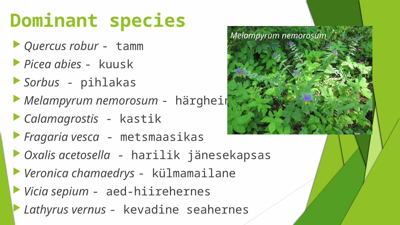
Dominant species Quercus robur - tamm Picea abies - kuusk Sorbus - pihlakas Melampyrum nemorosum - härghein Calamagrostis - kastik Fragaria vesca - metsmaasikas Oxalis acetosella - harilik jänesekapsas Veronica chamaedrys - külmamailane Vicia sepium - aed-hiirehernes Lathyrus vernus - kevadine seahernes
Melampyrum nemorosum

Conclusions The three measured sites were the same as
the satellite pictures Dominant species can be the same if the
sites are similar (site 1 and 3) The dominant species are usually common in
this area The same type of land cover can have
different amount and size of land cover (for example if there is a human impact)
The meadow in site 3 was a field 10 years ago

Extras 1On the meadow In the forest

Extras 2
Mushrooms Our supervisor

Thank you for your attention