land and resource management plan
TRANSCRIPT

United States
Department of Agriculture
Forest Service
Rocky Mountain Region
Shoshone National Forest
Clarks Fork Ranger District
Park County, Wyoming
Environmental Assessment
for the
Comprehensive River
Management Plan
for the
Clarks Fork of the Yellowstone
Wild and Scenic River
Amendment to the
Shoshone National Forest
Land and Resource Management Plan
September 2009

Lead Agency:
USDA Forest Service
Responsible Official:
Rebecca Aus, Forest Supervisor
Shoshone National Forest Supervisor’s Office 808 Meadow Lane Avenue Cody, WY, 82414 Phone: 307.527.6241
For further information:
Terry Root, District Ranger or Marty Sharp, NEPA Coordinator
Shoshone National Forest Clarks Fork Ranger District 203A Yellowstone Ave. Cody, WY, 82414
Phone: 307.527.6921
This document is available on the Internet: http://www.fs.fed.us/r2/shoshone/projects/planning/forest_projects/env_analysis_index.shtml
Abstract. This Environmental Assessment is a public document that provides evidence and analysis for determining whether to prepare an environmental impact statement or a finding of no significant impact. The purpose of this proposal is to: 1) adopt a comprehensive resource management plan to protect and enhance the values for which the river was designated (free-flowing condition, water quality, and outstandingly remarkable values), and 2) identify and implement Forest Service management actions needed to protect these values in the Clarks Fork Wild River corridor.
There are two alternatives: Alternative 1-the proposed action, and Alternative 2. The management plan and proposed activities would occur in the designated wild segment of the Clarks Fork of the Yellowstone River, a component of the Wild and Scenic Rivers System, approximately 30 miles northwest of Cody in Park County, Wyoming. Whichever alternative, or blend of the alternatives, selected will be documented in a decision notice and the decision would become the comprehensive river management plan.
The U.S. Department of Agriculture (USDA) prohibits discrimination in all its programs and activities on the basis of race, color, national origin, sex, religion, age, disability, political beliefs, sexual orientation, or marital or family status. (Not all prohibited bases apply to all programs.) Persons with disabilities who require alternate means for communication or program information (Braille, large print, audiotape, etc.) should contact USDA’s TARGET Center at (202) 720-2600 (voice and TTY). To file a complaint of discrimination, write USDA, Director, Office of Civil Rights, Room 326-W, Whitten Building, 1400 Independence Avenue, SW, Washington, DC, 20250-9410, or call (202) 720-5964 (voice and TTY). USDA is an equal opportunity provider and employer.

Page i
Table of contents
Table of contents ............................................................................................................................... i Chapter 1 Introduction ................................................................................................................ 3 About this document ........................................................................................................................ 3
1.1 Background .................................................................................................................... 4 Description of river setting and resource values .............................................................................. 4 Location ........................................................................................................................................... 4 Boundary ......................................................................................................................................... 5 Classification ................................................................................................................................... 5 Free-flowing status .......................................................................................................................... 5 Landscape character ....................................................................................................................... 5
1.2 Analysis area .................................................................................................................. 8 1.2.1 Outstandingly remarkable values ............................................................................ 10
Scenic value .................................................................................................................................. 10 Recreational value ......................................................................................................................... 10 Historical value .............................................................................................................................. 11
1.3 Forest Plan management areas ................................................................................... 11 Forest Plan Management Area 10D .............................................................................................. 11
1.4 Purpose and need ........................................................................................................ 12 1.4.1 Need for action ......................................................................................................... 12
1.5 Proposed action ........................................................................................................... 13 1.6 Public involvement ....................................................................................................... 13 1.7 Issues ........................................................................................................................... 14
1.7.1 Key issues ................................................................................................................ 14 1.7.2 Other issues and concerns ...................................................................................... 15
1.8 Decision framework ...................................................................................................... 15 Chapter 2 Alternatives .............................................................................................................. 16 Purpose and overview ................................................................................................................... 16
2.1 Alternatives considered but eliminated from detailed study ......................................... 16 Alternative that changes the wild river boundary ........................................................................... 16 Alternative that opens motorized areas ......................................................................................... 16
2.2 Alternatives considered and analyzed in detail ............................................................ 16 2.2.1 Alternative 1 – proposed action ................................................................................ 17
Description of the proposed action ................................................................................................ 17 Travel designations ....................................................................................................................... 17 Management direction ................................................................................................................... 19 Standards ...................................................................................................................................... 19 Guidelines ...................................................................................................................................... 21 Management approach .................................................................................................................. 21 Initial approaches for controlling unauthorized motorized use ...................................................... 22 Approaches for controlling unauthorized use if monitoring indicates a lack of compliance .......... 22 Approaches for controlling unauthorized use if it is continuing ..................................................... 22
2.2.2 Alternative 2 – alternative that closes forest roads in the corridor to motorized use 23 Description of the alternative to the proposed action .................................................................... 23
2.3 Monitoring and baseline data collection ....................................................................... 25 Monitoring ...................................................................................................................................... 25 Unauthorized motorized use .......................................................................................................... 25 Stream health and Class 1 water quality standards ...................................................................... 25 Best management practices .......................................................................................................... 25 Baseline data collection for Class 1 water quality standards and recreation ................................ 25 Stream health and Class 1 water quality standards ...................................................................... 25 Recreation use ............................................................................................................................... 26 Chapter 3 Affected environment and environmental consequences ........................................ 28
3.1 Watershed resources (soil, water and aquatic resources) ........................................... 28 3.1.1 Free-flowing status ................................................................................................... 28 3.1.2 Water rights, water quality, and in-stream flow ........................................................ 29

Page i i
3.2 Access, transportation, and motorized use .................................................................. 30 3.2.1 Access ..................................................................................................................... 31 3.2.2 Transportation system ............................................................................................. 31 3.2.3 Motorized recreation use ......................................................................................... 32
3.3 Recreation .................................................................................................................... 36 3.3.1 Existing recreation developments and trails ............................................................ 37 3.3.2 Use trends ................................................................................................................ 38 3.3.3 Visitor use capacity .................................................................................................. 38
3.4 Visuals .......................................................................................................................... 42 3.4.1 Landscape character ............................................................................................... 42
3.5 Cultural resources ........................................................................................................ 45 3.6 Vegetation diversity and botany ................................................................................... 48
3.6.1 Invasive plant species and sensitive plant species.................................................. 48 3.7 Commercial livestock grazing ...................................................................................... 49 3.8 Wildlife and fisheries .................................................................................................... 50
Wyoming Priority Bird Species ...................................................................................................... 50 Effects on threatened and endangered species ............................................................................ 50 Canada lynx ................................................................................................................................... 51 Gray wolf ........................................................................................................................................ 51 Effects to sensitive terrestrial wildlife species ............................................................................... 52 Grizzly bears .................................................................................................................................. 52 Coniferous and mature forest habitats .......................................................................................... 53 Sagebrush/grassland habitats ....................................................................................................... 53 Riparian/wetland/aquatic habitats ................................................................................................. 54 Biological evaluation determination on sensitive terrestrial species ............................................. 54 Effects on sensitive aquatic species .............................................................................................. 54 Effects on terrestrial management indicator species ..................................................................... 55 Effects on aquatic management indicator species ........................................................................ 57
3.9 Fire and fuels ................................................................................................................ 58 3.10 Lands, minerals, special uses, and rights-of-way ........................................................ 58 3.11 Land ownership and land use description .................................................................... 58 3.12 Socio-economic ............................................................................................................ 59 3.13 Cumulative effects ........................................................................................................ 60
3.13.1 Past, present, and reasonably foreseeable future actions....................................... 61 3.13.2 Cumulative effects to resources............................................................................... 63
Sources Cited / References and Data Sources ............................................................................. 65 Appendix A—Clarks Fork Wild and Scenic River Designation Act of 1990 .................................... 67 Appendix B—Scoping respondents ................................................................................................ 68

Page 3
Chapter 1 Introduction
About this document
The purpose of this document is to record the analysis of the effects of adopting a comprehensive river management plan (CRMP) and implementing the actions described in the CRMP for the designated wild segment of the Clarks Fork of the Yellowstone River.
This environmental assessment (EA) has been prepared in compliance with the National Environmental Policy Act and other relevant federal laws and regulations. This is not a decision document; the responsible official will document the decision regarding the comprehensive river management plan in a decision notice after a 30-day public review of the predecisional environmental assessment.
This environmental assessment discloses the direct, indirect, and cumulative environmental effects that would result from the proposed action and alternatives. The document is organized into these parts:
Chapter 1 – Introduction This chapter includes information on the history of the proposal, the purpose of and need for the proposal, and a brief summary of the agency’s proposal for achieving that purpose and need. This section also details how the Forest Service informed the public of the proposal and how the public responded. Issues and concerns are identified in this chapter.
Chapter 2 - Alternatives, including the proposed action This chapter provides a detailed description of the agency’s proposed action and alternatives. These alternatives were developed based on issues raised by the public, other agencies, and internal concerns. Finally, this section provides a summary table of the environmental consequences associated with each alternative.
Chapter 3 - Affected environment and environmental consequences This chapter describes the environmental effects of implementing the proposed action and other alternatives. This analysis is organized by resource, e.g., forest health, recreation, etc. Within each section, the affected environment and current conditions are described first, which provide a baseline for evaluation and comparison of the other alternatives that follow.
Members of the interdisciplinary team are listed, followed by the sources cited in the environmental assessment.
Appendices The appendices include the Clarks Fork Wild and Scenic River Designation Act of 1990 (appendix A) and a list of the agencies and persons consulted/scoping respondents (appendix B). Appendix C, responses to comments on the predecisional environmental assessment, is a separate document.
Additional information that supports the analysis presented in this document is contained in the project file located at the Clarks Fork Ranger District, 203A Yellowstone Ave., Cody, Wyoming, 82414, phone 307.527.6921.
Page 4
1.1 Background
The Wild and Scenic Rivers Act (Act) was signed into law in 1968.1 The Act protects free flowing waters of many of our nation’s most spectacular rivers and safeguards the special character of these rivers, while also recognizing the potential for appropriate use and development. The Act purposefully strives to balance river development with permanent protection for the country’s most outstanding free flowing rivers.
To accomplish this, the Act prohibits federal support for actions such as the construction of dams or other instream activities that would adversely affect the river’s free flow or outstanding resource values. Designation neither prohibits development nor gives the federal government control over private property. The Act specifically:
Prohibits dams and other federally assisted water resource projects that would adversely affect river values.
Protects outstanding natural, cultural, or recreational values.
Ensures water quality is maintained.
Requires the creation of a comprehensive river management plan that addresses resource protection, development of lands and facilities, user capacities, and other management practices necessary to achieve the purposes of the Act.
In the late 1970s, the Clarks Fork of the Yellowstone River (Clarks Fork) was analyzed to determine its suitability for inclusion into the National Wild and Scenic Rivers System. A Wild and Scenic River Study was conducted in direct response to a 1975 Amendment2 to the Act. The suitability determination was finished in 1979 with the completion of the Clarks Fork of the Yellowstone Wild and Scenic River Study (River Study) and Final Environmental Statement, which recommended inclusion of a 21.5-mile segment of the Clarks Fork into the National Wild and Scenic Rivers System as a wild river.
Although the recommendation went to Congress soon thereafter, it was not until November 28, 1990 that the Clarks Fork Wild and Scenic River Designation Act (see Designation Act, appendix A) designated a 20.5-mile segment of the Clarks Fork as a wild river in the National Wild and Scenic Rivers System. 3 The legislation designated the wild river corridor—0.25 mile on each side of the river’s ordinary high water mark—to be managed to fully protect the values for which the segment is designated a wild river.
When the Forest Plan was approved in 1986, the now-designated segment was recommended for inclusion in the National Wild and Scenic Rivers System, and management direction was included in the Forest Plan as management area direction 10D.
Description of river setting and resource values
Location
The Clarks Fork of the Yellowstone River is located approximately 30 miles north-northwest of Cody in Park County, Wyoming, on the Shoshone National Forest
1 Wild and Scenic Rivers Act, Public Law 90-542, October 2, 1968.
2 Public Law 93-621.
3 Public Law 101-628. The final designation was 20.5 miles, versus the 21.5 miles recommended
in the final environmental impact statement.

Page 5
(Figure 1). The area can be accessed from several high-clearance roads off State Highway 296 (Chief Joseph Scenic Byway), which generally parallels the river to the south, and from the east by Park County Road 8VC (State Highway 292).
Boundary
The designated 20.5-mile wild river corridor starts on the upper end at the west boundary of Section 3, Township 56 North, Range 106 West (about 0.5 mile downstream from the Clarks Fork Bridge on Highway 296 near Painter Estates). It ends on the lower end at the north boundary of Section 13, Township 56 North, Range 104 West about one mile west of the Shoshone National Forest boundary near the mouth of the Clarks Fork Canyon.
The Clarks Fork Wild and Scenic River Designation Act of 1990 identified a boundary that includes all land within 440 yards (0.25 mile) from the ordinary high water mark on both sides of the river notwithstanding sec 3(b) of the Wild and Scenic Rivers Act.
The Clarks Fork Wild and Scenic River boundary was published in the Federal Register in 1994 (Vol. 59, No. 232). The publication of the legal boundary and maps are available at the Clarks Fork Ranger District in Cody, Wyoming
Classification
The 20.5-mile designated segment is classified as a wild river. Wild rivers are those rivers or sections of rivers that are free of impoundments and generally are inaccessible except by trail, with watersheds or shorelines essentially primitive and waters unpolluted.
Free-flowing status
The Clarks Fork is free flowing, without past or present major diversions. There are no planned impoundments or diversions on the Forest. The bridge across the river has minor in-water structures.
Landscape character
In the 1979 River Study and Final Environmental Statement, the Clarks Fork River was divided into three segments based on the physical characteristics of the canyon. These descriptions provide a helpful overview of the landscape character.
Upper Canyon. This segment begins at the upper terminus of the designated river downstream of the Crandall Bridge flowing to Canyon Creek, approximately 8 miles in length. It is characterized by slopes of 40 to 90 percent covered by stands of Douglas-fir with some Engelmann spruce and lodgepole pine. Most of this segment has a well-developed floodplain, which supports stands of Englemann spruce.
Most of the Upper Canyon has a gentle gradient. In the central portion of the Upper Canyon the river is contained within a shallow, narrow canyon. The river gradient increases here, resulting in several waterfalls, cascades, and rapids; most are impassable by boat or raft. In places, 500-foot granite cliffs contain the river and its immediate environment.
Middle Canyon. This segment runs downstream from the confluence of the Clarks Fork River and Canyon Creek for approximately 8 miles. Douglas-fir with limited shrub understory is confined to benches or narrow floodplains where some soil development has occurred. This segment is deeply incised into granite walls,

Page 6
towering to 1,200 feet vertically from the water’s edge. The river drops very fast throughout the entire segment, forming several rapids, plunge pools, and waterfalls that preclude raft or boat use, and most kayakers. This middle canyon contains the section known as the ―box,‖ which is an extremely technical kayak run with numerous portages.
Lower Canyon. In the eastern segment of about 7 miles, the river character changes dramatically. The canyon opens to a 0.5-mile wide u-shaped glacial valley with canyon walls towering up to 4,000 feet above the river. A combination of granite and overlying sedimentary rock form an interesting and scenic geological display. There are a few rapids and, generally, the river gradient is nearly flat in this segment.
Vegetation on the canyon walls is limited to widely scattered Douglas-fir and grasses and forbs. Vegetation in the canyon is typical of extremely dry sites, which is unusual for mountain valleys in the Absaroka-Beartooth area. Yucca and common junipers are the most noticeable species. Prolonged periods of high wind have prohibited the junipers from growing as trees, resulting in dense mats and mounds known as krummholz.

Page 7
Shoshone National Forest
_̂
_̂
_̂
_̂
_̂
_̂
_̂_̂
_̂_̂
_̂
_̂
_̂
_̂
_̂
_̂
_̂
Cody
Clark
Belfry
Dubois
Powell
Frannie
Crandall
Red Lodge
Meeteetse
Cooke City
Silver Gate
0 10 20 30 40 505Miles
Yellowstone
National
Park
Clarks Fork Canyon
Montana
Wyoming
Ë
ShoshoneNationalForest
Figure 1. Vicinity map for Clarks Fork of the Yellowstone Wild River

Page 8
1.2 Analysis area
For planning and analysis, the project area is the designated wild river corridor, which is approximately 6,800 acres.4 The project area follows the identified boundary from the Clarks Fork Wild and Scenic River Designation Act of 1990 that includes all land within 440 yards (0.25 mile) from the ordinary high water mark on both sides of the river for the designated 20.5-miles of the corridor.
For the analysis area, adjoining National Forest System lands, adjoining administrations, and private lands are also considered, especially in the context of potential impacts from activities in the surrounding vicinity and/or cumulative effects for the environmental assessment. The analysis area (approximately 40,170 acres) roughly follows the hydrologic divide on the north side of the river, and follows along Highway 296 on the south side. The existing situation, project area, and analysis area are depicted in the following map (Figure 2).
4 Geographical Information Systems and other data accuracy may vary; therefore, the acreages
used in the description of the proposed action and the alternatives throughout the document may vary by +/- 5%. This possible variance in acreage was considered in the effects analysis.

Page 9
_̂
_̂
120
165
17
4
110
178
110.1A
17
2
17
8.1
A
120
119
178.1B
119
Crandall
0 105Miles
Ë
ShoshoneNationalForest
WY 292
Legend
Roads
Highways
Private Ownership
Project Area (Clarks Fork Canyon)
Analysis Area Boundary
Shoshone National Forest
Streams and Rivers
Chief Jo
sep
h Hig
hway (WY 296)
Figure 2. Existing situation map for the Clarks Fork of the Yellowstone Wild River Corridor

Page 10
Figure 3. The Clarks Fork Wild River was designated based on its free-flowing characteristics and outstandingly remarkable values of scenery, history, and recreation.
1.2.1 Outstandingly remarkable values
Three outstandingly remarkable values were identified in the River Study and Final Environmental Statement (Figure 3).
Scenic value
The River Study identified the scenic qualities of the landforms and waterforms that are of a tumultuous whitewater nature, broken occasionally by deep, slick water pools.
Deep chasms, soaring cliffs, and whitewater combine to provide outstanding scenery in the canyon. The overall setting has stunning vistas of mountain scenery and magnificent geologic features and landforms, and outstanding opportunities for wildlife viewing (bears, wolves, mountain goats, and other big game). The geology, vegetation, and wildlife combine to create the scenic beauty of the area. Scenic vistas are in a relatively wild and natural state; the Chief Joseph Scenic Byway parallels the wild river corridor for about 20 miles.
Recreational value
The Clarks Fork Wild and Scenic River was identified as having an outstandingly remarkable recreational value in the River Study. Although traditional forms of water-based recreation are limited, the canyon provides high potential for challenging, and superb whitewater kayaking. The Middle Canyon of the Clarks

Page 11
Fork (the box) is recognized as one of the ultimate whitewater challenges in the Northern Rockies because of its spectacular scenery, challenging rapids, arduous portages, and long length. The ―honeymoon section‖ just upstream offers less challenging rapids that appeal to a broader range of the paddling community. The lower Clarks Fork features yet another great whitewater run, which is a relatively popular road-accessible Class IV/V section.
Recreation/tourism based on natural beauty, relative solitude, and the opportunity to view natural settings and wildlife abound in the river corridor. The canyon provides opportunities for viewing spectacular scenery and enjoying a unique and unusual environment, including numerous waterfalls and cascades, wet micro-environments, deep and narrow canyon walls, boulder floodplains, sand dunes, and wind-blown juniper krummholz. It is a rugged and primitive mountainous/canyon area that is home to wildlife populations, including elk, bighorn sheep, black and grizzly bears, wolves, cougars, moose, coyote, bobcat, pine marten, beaver, golden and bald eagles, osprey, and peregrine falcons.
Historical value
The Clarks Fork Wild and Scenic River was identified as having an outstandingly remarkable historical value in the River Study because of an event of nationwide interest.
In 1877, Chief Joseph and the Nez Perce eluded the U.S. cavalry in a 1,300-mile chase from Oregon to Montana. Although their exact route is unknown, they are said to have escaped through the mouth of the lower canyon, thus avoiding a cavalry detachment waiting on the plains to the east.
In addition, the Clarks Fork is named after William Clark of the Lewis and Clark Expedition. The Nez Perce (Nee-Me-Poo) Trail, a designated National Historic Trail, roughly follows the scenic byway and is an important historic resource in the greater Clarks Fork River area.
Historically, the greater Clarks Fork River area has served as an important transportation artery. Native Americans indigenous to the area west of the continental divide were using this area as a route to reach the buffalo hunting grounds of the Great Plains. The nearby Dead Indian Pass may have been in use as early as 1700 BC and is only about 2 to 3 miles south of the river corridor.
In 1869, gold was discovered along the upper Clarks Fork River and a mining camp was established, later to become Cooke City, Montana.
1.3 Forest Plan management areas
The 1986 Shoshone National Forest Land and Resource Management Plan (Forest Plan) assigns a management emphasis to each portion of the Forest to meet multiple-use objectives. For each designated management area, Chapter III of the Forest Plan includes a description of desired future conditions, goals, objectives, and standards and guidelines.
Forest Plan Management Area 10D
Management emphasis is on river segments recommended (or designated) as a component of the National Wild and Scenic River System.
Wild rivers are managed to be free of impoundments and generally inaccessible except by trail, with watersheds or shorelines essentially primitive and water unpolluted.

Page 12
1.4 Purpose and need
The purpose of this proposal is to: 1) adopt a comprehensive resource management plan to protect and enhance the values for which the river was designated (free-flowing condition, water quality, and outstandingly remarkable values), and 2) identify and implement Forest Service management actions needed to protect these values in the Clarks Fork Wild River corridor.
Planning is needed to integrate management of multiple resources, resource designations, and activities in the planning area. Management of uses and vehicle use on public lands is necessary in this congressionally designated area to address private, public, and administrative access needs; protect resources; promote public safety; and minimize conflicts among uses of public lands.
Based upon the review of the public input, evaluation of site-specific conditions, and need for action (see Section 1.5.1), the decision maker has chosen to focus on the following:
As required by law, develop a comprehensive river management plan that addresses resource protection, development of lands and facilities, user capacities, and other management practices necessary to achieve the purposes of the Act
Protect outstandingly remarkable values
Ensure water quality is maintained
There has been increased population growth in northwest Wyoming and areas of Montana such as Billings, and increases in the amount and type of motorized uses. The updated wild river management direction, standards, guidelines and prescriptions would help address these changes and other current management concerns.
The purpose of this environmental assessment is to provide a basis for comparing management alternatives and adopting a management plan for the Clarks Fork of the Yellowstone Wild River corridor. Section 3 of the Wild and Scenic Rivers Act (16 USC 1274, as amended) specifies that a comprehensive management plan will be developed for the designated river corridor.
1.4.1 Need for action
Unauthorized motor vehicle use is a potential threat to the river’s outstandingly remarkable values. This threat is of particular concern in the Lower Canyon, where increased unauthorized motorized use has been occurring in the sand dunes area and exposed gravel/sand bars. Motorcycles, 4WD vehicles, and ATVs have increased since 1990 when the Clarks Fork was designated a wild river. Littering, vandalism, trampling of vegetation, and loss of solitude and the primitive setting are also occurring in accessible areas. In combination, these impacts are impairing the special attributes of the corridor.
The need for the proposed action is to meet the legal obligations of the Wild and Scenic Rivers Act, protect the three outstandingly remarkable values of the Clarks Fork, and develop appropriate mitigation measures, including designation and management of motorized and non-motorized trails and areas within the corridor.
The need for the proposed action is to determine which roads to designate for motorized vehicle use, which trails and/or areas to designate for non-motorized

Page 13
recreation opportunities, how they will be identified on the ground, and what information and education will maximize compliance.
1.5 Proposed action
A proposed action is defined early in the planning process. This serves as a starting point for the interdisciplinary team’s analysis and gives the public and other agencies specific information on which to focus comments.
The proposed action is to adopt a comprehensive river management plan for the designated wild segment of the Clarks Fork of the Yellowstone River. The Shoshone National Forest is the administering unit and is proposing the comprehensive river management plan.
As part of the proposed action, the river management plan would amend the 1986 Shoshone National Forest Land and Resource Management Plan and replace management area direction 10D.
The comprehensive river management plan would serve as management direction and guidance for managing multiple resources and activities, including travel management and access, vehicle barriers and fences as needed, future development of recreation facilities, and administration of commercial uses. Details of the proposed action are found in chapter 2, section 2.2.2.
The comprehensive river management plan would include access and travel management, which essentially would be a continuation of existing off-road vehicle or travel management decisions that were made in the 1986 Forest Plan that restrict vehicular travel to designated roads.
The objectives that would be met by implementing the proposed action include:
Ensuring the resource values of the wild river corridor are maintained.
Eliminating the proliferation of unauthorized roads, trails, and play areas.
Closing certain roads that are unnecessary and are causing resource degradation.
Having a clearly defined road network that is understandable to the public, provides needed access, does not cause resource degradation, and is enforceable.
1.6 Public involvement
The proposal was listed in the Shoshone’s quarterly Schedule of Proposed Actions beginning July 1, 2007. A scoping notice was posted to the Forest’s Web site and was provided to the public and other agencies for comment during the scoping period (January 24, 2008 to February 29, 2008). A public meeting attended by 42 people was held February 6, 2008 in Cody, Wyoming as part of the scoping process. Approximately 47 comment letters were received. All comments received through scoping and the public involvement processes were considered in developing the issues and alternative, which directed the analysis process. A list of those who commented during scoping is found in appendix B.
Appendix C is a summary of public comments on the predecisional EA and the Forest Service responses.
All correspondence is retained in the project file.

Page 14
1.7 Issues
Issues are generally points of dispute or contention, or areas of uncertainty relative to a proposal. Public and agency input helped determine the issues relative to the physical, biological, social, and economic resources. Project analysis focuses on addressing conflicts or problems associated with the issues.
1.7.1 Key issues
As defined in National Environmental Policy Act regulations (40 CFR 1500.4[1]) key issues are used in the development of alternatives to the proposed action. The key issues are given special consideration by the decision maker when selecting an alternative. Guided by the Forest Plan, the interdisciplinary team addressed the key issues, comments, and concerns identified during scoping.
Key issues identified for development of the comprehensive river management plan are summarized here.
Management of increasing recreation use of the river canyon.
Development of an effective information and education and signing strategy for the area.
Potential for increasing impacts to outstandingly remarkable values.
Unauthorized use of motorized vehicles off designated routes or on user-created routes has the potential to adversely impact vegetation and the outstandingly remarkable values that led to the river’s designation. Where or what adaptive management actions should be taken to reduce or eliminate illegal (off-road) use?
The Forest Service does not have adequate travel management in the area. Road closures are ineffective; gates and signing are not to standard; unauthorized motorized use is occurring in many areas; and information, education, and enforcement are inadequate.
What level of road maintenance is needed and who has responsibility for the cost of road maintenance?
Increased management would lead to closures and loss of motorized recreation opportunities within the wild river corridor.
The key issues that led to the development of the proposed action relate to travel management in the corridor, unauthorized motorized use, and impacts to the sensitive dunes area from unauthorized vehicle use (Figure 4). These issues have the potential to adversely impact the outstandingly remarkable values for scenery, recreation, and history and degrade other resources such as wildlife habitat, vegetation, soils, and water quality.

Page 15
Figure 4. A key issue is the management of unauthorized use in the river corridor.
1.7.2 Other issues and concerns
All issues, concerns, and questions were given in-depth review and consideration; however, only key issues were analyzed in detail. A number of issues and concerns surfaced relative to the proposed action. These issues, while valid and important, were determined not to be significant. These issues did not specifically drive the formulation of alternatives and, therefore, were not analyzed in depth.
1.8 Decision framework
An environmental assessment is not a decision document. The purpose of this document is to disclose the effects and consequences of the proposed action and alternative. The responsible line officer will make a decision based on consideration of the purpose and need for the project, the effects of the alternatives, and public input.
For this proposal, the responsible official must decide:
Whether to implement the proposed action or an alternative. The decision will be documented in a decision notice that will be issued no sooner than 30 days after predecisional environmental assessment is distributed for public review and comment. Whichever alternative, or blend of the alternatives, selected will be

Page 16
documented in a decision notice and the decision will become the comprehensive river management plan.
Whether an environmental impact statement is needed. If the environmental analysis indicates to the decision maker that impacts associated with the alternatives are not significant, then a finding of no significant impact (FONSI) will be documented, (40 CFR 1508.13) and the action allowed to proceed without preparing an environmental impact statement.
Chapter 2 Alternatives
Purpose and overview
This chapter describes the alternatives considered for managing the river corridor. This section compares all alternatives, providing a basis for choice among options by the decision maker and the public.
The Forest Service is required by law to develop a comprehensive river management plan that addresses resource protection, development of lands and facilities, user capacities, and other management practices necessary to achieve the purposes of the Act.
A no action alternative is not included in this document. There is no requirement to include a no action alternative in an EA (Forest Service Handbook (FSH) 1909.15, 14.12, page 33). As allowed in FSH 1909.15 14.2, the effects of the no action alternative will be documented as follows:
The EA may document consideration of a no action alternative through the effects analysis by contrasting the impacts of the proposed action and any alternative(s) with the current condition and expected future condition if the proposed action were not implemented (36 CFR 220.7(b)(2)(ii)).
2.1 Alternatives considered but eliminated from detailed study
The following are brief descriptions of alternatives eliminated from detailed study and the reasons for eliminating them.
Alternative that changes the wild river boundary
The boundary and the classification for the wild river were established by Congress and can only be changed by Congress. An alternative to change the boundary or the classification is outside the scope of this analysis.
Alternative that opens motorized areas
This alternative would designate all or a portion of the planning area as open to cross-country travel for an off-highway vehicle play area or adding roads to the forest road system.
This alternative would not be consistent with management related to a nationally designated wild river segment and would not be consistent with Forest Plan management direction; therefore, this alternative would be beyond the scope of this analysis. No further analysis of this alternative is necessary.
2.2 Alternatives considered and analyzed in detail
The action alternatives were formulated to be responsive to the issues identified during scoping, and to address the purpose and need in Section 1.4. The

Page 17
alternatives are tiered to the Forest Plan and laws, regulations, and policies, specifically the Wild and Scenic Rivers Act.
2.2.1 Alternative 1 – proposed action
Description of the proposed action
Alternative 1 is to adopt a comprehensive river management plan to replace the Forest Plan Management Area direction 10D and add some specific management actions to address key issues. The proposed action alternative is designed to meet the purpose and need and to respond to current and future issues and management priorities.
Alternative 1 maintains existing, authorized motorized uses but would eliminate unauthorized motorized use.
The proposed action would continue to allow public motorized access on Forest Roads 110 (subject to seasonal closure), 119, 165, and 178, 178. 1A, and 178.1B, allowing continued use of long-standing existing routes and the access they provide to National Forest System and private lands. Access to private land must be granted as mandated by the Alaska National Interest Lands Conservation Act and would continue to be allowed, as in the case of Forest Road 174.5
Forest Road 119 is an access route that passes through the river corridor to access National Forest System lands on the Beartooth Plateau and would continue to be available for motorized and non-motorized public use. Forest Road 119 also provides important motorized access to private land on Dillworth Bench. Long-term motorized access on Forest Road 119 would be subject to regulation or closure if monitoring indicates adverse impacts to the outstandingly remarkable values of the river corridor are occurring.
Management actions in the comprehensive river management plan would serve to identify specific actions to implement planning decisions and meet resource management objectives.
Management direction and actions would be targeted to protecting the river’s free-flowing condition, water quality, and outstandingly remarkable values. The focus would be dealing with the issue of unauthorized motorized use that is occurring off Forest Road 119, particularly in the sand dune areas.
Travel designations
Under Alternative 1, the following roads are designated as open to motorized use: Forest Roads 110 (subject to seasonal closure), 119, 165, and 178, 178.1A, and 178.1B. The total miles of open, designated roads in the wild river corridor are 4.47 miles. These roads are described in further detail in the affected environment section for the transpiration system (See Section 3.6.2). Two roads (174 and 119) provide access to private land.
Throughout this planning process, potential travel and access related projects were identified. One specific, on-the-ground project proposed to be implemented if selected as part of the final decision is for a fence to meet resource management objectives, as described below.
The travel management designations would be implemented according to the map in Figure 5.
5 Public Law 96-487, also known as ANILCA.

Page 18
_̂
_̂
120165
17
4
110
178
110.1A
17
2
178 .1A
12
0119
178 .1B
119
Crandall
0 105Mi les
Ë
ShoshoneNationalForest
WY 2
92
Leg end
Open R oads
Hi ghw ays
Pr iva te Ow nersh i p
Pr oj ec t A rea ( Cl a rks For k C anyon)
Ana l ys is Ar ea Boundar y
Shoshone N ati onal For es t
St reams and Ri vers
Chief Jo
seph Hi g
h way (W
Y 2
96)
ProposedFence
Figure 5. Map of Alternative 1-the proposed action

Page 19
Figure 5 shows the road designations that are open to motorized use under Alternative 1. These roads would be identified by maps and information signs and signed with route markers. The proposed action for the CRMP identifies these management actions to implement the designations and achieve the following objectives:
Maps: produce an official travel management map to document road designations.
Signs and markers: Identify the designated open roads on the ground in a clear and consistent manner to facilitate compliance and enforcement of the road designations.
Education and information: Provide clear and consistent information about road designations and the implementation process that will contribute to improved public understanding and compliance with the designations.
Barriers: Use physical barriers if necessary to discourage unauthorized use and allow rehabilitation of closed routes.
The detailed proposed action, which is recommendations for the CRMP, contains:
Management direction
Management direction was developed to protect the wild river segment from the impacts of other land uses and preserve the free-flowing condition, water quality, and outstandingly remarkable values in accordance with the Act. Management direction and actions include consideration for increasing enforcement and fines. In the event monitoring indicates a lack of compliance with motorized use restrictions, management direction is to pursue options with local authorities to implement special orders and increase the fines for unauthorized use.
Motorized travel on land or water is generally permitted in wild, scenic, and recreational river areas, but can be restricted or prohibited where necessary to protect the values for which the river area was designated (http://www.rivers.gov/guidelines.html, page 14 Wild and Scenic Rivers Interagency Guidelines).
In 1979, the Final Environmental Statement allowed for motorized vehicle use and did not specify any roads to be closed. The designated open motorized routes at the time of designation provide the baseline conditions and set management direction for motorized use. All the proposed road designations are for existing vehicle roads that have been used by motorized vehicles for many years. The proposed road designations allow for most of the existing use to continue in the same manner and degree as in the past. The designations would not change or reduce vehicle use substantially, but allow for the continued use of designated roads.
Standards
Direction from the Act incorporated as standards include:
Dams and other water developments that restrict the free-flowing condition of the river are precluded (7(a)).
Do not dispose of National Forest System lands (8(a)).

Page 20
Mineral entry or leasing is prohibited. A mineral withdrawal 0.25 -mile wide on each side of the river would be continued (9(a))
Forest-specific standards are:
Manage stream flow according to State of Wyoming Permit No. W.S.1.
Casual collecting (i.e., panning for gold by hand) is not allowed in the designated river corridor.
Camping is prohibited in the lower corridor except in tents. Camping in recreational vehicles, camping trailers or other motorized dispersed camping is not allowed beginning at the western edge of Township 56 North, Range 104 West, Section 34 downstream to the end of the designated river corridor.
Wheeled motorized vehicles are restricted to designated routes (Forest Roads 110, 119, 165, 174, and 178, 178. 1A, and 178.1B). In the lower corridor, motorized traffic is not permitted off designated routes for the purpose of dispersed camping or any other generally permitted activity. The general authorizations in Shoshone National Forest Special Order 001-09 allowing for dispersed camping and firewood cutting within 300 feet of an open motorized route do not apply. This excludes snowmobiles traveling over snow.
Special orders will be established as needed to protect resources, reduce conflicts, or manage use within the designated river corridor. The orders will be established under the authority provided by 36 CFR 261.58(z) that covers special orders within wild and scenic river corridors.
Public or recreational use of motorized aircraft, including but not limited to, helicopters, motorized hang gliders, planes, etc. are prohibited from landing in the designated river corridor or streambed.
Helicopter use, including landings, for administrative access by the Forest Service, Wyoming Game and Fish, county sheriff or other agency or entity with a legitimate need for research and management activities, animal capture or wildlife surveys, emergencies, search and rescue, wildland fires, etc. could continue under the plan with prior notification of the Forest Service of planned activities.
New roads, campgrounds, picnic areas, and trailheads are not allowed.
Replacement of existing power lines is allowed; new power lines within the designated corridor would be discouraged.
Special or competitive events are not permitted.
New commercial outfitting permits that include the designated river corridor will not be issued.
For present commercial outfitting permits, existing service days for commercial use will be retained but not expanded (increased).
The maximum stay limit is 16 consecutive days.
Motorized watercraft are prohibited.
Memorial or dedication sites are prohibited except that a single memorial site that recognizes the dedication of the river is permitted.
Page 21
Any such memorial would be constructed of native materials and consist of a low profile stone monument, or something similar, with an appropriate plaque.
Fish habitat improvement projects and structures that do not adversely affect the free-flowing condition of the river would be allowed.
Fences will be constructed to be visually unobtrusive.
Guidelines
Management activities within the corridor and upstream of the corridor should include management measures from the Region 2 Watershed Conservation Practices Handbook.
Standards for Class 1 streams as prescribed in Wyoming Water Quality Rules and Regulations, chapter 1, should be adhered to.
Campsites, campfires, and human waste disposal should be at least 100 feet from the river shoreline to protect water quality.
Noncommercial groups should be limited to15 persons and 15 head of saddle and/or pack animals.
Trailing of livestock should occur only on established stock driveways.
The designated motorized routes within the river corridor are maintained as primitive routes for off-highway vehicles or high clearance vehicles.
Activities should be conducted in a manner that prevents the introduction of aquatic nuisance species in riparian and aquatic habitats.
Reasonable access to private land is allowed. Any access to private land in or proximate to the corridor should be on private land where possible.
Commercial livestock grazing is administered under existing grazing regulations and policy.
New range improvement structures should not be authorized unless they provide additional protection of river values.
Prescribed burning that is consistent with the wild river values and maintenance/enhancement of vegetation diversity is allowed.
Use of motorized vehicles to inventory/monitor, treat, or control invasive plants is allowed, with use of motorized vehicles restricted to designated routes. Control efforts in other areas are conducted on foot or horseback.
Installation of measuring devices deemed necessary for the administration of in-stream flow as may be ordered by the State Engineer under W.S. 41-3-1003(a), is allowed.
Timber harvest, including commercial timber harvest, vegetation removal or treatment, and forest product removal is generally not allowed except for the removal of hazard trees.
Low-intensity development (such as interpretive signs) of cultural resource properties compatible with river designation is allowed.
Management approach
The Forest Service will:
Pursue opportunities to acquire scenic easements or lands from willing seller(s) within the corridor as a means to ensure long-term protection of the corridor’s scenic values.
Page 22
As appropriate, work with state and county authorities to maintain zoning of private land in a manner compatible with protecting outstandingly remarkable values and river management goals.
Cooperate and coordinate with state, local, other federal agencies, and stakeholders to establish partnerships to protect the wild river characteristics and outstandingly remarkable values of the river.
Controlling unauthorized use
Initial approaches for controlling unauthorized motorized use
In response to public involvement and identified key issues, emphasis will be on information and education to achieve compliance with travel designations. Public education/outreach campaigns, including efforts made in conjunction with the local motorized community, will be used to discourage illegal off-road use in the Clarks Fork corridor.
Existing programs such as Leave No Trace and Tread Lightly will be emphasized. Efforts to monitor and enforce off-highway vehicle regulations and educate the public on appropriate off-highway vehicle use will be coordinated with Wyoming State Trails. All-terrain vehicle patrols, trail hosts, law enforcement patrols, or other means of visitor contact will be used to inform and educate the public on travel management and to monitor/check on compliance with travel management regulations or other management issues. These field patrols will be used primarily in the high use season to reduce conflicts and impacts to wild river values.
In some instances, physical barriers will be used to discourage unauthorized use and allow rehabilitation of closed routes. Barriers may include soil berms, rocks or boulders, vegetation, or fences to prevent travel on unauthorized routes.
Approaches for controlling unauthorized use if monitoring indicates a lack of compliance
In the event of non-compliance, increased patrols will be implemented in areas where monitoring efforts detect non-compliance with route designations. Additional restrictions or management tools could include gates or seasonal closures. Additional public notification, signing, and education efforts will be conducted.
Approaches for controlling unauthorized use if it is continuing
If unauthorized use continues to the point that additional protection measures are warranted on Forest Road 119, a National Environmental Policy Act process, including public involvement, will be initiated. This process will evaluate necessary management actions and alternatives, to possibly include permits, limits of use numbers, or road gating for additional seasonal or year round closures.
Management actions
Display designated routes and types of use descriptions for the wild river corridor on the motor vehicle use map that will be issued to meet the Travel Management Rule.
Identify designated routes on the ground in a clear and consistent manner to facilitate compliance and enforcement of the route designations, while keeping signing to a minimum in the wild river segment to maintain the natural appearance.

Page 23
Post signs in strategic locations informing the public that motorized use is authorized only on open, numbered, posted routes, such as at the Forest boundary, trailheads, and the junction of Forest Roads 119 and 120. Install an information/education kiosk or portal signing at the mouth of the Lower Canyon.
Forest Service recreation technicians, law enforcement officers, trail hosts, and volunteers will regularly patrol and monitor visitor compliance, including motorized use and camping.
The proposed action includes a site-specific proposal to build a fence near Rapid Creek in T56N, R104W, section 26 SW1/4. The purpose of this fence would be to block the unauthorized motorized use that is an ongoing near where Forest Road 119 begins its ascent out of the canyon and switchbacks up to the Dillworth Bench. A continuous metal fence is proposed to be built, about 450 feet, or 150 yards in length. The fence would include a pass through gate that would allow hikers and horses non-motorized access past the fence. The fence would not be visible form the river itself due to the high river bank and tall sagebrush.
2.2.2 Alternative 2 – alternative that closes forest roads in the corridor to
motorized use
Description of the alternative to the proposed action
Alternative 2 is the proposed comprehensive river management plan for the designated wild river corridor as described in Alternative 1, with the difference being how access and roads are managed. This alternative proposes to close to public motorized access on these existing motorized routes: Forest Roads 110, 119, 165, and 178.1B where they enter the designated river corridor. However, in the case of Forest Road 110, the closure would be for any unauthorized use extending past the corridor boundary and in the case of Forest Road 119, the closure would be at the Forest boundary. Closures would be year long to motorized recreation users; non-motorized access would be allowed. Forest Road 174 is not a public access route; it accesses private land and the landowner has been authorized to cross a portion of the national forest.
The corridor is generally inaccessible to motorized access except on a small number of designated routes. Alternative 2 would not allow public motorized access on these roads within the designated river corridor, in contrast to Alternative 1, which allows continued use of these long-standing established routes and the access provided to National Forest System and private lands.
While public motorized recreation access would be restricted, administrative access and access to private land must be granted as mandated by the Alaska National Interest Lands Conservation Act.
The travel management designations and road closures would be implemented according to the map in Figure 6.

Page 24
! !
!
! ! !
!!!!
!!
!!!
!
!
!!
!!
!!
!!
!!
!
!!
!
!
! !!
_̂
_̂
120165
17
4
110
178
110.1A
17
2
178 .1A
12
0119
178 .1B
119
Crandall
0 105Mi les
Ë
ShoshoneNationalForest
WY 2
92
Leg end
Open R oads
!
! !! ! Cl osed Roads
Hi ghw ays
Pr iva te Ow nersh i p
Pr oj ec t A rea ( Cl a rks For k C anyon)
Ana l ys is Ar ea Boundar y
Shoshone N ati onal For es t
St reams and Ri vers
Chief Josep
h Hi g
h way (W
Y 2
96)
Figure 6. Alternative 2.
Page 25
2.3 Monitoring and baseline data collection
Monitoring
Monitoring gathers information to determine if desired conditions are being met and maintained to protect free-flowing condition, water quality, and outstandingly remarkable values for the benefit and enjoyment of present and future generations. Monitoring is focused on those conditions where existing conditions are not meeting desired conditions or are at some risk of not meeting desired conditions.
Information from monitoring will be used to determine if specific actions, projects, or additional monitoring are needed.
Unauthorized motorized use
The primary threat to outstandingly remarkable values is unauthorized motorized use. A baseline of unauthorized motorized use will be documented using Global Positioning System technology and photographs.
Monitoring will then be focused on documenting unauthorized motorized routes using Global Positioning System and photography two times a year and comparing to baseline conditions. This information will be used to determine and document trends, such as if increases or decreases in illegal off-road travel are occurring. By 2012 or sooner, the results of this monitoring will be analyzed to determine if additional measures are needed.
Stream health and Class 1 water quality standards
Stream health and water quality currently meet desired conditions and do not appear to be at future risk given current and expected land uses in and above the corridor. If baseline monitoring indicates otherwise, or ocular indicators show possible stream health or water quality issues may be occurring, a stream health assessment will be conducted.
Best management practices
A best management practices review is conducted periodically (2 to 3 years) to assess impacts (looking primarily at sedimentation) to water quality from recreational activity. Data are used to identify whether mitigation or other actions are required to protect water quality.
Baseline data collection for Class 1 water quality standards and recreation
For future management of the wild river corridor, some base level information needs to be gathered. The following information on water quality and recreation use is needed to establish a baseline for assessing future management actions.
Stream health and Class 1 water quality standards
By 2012 or sooner, in cooperation with the Wyoming Department of Environmental Quality Water Quality Division, the Shoshone National Forest will collect baseline data to verify that State of Wyoming water quality standards are being met and designated uses are being protected, which are critical aspects of desired conditions.

Page 26
Recreation use
Data will be gathered from permittees whose operating area includes the wild river corridor to identify the amount and type of commercial outfitting use occurring in the wild river corridor.
Data will be gathered on the amount of motorized use occurring on designated routes within the wild river corridor.

Page 27
Table 1 is a comparison of Alternatives 1 and 2, showing the differences in access and road management.
Table 1. Access and road management under the two alternatives.
Road description Alternative 1 Alternative 2
Forest Road 110. Forest Road 110 is classified as a maintenance level 2 road (high clearance vehicles) and was open to public motorized use at the time of wild river designation. It does not extend into the corridor but accesses the boundary of the designated river corridor. It is used by kayakers and other recreationists.
Allows continued use of a long-standing established route and the access it provides to National Forest System lands.
In the case of Forest Road 110, the closure would be for any unauthorized use extending past the corridor boundary.
Forest Road 119. Forest Road 119 is classified as a maintenance level 2 road open to public motorized use and was open to public motorized use at the time of wild river designation. This 9.5-mile road has been in existence and used by the private landowner of the Switchback Ranch as the primary access for decades. About 3.5 miles are inside the wild river corridor. The portion of Forest Road 119 in the Lower Canyon is open year round and is popular for motorized access to Forest Road 120. Forest Road 120 traverses the Beartooth Plateau and is closed seasonally by a locked gate.
6
Allows continued use of a long-standing established route and the access it provides to National Forest System and private lands.
Closes use of a long-standing established route and the access it provides to National Forest System and private lands. Access to private land must be granted as mandated by the Alaska National Interest Lands Conservation Act.
Forest Road 165. This 2-mile road is a maintenance level 2 road that was open to public motorized use at the time of wild river designation. Approximately 0.35 mile is located inside the wild river corridor. It starts at Highway 296 and ends at the Clarks Fork River. This road has been in existence and used to access the river for decades. This road and Forest Road 178.1B access take-out/put-in sites for river runners. Forest Road 178.1B is the preferred access point for boaters.
Allows continued use of a long-standing established route and the access it provides to National Forest System lands.
Closes use of a long-standing established route and the access it provides to National Forest System and private lands.
Forest Road 174. This road accesses private land and the landowner has had an easement across a portion of the national forest. This road has been in existence and used by the private landowner for decades. It crosses about 0.25 mile of the wild river corridor.
Allows continued use of a long-standing established route and the access it provides private lands.
Currently does not provide public access to National Forest System. Access to private land must be granted as mandated by the Alaska National Interest Lands Conservation Act.
Forest Roads 178, 178.1A and 178.1B. While this road system does not access the river directly, it does provide vehicle access to user-created foot routes that are used by boaters. Forest Road 178 is a 0.50-mile, improved aggregate-surfaced road that starts at Highway 296 and ends at the transfer station. Forest Road 178.1A is a two-track road that branches off 178 and continues north for approximately 0.40 mile before ending close to Crandall Creek. Forest Road 178.1B branches off 178.1A and parallels Crandall Creek for approximately 1.0 mile before ending on the bench above the Clarks Fork. The user-created foot routes used by boaters begin from the end of Forest Road 178.1B.
Allows continued use of a long-standing established route and the access it provides to National Forest System lands.
Closes use of a long-standing established route and the access it provides to National Forest System and private lands.
6 Special Order 01-009, paragraph 4.

Page 28
Chapter 3 Affected environment and environmental consequences
This section summarizes the affected environment and the potential changes/effects due to implementation of an alternative and the basis for comparison of alternatives.
Only resources the interdisciplinary team determined to be affected are identified and analyzed. The level of detail is commensurate with the amount of information necessary to understand the effects of the actions. The effects discussions presented in this chapter are summaries of information from the resource specialists. The summaries focus on the resource issues and project goals disclosed in chapter 1.
The river’s classification (wild) and landscape character at the date of designation (1990) will serve as the basis (baseline) for evaluating proposed land uses and monitoring. Chapter 3 summarizes the potential changes attributed to implementation of the alternatives.
Management actions/projects could begin in 2009 at the earliest. In general, the period for the EA over which effects are projected for the analysis is 10 to 20 years unless otherwise identified.
3.1 Watershed resources (soil, water and aquatic resources)
3.1.1 Free-flowing status
Existing conditions are that the Clarks Fork is free flowing, without past or present major diversions. There are no planned impoundments or diversions on the Forest.
Baseline conditions at the time of designation included shorelines that are essentially primitive and water that is unpolluted; existing conditions remain essentially the same as in 1990. Shorelines are basically free from development and impacts. There are no dams, diversions, or structures of any kind that significantly alter the natural stream flow through the designated river corridor.
Baseline conditions at the time of designation included free-flowing conditions; existing management has maintained the free-flowing values as there are no dams, diversions, or structures of any kind that significantly alter the natural stream flow through the designated river corridor in 2009.
The Wyoming Department of Environmental Quality Class 1 classification and use designations for drinking water supplies, game and non-game fisheries, fish consumption, aquatic life other than fish, primary contact recreation, wildlife, industry, agriculture, and scenic value are being met.
In the river corridor, there is evidence of OHVs driving in the river channel, on sand/gravel bars, and up and down the shorelines, in some cases cutting through the river bank and impacting the shoreline (see Figures 4, 5, and 6). This type of activity and OHV play area activity are most common in the dunes areas.
Factors such as steep slopes, amount of vegetation, amount of water runoff, and wind affect the amount and rate of natural erosion of soils that are susceptible to damage. Erosion is accelerated by surface disturbances, such as off-highway travel by OHVs that leave soil exposed to wind and water erosion. Creation of two-track routes also has the potential for increased soil loss; the soil in the ruts

Page 29
can become compacted concentrating flow down an artificial channel. When ruts become too deep to drive in or too rocky, etc., vehicles bypass the area causing route braiding or multiple routes. Trails and two-track routes intercept and concentrate overland flow which increases the erosive power of water causing the route to erode.
3.1.2 Water rights, water quality, and in-stream flow
The Clarks Fork River originates in the Beartooth Mountains north of Cooke City, Montana, and is a major tributary of the Yellowstone River. The river flows into Wyoming, carving a deep, narrow canyon which is the section included in the designated wild river corridor. The river then flows back into Montana to join the Yellowstone River near Laurel, Montana.
The Designation Act directed ―the Secretary of Agriculture to apply for the quantification of the water right reserved by the inclusion of a portion of the Clarks Fork in the Wild and Scenic Rivers System in accordance with the procedural requirements of the laws of the State of Wyoming.‖ In 1994, the Shoshone National Forest submitted an Application for Permit to Appropriate Surface Water to the Wyoming State Engineer. The State Engineer processed and approved the application, assigning it Permit No. 9 I.F. later renamed to W.S.1, with a priority date of November 28, 1990.
Biophysical relationships were used to determine the amounts of water needed to protect the two values related to water for which the river was designated (recreational, and scenic). The resultant water right is for an instream flow that is dynamic and flexible in time and amount. It adjusts to the actual streamflow at any point in time. The instream flow is determined by the relationship of the actual streamflow to three key discharge values associated with the river.7
The Wyoming Department of Environmental Quality classifies the Clarks Fork River between the Montana state line and Forest boundary as a Class 1 stream.8 Class 1 waters are those surface waters in which no further water quality degradation by point source discharges are allowed and which nonpoint sources are controlled through appropriate best management practices.
Effects to water resources and water uses
Alternative 1-Proposed action
Alternative 1 is congruent with the Wild and Scenic Rivers Act and contributes to maintaining the free-flowing characteristics and outstandingly remarkable values, including water quantity, water quality, and primary contact recreation. The proposed action would protect and enhance the values for which the river was designated, while providing for public recreation and resource uses that do not adversely impact or degrade those values. They are designed to protect and enhance the values of the river area according to the wild classification; they meet the purpose and need and address the key issues.
There would be little change or departure from current conditions; however, the alternative would have these effects:
7 Detailed information about baseflow, instream flow, actual streamflow, and water quality is
available from the Shoshone’s hydrologist located in Cody, Wyoming. 8 Class 1 designations are based on value determinations rather than use support and are thus
protected for all uses in existence at the time of their designation. The designation date is November 28, 1975.

Page 30
Implementing the CRMP and the travel management actions would decrease the total amount of erosion associated with unauthorized roads in the river corridor. Soil stability would improve and unauthorized routes that are allowed to revegetate would leave less soil exposed to wind and water erosion. Watershed resources would be positively impacted. Under the proposed management direction, the quantity of water needed in the river to protect the scenic and recreational values for which it was designated would be maintained. Shorelines are essentially primitive and water is unpolluted; existing conditions remain essentially the same as in 1990. Shorelines remain basically free from development and impacts. Natural succession is occurring and outstandingly remarkable values and other values such as river shorelines, vegetation, soil and water, are all meeting the above management direction.
In summary, conditions at the time of designation included free-flowing conditions; existing conditions have maintained the free-flowing values as there are no dams, diversions, or structures of any kind that substantially alter the natural stream flow through the designated river corridor. Implementing road designations would define an appropriate network of routes and would reduce the occurrence of unauthorized cross-country travel or travel on routes not suitable for the vehicle type. The proposed action addresses the issues and ensures that water quality is maintained.
Alternative 2
The effects of Alternative 2 would be similar to Alternative 1. Limiting motorized access through road closures would only minimally differ from Alternative 1 or affect existing conditions for water resources and water uses. Conditions at the time of designation included free-flowing conditions; existing conditions have maintained the free-flowing values as there are no dams, diversions, or structures of any kind that substantially alter the natural stream flow through the designated river corridor in 2007 and this is unchanged under Alternative 2.
Implementing road closures would reduce the occurrence of unauthorized cross-country travel or travel on routes not suitable for the vehicle type. In terms of water resources and water uses, the effects resulting from this alternative would be immeasurable and would be of such a small magnitude that effects would be negligible between Alternative 1 and Alternative 2. Alternative 2 also ensures that water quality is maintained.
3.2 Access, transportation, and motorized use
Access and transportation should be integrated with all Forest programs and resource uses (such as non-motorized and motorized recreation, agricultural, commercial, utilities such as electrical, and educational). Roads are used by ranchers, grazing permittees, outfitters and guides and other commercial recreation permittees, public recreationists, private landowners, Wyoming Game and Fish Department, and other land management or natural resource agencies. Motorized vehicle access is required to access private lands.
This section presents conditions for access and the transportation system within the designated river corridor and summarizes the potential changes attributed to implementation of the alternatives.
The eastern end of the river corridor is accessible via Park County Road 8VC (State Highway 292).

Page 31
The eastern section of the river canyon is accessible via Forest Road 119, a primitive road suitable only for high clearance vehicles. Forest Road 119 is closed seasonally at the switchbacks due to wet conditions and soil hazards.
The baseline conditions for motorized routes that enter into or were designated within the Clarks Fork Wild River corridor at the date of wild river designation (1990) are discussed in the transportation section (see Section 3.2.2).
The corridor is naturally appearing with a primitive, undeveloped character and a high scenic integrity. The corridor is generally inaccessible to motorized access except on a small number of designated routes (Forest Roads 110, 119, 165, 174, 178, 178. 1A and 178.1B). Visitors to the wild river corridor find opportunities for solitude and primitive recreation, especially in portions of the corridor accessible only by foot, bicycle, kayak, or stock.
3.2.1 Access
The Middle Canyon is accessible only by kayak, primitive trails, or scrambling, fitting with the wild river corridor designation and desired primitive setting.
Access through the Lower Canyon is provided by a primitive road (Forest Road 119) that can be traveled with high clearance and/or 4WD vehicles, all-terrain vehicles, and motorcycles. This road enters the mouth of the canyon from the east and switch backs up the north canyon face to leave the river corridor. About 3.5 miles of the road pass through the wild river corridor in the Lower Canyon.
The lower section (east end) of the river corridor is accessible via County Road 8VC (State Highway 292). The eastern portion of the lower section is accessible via Forest Road 119, a road suitable only for high clearance 4WD vehicles. For most of the distance, Forest Road 119 is not highly visible from the river. The road climbs out of the canyon as a very narrow 4WD/all-terrain vehicle road, which provides access to the Dillworth Bench area and the private land at the Switchback Ranch, to the north and out of the designated river corridor.
3.2.2 Transportation system
The following roads are designated as open to motorized use; the total miles of open, designated roads in the wild river corridor are 4.47 miles and are described below. Two roads provide access to private land.
Forest Road 110. Forest Road 110 is classified as a maintenance level 2 road (high clearance vehicles) and was open to public motorized use at the time of wild river designation. The road has a seasonal closure and does not extend into the corridor but accesses the boundary of the designated river corridor. It is used by kayakers and other recreationists.
Forest Road 119. Forest Road 119 is classified as a maintenance level 2 road open to public motorized use and was open to public motorized use at the time of wild river designation. This 9.5-mile road has been in existence and used by the private landowner of the Switchback Ranch as the primary access for decades. About 3.5 miles are inside the wild river corridor. The portion of Forest Road 119 inside the corridor is rocky and stable. Because it is hard and durable, its use is not affecting water quality in the river. There is no evidence of the road surface migrating to the river. Outside the corridor, Forest Road 119 is characterized by extremely steep grades, sharp switchbacks, a narrow running surface, loose surfacing, and a low maintenance frequency where the road ascends the canyon. The road has a history of erosion and is prone to being washed out in places. The

Page 32
switchbacks are extremely tight and do not allow for regular trailer use, i.e., recreational, camper, etc. The running surface is extremely narrow, which inhibits two-way traffic; there is limited ability to pass on the steep grades and switchbacks. The surface is loose rock over large boulders, creating traction problems.
The portion of Forest Road 119 in the Lower Canyon is open year round and is popular for motorized access to Forest Road 120. Forest Road 120 traverses the Beartooth Plateau and is closed seasonally by a locked gate.9
Forest Road 165. This 2-mile road is a maintenance level 2 road that was open to public motorized use at the time of wild river designation. Approximately 0.35 mile is located inside the wild river corridor. It starts at Highway 296 and ends at the Clarks Fork River. This road has been in existence and used to access the river for decades. This road and Forest Road 178.1B access take-out/put-in sites for river runners. Forest Road 178.1B is the preferred access point for boaters.
Forest Road 174. This road accesses private land and the landowner has been authorized an easement to cross a portion of the national forest. This road has been in existence and used by the private landowner for decades. It crosses about 0.25 mile of the wild river corridor.
Forest Roads 178, 178.1A and 178.1B. While this road system does not access the river directly, it does provide vehicle access to user-created foot routes that are used for boating and fishing access. Forest Road 178 is a 0.50-mile, improved aggregate-surfaced road that starts at Highway 296 and ends at the transfer station. Forest Road 178.1A is a two-track road that branches off 178 and continues north for approximately 0.40 mile before ending close to Crandall Creek (which flows into the Clarks Fork River). Forest Road 178.1B branches off 178.1A and parallels Crandall Creek for approximately 1.0 mile before ending on the bench above the Clarks Fork. The user-created foot routes used by boaters begin from the end of Forest Road 178.1B.
3.2.3 Motorized recreation use
Use of motorized vehicles in the area has occurred for decades, mainly associated with recreation use, grazing, hunting, fishing, and private land access. With the advent of four-wheel drive vehicles, more use of the area for recreational driving and sightseeing occurred. ATVs became more popular for off-highway driving in the last decade or so. In the last five years, OHV play on sand/gravel bars, and recreational off-road driving began to create new routes.
Advancements in vehicle technology have allowed increasing motorized access to previously inaccessible areas. OHV recreation is becoming more popular and this trend is expected to continue as the population and tourism within the region continues to grow.
Motorized travel on land or water is generally permitted in wild, scenic, and recreational river areas, but can be restricted or prohibited where necessary to protect the values for which the river area was designated (http://www.rivers.gov/guidelines.html, page 14 Wild and Scenic Rivers Interagency Guidelines).
In 1979, the Final Environmental Statement stated, ―recreational use in the Lower Canyon at this time is expected to be extremely light.‖ In 2008, changes have
9 Special Order 01-009, paragraph 4.

Page 33
occurred and the recreation use level would be more accurately described as moderate, with the greatest change being the influx of ATVs, motorcycles, and motorized use, some of which is occurring off designated routes in site-specific areas. The motorized use is inappropriate where it is occurring off designated routes and is not in compliance with the 1986 Forest Plan, as amended, which does not allow motorized use off designated routes.
Use management techniques (such as structures, fences, area closures, seasonal restrictions, road closures, etc.), travel management planning, education, and regulatory measures will be necessary to manage use to ensure that specific river management goals and objectives are being met.
Observations over the last several years indicate that the sand dunes area and exposed gravel/sand bars are receiving increased unauthorized motorized use and are being used as an OHV play area (Figure 7). Limited monitoring has shown the proliferation of this type of illegal OHV use, mostly in the sand dunes. Designation of travel routes is necessary to ensure this motorized use off designated roads does not continue to increase, lead to the proliferation of new roads or routes, or impact the river’s outstandingly remarkable values.
Figure 7. Observations of exposed gravel/sand bars and unauthorized motorized use
There is a concern that unauthorized motorized recreation use is may be causing resource damage, impairing special attributes, and causing user conflicts (loss of primitive, non-motorized setting). This in turn results in the issue of negative effects to the outstandingly remarkable values for scenic, historical, and recreational values. Reports indicate that helicopters have landed on exposed

Page 34
gravel/sand bars to access areas for fishing; this is an incompatible and unauthorized motorized use.
Effects to Access, Transportation and Motorized Recreation
Alternative 1-Proposed action
Alternative 1 is congruent with the Wild and Scenic Rivers Act and contributes to maintaining the characteristics and outstandingly remarkable values. There would be positive changes from current conditions, as the proposed action would implement management actions toward these desired conditions and outcomes:
Provide opportunities for dispersed recreational activities, including river-oriented activities such as kayaking and fishing.
Allow existing uses in the river corridor, while ensuring outstandingly remarkable values (scenic, historical, and recreational) are protected and preserved.
The alternative would have the additional effects of:
Meeting the stated purpose and need for action (see Section 1.5.1) and the following: 1) as required by law, a comprehensive river management plan that addresses resource protection, development of lands and facilities, user capacities, and other management practices necessary to achieve the purposes of the Act would be developed, 2) protects outstandingly remarkable values, and 3) ensures water quality is maintained.
Motorized vehicle use off designated forest roads and trails would continue to be prohibited. Existing hiking/horse trails would remain closed to motorized use. No new road construction within the designated river corridor would be allowed.
Identification of a clearly defined network of roads open to motorized vehicles (designated roads) would reduce the potential for user-caused route proliferation and enhance the ability of law enforcement to respond to unauthorized uses.
Opportunities for dispersed recreational activities would continue similar to the existing situation. Existing authorized uses in the river corridor would be allowed, while ensuring outstandingly remarkable values (scenic, historical, and recreational values) are protected and preserved.
The proposed action includes a site-specific proposal to build a fence in T56N, R104W, southwest ¼, section 26. The purpose of this fence would be to block the unauthorized motorized use that is an ongoing near where Forest Road 119 begins its ascent out of the canyon and switchbacks up to the Dillworth Bench. A continuous metal fence is proposed to be built (about 450 feet or 125 yards in length). The fence would include a pass through gate that would allow hikers, mountain bikers, and horses non-motorized access past the fence.
The purpose of this fence project is to reduce the degradation to the river’s values in the sand dunes areas occurring from unauthorized motorized use. It would address the issue of increases in 4WD vehicles, motorcycles, and ATVs that have substantially increased since 1990 along with the unauthorized motorized recreation use that is currently considered a threat to outstandingly remarkable values now and into the near future without management action. In addition to outstandingly remarkable values, other values such as river shorelines,

Page 35
vegetation, visual resources, and soil and water in the sand dunes area would all benefit by eliminating the chronic unauthorized use.
Motorized watercraft are prohibited. Motorized aircraft, including helicopters, motorized hang gliders, planes, etc., are prohibited from landing in the designated river corridor or streambed under the proposed action. Exemptions exist for using or landing motorized aircraft, including helicopters, for administrative use.
Forest Special Orders would be established as needed to protect resources or reduce conflicts within the designated river corridor, such as restricting wheeled vehicles to designated trails or prohibiting helicopters from landing in the corridor. This would have a beneficial effect for management of the wild river corridor.
In summary, the effects of Alternative 1 would result in increased emphasis on travel management and better compliance from motorized users, implemented standards to keep road maintenance levels at a primitive level, and limited new developments such as roads and recreation facilities. This would add protection for outstandingly remarkable values and other values such as river shorelines, vegetation, wildlife habitat, and soil and water. Alternative 1 would protect and enhance the values for which the river was designated, while providing for public recreation and resource uses which do not adversely impact or degrade those values. The proposed action is designed to protect and enhance the values of the river area according to the wild classification and addresses the key issues (Section 1.8.1).
Alternative 2
As an alternative to the proposed action, Alternative 2 would close all forest roads10 within the wild river corridor to motorized use. This contrasts sharply from the current conditions and from Alternative 1.
There would be substantial changes from current conditions, as the proposed action would implement management actions to close roads and limit motorized access. Alternative 2 would conflict with these stated desired conditions and outcomes:
Provide opportunities for dispersed recreational activities.
Allow existing uses in the river corridor, while ensuring outstandingly remarkable values (scenic, historical, and recreational values) are protected and preserved.
The road closures would affect existing roads that have historical vehicle use for access to private lands and for motorized public use that were in existence at the time of the designation.
This alternative would not meet the variety of access needs that have been identified, including river-oriented activities such as kayaking and fishing. Alternative 2 would not be consistent with past planning and management efforts, i.e., it would not be consistent with the existing ―limited to designated roads only‖ management direction that exists (current conditions), a decision that was made with public participation during development of the 1986 Forest Plan.
This alternative to close Forest Road 119 and other forest roads (Forest Roads 110, 119, 165, and 178.1B) in the designated corridor would limit access and use
10
A forest road is a road wholly or partly within or adjacent to and serving the National Forest System that the Forest Service determines is necessary for the protection, administration, and utilization of the National Forest System and the use and development of its resources.
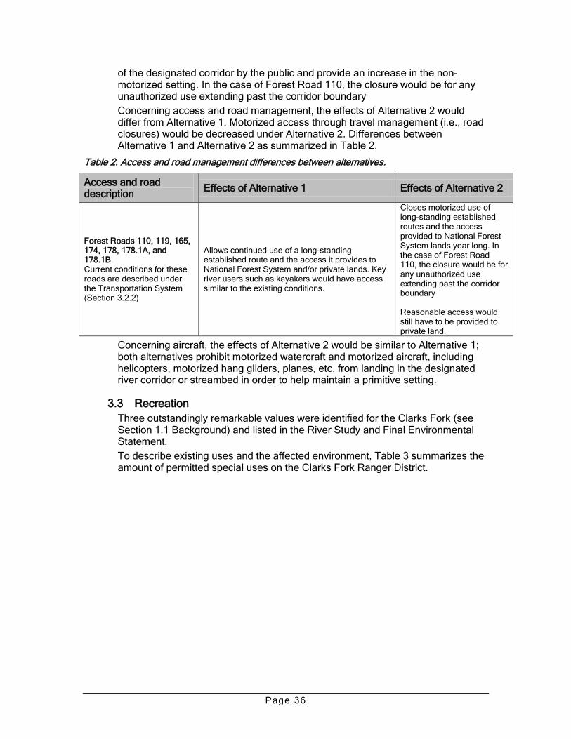
Page 36
of the designated corridor by the public and provide an increase in the non-motorized setting. In the case of Forest Road 110, the closure would be for any unauthorized use extending past the corridor boundary
Concerning access and road management, the effects of Alternative 2 would differ from Alternative 1. Motorized access through travel management (i.e., road closures) would be decreased under Alternative 2. Differences between Alternative 1 and Alternative 2 as summarized in Table 2.
Table 2. Access and road management differences between alternatives.
Access and road description
Effects of Alternative 1 Effects of Alternative 2
Forest Roads 110, 119, 165, 174, 178, 178.1A, and 178.1B. Current conditions for these roads are described under the Transportation System (Section 3.2.2)
Allows continued use of a long-standing established route and the access it provides to National Forest System and/or private lands. Key river users such as kayakers would have access similar to the existing conditions.
Closes motorized use of long-standing established routes and the access provided to National Forest System lands year long. In the case of Forest Road 110, the closure would be for any unauthorized use extending past the corridor boundary Reasonable access would still have to be provided to private land.
Concerning aircraft, the effects of Alternative 2 would be similar to Alternative 1; both alternatives prohibit motorized watercraft and motorized aircraft, including helicopters, motorized hang gliders, planes, etc. from landing in the designated river corridor or streambed in order to help maintain a primitive setting.
3.3 Recreation
Three outstandingly remarkable values were identified for the Clarks Fork (see Section 1.1 Background) and listed in the River Study and Final Environmental Statement.
To describe existing uses and the affected environment, Table 3 summarizes the amount of permitted special uses on the Clarks Fork Ranger District.

Page 37
Table 3—Existing commercial uses under special use permits (outfitter and guides) (number of service days)
Permitted outfitter Day use hunting
Day use fishing
Day use trail rides
Summer pack trips
Other (hiking, skiing, snowmobiling)
Crandall Creek Outfitters
40 -- -- -- --
Elk Creek Ranch -- 100 1,440 -- 314
K-Z Partnership 100 200 1,000 -- 20
Morning Creek Outfitters
150 40 50 -- --
Northwest College -- -- 300 -- --
Papoose Creek Outfitter
100 20 220 20* --
Seven D Ranch 50 200 1,400 15* 150
Switchback Outfitters 40 -- -- -- --
Timber Creek Outfitters
150 100 850 -- --
Wapiti Ridge Outfitting
180 -- -- -- --
Wyoming Wilderness Outfitter
25 25 -- -- --
*Clarks Fork Canyon Unit
3.3.1 Existing recreation developments and trails
All the current recreation developments and recreation uses described in this section are compatible with other management direction, public use of the resource, and resource attributes of the river. The following developments are present.
BLM Canyon Trailhead. Public access exists via Bureau of Land Management public land on the east end of the lower canyon near the Forest boundary. The site consists of a short stretch of road from the end of the paved highway to a small parking/trailhead area. The road is in rough condition and therefore not very suitable for large trailers, etc. Some recreationists choose to park at the end of the county road, creating a de facto trailhead for horse users and all-terrain vehicles. This minimal development is about 1 mile outside the designated corridor and off National Forest System lands.
Canyon Rim Trail (or Nez Perce Trail). The Canyon Rim Trail (trail 761, also called the Nez Perce Trail) is located east of the Dead Indian Campground (which is outside the designated corridor). This non-motorized trail is used mostly by hikers with some horse use. A small parking area serves a minimally developed trailhead off Wyoming Highway 296. The trailhead is outside the designated wild corridor and provides access to the scenic vistas of the canyon corridor.
Lewis and Clark Trail (or Clarks Fork Trail). Trail 628 is on the north side of the wild river and runs from the Clarks Fork Trailhead (outside the corridor) to forest road 119. The trail is a non-motorized, primitive trail. This trail provides non-motorized access to the wild river corridor and is very compatible with the wild designation. Although named for the Lewis and Clark Expedition, no part of this area was crossed by the expedition. Several non-system trails and scrambling routes also provide access.

Page 38
3.3.2 Use trends
The public is increasingly looking to public lands for a variety of recreation opportunities, including off-highway vehicle use, which is becoming more popular. This current trend is expected to continue locally as population and tourism increase in Park County and the region. Additionally, advancements in technology have allowed increasing motorized access to previously inaccessible areas.
A trend causing concern is damage from unauthorized vehicle use (primarily all-terrain vehicles) off designated routes, potentially modifying the natural environment of the river corridor. The type and intensity of unauthorized motorized use is a potential threat to the river’s outstandingly remarkable values.
Additional human use problems such as littering, vandalism, trampling of vegetation, and loss of solitude are also associated with higher use.
Current conditions and future trends to be aware of include geo-caching and mountain bike use, which may increase in popularity in the future. Rock climbing occurs at low levels. Since the Clarks Fork was designated, kayak use has grown but is limited to the more extreme enthusiasts because of access, required skill levels, and difficult navigability of the Clarks Fork. These uses are neither causing nor likely to cause adverse effects.
3.3.3 Visitor use capacity
Visitor use capacity is defined as the quantity of recreation use the area can sustain without adverse impacts on the outstandingly remarkable values and free-flowing character of the river area, quality of the recreation experience, and public health and safety.
While the increased recognition of the Clarks Fork as a desirable recreation area has probably resulted from designation into the National Wild and Scenic Rivers System, increases in use are not nearly as large as other, more accessible rivers that have been added to the system. The generally inaccessible nature of much of the corridor and lack of potential to generate a large amount of non-motorized recreational use is expected to continue to limit use.
Use limits are not needed due to the light kayaking use and the low potential for increases in such use. Fishing is also self-limiting due to the inaccessibility of the Middle and Upper Canyons and distances people have to hike to fish in the canyon in these segments. Kayaking is also somewhat self-limiting, due to the extreme difficulty and skill level required. No use allocations or special use permits currently exist for commercial boating or kayaking in the designated river corridor.
Also, to maintain low use levels and provide the opportunity for self-discovery, the proposed action limits additional commercial use and development. No additional commercial permits would be issued.
Trends for increased motorized use and the potential for associated resource impacts and social conflicts exist. As part of the proposed action, specific management actions for the wild river corridor should be implemented, including monitoring actions and related management actions.
Some of the current conditions affecting the environment are shown in the photo (Figure 8), which is the sand dunes area where OHV play use is occurring.

Page 39
Current conditions include channels through the riverbank leading directly to the river that are being carved along the shoreline by unauthorized vehicle use.
Figure 8. Sand dunes and OHV play area documented September 5, 2007.
Effects to recreation
Alternative 1-Proposed action
Alternative 1 is congruent with the Wild and Scenic Rivers Act and contributes to maintaining the characteristics and outstandingly remarkable values. The alternative would differ from the current conditions and have the following effects.
Recreational OHV use would be allowed on designated vehicle routes in the river corridor, in the same manner and degree that currently occurs. This use would continue and may be allowed under wild and scenic river guidelines, as long as use of the designated roads does not impair river characteristics and the outstandingly remarkable values.
Resources would be positively impacted; the designated road network would have an overall beneficial affect on soils, vegetation, water, and historic and visual resources, while still allowing a balance of motorized and non-motorized recreation uses. Reducing route proliferation and returning the area to a more natural appearance would result in the long term. Designation of roads open to vehicles generally has the beneficial effect of controlling impacts of OHV use on public lands, including potential impacts to outstandingly remarkable values.
All the proposed road designations are for existing vehicle roads that have been used by motorized vehicles for many years. The proposed road designations allow for most of the existing use to continue in the same manner and degree as

Page 40
in the past. The designations would not change or reduce vehicle use substantially, but allow for the continued use of designated roads.
The effect of prohibiting camping in RVs and camping trailers in the lower corridor and only allowing camping in tents is: 1) Forest Road 119 and the other roads in the corridor are low-standard roads that are not suitable for large RVs and camp trailers, 2) discourages motorists from driving off authorized roads to reach dispersed recreation sites and pioneering new unauthorized roads, and 3) protects scenic values as camping with vehicles creates areas subject to trampling of riparian areas and vegetation, impacts associated with driving vehicles off-road to dispersed camp sites, and compacted parking areas from vehicles/trailers.
An increased emphasis on travel management would have this effect to motorized users: Wheeled motorized vehicles are restricted to designated routes (Forest Roads 110, 119, 165, 174, and 178, 178. 1A, and 178.1B). Motorized traffic is not permitted off designated routes for the purpose of dispersed camping or any other generally permitted activity. The general authorizations in Shoshone National Forest Special Order 001-09 for dispersed camping and firewood cutting within 300 feet of an open motorized route do not apply. This excludes snowmobiles traveling over snow.
Road/route proliferation and OHV play areas would be stopped through enforcement of the travel management designations and public information, education, and enforcement. Closure of roads would reduce the opportunities for OHV recreation in some areas, but only where created by unauthorized cross-country travel and play areas and that would likely be closed with or without the CRMP due to resource degradation concerns. Opportunities for OHV recreation would still exist on designated open routes such as Forest Road 119.
No new commercial permits would be issued, but existing permits would be reissued when they come up for renewal and may be transferred to new owners. Permitted commercial use of the corridor would be capped at existing levels. Outfitters would be required to report and break out wild and scenic corridor days from their larger authorized area. This information would then be used to cap service days within the corridor at the level currently being used within the canyon and will not be increased.
No increases in commercial use would have the effect of limiting additional commercial use to maintain the character of the wild river corridor, reduce conflict, and limit use levels compatible with a primitive setting and provide the opportunity for self-discovery.
Casual collecting for gold is a minor use in the corridor and may increase relative to gold prices. The standard to not allow casual collecting for gold (hand panning) would limit increased visitor numbers in case use would drastically increase because of high gold prices. Effects would be similar under Alternatives 1 and 2, with the management standard prohibiting casual collecting for gold (hand panning). This prohibition of casual collection of gold limits potential surface disturbance from the use of shovels, pick axes, sluicing, dredging, etc. and protects water quality and outstandingly remarkable values.
Memorial or dedication sites are prohibited except that a single memorial site that recognizes the dedication of the river would be permitted. Any such memorial would be constructed of native materials and consist of a low profile stone monument, or something similar, with an appropriate plaque and would have a minimum effect.

Page 41
The proposed action addresses the key issues that were identified and the potential resource damage and unauthorized motorized use off designated routes. Designation of a network of open roads would protect resources and minimize conflicts; implementing the CRMP would end the slow process of resource degradation, which, if not addressed, could produce long-term adverse impacts.
The overall benefits of implementing the CRMP would be higher quality wildlife habitat, enhanced protection of outstandingly remarkable values (recreation, scenic, and historical), while maintaining existing motorized opportunities. The CRMP would lead to a change from current conditions and an increased emphasis on 1) information and education, 2) an increased management presence in the form of signs and road markers and personnel conducting monitoring, and 3) increased enforcement of the designations and law enforcement presence.
Under the proposed action alternative, an increased emphasis would be on information and education to achieve compliance with travel designations. Public education/outreach campaigns, including efforts made in conjunction with the local motorized community, would be used to discourage illegal off-road use in the Clarks Fork corridor. Existing programs such as Leave No Trace and Tread Lightly would be emphasized. Efforts to monitor and enforce off-highway vehicle regulations and educate the public on appropriate off-highway vehicle use would be coordinated with Wyoming State Trails. All-terrain vehicle patrols, trail hosts, law enforcement patrols, or other means of visitor contact would be used to inform and educate the public on travel management and to monitor/check on compliance with travel management regulations or other management issues. These field patrols would be used primarily in the high use season. Used in combination with the other identified actions, this would have the intended effects to reduce conflicts and potential impacts to wild river values.
In some instances, physical barriers would be used to discourage unauthorized use and allow rehabilitation of closed routes. Barriers may include soil berms, rocks or boulders, vegetation, or fences to prevent travel on unauthorized routes. Fences would be constructed to be visually unobtrusive.
Forest Service recreation technicians, law enforcement officers, trail hosts, and volunteers would regularly patrol and monitor visitor compliance, including motorized use and camping.
In the event that monitoring indicates a lack of compliance with motorized use restrictions, the Forest Service would pursue options with local authorities to implement special orders and increase the fines for unauthorized use. The Clarks Fork Canyon would be identified as a priority emphasis area for law enforcement patrols as time and staff allow. Increased patrols would be implemented in areas where monitoring efforts detect non-compliance with route designations. Additional restrictions or management tools could include gates, permits, or seasonal or year long closures. Additional public notification, signing, and education efforts would be conducted. All the mentioned options would have the effect of decreasing unauthorized use and emphasizing an on-going information and education effort for the intent of managing motorized use.
Alternative 2
The effects of Alternative 2 would be similar to Alternative 1, but limiting motorized access through road closures would result in a greater than before management presence and increased regulation that would decrease motorized

Page 42
access and curtail recreation access for users dependent on motorized access such as kayakers.
3.4 Visuals
The current conditions and scenic value of the designated wild river corridor is summarized in Section 1.2.
3.4.1 Landscape character
In the 1979 River Study and Final Environmental Statement, the Clarks Fork River was divided into three segments based on the physical characteristics of the canyon. These descriptions give a good overview of the landscape character.
Upper Canyon. This segment begins at the upper terminus of the designated river downstream of the Crandall Bridge flowing to Canyon Creek, approximately 8 miles in length. It is characterized by slopes of 40 to 90 percent covered by stands of Douglas-fir with some Engelmann spruce and lodgepole pine. Most of this segment has a well-developed floodplain, which supports stands of Englemann spruce.
Most of the Upper Canyon has a gentle gradient. In the central portion of the Upper Canyon the river is contained within a shallow, narrow canyon. The river gradient increases here, resulting in several waterfalls, cascades, and rapids; most are impassable by boat or raft. In places, 500-foot granite cliffs contain the river and its immediate environment.
Middle Canyon. This segment runs downstream from the confluence of the Clarks Fork River and Canyon Creek for approximately 8 miles. Douglas-fir with limited shrub understory is confined to benches or narrow floodplains where some soil development has occurred. This segment is deeply incised into granite, with walls towering to 1,200 feet vertically from the water’s edge. The river drops very fast throughout the entire segment, forming several rapids, plunge pools, and waterfalls that preclude raft or boat use, and most kayakers. This middle canyon contains the section known as the ―box,‖ which is an extremely technical kayak run with numerous portages.
Lower Canyon. In the eastern segment of about 7 miles, the river character changes dramatically. The canyon opens to a 0.5-mile wide u-shaped glacial valley with canyon walls towering up to 4,000 feet above the river. A combination of granite and overlying sedimentary rock form a very interesting and scenic geological display. There are a few rapids, but generally, the river gradient is nearly flat in this segment.
Vegetation on the canyon walls is limited to widely scattered Douglas-fir and grasses and forbs. Vegetation in the canyon is typical of extremely dry sites, which is unusual for mountain valleys in the Absaroka-Beartooth area. Yucca and common junipers are the most noticeable species. Prolonged periods of high wind have prohibited the junipers from growing as trees, resulting in dense mats and mounds known as krummholz.
Historically, natural succession and natural events—major wildfires, winds, insects and disease—have played a part in shaping the landscape.
Most of the roads in the area were constructed years ago and have a history of use for recreation and resource purposes. Most roads were put in place before the development of the Visual Management System (VMS). Except for cut slopes along the highway, the casual observer, due to the topography and screening

Page 43
vegetation present in the rugged, diverse landscape of the river corridor, probably would not notice most existing roads, routes, or past disturbances. For example, of the roads present in the area, very few are visible from key observation points.
Views from within the designated river corridor include diverse landscape character within the ―retention‖ visual quality objective (VQO) identified in the Forest Plan. Retention VQO is the desired condition for the river corridor.
The developments on the Wright Place (now owned by the Switchback Ranch) are well screened from the river. Two cables spanning the river are used to support small platforms on wheels, which provide access across the river when it is too deep to ford (old USGS gauge station). A power line and a telephone line serve the ranch. All these cables and lines are minor features within the surrounding landscape (River Study and Final Environmental Statement). A bridge crosses the river at the Wright Place. Further downstream, a power line crosses the river to the main Switchback Ranch on Dillworth Bench. Existing special use permits within the river corridor include the Wright Place ditch and the Wright Place road easement.
Baseline conditions at the time of designation included a scenic landscape that is essentially undisturbed. Retention VQO is the desired condition for the wild river corridor and this is being met. For baseline conditions, the Final Environmental Statement describes the switchbacks as not visible from the river directly below, although they can be seen from the river downstream. The road and switchbacks have low visual impact and do little to detract from the wild status of the Lower Section. The existing conditions for this road are not considered a threat to outstandingly remarkable values at this time, but the current unauthorized off-road use and increased motorized use is a concern, especially in the dunes area, river channel, gravel bars, and other features being used illegally (Figure 9).

Page 44
Figure 9. Unauthorized vehicle use on gravel bars, including the river channel itself.
Effects to visuals
Alternative 1-Proposed action
Alternative 1 is congruent with the Wild and Scenic Rivers Act and contributes to maintaining the characteristics and outstandingly remarkable values. The alternative would have the effect of increasing emphasis on travel management, seeking compliance from motorized users, setting standards to keep road maintenance levels at a primitive level, and limiting new developments such as roads and recreation facilities. This will add protection for outstandingly remarkable values, specifically scenic values.
Visual resources would be positively impacted; the designated road network would have an overall beneficial effect on soils, vegetation, water, and visual resources. Reducing route proliferation and returning the area to a more natural appearance would result in the long term.
Retention VQO is the desired condition for a wild river corridor and this is being met and would be met with the proposed action alternative. The alternatives involve management prescriptions and activities that would result in very little change from the existing character of the area.
Alternative 1 would protect and enhance the values for which the river was designated, while providing for public recreation and resource uses which do not adversely impact or degrade those values. They are designed to protect and enhance the values of the river area according to the wild classification.
Selection of the proposed action would allow for the site-specific fence project to be built. The fence would be built to be unobtrusive; it would be a rust-colored

Page 45
metal fence that would blend with the natural surroundings. The fence would not be visible form the river itself due to the high river bank and high sagebrush.
Since the fence would not be substantially visible, it would only be a minor visual impact in the canyon. The fence would have beneficial impacts that outweigh the slight visual intrusion. It would directly decrease cross-country vehicle travel, thus decreasing route proliferation and indirectly decreasing runoff and erosion. This decreased runoff and sediment from erosion helps protect downstream water quality, riparian areas, flood plains, and fish and wildlife habitat. Noxious weed spread would likely decrease as vehicle use is eliminated in the area.
If the decision is made to implement the fence, the area would be less susceptible to route proliferation from unauthorized cross-country travel. Unauthorized routes and activities in the sand dunes area and cutting vehicle routes through the river shoreline would be greatly reduced if not eliminated.
This single management action (fence construction) would greatly benefit soils, vegetation, visual resources, and wildlife. Non-motorized users (hikers, mountain bikers, and stock users) would still be able to access the area; motorized users would still be able to use the designated Forest Road 119, subject to the existing seasonal closure.
Benefits from this fence project include a reduction in the degradation to the river’s values in the sand dunes areas occurring from unauthorized motorized use. It would address the issue of increases in 4WD vehicles, motorcycles, and ATVs that have substantially increased since 1990 along with the unauthorized motorized recreation use that is currently considered a threat to outstandingly remarkable values now and into the near future without management action. In addition to outstandingly remarkable values, other values such as river shorelines, vegetation, visual resources, and soil and water in the sand dunes area would all benefit by eliminating the chronic unauthorized use.
The proposed management direction and the site-specific fence described above would address issues and concerns that unauthorized motorized use in the wild river corridor is potentially impacting the river corridor’s vegetation, wildlife habitat, and scenic attributes such as the dunes. Disturbance from motorized use is increasing and could affect special attributes, potentially threatening the river’s outstandingly remarkable values. Unauthorized vehicle use could degrade the visual resource, the primitive setting, and the scenic value.
In summary, implementing the proposed travel management plan and designating roads open to motorized travel would reduce adverse impacts to resources. Overall benefits would result from minimization of cross-country vehicle travel that would reduce unnecessary impacts and disturbance in the wild river corridor.
Alternative 2
Effects of Alternative 2 would be similar to Alternative 1. Implementing road closures would reduce the occurrence of unauthorized cross-country travel or travel on routes not suitable for the vehicle type.
3.5 Cultural resources
Although less than 1 percent of the Clarks Fork River corridor has been systematically surveyed for cultural resources, the archaeological record indicates that the general area has been occupied for at least 10,000 years. Archaeological evidence has shown that humans used the surrounding area for

Page 46
seasonal hunting and other resource procurement. The area also served as a travel corridor, including access to the high elevation alpine areas of the Beartooth Mountains, which could most easily be accessed by following the Clarks Fork River and its tributaries.
Historically, humans have used the area for ranching, homesteading, and timber harvesting. The Clarks Fork valley was also used as a travel corridor by European settlers. There is also a history of administrative use by the U.S. Forest Service.
The most famous historical event in the area was the chase of the Nez Perce Indians, led by Chief Joseph, by the U.S. Cavalry in 1877. One account of the event describes how the Nez Perce eluded the U.S. Cavalry by slipping through a narrow gorge into the Clarks Fork Canyon. The exact escape route is not known, and it is likely that multiple routes were taken by various bands of the Nez Perce.
Past projects in the area have not identified additional cultural, spiritual, symbolic, sacred, traditional, or religious values that would be compromised by the river management plan.
Effects to cultural resources
Alternative 1-Proposed action
Alternative 1 increases emphasis on travel management by setting standards to keep road maintenance at a primitive level and by limiting new developments such as roads and recreation facilities. Under Alternative 1, existing roads in the corridor would remain open. The overall effect to cultural resources under this alternative would be positive. The decrease in new road or recreation developments in the wild and scenic river corridor would add protection for outstandingly remarkable values for which the corridor was created, specifically historical values.
The designation of roads open to vehicular traffic generally has the beneficial effect of controlling impacts of OHV to cultural and historic resources. Effects of this alternative would be positive, as a designated roads system would reduce unauthorized cross-country travel. Compacted soil, vegetation reduction, and vehicle ruts due to cross-country vehicular travel can have negative impacts on cultural resources, archaeological sites in particular. Surface and subsurface archaeological remains can be displaced or destroyed as a result of unauthorized vehicular traffic. Alternative 1 limits vehicular traffic to designated roads, and reduces off-road traffic and associated impacts.
Unauthorized artifact collection may decrease under Alternative 1. When forest visitors are restricted to established routes within the corridor, they are less likely to encounter and collect archeological materials that may be present on the ground surface.
The reduction of future undertakings (e.g., new roads or recreation facilities) under Alternative 1 would reduce National Historic Preservation Act (NHPA) Section 106 compliance-related cultural resource surveys. This may result in fewer cultural resource discoveries and recordings within the corridor. However, historic and archaeological research is not prohibited under the management plan, and the plan allows for the low-intensity development of cultural resource properties compatible with the river designation.
No direct adverse effects would result from implementation of the Alternative 1. Segments of the historic Nez Perce trail are present in the wild and scenic river
Page 47
corridor; however, the limited planned management activities would not affect this historic property.
Implementation of Alternative 1 would protect and enhance the natural character of the wild river corridor by eliminating unauthorized vehicle routes. This action also protects the visual and historic character of the landscape by reducing development and traffic intrusions.
The field survey for the fence installation project proposed under Alternative 1 was conducted in 2008 for compliance with the National Historic Preservation Act (NHPA), Section 106. No cultural resources or historic properties were discovered. The Wyoming State Historic Preservation Office (SHPO) concurred with the agency’s finding of ―no historic properties affected‖ (SNF Heritage Event # R2008021400075 and SHPO Case # 0808JRD009).
Any additional project-specific activities associated with the proposed action would undergo cultural resource review prior to project implementation. Adherence to the regulations of the NHPA ensures that cultural resources eligible for the National Register of Historic Places (NRHP) are identified before project specific implementation. Section 106 of the NHPA ensures that cultural resources are identified and either avoided through policy, project design, or mitigation. New cultural resources discovered during the course of the project implementation would be protected while evaluations of their significance are made through consultation with the SHPO and Native American Tribes.
Consultation with Native American Tribes that may hold cultural, spiritual, or traditional values would occur when specific projects are proposed within the wild river corridor. Principal tribes that may be concerned with development in the corridor may include the Nez Perce, Crow, Shoshone, Northern Arapahoe, and Bannock tribes. Another human consideration relates to the accessibility to areas pertinent to subsistence, ceremonial, and other religious activities practiced by Native Americans. During public scoping and issue identification, no comments were received from the tribes and no subsistence, ceremonial, or other religious activities were identified.
Alternative 2
Under this Alternative, existing roads would be closed in the wild and scenic river corridor. The effects of Alternative 2 would be similar to those of Alternative 1. The beneficial effects from decreased road and recreation facility developments under Alternative 1 would have the same effect under Alternative 2.
Closing existing roads under Alternative 2 would further decrease traffic and forest users in the corridor. A decrease in vehicular traffic and forest visitors in the corridor would add further protection from ground disturbing activities and unauthorized artifact collection.
As with Alternative 1, a decrease in future projects (e.g. road or recreation developments) results in a decrease of NHPA Section 106 compliance cultural resource surveys, which could result in fewer discoveries and documentation of cultural and historic properties.
Closing roads in the corridor would affect accessibility to areas for subsistence, ceremonial, and other religious activities. During public scoping and issue identification, no comments were received from the tribes and no subsistence, ceremonial, or other religious activities were identified.

Page 48
3.6 Vegetation diversity and botany
3.6.1 Invasive plant species and sensitive plant species
In considering current conditions, there are over 20 high priority terrestrial invasive species on the Shoshone with many more invasive species with the potential to spread across large portions of the Forest. Large-scale disturbances, such as wildfires, can enhance conditions for invasive species spread if fires or other disturbances expose soil, reduce native vegetation, and facilitate the introduction or movement of invasive seed sources into an area. Early detection and rapid response are essential to finding new or expanding populations after a ground disturbing event.
The importance of addressing invasive species is that they have the negative long-term effect of reducing water quality, habitat quality, and biodiversity. Known invasive species infestations are mapped on the Forest and would be used under either alternative to direct weed management practices.
Invasive plant species. There is general concern about the potential spread of invasive species and noxious plant/aquatic species in the corridor area, especially cheatgrass in the east end of the canyon/corridor. Forest-wide, monitoring has shown an increase in invasive species or weed expansion, primarily bull thistle, knapweeds, hounds tongue, and Canada thistle.
Only weed free hay is allowed on the Forest, including the wild river corridor.
Sensitive plant species. Sensitive plants were not identified as a major concern. No threatened and endangered plant species are found on the Forest.
Effects to vegetation diversity and botany
Alternative 1-Proposed action
Alternative 1 is congruent with the Wild and Scenic Rivers Act and contributes to maintaining the characteristics and outstandingly remarkable values. There would be little change or departure from current conditions; however, the alternative would have these effects:
Motorized vehicle travel on designated routes would have minimal effect on vegetation diversity or botanical resources. Cross-country vehicle travel has the potential to crush or uproot vegetation and leaves visible tracks that others can follow. Areas where soil and vegetation have been disturbed due to cross-country travel or OHV play areas (i.e., the sand dunes area) are especially susceptible to establishment of invasive, non-native species.
Implementing the travel management and designated roads only strategy would allow slightly more vegetation on the non-designated roads, enhance the forage for livestock and wildlife, and increase ground cover for improved watershed function.
Eliminating or greatly reducing the occurrence of cross-country vehicle travel would reduce the impacts to existing vegetation, which would reduce the spread of weeds and help maintain vegetation diversity.
The protective designation for most of the river corridor would benefit sensitive plants or special botanical attributes.
Early detection and rapid response are essential to finding new or expanding populations of invasive plant species and would help maintain natural diversity.
Motorized use for administrative purposes, such as access for weed spraying, would be allowed and would be beneficial for maintaining natural diversity.

Page 49
Educational efforts would be pursued to ensure that public land users are aware of techniques to prevent the spread of invasive, non-native species (plants and aquatic species). Weed treatments would continue to be coordinated between Park County Weed and Pest and the Forest Service as staff and funding allow.
In summary, based on the existing conditions and management direction for allowing natural succession, diversity for the river corridor would decline due to the loss of conifer forests resulting from beetle infestations. In areas with encroaching conifer species and cover types of dense, mature, late seral species, diversity would continue to decline in the absence of disturbance and stands would be more susceptible to stand replacing events. Alternative 1 would have a negligible effect on reversing this trend, which is part of natural succession.
Natural disturbances and natural succession would occur. In the event of future large-scale natural disturbances (wind, wildfire, insects), vegetation diversity is expected to increase in the long-term in those areas affected.
Alternative 2
The effects of Alternative 2 would be similar to Alternative 1. Limiting motorized access through travel management (Alternative 1) or through the identified road closures (Alternative 2) would minimally slow the spread of invasive plant species in the corridor, but overall would have little impact on vegetation diversity, including sensitive plant species, botanical resources, or invasive plant species.
3.7 Commercial livestock grazing
Past and present use includes a minor amount of commercial livestock grazing. In the Lower Canyon, it consists primarily of trailing activities along a stock driveway and limited amount of use on the benches above the canyon but within the 0.5-mile wild and scenic corridor. Portions of four grazing allotments (Bench, Table Mountain, Ghost Creek, and Crandall) overlap into the 0.5-mile wide river corridor. Overall, grazing use is minimal throughout the actual designated corridor.
At this time, grazing is not determined to be substantially degrading river values. Therefore, the affected environment for rangeland was not determined to be inconsistent with river management and major changes in livestock and/or grazing practices are not warranted at this time. However the Act gives river-administering agencies authority to adjust or eliminate livestock grazing, or any other commercial use, if doing so is necessary to meet river management goals
Effects to commercial livestock grazing
Alternative 1-Proposed action
There would be little change or departure from current conditions. Continued permitted commercial livestock grazing and use of the stock driveway does not substantially interfere with public use or detract from the values that led to the river’s inclusion in the National Wild and Scenic River System. Based on the existing conditions and management direction for rangelands there would be no substantial adverse effects from the proposed action or changes in the current conditions. Overall, grazing use is minimal throughout the entire wild river corridor. No changes in amounts or types of grazing are expected to occur within the wild river corridor in the foreseeable future.

Page 50
Alternative 2
Effects of Alternative 2 would be similar to Alternative 1. Limiting motorized access through travel management or road closures would require the Forest Service to coordinate closely with the grazing permittees to allow for needed access for allotment activities. The Forest Service also uses the affected roads for grazing administration. Overall, Alternative 2 would have little impact on rangeland or the existing commercial livestock grazing.
3.8 Wildlife and fisheries
Wildlife species are addressed in several different categories: Wyoming Priority Bird Species, threatened and endangered species, regionally designated sensitive species, and Forest management indicator species.
Alternative 1-Proposed action and Alternative 2
When considering the management direction, the impact on wildlife habitat conditions is negligible when considered in the context of the ongoing natural disturbances (insects, wildfire, wind, drought, etc.). Limiting vehicles to a designated network of roads would reduce disturbance to wildlife by motorized vehicles and would reduce habitat fragmentation in the area and improve the overall quality of riparian, wildlife, and fisheries habitat in the area.
Implementing the proposed travel management plan and designating roads open to motorized travel would not adversely affect listed or candidate species under the Endangered Species Act or species on the Region 2 sensitive species list, as discussed below. Overall benefits would result from minimization of cross-country vehicle travel and would reduce unnecessary disturbance to wildlife habitat.
Construction and maintenance of minor structures for the protection, conservation, rehabilitation, or enhancement of fish and wildlife habitat are acceptable, provided they do not have a direct and adverse effect on the values of the river, including its free-flowing nature. Structures should be compatible with the river’s wild classification, allow the area to remain natural in appearance, and harmonize with the surrounding environment. An analysis should be conducted to assess the effect on river values.
The closure of forest roads as proposed in Alternative 2 would reduce disturbance from recreation activities and unauthorized uses. In general, less disturbance of this kind would be of benefit to wildlife species.
Wyoming Priority Bird Species
The Wyoming Partners in Flight group rated species in priority order of conservation needs. The highest priority includes four birds that occur on the Shoshone: Brewer’s sparrow, northern goshawk, peregrine falcon, and bald eagle. These species are included and analyzed in other categories in this document.
Effects on threatened and endangered species
Alternative 1-Proposed action and Alternative 2
Analysis of effects to threatened and endangered species is documented in the Biological Assessment/Biological Evaluation for the Clarks Fork Wild River Forest Plan Amendment.
All threatened and endangered species known or suspected to occur on the Shoshone National Forest were considered. Species determined unlikely to occur were not carried into further analysis and were given a ―no effect‖ determination.

Page 51
To determine which species could occur within the analysis area, species occurrence records for the area were checked and the habitat requirements of the species were compared with the habitat present in the analysis area and summarized in Table 4.
Table 4—Threatened and endangered species for the Shoshone National Forest
Species Status Species
occurrence on Forest
General habitat
Suitable habitat present in action
area
Likelihood of species
occurring in action area
Carry forward
in analysis
Canada lynx (Lynx canadensis)
Threatened Yes Mature forest
No Very unlikely Yes
Black-footed ferret (Mustela nigripes)
Endangered No Prairie dog towns
Very little
Very unlikely No
Gray wolf (Canis Lupus)
Non-essential experimental
Yes Habitat generalist
Yes Likely Yes
In this analysis, the direct, indirect, and cumulative effects were analyzed and determinations were made for threatened and endangered species. For federally listed threatened and endangered species, determinations of "no effect," "may affect, not likely to adversely affect," or "may affect, likely to adversely affect" were considered. Rationale accompanies these determinations.
Canada lynx
The U.S. Fish and Wildlife Service published a Final Rule in the Federal Register on March 24, 2000 listing the North American lynx population in the contiguous United States as threatened, pursuant to the Endangered Species Act (USDI Fish and Wildlife Service 2000). The national forests in the Northern Rocky Mountains, including the Shoshone, completed a forest plan amendment (USDA Forest Service 2007a) that incorporates standards and guidelines for lynx based on the Canada Lynx Conservation Assessment and Strategy (USDA Forest Service et al. 2000).
Primary lynx habitat in the western mountains consists of lodgepole pine, subalpine fir, and Engelmann spruce (Aubry et al. 2000). There is no mapped lynx habitat in the project area, which is located well below elevations where lynx habitat is typically found. Forest types within the project area are more open, drier types which do not support lynx or their prey.
Alternative 1-Proposed action and Alternative 2
Programmatic direction in the comprehensive river management plan and Forest Plan amendment would have ―no effect‖ on Canada lynx.
Gray wolf
The availability of a stable ungulate prey base is the primary special habitat requirement for this species although smaller animals and carrion are also used as prey. Wolf distribution in the Greater Yellowstone Area has exceeded expectations since their reintroduction in 1995. Wolves began dispersing onto the Shoshone in 1999. Currently, the Beartooth pack’s territory encompasses the wild river corridor. This pack’s territory is large, and the wild river corridor is only a small portion of it. There are no den sites located within the wild river corridor.

Page 52
The gray wolf historically occupied the Shoshone National Forest and this area is part of the Gray Wolf Recovery Zone. Wolves were reintroduced into the Yellowstone area in 1995. As of the end of 2006, there were an estimated 453 wolves in the Greater Yellowstone Area (U.S. Fish and Wildlife Service et al. 2008). Recovery criteria established for wolves in the Yellowstone area have been met since 2002. However, gray wolves are currently protected under the Endangered Species Act. In the Greater Yellowstone Area, wolves outside national parks and National Wildlife Refuge System lands are designated a "non-essential, experimental population" under Section 10 of the Endangered Species Act. Wolves within the experimental population geographic area (including the Shoshone National Forest) are treated for management purposes as though they are proposed for listing.
Alternative 1-Proposed action and Alternative 2
Neither alternative would affect the gray wolf as there would be no potential for disturbance to den sites and prey populations would not be affected at the population level. The proposed action would be ―not likely to jeopardize the continued existence of‖ the gray wolf.
Effects to sensitive terrestrial wildlife species
Alternative 1-Proposed action and Alternative 2
All sensitive species known or suspected to occur on the Shoshone National Forest are displayed and analyzed in the Biological Assessment/Biological Evaluation for Clarks Fork Wild River Forest Plan Amendment (USDA Forest Service 2008a). Sensitive species that occur, or could occur, in the analysis area were considered to determine if they could be affected by the proposed action. Affected species, except the grizzly bear and gray wolf, were grouped according to the habitats in which they occur; they are presented in that context.
As a result of analysis, one of the following determinations was made for each species: ―no impact," ―beneficial impact,‖ ―may adversely impact individuals, but not likely to result in a loss of viability on the planning area, nor cause a trend to federal listing or a loss of species viability rangewide,‖ or ―likely to result in a loss of viability on the planning area, in a trend to federal listing, or a loss of species viability rangewide‖ for sensitive species. Rationale accompanies these determinations.
Grizzly bears
In 2006, direction from the Forest Plan Amendment for Grizzly Bear Habitat Conservation for the Greater Yellowstone Area National Forests Record of Decision (USDA Forest Service 2006a) was incorporated into the Forest Plan. In April 2007, the Yellowstone distinct population segment of grizzly bears was removed from the federal list of threatened and endangered species (USDI Fish and Wildlife Service 2007b). This species is now a Forest Service Region 2 sensitive species. The wild river corridor is outside the grizzly bear Primary Conservation Area, but is within occupied habitat. It is low quality habitat for much of the year but grizzly bears likely use the area on occasion, especially during spring and fall.
Alternative 1-Proposed action and Alternative 2
The effects of both alternatives would be similar. No changes in habitat are expected to result. There would be some potential for grizzly bear/human
Page 53
conflicts, but the Food Storage Order would be in place here under any scenario and would help mitigate this potential.
Coniferous and mature forest habitats
Species that occur or could occur in this habitat type in the analysis area include marten, wolverine, fringed myotis, Townsend’s big-eared bat, northern goshawk, boreal owl, black-backed woodpecker, American three-toed woodpecker, and olive-sided flycatcher. Suitable habitat for wolverines, martens, goshawks, boreal owls, black-backed woodpeckers, three-toed woodpeckers, and olive-sided flycatchers is generally not present in the wild river corridor as these species are associated with wetter, higher-elevation forest types, Suitable habitat for the fringed myotis and Townsend’s big-eared bat may be present, but the species are not known to occur there
Alternative 1-Proposed action and Alternative 2
There would be no effects to these species under either alternative. For many of these species, there is no suitable habitat and they are not expected to occur in the wild river corridor except in the rare case of individuals traveling through. The two bat species may be present, but no changes in habitat or alterations in human use patterns that could lead to increased potential for disturbance of roosts is expected.
Sagebrush/grassland habitats
Sagebrush/grassland habitat is habitat for the white-tailed prairie dog, ferruginous hawk, sage grouse, northern harrier, grasshopper sparrow, and Brewer’s sparrow, as well as making up a component of peregrine falcon and bighorn sheep foraging habitat. This habitat is most prevalent in the lower portion of the Clarks Fork Canyon. Peregrine falcons are also known to nest in the Clarks Fork Canyon. The canyon is a wintering area for bighorn sheep from the Clarks Fork herd.
Alternative 1-Proposed action
Sagebrush/grassland habitat would not change as part of the alternatives. Bighorn sheep and peregrine falcons spend a significant portion of their lives in cliff habitat. Generally, they are present in difficult to access areas during the prime recreation use periods and are separated from people using the road network or the river and are relatively unaffected.
Designating roads open to motorized use would reduce disturbance from recreation activities. Less disturbance of this kind would be of benefit to both wildlife species.
Alternative 2
Sagebrush/grassland habitat would not change substantially as part of the alternative. Bighorn sheep and peregrine falcons spend a significant portion of their lives in cliff habitat. Generally, they are present in difficult to access areas during the prime recreation use periods and are separated from people using the road network or the river and are relatively unaffected.
The closure of forest roads as proposed in Alternative 2 would reduce disturbance from recreation activities and unauthorized uses. Less disturbance of this kind would be of benefit to both wildlife species.

Page 54
Riparian/wetland/aquatic habitats
No suitable habitat is present in the wild river corridor for the water vole or trumpeter swan. Species that occur or could occur in the analysis area and are primarily found in riparian, wetland, or aquatic habitats include the river otter, harlequin duck, bald eagle, boreal toad, northern leopard frog, and Columbia spotted frog. (Yellowstone cutthroat trout, lake chub, and mountain sucker are presented under sensitive aquatic species.)
Other invasive, aquatic nuisance species, including whirling disease, New Zealand mud snails, and Didymo are a concern.
Alternative 1-Proposed action
Some small benefits to riparian species may result under Alternative 1 as a result of measures that would be taken to prevent cross country travel by OHVs. Otherwise, the effects of the alternatives would be similar.
Alternative 2
The closure of forest roads as proposed in Alternative 2 would benefit riparian species, as a result of measures that would be taken to reduce roaded access. Otherwise, the effects of the alternatives would be similar.
Biological evaluation determination on sensitive terrestrial species
Alternative 1-Proposed action and Alternative 2
Based on the above effects analysis, the Biological Evaluation determination for the marten, northern goshawk, boreal owl, wolverine, black-backed woodpecker, three-toed woodpecker, olive-sided flycatcher, fringed myotis, water vole, trumpeter swan, and Townsend’s big-eared bat is ―no impact.‖ For the grizzly bear, bighorn sheep, river otter, harlequin duck, bald eagle, boreal toad, northern leopard frog, and Columbia spotted frog, the alternatives ―may adversely impact individuals, but are not likely to result in a loss of viability on the planning area, nor cause a trend to federal listing or a loss of species viability rangewide.‖
Effects on sensitive aquatic species
Region 2 sensitive fish species include Yellowstone cutthroat trout, mountain sucker, and lake chub.
Yellowstone cutthroat trout have been significantly reduced in numbers and are found in a small fraction of their historic range. This was caused primarily from introduction of non-native fish species and human-caused habitat modification/degradation (May et al. 2006).
Mountain suckers are found in streams and rivers. They are common to abundant where suitable habitat exists on the Forest (USDA Forest Service 2006b).
Lake chubs are typically found in lakes and slower, low gradient stream backwaters (Stasiak 2006). Lake chubs are common to abundant where suitable habitat exists on the Forest.
Alternative 1-Proposed action
Alternative 1 could have longer-term beneficial effects caused primarily by sediment level decreases in streams. Alternative 1 ―will impact habitat availability but in such a small scale that it is not likely to result in a loss of viability on the planning area nor cause a trend to federal listing or a loss of viability range wide.‖
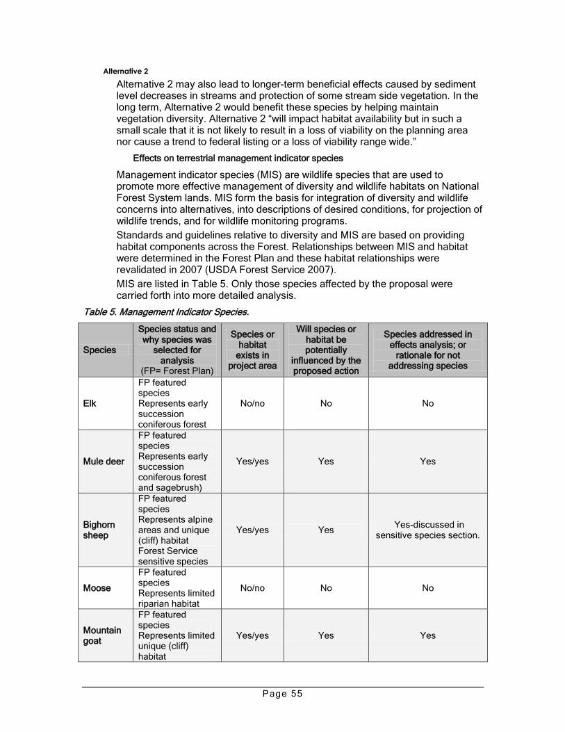
Page 55
Alternative 2
Alternative 2 may also lead to longer-term beneficial effects caused by sediment level decreases in streams and protection of some stream side vegetation. In the long term, Alternative 2 would benefit these species by helping maintain vegetation diversity. Alternative 2 ―will impact habitat availability but in such a small scale that it is not likely to result in a loss of viability on the planning area nor cause a trend to federal listing or a loss of viability range wide.‖
Effects on terrestrial management indicator species
Management indicator species (MIS) are wildlife species that are used to promote more effective management of diversity and wildlife habitats on National Forest System lands. MIS form the basis for integration of diversity and wildlife concerns into alternatives, into descriptions of desired conditions, for projection of wildlife trends, and for wildlife monitoring programs.
Standards and guidelines relative to diversity and MIS are based on providing habitat components across the Forest. Relationships between MIS and habitat were determined in the Forest Plan and these habitat relationships were revalidated in 2007 (USDA Forest Service 2007).
MIS are listed in Table 5. Only those species affected by the proposal were carried forth into more detailed analysis.
Table 5. Management Indicator Species.
Species
Species status and why species was
selected for analysis
(FP= Forest Plan)
Species or habitat
exists in project area
Will species or habitat be potentially
influenced by the proposed action
Species addressed in effects analysis; or
rationale for not addressing species
Elk
FP featured species Represents early succession coniferous forest
No/no No No
Mule deer
FP featured species Represents early succession coniferous forest and sagebrush)
Yes/yes Yes Yes
Bighorn sheep
FP featured species Represents alpine areas and unique (cliff) habitat Forest Service sensitive species
Yes/yes Yes Yes-discussed in
sensitive species section.
Moose
FP featured species Represents limited riparian habitat
No/no No No
Mountain goat
FP featured species Represents limited unique (cliff) habitat
Yes/yes Yes Yes

Page 56
Species
Species status and why species was
selected for analysis
(FP= Forest Plan)
Species or habitat
exists in project area
Will species or habitat be potentially
influenced by the proposed action
Species addressed in effects analysis; or
rationale for not addressing species
Bald eagle
FP recovery species Forest Service sensitive species
No nesting habitat or winter roosts present.
No
No-eagles occassionaly present but there are no nesting or roost areas and the project would not affect eagle habitat.
Peregrine falcon
FP recovery species Forest Service sensitive species
Yes/yes No
No-Species nests in canyon but on high
canyon walls that are inaccessible to humans
and associated activities.
Black-footed ferret
FP recovery species Listed under ESA as endangered Extirpated from the Forest
No/no No No
Gray wolf
FP recovery species Forest Service sensitive species
Yes/yes No No-species occasionally
present but will not be influenced by proposal
Grizzly bear
FP recovery species Forest Service sensitive species
Yes/yes Yes Yes, addressed in section
on sensitive species
Marten
FP ecological indicator for late succession conifer forest Forest Service sensitive species
Yes/yes No No
Northern goshawk
FP ecological indicator for late succession conifer forest Forest Service sensitive species
Yes/yes No No
Brewer’s sparrow
FP ecological indicator for sagebrush communities Forest Service sensitive species
Yes/yes No
No- alteration of sagebrush habitat is primary issue for this species, no habitat
alteration proposed with this project.
Hairy wood-pecker
FP ecological indicator for late successional aspen and snags
Yes/yes No No
Beaver FP ecological indicator for riparian
Yes/possible No No-alteration to riparian habitat is not proposed.

Page 57
Species
Species status and why species was
selected for analysis
(FP= Forest Plan)
Species or habitat
exists in project area
Will species or habitat be potentially
influenced by the proposed action
Species addressed in effects analysis; or
rationale for not addressing species
Ruffed grouse
FP ecological indicator for multi-storied aspen
Yes/yes No No
Blue grouse
FP ecological indicator for forested habitat
No/no No No
Game trout
FP ecological indicator for aquatic habitat
Yes/yes Possibly Yes, addressed in aquatic
/ riparian section
Alternative 1-Proposed action
Mule deer and mountain goats all winter in the lower portion of the Clarks Fork Canyon. Some disturbance of wintering animals would be possible, as Forest Road 119 would be managed for motorized use. However, the road receives only light use during the winter months due to the often cold, windy conditions. The effects of motorized travel on wintering deer, sheep, and goats are expected to be limited. MIS habitat and population trends would likely continue as they currently are.
Alternative 2
The closure of forest roads as proposed in Alternative 2 would result in reductions in disturbance to wintering deer and goats. Otherwise, the effects to management indicator species would be similar to Alternative 1.
Effects on aquatic management indicator species
Game trout were selected for this analysis because of their dependency on aquatic habitat types and the adjacent riparian communities that may be potentially affected by this proposal. The needs of game trout were a major factor in the formulation of Forest Plan goals (chapter III-8 and 9) and standards and guidelines for aquatic and riparian habitat (chapter III 207-222).
Historic native trout stream species include Yellowstone cutthroat trout, mountain whitefish, and arctic grayling. Introduced stream species include rainbow trout, rainbow-cutthroat hybrids, brook trout, brown trout, and arctic grayling.
Alternative 1-Proposed action
The risk to game trout and the habitats they use would be reduced by a designated road system and travel management. Potential effects include increased sediment, decreased vegetation, decreased bank stability, and increased erosion from unauthorized vehicle use. As a result, there would be no long-term downward trend Forest-wide of habitat or game trout populations.
Alternative 2
The risk to game trout and the habitats they use would be reduced by the closure of forest roads as proposed in Alternative 2. Potential effects include increased sediment, decreased vegetation, decreased bank stability, and increased erosion from unauthorized vehicle use. These potential effects would be reduced as a result of Alternative 2; therefore, there would be no long-term downward trend Forest-wide of habitat or game trout populations.

Page 58
3.9 Fire and fuels
Fires have occurred very infrequently, although some evidence in the form of vegetation patterns suggests past wildfires, the most evident being the Dano Fire of 1996.
Effects to fire and fuels
Alternative 1-Proposed action
Alternative 1 is congruent with the Wild and Scenic Rivers Act and contributes to maintaining the characteristics and outstandingly remarkable values.
There would be little change or departure from current conditions; however, the alternative would have the following effects.
Natural processes and past actions, particularly fire exclusion policies and fire suppression, have created unnatural fuel conditions; under the alternatives, this trend would continue into the future. There is the potential for large stand replacement fires under the right weather conditions in or near the designated corridor.
In summary, no fuels management actions are planned as part of this action alternative in the river corridor; therefore, no changes or effects to wildfire behavior would result from the alternatives. The proposed action does not contribute to fuels reduction, changes in fire behavior, or the creation of defensible space resulting in improved fire suppression capability adjacent to private properties and power lines in the vicinity. The proposed action would allow for prescribed burning to maintain or enhance vegetation diversity.
Alternative 2
The effects of Alternative 2 would be similar to Alternative 1.
3.10 Lands, minerals, special uses, and rights-of-way
3.11 Land ownership and land use description
Lands in the corridor are part of the National Forest System, except for 136 acres of private land in Section 6, Township 56 North, Range 105 West, known in the past as the Wright Place (now part of the Switchback Ranch). This inholding is located on the river below Reef Creek, about 3.5 miles downstream from the west end of the river corridor. The land is occupied by a house, and several barns and sheds, and is used for the irrigated production of hay. A bridge across the river is present. Access is by a 4WD road (Forest Road 174) that crosses National Forest System lands. A special use permit (easement) is in place on this road to provide authorized private land access.
An electricity transmission line parallels some of the wild river corridor on the south side, from about the box to Crandall Creek in the middle and upper segments. A transmission line also crosses the river canyon in the Middle Canyon section, providing electricity to the Switchback Ranch (private land) on the Dillworth Bench.
Past and present use includes commercial livestock grazing by cattle in the upper and lower canyons. The 1979 Final Environmental Statement states that parts of four grazing allotments occur within the study area (roughly equivalent to the designated river corridor). One hundred ten animal use months11 of cattle grazing
11
The equivalent of one cow and calf grazing for 30 days.

Page 59
are produced within the study area, most of which occurs in the Upper Canyon. Overall, grazing use is minimal throughout the entire wild river corridor.
There are no known valid mining claims in the wild river corridor. Limitations on mineral entry and development on public lands are specified in section 9 of the Act and would be applicable under both alternatives.
Effects to lands, minerals, special uses, and rights-of-way
Alternative 1-Proposed action
Alternative 1 is congruent with the Wild and Scenic Rivers Act and contributes to maintaining the characteristics and outstandingly remarkable values. The effects of the standards above would result in an increasing emphasis on travel management seeking compliance from motorized users, set standards to keep road maintenance levels at a primitive level, and limit new developments such as roads and recreation facilities. This will add protection for outstandingly remarkable values, while continuing to allow the existing uses such as private land access, commercial grazing, and utility corridors.
Each standard would protect and enhance the values for which the river was designated, while providing for public recreation and resource uses which do not adversely impact or degrade those values. They are designed to protect and enhance the values of the river area according to the wild classification.
Economic uses of the Forest Service lands include limited commercial livestock grazing and limited commercial recreation. Power lines and telephone lines exist in the area, along with the associated utility corridors. Most are outside the designated corridor, but some are present in the designated wild river corridor and may require occasional access needs for maintenance and repairs.
Alternative 2
The effects of Alternative 2 would be similar to Alternative 1.
Economic uses of the Forest Service lands include limited commercial livestock grazing and limited commercial recreation, which could be inconvenienced to some degree by additional road closures. Power lines and telephone lines exist in the area, along with the associated utility corridors and need for access for maintenance. Most are outside the designated corridor, but some are present in the designated wild river corridor.
Access to private land must be granted as mandated by the Alaska National Interest Lands Conservation Act.
3.12 Socio-economic
Under the Wild and Scenic Rivers Act, the federal government has no authority to regulate or zone lands. Land use controls on private lands are solely a matter of state and local zoning. Although the Act includes provisions encouraging the protection of river values through state and local governmental land use planning, there are no binding provisions on local governments. In the absence of state or local river protection provisions, the federal government may assure compliance by entering into agreements with landowners and/or through purchase of easements, exchanges, or acquisition of private lands
Alternative 1-Proposed action
Existing power line or communication transmission rights-of-way would continue to be used and maintained. New proposals would be evaluated for impacts to river values.

Page 60
Commercial recreation and outfitting were covered in Section 3.7.
Alternative 2
The effects of Alternative 2 would be similar to Alternative 1. Limiting motorized access through travel management (i.e., road closures) would only minimally affect or differ from Alternative 1. Implementing road closures would reduce the occurrence of unauthorized cross-country travel or travel on routes not suitable for the vehicle type.
Environmental Justice
Executive Order (EO) 12898 (February 11, 1994) directs federal agencies to focus attention on the human health and environmental conditions in minority communities and low-income communities. The purpose of EO 12898 is to identify and address, as appropriate, disproportionately high and adverse human health or environmental effects on minority and low-income populations.
Table 6 shows the minority characteristics of the three counties compared to Wyoming state statistics. Table 7 shows county and state poverty statistics, percentage of individuals living below the poverty level, as defined by the U.S. Census Bureau. Because none of the counties in the project area contain low-income or minority populations as defined by EO 12898, no additional outreach or analysis has been completed. Low-income populations exist if 20 percent or more of the total population is at or below the poverty level, and a minority population exists if 50 percent or more of the total population is considered minority. Any management actions taken on the Forest will affect the surrounding population in a similar way – the potential impact would be felt proportionally by the total population surrounding the Forest.
Table 6. Minority component of population by county, 2000 (Taylor, et al 2008)
County/State Total Population
White Black American Indian
Asian or Pacific Islander
Other/Multi-Race
Hispanic Any Race
Fremont 35,804 74.6% 0.1 18.8% 0.3% 1.8% 4.4% Hot Springs 4,882 94.5% 0.3% 1.5% 0.2% 1.1% 2.4% Park 25,786 94.5% 0.1% 10.4% 0.4% 1.4% 4.0% Wyoming 493,782 88.9% 0.7% 2.1% 0.6% 1.3% 6.4%
Table 7. Percent of population living below poverty level by county, 2005 (Taylor et al 2008)
Fremont Hot Springs Park Wyoming U.S. Poverty Level 14.9% 11.5% 10.3% 10.6% 13.3%
Alternative 1-Proposed action
Given that no minority or low-income populations are identified in the affected area, there would be no disproportionate effect from any alternative on such populations regarding environmental justice concerns or factors.
Alternative 2
Effects from Alternative 2 would be similar to Alternative 1; there would be no disproportionate effect on minority or low-income populations regarding environmental justice concerns or factors.
3.13 Cumulative effects
This section discloses cumulative effects from past and present activities, effects of the action alternatives, as well as effects of reasonably foreseeable activities

Page 61
that are likely to occur on federal, state, and private land within or near the designated river corridor over the next 20 years.
The effects analysis examines the cumulative or incremental effects of the proposed action when added to past, present, and reasonably foreseeable future actions/activities that likely would occur in or adjacent to the analysis area.
Cumulative effects were bounded temporally and spatially for this analysis, thus defining the duration for projection of effects as well as the project area boundary. Projection of effects over time was limited to that reasonably foreseeable future time period during which the identified major threats or changes to Forest resources and/or associated social/economic values could result in a substantial change.
The time period within which cumulative effects were bounded is roughly from the 1970s through 20 years from project initiation, or about 2028. This is related to the time over which this analysis is conducted, the decision made, and anticipated follow-up actions are implemented and completed.
The area used for cumulative effects analysis was the project area and adjacent lands in proximity to the Shoshone National Forest. For planning and analysis, the project area is the designated wild river corridor, which is approximately 6,800 acres.12 Adjoining National Forest System lands, adjoining administrations, and private lands are also considered, especially in the context of potential impacts from activities in the surrounding vicinity and/or cumulative effects for the environmental assessment.
Unless otherwise noted, the period of time and area of analysis for this cumulative effects analysis is the same for all resources.
An activity that overlaps the river corridor in time and space does not necessarily contribute to cumulative effects. Neither do large-scale direct effects nor long-term indirect effects necessarily contribute to cumulative effects. The cumulative effects discussion that follows summarizes the effects of those actions or activities that have the potential to contribute to a substantial degree to cumulative effects.
3.13.1 Past, present, and reasonably foreseeable future actions
Past actions/activities
A summary of past, present and future actions are listed below.
Vegetation management
Commercial livestock grazing has been permitted historically
Weed infestations and invasive weed control efforts have occurred.
A fire suppression strategy has been in effect and wildland fire suppression has occurred
Recreation
Recreation sites (i.e. campgrounds, trailheads, etc.) previously constructed have had years of continued use
Motorized recreation use (including ATVs and some snowmobiles) as well as non-motorized recreation use has occurred
12
Geographical Information Systems and other data accuracy may vary; therefore, the acreages used in the description of the proposed action and the alternatives throughout the document may vary by +/- 5%. This possible variance in acreage was considered in the effects analysis.

Page 62
Outfitting/guiding has been permitted historically
Present actions/activities in addition to past recurring activities
Dispersed motorized recreation use, including ATVs and snowmobiles, is increasing
Continued wildfire suppression as needed
Grazing by commercial livestock and wild ungulates is occurring
Identification and treatment of invasive plants and noxious plant/aquatic species
Limited additional development of private land is occurring
Reasonably foreseeable future actions in addition to past and present activities
Hunting and fishing, kayaking, and motorized use and other recreation activities would continue
Suppression of wildland fires would continue as needed
A current proposal for Yellowstone trout restoration in a segment of Dead Indian Creek would likely be implemented

Page 63
3.13.2 Cumulative effects to resources
This section displays the additive or cumulative effects of the alternatives when added to the past, present, and reasonable foreseeable management actions within all jurisdictions.
Cumulative effects on vegetation and vegetation diversity
For rangelands, sensitive plants, and invasive plant/aquatic species, there would be no substantial adverse cumulative effects. The action alternative would not adversely contribute to cumulative effects. Any contribution to cumulative effects have either been eliminated or adequately mitigated.
Cumulative effects on wildfire and fuels
Past actions, particularly fire exclusion policies and fire suppression, have created unnatural fuel conditions; this current trend would continue into the future if an action alternative is selected. Under current and future conditions, there is also the potential for large stand replacement fires under the right weather conditions.
Cumulative effects on watershed resources
Cumulative effects analyzed are those synergistic effects from past or future projects that overlap either temporally or spatially with the span of effects expected from the proposed project. Actions that can present overlapping effects include historic and ongoing activities such as grazing, roads, wildfires, fire suppression, developments and infrastructure, wildlife browsing, weed control, and recreation use activities that may affect hydrologic and watershed values. The wild river corridor management plan would not add appreciably to cumulative effects from other activities.
Cumulative effects on wildlife
A wide range of activities on and off the Forest affect wildlife, primarily livestock grazing, vegetation management, and recreation use. In considering the impacts of the proposed action and any alternatives with current conditions and the expected future condition, cumulative effects are limited.
The wild river corridor management plan would not add appreciably to cumulative effects from other activities. The determinations for threatened and endangered and sensitive species considered cumulative effects. When considering the past, present, and reasonably foreseeable future management activities in all jurisdictions, the cumulative impacts to wildlife and their habitat is negligible when considered in the context of ongoing natural disturbances (insect, wildfire, drought, wind events, etc.) and human activities.
Cumulative effects on recreation, visuals and socio-economics
Many elements influence and affect local economies. Population growth, economics, and economic diversity and dependency of counties and communities all affect local economies.

Page 64
Interdisciplinary team
Name Position Office13
Area of responsibility
Karri Cary Hydrologist North Zone Watershed
Ashley Duke Recreation North Zone Recreation
Tim Elder Engineer North Zone Transportation system
Joe Hicks Rangeland Management Specialist
North Zone Range resources
Vaughn Hintze
Landscape Architect Supervisor’s Office
Visuals
Jeremy Karchut
Archaeologist Supervisor’s Office
Cultural resources
Molly Karnopp
Archaeologist Supervisor’s Office
Cultural resources
Julie Lyons Recreation/special uses North Zone Recreation
Ken Ostrom GIS coordinator Supervisor’s Office
Mapping
Andy Pils Wildlife biologist North Zone Wildlife
Marty Sharp NEPA coordinator North Zone EA document
13
The Clarks Fork, Greybull, and Wapiti Ranger Districts comprise the North Zone of the Shoshone National Forest. The District office is located in Cody, Wyoming.

Page 65
Sources Cited / References and Data Sources
A listing of resources used in and to support the analysis and conclusions, such as professional data and standards, field inventories and monitoring, persons/organizations/agencies consulted, GIS data, web, sites, et cetera.
Aubry, K.B.; Koehler, G.M.; Squires, J.R. 2000. Ecology of Canada lynx in southern boreal forests. In: Ecology and conservation of lynx in the United States. Gen. Tech. Rep. RMRS-GTR-30WWW. Fort Collins, CO: U.S. Department of Agriculture, Forest Service, Rocky Mountain Research Station.
Bisson, P.A.; Rieman, B.E.; Luce, C. et al. 2003. The effect of wildland fire on aquatic ecosystems in the western USA. Forest Ecology and Management. 178: 213-229.
Code of Federal Regulations( CFR) are accessible at http://www.gpo.gov/nara/cfr/index.html
Forest Service Manuals and Handbooks. For electronic access to the Forest Service Directive System, use this link: http://www.fs.fed.us/r2/shoshone/business/directives/index.html
Jimenez, M.D.; Smith, D.W.; Stahler, D.S. et al. 2008. Wyoming wolf recovery 2007 annual report. In: U.S. Fish and Wildlife Service Rocky Mountain wolf recovery 2007 annual report. Helena, MT.
Knight, D.H. 1994. Mountains and plains: the ecology of Wyoming landscapes. Yale University Press, New Haven, CT.
MacDonald, L.H.; Smart, A.; Wissmar, R.C. 1991. Monitoring guidance to evaluate effects of forestry activities on streams in the Pacific Northwest and Alaska. EPA/910/9191-001: Environmental Protection Agency Region 10. Seattle,WA.
May, B.E.; Albeke, S.E.; Horton, T. 2006. Range-wide status assessment for Yellowstone cutthroat trout (Oncorhynchus clarkia bouvieri): 2006. Bozeman, MT.
Meyer, C.B.; Knight, D.H.; Dillon, G.K. In review. Historic variability for the upland vegetation of the Shoshone National Forest. On file with: Shoshone National Forest, 808 Meadow Lane Avenue, Cody, WY 82414.
Monitoring reports for the Shoshone National Forest, 1997 through 2001, are available at http://www.fs.fed.us/r2/shoshone/forestmgt/nepa/planinfo.htm
National Wildfire Coordinating Group. 2007. Glossary of wildland fire terminology. Boise, Idaho. Available at http://www.nwcg.gov/pms/pubs/glossary/index.htm
Ohlander, C. 1996. Clean Water Act monitoring and evaluation. U.S. Department of Agriculture, Forest Service. Lakewood, CO.
Romme, W.H.; Bohlands, L.; Persichetty, C. et al. 1995. Germination ecology of some common forest herbs in Yellowstone National Park, Wyoming. Arctic and Alpine Research 27: 407-412.
Romme, W.H.; Turner, M.G.; Gardner, R.H. et al. 1997. A rare episode of sexual reproduction in aspen (Populus tremuloides Michx) following the 1988 Yellowstone fires. Natural Aras Journal 17: 17-25.
Ruggerio, K.B.; Aubry, S.W.; Buskirk, L.J. et al. 1994. Lynx. In: The scientific basis for conserving forest carnivores: American marten, fisher, lynx, and wolverine in the western United States. Gen. Tech. Rep. RM-254. Fort Collins, CO: U.S. Department of Agriculture, Forest Service.
Stasiak, R. 2006. Lake chub (Couesius plumbeus): A technical conservation assessment. Lakewood, CO: U.S. Department of Agriculture, Forest Service, Rocky Mountain Region.
Steele, R.; Cooper, S.F.; Ondov, D.M. et al. 1983. Forest habitat types of eastern Idaho-western Wyoming. Gen. Tech. Rep. INT-144. Ogden, UT: U.S. Department of Agriculture, Forest Service, Intermountain Forest and Range Experiment Station.
Taylor, David, Thomas Foulke and Roger H. Coupal. 2008. An Economic Profile of the Shoshone National Forest. University of Wyoming, Department of Agricultural and Applied Economics. Laramie, Wyoming.

Page 66
Tweit, S.J; Houston, K.E. 1980. Grassland and shrubland habitat types of the Shoshone National Forest. Unpublished report. On file with: Shoshone National Forest, 808 Meadow Lane Avenue, Cody, WY 82414.
U.S. Department of Agriculture, Forest Service. 1986. Shoshone National Forest land and resource management plan. Shoshone National Forest. Cody, WY.
U.S. Department of Agriculture, Forest Service. 1987. Land and resource management plan Shoshone National Forest, amendment number 87-003. Shoshone National Forest. Cody, WY.
U.S. Department of Agriculture, Forest Service. 1994. Allowable sale quantity record of decision. Shoshone National Forest. Cody, WY.
U.S. Department of Agriculture, Forest Service. 2005. Geographic information system data. On file with: Shoshone National Forest, 808 Meadow Lane Avenue, Cody, WY 82414.
U.S. Department of Agriculture, Forest Service. 2006a. Forest plan amendment for grizzly bear habitat conservation for the Greater Yellowstone Area national forests record of decision. Beaverhead-Deerlodge National Forest, Bridger-Teton National Forest, Caribou-Targhee National Forest, Custer National Forest, Gallatin National Forest, Shoshone National Forest. Cody, WY.
U.S. Department of Agriculture, Forest Service. 2006b. Mountain sucker (Catostomus platyrhynchus): A technical conservation assessment. By L.T. Belica and N.P. Nibbelink. Rocky Mountain Region. Lakewood, CO. Available at http://www.fs.fed.us/r2/projects/scp/assessments/mountainsucker.pdf
U.S. Department of Agriculture, Forest Service. 2007a. Northern Rockies lynx management direction record of decision. Missoula, MT.
U.S. Department of Agriculture, Forest Service. 2007b. Shoshone National Forest management indicator species, version 7, 2007. Unpublished report. Shoshone National Forest. Cody, WY.
U.S. Department of Agriculture, Forest Service. 2008a. Biological assessment/biological evaluation for fire use forest plan amendment, Shoshone National Forest. Unpublished report. Shoshone National Forest. Cody, WY.
U.S. Department of Agriculture, Forest Service. et al. 2000. Canada lynx conservation assessment and strategy. Publication Number R1-00-53. Missoula, MT.
U.S. Department of the Interior. Bureau of Land Management.1993. Process for assessing proper functioning condition. Publication TR 1737-9.
U.S. Department of the Interior, Fish and Wildlife Service. 2000. Endangered and threatened animals and plants; determination of threatened status for the contiguous United States distinct population segment of the Canada lynx and related rule. Federal Register Vol. 65, No. 58. Published March 24, 2000.
U.S. Department of the Interior, Fish and Wildlife Service. 2007a. Biological opinion on the effects of the Northern Rockies lynx amendment on the distinct population segment of Canada lynx (Lynx canadensis) in the contiguous United States. Unpublished report. Helena, MT.
U.S. Department of the Interior, Fish and Wildlife Service. 2007b. Grizzly bears; Yellowstone distinct population; notice of petition finding; final rule. Federal Register Vol. 72, No. 60. Published March 29, 2007.
U.S. Department of the Interior, Fish and Wildlife Service. 2008a. Endangered and threatened wildlife and plants; revised critical habitat for the contiguous United States distinct population segment of the Canada lynx (Lynx canadensis); proposed rule. Federal Register Vol. 70, No. 40. Published February 28, 2008.
U.S. Department of the Interior, Fish and Wildlife Service. 2008b. Final rule designating the Northern Rocky Mountain population of gray wolf as a distinct population segment and removing this distinct population segment from the federal list of endangered and threatened wildlife. Federal Register Vol. 73, No. 39. Published February 27, 2008.

Page 67
Appendix A—Clarks Fork Wild and Scenic River Designation Act of 1990
Public Law 101-628—November 28, 1990
Section 1301. This Act may be cited as the ―Clarks Fork Wild and Scenic River Designation Act of 1990.‖
Section 1302. Designation of river.
Section 3(a) of the Wild and Scenic Rivers Act (16 USC 1274(a)), as amended, is further amended by adding at the end the following:
―Clarks Fork, Wyoming—(A) The twenty and five-tenths-mile segment from the west boundary of section 3, township 56 north, range 106 west at the Crandall Creek Bridge downstream to the north boundary of section 13, township 56 north, range 104 west at Clarks Fork Canyon; to be administered by the Secretary of Agriculture as a wild river. Notwithstanding subsection (b), the boundary of the segment shall include all land within four hundred and forty yards from the ordinary high water mark on both sides of the river. No land or interest in land may be acquired with respect to the segment without the consent of the owner thereof. For the purposes of carrying out this paragraph, there is authorized to be appropriated $500,000 for development and $750,000 for the acquisition of land and interests therein.
―(B) Designation of a segment of the Clarks Fork by this paragraph as a component of the Wild and Scenic Rivers System shall not be utilized in any Federal proceeding, whether concerning a license, permit, right-of-way, or any other Federal action, as a reason or basis to prohibit the development or operation of any water impoundment, diversion facility, or hydroelectric power and transmission facility located entirely downstream from the segment of the river designated by this paragraph; Provided, That water from any development shall not intrude upon such segment. Congress finds that development of water impoundments, diversion facilities, and hydroelectric power and transmission facilities located entirely downstream from the segment of the river is not incompatible with its designation as a component of the Wild and Scenic Rivers System.
―(C) The Secretary of Agriculture is directed to apply for the quantification of the water right reserved by the inclusion of a portion of the Clarks Fork in the Wild and Scenic Rivers System in accordance with the procedural requirements of the laws of the State of Wyoming: Provided, That, notwithstanding any provision of the laws of the State of Wyoming otherwise applicable to the granting and exercise of water rights, the purposes for which the Clarks Fork is designated, as set forth in this Act and this paragraph, are declared to be beneficial uses and the priority date of such right shall be the date of enactment of this paragraph.
―(D) The comprehensive management plan developed under subsection (d) for the segment designated by this paragraph shall provide for all such measures as may be necessary in the control of fire, insects, and diseases to fully protect the values for which the segment is designated as a wild river.‖
Approved November 28, 1990

Page 68
Appendix B—Scoping respondents
The following individuals or groups submitted comments during the scoping period. All correspondence is located in the project file.
1. Dick Lee Bilodeau and Deborah Thomas 2. Bradley Borden 3. Curt Bradley 4. Larry Brewster 5. Malcom Black 6. Brian Casteel 7. David Christianson 8. Clarks Fork Council, Deb Thomas 9. Kevin Colburn 10. Ed Conning 11. Barry Davis, et al. (petition) 12. Dave Courtis 13. Christina Denney 14. Tom Dolese and Jennifer Sarah 15. Lamar Empey 16. Ron Erickson 17. Jerry French 18. Kris Gagnon 19. Kevin Grasser 20. Greater Yellowstone Coalition, Scott Bosse 21. Dave Gulbrandson 22. Frank Kolendich 23. Kinard Kunnemann, VP Families for Outdoor Recreation and Board of Directors
of Citizens for Balance Use 24. Delmar Lange 25. Ron Lodders 26. Ron Manley 27. John Milhollin 28. Annie McHale 29. Harry Miller 30. Magic City 4-Wheelers, Inc.-Mark Kary 31. Mountain Valley Motor Sports, Tom Phipps 32. Park County Commissioners 33. Randy Minkoff 34. David Myers 35. Nancy Myers 36. James Paulson 37. Jodee Pring

Page 69
38. Timothy Ravndal 39. Bernie Spanogle 40. Jim Spencer 41. State of Wyoming, Wyoming Game and Fish Department 42. State of Wyoming, State Parks 43. State of Wyoming, Wyoming State Trails Program 44. Trout Unlimited, Bob Capron 45. United States Department of the Interior, Bureau of Land Management, Cody
Field Office 46. Barry Usher 47. Wyoming Wilderness Association, Liz Howell-Dave Malutich 48. Ernest Zemke