land & natural resources - state
TRANSCRIPT

LAND & NATURAL RESOURCES

Introduction
Although New Jersey is one of the smallest and most densely populated states in theUnited States, it is ecologically unique. The state overlaps very different northern andsouthern plant and animal communities; its ecosystems are among the most complex anddiverse in the nation. New Jersey’s five physiographic regions range from mountainousareas in the Valley and Ridge and Highlands regions in the north to the gentle ridges andfertile soils of the Piedmont Region stretching from the Hudson River south and westthrough Pennsylvania. These regions support northern plant and animal communitytypes. The Inner and Outer Coastal Plain Regions are the most easterly and southernparts of New Jersey. This vast area of sandy, unconsolidated soil is host to diversehabitats including the Pinelands National Reserve, extensive salt marshes and freshwaterwetlands, and the Atlantic coast barrier islands and bays. These two regions includenearly 60% of New Jersey’s land mass and support southern plant and animal communitytypes.
Ecosystem integrity is a measure of the capacity of ecosystems to renew themselves. It isthe degree to which all ecosystem elements - species, habitats, and natural processes - areintact and functioning well enough to ensure sustainability and long-term adaptation tochanging environmental conditions and human uses. Many ecological communitieswithin New Jersey are healthy and vibrant, while others require restoration and improvedmanagement to reverse declining environmental health. One sign of the fragile nature ofour habitat is the number of threatened or endangered species that live in NJ.
NJ has 2,117 known native plant species. Approximately 30% of those are categorized asspecies of conservation concern. In other words, nearly one in every three native plantsin NJ is at risk of becoming increasingly rare or extinct – 15% are also listed asendangered. Swamp pink, a flowering wetlands plant, is an example of a species that isfound on the Federal and State Endangered Plant Species lists.
NJ is home to 90 species of mammal, 79 reptile and amphibian species, and more than400 species of fish. Approximately 325 species of birds inhabit NJ; 1.5 millionshorebirds and as many as 80,000 raptors make migratory stopovers in NJ each year.Like plant species, about one-third of the known vertebrate animal species are classifiedas either rare or endangered. The peregrine falcon and bog turtle are examples of specieson both the Federal and State Endangered Species lists.
To address the continuing concerns over the loss of open space and its associated impactson quality of life, habitat impacts, air and water quality, and the continued stress on NewJersey’s flora and fauna, the NEPPS Land and Natural Resources (LNR) overarchinggoal states: Maintain, enhance, and restore functioning ecosystems and sustainablecommunities.
This overarching goal is further defined by nine key issue area subgoals within threestructural components: Ecosystem Structural Integrity; Ecosystem Biotic Integrity; andNJ Lands. Subcomponents under Ecosystem Structural Integrity include Wetlands;

Headwaters and Riparian Corridors; Coastal Resources and Flood-prone Areas; SoilErosion and Soil Contamination; Forest Resources; and Patterns in Land Development.Ecosystem Biotic Integrity is addressed through Biodiversity; while NJ Lands includeOpen Space and Environmentally Damaged Land.
LNR initial efforts have centered on development of those indicators with the broadestpossible application. Many NJDEP programs have made significant progress onapproximately 15 research and data development projects as the direct result of theNEPPS process. One of the most significant of these projects has been development ofthe update to the 1986 Land Use/Land Cover GIS coverage with data from 1995/97 aerialphotography. Completion of this data set will allow for the development of a series ofindicators, including, but not limited to, measurement of the loss or fragmentation ofhabitat, the impact of impervious cover on water quality, determination of riparianhabitats coverage and relation to in-stream conditions, and impacts of changing land useson cover types such as wetlands and forests.
Those indicators for which data were readily available, as well as identified as key byNJDEP stakeholders, are reported for the first time. Overall, NJDEP has reported anestimated permitted net loss of 718 acres of freshwater wetlands for 1989-1999. For1992-1998, NJDEP reports 204.18 acres of coastal wetlands were permitted to bedisturbed with a concurrent 17.5 acres of creation and a projected increase in the functionand value of approximately 8,900 acres of enhancement required as mitigation.
Integrating Land Use/Land Cover by Watershed - NJDEP reports on data for theWhippany-Upper Passaic-Rockaway River Watershed (known as WatershedManagement Area 6 or WMA6). This watershed is located within both the Highlands andPiedmont regions of Northern New Jersey. Between 1986 and 1995, WMA6 experiencedthe following changes: urban-built up acreage increased by 8%; agricultural acreagedecreased by 22%; forested land decreased by 7%; and wetlands decreased by 2%.Agricultural land, forested land and wetlands were predominantly converted tourban/built-up land*.
With respect to LNR goals for this WMA in the Highlands and Piedmont region, thesedata relate to several key issue areas. The goal of no net loss of wetlands is not beingmet. Headwaters and riparian corridors and soil erosion and sedimentation are negativelyinfluenced by increases in urban and built-up land, with some positive influencesprojected by increases in forested lands that were previously agricultural lands. Net lossof forested lands and forest fragmentation is not minimized. Biodiversity is affected byloss of wetlands, forested lands, and agricultural lands.
Indicators of coastal ecosystem biotic integrity show that NJ’s Atlantic Coast long-leggedwading birds are experiencing decline. Only 1 of 8 long-legged wading bird species, theTri-Colored Heron, experienced population increases for the nineteen-year period 1977 to1995. More recent data are needed to determine if 3 of the 8 species of long-legged
* Additional information on the 1986-1995 Land Use/Land Cover coverage may be found on DEP’s GIS
webpage: www.state.nj.us/dep/gis/

waders that showed modest increases from 1985 to1995 (Glossy Ibis, Little Blue Heron,and Great Egret) are continuing to increase. In addition, more current data are needed todetermine if the rare coastal species, Yellow-Crowned Night Heron and Black-CrownedNight Heron have stable or improved status.
NJDEP is making significant progress to preserve open space for current and futurepreservation of natural resources, biodiversity, and recreation. Data show that by the endof 1999, almost 19% of New Jersey’s land area is permanently preserved. NJDEP ismore than half-way toward meeting its four-year goal of preserving an additional 150,000acres of open space. Land preservation involves not only partners at all levels ofgovernment, but also partners in the non-profit and business community. The number ofcounties and municipalities with open space taxes has steadily increased with 17% of NJcounties and 21% of NJ municipalities instituting an open space tax by the end of 1999.

Milestone: Achieve no net loss of wetlands by year 2005 and implementeffective techniques for increased creation of wetlands.
Indicator: Status and Trends of Wetlands Impacts authorized byNJDEP
Type of Indicator: Cause
Indicator: Status and Trends of Restoration/Creation/EnhancementProjects
Type of Indicator: Response
Permitted wetlands disturbances in relation to wetland mitigation required is an indirectmeasure of the net change in impacted wetlands acreage in New Jersey. From July 1,1988 to June 30, 1999, 1,638.12 acres of NJ freshwater wetlands were permitted to bedisturbed, while a total of 920.12 acres of compensatory mitigation were required,resulting in an estimated permitted net loss of 718 acres of freshwater wetlands over thiseleven year period.
From 1992 to 1998, an estimated 204.18 acres of NJ coastal wetlands were permitted tobe disturbed. Required mitigation for this disturbance consisted of approximately 17.5acres of creation and 8,849 acres of enhancement (return of natural tidal flow to formersalt hay farms). While there has been a net loss of coastal wetlands, there is projected tobe an increase in the function and value of approximately 8,900 acres of coastal wetlandswhere enhancement and restoration projects are underway.
Net Acres of New Jersey Permitted Freshwater Wetlands
Lost1,2
0
20
40
60
80
100
120
140
160
1989 1990 1991 1992 1993 1994 1995 1996 1997 1998 1999
Acr
es
1 Acres lost equals sum of acres disturbed pursuant to both individual and general permits minus acreage of compensatory mitigation required2 Data include repeat disturbances/impacts for certain activities and/or temporary disturbances which do not necessarily constitute new or additional wetlands losses.

Data Description
In the last eleven years, NJDEP permitted the disturbance of 49.93 to 196.9 acres offreshwater wetlands annually, with a mitigation requirement of 0 to 182.51 acres,annually. Assuming the 1986 freshwater wetland baseline of 739,160 acres (NJDEPBureau of Geographic Information and Analysis), the permit data indicate approximately0.22% of NJ freshwater wetlands have been permitted for disturbance resulting in apermit-estimated net loss of 0.09% of freshwater wetlands over this eleven year period.
For the period between January 1, 1992 to June 30, 1998, an estimated 8.74 acres ofcoastal wetlands were permitted to be disturbed for construction projects with 17.5 acresof compensatory mitigation required. During the same period, there was an additionalloss of 195.44 acres of coastal wetlands to create channels for restoring tidal flow andconstruction of dikes to protect remaining structures. These activities were part of anoverall project to return tidal flow to approximately 8,900 acres of diked coastal wetlands(former salt hay farms). This project was required to meet a NJPDES permit condition toenhance fish spawning habitat in the Delaware Bay Estuary.
Wetlands provide critical habitat for wildlife, filter surface water runoff, provide for floodcontrol, and provide aquifer recharge functions. Permitted disturbances affect the abilityof wetlands to perform these important ecological functions. Compensatory mitigation is
New Jersey Freshwater Wetlands Permitted Disturbances and Required Mitigation
0
50
100
150
200
1989 1990 1991 1992 1993 1994 1995 1996 1997 1998 1999
Acr
es
Acreage permitted to be disturbed: general permits
Acreage permitted to be disturbed: individual permits
Acreage mitigation required

the creation, enhancement, or restoration of wetlands of equal ecological value to replacethe loss of wetland habitat and function because of permitted activities.
Data Characteristics
The number of acres permitted for disturbance are determined by NJDEP’s Land UseRegulation Program in response to an application for said disturbances. Compensatorymitigation is not required for General Permit projects such as minor road crossings orfilling of isolated wetlands, ditches, and swales (< 1 acre). General Permits for activitiesinvolving investigation, cleanup or removal of hazardous substances requires mitigation.Individual Permits are required for proposed activities that exceed the minimumrequirements of a General Permit. Individual Permit projects usually requirescompensatory mitigation at a ratio of 2 acres mitigation for every wetland acre disturbed.Permitted coastal wetland projects in the coastal area usually require compensatorymitigation at a ratio of 2:1. Mitigation for both coastal and freshwater wetlands wereestimated by examining the mitigation database maintained by the Land Use RegulationProgram.
The data presented within are available through the NJDEP Land Use RegulationProgram and can be obtained by calling (609) 292-0060.
Data Strengths and Limitations
The data are valuable in that they track totals of wetland acreage permitted disturbancefrom the effective date of the New Jersey Freshwater Wetlands Protection Act (1988)through New Jersey’s assumption of the 404 Program of the Federal Clean Water Act(1993). The data continue to improve in tracking yearly status and trends over time asNew Jersey began assumption for the freshwater wetlands program after 1993.
Key limitations to the data include verifying the actual disturbances and respectivemitigation. Permittees do not necessarily conduct the regulated activity, even if theyhave a permit to do so. In some cases, permits are required for repeat disturbances to thesame site (for repair, rehabilitation, replacement, maintenance or reconstruction of anypreviously authorized currently serviceable structure or fill lawfully existing prior to7/1/88) and/or temporary disturbances, which do not necessarily constitute new oradditional wetlands losses. Therefore, the actual acreage disturbed may indeed be lessthan reported herein. Conversely, without field verification and delineation, activitiesmay have taken place which affect greater acreage than permitted, either through greateracreage disturbed, unintended secondary hydrologic impacts, and/or failure to properlymitigate. The mitigation database is currently being updated to include additionalinformation. A field research project was initiated in July 1999 to verify mitigationacreage and success statewide. The results of these efforts will affect the estimatedmitigation acreages provided herein.
Data on the impacts to wetlands as a result of exemptions specified in the New JerseyFreshwater Wetlands Protection Act are not included in this indicator. Regulatoryauthority for wetlands permits within the Hackensack Meadowlands is under the

jurisdiction of the U.S. Army Corps of Engineers and therefore, data for permittedwetlands activities within the Hackensack Meadowlands are not accounted for. Otherexemptions not reported include: ongoing farming activities such as construction ormaintenance of farm ponds or irrigation ditches and maintenance of farm or forest roads;projects for which preliminary site plan or subdivision applications received preliminaryapprovals prior to the effective date of the Act (7/1/88); projects for which preliminarysite plan or subdivision applications were submitted prior to June 8, 1987 (at which timeGovernor Kean issued a moratorium on construction in wetlands until FWWPA signed);and permit applications that were approved by the Army Corps of Engineers prior to theeffective date of the Act.
In addition to the causes listed above, the loss of wetlands due to illegal activities is notaddressed in this indicator.
Discussion
In order to understand the NJDEP data, it is important to recognize that New Jersey’swetlands have been drained and filled since settlement by Europeans began in the 1600s(Fretwell et al. 1996). Dahl (1990) estimated that NJ lost 39% of its wetlands between the1870s and 1970s; while Tiner (1985) estimated that NJ may have lost at least 20% of itswetlands resources since the mid-1900s. In response to these dramatic losses, NewJersey passed its own Freshwater Wetlands Protection Act in 1987, considered to be oneof the most, if not the most, stringent wetland laws in the nation. This Act providedNJDEP with regulatory powers beyond that of Federal law (Torok et al. 1996).
Approximately 19% of New Jersey’s land base is wetlands. Current data indicate thatbased upon 1986 aerial photography, NJ has 739,160 acres of freshwater wetlands whichcomprise approximately 15% of New Jersey’s 4,984,338 acres of land. Based uponUSFWS estimates (from 1977), there are approximately 209,269 acres of tidal wetlandsin New Jersey or approximately 4% of New Jersey lands. NJDEP is expected to havemore accurate information on total wetlands acreage in New Jersey based upon 1995/97aerial photography (photo-interpreted to Land Use/Land Cover classification) by Fall2000. [Note, however, that direct comparison of permit data with any losses indicated bythe Land Use/Land Cover data is inappropriate because of differences in the time framesfor which the data are recorded; lack of data on activities exempted from the NJFreshwater Wetlands Protection Act; and lack of data on violations.]
The current indication is that the overall trend is to permit wetland disturbances in NewJersey with a net loss of wetland acreage. This paradox results from a lack of regulatoryauthority to require compensatory mitigation for every type of disturbance. More accuratenumbers regarding mitigation site acreages and evaluation of mitigation site successshould provide better understanding of the accuracy of this indicator. NJDEP isinvestigating the availability and applicability of new housing starts and new constructionas an additional cause indicator to provide a more complete picture of the status andtrends with respect to wetlands resources for New Jersey.

Implementation of NJDEP’s Strategic Plan 1998-2001 strategies for increasing andenhancing wetland acreage by 2005 is intended to improve NJDEP’s ability to meetwetlands goals. These wetlands strategies include 1) accelerate use of credits held by theWetlands Mitigation Bank; 2) continue to require mitigation in Individual Permits andexpand mitigation requirements into certain General Permits; and 3) Coordinate withother state and federal agencies to acquire funding to create and enhance wetlands inareas impacted by agricultural, transportation and other development activities.
References
Dahl, T.E. 1990. Wetlands - losses in the United States 1780s to 1980s. Washington,D.C.: US Fish and Wildlife Service, Report to Congress, 13 pp.
Fretwell, J.D., J.S. Williams, and P.J. Redman. 1996. National Water Summary onWetland Resources. U.S. Geological Survey Water-Supply Paper 2425. P.279-284.
Tiner, R.W., Jr. 1985. Wetland of New Jersey. U.S. Fish and Wildlife Service, NationalWetlands Inventory, Newton Corner, MA. 117 pp.
Torok, L.S., S. Lockwood, and D. Fanz. 1996. Review and comparison of wetlandimpacts and mitigation requirements between New Jersey, USA, Freshwater WetlandsProtection Act and Section 404 of the Clean Water Act. Environmental Management 20(5):741-752.
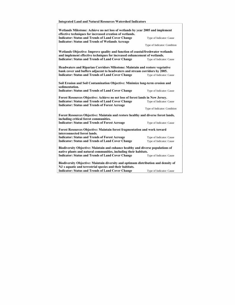
Integrated Land and Natural Resources Watershed Indicators
Wetlands Milestone: Achieve no net loss of wetlands by year 2005 and implementeffective techniques for increased creation of wetlands.Indicator: Status and Trends of Land Cover Change Type of Indicator: CauseIndicator: Status and Trends of Wetlands Acreage
Type of Indicator: Condition
Wetlands Objective: Improve quality and function of coastal/freshwater wetlandsand implement effective techniques for increased enhancement of wetlands.Indicator: Status and Trends of Land Cover Change Type of Indicator: Cause
Headwaters and Riparian Corridors Milestone: Maintain and restore vegetativebank cover and buffers adjacent to headwaters and stream corridors by 2005.Indicator: Status and Trends of Land Cover Change Type of Indicator: Cause
Soil Erosion and Soil Contamination Objective: Minimize long-term erosion andsedimentation.Indicator: Status and Trends of Land Cover Change Type of Indicator: Cause
Forest Resources Objective: Achieve no net loss of forest lands in New Jersey.Indicator: Status and Trends of Land Cover Change Type of Indicator: CauseIndicator: Status and Trends of Forest Acreage
Type of Indicator: Condition
Forest Resources Objective: Maintain and restore healthy and diverse forest lands,including critical forest communities.Indicator: Status and Trends of Forest Acreage Type of Indicator: Cause
Forest Resources Objective: Maintain forest fragmentation and work towardinterconnected forest lands.Indicator: Status and Trends of Forest Acreage Type of Indicator: CauseIndicator: Status and Trends of Land Cover Change Type of Indicator: Cause
Biodiversity Objective: Maintain and enhance healthy and diverse populations ofnative plants and natural communities, including their habitats.Indicator: Status and Trends of Land Cover Change Type of Indicator: Cause
Biodiversity Objective: Maintain diversity and optimum distribution and density ofNJ’s aquatic and terrestrial species and their habitats.Indicator: Status and Trends of Land Cover Change Type of Indicator: Cause

Error! Not a valid link.1986 Wetlands in WMA6 1995 Wetlands inWMA6
WMA6 Wetlands Net Change (Loss) 1986-1995
Table 2: Wetlands Conversion 1986-19951986 Wetlands Changed To Acres PercentAgricultural Land 10 1.15%Barren Land 30 3.49%Forest Land <1 0.04%Urban/Built-Up Land 770 89.71%Water 48 5.62%
Wetlands Acres that Changed LU/LC Type 8591995 Wetlands not Present in 1986 (Gain) 42

Net Loss of Wetlands 1986-1995 817
1986 Forested Land in WMA6 1995 Forested Land in WMA6
WMA6 Forested Land Net Change (Loss) 1986-1995
Table 3. Forested Land* Conversion 1986-19951986 Forested Land Changed To Acres PercentAgricultural Land 94 1.42%Barren Land 826 12.45%Urban/Built-Up Land 5690 85.74%Water 18 0.28%Wetlands 7 0.11%
Forest Acres that Changed LU/LC Type 66351995 Forest not Present in 1986 (Gain) 574Net Loss of Forest 1986-1995 6061

* Forested Land does not include Forested Wetlands
1986 Forested Land & Forested 1995 Forested Land & ForestedWetlands in WMA6 Wetlands in WMA6
WMA6 Forested Land & Forested Wetlands Net Change (Loss) 1986-1995
Table 4. Total Forested Land Conversion:1986 Forested Land and Forested Wetlands Changed To Acres Percent
Agricultural Land 95 1.22%Barren Land 844 10.91%
Urban/Built-Up Land 6292 81.33%
Water 56 0.72%
Other Wetlands 450 5.81%
Total 1986 Forest & Forested Wetlands that Changed LU/LC Type 77371995 Forest & Forested Wetlands not Present in 1986 (Gain) 574Net Loss of Forest and Forested Wetlands 1986-1995 7163

1986 Agricultural Land in WMA6 1995 Agricultural Land in WMA6
WMA6 Agricultural Land Net Change (Loss) 1986-1995
Table 5. Agricultural Land Conversion1986 Agricultural Land Changed To Acres PercentBarren Land 162 10.94%Forested Land 250 16.85%Urban/Built-Up Land 1060 71.51%Water 3 0.19%Wetlands 8 0.51%
Agricultural Acres that Changed LU/LC Type 14831995 Agricultural Land not Present in 1986 (Gain) 131Net Loss of Agricultural Land 1986-1995 1352

1986 Urban/Built Up Land in WMA6 1995 Urban/Built Up Land in WMA6
WMA6 Urban/Built Up Land Net Change (Gain) 1986-1995

Data Description
From 1986-1995, the following changes to the Upper Passaic-Whippany-RockawayWatershed Management Area (WMA6) occurred:
Overall Watershed Change
With respect to the approximately 236,222 acres in WMA6:
• Approximately 7% of the land changed land use/land cover type.
• The greatest net increase in land type with respect to total WMA6 acreage is inurban/built-up land; approximately 3.3% greater overall WMA6 acreage in 1995 than1986.
• The greatest net loss in land type with respect to total WMA6 acreage is in forestedland; approximately 2.6% less overall WMA6 acreage in 1995 than 1986.
When comparing acreages within cover type between 1986 and 1995:
• Barren land increased by 27% above its 1986 acreage.
• Urban/Built-up land increased by 8% above its 1986 acreage.
• Agricultural land decreased by 22% below its 1986 acreage.
• Forested land decreased by 7% below its 1986 acreage.
• Wetlands decreased by approximately 2% below their 1986 acreage.
Wetlands Change
• There is a net loss of wetlands in WMA6 during this nine-year period; approximately2% loss from the 1986 acreage.
• Approximately 64% of gains in wetland acreage were in the category of disturbedwetlands.
• Approximately 90% of wetlands that were changed from 1986-1995 were convertedto urban/built-up land.
• Approximately 3.5% of wetlands that were changed from 1986-1995 were convertedto barren land.

• Proportionally, wetlands account for approximately 17% of the total WMA6 acreagein both 1986 and 1995; there is a 2% net loss of wetlands between 1986 and 1995indicating potential impacts to habitat, biodiversity, and water quality.
Forested Land Change
• There is 7% less forest in 1995 than in 1986 in WMA6.
• Approximately 86% of forested lands that were changed from 1986-1995 wereconverted to urban/built-up land.
• Approximately 12.5% of forested lands that were changed from 1986-1995 wereconverted to barren land.
• Approximately 1.4% of forested lands that were changed from 1986-1995 wereconverted to agricultural land.
• Proportionally, forested land accounted for approximately 36% of the total WMA6acreage in 1986 and 33% of the total WMA6 acreage in 1995; there is a 7% net lossof forested land between 1986 and 1995, indicating potential impacts to forestresources including loss of forest health, forest biodiversity, and fragmentation; aswell as potential impacts to water quality.
Forested Lands and Forested Wetland Change
• When combining forested lands and forested wetlands, 6.09% of total forested landsand forested wetlands were changed to other land type categories (including othertypes of wetlands).
• Approximately 81% of forested lands and forested wetlands that were changed from1986-1995 were converted to urban/built-up land.
• Approximately 11% of forested lands and forested wetlands that were changed from1986-1995 were converted to barren land.
• Approximately 5.8% of forested land and forested wetlands that were changed from1986-1995, were converted to other wetlands types: approximately 83% of theseother wetlands were disturbed wetlands.
• Approximately 1.2% of forested lands and forested wetlands that were changed from1986-1995 were converted to agricultural land.

Agricultural Land Change
• Approximately 22% of the agricultural land present in 1986 was lost by 1995 inWMA6.
• Approximately 72% of the agricultural lands that were changed from 1986-1995 wereconverted to urban/built-up land.
• Approximately 17% of the agricultural lands that were changed from 1986-1995 wereconverted to forested land.
• Approximately 11% of the agricultural lands that were changed from 1986-1995 wereconverted to barren land.
• Proportionally, agricultural land accounted for almost 2.6% of the total WMA6acreage in 1986 and 2% of the total WMA6 acreage in 1995, indicating a 22% netloss of agricultural land between 1986 and 1995. Agricultural land can provideimportant habitat for wildlife species, including open fields to provide raptors withaccess to prey resources. 72% of the lost agricultural land was converted tourban/built-up land and almost 11% was converted to barren land; the loss of habitatin this direction has implications for water quality as impervious surface cover hasmost likely increased. Conversely, almost 17% of the lost agricultural land wasconverted to forested land, presumably with an increase in biodiversity and wildlifehabitat. Assuming this increase in forested land will also result in reduced applicationof agricultural fertilizers and pesticides, this increase should result in water qualityimprovements.
Data Characteristics
NJDEP is currently updating the 1986 land use/land cover data layer using 1995/97digital imagery based upon aerial photography classified using a modified Andersonsystem. This classification system (Anderson, et al., 1976), modified in 1998 (NJDEP,1998), is a hierarchical land use and land cover classification system with primarycategories for: urban or built-up land; agricultural land; forest land; water-wetlands; andbarren land. The analyses presented here for WMA6 are based upon the first updatesrecently received by NJDEP. The updates are being completed on a watershed-by-watershed basis and will be made publicly available on the Internet upon internal NJDEPreview. These initial postings should be considered DRAFT FINAL because all edgematches between watersheds cannot be made until the entire state is completed in Fall2000.
The update to the 1986 data includes reducing the minimum polygon size from 2.5 to 1acre, adding additional categories for some land use types, and evaluating every polygonfor the amount of impervious cover.
The land use/land cover categories in this analysis are defined as follows:

Agricultural Land includes all land used primarily for food and fiber production andsome structures associated with this production. Cropland, pastureland, orchards,vineyards, nurseries and horticultural areas, and confined feeding operations are theprimary agricultural land subtypes included in this category.
Barren Land/Altered Land is characterized by thin soil, sand or rocks and lack ofvegetative cover in a non-urban setting. Vegetation, if present, is widely spaced. Barrenland such as beaches and rock faces are found in nature but also result from humandisturbance (these sites include mining operations, sand and gravel pits, quarries, opendumps, landfills). Barren land can also include sites cleared and/or prepared forconstruction and sites in the early phases of construction.
Forested Land includes any lands covered by woody vegetation other than wetlands.These lands are capable of producing timber and other wood products, and supportingmany kinds of outdoor recreation. Forested Land subtypes in this category include:deciduous; coniferous; mixed deciduous-coniferous; and brushland/shrubland which arepredominantly between 0 and 20 feet in height (including old fields covered primarily bygrasses and some shrubs). Forested lands in this category do not include forestedwetlands.
Urban/Built-Up Land includes land characterized by intensive land use where thelandscape has been altered by human activities. Although structures are usually present,this land type is not restricted to traditional urban areas. Primary urban/built-up landsubtypes include: residential; commercial and service; industrial; transportation,communication and utilities; industrial and commercial complexes; mixed urban or built-up; other urban or built-up (including cemeteries) and recreational lands (golf courses,zoos, marinas, picnic areas, etc.).
Water. All areas within New Jersey periodically covered by water (except for wetlands)include: streams and canals (river, creeks, canals and other linear water bodies that have aminimum width of 80 feet); natural lakes; artificial lakes and reservoirs; and bays andestuaries.
Wetlands are those areas inundated or saturated by surface or ground waters at afrequency and duration sufficient to support vegetation adapted for life in saturated soilconditions. Included in this category are naturally-vegetated swamps, marshes, bogs andsavannas which are normally associated with topographically low elevations but may belocated at any elevation where water perches over an aquiclude. Forested wetlands areincluded in this category, as opposed to the Forest Category. For this analysis, disturbedwetlands (agricultural wetlands, rights-of-way, landscaped areas, etc.) have also beenincluded.
The data presented within are available through NJDEP’s Bureau of GeographicInformation and Analysis and can be obtained by calling (609) 984-2243. Additional

information regarding these data sets and updates to the 1995 data availability can also befound at www.state.nj.us/dep/gis.
Data Strengths and Limitations
These data enable more than a baseline as to the status of land use/land cover in NewJersey; they are based upon aerial data from two points in time: 1986 and 1995.Photointerpretation has been conducted by the same organization (Aerial InformationSystems, Redlands, CA) using similar methods for both time periods, thereby reducingerror. NJDEP has made the 1986 data publicly available for several years, resulting inwidespread use. The 1995 data will be made publicly available as they are received withthe caveat that edge-matching between the watersheds will need to be completed beforethe data are no longer considered DRAFT. Ground-truthing has been conducted for bothdata layers. The 1995 data are being photointerpreted by two analysts and whenconcurrence on a polygon is not reached, the polygon is flagged for ground-truthing.Data are by polygon (2.5 acres minimum polygon size for 1986 and 1 acre for 1995) andcan be clipped multiple ways depending upon needs of the analyst (by municipality,watershed, county, etc.). All polygons are being evaluated for impervious surface coverat 5% intervals. All polygons retain all 1986 codes as well as 1995 codes which allowsfor ready trend analysis from one data set. All data are fully documented and describedin the digital metadata information according to national metadata standards.
Limitations include the fact that approximately 2/3 of the digital imagery is from thesame flying season (March 1995). The remaining imagery is from 1997. While based onactual pre-compilations test delineations, impervious surface cover values included in thefinal layers are from visual estimates. 1986 data do not include impervious surface cover,therefore, quantitative trends from the two time periods cannot be made. Broad statewideindicators necessitated the use of the 6 major land use/land cover categories. The landuse/land cover data, however, are available and detailed to a much higher specificity ofcover type than presented here. For example, forest cover categories are further brokendown based on amount of tree type (coniferous, deciduous, or mixed classes and amountof crown closure). Therefore, more refined indicators could be developed.
Although these data are appropriate for general trend information; it is critical to read andunderstand the associated metadata, particularly because the categories do not necessarilycompletely reflect environmental quality. For instance, in this broad analysis, waterincludes surface impoundments and agricultural ponds.
Disturbed wetlands are classified as wetlands in this analysis. Hence, when analyzing forwetlands quality and function, as opposed to quantity, it would be important tounderstand that disturbed wetlands would not be of the same quality as naturallyoccurring wetlands.
Forested wetlands are classified as wetlands, not forests, in this classification scheme.Therefore, an effort was made to add forests and forested wetlands to gain a better pictureof total forested lands in WMA6. Since a small amount of acreage (0.271 acres) that was

classified as wooded wetlands in 1986 changed to old field forest by 1995, the combineddata sets of forests and forested wetlands do not register this as an increase in total forestacreage (i.e., Total Forest Gain in Table 4 is 0.271 acres less than Forest Gain in Table 5).
The 1995 data are to be considered DRAFT until all edge matching is complete.
Discussion
Although these data pertain to just one New Jersey watershed, a reasonable assumption isthat these data are indicators of statewide conditions. A key relationship in the WMA6data is that between Urban/Built-up land and Forested land. Urban/Built-up landaccounted for almost 41% of WMA6 acreage in 1986 and almost 44% in 1995, whileForested land accounted for almost 36% of the WMA6 acreage in 1986 andapproximately 33% in 1995. When comparing forested land conversion, much of theoverall forested land change in this watershed is an increase to urban land. Thisrelationship is consistent for wetlands and agricultural lands; i.e., the greatest changefrom these cover types was to urban/built-up land. This overall change in cover typesindicate anthropogenic stresses in relation to the current conditions of the various landand natural resources components of WMA6.
With respect to the current land and natural resources milestones and objectives for:wetlands; headwaters and riparian corridors; soil erosion and soil contamination; forestresources; and biodiversity, these land cover changes in relation to current conditionsindicate that for WMA6 (and possibly New Jersey as a whole):
• There is a net loss of wetlands and many of those wetlands that were gained weredisturbed; therefore, the objectives with respect to wetlands quantity and quality arenot being met.
• There are indirect indications that headwaters and riparian corridors could benegatively influenced by increases in urban and built-up lands and positivelyinfluenced by increases in forested lands that were previously agricultural lands.
• There are indirect indications that long-term erosion and sedimentation are negativelyinfluenced by increases in urban and built-up lands and positively influenced byincreases in forested lands that were previously agricultural lands.
• There is a net loss of forested lands with indirect indications that there is not overallmaintenance and restoration of forested lands or minimization of forestfragmentation.
• The loss of wetlands, forested lands, and agricultural lands may indicate loss ofbiodiversity including native plants, natural communities, and aquatic and terrestrialspecies in that region.

These data are based upon land use/land cover data and provide general trends on theland and natural resources in WMA6 and whether the broad statewide goals for these keyissue areas are being met.
Future Applications
These data are also important for generating hypotheses and refining the queries for keyissues based upon various levels of geographic scale; providing for more precise levels ofanalyses such that response measures can be targeted in a biologically meaningfulmanner. As statewide data become available, additional analyses will be performed forall watersheds so they can be applied to NEPPS statewide, as well as directed intoNJDEP’s watershed characterization and assessment process. As NJDEP becomes moreadept at relating sources and causes of environmental concern, management measures canbecome more targeted.
The analyses presented so far are preliminary and can be further refined based uponcurrent and pending data. Land cover change in relation to stream corridors (streams andassociated buffers), for example, would allow for better precision as to implications forriparian corridors, soil erosion and sedimentation, as well as water quality indicators.Further analyses would extend these relationships to the water quality data forsubwatersheds.
In the future, NJDEP will look at not only total forest acreage, but the relationshipbetween acreage and patch size to determine the amount of forest that is beingfragmented. Additionally, if critical areas are defined based upon goals for ecosystemtypes (wetlands, forests, grasslands), native plants and natural communities; and aquaticand terrestrial species; then analyses of not only the land quantity, but the land type inrelation to the species types can be made. Similarly, the relationship between ecosystemtype and management measures should be refined to determine if, for instance, landpreservation and acquisition is targeting the ecosystem types of concern.
Programs within NJDEP’s Division of Fish and Wildlife and Division of Parks andForestry are moving to defining critical areas as well as to determining if currentpreservation lands are meeting preservation goals. Therefore, refined analyses betweenecosystem types, such as wetlands and land preservation type, will provide betterindicators of whether response measures are targeted to meet land and natural resourcesgoals toward healthy ecosystems.
Linkages can be made between stressors, conditions, and the NJ State Development andRedevelopment Plan to determine if trends in development and redevelopment areconsistent with the milestones and objectives for healthy ecosystems defined through theNEPPS stakeholder process.
Relationship of land cover change and impervious surface cover data will also beconducted. Application of these data for both water quality and water supply will beimportant.

Another critical linkage may be in the relation between these data and air quality data;hypotheses generated could include the relationship between forest loss and changes inair quality and indications for climate change.
References
Anderson, J.R., E.E. Hardy, J.T. Roach, and R.E. Witmer, 1976. A Land Use and LandCover Classification System for Use with Remote Sensor Data, Washington D.C.: U.S.Department of the Interior, Geological Survey Professional Paper 964, 28 pages.
N.J. Department of Environmental Protection (NJDEP), 1998. Land Use Land CoverClassification System. Trenton, NJ, Office of Information Resource Management,Bureau of Geographic Information and Analysis, 36 pages.

Milestone: By the year 2008, the State’s rare, threatened andendangered species populations will be stable or have improved status.
Objective: Maintain diversity and optimum distribution and density ofNJ’s aquatic and terrestrial species and their habitats.
Objective: Reduce contaminant concentrations in biota to belowadverse effects thresholds.
Objective: Maintain and enhance aquatic life designated uses inassessed tidal waters.
Indicator: Status and Trends of Atlantic Coast Long-Legged WadingBird Populations
Type of Indicator: Condition
Populations of Atlantic Coast long-legged wading birds provide several biodiversityindicators including direct measures of coastal ecosystem biodiversity and indirectmeasures of contaminants in biota. Direct measures of rare species populations includethe Yellow-Crowned Night Heron (an Endangered Species in New Jersey) and the Black-Crowned Night Heron (a Threatened Species in New Jersey). Long-legged wading birdsalso provide an indicator of aquatic life designated use for tidal systems.
Long-term trends for the 19-year period (1977-1995) show that 5 out of 8 long-leggedwading birds species (including two rare species) along New Jersey’s Atlantic Coasthave had declining populations (Cattle Egret, Black-Crowned Night Heron, Yellow-Crowned Night Heron, Snowy Egret, and Glossy Ibis). During this same 19-year period,2 out of 8 species have had no real long-term trends (Little Blue Heron and Great Egret),while only 1 of 8 species (Tri-Colored Heron) has had a population increase.
More recent trends for the 10-year period (1985-1995) show Cattle Egrets are declining.While 4 out of the 8 species (Black-Crowned Night Heron, Yellow-Crowned Night Heron,Snowy Egret, and Tri-Colored Heron) do not show more recent trends of increasing ordecreasing populations, the Black-Crowned Night Heron failed to recover from a majorpopulation decline. These more recent data show that 3 out of 8 species of long-leggedwading birds (Glossy Ibis, Little Blue Heron, and Great Egret) had a modest populationincrease.
Black-Crowned Night Herons declined dramatically up until 1989 and have failed toshow any significant recovery. Yellow-Crowned Night Herons are at low numbers (<110 birds were reported for 5 of 7 observations in 19 years). More recent data areneeded to conclude if these rare coastal indicator species populations are stable.

New Jersey Atlantic Coast Long-Legged Wading Bird Populations, 1977-1995
1 0 0
1 5 0
2 0 0
2 5 0
3 0 0
3 5 0
4 0 0
1 9 7 7 1 9 7 8 1 9 7 9 1 9 8 3 1 9 8 5 1 9 8 9 1 9 9 5
Y e a r
# o
f B
ird
s
0
2 0
4 0
6 0
8 0
1 0 0
1 2 0
1 4 0
1 6 0
1 8 0
2 0 0
1 9 7 7 1 9 7 8 1 9 7 9 1 9 8 3 1 9 8 5 1 9 8 9 1 9 9 5
Year
# o
f B
ird
s
0
5 0
1 0 0
1 5 0
2 0 0
2 5 0
3 0 0
3 5 0
4 0 0
4 5 0
5 0 0
1 9 7 7 1 9 7 8 1 9 7 9 1 9 8 3 1 9 8 5 1 9 8 9 1 9 9 5
Y e a r
# o
f B
ird
s
1 0 0
3 0 0
5 0 0
7 0 0
9 0 0
1 1 0 0
1 3 0 0
1 5 0 0
1 7 0 0
1 9 7 7 1 9 7 8 1 9 7 9 1 9 8 3 1 9 8 5 1 9 8 9 1 9 9 5
Y e a r
# o
f B
ird
s
Cattle Egret
Yellow-CrownedNight Heron*
* NJ Endangered Species
Little Blue Heron
Black-CrownedNight Heron*
*NJ Threatened Species
0
5 0
1 0 0
1 5 0
2 0 0
2 5 0
3 0 0
1 9 7 7 1 9 7 8 1 9 7 9 1 9 8 3 1 9 8 5 1 9 8 9 1 9 9 5
Year
# o
f B
ird
s
5 0 0
1 0 0 0
1 5 0 0
2 0 0 0
2 5 0 0
3 0 0 0
3 5 0 0
4 0 0 0
4 5 0 0
1 9 7 7 1 9 7 8 1 9 7 9 1 9 8 3 1 9 8 5 1 9 8 9 1 9 9 5
Y e a r
# o
f B
ird
s
Tri-Colored Heron
Glossy Ibis
1 0 0 0
1 5 0 0
2 0 0 0
2 5 0 0
3 0 0 0
3 5 0 0
1 9 7 7 1 9 7 8 1 9 7 9 1 9 8 3 1 9 8 5 1 9 8 9 1 9 9 5
Year
# o
f B
ird
s
Snowy Egret
2 0 0
2 5 0
3 0 0
3 5 0
4 0 0
4 5 0
5 0 0
5 5 0
6 0 0
6 5 0
7 0 0
1 9 7 7 1 9 7 8 1 9 7 9 1 9 8 3 1 9 8 5 1 9 8 9 1 9 9 5
Year
# o
f B
ird
s
Great Egret

Data Description
Trends of colonial nesting waterbird populations provide several measures ofenvironmental quality: resource abundance and health; indirect indicators of organiccontaminants and heavy metal concentrations; and levels of human disturbance.The New Jersey Department of Environmental Protection, Division of Fish and Wildlifehas monitored the nesting populations of 14 colonial waterbird species through acombination of ground and aerial surveys for the past two decades.
Data for 8 species of long-legged wading birds (Cattle Egret, Black-Crowned NightHeron, Yellow-Crowned Night Heron, Snowy Egret, Glossy Ibis, Little Blue Heron, Tri-Colored Heron, and Great Egret) have been presented because they represent a feedingand nesting guild of colonial water birds in the Atlantic Coastal ecosystem
Data Characteristics
Concerns about declining species populations (from pesticide contamination and habitatloss) were the impetus for NJDEP’s Division of Fish and Wildlife beginning surveys ofcolonial nesting waterbirds in the late 1970s. Investigators searched salt-marsh andscrub-shrub habitats between the Garden State Parkway and the developed sections ofbarrier islands from a Bell Jet Ranger helicopter flying at altitudes ranging from 30 to100 meters above the ground.
After completion of the initial survey in 1977, the maps prepared during the survey wereused to help guide subsequent surveys. Each flight carried three observers who directedthe pilot, located colonies, counted birds, recorded data and mapped approximate colonyboundaries. Birds were counted by circling slowly or hovering near the colony. Alladults in the nesting colony were counted except those that were obviously not engagedin nesting (e.g., loafing on nearby shoreline). Aerial surveys were conducted in 1977,1978, 1979, 1983, 1985, 1989 and 1995. Because aerial surveys did not cover some areasof barrier islands, counts of Yellow-Crowned Night Herons nesting on barrier islandswere supplemented with ground counts.
The data presented herein are available through the Endangered and Nongame SpeciesProgram within the Division of Fish and Wildlife (609-292-9400).
Data Strengths and Limitations
Analysis and interpretation of survey data would clearly benefit from more frequentsurveys. The data presented here show that variability in counts between surveys is highfor many species. Ideally, surveys should be performed annually. Periodically repeatingall or a portion of the survey within years would help assess some of the sources ofvariability and aid in data interpretation. The primary factor determining when surveyshave been conducted in the past has been the availability of funding. Most of the surveysto date have been supported by federal funding (National Biological Survey – now USGS

Biological Resources Division, U.S. Fish and Wildlife Service, and National Oceanic andAtmospheric Administration).
Aerial surveys are limited to the Atlantic coastal area from Cape May to Point Pleasant.Although this represents the vast majority of long-legged wading bird colonies in thestate, important nesting areas are also known in the New York Harbor and DelawareEstuary, areas not included in the current analysis. In addition, unknown or undiscoveredcolonies probably also exist along the Southern Delaware Estuary, Navesink andShrewsbury Rivers, Hackensack Meadowlands, and other areas not covered by the aerialsurvey. Data from these areas would contribute considerably to our understanding ofstatewide populations, and are necessary for understanding more local trends.
Over the past decade Yellow-Crowned Night Herons have begun nesting in relativelyurban and suburban habitats in the Tidewater areas of Virginia (Watts 1989, 1991).Colonies often consist of 2-3 nests that are not associated with other herons. Over thepast five to ten years, similar nesting situations have been observed in developed areas ofthe Raritan estuary. As a result of their small size, isolation, and occasional location inurban or suburban habitats, Yellow-Crowned Night Herons nesting in locations such asdescribed above would probably not be detected on aerial surveys. Therefore count datapresented here may not adequately reflect current populations levels or trends.
To gain better understanding of the factors leading to population changes, moreinformation is also needed on nesting success and productivity for each species. Nestingstudies that assess nest and brood fate at selected sites would be extremely beneficial inthis regard. Long-term (>5 year) monitoring of nesting is necessary to characterize andquantify the factors influencing breeding outcome.
In addition to general demographic studies, applied studies designed to investigatespecific factors affecting breeding success and to evaluate specific managementalternatives are also needed. Such studies should broadly include evaluation of pesticideand contaminant loadings and effects; studies of the effects of human disturbance onbreeding and foraging, especially the effects of personal watercraft; studies evaluatingpredator control techniques; and studies of habitat use.
Discussion
Colonial nesting waterbirds represent prominent members of estuarine ecosystems. Theyare important predators, feeding near the top of the food chain on a wide variety of foragefish, and on marine invertebrates such as small crabs and mollusks. As relatively long-lived, high-level predators, colonial nesting waterbirds serve as valuable indicators ofenvironmental quality, including: resource abundance and health; levels of toxicsubstances such as organic contaminants and heavy metals; and levels of humandisturbance.
Estuarine ecosystems are, in turn, extremely important to colonial waterbirds. Estuarineopen water and wetland habitats supply the primary, and in some cases, the only feeding
habitats for most colonial waterbird species in the mid-Atlantic region. Estuarine areas,particularly islands, also provide critical nesting habitat.
Monitoring of colonial waterbird populations also provides important information forassessing impacts of coastal development projects that may affect waterbird habitat. Themapping of the nesting areas delineates the most current nesting colony boundaries
Consistent with New Jersey data, several sources suggest that Snowy Egrets and Black-Crowned Night Herons may be declining throughout the Eastern U.S. Analysis of trendsin Maryland, between 1985 and 1995, show a decrease in Snowy Egret numbers (Brinkeret al., 1996). Parsons' (1996) review of trends in colonial nesting long-legged wadingbirds from Delaware to Maine suggests a declining trend for both Snowy Egrets andBlack-Crowned Night Herons. Erwin (1995) cites similar evidence for Virginia andFlorida.
Maryland surveys also indicate declining Glossy Ibis numbers between 1985 and 1995.Although more recent New Jersey data show a modest increase in Glossy Ibis numbers,Erwin (1995) cautions that ibis species are particularly mobile and that populationmonitoring requires a coordinated regional approach.
Based on preliminary research in the Delaware Estuary and other estuaries in theNortheast, Parsons (1997) postulated that contemporary pesticides such asorganophosphates and carbamates may affect long-legged wading birds exposed throughconsumption of contaminated food. Depressed cholinesterase levels in birds exposed tothese pesticides may be leading to adverse behavioral changes that, in turn, could reducenesting success. Current information is insufficient to establish a clear link betweenbehavioral changes or nesting productivity and exposure to cholinesterase-inhibitingchemicals. Parsons' findings should, however, prompt further investigation into possiblelinks between modern pesticides and wading bird reproductive success. Given theirdocumented effects on avian reproduction, the possible role of more persistentenvironmental contaminants such as organochlorine compounds and heavy metals mustalso be considered when examining colonial waterbird population trends.
Although there is considerable variability among species in their sensitivity todisturbance, nesting success of all colonial waterbirds can be severely reduced by specifictypes and excessive levels of human activity. The burgeoning use of personal watercraft("Jet Skis") is a particular concern (Burger, 1998 and Carney and Sydeman, 1999).These watercraft allow access to very shallow and narrow waterways not accessible tolarger boats. This has lead to increased disturbance of previously isolated nestingcolonies and increased interference with feeding activities, especially of long-leggedwading birds.
Nesting sites for more sensitive species and especially for those containing endangered orthreatened species should be protected from human disturbance. All nesting sites forterns, skimmers, and long-legged wading birds that are susceptible to human disturbance

should be designated as "sanctuaries." The designation should include a buffer of at least50 meters surrounding the nesting site.
These areas should be off-limits to any type of human access, including watercraft duringthe nesting season (approximately April to July). While existing laws protectingendangered, threatened, and other nongame species prohibit "harassment" of these birds,in practice, enforcement is difficult because actual harassment and/or intent to harassmust usually be demonstrated. Regulations specifically prohibiting human access tonesting areas and important feeding areas could probably be developed under existingstatutes.
Given the near elimination of scrub-shrub and wooded habitats from New Jersey's barrierislands, dredged material islands have become a primary nesting habitat for long-leggedwading birds in New Jersey. Currently, creation of new nesting habitat from dredgedmaterial disposal occurs by chance, not by design. Typically, when the interval betweenuse of dredged material sites is long, natural succession leads to habitats that are suitablefor nesting by long-legged wading birds. Ironically, once waders colonize a site, futureuse of the site for disposal can be blocked by their presence.
A more proactive approach to dredged materials management through creation ofavailable nesting habitat would help reduce conflicts between dredging operations andhabitat protection. Given the shortage of suitable nesting sites, coupled with the shortageof acceptable disposal sites faced by state and federal agencies responsible for waterwaymaintenance, such an approach could help address both needs. Site design specificallygeared towards nesting habitat creation can improve habitat suitability and the intervalbetween disposal use and suitability for nesting can be shortened by planting ofappropriate woody vegetation.
References
Brinker, D. F., L. A. Byrne, P. J. Tango, and G. D. Therres. 1996. Populations trends ofcolonial nesting waterbirds on Maryland's coastal plain: final report. MarylandDepartment. of Natural Resources, Forest, Wildlife and Heritage Service, Wildlife andHeritage Division. Annapolis, MD.
Buckley, P. A. and F. G. Buckely. 1984. Seabirds of the north and middle Atlantic coastsof the United States: their status and conservation. In: J. P. Croxal G. H. Evans, and F-W. Schriever, (eds.). International Council for Bird Preservation Tech. Publ. 2.,Cambridge, England. pp. 101-134
Burger, J. 1998. Effects of Motorboats and Personal Watercraft on Flight Behavior Overa Colony of Common Terns, The Condor, 100, 528-534.
Carney, K. M., and W. Sydeman, 1999. A Review of Human Disturbance Effects onNesting Colonial Waterbirds, Waterbirds, 22, 68-79.

Dolbeer, R- A.. and J. L. Bucknall. 1997. Shooting gulls to reduce strikes with aircraft atJohn F. Kennedy International Airport, 1991-1996. Special Report for the Port Authorityof New York and New Jersey, John F. Kennedy Airport, U.S. Department of Agriculture- Animal Damage Control.
Dove, L/E., and R.M. Nyman, eds. 1995. Living Resources of the Delaware Estuary.The Delaware Estuary Program. 530 pp. & appendices.
Erwin, M.R. 1995. Colonial waterbirds. In: Our Living Resources.- A Report to theNation on the Distribution, Abundance, and Health of U.S. Plants, Animals, andEcosystems. U.S. Department of the Interior, National Biological Service, Washington,D.C. pp 53-57.
Flimlin, G.E., Jr., and M.J. Kennish, eds. 1996. Proceedings of the Barnegat BayEcosystem Workshop. USEPA, NJDEP, Ocean County, New Jersey, Rutgers University,Rutgers Cooperative Extension of Ocean County, Toms River, New Jersey 08755
Meskill, K. J. and L. A. Sommers. 1995. 1994 Long Island colonial waterbird and pipingplover survey. Research Rept. of NY Department of Environmental Conservation, StonyBrook, NY.
Parsons, K.C. 1997. Snowy egret (Egretta thula). In: A. Poole and F. Gill, (eds.). TheBirds of North America The Academy of Natural Sciences, Philadelphia, PA- and TheAmerican Ornithologists Union, Washington, D.C.
Parsons, K. C. 1996. Coastal populations of herons decline in the northeast U.S. 1996Colonial Waterbird Society annual meeting. 16-20 October 1996 Charleston, S.C.
Thomas, G. J. 1972. A review of gull damage and management methods at naturereserves. Biol. Conserv. 4:117-127.
Watts, B. D. 1989. Nest site characteristics of yellow-crowned night herons in Virginia.Condor 91: 970-983.
Watts, B. D. 199 1. Yellow-crowned night heron. In: K. Terwilliger, (ed.). Virginia'sEndangered Species. McDonald and Woodward, Blacksburg, VA, p. 493-496.

Milestone: Federal, State, and local programs will strive to preserve andprotect through fee simple acquisition or other means an additional300,000 acres of open space and farmland by the year 2002 and a totalof 1,000,000 acres of open space and farmland by 2010*.
Indicator: Acres of Permanently Protected Open Space
Type of Indicator: Condition
* Half of the acreage to be preserved will be open space and half will be farmland. The preservation offarmland is the responsibility of the NJ Department of Agriculture. Thus, the responsibility of NJDEP willbe to preserve 150,000 acres of open space by 2002 and 500,000 acres by 2010.
Acres of dedicated open space owned and managed by the Federal, Interstate, State,County, and Municipal governments, as well as open space acquired by Not-For-Profitsorganizations using state funding have steadily increased since 1966 with an estimated936,231 acres (or 19% of NJ land) preserved as of 1999.
0
200,000
400,000
600,000
800,000
1,000,000
1,200,000
1,400,000
Cu
mu
lati
ve A
cres
1966 1970 1976 1982 1988 1993 1996 1997 1998 1999 2002Goal
2010Goal
Year
New Jersey's Permanently Preserved Open Space
Acreage Open Space (not including farmland)
4-Y
ear
Go
al;
1,00
4,00
0
10-Y
ear
Go
al;
1,35
4,00
0

Data Description
By the end of 1999, New Jersey had an estimated 936,231 acres of permanently protectedopen space, including lands managed by federal, state and local governments, interstateagencies and nonprofit organizations. Based upon the estimated 4,984,338 acres of landin New Jersey, 19% of NJ lands are permanently preserved. The Governor’s Council onNew Jersey Outdoors found that New Jersey required an additional one million acres(half of which would be farmland protected through Department of Agricultural program)of public open space and recreation areas to meet present and future needs. (See InterimReport of Governor’s Council on New Jersey Outdoors, May 1997). Subsequently, in hersecond inaugural address, Governor Whitman launched an initiative with the goal ofpreserving one million additional acres of open space (to the 854,000 acres that hadalready been preserved as of the May 1997 report date) by 2010 with the first 300,000acres (half of which would be farmland protected through Department of Agriculturalprogram) to be preserved by 2002. These data show that New Jersey is making progresstoward meeting both the 2002 and 2010 goals of open space preservation. NJDEP ismore than half-way toward meeting its four-year goal of preserving an additional 150,000acres of open space.
Preservation of open space is critical for current and future protection of naturalresources, biological diversity and recreation. NJDEP manages 67% of all public landpreserved in New Jersey. The Division of Parks and Forestry is steward for 53 parks,forest and recreational areas; 57 historic sites and districts; 42 natural areas; marinas; andother facilities encompassing 342,894 acres. The Division of Fish and Wildlife manages107 Wildlife Management Areas, totaling 254,432 acres. Counties and municipalitiesmanage 17% of open space, the federal government manages 12%, and nonprofitorganizations hold about 4% of all preserved lands. Nationally, New Jersey ranks first forland preserved by the State as a percent of the land area of the state; however, other states(particularly Western states) have a larger percentage of conservation and recreationlands managed by the federal government.
The data provided herein are from NJDEP’s Green Acres Program and are available bycalling (609) 984-0500.
Data Characteristics
The NJDEP Green Acres Program maintains the open space acreage data in twodatabases, one for the state lands acquisition program and another for the local landsacquisition program. Acreage in the state acquisition program is recorded and counted asthe projects close and deeds are filed. Acreage in the local acquisition program(including grants to non-profits) is recorded and counted initially when the appropriationbill is signed and grants/loans approved. If changes to acreage purchased by the localgovernment or non-profit agency are realized, they are recorded as they are received.

Data Strengths and Limitations
The strengths are that data are taken directly from the project files and reflect actualacreage.
One of the key limitations to the data is that they do not include farmland protected underthe New Jersey Department of Agriculture’s Farmland Preservation Program. Anotherlimit is that the actual amount of preserved open space may be underreported, as datafrom nonprofit lands, such as donated lands, are not recorded.
Discussion
The trend toward increasing open space preservation demonstrates that NJ is movingtoward its short-term goal of an additional 300,000 acres of open space preserved by2002 and an additional 1,000,000 acres by 2010. In 1998, New Jersey voters approved aconstitutional dedication of $98 million of annual funds for ten years and over $1 billionin bond financing to support open space preservation. Passage of the Garden StatePreservation Trust Act in June 1999, established this stable source of funding. Fundingfor open space, farmland, and historic preservation became available in Fiscal Year 2000and will continue through Fiscal Year 2009. Given the lag time between appropriation offunds and actual closings, acquisitions and easement purchases are not expected to befinalized until 2010.

Milestone: Federal, State, and local programs will strive to preserve andprotect through fee simple acquisition or other means an additional300,000 acres of open space and farmland by the year 2002 and a totalof 1,000,000 acres of open space and farmland by 2010.
Indicator: Number of Counties and Municipalities with Open SpaceTaxes
Type of Indicator: Response
The number of New Jersey counties and municipalities with open space taxes hascontinued to increase steadily over the past five years with a total of 17 counties (81% ofNew Jersey’s 21 counties) and 118 municipalities (21% of NJ’s 566 municipalities)providing funds for open space preservation, as of 1999.
0
20
40
60
80
100
120
(n)
Number of NJ Counties and Municipalities With Open Space Taxes
Counties with Open Space Taxes Municipalities with Open Space Taxes
19961995 1997 1998 1999
Data Description
In the last five years, the number of counties and municipalities with open space taxes hasincreased steadily from 8 counties and 13 municipalities in 1995 to 17 counties and 118

municipalities in 1999. As of 12/31/97, local governments (county and municipal) havereported spending $24.8 million to preserve 26,335 acres of open space and farmlandstatewide. These are local governments that are either assessing a tax, bonding for openspace, or have a specific budget appropriation for open space.
Local governments have come to realize that open space preservation should be anintegral component of community planning. Open space preservation enhances thequality of life within a community, protects natural resources, provides opportunity foroutdoor recreation and helps communities to avoid the excessive service costs associatedwith poorly planned sprawl development. By preserving open space, communities helpto channel development to appropriate areas, thereby fostering economic growth that iscompatible with community character. Similar to other important investmentscommunities make to provide public infrastructure, such as roads and schools, it alsomakes sense to insure that fiscal resources are set aside for preservation of open space.Local governments have turned to dedicated open space taxes as a way to fund their landpreservation programs.
Data Characteristics
Open space tax data are collected annually by NJDEP’s Green Acres Program via amailed survey to local governments with open space taxes. The above data regarding theamount of local government spending and related acreage preserved were developedthrough a 1997 Green Acres Program survey of 46 New Jersey local governments(counties and municipalities) which assessed an open space tax or had an open spacefunding program in 1997. Additional data on open space taxes are collected from avariety of sources: newspapers; local contacts; and through the individual county clerk'soffices who are responsible for ballot questions.
All data provided herein are from NJDEP’s Green Acres Program and are available bycalling (609) 984-0500. The results of the Green Acres survey noted above are publishedin Local Government Open Space Funding Programs in New Jersey, NJDEP GreenAcres Program, October 1998.
Data Strengths and Limitations
Local government spending and related acreage preserved was based upon the 1997Green Acres survey of counties and municipalities as described above. These values areprobably underreported for several reasons. At the time of the survey, 11 counties and 34municipalities collected open space taxes; however, 1 county and 15 municipalities didnot respond to the survey. In addition, the number of counties and municipalitiesimplementing open space taxes for preservation purposes has increased by 6 and 84,respectively, since the survey was first conducted in 1997.
Starting in 1999, all open space tax data will be collected by the Department ofCommunity Affair’s Division of Local Government Services. One of the data strengths

for this information is that reporting to the Department of Community Affairs is requiredby law and the data is prepared by local finance officials.
Discussion
In 1989, the New Jersey legislature enacted PL. 1989 Chapter 30 that empoweredcounties to assess a tax approved by public referendum for open space preservation. Formunicipalities, N.J.S.A. 19:37-1 et seq. authorizes New Jersey municipalities to submit areferendum to the voters in order to ascertain voter sentiment on policy pertaining to thegovernance of the municipality. These laws allowed local governments to establish asource of open space funding that was approved by public referendum and would providea consistent revenue stream for open space preservation. Local governments were able todesign their tax to fit their individual open space needs. Some focused on landpreservation for recreation and conservation purposes, some targeted farmland, and somedid both . The referendums also provided for not only fee simple acquisition but alsoeasement and development rights purchases. In 1997, P.L.1997 Chapter 24 repealed andconsolidated previous open space tax legislation and broadened the use of open space taxfunds to include park development and maintenance and historic preservation, and manylocal governments have included these elements in their open space programs.
In order to provide continued support to local governments for their progressive openspace policies, the Green Acres Program initiated a funding category for land acquisition,the Planning Incentive. Under the Planning Incentive, local governments that have andare collecting and expending an open space tax, or alternative funding mechanismequivalent to a tax, and have also adopted an Open Space and Recreation Plan are eligibleto receive funding in the form of a 50% grant and 50% loan to acquire land for recreationand conservation purposes.
The advantage of the Planning Incentive funding over the other Green Trust applicationprocess is that a local government can use its Open Space and Recreation Plan as itsapplication and receive funding for the acquisition of properties identified in the plan.Once Green Acres has approved a local government’s Open Space and Recreation Plan,the local government can acquire sites without separate applications for each property,which results in a significant time and cost savings.