lakhwar hydroelectric project - ministry of environment and forests
TRANSCRIPT

CISMHE
CENTRE FOR INTER-DISCIPLINARY STUDIES OF MOUNTAIN & HILL ENVIRONMENT
University of Delhi, Delhi
Environmental Management Plan for Environmental Management Plan for 1750 MW Demwe Lower HE Project, Arunachal Pradesh 1750 MW Demwe Lower HE Project, Arunachal Pradesh
Prepared for:
Athena Demwe Power Private Limited, New Delhi
JULY, 2009

DEMWE LOWER HE PRJECT (1750 MW) CISMHE
CONTENTS
Page No. CHAPTER 1 BIODIVERSITY CONSERVATION & WILDLIFE MANAGEMENT 1.1 INTRODUCTION 1-1 1.2 CONSERVATION STATUS AND MAJOR THREATS 1-3 1.3 BIODIVERSITY CONSERVATION PLAN 1-7 1.4 WILDLIFE MANAGEMENT PLAN 1-18 1.5 BIODIVERSITY MANAGEMENT COMMITTEE (BMC) 1-21 1.6 COST ESTIMATES 1-22 CHAPTER 2 CATCHMENT AREA TREATMENT PLAN
2.1 INTRODUCTION 2-1 2.2 APPROACH FOR STUDY 2-2 2.3 ESTIMATION OF SOIL LOSS USING SILT YIELD INDEX
METHOD 2-14 2.4 WATERSHED MANAGEMENT – AVAILABLE TECHNIQUES 2-17 2.5 CATCHMENT AREA TREATMENT (CAT) PLAN 2-19 2.6 COST ESTIMATE 2-25
CHAPTER 3 FISHERIES DEVELOPMENT PLAN 3.1 INTRODUCTION 3-1 3.2 FISH COMPOSITION AND STATUS IN LOHIT RIVER 3-2 3.3 LIKELY IMPACTS ON FISH FAUNA 3-2 3.4 FISHERY DEVELOPMENT 3-3 3.5 BUDGET 3-5 CHAPTER 4 PUBLIC HEALTH DELIVERY SYSTEM 4.1 INTRODUCTION 4-1 4.2 PROMINENT DISEASES AND MEDICAL FACILITIES AVAILABLE 4-1 4.3 LIKELY IMPACTS ON HEALTH 4-5 4.4 PROPOSED MEDICAL FACILITIES 4-7
4.5 VETERINARY HOSPITAL 4-9 4.6 IMPROVEMENT OF EXISTING FACILITIES 4-9 4.7 FIRST-AID FACILITIES 4-10 4.8 BUDGET 4-10
Environment Management Plan-Contents i

DEMWE LOWER HE PRJECT (1750 MW) CISMHE
CHAPTER 5 SOLID WASTE MANAGEMENT
5.1 INTRODUCTION 5-1 5.2 COMPOSITION OF MUNICIPAL SOLID WASTES 5-2 5.3 ENVIRONMENTAL AND HEALTH IMPACTS DUE TO IMPROPER 5-3
SOLID WASTE MANAGEMENT 5.4 MUNICIPAL SOLID WASTE MANAGEMENT 5-4 5.5 SANITATION FACILITIES 5-7 5.6 MANAGEMENT OF WASTES FROM CONSTRUCTION
ACTIVITIES 5-8 5.7 MANAGEMENT OF HAZARDOUS WASTES FROM HOSPITALS 5-9 5.8 OTHER MEASURES 5-9 5.9 COST ESTIMATE 5-10
CHAPTER 6 PROVISION FOR FUEL AND ENERGY CONSERVATION MEASURES
6.1 INTRODUCTION 6-1 6.2 NEED FOR THE FUEL AND ENERGY CONSERVATION 6-3 MEASURES 6.3 SUGGESTED MEASURES 6-3
CHAPTER 7 DISPOSAL AND REHABILITATION OF MUCK 7.1 INTRODUCTION 7-1 7.2 MUCK SOURCE AND VOLUME 7-1 7.3 SELECTION OF DUMPING SITES 7-2 7.4 MUCK REHABILITATION PLAN 7-4 7.4.1 Engineering Measures 7-4 7.4.2 Biological Measures 7-5 7.4.3 Utilisation of Dumping Site 7-8 7.5 BUDGETARY PROVISIONS 7-9 CHAPTER 8 RESTORATION OF CONSTRUCTION AREAS AND LANDSCAPING 8.1 INTRODUCTION 8-1 8.2 DISTURBED SITES AND THEIR RESTORATION 8-1
Environment Management Plan-Contents ii
DEMWE LOWER HE PRJECT (1750 MW) CISMHE
8.3 QUARRY SITE 8-2 8.4 RESTORATION OF QUARRY SITES 8-2 8.5 ENGINEERING AND BIO-ENGINEERING MEASURES 8-2 8.6 COLONY AND OFFICE COMPLEX 8-4 8.7 RESTORATION OF COLONY AND OFFICE COMPLEXES 8-4 8.8 ROADS AND BRIDGES 8-6 8.9 COST ESTIMATES 8-9 CHAPTER 9 CREATION OF GREEN BELT AROUND THE RESERVOIR 9.1 INTRODUCTION 9-1 9.2 OBJECTIVES 9-1 9.3 SCHEDULE 9-4 9.4 BUDGET 9-5 CHAPTER 10 REHABILITATION & RESETTLEMENT PLAN 10.1 INTRODUCTION 10-1 10.2 OBJECTIVES OF THE RESETTLEMENT AND REHABILITATION 10-5 PLAN 10.3 APPROACH 10-7 10.4 LAND REQUIREMENT AND COMPENSATION 10-11 10.5 PROVISIONS MADE FOR SOCIO-ECONOMIC UPLIFTMENT 10-21 10.6 LOCAL AREA DEVELOPMENT PROGRAMME 10-27 10.7 ENVISAGED BENEFITS 10-32 10.8 PROPOSED FINANCIAL OUTLAY FOR LOCAL AREA 10-34 DEVELOPMENT PLAN 10.9 EVALUATION AND MONITORING 10-45 10.10 FINANCIAL PACKAGE FOR R & R PLAN 10-46 CHAPTER 11 DISASTER MANAGEMENT PLAN 11.1 INTRODUCTION 11-1 11.2 SEISMIC CONCERNS AND DISASTER MANAGEMENT 11-2 11.3 DAM BREAK STUDY 11-3 11.4 DISASTER MANAGEMENT PLAN 11-41 11.5 COST ESTIMATES 11-49 CHAPTER 12 COMPENSATORY AFFORESTATION SCHEME
Environment Management Plan-Contents iii

DEMWE LOWER HE PRJECT (1750 MW)
Environment Management Plan-Contents iv
CISMHE
12.1 INTRODUCTION 12-1 12.2 EXISTING FOREST AND IMPACTS DUE TO PROPOSED 12-1 PROJECT 12.3 COMPENSATORY AFFORESTATION SCHEME
12-2 12.4 SITES FOR COMPENSATORY AFFORESTATION 12-2 12.5 METHODOLOGY AND COMPONENTS 12-3 12.6 INSTITUTIONAL MECHANISMS 12-5
CHAPTER 13 RESERVOIR RIM TREATMENT PLAN
13.1 INTRODUCTION 13-1 13.2 RIVER BASIN CHARACTERISTICS 13-1 13.3 GEOLOGY OF THE RESERVOIR AREA 13-2 13.4 RESERVOIR STABILITY ANALYSIS 13-3 13.5 LANDSLIDE INVENTORY MAPPING 13-4 13.6 COST ESTIMATE 13-13
CHAPTER 14 CONSTRUCTION METHODOLOGY & EQUIPMENT PLANNING
14.1 INTRODUCTION 14-1 14.2 TRANSPORTATION OF MEN, MATERIAL AND EQUIPMENT 14-1 14.3 CONSTRUCTION POWER 14-2 14.4 TELECOMMUNICATION 14-4 14.5 CONSTRUCTION METHODOLOGY 14-4 14.6 CONSTRUCTION MAMATERIAL 14-11
CHAPTER 15 ENVIRONMENTAL MONITORING PROGRAMME
15.1 INTRODUCTION 15-1 15.2 AREAS OF CONCERN 15-1 15.3 TOTAL BUDGET FOR ENVIRONMENTAL MONITORING PROGRAMME 15-6
CHAPTER 16 COST ESTIMATES 16.1 COST FOR IMPLEMENTING ENVIRONMENTAL 16-1
MANAGEMENT PLAN

DEMWE LOWER HE PRJECT (1750 MW) CISMHE
TABLES
TABLE CONTENT
1.1 : SUMMARY TABLE OF PLANTS BELONGING TO DIFFERENT GROUPS RECORDED DURING THE VEGETATION SURVEY
1.2 : CONSERVATION STATUSES OF THE FLORA SPECIES IN THE DEMWE LOWER HYDROELECTRIC PROJECT
1.3 : CONSERVATION STATUS OF THE FAUNAL SPECIES IN THE STUDY AREA, INFLUENCE ZONE AND CATCHMENT AREA OF DEMWE LOWER HYDROELECTRIC PROJECT
1.4 : COST ESTIMATES FOR ESTABLISHMENT OF GARDENS FOR VOUCHER SPECIMEN
1.5 : COST ESTIMATES FOR ESTABLISHMENT OF BUTTERFLIES GARDENS
1.6 : COST ESTIMATES FOR FOREST PROTECTION PLAN
1.7 : COST ESTIMATES FOR WILDLIFE MANAGEMENT PLAN FOR DEMWE LOWER H.E. PROJECT
1.8 : THE ESTIMATED COST OF BIODIVERSITY CONSERVATION AND MANAGEMENT PLAN
2.1 : LAND USE CLASSIFICATION FOR FREE DRAINING CATCHMENT AT DIVERSION SITE
2.2 : AREAS FALLING UNDER DIFFERENT SLOPE CATEGORIES
2.3 : SOIL LOSS RANGES FOR THE RIVER CATCHMENT
2.4 : CRITERIA FOR EROSION INTENSITY RATE
2.5 : BASIS FOR SELECTION OF CATCHMENT AREA TREATMENT MEASURES
2.6 : EROSION INTENSITY CATEGORIZATION AS PER SYI CLASSIFICATION
2.7 : EROSION INTENSITY RATES OF CATCHMENT AREA
2.8 : SUB-WATERSHED WISE PROPOSED TREATMENT MEASURES
2.9 : COST ESTIMATE FOR CATCHMENT AREA TREATMENT OF LOWER DEMWE HEP
Environment Management Plan-Tables i

DEMWE LOWER HE PRJECT (1750 MW) CISMHE
TABLE CONTENT
2.10 : YEAR WISE TARGET (PHYSICAL AND FINANCIAL) FOR CATCHMENT AREA TREATMENT PLAN
3.1 : YEAR-WISE BREAK UP OF COST ESTIMATES FOR FISHERIES DEVELOPMENT IN PROPOSED DEMWE LOWER H.E. PROJECT
4.1 : MAJOR DISEASES PREVALENT IN ARUNACHAL PRADESH
4.2 : MEDICAL FACILITIES IN LOHIT DISTRICT AND ITS TWO CIRCLES TEZU AND WAKRO AS WELL AS IN ANJAW DISTRICT
4.3 : HEALTH ISSUES ASSOCIATED WITH HYDRO POWER PROJECTS
4.4 : PROPOSED MEDICAL FACILITIES IN DEMWE LOWER H.E. PROJECT AREA
4.5 : LIVESTOCK IN TEZU AND WAKRO CIRCLES
4.6 : INFRASTRUCTURE FOR ANIMAL HUSBANDRY
4.7 : ESTIMATED COST FOR SETTING UP OF MEDICAL FACILITIES
5.1 : EXPECTED TYPICAL COMPOSITION OF WASTE IN PROPOSED DEMWE LOWER HYDROELECTRIC PROJECT.
5.2 : TYPICAL COMPOSITION OF MUNICIPAL SOLID WASTES EXPECTED IN DEMWE LOWER HEP.
5.3 : CHEMICAL COMPONENTS OF MUNICIPAL SOLID WASTES EXPECTED IN DEMWE LOWER HEP.
5.4 : PERIODIC WORKFORCE REQUIREMENT DURING THE CONSTRUCTION OF THE PROPOSED DEMWE LOWER H.E. PROJECT
5.5 : TOTAL MIGRANT POPULATION EXPECTED IN THE DEMWE LOWER H.E. PROJECT
5.6 : ESTIMATED COST FOR THE SOLID WASTE MANAGEMENT IN THE DEMWE LOWER H.E. PROJECT
6.1 : ESTABLISHMENT OF NEW LPG DEPOTS AND COMMUNITY KITCHENS IN THE PROJECT AREA
6.2 : FINANCIAL PROVISION FOR ENERGY CONSERVATION MEASURES IN THE PROJECT AREA
7.1 : STATUS OF MUCK GENERATION IN DEMWE LOWER H.E. PROJECT
7.2 : DIMENSIONS OF MUCK DISPOSAL SITES
7.3 : PLANT SPECIES RECOMMENDED FOR PLANTATION IN THE
Environment Management Plan-Tables ii

DEMWE LOWER HE PRJECT (1750 MW) CISMHE
TABLE CONTENT
DUMPING SITES
7.4 : COST ESTIMATE FOR DIFFERENT MEASURES AT THE DUMPING
8.1 : AREA AND LOCATION OF THE QUARRY SITE PROPOSED IN THE DEMWE LOWER H.E. PROJECT
8.2 : AREA AND LOCATION OF COLONIES, OFFICE COMPLEXES, JOB SITE AND OTHER SITES IN THE PROPOSED DEMWE LOWER H.E. PROJECT
8.3 : ROADS AND BRIDGES IN THE PROPOSED PROJECT AREA OF DEMWE LOWER HE PROJECT
8.4 : SOME IMPORTANT PLANT SPECIES FOR PLANTATION IN THE COLONY AREA, QUARRY SITES AND ALONG THE ROAD SIDES
8.5 : COST ESTIMATES FOR RESTORATION WORKS AND LANDSCAPE DESIGNING
9.1 : LAND USE/LAND COVER OF DIFFERENT GREEN BELT LAYERS
9.2 : PLANTATION LAYOUT FOR THE GREEN BELT
9.3 : PHYSICAL AND FINANCIAL BREAK UP FOR THE CREATION AND MAINTENANCE OF GREEN BELT AROUND THE RESERVOIR OF DEMWE LOWER HE PROJECT
10.1 : COMPARATIVE STATEMENT INDICATING R&R PACKAGE AND LADP ADOPTED IN FORMULATING THE PROPOSAL VIS-À-VIS PROVISIONS OF NPRR, 2007, ARUNACHAL POLICY, 2008 AND DRAFT TRIBAL POLICY, 2009.
10.2 : ABSTRACT OF LAND REQUIREMENT FOR DEMWE LOWER HEP (PROPERTY SURVEY, 2008).
10.3 : COMPENSATION FOR LAND ACQUISITION IN DEMWE LOWER HEP
10.4 : COMPENSATION FOR STANDING TREES ON THE LAND TO BE ACQUIRED IN DEMWE LOWER HEP (PROPERTY SURVEY, 2008)
10.5 : R&R PACKAGE FOR THE PROJECT AFFECTED FAMILIES OF PROPOSED DEMWE LOWER H.E. PROJECT
10.6 : STATUS OF BASIC AMENITIES IN THE VILLAGES OF INFLUENCE ZONE OF DEMWE LOWER HEP.
10.7 : COST ESTIMATES FOR THE INFRASTRUCTURE DEVELOPMENT IN THE AFFECTED AREA OF DEMWE LOWER H.E. PROJECT
Environment Management Plan-Tables iii

DEMWE LOWER HE PRJECT (1750 MW)
Environment Management Plan-Tables iv
CISMHE
TABLE CONTENT
11.1 : ELEVATION-VOLUME RELATIONSHIP OF RESERVOIR
11.2 : PROBABLE MAXIMUM FLOOD (PMF)
11.3 : BREACH PARAMETERS CONSIDERED FOR SENSITIVITY ANALYSIS
11.4 : MAXIMUM DISCHARGE, WATER LEVEL AND FLOOD WAVE TRAVEL TIME AT DIFFERENT LOCATIONS OF LOHIT RIVER FOR DEMWE LOWER DAM BREAK (BREACH WIDTH 120M, BREACH DEPTH 36.8M)
11.5 : DAM BREAK FLOOD HYDROGRAPH
11.6 : MAXIMUM DISCHARGE, WATER LEVEL AND FLOOD WAVE TRAVEL TIME IN LOHIT RIVER DUE TO OCCURRENCE OF PMF WITHOUT DAM BREACH
11.7 : MAXIMUM DISCHARGE, WATER LEVEL AND AVERAGE TRAVEL TIME IN VIRGIN CONDITION OF LOHIT RIVER DUE TO OCCURRENCE OF PMF
11.8 : ESTIMATED COST OF SETTING UP OF A SATELLITE COMMUNICATION SYSTEM
13.1 : DATA PERTAINING TO LANDSLIDES SHOWN IN PLATE – 13.2
13.2 DATA PERTAINING TO LANDSLIDES BETWEEN 408 TO 424.8 M
14.1 : REQUIREMENT OF CONSTRUCTION POWER
14.2 : NUMBER OF EQUIPMENTS TO BE USED FOR THE PURPOSE OF CONSTRUCTION OF DIFFERENT APPURTENANT STRUCTURES OF DEMWE LOWER HE PROJECT
15.1 : SUMMARY OF ENVIRONMENTAL MONITORING PROGRAMME DURING CONSTRUCTION PHASE
15.2 : SUMMARY OF ENVIRONMENTAL MONITORING PROGRAMME DURING PROJECT OPERATION PHASE
16.1 : COST FOR IMPLEMENTING ENVIRONMENTAL MANAGEMENT PLAN

DEMWE LOWER HE PRJECT (1750 MW) CISMHE
FIGURES
FIGURE CONTENT
1.1 : PRIORITY SETTINGS OF BIODIVERSITY OF NORTHEAST STATES OF INDIA INCLUDING THE PROPOSED PROJECT AREA
2.1 : SATELLITE IMAGERY OF FREE DRAINING CATCHMENT
2.2 : LANDUSE/ LANDCOVER CLASSIFICATION OF FREE DRAINING CATCHMENT
2.3 : SLOPE MAP
2.4 : SOIL MAP
2.5 : AREA VULNERABLE TO SOIL EROSION
2.6 : SOIL EROSION
2.7 : PROPOSED TREATMENT MEASURES
2.8 : TREATMENT INDEX MAP
3.1 : A SCHEMATIC DIAGRAM OF THE PROPOSED HATCHERY
7.1 : MUCK DISPOSAL PLAN
7.2 : DESIGN OF RETAINING WALLS FOR HOLDING OF MUCK
9.1 : PROPOSED GREENBELT AROUND THE SUBMERGENCE AREA
11.1 : FLOW CHART OF DAM BREAK MODELING PROCESSES
11.2 : MAXIMUM NON-OVERFLOW SECTION OF DEMWE LOWER DAM
11.3 : UPSTREAM ELEVATION OF DEMWE LOWER DAM
11.4 : HEC-RAS MODEL SET UP FOR DAM AND SPILLWAY
11.5 : HEC-RAS MODEL SET UP FOR DAM BREAK STUDIES
11.6 : DISCHARGE THROUGH SPILLWAY AND RESERVOIR LEVEL DURING RESERVOIR ROUTING
11.7 : DISCHARGE TIME SERIES THROUGH DAM BREACH
11.8 : DAM BREAK FLOOD HYDROGRAPH DUE TO DEMWE LOWER DAM BREAK
11.9 : TIME SERIES OF WATER LEVEL FOR THE ENTIRE SIMULATION PERIOD DUE TO DEMWE LOWER DAM BREAK
Environment Management Plan-Figures i

DEMWE LOWER HE PRJECT (1750 MW)
Environment Management Plan-Figures ii
CISMHE
FIGURE CONTENT
11.10 : TIME SERIES FOR THE PEAK SEGMENT OF WATER LEVEL AT DIFFERENT CROSS SECTIONS OF LOHIT RIVER DUE TO DEMWE LOWER DAM BREAK
11.11 : PLOTS OF LOHIT RIVER CROSS SECTIONS USED IN HEC-RAS SET UP
11.12 : BED PROFILE, AND MAXIMUM WATER SURFACE PROFILE OF LOHIT RIVER DURING DEMWE LOWER DAM BREAK

DEMWE LOWER HE PRJECT (1750 MW) CISMHE
PLATES
PLATE CONTENTS 13.1 : RESERVOIR MAP PLATE
13.2 : LAND SLIDE MAPS
13.3 : CRITICAL LAND SLIDE MAP
13.4A : LAND SLIDE NO.5 SECTIONS 1:1
13.4B : LAND SLIDE NO.5 SECTIONS 2:2
13.4C : LAND SLIDE NO.5 SECTIONS 3:3
13.5A : LAND SLIDE NO.31 SECTIONS 1:1
13.5B : LAND SLIDE NO.31 SECTIONS 2:2
13.5C : LAND SLIDE NO.31 SECTIONS 3:3
Environment Management Plan-Plates i

DEMWE LOWER HE PRJECT (1750 MW) CISMHE
ANNEXURES
ANNEXURE CONTENT
1.1 : PERTINENT DETAILS FOR CONSERVATION OF RARE, THREATENED AND VULNERABLE FLORA/FAUNA OF DEMWE LOWER HEP
3.1 : INFORMATION ON DISTRIBUTION PATTERN, HABITAT REQUIREMENT, FOOD REQUIREMENT AND CONSERVATION STRATEGY FOR VARIOUS ENDANGERED AND VULNERABLE CATEGORY FISH SPECIES OF DEMWE LOWER HEP.
I : APPLICATION FORM FOR TRAINING PROGRAMME
II : APPLICATION FORM FOR MERIT SCHOLARSHIP SCHEME
III : APPLICATION FORM FOR INCOME GENERATION SCHEME
Environment Management Plan-Annexures i

DEMWE LOWER HE PRJECT (1750 MW)
CISMHE
1
BIODIVERSITY CONSERVATION & WILDLIFE MANAGEMENT
PLAN 1.1 INTRODUCTION
m bio resources.
have been long
and were at an
uman population
ever increasing
and ecosystems
pecies lost today
own to mankind.
n depleted both
asons such as
ental
needs. Looking at this alarming destruction of habitat, the foremost priority that
conservation of
s is possible only
ing of the various
biotic entities. Although in recent past there has been a deep concern and
awareness for the conservation of fragile Himalayan ecosystem.
The Himalayan landscape is a wide matrix of variety of ecosystems ranging from
forests, grasslands, alpine meadows and agro-ecosystems and is distributed in
patches. It represents one of the most important mega centre of biodiversity of
the world, although covering only 18% of the geographical area of India, it
Biodiversity has ethical, social, and economic values distinct fro
The social, ethical, cultural and economic values of biodiversity
recognised in religion, art and literature of the Himalayan region
all-time high and resources were freely available to sustain the population needs
and developments. However, the current explosive growth of h
and rage pressure on the mother nature for sustaining the
demands is causing huge species loss in floral and faunal components day by
day. The loss of biological diversity and degradation of habitats
will immensely affect the present and future generations as the s
may have food, medicine and industrial value presently not kn
The diverse floristic and faunal wealth of Himalaya has bee
qualitatively as well as quantitatively, owing to various re
unplanned land use, overgrazing of natural grasslands, and developm
stares the biologists of today is the proper management and
present biological components (both terrestrial and aquatic). Thi
through consistent exploration, inventory and systematic record
Environmental Management Plan – Biodiversity Management Plan 1-1

DEMWE LOWER HE PRJECT (1750 MW)
CISMHE
accounts for more than 50% of the vegetation wealth. The
diversity and peculiar environmental factors of Himalaya sustain
life which supports 528 species of birds, 241 species of mammal
bird species and 372 mammalian species respectively recorded
far. Likewise 147 species of reptiles, 74 species of amphibians
of fishes have been documented from the Himalaya which amo
and 17% respectively of known species in the country. Further, rich and div
floristic and faunalistic wealth of Himalaya is undoubtedly due
varying climatic and geographical conditions with varied ecolog
provide a high degree of d
high vegetation
a variety of wild
ian out of 1228
in the country so
and 218 species
unt to 35%, 36%
erse
to its immensely
ical habitats and
iversity at species level. Another fascinating feature of
the Himalayan flora and fauna is that it has elements from surrounding and
r and even from
sity conservation
reas (Biodiversity
ion sites (State
he major threats
extraction of the
d system of the
on. For instance,
agriculture system of shifting slash and burn cultivation (Jhum) is a
destabilizing factor in biodiversity conservation. However, it needs to be
ecosystem more than anywhere else in the Himalayan region. The customs and
cultures of the local tribal communities have evolved with the local biodiversity
and play a significant role in figuring out the key issues of biodiversity
conservation.
The entire catchment of Demwe Lower Hydroelectric project is a storehouse of
the large array of diversity in timber, fuel, fodder, food, fibre, wild fruit, vegetables
adjacent countries like Tibet, China, Malaya, Nepal & Myanma
far flung and separated continents.
Arunachal Pradesh holds an important position as a biodiver
area and is an identified region for ‘biodiversity hot spot’, ‘endemic bird areas
(ICBP), global eco-regions of WWF, conservation significance a
Conservation Prioritization Project – BCPP) and conservat
Biodiversity Conservation Strategy Action Plans – SBCSAP). T
to the biodiversity of this region include growing human influx,
forest produce, hunting and poaching. The traditional livelihoo
local tribes is at times also seen to be in conflict with conservati
age-long
mentioned that the tribes in Arunachal Pradesh are an integral part of the forest
Environmental Management Plan – Biodiversity Management Plan 1-2

DEMWE LOWER HE PRJECT (1750 MW)
CISMHE
and medicinal plants which are naturally or artificially growing in the region (a
detailed analysis has been given in the baseline status in EIA report). 1.2 TS
The influence zone area of Demwe Lower H.E. project is rich in the floral and
nal diversity (see floral and faunal elements in the EIA report).
1.2
atches of primary
re dominated by
spp., Duabanga
acerifolium, etc.
pennata, Acacia
escen, Boehmeria longifolia, Boehmeria macrophylla, Calamas spp.,
Clerodendron colebrookianum, Debregeasia longifolia and Desmodium
ered category of
degraded along
e Ficus spp. that
, Musa sp. and
the bank of Lohit
he dam is steep
was dominated by Ficus spp., and shrubby species and the trees showed three
distinct strata viz., canopy layer of trees with 8 m height, shrub layer and the
ground layer. However, undisturbed primary forest of the area had distinct
stratification. The canopy cover of forests at Dam site and submergence area is
<40% (open forest) due to rock outcrops, whereas the Catchment area
represents shifting cultivation sites, degraded forests and primary forests with
>60% cover. The colony site is represented by young as well as old growth
CONSERVATION STATUS AND MAJOR THREA
fau
.1 Flora The project area is rich in diversity and along the river valley, p
undisturbed forests specially on the left bank are seen and a
species such as Altingia excelsa, Albizzia spp., Dalbergia
grandiflora, Ficus spp., Terminalia myriocarpa, Pterospermum
The shrub layer is rich and includes species like Acacia
pruin
laxiflorum. Plants of economic importance such as timber, medicinal, edible fruits
were common at the project site. However, there was no endang
species.
The vegetation particularly along riverbanks is some places are
the accessible bank. A few fodder trees that have been seen ar
was the dominant species particularly roadside. Beside this
bamboo were also found to be scattered here and there on both
River along the submergence area. Most of the area around t
with rock outcrop and low vegetation density. The forest at the disturbed area
Environmental Management Plan – Biodiversity Management Plan 1-3

DEMWE LOWER HE PRJECT (1750 MW)
CISMHE
plantations. Overall, One hundred and seventy plant species
were recorded during floristic survey in the project area at d
of angiosperms
ifferent sampling
seasons. The number of plant species belonging to different groups is given in
Table 1.1: Summary table of plants belonging to different groups recorded during the vegetation surv
Source: Prim
equate attention
scientific value.
economically important plants are diminishing day by day due to
unplanned development and over exploitation of floral wealth. The categorization
of conservation status based on Red Data Book suggests that a total of 6
species comes under conservation status in the entire catchment and influence
zone. Out of them 4 species are Rare and two species are of Endangered
category (Table 1.2). Among these, species none of them was recorded from the
submergence zone.
No. of species
Table 1.1.
ey
Plant Group/Life form Monsoon Winter Summer Post monsoon
Angiosperms 111 106 114 110
Dicots 89 87 92 89
Monocots 2 9 22 2 1 21
Trees 48 8 48 4 48
Shrubs 22 2 22 2 22
Herbs 2 26 3 18 22
Climbers 11 11 11 11
Pteridophytes 5 5 5 5
Bryophytes 4 4 4 4
Algae 16 16 16 16
Fungi 4 4 4
ary data sampling
The conservation efforts toward plants have not been given ad
particularly of those which are of potential economic and
Therefore, our
4
Environmental Management Plan – Biodiversity Management Plan 1-4

DEMWE LOWER HE PRJECT (1750 MW)
CISMHE
Table 1.2: Conservation status of the flora species in the Demw droelectric jec
.N u Name Catchment Influence Project
Area
e Lower hypro t
S o. Stat s
1 g orea deltoidea 1 1 - Endan ered Diosc
2 ang
1 1 - End ered microcarpum
Acer oblongum Var.
Begonia burkilli
3 Rare Paphiopedilum w
i; Calanthe anii
ardii; Phoenix
rupicola
4 4 -
m
Total 6 6 -
Sou
1.2
emic Bird Areas
BCSAP) includes
akro and Demwe - Sewapass – Tidding areas as
ies of
al stretch on the outer fringes of the
ence rted to om of s e t ies mostly on the
ons s of the faun spe s the uence Zone ent Lower hydroelectric project
SA IZ IUCN ZSI WPA
rce: Secondary data and data from primary surveys
.2 Fauna About 20 species of birds inhabiting this area belong to the End
(EBA). State Biodiversity Conservation Strategy Action Plans (S
Tengapani – Madhuban – W
conservation sites owing to the presence of a number of threatened spec
plants and animals. The lower tropic
influ zone is repo be h e om threa ened spec
basis of secondary literature (Table 1.3)
Table 1.3: C ervation statu al cie in Study Area, Infland Catchm Area of Demwe Common name Scientific name CA
Hoolock gibbon Bunopithecus hoolock A P P EN I
Slow loris Nycticebus coucang A P P IK I
Tiger Panthera tigris tigris A - - EN VU I
Common leopard Panthera pardus A P P VU I
Clouded leopard Neofelis nebulosa A P P EN
Leopard cat Prionailurus bengalensis A P P VU I
Fishing cat Prionailurus viverrinus A P P VU I
Himalayan Black
Bear
Ursus thibetanus A A P VU I
Environmental Management Plan – Biodiversity Management Plan 1-5

DEMWE LOWER HE PRJECT (1750 MW)
CISMHE
Common name c nam S IZ IUCN ZSI WPA Scientifi e A CA
Asian elephant aximu A P P VU I Elephas m s
Mainland Serow edus
s
A P P VU I Nemorha
sumatraensi
Takin Budorcas taxicolor A A P IK I
Himalayan musk schus chrysogaster A EN I Mo
deer
A P
Wild boar Sus scrofa A P IK EN III P
Indian pangolin Manis crassicaudata A P P VU
Chinese pangolin Manis pentadactyla A P P IK I
Indian porcupine Hystrix indica A P P VU IV
SA one from project components, CA = Cat = absSou
WWF prioritized
u – Hayuliang road as an important
the conservation
obal and national
of Biodiversity of
These areas do not have the minimum basic network like roads, communication,
uate presence of forest personnel and other facilities. The
hifting cultivation,
projected developmental activity would tend to increase the industrialization and
urbanization of the area and can affect biodiversity adversely.
1.2.3 Protected Area
Kamlang Sanctuary is the nearest protected area to the proposed Demwe Lower
H.E. project, located in the southeastern part of Lohit district. None of the project
components fall within the Wildlife Sanctuary. It covers a total area of 783 sq. km
= Study area (Project components area), IZ = 10km influence zchment area, EN = endangered, VU = vulnerable, P = presence, A
ence rce : Secondary data and data from primary surveys
Biodiversity Conservation Prioritization Project (BCPP) by
Demwe-Sewak Pass–Tiding along the Tez
area of conservational significance. Figure 1.1 illustrates
significance of the proposed project area as it lies within the gl
priority settings given by Chatterjee et al (2006) in the Review
Northeast India, WWF, New Delhi.
watching towers, adeq
biodiversity in the region is already under threat due to the s
regular hunting and poaching, deforestation and forest encroachment. The
Environmental Management Plan – Biodiversity Management Plan 1-6

DEMWE LOWER HE PRJECT (1750 MW)
CISMHE
and falls within the latitude 27040’-28000’ N and longitudes 9
Lang river borders Kamlang sanctuary in North, which join Loh
bank. The aerial distance of the nearest point of Kamlang Sanct
river is about 4.2 km away from Lohit river. The formation o
60 20’- 960 55’E.
it river on the left
uary from Lohit
f dam would lead to
the submergence of 1131 ha area. Proposed reservoir would creek the Lang
fe Sanctuary.
evergreen, Sub-
lia – Duabanga
y are Bischofia
nga grandiflora,
ellirica. Kamlang
lephant, Hoolock
pard cat, Barking deer, Wild boar), birds
pent eagle, vultures, Assam Wreathed
ormorants, etc.),
, Common wolf
1.3for the proposed
considering the
s, cultures and
Biodiversity Conservation Strategy Action plans (SBCSAP) and Biological
Diversity Act (2002). It may be stressed here that during the primary flora/fauna
survey in the project area where construction activities are proposed, none of the
species of rare, threatened or endangered category was recorded; however,
recognizing the need for conservation and likelihood of their existence in the
vicinity areas, a comprehensive biodiversity management plan is drawn up.
river and would be outside from the boundary of Kamlang Wildli
The forest types comprise of Assam Alluvial Plains Semi-
Himalayan light alluvial semi-evergreen forests and Termina
forests. The dominant plant species of Kamlang sanctuar
javanica, Castanopsis indica, Canarium bengalensis, Duaba
Dillenia indica, Dysoxylum procerum, Magnolia hodgsonii, Messua ferrea,
Pterospermum acerifolium, Shorea assamica and Terminalia b
Wildlife Sanctuary is known to harbour a variety of mammals (E
gibbon, Slow loris, Fishing cat, Leo
(Kaleej pheasant, Red jungle fowl, Ser
hornbill, Great Indian pied hornbill, Rufous-necked hornbill, c
reptiles (Python, Keelbacks, Cobras, Common worm snake
snake, etc.) and a number of amphibian species.
BIODIVERSITY CONSERVATION PLAN The Biodiversity conservation and Wildlife Management Plan
1750 MW Demwe Lower H.E. project has been formulated
existing wildlife (fauna and flora) profile of the region, custom
traditional rights of Mishmi tribes, conservation significance of the area, State
Environmental Management Plan – Biodiversity Management Plan 1-7

DEMWE LOWER HE PRJECT (1750 MW)
CISMHE
Following objectives have been taken into consideration fnsideration for the preparation of
.E. project.
(i)
conservation sites in the surrounding areas,
reatened, newly
ant plant/
egarding
er,
the
or the preparation of
.E. project.
(i)
conservation sites in the surrounding areas,
reatened, newly
ant plant/
egarding
er,
the
Biodiversity Management Plan for the proposed Demwe Lower HBiodiversity Management Plan for the proposed Demwe Lower H
To maintain a sustainable approach between customs and culture of the To maintain a sustainable approach between customs and culture of the
local communities and biodiversity conservation,
(ii) Preservation of State’s
local communities and biodiversity conservation,
(ii) Preservation of State’s
(iii) To establish gardens for the voucher specimens of th
recorded and endemic species,
(iii) To establish gardens for the voucher specimens of th
recorded and endemic species,
(iv) Special efforts for in situ or ex situ conservation of cri(iv) Special efforts for in situ or ex situ conservation of critical/ import
t the traditional knowledge of the local people r
ity Regist
(v vaids’ and their traditional knowledge on
medicinal plants,
ducation to increase
awareness with respect to biodiversity.
viii) Noise mitigation and wildlife management
Fig. 1.1: Priority settings of biodiversity of northeast states of India including
proposed project area
tical/ import
t the traditional knowledge of the local people r
ity Regist
vaids’ and their traditional knowledge on
medicinal plants,
ducation to increase
awareness with respect to biodiversity.
viii) Noise mitigation and wildlife management
Fig. 1.1: Priority settings of biodiversity of northeast states of India including
proposed project area
animal species, if any, affected by the project,
(v) To protec
animal species, if any, affected by the project,
(v) To protec
biodiversity and its value and to prepare Peoples’ Biodiversbiodiversity and its value and to prepare Peoples’ Biodivers
i) To create a data bank on ‘(vi) To create a data bank on ‘
(vii) To provide incentives for research, training and public e(vii) To provide incentives for research, training and public e
Priority settings
National Global
EBAs Hotspots ER
PPAN BCPP BC SBSAPs
Environmental Management Plan – Biodiversity Management Plan 1-8

DEMWE LOWER HE PRJECT (1750 MW)
CISMHE
= planning for
= biodiversity conservation prioritization project;
BC = Biodiversity characterization, SBSAPs= state biodiversity strategy action
1.3.1 Definitions
The terms and definitions used in this volume are those mentioned in the
ed exclusively in
1.3.1 anisms from all
art and includes
thin species or between species and of ecosystem.
anisms or parts
ng value added
r value but does not include human
1.3.1 ecies, sub species, genes,
ose and includes
1.3.1 ” means panchayats, and municipalities.
1.3.1.5 “Cultivar” means a variety of a plant that has originated and persisted under
cultivation or was specifically bred for the purpose of cultivation.
1.3.1.6 “Folk variety” means a cultivated variety of plant that was developed, grown
and exchanged informally among farmers.
1.3.1.7 “Land race” means primitive cultivar that was grown by ancient farmers and
their successor.
EBAs = endemic bird area; ER = global eco-region; PPAN
protected area network; BCPP
plans
Biological Diversity Act (2002). However, some of the terms us
this plan, which are relevant, are explained below:
.1 “Biological diversity” means the variability among living org
sources and the ecological complexes of which they are a p
diversity wi
1.3.1.2 “Biological resources” means plants, animals and micro-org
thereof, their genetic material and by-products (excludi
products) with actual or potential use o
genetic material.
.3 “Bio-survey” means survey or collection of sp
components, and extract of biological resources for any purp
characterization, inventorisation and bioassay.
.4 “Local bodies
Environmental Management Plan – Biodiversity Management Plan 1-9

DEMWE LOWER HE PRJECT (1750 MW)
CISMHE
1.3f habitats and ecosystem
we Lower H.E. project.
1.3
any threatened,
Schizostachyum
rpum, Cyathea
ted to inhabit this
st to biodiversity
ntal awareness.
ed at Parasuram
of Tidding- Lohit confluence) and near
Ziro point. These repositories would be established in an area of 9-10 ha of
y for the repositories
es, collection of seeds and plant species, small
Table 1.4: Cost estimates for establishment of gardens for voucher specimen
Amount (in Rs.) rch scientist, Curator, Gardener, Peon) 92,00,000
t (1) (basic Rs. 20280)
Peon (3) (basic pay Rs. 6050)
Collection of seeds and plant species 2,00,000
Development of gardens (3 No) 20,00,000
Development of nurseries (2 No) 4,00,000
Plantation 5,00,000
Water supply system 2,00,000
Laboratory
.2 Activities and Development Works to be Undertaken For the promotion of the conservation and preservation o
the following measures are proposed for the Dem
.2.1 Establishment of gardens for voucher specimen The entire region has diverse habitats featuring a varied biota. M
rare and endemic plant species like Albizia arunachalensis,
fuchsianum (Poisonous bamboo), Acer oblongum var. microca
spp, Litsea mishmiensis, Syzygium mishmiense, etc. are repor
region. The proposed repositories would be of special intere
conservation, scientific research, education and environme
Depending on the habitat of a species, three gardens are propos
Kund, left bank of Tidding river (upstream
degraded land. The break up of the total financial outla
including development of nurseri
laboratory and staff for five years is given in Table 1.4.
Particulars Salaries/wages* (Resea
Research Scientis
Curator (3) (basic pay Rs. 11170)
Gardener (3) (basic pay Rs. 6050)
Environmental Management Plan – Biodiversity Management Plan 1-10

DEMWE LOWER HE PRJECT (1750 MW)
CISMHE
Building
Equipmen
10,00,000
t
5,00,000
145,00,000 *In dering the revised pay
tlay of Rs. 145 lakhs would be provided by the project
authorities. The project authorities would provide funds for the establishment of
s for 5 years. After 5 years project authorities would hand it over it to
1.3
amkund, Tidding,
rflies. During the
ed. Also, a large
Lohit and Tidding
aceous flowering
abitats
tterflies, 3 parks
Salangum). The
and fruit bearing
p. Artemisia spp,
Murrya spp, Crotalaria spp, Desmodium spp., Clerodendrum, Phlogacanthus
spp. Duabanga spp., Bombax ceiba, Bauhunia spp., etc. are suggested for the
proposed butterfly parks. Moist damp places and stream beds are the most
appropriate places for the butterflies. Therefore, these parks will be located along
the river beds. Total budget including fencing of enclosed areas, plantation,
salaries, maintenance grant and contingency for butterfly parks is given in Table
1.5 amounting to Rs. 96,80,000 (Rs. Ninety six lakhs and eighty thousand).
5,00,000
Contingency
Total the salary head, lump sum amount for 5 years has been allocated consi scale
A total financial ou
repositorie
State Forest Department.
.2.2 Butterfly park Lohit valley is highly rich in the diversity of butterflies. Parasur
Salangam, Mompani are well endowed habitats for the butte
primary surveys many scheduled butterfly species like Variegated Sailer, Metallic
cerulean, Sullied sailer, Elbowed pierrot, etc. were encounter
soul of Indian cabbage white was observed along the banks of
rivers. Field investigations also revealed that a number of herb
plants in the Parsuramkund, Mompani and areas along the riparian h
attracted a variety of butterflies. In order to conserve these bu
are suggested on the degraded lands (near Wakro, Tidding and
area of each park would be around 1.5 – 2.0 ha. The flowering
plant species like Hibiscus spp., Tagetes spp., Carthamus sp
Environmental Management Plan – Biodiversity Management Plan 1-11

DEMWE LOWER HE PRJECT (1750 MW)
CISMHE
Table 1.5: Cost estimates for establishment of butterflies gardens Salaries/wages (1 curator, 3 gardener/peon) Rs. 23,80,000
Rs. 30,00,000
Rs. 8,00,000
n ant (@ Rs. 2,00,000 per year/ park) Rs. 30,00,000
Rs. 5,00,000
1.3
nowledge on the
illages and tribal
underestimated.
ant species, viz.
paedaria foetida,
and exchange of
portance of the
ion. In addition to
nts, cultivars, folk
taxonomists, and
’ and record their knowledge. For this purpose, it is proposed that two
ach headed by a scientist should be engaged on
rch institution of
ies spread over 5
(Rs. Fifty lakhs).
1.3.2.4 Natural Resource Management
Mishmis, the predominant local tribe in Lohit Valley, have traditional rights on the
forest produce. They practice shifting cultivation and hunting. Animal hunting in
the region is related not only to diet of Mishmis, but is also associated with their
culture and customs. Thus, the involvement of Mishmis and other tribes in
Fencing in closed areas
Plantation
Mainte ance gr
Contingency (include travels etc)
.2.3 Preparation of Peoples Biodiversity Registers (PBR)
There is increasing realization that a vast amount of traditional k
plant species and their importance exists in the remote areas, v
areas of India. This knowledge remains both unexploited and
The Mishmi tribes of the region have a unique way of life and have developed
their own system of medicine and food. Tribes use many pl
Diplazium esculentum, Solanum torvum, S. spirale, S. indicum,
clerodendrum colebrookianum, Impatiens spp., Spilanthus sp. etc. for food and
medicines to cure some of the prevalent diseases. Recording
this unique system of knowledge of economic and medicinal im
plant species would open doors for a new strategy of conservat
the documentation of the traditional knowledge on medicinal pla
varieties, the proposed PBR would also prepare a list of para
local ‘vaids
teams of researchers, e
contractual basis through tie-up with nearby university/resea
repute having requisite expertise in the subject area. The activit
years could be strengthened with a financial outlay of Rs. 50,00,000
Environmental Management Plan – Biodiversity Management Plan 1-12

DEMWE LOWER HE PRJECT (1750 MW)
CISMHE
biodiversity conservation shall be crucial. The prohibition of hun
cultivation is a serious challenge in this region. The n
management can be achieved by joint forest management involving tribes,
through local NGOs and coordinated efforts of the project pro
government. This joint programme
ting and shifting
atural resource
ponents and the
should be carried at various levels like
awareness programmes, reward system, salaries to villagers, awareness about
a communities of
respect to forest
gchen means an
hunting and no
this area. The
servation and a
al people will be
C would prepare
exploitation of forest resources. The participating NGO
mmes for the local
t) would provide
at least 5 years.
t would be Rs.
1.3.2.5 Identification of invasive species and recovery of susceptible species The proposed project area is not under severe anthropogenic pressure.
However, Ageratina adenophora, Ageratum conyzoides, Bidens bipinnata,
Mikania micrantha, Chromolaena odoratum and Ambrosia artemisifolia are some
of the invasive species that have been introduced unintentionally or by natural
means in this area. The increased human activity and disturbance in natural
continued survival and importance of wildlife, etc.
An inspiring example of Natural Resource Management is Monp
Tawang district. They work on a self governance system with
conservation. In the organization - Pangchen Dhing Druk, (Pan
oath) taken by villagers not to damage forests, streams, no
fishing. Similar form of resource management is proposed in
constituents of natural resource management would be an Eco Development
Committee (EDC), an NGO, based on the environment con
Financing Body. Eco Development Committee would involve local people, Forest
Department and the project proponents. EDC would discourage burning of
forests, hunting and slash and burn agriculture. Some of the loc
appointed in the EDC on payment of honorarium basis. The ED
a plan for sustainable
would run awareness, teaching and training progra
communities. The project proponent (Demwe Lower HE Projec
the finances for supporting the activities of EDC and NGO for
Total financial outlay for the natural resource managemen
50,00,000/- (Rs. Fifty lakhs).
Environmental Management Plan – Biodiversity Management Plan 1-13

DEMWE LOWER HE PRJECT (1750 MW)
CISMHE
ecosystems is the main cause of the spread of invasive specie
prove to be adverse for the native plant diversity leading to decl
s. This trend may
ine in number of
nd manage it
y the following measures are suggested:
have occurred and are
tats.
isation and
gement measures to control this negative impact
ventorise the native species which are threatened by invasions and that
require rehabilitation and management.
es and floral
biology
(vi) Removal of exotic invasive plant species and obnoxious weeds.
0,000 (Rs. Fifty
1.3.2.6 t (Tengapani –
resent a habitat
oes not have the
as road and communication network. The wildlife
protection force is not adequately equipped with watching towers, wildlife
personnel and other field work facilities. In addition to the efforts of various
government and non-government organizations, a number of strengthening
measures for these conservation sites are suggested. Various activities which are
warranted for the biodiversity conservation and management of conservation sites
are described in the following paragraphs:
endemics in future. In order to understand this problem a
successfull
(i) Identify the areas where biological invasions
threatening.
(ii) Identify the exotic invasive species that are invading these habi
(iii) Identify the institutions/experts who can undertake inventor
researches to suggest mana
of invasive species.
(iv) In
(v) Researches on control of weed including bio control measur
Total budget for these activities is suggested to be Rs. 50,0lakhs).
Forest Protection Plan
As stated earlier, the surroundings of the proposed projec
Madhuban – Wakro and Demwe - Sewapass – Tidding) rep
heterogeneity which has conservation significance. The area d
minimum basic amenities such
Environmental Management Plan – Biodiversity Management Plan 1-14

DEMWE LOWER HE PRJECT (1750 MW)
CISMHE
i) poaching, check
then the working
ent they must be
e their capability
Equipment such as a camera, GPS, wireless, binoculars
h lights, sleeping
ii) d to engage the
quainted with the area and are resourceful
y of butterflies,
) and better vigilance. These
on a contractual basis.
iii re effective and
iv ould be essential
and motorbikes.
althcare of wild
and for controlling diseases. For this purpose it is essential to
a mobile-rescue-
cum-publicity-van.
nducting training
s, preparation of research documents, pamphlets, brochures,
hoardings, etc.
viii) Provision of fire lines within critical areas to protect the forest from
accidental fires
The break up of the budget amounting to Rs. 257 lakhs for these activities is
given in Table 1.6.
For the improvement of vigilance and measures to check
posts and watch towers will be needed. In order to streng
capacity the officers of the State Forest/Wildlife Departm
provided with necessary equipment that would increas
and efficiency.
and other minor equipment (altimeter, spot scope, searc
bags, health kits, etc.).
Under the reward for informers programme it is propose
workers of EDC who are well ac
in gathering information for anti-poaching (particularl
medicinal herbs and endangered species
youth could be hired
) The construction of bridges, inspection paths for mo
meaningful patrolling of the staff should be undertaken.
) The construction of an office complex for the purpose w
to monitor all these activities.
v) Improvement of vigilance by procurement of field vehicles
vi) Creation of veterinary facilities and rescue camps for he
animals
maintain a stock of medicines in addition to setting up of
vii) Organizing occasional public awareness programmes, co
camp
Environmental Management Plan – Biodiversity Management Plan 1-15

DEMWE LOWER HE PRJECT (1750 MW)
CISMHE
Table 1.6: Cost estimates for Forest Protection Plan
Amount (in Rs)
s, 1 forester) 96,00,000
ireless, Laptop, V-Sat, GPS etc) 30,00,000
10,00,000
50,00,000
and patrolling paths 15,00,000
ice Complex 15,00,000
Vehicles 8,00,000
Mobile rescue van 8,00,000
15,00,000
To 0,000
1.3
the wildlife are
g areas of the proposed project in terms of increased
n of air and water
p by these negative
im bit. To avoid and
m rities are advised
to prepare strict gui
(i) Strict restrictions shall be imposed on the workers at project sites to
ensure that they do not harvest any species/produce from the natural
forests and cause any danger or harm to the animals and birds in the wild.
(ii) Minimum levels of noise during construction activities will be maintained
and no activity shall be carried out at night where the project site is in the
close vicinity of animal/bird or human habitats especially located in the
vicinity of dense forest area.
Particulars
Salaries/wages/Contingency (for 5 years)
(10 forest guard
Equipment (Camera, W
Reward programmes
Fire lines
Check posts and watch towers 10,00,000
Construction of bridges
Off
Veterinary facilities
tal 257,0
.2.7 Safeguards during construction phase
During the construction phase, various adverse impacts on
anticipated in the surroundin
oise levels, land vibrations during tunneling and blasting, release
ollutants, etc. Mammals are the most vulnerable group affected
pacts, which affect their movement, behaviour and breeding ha
inimize the negative impacts from these activities project autho
delines as follows.
Environmental Management Plan – Biodiversity Management Plan 1-16

DEMWE LOWER HE PRJECT (1750 MW)
CISMHE
(i lantations meant
supply of the
t up for this
imal habitats.
(i ality and release of pollutants into
tion facilities and
minimum in the
e contractors do
erness areas.
gulations of the
2002), Forest Act
elines of State
CSAP) for the
ix) 0-120 dB in
life habitats are
that the blasting
ornings and late
h are the feeding times of most of the fauna. Blasting will
. For this strict blasting regime,
llance should be
r reduction and
ce to the animals as
possible are given below:
(a) Only well maintained/new equipment that produces lesser noise
would be installed at the work sites.
(b) The best way to control the noise is at source. Certain equipment
that needs to be placed permanently at one place like generators,
etc. would be housed in enclosed structures to cut off the noise.
(c) The heavy equipment like rotating or impacting machines will be
mounted on anti-vibration mountings.
ii) The fuel wood to the labourers shall be provided from p
for the purpose and/or the provision made for the
free/subsidized kerosene/LPG from the depots being se
purpose to avoid forest degradation and destruction of an
v) To avoid the deterioration of water qu
the river, project authorities would provide proper sanita
garbage disposal bins to the workers/colony areas.
(v) The interference of human population would be kept to a
adjacent forested areas and it would be ensured that th
not set up labour colonies in the vicinity of forests and wild
(vii) The project authorities will be bound by the rules and re
Wildlife Protection Acts (1972), Biological Diversity Act (
(1980), Environment Protection Act (1986) and guid
Biodiversity Conservation Strategy Action Plans (SB
preservation of habitats and protection of wild animals.
It will be ensured that the noise levels in no case go above 10
the project area, particularly where human and wild
located. One of the measures proposed to be adopted is
is to be restricted and avoided during nights, early m
afternoons, whic
be resorted to only if extremely necessary
i.e. controlled blasting under constant and strict survei
followed. Some of the suggested methodologies fo
mitigation of noise so as to cause as little disturban
Environmental Management Plan – Biodiversity Management Plan 1-17

DEMWE LOWER HE PRJECT (1750 MW)
CISMHE
(d) Wherever combustion engines are required they will be fitted with
(e)
ducing stop and
provided to the
tc. in the forested
ruction activities.
roject work, the
as sufficient layer
ise absorber and
e and these are
n to cut off noise by about 3-12 dB at a site depending upon
the density of vegetation. These measures will be planned in
before starting operation at any site.
1.3
pattern, habitant
tion strategy for the floral as well as for the faunal
species falling under the RET schedule. Appropriate budgetary provisions have
ng conservation of these species. However, it is
nd conservation
mark a lumpsum
provision of Rs 50 lakhs for supporting R & D activities by identified national,
international research organizations.
1.4 WILDLIFE MANAGEMENT PLAN
The influence zone and catchment of proposed project is very important
ecological niche for the wildlife. A part of the Kamlang Wildlife sanctuary forms
the catchment of the Demwe Lower H.E. project. It harbours about 58 species of
silencers.
The traffic (trucks, etc.) used by the project works will be managed
to produce a smooth flow instead of a noise pro
start flow. Necessary training/orientation will be
traffic operators/drivers. Sounding of loud horns, e
areas should be banned. Project authorities will use water
sprinklers on the road to avoid the dust from const
(f) While clearing the land of vegetation for any p
project authorities will ensure that the work area h
of tree cover around it. It will act as an effective no
dust barrier. The tree layer will act as buffer zon
know
advance and well
(g) The project authorities will monitor the noise at critical sites from
time to time.
.2.8 Research and Development activities
Efforts have been made to document the status, distribution
requirements and conserva
been made for promoti
recognized that for some of the species, propagation protocols a
strategy are not fully documented. It is therefore proposed to ear
Environmental Management Plan – Biodiversity Management Plan 1-18

DEMWE LOWER HE PRJECT (1750 MW)
CISMHE
mammals, 87 species of birds, 20 species of reptiles and a l
invertebrates including butterflies. The sanctuary is very rich i
harbouring about 50 species of trees ( Albizia lebbek, Am
Anthocephalus cadamba, Bobax ceiba, Magnolia griffithiii, Mesua
a large species of herbs, Shrubs, climbers and bamboos. Ma
Wildlife Sanctuary, viz. Mishmi takin, Serow, Musk deer, Le
leopard, Leoprad cat, Clawless otter, Himalayan black bear, Red panda, Hoolock
gibbon (mammals), Black eagle, Serpent eagle, Grey pea
Hornbills (birds), Indian python (Reptile), etc. have great conser
details in EIA). The proposed project does not have direc
Kamlang Wildlife sanctuary and none of the project activity f
sanctuary. However, a few species of Wildlife Sanctuary share
the immediate v
arge numbers of
n floral diversity
oora wallichii,
ferrea etc), and
ny species in the
opard, Clouded
cock pheasant,
vation value (see
t impact on the
alls in within the
their habitat with
icinity of proposed project. Similarly, many plant species in the
protected area are threatened and endemic. Considering the fact, a Wildlife
respect to the
conservation. The Wildlife Management Plan emphasizes on following measures
n
f floating population and settlement of
habitat
of wildlife habitat
unization of livestock against FMD and other communicable
f the area
vi. Infrastructure development
vii. Control and management of forest fires
viii. Enforcement of law
ix. Reduction of cattle and liaison with the project developers
xi. Special conservation of habitat vulnerable species
xii. Improvement of existing waterholes and spring
xiii. Rehabilitation of a small wildlife health cum ex-situ conservation centre.
Management Plan for sanctuary has been proposed with
i the protected areas.
i. Proper regulation of movement o
camps near wildlife
ii. Recovery and improvement
iii. Regular imm
diseases.
iv. Up-gradation of check list of wildlife o
v. Expansion of wildlife habitat
Environmental Management Plan – Biodiversity Management Plan 1-19

DEMWE LOWER HE PRJECT (1750 MW)
CISMHE
xi ce
xv
ures
xv the project implementation
xv
xix Eco-development and community participation
xx. Awareness, education and sensitizing of fringe population
in line with the
of the protected
The activities of
the affected area by the project
shall be for a period of five years from the final approval of the project by the
nvironment and Forests Government of India. The Conservation plan
ent and Wildlife
Management Department, Government of Arunachal Pradesh.
1.4.1 Cost Estimates Table 1.7 shows the statement of physical and financ
Management.
e r H.E. project
Un Q Cost (in Rs.) (in lakhs)
1 Habitat improvement ha 1,000 80 8.00
2 Construction of watchtowers No 2,50,000 3 7.50
3 Construction of Check posts No 3,50,000 2 7.00
4 Improvement of footpath km 3,50,000 4 14.00
5 Waterholes/check dams cum 1,000 500 5.00
6 Estimation of wildlife ha 22,500 20 4.50
v. Patrolling and surveillan
. Identification of decimating factors
xvi Anti-poaching and hunting operational meas
ii. Study of wildlife population during
iii. Enhancing bird diversity and dynamics
xxi Recruitment of field staff
The implementation of Wildlife Management Plan shall be
guidelines of the Kamlang Wildlife Sanctuary and all the rules
area shall be applied in the course of the project operation.
conservation management and improvement of
Ministry of E
shall be implemented by the Wildlife Circle Forests, Environm
ial target for Wildlife
Table 1.7: Cost estimates for Wildlife Management Plan for Demw we Lo
S.No Activities it Rate uantity
Environmental Management Plan – Biodiversity Management Plan 1-20

DEMWE LOWER HE PRJECT (1750 MW)
CISMHE
S.No nit te Quantity Activities U Ra Cost (in (in lakhs)
7 f wildlife 0 00 4.00
rable h 15 3.75
15,000 3.00
h 1 6.25
k 35000 25 8.75
ha 186 5 2.79
13 Enhancing 20200 15 3.03
ion and training No 8 4.00
itment of field staff (guards etc) 57.60
developmen ra, wirel 20.00
159.17 17 Administrative expenses % 12 12 19.10
178.27 5.34
183.61
1.5
anagement Committee (BMC) will follow the
guidelines of National Biodiversity Authority and State Biodiversity Conservation
onitor and evaluate the
oposed Demwe Lower H.E. project. The
the direct administrative control of the Chief
Wildlife Warden/Principal Chief Conservator of Forests, Arunachal Pradesh. The
BMC will comprise of following members.
i. Chief Wildlife Warden/Principal Chief Conservator of Forests, Chairman
Arunachal Pradesh
ii. Chief (Environment), Demwe Lower HE Project Member Secretary
iii.DFO (s) (wildlife) of the concerned Division Member(s)
Rs.)
Immunization o Head 50 8
8 Conservation of vulne spp. a ,000 25
9 Control of forest fires ha 20
10 Patrolling and surveillance a 2500 50
11 Anti-poaching m
12 Eco-development 000 1.
wildlife diversity ha
14 Awareness, educat 0000 5
15 Recru - 6
16 Infrastructure t (came ess etc) - -
Total
Total Contingencies % 3 3
Grand Total (lakhs)
BIODIVERSITY MANAGEMENT COMMITTEE (BMC) The proposed Biodiversity M
Strategy Action Plans (SBCSAP) to implement, m
Biodiversity Management Plan of the pr
activities of BMC shall be under
Environmental Management Plan – Biodiversity Management Plan 1-21

DEMWE LOWER HE PRJECT (1750 MW)
CISMHE
iv. Two experts form University or renown D Instited R & utions Member
v. at least 3 villages Member
on a rotational basis
ber
t o as ign various activities to
1.6agement Plan of
Pradesh for five years. The total
Management Plan
would be Rs. 892.41 lakhs (Rs. Eight hundred-forty two lakh and forty one
only) (Table. 1.8).
T ersity conser and management plan
rs Amount (Rs. In lakhs)
1 f gardens for voucher specimen 145.00
2 96.80
3 50.00
4 Resource M nagement 50.00
5. Research and Developmental Activities 50.00
6. Identification of invasive species/recovery of susceptible species 50.00
7. Forest Protection Plan 257.00
8. Wildlife Management Plan 183.61
9. Biodiversity Management Committee 10.00
Grand Total 892.41
Panchayat Representatives from
vi. Representative of a well known local NGO Mem
The Chairman of the committee will have the righ t s
various members for proper functioning and result-oriented tasks. Total budget
for the committee’s routine functioning would be Rs. 10,00,000.
COST ESTIMATES The project authorities will provide the funds for Biodiversity Man
Demwe Lower H.E. project in Arunachal
estimated cost of the Biodiversity conservation and Wildlife
thousand
able 1.8: The estimated cost of biodiv vation
Particula
. Establishment o
. Butterfly parks
. Preparation of PBR
. Natural a
Environmental Management Plan – Biodiversity Management Plan 1-22

DEMWE LOWER HE PRJECT (1750 MW)
CISMHE
Annexure 1.1: Pertinent details for conservation of rare, threatened and vulnerable auna of Demwe Lower HEP
tific Nam ervation Habit
reDistribution
pattern
flora/f
A. Flora
Scien e Cons status at & Climate
quirement
Acer oblong
microcarpum
um v
gdom: Plan
ar.
taeo Kin
Subkingdom:
eViridaeplanta
Tracheo
phytaPhylum:
Subphylum:
Euphyllophytina
Infraphylum:
Radiatopses
Class: Magnoliopsida
eSubclass: Rosida
naeSuperorder: Ruta
sOrder: Sapindale
eFamily: Aceracea
Genus: Acer
Specific epithet:
ch ex
me: -
longum var.
ex DC
Remark : Not fo
in project area &
Kamlang Wildlife
sanctuary
f me
in
et
n of en
ara
p
covery plans
ent of
as to conserve
and habitats.
vation centers
a,
rdens, seed banks,
clonal collections, forest
nurseries, zoological gardens
etc., can help to conserve
stocks of both wild and
domesticated animals, plants
and microorganisms.
EST
in etween
es .
ergreen and dense in
. The trees attain
imensions (25-
40m high). The forests
are rich in species
diversity and dominated
by Fagaceae members
Subtropical pine
forest in the
Mishmi Hills,
Lohit District
(Arunachal
Pradesh),
Uttarakhand, etc.
India ENDEMIC
oblongum - Walli
DC.
Botanical na
Acer ob
microcarpum Wallich
und
A wide variety o
be used to conserve
biodiversity, includ
situ and ex- situ m
situ conservation effects in
legal protectio
species, the prep
implementation of s
management or re
and the establishm
protected are
individual species
Ex -situ conser
such as arboreta, aquari
botanic ga
asures can
g both in-
hods. In
clude
dangered
tion and
ecies
SUBTRO
FOR
Occur
altitud
These are essentially
ev
nature
large d
PICAL
S
districts b
800m to 1900m
Paphiopedilum wardii
A wide variety of measures can
be used to conserve
biodiversity, including both in-
situ and ex- situ methods. In
situ conservation effects include
Grows on granite rocky
surface covered with
mosses and leaf litter.
Australia: New
South Wales
China
India, Lohit
district of
Environmental Management Plan – Biodiversity Management Plan 1-23

DEMWE LOWER HE PRJECT (1750 MW)
CISMHE
Kingdom: Plantae
Subkingdom:
eViridaeplanta
TracheoPhylum: phyta
Subphylum:
ytinaEuphylloph
lum:
s
Infraphy
Radiatopse
iliopsidaClass: L
: Liliidae
Subclass
Superorder: Lilianae
sOrder: Orchidale
eaeFamily: Orchidac
Subfamily:
Cypripedioideae
ieaeTribe: Cypriped
ibe:
inae
Subtr
Paphiopedil
wardii
: -
pedilum wardii
ect area &
e
sanctuary
endangered
aration and
pecies
or recovery plans
ment of
nserve
ies and habitats.
tion centers
reta, aquaria,
seed banks,
ions, forest
ical gardens
elp to conserve
stocks of both wild and
domesticated animals, plants
and microorganisms.
(Arunachal
Pradesh
ENDEMIC)
Specific epithet:
- Summerh.
Botanical name
Paphio
Summerh
Remark : Not found
in proj
Kamlang Wildlif
legal protection of
species, the prep
implementation of s
management
and the establish
protected areas to co
individual spec
Ex -situ conserva
such as arbo
botanic gardens,
clonal collect
nurseries, zoolog
etc., can h
Dioscorea deltoidea
Domain: Eukaryota
Kingdom: Plantae
Subkingdom:
Viridaeplantae
Phylum: Tracheophyta
ing both in-
situ and ex- situ methods. In
situ conservation effects include
legal protection of endangered
species, the preparation and
implementation of species
management or recovery plans
and the establishment of
protected areas to conserve
1000 - 30
subtropic yas
China,
Nepal,
Pakistan,
Thailand,
Afghanistan,
Vietnam,
India Himalaya,
Kashmir to
Assam,
Darjeeling).
A wide variety of measure
be used to conserve
biodiversity, includ
s can Found at an altitude of
00 m in
al Himala
Environmental Management Plan – Biodiversity Management Plan 1-24

DEMWE LOWER HE PRJECT (1750 MW)
CISMHE
Subphylum:
Euphyllophytina
hylum:
s
Infrap
Radiatopse
daClass: Liliopsi
Subclass: Liliidae
Superorder:
eDioscoreana
reaOrder: Diosco les
Family:
Dioscoreaceae
us: DioscoreaGen
ithet:
all.
ame: -
ltoidea
mark : Not found
&
ildlife
ary
ies and habitats.
ers
, aquaria,
ed banks,
, forest
cal gardens
to conserve
and
nimals, plants
anisms.
ame bitarequiremen
Distribution pattern
Specific ep
deltoidea - W
Botanical n
Dioscorea de
Wall.
Re
in project area
Kamlang W
sanctu
individual spec
Ex -situ conservation cent
such as arboreta
botanic gardens, se
clonal collections
nurseries, zoologi
etc., can help
stocks of both wild
domesticated a
and microorg
Scientific N Conservation status Ha t & Climate
t
Begonia burkillii
Rare Kingdom: Plantae
gnolioph
noliopsida
Violanae
Phylum: Ma yta
Class: Mag
SuperOrder:
lesOrder: Begonia
Family: Begoniaceae
Genus: Begonia Species:
Begonia burkillii
dian
ASIA-TROPICAL
In Subcontinent:
India - Arunachal
sh
Abor hills. 300-1000
m
Grows on moist
shady banks at 600-
1800 m altitude.
Prade
Calanthe manii Rare Calanthe mannii
Phylum Magnoliophyta
Class Liliopsida
Order Asparagales
Himalaya to Vietnam
Himalaya (Kumaun
On rock boulders and
along
the streams in Quercus
forest
Environmental Management Plan – Biodiversity Management Plan 1-25

DEMWE LOWER HE PRJECT (1750 MW)
CISMHE
Scientific Na nservation status Habitat & Climate
Distribution pattern me Corequirement
Family Orchidaceae
alanthe
to Bhutan), Assam.
Khas
m eastern Himalayas
at altitudes of up to
3,000m though it is also
known from lower
itats. Laos, Sikkim,
and Bhutan
Genus C
i hills Fro
hab
Phoenix rupicola
Cliff Date Palm
Rare. Kingdom: Plantae
TracheophPhylum: yta llophytinaSubphylum: Euphy
Class: Liliopsida Su erorder: pArecanae
Order: Arecales Family: caceaeAre
nicSubfamily: Phoe oideae Genus: Phoenix
rupi
me: - Prupicola
Nativ
(Arun
h
Tista Mishmi hills.
Nativ
n
d
Specific epithet: Botanical na
cola hoenix
mou
of
e to India
achal Pradesh,
alaya, Sikkim)Meg
450 m
e to the
tainous forests
iaIn and Bhutan
200 m, from 300 to 1
usually occurring on
cliffs, hillsides and
similar terrain.
rives among the rocks
e
Himalayan Mountains.
Rocky cliffs, and gorges
Himalayas.
It is easy and fast
growing, suitable for
tropical as well as
temperate climates, and
will even tolerate
moderate frosts
Th
and cliffs in th
in the Indian
Environmental Management Plan – Biodiversity Management Plan 1-26

DEMWE LOWER HE PRJECT (1750 MW)
CISMHE
B. Fauna
Scientific Nam ood requirement e Distribution pattern Habitat requirement F
Moschus chrysogaster
a
ta
Mammalia
Classification
Kingdom: Animali
Phylum: Chorda
Class: Order: Artiodactyla
idae Family: Mosch
hus Genus: Mosc
r
arks: The elevation
of proposed project is
300-425. Musk deer is
not found in the project
area as its habitat
requirement is 2,200-
4,300.
rn an
edge of Tib
southern
the Himalaya
v l
latrines, an
ith becomes
uent during the
season.
musk deer
ry, remaining
e
ughout the
males these
t 125 acres in
male musk
ill control a
which
encompasses the ranges
of several females,
defending it against
intrusion by rival males.
The Himalayan musk
deer does not undertake
any seasonal migrations,
remaining in the same
musk deer
rowsers and select
y digestible,
tious foods that are
in and
(sugars) and low
Forbs (i.e, herbs)
woody
(shoots, twigs)
tute the bulk of the
summer and
r, respectively.,
re available, musk
deer may switch to
feeding largely on
arboreal lichens (Usnea
spp.), which are low in
protein but high in energy
Species:crysogaste
Rem
Alpine for
scrub at elev
>3,000m
easte
est and
ations of
on the
d southern
et and the
slopes of
s
Himalayan
are most ac
dusk
alternately
feeding t
period. A
deer can be
open ar
habitat a
while du
they remai
cover.
indi idua
common
activity w
more freq
mating
Himalayan
are sedenta
within a defined hom
range thro
year. In fe
are abou
size, while
deer w
territory
musk deer
tive between
and dawn,
resting and
hroughout this
t night, musk
seen in the
eas of their
s they graze,
ring the day,
n in dense
Neighboring
s may utilize
Essentially,
are b
easil
nutri
high in prote
energy
in fiber.
and
plants
consti
diet in
winte
Whe
Environmental Management Plan – Biodiversity Management Plan 1-27

DEMWE LOWER HE PRJECT (1750 MW)
CISMHE
area year-round despite
harsh weathe
conditions
r
.
Neofelis nebulosa
imaliaKingdom:An
ordataPhylum:Ch
maliaClass:Mam
Order:Carnivora
:FelFamily idae
Genus: Neofelis
Species: nebulosa
Remarks: Clo
leopard a
uded
re found up to
an elevation of 1500.
hence present in the
project area And also
present in Kamlan
scantuary
i
g WL
It is found n southern
China (at le
north as
ast as far
yi ShanWu ),
eastern the
Himalayas, Nepal,
north-east India, and
mainland Southeast
Asia.
ing and
hunting.
spend
unting on the
was
believed.
f clouded
occur most
n primary
ical forest
ave also been
n other habitats,
opic st, and
rdwood forest.
clouded leopard is a
re. Its prey
udes the sambar
Clouded
occupy tr
elevations
meters. T
arboreal,
primarily
also for
However, they
more time h
ground than
originally
Sightings o
leopards
often i
evergreen trop
but they h
sighted i
leopards
opical forests at
up to 3000
hey are highly
using trees
for rest
The
carnivo
incl
such a
forest, l
mangrove
grassland, scru
dry tr
coastal ha
s secondary
ogged forest,
swamp,
b land,
al fore
and
muntjac deer, birds,
ded pigs, civetbear ,
monkeys, gibbons,
squirrels, porcupines,
fish, domestic cattle and
chicken
Hylobates Hoolock
Kingdom: Animalia
Phylum: Chordata
Class: Mammalia
Order: Primates
Family: Hylobatidae
extending from
Assam
The range
hoolocks is
northwester
the
of the
the most
n of all
gibbons,
in North-East
India, to Myanmar.
Small populations (in
each case few
hundred animals) live
also in the eastern
Bangladesh and in
lock gibbon is
in tropical
rainforest,
en forest,
tropical mixed
deciduous-dominated
forest, and sub-tropical
broadleaf hill forest up to
1400 m (4500'). It prefers
the closed canopy/three-
tiered forest (high,
middle and low)
The species is an
important seed disperser;
its diet includes mostly
ripe fruits, with some
flowers, leaves and
shoots.
The hoo
found
evergreen
semi-evergre
Environmental Management Plan – Biodiversity Management Plan 1-28

DEMWE LOWER HE PRJECT (1750 MW)
CISMHE
Genus: Hylobates
is present in
Kamlang wildlife
sanctuary.
southwest C
Species: hoolock
Remarks: Hoolock
gibbon
hina vegetation. T
high tier supp
sleeping,
basking,
in the middl
rees in the
ort
resting and sun
while the trees
e and low
tiers provid
paths and
e locomotion
food
Tiger :Panthera tigris
nimalia
tigris
Kingdom:A
Phylum:Chordata
Class:Mammalia
Order:Carnivora
Family:Felidae
Genus:Panthera
Species:. tigris
Remarks : Tigers
present in Kamlan
Sanctua nd al
ject area
found in
India
are
g WL
so in ry a
the Pro
parts of
, Bangladesh,
Nepal, Bhutan, and
Burma re
stalking and
prey
It lives in
grassland
and tropi
scrub fo
dry decid
and man
rely on c
varied habitats:
s, subtropical
cal rainforests,
sts, wet and
uous forests,
groves.. Tigers
oncealment for
ambushing
. The
with amp
and mod
cover.
er's favorite prey is
and wild boar. Deer
s may include
chital, sika deer,
p deer, and hog
, among others.
g on the
also
antelope, buffalo,
, domestic livestock,
owl, monkeys,
ets
y seek areas
le food, water,
erately dense
A tig
deer
specie
sambar,
swam
deer
Dependin
habitat, tigers may
eat
guar
peaf
civ , porcupines, fish,
frogs, crabs, large
zards, pythons,
young elephants or
. Grass, fruits, and
rries are also eaten.
monitor li
and
rhinos
be
Golden cat:Catopuma
temminckii
Kingdom:Animalia
Phylum:Chordata
Class:Mammalia
Order:Carnivora
ian golden cat
is found throughout
southeast Asia, from
as far north as
southern China, west
to Nepal, east of
Fukien in China, and
south to Sumatra
The Asian
found in d
forests, tr
rainforests, and
occasionally open
habitats with rocky areas
The Asiatic wild cat is
unt primarily
und, but they
are agile climbers. From
examining their feces, it
has been found that they
eat muntjac, rats and
even snakes. It is
believed that they are
opportunistic feeders.
The As golden cat is
ry deciduous
opical
believed to h
on the gro
Environmental Management Plan – Biodiversity Management Plan 1-29

DEMWE LOWER HE PRJECT (1750 MW)
CISMHE
Family:Felidae
aGenus:Catopum
ii
Remarks :presentKamlang WL sanc
Species temminck
in tuary
Wild boar:Sus scrofa
m:Animalia
Kingdo
rdataPhylum:Cho
Class:Mammalia
Order:Artiodactyla
Family:Suidae
Genus:Sus
Species: scrofa
Remarks: It is present in
kamlang WL sanctuary
and also in the Project
area
iting
North Afri
Mountains)
of Asia
India)
new
be mainly
y maximum
nowfall, deep
creases their
ravel and find
y are sensitive
emperature
scrofa has
d the technique
ing in mud or
aintain a
temperature.
protects
sunburn and
insect bites. Sus scrofa
has even been known to
wallow in their own urine
to keep cool.
Temperatures dropping
below 50 degrees will
cause discomfort.
Conversely, Sus scrofa
scrofa is known for
omnivorous and
times indiscriminate
The diet includes
fungi, tubers and bulbs,
s and
fruit, eggs, small
brates,
ebrates, carrion,
anure. Such a
wide range of food
sources has enabled Sus
scrofa to survive in a
variety of environments,
from deserts to
mountainous terrain.
Wild boar i
inhab
woodlands
Europe,
Mediterrane
Region (i
s found
the
of Central
an
ncluding
ca's Atlas
and most
(including
Although
found in a
habitats a
domestica
introductio
areas, the
habitat is
forests and
especially
and areas where reed
are abun
thought
limited b
winter s
snow de
ability to t
food. The
to severe t
changes. Sus
develope
of wallow
water to m
comfortable
Wallowing also
against
Sus scrofa is
wide variety of
s a result of
tion and
n to
typical wild
generally moist
shrublands,
oak forests
s
dant. They are
Sus
its
some
diet.
vegetation, grain
nuts,
verte
invert
and m
to
Environmental Management Plan – Biodiversity Management Plan 1-30

DEMWE LOWER HE PRJECT (1750 MW)
CISMHE
is prone to suns
Scientific Na d requirement
troke in
unusually warm
temperature.
me Distribution pattern Habitat requirement Foo
d :
Common leopar
rdus
on
Panthera pa
Classificati
imaKingdom:An lia
aPhylum:Chordat
Class:Mammalia
Order:Carnivora
Family:Felidae
Genus:Panthera
In the Centr
republics,
distribution is
known. H
leopards had a wider
distribution
Turkmenistan,
found in p
Uzbekistan
Tajikistan. An
leopard was k
local hunter in
2000 in Kazakh
first record of the
species in this
in a location
km from
occurrences in
Uzbekistan
Tajikistan, a
1,200 km from
occurrences
Turkmenistan. It is aplso
possible that t
Species:. pardus
h
travelled along the
foothills of the Pamirs,
then proceeded via the
Ugam and Pskem
ranges into the Talas
river valley. Habitat
appears to be suitable,
but the existence of any
a
s
as 4,600 m on
(Hunter et al.
In Southwest
formerly
a range of
ut now are
chiefly to the
e montane
gged foothill
areas. Through India
and Southeast Asia,
Leopard are found in all
forest types, from
tropical rainforest to the
temperate deciduous
and alpine coniferous
(up to 5,200 m in the
ave extremely
lic diets including
than 90 species in
haran Africa,
arthropods to
ntelope up to the
f adult male Eland
phus oryx (Hunter
with habitat, prey
ility, and degree of
from fewer than
0 km² to over
r 100 km², with
highest densities obtained
in protected East and
southern African mesic
woodland savannas
(Hunter et al. in press).
al Asian
leopard
poorly
istorically,
in
and were
arts of
and
old male
illed by a
January
stan, the
country,
over 600
possible
and
nd over
known
in
e leopard
The leop
widest h
of any O
ranging f
to desert. In Afric
are most su
woodland
savanna
also occ
mountain
coastal
areas, sh
desert an
range from
as much
Mt Kenya
in press).
and Central Asia,
leopards
occupied
habitats, b
confined
more remot
and ru
ard has the
bitat tolerance
ld World felid,
rom rainforest
a, they
ccessful in
, grassland
and forest but
ur widely in
habitats,
crub, swampy
rubland, semi-
d desert. They
sea level to
Leopards h
catho
more
sub-Sa
ranging from
large a
size o
Tragela
et al. in press). Densities
vary
availab
threat,
one per 10
30 pe
Environmental Management Plan – Biodiversity Management Plan 1-31

DEMWE LOWER HE PRJECT (1750 MW)
CISMHE
Scientific Na equirement Food requirement me Distribution pattern Habitat r
leopard subpop
any of thes
countries is
(Shakula
In Pakistan, the leo
is thinly distrib
montane area
there have only been
handful of co
records in rece
(Ahmed
Leopards occu
the forests of th
sub-continent, th
ulation in
e three
Himalaya
o
uncertain
2004).
pard
uted in
s, and
a
nfirmed
nt years
2001).
r widely in
e Indian
rough
), and also
ccur in dry scrub and
grasslands (Nowell and
Jackson 1996).
Southeast Asia
China, although
becoming in
rare outside prote
areas.
and into
they are
creasingly
cted
Leopard cat :
s
Kingdom:Anima
Prionailuru
beng
alensis
lia
Phylum:Chordata
Class:Mammalia
Order:Carnivora
Family:Felidae
Genus:Prionailurus
Species:
bengalensis
and north to the Korean
peninsula and into the
Russian Far East
(Nowell and Jackson
1996). It is found
throughout Southeast
Asia, and on the islands
of Sumatra, Java,
v
occurs
and, marginally,
coniferous forest, as
well as shrub forest and
successional
grasslands. The
northern boundaries of
its range are limited by
snow cover; the leopard
d closed forest
ts were used in
tion to their
ce, and activity
showed
ular and nocturnal
. On Borneo,
m et al. (2007)
at leopard cats
hunted rodents in oil palm
plantations, and used
forest fragments for
resting and breeding.
Murids dominate the diet
(85-90%: Grassman et al.
2005b, Rajaratnam et al.
2007). Other small
The leopard
widespread sp
Asia. It is
throughout most of India
west into Pak
Afghanistan
2004), throu
Himalayan foothills,
across most
cat is a
ecies in
found
istan and
(Habibi
gh the
of China,
The spec
up to 3,00
its range,
into the
along ri
spectrum
from tropic
to tempe
ies can range
0 m in parts of
which extends
Himalayas
er valleys. It
in a broad
of habitats,
al rainforest
rate broadleaf
Open an
habita
propor
occurren
patterns
crepusc
peaks
Rajaratna
found th
Environmental Management Plan – Biodiversity Management Plan 1-32

DEMWE LOWER HE PRJECT (1750 MW)
CISMHE
Scientific Na d requirement me Distribution pattern Habitat requirement Foo
and Jackson 1996,
Sunquist and
2002).
steppe
s, and
does not occur
s, although
a few records
dry and
areas in
Leopard cats
commonly in
secondary
ing logged
have been
cultural and
er tree, oil
arcane)
species
close to rural
s. Leopard
excellent
s
u
Sunquist 2002).
, eels and fish
so been reported,
l as occasional
scavenging of carrion
(Nowell and Jackson
1996).
Borneo and Ta
found on
small offshore
mainland Asia
iwan. It is
numerous
islands of
(Nowell
Sunquist
cat avoid
snow is
cm deep. It is n
in the
grassland
generally
in arid zone
there are
from relatively
treeless
Pakistan.
occur
dense
growth, includ
areas, and
found in agri
forest (rubb
palm, sug
plantations. The
can live
settlement
cats are
s areas where
more than 10
ot found
cold
mamals
have al
as wel
swimmer
successf
offshore
throughou
(Nowell a
1996; S
, and have
lly colonized
islands
t their range
nd Jackson
unquist and
Fishing cat
Prionailurus
The fishing cat has a
broad but discontinuous
distribution in Asia, with
large gaps - some the
result of its association
primarily with wetlands,
some the result of recent
Fishing cats are strongly
associated with wetland.
They are typically found
in swamps and marshy
areas, oxbow lakes,
reed beds, tidal creeks
and mangrove areas
fish comprised 76% of the
diet, followed by birds
(27%), insects (13%) and
small rodents last (9%)
(Haque and Vijayan 1993).
Molluscs, reptiles and
amphibians are also taken
Environmental Management Plan – Biodiversity Management Plan 1-33

DEMWE LOWER HE PRJECT (1750 MW)
CISMHE
Scientific Na od requirement me Distribution pattern Habitat requirement Fo
viverrinus
Kingdom:Animalia
aPhylum:Chordat
Class:Mammalia
Order:Carnivora
Family:Felidae
Genus:Prionailurus
extirpation, a
supposed due
of confirmed r
is primarily fou
terai region of the
Himalayan foo
eastern Ind
Bangladesh, w
widely distributed an
locally commo
areas (Khan
although in eas
few prime
remain (Kolipaka
On the islan
Lanka, it
appa
Species: viverrin
rently all
island, and has bee
w
h
nd tropical
nowitz
er 1991), their
s to be
g
e and Vijayan 1993,
rjee 1989).
ver, they are capable
large mammal
chital
(Nowell and
996, Sunquist
unquist 2002), and
een seen
ging livestock
es and tiger kills
and Jackson
1996). Predation on small
domestic livestock and
dogs has also been
reported (Nowell and
Jackson 1996).
nd some
to a lack
ecords. It
nd in the
thills, and
ia into
here it is
d
n in some
2004),
tern India
habitats
2006).
d of Sri
occurs
over the
n
and are
around
moving
Along
they have been
recorded
up to 1,52
records
lowland a
fishing ca
distributed
variety o
(including
evergreen a
dry forest: Rabi
and Walk
occurrence tend
highly localized . Fishin
found on
near the capit
Colombo in
habitats.
aterways
al city of
degraded
cats
swimmers
most oth
may prey
fish rath
mammals
more scarce
smaller, fast-
watercourses.
watercourses
at elevations
5 m, but most
are from
reas. Although
ts are widely
through a
f habitat types
bot
(Haqu
Mukhe
Howe
of taking
prey, including small
fawns
Jackson 1
and S
have b
scaven
carcass
(Nowell
are good
, and unlike
er small cats
primarily on
er than small
.
Himalayan Black
Bear
Ursus thibetanusi
Kingdom:Animalia
Phylum:Chordata
Class:Mammalia
Order:Carnivora
eastward through
Afghanistan and
Pakistan, across the
foothills of the
Himalayas, to Myanmar.
It occupies all countries
in mainland Southeast
Asia except Malaysia. It
coniferous, from near
sea level to an elevation
of 4,300 m (in
northeastern India, A.
Choudhury, Rhino
Foundation for Nature
pers. comm.). They also
infrequently use open
clude succulent
ation (shoots, forbs
aves) in spring,
o insects and a
variety of tree and shrub-
borne fruits in summer,
and finally nuts in autumn
(Bromlei 1965, Reid et al.
1991, Huygens et al.
2003). In some places the
diet contains a sizeable
portion of meat from
This species o
narrow ban
southeastern Iran
(Gutleb and Z
ccupies a
d from
iaie 1999)
Asiatic
occupy
forested habitats
broad-leav
black bears
a variety of
, both
ed and
Foods in
veget
and le
turning t
Environmental Management Plan – Biodiversity Management Plan 1-34
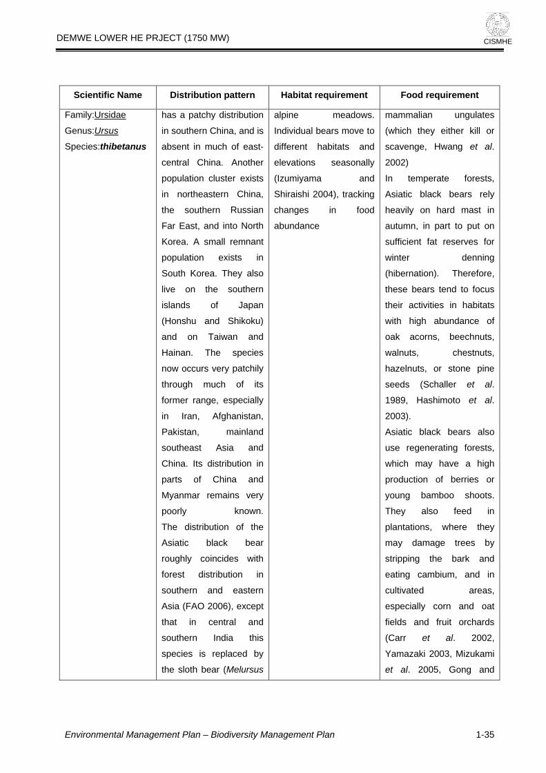
DEMWE LOWER HE PRJECT (1750 MW)
CISMHE
Scientific Na requirement me Distribution pattern Habitat requirement Food
Family:Ursidae
Genus:Ursus
Species:thibeta
d
rn China,
Russian
into North
nant
xists in
hey also
southern
ikoku)
an and
ecies
patchily
of its
especially
n,
mainland
and
ution in
na and
ains very
known.
k bear
roughly coincides with
forest distribution in
southern and eastern
Asia (FAO 2006), except
that in central and
southern India this
species is replaced by
the sloth bear (Melursus
move to
s
Shiraishi
changes
abundanc
alian ungulates
(which they either kill or
e, Hwang et al.
ts,
black bears rely
d mast in
, in part to put on
ent fat reserves for
denning
ation). Therefore,
tend to focus
ctivities in habitats
high abundance of
oak acorns, beechnuts,
s, chestnuts,
uts, or stone pine
challer et al.
Hashimoto et al.
black bears also
generating forests,
may have a high
berries or
bamboo shoots.
also feed in
s, where they
damage trees by
stripping the bark and
eating cambium, and in
cultivated areas,
especially corn and oat
fields and fruit orchards
(Carr et al. 2002,
Yamazaki 2003, Mizukami
et al. 2005, Gong and
nus
has a patchy
in southern Chi
absent in muc
central China.
population cluster exi
in northeaste
the southern
Far East, and
Korea. A small rem
population e
South Korea. T
live on the
islands of Japan
(Honshu and Sh
and on Taiw
Hainan. The sp
now occurs very
through much
former range,
in Iran, Afghanista
Pakistan,
southeast Asia
China. Its distrib
parts of Chi
Myanmar rem
poorly
The distribution of the
Asiatic blac
istribution
na, and is
h of east-
Another
sts
alpine
Individual
different
elevation
(Izumiyam
meadows.
bears
mamm
habitats and
seasonally
a and
2004), tracking
in food
e
scaveng
2002)
In temperate fores
Asiatic
heavily on har
autumn
suffici
winter
(hibern
these bears
their a
with
walnut
hazeln
seeds (S
1989,
2003).
Asiatic
use re
which
production of
young
They
plantation
may
Environmental Management Plan – Biodiversity Management Plan 1-35

DEMWE LOWER HE PRJECT (1750 MW)
CISMHE
Scientific Na n Habitat ment me Distribution patter requirement Food require
ursinus), in
Thailand and
Malaysia it is
by the su
(Helarctos m
and north an
the Russian Fa
is replaced by the brown
bear (Ursus ar
However, the
black bear over
southern
into
replaced
n bear
alayanus)
d west of
r East it
ctos).
Asiatic
laps the
ranges of each of these
a la
Harris 2006,
Vinitpornsawan et al.
2006).
species, espe
sun bear in
portion of S
Asia.
cially the
rge
outheast
s
lia
Asian elephant
u
Kingdom:Anima
Elephas maxim
aPhylum:Chordat
Class:Mammalia
eaOrder:Proboscid
idaeFamily:Elephant
Genus :Elephas
Species: maximus
a
populations in 13 states,
with a very approximate
total range area of
486,800 km² (Sukumar
2003; but see Blake and
Hedges 2004). The
species occurs in
Bangladesh, Bhutan,
d
range of habitat types
elephants are seen from
sea level to over 3,000
m asl. In the Eastern
Himalaya in northeast
India, they regularly
move up above 3,000 m
asl in summer at a few
sian elephant is one
st few mega-
ores (i.e. plant-
ammals that
n adult body
in excess of 1,000
ll extant on earth
-Smith, 1988).
their physiology and
y requirements,
to
e large quantities
of food per day. They are
generalists and browse
and graze on a variety of
plants. The proportions of
the different plant types in
their diet vary depending
upon the habitat and
season. During dry season
Asian elephant
ranged from West Asi
along the Iran
into the
subcontinent, e
into South-ea
including Sum
and Borneo,
China at least
the Yang
Asian elephants
occur in
s formerly
a
ian coast
Indian
astwards
st Asia
tra, Java,
and into
as far as
tze-Kiang.
still
isolated
Asian e
generalists and
occur in
tropical
forest, s
forest, mo
forest,
forested
forest, in
cultivated and
secondary
scrubland
lephants are
they
grassland,
evergreen
emi-evergreen
ist deciduous
ry deciduous
and dry thorn
addition to
forests and
s. Over this
The A
of the la
herbiv
eating m
reach a
weight
kg) sti
(Owen
Given
energ
elephants need
consum
Environmental Management Plan – Biodiversity Management Plan 1-36

DEMWE LOWER HE PRJECT (1750 MW)
CISMHE
Scientific Na requirement me Distribution pattern Habitat requirement Food
India, Nepal, and
Lanka in South
Cambodia,
Indonesia (Kali
and Sumatra) Lao PDR,
Malaysia (P
Malaysia and
Myanmar, Tha
Viet Nam in South-e
Sri
Asia and
China,
mantan
eninsular
Sabah),
iland, and
ast
pulations
Islands
n
ow
r general
rtheastern
dia,
dia, and
ia. In
India, the
e extends
order
rn
through
along
Hills.
From here it extends into
eastern Arunachal
Pradesh, the plains of
upper Assam, and the
foothills of Nagaland.
Further west, it extends
to the Garo Hills of
Meghalaya through the
sites
1999).
southern India,
ar (1992) observed
0% of the elephant's
as browse, while in
sses make
out 55%. However,
adjoining area,
ran (2002) observed
wse formed only
of the diet in dry
nd 47%
diet in the thorn
in the dry season,
e annual diet was
ated by grass
. In Sri Lanka,
ts may feed on
an 60 species of
belonging to 30
cKay, 1973). In
rn India, Baskaran
recorded that
ed on 82
of plants (59
lant species and
grass species).
s may spend up
4–19 hrs a day
feeding, during which they
may consume up to 150
kg of wet weight
(Vancuylenberg, 1977).
They defecate about 16–
18 times a day, producing
about 100 kg of dung.
Dung also helps disperse
Asia. Feral po
occur on some of the
Andaman
(India).
Once widespread i
India, the species is n
restricted to fou
areas: no
India, central In
northwestern In
southern Ind
northeastern
elephant rang
from the eastern b
of Nepal in northe
West Bengal
western Assam
the Himalaya foothills as
far as the Mishmi
(Choudhury, in
Sukum
that 7
diet w
wet season, gra
up ab
in an
Baska
that bro
15%
deciduous forest a
of the
forest
while th
domin
(84%)
elephan
more th
plants
families (M
southe
(2002)
elephants f
species
woody p
23
Elephant
to 1
Environmental Management Plan – Biodiversity Management Plan 1-37

DEMWE LOWER HE PRJECT (1750 MW)
CISMHE
Scientific Na pattern Habitat Food requirement me Distribution requirement
Khasi Hills, to p
the lower Bra
plains and
Plateau. Else
the south in
Mizoram, Manipur,
arts of
hmaputra
Karbi
where in
Tripura,
and
the Barak valley districts
a
germinating seeds.
of Assam, isol
occur (C
1999).
ted herds
houdhury,
MainlandSerow
us
alia
Nemorhaed
sumatraensis
Kingdom:Anim
m:ChordataPhylu
mmaliaClass:Ma
Order:Artiodactyla
Family:Bovidae
Subfamily:Caprinae
Genus:Capricornis
Species:
sumatraensi
ainland S
be found in
The M erow can
Indonesia,
Malaysia, India,
inasouthern Ch , and
southeast Asia.
a terrestrial
animal of
forest,
mountain
environm
animal g
alone or in small
and is te
territory o
Serow usu
few square
The Mainland Serow is
dwelling
ten inhabiting
tropical and
ous
ents. The
enerally lives
groups
rritorial. The
f the Mainland
ally extends a
miles. The
enerally does
y from this
and feeds
is area. The
s
shoots and
leaves.
The serow lives alone or
in small groups. It is
attached to its territory,
which usually covers
just a few miles square,
and does not move far
when feeding. It is most
It grazes on grass and
also eats shoots and
leaves.
Serow g
not stra
territory
across th
Mainland Serow eat
grass,
Environmental Management Plan – Biodiversity Management Plan 1-38

DEMWE LOWER HE PRJECT (1750 MW)
CISMHE
Scientific Name Distribution equirement Food requirement pattern Habitat r
active a
dusk, an
rest of th
vegetation.
along whi
t dawn and
d spends the
e day in thick
It has paths
ch it moves,
and traditional spots
where i
territory a
droppings
t marks its
nd deposits its
.
data
lia
Indian pangolin
sicau
om:Anima
Manis cras
Kingd
aPhylum:Chordat
Class:Mammalia
Order:Pholidota
FamilyManidae
Genus:Manis
Species:
crassicauda
rds in Myanmar
d in Allen
southern
n) which
refer to
MC
cies is
widely distributed from
the plains and lower hills
south of the Himalayas
to extreme southern
India (Tikader 1983).
There have been recent
records from Kerala and
Kanyakumari; Tamil
is thought to
adapt well to modified
habitats, provided their
termites and ants that
are their primary food
source remains
abundant and they are
not hunted.
es is a specialist
r on termites and
rater 1971; Roberts
Tikader 1983). It is
lly solitary and
(Roberts, 1977).
live in burrows
under large rocks,
ce to the
w often hidden with
dirt (Roberts, 1977). The
species is mainly
terrestrial, but in some
habitats is arboreal, using
its prehensile tail and
claws to climb trees.
This species
South Asia fro
eastern
through much
(excluding no
portions of the
south of the H
Bangladesh
Lanka (CITES
Schlitter 2005
have been
reco
occurs in
m parts of
Pakistan
of India
rtheastern
country)
imalayas,
and Sri
2000;
). There
dubious
There is
about the
of this
records ar
types of t
open lan
in additio
proximity
(Zoological Survey
India,
species
(sources quote
1938) and
China (Yunna
almost certainly
Manis javanica (WC
et al. 1999).
In India, this spe
little known
natural history
species, but
e from various
ropical forests,
d, grasslands,
n to in close
to villages
of
1994). The
The speci
feede
ants (P
1977;
genera
nocturnal
Animals
often
with the entran
burro
Environmental Management Plan – Biodiversity Management Plan 1-39

DEMWE LOWER HE PRJECT (1750 MW)
CISMHE
Scientific Na n Habitat requirement Food requirement me Distribution patter
Naidu; Delhi;
and Achanakur Wildlife
Sanctuaries
Pradesh); Bandip
Bhadra, Dalma a
Dandeli
Sanctuaries;
Tiger Rese
(Karnataka); Buxa
Reserve (West
Catugao
Sanctuary
Chambal Natio
(Madhya Prade
National Park
Keolodeo Ghana W
Sanctuary (R
Kotgarh and Kuldi
Wildlife Sanctu
the Sunabedh
(Orissa);
Gwalior
(Madhya
ur,
nd
Wildlife
Bandipur
rve
Tiger
Bengal);
Wildlife
(Goa);
nal Park
sh); Gir
(Gujarat);
ildlife
ajasthan);
ha
aries and
Plateau
Singalila
Wildlife Sanctuary (West
Bengal); Ac
Wildlife S
(Madhya Prad
the Himalayan
of Uttar Pradesh
2000).
hanakuar
anctuary
esh); and
foothills
(CITES
Indian porcupine
Hystrix indica
Recorded in Turkey and
the eastern
Mediterranean through
southwest and central
Asia (including
Afghanistan and
Turkmenistan) to
Pakistan, India, Nepal,
This species has a
broad habitat tolerance,
occupying rocky
hillsides, tropical and
temperate shrubland,
grasslands, forests,
arable land, plantations,
and gardens.
pests
Environmental Management Plan – Biodiversity Management Plan 1-40

DEMWE LOWER HE PRJECT (1750 MW)
CISMHE
Scientific Na pattern Habitat requirement Food requirement me Distribution
Kingdom:Animalia
aPhylum:Chordat
Class:Mammalia
Order:Rodentia
ricidaeFamily:Hyst
Genus:Hystrix
Subgenus :Hystrix
Species: indica
Lanka. In
imalayan
reach
des of up to 2400
meters (Gurung and
Singh 1996).
China and Sri
the H
mountains they
altitu
Name istr Food requirement Scientific Dpattern
ibution Habitat requirement
Lophophorus scl
ateri
imaliaKingdom:An
Phylum:Chordata
Class:Aves
Order:Galliformes
Family:Phasianidae
Genus:Lophophorus
Species: sclateri
Remarks : not pres
Lohit division forest working
plan and also in Kamlang
WL scantuary
clateri
and Lo
rientalis
uted in
ibet,
and
rus
sclateri
(also known as
the Mishmi
Monal) alone is
reported from
parts of
Arunachal
Pradesh. Not
found elsewhere
cotoneaster,
rocky prec
Found betw
4,200 metr
level, desce
as 2,000 me
y little is known
out this species'
ding habits, other
Polygonum
s and flower-
ads have been
d in the diet. In
ina, rhizomes of
rns, bamboo leaves
other unspecified
aves are all
nsumed,
while the newly
discovered race in
Arunachal Pradesh,
India, was observed
feeding on the
underground tubers of
the cobra lily
(Arisaema)
ent in
Global:
species
known
Lophopho
s
sclateri o
- distrib
India, T
China
Myanmar.
India:
Lophopho
sclateri
Two sub-
are
-
rus
sclateri
phophorus
Sclater's mo
coniferous
bamboo
subalpine rhodo
scrub, azal
areas
nal occurs in
forest with a
understorey,
dendron
ea forest, and
of juniper,
open grass and
ipitous slopes.
een 3,000 and
es above sea
nding to as low
tres in winter
Ver
ab
fee
than that
seed
he
foun
Ch
fe
and
le
reportedly co
Environmental Management Plan – Biodiversity Management Plan 1-41

DEMWE LOWER HE PRJECT (1750 MW)
CISMHE
in India.
Lophu
s
imalia
ra
leucomelano
Kingdom: An
ataPhylum: Chord
sClass: Ave
Order:Galliformes
Family:Phasianidae
Genus:Lophura
Species:leucomelanos
Remarks: Present
kamlang WL Sanctuary
ia,
angla
species
distribu
u and
Himachal
sh,
ttaranchal,
Bengal,
kkim,
sh,
Manipu
hal
Tripura
00 m (higher in
imalaya) These
pairs or small
feed in open
in the mornings.
very shy and
le for cover at the
slightest hint of alarm. This
is one of the more adaptable
pheasant species found in
many habitat types.
d is a mixture
plant and animal
od, chief among
them are bamboo
seeds, fruits of Ficus
spp. and white ants.
in
Global: Paki
Ind
Bhutan,
B
Myanmar and
Thailand
India: F
Jamm
Kashmi
Prade
U
North
Si
Arunachal
Prade
stan,
Nepal,
desh,
.
ive sub-
ted from
r,
The bird dw
undergrowth within t
forest show
for moist ra
altitude of 2,6
Western H
birds keep in
groups and
areas early
They are
scutt
Nagalan
Meg
Nagaland.
d,
r, Assam,
aya,
and
ells in dense
he
ing preference
vines upto an
The foo
of
fo
Buceros bicornis
Kingdom:Animalia
Phylum:Chordata
Class:Aves
Order:Coraciiformes
Family:Bucerotidae
Genus:Buceros
Species:. bicornis
are f
ia,
China,
Bangladesh,
Western Ghats of
India, Thailand,
Mainland
Southeastern
Asia, Malaya,
and Sumatra.
is primarily the
tall evergreen
and moinst
deciduous forests, ranging
from elevations of 600
meters to 2000 meters.
Deforestation is the main
threat to the survival of the
great hornbill as it eliminates
both food sources and sites
for breeding
In the wild, the Great
Hornbill's diet consists
mainly of fruit. It will
also eat small
mammals, birds,
small reptiles and
insects
Great
Ind
Southw
hornbills
ound in
estern
The habitat
canopy of
diptocarp
Environmental Management Plan – Biodiversity Management Plan 1-42

DEMWE LOWER HE PRJECT (1750 MW)
CISMHE
he
Lohit
division working plan
and also in Kamlang WL
sanctuary
Remarks: present in t
project area as per
forest
Environmental Management Plan – Biodiversity Management Plan 1-43

DEMWE LOWER HE PRJECT (1750 MW)
CISMHE
C. Avifauna
Scientific Nam n pattern Habitat requirement Food requirement
e Distributio
Grey peacock
ctron
pheasant
Polyple
bicalcaratum
Kingdom:Animalia
Phylum:Chordata
Class:Aves
Subclass:Neornithes
seraeInfraclass:Galloan
Order:Galliformes
eFamily:Phasianida
inaeSubfamily:Phasian
nGenus:Polyplectro
tum
This s
range, with a
global Extent of
Occurrence
1,000,000-10
km². The glo
population si
been quan
believed to be
the species
as 'freque
parts of its ra
Hoyo et al.
populat
not been quan
there is evid
population
Hoyo et al.
the species is not
belie
thresholds fo
populatio
crite
Species:bicalcara
pecies has a large
n estimated
of
,000,000
bal
ze has not
tified, but it is
large as
is described
nt' in at least
nge (del
1994). Global
ion trends have
tified;
ence of a
decline (del
1994), but
ved to approach the
r the
n decline
rion of the IUCN
. d
or three
generations). For these
reasons, the species is
evaluated as Least
Concern.
Red List (i.e
more than 30% in ten
years
eclining
North-east India, south
Bhutan, Myanmar,
Thailand, Cambodia.
Vietnam, Laos,
Wreathed Hornbill
lives in evergreen and
mixed deciduous
forests from plain to
Frugivorous, mainly
berries, drupes, capsular
fruits of primary belonging
toLauraceae, Meliaceae,
Environmental Management Plan – Biodiversity Management Plan 1-44

DEMWE LOWER HE PRJECT (1750 MW)
CISMHE
Scientific Nam tion abita nt Food requirement e Distribu pattern H t requireme
Assam Wreathed
ros undulates
alia
hornbill
Rhytice
Kingdom: Anim
Phylum:Chordata
Class:Aves
Order:Coraciiformes
eFamily:Bucerotida
s
Genus:Rhyticeros
Species: undulate
Malaysia,
n Sumatra
islands,
Bali, Sarawak.
Sabha, Brunei, and other
smaller islands.
1,800 m. and
islands
ceae,
Myristicaceaeand figs
Moraceae). Also beetles
and crabs.
Peninsular
Indonesia
and Adjacent
Java,
on
.
Annona
Rufousnecked ho
nsis
Kingdom:Animalia
rnbill
Aceros nipale
Phylum:Chordata
Class:Aves
Order:Coraciiformes
Family:Bucerotidae
Genus:Aceros
Species:.nipalensis
se to
ietnam; it
has also disappeared
from many areas in
Thailand. While still
widespread and fairly
common in Bhutan,
healthy populations
elsewhere survive only
in Namdapha National
Evidence
suggests that some
populations make
seasonal movements
between forested
areas in response to
variations in the
abundance of fruiting
trees.
ence on large
for feeding and
akes it especially
ible to
tation and habitat
ation through
, shifting cultivation
earance for
ure. Furthermore,
populations require
tracts of forest to
survive, exacerbating its
susceptibility to habitat
fragmentation. These
problems are compounded
by widespread hunting
and trapping for food, and
trade in pets and casques.
Aceros nipa
currently kno
Bhutan,
India,
southern Yun
south-east Tib
Thailand, LVietnam. It has
dramatically a
very rare acros
its historical ra
thought to be
Nepal, and to be clo
extinction in V
lensis is
wn from
north-east
Myanmar, nan and
et, China,
aos and
declined
nd is now
s much of
nge. It is
extinct in
It inh
broadle
genera
600-1,800
(maxim
2,200 m
down to
also been re
dry woo
(usually
in tall
trees.
abits mature
aved forests,
lly between
m
um altitude
), but locally
150 m. It has
corded in
dland. It nests
March-June)
, wide-girthed
Its depend
trees
nesting m
suscept
defores
degrad
logging
and cl
agricult
viable
vast
Environmental Management Plan – Biodiversity Management Plan 1-45
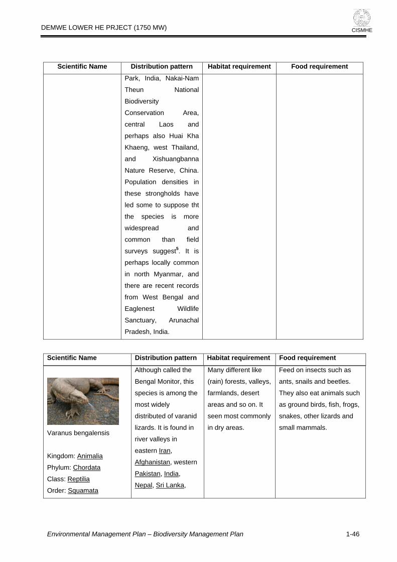
DEMWE LOWER HE PRJECT (1750 MW)
CISMHE
Scientific Nam pattern Habitat requirement Food requirement e Distribution
Park, India, Nakai-Nam
Theun N
Biodiversity
Conservation
central Laos an
perhaps also Huai Kh
Khaeng, west
and Xishuang
Nature Reserv
Population densities
these stronghol
led some to su
the species
widespread and
common th
surveys suggest5.
perhaps locally c
in no
ational
Area,
d
a
Thailand,
banna
e, China.
in
ds have
ppose tht
is more
an field
It is
ommon
rth Myanmar, and
there are recent records
sh, India
from West Bengal an
Eaglenest
Sanctuary,
Prade
d
Wildlife
Arunachal
.
ribution pattern Habitat requirement Food requirement Scientific Name Dist
Varanus bengalensis
Kingdom: Animalia
Phylum: Chordata
Class: Reptilia
Order: Squamata
ough called the
nitor, this
ong the
most widely
distributed of varanid
lizards. It is found in
river valleys in
eastern Iran
Alth
Bengal Mo
species is am
,
Afghanistan, western
Pakistan, India,
Nepal, Sri Lanka,
Many different like
(rain) forests, valleys,
farmlands, desert
areas and so on. It
seen most commonly
in dry areas.
Feed on insects such as
ants, snails and beetles.
They also eat animals such
as ground birds, fish, frogs,
snakes, other lizards and
small mammals.
Environmental Management Plan – Biodiversity Management Plan 1-46

DEMWE LOWER HE PRJECT (1750 MW)
CISMHE
Family: Varanidae
Genus: Varanus
sis
n the project area as per Lohit
forest division workin
Bangladesh and
Burma
Species: bengalen
Remarks: present i
g plan
Python molurus
Animalia
Kingdom:
Phylum: Chordata
Subphylum:
Vertebrata
Class: Reptilia
Order: Squamata
Suborder: Serpentes
Family: Pythonidae
Genus: Python
Species: molurus
Remarks present in project
area as per Lohit forest
division working plan
nd in Fou Pakistan,
India, Sri Lanka,
southern Nepal,
Bangladesh,
Myanmar, southern
China, (Sichuan and
Yunnan east to
Fujian, Hainan, Hong
Kong), Thailand,
Laos, Vietnam,
Cambodia, Peninsula
Malaysia and
Indonesia (Java,
Sumbawa, Sulawesi).
The type locality
given is "Indiis
be
aband
burrow
trees,
reeds
thickets
snakes feed on
s, birds and
discriminately, but
to prefer mammals.
to activity on
the snake will
e with quivering tail
with open mouth.
is constricted and
ne or two coils are
o hold it in a tight
he prey, unable to
uccumbs and is
ntly swallowed
t. After a heavy
hey are disinclined to
ced to, hard
meal may tear
the body.
re, if disturbed,
ecimens will
e their meal in order
from potential
predators. After a heavy
meal, an individual may fast
for weeks; the longest
recorded duration being 2
years. The python can
swallow prey bigger than its
size because the jaw bones
are not connected.
Occurs
range
includi
swamp
rocky
woodla
jungle
valleys. They
on a
source
Somet
in a wide
of habitats,
ng grasslands,
s, marshes,
foothills,
nds, "open"
and river
depend
permanent
of water.
imes they can
found in
oned mammal
s, hollow
dense water
and mangrove
These
mammal
reptiles in
seem
Roused
sighting prey,
advanc
and lunge
Live prey
killed. O
used t
grip. T
breathe, s
subseque
head firs
meal, t
move. If for
parts of the
through
Therefo
some sp
disgorg
to escape
Environmental Management Plan – Biodiversity Management Plan 1-47

DEMWE LOWER HE PRJECT (1750 MW)
CISMHE
Moreove
escape fr
because
arrangement
(which
So far the
r the prey cannot
om its mouth
of unique
of the teeth
is reverse saw like).
re have been no
authentic cases of a human
eaten by this species
quirement Food
requirement
being
Distribution pattern Habitat Re
Nigger: Orsotrioena
s
alia
medus medu
Kingdom:Anim
Phylum:Arthropoda
Class:Insecta
Order:Lepidoptera
Family:Nymphalidae
Genus: Orsotrioena
medus
Distributed
South India
Sikkim onw
further eastw
nobasic and the
bundant in rice
low elevations up
et seasons Flies
ground in the
undergrowth and infact the
weakest flier of all satyridae .
Basks in the sun during early
mornings with wings closed and
parallel to the
-
Species: medus
widely in
and from
ards and
ards.
The genus is mo
single species is a
growing areas at
to 1600 m, in w
close to the
keeping the bod
sun rays y
Indian fritillary Argyreu
hyperbius hyperbius
Kingdom:Animalia
Phylum:Arthropoda
Class:Insecta
Order:Lepidoptera
Family:Nymphalidae
Recorded from
Shillong, Mawphlang,
Mawpat, Umtyngar,
Umshing and Barapani
during April -
December.
This butterfly frequents open
areas, glades, gardens etc. -
Environmental Management Plan – Biodiversity Management Plan 1-48

DEMWE LOWER HE PRJECT (1750 MW)
CISMHE
Distribution pattern Habitat Requirement Food requirement
Genus: Argyreus
Species: hyperbius
hyperbius
Common Sailor: Neptis
rmona
alia
hylas va
Kingdom:Anim
rthropodaPhylum:A
Class:Insecta
Order:Lepidoptera
Family:Nymphalidae
Genus: Neptis
ona
from
wpat and
Barapani during March
and July – September.
Commonly found in forest and
gardens.
-
Species: hylas varm
Recorded
Shillong, Ma
The Indian Red Admiral :
Kingdom:Animalia
Vanessa
indica
Phylum:Arthropoda
Class:Insecta
Order:Lepidoptera
Family:Nymphalidae
Genus: Vanessa
Species: indica
Recorded from Shillong
during June
The Indian Red Admiral is confined
to elevations above 3000 feet and
is found along edges of grasslands
and forests, in open areas with
secondary vegetation, the edges of
tea fields and ravines..
-
Oriental Region (absent
from the Philippines).
Elbowed Pierrot is often found
flying close to the ground and
Environmental Management Plan – Biodiversity Management Plan 1-49

DEMWE LOWER HE PRJECT
(1750 MW)
Environmental Management Plan – Biodiversity Management Plan 1-50
CISMHE
Distributio quirement Food requirement
n pattern Habitat Re
Elbowed Pierrot: Caleta
alia
elna Elvira
Kingdom:Anim
aPhylum:Arthropod
Class:Insecta
Order:Lepidoptera
Family: Lycaenida
Genus: CaletaCalet
Species: elna elvira
settled at moist spots on the forest
floor.
a
Large yeoman :
Kingdom:Animalia
Cirrochroa
aoris aoris
Phylum:Arthropoda
Class:Insecta
Order:Lepidoptera
Family:Nymphalidae
Genus: Cirrochroa
Species: aoris aoris
found in evergreen
forests and on the
plateau in India.
visits moist or damp patches and
flowers, and males occasionally
water.

DEMWE LOWER HE PRJECT (1750 MW)
CISMHE
2
CATCHMENT AREA TREATMENT PLAN
2.1 INTRODUCTION
It is a well-established fact that reservoirs formed by dams on rivers are
subjected to sedimentation. The process of sedimentation embodies the
sequential processes of erosion, entrainment, transportation, deposition and
compaction of sediment. The study of erosion and sediment yield from
catchments is of utmost importance as the deposition of sediment in reservoir
reduces its capacity, and thus affecting the water availability for the designated
use. The eroded sediment from catchment when deposited on streambeds and
banks causes braiding of river reach. The removal of top fertile soil from
catchment adversely affects the agricultural production. Thus, a well-designed
Catchment Area Treatment (CAT) Plan is essential to ameliorate the above-
mentioned adverse process of soil erosion.
Soil erosion may be defined as the detachment and transportation of soil. Water
is the major agent responsible for this erosion. In many locations, winds, glaciers,
etc. also cause soil erosion. In a hilly catchment area, as in the present case,
erosion due to water is a common phenomenon and the same has been studied
as a part of the Catchment Area Treatment (CAT) Plan. Soil erosion leads to:
• loss in production potential
• reduction in infiltration rates
• reduction in water-holding capacity
• loss of nutrients
• increase in tillage operation costs
• reduction in water supply
Environmental Management Plan – Catchment Area Treatment Plan
2-1

DEMWE LOWER HE PRJECT (1750 MW)
CISMHE
The Catchment Area Treatment (CAT) plan highlights the management
techniques to control erosion in the catchment area of a water resource project.
The life span of a reservoir is greatly reduced due to erosion in the catchment
area. Adequate preventive measures are thus needed for the treatment of
catchment for its stabilization against future erosion.
Catchment Area Treatment Plan has been formulated for free draining catchment
i.e. up to the tail water levels of proposed upstream Demwe Upper HE project on
Lohit River.
The catchment area considered for the present study is given in Figure 2.1 as
raw satellite imagery.
The catchment area treatment involves
• Understanding of the erosion characteristics of the terrain and,
• Suggesting remedial measures to reduce the erosion rate.
In the present study `Silt Yield Index’ (SYI), method has been used. In this
method, the terrain is subdivided into various watersheds and the erodibility is
determined on relative basis. SYI provides a comparative erodibility criteria of
catchment (low, moderate, high, etc.) and do not provide the absolute silt yield.
SYI method is widely used mainly because of the fact that it is easy to use and
has lesser data requirement. Moreover, it can be applied to larger areas like sub-
watersheds, etc.
2.2 APPROACH FOR THE STUDY A detailed database on natural resources, terrain conditions, soil type of the
catchment area, socio-economic status, etc. is a pre-requisite to prepare
treatment plan keeping in view the concept of sustainable development. Various
thematic maps have been used in preparation of the CAT plan. Geographic
Information System (GIS) is a computerized resource data base system, which is
referenced to some geographic coordinate system. In the present study, real
coordinate system has been used. The GIS is a tool to store, analyze and display
Environmental Management Plan – Catchment Area Treatment Plan
2-2

DEMWE LOWER HE PRJECT (1750 MW)
CISMHE
various spatial data. In addition, GIS, because of its special hardware and
software characteristics, has a capacity to perform numerous functions and
operations on the various spatial data layers residing in the database. GIS
provides the capability to analyze large amounts of data in relation to a set of
established criteria. In order to ensure that latest and accurate data is used for
the analysis, satellite data has been used for deriving land use data. Ground truth
studies, too, have been conducted.
The various steps, covered in the study, are as follows:
• Definition of the problem
• Data acquisition and preparation
• Output presentation
The above mentioned steps are briefly described in the following paragraphs:
2.2.1 Definition of the Problem
The requirements of the study were defined and the expected outputs were
finalized. The various data layers of the catchment area to be used for the study
are as follows:
• Slope Map
• Soil Map
• Land use Classification Map
• Current Management Practices
• Catchment Area Map.
2.2.2 Data Acquisition and Preparation
The data available from various sources has been collected. The ground maps,
contour information, etc. were scanned, digitized and registered as per the
requirement. Data was prepared depending on the level of accuracy required and
any corrections required were made. All the layers were geo-referenced and
brought to a common scale (real co-ordinates), so that overlay could be
performed. A computer program using standard modeling techniques was used
Environmental Management Plan – Catchment Area Treatment Plan
2-3

DEMWE LOWER HE PRJECT (1750 MW)
Environmental Management Plan – Catchment Area Treatment Plan
2-4
CISMHE
to estimate the soil loss. The formats of outputs from each layer were firmed up
to match the formats of inputs in the program. The grid size to be used was also
decided to match the level of accuracy required, the data availability and the
software and time limitations. The format of output was finalized. Ground truthing
and data collection was also included in the procedure.
For the present study, IRS P6-LISS III digital satellite data was used for
interpretation & classification. The data has been procured in raw digital format
and has been geo-referenced using Survey of India topographical sheets with the
help of standard data preparation techniques in standard image processing
software. The interpretation of geo-referenced satellite data has been done using
standard enhancement techniques, ground checks and experiences of qualified
professionals. A detailed ground truth verification exercise has been undertaken
as a part of ecological survey to enrich the image interpretation process. The
classified land use map of the free draining catchment area, considered for the
study, is shown as Figure 2.2. The land use pattern of the catchment area is
summarized in Table 2.1.
Derived contours from topographical maps were used for preparation of Digital
Elevation Model (DEM) of the free draining catchment area and to prepare a
slope map. The first step in generation of slope map is to create surface using
the elevation values stored in the form of contours or points. After marking the
catchment area, all the contours on the topographical maps were derived. The
output of the digitisation procedure was the contours as well as points contours in
form of x, y & z points. (x, y - location and z - their elevation). All this information
was in real world co-ordinates (latitude, longitude and height in meters above sea
level).

DEMWE LOWER HE PRJECT (1750 MW) CISMHE
Figure 2.1
Environmental Management Plan – Catchment Area Treatment Plan 2-5

DEMWE LOWER HE PRJECT (1750 MW)
Environmental Management Plan – Catchment Area Treatment Plan 2-6
CISMHE
Figure 2.2

DEMWE LOWER HE PRJECT (1750 MW) CISMHE
Table 2.1: Land use classification for free draining catchment at diversion site
Land use/ Land cover Area in percentage Area in ha
Dense Forest 47.69 57916.63
River 0.86 1040.93
Alpine Scrub 5.26 6382.98
Open Forest 25.24 30650.73
Degraded Forest 2.23 2712.29
Cultivation/Settlement 0.24 289.21
Scrub 1.01 1221.81
Landslide 0.20 238.94
Sand 0.97 1183.23
Moraines 3.96 4814.34
Water Body 0.09 103.66
Snow Covered Areas 12.27 14898.25
Total 100.00 121453.00
A Digital Terrain Model (DTM) of the area was then prepared, which was used
to derive a slope map. The slope was divided in classes of slope percentages.
The areas falling under various standard slope categories have been
tabulated below in Table 2.2. The slope map is enclosed as Figure 2.3.
Table 2.2: Areas falling under different slope categories
Slope category (percentage) Area in percentage Area in sq km
0-1 0.42 5.11
1-3 1.93 23.41
3-5 2.42 29.39
5-10 5.95 72.29
10-15 4.03 48.92
15-25 5.25 63.77
25-33 4.14 50.32
33-50 12.95 157.29
> 50 62.91 764.04
Total 100.00 1214.53
Environmental Management Plan – Catchment Area Treatment Plan
2-7

DEMWE LOWER HE PRJECT (1750 MW)
Environmental Management Plan – Catchment Area Treatment Plan
2-8
CISMHE
Soil map has been digitized and produced using soil maps collected from
Natural Resources Atlas of Arunachal Pradesh. Various layers, thus prepared,
were used for Modeling. Soil map has been shown as Figure 2.4. The legend
for soil classes has been given subsequently.

DEMWE LOWER HE PRJECT (1750 MW)
Environmental Management Plan – Catchment Area Treatment Plan 2-9
CISMHE
Figure 2.3

DEMWE LOWER HE PRJECT (1750 MW) CISMHE
Figure 2.4
Environmental Management Plan – Catchment Area Treatment Plan 2-10

DEMWE LOWER HE PRJECT (1750 MW)
Environmental Management Plan – Catchment Area Treatment Plan 2-11
CISMHE

DEMWE LOWER HE PRJECT (1750 MW) CISMHE
Software was prepared using standard modeling techniques to calculate the
soil loss using input from all the layers as described below:
2.2.2.1 Modelling
The river catchment area has been divided into small grids of 50m*50m. The
vector layer so generated of 50 m grid size was updated by landuse/landcover
details, soil information and slope values in GIS software using different maps
as generated above. Soil loss has then been calculated for each grid using
modelling techniques) through information derived from updated grids with the
help of a customized computer software/program.
A thematic map has been prepared using these calculated soil erosion values
for delineating areas prone to soil erosion in the free draining catchment. The
percentages of free draining catchment area falling in different soil
vulnerability classes are given in Table 2.3 and shown in Figure 2.5.
Table 2.3: Soil loss ranges for the river catchment S. No. Soil loss range in tons/acre/annum Area in sq km Area in percentage
1 0 – 2.5 384.04 31.62
2 2.5 – 5.0 92.93 7.65
3 5.0 – 10.0 271.16 22.33
4 10.0 – 15.0 236.14 19.44
5 15.0 – 20.0 95.88 7.89
6 > 20.0 134.38 11.06
Total 1214.53 100.00
2.2.3 Output Presentation The result of the modeling was interpreted in pictorial form to identify the
areas with high soil erosion rates. The primary and secondary data collected
as a part of the field studies were used as an input for the model.
Environmental Management Plan – Catchment Area Treatment Plan
2-12

DEMWE LOWER HE PRJECT (1750 MW)
Environmental Management Plan – Catchment Area Treatment Plan 2-13
CISMHE
Figure 2.5

DEMWE LOWER HE PRJECT (1750 MW)
CISMHE
2.3 ESTIMATION OF SOIL LOSS USING SILT YIELD INDEX (SYI) METHOD
In `Silt Yield Index’ (SYI), method, the terrain is subdivided into various
watersheds and the erodibility is determined on relative basis. SYI provides a
comparative erodibility criteria of catchment (low, moderate, high, etc.) and do
not provide the absolute silt yield. SYI method is widely used mainly because of
the fact that it is easy to use and has lesser data requirement. Moreover, it can
be applied to larger areas like sub-watersheds, etc.
The Silt Yield Index Model (SYI), considering sedimentation as product of
erosivity, erodibility and arial extent was conceptualized in the All India Soil and
Land Use Survey (AISLUS) as early as 1969 and has been in operational use
since then to meet the requirements of prioritization of smaller hydrologic units
within river valley project catchment areas.
The erosivity determinants are the climatic factors and soil and land attributes
that have direct or reciprocal bearing on the unit of the detached soil material.
The relationship can be expressed as:
Soil erosivity = f (Climate, physiography, slope, soil parameters, land use/land
cover, soil management)
2.3.1 Silt Yield Index
The Silt Yield Index (SYI) is defined as the Yield per unit area and SYI value for
hydrologic unit is obtained by taking the weighted arithmetic mean over the
entire area of the hydrologic unit by using suitable empirical equation.
2.3.2 Prioritization of Watersheds/Sub-watersheds
The prioritization of smaller hydrologic units within the vast catchments is based
on the Silt Yield Indices (SYI) of the smaller units. The boundary values or
range of SYI values for different priority categories are arrived at by studying
the frequency distribution of SYI values and locating the suitable breaking
Environmental Management Plan – Catchment Area Treatment Plan
2-14

DEMWE LOWER HE PRJECT (1750 MW)
CISMHE
points. The watersheds/ sub-watersheds are subsequently rated into various
categories corresponding to their respective SYI values.
The application of SYI model for prioritization of sub-watersheds in the
catchment areas involves the evaluation of:
• Climatic factors comprising total precipitation, its frequency and intensity,
• Geo-morphic factors comprising land forms, physiography, slope and
drainage characteristics,
• Surface cover factors governing the flow hydraulics and
• Management factors.
The data on climatic factors can be obtained for different locations in the
catchment area from the meteorological stations whereas the field
investigations are required for estimating the other attributes.
The various steps involved in the application of model are:
• Preparation of a framework of sub-watersheds through systematic
delineation
• Rapid reconnaissance surveys on 1:50,000 scale leading to the
generation of a map indicating erosion-intensity mapping units.
• Assignment of weightage values to various mapping units based on
relative silt-yield potential.
• Computing Silt Yield Index for individual watersheds/sub-watersheds.
• Grading of watersheds/sub-watersheds into very high, high, medium, low
and very low priority categories.
The area of each of the mapping units is computed and silt yield indices of
individual sub-watersheds are calculated using the following equations:
Environmental Management Plan – Catchment Area Treatment Plan
2-15

DEMWE LOWER HE PRJECT (1750 MW)
CISMHE
Silt Yield Index To calculate silt yield index, the methodology developed by All India Soil &
Land Use Survey (Department of Agriculture, Govt. of India) has been followed,
where each erosion intensity unit is assigned a weightage value. When
considered collectively, the weightage value represents approximately the
relative comparative erosion intensity. A basic factor of K = 10 was used in
determining the weightage values. The value of 10 indicates a static condition
of equilibrium between erosion and deposition. Any addition to the factor K
(10+X) is suggestive of erosion in ascending order whereas subtraction, i.e.
(10-X) is indicative of deposition possibilities.
Delivery ratios were adjusted for each of the erosion intensity unit. The delivery
ratio suggests the percentage of eroded material that finally finds entry into
reservoir or river/ stream. Area of each composite unit in each sub-watershed
was then estimated.
Silt yield index (SYI) was calculated using following empirical formula:
SYI = Σ (Ai * Wi ) * Di * 100 ; where i = 1 to n
Aw
where, Ai = Area of ith unit (EIMU)
Wi = Weightage value of ith mapping unit
n = No. of mapping units
Aw = Total area of sub-watershed.
Di = Delivery ratio
Delivery ratios are assigned to all erosion intensity units depending upon their
distance from the nearest stream. The criteria adopted for assigning the
delivery ratio are as follows:
Environmental Management Plan – Catchment Area Treatment Plan
2-16

DEMWE LOWER HE PRJECT (1750 MW)
CISMHE
Nearest Stream Delivery ratio
0 - 0.9 km 1.00
1.0 - 2.0 km 0.95
2.1 - 5.0 km 0.90
5.1 - 15.0 km 0.80
15.1 - 30.0 km 0.70
The SYI values for classification of various categories of erosion intensity rates
are given in Table 2.4.
Table 2.4: Criteria for erosion intensity rate
Priority categories SYI Values
Very high > 1300
High 1200-1299
Medium 1100-1199
Low 1000-1099
Very Low <1000
The erosion category of various watersheds in the catchment area as per a SYI
index has been estimated. The objective of the SYI method is to prioritize sub-
watershed in a catchment area for treatment. The area under very high and
high erosion categories is to be treated at the project proponent cost. Hence,
CAT plan shall be suggested for very high and high erosion categories, as a
part of the EIA study, the expenses of which have to be borne by project
proponents.
2.4 WATERSHED MANAGEMENT – AVAILABLE TECHNIQUES Watershed management is the optimal use of soil and water resources within a
given geographical area so as to enable sustainable production. It implies
changes in land use, vegetative cover, and other structural and non-structural
action that are taken in a watershed to achieve specific watershed
Environmental Management Plan – Catchment Area Treatment Plan
2-17

DEMWE LOWER HE PRJECT (1750 MW)
CISMHE
management objectives. The overall objectives of watershed management
programme are to:
• Increase Infiltration Into Soil;
• Control Excessive Runoff;
• Manage & Utilize Runoff For Useful Purpose.
• Check Soil Erosion
Following Engineering and Biological measures shall be suggested for the
catchment area treatment:
A Engineering measures - Step Drain
- Angle Iron Barbed Wire Fencing
- Stone Masonry Wall
- Check Dams
B Biological measures - Development of Nurseries
- Plantation/Afforestation
- Pasture Development
- Social Forestry
The basis of site selection for different biological and engineering treatment
measures under CAT are given in Table 2.5.
Environmental Management Plan – Catchment Area Treatment Plan
2-18

DEMWE LOWER HE PRJECT (1750 MW)
CISMHE
Table 2.5: Basis for selection of catchment area treatment measures
Treatment measure Basis for selection
Social forestry, fuel
wood and fodder
grass development
Near settlements to control tree felling
Contour Bunding Control of soil erosion from agricultural fields.
Pasture
Development
Open canopy, barren land, degraded surface
Afforestation Open canopy, degraded surface, high soil erosion, gentle to
moderate slope
Barbed wire fencing In the vicinity of afforestation work to protect it from grazing etc.
Step drain To check soil erosion in small streams, steps with concrete base
are prepared in sloppy area where silt erosion in the stream and
bank erosion is high due to turbidity of current.
Nursery Centrally located points for better supervision of proposed
afforestation, minimize cost of transportation of seedling and ensure
better survival.
2.5 CATCHMENT AREA TREATMENT (CAT) PLAN
In the present report, CAT Plan as per the slope, land use pattern, soil
characteristics has been suggested based on the prioritization of sub
watersheds using SYI method (Table 2.6). The CAT plan has been suggested
for sub watersheds with very high and high erosion categories as the cost for
treatment for such watersheds is to be borne by the project proponents.
Table 2.6: Erosion intensity categorization as per SYI classification
Sub watershed Area in ha SYI Priority Category
W1 1720 1005 Low
W2 4088 1266 High
W3 1125 1137 Medium
W4 2034 1014 Low
W5 4767 1136 Medium
Environmental Management Plan – Catchment Area Treatment Plan
2-19

DEMWE LOWER HE PRJECT (1750 MW)
CISMHE
Sub watershed Area in ha SYI Priority Category
W6 3474 1049 Low
W7 3260 1255 High
W8 4395 1241 High
W9 2925 1138 Medium
W10 2405 1062 Low
W11 2851 990 V Low
W12 2667 1103 Medium
W13 2504 1083 Low
W14 2267 1017 Low
W15 6400 1007 Low
W16 4190 1017 Low
W17 4564 990 V Low
W18 4236 990 V Low
W19 2970 1031 Low
W20 2949 1110 Medium
W21 2479 1178 Medium
W22 4839 1234 High
W23 4447 1188 Medium
W24 5733 1339 V High
W25 6937 973 V Low
W26 5612 894 V Low
W27 7002 1019 Low
W28 4366 932 V Low
W29 4207 910 V Low
W30 10040 869 V Low
Environmental Management Plan – Catchment Area Treatment Plan
2-20

DEMWE LOWER HE PRJECT (1750 MW)
Environmental Management Plan – Catchment Area Treatment Plan
2-21
CISMHE
Table 2.7: Erosion intensity rates of catchment area
Erosion intensity categorization as per SYI values
Percentage of catchment area
Very High 4.72
High 13.65
Medium 17.59
Low 28.79
Very Low 35.25
Total 100.00
The objective of the SYI method is to prioritize sub-watershed in a catchment
area for treatment. The area under very high and high erosion categories have
to be treated by the project proponents, which accounts for about 18.37% of the
total free draining catchment area. (Table 2.7, Figure 2.6). Sub-watershed wise
proposed treatment measures in these sub watersheds are given in Table 2.8
and have been shown in Figure 2.7. It is proposed that treatment measures
shall be implemented over five years and shall be co-terminus with the
construction of dam. Phase wise treatment plan has been shown in Figure 2.8
and has been tabulated in Table 2.10.
Table 2.8: Sub-watershed wise proposed treatment measures
Sub-watersheds
Afforestation (1600 tree/ha) in ha
Afforestation (800 tree/ha) in
ha
Contour-Bunding in ha
Pasture Development
in ha
W2 420 65 22 158
W7 323 49 26 54
W8 734 344 36 96
W22 1001 643 0 381
W24 905 1284 3 328
3383 2384 86 1017

DEMWE LOWER HE PRJECT (1750 MW)
CISMHE Figure 2.6
Environmental Management Plan – Catchment Area Treatment Plan 2-22

DEMWE LOWER HE PRJECT (1750 MW)
CISMHE
Figure 2.7
Environmental Management Plan – Catchment Area Treatment Plan 2-23

DEMWE LOWER HE PRJECT (1750 MW)
Environmental Management Plan – Catchment Area Treatment Plan 2-24
CISMHE
Figure 2.8

DEMWE LOWER HE PRJECT (1750 MW)
CISMHE
2.6 COST ESTIMATE
The cost required for Catchment Area Treatment is Rs. 3312.00 lakh. The
details are given in Table 2.9.
Table 2.9: Cost estimate for Catchment Area Treatment of Lower Demwe HEP
Target S.
No. Item
Rate (Rs.)
Unit Physical
Financial (Rs. Lakh)
Biological Measures
1. Afforestation (1600
trees/ha) 39,000/ha ha 3383 1319.37
2. Afforestation (800
trees/ha) 19,500/ha ha 2384 464.80
3. Maintenance of
afforestation area 5,000/ha ha 5767 288.35
4. Pasture development 20,000/ha ha 1017 203.47
5. Nursery development 2,00,000/no. no. 60 120.00
6. Maintenance of
nursery 1,00,000/no. no. 60 60.00
7. Vegetative fencing 45,000/km km 50 22.50
8. Watch and ward for 5
years @ 50/ persons
6,000/man-
month
Man-
months 3000 180.00
Engineering Measures
9. Contour Bunding 25,000/ha ha 86 21.50
10. Check Dams 2,00,000 No 100 200.00
Total 2880.00
Environmental Management Plan – Catchment Area Treatment Plan 2-25

DEMWE LOWER HE PRJECT (1750 MW)
Environmental Management Plan – Catchment Area Treatment Plan 2-26
CISMHE
Total cost for Biological and Engineering measures = Rs. 2880.00 lakh Administrative expenditure Government Expenditure 3% of Total (including O&M) = Rs. 86.40 lakh
Establishment cost 7% of Total = Rs. 201.60 lakh
Contingency 5% of Total = Rs. 144.00 lakh
-----------------------------------------------------------------------------------------------------------
Total Rs. 3312.00 lakh
The year wise physical and financial targets are given in Table 2.10.

DEMWE LOWER HE PRJECT (1750 MW)
CISMHE
Table 2.10: Year wise target (physical and financial) for Catchment Area Treatment Plan
Year I Year II Year III Year IV Year V Total Measures
Physical Financial (Rs. lakhs)
Physical Financial (Rs. lakhs)
Physical Financial (Rs. lakhs)
Physical Financial (Rs. lakhs)
Physical Financial (Rs. lakhs)
Physical Financial (Rs. lakhs)
Biological measures
Enrichment
Plantations
500 ha 97.50 500 ha 97.50 500 ha 97.50 500 ha 97.50 384 ha 74.80 2384 ha 464.80
Afforestation 750 ha 292.50 750 ha 292.50 750 ha 292.50 750 ha 292.50 383 ha 149.37 3383 ha 1319.37
Maintenance of
afforestation
1250 ha 62.50 1250 ha 62.50 1250 ha 62.50 1250 ha 62.50 767 ha 38.35 5767 ha 288.35
Pasture
Development
217 ha 43.47 200 ha 40.00 200 ha 40.00 200 ha 40.00 200 ha 40.00 1017 ha 203.47
Nursery
development
30 no. 60.00 30 no. 60.00 - - - - - - 60 no. 120.00
Maintenance of
Nursery
- - - 25.0 - 25.0 - 10.0 - - - 60.00
Vegetative fencing 10 km 4.50 10 km 4.50 10 km 4.50 10 km 4.50 10 km 4.50 50.0 km 22.50
Watch and ward - 36.00 - 36.00 - 36.00 - 36.00 - 36.00 - 180.00
Engineering Measures
Contour Bunding 25 ha 6.25 25 ha 6.25 25 ha 6.25 11 ha 2.75 - - 86.0 ha 21.50
Check Dams 20 no. 40.00 20 no. 40.00 20 no. 40.00 20 no. 40.00 20 no. 40.00 100 no. 200.00
Total 642.72 664.25 604.25 585.75 383.02 2880.00
Environmental Management Plan – Catchment Area Treatment Plan 2-27

DEMWE LOWER HE PRJECT (1750 MW)
CISMHE
3
FISHERIES DEVELOPMENT PLAN
3.1 INTRODUCTION
Fisheries development plan is implemented to meet the specific objectives viz. to
achieve the maximum sustainable economic yield, to secure protein production
and food supply, to conserve the indigenous fish species, etc. Thus, fisheries
management broadly includes fish, consumers and conservationists. Whenever
water resource suffers from stresses, viz. overfishing, degradation of habitat,
deterioration of water quality and obstacles come in the way of fish movement, it
requires a suitable fisheries development and management plan. A hydro-electric
project leads to the modification of natural habitat and create a barrier in the way
of dispersal of fish. Regarding the hydro-electric project fisheries management
plan focuses on the conservation of the threatened species, fish migration and
livelihood of the local people.
Lohit is one of the largest rivers of Arunachal Pradesh and rich in ichthyofaunal
diversity. Present status of Lohit river indicates that it is not over fished due to
very sparse population in the surroundings. Also, other stresses on fish like
habitat degradation and deterioration are lacking in the area. Though, the Mishmi
tribes in the surroundings are very fond of non vegetarian food including fish but
they prefer wild animals rather than fish. The fisheries development plan is
proposed for the Demwe Lower H.E. project on the Lohit river. A high dam would
create a large reservoir measuring 1131 ha, which would provide the scope of
fisheries development in the region. On the other hand, the dam would hamper
the migration of some fish species. A suitable fisheries management plan would
be helpful not only in the fish conservation and in sustaining livelihood of people
but would reduce the pressure on wildlife.
Environmental Management Plan – Fisheries Development Plan
3-1
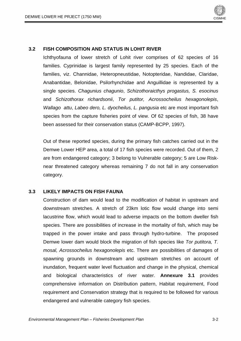
DEMWE LOWER HE PRJECT (1750 MW)
CISMHE
3.2 FISH COMPOSITION AND STATUS IN LOHIT RIVER Ichthyofauna of lower stretch of Lohit river comprises of 62 species of 16
families. Cyprinidae is largest family represented by 25 species. Each of the
families, viz. Channidae, Heteropneustidae, Notopteridae, Nandidae, Claridae,
Anabantidae, Belonidae, Psilorhynchidae and Anguillidae is represented by a
single species. Chagunius chagunio, Schizothoraicthys progastus, S. esocinus
and Schizothorax richardsonii, Tor putitor, Acrossocheilus hexagonolepis,
Wallago attu, Labeo dero, L. dyocheilus, L. pangusia etc are most important fish
species from the capture fisheries point of view. Of 62 species of fish, 38 have
been assessed for their conservation status (CAMP-BCPP, 1997).
Out of these reported species, during the primary fish catches carried out in the
Demwe Lower HEP area, a total of 17 fish species were recorded. Out of them, 2
are from endangered category; 3 belong to Vulnerable category; 5 are Low Risk-
near threatened category whereas remaining 7 do not fall in any conservation
category.
3.3 LIKELY IMPACTS ON FISH FAUNA Construction of dam would lead to the modification of habitat in upstream and
downstream stretches. A stretch of 23km lotic flow would change into semi
lacustrine flow, which would lead to adverse impacts on the bottom dweller fish
species. There are possibilities of increase in the mortality of fish, which may be
trapped in the power intake and pass through hydro-turbine. The proposed
Demwe lower dam would block the migration of fish species like Tor putitora, T.
mosal, Acrossocheilus hexagonolepis etc. There are possibilities of damages of
spawning grounds in downstream and upstream stretches on account of
inundation, frequent water level fluctuation and change in the physical, chemical
and biological characteristics of river water. Annexure 3.1 provides
comprehensive information on Distribution pattern, Habitat requirement, Food
requirement and Conservation strategy that is required to be followed for various
endangered and vulnerable category fish species.
Environmental Management Plan – Fisheries Development Plan
3-2

DEMWE LOWER HE PRJECT (1750 MW)
CISMHE
3.4 FISHERY DEVELOPMENT The fishery development has been aimed towards multiplication of important
commercial fish species and the conservation of threatened species and
economic upliftment of the region. In order to conserve threatened species and to
develop sustenance fishery, hatcheries with nurseries and rearing and stocking reservoirs are proposed in the project area. A reservoir of 1131 ha needs to be
developed into an organized reservoir fishery, which would also provide the
scope of employment to the local people apart from conservation of fish species.
The reservoir would also have a recreational importance and would fulfill not only
the diet requirements of the local people but would also reduce the pressure on
the Wildlife, which is a major issue in the region.
3.4.1 Hatcheries Units
A fish hatchery is the centre of ova production. It helps in propagating the ova of
required species and stocking of fish fingerlings to different water bodies. A
hatchery can play an important role in the conservation of threatened species
and sustenance fishery. In order to conserve the vulnerable species of Lohit
river, which would undergo through stresses due to proposed Demwe Lower H.E.
project, 3 hatcheries are proposed for the indigenous species alongside the
reservoir or the tributaries. The species, viz. Tor putitora, T. mosal, T. tor,
Acrossocheilus hexagonolepis, Labeo rohita, L. dero, Schizothorax richardsoni,
Schizothoraicthys progastus are suggested for the hatchery unit, however,
fishery department can use the hatchery unit for other species also.
Proposed hatchery unit would comprise of indoor spawnery /eco hatchery for
hatchlings, nursery tanks (2m x 1m x 0.5m) for fry, rearing tanks (5mx 2m x 1m)
for juveniles and stocking tanks (10m x 2.5 m x 1.5m) for brooders. After
complete digestion of yolk the spawns would be transferred into the nursery
tanks. From nursery tanks fry would be propagated into the reservoir and other
water bodies. A schematic diagram of the proposed hatchery is given in Figure 3.1. The total cost estimates for the fishery development is given in the Table 3.1.
Environmental Management Plan – Fisheries Development Plan
3-3

DEMWE LOWER HE PRJECT (1750 MW)
CISMHE
3.4.2 Reservoir Fishery and its Management The State Fishery Department may take the responsibility of managing the
proposed hatchery and the management of the reservoir fishery with the
cooperation of project authorities. State Fishery Department may take up
propagation of indigenous species in the reservoir and the surrounding rivers in
order to conserve the native fish species. The process of raising and managing
the reservoir fishery is described in following paragraphs.
3.4.2.1 Stocking of seeds
Prior to the stocking of seeds, there would be requirement of a detailed physical,
chemical and biological analysis of the water of the reservoir. After the pre-
management studies, the reservoir would be stocked @ 4000-5000 spawns/fry or
400 to 500 fingerlings of different species per ha surface area. Total requirement
of fry or fingerlings for the reservoir would be 4,00,000 to 5,50,000 fry or 40,000
to 55,000 fingerlings in the first year. Proposed hatchery would be the main
source of seeds for the reservoir. The propagation of seed would be repeated in
successive years on the basis of the survival rates of the spawns.
3.4.2.2 Management of reservoir
Entire reservoir would be divided into 10 beats, each having a surface area of
about 100 ha. Each beat will be given on the lease basis. For the contract,
preference will be given to the affected villages and families. The contractor will
pay the contract price to the concerned department.
3.4.2.3 Fisherman and their rights
The concerned Department may set up a cooperative of local fishermen, which
will be divided into 10 groups and linked to the contractors. According to the
provision of National Policy on Rehabilitation and Resettlement (NPRR) the
fishermen belonging to the affected villages would have right of fishing in
reservoir at no cost while in other case the Department may issue the licenses
for the fishing at a cost. Fishermen will sell their fish to the contractor of
concerned beat.
Environmental Management Plan – Fisheries Development Plan
3-4

DEMWE LOWER HE PRJECT (1750 MW)
CISMHE
3.4.2.4 Training
State Fishery Department will provide training of fishing and boating in the
reservoir to the local people. It will provide guidelines regarding the types of
fishing gears, mesh size, etc. These guidelines would be helpful in preventing the
reservoir from overexploitation. These guidelines must be followed strictly by the
fishermen. Fishermen can use their own boat or contractors will provide boats for
fishermen at the rate of per day or per hour charges. The boats should follow all
rules of safety. The provision of funds for the training and assistance has been
provided under the local area development programme of R & R chapter in EMP.
3.4.2.5 Marketing
Tezu and Namsai are the nearby markets in the region; however, fish could be
supplied up to Tinsukia and Dibrugarh. The contractors would receive the fish
from fishermen and supply to markets. This would be crucial in preparing proper
marketing plans and practices. The cooperative/contractors may like to explore
the possibility of fish export, if harvests are good. It would be essential to train the
local fishermen in the post-harvest technologies for increasing the shelf-life of
fish, which will fetch a higher price for the local communities.
3.4.2.6 Research and Development activities
Efforts have been made to document the status, distribution pattern, habitant
requirements and conservation strategy for the aquatic fauna falling under the
RET schedule. Appropriate budgetary provisions have been made for
promoting/conservation of these species. However, it is recognized that for some
of the species, propagation protocols and conservation strategy are not fully
documented. It is therefore proposed to earmark a lumpsum provision of Rs 30
lakhs for supporting R & D activities by identified national, international research
organizations.
3.5 BUDGET
Environmental Management Plan – Fisheries Development Plan
3-5

DEMWE LOWER HE PRJECT (1750 MW)
Environmental Management Plan – Fisheries Development Plan
3-6
CISMHE
Total cost estimated for the fishery development is Rs 456.33 (Four crore fifty six lakhs and thirty three thousand only). The State Fishery Department
would be implementing agency in association with project authority. Thereafter,
entire assets will be handed over to the department. The financial outlay for the
fishery development was prepared considering the new scales on lump sum
basis (Table 3.1).

DEMWE LOWER HE PRJECT (1750 MW)
CISMHE
Table 3.1: Year-wise break up of cost estimates for fisheries development in proposed Demwe Lower H.E. project
S. No. Components 1st Yr 2nd Yr 3rd Yr 4th Yr 5th Yr Total (Rs. In Lakh) A. Non Recurring Cost 1. Land
i) Maintenance of Land 5.00 - - - - 5.00
ii) Water intake Channels etc 5.00 - - - - 5.00
iii) Sedimentation tank 5.00 - - - - 5.00
2. Office Complex.
i) Office 20.00 - - - - 20.00
ii) Staff quarters 50.00 - - - - 50.00
iii) Inspection hut 15.00 - - - - 15.00
3. Hatchery (Spawnery 100.00 - - - - 100.00 Nursery, Rearing and stocking)
5. Feed Mill 25.00 - - - - 25.00
6. Laboratory and equipments/nets/boats etc 30.00 - - - - 30.00
Environmental Management Plan – Fisheries Development Plan
3-7

DEMWE LOWER HE PRJECT (1750 MW)
CISMHE
7. Store Room and miscellaneous 7.00 - - - - 7.00
8. Contingency (equipment purchasing, 5.00 - - - - 5.00
Import duty etc.) 9. Transport/ electrical fittings/ water supply etc 15.00 - - - - 15.00
10. Mini truck/official vehicle/2 motor cycles 20.00 - - - - 20.00
Sub Total (A) 302.00 302.00 B. Recurring Cost
1. Salaries
i) Farm Manager (1)
(@ Rs. 40,000/- lump sum) 4.80 4.92 5.05 5.18 5.31 25.26
(Basic pay Rs. 20,280/-)
ii) Fishery Officer (1)
(@ Rs. 26,000/- lump sum) 3.12 3.20 3.30 3.39 3.58 16.51
(Basic pay Rs. 14.430/-)
iii) Clerk (1)
(@ Rs. 20,000/-lump sum) 2.40 2.49 2.58 2.66 2.75 12.88
(Basic pay Rs. 11,170/-)
iv) Peon (1)
(@ Rs. 13,000/-lump sum) 1.56 1.62 1.68 1.74 1.80 8.40
(Basic pay Rs. 7,330)
Environmental Management Plan – Fisheries Development Plan
3-8

DEMWE LOWER HE PRJECT (1750 MW)
Environmental Management Plan – Fisheries Development Plan
3-9
CISMHE
v) Driver (1)
(@ Rs. 13,000/- lump sum) 1.56 1.62 1.68 1.74 1.80 8.40
(Basic pay Rs. 7,330)
vi) Feed mill operator/Fisherman (4 nos.
(@ Rs. 13,000/- lump sum) 7.00 7.50 8.00 9.00 10.80 42.80
(Basic pay Rs. 7,330)
2. Travel
(lumpsum @ 70,000 per year) 1.00 1.00 1.00 1.00 1.00 5.00
3. Pelleted Feed
(lumpsum @ 1,00,000 per year) 1.00 1.00 1.00 1.00 1.00 5.00
Sub Total (B) 19.04 19.93 20.85 21.75 22.76 124.33 C. R & D Activities 30.00
Grand Total (A+B+C) 341.04 19.93 20.85 21.75 22.76 456.33 A lumpsum amount has been suggested in the salary head considering the revised scale

DEMWE LOWER HE PRJECT (1750 MW)
CISMHE
Annexure 3.1 Information on Distribution pattern, Habitat requirement, Food requirement and Conservation strategy for various endangered and vulnerable category fish species of Demwe Lower HEP area.
S. No.
Scientific Name &
Remarks
Conservation strategy
Distribution pattern
Habitat requirement
Food requirement
1 Tor putitora Kingdom:
Animalia
Phylum:
Chordata
Class:
Actinopterygii
Order:
Cypriniformes
Family:
Cyprinidae
Genus: Tor
Species: T.
putitora
The ecological
status of these
species of
Mahseer has
been assigned
as endangered
by Singh and
Sharma (1998),
Anon
(2001) and
Sharma (2003).
Remedial Measures for the Protection of Mahseer The following
measures have
been
recommended to
restore habitat
quality and
connectivity for
the Mahseer
(Tor tor and Tor
putitora):
• Stream
restoration and
stream bank
stabilization
should be
undertaken at
Asia:
Afghanistan,
Pakistan, India,
Nepal,
Bangladesh,
Bhutan and
Myanmar
Benthopelagic;
potamodromous,
freshwater; pH
range: 7.4 - 7.9,
usually 0 - 1 m
Subtropical; 13°C
- 30°C; 34°N -
20°N.
Inhabit streams,
riverine pools and
lakes. Found in
rapid streams with
rocky bottom.
Ascend streams
to breed over
gravel and stones
and returns to
perennial ponds
after breeding.
The most
common
Himalayan
mahseer and a
very attractive
sport fish, with
excellent food
value. Specimens
over 30 cm and 5
kg in weight are
rarely caught in
Omnivorous,
feeding on fish,
zooplankton,
dipteran larvae
and plant matter.
Juveniles subsist
on plankton while
fingerlings feed
mainly on algae.
Environmental Management Plan – Fisheries Development Plan
3-10

DEMWE LOWER HE PRJECT (1750 MW)
CISMHE
the sites of
morphometric
transformations
and
fragmentation of
the fish habitats.
• Gravel mining
and dredging in
streams should
be undertaken
for removing
excess
sedimentation,
soil and woody
debris.
• Riparian
vegetation
should be
protected, as it
produces cooling
water
temperature,
cover for the
fish, and habitat
for aquatic
insects.
• Efforts should
be made for the
enhancement of
fish food
reserves.
• There should
be monitoring of
the water quality
of streams
adjacent to the
roads in the area
recent times.
Environmental Management Plan – Fisheries Development Plan
3-11

DEMWE LOWER HE PRJECT (1750 MW)
CISMHE
of the project.
• Natural fish
passages (riffle
grade controls
for sand / gravel
bedded, and
flow constrictor /
step pools for
cobble / boulder
bedded streams)
should be
constructed for
providing easy
passage to the
Mahseer for
migration.
• Make the
necessary
efforts for early
establishment of
a hatchery /
nursery for the
rehabilitation of
Mahseer.
• Ecofriendly
techniques for
road
construction and
maintenance
should be
employed in the
area
• A strong
partnership
should be
established
among civil
Environmental Management Plan – Fisheries Development Plan
3-12

DEMWE LOWER HE PRJECT (1750 MW)
CISMHE
engineers (road
construction
agency),
environmental
biologists, and
the public for
minimizing the
conflicts
between the
transportation
network and the
Mahseer.
2. Tor tor Kingdom:
Animalia
Phylum:
Chordata
Class:
Actinopterygii
Order:
Cypriniformes
Family:
Cyprinidae
Genus: Tor
Species:T. tor
The ecological
status of these
species of
Mahseer has
been assigned
as endangered
by BCCP-CAMP
Remedial Measures for the Protection of Mahseer Tor
tor Same as Tor
putitora
Asia: Pakistan,
India,
Bangladesh ,
Myanmar ,
Nepal and
Bhutan
Benthopelagic;
potamodromous;
freshwater; depth
range 15 - ? m
Subtropical; 15°C
- 30°C; 29°N -
20°N
Inhabit streams,
riverine pools and
lakes. Found in
rapid streams with
rocky bottom.
Omnivorous,
Ascend streams
to breed over
gravel and stones
and returns to
perennial ponds
after breeding.
The most
common
Himalayan
mahseer and a
very attractive
sport fish, with
Feeding on fish,
zooplankton,
dipteran larvae
and plant matter.
Juveniles subsist
on plankton while
fingerlings feed
mainly on algae.
Environmental Management Plan – Fisheries Development Plan
3-13

DEMWE LOWER HE PRJECT (1750 MW)
CISMHE
excellent food
value. Specimens
over 30 cm and 5
kg in weight are
rarely caught in
recent times.
Threatened due to
over harvesting
and habitat loss.
3. Tor mosal Kingdom:
Animalia
Phylum:
Chordata
Class:
Actinopterygii
Order:
Cypriniformes
Family:
Cyprinidae
Genus: Tor
Species: T.
mosal
The ecological
status of these
species of
Mahseer has
been assigned
as endangered
by BCCP-CAMP
Remedial Measures for the Protection of Mahseer Tor
tor Same as Tor
putitora
Asia: Pakistan,
India,
Bangladesh,
Myanmar,
Nepal and
Bhutan
4 Euchiloglanis hodgarti
Kingdom: Animalia
Phylum: Chordata
Class:
Actinopterygii
Order: Siluriformes
Family: Sisoridae
Subfamily:
Glyptosterninae
Tribe:
Glyptosternina
The ecological
status of this
species of has
been assigned
as venerable by
BCCP-CAMP
Sisorids inhabit
freshwater and
originate from
southern Asia,
from Turkey
and Syria to
South China
and Borneo,
primarily in the
Oriental region.
Most
glyptosternine
Demersal;
freshwater
Environmental Management Plan – Fisheries Development Plan
3-14

DEMWE LOWER HE PRJECT (1750 MW)
CISMHE
Genus:
Parachiloglanis
Species: P.
hodgarti
genera are
found in China,
with the
exception of
Myersglanis
Glyptosternoid
catfish species
have restricted
distributions,
and many
apparently
wide-ranging
species have
been shown to
consist of more
than one
species, each
with restricted
distributions
Sisorids are
mostly small
forms inhabit
mountain
streams.
5 Sisor
rhabdophorus Kingdom:
Animalia
Phylum:
Chordata
Class:
Actinopterygii
Order:
Siluriformes
Family: Sisoridae
Subfamily:
Sisorinae
The ecological
status of this
species has
been assigned
as endangered
by BCCP-CAMP
Sisor species
are distributed
in the Ganges
and
Brahmaputra
drainages in
India
Demersal;
potamodromous;
freshwater
Environmental Management Plan – Fisheries Development Plan
3-15

DEMWE LOWER HE PRJECT (1750 MW)
CISMHE
Genus: Sisor
6 Noemacheilus
sikimaiensis
Species Schistura
sikmaiensis
Genus Schistura
Family Balitoridae
Superfamily Cobitoidea
Order Cypriniformes
The ecological
status of this
species has
been assigned
as endangered
by BCCP-CAMP
7 Anguilla
bengalensis
The ecological
status of this
species has
been assigned
as endangered
by BCCP-CAMP
Tropical; 22°C -
25°C; 38°N -
10°S
Asia: Pakistan,
India, Sri
Lanka, Burma,
and the East
Indies.
Reported from
Nepal and
Bangladesh.
Endangered
status in India.
Anguilla
bengalensis
labiata is the
African
subspecies.
Lives in
freshwaters, but
also occurs in
estuaries and in
the sea during
early life and near
maturity. Occurs
in freshwater
streams, pools
and reservoirs
and commonly
found in mud
substrates of
tanks and in deep
rock pools of
rivers. Most
common eel in
Indian inland
waters. There
exists a good
export market for
both live elvers
and eels. Highly
prized as food fish
Environmental Management Plan – Fisheries Development Plan
3-16

DEMWE LOWER HE PRJECT (1750 MW)
CISMHE
because of its
nutritional value.
Fish mucous from
live fish mixed
with rice or wheat
flour is used as
medicine for
arthritis
Distribution pattern
S. No.
Scientific Name & Remarks
Habitat requirement Food requirement
8 Aspidoparia jaya Order Cypriniformes
Superfamily Cyprinoidea
Family Cyprinidae
Genus Aspidoparia
Species Aspidoparia jaya
Asia: India, Nepal
and Bangladesh
Reported from
Afghanistan
benthopelagic;
freshwater streams
and ponds in plains
and mountainous
regions
9 Garra gotyla Gotyla
Asia: Pakistan,
India, Bangladesh
and upper
Myanmar. Also
reported from
Afghanistan,
Bhutan and Nepal
Tropical,
Benthopelagic;
freshwater
10 G. lissorhynchus Asia: Assam
Himalaya,
Meghalaya and
Nagaland in India
benthopelagic;
freshwater
Occurs in mountain
streams
11 Family: Cyprinidae
Order: Cypriniformes
Class: Actinopterygii
Asia: Pakistan,
India, Nepal,
Bangladesh,
Myanmar and
Inhabits torrential
hill-streams in
shallow waters.
Adults migrate to
Herbivorous. Highly
esteemed as food.
Environmental Management Plan – Fisheries Development Plan
3-17

DEMWE LOWER HE PRJECT (1750 MW)
CISMHE
China; probably Sri
Lanka. Also
reported from Iran,
Afghanistan and
Bhutan
warmer regions of
lakes and streams
during winter. Used
commonly by anglers
as bait for Raiamas
bola and Tor
putitora.
Herbivorous. Highly
esteemed as food
12 L. Dyocheilus
Family: Cyprinidae
Order: Cypriniformes
Class: Actinopterygii
Asia: Pakistan,
India, Bangladesh
and Nepal. Known
from Maeklong
Lives in clear active
currents of large
rivers. A migratory
species. Found in
the basin-wide
mainstream of the
lower Mekong
13 Schizothorax richardsonii
Family: Cyprinidae
Order: Cypriniformes
Class: Actinopterygii
Himalayan region
of India, Sikkim
and Bhutan, Nepal,
Pakistan, and
Afghanistan
Inhabits mountain
streams and rivers,
preferring to live
among rocks. Breeds
during April and May.
The flesh of this
species is much
relished
Herbivore feeding
mainly on algae,
aquatic plants and
detritus.
14 Bagarius bagarius Kingdom: Animalia
Phylum: Chordata
Class: Actinopterygii
Order: Siluriformes
Family: Sisoridae
Subfamily: Sisorinae
Genus: Bagarius
Asia: Ganges,
Mekong and Chao
Phraya basins.
Reported from
Salween,
Maeklong and
Peninsular
Thailand.
Inhabits rapid and
rocky pools of large
and medium-sized
rivers.. Breeds in
rivers prior to the
beginning of the
annual flood season.
Marketed fresh.
Important as a food
fish, but the meat
spoils rapidly and
can cause illness.
Feeds on insects,
small fishes, frogs and
shrimps
Environmental Management Plan – Fisheries Development Plan
3-18

DEMWE LOWER HE PRJECT (1750 MW)
CISMHE
15 Euchiloglanis
kamengensis Family:Sisoridae
Order: Siluriformes
Class:Actinopterygi
Asia: Arunachal
Pradesh India. Also
in Tibet
Benthopelagic;
freshwater
16 Pseudecheneis sulcatus Family:Sisoridae
Order: Siluriformes Class: Actinopterygii
Asia: India, Nepal
and Bangladesh.
Reported from
Tibet
Found in fast-flowing
hill streams. Prefers
deep riffles and runs
over gravel, cobble
substrates
17 Clarias batrachus
Kingdom: Animalia
Phylum: Chordata
Class: Actinopterygii
Order: Siluriformes
Family: Clariidae
Genus: Clarias
Species: C. batrachus
The walking catfish
is a native of South
East Asia including
Malaysia, Thailand,
eastern India, Sri
Lanka,
Bangladesh,
Burma, Indonesia,
Singapore, and
Borneo.
Inhabits lowland
streams, swamps,
ponds, ditches, rice
paddies, and pools
left in low spots after
rivers have been in
flood. Usually
confined to stagnant,
muddy water. Found
in medium to large-
sized rivers, flooded
fields and stagnant
water bodies
including sluggish
flowing canals.
Undertakes lateral
migrations from the
Mekong mainstream,
or other permanent
water bodies, to
flooded areas during
the flood season and
returns to the
permanent water
bodies at the onset
of the dry season.
The Lao use this fish
as lap pa or ponne pa.
Feeds on insect larvae,
earthworms, shells,
shrimps, small fish,
aquatic plants and
debris An important
food fish that is
marketed live, fresh
and frozen. Recently
rare, due to replacing
of introduced African
walking catfish.
Environmental Management Plan – Fisheries Development Plan
3-19

DEMWE LOWER HE PRJECT (1750 MW)
Environmental Management Plan – Fisheries Development Plan
3-20
CISMHE
Can live out of water
for quite sometime
and move short
distances over land.
Can walk and leave
the water to migrate
to other water bodies
using its auxiliary
breathing organs
18 Heteropneustes fossilis
Kingdom: Animalia
Phylum: Chordata
Class: Actinopterygii
Order: Siluriformes
Family: Heteropneustidae
Genus: Heteropneustes
Species: H. fossilis
Krishna, Cauvery,
Godavary river
drainages
Found mainly in
ponds, ditches,
swamps and
marshes, but
sometimes occurs in
muddy rivers. Can
tolerate slightly
brackish water.
Omnivorous. Breed
in confined waters
during the monsoon
months, but can
breed in ponds,
derelict ponds and
ditches when
sufficient rain-water
accumulates.
Oviparous, distinct
pairing possibly like
other members of
the same family. In
great demand due to
its medicinal value.

Water intake channel Spawneries Desilting chamber Spawneries Nursery tanks for fry Rearing tanks for fingerlings and juveniles Stocking tanks for brooders Outlet
Fig.3.1: A schematic diagram of the proposed hatchery

DEMWE LOWER HE PRJECT (1750 MW)
CISMHE
4
PUBLIC HEALTH DELIVERY SYSTEM
4.1 INTRODUCTION
Environmental concerns are not merely confined to depletion of forests or
pollution of rivers, it also encompasses the social realities created by man
because environment is an integration of the natural, physical and social settings
where people live and work. Due to low income for most families in the context of
our country and especially Himalayan region, after paying for the daily
necessities like food, very little is left to pay for housing and health services. In
addition to the stepped up effort to eradicate poverty, if the government does not
take action to stop the environmental degradation, provide housing and piped
water for drinking, sanitation, cooking and washing facilities, the poor people will
continue to suffer with ill health, disability and death.
Arunachal Pradesh, one of the largest state of North East region of India has a
population of 10,97,968 person (Census, 2001). However, the state has the
poorest health facilities in the country. The life expectancy of 54.05 years in the
State is the lowest among major States (Arunachal Pradesh Human
Development Report, 2005). The prevailing high rates of morbidity and mortality
have always been a matter of concern. Majority of the Community Health
Centres (CHCs) of the state, which are first referral units, are not well equipped
in terms of indoor wards, medical facilities and specialists.
4.2 PROMINENT DISEASES AND MEDICAL FACILITIES AVAILABLE Various health related problems in the state are due to its vast tracts of forested
area and harsh varied climatic conditions. The state has a large number of
surface water bodies which act as a suitable habitat for the growth of vectors of
various diseases. Diarroheal diseases, Malaria, Hepatitis, etc. are the major
health concerns in the region causing morbidity and mortality, particularly among
Environmental Management Plan- Public Heath Delivery System
4-1

DEMWE LOWER HE PRJECT (1750 MW)
CISMHE
infants in remote villages. In many areas especially in inaccessible villages, the
incidence of malaria is very high. According to a survey, there were 12.21 per
cent deaths due to malaria among the surveyed population (Table 4.1).
Dysentery/ diarrhea/ gastro-enteritis are the other diseases which cause
maximum deaths in the State and comparatively higher than percentage deaths
in India (Table 4.1).
Table 4.1: Major diseases prevalent in Arunachal Pradesh
Diseases Arunachal Pradesh as a percentage India as a percentage of of Total Deaths Total Deaths Survey Data Secondary Data
Dysentery/diarrhoea/Gastro-enteritis 11.22 6.65 2.41
Tuberculosis 5.41 4.29 3.38
Tetanus 0.09 0.75 0.4
Measles 1.88 0 0.23
Malaria 12.21 3.97 1.6
Influenza 7.45 0.11 0.74
Cancer 3.93 0.21 2.06
Jaundice 2.7 0.11 0.56
Anaemia 0.33 2.25 0.91
Heart Disease Attack 5.24 14.48 7.72
Pneumonia 0.74 2.15 1.13
Paralysis (Cerebrovascular) 1.31 0.75 3.83
Bronchitis/Asthma 1.31 0.75 3.83
Chronic Liver Diseases & Cirrhosis 0.49 0.54 0.54
Ulcer of Stomach & Duodenum 0.82 0.21 0.53
Senility 6.31 2.25 13.29
Suicide 1.39 0.97 0.64
Fall & Drowning 0.33 1.18 0.39
Transport Accident (Rail/Road/Board/ 2.62 2.47 1.06
Aircraft/Motor & other vehicles)
Environmental Management Plan- Public Heath Delivery System
4-2

DEMWE LOWER HE PRJECT (1750 MW)
CISMHE
Complications related to pregnancy, 1.39 0.33 0.4
Child-birth & puerperium
Others not classified 32.84 56.33 55.89
Total 100 100 100 Source: Arunachal Pradesh Human Development Report, 2005
Development and expansion of health services in Arunachal Pradesh is post-
independence. Before independence, very few medical units were located in
Arunachal Pradesh, mainly in the plain areas or foothills. In the upper regions,
where a majority of the population lives, there were no facilities of modern
medicine. In 1952-53, there were only 48 doctors in the whole of Arunachal
Pradesh, an area of 83,743 sq km and number of medical units (hospitals and
dispensaries) were 52 (Arunachal Pradesh Human Development Report, 2005).
The total medical staffs (doctors, compounders and midwives) in these 52
medical units were 101 and provided health services in Arunachal Pradesh at
that time. However, the situation now is much improved and in some cases better
than the national level. Now, the number of doctors for 10,000 person in
Arunachal Pradesh is 4.3 and number of beds is 20.3 (APHD, 2005). However,
these medical facilities are mainly available in towns and big cities like Itanagar.
Still a lot is required to be done in the remote areas.
4.2.1 Status in Lohit District
The proposed Demwe Lower H.E. Project is in Lohit district. The district is
recently divided into two districts, Lohit and Anjaw. The proposed project falls in
Tezu and Wakro circles of Lohit district. In terms of health facilities the district is
quite behind compared to other districts. The life expectancy of 55.30 in Lohit
district is slightly better than the state average of 54.05; highest life expectancy is
in Papum Pare district (61.80) (APHD, 2005). There is very high infant mortality
in the district.
Malaria and a number of other diseases like tuberculosis, syphilis and fever take
a heavy toll of lives in the region. Still most of the people, particularly in remote
Environmental Management Plan- Public Heath Delivery System
4-3

DEMWE LOWER HE PRJECT (1750 MW)
CISMHE
villages, have their own traditional methods of diagnosis and cure using herbs
and other plants as preventive medicine. In all there are 33 medical units
(including 4 homeopathic units and one NGO unit (Table 4.2). The entire medical
and health related facilities come under administrative control of District Medical
Officer, with its headquarter at Tezu. Total population of the district is 1,25,086
and around 56 percent of the total population is rural living in small villages or
hamlets in valleys and ridges. Most of these villages do not have medical
facilities. For all medical facilities people come to towns or cities like Tezu,
Wakro, Namsai, etc. Most of these villages are not connected with roads. Some
time it takes one to two days to reach Tezu or Wakro with a sick person. Medical
facilities are also not adequate in these towns or cities. There is one district
hospital for a population of 1,25,086 which is located at Tezu. Tezu and Wakro
are the two circles where all the project components of the project fall. Tezu (with
a population of 16289) is the district headquarter of the district and has one
district hospital, one PHC, three medical sub-centres and one homeopathic
centre (Table 4.2), whereas Wakro has 5 medical units for its total population of
6809.
4.2.2 Status in Anjaw District
Anjaw district of Arunachal Pradesh has been carved out from the Lohit district
recently. The total population of the district is 18441. Hawai is the district
headquarters (with a population of 3954) and the administrative set up is divided
into two sub-divisions i.e. Hawai and Hayuliang and 7 Circles. Hayuliang is an
ADC headquater. So far, it has single Health Centre. There is no district hospital
for all 266 villages. For all medical facilities people come to adjoining towns or
cities like Hayuliang, Tezu, Namsai, etc. Still most of the villages are not
connected with Tezu - Kibithoo Highway.
Environmental Management Plan- Public Heath Delivery System
4-4

DEMWE LOWER HE PRJECT (1750 MW)
CISMHE
Table 4.2: Medical facilities in Lohit district and its two circles Tezu and Wakro as well as in Anjaw district
Lohit Anjaw S.No. Medical Institutions Lohit Tezu Wakro
1 Private/ Aided Centre 1 - 1
2 District Hospital 1 1 -
3 Community Health Centre 2 - -
4 PHC 5 1 1
5 Sub-Centre 20 3 3
6 Homeopathic centre 4 1 -
TOTAL 33 6 5 Source: Lohit District Statistical Handbook, 2005 & 2006.
4.2.3 Status in Influence Zone There are 41 villages within the vicinity of the project (within 10 km’s radius from
the project area), with total population of 4293. There are 23 villages which are
directly affected due to the project and the population of these villages is 1349
living in 204 houses. None of these villages have any type of medical facilities.
Malaria is a major disease in the region. During survey in Wakro region more
than 75 percent cases were observed with malarial symptoms. Other major
diseases in the area are tuberculosis, syphilis and fever. Infant mortality is also
very high in the region. Maternity facility is totally lacking in these villages.
4.3 LIKELY IMPACTS ON HEALTH Due to construction of the proposed project infestation of water borne vector will
increase as the water body is going to be created in the area which will invariably
increase the moisture levels in and around the dam site. In addition to this, the
work force going to be inducted for the construction of project may also enhance
the instances of communicable disease. The brief description of health related
issues associated with hydro projects are listed in Table 4.3. Some of the worst
Environmental Management Plan- Public Heath Delivery System
4-5

DEMWE LOWER HE PRJECT (1750 MW)
CISMHE
human diseases are of parasitic nature and are transmitted to human being by
vectors such as mosquitoes and snails that breed in rivers, lakes, water logged
lands, and wetlands. Impoundments may expand these breeding areas
increasing the density of vectors in the vicinity and thereby exposing local
population to higher risks of infestation. Malaria, Schistosomiasis, Filariasis, and
viral encephalitis are the major water borne diseases. Malaria, filariasis and viral
encephalitis are caused by Mosquitoes, whereas Schistosomiasis is caused due
to contact with snails in water. There will be periodic water level fluctuations in
reservoir level due to flow of the water during rains and snow melting apart from
draw down due to withdrawals. This will slow down breeding of vectors if any.
Therefore, the probability of these diseases/infections are very low. However
appropriate medical measures will be taken to check any eventuality of these
diseases.
Table 4.3: Health issues associated with hydro power projects
S. No. Health issues Examples Knowledge base 1 Communicable
disease Vector-borne, water borne, sexually transmitted, zoo noses, other parasites.
Large, reliable, ecosystem specific, some quantification.
2 Non-communicable disease
Poisoning by minerals, biological toxins, pesticide residues, and industrial effluent.
Geographically limited, reliable, generalized and frequently well quantified.
3 Injury Drowning, construction injuries, communal and domestic violence, catastrophic failure, seismic activity, traffic injury.
Limited, reliable, transferable, some statistics.
4 Malnutrition Lake of protein, carbohydrate or essential elements.
Limited and controversial, limited transferability, reasonably quantified, limited reliability.
5 Psychological disorder
Stress, suicide, substance abuse, social disruption, unrest, violence, decreased tolerance.
Low volume, of poor reliability with little quantification and cultural variation.
6 Social well-being Quality of life, social cohesion and support structures, self-determination, human rights, equity.
Low volume, of variable reliability and quantification and considerable cultural variation.
Environmental Management Plan- Public Heath Delivery System
4-6

DEMWE LOWER HE PRJECT (1750 MW)
CISMHE
4.3.1 Water pollution Water pollutes due to the pollutants which comes from the industrial discharge
and agricultural chemicals and wastes from the habitats. However, the upstream
habitats and upper catchments of the river Lohit and adjoining streams are not
host to any industry. The agriculture practices are in good scale; however only
organic farming is practiced. Although there are not many villages close to
reservoir, however it is strongly recommended that drinking water should not be
supplied from the reservoir to population of nearby villages without proper
treatment. The water quality analysis of project site suggests that the quality of
water is normal.
4.3.2 Health management in labour campus The dam construction activities spanning over 5 years involve diverse activities
and agglomeration of labour and technicians. The discussion with project
proponents indicates that approximately 8933 workers along with technical staff
including their family members would be migrating during the construction phase.
The change in population density through immigrants/influx may cause new
health problems in the region, which should be addressed by implementing
adequate medical facilities as detailed below:
4.4 PROPOSED MEDICAL FACILITIES
Various medical facilities are proposed (Table 4.4) along with location of medical
units in the project area, however, these locations can be changed according to
the requirement hospital. One hospital of 25 beds has been proposed in the
management plan. The hospital can be established at Parasuram Kund or near
Wakro. The hospital shall provide medical facilities to the inhabitants living in the
region of Wakro and Tezu circles as well as to the migrant staff in the project
area. The hospital shall have all facilities like X-rays, testing facilities, medical
store, etc. The hospital shall also have the maternity wards and pediatrics
facilities.
Environmental Management Plan- Public Heath Delivery System
4-7

DEMWE LOWER HE PRJECT (1750 MW)
CISMHE
Table 4.4: Proposed medical facilities in Demwe Lower H.E. project area
Medical Unit Location of the medical unit Number of Units
Hospital (25 beds) Near Parasuram Kund of Wakro One Primary Health Centre Demwe village Two Kathan Women & Child Welfare Centre Mowai-II village One Cretch Parasuram Kund One Strengthening of existing PHC at Wakro One Health facilities
4.4.1 Primary Health Centre Two primary health centres are proposed to be developed in the project area.
One primary health centre is suggested at or near Demwe village and another is
proposed at Kathan. Each centre will have one male and female doctor. In this
area, infant mortality is high and there is also lack of proper facilities for child
birth. These centers should have facilities to address these two aspects.
4.4.2 Woman and Child Welfare Centre In Lohit district there is very high infant mortality rate (IMR of 72 per 1000 live
birth) and there are no facilities for maternity and child care in the project area.
There will be a floating population of 8000 or more in the region during
construction phase of the project which is scheduled for five years. Looking into
these aspects a child and woman welfare centre is proposed in the region. This
can be established at Mawai-II village.
4.4.3 Cretch During construction phase, there will be a number of families where both
husband and wife will be working and there will be no one to look after small
children. Provision has been given for establishing a cretch near the construction
site at Parasuram Kund to look after the children of working parents in their
absence.
Environmental Management Plan- Public Heath Delivery System
4-8

DEMWE LOWER HE PRJECT (1750 MW)
CISMHE
4.5 VETERINARY HOSPITAL
The local inhabitants of Wakro and Tezu are mainly engaged in cultivation,
rearing of animals like cows, pigs and poultry (Table 4.5). At present there is no
veterinary hospital in the region to deal with health and medical problems related
with domestic and wildlife of the region.
Table 4.5: Livestock in Tezu and Wakro circles
S.No. Circle Cattle Goats Horns Pigs Poultry Duck Mithun 1 Tezu 9295 6047 43 3809 19282 301 548
2 Wakro 4501 1693 - 2111 11599 794 792 Source: Lohit District Statistical Data Handbook
There is veterinary dispensary, veterinary aid centre, cattle upgrading centre, as
well as cattle, poultry and pig breeding farms in the region (Table 4.6). However,
there is no veterinary hospital in this area. Therefore, a veterinary hospital is
proposed in the management plan. The hospital should have facilities for
handling and treating wild animals also. The hospital can be established near
Wakro.
Table 4.6: Infrastructure for animal husbandry
S. No
Circle/ District
Veterinary dispensary
Veterinary aid centre
Cattle upgrading centre
Cattle breeding
farm
Poultry breeding
farm
Pig breeding
farm 1 Tezu 1 2 5 1 1 1 2 Wakro 1 1 2 - - - 3 Anjaw 2 4 2 1 - -
Source: Lohit District Statistical Data Handbook
4.6 IMPROVEMENT OF EXISTING FACILITIES
Grant provision is also made for the improvement and upgradation of the existing
health facilities in the region. A lumpsum grant of Rs. 4 lakh is provided for the
improvement of existing facilities at Wakro primary health centre. This will include
the cost towards bed, sterilization units, medicines, vaccines etc (Table 4.7).
Environmental Management Plan- Public Heath Delivery System
4-9

DEMWE LOWER HE PRJECT (1750 MW)
CISMHE
4.7 FIRST AID FACILITIES Workers will be working at different places in the region. Provision is also made
for having at least 4-5 first aid kits. These first aid kits should have all the
necessary items for providing first aid medical help at the construction site. A
lumpsum grant of Rs 11 lakh has been provided for this purpose (Table 4.7).
4.8 BUDGET Total budget for the development of health and medical facilities and
maintenance of these facilities for five years is Rs. 1045.5 lakh (Table 4.7).
Veterinary facilities are also provided in the plan. The budget for developing
veterinary facility is around Rs. 73.75 . The total budgetary requirement for the
public health delivery system is Rs. 1186.76 Lakh.
Table 4.7: Estimated cost for setting up of medical facilities S.No. Particulars Amount (Rs. In lakhs) I. Hospital (25 Beds) A. Non-Recurring Cost i) Building 1x2000sq m x @ Rs. 10,000 per sq m 200.00
ii) Ambulances (3 Nos.) 15.00
iii) Equipments for laboratory facility, furniture (Lump sum) 60.00
Total (A) 275.00 B. Recurring Cost (for 5 years)
SALARIES i) Medical Staff (a) Doctors (4 nos.) @ Rs.31624.49/- per month
4 X 5 years x 31624.49 x 12 months 80.60
(With an annual increment of 3 %)
(b) Radiotherapist (1 no.) @ Rs. 21730.54/- per month 13.84
1 x 5 years x 21730.54 x 12 months
(With an annual increment of 3%)
(c) Pharmacist (1 no.) @ Rs. 21730.54/- per month
Environmental Management Plan- Public Heath Delivery System
4-10

DEMWE LOWER HE PRJECT (1750 MW)
CISMHE
1 × 5 years × 21730.54 x 12 months 13.84
(With an annual increment of 3%)
(d) Nurses (5 nos.) @ Rs. 16,821.22/- per month
5 × 5 years × 16,821.22 x12 months 53.60
(With an annual increment of 3%)
ii) Non- Medical Staff (a) Accountant (1 no.)@ Rs. 21730.54/-per month 13.84
1 x 5years x 21730.54 x 12 months
(With an annual increment of 3%)
(b) Upper Division Clerk (UDC) (1 no.) @ Rs. 16,821.22/-per month
1 x 5 years x 16821.22 x 12 months 10.72
(With an annual increment of 3%)
(c) Lower Division Clerk (LDC) (1 no.) @ Rs. 14818.33/-per month 9.44
1 X 5 years X 14818.33 X 12 months
(With an annual increment of 3%)
(d) Driver (3 no.) @ Rs. 11716.12/-per month
3 × 5 years × 11716.12× 12 months 22.38
(With an annual increment of 3%)
(e) Helpers (4 nos.) @ Rs.10541.5/-per month
4 × 5 years × 10541.5 x 12 months 26.88
(With an annual increment of 15%)
Total Cost of B (With 50% overheads ) = 367.71
iii) Medicines and miscellaneous expenditure
@ Rs. 10.0 lakh per annum for 5 years 50.00
iv) Maintenance and running cost of ambulances
@ Rs. 1.0 lakh per annum per ambulance 15.00
Total (B) 432.71 Total (A+B) 707.71 II. PRIMARY HEALTH CENTRE (2 Nos.)
C. Non- Recurring Cost i) 1 PHC Building each 10
2 X 50 m² X @ Rs. 10,000 per sq m
ii) Furniture and miscellaneous expenditure 4.00
Environmental Management Plan- Public Heath Delivery System
4-11

DEMWE LOWER HE PRJECT (1750 MW)
CISMHE
@ Rs. 2 lakh per PHC
Rs.2.0 lakh x 2 PHC
iii) Improvement of existing facilities at Wakro PHC 4.00
Total (C) 18 D. Recurring Cost
SALARIES i) Medical Staff (a) Doctors (2 nos.) @ 31624.49/-per month
2 x 5 years x 31624.49 x 12 months
(With an annual increment of 3%) 40.30
(b) Nurses (4 nos.)@ Rs. 16821.22/-per month
4 X 5 years x 16,821.22 x 12 months
(With an annual increment of 3%) 42.88
ii) Non- Medical Staff
(a) Helper/Assistant/lab boy (1 no.)
@Rs. 4000/-per month
1 X 5 years X 4, 000 X 12 months 3.24
(With an annual increment of 15%)
Total Cost of D (With 50% overheads) = 129.63
iii) Medicines and miscellaneous expenditure
@ Rs. 2 Lakh per annum per PHC 20.00
Total (D) 149.63 Total (C + D) 167.63 III. WOMAN CHILD WELFARE CENTRE (1 No.) E. Non-Recurring Cost
i Building 1× 50 m2 × Rs. 10,000 per sq m 5 ii Equipments for laboratory facility, furniture
(Lump sum) 8.00
Total (E) 13 F. Recurring Cost
SALARIES i) Medical Staff
(a) Doctor (1 no.) @ Rs. 31624.49/-
Environmental Management Plan- Public Heath Delivery System
4-12

DEMWE LOWER HE PRJECT (1750 MW)
CISMHE
1 x 5 years x 31624.49 x 12 months
(With an annual increment of 3 %) 20.15 (b) Nurse (1 no.) @ Rs. 16,821.22/-
1 x 5 years x 16,821.22 x 12 months
(With an annual increment of 3%) 10.72
ii) Non- Medical Staff (a) Helper/Assistant/lab boy (1 no.)
@ Rs. 4000 per month for 2 Helpers
2 x 5 years x 4,000 x 12 months 4.80
(With an annual increment of 3%)
Total Cost of F (With 50% overhead ) = 53.51
iii) Medicines and miscellaneous expenditure
@ Rs. 1.0 Lakh per annum per CWC 5.00
Total (F) 58.51 Total (E + F) 71.51 IV. CRETCH (1 no.)
G. Non-recurring cost (a) Building 1 x 100 sq m x @ Rs. 10,000/- per sq m 10
(b) Facility development (Play articles, books etc.) 1.00
Total (G) 11 H. Recurring costs for 5 years (a) Salaries
i) Care taker (1 no.) @ Rs.23206.35/- per month 14.78
1 x 5 years x 23206.35 x 12 months
(With an annual increment of 3%)
ii) Aaya (2 nos.) @ Rs. 14,818.33/- per month 18.88
2 x 5 years x 14,818.33 x 12 months
(With an annual increment of 3 %)
iii) Helper (2 nos.) @ Rs. 10541.5/- per month 13.44
2 x 5 years x 10,541.5 x 12 months
(With an annual increment of 15%)
Total Cost for H (With 50% overheads) = 70.65
(b) Maintenance and Miscellaneous expenditure 5.00
Environmental Management Plan- Public Heath Delivery System
4-13
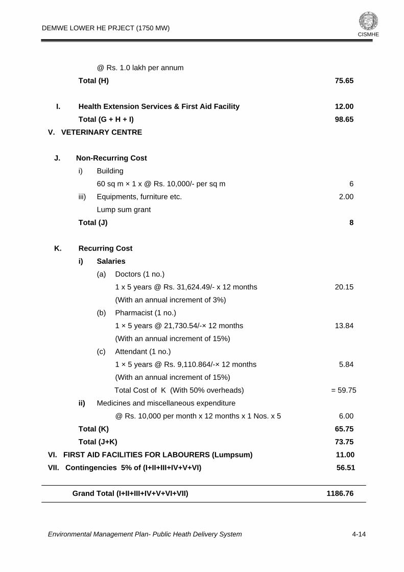
DEMWE LOWER HE PRJECT (1750 MW)
Environmental Management Plan- Public Heath Delivery System
4-14
CISMHE
@ Rs. 1.0 lakh per annum
Total (H) 75.65 I. Health Extension Services & First Aid Facility 12.00 Total (G + H + I) 98.65 V. VETERINARY CENTRE J. Non-Recurring Cost i) Building
60 sq m × 1 x @ Rs. 10,000/- per sq m 6
iii) Equipments, furniture etc. 2.00
Lump sum grant
Total (J) 8 K. Recurring Cost i) Salaries (a) Doctors (1 no.)
1 x 5 years @ Rs. 31,624.49/- x 12 months 20.15
(With an annual increment of 3%)
(b) Pharmacist (1 no.)
1 × 5 years @ 21,730.54/-× 12 months 13.84
(With an annual increment of 15%)
(c) Attendant (1 no.)
1 × 5 years @ Rs. 9,110.864/-× 12 months 5.84
(With an annual increment of 15%)
Total Cost of K (With 50% overheads) = 59.75
ii) Medicines and miscellaneous expenditure
@ Rs. 10,000 per month x 12 months x 1 Nos. x 5 6.00
Total (K) 65.75 Total (J+K) 73.75 VI. FIRST AID FACILITIES FOR LABOURERS (Lumpsum) 11.00 VII. Contingencies 5% of (I+II+III+IV+V+VI) 56.51
Grand Total (I+II+III+IV+V+VI+VII) 1186.76

DEMWE LOWER HE PRJECT (1750 MW)
CISMHE
5
SOLID WASTE MANAGEMENT 5.1 INTRODUCTION
The proposed Demwe Lower Hydroelectric Project will provide cheap and clean
power, direct and indirect employment opportunities, economic benefits to locals,
reduction in green house emissions and tourism potential on one hand. The
problems of loss of vegetal cover, increased soil erosion, muck disposal, air and
water pollution on the other pose some of the negative threats.
Solid waste generation will be the leading problem among the negative impacts
assuming that huge quantity of municipal waste that would be generated from
residential colony, labour camps and office buildings when the project is
constructed. Huge amount of sewage will also be generated from the similar
sources during the construction and operation phase of the proposed project.
The major generation sources for sewage and municipal wastes would be as
follows:
• Municipal waste from residential colony, labour camps, office buildings
• Sewage from residential colony, labour camps, office buildings
• Hazardous wastes (i.e. Bio-Medical wastes) from primary health centre and
hospitals
It is also expected that if proper management measures for solid waste are not
adopted, it will degrade the nearby environment, create hazards for labour and
staff that would be posted in the project area during construction/ operation
period of the project. Therefore, all the problems due to origination of solid waste
require proper management facilities. The types of wastes, its composition and
Environmental Management Plan – Solid Waste Management
5-1

DEMWE LOWER HE PRJECT (1750 MW)
CISMHE
major generation sources during the construction/ operation of proposed Project
are indicated in Table 5.1
Table 5.1: Expected typical composition of waste in proposed Demwe Lower Hydroelectric project. Waste Type Composition of waste Sources of waste generation
Municipal waste Food wastes, plastics, paper,
sewage, glass, vegetables waste.
From residential and labour camp
areas
Construction waste Empty cement begs, dust, debris,
demolition and construction
wastes, scrap, dust and ashes etc.
From construction site and crusher
etc.
Bio-medical waste Syringes, cotton, bandages, glass
tubes, etc.
From primary health centers
5.2 COMPOSITION OF MUNICIPAL SOLID WASTES
The composition of garbage in India indicates lower organic matter and high ash
or dust contents. It has been estimated that recyclable content in solid waste
varies from 13 to 20% and compostable materials is about 80-85%. A typical
composition of municipal solid waste is given below in Table 5.2.
Table 5.2: Typical composition of municipal solid wastes expected in Demwe Lower HEP.
Description Percent by weight
Vegetable, leaves 40.15
Grass 3.80
Paper 0.81
Plastic 0.62
Glass/ceramics 0.44
Metal 0.64
Stones/ashes 41.81
Miscellaneous 11.73
Source: Central Pollution Control Board
Environmental Management Plan – Solid Waste Management
5-2

DEMWE LOWER HE PRJECT (1750 MW)
CISMHE
Chemical composition of solid waste is another important aspect for evaluating
alternative processing and energy recovery point of view. The details of typical
chemical composition of municipal wastes in India are given in Table 5.3.
Table 5.3: Chemical components of municipal solid wastes expected in Demwe Lower HEP.
Component C (%) H (%) O (%) N (%) S (%) Ash (%)
Food wastes 48 6.4 37.6 2.6 0.4 5
Paper 43.5 8 44 0.3 0.2 6
Card board 44 5.9 44.6 0.3 0.2 5
Plastic 60 7.2 22.8 - - 10
Textiles 55 6.6 31.2 4.6 0.15 2.5
Rubber 78 10 - 2 - 10
Leather 60 8.0 11.6 10 0.4 10
Garden trimming 47.8 6 38 3.4 0.3 4.5
Wood 49.5 6 42.7 0.2 0.1 1.5
Dirt, ashes, brick etc 26.3 3 2 0.5 0.2 68
Source: Central Pollution Control Board
5.3 ENVIRONMENTAL AND HEALTH IMPACTS DUE TO IMPROPER SOLID WASTE MANAGEMENT Improper management of solid waste causes all types of pollution: air, soil, and
water. Uncontrolled dumping of wastes accelerates the contamination of surface
and ground water supplies. In urban areas, solid waste clogs drains, creating
stagnant water for insect breeding and floods during rainy seasons. Uncontrolled
burning of wastes and improper incineration contributes significantly to urban air
pollution. Greenhouse gases are generated from the decomposition of organic
wastes in landfills, and untreated leachate pollutes surrounding soil and water
bodies. These negative environmental impacts are only a result of solid waste
disposal.
Unscientific method being adopted for management of solid waste is a serious
health concern, particularly, during rainy season, when the run-off and high
Environmental Management Plan – Solid Waste Management
5-3

DEMWE LOWER HE PRJECT (1750 MW)
CISMHE
humid conditions increase the health hazards. Open dumping of garbage serves
as breeding ground for disease vectors such as flies, mosquitoes, cockroaches,
rats and other pests. High risks of spreading diseases like typhoid, cholera,
dysentery, yellow fever, encephalitis, plague and dengue fever may not be ruled
out.
5.4 MUNICIPAL SOLID WASTE MANAGEMENT
Management of municipal solid waste is one of the important issues. There are
three major steps involved in the management of garbage viz. collection,
transportation and disposal. The more concentration should be on the
segregation of waste. The common method for segregation and collection of
municipal solid waste is by using separate dustbins. There should be different
collection centers to collect the waste during the construction as well as
operation phase. The transportation of waste is also an important step in the
management of garbage. The garbage during transportation to the disposal site
is exposed to the open conditions thus causing public nuisance. The vehicles
carrying garbage should be therefore covered. Disposal of municipal solid wastes
is generally done trough various techniques and technology (i.e. sanitary land-
filling, Pelletisation, Pyrolysis/Gasification, Incineration, Vermiculture etc.). In the
context of Demwe Lower Hydroelectric Project, Sanitary land-filling is the suitable
technique for composting the bio-degradable waste. Other wastes including Non-
biodegradable like plastic, glass, scrap, etc. could be sold in the market.
Hazardous and Bio-Medical waste from hospital can be incinerated by the
incineration facility which is suggested in the management plan.
The garbage from the colony area should be collected at particular places in
collection pits/vats of particular sizes. From these places, garbage should be
transported to incinetors or landfill area. One dumper and wheel barrow are
proposed in the DPR for the purpose alongwith provisions for staff of 16-17
persons. The provision of budget for the infrastructure is included in the DPR of
Demwe Lower H.E. project except for incinerators.
Environmental Management Plan – Solid Waste Management
5-4

DEMWE LOWER HE PRJECT (1750 MW)
CISMHE
5.4.1 Estimation of Municipal Solid Waste Generation The estimated peak labor force for the proposed project is around 3000. This will
include technical, non-technical and service providers. Table 5.4 shows the
movement of workforce, coming and going in the region. Considering the non-
availability of local trained manpower for the execution of the project, it is
expected that majority of the workers will be coming from outside. The calculation
of population load in the region due to immigrant workforce is based on the
following assumptions:
i) It is assumed that 80% of laborers and 50% technical staff are likely to be
married.
ii) 80% of the total workers including technical staff have been considered as
migrant (considering maximum for management plan)
iii) 50% of the labor will comprise of both husband and wife.
iv) 50% of the technical staff will come with their families and only husband
will work.
v) 2% of the total migratory population are assumed as service providers
vi) 50% of service providers will have families.
vii) The family size for laborers as well as for technical staff is assumed to be
of 5 persons.
Table 5.4: Periodic Workforce requirement during the construction of the proposed
Demwe Lower H.E. Project
Year No. of laborers No. of skilled labor and technical staff Total
1st 1440 360 1800
2nd 1680 420 2100
3rd 2400 600 3000
4th 1680 420 2100
5th 800 1200 2000
The migrant population has been calculated around 8933 based on these
assumptions (Table 5.5). This population will reside in the project area at any
Environmental Management Plan – Solid Waste Management
5-5

DEMWE LOWER HE PRJECT (1750 MW)
CISMHE
given time. There are chances of increase in the migrant population. Here, the
population coming for establishing other small business related to project is not
considered. This temporary population will keep floating for 5-6 years. This much
huge population will generate enormous quantity of waste that needs to be
disposed without polluting land, air and water of the region.
Table 5.5: Total migrant population expected in the Demwe Lower H.E. Project S.No. Particular Family/Population A. Migrant workers i) Peak workers 2400
ii) Migrant workers (80%) 1920
iii) Single migrant workers (20% of 1920) 384
iii) Married migrant workers (80% of 1920) 1536
iv) Husband and wife both working (80% of 1536) 1230
v) Number of families where both husband and wife are working (1230/2) 615
vi) Families where only husband is working (615/2) 308
Total Population of A = 384 + (615 X 5) + (308 X 5) 4999 B. Migrant Technical staff
i) Total Peak technical staff 1200
ii) Single technical staff (50% of 1200) 600
iii) Married migrant technical staff (50% of 1200) 600
iv) Husband and wife both working (10% of 600) 60
v) Families where both husband and wife are working (60/2) 30
vi) Families where husband is only working 540
Total population of B = 600 + (30 X 5) + (540 X 5) 3450
C. Service Providers i) Total service provider (2% of the total population, i.e., A+B) 168
ii) Single persons 84
iii) Married service providers (50% of 168) 84
iv) Number of persons where husband and wife both are working (10% of 84) 9
v) Number of families where both husband and wife are working (10/2) 5
vi) Families where husband is only working 75
Total population of C = 84 + (5 X 5) + (75 X 5) 484 Grand Total of A+B+C = 4999 + 3450 +484 8933
Environmental Management Plan – Solid Waste Management
5-6

DEMWE LOWER HE PRJECT (1750 MW)
CISMHE
Generally in India, average per capita municipal solid waste generated per day is
calculated to be 425 g (dry weight). Certainly there will be huge solid waste
generation by 8933 persons. The calculated amount per year will be around
1447.78 ton. This waste should not be allowed to be dumped near any water
body or stream. The project developer should develop proper method of
collection and disposal of this waste.
5.5 SANITATION FACILITIES As mentioned earlier about 8933 workers and staff are likely to work during
project construction phase. Water consumption per capita in rural area has been
estimated to be 135 litres per day which shall include washing, bathing, cooking
and drinking requirements. The estimated quantity of water consumption for
workers is about 12,60,000 litres per day. Of which nearly 10,08,000 liters per
day would be changed into sewerage. It is therefore proposed to treat the
sewage generated from labour colonies and residential areas before disposal.
Normally, during project construction, the labour population is concentrated at 3
or 4 locations. Thus, the sewage would flow into river Lohit at these 3-4 locations.
The sewage is proposed to be treated before disposal to avoid the deterioration
of water quality of the receiving water body. It is proposed to commission
adequate number of septic tanks for treatment of sewage. It has been observed
during the construction phase of many projects, that contractor makes a block of
two large rooms in which about 30-40 workers stay. It is proposed that one
community latrine can be provided per 20 persons. The sewage from the
community latrines can be treated in septic tanks. For each 500 persons, one
septic tank should be provided. To ensure that the sewage from the labour
camps do not pollute the river water.
5.5.1 Septic Tanks
Solid waste from the toilets should be collected in the tanks or vats of 25 cubic meter
size. Soak pits or septic tanks should be near to each toilet set or building having
toilets. The total budget allocated for the construction and maintenance of these
septic tanks is around Rs. 14.11 lakhs.
Environmental Management Plan – Solid Waste Management
5-7

DEMWE LOWER HE PRJECT (1750 MW)
CISMHE
5.5.2 Bathrooms and Washing Facilities Workers and laborers will require bathing facilities. Provisions are made for
providing these facilities in the permanent as well as in temporary colonies. The
budget kept for this purpose is around Rs. 15.84 lakhs.
5.5.3 Sewage Treatment Plant The quantity of waste generated from the colony area shall be treated using
appropriate treatment methods. A sewage plant is proposed in the management
plan for treating the waste water. This waste water after proper treatment shall be
either reused for irrigation or horticultural purposes or should be released to the
streams or rivers. The cost and maintenance grant of the sewage plant is Rs.
55/- lakh.
5.5.4 Community toilets In order to avoid the open defecation, there is a provision of establishment of
community toilets at temporary colonies and working sites. Financial outlay for
community toilets would be Rs. 21.63 lakhs.
5.6 MANAGEMENT OF WASTES FROM CONSTRUCTION ACTIVITIES
Apart from the municipal solid waste in the project area, a lot of waste is
expected to be generated on account of construction activities. This would mainly
consist of cement bags, iron scrap, packing material, dust etc. It is expected that
most of the iron scrap and packing material would be recycled since it has reuse
value apart from monetary values and hence, it is proposed that stipulations
should be imposed on suppliers and contractors to take away the scrap and
packing materials. Apart from above, about 13.3 lakh MT of cement will be
required for remaining constructional works. Since cement is supplied in gunny
bags with capacity of each bag as 50 kg only. As a result large number of gunny
bags would require proper disposal arrangement. For this purpose, it is
proposed that for slope stabilization works, use of these gunny bags should be
made to the extent possible by filling them with debris and 2% cement for
Environmental Management Plan – Solid Waste Management
5-8

DEMWE LOWER HE PRJECT (1750 MW)
CISMHE
strengthening. These bags can be placed along the contours to reduce the flow
length and velocity. The remaining quantity of cement bags should be collected
and disposed properly.
5.7 MANAGEMENT OF HAZARDOUS WASTES FROM HOSPITALS It is expected that in Demwe Lower Hydroelectric Project, generation of
hazardous waste will be very less and would be mostly from of hospital waste.
Hospital waste is generated during the diagnosis, treatment or immunization of
human beings. Biomedical waste includes like anatomical waste, culture media,
discarded medicines, chemical waste, syringes, bandages, body fluids, human
excreta, etc. This waste is highly infectious and can be serious threat to human
health if not managed in a scientific manner. It is estimated that out of 15 kg of
hospital waste, 1 kg would be infected. For this purpose, special type of
collection container and incinerator should be placed in hospital for proper
collection and disposal of hospital waste.
5.8 OTHER MEASURES The following other measures are also proposed for management of solid waste
under the Demwe Lower Hydroelectric Project.
• A proper sewerage and drainage plan for each complex such as colonies and
office complexes should be formulated and implemented at the initial stages
when these structures are started by the project proponent
• There should be a separate drainage channel, which should be either
connected to a sewerage channel or should have its own treatment plant
before this waste is released in river Lohit or other aquatic body. In no case
the untreated water from the lanes and drains should be discharged in
riverine or reservoir system
• There should be a sewage treatment plant in each colony. Where it is not
feasible or the population is small, it is proposed that proper sewage septic
tanks should be installed. However provision for these community latrines and
septic tanks is being made by the project proponents in the project cost,
hence no budgetary estimate for these are made.
Environmental Management Plan – Solid Waste Management
5-9

DEMWE LOWER HE PRJECT (1750 MW)
CISMHE
• The solid waste like the kitchen waste, packing material, plastic bags, pet
bottles, office garbage etc. should not be littered all around. It is proposed that
proper litter collectors in sufficient numbers, separate for plastic goods and
other solid materials, should be installed at regular intervals within a locality,
or colony or office by the project authorities.
• It is also proposed that an incinerator must be installed near the site colony
for the proper disposal of the bio-medical waste from project hospitals.
• For the proper disposal of the plastic items, which is non-biodegradable in
nature, it is proposed that these can be collected and sold or sent for
recycling, wherever such facilities are available, otherwise these would create
lot of health and environmental problems.
5.9 COST ESTIMATE
Various facilities are proposed in the Solid Waste Management. The facilities
shall be provided by the project for keeping the entire project area as well as
region neat and clean. These facilities will be run and maintained by the project
authority for 5 years or as long as project construction work continues. The total
budget for the management of solid waste would be Rs. 128.58 lakhs.
Table 5.6: Estimated cost for the solid waste management in the Demwe Lower H.E. Project
S.No. Particulars Numbers Installation/ Maintenance Total Primary cost for5 years (Amount (Rs.) (Rs.) in lakhs)
I. Incinerator 1. At permanent settlement & Colony area 2 20.00 2.00 22.00
II. Septic tanks and soak pits @ Rs.0.30 Lakh per pit 1. For permanent settlements and 30 9 1.08 10.08
office area
2. For temporary settlements 5 1.5 0.18 1.68
3. At construction site 2 0.6 0.07 0.67
4. At villages 5 1.5 0.18 1.68
III. Bathrooms and Washing places 1. At temporary settlements Rs.0.30 lakhs 40 12 2.16 14.16
Environmental Management Plan – Solid Waste Management
5-10

DEMWE LOWER HE PRJECT (1750 MW)
Environmental Management Plan – Solid Waste Management
5-11
CISMHE
per set (one set with 10 cubicles of
1.5 m length x 2.0 m breadth)
2. In the village @ Rs.0.30 lakh per set 5 1.5 0.18 1.68
(one set with 10 cubicles of 1.5 m
length x 2.0 m breadth)
IV. Sewage Treatment Plan 1 50 5 55.00
V. Community Toilets
1. Community toilets at temporary 40 sets 16 3.60 19.60
colony/ settlement @ Rs.0.40 lakhs
per set (one set with 20 to 30 seats)
2. Community toilets at working sites 8 sets 1.6 0.43 2.03
@ Rs.0.2 lakhs per set (one with
4 to 5 seats)
Total Cost 128.58

DEMWE LOWER HE PRJECT (1750 MW)
CISMHE
6
PROVISION FOR FUEL AND ENERGY CONSERVATION
MEASURES
6.1 INTRODUCTION Arunachal Pradesh, one of the greenest states in the country with average
population density of thirteen persons to a sq km and about 8.4 million ha of rich
vegetation, the state is gravely threatened by deforestation. A large part of the
state’s revenue is generated directly from its forests. A note prepared by the
Arunachal Pradesh Forest Corporation (APFC) in March 1988 states that "90 per
cent of the state’s direct revenue is generated by its forests besides indirect
revenue in the form of allocable excise duty available mainly through the plywood
industry". With few opportunities for growth, the state has become heavily
dependent on external assistance. The per capita share of plan investment for an
Arunachal Pradesh tribal, at Rs 8,511, is the highest in the country today, way
above the national average of Rs 1,493. Despite this, only a small minority of the
tribal have profited from the lucrative timber trade. With no industrial base to
speak of, more than 75 per cent of Arunachal Pradesh population is dependent
on agriculture for their livelihood. A few get government jobs or find employment
in the transport and communication sectors. Clearly, the easy road to riches is
through timber operations. It was during the 1980s that forestry emerged as one
of the major contributors to the state’s net domestic product (NDP), its share
rising from 12 per cent in 1980-81 to around 20 per cent today. The road
construction sector, the most organized enterprise in the state, serves to provide
better access to hitherto untouched forests. The growing demand for timber has
created elite which wields immense political clout. Forests have become so
valuable that not only are the state government and the local elite vying for
greater control over them, but neighbouring states have also laid claims to them.
Environmental Management Plan – Provision for Fuel and Energy Conservation Measures
6-1

DEMWE LOWER HE PRJECT (1750 MW)
CISMHE
The acute shortages of timber, escalating prices and attractive profits have had
definite fallout in terms of increased illegal felling of trees. Apart from commercial
timber felling, complicated ownership claims over forest land are another source
of tension in the area. Local tribes are now asserting hereditary ownership rights
over the forest area and vast tracts are now being claimed as individual property
where even other villagers are denied entry. Boundary disputes, often leading to
violence, have become commonplace. While the tribal claim absolute right over
the land and forests, the state also claims ownership rights over them.
Legislation, which classifies vast forest areas as unclassed state forests,
complicates the situation further. The loss of forest cover is also posing a serious
threat to the fodder and energy resources of the villages. Historically, jhum or
shifting cultivation, which has been the dominant land use option in this region,
has been severely criticized for causing land degradation and deforestation.
While the shortening of the jhum cycle years has created vast deforested tracts,
putting the entire blame for this on the jhumias is unfair. After all, there is
extensive deforestation in certain tribal tracts like Tawang as well, where shifting
cultivation is not practiced.
The tribal populations in Arunachal Pradesh are undoubtedly very close to the
nature for their livelihoods in terms of shifting cultivation, animal hunting and
poaching. Extraction of fuel wood also has immense effects on the forest
resources wherein even the existing labourers in the region also use wood as
fuel. A number of measures have been suggested in the Forest Protection
measures under Bio-diversity Conservation plan, which can be enhanced with
formulating a suitable fuel and energy conservation measures. Major part of the
rural population in Lohit and Anjaw districts use wood as kitchen fuel. The
stresses on the forest resources may increase with increase in the population
due to the influx of migrant labourers. In order to minimize the pressure on the
forest products and strengthen the forest protection plan, the provision for fuel
and energy conservation measures are given in the following paragraphs.
Environmental Management Plan – Provision for Fuel and Energy Conservation Measures
6-2

DEMWE LOWER HE PRJECT (1750 MW)
CISMHE
6.2 NEED FOR THE FUEL AND ENERGY CONSERVATION MEASURES Survey of affected families of Demwe Lower H.E. project indicates that 87.9%
families use wood as kitchen fuel. Extrapolating the data, out of 1041 households
of 41 villages of study area, nearly 916 families are likely using wood as kitchen
fuel. About 416 families have facilities of LPG gas cylinders; therefore, there
would be a need of 625 new LPG connections for the rural households. In
addition to the villages, migrant workers and technical staff would require nearly
2525 new LPG gas connections.
6.3 SUGGESTED MEASURES In the backdrop of above critical aspects, provisions are made to meet fuel
requirements of incoming work force and families located within study areas. It is
proposed to provide LPG (Liquid Petroleum Gas) to these rural households and
workers by the project authorities. This would discourage them from illicit tree
felling and removal of fuel wood and timber from the adjoining forests. The
project authority will open LPG depot at different project site (Table 6.1).
Cooking gas shall be arranged from the concerned authorities. These facilities
can also be utilized by local people living in the nearby villages. Project authority
will also provide the facility of community kitchen to the labourers.
In addition to above mentioned measures efforts would be made towards energy
conservation and installation of non-conventional sources of energy as energy
conservation measures are of paramount importance for conserving the
environment. Under this program following facilities are proposed.
6.3.1 LPG Depots and Cylinders
One LPG (Liquid petroleum gas depot) has been proposed in the project. This
depot can be opened either near Parsasuram Kund or in Wakro. Wakro is Circle
head quarter and establishing of this facility at Wakro will also be useful for
nearby villages. Project developer/its Contractor’s will run scheme of free
distribution of gas cylinder to its employees and labourers whereas villagers
Environmental Management Plan – Provision for Fuel and Energy Conservation Measures
6-3

DEMWE LOWER HE PRJECT (1750 MW)
CISMHE
would be provided with one time assistance to obtain a new LPG connection.
The total budget for the connection (2525 connection) and establishment of
depot would be Rs. 138.40 Lakhs (Tables 6.1 and 6.2).
6.3.2 Community Kitchen
Community kitchen is suggested for the workers at the project site. Provisions
have been made for establishing four community kitchens (two for technical staff
and two for labourers). These facilities can be developed at Parasuram Kund or
at other location where maximum construction work will be going on. The total
budget for running these facilities would be around 70 lakhs (assuming
consumption rate of 2.5 kg LPG/person/month for average 2000 workers over
next 5 years @Rs. 350 per 15kg cylinder).
6.3.3 Energy Conservation Measures
The project area is remotely located. Most of the local people are not aware of
conservation measures of energy like pressure cookers, solar cookers, or other
efficient systems of cooking and saving energy. Here provisions are made to
make these facilities to the labourers also to the local people. In order to
conserve the energy, project developers are suggested to distribute pressure
cockers, solar cockers and smokeless chullahs to workers and villagers.
Total financial out lay for the provision of fuel and energy conservation is Rs. 229.00 lakhs.
6.3.4 Wood distribution from the diverted forest area The project authorities shall take necessary steps to provide free or subsidized
wood from the wood felled from the diverted forest areas from the forest dept.
Environmental Management Plan – Provision for Fuel and Energy Conservation Measures
6-4

DEMWE LOWER HE PRJECT (1750 MW)
Environmental Management Plan – Provision for Fuel and Energy Conservation Measures
6-5
CISMHE
Table 6.1: Establishment of new LPG depots and community kitchens in the project area S. No. LPG/ Community Kitchen Village (Tehsil) Number
1. LPG Depots Parasuram Kund or Wakro 1
2. Community Kitchen Parasuram Kund, Colony areas 4
Table 6.2: Financial provision for energy conservation measures in the project area
Sl.No. Foliation (Particulars) Amount (Rs. in Lakhs)
1. (a) Construction of LPG Depot (1Nos.) 50.00
(b) LPG connection + Cylinder cost (No. 2525) Rs. 88.3750 say 88.40
@ Rs. 3500 per connection
2. Pressure cookers 14.40
5. Installation of Smokeless chullahs 6.20
6. Community Kitchen / Canteens (4Nos.; refilling of cylinders 70.00
Total 229.00

DEMWE LOWER HE PRJECT (1750 MW)
CISMHE
7
DISPOSAL AND REHABILITATION OF MUCK
7.1 INTRODUCTION
The muck generated from various project activities during the construction of a
H.E. project may adversely affect the environment if not properly managed. The
generated muck volume, if not properly disposed, can i) destroy the landscape, ii)
increase the atmospheric particulate levels and iii) increase the sediment load in
river channels. The proposed Demwe Lower HE project is likely to generate large
volume of muck, of which some quantity will be utilizable and the remaining muck
volume needs to be rehabilitated at appropriate dumping sites in a technically
and ecologically sound manner. This chapter discusses all these aspects and
suggests a management plan for disposal and rehabilitation of muck.
7.2 MUCK SOURCE AND VOLUME
During the construction phase, a total 101.18 lakh cum of muck will be generated
from excavation for different appurtenant structures like diversion tunnel, dam,
adits, infrastructure works and power house complex (Table 7.1). About 40% of
the muck generated from overburden excavation, amounting to 20.00 lakh cum will
be utilized as aggregate for concrete and 4.2 lakh cum will be used in the Coffer
dam. The volume of the remaining muck from overburden amounts to 34.28 Lakh
cum and that from rock amounts to 42.70 Lakh cum. After adding a swelling factor
of 25% for overburden material and 60% for excavated rock, the total muck
volume that requires to be rehabilitated is 111.17 Lakh cum.
Environmental Management Plan – Disposal and Rehabilitation of Muck
7-1

DEMWE LOWER HE PRJECT (1750 MW)
CISMHE
Table 7.1: Status of muck generation in Demwe Lower H.E. project
Particulars Volume (Lacs
cum) Total (Lacs
cum)
Overburden(1) 50 Civil Hydraulic
Structures Rock(1) 40.58
Overburden(2) 8.48
Excavation
Infrastructure
Works and
Quarries Rock(2) 2.12
101.18
Concrete
40% of
Overburden(1) 20
Utilization
Coffer Dam Usable for Coffer
dam (from
Overburden) 4.2
24.2
Overburden 34.28 Remaining Muck Rock 42.7
76.98
Overburden 34.28 + 25%
Swelling
Factor=42.85.
Remaining Muck Volume with appropriate swelling factors
Rock
42.7+60% Swelling
factor=68.32
111.17
Capacity of the Muck Disposal sites
DS1 (81.4 Cum)
DS2 (31.58 Cum)
112.62
7.3 SELECTION OF DUMPING SITES The dumping sites were selected after careful examination of following points:
i) The dumping sites should be selected nearby the adits and near the dam
sites to avoid long-distance transport of muck.
ii) The sites must be free from active landslides or creeps and care should be
taken that the sites do not have a possibility of toe-erosion related slope
failure.
Environmental Management Plan – Disposal and Rehabilitation of Muck
7-2

DEMWE LOWER HE PRJECT (1750 MW)
CISMHE
iii) The base level of the sites must be at higher elevation than the maximum
flood level.
iv) The sites must not be on the concave side of a meander belt.
v) There should not be any channel of small streams flowing through the
dumping sites.
vi) These sites should not be pristine habitats containing endangered and rare
species.
Based on these criteria, two dumping sites (DS1 and DS2) have been identified
on the plain area near Parasuram Kund on the left bank of Lohit river to
rehabilitate the generated muck ( Figure.7.1, Table 7.2). These dumping sites
are situated about 1-2 km from the main construction area. Total land
requirement for these sites is 150 ha of which the dumping site DS1 is spread
over 100 ha and DS2 acquires 50 ha. The calculation of muck accommodative
volume of DS1 and DS2 was based on surveyed cross-sections at 200 m
intervals. In total, 11 cross-sections for DS1 and 4 cross-sections DS2 were used
in the estimation of muck accommodative volume available at these sites
(Figure.7.2). The measured cross-sectional area varies from 360.06 to
10426.76 m2 for DS1 and 3223.59 to 5394.89 m2 for DS2. The DS1 and DS2
have the capacity to accommodate 81.04 Lakh cum and 31.58 Lakh cum of
muck, respectively.
Table 7.2: Dimensions of muck disposal sites
Sites Area Elevation Range
Length Cross sectional area of Muck deposits at 200 m intervals
Total no of cross-sections
Total Capacity (Lakh Cum)
DS1 100 ha 295-300 m 2200 m 360.06 to 10426.76 11 81.04
DS2 50 ha 310-340 m 800 m 3223.59 to 5394.89 4 31.58
Total 150 ha 295-340 m 3000 - 15 112.62
Environmental Management Plan – Disposal and Rehabilitation of Muck
7-3

DEMWE LOWER HE PRJECT (1750 MW)
CISMHE
The tree species present in the dumping sites are Albizia procera, Bombax ceiba,
Phyllanthus emblica and Sterculia villosa. Among the shrubs are Chromolaena
odoratum and Phlogacanthus thrysiformis. The herbs growing in these sites are
Achyranthes aspera, Boerhavia diffusa, Cynodon dactylon and Thysanolaena
latifolia. None of these species falls in rare or endangered category. In the north of
DS1 flows the Lohit river and in the south of it, there is a small seasonal nala (See
Figure 7.1 and the inset). Since the convex face of the Lohit river channel is
present in the north, the possibility of toe-cutting along this slope is minimal. The
Lai river flows in the south of DS2. The main channel of Lai river is away from
DS2. There is no active landslide or slow creep of the slopes at these sites.
7.4 MUCK REHABILITATION PLAN
The muck rehabilitation plan involves both engineering and biological measures
that depend on the terrain and eco-climatic conditions. Stability of the loosely
held muck requires appropriate method of consolidation and biological measures
so that the muck is not easily eroded leading to subsequent ecological problems.
The measures suggested for the proposed dumping sites in the Demwe Lower
HE Project are discussed below.
7.4.1 Engineering Measures
Retaining walls filled with plum concrete are proposed to hold the disposed muck
(Figure 7.1). These retaining walls (5m high) shall be of stone masonry filled with
plum concrete for both the dumping sites (Figure 7.2). The retaining walls shall
be provided in stone masonry of grade M15 (1:2:4). The foundation of retaining
wall structure shall be of cement concrete of grade M10 (1:3:6). A stone filled
layer shall be placed at the side facing the dumped materials. The retention walls
should carry weep holes for the discharge of subsurface water during rainy
season. The weep holes should also carry filters at the side facing the dumped
materials.
Environmental Management Plan – Disposal and Rehabilitation of Muck
7-4

DEMWE LOWER HE PRJECT (1750 MW)
CISMHE
The total length of the retention walls works out to 5272.34 m approximately. The
total estimated volume of the foundation of retaining wall would be around
16607.87 cum and that of the retaining wall would be 99174.92 cum. These
retaining walls are proposed to be located at more than 80 m distance from the
highest flood level. The muck will be disposed at an angle of repose less than
25°. Detailed plan of the dumping area and retaining wall for both the dumping
sites are shown in Figure 7.1 and 7.2. In order to ensure slope stabilization, the
slopes may be broken into terraces wherever required.
7.4.2 Biological Measures Vegetation cover controls the hydrological and mechanical effects on soils and
slopes. Therefore, biological measures to stabilize the loose slope are essential.
However, such measures are dependent on the local environmental conditions.
The stages in implementation of such measures are discussed below.
Fencing
After rehabilitation of muck the dumping areas need to be protected for some
time, from grazing by domestic animals, livestock, sheep and goats. For this
reason fencing over the muck deposits is required. Barbed wire strands with two
diagonal strands, clamped to wooden/concrete posts placed 3 m apart is
proposed for this purpose. Both the ends of the wooden fence posts should be
coated with coal tar to ensure longevity of the intervention.
Selection of plant species
Different plant species may be utilized for different ecological and engineering
functions. Grasses are more suited for armoring the loose soil surface, and
shrubs or trees hold the soil upto the deeper level. The selection of plant species
used for rehabilitation of soil/muck must take into account the climatic, soil and
drainage conditions of the site.
The dumping sites located in Demwe Lower HE project are located in the
altitudinal range of 295 to 340 m. The area has tropical climate and major part of
Environmental Management Plan – Disposal and Rehabilitation of Muck
7-5

DEMWE LOWER HE PRJECT (1750 MW)
CISMHE
the precipitation is received during July to September. About 1000 mm of rain is
received during July. In some years high rainfall may be received during April.
The period from November to January is relatively dry. Considering all these
factors as well as the existing natural vegetation in the area, the species
recommended for plantation are listed in Table 7.3.
Table 7.3: Plant species recommended for plantation in the dumping sites
Botanical Name Common Name Family Trees Albizia lucida Moj Mimosaceae
A. procera Koroi Mimosaceae
Artocarpus lacucha Dewasali Moraceae
Bischofia javanica Urium Bischofiaceae
Bombax ceiba Himolu Bombacaceae
Callicarpa arborea Guelo Verbenaceae
Castanopsis indica Hingori Fagaceae
Cinnamomum pauciflorum Gonsoroi Lauraceae
Duabanga grandiflora Khokan Sonneriaceae
Kydia calycina Pichola Malvaceae
Gynocardia odorata Chalmugra Flacourtiaceae
Lannea coromandelica Jia Anacardiaceae
Phyllanthus emblica Aonla Euphorbiaceae
Pterospermum acerifolium Hathipoila Sterculiaceae
Spondias pinnata Amara Anacardiaceae
Sterculia villosa Udal Sterculiaceae
Syzygium cumini Jamon Myrtaceae
Terminalia myriocarpa Hollock Combretaceae
Toona ciliata Toon Meliaceae
Xylosma longifolia Kot kua Flacourtiaceae
Shrubs Buddleja asiatica Pasauti Loganiaceae
Chromolaena odoratum - Asteraceae
Environmental Management Plan – Disposal and Rehabilitation of Muck
7-6

DEMWE LOWER HE PRJECT (1750 MW)
Environmental Management Plan – Disposal and Rehabilitation of Muck
7-7
CISMHE
Botanical Name Common Name Family
Clausena heptaphylla Kebu-taye Rutaceae
Dracaena angustifolia Dracaena Agavaceae
Calamus floribundus Bent Arecaceae
Jatropha curcas Jatropa Euphorbiaceae
Phlogacanthus thrysiformis - Acanthaceae
Phoenix sylvestris Khjur Arecaceae
Herbs Achyranthes aspera Chirchita Amaranthaceae
Boerhavia diffusa Punernava Nyctangiaceae
Bergenia ciliata Silphari Saxifragaceae
Cynodon dactylon Durva Poaceae
Capillipedium assimile - Poaceae
Chrysopgon gryllus - Poaceae
Saccharum elephanticus Elephant grass Poaceae
Thysanolaena latifolia - Poaceae
Planting of trees The selected species will be planted after their nurseries have been developed.
The saplings will be transplanted when these are 1-2 year old. The plantation can
be carried out in lines across the slope, usually following the contour to prevent
the development of rill, and trap material moving down the slope. Brush layers,
fascines and palisades can be used because their use controls erosion, catches
debris and provides strong, fibrous root reinforcement. Different plant species
when used together will provide increased stability. Grasses planted in a line
across a slope will provide a continuous chain of support in retaining debris,
reinforcing soil and increasing the infiltration capacity of the area.
Plant saplings may be raised on biodegradable pots and transplanted as such.
The plantation should be done during monsoon season. Pits of 0.45 m x 0.45 m x
0.45 m will be dug and filled with some soil rich in nutrients. Compost from the
local organic waste can be used. An integrated biotechnological approach will be

DEMWE LOWER HE PRJECT (1750 MW)
CISMHE
very useful for sustenance and growth of plants. This approach involves the
following steps:
i) Assessment of the nutrient status of the soil and evaluation of the physical
and chemical properties of the dumped material.
ii) Formulation of the appropriate blend of organic waste and soil to enhance
the nutrient status of the rhizo sphere.
iii) Isolation and screening of specialized strains of mycorrhizal fungi,
rhizobium, azobacter and phosphate solubilizers (biofertilizer inoculum)
which can be best suited for the dumped material.
iv) Mass culture of plant specific biofertilizer and mycorrhizal fungi.
v) Plantation of dumping sites/areas using identified blend and biofertilizer
inoculums.
The rich soil and farmyard manure requirement for nearly 100 pits will be about
1cubic meter with approximate weight of 200 kg. The saplings will be planted at 3
m intervals along the contour and 5 m across it. Wherever terracing shall be
prescribed, the same will be done on terraces at 3m intervals leaving one-meter
space from the edge of the terrace. About 600 to 900 seedlings shall be planted
per ha depending on the space available at the site. Shrubs and herbs will be
planted in the interspaces. The local Forest Officials should be informed of the
requirement of species well in advance and the seedlings will be procured on the
prevalent cost basis. About 80,000 plant saplings will be planted at different
dumping sites and 100 ha area including inter-space area of land would require
grass seeding.
7.4.3 Utilization of Dumping Sites Considering the inflow of population and development of colony, schools etc. in
the region, and scenic beauty on the right bank and downstream stretch part of
DS1 can be developed into a children’s park after rehabilitation of the muck. If
Environmental Management Plan – Disposal and Rehabilitation of Muck
7-8

DEMWE LOWER HE PRJECT (1750 MW)
CISMHE
required, part of DS2 can be developed as a parking site. The remaining areas of
DS1 and DS2 require biological measures for stabilization.
7.5 BUDGETARY PROVISIONS
The rates for retaining wall and other measures adopted in the DPR DLHEP
(2008) are given in Table 7.4. The total cost requirement for the purpose of
rehabilitation of muck is Rs.7000 lakh of which the requirement for engineering
measures is Rs 5495 lakh. The engineering measures includes Rs. 622 lakh for
Cement concrete of grade M10 (1:3:6) for foundation of retaining wall structure,
Rs. 158 lakh for Earth work excavation in hard rock for foundation, and Rs. 4315
lakh for Cement concrete of grade M15 (1:2:4) for retaining wall. An amount of
Rs1503.76 lakh has been kept for reclamation of dumping area, which includes
rolling of muck, plantation and associated activities as well as establishment of
park and parking place in the dumping sites. This also includes the cost for
maintenance, which will be required at the end phase of the project construction
and even after the installation.
Table 7.4: Cost Estimate for different measures at the dumping site
S. No.
Particular
Volume (Cum)/ Quantity
Rate per Cum (adopted in
DPR DLHEP) in Rs.
Cost (Rs. Lakh)
A Engineering Measures
1.
Earth Work excavation in Hard rock for
Foundation
29063.78 543 158
2.
Cement Concrete of Grade M10 (1:3:6)
for foundation of Retaining wall Structure
16607.87 3745 622
3.
Cement Concrete of Grade M15 (1:2:4)
for Retaining Wall
99174.92 4351 4315
4. Stone filling and filter behind the wall Lumpsum 400
Total (A) 5495
B Reclamation of Dumping area
Environmental Management Plan – Disposal and Rehabilitation of Muck
7-9

DEMWE LOWER HE PRJECT (1750 MW)
Environmental Management Plan – Disposal and Rehabilitation of Muck
7-10
CISMHE
S. No.
Particular
Volume (Cum)/ Quantity
Rate per Cum (adopted in
DPR DLHEP) in Rs.
Cost (Rs. Lakh)
1. Rolling of Muck Lumpsum 800.00
2.
Pitting (size: 0.45m x 0.45m x
0.45m)
80,000 pits Rs.33.08 per pit 26.46
3. Manure and Imported soil in pits 80,000 pits Rs 4.00 per pit 3.20
4. Raising Plants 1,00,000 plants Rs 18.98 / plant 18.98
5. Grass Seeding 100 ha Rs. 1320/ha 1.32
6.
Fencing of area with barbed wire 4
strands horizontal and two strands
diagonal
10,000 m Rs 38/ running
Meter
3.80
7.
Watering, maintenance and
transport and Miscellaneous
expenses
Lumpsum 500.00
8.
Parking Place and Children’s
Park
Lumpsum 150.00
Total (B) 1503.76
Total (A+B) 6998.76
Total cost Say Rs. 7000 Lakh = Rs 70 Crore

Figure 7.1
Dumping site (DS1, DS2) and their relative positioning with respect to rivers and other proposed activity areas. Inset: a scene from google earth showing the terrain in and around the dumping sites.

Figure 7.2a
Cross-sections of Muck Dumping Area (Refer Figure 7.1 for location)

Figure 7.2b
Cross-sections of Muck Dumping Area (Refer Figure 7.1 for location)

Figure 7.2c
Cross-sections of Muck Dumping Area (Refer Figure 7.1 for location)

Figure 7.2d
Cross-sections of Muck Dumping Area (Refer Figure 7.1 for location)

Figure 7.2e
Cross-sections of Muck Dumping Area (Refer Figure 7.1 for location)

Figure 7.2f
Cross-sections of Muck Dumping Area (Refer Figure 7.1 for location)

DEMWE LOWER HE PRJECT (1750 MW)
CISMHE
8
RESTORATION OF CONSTRUCTION AREAS AND
LANDSCAPING
8.1 INTRODUCTION Demwe Lower H.E. Project will involve construction of colonies for staff and
laborers, roads linking to various components of the project, offices, workshops,
etc. Total area likely to be affected due to these activities is around 1589.97 ha.
This land also includes areas likely to be affected due to quarries, submergence
and dumping of unused muck, dam construction and powerhouse site. At
present, the proposed project area is covered with open/dense forest particularly
at dam and power house site. The proposed colony area and office complex at
present is covered with secondary forests. This existing landscape will be totally
modified or changed due to proposed project. It is, therefore, important that after
the project work and related activities are over, these disturbed areas are
restored to bring them back to their similar or near to similar pre-construction
condition or in improved state. For the restoration and landscaping of the colony
and other disturbed regions in the project, a budget of Rs. 168.35 lakhs is
proposed in the management plan.
8.2 DISTURBED SITES AND THEIR RESTORATION
Around 1589.97 ha land in the region will be directly disturbed due to various
construction activities of the proposed project, like submergence area, roads,
muck dumping sites, quarry sites, colonies, workshops, offices, etc which will
change the existing land use/ land cover in the region. After completion of the
construction work, it is required to restore the disturbed area to its original
condition. Restoration of dumping sites and reservoir area are given in the
Chapter 7 and Chapter 9 of EMP volume, respectively. Here restoration of quarry
sites, roads and colony area is discussed and a detailed plan is given for the
Environmental Management Plan – Restoration of Construction Areas and Landscaping
8-1

DEMWE LOWER HE PRJECT (1750 MW)
CISMHE
landscaping of the region. Various engineering and biological measures have
been suggested for the restoration of these areas. Proposed mitigation measures
will also help to arrest soil erosion in the region.
8.3 QUARRY SITE
The quarry sites (QS1 and QS2) are located in the project area for the excavation
of constructional material (Table 8.1). Total area of the proposed quarry site is
around 60 ha. After excavation of the required material, maximum area of the
quarry sites (entire area in case of QS1 and a part of QS2) will be submerged and
will become part of the reservoir at operation phase. However, remaining disturbed
quarry site will require restoration. Appropriate engineering, bio-engineering and
biological methods are proposed for effective restoration of the quarry sites.
8.4 RESTORATION OF QUARRY SITES Some of the land area identified for the excavation of sand and rock (quarry
area) falls in the reservoir area and will be submerged after filling the dam. The
quarry area QS1 will be completely submerged and a part of QS2 will be under
submergence. Various biological, bio-engineering and engineering measures are
proposed for the restoration of the quarry site QS2 and total budget for the
purpose of restoration of quarry site is shown in Table 8.5
8.5 ENGINEERING AND BIO-ENGINEERING MEASURES The top soil (top 6-12 inch soil) should be removed before excavating the sand or
rocks from the quarry sites. This soil contains all microbes (including earth
worms) and important nutrients and organic matters which will be required at the
time of restoration of these quarry sites. The craters formed at the quarry sites
will be filled with muck consisting of boulders, rocks, gravel and soil from the
nearby sites. All the muck required for filling at quarry sites, QS2 will be
transported from dam site or power house site in the downstream of quarry site,
near Parsuram Kund. After filling these craters, the top soil collected prior to
quarrying will be spread as top layer. The top soil then should be covered with
Environmental Management Plan – Restoration of Construction Areas and Landscaping
8-2

DEMWE LOWER HE PRJECT (1750 MW)
CISMHE
geo-textiles like coir, jute or by other locally available bio-degradable material.
This will protect the top soil from erosion.
Table 8.1: Area and location of the quarry site proposed in the Demwe Lower H.E. Project
Quarry Sites Location of Quarry Sites Area QS1 Left Bank 17.43 ha
QS1 (under submergence) Left Bank 17.43 ha
QS2 Right Bank 42.57 ha
QS2 (under submergence) Right Bank 19.04ha
Area to be restored 23.53 ha
8.5.1 Biological Measures Half portion of the site at QS2, covering land area of approximately 18.5 ha will
remain outside of the submergence area. This area needs to be planted
extensively. This part will also become part of green belt. The saplings of trees
and shrubs should be raised using microbial inoculum like, VAM (Vesicular-
arbuscular mycorrhiza), bacterial and fungal strains. The steps for raising plant
saplings with mycorrhizal colony are given below:
(I). Top soil collection from quarry sites before start of quarrying.
(II). This soil which is rich in microbes shall be used for the preparation of seed
beds and shall also be filled in polybags for raising saplings.
(III). Isolation of VAM from the roots of juvenile seedlings particularly dominant
tree species which are available in the region.
(IV). Suitable strain of VAM and other microbe can also be obtained from IARI,
New Delhi and/or IMTECH, Chandigarh.
(V). Preparation of mother culture and their appropriate dilution.
(VI). Growing of plant species which will be inoculated by specific and efficient
strains,
(VII). Mixing the soil with the VAM inoculum and filling in the polybags.
(VIII). Planting of saplings in the polybags two days after inoculating the soil with
fungal microbial strains.
Environmental Management Plan – Restoration of Construction Areas and Landscaping
8-3

DEMWE LOWER HE PRJECT (1750 MW)
CISMHE
(IX). After thirty days of inoculation these saplings can be planted at the quarry
sites.
8.6 COLONY AND OFFICE COMPLEX
Around 170ha will be disturbed due to construction of colony area, office colony,
crusher and batching plant and workshop etc. (Table 8.2). Except crusher and
batching plants (two sites) all other sites are in the downstream of the dam.
Colonies are proposed on the left bank of Lohit river along the National Highway
52, further land will also be acquired for the construction of roads etc.
Table 8.2: Area and location of colonies, office complexes, job site and other sites in the proposed Demwe Lower H.E. Project
S. No. Site specification Area 1 Construction facility equipment 25.47 ha
2 Construction facility workshop 5.0 ha
3 Construction facility steel yard 13.0 ha
4 Construction facility Fabrication yard 13.0 ha
5 Construction facility labour camp 36.0 ha
6 Construction facility office set up 3.0 ha
7 Construction facility office colony 5.0 ha
8 Permanent Colony 60.0 ha
9 Crusher and Batching Plant 11.24 ha
8.7 RESTORATION OF COLONY AND OFFICE COM PLEXES Due to various projects activities viz., road construction, deforestation, office
complexes, etc some area of Parasuram Kund may be affected. Engineering and
biological measures are suggested for the stabilization and beautification of the
disturbed area. Following measures should be adopted for the restoration and
landscaping of colony areas and construction sites.
Environmental Management Plan – Restoration of Construction Areas and Landscaping
8-4

DEMWE LOWER HE PRJECT (1750 MW)
CISMHE
(I). Proper roads and lanes would be provided inside the colony area. Open area
should be covered with vegetation. Ornamental plants and avenue trees
should be planted along the roads and lanes.
(II). Retaining walls should be built to avoid landslides and slips. Proper drainage
would be provided inside colony for the outlet of the domestic/rain water.
(III). Parks and play grounds would be developed.
(IV). After the completion of all the construction activity, the construction sites and
other temporary settlements would be covered with the top soil from the
quarry site which would support the growth of plant species. These plant
species which grow first are considered ecological pioneers and would initiate
the process of succession and colonization.
8.7.1 Engineering Measures
During construction phase, some patches in the area are likely to be prone to
soil erosion. Construction of retaining walls would be necessary to stabilize the
slopes. The budget kept for the construction of retaining walls and for other
engineering measures is around Rs. 13.14 Lakhs. 8.7.2 Biological Measures
In the project area, the primary forests are destroyed at places and developed
into secondary forests due to various biotic and abiotic factors like shifting
cultivation, developmental activities, landslides, fires, etc. There is possibility that
after construction, these degraded forests existing in the area will be further
destroyed or damaged. Plantation of the tree species and shrubs are suggested
in the colony area. Local plant species should be preferred for plantation. Some
of the plant species are mentioned in Table 8.4. Total budget allocated for the
purpose is around Rs.13.82 lakhs which includes maintenance cost also (see
Table 8.5).
Environmental Management Plan – Restoration of Construction Areas and Landscaping
8-5

DEMWE LOWER HE PRJECT (1750 MW)
CISMHE
8.8 ROADS AND BRIDGES
Most of the project components are along National Highway 52 and there is
requirement of around 32 km of additional road (Table 8.3). Two bridges are also
proposed in the project area. One bridge is in upstream of the dam axis on Lohit
river and another is on Tidding river (Table 8.3). The region will be disturbed due
to construction of roads and bridges. Various measures are suggested for the
stabilization of the disturbed area.
Table 8.3: Roads and bridges in the proposed project area of Demwe Lower HE project Bridges 1. 40 R Bailey Bridge Upstream of dam axis
2. 18 R On Tidding river Will be constructed
Roads: The roads construction activity include
a. realignment of Tidding road : 3 km
b. construction of Left Bank road :10 km
c. construction of Right Bank road :10 km
The land requirement for road construction is as follows:
a. Left Bank road :10 ha
b. Right Bank Intake/Diversion Tunnel inlet :5 ha
c. Right Bank Diversion Tunnel Outlet :1 ha
d. Quarry area road :14 ha
e. Tidding road :10 ha
8.8.1 Engineering Measures
Road construction in the proposed project will disturb the hill slopes and result in
excavated material (muck). Retaining walls are proposed in the region to avoid
slippage and land slides. The loose muck should be covered with geo-textiles like
jute or other locally available material.
Environmental Management Plan – Restoration of Construction Areas and Landscaping
8-6

DEMWE LOWER HE PRJECT (1750 MW)
CISMHE
8.8.2 Biological Measures
Even though a muck disposal plan has been proposed, some of the excavated
muck are likely to form thin apron on mountain slopes along the road. Provisions
are made to cover such slopes with vegetation. Trees and shrub saplings should
be planted along the road. Seeds of herbs and grass species should be spread
over the loose soil. Some plants for plantation are suggested in the Table 8.4.
Table 8.4: Some important plant species for plantation in the colony area, quarry sites
and along the road sides
Botanical name Vern. name Use 1. Colonies/ Office complex Trees 1 Albizia procera Koroi landscaping
2 Alangium chinense Karam landscaping
3 Alstonia scholaris Satiana landscaping
4 Bauhinia purpurea Kanchon landscaping
5 B. variegata Kanchon landscaping
6 Cassia fistula Amltas landscaping
7 Dalbergia sissoo Shisam landscaping
8 Dillenia indica Outenga landscaping
9 Ficus bengalensis Borgad landscaping
10 Holarrhena pubescens Kudla landscaping
11 Kydia calycina Pichola landscaping
12 Magnolia hodgsonii Boromthuri landscaping
13 Michelia champaca Champ landscaping
14 Moringa oleifera Sahjan landscaping
15 Phyllanthus emblica Aonla landscaping
16 Pterospermum acerifolium Hathipoila landscaping
17 Spondias pinnata Amara landscaping
18 Sterculia villosa Udal landscaping
19 Syzygium cumini Jamun landscaping
20 Terminalia bellerica Bahera landscaping
Environmental Management Plan – Restoration of Construction Areas and Landscaping
8-7

DEMWE LOWER HE PRJECT (1750 MW)
CISMHE
Shrubs
1 Abroma angusta Gorkhya Kudai landscaping
2 Alsophila spinulosa Tree fern landscaping
3 Asparagus racemosus Satawari landscaping
4 Bambusa tulda Bijili landscaping
5 B. pallida Makal landscaping
6 Dendrocalamus hamiltonii Kakua landscaping
7 Murrya paniculata Nera Khar sing landscaping
8 Phlogacanthus thyrsiflorus landscaping
Herbs
1 Achyranthes aspera Chirchita landscaping
2 Alpinia allughas Tarka landscaping
3 Arundina graminifolia Orchid landscaping
4 Coix lacryma-jobi Gargar landscaping
5 Curcuma longa Haldi landscaping
6 Saccharum elephanticus Elephant grass landscaping
7 S. spontaneum Kus landscaping
8 Thysanolaena latifolia Broom grass landscaping
9 Zingiber officinale Zinger landscaping
2 Roadside/Avenues
Trees
1 Albizia lucida Moj landscaping
2 Altsonia scholaris Satiana landscaping
3 Butea monosperma Dhak landscaping
4 Crateva unilocularis Baruna landscaping
5 Calophyllum polyanthum landscaping
6 Duabanga grandiflora Khokon landscaping
7 Erythrina stricta landscaping
8 Gmelina arborea Gomari landscaping
9 Gynocardia odorata Bandepele landscaping
10 Magnolia hodgsonii Bromthuri landscaping
Environmental Management Plan – Restoration of Construction Areas and Landscaping
8-8

DEMWE LOWER HE PRJECT (1750 MW)
CISMHE
11 Mangifera sylvatica Bonam landscaping
15 Pandanus nepalensis Kewra landscaping
16 Sapindus mukorossi Reetha landscaping
17 Terminalia myriocarpa Hollock landscaping
Shrubs
1 Alsophila spinulosa Tree fern landscaping
2 Asparagus racemosus Satvari landscaping
3 Bambusa tulda Bijili landscaping
4 Calamus floribundus Bent landscaping
5 Clerodendrum bracteatum landscaping
6 Dracaena angustifolia Dracaena landscaping
7 Dendrocalamus hamiltonii Kakua landscaping
Herbs
1 Pennisetum purpureum landscaping
2 Saccharum elephanticus Elephant grass landscaping
3 Themeda arundinacea Thatch grass landscaping
4 Thysanolaena latifolia landscaping
8.9 COST ESTIMATES Cost estimates for different components of the landscaping and restoration are
given in the Table 8.5. An amount of Rs. 240.88 lakh would be required to
restore the disturbed area to its near original state. Component-wise required
budget for restoration is given in Table 8.5.
Table 8.5: Cost estimates for Restoration Works and Landscape Designing
S.No. Item of Work Unit Quantity Rate/unit Amount
(Rs)
A. Quarry Sites
(i) Engineering measures
a) Removal of top soil ha 60 8000 480000
Environmental Management Plan – Restoration of Construction Areas and Landscaping
8-9

DEMWE LOWER HE PRJECT (1750 MW)
CISMHE
S.No. Item of Work Unit Quantity Rate/unit Amount
(Rs)
(transplantation and stockpiling)
b)
Filling of crates with muck,
stones, etc.( Cum 1600 1500 2400000
c)
Retaining walls, diversion
channels Cum 1700 6000 10200000
(ii) Bio-engineering measures
a)
Carpeting with geo-textiles (coir,
jute and other local fibers)
sq.
m. 72000 48.4 3484800
b) Grass seeding ha 24 1320 31680
(iii) Biological measures
(a)
Planting of herbs and grass
species no 90000 10 900000
(b) Planting of trees and shrubs no 180000 4 720000
B. Colony Area, Office Complexes
(i) Engineering measures
(a) Retaining walls Cum 100 6000 600000
(b) Leveling the area
sq.
m. 87500 8.16 714000
(c)
Development of parks, etc.
(suggested in Muck disposal
chapter) 0 0 0
(ii) Bio-engineering measures
(a)
Covering the slopes with geo-
textiles
sq.
m. 17500 48.4 847000
(b) Grass seeding ha 87.5 1320 115500
(iii) Biological measures
(a) Planting of trees and shrubs no 10500 30 315000
(b)
Planting of flowering plants and
other herbs no 5250 20 105000
C. Roads and Bridges
(i) Engineering measures
Environmental Management Plan – Restoration of Construction Areas and Landscaping
8-10

DEMWE LOWER HE PRJECT (1750 MW)
Environmental Management Plan – Restoration of Construction Areas and Landscaping
8-11
CISMHE
S.No. Item of Work Unit Quantity Rate/unit Amount
(Rs)
(a) Retaining walls Cum 267 1500 400000
(b) Stream bank stabilization 6 1000 6000
(ii) Bio-engineering
(a)
Carpeting the slopes with coir,
jute or local fibers 2000 48.4 96800
(b) Grass seeding ha 10 1320 13200
(iii)
Biological measures – Planting
trees, shrubs and herbs
D. Development of Nursery
(i)
Infrastructure including land
cost
Nil
(provision has been made
under the CAT plan) 0 0 0
(ii)
Collection of seeds & Spraying
of Seeds sq.m 30000 80 2400000
(iii) Raising of plants no 70000 20 1400000
(iv)
Manpower to maintain the
nursery 4
5000/month
for 5 years 1200000
Total (A + B + C + D ) 2,40,88,980

DEMWE LOWER HE PRJECT (1750 MW)
CISMHE
9
CREATION OF GREEN BELT AROUND THE RESERVOIR
9.1 INTRODUCTION
The proposed dam of 163.12 m (above deepest foundation) height at Parasuram
Kund will create a reservoir of around 1131 ha area. The length of the reservoir
will be around 23 km along the Lohit river. Around 50% of the reservoir area at
present is covered with forest of dense or open type. Slopes along the river are
mostly stable. Some areas around the reservoir are under cultivation or have
scrub forests, which are the main source of silt to the reservoir. Creation of green
belt has been proposed around the reservoir of Demwe Lower H.E. Project to
reduce the silt flow in the reservoir and thus increase its life. The area taken for
the creation of green belt is around 2887.8 ha along the periphery of the reservoir
and the budget allocated for this purpose is around Rs. 91.45 lakhs.
9.2 OBJECTIVES Main objectives of creating a green belt around a reservoir are to i) check soil
erosion around the reservoir, ii) check landslides and slips around the reservoir,
and iii) develop the habitat for wildlife particularly birds and butterflies. Besides
these objectives, development of lake view points and creation of recreation sites
along the reservoir rim are two additional aspects. Development of green belt
around the reservoir will also improve the habitat of birds and other wild animals
around the region. Planting of trees, shrubs and other plant species in the region
will definitely improve the environment of the region besides checking the soil
erosion.
9.2.1 Green Belt Structure and Development Planning In the proposed Demwe Lower H.E. Project, the area taken for the development
of green belt around the reservoir is around 2887.8 ha. This area has been
divided into three layers for plantation of plant species depending upon the
Environmental Management Plan – Creation of Green Belt around the Reservoir
9-1

DEMWE LOWER HE PRJECT (1750 MW)
CISMHE
microclimatic condition that will develop after creation of the reservoir in the
region (Fig. 9.1). Various engineering and bioengineering measures for the
stabilization of the region around reservoir rim will be applied under the proposed
CAT plan of Demwe lower HE project and, therefore, have not been considered
here. Emphasis has been given here for plantation to develop the green belt.
Covering of the area with vegetation will check soil erosion and flow of the silt to
the reservoir.
In the proposed green belt area, more than 37% of the total area is covered with
dense forest. The open forest, degraded forest and scrub forest together cover
nearly 56% of the area. (Table 9.1). A detailed plan is given for greening the
reservoir rim. Entire green belt is divided into three layers, G1, G2 and G3 with
total land area of 2888 ha. The first layer (G1) is bottommost layer immediately
above submerged area and G3 layer is the topmost layer. The bottom layer
starts at 425 m contour and covers an area of 688.74 ha up to 500 m contour
line. The width of this layer varies from a minimum of 26.72 to 473.89 m. The
micro climate of the layer will be very humid, and therefore, water loving plant
species like Albizia odoratissima, Bischofia javanica, etc. are suggested for
plantation (Table 9.2).
Layer G2 starts at contour 500 m and covers an area up to 600 m contour line.
The total area within the layer is around 1051.24 ha. The micro climate of the
layer will be slightly different than the G1 layer. The plants suggested for
plantation in the region are Aesculus assamica, Alangium chinense, Bambusa
tulda, Centella asiatica (Table 9.2)
The topmost layer (G3) is suggested from contour 600 m and can extend up to
700 m or more, area covered is around 1147.84 ha. The micro climate in this
layer will be slightly drier than the two inner layers. Plant species like Butea
monosperma, Castanopsis indica, Asparagus raccmosus, Ajuga bracteosa, etc.
are suggested for the plantation in this layer (Table 9.2).The open forest, scrub
forest and degraded forest lands of each layer need plantation. These forests
Environmental Management Plan – Creation of Green Belt around the Reservoir
9-2

DEMWE LOWER HE PRJECT (1750 MW)
CISMHE
land together constitute 352.91, 595.06, 655.78 ha in G1, G2 and G3 layer,
respectively (Table 9.1).
Table 9.1: Land use/land cover of different green belt layers
Land use/ Land cover Bottom layer (ha) Middle layer (ha) Top layer (ha) categories Dense forest 244.34 391.69 455.55
Open forest 240.12 420.24 467.33
Scrub 18.5 31.34 38.26
Degraded forest 94.29 143.48 150.19
Cultivation 32.42 28.39 21.48
Landslide 7.65 11.31 3.28
River water-body 42.33 24.79 10.95
Sand 9.09 - 0.80
Total 688.74 1051.24 1147.84 Area to be treated 352.91 595.06 655.78 (Open forest, scrub, degraded forest)
Table 9.2: Plantation layout for the Green Belt
Green Belt Layers Area (ha) Elevation
(m) Some major plant species for the Plantation
Layer G1
688.74
425-500
Trees:, Albizia odoratissima, Artocarpus chaplasha Bischofia javanica, Dillenia indica, Oroxylum indicum, Rhus succadanea, etc. Shrubs: Alsophila spinulosa, Calamus floribundus, Dendrocalamus hamiltonii, Debregeasia longifolia, Ipomoea carnea, Pinanga gracilis, etc. Herbs: Coix lacryma-jobi, Cynodon dactylon, Hedychium coccineum, Imperata cylindrica, Piper pedicellatum, Saccharum elephanticus, S. spontaneum, Thysanolaena latifolia, etc. Trees: Aesculus assamica, Alangium chinense, Altsonia scholaris, Artocarpus lacucha, Bauhinia
Environmental Management Plan – Creation of Green Belt around the Reservoir
9-3

DEMWE LOWER HE PRJECT (1750 MW)
CISMHE
Green Belt Layers Area (ha) Elevation
(m) Some major plant species for the Plantation
Layer G2 Layer G3
1051.24
1147.84
500-600
600-700
purpurea, Canarium strictum, Magnolia hodgsonii, Moringa oleifera, Terminalia myriocarapa, T. bellerica, Ulmus lancifolia, etc Shrubs: Agave sisalana, Bambusa tulda, B. nutens, Dendrocalamus hamiltonii, Jatropha curcas, Manihot esculenta, Vitex negundo, etc. Herbs: Achyranthes aspera, Centella asiatica, Chlorophytum arundinaceum, Cymbopogon flexuosus, Saccharum spontaneum, etc. Trees: Albizia lebbeck, A. Procera, Butea monosperma, Castanopsis indica, Cinnamomum pauciflorum, Crateva unilocularis, Engelhardtia spicata, Magnolia hodgsonii, Mesua ferrea, Michelia kisopa, Saurauia roxburghii, Spondias pinnata, etc. Shrubs: Asparagus racemosus, Bambusa tulda, Clerodendrum bracteatum, Calamus spp., Pinanga gracilis, Zanthoxylum armatum, etc. Herbs: Ajuga bracteosa, Artemisia indica, Begonia palmata, Bergenia ciliata, Chrysopogon gryllus, Pennisetum purpureum, Saccharum spontaneum, etc.
Total area proposed for greening around the reservoir rim is around 2887.8 ha
and the budget proposed is Rs. 91.45 lakhs.
9.3 SCHEDULE The construction period of the project is around 60 months. All engineering
measures like construction of retaining walls, crate walls, stream bank
treatments, etc to stabilize landslips around reservoir will be carried out under the
CAT plan. Plant sapling will be required for biological treatment measures.
Plantation and maintenance will be carried out between 18-54 months from the
date of inception of the projects. Between 1-18 months all the engineering and
bioengineering measures for stabilization of slopes will be carried out under the
proposed CAT plan.
Environmental Management Plan – Creation of Green Belt around the Reservoir
9-4

DEMWE LOWER HE PRJECT (1750 MW)
Environmental Management Plan – Creation of Green Belt around the Reservoir
9-5
CISMHE
9.4 BUDGET The budget allocated for different components of green belt like preparation of
pits, manure, raising saplings, etc. is around Rs. 91.45 lakhs (Table 9.3). The
budget also includes maintenance of the executed work.
Table 9.3: Physical and financial break up for the creation and maintenance of green belt around the reservoir of Demwe Lower HE project
Item (G3) Ist layer (G1) IInd layer (G2) IIIrd layer
(18-30 months) area: 352. 91 (ha)
30-42months) area: 595. 06 (ha)
(42-54 months) area: 655.78 (ha)
Biological measures (Afforestation and Maintenance)
1. Pitting i) Physical (Nos.) 35291 59506 65578 (@100pits/ha)
(size of pit:0.45m*0.45m*0.45m)
ii) Financial (Rs Lakh) 11.7 19.7 21.7 (@Rs33.08/pit)
2. Manure and imported soil i) Physical (Nos.) 35291 59506 65578
(@100pits/ha)
ii)Financial (Rs. lakh) 1.41 2.38 2.62
(@Rs 4/pit)
3. Raising plants i) Physical (Nos) 35291 59506 65578 (@100 plants/ha)
ii)Financial (Rs. lakhs) 6.70 11.29 12.45
(@Rs18.98/plant)
4. Watering, maintenance 0.40 0.50 0.60 and transport (Lumsum) Total (Rs. lakhs) 20.21 33.87 37.37
Grand Total (Rs. lakhs) (G1+G2+G3) = 91.45

Figure 9.1
Proposed green belt around the submergence area of Demwe Lower H.E. project

DEMWE LOWER HE PRJECT (1750 MW)
CISMHE
10
REHABILITATION & RESETTLEMENT PLAN
10.1 INTRODUCTION
Proposed Demwe Lower H.E. project is located in the Lohit and Anjaw districts of
Arunachal Pradesh. The project envisages construction of 163.12 m high
concrete gravity dam with a dam-toe power house to generate 1750 MW
electricity. The reservoir likely to be created upon construction of project would
submerge a total area of 1131 ha. The project area is dominated by Mishmi and
small patches by Khampti tribes. These tribes are known to dwell in compact
areas, follow a community way of living, remain very close to the nature and have
a uniqueness of culture, distinctive customs, traditions and beliefs. These
communities are well known to practice jhum cultivation and have traditional
rights and privileges on forested areas. Considering the legal position and
community rights into consideration, a PROPERTY SURVEY was undertaken by
the State Government of Arunachal Pradesh in the project area from March 2008
to October 2008 at the request of the project proponents. Based on the property
survey findings, it was observed that such land belongs to the Project Affected
Families of 23 villages within 3 administrative circles. Only five villages, viz.
Paya, Chipragam, Dingliang, Tidding and Lakoa are revenue villages whereas
remaining villages (Chaigadiliang, Pumla, Dumla, Tyulliang, Challing, Taseliang,
Kangkhai, Langmeh, Netoh, Pram, Langliong, Rangam, Bajiliang, Dowamma,
Aoliang, Haloiang and Tangam) are considered as hamlets. Baseline status of
socio-economic environment in respect of all the project affected families of
Demwe Lower hydroelectric project was evaluated for population status, social
and cultural environment, land holdings and other parameters. The baseline data
for project-affected families was collected from field surveys by conducting door-
to-door socio-economic survey.
Environnemental Management Plan – Rehabilitation & Resettlement Plan
10-1

DEMWE LOWER HE PRJECT (1750 MW)
CISMHE
Generally, Resettlement and Rehabilitation Plan for the developmental project is
framed out to minimize the negative impacts of the project, to satisfy project
affected families or persons, to compensate the loss of livelihood of people, to
consider all cultural, traditional and social aspects and to furnish infrastructure
development in the project area. Thus, in case of Demwe Lower HEP, it was felt
that R & R plan needs some careful considerations to strike a balance between
preservation of tribal identity, culture and values, protecting the tribes from being
swamped by mainstream lifestyles, while at the same time increasing and
ensuring their access to mainstream education, health care and income
generation so that their quality of life is improved.
In order to formulate and implement the Rehabilitation and Resettlement Plan, a
well defined National Policy on Rehabilitation and Resettlement provides the
guidelines. However, a few States have their own Rehabilitation and
Resettlement polices, which provides not only the better relief package but take
care of the regional issues and aspirations. Arunachal Pradesh Government has
recently finalized its R & R policy, which follows same definitions of expressions
as provided in National Rehabilitation and Resettlement Policy, 2007 (NRRP-
2007) except a few terms like ‘community’, ‘Affected area’ and ‘Jhum’. The
proposed Rehabilitation and Resettlement Plan for Demwe Lower (1750 MW) HE
project is prepared considering the NRRP, 2007 and Rehabilitation and
Resettlement Policy of Arunachal Pradesh State Government (2008) and the
draft National Policy for the Scheduled Tribes, Govt of India which outlines
measures for Local Area Development Plan (LADP) also. Comparing these
policies, the better options have been suggested in the proposed R&R package
and LADP. Table 10.1 presents a summarized overview on the financial
provisions that are suggested in the proposed R&R package and LADP vis-à-vis
the recommendations of NRRP, 2007, Arunachal State Policy (2008) and Draft
Tribal Policy (2009).
Environnemental Management Plan – Rehabilitation & Resettlement Plan
10-2

DEMWE LOWER HE PRJECT (1750 MW)
CISMHE
Table 10.1: Comparative statement indicating R&R package and LADP adopted in formulating the proposal vis-à-vis provisions of NPRR, 2007 and Arunachal Policy, 2008.
Item NRRP-2007 Arunachal Pradesh State R & R Policy-2008
ADPPL Suggested Provisions
Fishing rights 7.5 (a) In the case of
irrigation or hydel
projects, fishing rights in
the reservoirs shall be
given to the affected
families, if such rights
were enjoyed by them in
the affected area; (b) In
other cases also, unless
there are special
reasons, fishing rights
shall be given
preferentially to the
affected families. And
also under section
7.21.10:
8.14.3: The tribal families
residing in the project affected
areas having fishing rights in the
river/ponds/dam shall be given
fishing rights in the reservoir
area And also under section
8.14.3
Fishing rights will be
allowed
Compensation
for trees on
agriculture
land
No such Provision 8.5.1: Compensation for trees
standing on the acquired
agriculture land would be
payable to the entitled land
owner families as per valuation
done by the state
authority/Horticulture department
as per the guidelines and
principles as ma / be laid down
by the state government.
Rs 7,97,450 will be
payable to the eligible
land owners as per the
property survey
Vulnerable
person grant
7.17: The project
authorities shall, at their
cost, arrange for annuity
policies that will pay a
pension for life to the
vulnerable affected
persons as indicated at
paragraph 6.4(v), of such
8.12.1: The project authorities
shall, at their cost, arrange for
annuity policies that will pay a
pension of Rs 500/- per month
for life to the vulnerable affected
persons as indicated at
paragraph 7.1.6 (iv) of this policy
Pension of Rs. 500/- per
month for lifetime to
vulnerable affected
person such as widows,
unmarried adult women,
all those above 50 years
of age without family
support for 60 persons
Environnemental Management Plan – Rehabilitation & Resettlement Plan
10-3

DEMWE LOWER HE PRJECT (1750 MW)
CISMHE
Item NRRP-2007 Arunachal Pradesh State R & R Policy-2008
ADPPL Suggested Provisions
amount as may be
prescribed by the
appropriate Government
subject to a minimum of
Rs 500/month.
totaling Rs 1,80,00,000/-
Free
electricity to
PAF
No Such Provision 8.14.5: The project developers
will provide to each of the project
affected families the benefit of
100 units of electricity per month
free of charge for a period of 10
years from the date of
commissioning of a hydroelectric
project and arrange this benefit
through the concerned
distribution company. In case of
the affected family not
consuming 100 units, of
electricity the cost of balance
unused units shall be made
available to the family in cash or
kind or combination of both as
per the hydropower policy of the
State Government.
Free Electricity grant of
100 units per month for
PAF’s for 10 year for
204 No. of families @
Rs. 5.00/unit (lump sum
rate) totaling Rs
1,22,40,000/-
ST family
compensation
7.21.5: In case of a
project involving land
acquisition on behalf of a
requiring body, each
Scheduled Tribe affected
family shall get an
additional one-time
financial assistance
equivalent to five
hundred days minimum
agricultural wages for
loss of customary rights
or usages of forest
No such Provision Scheduled Tribe family
grant for 204 families @
Rs. 50,000, totaling to
Rs 1,02,00,000/-
Environnemental Management Plan – Rehabilitation & Resettlement Plan
10-4

DEMWE LOWER HE PRJECT (1750 MW)
CISMHE
Item NRRP-2007 Arunachal Pradesh State R & R Policy-2008
ADPPL Suggested Provisions
produce.
Land
compensation
Provision as per the land
Acquisition
(ii) the Deputy commissioner in
his capacity as forest settlement
officer assisted by land revenue
department and settlement
officer, shall work our
compensation for the loss of
rights and privileges of the tribal
people to collect and use forest
produce from USF @ Rs
1,56,000/ha for USF area and
Rs 78,000/ha for RF (if any
rights and privileges are granted
by notification constituting RF)
for the base year 2008 as on 1-
4-2008
(iii) in addition, in case of
diversion of USF, the community
shall also be paid compensation
against extinction of their
traditional rights over the USF
land use @ 25 % of NPV as
determined by GOI from timer to
time. This compensation is over
and above the NPV paid to
CAMPA.
1. Reserve Forest Land
- Rs 78,000 per ha
2. USF/Community
Forest Land - Rs
1,56,000 per ha+ 25
% NPV
3. Community Jhum
Land/Community
Land - Rs 1,75,000
per ha + 30 %
Solatium of land value
4. Cost of Crops in Hilly
area - Rs 1,00,000
per ha
5. Cost of Crops in Plain
area - Rs 1,20,000
per ha
Total Cost of Land Value
Rs 21,11,70,600
calculated as per the
property survey.
10.2 OBJECTIVES OF THE RESETTLEMENT AND REHABILITATION PLAN (R&R PLAN)
The objectives of the Resettlement and Rehabilitation Plan are to:
• Provide assistance and other support to the PAF’s so that they regain their
previous standard of living; even improve if possible, within a reasonable
transition period.
• Pay compensation for the loss of land, houses and all other immovable
properties to the PAF’s as per the Land Acquisition Act (LAA). This is
Environnemental Management Plan – Rehabilitation & Resettlement Plan
10-5

DEMWE LOWER HE PRJECT (1750 MW)
CISMHE
done primarily as there is no other National Law under which Project
authority can acquire land for the construction of projects. Besides, the
Land Acquisition Act, 1894 has laid down certain norms for compensation
for acquisition of private property.
• Improve the quality of life, activities connected with primary education,
primary health care, women and child welfare, care of the aged & destitute
can be organized.
• Assist the PAF’s in regaining their economic status in the initial stages in
such a way that they can sustain on their own and do not have to depend
on the project authorities for long. The project authorities can slowly
phase-out their assistance and leave the PAF’s to depend on their own
economic activities and social lifestyle.
The process of R&R has two distinct components namely rehabilitation and
resettlement. Rehabilitation primarily means to assist the affected population so
that every individual could regain or improve lifestyle and socio-economic
condition. This is done primarily by imparting skills and/or vocational training to
the PAP’s. Resettlement on the other hand, primarily involves the physical
relocation of the affected population to a new residential site.
The Rehabilitation package is conceptualized around a development strategy to
bring about a positive socio-economic transformation of the PAF’s, so as to
improve the quality of their life. This is done primarily through the following
measures:
• Provision of alternate jobs/ vocational training
• Opportunities to avail the facilities of training in various trades
And last but not the least, acquisition of land would have to be compensated in
accordance with the Land Acquisition Act, 1894 and provisions laid in the
National Rehabilitation Resettlement Policy -2007 & , Arunachal State Policy
(2008).
Environnemental Management Plan – Rehabilitation & Resettlement Plan
10-6

DEMWE LOWER HE PRJECT (1750 MW)
CISMHE
10.3 APPROACH Under the proposed Rehabilitation and Resettlement Plan, it has been
emphasized that the project shall play a positive role in their socio-economic
upliftment and also for betterment of quality of life of tribes. In addition to the
rightful compensation, the provisions of Rehabilitation and Relief and Local Area
Development Programme (LADP) have been therefore proposed. Individual land
holding details in the affected area were assessed by the State Government at
the request of Project Proponents through a Property Survey which has been
detailed in Socio-economic baseline data.
Subsequently, all the families, having rights on the proposed land to be acquired
were considered as affected families. A detailed questionnaire was prepared for
conducting detailed socio-economic survey among the PAF’s.
For the maximum benefit of the affected families Rehabilitation and Resettlement
package has been prepared considering the various policies like National
Rehabilitation Resettlement Policy (NRRP) 2007, Rehabilitation and
Resettlement policy of Arunachal Pradesh Government (2008) and the draft
National Policy for the Scheduled Tribes, Govt of India and the best option
among the policies has been selected. Only the relevant provisions under the
various policies have been mentioned below, similar provisions of different
policies are not repeated for sake of brevity and similarly the monetary
references having higher values have been taken. It is worth mentioning here
that due to the various project activities, none of the family is to be displaced;
therefore, only relief and rehabilitation measures along with Local Area
Development Programmes are taken into account.
10.3.1 Definitions The various terms except ‘community’, ‘jhum’ and ‘affected area’ defined by the
R & R Policy of Arunachal Government (2008) are similar to the NRRP (2007).
To provide better package, in the proposed R & R plan the terms ‘community’
and ‘jhum’ have been adopted from the R & R policy of Arunachal Govt. The term
Environnemental Management Plan – Rehabilitation & Resettlement Plan
10-7

DEMWE LOWER HE PRJECT (1750 MW)
CISMHE
‘affected area’ has been defined according to NPRR (2007). The various terms
which are relevant to the proposed project are described in following paragraphs
(a) "Administrator for Rehabilitation and Resettlement" means an officer not
below the rank of District Collector in a State appointed for the purpose of
rehabilitation and resettlement of affected persons.
(b) "Affected family" means:
(i) a family whose primary place of residence or other property or source of
livelihood is adversely affected by the acquisition of land for a project or
involuntary displacement for any other reason or
(ii) any tenure holder, tenant, lessee or owner of other property, who on
account of acquisition of land (including plot in the abadi or other
property) in the affected area or otherwise, has been involuntarily
displaced from such land or other property; or
(iii) any agricultural or non-agricultural labourer, landless person (not having
homestead land, agricultural land, or either homestead or agricultural
land), rural artisan, small trader or self-employed person; who has been
residing or engaged in any trade, business, occupation or vocation
continuously for a period of not less than three years preceding the date
of declaration of the affected area, and who has been deprived of
earning his livelihood or alienated wholly or substantially from the main
source of his trade, business, occupation or vocation because of the
acquisition of land in the affected area or being involuntarily displaced for
any other reason.
(c) "Affected area" means area of village or locality notified by the appropriate
Government under paragraph 6.1 of this policy;
(d) "Agricultural labourer" means a person primarily resident in the affected
area for a period of not less than three years immediately before the
declaration of the affected area who does not hold any land in the affected
area but who earns his livelihood principally by manual labour on
agricultural land therein immediately before such declaration and who has
been deprived of his livelihood.
Environnemental Management Plan – Rehabilitation & Resettlement Plan
10-8

DEMWE LOWER HE PRJECT (1750 MW)
CISMHE
(e) "Agricultural land" includes lands being used for the purpose of
(i) agriculture or horticulture;
(ii) dairy farming, poultry farming, pisciculture, breeding of livestock or
nursery growing medicinal herbs;
(iii) raising of crops, grass or garden produce; and
(iv) land used by an agriculturist for the grazing of cattle, but does not
include land used for cutting of wood only;
(f) "Appropriate Government" means,-
(i) in relation to the acquisition of land for the purposes of the Union,
the Central Government;
(ii) in relation to a project which is executed by the Central
Government agency or undertaking or by any other agency on the
orders or directions of the Central Government, the Central
Government;
(iii) in relation to the acquisition of land for purposes other than (i)
and (ii) above, the State Government; and
(iv) in relation to the rehabilitation and resettlement of persons
involuntarily displaced due to any other .reason, the State
Government;
(g) 'BPL family The below poverty line (BPL) families shall be those as
defined by the Planning Commission of India from time to time and
included in a BPL list for the time being in force.
(h) "Commissioner for Rehabilitation and Resettlement" means the
Commissioner for Rehabilitation and Resettlement appointed by the State
Government not below the rank of Commissioner' or of equivalent rank of
that Government.
i) "family" includes a. person, his' or her spouse, minor sons, unmarried
daughters, minor brothers, unmarried sisters, father, mother and other
relatives residing with him or her and dependent on him or her for their
livelihood; and includes "nuclear family" consisting of a person, his or her
spouse and minor children.
Environnemental Management Plan – Rehabilitation & Resettlement Plan
10-9

DEMWE LOWER HE PRJECT (1750 MW)
CISMHE
(j) "Holding" means the total land held by a person as an occupant or tenant
or as both.
(k) "Land acquisition" or "acquisition of land" means acquisition of land under
the Land Acquisition Act, 1894 (1 of 1894), as amended from time to time,
or any other law of the Union or a State for the time being in force.
(l) "marginal farmer" means a cultivator with an un-irrigated land holding up
to one hectare or irrigated land holding up to half hectare.
(m) "non-agricultural labourer" means a person who is not an agricultural
labourer but is primarily residing in the affected area for a period of not
less than three years immediately before the declaration of the affected
area and who does not hold any land under the affected area but who
earns his livelihood principally by manual labour or as a rural artisan
immediately before such declaration and who has been deprived of
earning his livelihood principally by manual labour or as such artisan in the
affected area.
(n) “Notification" means a notification published in the Gazette of India or, as
the case may be the Gazette of a State.
(o) "Occupiers" mean members of the Scheduled Tribes in possession of
forest land prior to the 13th day of December, 2005;
(p) "project" means a project involving involuntary displacement of people,
irrespective of the number of persons affected;
(q) "requiring body" means a company, a body corporate, an institution, or
any other organisation for whom land is to be acquired by the appropriate
Government, and includes the appropriate Government if the acquisition
of land is for such Government either for its own use or for subsequent
transfer of such land in public interest to a company, a body corporate, an
institution, or any other organization, as the case may be, under lease,
license or through any other system of transfer of land;
(r) "small farmer" means a cultivator with an un-irrigated land holding up to
two hectares or with an irrigated land holding up to one hectare, but more
than the holding of a marginal farmer.
Environnemental Management Plan – Rehabilitation & Resettlement Plan
10-10

DEMWE LOWER HE PRJECT (1750 MW)
CISMHE
10.4 LAND REQUIREMENT AND COMPENSATION Total land required for the various project components viz. dam structure, power
house structure, submergence, colony development etc. is 1589.97 ha. It
includes community forest land/reserved forest land of 1087.05 ha of which
652.18 ha falls under submergence and 434.87 ha is required for various project
components.
S.NO Land Classification Land, Ha
1 Total Community Land Holding/Claim 1087.05
a Community Jhum land (Agricultural/Horticultural area) 174.05
b Community Forest land 720.25
c Reserved Forest 192.75
2 Forest Department (Riverbed/Waterbody) 502.92
Grand Total 1589.97
The communities’ livelihood depends on the 1087.05 ha land to be acquired,
therefore, rightful and rehabilitation compensation will be provide for the same
land only. (Table 10.2)
Table 10.2: Abstract of Land Requirement for Demwe Lower HEP
S No Project component Area (ha) River Bank Legal Status
A Surface Structures
1 Dam Complex Area
a River Bed 12.01 Riverbed
b Surface Area
i) L/B Lohit dam axis 4.32 L/B Lohit Kamlang Reserved
Forest
ii) R/B Lohit dam axis 12.13 R/B Lohit Community Forest
Land
2 Power House Complex
Area including Tail Race 21.59 R/B Lohit
Community Forest
Land
Environnemental Management Plan – Rehabilitation & Resettlement Plan
10-11

DEMWE LOWER HE PRJECT (1750 MW)
CISMHE
tunnel & Pressure shaft
3 Muck Dumping Area/Stack Yard
150 L/B Lohit Kanday Community
Forest Land
4 Magazine Area 5 R/B Lohit Community Forest
Land
5 Crusher Plant & batching
plant -1 5 R/B Lohit
Community Forest
Land
6 Crusher Plant & batching
plant -2 and 3 6.24 R/B Lohit
Community Forest
Land
7 Construction facilities
a Equipment 25.47 L/B Lohit Kanday Community
Forest Land
b Workshop 5 L/B Lohit Kanday Community
Forest Land
c Steel yard 13 L/B Lohit Kanday Community
Forest Land
d Fabrication yard 13 L/B Lohit Kanday Community
Forest Land
e Labour Camp 36 L/B Lohit Kanday Community
Forest Land
f Office setup 3 L/B Lohit Kanday Community
Forest Land
g Office Colony 5 L/B Lohit Kanday Community
Forest Land
8 Permanent Colony Area 60 L/B Lohit Kanday Community
Forest Land
9 Approach Roads
i) Left Bank Road (1) 5 L/B Lohit Community Forest
Land
ii) Left Bank Road (2) 3 L/B Lohit Community Forest
Land
iii) R/B DT intake and quarry 9.84 R/B Lohit Community Forest
Environnemental Management Plan – Rehabilitation & Resettlement Plan
10-12

DEMWE LOWER HE PRJECT (1750 MW)
CISMHE
area road Land
iv) R/B DT outlet and
diversion road 2 R/B Lohit RF Dining
v) Tidding diversion Road 12.4
R/B Lohit
(R/B
Tidding)
Community Jhum
Land
10
Quarry Area above Submergence (excluding 36.47 ha of quarry area in
submergence)
23.53 R/B Lohit Community Forest
Land
11 DT outlet Area 6.73 R/B Lohit Dining RF
12 Shoal Area 12 R/B Lohit River bed
13 Submergence Area
a River Bed 478.91 Community Forest
Land
b Surface/pondage 652.18
Community
Forest/Jhum
Land/Kamlang RF
B Under Ground Structures
a Diversion Tunnel and
Road tunnel
i) Diversion Tunnel L/B Lohit 0.84 L/B Lohit Community Forest
Land
ii) Diversion Tunnel R/B Lohit 2.67 R/B Lohit Dining RF
iii) Diversion Tunnel R/B Lohit 4.11 R/B Lohit Community Forest
Land
b
Pressure shaft already included in PH area (3.8
ha)
15 Total 1589.97
Environnemental Management Plan – Rehabilitation & Resettlement Plan
10-13

DEMWE LOWER HE PRJECT (1750 MW)
CISMHE
In the case of Demwe Lower (1750 MW) HE project, no immovable asset is
being either acquired or submerged, however, some of the communities are
loosing their land holding partially. In this project, most of the project components
are located at one place as it is a Dam toe power house project. Majority of the
area being acquired is for:
• Dam Complex Area
• Roads
• Muck Retaining Structures
• Project Colonies & Work Spaces
• Submergence
The land to be acquired for the construction of roads would be useful to both, the
project as well as the public as it would enhance their connectivity and improves
their quality of life. The area to be acquired for dumping the muck would basically
protect the environment of the project area in long run with the proposed
interventions in the Restoration Measures. The land to be acquired for project
colonies and work spaces are proposed to be acquired where relatively there is
no habitation. However, it must be stated that once the infrastructure is
developed, they would generate tremendous scope for indirect employment and
economic opportunities to the people around these areas.
10.4.1 Rehabilitation Grant for Affected Families 10.4.1.1Compensation for land:
The project components are located in the Lohit district with the reservoir
extending partly in the Anjaw district of Arunachal Pradesh. No households are
likely to lose their homestead due to the proposed project. No families are being
landless as only small land of the community holding is being acquired. The
village communities have expressed support to the project. All the tribal
communities who are losing the land would be compensated as detailed below:
a. Reserve Forest Land - Rs 78,000 per ha
b. USF/Community Forest Land - Rs 1,56,000 per ha+ 25 % NPV
Environnemental Management Plan – Rehabilitation & Resettlement Plan
10-14

DEMWE LOWER HE PRJECT (1750 MW)
CISMHE
c. Community Jhum Land/Community Land - Rs 1,75,000 per ha + 30 %
Solatium of land value + Cost of Crops ( in Hilly area - Rs 1,00,000 per
ha or in Plain area - Rs 1,20,000 per ha)
Table 10.3: Compensation for land acquisition in Demwe Lower HEP
S. No.
Village Ownership/claim
No. of
PAF’s
Area to be acquired,
ha
Compensation, Rs
Landuse
A. Submergence Area
1 Chailliang Tayang Clan 11 8.58 1501500.00 Community Jhum land
(Agricultural/Horticultural)
2 Paya Tayang/Yun Clans 10 21.42 3748500.00 Community Jhum land
(Agricultural/Horticultural)
3 Chipragam Yun/Towang Clans 6 10.6 1855000.00 Community Jhum land
(Agricultural/Horticultural)
Tayang/Thalai
Clans 19.41 3396750.00
Community Jhum land
(Agricultural/Horticultural) 4 Dingaliang
Tayang/Thalai
Clans
6
30.62 5358500.00 Community Jhum land
(Agricultural/Horticultural)
5 Tidding Tayang Clan 9 34.89 3808000.00 Community Jhum land
(Agricultural/Horticultural)
6 Taseliang Tayang Clan 2 15.15 2651250.00 Community Jhum land
(Agricultural/Horticultural)
7 Chaigadiliang Thalai Clan 1 9.8 1715000.00 Community Jhum land
(Agricultural/Horticultural)
8 Chaidheliang Tayang Clan 6 11.18 1956500.00 Community Jhum land
(Agricultural/Horticultural)
Tayang 4 15.3 2386800.00 Community forest land
Pong Clan 3 18.98 2960880.00 Community forest land 9 Pumla
Takaliang Clan 8.4 1310400.00 Community forest land
10 Dumla Takaliang Clan 14
48.38 7547280.00 Community forest land
11 Tyluliang Tayang Clan 17 78.21 12200760.00 Community forest land
12 Lamaliang
(Bajailiang) Tayang Clan 13 31.06 4845360.00 Community forest land
13 Dowamma Tayang Clan
3 10.83 1689480.00 Community forest land
Environnemental Management Plan – Rehabilitation & Resettlement Plan
10-15

DEMWE LOWER HE PRJECT (1750 MW)
CISMHE
S. No.
Village Ownership/claim
No. of
PAF’s
Area to be acquired,
ha
Compensation, Rs
Landuse
(Kajing)
Dowamma Tayang Clan 9.9 1544400.00 Community forest land
Aogum Tayang Clan 13.41 1045980.00 Kamlang RF
14 Pram Yun/Tayang/ Don
Clans 12 32.85 5124600.00
Community forest land
15 Lakao Yun/Tayang/ Brap/
Bru Clans 8 12.29 1917240.00 Community forest land
Fungo Mam Clan 9.79 763620.00 Kamlang RF
Kangkhai Mam Clan 7.5 1170000.00 Community forest land
Mitaw Mam Clan 6.53 509340.00 Kamlang RF
Khawmai Mam Clan 12.56 979680.00 Kamlang RF
Chingro Mam Clan 5.94 463320.00 Kamlang RF
16
Ngalang Mam Clan
24
0.68 53040.00 Kamlang RF
17 Aoliang Tayang/Mam/Silon
g/ Nagadong Clans 10 10.14 790920.00
Kamlang RF
18 Rangam Tayang/Saga Clans 16 21.65 1688700.00 Kamlang RF
19 Haloliang Tayang Clan 2 14.77 1152060.00 Kamlang RF
20 Tangam Tayang Clan 10 6.06 472680.00 Kamlang RF
21 Netoh Thalai clan 5 35.48 5534880.00 USF
22 Langmeh Thalai clan 8 34.21 2668380.00 Kamlang RF
Thalai Clan 4 28.87 2251860.00 Kamlang RF 23 Langjong
Thalai Clan 16.74 1305720.00 Kamlang RF
Sub Total (A) 204 652.18 8,83,68,380
B. Surface Structures
S.No Village Project
component/Purpose
No. of Families/Househ
olds
Area (ha)
Total Property
Value (Rs) Land Use
1 Pram L/B Lohit dam axis
Land belongs to
PAF of families
already counted
4.32 336960 Reserved
Forest
Environnemental Management Plan – Rehabilitation & Resettlement Plan
10-16

DEMWE LOWER HE PRJECT (1750 MW)
CISMHE
S.No Village Project
component/Purpose
No. of Families/Househ
olds
Area (ha)
Total Property
Value (Rs) Land Use
for in Wakro circle
2 Tayuliang R/B Lohit dam axis
Land belongs to
PAF of families
already counted
for in Tezu circle
12.13 1892280 Community
Forest Land
3 Tayuliang
Power House
Complex Area
including Tail Race
tunnel & Pressure
shaft
Land belongs to
PAF of families
already counted
for in Tezu circle
21.59 3368040 Community
Forest Land
4 Kanday Muck Dumping
Area/Stack Yard Kanday 150 23400000
Kanday
Community
Forest Land
5 Tayuliang Magazine Area
Land belongs to
PAF of families
already counted
for in Tezu circle
5 780000 Community
Forest Land
6 Tayuliang Crusher Plant &
batching plant -1
Land belongs to
PAF of families
already counted
for in Tezu circle
5 780000 Community
Forest Land
7 Tayuliang
Crusher Plant &
batching plant -2
and 3
Land belongs to
PAF of families
already counted
for in Tezu circle
6.24 973440 Community
Forest Land
Construction Facilities
8 Kanday Equipment Kanday 25.47 3973320
Kanday
Community
Forest Land
9 Kanday Workshop Kanday 5 780000
Kanday
Community
Forest Land
10 Kanday Steel yard Kanday 13 2028000 Kanday
Community
Environnemental Management Plan – Rehabilitation & Resettlement Plan
10-17

DEMWE LOWER HE PRJECT (1750 MW)
CISMHE
S.No Village Project
component/Purpose
No. of Families/Househ
olds
Area (ha)
Total Property
Value (Rs) Land Use
Forest Land
11 Kanday Fabrication yard Kanday 13 2028000
Kanday
Community
Forest Land
12 Kanday Labour Camp Kanday 36 5616000
Kanday
Community
Forest Land
13 Kanday Office setup Kanday 3 468000
Kanday
Community
Forest Land
14 Kanday Office Colony Kanday 5 780000
Kanday
Community
Forest Land
15 Kanday Permanent Colony
Area Kanday 60 9360000
Kanday
Community
Forest Land
16 Tayuliang
Quarry Area above
Submergence
(excluding 36.47
ha of quarry area
in submergence)
Land belongs to
PAF of families
already counted
for in Tezu circle
23.53 3670680 Community
Forest Land
17 Tayuliang DT outlet Area
Land belongs to
PAF of families
already counted
for in Tezu circle
6.73 524940
Dining
Reserve
Forest
Sub Total
(B) 395.01 60759660
C. Approach Roads
1 Pram Left Bank Road (1)
Land belongs to
PAF of families
already counted
for in Wakro circle
5 780000 Community
Forest Land
2 Pram Left Bank Road (2) Land belongs to
PAF of families 3 468000
Community
Forest Land
Environnemental Management Plan – Rehabilitation & Resettlement Plan
10-18

DEMWE LOWER HE PRJECT (1750 MW)
CISMHE
S.No Village Project
component/Purpose
No. of Families/Househ
olds
Area (ha)
Total Property
Value (Rs) Land Use
already counted
for in Wakro circle
3 Tayuliang R/B DT intake and
quarry area road
Land belongs to
PAF of families
already counted
for in Tezu circle
9.84 1535040 Community
Forest Land
4 Tayuliang R/B DT outlet and
diversion road
Land belongs to
PAF of families
already counted
for in Tezu circle
2 156000
Dining
Reserved
Forest
5
Taseliang
Chaigaidheli
ang
Chadheliang
Dingliang
Tidding diversion
Road
Land belongs to
PAF of families
already counted
for in Tezu circle
12.4 2170000 Community
Jhum Land
Sub Total
(C) 32.24 5109040
D. Underground
1 Pram Diversion Tunnel
L/B Lohit
Land belongs to
PAF of families
already counted
for in Wakro circle
0.84 131040
Community
Forest
Land
2 Tayuliang Diversion Tunnel
R/B Lohit
Land belongs to
PAF of families
already counted
for in Tezu circle
2.67 208260
Dining
Reserve
Forest
3 Tayuliang Diversion Tunnel
R/B Lohit
Land belongs to
PAF of families
already counted
for in Tezu circle
4.11 641160
Community
Forest
Land
4
Pressure shaft
already included in
PH area (3.8 ha)
Sub Total 7.62 980460
Environnemental Management Plan – Rehabilitation & Resettlement Plan
10-19

DEMWE LOWER HE PRJECT (1750 MW)
CISMHE
S.No Village Project
component/Purpose
No. of Families/Househ
olds
Area (ha)
Total Property
Value (Rs) Land Use
(D)
Grand Total (A+B+C+D)
204 1087.0
5 15,52,17,540
Note : 1. The property value above is calculated based on land compensation only. In
case of USF/Community Forest land 25 % NPV and, in case of Community
Jhum Land/Community agricultural Land, 30 % Solatium of land value and
Cost of Crops (Rs 1,00,000 per ha in Hilly area - or Rs 1,20,000 per ha in
Plain area) would be paid additionally.
2. The land requirement is assessed based on the latest project features and
Project Layout finalized by CEA during DPR appraisal and same land details
have been submitted in final forest application for diversion of forest land. The
legal status is shown as per the findings of Property Survey carried out so far
during March 2008 to October 2008. However the actual location of
component wise land requirement and ownership may slightly change as per
the assessment of State Land Acquisition officer (SLAO) and as per the
provision of Forest Conservation Act–1980 for which application has been
submitted to the State Government. However the total land requirement i.e.
1589.97 ha will remain the same. The cost arrived is based on the legal
status as per the property survey, however, the final actual compensation
shall be paid as per the revised property survey by the State Government).
10.4.1.2 Compensation for trees:
Compensation for trees standing on the acquired agricultural land would be
payable to the entitled land owner families as per the valuation done during the
property survey. The itemized value of different trees is as detailed below:
Environnemental Management Plan – Rehabilitation & Resettlement Plan
10-20

DEMWE LOWER HE PRJECT (1750 MW)
CISMHE
Table 10.4: Compensation for standing trees on the land to be acquired in Demwe Lower HEP (Property Survey, 2008) S No Description of Properties Quantity Per Asset Value in Rs Total Cost
1 Orange Tree 358 1500 537000
2 Banana Grove Tree 1655 50 82750
3 Mango Tree 2 1200 2400
4 Guava Tree 1 800 800
5 Orange nursery plant 200 10 2000
6 Jati Bamboo 6900 25 172500
TOTAL 9116 7,97,450
10.5 PROVISIONS MADE FOR SOCIO-ECONOMIC UPLIFTMENT OF PROJECT AFFECTED PEOPLE AND LOCAL POPULATION
10.5.1 Brief Socio-Economic Profile A detailed socio-economic profile of the project and surrounding areas is given in
Socio Economic chapter of the EIA report. In order to understand the social and
cultural issues, loss of livelihood and infrastructure development in the
surroundings that are directly related to the Rehabilitation and Resettlement
Plan, a brief discussion on socio-economic profile is given below.
10.5.1.1 Project Area
The proposed Demwe Lower H.E. project is located in the Hayuliang, Wakro and
Tezu circles of Hayuliang, Namsai and Tezu sub-divisions in Lohit and Anjaw
districts. Total population of Hayuliang circle is 5202 belong to 1139 households.
Sex ratio is 675 considerably lower than neighboring circles. The average literacy
rate is 57% with considerably higher in male population (68.7%). Tezu circle
covers an area of 1280 sq. km. Total population of Tezu circle is 31,304 with sex
ratio of 814. About 48% of the total population of Tezu circle is urban. Total
literacy rate in Tezu circle is 70.6%, which is considerably high as compared to
the state and district averages. Scheduled cast (SC) population accounts for
0.69% while scheduled tribe (ST) population is 24.4%. Wakro circle covers an
area of 1665 sq. km. Total population of Wakro is 6809 with 100% rural. Sex ratio
Environnemental Management Plan – Rehabilitation & Resettlement Plan
10-21

DEMWE LOWER HE PRJECT (1750 MW)
CISMHE
in Wakro is 863. Average literacy rate in Wakro circle is 46.4% with considerably
low in females. The literacy rate is lower than state and district averages.
Scheduled caste population accounts for 0.71% while scheduled tribes constitute
about 47% of the total population. Major tribe in the area is Mishmi.
10.5.1.2 Influence Zone
A total of 41 villages are located in the 10 km radius of proposed project -
Demwe Lower H.E. project, of which 21 come under the jurisdiction of Hayuliang
circle, 7 under the Tezu circle and remaining 13 are under the Wakro circle. Total
population of vicinity villages is 4293, belong to 973 households. Population
within the age class 0-6 year accounts for 20.1%. Average sex ratio is 750.
Scheduled caste population residing only in Demwe village only, accounts for
1.3% of the total population. Scheduled tribe population is 38.9% of the total
population; they dominate native villages like Wakro, Gundri, Mawai. The
average literacy rate is 44.58%, which is considerably higher in male population
(55.53%). Primary schools are located in Demwe, Wakro, Mawai and Phukri
villages. Only Wakro among the vicinity villages has facilities of high school and
secondary school level education. About 53% of the total population is engaged
in various types of works like cultivation, agriculture, households industry etc. Of
the total workers, nearly 88% are main workers, dominated by males. Citrus is
the main horticultural crop in the area. Other crops include ginger, maize and
pulses. The native tribes are engaged mainly in the citrus cultivation (about 58%
of main workers) while migrant people are employed in the road construction,
household industry etc.
10.5.1.3 Project Affected Families
Along with the Property Survey, a detailed Socio Economic Survey was
conducted among the PAF’s. During the survey, it has been observed that most
of the families belonging to various communities have migrated to lower reaches
in and around the Wakro, Tezu and Hayuliang circles doing agriculture,
government jobs and small business etc, but still vests right over the community
land. None of the families are residing in the area to be acquired for the project,
Environnemental Management Plan – Rehabilitation & Resettlement Plan
10-22

DEMWE LOWER HE PRJECT (1750 MW)
CISMHE
hence no homestead is getting affected due to submergence of the Demwe
Lower HE Project, however a total of 204 families having tribal rights on the land
likely to be affected partially due to the various components like dam, colony,
quarries, tunnels etc. of Demwe Lower H.E. project on account of their
jhum/agriculture land under the community name. These families belong to 23
villages/hamlets spread over Wakro, Tezu and Hayuliang circles. Based on the
property survey details, villagers claim a total land 1087.05 ha under various
community names. Since there is no individual land holding, the affected
community lands, owned by the different villages, were taken into consideration
in formulating the R & R grants. Each family having right of exploitation of a
particular community land was considered as project affected family (PAF).
Total population of the project affected families is 1349 belonging to 204
households. All the project affected persons belong to Scheduled tribes category,
and are of mostly Tayang and Thalai communities of Miju and Digaru Mishmis.
Average literacy rate among the projected affected families is 63.01% with
significantly high in male population. Total workers population in the affected
families is 30.9%, of which 74.5% are employed in the cultivation and agricultural
practices. Citrus is the main horticultural cash crop of affected families while
millets, maize, rice etc. are main agricultural crops. People practice Jhum and dry
cultivation. About 19.6% of the total workers are employed in the government
services. Only 4.7% of the total workers are engaged in the small scale business.
Livestock of affected families comprises of cows, mithuns, ox, horses, pigs, goats
and other animals. Pigs, mithuns and cows comprise the major share of livestock
population. Cows are reared mainly as source of milk. Mithun is a semi
domesticated animal, owned by tribes.
The community land in the upper reaches have no basic infrastructural facilities,
these villagers who have shifted to other places will occasionally visit these
places for the agricultural purposes. The present settled villages are connected
by the National Highway 52 and pucca roads. The houses of Mishmis are
Environnemental Management Plan – Rehabilitation & Resettlement Plan
10-23

DEMWE LOWER HE PRJECT (1750 MW)
CISMHE
kaccha, made up of bamboo, cane, leaves of straw and wood, raised about two
feet above the ground on the wooden posts. Most of the houses avail the
electricity and tap water facilities. Wood is the main fuel among the affected
families; however, about 40% families are consumers of cooking gas whereas
72% also use kerosene as fuel. More than 45% families have access to the
television, which is the main medium of entertainment. About 12% families are
connected with telecommunication. Only 4% use fridge in their homes. About
37% families have their own vehicles; most of them are two wheelers. Only 6% of
the total population of affected families is employed in the government jobs.
About 13% families have been categorized as BPL (below poverty line). In line
with the R&R interventions recommended in various policies, following best
suited measures are suggested for each of the components in the following
paragraphs.
10.5.2 Schedule tribe family grant as per NRRP, 2007
Each Scheduled Tribe affected family shall get an additional one-time financial
assistance equivalent to five hundred days minimum agricultural wages for loss
of customary rights or usages of forest produce or Rs. 50,000/-.
Livelihood Grant
As per the provisions of Arunachal Government R&R policy, in case of a project
involving land acquisition on behalf of a requiring body each of the affected
families who have been rendered landless after land acquisition and have not
been provided agriculture land or employment shall be entitled to a livelihood
grant equivalent to 1000 days minimum agricultural labour wage @ Rs. 100/day.
In the present case, though no such case is reported; however, to take care of
any such need, a lumpsum provision of Rs 2,00,00,000/- has been kept for this
purpose.
BPL Family grant as per NRRP, 2007 In addition to their rightful compensation of land and other standing property, an
amount of Rs. 50,000 will be granted to the family whose land has been acquired
Environnemental Management Plan – Rehabilitation & Resettlement Plan
10-24

DEMWE LOWER HE PRJECT (1750 MW)
CISMHE
and belongs to BPL category. The information of BPL status would be provided
by the Head of the BPL family along with general application form. With all
necessary certificates required for the landless/houseless/eligible family grant, a
separate certificate of BPL status and caste certificate from the officer not below
the rank of SDM/DM/DC will be submitted by the head of the BPL family to claim
this grant. A provision of Rs 102,00,000/- has been kept for this BPL grant.
10.5.3 Vulnerable person family grant
Pension of Rs. 500/- per month for lifetime to vulnerable affected person such as
widows, unmarried adult women, all those above 50 years of age without family
support.
10.5.4 There will be an option of acquiring entire agriculture land, if 75% of land
holdings are required for acquisition.
10.5.5 The tribal families residing in the project affected areas having fishing rights in
the river/reservoir.
10.5.6 Free electricity As per Arunachal Policy
The project developers will provide to each of the project affected families the
benefit of 100 units of electricity per month free of charge for a period of 10 years
from the date of commissioning of a hydro-electric project. In case of the affected
family not consuming 100 units of electricity, the cost of balance unused units
shall be made available to the family in cash.
10.5.7 The project affected families, who were in possession of forest lands prior to 25th
October, 1980 shall get all the benefits of Relief and Rehabilitation as under the
policy. The Relief package for the affected families has been shown in Table
10.5.
Environnemental Management Plan – Rehabilitation & Resettlement Plan
10-25

DEMWE LOWER HE PRJECT (1750 MW)
CISMHE
Table 10.5: R&R package for the project affected families of proposed Demwe Lower H.E. project
Particulars nos Amount (in Rs.)
A) Total No. of project affected Families 204
B) Total Cost of Land Value 15,52,17,540
C) Cost of Trees 7,97,450
D) Scheduled Tribe family grant
Total Number 204
@ Rs. 50,000 1,02,00,000
E) Vulnerable Person Grant
Pension for vulnerable persons
(average life 50 years per person)
Total Number 60
@ Rs. 500 per month for lifetime 1,80,00,000 F) Free Electricity grant
100 units per month for PAF’s for 10 year
No. of families 204
@Rs. 5.00/unit (lump sum rate) 1,22,40,000 H) Livelihood grant 2042,00,00,000
I) BPL Family grant 204 102,00,000
Grand Total (B+C+D+E+F) 22,66,54,990
10.5.8 Application for Grant and Grant Distribution The Commissioner/ District magistrate or his/her representative not below the
rank of ADM/ SDM from Lohit and Anjaw district as the case may be, will be the
sanctioning authority for the rehabilitation grant, which shall be provided by the
project authorities. Affected family/ person will apply on a general prescribed
format, which will furnish the information of the village; details of his/her land
acquired, family status, etc. The form will be submitted to the project office and
evaluated by Land Acquisition Officer and General Manager of the Requiring
Body (ADPP Ltd). After receiving the list of PAF’s by District Magistrate, the
options will be invited from head of affected family on stamp paper and this will
Environnemental Management Plan – Rehabilitation & Resettlement Plan
10-26

DEMWE LOWER HE PRJECT (1750 MW)
CISMHE
be rooted through SDM concerned. District Magistrate shall be the final authority
to sort out the disputes between affected families and the project authorities. All
stamp duty and fees of registration shall be born by the project developers. After
submitting all necessary document R&R cell would disburse the compensatory
amount to the affected person. If there is any dispute between affected person
and the project, Commissioner / DM can interfere to sort out the disputes.
Alternatively, R&R cell of ADPP Ltd can execute the procedure of grant
distribution by involving a reputed NGO and civil society groups.
10.6 LOCAL AREA DEVELOPMENT PROGRAMME 10.6.1 Amenities and Facilities available in the Influence Zone Area
Information pertaining to access to various amenities and facilities by the
residents in the Influence Zone area was gathered from the Census data, 2001
and during the primary Survey. The details of various amenities and facilities
available in the study area are compiled in Table 10.6.
10.6.1.1 Educational facilities
Access to educational facilities is quite poor in the influence zone. Primary
School is available in 18 out of the 41 study area villages, while middle and high
schools are available in 5 and 2 villages respectively. The children have to travel
to longer distances to pursue higher education, only in about 4 of the 41 villages
children have to travel about 0-5 km to attend school.
10.6.1.2 Medical facilities
Primary Health Center is available in only 4 (Wakro Village, Kharangliang,
Mahikong and Dingliang) out of the 41 villages. Primary Health Sub-center is
available in only 8 out of the 41 villages. Community Health Workers are
observed in 9 out of the 41 villages. CWC is observed in 2 out of the 41 villages.
Besides, for about 10 and 5 villages, the nearest health care center is located
less than 5 km and between 5 and 10 km respectively. While for the remaining 8
villages, the nearest medical facility is located at a distance of more than 10 km.
Environnemental Management Plan – Rehabilitation & Resettlement Plan
10-27

DEMWE LOWER HE PRJECT (1750 MW)
CISMHE
10.6.1.3 Potable drinking water
Water for drinking purposes is available in the SAVs through taps and springs.
About 28 and 7 of the villages have access to Tap water and spring water
respectively for meeting their domestic water requirements. The residents of the
remaining study area villages (3) use water from springs as well as tap.
10.6.1.4 Electricity
In the study area about 20 villages have access to electricity supply to meet only
the domestic lighting and about 16 villages have access to electricity supply for
all purposes. The remaining villages (2 in Nos.) are not electrified and no data
available for 3 villages.
10.6.1.5 Post and Telegraph
Post office is located and available only in 2 villages within the influence zone.
Phone facility, on the other hand, is available in 1 villages. In about 12 villages
each, post and telegraph facility is available at a distance less than 5 km and 8
villages between 5 and 10 km respectively. While in the remaining villages, the
villagers have to travel more than 10 km to access a post office.
10.6.1.6 Local Markets
As per the available data, none of the villages have access to a market place on
a daily basis, and the residents have to travel varying distances to the nearest
market place. In only 6 villages, the residents have to travel a distance of less
than 5 km to get to reach the nearest market, while in the remaining villages the
residents travel more than 10 km to reach the nearest market.
10.6.1.7 Transport and Communication
About 15 villages in the influence zone are connected with a Pucca road, while
18 of the villages have connectivity through Kutcha road. The remaining 8
villages do not have any road connectivity and they are accessible only through
foot-path. About 12 influence zone villages have a bus stop. Other villages in the
Environnemental Management Plan – Rehabilitation & Resettlement Plan
10-28

DEMWE LOWER HE PRJECT (1750 MW)
Environnemental Management Plan – Rehabilitation & Resettlement Plan
10-29
CISMHE
influence zone do not have access to transportation facilities and the nearest
bust stop is located at varying distances from less than 5 km to more than 10 km.
Hayuliang, Tezu, Wakro and Namsai are the nearest towns for the villages.
In view of the above, since many villages are not even having basic amenities like medical facilities, communication facilities, adequate provisions have been proposed under the LADP for the economic upliftment of the affected persons as well the study area villagers.

DEMWE LOWER HE PRJECT (1750 MW)
CISMHE
Environnemental Management Plan – Rehabilitation & Resettlement Plan 10-30
Table 10.6: Status of basic amenities in the villages of Influence Zone of Demwe Lower HEP.
Village Name Education Medical Drinking
Water Post &
Telegraph Market Communication
ApproachRoad
Nearest Town
Power Supply
Hayuliang Circle
Kibom Nil PHS, CHW T, S PO -(10+ KM) BS PR Hayuliang (52 km) EA
Dingliang Nil PHC, CWC T PO, Phone -(10+ KM) BS PR Hayuliang (30 km) EA
Rahagam Nil -(-5 KM) T -(-5 KM) -(10+ KM) BS PR Hayuliang (22 km) EA
Mologam DNA DNA DNA DNA DNA DNA DNA DNA DNA
Machima M,P PHS, CHW (2) T, S -(10+ KM) -(10+ KM) -(-5 KM) KR Hayuliang (26 km) ED
Lamaliang Nil -(-5 KM) S -(-5 KM) -(10+ KM) -(-5 KM) FP Hayuliang (70 km) EA
Tadumna Nil -(-5 KM) S -(-5 KM) -(10+ KM) -(-5 KM) FP Hayuliang (75 km) -
Mahikong Nil PHC, CWC T PO -(10+ KM) BS PR Hayuliang (18 KM) EA
Zapaliang Nil -(-5 KM) T -(-5 KM) -(10+ KM) BS PaR Hayuliang (13 KM) ED
Chiphugam Nil PHS T -(10+ KM) -(10+ KM) -(10+ KM) FP Hayuliang (40 KM) -
Takaliang Nil -(5-10 KM) T -(5-10 KM) -(10+ KM) -(10+ KM) KR Hayuliang (35 KM) ED
Naraliang P PHS T -(10+ KM) -(10+ KM) -(10+ KM) KR Hayuliang (40 KM) ED
Kharangliang Nil PHS, PHC T PO -(10+ KM) BS KR Hayuliang (16 KM) EA
Hayuliang H CHW T PO -(10+ KM) BS KR Hayuliang (12 KM) EA
Tawaikunung Nil -(-5 KM) T, S -(-5 KM) -(-5 KM) BS PR Hayuliang (3 KM) ED
Chillang Nil -(-5 KM) T -(-5 KM) -(-5 KM) -(-5 KM) FP Hayuliang (4 KM) EA
Mompani Nil CHW T -(5-10 KM) -(10+ KM) -(-5 KM) KR Hayuliang (12 KM) EA
Mahikong Nil PHS, CHW T PO -(10+ KM) -(10+ KM) KR Hayuliang (15 KM) EA
Paya Nil -(-5 KM) T -(-5 KM) -(10+ KM) -(10+ KM) KR Hayuliang (20 KM) EA
Chingraliang Nil PHS, CHW T -(5-10 KM) -(10+ KM) -(10+ KM) KR Hayuliang (30 KM) EA

DEMWE LOWER HE PRJECT (1750 MW)
Environnemental Management Plan – Rehabilitation & Resettlement Plan
10-31
CISMHE
Village Name Education Medical Drinking
Water Post &
Telegraph Market Communication
ApproachRoad
Nearest Town
Power Supply
Chirang P -(-5 KM) S -(-5 KM) -(-5 KM) -(-5 KM) FP Hayuliang (5 KM) ED
Tezu Circle EA
Soiliang P1,M2 -(10+ KM) S -(10+ KM) -(10+ KM) -(5-10 KM) KR TEZU (65KM) ED
10th Nallah P3 -(10+ KM) S -(10+ KM) -(10+ KM) -(5-10 KM) PR TEZU (25KM) ED
Lalpani Rd. side P1 -(10+ KM) S -(10+ KM) -(10+ KM) -(5-10 KM) PR TEZU (45KM) ED
Demwe S1, P1, -(10+ KM) T -(10+ KM) -(10+ KM) -(5-10 KM) PR TEZU (14KM) EA
Tinali Brahma Kund Nil -(10+ KM) T -(10+ KM) -(10+ KM) BS PR TEZU (30KM) ED
Salamgam Nil -(10+ KM) T -(10+ KM) -(10+ KM) -(5-10 KM) PR TEZU (60KM) ED
Tidding Nil -(10+ KM) S -(10+ KM) -(10+ KM) -(5-10 KM) PR TEZU (70KM) ED
Wakro Circle
Fango(Famgo) No Settlement Due to Migration
Lakao No Settlement Due to Migration
Parsuram Kund P -(10+Km) T -(10+Km) (10+Km) BS PR Wakro (16KM) ED
Mawai - I P -(5-10Km) T -(5-10Km) -(5-10Km) -(5-10Km) KR Wakro (8KM) ED
Mawai – II Nil -(5-10Km) T -(5-10Km) -(5-10Km) -(5-10Km) KR Wakro (8KM) ED
New Phukari Nil -(5-10Km) T -(5-10Km) -(5-10Km) -(5-10Km) KR Wakro (7KM) ED
Phukari(Old) P, M -(5-10Km) T -(5-10Km) -(5-10Km) -(5-10Km) KR Wakro (7KM) ED
Kanjang P -(-5Km) T -(-5Km) -(-5Km) -(-5Km) KR Wakro (3KM) ED
Gundri Nil -(-5Km) T -(-5Km) (-5Km) -(-5Km) KR Wakro (3KM) ED
Wakro Village P,M PHC T -(-5Km) (-5Km) BS PR Wakro (1Km) EA
Kamlang Nagar P PHS T -(-5Km) -(5-10Km) -(-5Km) PR Wakro (9KM) EA
Namgo P PHS T -(5-10Km) -(5-10Km) (5-10Km) KR Namsai(60 Km) DNA
Manyuliang P Nil T -(-5Km) -(-5Km) BS KR Namsai (46Km) ED

DEMWE LOWER HE PRJECT (1750 MW)
CISMHE
10.7 ENVISAGED BENEFITS In addition to the relief and rehabilitation package for the affected families, the
project authorities will undertake a plan of infrastructural development in the area
which would result in better quality of life for the entire human population of the
area. Several such facilities would be created for the benefit and use of general
public. A detailed account of these proposed development activities is presented
based on envisaged impacts of the project.
10.7.1 Economic Development
The proposed Demwe Lower is a large hydro-electric project, which would
require a large number of workers, officers and other staff. As a result of
increased population and with more surplus income at their command, together
with enhanced requirements of food grains, vegetables, milk, clothing and other
grocery items, there would be a sharp increase in the business activity and
turnover of existing businessmen. This would also lead to establishment of new
markets and growth of local economy. In addition to the prospering business
establishments, there would be requirement of some ancillary local level industry
for providing hardware to the project activities, which again would result in
upliftment of local economy and better quality of life.
10.7.2 Employment Opportunities
The proposed Resettlement & Rehabilitation Policy (2008) of Arunachal Pradesh
Government has recommended a fair participation of local people in the jobs in
the project. The project authorities directly as well as through their contractors
would ensure that local population gets good number of jobs. The jobs, however,
would be determined by the qualifications and experience of the persons wanting
to be employed. It will also provide an opportunity to many unskilled youth to
become skilled. By gaining technical knowledge and experience, their chances of
gainful employment will be greatly enhanced. Enhancing the local people’s skills
and opportunities for employment the project would result in uplifting the
standard of living and the existing quality of life of the local inhabitants. This
would go a long way in making the area economically self-sustaining.
Environnemental Management Plan – Rehabilitation & Resettlement Plan
10-32

DEMWE LOWER HE PRJECT (1750 MW)
CISMHE
Besides generating local employment for the skilled and un-skilled labour, the
project would also provide an opportunity for the local people to compete for
various contracts related to project works, depending on their economic status.
The participation in this process would, however, be guided by the usual process
of tendering. Project Developer would ensure as far as possible, to engage local
labourer in various skilled/non-skilled jobs depending on a candidate’s
qualifications and experience. There would also be sufficient opportunities for
indirect income generating activities, which include provision of services to
contractors, opening of small and medium sized market place/ shops, etc. Project
authorities will provide various training and will run income generating schemes
for local youth. These developments would be helpful in self employment of the
local residents.
The company setting up hydro power projects shall give the preference to local
tribal people in following categories of posts, subject to the incumbents fulfilling
the job requirements as per the criteria given below;
i) Managerial/Professional posts 25%
ii) Clerical posts 50%
iii) Skilled jobs 25%
iv) Unskilled jobs 75%
10.7.3 Educational Facilities
The area is poor in the education facilities. The project authorities would
establish educational institutions in the area for the children/wards of their project
employees. These institutions shall also be open to the children of the local
inhabitants. At some places, grants would be provided for the maintenance and
upgradation of existing educational institutions which would be a great benefit for
the local residents.
10.7.4 Health Related Facilities The project authorities would establish healthcare facilities in terms of healthcare
centers at a few affected villages and for their employees. These centers shall
Environnemental Management Plan – Rehabilitation & Resettlement Plan
10-33

DEMWE LOWER HE PRJECT (1750 MW)
CISMHE
extend services to the local people. Project authorities would provide mobile vans
for emergency services in the area.
10.7.5 Sports Facilities
The project authorities would construct and establish club/playgrounds for the
project employees/ sports competitions and sports meets would be organized
between the local players and project employees which would ensure the local
participation. This will also provide them necessary facilities for excelling in
sports of their choice. These facilities would go a long way in honing and
nurturing the local talent in the field of sports and competitive games.
10.7.6 Recreational Facility Provision of green belt in the periphery of the reservoir, landscaping and
establishment of botanic gardens/butterfly parks will enhance the scenic beauty
and tourist spots of the area and attract the local and outside tourists.
10.8 PROPOSED FINANCIAL OUTLAY FOR LOCAL AREA DEVELOPMENT PLAN The influence zone of the Demwe Lower HEP is considered an abode for Mishmi
tribes, having uniqueness in culture and customs. The area is sparsely
populated. The Mishmis have traditional right on the forest produce and practice
shifting cultivation and regular hunting. The forest is, therefore, under heavy
anthropogenic pressure. The proposed infrastructure development has been
suggested keeping in view the cultural complexity and sensitivity of the area. The
developmental activities and the involvement of tribes might divert their focus
from the exploitation of forest. The required infrastructural facilities are described
under the following headings.
10.8.1 Training Program
Following the clause 7.13.2 of NRRP, the affected persons shall be offered the
necessary training facilities for development of entrepreneurship, technical and
professional skills for self-employment. Training on the food processing,
mushroom cultivation, computer courses, organic farming, apiculture,
Environnemental Management Plan – Rehabilitation & Resettlement Plan
10-34

DEMWE LOWER HE PRJECT (1750 MW)
CISMHE
vermiculture, eco-tourism, poultry farming, dairy farming, knitting, sewing etc.
could open new areas of self employment in the region. Requiring body would
invite trainees among the affected families for the training on various courses.
The requiring body would select 60 trainees every year for the period of 5 years
(Rs 6000/month). If the applicants are not available among the affected families
the training programme can be extended to the affected villages and/or villages
located in the 10 km radius. The applicants can obtain application form at no cost
from the office of requiring body (ADPP Ltd) (Annexure-I). Applicant would
submit application form along with certificate of land acquired from the LAO
(Land Acquisition Officer) of Requiring Body, income certificate from DC/SDM/,
certificates of educational qualification, caste certificate issued by an officer not
below the rank of executive magistrate and verification certificate of the
concerned Gram Pradhan. The scheme is only a welfare measure for the PAF’s
and does not confer any right on the PAF’s for financial assistance. If the
requiring body is not able to develop all infrastructural facilities for all the training
programmes, it may consult concerned department of the state to facilitate
training to the applicants. The requiring body would bear all expenditure including
accommodation, travel etc. of the trainees and charges of the concerned
department. Total financial out lay for the training programme has been kept as
Rs. 216.00 lakhs.
10.8.2 Merit Scholarship Scheme As per clause 7.13.1(c) of NPRR, requiring body shall offer scholarships and
other skill development opportunities to the eligible persons from the affected
families as per the criteria fixed by the appropriate Government. To improve and
encourage the literacy and educational standards in the project affected area and
to create a pool of potential candidates, Requiring Body (ADPP Ltd) proposes to
introduce a Merit Scholarship Scheme for the wards of the Project Affected
Families. If the wards from the affected families are not eligible and/or available,
then Merit Scholarship Scheme would be extended to the wards of the affected
villages or vicinity villages. The wards should be studying in school, college or
any other educational institute recognized by State or Central Government or a
Environnemental Management Plan – Rehabilitation & Resettlement Plan
10-35

DEMWE LOWER HE PRJECT (1750 MW)
CISMHE
reputed private institution. The students should not be receiving any other
scholarship of State and Central government. A total of 50 students every year
will be selected for the scholarship on merit basis. The scholarship would be
divided on the basis of standards and disciplines, viz. Senior secondary school
(15 students), Vocational training (15 students), Diploma (10 students) and
Degree in Science, Engineering, Medical etc. (10 students). The scholarship will
last for the tenure of course. The scholarship @ Rs.2000/-, Rs.5000/-, Rs.7000/-
and Rs.9000/- per month would be provided to the students of secondary school,
vocational training, diploma and degree, respectively. The project authorities
propose to run this scheme at least for 5 successive years. After completion of
the scheme, Requiring Body reserves the right to restart or terminate this
scheme.
The eligible students may apply for the grant of scholarship as per the format given
at Annexure-II. The amount of the scholarship shall be released on a half-yearly
basis. The submission of application for scholarship shall not guarantee the grant
of scholarship. Requiring body management shall reserve the right to accept or
reject any or all application without assigning any reasons. Requiring Body also
reserves the right to reduce/ increase the number of beneficiaries or change the
number of beneficiaries in different standards depending upon availability of the
students. The eligible candidate shall apply on the prescribed form printed by
Requiring Body. Duly completed application form should be submitted along with
attested copies of marks sheets of previous annual examinations, certificates of
land/ house acquisition from LAO and two passport size photographs attested by
the principal/head of the institute. Total budget for the Merit scholarship including
increment has been kept as Rs. 159.00 lakhs.
10.8.3 Marriage grant Requiring body would provide an amount of Rs. 10,000 to the daughter of
affected family of BPL category as a marriage grant. The provision is kept for a
daughter in a family, but if affected family person would apply second time for
marriage grant, requiring body can consider it. The grant would be given
Environnemental Management Plan – Rehabilitation & Resettlement Plan
10-36
DEMWE LOWER HE PRJECT (1750 MW)
CISMHE
preferably to the affected families; however, project authorities may extend it to
the families of the influence zone. A lumpsum budget for the purpose has been
kept as Rs. 40.80 lakhs.
.
10.8.4 Income Generation Scheme As discussed earlier, requiring body would run various training programmes for
the youth of the project affected area. Food processing, vermiculture and
mushroom cultivation are given special attention due to their easily availability in
the region. After completion of training, project authorities may provide financial
assistance to the trained project affected person to enable him/her to generate
his own source of income. In addition to the different vocations, this scheme will
be extended to small scale business, apiculture, sewing knitting, etc. The
preferences will be given to those belonging to Scheduled Caste, Scheduled
Tribe and vulnerable groups. Any family whose member has been provided
employment in the company will not be considered for this scheme. The
candidate would opt for any vocational training and would be paid 80% of the
cost of the assets, procured for the vocation (up to a maximum of Rs. 50,000).
The amount of the financial assistance would be paid by Requiring Body to
supplier (s) of assets. The financial assistance would be a one time grant and the
requiring body would not stand guarantee or surety for the loan amount arranged
by the applicant. The maximum number of beneficiaries of the scheme will be
about 20 for every year.
The applicants are required to submit their application in the enclosed prescribed
format (Annexure-III). It would be submitted along with certificate of land acquired
from LAO (Land acquisition Officer) of Requiring Body, income certificate from
DC/SDM/ certificates of educational qualification, caste certificate issued by an
officer not below the rank of executive magistrate and verification certificate of
concerned Gram Pradhan. The scheme is only a welfare measures for the PAF’s
and does not confer any right on the PAF’s for financial assistance. The
Requiring Body’s decision in implementation of the scheme will be final and the
Requiring Body reserves the right to accept or reject any application. Total
Environnemental Management Plan – Rehabilitation & Resettlement Plan
10-37

DEMWE LOWER HE PRJECT (1750 MW)
CISMHE
budget for the Income generation Scheme including creation of basic
infrastructure would be Rs. 250.00 lakhs.
10.8.5 Education Facilities Due to the poor education and transport facilities, students from surrounding
villages face serious problems. To strengthen the education facilities one senior
secondary school or a high school are suggested. In addition, primary and middle
schools would also be established. The project authorities in consultation with the
State Education Department would decide the final location of schools at central
places. The project authorities would provide all the infrastructure, salaries and
maintenance grant for the schools for at least five years. Total budget for the
proposed schools including buildings, salaries and maintenance would be Rs. 16,60,00,000 (Rs. Sixteen crores and sixty lakhs only). The break up of the
budget is given below:
Components Amount (In Rs.) A.Salaries Primary Teacher (No. 8) (Basic pay Rs. 9840/-) 90,00,000
Middle School teacher (No. 12) (Basic pay Rs. 11,170/-) 1,50,00,000
High School teacher (No. 20) (Basic pay Rs. 11, 170 & Rs. 14,430/- ) 2,80,00,000
Senior teachers (No. 12) Basic pay Rs. 14,430 & Rs. 16,290/- 2,10,00,000
Sub total A 7,30,00,000
B.School buildings 7,40,00,000
C.Play grounds 40,00,000
D.Maintenance grant 1,00,00,000
E.Miscellaneous grant 50,00,000
Total 16,60,00,000 10.8.6 Health Related Facilities
The details of establishing a Public health delivery system has been given in the
Chapter 4 of EMP report with a financial outlay of Rs. 11,86,76,000/-.
Environnemental Management Plan – Rehabilitation & Resettlement Plan
10-38

DEMWE LOWER HE PRJECT (1750 MW)
CISMHE
10.8.7 Bus Stops/ Rain Shelters Surrounding villages are connected by the National Highway 52. Villages are
sparsely located; there is dearth of link roads and traffic density is low. People
traverse up to 5 km or more than 5 km distance on foot. There are no proper bus
stops on the state highways and link roads. For the convenience of the residents,
rain shelters and bus stops are suggested alongside footpaths and roads. Total
cost estimates for 41 rain shelters @ Rs. 2,00,000 are Rs. 82,00,000 (Rs. Eighty
two lakhs).
10.8.8 Construction of Footpaths
The villages are located on the hill slopes, many of which are not connected with
the state highways and link roads. People use footpaths for their movement to
and fro the villages. This at times leads to severe encumbrance to the residents,
particularly during ill-health and sickness. The construction of new roads to these
villages may not advisable because it may lead to degradation of the forest,
therefore, construction of new pacca footpaths and repairs of the existing
footpaths are suggested for the project affected villages. Construction of
approximately 3 km long pacca footpath is proposed for each village/revenue
village located in 10 km radius. The estimated cost (@ Rs. 200/m3) of footpaths
for 41 affected villages / revenue blocks would be Rs. 2,46,00,000 (Rs. Two
crore, forty-six lakhs).
10.8.9 Support Services for Agricultural and Horticultural Activities
Citrus is the main crop in the region, especially in the villages of Wakro circle.
Due to the lack of proper marketing facilities and markets, the citrus crop could
not be a cash crop in this area. Our surveys reveal that establishment of a proper
research centre for the improvement genetic viability and quality of citrus and
training on the food processing can be helpful in the upliftment of the local
economy. Regarding the support services to the affected area project authorities
are suggested to establish a small research laboratory with staff, training centre
with food processing unit and seed centre. The project authorities shall provide
all the necessary infrastructures and support to such programmes for at least 5
Environnemental Management Plan – Rehabilitation & Resettlement Plan
10-39

DEMWE LOWER HE PRJECT (1750 MW)
CISMHE
years. The total financial outlay including infrastructure (Rs.50.00 lakhs),
salaries/wages (Rs. 50.00 lakhs), contingency and miscellaneous 50.00 lakhs)
for this programme would be Rs. 150,00,000 (Rs. One hundred fifty lakhs).
10.8.10 Women Technology Park
Mishmis women are considered as weaker section. They are considerably poor
in getting education, health, malnutrition etc. The Women Technology Parks
(WTP) in the area would create awareness, gender sensitivity and new
technologies. The main objective of the WTP is to empower the women with the
inputs of science and technology. Many grass root voluntary organizations have
been running such types of parks in the country, which are sponsored by DST,
Government of India. The project authorities are suggested to establish WTPs in
the region at a cost of Rs 100,00,000 , which would provide trainings to the
women on food processing, natural dyes extraction, fodder production
technology, buffaloes rearing and milk production, cost effective water treatment,
ergonomic assessment of hand tools etc. About 50 women from the affected
villages shall be trained each year and shall be provided a allowance of Rs
3000/month. The project authorities would provide trainers with the help of
NGOs. Such types of support services would be provided for the 5 years. Total
budget for the Women Technology Parks would be Rs. 1,90,00,000 (One
hundered ninety lakhs).
10.8.11 Protection of Cultural Heritage and Old Monuments
Parasuram Kund in the project area is a monument of cultural importance. It is an
evidence of spiritual contact between Arunachal Pradesh and rest of the country.
Also, Mishmis themselves are unique in their customs and culture and they have
their own temples and other places of worship. All these places are devoid of
proper maintenance. Parasuram Kund and other places of worship need to
maintained and repaired. In order to protect the ethnic values and cultural
heritage, project authorities are suggested to renovate and restore all places of
worship and festivals and develop a few cultural centres for Mishmi tribes. Total
financial outlay for this head would be Rs. 5,00,00,000 (Rupees Five crore).
Environnemental Management Plan – Rehabilitation & Resettlement Plan
10-40

DEMWE LOWER HE PRJECT (1750 MW)
CISMHE
During the operation phase, the river water will be diverted through 4 diversion
tunnels on right bank (each 1100 m long). In order to maintain the regular flow to
Parasuram Kund a separate tunnel (850 m long and 6.0 m. diameter) will be
constructed on the left bank by the project authorities. Also, project authority
would install a 40 MW power unit at dam toe with respect to continuous minimum
flow/ release of water in main channel.
10.8.12 Assistance and Training to Fishermen Rehabilitation and Resettlement policy of Arunachal Pradesh Government has
provision of fishing right in the reservoir for tribal families residing in the project
affected areas. It would be new experience for the local residents to fish in the
reservoir. The project developers propose to provide assistance and training to
the local fishermen. The financial outlay for the training and assistance would be
Rs. 150.00 lakhs (50.00 Training + 60.00 Boats & fishing accessories + 40
Infrastructure).
10.8.13 Communication Facilities Phone, internet and television access are most important ways of empowerment
and development of communities. These are primary needs for the improvement
of quality of life. The surrounding areas are lacking of these facilities.
Communication facilities include ground based T.V. towers, ground and rooftop
cell phone towers. The area is poor in post offices facilities. There is no post
office in the 10 km radius of proposed dam site. In order to strengthen the
communication facilities, at least three post offices are suggested in the 10 km
radius. The project authority would bear the funds for the branch post offices for
5 years. There is no provision of buildings for post offices. They will be hired as
rent basis. After 5 years, these facilities would be handed over to the State
Government. The affected villages shall be given preference; however, these
facilities would be extended for those areas where these do not exist. The total
budget for the communication facilities would be Rs. 6,00,00,000 (Six crores).
Environnemental Management Plan – Rehabilitation & Resettlement Plan
10-41

DEMWE LOWER HE PRJECT (1750 MW)
CISMHE
Ground based T.V tower (including maintenance grant) Rs. 2,00,00,000
Ground and Rooftop cell phone towers (including maintenance grant) Rs.
2,00,00,000
Branch post office (No. 3) (including salaries/wages of post master, Rs.
2,00,00,000
Post man, Post runner)
10.8.14 Community Welfare Centers
Project authority will develop community welfare centers in those villages where
this facility is not available. The preference will be given to project affected
villages; however, Project authority can extend this facility to other villages in the
vicinity. At least 10 villages are proposed (affected and surrounding villages) for
this facility. All community welfare centres shall be provided with basic
infrastructures. Total financial outlay under this head would be Rs. 4,50,00,000 (Four crores fifty lakhs).
10.8.15 Transportation Facilities Transport services in the region depend mainly on the state transport and private
light vehicles, which are very sparse. The scanty transport facilities can be
attributed to the sparse population, however, people suffer due to the poor
transport facilities. The project authorities are suggested to provide transport
services on the important routes like Tezu to Hayuliang, Hayuliang to Wakro,
Wakro to Namsai. The project authorities shall provide basic infrastructure while
people would pay as per norms of state government. The scheme would last for
5 years. Total cost estimated for the infrastructure (buses) is Rs. 3,50,00,000
(Three crores and fifty lakhs). 10.8.16 Recreation Facilities
Project authority would develop the recreation facilities and aesthetic value, viz.
development of parks and view points alongside the road, near colony area, in a
few villages etc. The financial outlay for the recreation facilities would be Rs. 2,50,00,000 (Two crore fifty lakhs).
Environnemental Management Plan – Rehabilitation & Resettlement Plan
10-42

DEMWE LOWER HE PRJECT (1750 MW)
CISMHE
10.8.17 Public Library Public library can play an important role in the awareness of local people and can
encourage the literacy in the area. Four libraries are proposed in the region
located at Wakro, Parsuram Kund, Demwe and Pukhri. Ministry of Education of
Arunachal Pradesh would be final authority to decide the location of proposed
libraries. Total financial outlay for the libraries would be Rs. 1,50,00,000 (One
crore fifty lakhs)
10.8.18 Crafts and Skill Upgradation The industrial training is an important means for the development of effective
work habits and method of work. The development of infrastructure and training
are proposed to preserve and revitalize the traditional indigenous handicrafts,
handlooms and sericulture products. The project authorities are suggested to
allocate Rs. 2,60,00,000 (Two crore and Sixty lakhs) for the two handlooms units
and two training centre in the region. Ministry of Agriculture of State would be the
implementing agency.
10.8.19 Market complex A market complex would be established near the working site to fulfill the daily
needs of migrant laborers, local people and technical staff. The shops shall be
distributed to the local inhabitants on the minimal rent basis. The project affected
persons shall be given the preference. In case of non availability of project
affected persons, it can be extended for the people of vicinity villages. Total
financial outlay for the market complex would be Rs. 4,00,00,000 (Four crore).
10.8.20 Water supply system Many villages within 10 km radius have tap water supply system while others are
dependant on the spring water. However, potable water is untreated and prone to
the water born diseases. There is provision of water supply system for those
villages, where it does not exist. Also, project authorities would establish water
treatment systems in the region. Total budget for the water supply would be Rs. 5,00,00, 000 (Five crores).
Environnemental Management Plan – Rehabilitation & Resettlement Plan
10-43

DEMWE LOWER HE PRJECT (1750 MW)
CISMHE
10.8.21 Miscellaneous activities Miscellaneous activities include first aid facilities at labour camp, cretch for the
infants of labourers, sanitation facilities, buses for labourers’ transport,
establishment of graveyard and crematorium in the region. The total financial
budget for the miscellaneous activities would be Rs. 6,00,00,000 (Six crores).
It is important to mention here that the budgetary provisions under various heads
are tentative and the co-ordination committee may reallocate the funds as per
actual needs.
Table 10.7: Cost estimates for the infrastructure development in the affected area of
Demwe Lower H.E. project
S. No Particulars Amount (in Rupees)
1 Training Programme 21600000
2 Merit Scholarship 15900000
3 Marriage Grant 4080000
4 Income Generation Scheme 25000000
5 Education facilities 166000000
6 Bus stops/rain shelters 8200000
7 Construction of footpaths 24600000
8 Support Services for Agricultural and Horticultural Activities 15000000
9 Women Technology Park 19000000
10 Protection of Cultural Heritage and Old Monuments 50000000
12 Training and Assistance to fishermen 15000000
13 Communication facilities 60000000
14 Community welfare centers 45000000
15 Transportation 35000000
16 Recreation Facilities 25000000
17 Public Library 15000000
18 Crafts and Skill up gradation 26000000
19 Water supply system 50000000
20 Market Complex 40000000
Environnemental Management Plan – Rehabilitation & Resettlement Plan
10-44

DEMWE LOWER HE PRJECT (1750 MW)
CISMHE
S. No Particulars Amount (in Rupees)
21 Miscellaneous (Creche, Graveyard, Crematorium etc) 60000000
22 Health delivery system 118676000
Total 839056000
10.9 EVALUATION AND MONITORING
The monthly report of execution of R & R plan will be sent to Corporate R & R
cell, Athena Demwe Power Private Ltd (ADPP Ltd), which will be monitored by
the Managing Director. The committee to oversee this will have the following
members.
i) Managing Director, ADPP Ltd or his/her representative Chairman
ii) General Manager (Project), ADPP Ltd Member
iii) Head of R & R Cell, ADPP Ltd Member Secretary
iv) Head of the Corporate Planning Member
v) A representative from Corporate Finance Deptt. Member
In addition to an internal committee (above), it is suggested to constitute another
committee in order to avoid any dispute between project authorities and the
affected persons. The committee will include representatives of district
administration, elected members, project authority, panchayat, member etc as
per the provision of NRRP 2007. The committee will comprise of followings:
i. District Magistrate, Lohit or his/her representative Chairman
ii. ADC, Namsai Member
iii. Representative of Panchayat members of affected villages Member
iv. Woman (social worker) from the affected area Member
v. Representative of well known NGO in the area Member
vi. Representative of Managing Director ADPP Ltd Member
vi. Head of the R & R Cell (ADPP Ltd) Member
vii. Land Acquisition Officer of the project Member
Environnemental Management Plan – Rehabilitation & Resettlement Plan
10-45

DEMWE LOWER HE PRJECT (1750 MW)
Environnemental Management Plan – Rehabilitation & Resettlement Plan
10-46
CISMHE
The financial budget for the day to day expenditure of the committees would be
Rs. 50,00,000 (Rs. Fifty lakhs) for five years. The expenditure includes TA and
DA of participants, running cost, stationeries etc.
10.10 FINANCIAL PACKAGE FOR R & R AND LOCAL AREA DEVELOPMENT PLAN Total financial package for the Rehabilitation and Resettlement plan of Demwe
Lower H.E. project is budgeted as follows:
a. Compensation for land & trees Rs. 1560.15 Lakhs
b. R&R Grant Rs.706.40 Lakhs
c. LADP provisions Rs. 8390.56 Lakhs
d. Monitoring & Evaluation Rs. 50 Lakhs
Out of the above, since compensation for land & trees would be exclusively met
out from the land compensation grants under DPR, the total package for R&R
and LADP under EIA/EMP amounts to 9146.96 lakhs.

DEMWE LOWER HE PRJECT (1750 MW)
CISMHE
Annexure-I i
ANNEXURE-I
Attested photograph
ATHENA DEMWE POWER PRIVATE LIMITED DEMWE LOWER H.E. PROJECT, LOHIT, A.P.
APPLICATION FORM FOR TRAINING PROGRAMME
1. Name of the applicant ( in block letters): -------------------------------- 2. Fathers Name : -------------------------------- 3 Date of birth : -------------------------------- 4. Qualification : ------------------------------- 5. Residential Address : ------------------------------- 6. Name of head of family : ------------------------------- From whom land acquired (PAP) 7. Relation of applicant : ------------------------------- With head of family (PAP) 8. Cast : Gen SC OBC ST 9. Land details a) Name of the village (S) : from where land acquired. b) Area of the land acquired :
(in ha.) and taken possession by ADPP, Ltd
c) Land left (in ha) : -------------------------------- d) whether the family has been : -------------------------------- declared landless by R&R Officer
e) Whether the family member : Yes No. has got employment in ADPP, Ltd
R&R scheme. f) If Yes Name of employee : ------------------------------- g) whether SC/ST/OBC/Gen. : ------------------------------- 10. a) Present occupation of : ------------------------------- the applicant. b) Annual income from the : -------------------------------

DEMWE LOWER HE PRJECT (1750 MW)
Annexure-I ii
CISMHE
occupation. 11. Choice of vocations for : For which applied (please put a tick mark : i) Food processin ii) Mushroom cultivation iii) Computer course iv) Dairy farming v) Poultry farming vi) Organic farming vii) Sericulture viii) Apiculture ix) Fish culture x) Knitting xi) Sewing
xii) Any other please specify 12. Certificates enclosed i) ii) iii) iv) 13. Declaration: I here by declare that all the particulars furnished in this application are complete are true to the
best of my knowledge. I shall abide by the rules and conditions mentioned in this scheme for PAFs. Signature of the applicant Name : Date : Place :
Verified that the particulars of the applicant Sh/Smt./Km. ------------------------------ /daughter/wife of -------------------------------------- are true.
Signature of Gram Pradhan
Date : Name with stamp:

DEMWE LOWER HE PRJECT (1750 MW)
CISMHE
Annexure-II i
ANNEXURE-II
Attested photograph
ATHENA DEMWE POWER PRIVATE LIMITED DEMWE LOWER H.E. PROJECT, LOHIT, A.P.
APPLICATION FORM FOR THE MERIT SCHOLARSHIP SCHEME
1. Name of the applicant ( in block letters): -------------------------------- 2. Fathers Name : -------------------------------- 3 Date of birth : -------------------------------- 4. Qualification : ------------------------------- 5. Residential Address : ------------------------------- 6. Correspondence address : ------------------------------- 7. Name of head of family : ------------------------------- From whom land acquired (PAP) 8. Relation of applicant : ------------------------------- With head of family (PAP) 9. Cast : Gen SC OBC ST 10. Land details a) Name of the village (S) : from where land acquired. b) Area of the land acquired :
(in ha.) and taken possession by ADPP, Ltd
c) Land left (in ha) : -------------------------------- d) whether the family has been : -------------------------------- declared landless by R&R Officer
e) Whether the family member : Yes No. has got employment in ADPP, Ltd
R&R scheme. f) If Yes Name of employee : ------------------------------- g) whether SC/ST/OBC/Gen. : ------------------------------- 11. a) Present occupation of : ------------------------------- the applicant.

DEMWE LOWER HE PRJECT (1750 MW)
Annexure-II ii
CISMHE
b) Annual income from the : ------------------------------- occupation.
12. Name of the school/institute/University: ----------------------------------- In which applicant studies 13. Name of the class/ course/diploma/degree ----------------------------------- for which scholarship is applied 14 Tenure of the class/course/diploma/degree ----------------------------------- 15. Certificates enclosed
i) ii) iii) iv) 13. Declaration: I here by declare that all the particulars furnished in this application are complete are true to the
best of my knowledge. I shall abide by the rules and conditions mentioned in this scheme for PAFs. Signature of the applicant Name : Date : Place :
Verified that the particulars of the applicant Sh/Smt./Km. ------------------------------ /daughter/wife of -------------------------------------- are true.
Signature of Principal Signature of Gram Pradhan Name with stamp Name with stamp: Date Date :

DEMWE LOWER HE PRJECT (1750 MW)
CISMHE
Annexure-III i
ANNEXURE-III
Attested photograph
ATHENA DEMWE POWER PRIVATE LIMITED DEMWE LOWER H.E. PROJECT, LOHIT, A.P.
APPLICATION FORM FOR INCOME GENERATION SCHEME
1. Name of the applicant ( in block letters): -------------------------------- 2. Fathers Name : -------------------------------- 3 Date of birth : -------------------------------- 4. Qualification : ------------------------------- 5. Residential Address : ------------------------------- 6. Name of head of family : ------------------------------- From whom land acquired (PAP) 7. Relation of applicant : ------------------------------- With head of family (PAP) 8. Cast : Gen SC OBC ST 9. Land details a) Name of the village (S) : from where land acquired. b) Area of the land acquired :
(in ha.) and taken possession by ADPP, Ltd c) Land left (in ha) : --------------------------------
d) whether the family has been : -------------------------------- declared landless by R&R Officer
e) Whether the family member : Yes No. has got employment in ADPP, Ltd
R&R scheme. f) If Yes Name of employee : ------------------------------- g) whether SC/ST/OBC/Gen. : ------------------------------- 10. a) Present occupation of : ------------------------------- the applicant. b) Annual income from the : -------------------------------
occupation.

DEMWE LOWER HE PRJECT (1750 MW)
Annexure-III ii
CISMHE
11. Choice of unit/assets : For which applied financial assistance Required (please put a tick mark : i) Food processing ii) Mushroom cultivation unit iii) Computer unit iv) Dairy farming assets v) Poultry farming assets vi) Organic farming assets vii) Sericulture assets viii) Apiculture assets ix) Fish culture assets x) Knitting Machines xi) Sewing machines
xii) Business Xiii) Bakery unit xiv) Handicraft xv) Any other please specify
12. Certificates enclosed i) ii) iii) iv) 13. Declaration: I here by declare that all the particulars furnished in this application are complete are true to the
best of my knowledge. I shall abide by the rules and conditions mentioned in this scheme for PAFs. Signature of the applicant Name : Date : Place :
Verified that the particulars of the applicant Sh/Smt./Km. ------------------------------ /daughter/wife of -------------------------------------- are true.
Signature of Gram Pradhan Name with stamp:

DEMWE LOWER HE PRJECT (1750 MW) CISMHE
11
DISASTER MANAGEMENT PLAN
11.1 INTRODUCTION
Disasters in case of hydroelectric power projects may take place due to natural
reasons such as flood and earthquakes or may take place due to sabotage,
safety failures and due to technical reasons .The Disaster Management Plan
deals with the management practices to be adopted to counter the disasters,
emerging out of any of the above listed causes. In case of Demwe Lower HEP,
the anticipated disasters could be due to earthquake, flood or technological
failures of the project or the projects constructed in the upstream course of river
Lohit and its tributaries. The upper reaches of Lohit basin are frequented by
earthquakes from time to time and the catchment has a history of excessive
downpour which has caused massive floods. Till recent past, the communication
of natural disasters taking places in the upper reaches of the catchment was
hardly being received by the people living in the downstream area’s, at the onset
of the disaster, since, the valley was not having any project of economic
importance either in the upper reaches or in the downstream. With the
advancement in technology and communication network, the exchange of news
and prediction of likelihood of disastrous events at a faster pace has made it
possible to counter the threats so emerging. The location of different proposed
projects in the upstream reaches of river Lohit is given in Figure 1.1
It is important to mention here that the Disaster Management of different hydro
projects needs to be integrated among the various power developers because
the river Lohit and its tributaries are proposed for cascade power development
and dealing with the disasters in isolation would neither be possible nor adequate
at individual project level. In case of the disaster taking place in the northernmost
project, the brunt of the same will be felt by every body down the valley. The
Environmental Management Plan – Disaster Management Plan 11-1

DEMWE LOWER HE PRJECT (1750 MW) CISMHE
precautionary steps to be taken to make the public aware about various disasters
include the following:
1. The public should be made aware about different kind of disasters such as
natural disasters, disasters emanating from seismic concerns, manmade
disasters and technological disasters in general.
2. The public should also be told about the measures which are required to
be taken incase of disasters .This can be achieved by organizing seminars
.By distributing awareness pamphlets or by conducting workshops on
management practices. The public should also be made aware of
interpreting the electronic communication made in this regard with the help
of sirens and hooters etc.
3. The public should also be made aware as what to do at the time of
occurrence of disasters and how to provide first aid to the affected
persons and where to contact for medical help
11.2 SEISMIC CONCERNS AND DISASTER MANAGEMENT
The project area of Demwe Lower HEP as such falls in the seismic zones V
which is considered as vulnerable. A detailed account of the geology and geo-
morphological parameters of the study area had been presented in Geology
chapter of EIA report. The area has experienced earthquakes of moderate to
severe intensity in the past. The epicenters of major earthquakes in and around
the project area of Demwe Lower HEP are related to mega and intermediate
lineaments and due design parameters have been taken care in the design of
project appurtenants. However, from safety point of view, a plan of seismic
surveillance of the area by establishing a seismic monitoring station is proposed.
Detailed dam site investigations have been conducted from geological point of
view and design of dams has been done accordingly.
11.2.1 Seismic Station
For mitigation of the seismic hazard, the only option available is to upgrade our
knowledge on the geo-dynamics of earthquakes and to utilize the state-of-the-art
Environmental Management Plan – Disaster Management Plan 11-2
DEMWE LOWER HE PRJECT (1750 MW) CISMHE
to constraint the motion characteristics. This would help in seismic designing of
the components of the project. The reservoir induced seismicity concerns,
however, requires a special emphasis for judging the effect of impoundment of
the reservoir on seismic status of the area. With this background, it is proposed
that a seismic observatory may be made compatible with IMD National Grid for
recording and analyzing the nation-wide seismic activity. This would not only
help the project authorities to plan the disaster management scheme related to
the project but will also be helpful for the other projects in the area.
11.3 Dam Break Study Dam break may be summarized as the partial or catastrophic failure of a dam
leading to the uncontrolled release of water. Such an event can have impacts on
the land and communities downstream of the failed structure. A dam break may
result in a flood wave up to tens of meters deep traveling along a valley at quite
high speeds. The impact of such a wave on developed areas can be devastating.
Such destructive force comes as an inevitable loss of life, if advance warning and
evacuation is not planned. Additional features of such extreme flooding include
movement of large amounts of sediment (mud).
11.3.2 Objective of dam break modeling The first European Law on dam break was introduced in France in 1968 following
the earlier Malpasset Dam failure. Since then many countries have also
established requirements and in others, dam owners have established guidelines
for assessment. In India, risk assessment and disaster management plan has
been made a mandatory requirement while submitting application for
environmental clearance in respect of river valley projects. The extreme nature of
dam break floods means that flow conditions will far exceed the magnitude of
most natural flood events. Under these conditions flow will behave differently to
conditions assumed for normal river flow modeling and areas will be inundated
that are not normally considered. This makes dam break modeling a separate
study for the risk management and disaster management plan. The objective of
dam break modeling or flood routing is to simulate the movement of a dam break
Environmental Management Plan – Disaster Management Plan 11-3

DEMWE LOWER HE PRJECT (1750 MW) CISMHE
flood wave along a valley or indeed any area downstream that would flood as a
result of dam failure. The key information required at any point of interest within
this flood zone is generally:
Travel time of flood water
Peak water level – extent of inundation
Peak discharge
Duration of flooding
11.3.3 Scope of present study
The present study for the Demwe Lower H.E. Project comprises of the following
hydrodynamic simulations due to occurrence of:
- PMF with Dam break with initial reservoir level at FRL
- PMF discharge with no dam break
- PMF without dam in place (virgin condition);
11.3.4 Dam break modeling process
Generally, dam break modeling can be carried out by either i) scaled physical
hydraulic models or ii) mathematical simulation using computer. A modern tool to
deal with this problem is the mathematical model, which is most cost effective
and approximately solves the governing flow equations of continuity and
momentum by computer simulation. A flow chart for mathematical modeling is
given at the end of this chapter. Mathematical modeling of dam breach floods can
be carried out by either one dimensional analysis or two dimensional analyses. In
one dimensional analysis, the information about the magnitude of flood, i.e.,
discharge and water levels, variation of these with time and velocity of flow
through breach can be had in the direction of flow. In the case of two
dimensional analyses, the additional information about the inundated area,
variation of surface elevation and velocities in two dimensions can also be
forecast. One dimensional analysis is generally accepted when valley is long and
narrow and the flood wave characteristics over a large distance from the dam are
of main interest. The basic theory for dynamic routing in one dimensional
Environmental Management Plan – Disaster Management Plan 11-4

DEMWE LOWER HE PRJECT (1750 MW) CISMHE
analysis consists of two partial differential equations originally derived by Barre
De Saint Venant in 1871. The equations are:
i. Conservation of mass (continuity) equation
a. (∂Q/∂X) + ∂(A + A0) / ∂t - q = 0
ii. Conservation of momentum equation
b. (∂Q/∂t) + { ∂(Q2/A)/∂X } + g A ((∂h/∂X ) + Sf + Sc ) = 0
c. where Q = discharge;
i. A = active flow area;
ii. A0 = inactive storage area;
iii. h = water surface elevation;
iv. q= lateral outflow;
v. X = distance along waterway;
vi. t = time;
vii. Sf = friction slope;
viii. Sc = expansion contraction slope and
ix. g = gravitational acceleration.
11.3.4 HEC-RAS Model
Selection of an appropriate model to undertake dam break flood modeling is
essential to ensure to achieve the right balance between modeling accuracy and
cost in terms of time spent developing the model setup. In the instant case HEC-
RAS version 4.0 model released by Hydrologic Engineering Center of U.S. Army
Corps of Engineers in March 2008 has been selected. HEC-RAS is an integrated
system of software, designed for interactive use in a multi-tasking environment.
The system is comprised of a graphical user interface, separate hydraulic
analysis components, data storage and management capabilities, graphics and
reporting facilities. The model contains the advanced features for dam break
simulation.
The present version of HEC-RAS system contains two one-dimensional hydraulic
components for: i) Steady flow surface profile computations; ii) unsteady flow
Environmental Management Plan – Disaster Management Plan 11-5

DEMWE LOWER HE PRJECT (1750 MW) CISMHE
simulation. The steady/unsteady flow components are capable of modeling
subcritical, supercritical, and mixed flow regime water surface profiles. The
system can handle a full network of channels, a dendric system, or a single river
reach. The basic computational procedure is based on the solution of one-
dimensional energy equation. Energy losses are evaluated by friction (Manning’s
equation) and contraction/expansion (coefficient multiplied by the velocity head).
The momentum equation is utilized in situations where the water surface profile is
rapidly varied. The graphics include X-Y plots of the river system schematic,
cross-sections, profiles, rating curves, hydrographs, and many other hydraulic
variables. Users can select from pre-defined tables or develop their own
customized tables. All graphical and tabular output can be displayed on the
screen, sent directly to a printer, or passed through the Windows clipboard to
other software, such as word processor or spread sheet. Reports can be
customized as to the amount and type of information desired.
11.3.5 Model Stability during unsteady flow simulation
HEC-RAS uses an implicit finite difference scheme. The common problem of
instability in the case of unsteady flow simulation can be overcome by suitable
selection of following;
1. Cross section spacing along the river reach
2. Computational time step
3. Theta weighing factor for numerical solution
4. Solution iterations
5. Solution tolerance
6. Weir and spillway stability factors
13.3.5.1 Cross section spacing The river cross sections should be placed at representative locations to describe
the change in geometry. Additional cross sections should be added at locations
where changes occur in discharge, slope, velocity and roughness. Cross sections
must also be added at levees, bridges, culverts, and other structures. Additional
cross sections should be added at locations where changes occur in discharge,
Environmental Management Plan – Disaster Management Plan 11-6

DEMWE LOWER HE PRJECT (1750 MW) CISMHE
slope, velocity, and roughness to describe the change in geometry. Bed slope
plays an important role in deciding the cross section spacing. Streams having
steep slope require cross sections at a closer spacing say 500 m or so. For larger
uniform rivers with flat slope the cross section spacing can be kept from 1000m
to 3000m.
11.3.5.2 Computational time step
Stability and accuracy can be achieved by selecting a computational time step
that satisfies the current condition;
Cr = Vw(∆t/∆x)≤1.0
Therefore: ∆t≤(∆x/Vw)
Where: Vw = Flood wave speed
V = Average velocity of flow
∆x = Distance between the cross sections
∆t = Computational time step
For most of the rivers the flood wave speed can be calculated as:
Vw = dQ/dA
However, an approximate way of calculating flood wave speed is to multiply the
average speed by a factor. Factors for various channel shapes are shown in the
table below
Channel Shape Ratio (Vw/V) Wide rectangular 1.67
Wide parabolic 1.44
Triangular 1.33
Natural Channel 1.5
11.3.5.3 Theta weighing factor
Theta is a weighing factor applied to the finite difference approximations when
solving the unsteady flow equations. Theoretically Theta can vary from 0.5 to 1.0.
Theta of 1.0 provides the most stability, while Theta of 0.6 provides the most
accuracy.
Environmental Management Plan – Disaster Management Plan 11-7

DEMWE LOWER HE PRJECT (1750 MW) CISMHE
11.3.5.4 Solution iteration
At each time step derivatives are estimated and the equations are solved. All the
computational nodes are then checked for numerical error. If the error is greater
than the allowable tolerances, the program will iterate. The default number of
iterations in HEC-RAS is set to 20. Iteration will improve the solution.
11.3.5.5 Solution tolerances
Two solution tolerances can be set or changed by the user: i) water surface
calculation ii) storage area elevation. Making the tolerance larger can reduce the
stability problem. Making them smaller can cause the program to go to the
maximum number of iterations every time.
11.3.5.6 Weir and spillway stability factor
Weirs and spillways can often be a source of instability in the solution. During
each time step, the flow over a weir/spillway is assumed to be constant. This can
cause oscillations by sending too much flow during a time step. One solution is to
reduce the time step.
11.3.6 Description of the project
Demwe Lower Hydroelectric Project is a run-of-the-river scheme planned across
Lohit river, near Parasuram Kund/ Brahma Kund in Lohit district of Arunachal
Pradesh. The project envisages construction of 163 m high concrete gravity dam
(above deepest foundation level) across Lohit River. The Full Reservoir Level
(FRL) and Maximum Water Level (MWL) for the project are at EL 424.8 m. The
MDDL is at EL 408 m. The intake invert level is at EL 381 m. The reservoir
extends about 23 km upstream of the dam. There are 12 sluice spillway gates of
size 8.6 m x 11 m, apart from a surface spillway bay of 12.5 m x 18.0 m. The
gross storage of the reservoir at FRL is 516.38 MCM. The dead storage up to
MDDL is 345.18 MCM. The catchment area at the project site is 20174 sq. km.
The design flood (PMF) for the project has been estimated as 28500 cumec. The
maximum non-overflow section of Demwe Lower dam is given in Figure 11.2.
The upstream elevation of the dam is given in Figure 11.3.
Environmental Management Plan – Disaster Management Plan 11-8

DEMWE LOWER HE PRJECT (1750 MW)
Environmental Management Plan – Disaster Management Plan 11-9
CISMHE
Structural failure
Base flow conditions
Define Dambreak Aims & Objectives
(Mapping format & data requirements)
Data Collection
Flood Hydrograph
Additional Data
Requirements?
Sensitivity Analyses
Breach Formation
Partial failure
Reservoir Level
Modelling Parameters
Base flow conditions
Flood Routing
Additional Data
Requirements?
Sensitivity Analyses
Secondary Structures
Debris & Sediments
Modelling Parameters
Mapping &
Data Output
FLOW CHART OF DAM BREAK MODELLING PROCESS


DEMWE LOWER HE PRJECT (1750 MW) CISMHE
Figure 11.2: Maximum non-overflow section of Demwe Lower dam
Environmental Management Plan – Disaster Management Plan 11-10

DEMWE LOWER HE PRJECT (1750 MW)
Environmental Management Plan – Disaster Management Plan 11-11
CISMHE
Figure 11.3: Upstream elevation of Demwe Lower dam

DEMWE LOWER HE PRJECT (1750 MW)
CISMHE
11.3.7 INPUT DATA AND MODEL SETUP 11.3.7.1 Data required for dam break modelling
Undertaking a dam break analysis requires following range of data in
general:
i. Cross sections of the river from dam site and up to location downstream of
the dam to which the study is required
ii. Stage-volume relationship for the reservoir
iii. Salient features of the all hydraulic structures at the dam site and also in
the study reach of the river
iv. Design flood hydrograph
v. Stage-discharge relationship at the last river cross section of the study area
vi. Manning’s roughness coefficient for different reaches of the river under
study
vii. Rating curve of all the hydraulic structures in the study reach of the river
viii. Topographic map of the downstream area for preparation of inundation
map after dam break studies
11.3.7.2 Dam break model set up for Demwe Lower H.E. Project For dam break model setup and other hydrodynamic model set up for
Demwe Lower H.E. Project, the different components of the project have
been represented in the model as following:
Lohit river The Lohit river for a length of 58 km downstream of Demwe Lower dam site
has been represented in the model by cross sections taken at varying
intervals depending upon topography. The Lohit river cross section at dam
axis has been connected to a storage area representing the reservoir. As
the dam breach flood levels far exceed the normal flood level marks and
the flood spreads beyond the normal river course, the Manning’s
roughness coefficient for the dam break studies should be assumed
normally more than the other hydro-dynamic studies. The Manning’s
roughness coefficient for the first 10 km of the river reach downstream of
dam has been taken as 0.040 considering the bouldery river beds with
grassy banks of hilly terrain. From 10 to 58 km reach of the river the river
Environmental Management Plan – Disaster Management Plan 11-12

DEMWE LOWER HE PRJECT (1750 MW)
CISMHE
bed is sandy with very wide alluvial flood plains thus the Manning’s
roughness coefficient has been taken as 0.035 to account for the river bed
& flood plain resistance.
Reservoir The reservoir has been represented in the model by storage area of the
graphical editor of the model and its Elevation-volume relationship has
been specified therein. The stage – volume relationship of the reservoir as
used in the model set up is given in Table 11.1
Dam and Spillway The concrete gravity dam of the project has been represented in the model
by its crest length and crest level at the cross section just downstream of
the reservoir. For the dam break study the breach plan data has been
specified at dam location. The surface spillway and sluice spillway of the
project have been represented as gated inline structures at the dam
location, with their crest level, gate size and number of gates specified
therein. The HEC-RAS model set up for dam and spillway is given in
Figure 11.4. Table 11.1: Elevation-Volume relationship of reservoir
ELEVATION
(m)
CUMULATIVE VOLUME
(million cubic meter)
ELEVATION
(m)
CUMULATIVE VOLUME
(million cubic meter)
400 274.18 413 393.08
401 283.06 414 403.13
402 291.93 415 413.18
403 300.81 416 423.23
404 309.68 417 433.28
405 318.56 418 443.34
406 327.43 419 453.39
407 336.31 420 463.44
408 345.18 421 474.47
409 354.05 422 485.50
410 362.93 423 496.53
411 372.98 424 507.56
412 383.03 425 518.59
Environmental Management Plan – Disaster Management Plan 11-13

DEMWE LOWER HE PRJECT (1750 MW)
CISMHE
0 100 200 300 400 500 600300
350
400
450
500
550
Dem we Lower River = Lohit Reach = Dem we-ds RS = 80
Station (m)
Ele
vatio
n (m
)Legend
Ground
Bank Sta
Figure 11.4: HEC-RAS Model set up for dam and spillway
Upstream Boundary Normally upstream boundary for any hydrodynamic study is the flood
hydrograph. This flood hydrograph can be corresponding to a flood of
specific return period, Standard Project Flood (SPF) or Probable Maximum
Flood (PMF). For the dam break model simulation, the Probable Maximum
Flood (PMF) given in Table 11.2 has been considered as the upstream
boundary. The same has been impinged in to the reservoir as inflow
hydrograph.
Table 11.2: Probable Maximum Flood (PMF)
Time (hours)
Discharge (cumec)
Time (hours)
Discharge (cumec)
Time (hours)
Discharge (cumec)
0 2001 44 20105 88 7134
1 2001 45 20036 89 6699
2 2002 46 20242 90 6290
3 2007 47 20729 91 5908
4 2019 48 21484 92 5555
5 2044 49 22497 93 5230
6 2091 50 23718 94 4932
7 2176 51 25016 95 4655
Environmental Management Plan – Disaster Management Plan 11-14

DEMWE LOWER HE PRJECT (1750 MW)
CISMHE
Time
(hours) Discharge (cumec)
Time (hours)
Discharge (cumec)
Time (hours)
Discharge (cumec)
8 2328 52 26226 96 4431
9 2585 53 27179 97 4265
10 2970 54 27773 98 3750
11 3493 55 28019 99 3164
12 4154 56 28500 100 2552
13 4953 57 27879 101 2016
14 5867 58 27674
15 6830 59 27404
16 7767 60 27051
17 8609 61 26603
18 9333 62 26055
19 9974 63 25387
20 10622 64 24594
21 11370 65 23683
22 12271 66 22670
23 13320 67 21593
24 14497 68 20509
25 15783 69 19465
26 17128 70 18481
27 18433 71 17562
28 19595 72 16703
29 20521 73 15908
30 21163 74 15181
31 21547 75 14509
32 21760 76 13868
33 21886 77 13236
34 21980 78 12595
35 22045 79 11949
36 22064 80 11318
37 22034 81 10716
38 21952 82 10143
39 21796 83 9596
40 21554 84 9068
41 21216 85 8558
42 20807 86 8066
43 20398 87 7591
Environmental Management Plan – Disaster Management Plan 11-15

DEMWE LOWER HE PRJECT (1750 MW)
Environmental Management Plan – Disaster Management Plan 11-16
CISMHE
Downstream Boundary The Normal depth has been used as the downstream boundary for the dam
break model set up. The downstream boundary has been applied at the
cross section of Lohit river 58 km d/s of Demwe Lower dam axis. The HEC-
RAS Model set up for the dam break studies is given in Figure 11.5.

DEMWE LOWER HE PRJECT (1750 MW)
CISMHE
Demwe-ds200
-3000
-4500.*
-5000-7000.*-7500.*
-8500.*-9500.*
-14000-15500.*
-18000.*-20000.*
-21500.*-23500.*
-27000.*-32500.*-36500.*
-40000.*-41500.*
-45000.*-51000.*
-53500.*-55500.*
-58000
Lohit
Reservoir
None of the XS's are Geo-Ref erenced ( Geo-Ref user entered XS Geo-Ref interpolated XS Non Geo-Ref user entered XS Non Geo-Ref interpolated XS)
Figure 11.5: HEC-RAS Model Set up for Dam Break Studies
Environmental Management Plan – Disaster Management Plan 11-17

DEMWE LOWER HE PRJECT (1750 MW)
CISMHE
11.3.8 BREACH PARAMETERS AND DAM BREAK SIMULATION 11.3.8.1 Selection of breach parameters for Dam Break study
For any dam break study it is extremely difficult to predict the chances of
failure of a dam, as prediction of the dam breach parameters and timing of the
breach are not within the capability of any of the commercially available
mathematical models. However, assuming the dam fails, the important
aspects to deal with are, time of failure, extent of overtopping before failure,
size, shape and time of the breach formation. Estimation of the dam break
flood will depend on these parameters.
The breach characteristics that are used as input to the existing dam break
models are i) Final bottom width of the breach, ii) Final bottom elevation of the
breach, iii) Left and right side slope of the breaching section iv) Full formation
time of breach, and v) Reservoir level at time of start of breach. The breach
formation mechanism is, to a large extent, dependent on the type of dam and
the cause due to which the dam failed.
A study of the different dam failures indicate that concrete arch and gravity
dams breach by sudden collapse, overturning or sliding away of the structure
due to inadequate design or excessive forces that may result from
overtopping, earthquakes and deterioration of the abutment or foundation
material.
As per the UK Dam Break Guidelines and U.S. Federal Energy Regulatory
Commission (FERC) Guidelines, in the case of concrete gravity dams, the
breach width should be taken between 0.2 to 0.5 times the crest length of the
dam and full breach formation time should be taken instantaneous which may
be practically taken as 0.2 to 0.25 hours. The full breach formation time for the
dam break simulation of Demwe Lower H.E. Project has been considered as
15 minutes. The final bottom elevation of the breach for sensitivity analysis
has been taken corresponding to relatively weaker locations in the dam, such
location of openings, galleries etc. Further, the final bottom elevation of the
breach should be restricted to the reservoir bed level / natural ground level at
the dam location due to nil reservoir storage below this level.
Environmental Management Plan – Disaster Management Plan
11-18

DEMWE LOWER HE PRJECT (1750 MW)
CISMHE
The manner in which the failure is to commence can be specified as one of
the following:
• At a specified stage (water surface elevation) of the reservoir and
duration
• At a specified time
• At a specified stage (water surface elevation) of the reservoir
11.3.8.2 Critical condition for dam break study
The critical condition for a dam break study is when the reservoir is at Full
Reservoir Level (FRL) and design flood hydrograph (PMF in the present case)
is impinged. Accordingly, in the present study keeping the initial reservoir
level 424 m, just near FRL, the reservoir routing has been carried out by
impinging the PMF. For opening schedule of spillway gates the elevation
controlled algorithm of HEC-RAS model has been used, where the spillway
gate opening is controlled with the rise and fall of reservoir water level just
upstream of dam. The upper and lower limits of reservoir level for PMF routing
have been fixed corresponding to FRL (424.8 m) and MDDL (408 m)
respectively. In order to get the maximum discharge through dam breach The
maximum water level reached in the reservoir during routing is 424.8 m which
occurs 55 hours 45 minutes after the impingement of PMF. The top of dam is
at EL 426.8 m. Hence, it can be said that even initial reservoir level at FRL the
PMF can be safely passed as the spillway capacity is adequate to negotiate
the PMF. Further, this type of routing has been adopted in order to get the
PMF peak and maximum dam break flood synchronized and thus resulting the
maximum net total discharge just downstream of the dam. The discharge
through spillway gates and the reservoir level as obtained during reservoir
routing of PMF is shown in Figure 11.6. The dates given on the horizontal
axis of the plot are the relative dates only, as used in HEC-RAS model set up.
Environmental Management Plan – Disaster Management Plan
11-19

DEMWE LOWER HE PRJECT (1750 MW)
CISMHE
2400 1200 2400 1200 2400 1200 2400 1200 240020Sep2008 21Sep2008 22Sep2008 23Sep2008
300
320
340
360
380
400
420
440
0
5000
10000
15000
20000
25000
30000Plan: p01 River: Lohit Reach: Demwe-ds RS: 80
Tim e
Sta
ge (m
)
Flow
(m3/
s)
Legend
Reservoir level
Total outflow
Surface spillway flow
Sluice spillway flow
Figure 11.6: Discharge through spillway and reservoir level during reservoir
routing
From Figure 11.6 it can be seen that the PMF can be safely passed by
suitable operation of spillway gates. In order to get the maximum discharge
through the breach and most critical dam break flood, the dam has been
assumed to breach 55 hours 45 minutes after the impingement of PMF i.e. on
22 Sep 2008, 0745 hours as per simulation time adopted, when the reservoir
level is at FRL. 11.3.8.3 Breach parameters selected for sensitivity analysis of dam break
simulation
Considering the criteria for selection of breach parameters and critical
condition for the dam break study as discussed earlier, two different cases of
breach parameters as given in (Table 11.3) have been identified for sensitivity
analysis of dam break simulations. In all these two cases, the initial breach
elevation has been taken corresponding to the top of dam (EL 426.8 m). The
final bottom elevation of the breach has been taken corresponding to gallery
levels. The breach side slope has been taken as zero as applicable for
concrete gravity dam. The time of failure has been taken as 15 minutes for the
instantaneous failure of non- overflow blocks.
Environmental Management Plan – Disaster Management Plan
11-20

DEMWE LOWER HE PRJECT (1750 MW)
CISMHE
Table 11.3: Breach parameters considered for sensitivity analysis
Breach Elevation
(m)
Breach
Width (m)
Case
No.
Initial Final
Breach
Develo-
pment
Time
(Minutes)
Max.
Discha-
rge just
d/s of
dam
(cumec)
Remarks
1. 426.8 390 120 15 55775 5 non-overflow blocks
right of the sluice spillway
considered to break up to
the gallery at EL 390 m.
2. 426.8 360 45 15 55309 2 non-overflow blocks right
of the sluice spillway
considered to break up to
the gallery at EL 360 m.
As case-1 generates the maximum discharge through the breach width of 120
m, the same has been finalized for detailed outputs of dam break simulation.
11.3.8.4 Dam break simulation: Breach width 120m, breach depth 36.8 m
In the present case, five non-overflow blocks right of the sluice spillway
(Figure11.2) with total width of 120 m considered to break till the gallery at EL
390 m, 55 hours 45 minutes after the occurrence of PMF. In the model set up
the first ordinate of PMF hydrograph has been assumed to occur on 19 Sep
2008 at 2400 hour (which is a relative time used for mathematical modelling
only). Accordingly, the breach has been assumed to start on 22 Sep 2008 at
0745 hours. The maximum discharge through breach has been found as
26526 cumec occurring on 22 Sep 2008 at 0800 hours or (56 hours after the
impingement of PMF hydrograph). The time series plot of discharge through
dam breach is given in Figure 11.7.
Environmental Management Plan – Disaster Management Plan
11-21

DEMWE LOWER HE PRJECT (1750 MW)
CISMHE
Figure 11.7: Discharge time series through dam breach
2400 1200 2400 1200 2400 1200 2400 1200 240020Sep2008 21Sep2008 22Sep2008 23Sep2008
0
5000
10000
15000
20000
25000
30000
80 INL STRUCT Tim e s eries of dis charge
Tim e
FLO
W (M
3/S)
Note: The dates and time are relative dates and time as used in the HEC-RAS
model set up
The dam break flood hydrograph just downstream of Demwe Lower dam
(comprising of total discharge through spillway and dam breach) with peak
55775 cumec is given in Figure 11.8. The time of occurrence of the flood
peak is on 22 Sep 2008 at 0800 hours, which is 15 minutes after the start of
breach. The peak segment of the hydrograph (Figure 11.8) last for about 4
hours. This is due to medium reservoir capacity, and the reservoir gets
depleted quickly after the dam breach.
The maximum discharge, water level and flood travel time at different
locations of the Lohit river downstream of the dam are given in Table 11.4.
From the Table 11.4, it can be seen that the dam breach flood peak just
downstream of the dam is 55775 cumec, which reduces to 40084 cumec at
the chainage 58000 m downstream of the dam axis. Here it is important to
mention that the attenuation pattern of any dam break flood hydrograph
depends upon the reservoir capacity, variability of river cross sections in the
study reach and the time base of the peak segment of the flood hydrograph. If
Environmental Management Plan – Disaster Management Plan
11-22

DEMWE LOWER HE PRJECT (1750 MW)
CISMHE
the time base of the peak segment of the flood hydrograph is more its
attenuation along the downstream river reach will be relatively less. The flood
peak attenuation of about 15000 cumec is basically due to medium reservoir
capacity and variation in Lohit river cross section downstream of Demwe
Lower dam. The average velocity of the flood wave is about 9 km/hour due to
extensive widening of Lohit river course after 5 km downstream of proposed
Demwe Lower dam axis.
Figure 11.8: Dam break flood hydrograph due to Demwe Lower dam break
2400 1200 2400 1200 2400 1200 2400 1200 240020Sep2008 21Sep2008 22Sep2008 23Sep2008
0
10000
20000
30000
40000
50000
60000
LOHIT DEMWE-DS 0 Tim e s eries of dis charge
Tim e
FLO
W (M
3/S
)
Table 11.4: Maximum discharge, water level and flood wave travel time at different
locations of Lohit river for Demwe Lower dam break (breach width 120m, breach depth 36.8m)
Environmental Management Plan – Disaster Management Plan
11-23

DEMWE LOWER HE PRJECT (1750 MW)
CISMHE
(Note: -100, -1000 etc denote the location of river cross sections 100 m, 1000 m d/s of dam axis)
River Chainage (m) d/s of Demwe Lower
dam axis Profile
Max discharge
Bed level Max.
Water level
Travel Time
(m3/s) (m) (m) (hrs)
Lohit 0 Max WS 55775 296.37 323.56 0
Lohit -100 Max WS 55770 294.87 322.68 0
Lohit -200 Max WS 55766 292.17 322.71 0
Lohit -300 Max WS 55759 288.57 321.92 0
Lohit -400 Max WS 55750 293.57 322.73 0.01
Lohit -600 Max WS 55738 299.27 321.07 0.01
Lohit -1000 Max WS 55724 291.97 316.97 0.02
Lohit -1500 Max WS 55713 290.47 313.00 0.03
Lohit -2000 Max WS 55706 292.27 307.13 0.04
Lohit -2500.* Max WS 55704 286.14 299.97 0.05
Lohit -3000 Max WS 55688 280.00 295.56 0.07
Lohit -3500.* Max WS 55682 278.00 293.21 0.09
Lohit -4000 Max WS 55656 276.00 289.60 0.11
Lohit -4500.* Max WS 53880 274.00 288.29 0.13
Lohit -5000 Max WS 52721 272.00 288.17 0.17
Lohit -5500.* Max WS 52569 269.50 287.27 0.21
Lohit -6000 Max WS 52485 267.00 284.31 0.24
Lohit -6500.* Max WS 52417 265.50 281.12 0.26
Lohit -7000.* Max WS 52372 264.00 278.01 0.29
Lohit -7500.* Max WS 52306 262.50 274.96 0.31
Lohit -8000.* Max WS 52259 261.00 271.91 0.34
Lohit -8500.* Max WS 52203 259.50 268.94 0.37
Lohit -9000.* Max WS 52142 258.00 265.79 0.40
Lohit -9500.* Max WS 52126 256.50 263.08 0.43
Lohit -10000 Max WS 52123 255.00 259.50 0.47
Lohit -10500.* Max WS 52108 250.37 254.93 0.50
Lohit -11000.* Max WS 52089 245.75 250.36 0.52
Lohit -11500.* Max WS 52081 241.13 245.72 0.55
Lohit -12000.* Max WS 52072 236.50 241.12 0.58
Lohit -12500.* Max WS 52057 231.88 236.33 0.61
Lohit -13000.* Max WS 51985 227.25 231.74 0.64
Lohit -13500.* Max WS 52025 222.63 226.47 0.67
Lohit -14000 Max WS 51513 218.00 222.87 0.71
Environmental Management Plan – Disaster Management Plan
11-24

DEMWE LOWER HE PRJECT (1750 MW)
CISMHE
River Chainage (m) d/s of Demwe Lower
dam axis Profile
Max discharge
Bed level Max.
Water level
Travel Time
(m3/s) (m) (m) (hrs)
Lohit -14500.* Max WS 51224 216.69 222.00 0.76
Lohit -15000.* Max WS 50983 215.38 220.97 0.82
Lohit -15500.* Max WS 50765 214.06 219.85 0.87
Lohit -16000.* Max WS 50575 212.75 218.69 0.92
Lohit -16500.* Max WS 50396 211.44 217.50 0.97
Lohit -17000.* Max WS 50230 210.12 216.29 1.01
Lohit -17500.* Max WS 50121 208.81 215.07 1.06
Lohit -18000.* Max WS 49973 207.50 213.85 1.11
Lohit -18500.* Max WS 49827 206.19 212.62 1.15
Lohit -19000.* Max WS 49731 204.88 211.38 1.20
Lohit -19500.* Max WS 49602 203.56 210.14 1.24
Lohit -20000.* Max WS 49510 202.25 208.90 1.28
Lohit -20500.* Max WS 49386 200.94 207.66 1.33
Lohit -21000.* Max WS 49306 199.63 206.41 1.37
Lohit -21500.* Max WS 49264 198.31 205.15 1.41
Lohit -22000 Max WS 49214 197.00 203.45 1.45
Lohit -22500.* Max WS 49169 195.58 201.63 1.49
Lohit -23000.* Max WS 49124 194.17 199.82 1.53
Lohit -23500.* Max WS 49079 192.75 198.03 1.57
Lohit -24000.* Max WS 49035 191.33 196.26 1.60
Lohit -24500.* Max WS 48992 189.92 194.52 1.64
Lohit -25000.* Max WS 48964 188.50 192.80 1.68
Lohit -25500.* Max WS 48923 187.08 191.09 1.72
Lohit -26000.* Max WS 48883 185.67 189.40 1.77
Lohit -26500.* Max WS 48829 184.25 187.63 1.81
Lohit -27000.* Max WS 48815 182.83 186.06 1.86
Lohit -27500.* Max WS 48776 181.42 183.86 1.91
Lohit -28000 Max WS 48628 180.00 182.31 1.97
Lohit -28500.* Max WS 48495 178.50 181.46 2.05
Lohit -29000.* Max WS 48313 177.00 180.52 2.13
Lohit -29500.* Max WS 48147 175.50 179.42 2.19
Lohit -30000.* Max WS 47991 174.00 178.25 2.25
Lohit -30500.* Max WS 47836 172.50 177.02 2.31
Lohit -31000.* Max WS 47690 171.00 175.74 2.36
Environmental Management Plan – Disaster Management Plan
11-25

DEMWE LOWER HE PRJECT (1750 MW)
CISMHE
River Chainage (m) d/s of Demwe Lower
dam axis Profile
Max discharge
Bed level Max.
Water level
Travel Time
(m3/s) (m) (m) (hrs)
Lohit -31500.* Max WS 47538 169.50 174.39 2.41
Lohit -32000.* Max WS 47428 168.00 172.99 2.46
Lohit -32500.* Max WS 47358 166.50 171.54 2.50
Lohit -33000.* Max WS 47305 165.00 170.12 2.54
Lohit -33500.* Max WS 47266 163.50 168.77 2.58
Lohit -34000.* Max WS 47228 162.00 167.41 2.62
Lohit -34500.* Max WS 47206 160.50 166.04 2.66
Lohit -35000.* Max WS 47173 159.00 164.64 2.70
Lohit -35500.* Max WS 47141 157.50 163.21 2.74
Lohit -36000.* Max WS 47111 156.00 161.73 2.77
Lohit -36500.* Max WS 47092 154.50 160.20 2.81
Lohit -37000.* Max WS 47052 153.00 158.57 2.85
Lohit -37500.* Max WS 46831 151.50 157.13 2.90
Lohit -38000 Max WS 46575 150.00 156.39 2.95
Lohit -38500.* Max WS 46367 149.50 155.81 3.02
Lohit -39000.* Max WS 46216 149.00 155.22 3.08
Lohit -39500.* Max WS 46024 148.50 154.64 3.15
Lohit -40000.* Max WS 45884 148.00 154.05 3.21
Lohit -40500.* Max WS 45704 147.50 153.46 3.27
Lohit -41000.* Max WS 45530 147.00 152.87 3.34
Lohit -41500.* Max WS 45401 146.50 152.29 3.40
Lohit -42000.* Max WS 45237 146.00 151.70 3.46
Lohit -42500.* Max WS 45122 145.50 151.13 3.52
Lohit -43000.* Max WS 45014 145.00 150.55 3.59
Lohit -43500.* Max WS 44918 144.50 149.95 3.65
Lohit -44000.* Max WS 44859 144.00 149.32 3.71
Lohit -44500.* Max WS 44783 143.50 148.66 3.77
Lohit -45000.* Max WS 44716 143.00 147.98 3.84
Lohit -45500.* Max WS 44648 142.50 147.27 3.90
Lohit -46000.* Max WS 44529 142.00 146.53 3.97
Lohit -46500.* Max WS 44215 141.50 145.81 4.03
Lohit -47000.* Max WS 43533 141.00 145.22 4.10
Lohit -47500.* Max WS 42970 140.50 144.85 4.19
Lohit -48000 Max WS 42594 140.00 144.65 4.29
Environmental Management Plan – Disaster Management Plan
11-26

DEMWE LOWER HE PRJECT (1750 MW)
CISMHE
River Chainage (m) d/s of Demwe Lower
dam axis Profile
Max discharge
Bed level Max.
Water level
Travel Time
(m3/s) (m) (m) (hrs)
Lohit -48500.* Max WS 42357 139.85 144.49 4.41
Lohit -49000.* Max WS 42134 139.70 144.32 4.53
Lohit -49500.* Max WS 41880 139.55 144.15 4.64
Lohit -50000.* Max WS 41691 139.40 143.98 4.76
Lohit -50500.* Max WS 41514 139.25 143.79 4.88
Lohit -51000.* Max WS 41309 139.10 143.61 4.99
Lohit -51500.* Max WS 41158 138.95 143.41 5.11
Lohit -52000.* Max WS 41019 138.80 143.21 5.23
Lohit -52500.* Max WS 40891 138.65 143.01 5.35
Lohit -53000.* Max WS 40773 138.50 142.79 5.46
Lohit -53500.* Max WS 40638 138.35 142.57 5.58
Lohit -54000.* Max WS 40539 138.20 142.33 5.70
Lohit -54500.* Max WS 40449 138.05 142.08 5.82
Lohit -55000.* Max WS 40369 137.90 141.82 5.94
Lohit -55500.* Max WS 40296 137.75 141.54 6.06
Lohit -56000.* Max WS 40219 137.60 141.24 6.18
Lohit -56500.* Max WS 40166 137.45 140.93 6.31
Lohit -57000.* Max WS 40120 137.30 140.58 6.43
Lohit -57500.* Max WS 40093 137.15 140.19 6.56
Lohit -58000 Max WS 40084 137.00 139.74 6.68
Note: .* indicates the cross section locations interpolated by HEC-RAS Model
11.3.8.5 Time series plot of water level
The plots of time series of water level for the entire simulation period of 101
hours (from 19Jul2008 : 2400 hours to 24Sep2008 : 0500 hours) at the three
cross sections one each at starting, middle and end of the study reach, is
given in Figure 11.9. As the main concern for dam break study is the peak
segment of stage/water level time series, the same has been plotted in
Figure 11.10 at different downstream locations of Lohit river for a simulation
period of 30 hours (from 22 Sep 2008 : 0200 hours to 22 Sep 2008: 2400
hours), in order to get hourly change in water level. The same can be used for
estimating the period of inundation corresponding to a particular elevation
during the preparation of disaster management plan.
Environmental Management Plan – Disaster Management Plan
11-27
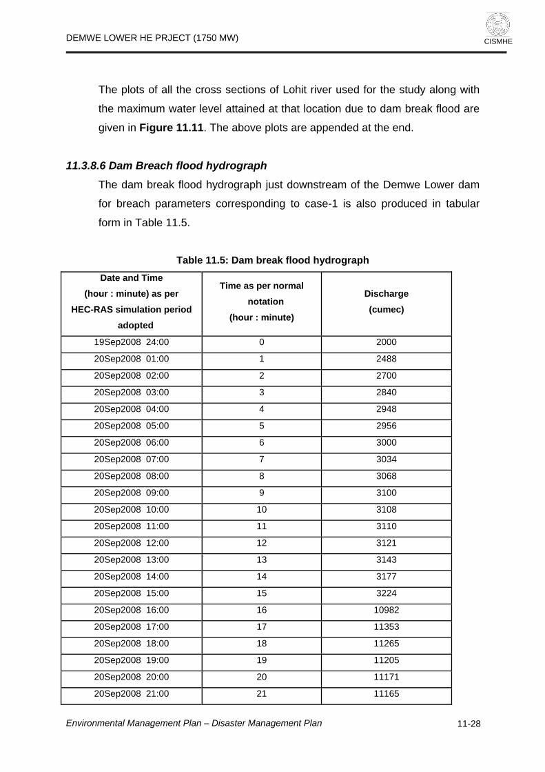
DEMWE LOWER HE PRJECT (1750 MW)
CISMHE
The plots of all the cross sections of Lohit river used for the study along with
the maximum water level attained at that location due to dam break flood are
given in Figure 11.11. The above plots are appended at the end.
11.3.8.6 Dam Breach flood hydrograph
The dam break flood hydrograph just downstream of the Demwe Lower dam
for breach parameters corresponding to case-1 is also produced in tabular
form in Table 11.5.
Table 11.5: Dam break flood hydrograph
Date and Time (hour : minute) as per
HEC-RAS simulation period adopted
Time as per normal notation
(hour : minute)
Discharge (cumec)
19Sep2008 24:00 0 2000
20Sep2008 01:00 1 2488
20Sep2008 02:00 2 2700
20Sep2008 03:00 3 2840
20Sep2008 04:00 4 2948
20Sep2008 05:00 5 2956
20Sep2008 06:00 6 3000
20Sep2008 07:00 7 3034
20Sep2008 08:00 8 3068
20Sep2008 09:00 9 3100
20Sep2008 10:00 10 3108
20Sep2008 11:00 11 3110
20Sep2008 12:00 12 3121
20Sep2008 13:00 13 3143
20Sep2008 14:00 14 3177
20Sep2008 15:00 15 3224
20Sep2008 16:00 16 10982
20Sep2008 17:00 17 11353
20Sep2008 18:00 18 11265
20Sep2008 19:00 19 11205
20Sep2008 20:00 20 11171
20Sep2008 21:00 21 11165
Environmental Management Plan – Disaster Management Plan
11-28

DEMWE LOWER HE PRJECT (1750 MW)
CISMHE
Date and Time
(hour : minute) as per HEC-RAS simulation period
adopted
Time as per normal notation
(hour : minute)
Discharge (cumec)
20Sep2008 22:00 22 11190
20Sep2008 23:00 23 11250
20Sep2008 24:00 24 11350
21Sep2008 01:00 25 13203
21Sep2008 02:00 26 20431
21Sep2008 03:00 27 20276
21Sep2008 04:00 28 20201
21Sep2008 05:00 29 20194
21Sep2008 06:00 30 20233
21Sep2008 07:00 31 20300
21Sep2008 08:00 32 20380
21Sep2008 09:00 33 20465
21Sep2008 10:00 34 21530
21Sep2008 11:00 35 23404
21Sep2008 12:00 36 23315
21Sep2008 13:00 37 23231
21Sep2008 14:00 38 23149
21Sep2008 15:00 39 23064
21Sep2008 16:00 40 22971
21Sep2008 17:00 41 22864
21Sep2008 18:00 42 22738
21Sep2008 19:00 43 22589
21Sep2008 20:00 44 22413
21Sep2008 21:00 45 22235
21Sep2008 22:00 46 22075
21Sep2008 23:00 47 21952
21Sep2008 24:00 48 21887
22Sep2008 01:00 49 21897
22Sep2008 02:00 50 21992
22Sep2008 03:00 51 22176
22Sep2008 04:00 52 22440
22Sep2008 05:00 53 22747
22Sep2008 06:00 54 23066
22Sep2008 07:00 55 23386
Environmental Management Plan – Disaster Management Plan
11-29

DEMWE LOWER HE PRJECT (1750 MW)
CISMHE
Date and Time
(hour : minute) as per HEC-RAS simulation period
adopted
Time as per normal notation
(hour : minute)
Discharge (cumec)
22Sep2008 07:15 55:15 23465
22Sep2008 07:30 55:30 25988
22Sep2008 07:45 55:45 28710
22Sep2008 08:00 56 55775
22Sep2008 08:15 56:15 52968
22Sep2008 08:30 56:30 50247
22Sep2008 08:45 56:45 47671
22Sep2008 09:00 57 45422
22Sep2008 09:15 57:15 43455
22Sep2008 09:30 57:30 41732
22Sep2008 09:45 57:45 40217
22Sep2008 10:00 58 38772
22Sep2008 11:00 59 34225
22Sep2008 12:00 60 31566
22Sep2008 13:00 61 29840
22Sep2008 14:00 62 23968
22Sep2008 15:00 63 23925
22Sep2008 16:00 64 24279
22Sep2008 17:00 65 24217
22Sep2008 18:00 66 23845
22Sep2008 19:00 67 23251
22Sep2008 20:00 68 19341
22Sep2008 21:00 69 19537
22Sep2008 22:00 70 19341
22Sep2008 23:00 71 16870
22Sep2008 24:00 72 16940
23Sep2008 01:00 73 15524
23Sep2008 02:00 74 15224
23Sep2008 03:00 75 14792
23Sep2008 04:00 76 13845
23Sep2008 05:00 77 13753
23Sep2008 06:00 78 12597
23Sep2008 07:00 79 11606
23Sep2008 08:00 80 11534
Environmental Management Plan – Disaster Management Plan
11-30

DEMWE LOWER HE PRJECT (1750 MW)
CISMHE
Date and Time
(hour : minute) as per HEC-RAS simulation period
adopted
Time as per normal notation
(hour : minute)
Discharge (cumec)
23Sep2008 09:00 81 10723
23Sep2008 10:00 82 10003
23Sep2008 11:00 83 9374
23Sep2008 12:00 84 8865
23Sep2008 13:00 85 8459
23Sep2008 14:00 86 8152
23Sep2008 15:00 87 7540
23Sep2008 16:00 88 7403
23Sep2008 17:00 89 7269
23Sep2008 18:00 90 7058
23Sep2008 19:00 91 6801
23Sep2008 20:00 92 6519
23Sep2008 21:00 93 6225
23Sep2008 22:00 94 5930
23Sep2008 23:00 95 5643
23Sep2008 24:00 96 5370
24Sep2008 01:00 97 5121
24Sep2008 02:00 98 4851
24Sep2008 03:00 99 4436
24Sep2008 04:00 100 3414
24Sep2008 05:00 101 2716
11.3.8.7 Longitudinal profile
The longitudinal profile of the Lohit river for dam break condition is given in
Figure 11.12 of the chapter.
11.3.9 Maximum water level in Lohit river due to occurrence of PMF without
dam break
In order to assess the maximum water level at different locations of Lohit river
downstream of Demwe Lower dam due to occurrence of PMF, without any
dam break, the PMF has been routed through the reservoir assuming initial
water level at FRL. Since FRL and MWL are same ie EL 424.8 m, hence no
mitigation of flood is possible as no additional flood storage is available.
Environmental Management Plan – Disaster Management Plan
11-31

DEMWE LOWER HE PRJECT (1750 MW)
CISMHE
Further, the spillway capacity is adequate to negotiate the PMF hence the
PMF can be safely passed through reservoir. In this case the spillway gate
openings has been fully synchronised with the ordinates of PMF hydrograph.
The maximum discharge, water level and flood travel time at different
locations of the Lohit river downstream of the dam are given in Table 11.6.
The average velocity of the flood wave is about 8 km/hour.
Table 11.6: Maximum discharge, water level and flood wave travel time in Lohit river
due to occurrence of PMF without dam breach
River
Chainage (m) d/s
of Demwe Lower
dam axis
Profile Max
discharge Bed level
Max. Water level
Travel Time
(m3/s) (m) (m) (hrs)
Lohit 0 Max WS 28500 296.37 316.61 0
Lohit -100 Max WS 28497 294.87 317.04 0
Lohit -200 Max WS 28496 292.17 317.55 0
Lohit -300 Max WS 28494 288.57 316.72 0.01
Lohit -400 Max WS 28492 293.57 317.13 0.01
Lohit -600 Max WS 28489 299.27 315.67 0.01
Lohit -1000 Max WS 28482 291.97 312.04 0.02
Lohit -1500 Max WS 28486 290.47 310.19 0.04
Lohit -2000 Max WS 28485 292.27 302.59 0.05
Lohit -2500.* Max WS 28483 286.14 294.42 0.07
Lohit -3000 Max WS 28479 280.00 292.14 0.09
Lohit -3500.* Max WS 28474 278.00 289.96 0.11
Lohit -4000 Max WS 28465 276.00 286.79 0.14
Lohit -4500.* Max WS 28452 274.00 285.44 0.16
Lohit -5000 Max WS 28447 272.00 285.21 0.21
Lohit -5500.* Max WS 28435 269.50 284.46 0.26
Lohit -6000 Max WS 28433 267.00 281.65 0.3
Lohit -6500.* Max WS 28431 265.50 278.86 0.32
Lohit -7000.* Max WS 28426 264.00 276.08 0.35
Lohit -7500.* Max WS 28424 262.50 273.31 0.38
Lohit -8000.* Max WS 28421 261.00 270.48 0.41
Environmental Management Plan – Disaster Management Plan
11-32

DEMWE LOWER HE PRJECT (1750 MW)
CISMHE
River
Chainage (m) d/s
of Demwe Lower
dam axis
Profile Max
discharge Bed level
Max. Water level
Travel Time
Lohit -8500.* Max WS 28419 259.50 267.74 0.45
Lohit -9000.* Max WS 28416 258.00 264.77 0.49
Lohit -9500.* Max WS 28414 256.50 262.17 0.53
Lohit -10000 Max WS 28413 255.00 258.59 0.57
Lohit -10500.* Max WS 28410 250.37 253.99 0.6
Lohit -11000.* Max WS 28410 245.75 249.43 0.63
Lohit -11500.* Max WS 28407 241.13 244.77 0.67
Lohit -12000.* Max WS 28406 236.50 240.21 0.7
Lohit -12500.* Max WS 28404 231.88 235.39 0.73
Lohit -13000.* Max WS 28404 227.25 230.9 0.77
Lohit -13500.* Max WS 28402 222.63 225.64 0.8
Lohit -14000 Max WS 28397 218.00 221.82 0.85
Lohit -14500.* Max WS 28392 216.69 220.92 0.91
Lohit -15000.* Max WS 28387 215.38 219.84 0.98
Lohit -15500.* Max WS 28385 214.06 218.7 1.04
Lohit -16000.* Max WS 28382 212.75 217.51 1.09
Lohit -16500.* Max WS 28377 211.44 216.31 1.15
Lohit -17000.* Max WS 28374 210.12 215.09 1.2
Lohit -17500.* Max WS 28370 208.81 213.86 1.26
Lohit -18000.* Max WS 28369 207.50 212.62 1.31
Lohit -18500.* Max WS 28365 206.19 211.38 1.36
Lohit -19000.* Max WS 28362 204.88 210.14 1.41
Lohit -19500.* Max WS 28358 203.56 208.89 1.46
Lohit -20000.* Max WS 28357 202.25 207.64 1.51
Lohit -20500.* Max WS 28354 200.94 206.38 1.56
Lohit -21000.* Max WS 28351 199.63 205.13 1.61
Lohit -21500.* Max WS 28350 198.31 203.9 1.66
Lohit -22000 Max WS 28348 197.00 202.24 1.71
Lohit -22500.* Max WS 28346 195.58 200.44 1.75
Lohit -23000.* Max WS 28345 194.17 198.65 1.79
Lohit -23500.* Max WS 28343 192.75 196.9 1.84
Lohit -24000.* Max WS 28342 191.33 195.17 1.88
Environmental Management Plan – Disaster Management Plan
11-33

DEMWE LOWER HE PRJECT (1750 MW)
CISMHE
River
Chainage (m) d/s
of Demwe Lower
dam axis
Profile Max
discharge Bed level
Max. Water level
Travel Time
Lohit -24500.* Max WS 28340 189.92 193.48 1.93
Lohit -25000.* Max WS 28339 188.50 191.81 1.97
Lohit -25500.* Max WS 28337 187.08 190.16 2.02
Lohit -26000.* Max WS 28336 185.67 188.55 2.07
Lohit -26500.* Max WS 28334 184.25 186.86 2.13
Lohit -27000.* Max WS 28332 182.83 185.38 2.19
Lohit -27500.* Max WS 28331 181.42 183.32 2.25
Lohit -28000 Max WS 28329 180.00 181.78 2.32
Lohit -28500.* Max WS 28325 178.50 180.86 2.41
Lohit -29000.* Max WS 28321 177.00 179.77 2.5
Lohit -29500.* Max WS 28318 175.50 178.57 2.57
Lohit -30000.* Max WS 28313 174.00 177.27 2.63
Lohit -30500.* Max WS 28309 172.50 175.87 2.69
Lohit -31000.* Max WS 28308 171.00 174.38 2.74
Lohit -31500.* Max WS 28306 169.50 172.95 2.79
Lohit -32000.* Max WS 28304 168.00 171.59 2.84
Lohit -32500.* Max WS 28302 166.50 170.24 2.89
Lohit -33000.* Max WS 28302 165.00 168.89 2.93
Lohit -33500.* Max WS 28300 163.50 167.54 2.98
Lohit -34000.* Max WS 28299 162.00 166.19 3.02
Lohit -34500.* Max WS 28297 160.50 164.83 3.07
Lohit -35000.* Max WS 28296 159.00 163.45 3.11
Lohit -35500.* Max WS 28295 157.50 162.05 3.16
Lohit -36000.* Max WS 28293 156.00 160.62 3.2
Lohit -36500.* Max WS 28292 154.50 159.14 3.25
Lohit -37000.* Max WS 28291 153.00 157.58 3.3
Lohit -37500.* Max WS 28287 151.50 156.11 3.34
Lohit -38000 Max WS 28283 150.00 155.29 3.4
Lohit -38500.* Max WS 28279 149.50 154.71 3.48
Lohit -39000.* Max WS 28274 149.00 154.12 3.55
Lohit -39500.* Max WS 28270 148.50 153.53 3.62
Lohit -40000.* Max WS 28266 148.00 152.94 3.7
Environmental Management Plan – Disaster Management Plan
11-34

DEMWE LOWER HE PRJECT (1750 MW)
CISMHE
River
Chainage (m) d/s
of Demwe Lower
dam axis
Profile Max
discharge Bed level
Max. Water level
Travel Time
Lohit -40500.* Max WS 28262 147.50 152.35 3.77
Lohit -41000.* Max WS 28258 147.00 151.76 3.84
Lohit -41500.* Max WS 28254 146.50 151.17 3.91
Lohit -42000.* Max WS 28250 146.00 150.58 3.98
Lohit -42500.* Max WS 28246 145.50 149.99 4.05
Lohit -43000.* Max WS 28242 145.00 149.4 4.12
Lohit -43500.* Max WS 28239 144.50 148.82 4.19
Lohit -44000.* Max WS 28235 144.00 148.25 4.26
Lohit -44500.* Max WS 28232 143.50 147.67 4.33
Lohit -45000.* Max WS 28229 143.00 147.05 4.4
Lohit -45500.* Max WS 28226 142.50 146.4 4.47
Lohit -46000.* Max WS 28223 142.00 145.74 4.55
Lohit -46500.* Max WS 28216 141.50 145.07 4.62
Lohit -47000.* Max WS 28195 141.00 144.48 4.7
Lohit -47500.* Max WS 28171 140.50 144.08 4.8
Lohit -48000 Max WS 28153 140.00 143.89 4.92
Lohit -48500.* Max WS 28143 139.85 143.74 5.06
Lohit -49000.* Max WS 28127 139.70 143.59 5.2
Lohit -49500.* Max WS 28119 139.55 143.43 5.34
Lohit -50000.* Max WS 28111 139.40 143.28 5.48
Lohit -50500.* Max WS 28097 139.25 143.11 5.61
Lohit -51000.* Max WS 28090 139.10 142.94 5.75
Lohit -51500.* Max WS 28078 138.95 142.77 5.89
Lohit -52000.* Max WS 28072 138.80 142.59 6.02
Lohit -52500.* Max WS 28066 138.65 142.4 6.16
Lohit -53000.* Max WS 28056 138.50 142.21 6.3
Lohit -53500.* Max WS 28047 138.35 142 6.43
Lohit -54000.* Max WS 28043 138.20 141.79 6.57
Lohit -54500.* Max WS 28036 138.05 141.56 6.71
Lohit -55000.* Max WS 28032 137.90 141.33 6.84
Lohit -55500.* Max WS 28026 137.75 141.07 6.98
Lohit -56000.* Max WS 28023 137.60 140.8 7.12
Environmental Management Plan – Disaster Management Plan
11-35

DEMWE LOWER HE PRJECT (1750 MW)
CISMHE
River
Chainage (m) d/s
of Demwe Lower
dam axis
Profile Max
discharge Bed level
Max. Water level
Travel Time
Lohit -56500.* Max WS 28018 137.45 140.51 7.26
Lohit -57000.* Max WS 28016 137.30 140.2 7.4
Lohit -57500.* Max WS 28014 137.15 139.84 7.54
Lohit -58000 Max WS 28012 137.00 139.39 7.68
Note : .* indicates the cross section locations interpolated by HEC-RAS Model
11.3.10 Maximum water level in virgin condition of Lohit river due to
occurrence of PMF It is important to know the water level for occurrence of PMF in the virgin
condition of the Lohit river i.e., without Demwe Lower dam. This will indicate
inundation levels under virgin conditions. In this condition the PMF has been
impinged at chainage “0” of the Lohit river (location just downstream of dam)
without considering the Demwe Lower dam.
The maximum discharge, water level and flood travel time at different
locations of the Lohit river are given in Table 11.7. The average velocity of the
flood wave in this case is also about 8 km/hour.
Table 11.7: Maximum discharge, water level and average travel time in virgin
condition of Lohit river due to occurrence of PMF
River
Chainage (m) d/s of
Demwe Lower dam
axis
Profile Max
discharge Bed level
Max. Water level
Travel Time
(m3/s) (m) (m) (hrs)
Lohit 0 Max WS 28500 296.37 316.61 0
Lohit -100 Max WS 28497 294.87 317.04 0
Lohit -200 Max WS 28496 292.17 317.55 0
Lohit -300 Max WS 28494 288.57 316.72 0.01
Lohit -400 Max WS 28492 293.57 317.13 0.01
Environmental Management Plan – Disaster Management Plan
11-36

DEMWE LOWER HE PRJECT (1750 MW)
CISMHE
River
Chainage (m) d/s of
Demwe Lower dam
axis
Profile Max
discharge Bed level
Max. Water level
Travel Time
(m3/s) (m) (m) (hrs)
Lohit -600 Max WS 28489 299.27 315.67 0.01
Lohit -1000 Max WS 28482 291.97 312.04 0.02
Lohit -1500 Max WS 28486 290.47 310.19 0.04
Lohit -2000 Max WS 28485 292.27 302.59 0.05
Lohit -2500.* Max WS 28483 286.14 294.42 0.07
Lohit -3000 Max WS 28479 280.00 292.14 0.09
Lohit -3500.* Max WS 28474 278.00 289.96 0.11
Lohit -4000 Max WS 28465 276.00 286.79 0.14
Lohit -4500.* Max WS 28452 274.00 285.44 0.16
Lohit -5000 Max WS 28447 272.00 285.21 0.21
Lohit -5500.* Max WS 28435 269.50 284.46 0.26
Lohit -6000 Max WS 28433 267.00 281.65 0.3
Lohit -6500.* Max WS 28431 265.50 278.86 0.32
Lohit -7000.* Max WS 28426 264.00 276.08 0.35
Lohit -7500.* Max WS 28424 262.50 273.31 0.38
Lohit -8000.* Max WS 28421 261.00 270.48 0.41
Lohit -8500.* Max WS 28419 259.50 267.74 0.45
Lohit -9000.* Max WS 28416 258.00 264.77 0.49
Lohit -9500.* Max WS 28414 256.50 262.17 0.53
Lohit -10000 Max WS 28413 255.00 258.59 0.57
Lohit -10500.* Max WS 28410 250.37 253.99 0.6
Lohit -11000.* Max WS 28410 245.75 249.43 0.63
Lohit -11500.* Max WS 28407 241.13 244.77 0.67
Lohit -12000.* Max WS 28406 236.50 240.21 0.7
Lohit -12500.* Max WS 28404 231.88 235.39 0.73
Lohit -13000.* Max WS 28404 227.25 230.9 0.77
Lohit -13500.* Max WS 28402 222.63 225.64 0.8
Lohit -14000 Max WS 28397 218.00 221.82 0.85
Lohit -14500.* Max WS 28392 216.69 220.92 0.91
Lohit -15000.* Max WS 28387 215.38 219.84 0.98
Lohit -15500.* Max WS 28385 214.06 218.7 1.04
Lohit -16000.* Max WS 28382 212.75 217.51 1.09
Environmental Management Plan – Disaster Management Plan
11-37

DEMWE LOWER HE PRJECT (1750 MW)
CISMHE
River
Chainage (m) d/s of
Demwe Lower dam
axis
Profile Max
discharge Bed level
Max. Water level
Travel Time
(m3/s) (m) (m) (hrs)
Lohit -16500.* Max WS 28377 211.44 216.31 1.15
Lohit -17000.* Max WS 28374 210.12 215.09 1.2
Lohit -17500.* Max WS 28370 208.81 213.86 1.26
Lohit -18000.* Max WS 28369 207.50 212.62 1.31
Lohit -18500.* Max WS 28365 206.19 211.38 1.36
Lohit -19000.* Max WS 28362 204.88 210.14 1.41
Lohit -19500.* Max WS 28358 203.56 208.89 1.46
Lohit -20000.* Max WS 28357 202.25 207.64 1.51
Lohit -20500.* Max WS 28354 200.94 206.38 1.56
Lohit -21000.* Max WS 28351 199.63 205.13 1.61
Lohit -21500.* Max WS 28350 198.31 203.9 1.66
Lohit -22000 Max WS 28348 197.00 202.24 1.71
Lohit -22500.* Max WS 28346 195.58 200.44 1.75
Lohit -23000.* Max WS 28345 194.17 198.65 1.79
Lohit -23500.* Max WS 28343 192.75 196.9 1.84
Lohit -24000.* Max WS 28342 191.33 195.17 1.88
Lohit -24500.* Max WS 28340 189.92 193.48 1.93
Lohit -25000.* Max WS 28339 188.50 191.81 1.97
Lohit -25500.* Max WS 28337 187.08 190.16 2.02
Lohit -26000.* Max WS 28336 185.67 188.55 2.07
Lohit -26500.* Max WS 28334 184.25 186.86 2.13
Lohit -27000.* Max WS 28332 182.83 185.38 2.19
Lohit -27500.* Max WS 28331 181.42 183.32 2.25
Lohit -28000 Max WS 28329 180.00 181.78 2.32
Lohit -28500.* Max WS 28325 178.50 180.86 2.41
Lohit -29000.* Max WS 28321 177.00 179.77 2.5
Lohit -29500.* Max WS 28318 175.50 178.57 2.57
Lohit -30000.* Max WS 28313 174.00 177.27 2.63
Lohit -30500.* Max WS 28309 172.50 175.87 2.69
Lohit -31000.* Max WS 28308 171.00 174.38 2.74
Lohit -31500.* Max WS 28306 169.50 172.95 2.79
Lohit -32000.* Max WS 28304 168.00 171.59 2.84
Environmental Management Plan – Disaster Management Plan
11-38

DEMWE LOWER HE PRJECT (1750 MW)
CISMHE
River
Chainage (m) d/s of
Demwe Lower dam
axis
Profile Max
discharge Bed level
Max. Water level
Travel Time
(m3/s) (m) (m) (hrs)
Lohit -32500.* Max WS 28302 166.50 170.24 2.89
Lohit -33000.* Max WS 28302 165.00 168.89 2.93
Lohit -33500.* Max WS 28300 163.50 167.54 2.98
Lohit -34000.* Max WS 28299 162.00 166.19 3.02
Lohit -34500.* Max WS 28297 160.50 164.83 3.07
Lohit -35000.* Max WS 28296 159.00 163.45 3.11
Lohit -35500.* Max WS 28295 157.50 162.05 3.16
Lohit -36000.* Max WS 28293 156.00 160.62 3.2
Lohit -36500.* Max WS 28292 154.50 159.14 3.25
Lohit -37000.* Max WS 28291 153.00 157.58 3.3
Lohit -37500.* Max WS 28287 151.50 156.11 3.34
Lohit -38000 Max WS 28283 150.00 155.29 3.4
Lohit -38500.* Max WS 28279 149.50 154.71 3.48
Lohit -39000.* Max WS 28274 149.00 154.12 3.55
Lohit -39500.* Max WS 28270 148.50 153.53 3.62
Lohit -40000.* Max WS 28266 148.00 152.94 3.7
Lohit -40500.* Max WS 28262 147.50 152.35 3.77
Lohit -41000.* Max WS 28258 147.00 151.76 3.84
Lohit -41500.* Max WS 28254 146.50 151.17 3.91
Lohit -42000.* Max WS 28250 146.00 150.58 3.98
Lohit -42500.* Max WS 28246 145.50 149.99 4.05
Lohit -43000.* Max WS 28242 145.00 149.4 4.12
Lohit -43500.* Max WS 28239 144.50 148.82 4.19
Lohit -44000.* Max WS 28235 144.00 148.25 4.26
Lohit -44500.* Max WS 28232 143.50 147.67 4.33
Lohit -45000.* Max WS 28229 143.00 147.05 4.4
Lohit -45500.* Max WS 28226 142.50 146.4 4.47
Lohit -46000.* Max WS 28223 142.00 145.74 4.55
Lohit -46500.* Max WS 28216 141.50 145.07 4.62
Lohit -47000.* Max WS 28195 141.00 144.48 4.7
Lohit -47500.* Max WS 28171 140.50 144.08 4.8
Lohit -48000 Max WS 28153 140.00 143.89 4.92
Environmental Management Plan – Disaster Management Plan
11-39

DEMWE LOWER HE PRJECT (1750 MW)
CISMHE
River
Chainage (m) d/s of
Demwe Lower dam
axis
Profile Max
discharge Bed level
Max. Water level
Travel Time
(m3/s) (m) (m) (hrs)
Lohit -48500.* Max WS 28143 139.85 143.74 5.06
Lohit -49000.* Max WS 28127 139.70 143.59 5.2
Lohit -49500.* Max WS 28119 139.55 143.43 5.34
Lohit -50000.* Max WS 28111 139.40 143.28 5.48
Lohit -50500.* Max WS 28097 139.25 143.11 5.61
Lohit -51000.* Max WS 28090 139.10 142.94 5.75
Lohit -51500.* Max WS 28078 138.95 142.77 5.89
Lohit -52000.* Max WS 28072 138.80 142.59 6.02
Lohit -52500.* Max WS 28066 138.65 142.4 6.16
Lohit -53000.* Max WS 28056 138.50 142.21 6.3
Lohit -53500.* Max WS 28047 138.35 142 6.43
Lohit -54000.* Max WS 28043 138.20 141.79 6.57
Lohit -54500.* Max WS 28036 138.05 141.56 6.71
Lohit -55000.* Max WS 28032 137.90 141.33 6.84
Lohit -55500.* Max WS 28026 137.75 141.07 6.98
Lohit -56000.* Max WS 28023 137.60 140.8 7.12
Lohit -56500.* Max WS 28018 137.45 140.51 7.26
Lohit -57000.* Max WS 28016 137.30 140.2 7.4
Lohit -57500.* Max WS 28014 137.15 139.84 7.54
Lohit -58000 Max WS 28012 137.00 139.39 7.68
Note : .* indicates the cross section location interpolated by HEC-RAS Model
11.3.11 Inundation map Taking the maximum water level given in Table 11.4, 11.6 and 11.7 for
different simulated conditions the inundation map is presented in Figure 11.13.
11.3.12 Limitations The uncertainties associated with the breach parameters, specially breach
width, breach depth and breach development time may cause uncertainty in
flood peak estimation and arrival times. Further the high velocity flows
Environmental Management Plan – Disaster Management Plan
11-40

DEMWE LOWER HE PRJECT (1750 MW)
CISMHE
associated with dam break floods can cause significant scour of channels.
This enlargement in channel cross section is neglected since the equations for
sediment transport, sediment continuity, dynamic bed form friction etc. are not
included among the governing equations of the model. The narrow channels
with minimal flood plains are subject to over estimation of water elevation due
to significant channel degradation. The dam breach floods create a large
amount of transported debris, which may accumulate at very narrow cross
sections, resulting water level variation at downstream locations. This aspect
has been neglected due to limitations in modeling of such complicated
physical process.
11.4 DISASTER MANAGEMENT PLAN
From the result it is evident that up to about 58 km d/s of the proposed Lower
Demwe dam, time required in reaching the flood wave elevation to the
maximum is of the order of 6.68 hr. It makes it very hard for rescue and
evacuation. Since the time available is very short, the Disaster Management
Plan should, therefore, concentrate on preventive actions.
Surveillance and monitoring programmes are required to be implemented
during design and investigation, construction, first reservoir filling, early
operation period and operation & maintenance phases of the life cycle of dam.
It is desirable that all gates, electricity, public announcement system, power
generator backups etc are thoroughly checked before arrival of the monsoon.
As it is clear from the results that u/s water level has significant effect on the
dam break flood, the following flood conditions may be considered for different
level of alertness:
1) If u/s water level reaches at top of the dam, it may be considered as an
emergency. At this point only a few minutes are available for taking any
action. All the staff from the dam site should be alerted to move to a safe
place. The district administration and the corporation’s head office shall be
informed about the possibility of dam failure.
2) If u/s water level rises above the dam top and dam begins to fail, it may be
considered as a disaster condition. At this stage, nothing can be done.
Environmental Management Plan – Disaster Management Plan
11-41

DEMWE LOWER HE PRJECT (1750 MW)
CISMHE
Information in this regard should be given to the head office and district
administration.
• If upstream water level is at or below FRL and flood is of the order
of 20% to 30% of PMF, it may be considered as normal flood
condition and normal routine may be maintained.
• If upstream water level is rising above FRL/MWL, it may be
considered as Level-1 emergency. In this condition at least 11
gates must be kept fully operational. All concerned officials should
be alerted so that they may reach at the dam site to take suitable
actions. Preventive actions may be carried out simultaneously. A
suitable warning and notification procedure may be laid. The local
officials should be informed about the situation.
• If upstream water level reaches at the top of the dam, it may be
considered as Level-2 emergency. At this point only a few
minutes are available for taking any action. All the staff from the
dam site should be alerted to move to a safe place. The district
level office and the corporation’s head office should be informed
about the dam overtopping.
• If upstream water level is rising above the dam top and dam has
been overtopped. It may be considered as a disaster condition.
Any information in this regard should be immediately provided to
civil administration for necessary rescue operations.
The following measures can be taken to avoid the loss of lives and property:
1) To establish an effective Dam Safety Surveillance and monitoring
program including rapid analysis and interpretation of instrumentation
and observation data; periodic inspection and safety reviews/evaluation
by an independent panel of experts.
2) To formulate and implement an Emergency Action Plan to minimize to
the maximum extent possible, the probable loss of life and damage to
property in the event of failure of dam.
Environmental Management Plan – Disaster Management Plan
11-42

DEMWE LOWER HE PRJECT (1750 MW)
CISMHE
11.4.1 Surveillance
The surveillance and monitoring programs are required to be implemented
during design and investigation, construction, early operation period and
operation and maintenance phases of the life cycle of the dam. An affective
flood forecasting system is required by establishing hourly gauge reading at
suitable upstream locations with real time communication at the top. An
effective dam safety surveillance, monitoring and observation along with
periodic inspection, safety reviews and evaluation must be put in place. These
programs will be implemented in five phases in the life cycle of a dam viz.
i) design and investigation phase,
ii) construction phase,
iii) first reservoir filling,
iv) early operation period, and
v) operation and maintenance phase.
11.4.2 Emergency Action Plan
An emergency is defined as a condition of serious nature which develops
unexpectedly and endangers downstream property and human life and
requires immediate attention. Emergency Action Plan shall include all
potential indicators of likely failure of the dam, since the primary concern is for
timely and reliable identification and evaluation of potential emergency.
This plan presents warning and notification procedures to be followed in case
of potential failure of the dam. The purpose is to provide timely warning to
nearby residents and alert key personnel responsible for taking action in case
of an emergency.
11.4.3 Administrative and Procedural Aspects The Administrative and Procedural Aspects of Emergency Action Plan
consists of a flowchart depicting the names, addresses and telephone
numbers of the responsible officials. In order of hierarchy, the following
system will usually be appropriate. In the event of potential emergency, the
observer at the site is required to report it to the Head of Project through a
Environmental Management Plan – Disaster Management Plan
11-43

DEMWE LOWER HE PRJECT (1750 MW)
CISMHE
wireless system, if available, or by the fastest communication system
available. The Head of Project shall be responsible for contacting the Civil
Administration, viz. Deputy Commissioner. In order to oversee all the
operations required to tackle the emergency situations, a centralized control
room would be set up by the project authorities at Tezu/Parasuramkund.
Each person would be made aware of his/her responsibilities/ duties and the
importance of work assigned under the Emergency Action Plan. All the
villages falling under the flood prone zone or on the margins would be
connected through wireless communication system with backup of standby
telephone lines. A centralized siren alert system would be installed at all the
Village Panchayats so that in the event of a warning all villagers can be
alerted through sirens rather than informing everybody through messengers
which is not feasible in such emergency situations.
11.4.4 Preventive Action Once the likelihood of an emergency situation is suspected, action has to be
initiated to prevent a failure. The point at which each situation reaches an
emergency status shall be specified and at that stage the vigilance and
surveillance shall be upgraded. At this stage, a thorough inspection of the
dam shall be carried out to locate any visible signs of distress.
The anticipated need of equipment shall be evaluated and if these are not
available at the dam site, the exact locations and availability of these
equipments shall be identified. A plan shall be drawn on priority for inspection
of the dam. The dam, its sluices and non-overflow sections will be properly
illuminated.
11.4.5 Communication System An efficient communication system and a downstream warning system is
absolutely essential for the success of an emergency plan especially in the
present case because of inadequacy of time. The difference between a high
flood and a dam break situation shall be made clear to the downstream
people. All of the villages falling under the flooding zone or on margins are
Environmental Management Plan – Disaster Management Plan
11-44

DEMWE LOWER HE PRJECT (1750 MW)
CISMHE
required to be connected through wireless system backed by stand-by
telephone lines. A centralized siren system is to be installed at Panchayats so
that in event of a warning, all villagers can be alerted, through messengers
which may not be possible in this case.
11.4.6 Merits of Satellite Communication System Keeping the disaster scenario in mind, any terrestrial system such as land
lines, etc. is likely to be the first casualty in earthquakes or floods. The
restoration of such systems is time consuming. Moreover the maintenance of
such lines becomes a great problem in emergency even for the technical
personnel who are required to reach the site of fault, which may be struck by
the disaster. So the system cannot be put back into operation soon. The fault
repairs and restoration of communication services are usually not possible for
a considerable period of time after the calamity has struck. Moreover, it is
critical that the communication systems are restored at the earliest so that
relief/medical teams and other personnel can be arranged at the earliest
possible time. All the subsidiary help depends solely on the communication
system. As this criteria is paramount, existing systems such as telephones
and telex, etc. are practically of little use in case of such events and situations.
Similarly, microwave links are expected to be down due to collapse of towers,
etc. Restoration of towers and alignment of equipment is again a time
consuming activity.
Keeping in view the urgency of services and their dependability during
emergency relevant to the disaster conditions, satellite based systems present
an ideal solution. The satellite based system usually comprises following
components.
i) A small dish of approximately one meter diameter
ii) Associated radio equipment
iii) A power source
The deployment of the system is not dependent on the restoration of land
routes. The existing satellite based communication systems are designed in
such a manner that they are able to withstand fairly high degree of demanding
Environmental Management Plan – Disaster Management Plan
11-45

DEMWE LOWER HE PRJECT (1750 MW)
CISMHE
environmental conditions. Secondly, the restoration of the satellite based
system can be undertaken by carrying maintenance personnel and equipment
by helicopters at a very short notice. Even the fresh systems could be
inducted in a matter of an hour or so because most of these are designed for
transportability by air. The deployment takes usually less than an hour. The
power requirements are not large and can be met by sources such as
UPS/batteries/ generators.
11.4.7 Financial Outlay for Installation of VSAT Communication System The cost of deployment and maintenance of a telecommunication system in
disaster prone areas is not as important as the availability, reliability and quick
restoration of the system. The cost of both satellite bandwidth and the ground
components of the satellite communication system has been decreasing
rapidly like that of V-SAT (Very Small Aperture Terminal) based systems
supporting a couple of voice and data channels. Some highly superior
communication systems in VSAT without time delay are marketed by licensed
service providers/agencies like HECL, HFCL, ESSEL Shyam, Telstra V-Com,
HCL Comnet, RPG Satellite Communications, etc. There are two different
types of systems with the above mentioned capabilities available in the market
viz. TDMA and DAMA. The two alternatives for VSATs are: time designed
multiple access (TDMA) and demand assigned multiple access (DAMA). In a
TDMA network, all remote VSATs communicate with the service provider’s
central hub station. The hub station monitors and controls all VSATs in the
network and the entire customer traffic is routed through it. On the other hand,
in the DAMA network, VSATs are pre-allocated a designated frequency.
Equivalent of the terrestrial leased-line solutions, DAMA solutions use the
satellite resources constantly. Consequently, there is no call-up delay, which
makes them most suited for interactive data applications or high-traffic
volume. Single Channel per Carrier (SCPC refers to the usage of a single
satellite carrier for carrying a single channel of user traffic. In case of ‘SCPC
VSATs’, the frequency is allocated on a pre-assigned basis. DAMA network
uses a pool of satellite channels, which are available for use by any station in
that network. On demand, a pair of available channels is assigned, such that a
call can be established. Once the call is completed, channels are returned to
Environmental Management Plan – Disaster Management Plan
11-46

DEMWE LOWER HE PRJECT (1750 MW)
CISMHE
the pool for being assigned to another call. Since the satellite resource is used
only in proportion to the active circuits and their holding times, it is ideally
suited for voice traffic and data traffic in batch mode.
Therefore, SCPC & DAMA has been recommended for the Lower Demwe H.E.
project. Two such systems would be installed in the upstream catchment of
Lohit River and four such systems would be installed in the downstream reach.
The estimated cost of installation of such a communication system has been
given in Table 11.8.
11.4.8 Evacuation Plans Emergency Action Plan includes evacuation plans and procedures for
implementation based on local needs. These are:
• Demarcation/prioritization of areas to be evacuated.
• Notification procedures and evacuation instructions.
• Safe routes, transport and traffic control.
• Shelter areas
• Functions and responsibilities of members of evacuation team.
The flood prone zone in the event of break of Lower Demwe dam shall be
marked properly at the village locations with adequate factor of safety. As the
flood wave takes some time in reaching these villages, its populace shall be
informed in time through wireless and sirens etc. so that people may climb on
hills or to some elevated place beyond the flood zone which has been
marked.
The Evacuation Team would comprise of:
i) D.M./ his Nominated Officer (To peacefully relocate the people to
places at higher elevation with state administration)
ii) Head of the Project (Team Leader)
iii) S.P./Nominated Police Officer (To maintain law and order)
iv) C.M.O. of the area (To tackle morbidity of affected people)
v) Sarpanch/ Affected Village Representative to execute the resettlement
operation with the aid of state machinery and project proponents
vi) Sub-committees at village level
Environmental Management Plan – Disaster Management Plan
11-47

DEMWE LOWER HE PRJECT (1750 MW)
CISMHE
The Head of Project will be responsible for the entire operation including
prompt determination of the flood situation from time to time. Once the red
alert is declared the whole state machinery will come into swing and will start
evacuating people in the inundation areas delineated in the inundation map.
For successful execution, annually Demo exercise will be done. DM is to
monitor the entire operation.
11.4.9 Notifications
Notification procedures are an integral part of any emergency action plan.
Separate procedures shall be established for slowly and rapidly developed
situations and failure. Notifications will include communications of either an
alert situation or an alert situation followed by a warning situation. An alert
situation will indicate that although failure or flooding is not imminent, a more
serious situation can occur unless conditions improve. A warning situation will
indicate that flooding is imminent as a result of an impending failure of the
dam. It will normally include an order for evacuation of delineated inundation
areas. For a regular watch on the flood level situation, it is necessary that two
or more people man the flood cell so that an alternative person is available for
notification round the clock.
In addition, a few guidelines to be generally followed by the inhabitants of
flood prone areas, which form part of public awareness for disaster mitigation
include:
• Listen to the radio for advance information and advice.
• Disconnect all electrical appliances and move all valuable personal and
household goods and all clothing out of reach of flood water.
• Move vehicles, farm animals and movable goods to the highest ground
nearby.
• Move all dangerous pollutants and insecticides out of reach of water.
• Do not enter flood waters on foot, if it can be avoided.
Environmental Management Plan – Disaster Management Plan
11-48

DEMWE LOWER HE PRJECT (1750 MW)
CISMHE
11.5 Cost Estimates
The estimated total cost of execution of disaster management plan including
the equipment would be Rs. 251.88 lakh and it is given in Table 11.8. Table 11.8: Estimated cost of setting up of a satellite communication system
Sl. No. Product Amount (Rs. in lakhs)
A. Setting up of V-SAT communication system
1. Product Name : SCPC & DAMA (6 sites) 108.00
@ Rs.18.00 lakhs per site
a) Antenna 1 x 2.4 M
b) RF 1 x 2 W
c) Modem 1 x 1No.
2. Generators 6 Nos. (2 KVA) 9.00
3. UPS 6 Nos. (2 KVA) 6.00
Sub-Total (A) 123.00 4. Installation and maintenance of system, maintenance 38.88
and running cost of UPS, generators, etc.
@ 12% of the total cost for 3 years (Rs. 10.8 x 3 yrs) B. Installation of alert systems, 30.00
Setting up of control room, etc.
C. Notification and publication procedures, 20.00
miscellaneous, etc.
D. Setting up Seismic Observatory 40.00
Total (A+B+C) 251.88
Environmental Management Plan – Disaster Management Plan
11-49
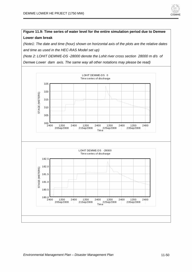
DEMWE LOWER HE PRJECT (1750 MW)
CISMHE
Figure 11.9: Time series of water level for the entire simulation period due to Demwe Lower dam break (Note1: The date and time (hour) shown on horizontal axis of the plots are the relative dates
and time as used in the HEC-RAS Model set up)
(Note 2: LOHIT DEMWE-DS -28000 denote the Lohit river cross section 28000 m d/s of
Demwe Lower dam axis. The same way all other notations may please be read)
2400 1200 2400 1200 2400 1200 2400 1200 240020Sep2008 21Sep2008 22Sep2008 23Sep2008
300
305
310
315
320
325
LOHIT DEMWE-DS 0 Tim e s eries of discharge
Tim e
STA
GE
(MET
ERS
)
2400 1200 2400 1200 2400 1200 2400 1200 240020Sep2008 21Sep2008 22Sep2008 23Sep2008
180.0
180.5
181.0
181.5
182.0
182.5
LOHIT DEMWE-DS -28000 Tim e s eries of discharge
Tim e
STA
GE
(MET
ERS
)
Environmental Management Plan – Disaster Management Plan
11-50

DEMWE LOWER HE PRJECT (1750 MW)
CISMHE
2400 1200 2400 1200 2400 1200 2400 1200 240020Sep2008 21Sep2008 22Sep2008 23Sep2008
137.0
137.5
138.0
138.5
139.0
139.5
140.0
LOHIT DEMWE-DS -58000 Tim e series of discharge
Tim e
STA
GE
(MET
ERS
)
Figure 11.10: Time series for the peak segment of water level at different cross sections of Lohit river due to Demwe Lower dam break (Note: The notation LOHIT DEMWE DS -1000 denotes river cross section located 1000m
downstream of dam axis. The same way all other notations may please be read.
0200 0400 0600 0800 1000 1200 1400 1600 1800 2000 2200 240022Sep2008
308
310
312
314
316
318
320
322
324Tim e series of discharge
Tim e
STA
GE
(MET
ERS
)
Legend
LOHIT DEMWE-DS 0
LOHIT DEMWE-DS -600
LOHIT DEMWE-DS -1000
Environmental Management Plan – Disaster Management Plan
11-51

DEMWE LOWER HE PRJECT (1750 MW)
CISMHE
0200 0400 0600 0800 1000 1200 1400 1600 1800 2000 2200 240022Sep2008
290
295
300
305
310
315Tim e series of dis charge
Tim e
STA
GE
(MET
ERS
)Legend
LOHIT DEMWE-DS -1500
LOHIT DEMWE-DS -2000
LOHIT DEMWE-DS -2500.*
0200 0400 0600 0800 1000 1200 1400 1600 1800 2000 2200 240022Sep2008
284
286
288
290
292
294
296Tim e series of dis charge
Tim e
STA
GE
(MET
ERS
)
Legend
LOHIT DEMWE-DS -3000
LOHIT DEMWE-DS -3500.*
LOHIT DEMWE-DS -4000
0200 0400 0600 0800 1000 1200 1400 1600 1800 2000 2200 240022Sep2008
281
282
283
284
285
286
287
288
289Tim e series of dis charge
Tim e
STA
GE
(MET
ERS
)
Legend
LOHIT DEMWE-DS -4500.*
LOHIT DEMWE-DS -5000
LOHIT DEMWE-DS -5500.*
Environmental Management Plan – Disaster Management Plan
11-52

DEMWE LOWER HE PRJECT (1750 MW)
CISMHE
0200 0400 0600 0800 1000 1200 1400 1600 1800 2000 2200 240022Sep2008
272
274
276
278
280
282
284
286Tim e series of dis charge
Tim e
STA
GE
(MET
ERS)
Legend
LOHIT DEMWE-DS -6000
LOHIT DEMWE-DS -6500.*
LOHIT DEMWE-DS -7000.*
0200 0400 0600 0800 1000 1200 1400 1600 1800 2000 2200 240022Sep2008
266
268
270
272
274
276Tim e series of dis charge
Tim e
STA
GE
(MET
ERS)
Legend
LOHIT DEMWE-DS -7500.*
LOHIT DEMWE-DS -8000.*
LOHIT DEMWE-DS -8500.*
0200 0400 0600 0800 1000 1200 1400 1600 1800 2000 2200 240022Sep2008
256
258
260
262
264
266Tim e series of dis charge
Tim e
STA
GE
(MET
ERS)
Legend
LOHIT DEMWE-DS -9000.*
LOHIT DEMWE-DS -9500.*
LOHIT DEMWE-DS -10000
Environmental Management Plan – Disaster Management Plan
11-53

DEMWE LOWER HE PRJECT (1750 MW)
CISMHE
0200 0400 0600 0800 1000 1200 1400 1600 1800 2000 2200 240022Sep2008
244
246
248
250
252
254
256Tim e series of dis charge
Tim e
STA
GE
(MET
ERS)
Legend
LOHIT DEMWE-DS -10500.*
LOHIT DEMWE-DS -11000.*
LOHIT DEMWE-DS -11500.*
0200 0400 0600 0800 1000 1200 1400 1600 1800 2000 2200 240022Sep2008
230
232
234
236
238
240
242Tim e series of dis charge
Tim e
STA
GE
(MET
ERS
)
Legend
LOHIT DEMWE-DS -12000.*
LOHIT DEMWE-DS -12500.*
LOHIT DEMWE-DS -13000.*
Environmental Management Plan – Disaster Management Plan
11-54

DEMWE LOWER HE PRJECT (1750 MW)
CISMHE
0200 0400 0600 0800 1000 1200 1400 1600 1800 2000 2200 240022Sep2008
220
221
222
223
224
225
226
227Tim e series of dis charge
Tim e
STA
GE
(MET
ERS
)
Legend
LOHIT DEMWE-DS -13500.*
LOHIT DEMWE-DS -14000
LOHIT DEMWE-DS -14500.*
0200 0400 0600 0800 1000 1200 1400 1600 1800 2000 2200 240022Sep2008
216
217
218
219
220
221Tim e series of dis charge
Tim e
STA
GE
(MET
ERS
)
Legend
LOHIT DEMWE-DS -15000.*
LOHIT DEMWE-DS -15500.*
LOHIT DEMWE-DS -16000.*
0200 0400 0600 0800 1000 1200 1400 1600 1800 2000 2200 240022Sep2008
212
213
214
215
216
217
218Tim e series of dis charge
Tim e
STA
GE
(MET
ERS
)
Legend
LOHIT DEMWE-DS -16500.*
LOHIT DEMWE-DS -17000.*
LOHIT DEMWE-DS -17500.*
Environmental Management Plan – Disaster Management Plan
11-55

DEMWE LOWER HE PRJECT (1750 MW)
CISMHE
0200 0400 0600 0800 1000 1200 1400 1600 1800 2000 2200 240022Sep2008
209
210
211
212
213
214Tim e series of dis charge
Tim e
STA
GE
(MET
ERS
)
Legend
LOHIT DEMWE-DS -18000.*
LOHIT DEMWE-DS -18500.*
LOHIT DEMWE-DS -19000.*
0200 0400 0600 0800 1000 1200 1400 1600 1800 2000 2200 240022Sep2008
205
206
207
208
209
210
211Tim e series of dis charge
Tim e
STA
GE
(MET
ERS
)
Legend
LOHIT DEMWE-DS -19500.*
LOHIT DEMWE-DS -20000.*
LOHIT DEMWE-DS -20500.*
Environmental Management Plan – Disaster Management Plan
11-56

DEMWE LOWER HE PRJECT (1750 MW)
CISMHE
0200 0400 0600 0800 1000 1200 1400 1600 1800 2000 2200 240022Sep2008
196
197
198
199
200
201
202Tim e series of dis charge
Tim e
STA
GE
(MET
ERS
)Legend
LOHIT DEMWE-DS -22500.*
LOHIT DEMWE-DS -23000.*
LOHIT DEMWE-DS -23500.*
0200 0400 0600 0800 1000 1200 1400 1600 1800 2000 2200 240022Sep2008
191
192
193
194
195
196
197Tim e series of dis charge
Tim e
STA
GE
(MET
ERS
)
Legend
LOHIT DEMWE-DS -24000.*
LOHIT DEMWE-DS -24500.*
LOHIT DEMWE-DS -25000.*
0200 0400 0600 0800 1000 1200 1400 1600 1800 2000 2200 240022Sep2008
186
187
188
189
190
191
192Tim e series of dis charge
Tim e
STA
GE
(MET
ERS
)
Legend
LOHIT DEMWE-DS -25500.*
LOHIT DEMWE-DS -26000.*
LOHIT DEMWE-DS -26500.*
Environmental Management Plan – Disaster Management Plan
11-57

DEMWE LOWER HE PRJECT (1750 MW)
CISMHE
0200 0400 0600 0800 1000 1200 1400 1600 1800 2000 2200 240022Sep2008
181
182
183
184
185
186
187Tim e series of dis charge
Tim e
STA
GE
(MET
ERS
)
Legend
LOHIT DEMWE-DS -27000.*
LOHIT DEMWE-DS -27500.*
LOHIT DEMWE-DS -28000
0200 0400 0600 0800 1000 1200 1400 1600 1800 2000 2200 240022Sep2008
178.0
178.5
179.0
179.5
180.0
180.5
181.0
181.5Tim e series of dis charge
Tim e
STA
GE
(MET
ERS
)
Legend
LOHIT DEMWE-DS -28500.*
LOHIT DEMWE-DS -29000.*
LOHIT DEMWE-DS -29500.*
0200 0400 0600 0800 1000 1200 1400 1600 1800 2000 2200 240022Sep2008
173
174
175
176
177
178
179Tim e series of dis charge
Tim e
STA
GE
(MET
ERS
)
Legend
LOHIT DEMWE-DS -30000.*
LOHIT DEMWE-DS -30500.*
LOHIT DEMWE-DS -31000.*
Environmental Management Plan – Disaster Management Plan
11-58

DEMWE LOWER HE PRJECT (1750 MW)
CISMHE
0200 0400 0600 0800 1000 1200 1400 1600 1800 2000 2200 240022Sep2008
169
170
171
172
173
174
175Tim e series of dis charge
Tim e
STA
GE
(MET
ERS
)
Legend
LOHIT DEMWE-DS -31500.*
LOHIT DEMWE-DS -32000.*
LOHIT DEMWE-DS -32500.*
0200 0400 0600 0800 1000 1200 1400 1600 1800 2000 2200 240022Sep2008
165
166
167
168
169
170
171Tim e series of dis charge
Tim e
STA
GE
(MET
ERS
)
Legend
LOHIT DEMWE-DS -33000.*
LOHIT DEMWE-DS -33500.*
LOHIT DEMWE-DS -34000.*
0200 0400 0600 0800 1000 1200 1400 1600 1800 2000 2200 240022Sep2008
161
162
163
164
165
166
167Tim e series of dis charge
Tim e
STA
GE
(MET
ERS
)
Legend
LOHIT DEMWE-DS -34500.*
LOHIT DEMWE-DS -35000.*
LOHIT DEMWE-DS -35500.*
Environmental Management Plan – Disaster Management Plan
11-59

DEMWE LOWER HE PRJECT (1750 MW)
CISMHE
0200 0400 0600 0800 1000 1200 1400 1600 1800 2000 2200 240022Sep2008
156
157
158
159
160
161
162Tim e series of dis charge
Tim e
STA
GE
(MET
ERS
)
Legend
LOHIT DEMWE-DS -36000.*
LOHIT DEMWE-DS -36500.*
LOHIT DEMWE-DS -37000.*
0200 0400 0600 0800 1000 1200 1400 1600 1800 2000 2200 240022Sep2008
154.0
154.5
155.0
155.5
156.0
156.5
157.0
157.5Tim e series of dis charge
Tim e
STA
GE
(MET
ERS
)
Legend
LOHIT DEMWE-DS -37500.*
LOHIT DEMWE-DS -38000
LOHIT DEMWE-DS -38500.*
0200 0400 0600 0800 1000 1200 1400 1600 1800 2000 2200 240022Sep2008
152.0
152.5
153.0
153.5
154.0
154.5
155.0
155.5Tim e series of dis charge
Tim e
STA
GE
(MET
ERS
)
Legend
LOHIT DEMWE-DS -39000.*
LOHIT DEMWE-DS -39500.*
LOHIT DEMWE-DS -40000.*
Environmental Management Plan – Disaster Management Plan
11-60

DEMWE LOWER HE PRJECT (1750 MW)
CISMHE
0200 0400 0600 0800 1000 1200 1400 1600 1800 2000 2200 240022Sep2008
150.0
150.5
151.0
151.5
152.0
152.5
153.0
153.5Tim e series of dis charge
Tim e
STA
GE
(MET
ERS
)
Legend
LOHIT DEMWE-DS -40500.*
LOHIT DEMWE-DS -41000.*
LOHIT DEMWE-DS -41500.*
0200 0400 0600 0800 1000 1200 1400 1600 1800 2000 2200 240022Sep2008
148.5
149.0
149.5
150.0
150.5
151.0
151.5
152.0Tim e series of dis charge
Tim e
STA
GE
(MET
ERS
)
Legend
LOHIT DEMWE-DS -42000.*
LOHIT DEMWE-DS -42500.*
LOHIT DEMWE-DS -43000.*
Environmental Management Plan – Disaster Management Plan
11-61

DEMWE LOWER HE PRJECT (1750 MW)
CISMHE
0200 0400 0600 0800 1000 1200 1400 1600 1800 2000 2200 240022Sep2008
146.5
147.0
147.5
148.0
148.5
149.0
149.5
150.0Tim e series of dis charge
Tim e
STA
GE
(MET
ERS
)Legend
LOHIT DEMWE-DS -43500.*
LOHIT DEMWE-DS -44000.*
LOHIT DEMWE-DS -44500.*
0200 0400 0600 0800 1000 1200 1400 1600 1800 2000 2200 240022Sep2008
145.0
145.5
146.0
146.5
147.0
147.5
148.0Tim e series of dis charge
Tim e
STA
GE
(MET
ERS
)
Legend
LOHIT DEMWE-DS -45000.*
LOHIT DEMWE-DS -45500.*
LOHIT DEMWE-DS -46000.*
0200 0400 0600 0800 1000 1200 1400 1600 1800 2000 2200 240022Sep2008
143.5
144.0
144.5
145.0
145.5
146.0Tim e series of dis charge
Tim e
STA
GE
(MET
ERS
)
Legend
LOHIT DEMWE-DS -46500.*
LOHIT DEMWE-DS -47000.*
LOHIT DEMWE-DS -47500.*
Environmental Management Plan – Disaster Management Plan
11-62

DEMWE LOWER HE PRJECT (1750 MW)
CISMHE
0200 0400 0600 0800 1000 1200 1400 1600 1800 2000 2200 240022Sep2008
143.2
143.4
143.6
143.8
144.0
144.2
144.4
144.6
144.8Tim e series of dis charge
Tim e
STA
GE
(MET
ERS
)
Legend
LOHIT DEMWE-DS -48000
LOHIT DEMWE-DS -48500.*
LOHIT DEMWE-DS -49000.*
0200 0400 0600 0800 1000 1200 1400 1600 1800 2000 2200 240022Sep2008
142.6
142.8
143.0
143.2
143.4
143.6
143.8
144.0
144.2Tim e series of dis charge
Tim e
STA
GE
(MET
ERS
)
Legend
LOHIT DEMWE-DS -49500.*
LOHIT DEMWE-DS -50000.*
LOHIT DEMWE-DS -50500.*
0200 0400 0600 0800 1000 1200 1400 1600 1800 2000 2200 240022Sep2008
142.2
142.4
142.6
142.8
143.0
143.2
143.4
143.6
143.8Tim e series of dis charge
Tim e
STA
GE
(MET
ERS
)
Legend
LOHIT DEMWE-DS -51000.*
LOHIT DEMWE-DS -51500.*
LOHIT DEMWE-DS -52000.*
Environmental Management Plan – Disaster Management Plan
11-63

DEMWE LOWER HE PRJECT (1750 MW)
CISMHE
0200 0400 0600 0800 1000 1200 1400 1600 1800 2000 2200 240022Sep2008
141.6
141.8
142.0
142.2
142.4
142.6
142.8
143.0
143.2Tim e series of dis charge
Tim e
STA
GE
(MET
ERS
)
Legend
LOHIT DEMWE-DS -52500.*
LOHIT DEMWE-DS -53000.*
LOHIT DEMWE-DS -53500.*
0200 0400 0600 0800 1000 1200 1400 1600 1800 2000 2200 240022Sep2008
141.0
141.2
141.4
141.6
141.8
142.0
142.2
142.4Tim e series of dis charge
Tim e
STA
GE
(MET
ERS
)
Legend
LOHIT DEMWE-DS -54000.*
LOHIT DEMWE-DS -54500.*
LOHIT DEMWE-DS -55000.*
0200 0400 0600 0800 1000 1200 1400 1600 1800 2000 2200 240022Sep2008
139.8
140.0
140.2
140.4
140.6
140.8
141.0
141.2
141.4Tim e series of dis charge
Tim e
STA
GE
(MET
ERS
)
Legend
LOHIT DEMWE-DS -56000.*
LOHIT DEMWE-DS -56500.*
LOHIT DEMWE-DS -57000.*
Environmental Management Plan – Disaster Management Plan
11-64

DEMWE LOWER HE PRJECT (1750 MW)
CISMHE
0200 0400 0600 0800 1000 1200 1400 1600 1800 2000 2200 240022Sep2008
139.2
139.4
139.6
139.8
140.0
140.2Tim e series of dis charge
Tim e
STA
GE
(MET
ERS
)Legend
LOHIT DEMWE-DS -57500.*
LOHIT DEMWE-DS -58000
Environmental Management Plan – Disaster Management Plan
11-65

DEMWE LOWER HE PRJECT (1750 MW)
CISMHE
Figure 11.11: Plots of Lohit river cross sections used in HEC-RAS set up
0 100 200 300 400 500 600250
300
350
400
450
500
550
Demwe Lower River = Lohit Reach = Demwe-ds RS = 0 c/s at Dem we Lower dam axis
Station (m )
Ele
vatio
n (m
)
Legend
WS Max WS
Ground
Bank Sta
.04
0 100 200 300 400 500 600250
300
350
400
450
500
550
Demwe Lower River = Lohit Reach = Demw e-ds RS = -100 100 m d/s of Demw e Low er dam axis
Station (m )
Ele
vatio
n (m
)
Legend
WS Max WS
Ground
Bank Sta
.04
0 100 200 300 400 500 600 700250
300
350
400
450
500
550
Demwe Lower River = Lohit Reach = Demw e-ds RS = -200 200 m d/s of Demw e Low er dam axis
Station (m )
Ele
vatio
n (m
)
Legend
WS Max WS
Ground
Bank Sta
.04
Max. water level due to dam break flood
Environmental Management Plan – Disaster Management Plan
11-66

DEMWE LOWER HE PRJECT (1750 MW)
CISMHE
Note: RS = -300 denotes river cross section 300 m d/s of dam axis. The same way all other
locations may please be read. 0.04 is the Manning’s roughness coefficient used for the study
reach.
0 200 400 600 800 1000250
300
350
400
450
500
550
Dem we Lower River = Lohit Reach = Demw e-ds RS = -300 300 m d/s of Demw e Low er dam axis
Station (m)
Ele
vatio
n (m
)
Legend
WS Max WS
Ground
Bank Sta
.04
0 200 400 600 800 1000250
300
350
400
450
500
550
Dem we Lower River = Lohit Reach = Demw e-ds RS = -400 400 m d/s of Demw e Low er dam axis
Station (m)
Ele
vatio
n (m
)
Legend
WS Max WS
Ground
Bank Sta
.04
Environmental Management Plan – Disaster Management Plan
11-67

DEMWE LOWER HE PRJECT (1750 MW)
CISMHE
0 200 400 600 800 1000 1200 1400250
300
350
400
450
500
550
Dem we Lower River = Lohit Reach = Demw e-ds RS = -600 600 m d/s of Demw e Low er dam axis
Station (m)
Ele
vatio
n (m
)Legend
WS Max WS
Ground
Bank Sta
.04
0 200 400 600 800 1000250
300
350
400
450
500
550
Dem we Lower River = Lohit Reach = Demw e-ds RS = -1000 1000 m d/s of Demw e Low er dam axis
Station (m)
Ele
vatio
n (m
)
Legend
WS Max WS
Ground
Bank Sta
.04
0 200 400 600 800 1000250
300
350
400
450
500
550
Dem we Lower River = Lohit Reach = Demw e-ds RS = -1500 1500 m d/s of Demw e Low er dam axis
Station (m)
Ele
vatio
n (m
)
Legend
WS Max WS
Ground
Bank Sta
.04
Environmental Management Plan – Disaster Management Plan
11-68

DEMWE LOWER HE PRJECT (1750 MW)
CISMHE
0 200 400 600 800 1000290
300
310
320
330
340
350
Dem we Lower River = Lohit Reach = Demw e-ds RS = -2000 2000 m d/s of Demw e Low er dam axis
Station (m)
Ele
vatio
n (m
)Legend
WS Max WS
Ground
Bank Sta
.04
0 1000 2000 3000 4000250
300
350
400
450
500
Demw e Low er Plan: Plan 03River = Lohit Reach = Demw e-ds RS = -3000 3000 m d/s of Demw e Low er dam axis
Station (m)
Elev
atio
n (m
)
Legend
WS Max WS
Ground
Bank Sta
.04
0 1000 2000 3000 4000 5000 6000250
300
350
400
450
500
Demw e Low er Plan: Plan 03River = Lohit Reach = Demw e-ds RS = -4000 4000 m d/s of Demw e Low er dam axis
Station (m)
Elev
atio
n (m
)
Legend
WS Max WS
Ground
Bank Sta
.04
Environmental Management Plan – Disaster Management Plan
11-69

DEMWE LOWER HE PRJECT (1750 MW)
CISMHE
0 5000 10000 15000 20000250
300
350
400
450
500
Demw e Low er Plan: Plan 03River = Lohit Reach = Demw e-ds RS = -5000 5000 m d/s of Demw e Low er dam axis
Station (m)
Elev
atio
n (m
)
Legend
WS Max WS
Ground
Bank Sta
.04
0 5000 10000 15000 20000250
300
350
400
450
500
Demw e Low er Plan: Plan 03River = Lohit Reach = Demw e-ds RS = -6000 6000 m d/s of Demw e Low er dam axis
Station (m)
Elev
atio
n (m
)
Legend
WS Max WS
Ground
Bank Sta
.04
0 5000 10000 15000 20000 25000 30000 35000 40000250
300
350
400
450
500
Demw e Low er Plan: Plan 03River = Lohit Reach = Demwe-ds RS = -10000 10000 m d/s of Demwe Lower dam axis
Station (m)
Elev
atio
n (m
)
Legend
WS Max WS
Ground
Bank Sta
.035
Environmental Management Plan – Disaster Management Plan
11-70

DEMWE LOWER HE PRJECT (1750 MW)
CISMHE
0 10000 20000 30000 40000200
250
300
350
400
450
500
550
Demw e Low er Plan: Plan 03River = Lohit Reach = Demwe-ds RS = -14000 14000 m d/s of Demwe Lower dam axis
Station (m)
Elev
atio
n (m
)
Legend
WS Max WS
Ground
Bank Sta
.035
0 10000 20000 30000 40000 50000150
200
250
300
350
400
450
500
Demw e Low er Plan: Plan 03River = Lohit Reach = Demwe-ds RS = -22000 22000 m d/s of Demwe Lower dam axis
Station (m)
Elev
atio
n (m
)
Legend
WS Max WS
Ground
Bank Sta
.035
0 10000 20000 30000 40000150
200
250
300
350
400
450
500
Demw e Low er Plan: Plan 03River = Lohit Reach = Demwe-ds RS = -28000 28000 m d/s of Demwe Lower dam axis
Station (m)
Elev
atio
n (m
)
Legend
WS Max WS
Ground
Bank Sta
.035
Environmental Management Plan – Disaster Management Plan
11-71

DEMWE LOWER HE PRJECT (1750 MW)
CISMHE
0 5000 10000 15000 20000 25000 30000 35000 40000150
200
250
300
350
400
Demw e Low er Plan: Plan 03River = Lohit Reach = Demwe-ds RS = -38000 38000 m d/s of Demwe Lower dam axis
Station (m)
Elev
atio
n (m
)Legend
WS Max WS
Ground
Bank Sta
.035
0 5000 10000 15000 20000 25000 30000140
150
160
170
180
Demw e Low er Plan: Plan 03River = Lohit Reach = Demwe-ds RS = -48000
Station (m)
Elev
atio
n (m
)
Legend
WS Max WS
Ground
Bank Sta
.035
Environmental Management Plan – Disaster Management Plan
11-72

DEMWE LOWER HE PRJECT (1750 MW)
Environmental Management Plan – Disaster Management Plan
11-73
CISMHE
0 5000 10000 15000 20000 25000 30000 35000 40000135
140
145
150
155
160
Demw e Low er Plan: Plan 03River = Lohit Reach = Demwe-ds RS = -58000
Station (m)
Elev
atio
n (m
)Legend
WS Max WS
Ground
Bank Sta
.035

DEMWE LOWER HE PRJECT (1750 MW)
CISMHE
0 10000 20000 30000 40000 50000 60000100
110
120
130
140
150
160
170
180
190
200
210
220
230
240
250
260
270
280
290
300
310
320
330
Dem we Lower
Main Channel Dis tance (m)
Ele
vatio
n (m
)
Legend
WS Max WS
Ground
-580
00-5
7000
.*-5
6000
.*-5
5000
.*-5
4000
.*-5
3000
.*-5
2000
.*-5
1000
.*-5
0000
.*-4
9000
.*-4
8000
-470
00.*
-460
00.*
-450
00.*
-440
00.*
-430
00.*
-420
00.*
-410
00.*
-400
00.*
-390
00.*
-380
00-3
7000
.*-3
6000
.*-3
5000
.*-3
4000
.*-3
3000
.*-3
2000
.*-3
1000
.*-3
0000
.*-2
9000
.*-2
8000
-270
00.*
-260
00.*
-250
00.*
-240
00.*
-230
00.*
-220
00-2
1000
.*-2
0000
.*-1
9000
.*-1
8000
.* (1
8000
m d
/s o
f dam
axi
s)-1
7000
.*-1
6000
.*-1
5000
.*-1
4000
-130
00.*
-120
00.*
-110
00.*
-100
00-9
000.
*-8
000.
*-7
000.
*-6
000
-500
0-4
000
-300
0 (3
000
m d
/s o
f dam
axi
s)-2
000
-100
0-2
00
Lohit Dem we-ds
Figure 11.12: Bed profile, and maximum water surface Profile of Lohit river during Demwe Lower dam break
Environmental Management Plan – Disaster Management Plan 11-75

DEMWE LOWER HE PRJECT (1750 MW)
CISMHE
Environmental Management Plan – Disaster Management Plan 11-76


DEMWE LOWER HE PRJECT (1750 MW)
CISMHE
12
COMPENSATORY AFFORESTATION SCHEME
12.1 INTRODUCTION The Forest Department of Arunachal Pradesh is responsible for Conservation
and Management of forest in the State including project area. The basic objective
of the proposed scheme for Compensatory afforestation is to make up loss of
forest land proposed to be utilized for construction of Demwe Lower HE project.
The other objectives shall include: combating soil erosion, afforestation and last
but not the least maintaining and/or improving ecological and environmental
balance.
12.2 EXISTING FOREST AND IMPACT DUE TO PROPOSED PROJECT The total land requirement for the proposed project is 1589.97 ha. The forest in
the project affected areas (the area, which will be actually acquired for the
project), is under stress due to multiple reasons, the human settlements,
agriculture activities and grazing in forest areas contribute to the degradation of
forest. No rare or endangered species are found in the forest area to be diverted
for the project purpose. There is no significant species diversity found in the
project affected forest areas. In the construction of dam, clearing of vegetation in
the submergence area, movement of earth and rock, widening of roads, stocking
of construction materials, erection of temporary labour sheds and excavation
activities disturbs the natural vegetation and forest areas. During reservoir
formation, inundation of the river and associated wetland may occur and some
species might be lost. However, in the present project area, since the species
diversity and density being low, loss in biodiversity is not much significant. Trees
and other vegetation shall be cleared from the reservoir area to avoid low oxygen
levels due to decomposition in the profoundal zones. Low oxygen level causes
growth of anoxic species in the reservoir.
Environmental Management Plan – Compensatory Afforestation Scheme
12-1

DEMWE LOWER HE PRJECT (1750 MW)
CISMHE
12.3 COMPENSATORY AFFORESTATION The Indian Forest Conservation Act (1980) stipulates that:
If non-forest land is not available, Compensatory Afforestation is to be done on degraded forest land, which must be twice of the forest area affected or lost, and
If non-forest land is available, Compensatory Afforestation is to be raised
over an area equivalent to the forest area affected or lost.
In view of the mandatory provisions of the law, it is required to prepare an
appropriate management plan for compensatory afforestation scheme for the
forest land that is likely to be diverted in case of Demwe Lower HEP. As
presented earlier, the total land required for Demwe Lower HEP is 1590 ha out of
which around 1409 ha belongs to surface forest area
(Community/Reserved/Unclassified State Forest).
Considering the non-availability of non-forest land for undertaking plantation,
degraded forest land has been selected for this purpose. Therefore,
Compensatory Afforestation shall be carried out over twice of the surface forest
land involved in the project i.e. 1409 x 2 = 2818 ha. The compensatory
afforestation plan has to be systematically implemented along with other soil
conservation measures and with barbed wire fencing i.e. protection measures to
mitigate biotic interference. The species to be planted would be area specific; to
meet the basic needs of the people with respect to fuel wood, fodder, and timber
with an objective of ecological conservation.
12.4 SITES FOR COMPENSATORY AFFORESTATION The Compensatory Afforestation scheme is proposed to be undertaken on
degraded forest land identified in consultation with the State Forest Department.
Compensatory Afforestation will be raised over an area of 2818 ha of degraded
forestland selected by State Forest Department.
Environmental Management Plan – Compensatory Afforestation Scheme
12-2

DEMWE LOWER HE PRJECT (1750 MW)
CISMHE
12.5 METHODOLOGY AND COMPONENTS The Compensatory Afforestation scheme would be implemented as per
Integrated Afforestation Programme by the State Forest Department. This
includes activities like soil conservation works, fencing, protection, awareness,
monitoring and evaluation along with maintenance for 10 years of period and
protection of the surrounding forests in the project area. In the hills, trees and
vegetation cover have an important role for the conservation of soil and ecology.
Demand of fuel wood, fodder and grazing pressure in the project area adds to
the loss of forests due to project development. It is very essential to create more
resources for fuel wood to check further degradation in the area where most of
the human and livestock population stays. This shall provide vegetal cover to
barren slopes to check soil erosion and cater to the increasing demand of fuel
wood and fodder. Soil working and plantation along contours conserves soil and
enhances moisture regime and adverse effects of surface run-off is reduced
considerably. Trenches, pits and plants along contour reduce velocity of water,
increase moisture and seepage of water in soil and reduce loss resulting in better
growth of plants. Hence soil working and plantation shall be strictly followed
along the contours. In afforestation areas for digging trenches and pits along the
contours, it is necessary to first align contour lines with the contour template.
Trenches should be dug along the contour lines aligned with the help of contour
template and limestone powder. Generally, 20 to 30 m long trenches are dug
leaving a space of 50 cm (septa) between two consecutive trenches. Soil is dug
along the contour lines marked on ground by limestone powder. The dug up soil
is collected on lower side of the trench and after removing pebbles and weeds,
the trench is half refilled with soil and berm is made using remaining soil on lower
trench. On the berm, seed sowing of shrubs or hedges should be done to raise
vegetative barrier. The size of trench should be 30 cm x 20 cm. The contour
trenches shall be at an interval of 5 m. For digging 1600 pits per ha pits are dug
15 cm uphill from the contour trenches. The spacing of pits along contour
trenches should not be closer than 1.25 m. It is important that the filling of
trenches should not be left to be done along with plantation during rains to avoid
Environmental Management Plan – Compensatory Afforestation Scheme
12-3

DEMWE LOWER HE PRJECT (1750 MW)
CISMHE
soil wash. Extreme care should be taken in transporting plants to avoid any
damage. Plantation should be done well in time during rains and few species that
get leafless in winter can be planted during winter rains. Seeds of hedge like
Dodonea, Duranta, Spirea, etc. may be sown in contour terraces before onset of
monsoon. With a view to conserve soil and water, it is very important to raise the
vegetative barrier of hedge plants. When surface run-off reaches the line of
hedges its speed is checked and silt is stopped and only percolated water
passes down slowly. In the silt left behind, hedges spreads to grow and thus
making a natural terrace. The plants in the pits near contour trenches get more
moisture and grow fast. Raising vegetative barrier of hedges has been found
very useful not only for soil and water conservation but also for fuel wood
production.
12.5.1 SEEDLING REQUIREMENTS The seedlings to meet the nursery requirements are to be obtained from local
market supplemented by saplings of Forest Department and new nurseries
developed under this project in the area.
12.5.2 Plantation Guard and Protection from fire Protection of plantation is greatest challenge as villagers and their cattle may
damage the plantations before they are established. Hence protection of
plantation is of paramount importance and guards should be arranged for two to
three years. Most of the plants shall be guarded against fire, mainly in the
summer season.
12.5.3 Species for Compensatory Afforestation The species for plantation are selected after considering altitude, aspect, biotic
pressure, soil depth, moisture etc. There is great pressure of cattle grazing hence
in plantations, non-fodder fuel wood species should be planted in suitable
proportion with fodder and timber species.
Environmental Management Plan – Compensatory Afforestation Scheme
12-4

DEMWE LOWER HE PRJECT (1750 MW)
CISMHE
12.6 INSTITUTIONAL MECHANISM 12.6.1 Responsibility of various institutions
The Forest department shall implement the Compensatory Afforestation scheme.
The project officer of Demwe Lower HEP would liaison with the forest officials as
for the financial disbursement is concerned. The afforestation program would
evolve employment opportunities, thus people’s participation should be
encouraged and would involve mobilization of manpower for plantation activity.
Secondly development and maintenance of the nursery would be required, for
which a staffing pattern has been delineated.
12.6.2 Project Implementation, Monitoring and Reporting Procedure
Meetings may be held every three months to resolve logistic problems in scheme
implementation. The Environmental Manager with team members would meet
with forest officials to ensure the implementation of project on time to time.
The actual quantities and total provision will be finalized by the forest department
during the process of forest application. However a tentative financial provision of
around Rs. 40.00 crore has been made for Compensatory Afforestation for
Demwe Lower HEP. The total time period for implementation of Compensatory
Afforestation is 10 years out of which six years of time period will be required for
raising of plantation and maintenance of plantation will be done for next four
years. The Compensatory Afforestation will be done by State Forest Department.
This Compensatory Afforestation scheme has to be approved by competent
authority during Forest Clearance process.
12.7 SALIENT REMARKS AND RECOMMENDATIONS
Salient recommendations for smooth implementation of the compensatory
afforestation scheme are delineated below:
• Selection of species having faster growth, and helpful in Soil and Water
conservation.
• Sub-contracting of afforestation to local people should be encouraged.
Environmental Management Plan – Compensatory Afforestation Scheme
12-5

DEMWE LOWER HE PRJECT (1750 MW)
Environmental Management Plan – Compensatory Afforestation Scheme
12-6
CISMHE
• Project authorities should ensure frequent meetings with the forest
department and executing teams to enable smooth implementation of the
Scheme and financial ensure flow.

DEMWE LOWER HE PRJECT (1750 MW)
CISMHE
13
RESERVOIR RIM TREATMENT PLAN
13.1 INTRODUCTION
Demwe Lower Hydroelectric Project envisages construction of about 163.0m high
concrete gravity dam across river Lohit. Considering the reservoir FRL at EL.
424.8m, the total reservoir area is 1131 hectare. The Reservoir Length along the
Lohit river is about 23 km. (Plate 13.1). Geological mapping of the reservoir area
has been carried out on 1 : 10,000 scale (refer Plate 13.2) by taking traverses in
the approachable area of the reservoir and for the inaccessible portions by
extrapolating existing geological information collected from GSI and published
literatures. Lack of proper access and a thick canopy of vegetation & steep terrain
have been major constraints while conducting the geological mapping of the
Reservoir area.
The access to the reservoir area of Lohit is very poor due to its remoteness, lack of
human settlement, rugged topography, dense vegetation & lack of access road /
path. The reservoir area is accessible at places only through the National Highway
located on the right bank of the Lohit river, however, the left bank can be
approached during non-monsoon period upto 4 km upstream of dam site by
crossing the river with the help of rubber boat. A traverse was taken upstream of
the dam axis along the river, using the rubber boat upto the confluence of Lang and
Lohit Rivers, beyond which due to the presence of rapids it was not possible to
negotiate.
13.2 RIVER BASIN CHARACTERISTICS Lohit River is amongst the three important Rivers that constitute Brahmaputra
River; the other two being Dibang and Siang. Lohit River after traversing from Tibet
and crossing the State of Arunachal Pradesh meets Dibang near Sadia from where
the combined flow meets Siang after which the River is called Brahmaputra in the
Environmental Management Plan – Reservoir Rim Treatment Plan
13-1

DEMWE LOWER HE PRJECT (1750 MW)
CISMHE
plains of Assam. The Lohit basin lies between Latitude 27° 34' N and 29° 36' N
and Longitude 95° 38' E and 97° 44' E. The snowy mountains in the upper
catchment, dense evergreen forests in the lower hills, innumerable rivers and
rivulets are major topographical characteristics of the Lohit basin. The proposed
dam site lies at Latitude 27° 52’ 48’’ N and Longitude 96° 22’ 39” E. The catchment
area of the river up to the proposed dam site of Demwe Lower is 20,174 sq. km. The Lohit River along with its turbulent tributaries (Kamlang, Tidding, Lang, Balijan,
and Kundli) flows through rugged hills with deep gorges flanked with steep valleys.
The hill ranges trend almost NW-SE & the mountain slopes are usually steep. The
Lohit River and its major tributaries primarily appear to be glacial valleys
superimposed & modified by fluvial action. The drainage pattern of the area in
general is sub parallel to dendretic and is mainly controlled by structural features
such as joints, fractures, folds, minor & major faults, and lineament etc. Therefore,
river Lohit flows mainly through major & narrow structural valleys bounded by steep
slopes. River channels are turbulent, waterfalls and rapids are common.
Geomorphologically the project area may be subdivided in to two categories, such
as, Flood Plain and Mountainous range. About 1.5km downstream of the dam axis
the Lohit river debouches in to the floodplain, characterized by the braided nature
of the river. In this reach the river changes its course frequently and forms several
distributaries having meandering course. Due to the frequent shifting of river
course, several oxbow lakes have formed in the flood plain of the Lohit river.
Upstream of the Parasuramkund bridge the river is flanked by steeply rising
mountainous terrain constituting Mishmi Hills. Mishmi Hills forms the outer or the
southernmost hill ranges in the Lohit basin, abruptly rising from the Lohit flood plain
and extending beyond the reservoir area of the Demwe Hydroelectric Project.
These are made up of metasediments- the Lohit Complex of Precambrian age with
younger mafic and acidic intrusive. The mountain ranges attain elevations of
between 500m and 3000 m and drained by the tributaries of the Lohit river.
13.3 GEOLOGY OF THE RESERVOIR AREA
Geology of the reservoir area has been described in details in baseline data under
Chapter 6 of EIA report in terms of overburden and bedrock geology.
Environmental Management Plan – Reservoir Rim Treatment Plan
13-2

DEMWE LOWER HE PRJECT (1750 MW)
CISMHE
13.4 RESERVOIR STABILITY ANALYSIS Major part of the reservoir area of Demwe Lower Hydroelectric Project falls in
highly rugged and inaccessible terrain. To carryout the reservoir stability analysis
CARTOSAT 1 stereo image and derivation of slope parameters from 1:10,000
scale contour map for slope stability analysis was carried out. Various types of
landslides, viz., active, dormant and stabilized were delineated and studied in detail
on ground. The digital data was studied using state of the art softwares, viz.,
ERDAS and ArcGIS. The input data, data preparation and methodology for carrying
out the reservoir stability analysis are described in the following pages. 13.4.1 Input data
1. Digital contour maps of project area 1:10.000 scale and 10m contour interval 2. Cartosat1 stereo data 3. LISS 3 Multispectral Image 4. Scanned contour map of 1:15,000 scale
13.4.2 Data Preparation
I) Georeferencing of 27 scanned contour maps of 1:15,000 scale in ArcGIS.
II) Import of 1:10,000 scale contour map from AutoCAD format to ESRI shapefiles,
cleaning of the data and georeferencing based on feature mapping from
1:15,000 maps as the supplied data did not have coordinate values. This was a
very challenging work and consumed lots of time.
13.4.3 Methodology
The basic objective of the work was to map the landslides and categorize them
based on their state of activity. This was possible to achieve by visual interpretation
of high resolution CARTOSAT1 data either monoscopically or stereoscopically.
Stereo model is preferred here because it allows picking up the geometry of
landslides with much ease and accuracy, depending on the size of the landslides
and contrast of the image. But to create stereo model very accurate Digital
elevation Model (DEM) is very essential. Though DEM can be generated from
Environmental Management Plan – Reservoir Rim Treatment Plan
13-3

DEMWE LOWER HE PRJECT (1750 MW)
CISMHE
cartosat stereo image automatically but the height accuracy of this DEM is beyond
acceptable limits (in the order of 100s of m) for the purpose of present project DEM
is used for orthorectification of the image therefore location accuracy is also a
concern. To refine the automatically generated DEM some very precise ground
control points (GCPs) were taken with the help of Differential Global Positioning
System (DGPS) and GCPs. The GCPs locations on the ground were selected
keeping in mind that these points can be identified in the Cartosat 1 image. To
have more accuracy, besides the points taken with the help of GCPs, the objective
of refining the automatically generated DEM was achieved in following steps.
Step1 Orthorectification of cartosat image using automatically generated DEM
Step2 Refinement of the orthorectified image generated in the first step by
coregistering it with the raster image of 1:15,000 contour maps.
Step3 The resulting orthorectified cartosat image was then subsetted as per the
extent of the available 1:10,000 contour map
Step4 Generation of accurate DEM for area of interest using supplied 1:10,000
contour data as mass point and drainage and area of extent as break lines.
Step5 Further refinement of the subsetted image with respect to the DEM created
from 1:10,000 scale contour map. This DEM has been referred as 10K DEM in the
subsequent part of the report.
Step6 Simulation of stereo-view for area of interest was done using the cartosat
and 10K DEM for mapping of landslides and further analysis.
Following above steps, two sets of products were generated.
a. Synoptic view of the regional terrain and landslide distribution using cartosat1
image and automatically generated DEM.
b. Detailed analysis of slope parameters and landslide inventory of smaller area
(area of interest) by refining the products with 10K DEM.
13.5 LANDSLIDE INVENTORY MAPPING
Landslides were interpreted and mapped in stereo view (anaglyph) created from
Cartosat Image and Digital elevation Model (DEM). Red and blue glass was used
Environmental Management Plan – Reservoir Rim Treatment Plan
13-4

DEMWE LOWER HE PRJECT (1750 MW)
CISMHE
for the stereo view. Another product merging IRS LISS 3 multispectral image with
B&W cartosat image was also generated to aid the interpretation. The following
rules for interpretation of the landslides were used.
Key Rule Contents
Tone Bright white, grayish white
Vegetation Presence or absence of vegetation, pattern and density of vegetation, Location In the vicinity of ridge lines, road sides, and the cut-off side of a river channel
Shape
Criterion
cumulated as tree-shaped in river basins, or a triangular or rectangular-shape if
located near river banks
Direction The longitudinal axis is in the direction of gravity or perpendicular to flow-lines
Based on the above rules the landslides were detected and mapped. A total
number of thirty landslides (ID nos. 1 to 30) were delineated The anaglyph
prepared using 10K DEM along with location and ID number of landslides are
shown in Plate 13.2 and the corresponding analytical data related to individual
landslides are shown in Table-1. From the distribution of landslides shown in Plate
13.2 and Table 13.1 it is evident that majority of landslides are in the stretch
between the confluence of Tidding and Lang with the Lohit river (refer Plate 13.2).
After delineating the landslides the base and top of each landslide were extracted
from the 10 K DEM. Delineation of top and base of landslides allowed selecting
those landslides which are crucial for the stability of the reservoir area. The FRL of
Demwe Lower Hydroelectric Project is EL 424.8 m and MDDL is kept at EL 408 m,
therefore the proposed drawdown will be 16.8 m. Besides, the reservoir is
proposed to be drawn down to EL 365m twice in a year to flush out the sediments
accumulated. An attempt was made to select the landslides located in between
365 m to 424.8 m as these landslides may get reactivated due to the drawdown
(59.8 m). Landslides with ID nos.1, 3, 5, 8, 9, 10, 19 and 25 satisfy these criteria
(refer Plate – 13.3).
Environmental Management Plan – Reservoir Rim Treatment Plan
13-5

DEMWE LOWER HE PRJECT (1750 MW)
CISMHE
Table 13.1: Data pertaining to landslides shown in Plate – 13.2 Slide ID Type Activity Area (sq. m) Level of Base (m) Level of Crown (m)
1 slide scar dormant 44678.84 397.80 600.00
2 debris slide dormant 18268.44 599.81 600.00
3 debris slide dormant 10692.11 393.91 482.72
4 shallow debris slide/scree active 12904.71 491.49 600.00
5 shallow debris slide/scree active 12759.75 389.90 600.00
6 debris slide dormant 92196.25 591.32 600.00
7 debris slide dormant 32299.15 574.18 600.00
8 Slide scar dormant 13396.58 400.00 591.94
9 debris slide active 8986.09 341.15 490.85
10 debris slide active 63750.88 344.89 600.00
11 debris slide dormant 4379.63 569.09 600.00
12 debris slide active 33119.08 600.00 600.00
13 debris slide active 2467.86 575.98 581.92
14 debris slide active 1242.19 576.62 591.90
15 debris slide dormant 32411.89 508.28 600.00
16 shallow debris slide/scree Dormant 3344.07 600.00 600.00
17 shallow debris slide/scree active 3870.65 563.61 600.00
18 debris slide active 29196.77 450.00 598.22
19 debris slide dormant 25260.87 390.00 570.13
20 shallow debris slide/scree active 15910.74 427.45 581.47
21 debris slide active 16162.16 560.26 600.00
22 debris slide dormant 8927.22 525.69 590.65
23 debris slide dormant 47390.93 600.00 600.00
24 debris slide active 28194.82 564.57 600.00
25 slide scar stabilised 33225.61 400.00 600.00
26 debris slide active 8326.11 595.44 600.00
27 debris slide active 22431.17 560.51 600.00
28 debris slide active 1160.63 474.84 507.51
29 debris slide active 348.87 556.49 589.30
30 debris slide active 583.33 556.49 589.30
*The Crown level for these slides may be more that 600 m but the highest contour on 1:10,000 topographic
map is 600 m and the same number is indicated in the table.
Environmental Management Plan – Reservoir Rim Treatment Plan
13-6

DEMWE LOWER HE PRJECT (1750 MW)
CISMHE
13.5.1 Field Checks
After preparing the landslide inventory map and locating the landslides (ID nos. 1,
3, 5, 8, 9, 10, 19 and 25) field traverses were taken to check these landslides on
ground to ascertain the geotechnical parameters responsible for the mass failure
and their remedial measures. During the course of field checks, it was found that
out of the eight critical landslides (ID nos. 1, 3, 5, 8, 9, 10, 19 and 25), three (ID
nos. 9, 10 & 19) are not landslides but near vertical scarps characterized by light
tone and no vegetation. At the same time, one active landslide (ID no. 31)
occurring about 600m upstream of the dam axis could not be identified during
landslide inventory using cartosat 1 data due to the shadow zone. Therefore, from
the point of view of reservoir rim stability six landslides (ID nos. 1, 3, 5, 8, 25 & 31)
will be critical (refer Plate 13.2), the detail of which are given in table 13.2 below.
Table 13.2: Data pertaining to landslides between 408 to 424.8 m
Slide ID
Type Activity Area (sq. m)
Level of Base (m)
Level of Crown (m)
1 Slide scar Dormant 44678.84 397.80 >=600*
3 Debris slide Dormant 11865.27 393.91 482.72
5 Shallow debris slide/
scree Active 12759.75 389.90 >=600*
8 Slide scar Dormant 21077.51 400.00 591.94
25 Slide scar Dormant 33225.61 400.00 >=600*
31 Slide scar Active 5997.43 390.00 540.00
*The Crown level for these slides may be more that 600 m but the highest contour on 1:10,000 topographic
map is 600 m and the same number is indicated in the table.
13.5.2 Relationship of landslides with Geotechnical parameters
An attempt was made to correlate the landslide occurrences with the lithological
units and general foliation trends. The area in between the confluence of Lohit &
Lang, and Lohit & Tidding is largely composed of schistose rocks and general trend
of foliation is NW-SE with gentle to moderate dip in the NE. It is a known fact that
such rocks are prone to debris slides of different magnitude and size depending on
slope of the terrain. Majority of landslides mapped in the Cartosat 1 image are
located either on the eastern & north-eastern slopes or western & south-west
Environmental Management Plan – Reservoir Rim Treatment Plan
13-7

DEMWE LOWER HE PRJECT (1750 MW)
CISMHE
slopes exposing schistosed rocks, and the magnitude of landslides increases if the
slope failure is in carbonaceous graphite schist.
A few landslides have been noticed within predominantly gneissic terrain, but the
major cause of failure in most of the cases has resulted due to the undercut action
of the river giving rise to planar failure along the valley dipping joints. Due to the
planar failure, only landslide scars are visible and there is no distress noticed within
the slip surface. The rockmass around the scar appears to be stable (Figure 13.1).
Once the reservoir is filled up, the intensity of toe cutting action of the river will get
reduced to zero, thus eliminating the possibility of planar failure due to river action.
Besides, landslides in the area have resulted due to the cumulative effect of
various sets of discontinuities and shear zones.
Figure 13.1: Landslide scar resulted by the planar failure along the valley dipping
joints. Loc: 400m downstream of the dam axis
A brief account of the critical landslides (ID nos. 1, 3, 5, 8, 25 & 31) occurring in the
reservoir rim area and the remedial measures to stabilize them particularly in
between EL 408m and EL 424.8m Elevations are given below.
Environmental Management Plan – Reservoir Rim Treatment Plan
13-8

DEMWE LOWER HE PRJECT (1750 MW)
CISMHE
13.5.2.1 Landslide – 1
It is a slide scar with its toe at EL 397.80 m and crown extending beyond EL 600 m
is located on the right bank of the Lohit river, about 2 km downstream of the
confluence of the Lohit and Tidding rivers. The slide scar is located over graphite
schist and has resulted due to the planar failure triggered by the undercutting
action of the river. The scar face is fresh and there is no distress noticed within the
slip surface. The rockmass around the scar appears to be stable. Once the
reservoir is filled up, the intensity of toe cutting action of the river will get
appreciably reduced, therefore eliminating initiation of planar failure due to river
action.
13.5.2.2 Landslide – 3
It is located on the right bank about 1.5 km downstream of the confluence of the
Lohit and Tidding rivers. It is an old and dormant slide with its toe at EL 393.91 m
and crown at EL 482.72 m, resulted by the failure of a gently sloping debris
accumulation, resulted by the undercutting action of the river. The slide in its major
part is sparsely vegetated and stabilized at present, and the debris comprises
admixture of big rock blocks and smaller rock fragments of quartzite. In between
FRL (EL 424.8m) and Maximum Drawdown Level (EL 408m) the debris
accumulation due to its open framework will not be subjected to pore pressure
fluctuations, therefore will remain more or less stable. No specific remedial
measure is required for this already stabilized landslide. 13.5.2.3 Landslide – 5
It is located about 2.5 km downstream of the confluence of the Lohit and Tidding
rivers, on the left bank. It is an active slide with its toe at EL 389.90 m and crown
extending beyond EL 600m, resulted by the failure of the shallow debris /scree
accumulation deposited on steeply sloping hill slope. Debris comprises admixture
of rock fragments of chlorite schist / quartzite and fine silt and sand fraction.
Remedial Measures:
Environmental Management Plan – Reservoir Rim Treatment Plan
13-9

DEMWE LOWER HE PRJECT (1750 MW)
CISMHE
Field studies revealed that the failure of the unconsolidated slope wash material
has been initiated by the erosion in its terminal parts by an ephemeral stream. To
contain further sliding, shotcreting up to FRL (EL 424.8m) may be carried out, and
a toe wall at the bottom may be constructed. To stabilize the debris accumulation
above the FRL, a toe wall with drainage holes may be constructed above the FRL.
Even after providing toe wall and shotcrete of adequate thickness, the
unconsolidated, permeable mass behind will get charged with water, which will
increase the pore pressure. During the operation of powerhouse and more
particularly during the flushing of reservoir, once the water level goes down the
pore pressure will decrease and the debris accumulation may become unstable.
Adequate measures, such as, weep holes/ drainage holes etc are to be provided
so that the water charged mass behind remains stable. Three geological cross
sections were prepared (refer Plates 13.4a, b & c) along the longer section of the
slide, and the proposed protection measures have been shown to stabilize the
zone during draw down.
13.5.2.4 Landslide – 8 & 25
These two dormant landslides are located on the left bank, at about 300m and
400m downstream of the confluence of the Lohit and Tidding rivers respectively. In
both the cases failure of the rock mass has resulted due to the undercut action of
the river giving rise to planar failure along the valley dipping joints. Hard, compact
and high strength limestone constitutes the rockmass around the scar. Once the
reservoir is filled up, there will be no toe cutting action of the river therefore
eliminating the possibility of any rock mass failure in future. 13.5.2.5 Landslide - 31
It is an active landslide located on the left hill slope at about 600m upstream of the
dam axis (Figure 13.2), with its toe at EL 390 m and Crown at EL 540 m. The rock
mass exposed in the slide area is fine to medium grained feldspathic gneiss. The
maximum length of the landslide is 160 m, whereas its width varies from 20 m to 70
m. A 70-80 m wide zone extending from the toe to the crown portion is
Environmental Management Plan – Reservoir Rim Treatment Plan
13-10

DEMWE LOWER HE PRJECT (1750 MW)
CISMHE
characterized by the presence of closely spaced parallel to sub-parallel shears.
The thickness of individual shear zone varies from a couple of meters to 20m with
moderate dip (50-60°) towards NE. Within the shear zone the rock mass is highly
sheared/crushed and shattered. At places due to intense shearing 1-2 m thick talc
bands/clay seams have developed rendering the rock mass more susceptible to
failure. As the shears are foliation parallel, the shear zone shows swerving nature
due to the superimposition of latter phases of deformation. The strike of the shear
zone makes an acute angle (30° to 35°) with the river course.
Detailed geological mapping of the landslide revealed that the rock mass failure
has resulted due to the cumulative effect of the three sets of discontinuities, viz.,
030°-065° / 45°-65° (S1); 210°-235° / 40°-65° (S2); 163°-185°/20°-45° (S3) and the
foliation parallel shears characterized by the presence of talc. Foliation parallel
shears are dipping upstream, however, the wedges formed by the intersection of
three sets of joints are getting disloged due to the presence of talc along the
shears. The conditions become more unfavourable during rain, as talc gets
lubricated and facilitates failure of rock mass.
Figure 13.2: Active landslide about 600m u/s of the dam axis. Note the debris cone at the base of the landslide
Environmental Management Plan – Reservoir Rim Treatment Plan
13-11

DEMWE LOWER HE PRJECT (1750 MW)
CISMHE
Remedial Measures:
The toe of the landslide is located at EL 390m and the crown extends up to EL
540m. The debris cone occurring at the base of the landslide may be kept as it is,
and toe wall / plum concreting is to be provided at the toe (EL 390 m) of the
landslide and afterwards from up to EL 450 m, the entire slide zone has to be
treated with proper thickness of shotcrete.
Even after providing toe wall and shotcrete of adequate thickness, the rock mass
behind will get charged with water, which will increase the pore pressure and
lubricate talc occurring along the foliation parallel shears. During the operation of
powerhouse and more particularly during the flushing of reservoir adequate
measures like drainage/ weep holes will be provided so that the rock mass behind
remains stable.
The summarized description of the critical slides is tabulated below. Three
geological cross sections were prepared (refer Plates 13.5 a, b & c) along the
longer section of the slide, and the proposed protection measures have been
shown to stabilize the zone during draw down. S.
No. Slide ID No.
Coordinates Landslide Type Vegetation Type Seepage Lithology
1 1 E835707.02 N3095985.08
Slide scar on Left bank
No vegetation Dormant No
seepage Graphite
schist 2 3 E 835472.08
N 3096477.56 Debris slide Sparse vegetation Dormant No
seepage Debris
3 5 E 836527.76 N 3095618.63
Shallow debris slide/scree, gently
sloping
No vegetation Active seepage Shallow debris
& scree
4 8 E 835789.75 N 3097968.70
Slide scar on Left bank
No vegetation Dormant No Limestone
5 25 E 835852.32 N 3097845.53
Slide scar on Left bank Vegetation Dormant Seepage Limestone
6 31 E 833273.97 N 3088730.52
Wedge failure accelerated by the presence of foliation parallel
shears containing talc.
No vegetation Active No
seepage Feldspathic
gneiss
Environmental Management Plan – Reservoir Rim Treatment Plan
13-12

DEMWE LOWER HE PRJECT (1750 MW)
CISMHE
13.6 COST ESTIMATE A total of 28 landslides of different magnitude and activity were interpreted from
cartosat1 stereo images using state-of-the art image processing techniques.
However, not all landslides are significant from the point of view of reservoir
stability of Demwe Lower H. E. Project. Landslides with ID nos. 1, 3, 5, 8, 25, and
31 are located in the critical zone between EL. 365m and EL 424.80m (FRL).
These slides will be vulnerable to the fluctuation in the water level within the live
storage as well as during the flushing out operation twice in a year. Keeping it in
view, detailed field studies of all these slides were under taken on ground by taking
arduous traverses.
It revealed that three slides scars (ID nos. 1, 8 & 25) have resulted due to the
undercut action of the river giving rise to planar failure along the valley dipping
joints. These landslides are located in the upper reaches of the proposed reservoir.
Once the reservoir is filled up, there will be no toe cutting action of the river due to
the vertical columns of water (EL 389m to EL 424.8m), thus eliminating the
possibility of any rock mass failure in future. Out of the six landslides, three slides
(ID nos. 3, 5 & 31) require treatment to make the reservoir rim stable, which is
described in brief below.
Landslide (ID no.3) in its major part is sparsely vegetated and stabilized at present,
and the debris comprises admixture of big rock blocks and smaller rock fragments
of quartzite. In between FRL (EL 424.8m) and maximum drawdown level (EL
408m) the debris accumulation due to its open framework will not be subjected to
pore pressure fluctuations, therefore will remain more or less stable. No specific
remedial measure is required for this already stabilized landslide.
Landslide (ID no. 5) has resulted due to the failure of the unconsolidated slope
wash material. To contain further sliding, toe wall in the terminal part followed by
shotcreting up to FRL (EL 424.8m) may be carried out. To stabilize the debris
accumulation above the FRL, a toe wall with drainage holes may be constructed
Environmental Management Plan – Reservoir Rim Treatment Plan
13-13

DEMWE LOWER HE PRJECT (1750 MW)
Environmental Management Plan – Reservoir Rim Treatment Plan
13-14
CISMHE
above the FRL. Adequate measures such as drainage/ weep holes are to be
provided so that the water charged mass behind remains stable.
Landslide (Id no. 31) is an active landslide located on the left hill slope at about
600m upstream of the dam axis. The rock mass exposed in the slide area is fine to
medium grained feldspathic gneiss. The debris cone occurring at the base of the
landslide may be kept as it is, and toe wall / plum concreting is to be provided at
the toe (EL 390 m) of the landslide and beyond that shotcrete of adequate
thickness will be provided up to the FRL (EL 424.8m) of the reservoir. The rock
mass behind will get charged with water, which will increase the pore pressure and
lubricate talc occurring along the foliation parallel shears. During the operation of
powerhouse and more particularly during the flushing of reservoir to maintain pore
water pressure in the rock mass behind shotcrete, drainage/beep holes will be
provided so that the rock mass behind remains stable. Two landslides need to be
treated to make the reservoir rim completely stable to withstand the water level
fluctuations resulting during generation of power and flushing out operation of the
reservoir. The estimated cost for the aforesaid treatment is tabulated below.
S. No. Slide ID No. Cost of toe wall
(in Rupees) Cost of Shotcrete
(in Rupees) Total cost
(in Rupees)
1 5 2,42,72,050 59,01,705
2 31 1,23,83,820 4,15,15,245 8,40,72,820

Plate 13.1

Plate 13.2

Plate 13.3

Plate 13.4a

Plate 13.4b

Plate 13.4c

Plate 13.5a

Plate 13.5b

Plate 13.5c

DEMWE LOWER HE PRJECT (1750 MW)
CISMHE
14
CONSTRUCTION METHODOLOGY AND EQUIPMENT
PLANNING 14.1 INTRODUCTION
Appropriate construction methodology and equipment planning can mitigate the
adverse impact to surrounding environment (if any) during construction phase.
The damages can be more if the project is delayed due to inadvertent planning.
Moreover, a good planning must take into account the methods and equipment
through which the project can be completed with minimal irreversible loss to the
environment.
Demwe Lower HE Project is located in the foothills of Mishmi ranges, which
receive rainfall during the monsoon months starting from May till September. The
details of construction methodology and equipment planning for the Demwe
Lower HE project are available in the DPR Demwe Lower HEP. This plan has
been prepared considering the accessibility of the region, weather condition
throughout the year and raw material availability. All the major works of the
project proposed to be executed through world class experienced contractors who
shall be selected on the basis of International Competitive bidding process. Latest
equipments are proposed to be used in avarious activities during construction.
The following sections in this chapter provide excerpts from the DPR Demwe
Lower HEP related to the construction planning proposed to achieve the goal of
commissioning the project within 61 months.
14.2 TRANSPORTATION OF MEN, MATERIAL AND EQUIPMENT The Demwe Lower Dam site is located at 692 km from Guwahati (along NH-37),
215 km from Dibrugarh, 160 km from Tinsukia, 80 km from Roing and 80 km
from Demwe Upper Dam site. The nearest Airport is at Dibrugarh.The project is
Environmental Management Plan – Construction Methodology and Equipment Planning
14-1

DEMWE LOWER HE PRJECT (1750 MW)
CISMHE
at about 40 km from the district headquarters at Tezu, where a helipad is
maintained by State Govt. and where weekly helicopter services are available
connecting Dibrugarh and Itanagar. Since the Demwe Lower project site is
located on the National Highway 52 and is well connected with Tinsukia in
Assam, which is the commercial hub of Assam state and is the nearest Broad
Gauge railhead, the Construction equipment can be transported either by Rail
upto Tinsukia which is about 160 km from the project site or via road (NH 37)
from Guwahati. The mobilization of men and equipment can take place even
during the monsoon months. However the best option would be to make use of
the Tinsukia Railhead from where the men, material and equipment can be
transported economically by road.
14.3 CONSTRUCTION POWER Construction power for main works i.e. for Dam, Tunnels, Power House,
Batching and Mixing plants, Workshop, quarry etc. would be arranged by the
Contractor, while the power required for colony and offices would be arranged by
the ADPPL. It is estimated that an overall peak requirement of about 17 MW
(Table 14.1) will be required for the project.
Table 14.1: Requirement of construction power
Area Maximum Load Demand (MW) Work site for Dam/Diversion Tunnel/Pressure Shaft 12
Work site for Power House / Crushers /Sand mills 2
Central Mechanical Workshop 1
Workshop for Penstock Works 1
Colony Area 1
Total 17
The NOx, HC, CO emissions from the DG sets should be below the prescribed
limits of CPCB. The Noise from DG set is required to be controlled by providing
an acoustic enclosure or by treating the room acoustically. The acoustic
enclosure or acoustic treatment of the room shall be designed for minimum 25 dB
Environmental Management Plan – Construction Methodology and Equipment Planning
14-2

DEMWE LOWER HE PRJECT (1750 MW)
CISMHE
(A) insertion loss or for meeting the ambient noise standards, whichever is on the
higher side. If the actual ambient noise is on the higher side, it may not be
possible to check the performance of the acoustic enclosure/acoustic treatment.
Under such circumstances the performance may be checked for noise reduction
upto actual ambient noise level, preferably, in the night time. The measurement
for insertion loss may be done at different points at 0.5 m from the acoustic
enclosure/room, and then averaged. The DG set shall be provided with proper
exhaust muffler with insertion loss of minimum 25 dB(A). These limits shall be
regulated by the State Pollution Control Board and the State Pollution Control
Committees. The manufacturer shall offer to the user a standard acoustic
enclosure of 25 dB(A) insertion loss and also a suitable exhaust muffler with
insertion loss of 25 dB(A). The project authority shall make efforts to bring down
the noise levels due to the DG set, outside its premises, within the ambient noise
requirements by proper siting and control measures. Installation of a DG set must
be strictly in compliance with the recommendations of the DG set manufacturer.
A proper routine and preventive maintenance procedure for the DG set should be
set and followed in consultation with the DG set manufacturer which would help
prevent noise levels of the DG set from deteriorating with use.
In accordance with the EPA Notification (GSR 742(E) dt. 30th Aug, 1970 and SO
8(E) dt Dec 31, 1990) the following pollution control measures are necessary for
the Crusher and Batching plant areas:
1. Dust containment cum supression system for the equipment.
2. Construction of wind breaking walls.
3. Construction of the metalled roads within the premises.
4. Regular cleaning and wetting of the ground within the premises.
5. Growing of a green belt along the periphery: Since there are good forest in
the periphery the creation of a green belt may not be required. However,
to improve the forest cover some plants can be planted.
Environmental Management Plan – Construction Methodology and Equipment Planning
14-3

DEMWE LOWER HE PRJECT (1750 MW)
CISMHE
The suspended particulate matter level between 3 to 10 metres from any
process equipment of a stone crushing unit shall not exceed 600 µg/m.
14.4 TELECOMMUNICATION During construction of Demwe Lower HE Project, it is proposed to have a multi
channel VSAT connection at site. LDST connection from MTNL exchange, Delhi
and local radio/wireless communication are also required to be established
during the construction of the project. For better communication network, OFC
connection between BSNL telephone exchange at Tezu and project site is also
planned. LAN connectivity for inter office communication is planned for better
efficiency in office.
14.5 CONSTRUCTION METHODOLOGY 14.5.1 Infrastructure Works
The Demwe Lower HE Project site is located on the National Highway with most
of the bridges having 70R specifications. Some of the bridges, which are of lower
specifications, are being upgraded by Border Road Organisation (BRO) to 70R
loading. There is a requirement of a new 40R bailey bridge upstream of the dam
axis for crossing the river and accessing the left bank of Lohit River, where the
rock quarry is located. This bridge is expected to be completed within 18 months
time. The existing 18R bridge across Tidding River lying upstream of the Dam
site, close to the confluence of Lohit and Tidding will also need to be replaced, as
the existing bridge would come within the submergence area. Approach to the
new bridge will also be constructed. There is a requirement of constructing 23 km
of access roads on the left and right bank for reaching various sites and work
locations.
All the access roads and bridges are expected to be completed within 18 months
of the Project construction commencement date, which is 1st April-2010. The
construction of temporary and permanent buildings, offices, Guest houses and
other recreational facilities are proposed to be completed within 18 months i.e. by
Sept. 2011.
Environmental Management Plan – Construction Methodology and Equipment Planning
14-4

DEMWE LOWER HE PRJECT (1750 MW)
CISMHE
14.5.2 Major Hydraulic Structures The Construction methodology for major hydraulic structures is discussed below.
The equipments to be used during construction of different appurtenant structures
are listed in Table 14.2.
Table 14.2: Number of equipments to be used for the purpose of construction of different
appurtenant structures of Demwe Lower HE project
Equipment
Div
ersi
on
Tunn
els
Pre
Cof
fer
Dam
s St
age
Cof
fer
Dam
Con
cret
e G
ravi
ty
Dam
Pres
sure
Sh
aft
Pow
er
Hou
se
and
Tail
Rac
e C
hann
el
25t Dumpers 24 - - - 20 -
Air Compressors (500 cfm) 4 - - - 3 -
Batching and Mixing Plant
(100/300 cum/hour) - - - - - 1
Coarse Aggregate Processing
Plants 750 TPH - - - 2 - -
Concrete Batching and Mixing
Plant (100 cum/hr) 1 - 1 - 1 -
Concrete Pump 40 cum/hr 4 - 2 - 5 -
Concrete Pumps (40 cum/hr) - - - - - 3
Concrete shutters for overt
concreting 4 - - - - -
Crawler Dozer (50 D) 1 - - - 1 -
Crawler Dozer (80 D) 1 - - - 1 -
Crawler Drilling Machine - - 2 - - -
Dewatering Pumps (20 HP, 10
HP and 5 HP) 2 each - - - 3 each -
DG Set (500 KVA) 2 - - 6 4 6
Dozer-D50 - 2 2 2 - 2
Dozer-D80 - 2 - 2 - 1
Dumpers 25 T - 20 30 40 - 20
Environmental Management Plan – Construction Methodology and Equipment Planning
14-5

DEMWE LOWER HE PRJECT (1750 MW)
CISMHE
Equipment
Div
ersi
on
Tunn
els
Pre
Cof
fer
Dam
s St
age
Cof
fer
Dam
Con
cret
e G
ravi
ty
Dam
Pres
sure
Sh
aft
Pow
er
Hou
se
and
Tail
Rac
e C
hann
el
Electrically Operated Winches - - - - 5 -
Excavators (3 cum) - 10 10 - - -
Fine Aggregate Processing
Plants 50 TPH - - - 12 - -
Front End Loader - - - - 4 -
Hydra Mobile Crane 2 - - - 2 -
Hydraulic Excavator 0f 3/6 cum
capacity - - - - - 6
Hydraulic excavators (2 cum) 4 - - - - -
Hydraulic excavators (3 cum) - - - - 5 -
Hydraulic Excavators 6/3 cum
capacity - - - 10 - -
Jack Hammers 10 3 3 - 10 -
Jet Grouting Equipment - - 2 sets - - -
Loader Cum Excavator 4 - - - 2 -
Mobile telebelt conveyor (275
cum/hr capacity) - - - - - 1
Raise Climbers - - - - 5 -
Shortecrete machine with
Robo Arm 2 - - - 2 -
Single Boom Rockbolter 2 - - - 2 -
Three boom Drill Jumbos 2 - - - 2 -
Tippers 10 - - - - -
Transit Mixers 6 Cum Capacity - - 5 - - 10
Ventilation Fan and ducts 4 - - - 5 -
Vibratory Rollers 10/20 T - 3 4 - - -
Wagon Drills 2 - - - 2 -
Wagon Drills - 1 1 6 - 4
Environmental Management Plan – Construction Methodology and Equipment Planning
14-6

DEMWE LOWER HE PRJECT (1750 MW)
CISMHE
14.5.2.1 Diversion Tunnels In order to cater to 1 in 25 year non-monsoon discharges in Lohit River, 5 Nos. of
diversion tunnels, each of 14 m diameter and about 1100 m of average length has
been planned. In addition to this a 6 m dia, 950 m long diversion tunnel has been
planned on the left bank to ensure continuous supply of water to Prasuramkund,
which is a holy place.
The 14.0 m dia tunnels have been planned to be excavated by Heading and
Benching method, while the 6 m dia tunnel would be done full face. For the
purpose of Heading excavation for 4 tunnels and 8 faces (14 m diameter), it is
proposed to deploy 2 three boom drill jumbos from each side. The operations in
the tunnels would be staggered in such a way that 2 drill jumbos at each side
(Outlet and Inlet) can cater to all the tunnels. The 6 m diameter tunnel shall be
excavated full face and would be completed well within the completion time of the
larger diameter and longer diversion tunnels.
The Concrete lining for the diversion tunnels are proposed to be done in two
stages. The overt lining will be done by using specially fabricated shutters and
invert lining by using templates. For the Overt concrete lining 12 m long telescopic
shutters would be fabricated for each tunnel and for each face. Thus a total of 8
numbers 12 m long telescopic shutters with hydraulic support and release system
would be fabricated and erected inside each face. Total time required for the overt
lining from the Outlet face would be about 5 months. Similarly the Overt lining
from each of the intake faces would take 3 months time. The Invert lining and
grouting would follow the overt lining and these activities would be completed
within 2-3 months of completion of the overt lining.
14.5.2.2 Coffer Dams
Pre-Coffer Dam
The Upstream cofferdam has been provided in order to divert requisite discharge
through the diversion tunnels. For constructing the upstream cofferdam, a pre-
coffer dam of dumped material is to be constructed in the lean season. The
Environmental Management Plan – Construction Methodology and Equipment Planning
14-7

DEMWE LOWER HE PRJECT (1750 MW)
CISMHE
upstream located pre-coffer dam has been planned as a 14 m high dumped
rockfill structure. This pre-coffer dam is to be constructed by using the diversion
tunnel muck and excavated material available from the Dam abutment stripping.
Upstream Coffer Dam
The upstream cofferdam is proposed to be constructed from rockfill material,
which would be locally obtained from the Excavation of the Dam, and some
material from the tunnels. The upstream cofferdam is proposed to be
constructed in two stages.
Downstream Cofferdam The downstream coffer dam is also a dumped rockfill structure which has been
provided downstream of the 6 m diameter diversion tunnel to avoid any back
flow in the dam excavation area. Since this diversion tunnel is expected to
discharge a maximum of only 400 cumecs, the downstream coffer dam would be
a 8 m high structure only and would be constructed in a month time at the time
when the river has been diverted through the 14 m dia tunnels and the gates of 6
m dia tunnel would be closed during that period.
14.5.2.3 Concrete Gravity dam
Concrete Gravity dam, which is proposed to be 163.12 m high, is the most
important structure of the project. The construction of this structure involves i)
excavation of (37.50 lakh cum), ii) concreting in O.F and N.O.F blocks – (43.6
lakh cum)
Entire work of dam construction including excavation of abutments starting from
the date of river diversion on December 2011 is to be completed in 54 months
time that is during May 2016. However, the stripping of the abutments will
commence before the river diversion.
Environmental Management Plan – Construction Methodology and Equipment Planning
14-8

DEMWE LOWER HE PRJECT (1750 MW)
CISMHE
Transport and Placing of Concrete in different work areas during dam construction To reach all corners of the dam and to safely top it out, it is proposed to use two
conveyor systems that will end with total of three (3) placing devices plus three
mobile units fed by trucks that will place concrete from outside of the dam in all
lifts within its reach. Two conveyor lines will include 2 x 360 m long feeder
conveyors that will feed set of total of 14 x 40 m long climber conveyors plus 3 x
30 m long link conveyors to feed total of 3 x conveyor placing device. Climber
conveyors will zigzag down and up the dam as per daily schedule requirements.
Mobile equipment will include 2 x 39 m long telescopic conveyors mounted on
truck chassis and 1 x 62 m long telescopic conveyor mounted on hydraulic crane
chassis. These units will move around and on the dam blocks to pour concrete in
all blocks within its realistic reach. Total of 8 numbers of Concrete Haulers of 6
m3 will haul concrete from mixing plants and feed mobile equipment as per daily
needs over total of three (3) mobile metering hoppers 6 m3 in size (to optimize
number of transit mixers hauling concrete and feed conveyors as per actual need
in the lift).
With the methodology mentioned above, there will be a total of five (5) different
and independent means of placing concrete in the dam at all times during the
works. The fifth is the third placing device and part of conveyor system that will
be fed by Concrete haulers as per the needs of daily work programs.
Due to placing capacity requirement of maximum 275 m3/h per conveyor line,
24” (610 mm) wide belt is selected that can do up to 275 m3/h. This size of
conveyor is lighter and much easier to set for pour and frequent reposition
throughout the works. Feeder overland conveyors will be on fixed supports made
at site and conveyors zigzagging up and down the dam will be supported at ends
by removable and reusable supports also made at site.
Environmental Management Plan – Construction Methodology and Equipment Planning
14-9

DEMWE LOWER HE PRJECT (1750 MW)
CISMHE
Total numbers of climber conveyor enable reaching the bottom of the dam as
well as topping it out going down at maximum 25 degrees and climbing up at
+20 degrees. All conveyors will be required to reach far top corners of the dam.
That will by itself alone provide for great reserve and flexibility. Two mixing
plants will be directly feeding concrete on to two conveyor lines.
Vibration
To vibrate all concrete in lifts on the dam it is proposed to use total of 5 x 8 x 150
mm vibrator gangs attached to the excavator on crawlers (approx. 16-22T) plus
3 x 4x150 mm vibrator gangs attached to excavator on crawlers (approx. 7-10T).
Service Cranes
All service works such as moving equipment for raising forms, vibration, steel
reinforcement and all other services needed at site like this including
repositioning of conveyors and placing devices, will be done with tower cranes of
20T capacity at 65 m with the maximum reach being not less than 85 m.
14.5.2.4 Pressure Shaft
Five numbers of 10 m diameter pressure shafts of 571 m average length has
been provided to feed the five Vertical Francis turbines.
The work of Pressure shaft includes open excavation at the Intake and
powerhouse end, portal construction at both the faces for each tunnel and
construction of inclined drop shafts. Tunneling shall be carried out by drilling and
blasting method using heading and benching approach. The tunnel from the
outlet portal can be started after excavation necessary for portal opening from
that face (which will also cover the part excavation for powerhouse pit). The
excavation would be done in Heading and Benching by using 3 boom drill
jumbos. A cycle time of about 14 hours for the Heading excavation for each
pressure shaft has been assumed. This would mean a monthly progress of
about 125 m from each of the face, considering 25 working days in a month and
each pull of 3.0 m. The drop shaft excavation has been planned to be carried out
Environmental Management Plan – Construction Methodology and Equipment Planning
14-10

DEMWE LOWER HE PRJECT (1750 MW)
CISMHE
simultaneously from the top and the bottom. While the excavation from the top
would be done by the conventional drilling-blasting method, the excavation from
the bottom shall be done by using Raise climber and by making a smaller
diameter pilot shaft of about 3 m diameter for this purpose. After the bottom pilot
shaft meets the already completed shaft from the top, the excavation shall be
continued from the top by slashing and mucking would be done from the bottom.
The erection of steel liners can be done after the completion of excavation of the
entire pressure shaft.
14.5.2.5 Power house and Tailrace channel
The surface powerhouse of Demwe Lower HE Project is located on the right
bank of the Lohit River housing 5 vertical Francis turbines of 342 MW each and
one unit of 40 MW. Part of the powerhouse pit excavation would be completed
along with the excavation for portal opening of the 5 pressure shafts. The
excavation of a part of the tail race channel lying between the maximum flood
level of the river and the tailrace channel’s powerhouse end would be left as a
natural flood protection for the powerhouse pit.
14.6 CONSTRUCTION MATERIAL 14.6.1 Required Construction Material
Based on the DPR stage designs and drawings various construction materials
and their estimated requirements for the construction of the project are i)Coarse
aggregate for concreting (54.5 lakh cum), ii) Sand for concreting (27.30 lakh
cum), iii) Cement (16.4 lakh MT), and iv) Steel Reinforcement (1,05,866 MT).
These quantities of major construction materials are exclusive of hydro-
mechanical works, steel liners and E&M equipment, switchyard steel structures
etc. In addition to this many other minor items like steel fibre reinforcement, wire
mesh, admixtures for concreting / grouting, bentonite, silica fume, bricks and
other items related to building architecture, water supply and sewage works
including fittings and fixtures would be required.
Environmental Management Plan – Construction Methodology and Equipment Planning
14-11

DEMWE LOWER HE PRJECT (1750 MW)
CISMHE
14.6.2 Availability of Construction Material The surveys for the construction material have been carried out and quarries
have been identified. The principal construction material like aggregate, rock etc.
are available in sufficient quantity in and around project areas from the identified
locations.
River bed deposits along the river Lohit and two shoals constituting the terrace
(T0) on the right bank, continuing for about 2 km length in the downstream of the
Dam Axis contain more than 14 lac m3 of natural aggregate (coarse and fine)
including boulder and cobbles. Excavated material from the Power House and Tail
Race Channel excavations is the additional source of construction material, which
will contribute about 8.0 Lac m3 of usable material as coarse and fine aggregate.
A rock quarry located about 2 km upstream of the Dam Axis on the right bank of
the Lohit river is the other potential source of construction material. From this rock
quarry at least 81.8 lakh m3 of usable material will be extracted for the production
of coarse and fine aggregates.
The RBM deposited along the course of the Lohit River is well sorted and
homogeneous in nature. The RBM exposed in the river bed and adjacent shoals
can be classified mainly into three categories, viz., boulders with minor amount
of cobbles, pebbles and sand; admixture of boulders, cobbles, pebbles and
sand; predominantly sand with minor amount of cobbles, pebbles and gravels.
The boulders predominantly comprise granite, granite gneiss, porphyritic granite,
leucocratic granite, ultramafics and pegmatite in order of decreasing abundance.
Various constituents of the RBM appear to have been transported from the
upper reaches of the Lohit catchment, mainly from the granodioritic complex
exposed upstream of the confluence of the Lohit and Tidding rivers. The RBM
lying along the Lohit river course appears suitable for construction of the
Concrete Gravity Dam and its appurtenant structures.
In addition, huge amount of construction material are available in six terraces (T0
to T5) on the right bank of Lohit river. The boulders comprise granite, granite
Environmental Management Plan – Construction Methodology and Equipment Planning
14-12

DEMWE LOWER HE PRJECT (1750 MW)
Environmental Management Plan – Construction Methodology and Equipment Planning
14-13
CISMHE
gneiss, porphyritic granite, leucocratic granite, ultramafics and pegmatite in order
of decreasing abundance.
As the Surface Powerhouse is proposed in the area occupied with the terrace
material on the right bank, suitable excavated material may be utilized for civil
construction works during excavation. In addition, the excavation down to 30m
depth for founding dam and spillway structure will contribute significantly as
aggregate material.
The requirement of cement for the project will be procured from the reputed
manufacturers/stockyards in the adjoining states of West Bengal, Bihar, Orissa,
Madhya Pradesh etc. This will involve carriage by Railway upto Tinsukia, Assam
and by Roadways upto the Project Site.
The required quantity of steel for reinforcement, structural steel, rock bolting etc.
shall be procured from Steel Authority of India Ltd. (SAIL) and other Agencies
like TISCO etc. This will involve carriage by Railway upto Tinsukia (Assam) and
by Roadways upto the Project Site.

DEMWE LOWER HE PRJECT (1750 MW)
CISMHE
15
ENVIRONMENTAL MONITORING PROGRAMME
15.1 INTRODUCTION
Environmental Monitoring is an essential tool in relation to environmental
management as it provides the basis for rational management decisions
regarding impact control. Monitoring shall be performed during all stages of the
project (namely: construction, commissioning, and operation) to ensure that the
impacts are no greater than predicted, and to verify the impact predictions. The
monitoring program will indicate where changes to procedures or operations are
required, in order to reduce impacts on the environment or local population. The
monitoring program for the Demwe Lower Hydropower Project will be undertaken
to meet the following objectives:
• To monitor the environmental conditions of the Lohit River and the reservoir
as impacted by the Demwe Lower Hydropower Project;
• To check on whether mitigation and benefit enhancement measures have
actually been adopted, and are proving effective in practice;
• To provide information on the actual nature and extent of key impacts and the
effectiveness of mitigation and benefit enhancement measures which,
through a feedback mechanism, can improve the planning and execution of
future, similar projects.
15.2 AREAS OF CONCERN From the monitoring point of view, the important parameters are water quality, air
quality, noise, erosion and siltation, landuse, afforestation, etc. An attempt is
made to establish early warning of indicators of stress on the environment.
Suggested monitoring details are outlined in the following sections.
Environmental Management Plan – Environmental Monitoring Programme 15-1

DEMWE LOWER HE PRJECT (1750 MW)
CISMHE
15.2.1 Water Quality Construction Phase
It is proposed to monitor the effluent before and after treatment from sewage
treatment plant. The frequency of monitoring could be once per month. The
sampling sites shall be Colony area, Power house site, Dam site; 3 km down
stream of dam site, Confluence point of Tidding river. A total of 60 samples need
to be analyzed every year. The parameters to be monitored include pH, Bio-
chemical Oxygen Demand (BOD), Total Suspended Solids (TSS) and Total
Dissolved Solids (TDS). The cost of treatment of one sample is expected to be
about Rs, 2000/-. Thus, total cost for analysis over a period of 5 years including
10% escalation every year works out to Rs.6.60 Lakhs. The monitoring is
proposed to be done over a period of 5 years.
Operation phase The surface water quality of the proposed reservoir and river Lohit can be
monitored thrice a year (summer, pre and post-monsoon seasons). The
proposed parameters to be monitored include; pH, temperature, electrical
conductivity, turbidity, total dissolved solids, calcium, magnesium, total hardness,
chlorides, Sulphates, Nitrates, DO, COD, BOD, Iron, Zinc and Manganese.
The sampling sites shall be: Confluence Point of Tidding river and Lang river with
Lohit river, Reservoir water, Parasuram- Kund, and downstream of the
confluence of the tail race discharge.
The total cost of analysis will be Rs.1.50 Lakhs per year (3 times x 5 sites
@10000 per sample) . During project operation phase, a Sewage Treatment
Plant (STP) is proposed to be set up to treat the effluent from the project colony.
Once every month, it is envisaged to analyze a sample each before and after
treatment from the STP. The parameters to be analyzed include pH, Biochemical
Oxygen Demand (BOD), Chemical Oxygen Demand (COD), Total Suspended
Solids (TSS) and Total Dissolved Solids (TDS). The cost of analysis of 24
Environmental Management Plan – Environmental Monitoring Programme 15-2

DEMWE LOWER HE PRJECT (1750 MW)
CISMHE
samples @ Rs.2500/sample works out to Rs 0.6 Lakhs/year. Thus, total cost for
analysis in project operation works out to (1.50+.60) Rs.2.10 Lakhs/year.
15.2.2 Air Quality Construction Phase The ambient air quality monitoring during construction phase will be carried out
by the self established an environmental lab or as per requirement by the
external agency, approved by State Pollution Control Board. Every year
monitoring is to be done for the following three seasons:
• Winter
• Summer
• Post-monsoon
The frequency of monitoring could be twice a week for four consecutive weeks at
each station for each season. The parameters to be monitored are Respirable
Particulate Matter (RPM) and Suspended Particulate Matter (SPM), Sulphur-
dioxide (SO2) and Nitrogen Oxides (NOx).
Every year, ambient air quality is to be monitored for (4 stations x 2 days/week x
4 weeks x 3 seasons) 96 days. A total cost of Rs. 2.9 Lakhs/year @ Rs.
3000/day can be earmarked for this purpose. For a construction phase of 5 years
the total cost works out to Rs. 17.7 Lakhs considering 10% escalation every year.
15.2.3 Noise Construction Phase Noise emissions from vehicular movement, operation of various construction
equipment may be monitored during construction phase at major construction
sites. The frequency of monitoring could be once every three months. For
monitoring of noise generators an Integrating Sound Level Meter will be required
for which an amount of Rs. 5.0 Lakh can be earmarked.
Environmental Management Plan – Environmental Monitoring Programme 15-3

DEMWE LOWER HE PRJECT (1750 MW)
CISMHE
15.2.4 Meteorological Aspects and Environmental Lab It is recommended that a meteorological laboratory be set up with the
environmental laboratory at site to monitor various meteorological parameters,
Instruments for continuous monitoring of following parameters need to be
commissioned:
• Temperature
• Rainfall
• Humidity
• Cloud cover
• Wind speed
• Wind direction
An amount of Rs. 101.5 Lakh can be earmarked for commissioning of laboratory
for monitoring various meteorological and environmental aspects. The break up
of cost for Environmental Division is shown in table 15.1.
15.2.5 Erosion and Siltation
Project Construction Phase Silt analysis is proposed to be carried out for project construction phase. The
frequency of monitoring could be done once per month from two different sites.
The various parameters to be monitored include soil erosion rates, stability of
bank embankment, etc. The cost of analysis of 24 samples @ Rs.1500/sample
works out to Rs 0.18 Lakhs/year. The total cost for Silt analysis shall be 1.98 lakh
with escalation charge @ 10% for 5 years.
Project Operation Phase Soil erosion rates, slope stability of embankments of dam, efficacy of soil
conservation measures, need to be closely monitored ones a month. The Demwe
Lower Hydropower Project staff at the site can do the study. The study should be
undertaken throughout the life of the project so as to design the soil erosion
prevention measures and also for the rehabilitation of the project. The various
parameters to be monitored include soil erosion rates, stability of bank Environmental Management Plan – Environmental Monitoring Programme 15-4

DEMWE LOWER HE PRJECT (1750 MW)
CISMHE
embankment, etc. The total cost of monitoring will be .36 lakhs/year @
Rs.1500/sample (12x2).
15.2.6 Ecology Project Construction Phase During construction phase monitoring of various management measures
proposed under the environment management plan like CAT, Forest protection
plan, Wildlife Management Plan and to monitor and prevent the illegal pouching
of Wildlife, Collect and record information on new ecological habitants if any etc.
Project Operation Phase Status of afforestation programmes, changes in migration patterns of the aquatic
and terrestrial fauna species should be studied. The study could be undertaken
with a frequency of 5 years till the entire design life of the dam. A provision of
Rs.5.0 lakh per study can be kept for this purpose. Thus, the annual expenditure
can be taken as Rs.1.0 lakh/year. Forest Department can conduct the study.
15.2.7 Fisheries Project Construction Phase A monitoring programme has been suggested during the project construction
phase to avoid illegal fishing activity and monitor the minimum flow requirements
and to monitor the aquatic ecology. The cost of analysis of 12 samples @
Rs.1500/sample works out to Rs 0.18 Lakhs/year. The total cost for aquatic
monitoring shall be 0.99 lakh with escalation charge @ 10% for 5 years.
Project Operation Phase Monitoring of fisheries in the reservoir will be essential to achieve sustainable
yield of fish. Some of the parameters to be monitored are phytoplanktons,
zooplanktons, benthic life and fish composition, etc. Based on human resources
and facilities available, monthly observations in time and space need to be made.
The parameters can be monitored twice at the water sampling sites given above.
The monitoring can be conducted by Fisheries Department or the
Environmental Management Plan – Environmental Monitoring Programme 15-5

DEMWE LOWER HE PRJECT (1750 MW)
CISMHE
environmentalist who will be on the site. The total cost for monitoring will be 1.80
lakh/year (2times in month, 5 different sites @1500/-)
15.2.8 Incidence of Water-Related Diseases During project construction phase, the incidence of various water-related
diseases can be monitored. The various parameters to be covered include
various diseases cause and control measures. The monitoring can be conducted
once in a year by the medical staff posted at the dispensary near construction
site. The monitoring can be done in project colony and settlements within 2-3 km
of the project site.
15.2.9 Minimum Releases It is proposed to continuously monitor release of minimum discharge from the
dam through an electronically operated system. An amount of Rs. 15 Lakhs is
proposed to be earmarked for this purpose.
15.3 TOTAL BUDGET FOR ENVIRONMENTAL MONITORING PROGRAMME Total cost estimated for environmental monitoring programme and laboratory
establishment is 148.77 Lakhs during construction phase and 5.26 lakhs during
operational phase.
Table 15.1: Cost of Environment Division
S.No. Items Cost (Rs.)
1 Capital cost
Office building including laboratory 150sqm @ 9,00,000 Office furnishing including computer etc 15,00,000 Laboratory equipment 50,00,000 Vehicle 1 no. 6,00,000
2 Recurring cost for 5 years Manpower (1 engineer, 1 T.A.,2 Assistants) @ 30,60,000 Vehicle running cost @ Rs 1,30,000/year 6,50,000 Office maintenance and consumables @ Rs 10,00,000 3 Services of Environmental Advisor @ Rs. 5,00,000 Grand Total 101,50,000
Environmental Management Plan – Environmental Monitoring Programme 15-6

DEMWE LOWER HE PRJECT (1750 MW)
CISMHE
Table 15.2: Cost estimates for Environmental Monitoring Programme
Cost estimate During Construction Phase
Particulars Cost (Lakhs)
Water quality 6.6
Air quality 17.7
Noise 5.0
Meteorological Laboratory & Environmental Division 101.5
Minimum release of water 15.0
Erosion and Siltation 1.98
Fisheries 0.99
Total 148.77
Cost estimate during Operation Phase
Particulars Cost (Lakhs)/year
Water quality 2.10
Erosion and Siltation 0.36
Ecology 1.0/year for five year
Fisheries 1.80
Total 5.26
15.4 SUMMARY OF ENVIRONMENTAL MONITORING PROGRAMME The summary of environmental monitoring programmes during construction
phase and operational phase are given in Tables 15.3 and 15.4 respectively.
Table 15.3: Summary of Environmental Monitoring Programme during construction
Phase S. No.
Items to be monitored
Parameters Frequency Location
1. Effluent from STPs pH, BOD, COD, TSS,
TDS
Once every month Before and after
treatment from the
SPTs at various
labour camps
2. Water-related
diseases
Identification of
water related
Three times a
year
Labour camps
and colonies
Environmental Management Plan – Environmental Monitoring Programme 15-7

DEMWE LOWER HE PRJECT (1750 MW)
Environmental Management Plan – Environmental Monitoring Programme 15-8
CISMHE
S. No.
Items to be monitored
Parameters Frequency Location
diseases, adequacy
of local control and
curative measure,
etc.
3. Air quality SPM, RPM, SO2 and
Nox
Once every
season
At major
construction sites
4.
Noise Equivalent noise
level (Leq)
Once in three
months
At major
construction sites.
Table 15.4: Summary of Environmental Monitoring Programme during Project Operation
Phase
S. No.
Items to be monitored
Parameters Frequency Location
1. Water pH, Temperature, EC,
Turbidity, Total Dissolved
Solids, Calcium,
Magnesium, Chlorides,
Sulphates, Nitrates, DO.
COD, BOD, Iron, Zinc,
Manganese.
Thrice a
year
Confluence Point of
Tidding River and Lang
River, Reservoir water,
Parasuramkund, and
downstream of the
confluence of the tail race
discharge.
2. Effluent from
STP
pH, BOD, COD, TSS, TDS Once
every
month
Before and after treatment
from STP
3. Erosion &
Siltation
Soil erosion rates, stability
of bank embankment, etc.
Twice a
year
(Summer &
post-
monsoons)
-
4. Ecology Status of afforestation
programmes
Once in 5
years
-
5. Fisheries Phytoplanktons,
zooplanktons, benthic life,
Twice a
year
Confluence Point of
Tidding River and Lang

DEMWE LOWER HE PRJECT (1750 MW)
Environmental Management Plan – Environmental Monitoring Programme 15-9
CISMHE
S. No.
Items to be monitored
Parameters Frequency Location
fish composition River, Reservoir water,
Parasuram Kund, and
downstream of the
confluence of the tail race
discharge.
6. Incidence of
water-related
diseases
Cause and control
measures for various
diseases.
Once in a
year
Project colony settlements
within 2-3 km of the
project site.
7 Meteorological
aspects
Temperature, rainfall,
humidity, cloud cover, wind
speed and direction
Continuous Project office
8 Flow
monitoring
Discharge in river Lohit Continuous Just downstream of dam
site

DEMWE LOWER HE PRJECT (1750 MW)
CISMHE
16
COST ESTIMATES 16.1 COST FOR IMPLEMENTING ENVIRONMENTAL MANAGEMENT PLAN
The total amount to be spent for implementation of Environmental Management
Plan (EMP) is Rs. 26770.26 Lakhs. The details are given in Table 16.1. The cost
is excluding of the following costs:
• Land compensation as per the provisions of Land Acquisition Act
• NPV towards forest land diversion
• Cost of trees in forest area to be diverted
Table 16.1: Cost for Implementing Environmental Management Plan
S. No. Item of work Cost in Lakhs
1 Catchment Area Treatment Plan 3312.00
2 Reservoir Rim Treatment Plan 840.73
3 Bio-diversity Conservation Plan 892.41
4 Greenbelt Development Plan 91.45
5 Landscaping & Restoration Plan 240.89
6 Muck Disposal Plan 7000.00
7 Fish Management Plan 456.33
8 Rehabilitation &Resettlement Plan and Local Area
Development Plan including Public Health Delivery 9146.96
9 Public Health Delivery Plan Booked under R&R
and LADP (1186.76)
10 Subsidized Fuel Management Plan 229.00
11 Solid waste management and sanitation facilities 128.58
12 Disaster management plan 251.88
13 Environmental Monitoring Plan 154.03
14 Compensatory Afforestation 4000.00
Grand Total 26744.26
Environmental Management Plan – Cost Estimates
16-1