lake wawasee dillon creek sediment control · pdf fileprepared for: wawasee area conservancy...
TRANSCRIPT
Prepared for:
Wawasee Area Conservancy Foundation PO Box 548
Syracuse, IN 46567
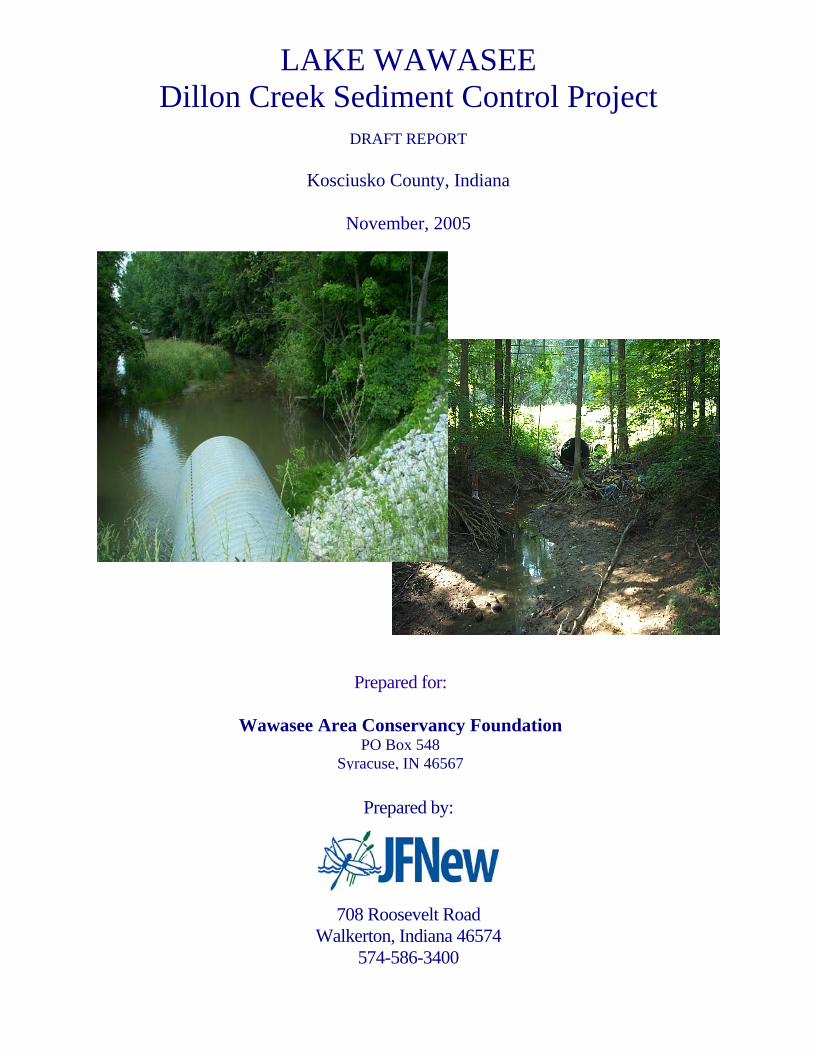
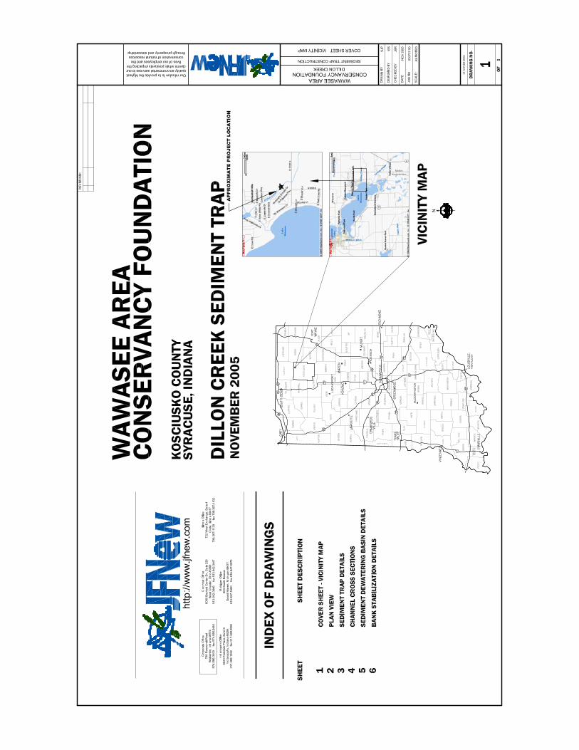
LAKE WAWASEE Dillon Creek Sediment Control Project
DRAFT REPORT
Kosciusko County, Indiana
November, 2005
Prepared by:
708 Roosevelt Road Walkerton, Indiana 46574
574-586-3400
Page 1 File #03-07-37 (01)
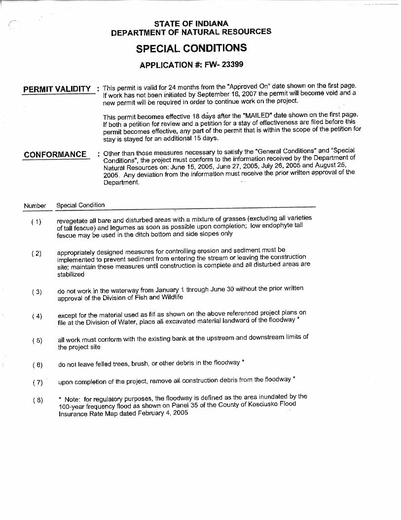
DILLON CREEK OUTLET DESIGN/BUILD REPORT KOSCIUSKO COUNTY, INDIANA
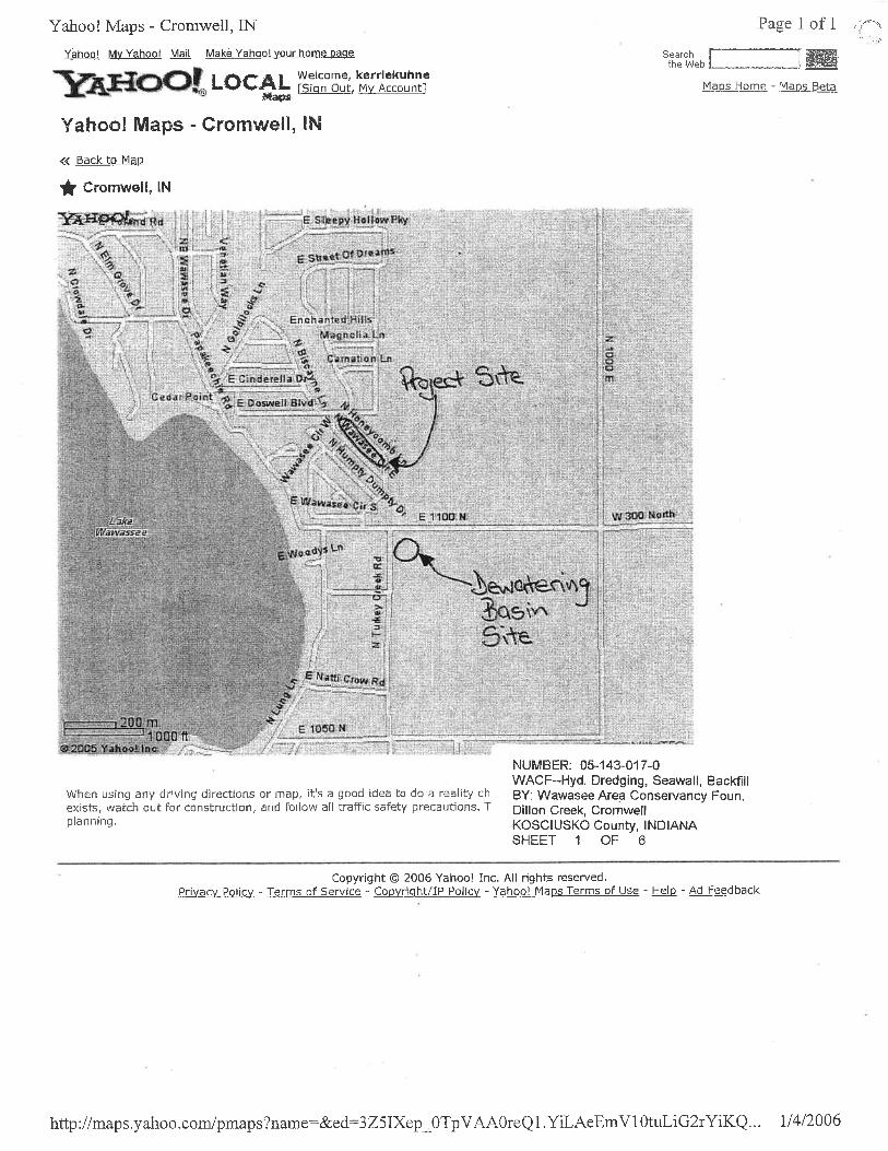
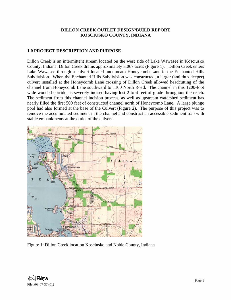
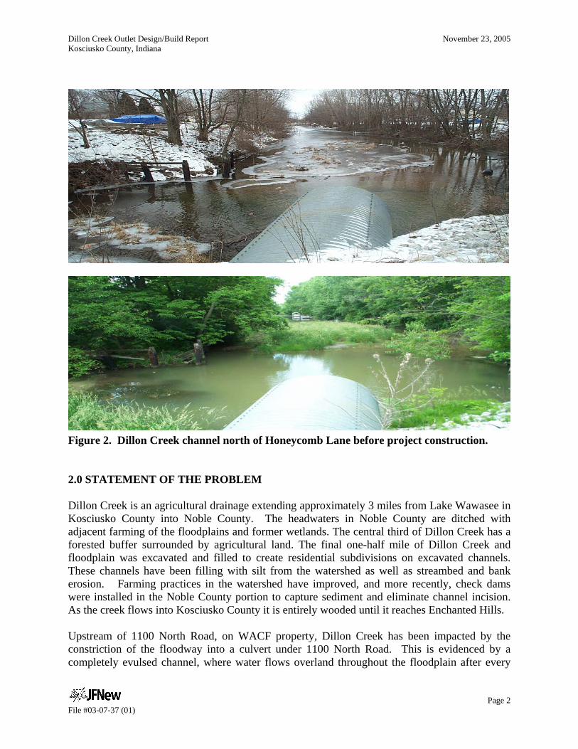
1.0 PROJECT DESCRIPTION AND PURPOSE Dillon Creek is an intermittent stream located on the west side of Lake Wawasee in Kosciusko County, Indiana. Dillon Creek drains approximately 3,067 acres (Figure 1). Dillon Creek enters Lake Wawasee through a culvert located underneath Honeycomb Lane in the Enchanted Hills Subdivision. When the Enchanted Hills Subdivision was constructed, a larger (and thus deeper) culvert installed at the Honeycomb Lane crossing of Dillon Creek allowed headcutting of the channel from Honeycomb Lane southward to 1100 North Road. The channel in this 1200-foot wide wooded corridor is severely incised having lost 2 to 4 feet of grade throughout the reach. The sediment from this channel incision process, as well as upstream watershed sediment has nearly filled the first 500 feet of constructed channel north of Honeycomb Lane. A large plunge pool had also formed at the base of the Culvert (Figure 2). The purpose of this project was to remove the accumulated sediment in the channel and construct an accessible sediment trap with stable embankments at the outlet of the culvert.
Figure 1: Dillon Creek location Kosciusko and Noble County, Indiana
Dillon Creek Outlet Design/Build Report November 23, 2005 Kosciusko County, Indiana
Page 2 File #03-07-37 (01)
Figure 2. Dillon Creek channel north of Honeycomb Lane before project construction. 2.0 STATEMENT OF THE PROBLEM Dillon Creek is an agricultural drainage extending approximately 3 miles from Lake Wawasee in Kosciusko County into Noble County. The headwaters in Noble County are ditched with adjacent farming of the floodplains and former wetlands. The central third of Dillon Creek has a forested buffer surrounded by agricultural land. The final one-half mile of Dillon Creek and floodplain was excavated and filled to create residential subdivisions on excavated channels. These channels have been filling with silt from the watershed as well as streambed and bank erosion. Farming practices in the watershed have improved, and more recently, check dams were installed in the Noble County portion to capture sediment and eliminate channel incision. As the creek flows into Kosciusko County it is entirely wooded until it reaches Enchanted Hills. Upstream of 1100 North Road, on WACF property, Dillon Creek has been impacted by the constriction of the floodway into a culvert under 1100 North Road. This is evidenced by a completely evulsed channel, where water flows overland throughout the floodplain after every
Dillon Creek Outlet Design/Build Report November 23, 2005 Kosciusko County, Indiana
Page 3 File #03-07-37 (01)
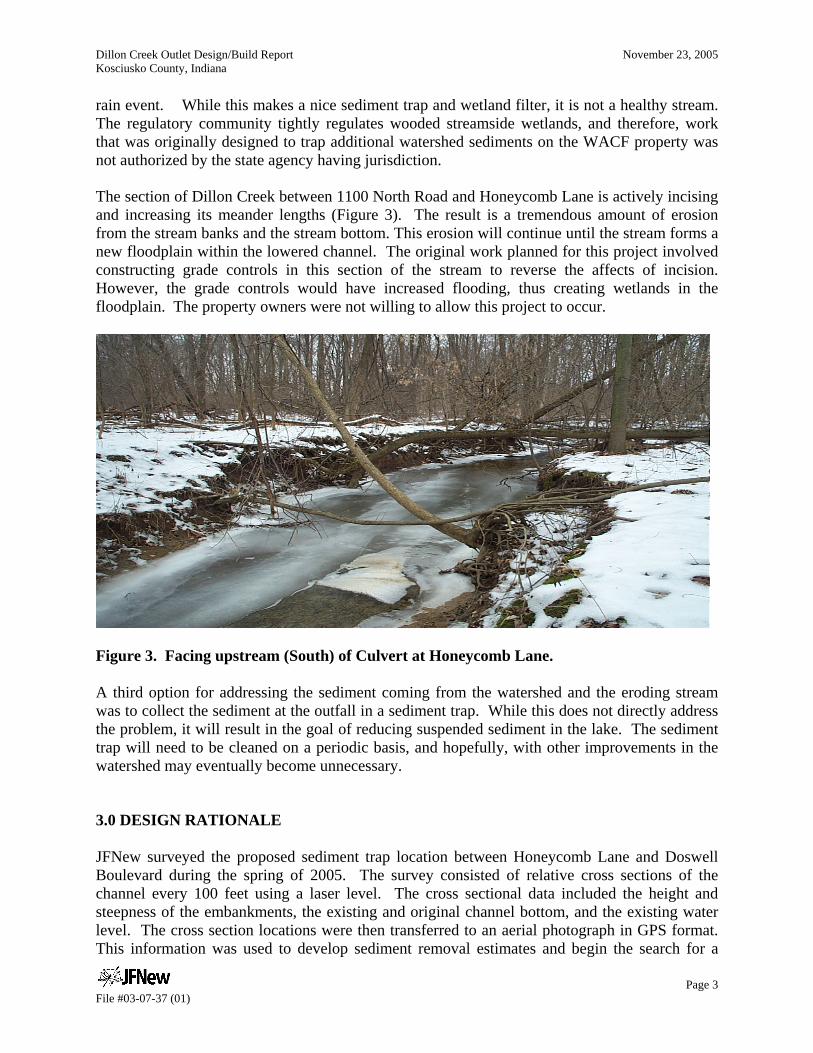
rain event. While this makes a nice sediment trap and wetland filter, it is not a healthy stream. The regulatory community tightly regulates wooded streamside wetlands, and therefore, work that was originally designed to trap additional watershed sediments on the WACF property was not authorized by the state agency having jurisdiction. The section of Dillon Creek between 1100 North Road and Honeycomb Lane is actively incising and increasing its meander lengths (Figure 3). The result is a tremendous amount of erosion from the stream banks and the stream bottom. This erosion will continue until the stream forms a new floodplain within the lowered channel. The original work planned for this project involved constructing grade controls in this section of the stream to reverse the affects of incision. However, the grade controls would have increased flooding, thus creating wetlands in the floodplain. The property owners were not willing to allow this project to occur.
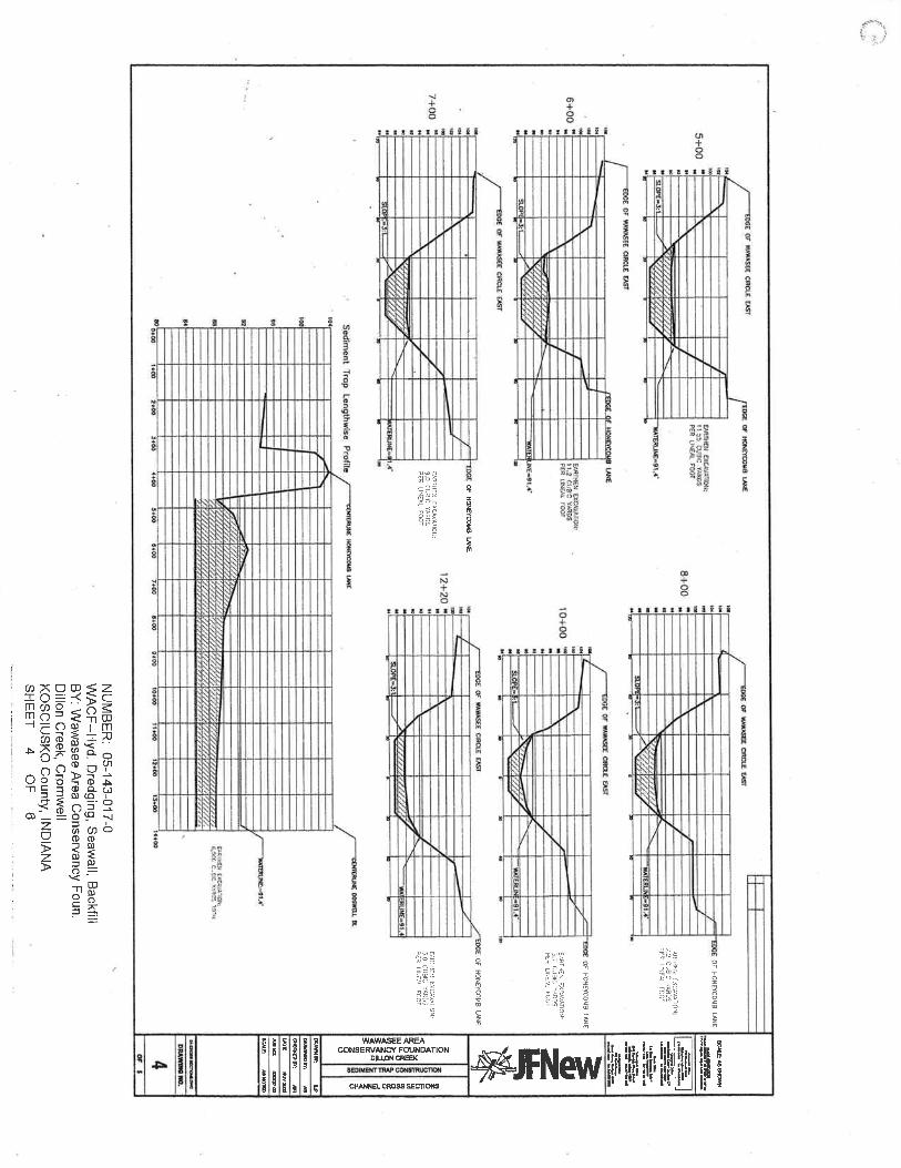
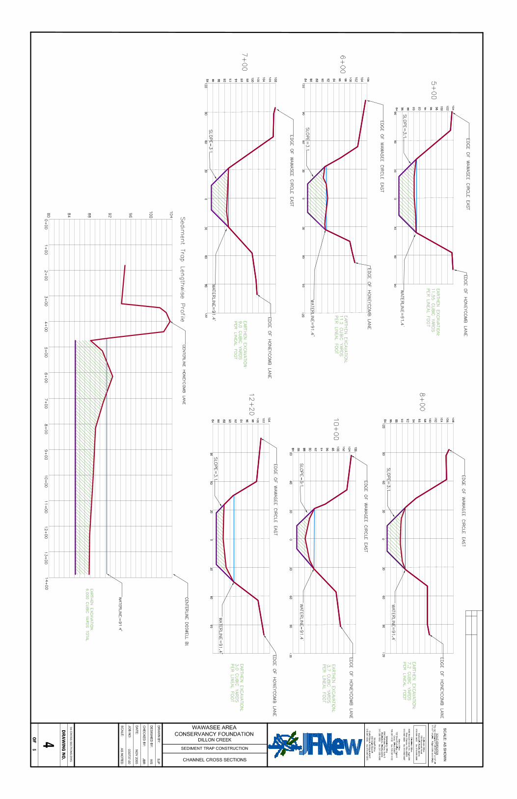
Figure 3. Facing upstream (South) of Culvert at Honeycomb Lane. A third option for addressing the sediment coming from the watershed and the eroding stream was to collect the sediment at the outfall in a sediment trap. While this does not directly address the problem, it will result in the goal of reducing suspended sediment in the lake. The sediment trap will need to be cleaned on a periodic basis, and hopefully, with other improvements in the watershed may eventually become unnecessary. 3.0 DESIGN RATIONALE JFNew surveyed the proposed sediment trap location between Honeycomb Lane and Doswell Boulevard during the spring of 2005. The survey consisted of relative cross sections of the channel every 100 feet using a laser level. The cross sectional data included the height and steepness of the embankments, the existing and original channel bottom, and the existing water level. The cross section locations were then transferred to an aerial photograph in GPS format. This information was used to develop sediment removal estimates and begin the search for a
Dillon Creek Outlet Design/Build Report November 23, 2005 Kosciusko County, Indiana
Page 4 File #03-07-37 (01)
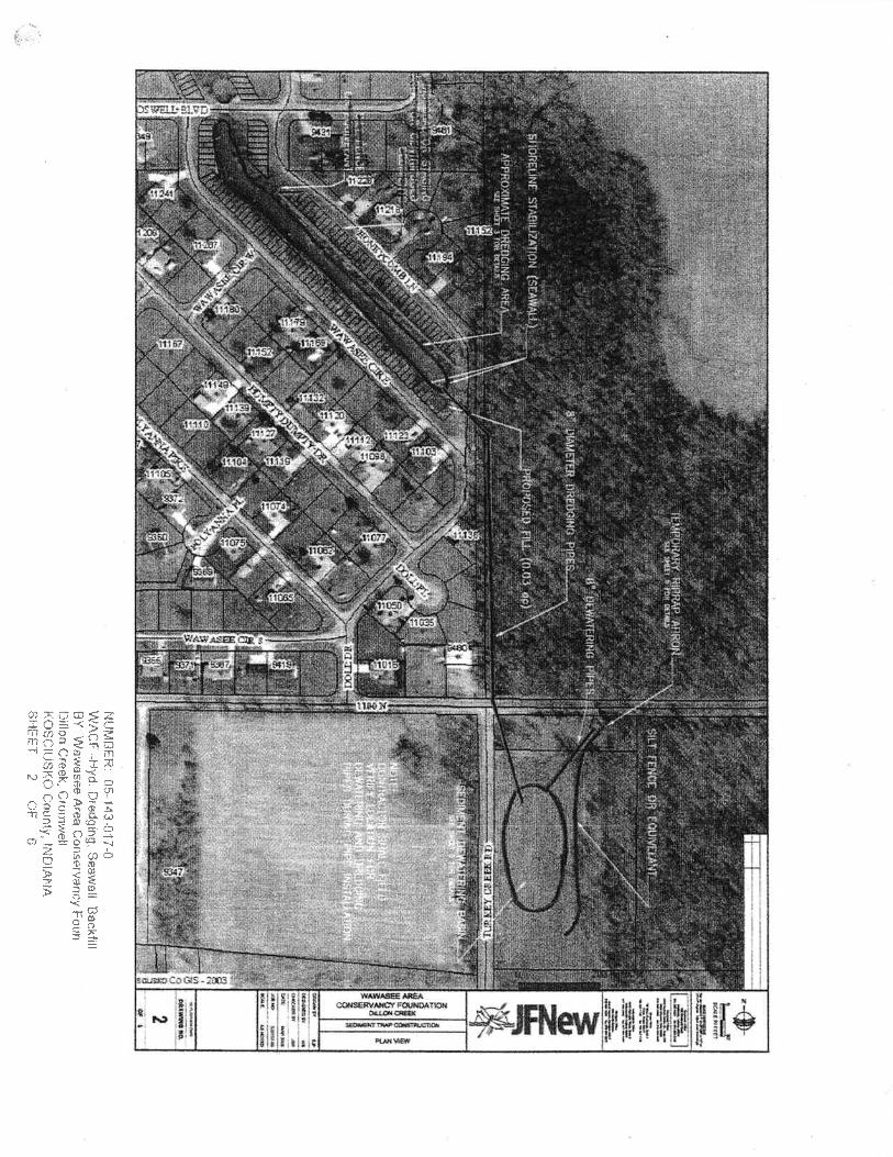
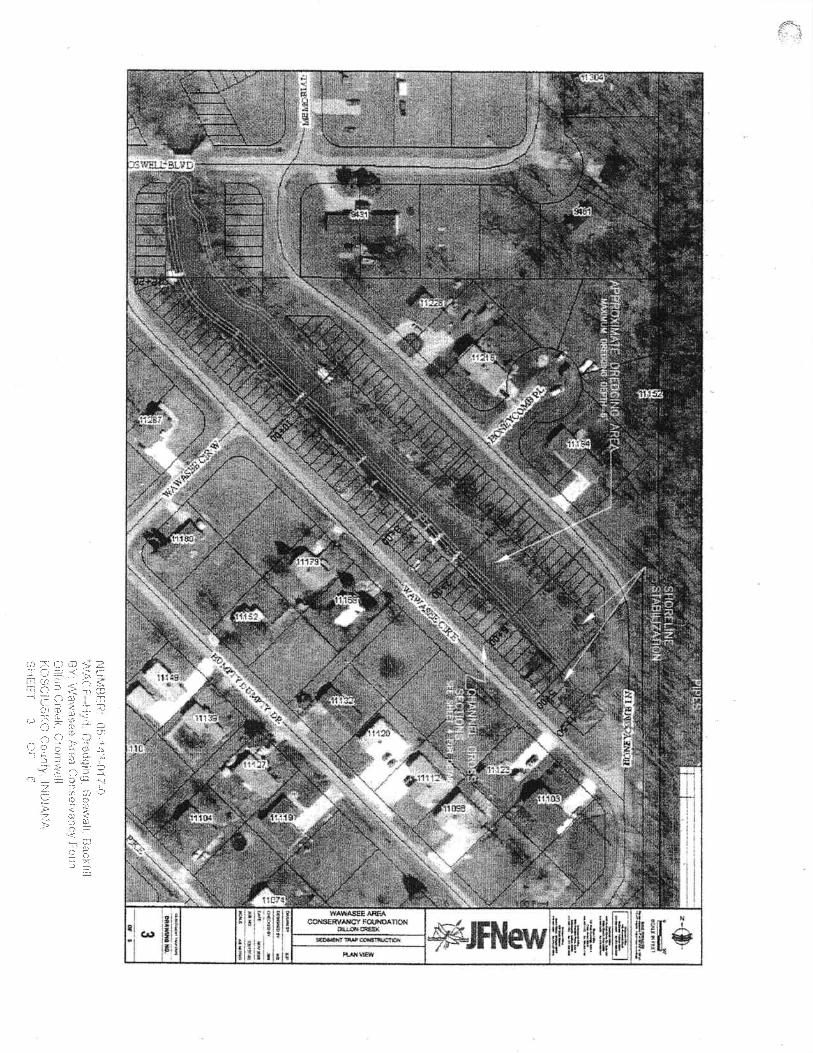
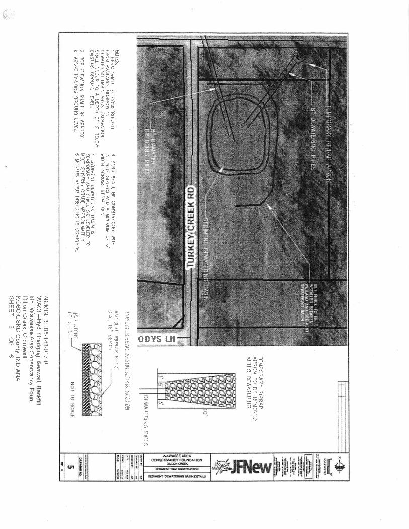
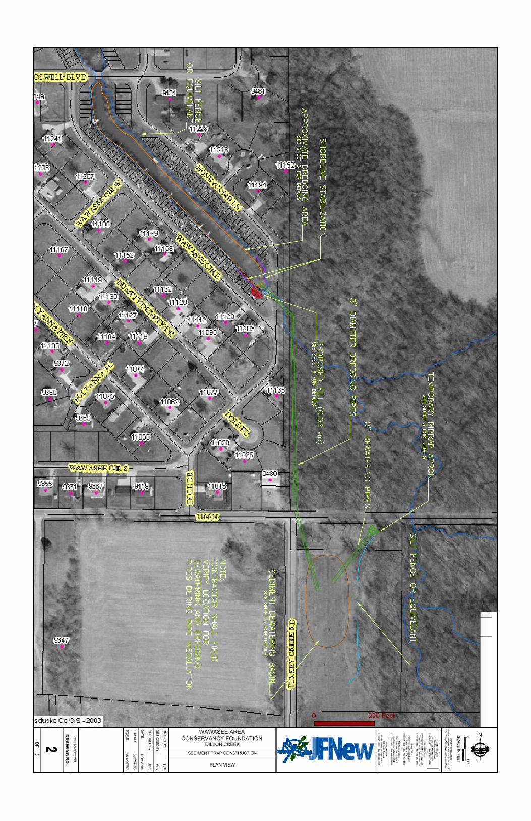
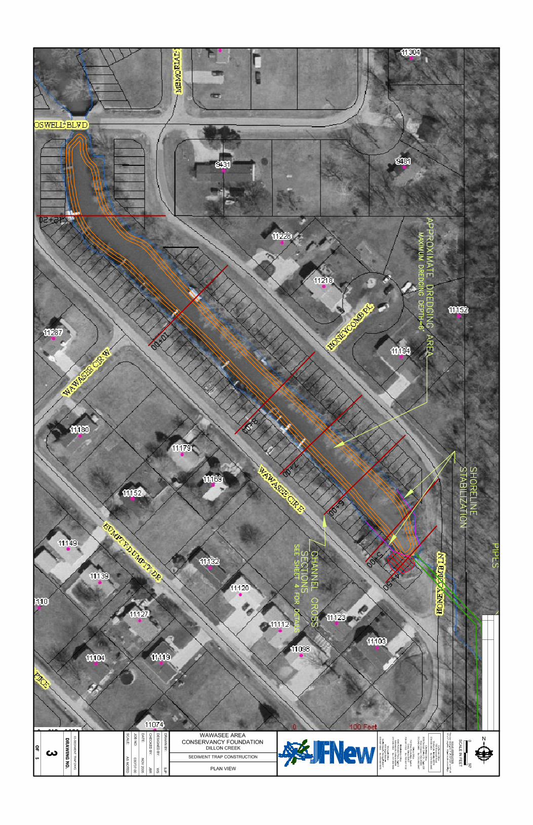
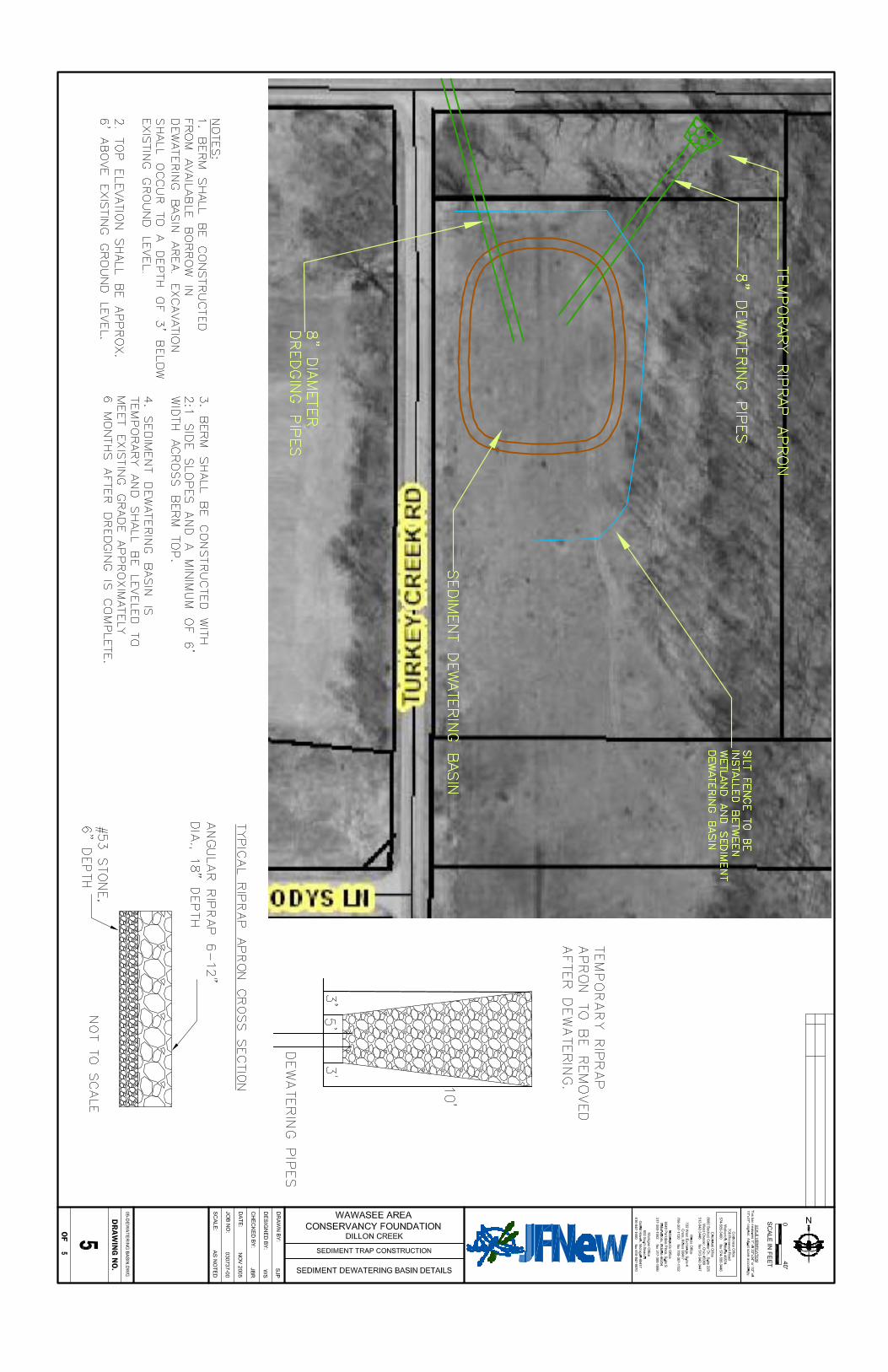
method to remove the accumulated material. As much as six feet of accumulated sand and organic matter had accumulated in an area almost three hundred feet long. The total volume of accumulated sediment was estimated at approximately 1,200 cubic yards. Physical, social, and regulatory concerns were of paramount importance in the decision process of how to remove the material from this channel. The original channel bottom ranged from 14 to 20 feet below the top of banks. The channel banks had at best a 1:1 (horizontal to vertical) slope and were fully vegetated with mature trees. Channel access lots had been plotted in 15-foot wide increments along both sides of the channel for the entire length resulting in 118 lots. All of these owners were notified during the IDNR permit application process. The regulatory concerns included timing of dredging, method of dredging, and maintenance of vegetation on the banks. There are no proven calculations to determine how big a sediment trap should be for a given waterway. Generally, the larger you make a sediment trap, especially when creating an area wider than the existing waterway, the more sediment will drop out of suspension. The heavy particles (sand) tend to fall out in the first portion of the basin while finer particles (clay) may stay in suspension no matter how large you make the basin. However, the longer and wider the trap is the more likely the fine clay particles will settle. JFNew considered constructing a circular trap just at the outfall, however, most of the deposited sand was more than 100 feet downstream of the culvert due to the scouring action as the water falls out of the culvert into the channel (a 5-foot drop). After discussions with the Enchanted Hills Homeowners Association and the permit agencies, it was decided that the entire channel between Honeycomb and Doswell would serve as a better sediment trap in the long term, with the culvert at Doswell acting as the downstream check dam to help recirculate the water flow. The construction methods considered included using a long reach excavator, a dragline, or hydraulic dredging. Using either the long reach excavator or the dragline would have resulted in the removal of the majority of woody vegetation on the slopes to facilitate the excavation. Excavation with land-based equipment also requires stockpiling of the material, drying time, and then removal of the material to a final disposal site. The two-step process became cost prohibitive. Additional concerns with land-based excavation equipment included the objectionable removal of the trees and additional sedimentation of the water column during construction. Hydraulic dredging was favored because of limited disturbance to the channel side slopes and adjacent lots. Hydraulic excavation of the sediment trap became the only realistic solution once a spoils basin location could be identified. The Wawasee Area Conservancy Foundation offered the spoils basin site for the sediment trap after an exhaustive search of other potential sites was conducted with negative results. 4.0 DESIGN AND CONSTRUCTION SPECIFICS 4.1 Sediment trap The sediment trap is 900-feet long and 40 feet wide. It is designed to extend at least to the original bottom and width of the channel with a minimum depth of 6-feet. It will be excavated
Dillon Creek Outlet Design/Build Report November 23, 2005 Kosciusko County, Indiana
Page 5 File #03-07-37 (01)
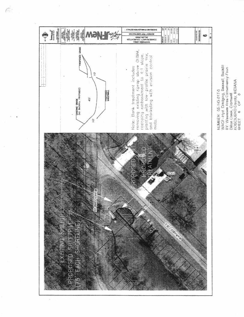
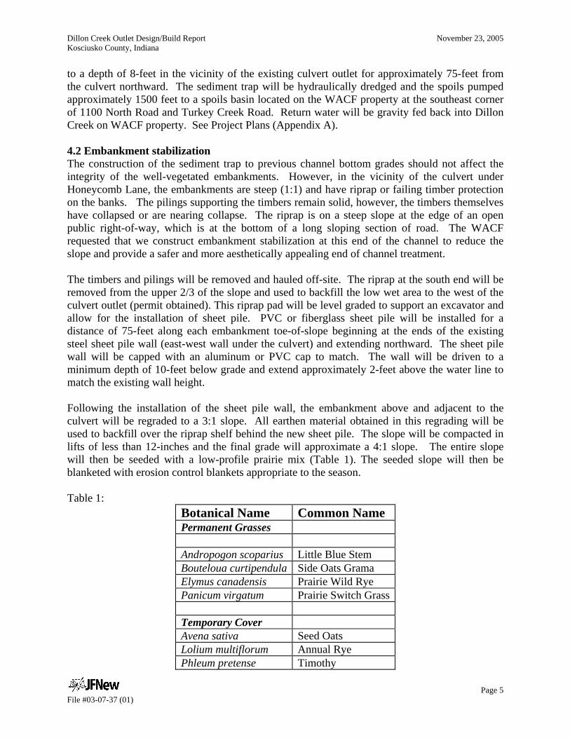
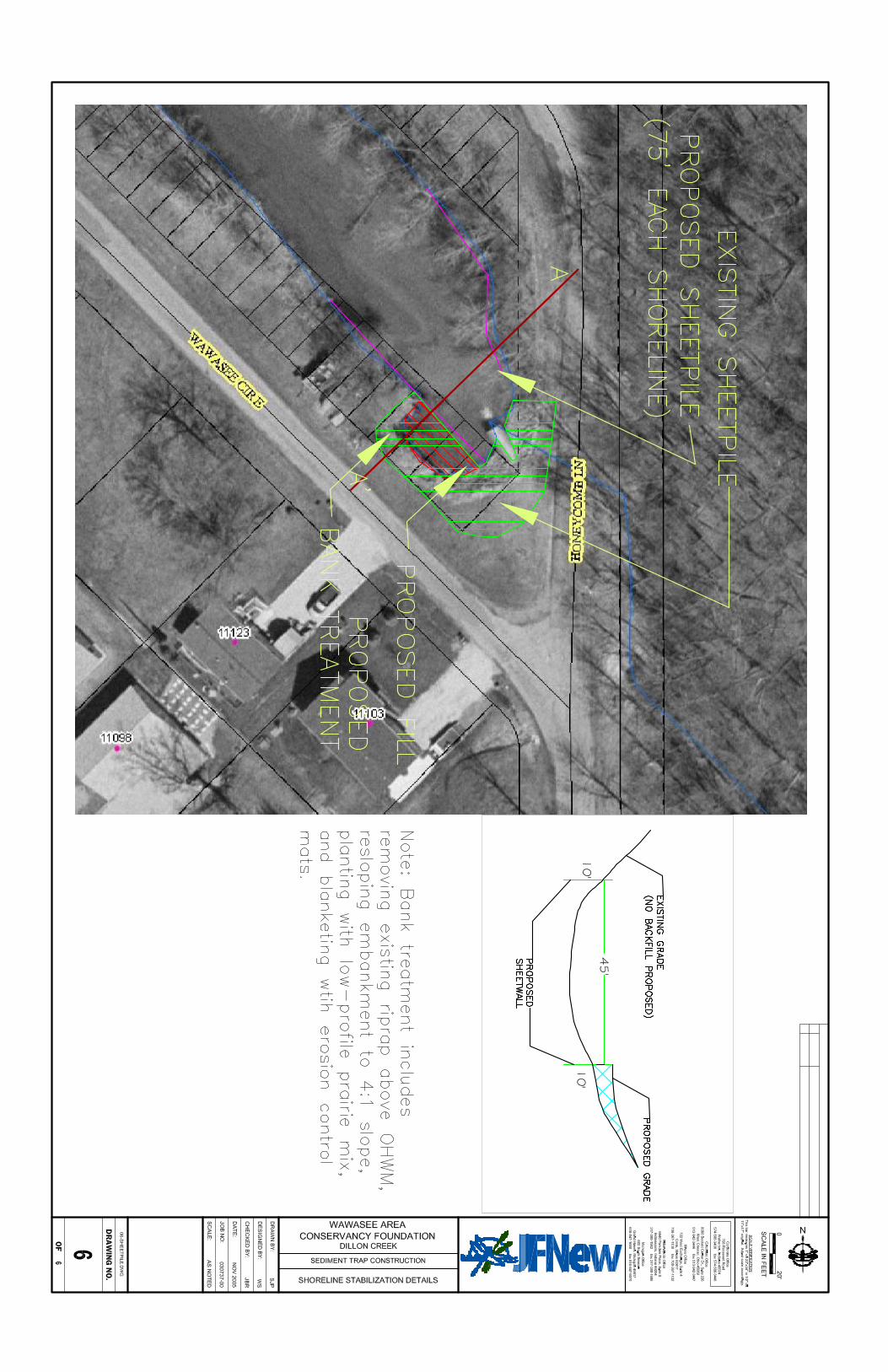
to a depth of 8-feet in the vicinity of the existing culvert outlet for approximately 75-feet from the culvert northward. The sediment trap will be hydraulically dredged and the spoils pumped approximately 1500 feet to a spoils basin located on the WACF property at the southeast corner of 1100 North Road and Turkey Creek Road. Return water will be gravity fed back into Dillon Creek on WACF property. See Project Plans (Appendix A). 4.2 Embankment stabilization The construction of the sediment trap to previous channel bottom grades should not affect the integrity of the well-vegetated embankments. However, in the vicinity of the culvert under Honeycomb Lane, the embankments are steep (1:1) and have riprap or failing timber protection on the banks. The pilings supporting the timbers remain solid, however, the timbers themselves have collapsed or are nearing collapse. The riprap is on a steep slope at the edge of an open public right-of-way, which is at the bottom of a long sloping section of road. The WACF requested that we construct embankment stabilization at this end of the channel to reduce the slope and provide a safer and more aesthetically appealing end of channel treatment. The timbers and pilings will be removed and hauled off-site. The riprap at the south end will be removed from the upper 2/3 of the slope and used to backfill the low wet area to the west of the culvert outlet (permit obtained). This riprap pad will be level graded to support an excavator and allow for the installation of sheet pile. PVC or fiberglass sheet pile will be installed for a distance of 75-feet along each embankment toe-of-slope beginning at the ends of the existing steel sheet pile wall (east-west wall under the culvert) and extending northward. The sheet pile wall will be capped with an aluminum or PVC cap to match. The wall will be driven to a minimum depth of 10-feet below grade and extend approximately 2-feet above the water line to match the existing wall height. Following the installation of the sheet pile wall, the embankment above and adjacent to the culvert will be regraded to a 3:1 slope. All earthen material obtained in this regrading will be used to backfill over the riprap shelf behind the new sheet pile. The slope will be compacted in lifts of less than 12-inches and the final grade will approximate a 4:1 slope. The entire slope will then be seeded with a low-profile prairie mix (Table 1). The seeded slope will then be blanketed with erosion control blankets appropriate to the season. Table 1:
Botanical Name Common Name Permanent Grasses Andropogon scoparius Little Blue Stem Bouteloua curtipendula Side Oats Grama Elymus canadensis Prairie Wild Rye Panicum virgatum Prairie Switch Grass Temporary Cover Avena sativa Seed Oats Lolium multiflorum Annual Rye Phleum pretense Timothy
Dillon Creek Outlet Design/Build Report November 23, 2005 Kosciusko County, Indiana
Page 6 File #03-07-37 (01)
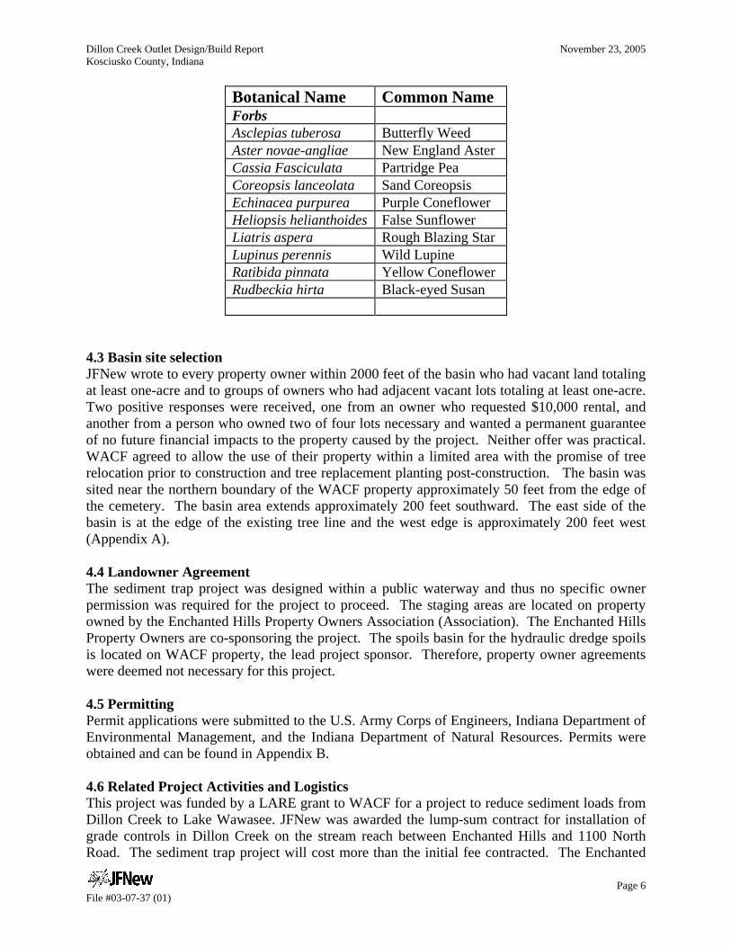
Botanical Name Common Name Forbs Asclepias tuberosa Butterfly Weed Aster novae-angliae New England Aster Cassia Fasciculata Partridge Pea Coreopsis lanceolata Sand Coreopsis Echinacea purpurea Purple Coneflower Heliopsis helianthoides False Sunflower Liatris aspera Rough Blazing Star Lupinus perennis Wild Lupine Ratibida pinnata Yellow Coneflower Rudbeckia hirta Black-eyed Susan
4.3 Basin site selection JFNew wrote to every property owner within 2000 feet of the basin who had vacant land totaling at least one-acre and to groups of owners who had adjacent vacant lots totaling at least one-acre. Two positive responses were received, one from an owner who requested $10,000 rental, and another from a person who owned two of four lots necessary and wanted a permanent guarantee of no future financial impacts to the property caused by the project. Neither offer was practical. WACF agreed to allow the use of their property within a limited area with the promise of tree relocation prior to construction and tree replacement planting post-construction. The basin was sited near the northern boundary of the WACF property approximately 50 feet from the edge of the cemetery. The basin area extends approximately 200 feet southward. The east side of the basin is at the edge of the existing tree line and the west edge is approximately 200 feet west (Appendix A). 4.4 Landowner Agreement The sediment trap project was designed within a public waterway and thus no specific owner permission was required for the project to proceed. The staging areas are located on property owned by the Enchanted Hills Property Owners Association (Association). The Enchanted Hills Property Owners are co-sponsoring the project. The spoils basin for the hydraulic dredge spoils is located on WACF property, the lead project sponsor. Therefore, property owner agreements were deemed not necessary for this project. 4.5 Permitting Permit applications were submitted to the U.S. Army Corps of Engineers, Indiana Department of Environmental Management, and the Indiana Department of Natural Resources. Permits were obtained and can be found in Appendix B. 4.6 Related Project Activities and Logistics This project was funded by a LARE grant to WACF for a project to reduce sediment loads from Dillon Creek to Lake Wawasee. JFNew was awarded the lump-sum contract for installation of grade controls in Dillon Creek on the stream reach between Enchanted Hills and 1100 North Road. The sediment trap project will cost more than the initial fee contracted. The Enchanted
Dillon Creek Outlet Design/Build Report November 23, 2005 Kosciusko County, Indiana
Page 7 File #03-07-37 (01)
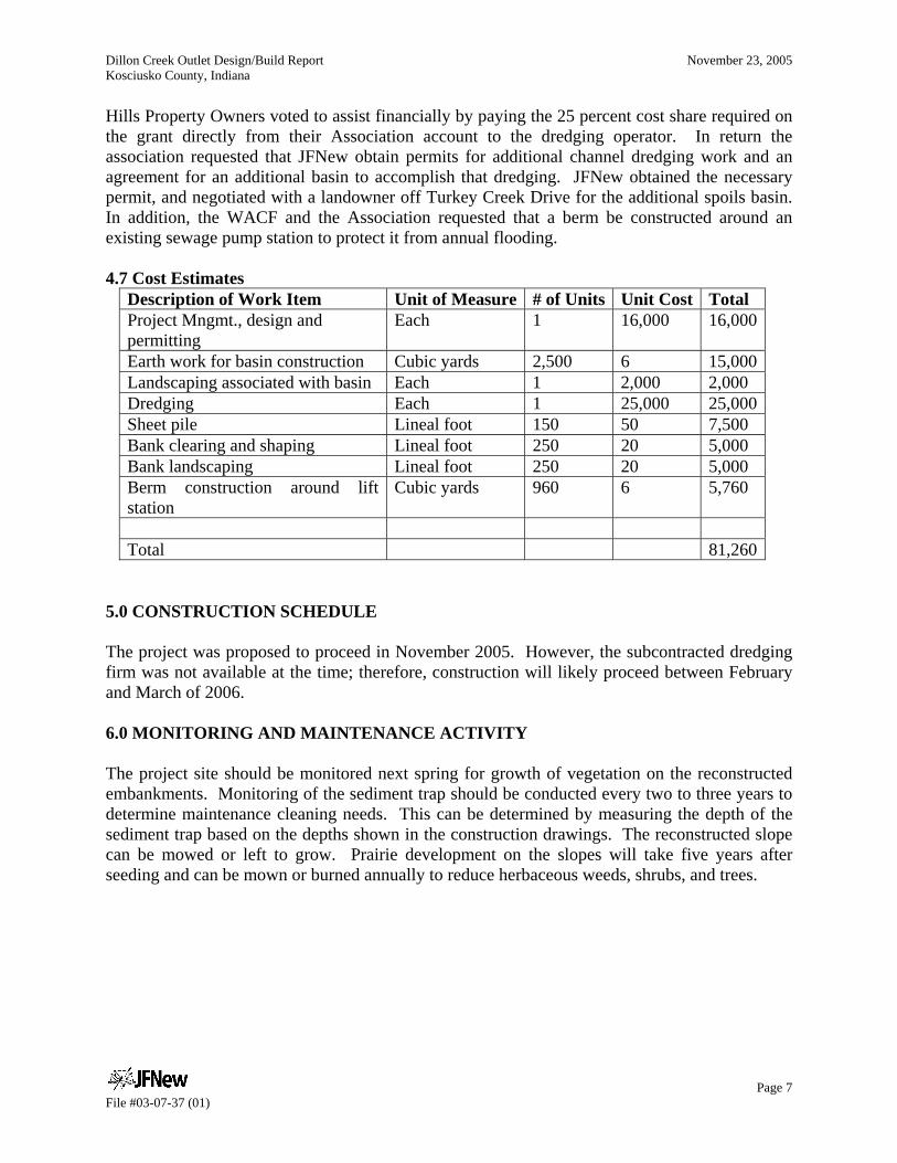
Hills Property Owners voted to assist financially by paying the 25 percent cost share required on the grant directly from their Association account to the dredging operator. In return the association requested that JFNew obtain permits for additional channel dredging work and an agreement for an additional basin to accomplish that dredging. JFNew obtained the necessary permit, and negotiated with a landowner off Turkey Creek Drive for the additional spoils basin. In addition, the WACF and the Association requested that a berm be constructed around an existing sewage pump station to protect it from annual flooding. 4.7 Cost Estimates
Description of Work Item Unit of Measure # of Units Unit Cost Total Project Mngmt., design and permitting
Each 1 16,000 16,000
Earth work for basin construction Cubic yards 2,500 6 15,000Landscaping associated with basin Each 1 2,000 2,000 Dredging Each 1 25,000 25,000Sheet pile Lineal foot 150 50 7,500 Bank clearing and shaping Lineal foot 250 20 5,000 Bank landscaping Lineal foot 250 20 5,000 Berm construction around lift station
Cubic yards 960 6 5,760
Total 81,260
5.0 CONSTRUCTION SCHEDULE The project was proposed to proceed in November 2005. However, the subcontracted dredging firm was not available at the time; therefore, construction will likely proceed between February and March of 2006. 6.0 MONITORING AND MAINTENANCE ACTIVITY The project site should be monitored next spring for growth of vegetation on the reconstructed embankments. Monitoring of the sediment trap should be conducted every two to three years to determine maintenance cleaning needs. This can be determined by measuring the depth of the sediment trap based on the depths shown in the construction drawings. The reconstructed slope can be mowed or left to grow. Prairie development on the slopes will take five years after seeding and can be mown or burned annually to reduce herbaceous weeds, shrubs, and trees.
Dillon Creek Outlet Design/Build Report November 23, 2005 Kosciusko County, Indiana
Page 8 File #03-07-37 (01)
7.0 PROJECT SUMMARY Sediment flowing to Lake Wawasee from Dillon Creek is derived from upper watershed surface erosion and from the stream channel between Enchanted Hills and 1100 North Road. This project originally targeted the sediment from the severely eroding channel in the wooded floodplain between Honeycomb Lane and 1100 North Road. The landowner would not allow the project to proceed. JFNew was approached by the Enchanted Hills Property Owners Association to consider a sediment trap within the Dillon Creek channel on Enchanted Hills' property. The WACF and the LARE staff agreed to allow the sediment trap project to proceed. The sediment trap was designed to be approximately 0.8 acres. Hydraulic dredging was selected as the most environmentally and physically feasible way to construct the sediment trap. A sediment basin was then designed for the WACF property at the southeast corner of 1100 North Road and Turkey Creek Road. Stabilization of the culvert outfall area will be accomplished by removal of debris, regrading the slope, and planting with native prairie vegetation.

Appendix A
Plan Drawings
File #03-07-37 (01)

Appendix B
Permits
File #03-07-37 (01)