lake marion creek and reedy creek
TRANSCRIPT

SFWMD Land Assessment, Fee‐Simple Lands 2013
23
Lake Marion Creek and Reedy Creek Polk and Osceola County Area within planning boundary footprint 37, 150 acres District fee‐simple ownership 12,915 acres Other public fee‐simple ownership 4,312 acres Area under other regulatory restriction (conservation easement, platted preserve area, etc.) *acreages are estimates 7,900 acres Site Overview This area consists of extensive lowlands surrounding creeks that flow into the Kissimmee Chain of Lakes. The most significant is Reedy Creek, on the east side, which receives water from the Walt Disney World Resort and the southwestern region of the greater Orlando area. These wetlands provide water quality improvement benefits to the region, particularly after storms and during the rainy season, when water spills out of the shallow natural streambeds and sheetflows through the basin. The Reedy Creek floodplain is joined to the broad swamps and hardwood wetlands to the west through the Intercession City assessment unit. The western units are lowlands that surround small tributaries (Snell Creek and Horse Creek) of Lake Marion Creek, a water course that connects Lake Marion to Lake Hatchineha. These creeks and forested wetlands are an important feature of the Everglades headwaters.
The District began purchasing lands within the Lake Marion Creek Project Area and Upper Reedy Creek Project Area in 1994 through the Save Our Rivers program. The majority of land was acquired between July 1994 and May 1997. Assessment Units Intercession City The Intercession City unit lies south of S. Orange Blossom Trail (U.S. 17‐92). The unit lies within the floodplain of Reedy Creek. Lake Russell and Poinciana Blvd The Lake Russell and Poiciana Blvd unit consist of two tracts within the Reedy Creek floodplain that are connected by platted preserve areas of Poinciana.
Huckleberry Island / Snell Creek Huckleberry Island and Snell Creek contain the primary public use features, with miles of trails, picnic areas, and primitive camping sites. This unit has been established as a Wildlife Management Area and opened to hunting by the Fish and Wildlife Conservation Commission. Lake Marion The Lake Marion unit consists of District and Polk County‐owned land lying south of Cypress Parkway (CR580), excluding the Avatar Scrub unit. These lands are floodplain forests and swamps, those which border Lake Marion or surround Lake Marion Creek, and are bisected by a narrow sandy ridge of scrub. Avatar Scrub The Avatar Scrub site is a high sand ridge of scrub with a steep forested seepage slope leading down into the Lake Marion Creek floodplain, and a cutthroat grass seepage slope on the opposite side of the ridge.
Lake Marion Creek planning boundary divided into
Assessment Units

SFWMD Land Assessment, Fee‐Simple Lands 2013
24
Publicly Owned Land and Protected Land in Lake Marion Creek and Reedy Creek

SFWMD Land Assessment, Fee‐Simple Lands 2013
25
Lake Marion Creek and Reedy Creek Assessment Unit: Intercession City District fee‐simple ownership – 4,033 acres Intercession City is named after a failed land development from the 1920s real estate boom. At that time it was called Interocean City, a development that went bust when the real estate bubble of the 20s burst. During the Depression, the site was donated to a group of orphans who had lost their original orphanage and who picked the wild huckleberries growing in the pine islands in order to survive. The orphanage became a bible college in the 40s, which closed in 1953. The District acquired the site in 1995 and 1997 under the Save Our Rivers program. Current Use The site is being managed and maintained in its natural state and condition. There is a northern tract south of U.S. 17‐92, and a southern tract north of the Poinciana community. Core Mission Value The site receives water that originates from the Walt Disney World Resort and other developed areas of the southwest Orlando area. Consisting of a broad and low floodplain, the site is an important flood attenuation and water quality feature. The site serves as an initial natural filter for stormwater runoff prior to entering the Kissimmee Chain of Lakes. There are two pine islands within the unit that are periodically burned through the application of prescribed fire. Other Resource Value The area is predominantly forested wetlands within the Reedy Creek floodplain. There are two significant pine islands, one south of the Intercession City community, and one north of the Poinciana community. The site is a landscape‐scale natural system, containing both upland and wetland communities, and supports an abundance of wildlife. The site is an important wildlife corridor serving as a nexus between the western Lake Marion Creek system to the southwest, the Reedy creek floodplain to the southeast, and the Reedy Creek Improvement District lands and the Walt Disney World Resort to the north.
Management Issues The biggest management issue is keeping exotic species under control within the floodplain. Accessing the interior areas of the swamp is difficult. The proximity of the pine island to the Intercession City community and U.S. 17‐92 limits the conditions under which it can be burned. Public Use and Recreation Value There is a public access trailhead to the northernmost pine island in the unit. There are hiking trails that extend down into the swamp. The distance that one may travel into the swamp changes with the seasonal fluctuations of water levels. The trailhead is used frequently by residents of the intercession city community.
Intercession City (the area shown within the yellow
planning boundary)
SFWMD Land Assessment, Fee‐Simple Lands 2013
26
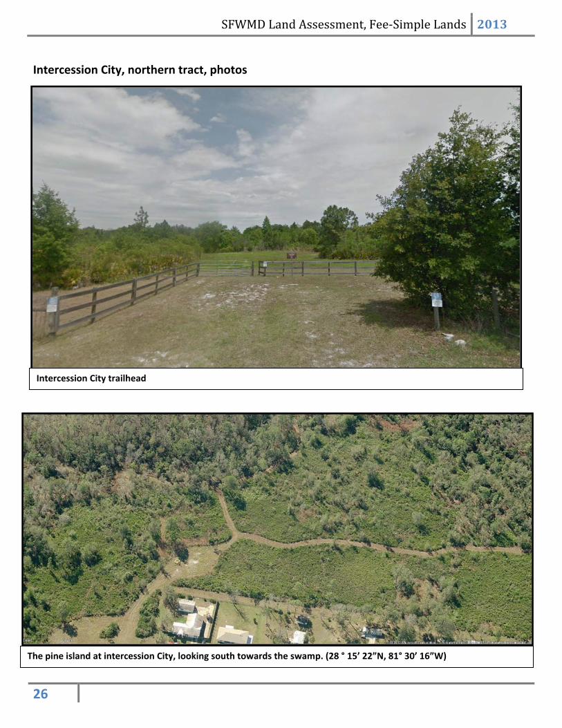
Intercession City, northern tract, photos
Intercession City trailhead
The pine island at intercession City, looking south towards the swamp. (28 ° 15’ 22”N, 81° 30’ 16”W)

SFWMD Land Assessment, Fee‐Simple Lands 2013
27
Intercession City pine island, ground view (left); and the trail as it dips into the swamp in the wet season (right).
Burning the Intercession City pine island, the ecological health of the pine islands are dependent upon the
periodic application of prescribed fire.
SFWMD Land Assessment, Fee‐Simple Lands 2013
28
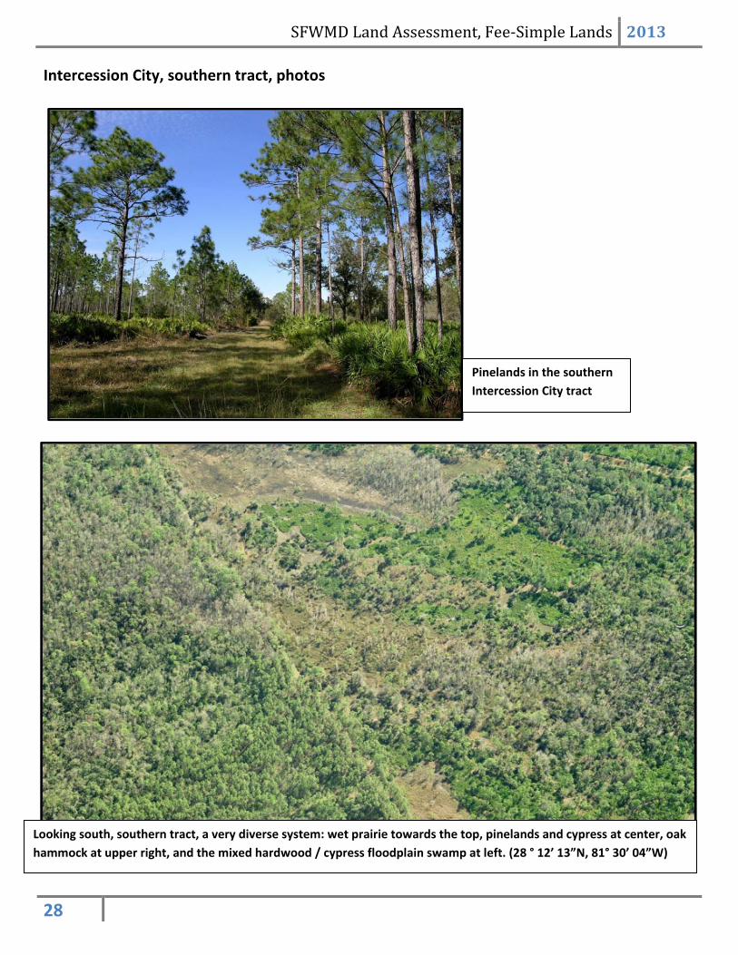
Intercession City, southern tract, photos
Looking south, southern tract, a very diverse system: wet prairie towards the top, pinelands and cypress at center, oak
hammock at upper right, and the mixed hardwood / cypress floodplain swamp at left. (28 ° 12’ 13”N, 81° 30’ 04”W)
Pinelands in the southern
Intercession City tract
SFWMD Land Assessment, Fee‐Simple Lands 2013
29
Intercession City, Individual Parcel Assessments
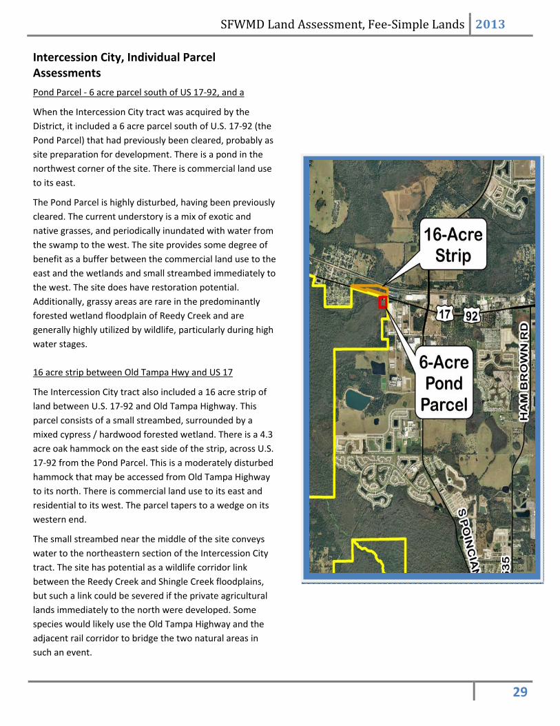
Pond Parcel ‐ 6 acre parcel south of US 17‐92, and a
When the Intercession City tract was acquired by the
District, it included a 6 acre parcel south of U.S. 17‐92 (the
Pond Parcel) that had previously been cleared, probably as
site preparation for development. There is a pond in the
northwest corner of the site. There is commercial land use
to its east.
The Pond Parcel is highly disturbed, having been previously
cleared. The current understory is a mix of exotic and
native grasses, and periodically inundated with water from
the swamp to the west. The site provides some degree of
benefit as a buffer between the commercial land use to the
east and the wetlands and small streambed immediately to
the west. The site does have restoration potential.
Additionally, grassy areas are rare in the predominantly
forested wetland floodplain of Reedy Creek and are
generally highly utilized by wildlife, particularly during high
water stages.
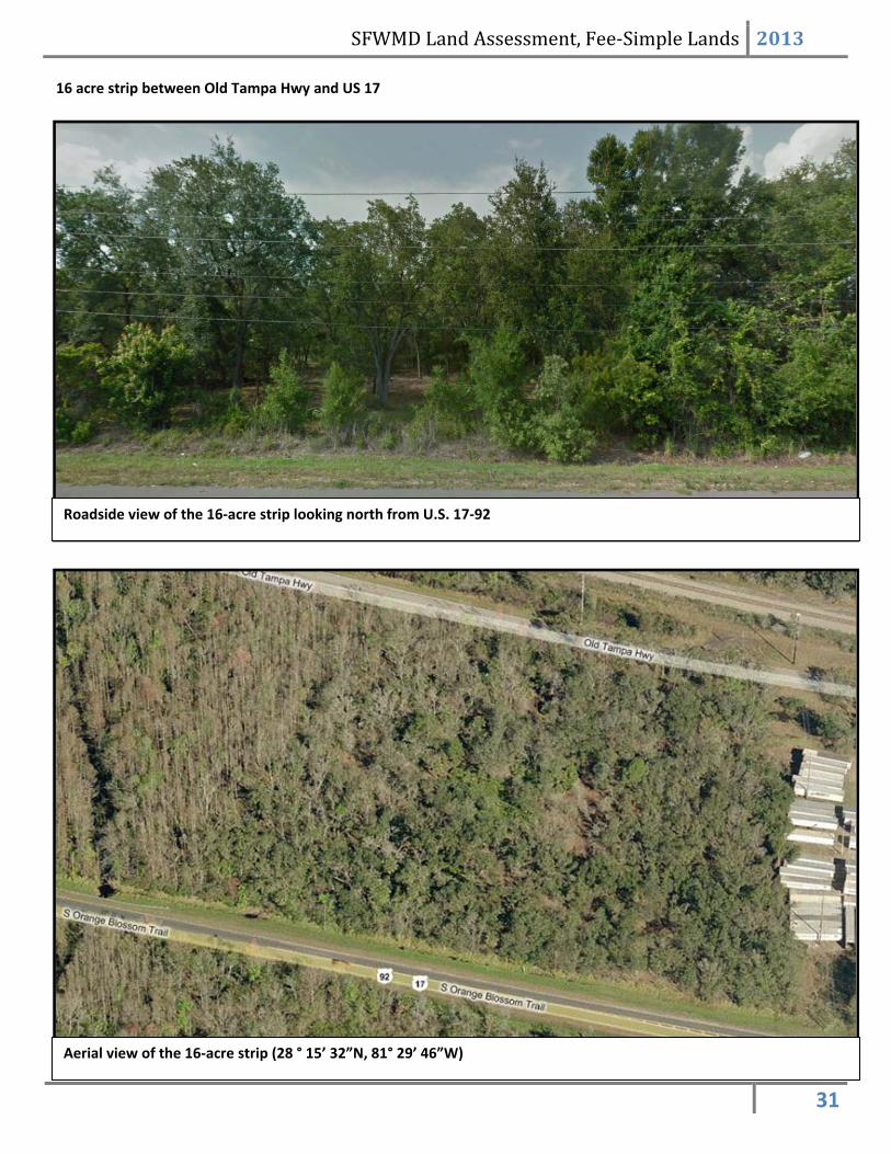
16 acre strip between Old Tampa Hwy and US 17
The Intercession City tract also included a 16 acre strip of
land between U.S. 17‐92 and Old Tampa Highway. This
parcel consists of a small streambed, surrounded by a
mixed cypress / hardwood forested wetland. There is a 4.3
acre oak hammock on the east side of the strip, across U.S.
17‐92 from the Pond Parcel. This is a moderately disturbed
hammock that may be accessed from Old Tampa Highway
to its north. There is commercial land use to its east and
residential to its west. The parcel tapers to a wedge on its
western end.
The small streambed near the middle of the site conveys
water to the northeastern section of the Intercession City
tract. The site has potential as a wildlife corridor link
between the Reedy Creek and Shingle Creek floodplains,
but such a link could be severed if the private agricultural
lands immediately to the north were developed. Some
species would likely use the Old Tampa Highway and the
adjacent rail corridor to bridge the two natural areas in
such an event.

SFWMD Land Assessment, Fee‐Simple Lands 2013
30
Pond Parcel ‐ 6 acre parcel south of US 17
The mostly cleared 6‐acre pond parcel
Aerial view of the cleared 6‐acre pond parcel (28 ° 15’ 25”N, 81° 29’ 46”W)
SFWMD Land Assessment, Fee‐Simple Lands 2013
31
16 acre strip between Old Tampa Hwy and US 17
Aerial view of the 16‐acre strip (28 ° 15’ 32”N, 81° 29’ 46”W)
Roadside view of the 16‐acre strip looking north from U.S. 17‐92
SFWMD Land Assessment, Fee‐Simple Lands 2013
32
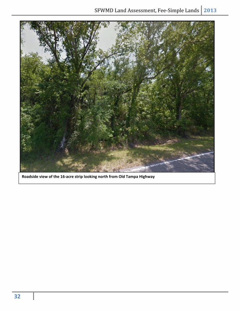
Roadside view of the 16‐acre strip looking north from Old Tampa Highway

SFWMD Land Assessment, Fee‐Simple Lands 2013
33
Year Acquired
1997
1995
16‐acre Strip
6‐AcrePondParcel
Funding Source
Preservation 2000
Land AcquisitionTrust Fund
16‐acre Strip
6‐AcrePondParcel
Land Use/ Land Cover
DevelopedArea
Pasture
Agriculture
Fallow Cropland
Upland Non-Forested
Upland Forested
Waterways
Wet Hardwood Forest
Slough
Marshes and Wetlands
Barren Land
16‐acre Strip
6‐AcrePondParcel
Intercession City, Land Acquisition
Intercession City, Land Character
IMPORTANT DISCLAIMER: All maps in this document are a conceptual or planning tool only. The South Florida Water Management District does not guarantee or make any
representation regarding the information contained herein. It is not self‐executing or binding, and does not affect the interests of any persons or properties, including any
present or future right or use of real property.
For more information on the data layers used in the assessment, please refer to the Land Assessment Study Process and Methodology document available here:
http://www.sfwmd.gov/portal/page/portal/xrepository/sfwmd_repository_pdf/land_assessment_study_process.pdf
16‐acre strip 6‐acre pond parcel

SFWMD Land Assessment, Fee‐Simple Lands 2013
34
Potential Habitat Richness
1 species
2-4 species
5-6 species
7 species
8-13 species
16‐acre Strip
6‐AcrePondParcel
Priority 1- HIGHEST
Priority 2
Priority 3
Priority 4
Priority 5
Priority 6
Rare Species Habitat Priorities
16‐acre Strip
6‐AcrePondParcel
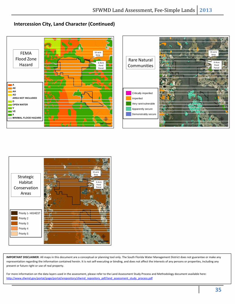
Intercession City, Land Character (Continued)
IMPORTANT DISCLAIMER: All maps in this document are a conceptual or planning tool only. The South Florida Water Management District does not guarantee or make any
representation regarding the information contained herein. It is not self‐executing or binding, and does not affect the interests of any persons or properties, including any
present or future right or use of real property.
For more information on the data layers used in the assessment, please refer to the Land Assessment Study Process and Methodology document available here:
http://www.sfwmd.gov/portal/page/portal/xrepository/sfwmd_repository_pdf/land_assessment_study_process.pdf
16‐acre strip 6‐acre pond parcel
16‐acre strip 6‐acre pond parcel
SFWMD Land Assessment, Fee‐Simple Lands 2013
35
FEMA Flood Zone Hazard
A
AE
AH
AO
AREA NOT INCLUDED
D
OPEN WATER
V
VE
X
MINIMAL FLOOD HAZARD
16‐acre Strip
6‐AcrePondParcel
Rare Natural Communities
Critically imperiled
Imperiled
Very rare/vulnerable
Apparently secure
Demonstrably secure
16‐acre Strip
6‐AcrePondParcel
Strategic Habitat
Conservation Areas
Priority 1- HIGHEST
Priority 2
Priority 3
Priority 4
Priority 5
16‐acre Strip
6‐AcrePondParcel
Intercession City, Land Character (Continued)
IMPORTANT DISCLAIMER: All maps in this document are a conceptual or planning tool only. The South Florida Water Management District does not guarantee or make any
representation regarding the information contained herein. It is not self‐executing or binding, and does not affect the interests of any persons or properties, including any
present or future right or use of real property.
For more information on the data layers used in the assessment, please refer to the Land Assessment Study Process and Methodology document available here:
http://www.sfwmd.gov/portal/page/portal/xrepository/sfwmd_repository_pdf/land_assessment_study_process.pdf

SFWMD Land Assessment, Fee‐Simple Lands 2013
36
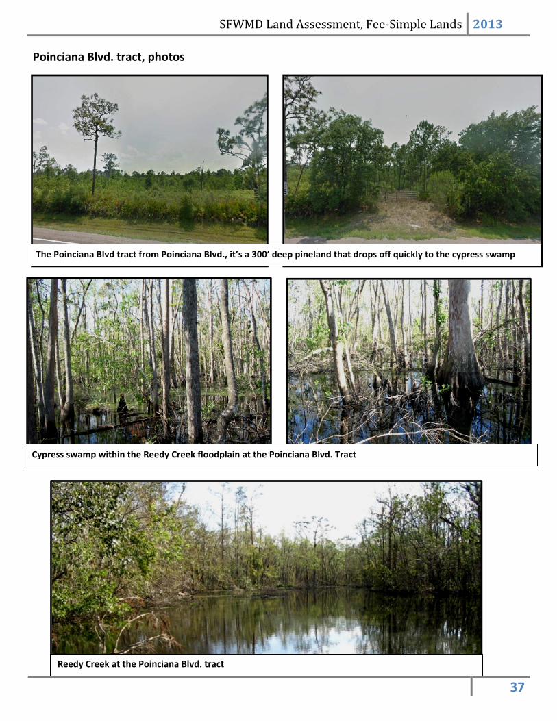
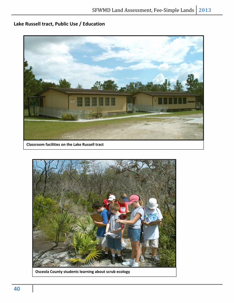
Lake Marion Creek and Reedy Creek Assessment Unit: Lake Russell and Poinciana Blvd Tracts District fee‐simple ownership – 871 acres These two tracts lie along the Reedy Creek floodplain, on the eastern side of the Poinciana community. The Poinciana community was an early example of the large‐scale planned urban development that became widespread in the 1990s. Poinciana was platted in the mid 1970s, so it pre‐dated modern land use rules. Most of the floodplain was dedicated to preservation through the platting of the development. The District’s land acquisition effort focused on the floodplain parcels that were not platted preserves. Current Use The two tracts are being managed and maintained in their natural state and condition. The Lake Russell tract is being utilized by the Osceola County School Board as an environmental and natural resource education center for County students. The School Board conducts educational programs throughout the school year as well as a summer camp. Core Mission Value The Poinciana Boulevard tract, together with the adjacent tracts preserved through the development of Poinciana, helps protect the floodplain of Reedy Creek from direct stormwater discharges from adjacent developments. The protection of the floodplain enables the creek to fluctuate naturally.
Lake Russell has a natural shoreline all the way around, with no direct stormwater discharges from residential or commercial development. The Lake Russell tract had been platted for residential development at the time the District acquired it. Other Resource Value The Poinciana Boulevard tract is predominantly a cypress swamp, but also contains a 300’ wide strip of pines between the swamp and Poinciana Boulevard.
The Lake Russell tract is an isolated island of scrub, dry prairie, scrubby flatwood, and a fringing seepage slope; all of which is surrounded by the Reedy Creek floodplain swamp. There are a number of rare and endemic scrub species present on site, and rare pitcher plants may be found on the seepage slopes. Gopher tortoises are
present. The Lake Russell shoreline contains a large wood
stork rookery.
Management Issues
Accessing the swamp in the Poinciana Tract to conduct land management activities, primarily exotic species control, is difficult since it is a swamp that rarely dries down. The proximity of the 300’ wide strip of pines to Poinciana Blvd limits the conditions under which it may be burned.
The District conducts the resource management activities on the Lake Russell tract, while the School Board conducts facility maintenance. Public Use and Recreation Value The Lake Russell tract is operated by the Osceola County School Board as an educational facility for Osceola County students. The Poinciana Blvd. tract is open to the public for short hikes through an access gate on off Poinciana Blvd.
The Poinciana Blvd and Lake Russell Tracts
Year Acquired: 1995
Funding Source: Preservation 2000
SFWMD Land Assessment, Fee‐Simple Lands 2013
37
Poinciana Blvd. tract, photos
The Poinciana Blvd tract from Poinciana Blvd., it’s a 300’ deep pineland that drops off quickly to the cypress swamp
Cypress swamp within the Reedy Creek floodplain at the Poinciana Blvd. Tract
Reedy Creek at the Poinciana Blvd. tract

SFWMD Land Assessment, Fee‐Simple Lands 2013
38
Lake Russell tract, photos
Native lopsided Indian grass within the pine flatwoods of the Lake Russell
tract
Scrubby flatwoods within the Lake Russell Tract

SFWMD Land Assessment, Fee‐Simple Lands 2013
39
Lake Russell tract, photos
Cypress knees on Reedy Creek at the Lake Russell tract
Cypress on the Lake Russell shoreline
The woodstork rookery along the Lake Russell
shoreline
Carnivorous pitcher plants on the seepage slope
between the scrub and the swampy floodplain
A wood duck nest box on Reedy Creek
Lichen growing on oak roots within the scrub
SFWMD Land Assessment, Fee‐Simple Lands 2013
40
Lake Russell tract, Public Use / Education
Osceola County students learning about scrub ecology
Classroom facilities on the Lake Russell tract

SFWMD Land Assessment, Fee‐Simple Lands 2013
41
Lake Marion Creek and Reedy Creek: Lake Russell and Poinciana Blvd Land Character
IMPORTANT DISCLAIMER: All maps in this document are a conceptual or planning tool only. The South Florida Water Management District does not guarantee or make any
representation regarding the information contained herein. It is not self‐executing or binding, and does not affect the interests of any persons or properties, including any
present or future right or use of real property.
For more information on the data layers used in the assessment, please refer to the Land Assessment Study Process and Methodology document available here:
http://www.sfwmd.gov/portal/page/portal/xrepository/sfwmd_repository_pdf/land_assessment_study_process.pdf

SFWMD Land Assessment, Fee‐Simple Lands 2013
42
Lake Marion Creek and Reedy Creek: Lake Russell and Poinciana Blvd Land Character (Continued)
IMPORTANT DISCLAIMER: All maps in this document are a conceptual or planning tool only. The South Florida Water Management District does not guarantee or make any
representation regarding the information contained herein. It is not self‐executing or binding, and does not affect the interests of any persons or properties, including any
present or future right or use of real property.
For more information on the data layers used in the assessment, please refer to the Land Assessment Study Process and Methodology document available here:
http://www.sfwmd.gov/portal/page/portal/xrepository/sfwmd_repository_pdf/land_assessment_study_process.pdf
SFWMD Land Assessment, Fee‐Simple Lands 2013
43
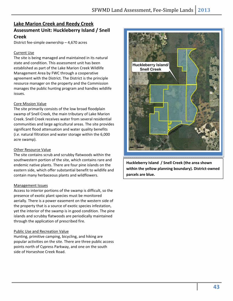
Lake Marion Creek and Reedy Creek Assessment Unit: Huckleberry Island / Snell Creek District fee‐simple ownership – 4,670 acres Current Use The site is being managed and maintained in its natural state and condition. This assessment unit has been established as part of the Lake Marion Creek Wildlife Management Area by FWC through a cooperative agreement with the District. The District is the principle resource manager on the property and the Commission manages the public hunting program and handles wildlife issues. Core Mission Value The site primarily consists of the low broad floodplain swamp of Snell Creek, the main tributary of Lake Marion Creek. Snell Creek receives water from several residential communities and large agricultural areas. The site provides significant flood attenuation and water quality benefits (i.e. natural filtration and water storage within the 6,000 acre swamp). Other Resource Value The site contains scrub and scrubby flatwoods within the southwestern portion of the site, which contains rare and endemic native plants. There are four pine islands on the eastern side, which offer substantial benefit to wildlife and contain many herbaceous plants and wildflowers. Management Issues Access to interior portions of the swamp is difficult, so the presence of exotic plant species must be monitored aerially. There is a power easement on the western side of the property that is a source of exotic species infestation, yet the interior of the swamp is in good condition. The pine islands and scrubby flatwoods are periodically maintained through the application of prescribed fire. Public Use and Recreation Value Hunting, primitive camping, bicycling, and hiking are popular activities on the site. There are three public access points north of Cypress Parkway, and one on the south side of Horseshoe Creek Road.
Huckleberry Island / Snell Creek (the area shown
within the yellow planning boundary). District‐owned
parcels are blue.
SFWMD Land Assessment, Fee‐Simple Lands 2013
44
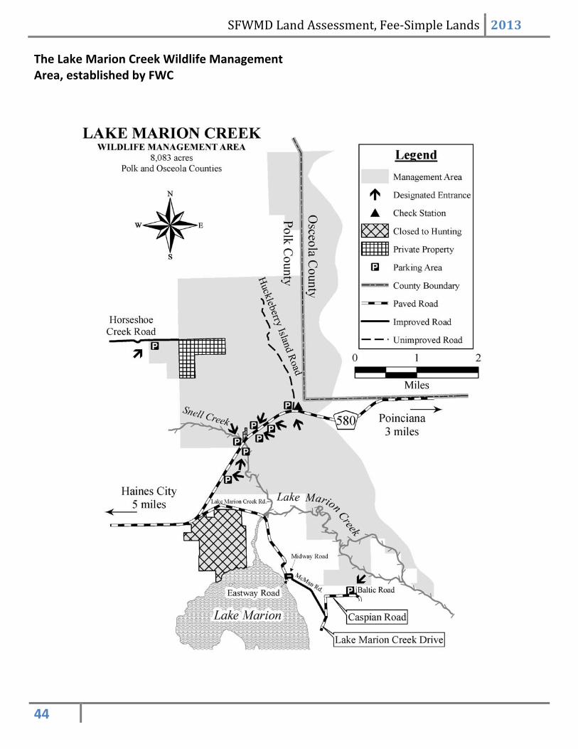
The Lake Marion Creek Wildlife Management Area, established by FWC
SFWMD Land Assessment, Fee‐Simple Lands 2013
45
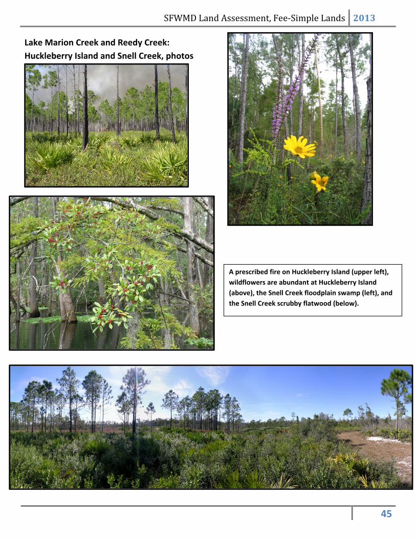
Lake Marion Creek and Reedy Creek:
Huckleberry Island and Snell Creek, photos
A prescribed fire on Huckleberry Island (upper left),
wildflowers are abundant at Huckleberry Island
(above), the Snell Creek floodplain swamp (left), and
the Snell Creek scrubby flatwood (below).

SFWMD Land Assessment, Fee‐Simple Lands 2013
46
Lake Marion Creek and Reedy Creek: Snell
Creek and Huckleberry Island, Public Use
Primitive camping at Huckleberry Island The main trail at Huckleberry Island
The Snell Creek trailhead

SFWMD Land Assessment, Fee‐Simple Lands 2013
47
Funding Source
Polk County &Preservation 2000
Preservation 2000
Year Acquired
1996
1995
Land Use/ Land Cover
DevelopedArea
Pasture
Agriculture
Fallow Cropland
Upland Non-Forested
Upland Forested
Waterways
Wet Hardwood Forest
Slough
Marshes and Wetlands
Barren Land
FEMA Flood Zone Hazard
A
AE
AH
AO
AREA NOT INCLUDED
DOPEN WATER
V
VE
X
MINIMAL FLOOD HAZARD
Lake Marion Creek and Reedy Creek: Snell
Creek and Huckleberry Is., Land Acquisition
Lake Marion Creek and Reedy Creek: Snell
Creek and Huckleberry Is., Land Character
IMPORTANT DISCLAIMER: All maps in this document are a conceptual or planning tool only. The South Florida Water Management District does not guarantee or make any
representation regarding the information contained herein. It is not self‐executing or binding, and does not affect the interests of any persons or properties, including any
present or future right or use of real property.
For more information on the data layers used in the assessment, please refer to the Land Assessment Study Process and Methodology document available here:
http://www.sfwmd.gov/portal/page/portal/xrepository/sfwmd_repository_pdf/land_assessment_study_process.pdf
SFWMD Land Assessment, Fee‐Simple Lands 2013
48
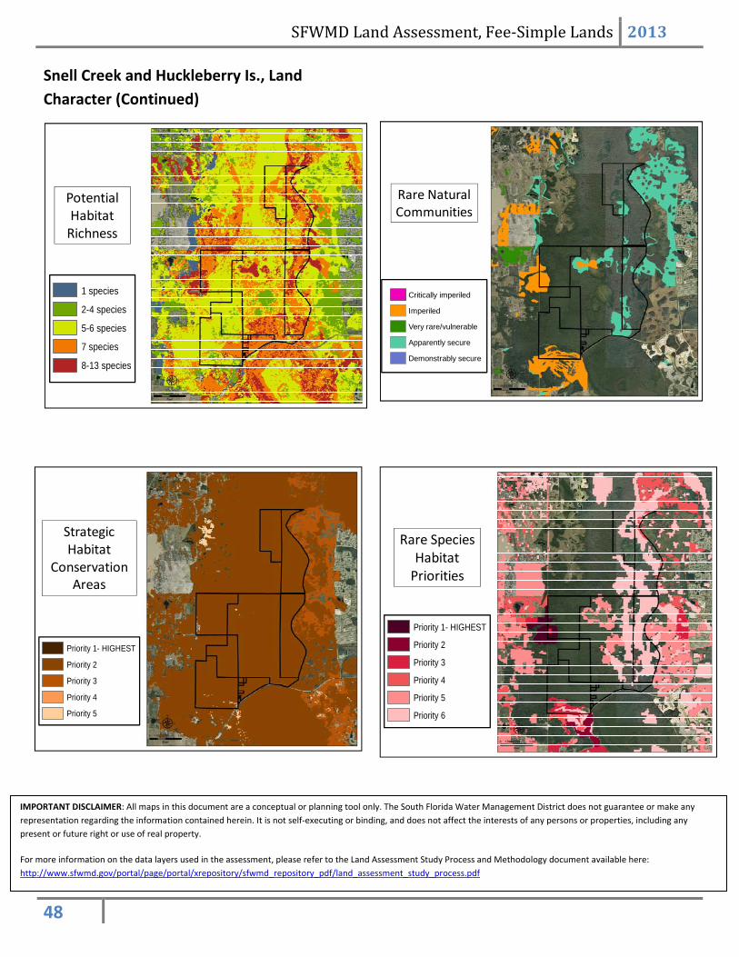
Rare Natural Communities
Critically imperiled
Imperiled
Very rare/vulnerable
Apparently secure
Demonstrably secure
Potential Habitat Richness
1 species
2-4 species
5-6 species
7 species
8-13 species
Strategic Habitat
Conservation Areas
Priority 1- HIGHEST
Priority 2
Priority 3
Priority 4
Priority 5
Priority 1- HIGHEST
Priority 2
Priority 3
Priority 4
Priority 5
Priority 6
Rare Species Habitat Priorities
Snell Creek and Huckleberry Is., Land
Character (Continued)
IMPORTANT DISCLAIMER: All maps in this document are a conceptual or planning tool only. The South Florida Water Management District does not guarantee or make any
representation regarding the information contained herein. It is not self‐executing or binding, and does not affect the interests of any persons or properties, including any
present or future right or use of real property.
For more information on the data layers used in the assessment, please refer to the Land Assessment Study Process and Methodology document available here:
http://www.sfwmd.gov/portal/page/portal/xrepository/sfwmd_repository_pdf/land_assessment_study_process.pdf
SFWMD Land Assessment, Fee‐Simple Lands 2013
49
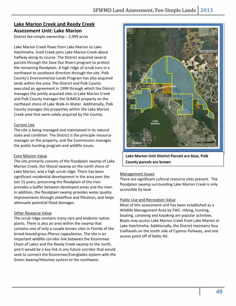
Lake Marion Creek and Reedy Creek Assessment Unit: Lake Marion District fee‐simple ownership – 2,999 acres Lake Marion Creek flows from Lake Marion to Lake Hatchineha. Snell Creek joins Lake Marion Creek about halfway along its course. The District acquired several parcels through the Save Our Rivers program to protect the remaining floodplain. A high ridge of scrub runs in a northwest to southeast direction through the site. Polk County’s Environmental Lands Program has also acquired lands within the area. The District and Polk County executed an agreement in 1999 through which the District manages the jointly acquired sites in Lake Marion Creek and Polk County manages the SUMICA property on the northeast shore of Lake Walk‐in‐Water. Additionally, Polk County manages the properties within the Lake Marion Creek area that were solely acquired by the County. Current Use The site is being managed and maintained in its natural state and condition. The District is the principle resource manager on the property, and the Commission manages the public hunting program and wildlife issues. Core Mission Value The site primarily consists of the floodplain swamp of Lake Marion Creek, the littoral swamp on the north shore of Lake Marion, and a high scrub ridge. There has been significant residential development in the area over the last 15 years, preserving the floodplain of the river provides a buffer between developed areas and the river. In addition, the floodplain swamp provides water quality improvements through sheetflow and filtration, and helps attenuate potential flood damages. Other Resource Value The scrub ridge contains many rare and endemic native plants. There is also an area within the swamp that contains one of only a couple known sites in Florida of the broad‐leaved grass Pharus Lappulaceus. The site is an important wildlife corridor link between the Kissimmee Chain of Lakes and the Reedy Creek swamp to the north, and it would be a key link in any future corridor that would seek to connect the Kissimmee/Everglades system with the Green Swamp/Hilochee system to the northwest.
Management Issues There are significant cultural resource sites present. The floodplain swamp surrounding Lake Marion Creek is only accessible by boat Public Use and Recreation Value Most of this assessment unit has been established as a Wildlife Management Area by FWC. Hiking, hunting, boating, canoeing and kayaking are popular activities. Boats may access Lake Marion Creek from Lake Marion or Lake Hatchineha. Additionally, the District maintains four trailheads on the south side of Cypress Parkway, and one access point off of Baltic Rd.
Lake Marion Unit District Parcels are blue, Polk
County parcels are brown

SFWMD Land Assessment, Fee‐Simple Lands 2013
50
Lake Marion Creek and Reedy Creek: Lake
Marion unit, Land Character
Lake Marion Creek The rare grass, Pharus Lappulaceus
The swamp north of Lake Marion The rare and endemic cutthroat grass seepage slope with the
scrub ridge in the background
SFWMD Land Assessment, Fee‐Simple Lands 2013
51
Funding Source
Land AcquisitionTrust Fund
Land Acquisition TrustFund & Polk County
Preservation 2000
Preservation 2000& Polk County
Year Acquired
1997
1995
1998
Land Use/ Land Cover
DevelopedArea
Pasture
Agriculture
Fallow Cropland
Upland Non-Forested
Upland Forested
Waterways
Wet Hardwood Forest
Slough
Marshes and Wetlands
Barren Land
FEMA Flood Zone Hazard
A
AE
AH
AO
AREA NOT INCLUDED
DOPEN WATER
V
VE
X
MINIMAL FLOOD HAZARD
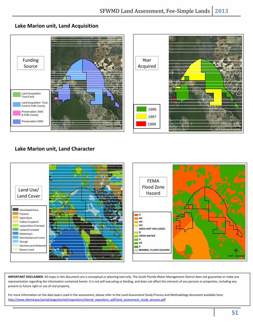
Lake Marion unit, Land Acquisition
Lake Marion unit, Land Character
IMPORTANT DISCLAIMER: All maps in this document are a conceptual or planning tool only. The South Florida Water Management District does not guarantee or make any
representation regarding the information contained herein. It is not self‐executing or binding, and does not affect the interests of any persons or properties, including any
present or future right or use of real property.
For more information on the data layers used in the assessment, please refer to the Land Assessment Study Process and Methodology document available here:
http://www.sfwmd.gov/portal/page/portal/xrepository/sfwmd_repository_pdf/land_assessment_study_process.pdf

SFWMD Land Assessment, Fee‐Simple Lands 2013
52
Priority 1- HIGHEST
Priority 2
Priority 3
Priority 4
Priority 5
Priority 6
Rare Species Habitat Priorities
Strategic Habitat
Conservation Areas
Priority 1- HIGHEST
Priority 2
Priority 3
Priority 4
Priority 5
Potential Habitat Richness
1 species
2-4 species
5-6 species
7 species
8-13 species
Rare Natural Communities
Critically imperiled
Imperiled
Very rare/vulnerable
Apparently secure
Demonstrably secure
Lake Marion unit, Land Character (Continued)
IMPORTANT DISCLAIMER: All maps in this document are a conceptual or planning tool only. The South Florida Water Management District does not guarantee or make any
representation regarding the information contained herein. It is not self‐executing or binding, and does not affect the interests of any persons or properties, including any
present or future right or use of real property.
For more information on the data layers used in the assessment, please refer to the Land Assessment Study Process and Methodology document available here:
http://www.sfwmd.gov/portal/page/portal/xrepository/sfwmd_repository_pdf/land_assessment_study_process.pdf

SFWMD Land Assessment, Fee‐Simple Lands 2013
53
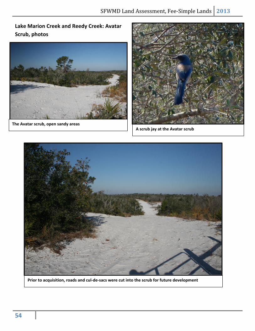
Lake Marion Creek and Reedy Creek Assessment Unit: Avatar Scrub District fee‐simple ownership – 342 acres Current Use The site is being managed and maintained in its natural state and condition. The property had been partially cleared for development at the time of acquisition, with the routes of roads and cul‐de‐sacs cut into the scrub. These open sand features seem to be favored by resident scrub jays. The site was acquired by the Florida Department of Transportation and donated to the district as mitigation for water resource impacts associated with the development of a transportation corridor. Core Mission Value The site was acquired as mitigation for water resource impacts. The primary hydrologic feature is the forested seepage slope that runs from the high scrub down to the Lake Marion Creek floodplain. Flowing water is often observed running down the face of the seepage slope; had the site been developed, this seepage into Lake Marion Creek could have been impaired by residential runoff. Other Resource Value / Management Issues The scrub ridge contains many rare and endemic native plants. Listed animals include, but may not be limited to, the sand skink, gopher tortoises, Gopher Frogs, and scrub jays. Public Use and Recreation Value Currently the area is not part of the FWC Wildife Management Area. The sand is likely too soft for most bicycles, but hiking access is available from an access point along Baltic Drive.
The Avatar scrub. The entire assessment unit is owned
by the District.
SFWMD Land Assessment, Fee‐Simple Lands 2013
54
Lake Marion Creek and Reedy Creek: Avatar
Scrub, photos
The Avatar scrub, open sandy areas A scrub jay at the Avatar scrub
Prior to acquisition, roads and cul‐de‐sacs were cut into the scrub for future development
SFWMD Land Assessment, Fee‐Simple Lands 2013
55
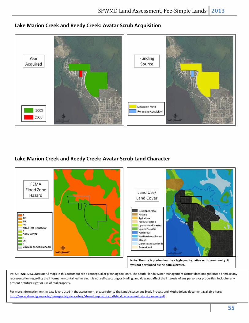
Lake Marion Creek and Reedy Creek: Avatar Scrub Acquisition
Lake Marion Creek and Reedy Creek: Avatar Scrub Land Character
IMPORTANT DISCLAIMER: All maps in this document are a conceptual or planning tool only. The South Florida Water Management District does not guarantee or make any
representation regarding the information contained herein. It is not self‐executing or binding, and does not affect the interests of any persons or properties, including any
present or future right or use of real property.
For more information on the data layers used in the assessment, please refer to the Land Assessment Study Process and Methodology document available here:
http://www.sfwmd.gov/portal/page/portal/xrepository/sfwmd_repository_pdf/land_assessment_study_process.pdf
Note: The site is predominantly a high quality native scrub community. It
was not developed as the data suggests.

SFWMD Land Assessment, Fee‐Simple Lands 2013
56
IMPORTANT DISCLAIMER: All maps in this document are a conceptual or planning tool only. The South Florida Water Management District does not guarantee or make any
representation regarding the information contained herein. It is not self‐executing or binding, and does not affect the interests of any persons or properties, including any
present or future right or use of real property.
For more information on the data layers used in the assessment, please refer to the Land Assessment Study Process and Methodology document available here:
http://www.sfwmd.gov/portal/page/portal/xrepository/sfwmd_repository_pdf/land_assessment_study_process.pdf