lacustrine clay mineral assemblages as a proxy for land ... ouahabi et al... · untangle soil...
TRANSCRIPT

lable at ScienceDirect
Quaternary International xxx (2016) 1e15
Contents lists avai
Quaternary International
journal homepage: www.elsevier .com/locate/quaint
Lacustrine clay mineral assemblages as a proxy for land-use andclimate changes over the last 4 kyr: The Amik Lake case study,Southern Turkey
Meriam El Ouahabi a, *, Aur�elia Hubert-Ferrari b, Nathalie Fagel a
a University of Li�ege, AGEs, Department of Geology, Li�ege, Belgiumb University of Li�ege, Department of Geography, Li�ege, Belgium
a r t i c l e i n f o
Article history:Received 17 June 2016Received in revised form18 November 2016Accepted 23 November 2016Available online xxx
Keywords:SoilWeathering conditionsLand erosionClay mineralogyLake sedimentsLast millennia
* Corresponding author.
http://dx.doi.org/10.1016/j.quaint.2016.11.0321040-6182/© 2016 Elsevier Ltd and INQUA. All rights
Please cite this article in press as: El Ouahabilast 4 kyr: The Amik Lake case study, South
a b s t r a c t
Lake sediments are sensitive to landscape changes and most of these changes seem to be modulated byland-use (anthropogenic factors) coupled to palaeoenvironmental/palaeoclimatic changes. In its detritalfraction, the lacustrine sediments record the history of soil erosion within its catchment via the inputs ofclays and others detrital products. Within a Mediterranean context, the study investigates the uppersediments infilling the central part of the Amik basin in southern Turkey. This tectonic basin wasoccupied and exploited by modern human at least since 6000e7000 BCE. We focus on the clay miner-alogy (x-ray diffraction on oriented aggregates) and magnetic susceptibility measurements (Bartington)of the sedimentary record in the area over the last 4000 years, to assess environmental changes inrelation with the different land uses and/or weathering during the successive Bronze, Iron, Roman, Is-lamic/Ottoman and Modern civilizations. The clay fraction of Amik Lake sediments comprises smectite,kaolinite, illite, chlorite and chlorite/smectite mixed layers that are the inherited clay phases. A relativechange in abundance and crystallinity and chemistry of illite attests that environmental conditionsevolved in the Amik Plain from the Bronze to Modern Age in relation with climates and/or land-usechanges. The history of the Amik Lake reveals different soil erosion episode. The most intense erosionphase occurred during the Bronze/Iron Ages as indicated by the clay and magnetic susceptibility proxies.The Roman period was an exceptional period with soil erosion products arriving from the watershed,probably due the water channelization. A reduction of soil erosion occurred during the post Romanperiod until nowadays. Significant pedogenesis transformations are evidenced, especially during theIslamic/Ottoman periods suggesting intense chemical weathering conditions related to climate change.
© 2016 Elsevier Ltd and INQUA. All rights reserved.
1. Introduction
Soil-forming environments and erosion processes are stronglyinfluenced by land-use practices which changed through humanhistory in a given area (e.g. Lawrence et al., 2015). Other influencingfactors, such as permanent parameters (seismology, lithology, re-lief), and variable factors (climate, hydrology, vegetation cover)have also an impact on sediment yield and erosion rates (e.g.Edwards and Whittington, 2001; Lucke et al., 2005; Dodson et al.,2004; Pelle et al., 2013; Vogel et al., 2016). These natural andanthropogenic factors are difficult to untangle (Berglund, 2003;Ackermann et al., 2014). Indeed, soil erosion can be induced byclimate changes (strong precipitations, seasonality and aridity) as
reserved.
, M., et al., Lacustrine clayminern Turkey, Quaternary Intern
well as more intense land-use (P�ecsi, 1990; Günster andSkowronek, 2001; Casana, 2008; Zielhofer et al., 2008; Jalut et al.,2009; Varga et al., 2011; Costantini et al., 2012; Sauer et al., 2015).
This problematic is particularly acute in the Amik Plain area(also known as the Plain of Antioch) in the southern Turkey, whichhas a long history of dense human settlement dating back at least tothe Pottery Neolithic (7000 BCE) (Braidwood and Braidwood,1960).Numerous studies were undertaken in the region in order toreconstruct the environmental and settlements history through aninterdisciplinary regional research program, incorporating archae-ological settlement survey, geomorphological and paleo-environmental analyzes, and targeted excavations at key sites ofvarious periods (Braidwood and Braidwood, 1960; Yener et al.,2000; Yener and Batiuk, 2010; Lawrence et al., 2015). A first ma-jor settlement phase occurred during the Bronze-Iron Ages,3000e500 BCE (Wilkinson, 2000; Casana, 2007). The lands around
eral assemblages as a proxy for land-use and climate changes over theational (2016), http://dx.doi.org/10.1016/j.quaint.2016.11.032

M. El Ouahabi et al. / Quaternary International xxx (2016) 1e152
tells and on low-dipping reliefs were used for wheat culture andorchards (Wilkinson, 2000; Casana, 2007). A second settlementphase more intensive occurred during the Hellenistic, Roman andLate Roman periods (300 BC-650 AD), and was associated with theconversion of upland areas for an intensive agricultural production(Wilkinson, 1997, 2000). This change was linked to the birth andgrowth of the city of Antioch, one of the largest city in the RomanEmpire, with may be up to 500 000 inhabitants including its sub-urbs. During the Late Roman period, the Amik Plain was moredensely occupied than at any time in its history (Casana, 2008).Agricultural farming associated with an irrigation network wasdeveloped around the city of Antioch and in the Amik Basin in orderto feed its large population. Around 700e900 AD, numerous Romansites were progressively abandoned in the basin and in the high-lands (Casana, 2007).
The spatial and temporal extent and organisation of the settle-ments in the Amik Plain are well constrained but not its possibleimpact on the environment (Yener et al., 2000; Wilkinson et al.,2001). In the present paper we propose to consider this issue bycharacterizing soil erosion in the Amik Plain using clay mineralogyand magnetic susceptibility as proxy indicators. An overview of theclimatic conditions that prevailed in this area is also the mainobjective. To achieve this, 6 m long sedimentary record wasanalyzed to define the clay types deposited in the plain and theirweathering characteristics. Clay mineralogy is then used to try tountangle soil erosion, land-use and climate change in this criticalzone.
2. Regional, tectonic and geological setting
The Amik Plain is situated in the Eastern Mediterranean basinwithin the borders of the Hatay province. It is surrounded byseveral mountain ranges and plateaus. To the west part, the Ama-nus Mountain culminating at 2250 m, is an ophiolitic complex andits sedimentary cover (Boulton et al., 2007). To the south, lie the lowranges of calcareous Jebel al-Aqra or Kuseyr Plateau. To the north-east, the Kurt Mountains culminating at 825 m are mainlycomposed of metamorphic rocks (Wilkinson, 2000; Robertson,2002; Altunel et al., 2009; Parlak et al., 2009; Eger, 2011;Karabacak and Altunel, 2013). The ~50 km long and 50 km widebasin itself is filled with up to 2.5 km thick Plio-Quaternary sedi-ments (Gülen et al., 1987), and is crossed by the left-lateral DeadSea Fault (DSF), which is active and ruptured during the largedestructive earthquakes (Akyuz et al., 2006; Altunel et al., 2009;Karabacak et al., 2010; Karabacak and Altunel, 2013). The Basinwas temporally occupied by the Amik Lake.
The Amik lake has a complex history with alternating extensionand disappearance (Friedman et al., 1997; Wilkinson, 1997, 2000;Casana, 2008). During the Roman period, the Afrin and the Kar-asu rivers draining into the Amik Lake were partly channelized,starting probably around 50 AD; some channels were used at leastuntil the early Islamic period (~700 AD) (Wilkinson and Rayne,2010). The lake started to be artificially drained in the 1940's forthe cultivation of cotton and to eradicate malaria (Çalıskan, 2008),but its wetland were still covering a large area. A more intensedesiccation work started in the 1966 and by 1972 the three riversdraining into the basin were channelized. The lake and its wetlandwere completely destroyed in 1987 (Kilic et al., 2006). As results,the cropland area increased by 174% (Kilic et al., 2006).
3. Material and methods
3.1. Coring site
The site (N 36�20.655’� E 036�20�.948’) is located just at the
Please cite this article in press as: El Ouahabi, M., et al., Lacustrine clayminlast 4 kyr: The Amik Lake case study, Southern Turkey, Quaternary Intern
border of the Kumtepe village, near the former eastern border ofthe Amik Lake defined by a low sandy ridge containing Romanpottery and lacustrine shells (Yener et al., 2000). In this area themajor water inflow is provided by the Afrin River (Fig. 1). In addi-tion the site stands near the DSF fault (Karabacak et al., 2010) and isadjacent to the following archaeological sites: Tell Kara Tepe (AS86)and Kurdu which are Bronze and Early-Middle Chalcolithic sites,respectively (Yener et al., 2000). It also lies near a Roman canaldraining the water from the Afrin River, which cessed to be usedafter the 2nd century CE (Casana, 2012).
Sediments were collected in a trench every 1 cm during thesummer time, July 1st, 2012. At this period the water table was1.5 m deep. The sampling was extended to 6 m depth thanks to adrill core.
3.2. Methods
3.2.1. Magnetic susceptibility and X-ray diffraction studiesMagnetic susceptibility (MS) performed every 1 cm using MS2
magnetic susceptibility system.Magnetic susceptibility was used asa first indicator of input of terrigenous materials, allochthonous tothe lake (Hubert-Ferrari et al., 2012).
Mineralogical and geochemical analyzes were performed at5 cm resolution to highlight the occurrence of environmentalchanges. Furthermore, clay mineralogy was carried out at lowerresolution (10e20 cm) depending mainly on the changes inchemical and mineralogical composition. In particular, sample se-lection for clay mineralogy analysis was based on the peaks shapeon the bulk XRD diffractogram at (001) reflections and the possiblepresence of the mixed layers clays mineral (10e14 A�).
The clay mineralogical analysis was performed by X-raydiffraction (XRD), using a Bruker D8 ADVANCE diffractometer,equipped with a Cu-Ka radiation on the <2 mm fraction (Univer-sality of Li�ege, Belgium). For the clay fraction analysis the wholesediment was decarbonated with HCl (0.1 mol/L) and the <2 mmfraction separated by settling in a water column. Samples weremounted as oriented aggregates on glass slides (Moore andReynolds, 1997). For each sample three X-ray patterns were recor-ded: air-dried (N), ethylene-glycol solvated for 24 h (EG), andheated at 500 �C for 4 h (H).
The background noise of the X-ray patterns was removed andprofile parameters such as line positions, Full Width at Half HeightWidth (FWHM), peak intensities were calculated by the DIF-FRAC.SUITE EVA software (BRUKER). The peak intensities are relatedto the size of the coherent scattering domain (CSDS) representingregions of the crystal lattice in which X-ray diffraction is coherent,to the number of crystalline defects, to the presence of the mixed-layering component (e.g. illite/smectite and chlorite/smectite)(Renac and Meunier, 1995) and to the hydration state of theseminerals (Ferrage et al., 2007). When the number of coherentlystacked sheets is high (i.e broad CSDS), the interference functioninduces intense and narrow peaks, and then the FWHM is small.Conversely, when the number of sheets is small, the peaks arebroader and less intense, the FWHM is wide and the coherentscattering domain is small. In the case of clay minerals in soil, thecoherent domain size is generally small except for the primary andphyllosilicates minerals inherited little affected by weathering(Righi et al., 1993; Righi et al., 1995; Lanson, 1997; Chipera and Bish,2001; Velde and Meunier, 2008; Hubert et al., 2009).
The shape and symmetry of the air dried XRD diffractogramswere investigated. The asymmetry of the peak with a broadcoherent scattering domain size (CSDS) distribution is due to thepresence of several phases with close, but distinct crystallographiccharacteristics (Lanson and Besson, 1992).
Semi-quantitative estimations of the main clay species were
eral assemblages as a proxy for land-use and climate changes over theational (2016), http://dx.doi.org/10.1016/j.quaint.2016.11.032

Fig. 1. (a) Geomorphological situation of the Amik plain. (b) Geological context of the Amik Plain.
Table 114C Age results obtained from vegetal remains, shells, ostracods and micro-charcoals.
Depth (cm) Material 14C Age year BP ± 14C Age calBP ±
317 Micro-charcoals 2900 35 3050 62326 Micro-charcoals 3010 25 3219 43391 Micro-charcoals 2620 30 2755 10402 Micro-charcoals 2655 25 2770 11415 Micro-charcoals 3060 35 3288 47
M. El Ouahabi et al. / Quaternary International xxx (2016) 1e15 3
based on the height of specific reflections on glycolated (EG) runsaccording to the method of Biscaye (1965), with an estimated un-certainty of ±5%. For calculating relative percentages of the majorclay mineral groups present in the given samples, peak intensitieswere multiplied by the following factors: 0.25 to smectite (17 Åpeak), 0.34 to vermiculite (14 Å peak), 1 to illite (10 Å peak) and0.70 to kaolinite (7 Å peak) and 0.34 to chlorite (14 Å peak) wereapplied. Kaolinite and chlorite individual percentages were calcu-lated using the 3.54Å and 3.58Å peak intensities. Mixed-layer claysamount were estimated using a factor of 0.40 at (~12 Å peak)Biscaye (1965).
The illite chemistry was deciphered by using the ratio of in-tensities of the 5 Å and 10 Å peaks (Esquevin,1969). The ratio below0.5 represents Fe, Mg-rich illites (biotites, micas), which are char-acteristic for physically eroded and unweathered rocks whereasabove 0.5 indicate Al rich illites which are formed by strong hy-drolysis (Gingele, 1996). The crystallinity index of illite wasmeasured using the FullWidth at Half HeightWidth (FWHM) of the10 Å peak in air dried XRD patterns (Kübler and Jaboyedoff, 2000). Ahigh crystallinity index implies a broad coherent scattering domainsize (CSDS). The FWHM values of smectite were also calculated.
3.2.2. Radiocarbon datingThe age of the record was constrained using radiocarbon dating.
We performed 14C radiocarbon dating (Aeon Radiocarbon Labora-tory, USA) on several fractions. Terrestrial vegetal remains providerecent ages linked to the root system developed by agriculturalactivities in the dried lake after 1940's. The shells are unreliable dueto strong and variable reservoir effects (Meadows, 2005). Micro-charcoal remains are the only reliable fraction to date. Fourmicro-charcoal samples founded in the clayey red levels at 317, 391,402 and 415 cm depth were dated (Table 1). In addition, some age
Please cite this article in press as: El Ouahabi, M., et al., Lacustrine clayminlast 4 kyr: The Amik Lake case study, Southern Turkey, Quaternary Intern
constraint was provided based on the 210Pb and 137Cs radiometricmarkers measured every 1 cm from the topsoil to 25 cm. Activitiesof 210Pb and 137Cs were measured using a low background, highefficiency, well-shaped g detector (CANBERRA) (Schmidt et al.,2009). Calibration of the g detector was achieved using certifiedreference materials (IAEA-RGU-1). Activities are expressed in mBqg�1 and errors are based on 1 SD counting statistics. Excess 210Pb(210Pbxs) was calculated by subtracting the activity supported by itsparent isotope, 226Ra, from the total 210Pb activity in the sediment(Table 2). The constant sedimentation constant flux model wasused to infer an average sedimentation rate (Appleby, 2002).
4. Results
4.1. Lithological description and magnetic susceptibility
Lithology of the core sediments showed small variations withdepth (Fig. 3). Silty clay sediments predominated. Sandy particlesappeared in some layers or as pockets in the clayey matrix. Thecolour of the sediment was mostly beige with interposition ofreddish and brownish clay levels. Several sedimentary coarser
eral assemblages as a proxy for land-use and climate changes over theational (2016), http://dx.doi.org/10.1016/j.quaint.2016.11.032

Table 2Bulk activities of 210Pb, 137Cs and 228Th in sediment samples.
Depth (cm) 210Pb (mBq/g) ±s 137Cs mBq/g ±s 228Th mBq/g ±s
2.0 34 2 6.0 0.3 6 06.0 19 2 6.0 0.3 7 09.0 20 3 6.2 0.5 6 011.5 21 4 5.8 0.6 6 113.5 15 3 5.6 0.5 6 015.5 15 2 5.4 0.4 7 017.5 15 4 6.3 0.6 5 123.5 12 2 6.0 0.4 7 028.5 13 4 4.7 0.7 6 133.5 14 3 0.2 0.4 6 1
M. El Ouahabi et al. / Quaternary International xxx (2016) 1e154
layers were identified and characterized by coarser grained parti-cles and higher magnetic susceptibility (MS) than the backgroundsedimentation, reworked shells and/or structural disturbances(plastic deformation, sand pillows). Four different sedimentaryunits (unit 1 to unit 5) were identified based on the lithology, grain-size and MS variation (Fig. 3).
The top unit (unit 5) is 130 cm thick and is mainly sandy claycharacterized by an average of MS of 66 ± 16 SI and significantproportion of sand size particles which reach ~80% at 48 cm depth.Below up to 60 cm depth, the profile was characterized by low MSvalues (63 ± 15 SI, in average) and numerous reworked shells. Aslight increase of MS, about 78 ± 15 SI was obtained from 60 to130 cm depth.
The fourth unit (unit 4) extends from 130 to 196 cm, the sedi-ment is silty clay characterized by a slightly lower values of MS(70 ± 19 SI, in average) showing more variations. Coarse sandylayers followed by silty clay sediment with some sandy in-tercalations occurred up to 205 cm. Down below and between 205and 300 cm, sediment is silty characterized by a high MS, notassociated with any structural disturbance. Two thin layersshowing minor structural disturbances associated with sand werealso identified.
The second unit (unit 2) is located between 308 and 450 cmbelow to the surface, and is characterized by coarser grain-size, ahigher MS (132 ± 52, in average), the occurrence of reddish claylevels at the bottom and strong variations in grain size compared tounit 3 (Fig. 3). Several rapid changes in the lithology with variousplastic deformations and sand pockets were observed in a claymatrix. Fine red clay layers associated with high MS (231 SI) situ-ated at the base of this unit, between 400 and 450 cm indicatingoxic conditions.
The basal unit (unit 1) extends from 450 cm to the bottom of thecore, and is characterized by high and variable MS values (96 ± 41SI, in average), low sand content and the occurrence of reddish claylevels. Sand was mixed evenly with silty clay particles. The coreended with a sandy layer and higher MS values.
4.2. Age-depth model
The age-depth model on the upper part of the core is con-strained using 210Pb and 137Cs data (Table 2). Measured 210Pb valuesin the upper part of sediment core (33.5 cm) range from 34 to12 mBqg�1. The profile distribution of 137Cs activity shows themaximum at 9 cm depth that represents the period of themaximum 1963 radionuclide fallout. The distribution of excess210Pb and 137Cs values follows an exponential decrease with depth.Therefore, a constant flux constant supply CS:CR sedimentationmodel was applied (Appleby, 2002). The 210Pb-derived sedimen-tation rate (S.R ¼ 0.36 cm/yr) was obtained with 228Th correction.This sedimentation rate implies that the two layers characterizedby high MS values between 44 and 66 cm depth, which correspond
Please cite this article in press as: El Ouahabi, M., et al., Lacustrine clayminlast 4 kyr: The Amik Lake case study, Southern Turkey, Quaternary Intern
to two sedimentary events would be induced by the 1872 and 1822historical earthquakes (Akyuz et al., 2006) (Fig. 2a). The two seg-ments of the Dead Sea Fault, the Karasu and the Hacipasa Faults,have ruptured subsequently in 1822 and 1872 inM� 7 earthquakes(Akyuz et al., 2006). The 1822 earthquake affected most speciallythe Afrin watershed, and caused landslides (Ambraseys, 1989).Furthermore, the 1872 earthquake triggered liquefactions andruptured the Hacipasa fault segment (Akyuz et al., 2006) which is afew hundred meters vicinity from our coring site (Ambraseys,1989).
The age of the lower part of the core is constrained usingradiocarbon dating (Table 1). Micro-charcoals at 398 and 408.5 cmprovide calibrated ages of 2755 ± 10 and 2770 ± 11yrs BP, implyingthat the unit 2 was deposited during the Iron Age. The three micro-charcoal samples located above provide older ages by about400e1000 years, implying large sediment reworking in thewatershed. Theymust be excluded from the agemodel. At 419.5 cm,micro-charcoal age is 400 years older than the sample located10 cm above, and is significantly older than the depositional age inthe lake.
A composite age model was thus built combining the modern210Pb sedimentation rate and the two youngest micro-charcoal agesat 398 and 408.5 cm. The modern sedimentation rate was extrap-olated to the base of unit 1 at 130 cm depth, where an abruptdecrease in grain-size occurred. Below 130 cm, the sedimentationbecomes silty clay, which is coherent with a reduction in sedi-mentation rate. A constant sedimentation rate constrained by themicro-charcoals from 130 cm to the base of the core is considered.Given that our age model is constrained at the top and at the bot-tom, its greatest uncertainties are associated with the Islamicperiod in the middle of the section.
The age model may appear imprecise, but it is compatible withthe sedimentary history established in previous studies in the eastpart of the Amik basin near the coring site. First, the nearby largeBronze Age site of Karatepe tell (AS 86) was made of lacustrine greysilty clay, which could be the clayey unit 1 (Fig. 3). Second, at theend of the Roman period, the lake level increased above the sandyridge limiting the former lake, as a result the cultivated lands to theeast of the coring site where inundated with grey silt lacustrinemarl overlying formerly cultivated soils (Yener et al., 2000). Thelake level increase is recorded in the unit 3 attested by the fine-grain sedimentation, which corresponds to the Late RomanPeriod in our age model. Third, during the Ottoman/Islamic Period,another environmental change occurred: silty clay derived from theAfrin River overlies the lacustrine clay deposited since the end ofthe Late Roman Period (Yener et al., 2000). This change occurredafter the travel of Abu-al Fida at the end of the 13th century in theregion (Eger, 2011; Casana, 2014). This transition is also recorded atour site between the silty clay unit 4 and the silty sand unit 5.According to our age model, it would have occurred around 1650AD, an age compatible with historical data.
4.3. Identification and characterization of the clay minerals
Smectite (0e60%), illite (5e50%), kaolinite (5e30%), chlorite(0e45%) and vermiculite (0e65%) were the main clay mineralspresent in the Amik Lake sediments. Mixed layers clay mineralswere also present. There were mainly chlorite/smectite inter-stratified (0e25%) accompanied by the appearance of illite/smectiteinterstratified clay minerals (0e30%) in the upper part of the core.
The XRD patterns of air dried clay samples had strong first-orderreflections with various basal spacing and peak intensities that aredescribed in the following. We also evaluate the crystallinity of thephyllosilicates based on the peak shapes, broad or narrow, and thepeak asymmetry in the d(001) basal diffraction and the size of the
eral assemblages as a proxy for land-use and climate changes over theational (2016), http://dx.doi.org/10.1016/j.quaint.2016.11.032

Fig. 2. (a) Sedimentation rate and ageedepth model from radionuclides (210Pb), a constant sedimentation rate was calculated and corrected by 228Th activity. The highest magneticsusceptibility peak values are used as earthquake tie-point to extrapolate the sedimentation rate. (b) Age-depth diagram for Amik Lake based on calibrated 14C age results obtainedfrom micro-charcoal remains, 210Pb activity and historical earthquakes tie-point (data from Akyuz et al. (2006).
M. El Ouahabi et al. / Quaternary International xxx (2016) 1e15 5
coherent scattering domain size (CSDS) distribution.Most of clays showed a broad basal reflection d(001), ranging
from 13 to 16 Å, characteristic of smectite. Smectite had, generally,
Please cite this article in press as: El Ouahabi, M., et al., Lacustrine clayminlast 4 kyr: The Amik Lake case study, Southern Turkey, Quaternary Intern
broadened reflection, asymmetrical or near asymmetrical (Fig. 4).The distinction of smectite from vermiculite and chlorite was basedon the expansion of the d(001) reflection to 14-18 Å upon ethylene
eral assemblages as a proxy for land-use and climate changes over theational (2016), http://dx.doi.org/10.1016/j.quaint.2016.11.032

Fig. 3. The main clay mineralogical composition and magnetic susceptibility of the Amik Lake sediments in terms of depth variation.
M. El Ouahabi et al. / Quaternary International xxx (2016) 1e156
glycol saturation run, and on the collapse to 10 Å after heating at500 �C for 4 h. The observed asymmetry of the d(001) peaks ofsmectite towards low angles is due to the contribution of a lowCSDS particle population to the diffracted intensity (Fig. 4) (seeFig. 5).
Kaolinite was detected in all clay samples and showed in airdried and glycolated spectra characteristic peak around7.05 Å d(00l) and 3.52 Å d(002) reflections occurring at 12.4 and24.9 2Theta, respectively. The d(00l) and d(002) peaks did notchange on ethylene glycol saturation (EG)meaning that no swellingoccurs. After heating at 500 �C, the peak disappeared pointing outthe kaolinite transformation into metakaolinite (dehydroxylation)and the absence of well crystallized chlorite. Two peaks wereobserved at ~ 7 Å (Fig. 4). The peak at ~7.30 Å may be related tochrysotile, whereas the peak at ~7.05 Å is typical of the authigenickaolinite. No significant peak asymmetry change was observed forthe 7.05 Å peak of kaolinite and the coherent domain size wasgenerally broad; kaolinite was thus a primary less weatheredmineral.
Illite was present in most of the samples and was distinguishedby the d(001) reflection at around 10 Å. The peak remained unaf-fected by the ethylene glycol treatment and the heating at 500 �C.The sharp and the broad d(001) and d(002) peaks at ~ 10 Å and ~
Please cite this article in press as: El Ouahabi, M., et al., Lacustrine clayminlast 4 kyr: The Amik Lake case study, Southern Turkey, Quaternary Intern
5 Å, respectively, do not shifted after glycol solvation (Fig. 4). Thepeak asymmetry was observed and is related to the presence ofphases with close, but distinct crystallographic characteristics likeillite and detrital mica (Lanson and Besson, 1992).
Chlorite and vermiculite were also detected and were charac-terized by a broad d(001) basal reflection at ~ 14 Å under the airdried, ethylene glycol saturation and heated treatment. It is ratherdifficult to distinguish the chlorite reflection due to the co-existence of the broad d(001) reflections of smectite and chloritein the same sample. Chlorite can still be clearly identifiable because(1) it is relatively thermally stable and thus resistant to heating at500 �C, (2) it shows a peak at ~ 14 Å after ethylene glycol saturationcharacteristic of chlorite minerals (Fig. 4). Theweak peak of chloritearound ~14 Å is asymmetric, reflecting poor crystalline species andthe contribution of chlorite with a small coherent domain size(CSDS). This indicated that the deposited chlorites were trans-formed by weathering after their formation. Vermiculite could beidentified readily based on the collapse of the peak at ~14 Å to 10 Åafter heating at 500 �C. The peak of vermiculite was symmetric at~14 Å under air dried and ethylene glycol saturation but was largeat the base due to its hydration. The symmetry of the vermiculitepeak and its large coherent domain size (CSDS) indicates theirprimary origin (Fig. 4a).
eral assemblages as a proxy for land-use and climate changes over theational (2016), http://dx.doi.org/10.1016/j.quaint.2016.11.032

Fig. 4. X-ray diffraction (XRD) patterns of the clay fraction (<2 mm) of the depths of 426e427 cm. A.D: oriented preparations in the air-dried; EG: ethylene-glycol solvated state; H:Heated at 500 �C for 4 h.
M. El Ouahabi et al. / Quaternary International xxx (2016) 1e15 7
Regarding to the characterization of the mixed layer clay min-erals, the air-dried patterns towards low angles produced a broadand asymmetric reflection between ~10 and ~14 Å due to thepresence of several phases with distinct crystallographic charac-teristics (Lanson and Besson,1992). This behaviour, according to themethods proposed by Moore and Reynolds (1997) and Thorez(1976) enabled the distinction of three mixed-layered structuresoften associated with discrete mineral phases: illite/smectite,chlorite/smectite and illite/chlorite. Illite/smectite interstratifiedclays. These mixed layer clays are characterized by an expanding tohigher spacing under ethylene glycol saturation, and a collapse to10 Å under heating at 500 �C. In addition, and according to (Inoueet al., 1989), the high saddle/peak ratio close to 17 Å and theappearance of an 8.6 Å peak at 10.3 2Theta on the EG pattern re-veals that the clay sample was composed of randomly inter-stratified illite/smectite mixed layers (Reynolds, 1988). Thepresence of a super structure reflection at ~29 Å which shifted to~31 Å after the ethylene glycol run indicated ordered chlorite/smectite mixed layer (Reynolds, 1988). Mixed-layer species werethus mainly chlorite/smectite and illite/smectite phases and areattributed to a soil source (Righi et al., 1995). Traces of chrysotile
Please cite this article in press as: El Ouahabi, M., et al., Lacustrine clayminlast 4 kyr: The Amik Lake case study, Southern Turkey, Quaternary Intern
and amphibole were also founded. These relict fractions wouldcome from the ophiolite body located just to the west of the AmikPlain.
4.4. Evolution of the clay minerals
The clay phases (<2 mm fraction) significantly differedthroughout the core sediments. In addition, the crystallinity of illiteas well as the shape of the air dried and glycolated XRD diffracto-grams of the overall phyllosilicates were quite different, mainlyrelated to different mode of stacking of the phyllosilicates sheets. Ingeneral, in the Amik lake sediments only kaolinite has a high CSDS(FWHM < 0.3� ± 0.2�). Six units could be distinguished regarding tothe evolution of clay mineral species with depth:
In unit (1), the main abundant clays were composed, in average,of smectite (37 ± 9%), illite (23 ± 10%), and kaolinite (17 ± 8%), withthe presence of the chlorite/smectite interstratified clays (15 ± 5%).About 20% of chlorite was present in 319e339 cm depth interval(Fig. 3). The FWHM values of smectite (~1.3 ± 0.2�) were highcompare to the other units, indicating that the smectite particleswere thicker. The unit was characterized by an upward increase of
eral assemblages as a proxy for land-use and climate changes over theational (2016), http://dx.doi.org/10.1016/j.quaint.2016.11.032
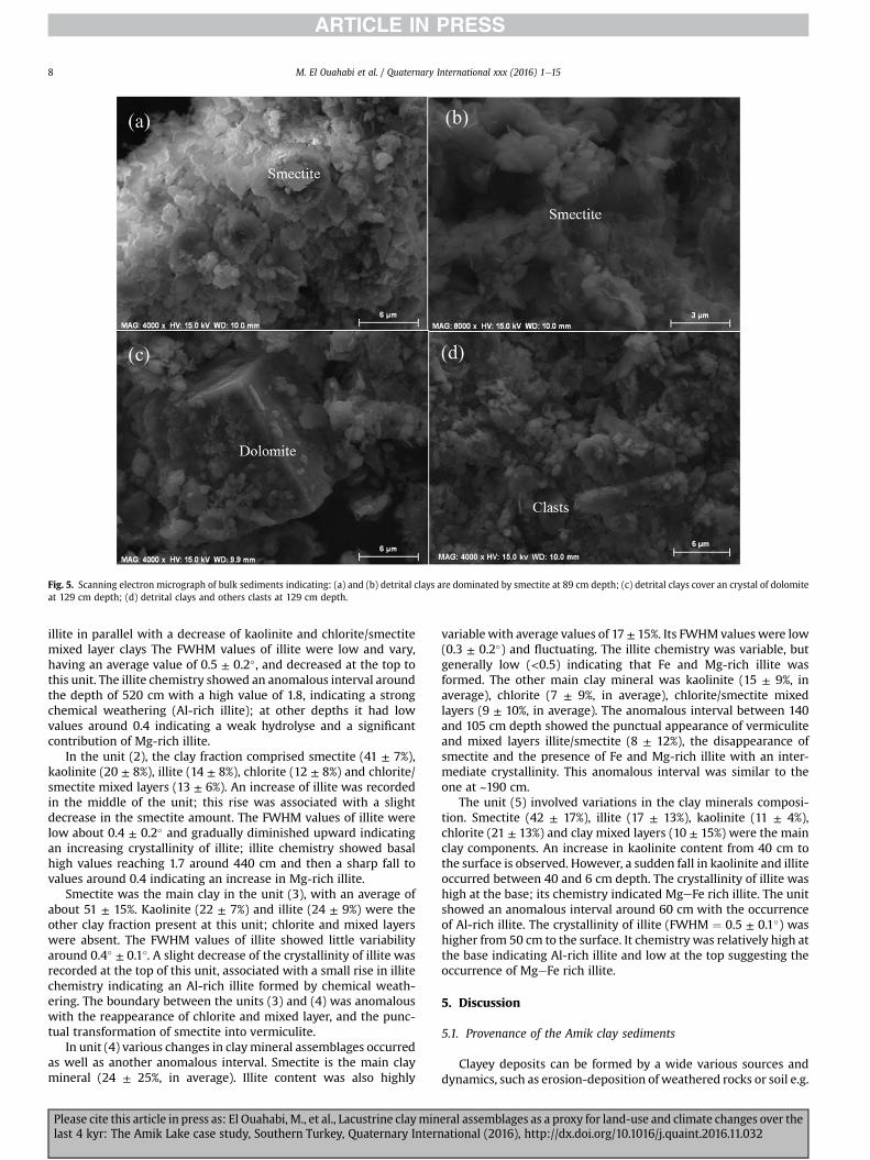
Fig. 5. Scanning electron micrograph of bulk sediments indicating: (a) and (b) detrital clays are dominated by smectite at 89 cm depth; (c) detrital clays cover an crystal of dolomiteat 129 cm depth; (d) detrital clays and others clasts at 129 cm depth.
M. El Ouahabi et al. / Quaternary International xxx (2016) 1e158
illite in parallel with a decrease of kaolinite and chlorite/smectitemixed layer clays The FWHM values of illite were low and vary,having an average value of 0.5 ± 0.2�, and decreased at the top tothis unit. The illite chemistry showed an anomalous interval aroundthe depth of 520 cm with a high value of 1.8, indicating a strongchemical weathering (Al-rich illite); at other depths it had lowvalues around 0.4 indicating a weak hydrolyse and a significantcontribution of Mg-rich illite.
In the unit (2), the clay fraction comprised smectite (41 ± 7%),kaolinite (20 ± 8%), illite (14 ± 8%), chlorite (12 ± 8%) and chlorite/smectite mixed layers (13 ± 6%). An increase of illite was recordedin the middle of the unit; this rise was associated with a slightdecrease in the smectite amount. The FWHM values of illite werelow about 0.4 ± 0.2� and gradually diminished upward indicatingan increasing crystallinity of illite; illite chemistry showed basalhigh values reaching 1.7 around 440 cm and then a sharp fall tovalues around 0.4 indicating an increase in Mg-rich illite.
Smectite was the main clay in the unit (3), with an average ofabout 51 ± 15%. Kaolinite (22 ± 7%) and illite (24 ± 9%) were theother clay fraction present at this unit; chlorite and mixed layerswere absent. The FWHM values of illite showed little variabilityaround 0.4� ± 0.1�. A slight decrease of the crystallinity of illite wasrecorded at the top of this unit, associated with a small rise in illitechemistry indicating an Al-rich illite formed by chemical weath-ering. The boundary between the units (3) and (4) was anomalouswith the reappearance of chlorite and mixed layer, and the punc-tual transformation of smectite into vermiculite.
In unit (4) various changes in claymineral assemblages occurredas well as another anomalous interval. Smectite is the main claymineral (24 ± 25%, in average). Illite content was also highly
Please cite this article in press as: El Ouahabi, M., et al., Lacustrine clayminlast 4 kyr: The Amik Lake case study, Southern Turkey, Quaternary Intern
variablewith average values of 17 ± 15%. Its FWHMvalues were low(0.3 ± 0.2�) and fluctuating. The illite chemistry was variable, butgenerally low (<0.5) indicating that Fe and Mg-rich illite wasformed. The other main clay mineral was kaolinite (15 ± 9%, inaverage), chlorite (7 ± 9%, in average), chlorite/smectite mixedlayers (9 ± 10%, in average). The anomalous interval between 140and 105 cm depth showed the punctual appearance of vermiculiteand mixed layers illite/smectite (8 ± 12%), the disappearance ofsmectite and the presence of Fe and Mg-rich illite with an inter-mediate crystallinity. This anomalous interval was similar to theone at ~190 cm.
The unit (5) involved variations in the clay minerals composi-tion. Smectite (42 ± 17%), illite (17 ± 13%), kaolinite (11 ± 4%),chlorite (21 ± 13%) and clay mixed layers (10 ± 15%) were the mainclay components. An increase in kaolinite content from 40 cm tothe surface is observed. However, a sudden fall in kaolinite and illiteoccurred between 40 and 6 cm depth. The crystallinity of illite washigh at the base; its chemistry indicated MgeFe rich illite. The unitshowed an anomalous interval around 60 cm with the occurrenceof Al-rich illite. The crystallinity of illite (FWHM ¼ 0.5 ± 0.1�) washigher from 50 cm to the surface. It chemistry was relatively high atthe base indicating Al-rich illite and low at the top suggesting theoccurrence of MgeFe rich illite.
5. Discussion
5.1. Provenance of the Amik clay sediments
Clayey deposits can be formed by a wide various sources anddynamics, such as erosion-deposition of weathered rocks or soil e.g.
eral assemblages as a proxy for land-use and climate changes over theational (2016), http://dx.doi.org/10.1016/j.quaint.2016.11.032

M. El Ouahabi et al. / Quaternary International xxx (2016) 1e15 9
(Moss and Walker, 1978; Dotterweich, 2008; Tsatskin and Zaidner,2014), inheritance of solubleminerals after limestone dissolution aswell as by neoformation. In this study, the observed clay crystal-linity as well as their XRD diffractogram shape imply that clays aremostly detrital that originated dominantly from the erosion of thesurrounding soils and geological rock formations, reflecting thegeology and soil cover in the lake catchment (Fig. 5). Multiplesourced inputs thus exist (Fig. 3). The proximal sources are theAmik Plain and its immediate surrounding composed of a largediversity of geological outcrops forming mountain ranges andplateaus (Fig. 1a). Clay sources extend potentially on a much largerarea as the Amik Lake. The Amik Basin is watered by three largerivers having large watersheds. To the south of the Amik Plain, theOrontes is the largest river with a catchment size of 24 660 km2
composed mostly of limestones, marls, amphibolites and schistes(Lehner et al., 2008). To the north, the Karasu drains a catchment of450 km2 composed of rocks with similar geology to the AmanusBasin as well as recent volcanic rocks (basalts); to the east, the AfrinRiver drains mostly calcareous and ophiolitic rocks (Fig. 1b). Ac-cording to the present soil map, the Amik Plain and its three riverscatchment, show poorly developed soil (entosols and some incep-tisols in the Afrin catchment) except in the lowland along theOrontes; this is consistent with the semi-arid environment of themost of the Amik catchment (Kilic et al., 2006). The geomorpho-logical study of (Casana, 2008) showed that several episodes of soildevelopment and erosion occurred in the last 3000 years just to thesouth of the Amik Plain.
The detrital clays in the Amik Lake would express the weath-ering conditions at the source. The clay types found shows thatchemical weathering products (smectite and kaolinite) dominateover the physical weathering products (illite and chlorite) in theAmik Basin (Chamley, 1989). Chemical weathering is indeed fore-seen given the climate regime of the Amik Plain, which is a typicalMediterranean climate, with a large annual precipitation(~1000 mm/yr), an 18 �C annual average temperature, and 69%relative humidity (Gün and Erdem, 2003). In the following, the claymajor sources are identified and discussed based on the clay min-erals abundance and their characteristics.
Illite is generally considered primary minerals derived from thedegradation of metamorphic and igneous formations as well asfrom the erosion of sedimentary rocks (Chamley, 1989). The rela-tively high crystallinity index of illite in some samples (FMWHbetween 0.2� and 0.4�) shows that a significant proportion of theillite is probably derived from the weathering of the metamorphicrocks (biotite and feldspars) in the catchment (Righi et al., 1995;Lanson, 1997; Chipera and Bish, 2001; Hubert et al., 2009). How-ever, in the Amik catchment, the broad base peaks of illite showthat illite is mostly detrital with a FMWH greater than 0.4(Pandarinath, 2009; El Albani et al., 2011). The small coherentdomain size confirms that part of illite results from a trans-formation within a soil formation context and reflects weathering(Lanson and Besson, 1992). The recurrent occurrence of Mg and Fe-bearing illite is traditionally interpreted as a proxy for physicalweathering, but in the present Mediterranean climatic context thisinterpretation is questionable. The documented Mg and Fe-bearingillite would still indicate a weak hydrolyse but suggest the input ofdetrital iron-rich illite that is present particularly in the LateCretaceous marine chalks from the Arabian plateau in the Afrincatchment.
Chlorite is generally derived from in igneous rocks as an alter-ation product of mafic minerals such as pyroxene, amphibole andbiotite, as well as from the erosion of sedimentary rocks (Chamley,1989). In our context, chlorite would be produced by alteration ofmafic rocks having high iron and magnesium content (e.g. ophio-lite) (Biscaye, 1965; Singer, 1984; Buurman et al., 1988; Chamley,
Please cite this article in press as: El Ouahabi, M., et al., Lacustrine clayminlast 4 kyr: The Amik Lake case study, Southern Turkey, Quaternary Intern
1989). The broad shape of the peaks of chlorites and their weakcrystallinity confirm their detrital origin. The Kurd, Amanus andAkra Mountains are thus the potential sources of chlorite. Theabsence of chlorite mostly during the deposition of unit (3) and unit(5) indicates probably a cut-off of those sources that would bediscussed in the next section.
Smectite is generally considered to be a secondary mineral thatis the product of pedogenetic weathering. Smectite is derivedmostly through chemical weathering of volcanic rocks in temperateand sub-arid zones (Chamley, 1989; Weaver, 1989; Fagel et al.,2003). In the Amik Plain, smectite is detrital and can have a widerange of sources brought by the three major rivers flowing into theplain. It could be derived from a) ophiolite complex (amphibole andpyroxene), b) alteration of volcanic rocks along the Karasu valley, c)sedimentary deposits present in the three river catchments. Duringthe deposition of unit 3, the percentage of smectite was particularlyhigh suggesting a strong input from these sources excluding theophiolite body, which would also produce chlorite.
Kaolinite is also considered to be a secondary mineral that is theproduct of pedogenetic weathering, derived through chemicalweathering of parent aluminosilicate under warm and humidconditions (Weaver, 1989; Fagel et al., 2003). Two kaolinite pop-ulations were founded in the Amik Lake sediments: a detrital andneoformed. This interpretation is based on the shape of the d(001)peak of kaolinite which is narrow at the top and more large at thebase in the XRD spectra. The detrital fraction of kaolinite is un-doubtedly a reworked fraction coming from Cretaceous andCenozoic sedimentary rocks that contain a significant proportion ofkaolinite (Fig. 1a) and from the weathering of igneous rocks rich infeldspars and other aluminous minerals and poor in ferromagne-sian minerals in vicinity of the ophiolite complex situated in theAmanus, Kurd and Akra Mountains. The neoformed kaolinite frac-tion is post-depositional formed during weathering.
Chrysotile is detrital derived from the serpentinisation processfrom the ophiolite rocks, especially from olivine by alteration(Prichard,1979). The traces of amphibole relict are derived from theultramafic rocks and the ophiolitic belts located in the watershed.
Finally, the occurrence of mixed-layer clays in the Amik Lakesediments indicates that the developed soils in the Amik watershedwere eroded. Such erosion would be triggered, for example byagriculture, wood exploitation and mining. The presence of mixedlayer clays through most of the core show that an intensive erosionof fertile soils has occurred from the catchment to the Amik Lake fora long time as confirmed by other studies (Wilkinson,1999; Casana,2008). The mixed layers, which are a product of soil erosion, areabsent during the Roman period; the later suggest that the claysource of the Amik Lake was changed during that period. Chloritesource has been disrupted as well during the same period. Theunchanged weathering proxies (illite chemistry, Sm/Il ratio) duringthe unit 3 compared to the previously deposited unit 2 furthersuggests a change in the source area.
5.2. Evolution of the environmental conditions during the last 4 kyr
The major clay minerals, smectite, illite, kaolinite and chloriteshowed significant changes in the studied core. Their relativeabundance may be taken as a proxy for chemical weathering rate inthe watershed: a high percentage of smectite and kaolinite wouldreflect warm and wet climate conditions. Furthermore, crystallinityand chemistry of illite could provide complementary informationregarding the weathering conditions, which are sensitive to theclimate change (Chamley, 1989; De Visser and Chamley, 1990;Pandarinath, 2009). Low illite crystallinity is generally associatedwith greater chemical weathering (Pandarinath, 2009), induced byhigh temperature and significant rainfall. On the opposite, the
eral assemblages as a proxy for land-use and climate changes over theational (2016), http://dx.doi.org/10.1016/j.quaint.2016.11.032

M. El Ouahabi et al. / Quaternary International xxx (2016) 1e1510
crystallinity of illite increases during colder and drier conditions(Fagel et al., 2003). Smectite/kaolinite (Sm/Il) and kaolinite/illite(Ka/Il) ratios can be used as proxy to discuss the climatic conditionsindicating chemical weathering. Sm/Il and Ka/Il ratio evolved in thesame way in the Amik Lake sediments, here we use only Sm/Il ratioas proxy. In addition, Sm/(Il þ Ch), Ka/(Il þ Ch) are used asweathering proxies.
Based on the obtained age model, we considered that thesediment deposited through the unit 1 corresponds to the LateBronze Age (2000e1200 BCE); the unit 2 corresponds to the sedi-ments deposited throughout the Iron Age (1200e300 BCE) andHellenistic period (300 BCE e 100 BCE), the unit 3 was depositedduring the Roman and early Islamic periods (100 BCE e 650 AD);the unit 4 comprises the sediment from the Islamic and Ottomanperiods (650 AD e 1650 AD); the unit 1 represents the Modernperiod.
The temporal variations in clay mineralogy are discussedthroughout these archaeological periods and the wealth of existingdata regarding the human occupation in the Amik Plain and cli-matic change during the last 4000 years. We particularly looked atsome possible cause-and-effect relationship between land-use,climate and soil erosion products supplied in the Amik Lake sedi-ments during the different periods since the Late Bronze Age.
5.3. Bronze and iron ages
The high magnetic susceptibility during this period highlightsthe occurrence of strong erosion. The relatively high amount ofchlorite/smectite mixed layers suggests sustained soil erosion witha detrital source composed of developed soil levels (Righi et al.,1995). The Amik plain was heavily settled with hundred or moresettlements occupied at some point during second millennium BC(Casana, 2009), as well as the Orontes and Afrin catchments. Soilerosion during that period would be linked to deforestation in theAmik catchment that is attested by the pollen record in the GhabBasin flowed by the Orontes to the south of the Amik Plain(Meadows, 2005). Marriner et al. (2012) documented during thatperiod a large increase in sedimentation rates on the nearby Syriancoast induced by soil erosion in local catchments. In the Amik Plain,the sedimentary record of Wilkinson et al. (2001) shows a highchromium content during the Bronze and Iron Ages that wasrelated to soil erosion in the Amanus Mountains in relation withdeforestation and the exploitation of ores. The occurrence of thinred clay layers in the core during this period, which clay charac-teristics are not different from the other layers, could be related tothe erosion of red soil founded in the Mediterranean area, andparticularly in the Afrin catchment that likely developed during theTertiary and Quaternary hot and humid periods (Atalay, 1997). Thelow amount of illite and the absence of chlorite during the BronzeAge and at the transition between Bronze/Iron suggest a decreasein erosion and a change in land-use.
Regarding climate, Drake (2012) shows that in the easternMediterranean a warm climate was prevailing during the BronzeAge, and a cool and more arid climate during the Iron Age whichlasted until the Romanwarm Period. Climatic proxy in coastal Syriasuggests that drier climatic conditions occurred in the Mediterra-nean belt of Syria from the late 13th/early 12th centuries BC to the9th century BC (Kaniewski et al., 2010). During the beginning of theLate Bronze Age (bottom of the sediment core), the high amount ofkaolinite and small rise of Sm/Il ratio associatedwith relatively highillite crystallinity suggest more chemical weathering. This indicatesthat climate was warm during that period.
The Bronze-Iron transition is marked by large variations in theclay minerals content and illite crystallinity. The very low kaolinitecontent, the narrow FWHM and the low illite chemistry (iron
Please cite this article in press as: El Ouahabi, M., et al., Lacustrine clayminlast 4 kyr: The Amik Lake case study, Southern Turkey, Quaternary Intern
bearing illite) suggest dry climate conditions. The end of the BronzeAge and the beginning of the Iron Age have been described as aDark Age related on one hand to the collapse of the Hittite Empireand on the other hand to climatic changes (Weiss, 1982; Drake,2012). Settlement studies around the Amik Plain suggest no ma-jor disruption: the Bronze-Iron Ages were characterized by anoccupation of the low lands, with deforestation in the mountains,particularly the Amanus Mountains (Casana, 2008). There was apossible decreasing settlement density at the end of the BronzeAge, but no identified societal changes (Casana, 2007, 2012). Thepaleoethno-botanical work of Capper (2012) indicates a lack ofagricultural variation in the area. Agriculturewasmainly developedin the lowland areas, and was sustainable in the fertile Amik Plainduring drought periods (Casana, 2012).
During the early Iron Age, the kaolinite content, Sm/Il ratio, Sm/(Il þ Ch) and Ka/(Il þ Ch), increased significantly and suggest amore intense chemical weathering associated with more leachingin the watershed. Furthermore, at this time, illite had a low crys-tallinity (high FWHM) indicating an enhanced chemical weatheringof the stack of phyllosilicates sheets due to warm and humid con-ditions. During the later Iron Age period, drier conditions occurred,attested by a significant decrease in illite chemistry, Sm/(Il þ Ch)and Ka/(Il þ Ch). The strong decrease in the FWHM related to anincrease in illite crystallinity and illite chemistry (FeeMg-rich illite)all point to less favourable climatic conditions, ie. cold and dry.Finally, there are more rapid changes in the clay types, abundances,Sm/Il ratio and illite crystallinity during the Iron Age than duringthe Bronze Age, suggesting that a significant climatic variability butunchanged source areas.
5.4. Roman age
The Roman period is drastically different from the precedingIron/Bronze Ages regarding clay minerals composition as well asmagnetic susceptibility data. The absence of interstratified claysand chlorite suggests a change of source or soil erosion patternduring that period, characterized by the lack of input of developedsoil levels already formed that are usually related to intenseerosion. The low magnetic susceptibility values during this periodconfirm a weak terrigenous input to the lake. These facts seem atodds with the human occupation at that time. The Roman periodcoincides, in fact, with the strongest anthropogenic pressure thathad occurred through the whole history of the Amik watershed(Casana, 2007; Yener et al., 2000; Wilkinson and Rayne, 2010). Thedevelopment of the city of Antioch with a large population had ledto the development of a more intensive agriculture/arboriculturecovering the lowland and the highlands as well as the developmentof a complex network of irrigation (Izdebski et al., 2016). Inparticular, settlements expanded on the shoulders of the Orontesvalley and pasture in the upland areas were converted to arbori-culture (Casana, 2007; Izdebski et al., 2016). The apparent contra-diction between restricted soil erosion and an intense land-use wasalready point out by Casana (2008), which suggested that Romanand late Roman land-use created the necessary preconditions forsoil erosion to occur, but that erosion actually took place about 400years after settlement in the Amik highlands under a differentclimate regime. The specificity of the Roman period around theAmik Lake is also attested by the occurrence of a mature soil at thefoot of the Amanus Mountains that developed during that time(Yener and Batiuk, 2010). The paleosoil overlained gravels depos-ited during the Bronze/Iron period and is covered by even coarsergravels deposited again during the Early Islamic period. This buriedRoman land surface has a significant extent and attests of a uniquelong period of non-erosive conditions (Eger, 2011). In fact, inerodible Mediterranean landscapes, unprotected soils under
eral assemblages as a proxy for land-use and climate changes over theational (2016), http://dx.doi.org/10.1016/j.quaint.2016.11.032

M. El Ouahabi et al. / Quaternary International xxx (2016) 1e15 11
pastures show the highest degree of erosion among the varioustypes of land use (Marathianou et al., 2000). The development ofarboriculture in highlands associated with terracing on steep slopewould not enhance, but reduce erosion. Marathianou et al. (2000)noted on the Levsos Island in the Aegean Sea that soils underpastures are thin and more erodible than soil occupied by olivetrees with terracing and that the developing of a livestock farmingcan protected land from soil erosion. Similarly the study of €Ozsahinand Uygur (2014) in themountainous range south of the Amik Plainshows that wheat growth as a crop can reduce erosion.
We could identified three possible concurrent factors that maybe responsible for observed change in clay minerals during theRoman period: (1) landscape stability linked to low climatic vari-ability (storminess); (2) intense human terracing on the upslopesand highlands that prevent soil erosion despite an intensive land-use; (3) channelization of the rivers draining the Amik plainresulting in a shift in the sediment sources in the Lake. The AfrinRiver which enters the Amik plain at it southern eastern corner wasfully channelized, triggering the development of settlements to theeast and north-east of the Amik Lake (Wilkinson and Rayne, 2010).At least three channel networks were built in different phases, theearliest ones at the beginning of the Roman period (Yener andYener, 2005; Gerritsen et al., 2008; Wilkinson and Rayne, 2010;Eger, 2011). Some of these channels were used until the early Is-lamic period (Yener and Yener, 2005; Gerritsen et al., 2008;Wilkinson and Rayne, 2010; Eger, 2011).
5.5. Islamic age
The end of the Roman period and the beginning of the Islamicone (Roman/Islamic transition) were marked by a strong decreasein the settlement density in the Amik Plain (Yener et al., 2000) aswell as in the highlands of the Afrin and Orontes watersheds (seeDead cities in Casana (2014)). The population decline is probablylinked to the much diminished economic and political role of theAntioch city (Liebeschuetz, 1972) at that time and to an epidemic ofplague and repeated destructive earthquakes rupturing the DeadSea Fault that devastated the region (Marco, 2008; Altunel et al.,2009). These combined factors would have a high toll on thepopulation and settlements, and thus on the land-use during thattime. The intensive agriculture and arboriculture sharply declinedand pastoralism developed (Kaptijn et al., 2013).
During the Roman/Islamic transitional period (Roman/Islamic),smectite was transformed into illite/smectite interstratified andchlorite into vermiculite. Colder conditions would have taken placeduring this critical period. Haldon et al. (2014) indicates that theclimate became much colder during the first half of the sixth cen-tury in the eastern Mediterranean Area.
The Islamic Age is globally characterized by the renew appear-ance of mixed layer clays indicating a renew erosion of mature soilin the catchment similar to the one during the Iron-Bronze Ages.The low magnetic susceptibility values during that time still sug-gested moderate soil erosion compared to the Iron/Bronze Period.This erosive period is responsible for the burial of the Late Romansettlements, and of the Roman Antioch City, which rests below 6 mof alluvial sediments of the Orontes (Casana, 2007). The renewerosion would be related to the increase of pastures and thedecrease in the management of terraced terrains in the highlands(Marathianou et al., 2000). Terraces are agricultural structures builtto protect the soil from erosion and to increase the terrain pro-ductivity, but they need a sustained maintenance, which may notbe feasible given the decrease in sedentary population during theIslamic Period. Their abandonment would result in enhanced soilerosion by run-off water as observed in the present record.
The complete change in clay mineralogy from Roman to Islamic
Please cite this article in press as: El Ouahabi, M., et al., Lacustrine clayminlast 4 kyr: The Amik Lake case study, Southern Turkey, Quaternary Intern
time could be related to other concurrent local and/or global fac-tors. Three additional local factors could be identified. The first onewould be the siltization of channels feeding the coring site, andpossibly of other channels on the Afrin or Orontes Rivers. In theAmik Plain, a marshy landscape prevailed starting in the early Is-lamic time and expanded in the later periods (Yener et al., 2000).The second one would be the renewed exploitation of forests in themountains as a source of wood. During Middle Age, Amanus washeavily exploited for its wood and Antiochwas a largewoodmarketfor Central Syria and Mesopotamia (Lombard, 1959). The thirdpossible factor would be the occurrence of repeated strong earth-quakes that impacted the landscape and the river network. Clusterof three to four large M > 6.5 earthquakes during the 6th centurystroke Antakya and its surrounding, the largest one occurred onMay 29 526 or 525 and would have killed about 250 000 people(Guidoboni et al., 1994; Ambraseys and White, 1997; Akyuz et al.,2006). In addition, strong earthquakes have the potential todivert the river drainage, which would affect the clay type inputinto the Amik Lake; the later occurred during the historical 1822and 1872 earthquakes (Ambraseys, 1989). Finally large magnitudeearthquakes shatter the landscape, preferentially affecting themountain regions, like the Amanus. There, earthquake strongground motion would trigger extensive slope failures and enhancethe erodibility of rock and soil (Harp and Jibson, 1996). The strongshaking of the landscape would thus increase the sediment fluxinto the Amik Basin, a phenomena that have been documentedafter recent earthquakes (Hovius et al., 2011). The concomitantseismically induced erosion, deforestation and the permanentfailure of infrastructures capable to keeping the sediments on thehighlands and slopes must have play a role in the renewed input ofsoils in the Amik Lake. Global factors, i.e climate, could also play arole regarding the observed change in clay mineralogy. Coolerconditions would have occurred during the Roman/Islamic transi-tion, as indicated by the transformation of chlorite into vermiculite,a fall in Sm/Il ratio and Sm/(II þ Ch). Similarly, McCormick et al.(2012) have evidenced that increased in the Western Roman Em-pire (around 400 AD) indicating colder and wetter conditions.
During the Islamic time, some changes in clay mineralogy mayalso be indicative to climate change. During the early Islamic periodan increase in the Sm/Il ratio and Sm/(II þ Ch) is recorded, indi-catingmore chemical weathering due towarm climate. Moreover, aslight decrease in the crystallinity of illite also suggested dry con-ditions. This period could correspond to the Medieval Warm Period(MWP) that is generally considered to be an episode of aboveaverage temperatures (Br�azdil et al., 2005; Kaniewski et al., 2011).Transformation in clay minerals occurs during the later period ofthe Islamic period. Smectite was transformed into illite/smectiteinterstratified and chlorite into vermiculite. Colder conditionswould have taken place during this critical period; at that time,pedogenesis was weak as shown by a decrease in the chlorite/smectite mixed layers. There was no major documented change inthe settlements around the Amik Lake during this time (Eger, 2015).Thus, these clay mineralogical changes were mostly due to theclimatic environmental change. During the Islamic period, therewas no progressive climatic change, but a strong variability(Izdebski et al., 2016).
5.6. Ottoman age
Regarding to the human occupation, there was no changeregarding the anthropic pressure on the environment except dur-ing the 19th century. The Amik Basin and its surrounding wereweakly occupied and pastoralism was the dominant occupation(Gerritsen et al., 2008). Soil erosion was still occurring in the AmikPlain as attested by in our record by the occurrence of chlorite/
eral assemblages as a proxy for land-use and climate changes over theational (2016), http://dx.doi.org/10.1016/j.quaint.2016.11.032

M. El Ouahabi et al. / Quaternary International xxx (2016) 1e1512
smectite mixed layers. The slight increase in the magnetic sus-ceptibility during that period also suggests a detrital supply in thelake related to soil erosion (Fig. 6). This strong erosion was alsoassociated with a high amount in the chlorite, which has not beensignificantly influenced by the pedogenic processes.
Changes in clay mineralogy would thus preferentially reflectclimatic changes. Two different periods were identified: a warmone during the early time followed by a colder and drier climate.Thewarm and humid conditions are attested by rise in the smectiteamount, Sm/Il ratio, Sm/(II þ Ch) and Ka/(II þ Ch). The followingcold period is characterized by a fall in Sm/Il ratio and Sm/(II þ Ch).This colder interval may correspond to the Little Ice Age (LIA) cli-matic event (Briffa, 2000; Jones et al., 2001; Osborn and Briffa,2006; Richter et al., 2009).
The end of the Ottoman period is also marked by a marked in-crease in chlorite reaching more than 40% and the near disap-pearance of illite. The increase in chlorite associate with a smallincrease in magnetic susceptibility would be linked to renewerosion of the mountainous ranges surrounding the Amik Plain. Atthe end of the 19th century and at the beginning of the 20th cen-tury, the anthropic pressure increased again on the environmentwith the industrial development. In particular, the railway between
Fig. 6. Down core variations in crystallinity of illite (FWHM, values given in �2Theta Cu Ka)sediments. Sm/(Il þ Ch), Ka/(Ii þ Ch), (Sm/Ka) ratio and (Ka/Il) ratio evolution were used a
Please cite this article in press as: El Ouahabi, M., et al., Lacustrine clayminlast 4 kyr: The Amik Lake case study, Southern Turkey, Quaternary Intern
Bagdad and Istanbul was constructed and its path goes through thecatchment of the Afrin and the Karasu Rivers. An acute deforesta-tion of the Amanus occurred close to the railroad to respond to thelack of coal during World War I (Huvelin, 1919).
5.7. Modern period
The Modern period is characterized by a renewed intensiveagriculture surrounding Antioch (Antakya), which became a moreimportant city. The present period is reminiscent of the Romanperiod with an engineered water drainage network in the AmikPlain and along the Karasu River that has driven an importantagricultural development and a decrease in pastoralism. In partic-ular, the grasslands on the ophiolites complex were converted toforests or arable lands (Gündo�gan et al., 2011), croplands sharplyincreased and bareground decreased (Kilic et al., 2006).Marathianou et al. (2000) noted that in the Levsos Island, soilsunder pastures have the strong erosion among the various types ofland use and this conversion is likely cause of soil erosion. Likeduring the Roman period, the modern period is characterized by adecrease/absence of chlorite as well as of mixed layers chlorite/smectite, which illustrates that a more intense agricultural
, illite chemistry and various clay minerals as environmental proxies in the Amik Lakes climate proxy. Smectite (Sm), illite (Il), chlorite (Ch), kaolinite (Ka).
eral assemblages as a proxy for land-use and climate changes over theational (2016), http://dx.doi.org/10.1016/j.quaint.2016.11.032

M. El Ouahabi et al. / Quaternary International xxx (2016) 1e15 13
development is not always synonymous with large soil erosion ifthe sensitive areas are well managed.
Clay mineralogy during this period is also characterized by asignificant increase in kaolinite, Sm/Il ratio, Sm/(II þ Ch) and Ka/(II þ Ch). A high chemistry of illite would be related to the currentwarm climate triggering an efficient hydrolysis. In addition, theappearance of illite/smectite mixed layers characterizing the actualsoils are in agreement with the current warm climate and theintense land-use marked by the extension olives, grapevines, grain,and forest on the upland slopes (Casana, 2008).
Magnetic susceptibility and clay mineralogy in the Amik Lakesediment maintains climate shifts including many globally recog-nized events like the Medieval Warm Period (MWP) and Little IceAge (LIA). This work represents the first extensive clay mineralogyand magnetic susceptibility study. The magnetic susceptibilityfluctuations are related to grain-size and indicated the input ofterrigenous material in the lake. The highest magnetic suscepti-bility values correspond to warm period with high chemicalweathering. However, the lowest values provide cold conditions.This study confirms that the magnetic susceptibility signal in theAmik Lake is largely a proxy for climate change.
6. Conclusion
The Amik Lake sedimentary record typically resulted from theerosion of soils and weathered sediments developed in thewatershed of the Amik Plain. Smectite, illite, kaolinite and chlorite/smectite mixed layers assemblages represented a detrital fractionof the sediments. The changes in their relative abundance, illitecrystallinity and its chemistry thus reflect changes in the sourcesand modifications of the environmental conditions prevailing inthe Amik watershed in relation with climatic changes and/or land-use.
The change in the crystallinity of illite and in the abundance ofsmectite, kaolinite, chlorite/smectite and illite/smectite were anindirect effect of pedogenesis and/or a weathering proxy. In addi-tion anthropogenic modification in the watershed (e.g., waterchannelling) can indirectly change the clay source, affecting thecomposition of clay mineral assemblages.
Themost intense erosion phase occurred during the Bronze/IronAges as indicated by the clay and magnetic susceptibility proxies.During the Roman period and until present days, less soil erosionshowed due to much less intense settlement in the watershed ofAmik Lake. As post-sedimentary conditions are marked in the AmikLake deposits, claymineral transformationwere showed, especiallyduring the Islamic/Ottoman period suggesting intense chemicalweathering and pedogenesis transformations related to climatechange.
Acknowledgment
This research was supported partially by the University of Liegeand the EU in the context of the MSCA-COFUND-BeIPD project.
References
Ackermann, O., Greenbaum, N., Bruins, H., Porat, N., Bar-Matthews, M., Almogi-Labin, A., Schilman, B., Ayalon, A., Horwitz, L.K., Weiss, E., Maeir, A.M., 2014.Palaeoenvironment and anthropogenic activity in the southeastern Mediter-ranean since the mid-Holocene: the case of Tell es-Safi/Gath, Israel. Quat. Int.328, 226e243.
Akyuz, H.S., Altunel, E., Karabacak, V., Yalciner, C.C., 2006. Historical earthquakeactivity of the northern part of the Dead sea Fault zone, Southern Turkey.Tectonophysics 426, 281e293.
Altunel, E., Meghraoui, M., Karabacak, V., Akyüz, S.H., Ferry, M., Yalçıner, Ç.,Munschy, M., 2009. Archaeological sites (tell and road) offset by the dead SeaFault in the Amik basin, southern Turkey. Geophys. J. Int. 179, 1313e1329.
Please cite this article in press as: El Ouahabi, M., et al., Lacustrine clayminlast 4 kyr: The Amik Lake case study, Southern Turkey, Quaternary Intern
Ambraseys, N., White, D., 1997. The seismicity of the eastern Mediterranean region550-1 bc: a re-appraisal. J. Earthq. Eng. 1, 603e632.
Ambraseys, N.N., 1989. Temporary seismic quiescence: SE Turkey. Geophys. J. Int.96, 311e331.
Appleby, P.G., 2002. Chronostratigraphic techniques in recent sediments. In:Tracking Environmental Change Using Lake Sediments. Springer, Netherlands,pp. 171e203.
Atalay, I., 1997. Red mediterranean soils in some karstic regions of Taurus Moun-tains, Turkey. Catena 28, 247e260.
Berglund, B.E., 2003. Human impact and climate changesdsynchronous events anda causal link? Quat. Int. 105, 7e12.
Biscaye, P.E., 1965. Mineralogy and sedimentation of recent deep-sea clay in AtlanticOcean and adjacent seas and oceans. Geol. Soc. Am. Bull. 76, 803e832.
Boulton, S.J., Robertson, A.H.F., Ellam, R.M., Safak, U., Unlügenc, U.C., 2007. Strontiumisotopic and micropalaeontological dating used to help redefine the stratig-raphy of the neotectonic Hatay Graben, Southern Turkey. Turkish J. Earth Sci. 16,1e39.
Braidwood, R., Braidwood, L., 1960. Excavations in the Plain of Antioch I. In: AJ, P.(Ed.), The Earlier Assemblages, Chicago.
Br�azdil, R., Pfister, C., Wanner, H., Von Storch, H., Luterbacher, J., 2005. Historicalclimatology in europeethe state of the art. Clim. Change 70, 363e430.
Briffa, K.R., 2000. Annual climate variability in the holocene: interpreting themessage of ancient trees. Quat. Sci. Rev. 19, 87e105.
Buurman, P., Meijer, E., VanWijck, J., 1988. Weathering of chlorite and vermiculite inultramafic rocks of Cabo Ortegal, Northwestern Spain. Clays Clay Miner. 36,263e269.
Çalıskan, V. (2008) Human-induced wetland degradation: a case study of Lake Amik(Southern Turkey). Pp. Third _International Conference on Water Observationand Information System for Decision Support, Ohrid, Macedonia.
Capper, M.M., 2012. Urban Subsistence in the Bronze and Iron Ages: the Palae-oethnobotany of Tell Tayinat, Turkey. Environment: Department of Archaeology.
Casana, J., 2007. Structural transformations in settlement systems of the NorthernLevant. Am. J. Archaeol. 111, 195e221.
Casana, J., 2008. Mediterranean valleys revisited: linking soil erosion, land use andclimate variability in the Northern Levant. Geomorphology 101, 429e442.
Casana, J., 2009. Alalakh and the archaeological landscape of Mukish: the politicalgeography and population of a Late Bronze age kingdom. Bull. Am. Sch. Orient.Res. 7e37.
Casana, J., 2012. 7 settlement, territory, and the political landscape of Late BronzeAge polities in the Northern Levant. Archeol. Pap. Am. Anthropol. Assoc. 22,107e125.
Casana, 2014. The late roman landscape of the northern levant: a view from TellQarqur and the lower Orontes River Valley. Oxf. J. Archaeol. 33, 193e219.
Chamley, H., 1989. Clay Sedimentology. Springer-Verlag, p. 623.Chipera, S.J., Bish, D.L., 2001. Baseline studies of the clay minerals society source
clays: powder x-ray diffraction analyses. Clays Clay Miner. 49, 398e409.Costantini, E.A., Bucelli, P., Priori, S., 2012. Quaternary landscape history determines
the soil functional characters of terroir. Quat. Int. 265, 63e73.De Visser, J., Chamley, H., 1990. Clay Mineralogy of the Pliocene and Pleistocene of
Hole 653a, Western Tyrrhenian Sea (odp leg 107).Dodson, J.R., Taylor, D., Ono, Y., Wang, P., 2004. Climate, human, and natural systems
of the PEP II transect. Quat. Int. 118, 3e12.Dotterweich, M., 2008. The history of soil erosion and fluvial deposits in small
catchments of central Europe: deciphering the long-term interaction betweenhumans and the environment d a review. Geomorphology 101, 192e208.
Drake, B.L., 2012. The influence of climatic change on the late Bronze age collapseand the Greek Dark ages. J. Archaeol. Sci. 39, 1862e1870.
Edwards, K.J., Whittington, G., 2001. Lake sediments, erosion and landscape changeduring the Holocene in Britain and Ireland. Catena 42, 143e173.
Eger, A.A., 2011. The swamps of home: marsh formation and settlement in the EarlyMedieval Near East. J. Near East. Stud. 70, 55e79.
Eger, A.A., 2015. The Islamic-byzantine Frontier: Interaction and Exchange AmongMuslim and Christian Communities. IB Tauris.
El Albani, A., Meunier, A., Macchiarelli, R., Ploquin, F., Tournepiche, J.F., 2011. Localenvironmental changes recorded by clay minerals in a karst deposit during MIS3 (La Chauverie, SW France). Quat. Int. 241, 26e34.
Esquevin, J., 1969. Influence de la composition chimique des illites sur leurcristallinit�e. Bull. Cent. Rech. Pau-SNPA 3, 147e153.
Fagel, N., Boski, T., Likhoshway, L., Oberhaensli, H., 2003. Late quaternary claymineral record in central lake Baikal (Academician ridge, Siberia). Palaeogeogr.Palaeoclimatol. Palaeoecol. 193, 159e179.
Ferrage, E., Lanson, B., Sakharov, B.A., Geoffroy, N., Jacquot, E., Drits, V.A., 2007.Investigation of dioctahedral smectite hydration properties by modeling of x-ray diffraction profiles: influence of layer charge and charge location. Am.Mineral. 92, 1731e1743.
Friedman, I., Trembour, F.W., Hughes, R.E., 1997. Obsidian hydration dating, inchronometric dating in archaeology. In: Taylor, R.E., Aitken, M.J. (Eds.), Advancesin Archaeological and Museum Science, vol. 2. Springer/Plenum Press, NewYork, pp. 297e321.
Gerritsen, F., De Giorgi, A., Eger, A., €Ozbal, R., Vorderstrasse, T., 2008. Settlement andlandscape transformations in the Amuq Valley, Hatay: a long-term perspective.Anatolica 34, 241e314.
Gingele, F.X., 1996. Holocene climatic optimum in southwest Africa - evidence fromthe marine clay mineral record. Palaeogeogr. Palaeoclimatol. Palaeoecol. 122,77e87.
eral assemblages as a proxy for land-use and climate changes over theational (2016), http://dx.doi.org/10.1016/j.quaint.2016.11.032

M. El Ouahabi et al. / Quaternary International xxx (2016) 1e1514
Guidoboni, E., Comastri, A., Traina, G., 1994. Catalogue of Ancient Earthquakes in theMediterranean Area up to the 10th Century. SGA.
Gülen, L., Barka, A., Toks€oz, M.N., 1987. Continental collision and related complexdeformation: Maras triple junction and surrounding structures, SE Turkey.Hacettepe Univ. Earth Sci. J. 14, 319e336.
Gün, M., Erdem, A., 2003. Agricultural master plan of Hatay. Ministry of Agricultureand Rural Affairs-Agricultural Directorate of Hatay (in Turkish).
Gündo�gan, R., €Ozyurt, H., Akay, A., 2011. The effects of land use on properties of soilsdeveloped over ophiolites in Turkey. Int. J. For. Soil Eros. (IJFSE) 1, 36e42.
Günster, N., Skowronek, A., 2001. Sedimentesoil sequences in the Granada Basin asevidence for long-and short-term climatic changes during the Pliocene andQuaternary in the Western Mediterranean. Quat. Int. 78, 17e32.
Haldon, J., Roberts, N., Izdebski, A., Fleitmann, D., McCormick, M., Cassis, M.,Doonan, O., Eastwood, W., Elton, H., Ladst€atter, S., Manning, S., Newhard, J.,Nicoll, K., Telelis, I., Xoplaki, E., 2014. The climate and environment of ByzantineAnatolia: Integrating science, history, and archaeology. J. Interdiscip. Hist. 45,113e161.
Harp, E.L., Jibson, R.W., 1996. Landslides triggered by the 1994 northridge, Califor-nia, earthquake. Bull. Seismol. Soc. Am. 86, S319eS332.
Hovius, N., Meunier, P., Lin, C.-W., Chen, H., Chen, Y.-G., Dadson, S., Horng, M.-J.,Lines, M., 2011. Prolonged seismically induced erosion and the mass balance ofa large earthquake. Earth Planet. Sci. Lett. 304, 347e355.
Hubert-Ferrari, A., Avsar, U., El Ouahabi, M., Lepoint, G., Martinez, P., Fagel, N., 2012.Paleoseismic record obtained by coring a sag-pond along the north Anatolianfault (Turkey). Ann. Geophys. 55, 929e953.
Hubert, F., Caner, L., Meunier, A., Lanson, B., 2009. Advances in characterization ofsoil clay mineralogy using x-ray diffraction: from decomposition to profilefitting. Eur. J. Soil Sci. 60, 1093e1105.
Huvelin, P., 1919. Que vaut la syrie? Librairie ancienne Honor�e Champion.Inoue, A., Bouchet, A., Velde, B., Meunier, A., 1989. Convenient technique for esti-
mating smectite layer percentage in randomly interstratified illite/smectiteminerals. Clays Clay Miner. 37, 227e234.
Izdebski, A., Pickett, J., Roberts, N., Waliszewski, T., 2016. The environmental,archaeological and historical evidence for regional climatic changes and theirsocietal impacts in the eastern mediterranean in late antiquity. Quat. Sci. Rev.136, 189e208.
Jalut, G., Dedoubat, J.J., Fontugne, M., Otto, T., 2009. Holocene circum-Mediterranean vegetation changes: climate forcing and human impact. Quat.Int. 200, 4e18.
Jones, P., Osborn, T., Briffa, K., 2001. The evolution of climate over the last millen-nium. Science 292, 662e667.
Kaniewski, D., Paulissen, E., Van Campo, E., Weiss, H., Otto, T., Bretschneider, J., VanLerberghe, K., 2010. Late secondeearly first millennium bc abrupt climatechanges in coastal Syria and their possible significance for the history of theeastern mediterranean. Quat. Res. 74, 207e215.
Kaniewski, D., Van Campo, E., Paulissen, E., Weiss, H., Bakker, J., Rossignol, I., VanLerberghe, K., 2011. The medieval climate anomaly and the Little Ice Age incoastal Syria inferred from pollen-derived palaeoclimatic patterns. Glob. Planet.Change 78, 178e187.
Kaptijn, E., Poblome, J., Vanhaverbeke, H., Bakker, J., Waelkens, M., 2013. Societalchanges in the Hellenistic, Roman and Early Byzantine periods. Results from thesagalassos territorial archaeological survey 2008 (Southwest Turkey). Anatol.Stud. 63, 75.
Karabacak, V., Altunel, E., 2013. Evolution of the northern dead sea fault zone inSouthern Turkey. J. Geodyn. 65, 282e291.
Karabacak, V., Altunel, E., Meghraoui, M., Akyüz, H., 2010. Field evidences fromnorthern dead sea fault zone (South Turkey): new findings for the initiation ageand slip rate. Tectonophysics 480, 172e182.
Kübler, B., Jaboyedoff, M., 2000. Illite crystallinity. Comptes Rendus de l'Acad�emiedes Sciences-Series IIA-Earth Planet. Sci. 331 (2), 75e89.
Kilic, S., Evrendilek, F., Berberoglu, S., Demirkesen, A., 2006. Environmental moni-toring of land-use and land-cover changes in a mediterranean region of Turkey.Environ. Monit. Assess. 114, 157e168.
Lanson, B., 1997. Decomposition of experimental x-ray diffraction patterns (profilefitting): a convenient way to study clay minerals. Clays Clay Miner. 45, 132e146.
Lanson, B., Besson, G., 1992. Characterization of the end of smectite-to-illitetransformation: decomposition of x-ray patterns. Clays Clay Miner. 40, 40e52.
Lawrence, D., Philip, G., Wilkinson, K., Buylaert, J.P., Murray, A.S., Thompson, W.,Wilkinson, T.J., 2015. Regional power and local ecologies: accumulated popu-lation trends and human impacts in the northern Fertile Crescent. Quat. Int. (inpress).
Lehner, B., Verdin, K., Jarvis, A., 2008. New global hydrography derived fromSpaceborne elevation data. Eos 89, 93e94.
Liebeschuetz, J.H.W.G., 1972. Antioch: City and Imperial Administration in the LaterRoman Empire. Oxford University Press, USA.
Lombard, M., 1959. Un probl�eme cartographi�e: Le bois dans la m�editerran�eemusulmane (VIIE-XIE si�ecles. In: Proceedings of the Annales. Histoire, SciencesSociales. JSTOR, pp. 234e254.
Lucke, B., Schmidt, M., Al-Saad, Z., Bens, O., Hüttl, R.F., 2005. The abandonment ofthe Decapolis region in Northern Jordan-forced by environmental change?Quat. Int. 135, 65e81.
Marathianou, M., Kosmas, C., Gerontidis, S., Detsis, V., 2000. Land-use evolution anddegradation in lesvos (Greece): a historical approach. Land Degrad. Dev. 11,63e73.
Marco, S., 2008. Recognition of earthquake-related damage in archaeological sites:
Please cite this article in press as: El Ouahabi, M., et al., Lacustrine clayminlast 4 kyr: The Amik Lake case study, Southern Turkey, Quaternary Intern
examples from the dead sea fault zone. Tectonophysics 453, 148e156.Marriner, N., Goiran, J.-P., Geyer, B., Matoïan, V., al-Maqdissi, M., Leconte, M.,
Carbonel, P., 2012. Ancient harbors and holocene morphogenesis of the ras IibnHani Peninsula (Syria). Quat. Res. 78, 35e49.
McCormick, M., Büntgen, U., Cane, M.A., Cook, E.R., Harper, K., Huybers, P., Litt, T.,Manning, S.W., Mayewski, P.A., More, A.F., Nicolussi, K., 2012. Climate changeduring and after the Roman Empire: reconstructing the past from scientific andhistorical evidence. J. Interdiscip. Hist. 43 (2), 169e220.
Meadows, J., 2005. The Younger Dryas episode and the radiocarbon chronologies ofthe lake Huleh and Ghab valley pollen diagrams, Israel and Syria. Holocene 15,631e636.
Moore, D.M., Reynolds, R.C., 1997. X-ray Diffraction and the Identification andAnalysis of Clay Minerals. Oxford University Press, Oxford.
Moss, A.J., Walker, P.H., 1978. Particle transport by continental water flows inrelation to erosion, deposition, soils, and human activities. Sediment. Geol. 20,81e139.
Osborn, T.J., Briffa, K.R., 2006. The spatial extent of 20th-century warmth in thecontext of the past 1200 years. Science 311, 841e844.
€Ozsahin, E., Uygur, V., 2014. The effects of land use and land cover changes (LULCC)in Kuseyr Plateau of Turkey on erosion. Turkish J. Agric. For. 38 (4), 478e487.
Pandarinath, K., 2009. Clay minerals in SW Indian continental shelf sediment coresas indicators of provenance and palaeomonsoonal conditions: a statisticalapproach. Int. Geol. Rev. 51, 145e165.
Parlak, O., Rızao�glu, T., Ba�gcı, U., Karao�glan, F., H€ock, V., 2009. Tectonic significanceof the geochemistry and petrology of ophiolites in southeast Anatolia, Turkey.Tectonophysics 473, 173e187.
Pelle, T., Fabio, S., Gaetano Di, P., Allevato, E., Marino, D., Robustelli, G., Mauro, F.,Russa, La, Pulice, L., 2013. Multidisciplinary study of Holocene archaeologicalsoils in an upland Mediterranean site: natural versus anthropogenic environ-mental changes at Cecita Lake, Calabria, Italy. Quat. Int. 303, 163e179.
P�ecsi, M., 1990. Loess is not just the accumulation of dust. Quat. Int. 7, 1e21.Prichard, H.M., 1979. A petrographie study of the process of serpentinisation in
ophiolites and the ocean crust. Contrib. Mineral. Petrol. 68, 231e241.Renac, C., Meunier, A., 1995. Reconstruction (hipalaeothermal, conditons in a pas-
sive margin using illite-smectite mixed-layer series (bal scientific deep drill-hole, Ardeche, France). Clay Miner. 30, 107e118.
Reynolds, R., 1988. Mixed layer chlorite minerals. Rev. Mineral. Geochem. 19,601e629.
Richter, T., Peeters, F., Van Weering, T., 2009. Late holocene (0e2.4 kabp) surfacewater temperature and salinity variability, Feni Drift, NE Atlantic Ocean. Quat.Sci. Rev. 28, 1941e1955.
Righi, D., Petit, S., Bouchet, A., 1993. Characterization of hydroxy-interlayeredvermiculite and illite/smectite interstratified minerals from the weathering ofchlorite in a cryorthod. Clays Clay Miner. 41, 484e484.
Righi, D., Velde, B., Meunier, A., 1995. Clay stability in clay-dominated soil systems.Clay Miner. 30, 45e54.
Robertson, A.H.F., 2002. Overview of the genesis and emplacement of mesozoicophiolites in the eastern Mediterranean Tethyan region. Lithos 65, 1e67.
Schmidt, S., Howa, H., Mouret, A., Lombard, F., Anschutz, P., Labeyrie, L., 2009.Particle fluxes and recent sediment accumulation on the Aquitanian margin ofBay of Biscay. Cont. Shelf Res. 29, 1044e1052.
Sauer, D., Amit, R., Carnicelli, S., Costantini, E.A., 2015. Rates of soil forming pro-cesses and the role of aeolian influx. Quat. Int. 376, 1e4.
Singer, A., 1984. The paleoclimatic interpretation of clay minerals in sediments - areview. Earth Sci. Rev. 21, 251e293.
Thorez, J., 1976. Practical Identification of Clay Minerals. G. Lelotte, Li�ege, p. 90.Tsatskin, A., Zaidner, Y., 2014. Geoarchaeological context of the later phases of
mousterian occupation (80e115 ka) at Nesher Ramla, Israel: soil erosion,deposition and pedogenic processes. Quat. Int. 331, 103e114.
Varga, A., Újv�ari, G., Raucsik, B., 2011. Tectonic versus climatic control on the evo-lution of a loessepaleosol sequence at Beremend, Hungary: an integratedapproach based on paleoecological, clay mineralogical, and geochemical data.Quat. Int. 240, 71e86.
Velde, B., Meunier, A., 2008. The Origin of Clay Minerals in Soils and WeatheredRocks, p. 406. Heidelberg.
Vogel, S., M€arker, M., Rellini, I., Hoelzmann, P., Wulf, S., Robinson, M.,Steinhübelh, L., Di Maioi, G., Imperatorej, C., Kastenmeierj, P., Liebmannf, L.,Espositoj, D., Seilerj, F., 2016. From a stratigraphic sequence to a landscapeevolution model: late Pleistocene and Holocene volcanism, soil formation andland use in the shade of Mount Vesuvius (Italy). Quat. Int. 394, 155e179.
Weaver, C., 1989. Clays, Muds, and Shales (Developments in Sedimentology).Weiss, B., 1982. The decline of Late Bronze Age civilization as a possible response to
climatic change. Clim. Change 4, 173e198.Wilkinson, T.J., 1997. The history of the lake of Antioch: a preliminary note. In:
Young, G., Chavalas, M., Averback, R. (Eds.), Rossing Boundaries and LinkingHorizons: Studies in Honor of Michael c. Astour on His 80th Birthday. CLD Press,Bethesda, Maryland.
Wilkinson, T.J., 1999. Holocene valley fills of southern Turkey and northwesternSyria: recent geoarchaeological contributions. Quat. Sci. Rev. 18, 555e571.
Wilkinson, T.J., 2000. Geoarchaeology of the Amuq plain. In: Yener, A., Edens, C.,Harrison, T., Verstraete, J., Wilkinson, T.J. (Eds.), The Amuq Valley RegionalProject, 1995e1998, vol. 104, pp. 163e220. American Journal of Archaeology.
Wilkinson, T.J., Friedman, E.S., Alp, E., Stampfl, A.P.J., 2001. The geoarchaeology of alake basin: spatial and chronological patterning of sedimentation in the AmuqPlain, Turkey. J. Name Recherches Archeometriques 211e226.
eral assemblages as a proxy for land-use and climate changes over theational (2016), http://dx.doi.org/10.1016/j.quaint.2016.11.032

M. El Ouahabi et al. / Quaternary International xxx (2016) 1e15 15
Wilkinson, T.J., Rayne, L., 2010. Hydraulic landscapes and imperial power in the neareast. Water Hist. 2, 115e144.
Yener, K., Yener, K., 2005. Alalakh spatial organization. Amuq Val. Regonal Proj. 1,1995e2002.
Yener, K.A., Batiuk, S., 2010. Tell Atchana, Ancient Alalakh: the 2003e2004 Exca-vation Seasons/ed. By Kutlu Aslihan Yener. With contrib. By Stephen Batiuk [ua].
Please cite this article in press as: El Ouahabi, M., et al., Lacustrine clayminlast 4 kyr: The Amik Lake case study, Southern Turkey, Quaternary Intern
Ege Yayınları.Yener, K.A., Edens, C., Harrison, T.P., Verstraete, J., Wilkinson, T.J., 2000. The Amuq
Valley regional project, 1995-1998. Am. J. Archaeol. 104, 163e220.Zielhofer, C., Faust, D., Linst€adter, J., 2008. Late Pleistocene and Holocene alluvial
archives in the Southwestern Mediterranean: changes in fluvial dynamics andpast human response. Quat. Int. 181, 39e54.
eral assemblages as a proxy for land-use and climate changes over theational (2016), http://dx.doi.org/10.1016/j.quaint.2016.11.032