lacerda et al-2005-rappam report-cambodia
TRANSCRIPT

Cambodia
Management Effectiveness Assessment
of the System of Protected Areas in Cambodia
using WWF’s RAPPAM Methodology
Project Liaison Office
Biodiversity and Protected Areas Management Project (BPAMP)
Department of Nature Conservation and Protection, Ministry of Environment
#48, Samdech Preah Sihanouk, Tonle Bassac, Chamkarmon, Phnom Penh, CAMBODIA
Tel/Fax: (855) 23 213 900 E-mail: [email protected]
Cambodia
Cambodia
Biodiversity and Protected AreasManagement Project
(BPAMP)

Map 2. Landcover of Cambodia.
Lacerda, L., Schmitt, K., Cutter, P. and Meas, S. 2004. Management EffectivenessAssessment of the System of Protected Areas in Cambodia using WWF’s RAPPAMMethodology. Ministry of Environment, Biodiversity and Protected Areas ManagementProject, Phnom Penh, Cambodia.
Front Cover Photograph: Virachey National Park J. Kitchens © BPAMP 2005
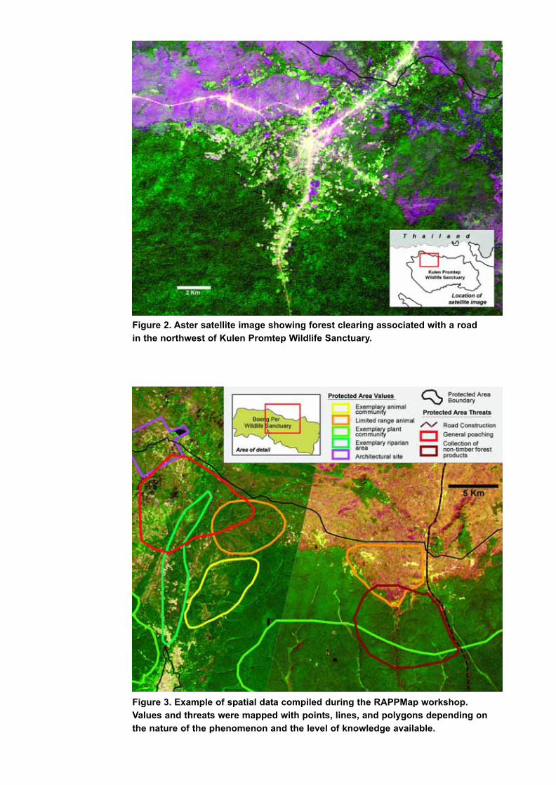
Figure 2. Aster satellite image showing forest clearing associated with a road
in the northwest of Kulen Promtep Wildlife Sanctuary.
Figure 3. Example of spatial data compiled during the RAPPMap workshop.
Values and threats were mapped with points, lines, and polygons depending on
the nature of the phenomenon and the level of knowledge available.
Map 1. Protected Areas of Cambodia.

CAMBODIA
Management Effectiveness Assessment
of the System of Protected Areas in Cambodia
using WWF’s RAPPAM Methodology
L. Lacerda, K. Schmitt, P. Cutter and S. Meas
Biodiversity and Protected AreasManagement Project
(BPAMP)

2
Contents
Introduction and Background. . . . . . . . . . . . . . . . . . . . . . . . . . . . . . 3
Scope and Coverage of the Assessment . . . . . . . . . . . . . . . . . . . . 5
Methodology . . . . . . . . . . . . . . . . . . . . . . . . . . . . . . . . . . . . . . . . . . 6
Analysis and Findings
Pressures and Threats . . . . . . . . . . . . . . . . . . . . . . . . . . . . . .8
Biological and Socio-economic Importance . . . . . . . . . . . . .13
Vulnerability . . . . . . . . . . . . . . . . . . . . . . . . . . . . . . . . . . . . . .16
Management . . . . . . . . . . . . . . . . . . . . . . . . . . . . . . . . . . . . .17
System-level Issues . . . . . . . . . . . . . . . . . . . . . . . . . . . . . . . . . . . .22
Recommendations . . . . . . . . . . . . . . . . . . . . . . . . . . . . . . . . . . . . .25
References and Acknowledgements . . . . . . . . . . . . . . . . . . . . . . .26

3
Cambodia: home to the majestic and elusive
banteng (Bos javanicus), a wild “cousin” of the
Asian river buffalo - man’s indispensable
companion while toiling in rice paddies to build
some of the world’s most fascinating civilisations.
Cambodia: seat of the mysterious Khmer temple of
Angkor, one of mankind’s greatest architectural
accomplishments. The identification of Cambodia
with these two icons (one natural, the other cultural)
is a testimony to the importance of the protected
area system of Cambodia as a guardian of the
country’s very soul. The highly endangered banteng
is now only found in a handful of areas in Cambodia
- most of them part of the protected area system.
The Angkor temple complex is the oldest protected
area in Asia and is now a Protected Landscape as
well as a UNESCO World Heritage Site.
Situated at the heart of Indochina, Cambodia
covers an area of 181,038 square kilometres.
Within its borders is the majority of the Lower
Mekong Dry Forests Ecoregion – identified by
WWF as one of the “Global 200 Ecoregions” - the
most biologically outstanding terrestrial and aquatic
habitats in the world. The Cardamom Mountains
ecoregion in the southwest of the country
represents one of the largest continuous and
relatively intact rainforests in mainland South East
Asia (Shields et al. 2004) and is protected by one of
the most extensive protected area complexes in the
region, made up of the Phnom Samkos and Phnom
Aural wildlife sanctuaries and the Central
Cardamom Mountains Protected Forest. The
Annamite Range Moist Forests and Mekong River
Ecoregions also have significant representation in
Cambodia.
Several important flagship species such as the
Asian elephant, tiger, banteng, and wild water
buffalo occur in significant numbers in Cambodia,
as do more species of globally threatened
mammals, birds, and fish per unit area than in any
other SE Asian country (Tordoff et al. 2005).
Although Cambodia’s forests and coastal areas are
some of the least disturbed in the region, nearly half
of the 70 species of terrestrial mammals recorded
for Cambodia have been listed by IUCN as globally
threatened, near-threatened or data deficient.
Cambodia pioneered the creation of protected
areas in Southeast Asia in 1925 by setting aside the
Angkor temple complex and surrounding areas for
protection. In 1993, a Royal Decree established a
national system comprising 23 protected areas
classified under four major categories: National
Parks, Wildlife Sanctuaries, Protected Landscapes,
and Multiple Use Areas. The Ministry of
Environment (MoE) has the responsibility for
overseeing these 23 protected areas and 3 Ramsar
sites, two of which are contained within the 23
protected areas. Combined, all of these areas cover
32,289 km² (tab. 1 and map 3). In addition to these
areas, the Ministry of Agriculture, Forestry and
Fisheries (MAFF) has set aside a number of areas
for biodiversity conservation, forest protection,
genetic conservation, and wildlife habitat
protection. Together, these areas represent an
additional 14,860 square kilometres (Forestry
Administration web site 2005, Shields et al. 2004,
Cambodian Government 2004, 2005) under
intentional protection (tab. 1 and map 1). The
country’s entire system of protected areas covers
47,845 km² (about 26.3% of Cambodia’s land
territory).
In addition to the areas shown in table 1, where the
primary management objective is conservation,
MAFF is responsible for the administration of the
country’s remaining forest lands. Of that, significant
portions are under forestry concessions although
these concessions are all currently under review.
Much of the forest areas allocated for exploitation or
production may at some time provide important
connectivity between areas under formal
protection.
Introduction and Background

Table 1. Summary of Cambodia’s protected area system.
The dry season extent of the Tonle Sap lake is not included in these calculations.a One of the 3 Ramsar sites lies completely within a Multiple Use Area and one is contained within a Wildlife Sanctuary and a NationalPark. Only the Stung Treng Ramsar Site is included in these calculations. b DoF = Department of Fisheries
4
Virachey National Park
© C. Turner 2004

This assessment covers the 26 protected areas
(map 3) under the management responsibility of
the Ministry of Environment. One of these, the
Tonle Sap Multiple Use Area has three distinct
management units that focus on its three core
zones. The Assessment Team decided to consider
these three sites as independent units. Two of the
country’s three official Ramsar sites overlap with
MoE-administered sites already included in the
analysis. For this reason, only the non-overlapping
site (Stung Treng Ramsar Site) was included as a
separate unit of evaluation in the analysis.
5
Scope and Coverageof the Assessment
Map 3. The 26 protected area sites considered in this assessment.

This assessment followed the Rapid Assessment
and Prioritization of Protected Area Management
Methodology - RAPPAM - (Erwin 2003) developed
by WWF (World Wide Fund for Nature) RAPPAM is
structured around the six key assessment
elements recommended by the World Commission
on Protected Areas (WCPA) Framework for
Assessing Management Effectiveness (Hockings
et al. 2000). RAPPAM has undergone extensive
testing and development and has been
successfully carried out in over 20 countries.
RAPPAM is a rapid and qualitative tool based on
subjective assessments by individuals with
extensive knowledge of the situation on the ground.
This particular assessment was conducted during a
three-day workshop in Phnom Penh (September
20-22, 2004) with 80 participants. Most of the
participants were staff of the Ministry of
Environment including most protected area
directors, deputy directors, and other technical and
support staff. Staff of the Biodiversity and Protected
Areas Management Project (BPAMP) and
representatives of international non-governmental
organisations (NGOs) also participated, including
Conservation International (CI), World Wide Fund
for Nature (WWF), Fauna and Flora International
(FFI), and the Wildlife Conservation Society (WCS).
The workshop included instruction sessions,
presentations, group discussions, and plenary
sessions. During the workshop, participants
assessed the six key elements contained in WCPA’s
Assessment Framework. A questionnaire with 19
questions, subdivided into a number of more
detailed items, was applied (Erwin 2003, p. 42-48).
Participants were divided into five groups, based
on broad country-level biogeographic units:
Eastern Protected Areas, Northern Plains and
Forests, Tonle Sap/Mekong River Areas,
Cardamom/Elephant Mountain Ranges, and
Coastal Areas. Within each of the five groups one
questionnaire was completed for each protected
area. Detailed guidance notes were made
available for explanation and clarification. Answers
to the questionnaires were compiled during the
workshop and the results summarised in charts
and graphs. These were discussed in plenary
sessions for peer review, validation and cross-
checking.
The analysis of context included assessments at
both the national level and the individual protected
area level. On the national level, participants
identified the most important pressures and threats
to the system as a whole. Also assessed were
such factors as the primary sources of vulnerability
in the system and the general policy environment
for protected areas in Cambodia. At the level of
individual protected areas, participants assessed
policies, legislation and regulations and applied
relative scores for both the biological and socio-
economic importance of each area.
In the analysis of design and planning, participants
reviewed the adequacy of management and
operational plans with respect to protected area
objectives and the overall understanding of the
objectives by protected areas managers and other
stakeholders. They also rated the legal security of
each area by assessing the degree of legal
protection, the extent of boundary demarcation, and
the existence and intensity of unsettled land
disputes. Finally, they assessed the layout and
configuration of each protected area, its zoning, and
its degree of connectivity with other protected areas.
With respect to inputs, participants reviewed the
quantity, quality, and adequacy of staff, the
adequacy of communications systems, data
collection and analysis in support of management,
the existing infrastructure (such as facilities, means
of transportation, equipment and maintenance), past
and current funding levels, and the adequacy and
transparency of financial management practices.
In assessing management processes, participants
evaluated the existence and comprehensiveness
of management plans, annual workplans, the
management decision-making process,
stakeholder participation, and the existence and
effectiveness of research, monitoring and
evaluation programmes at the site level.
6
MethodologyRapid Assessment and Prioritization of Protected Area Management (RAPPAM)

Finally, in reviewing management outputs and
conservation outcomes, participants looked at the
specific products, services, and conservation
results accomplished by the staff involved in
protected area management. The adequacy of
these products and results were then assessed
against protected area objectives and priority
activities that had been identified in management
plans and workplans.
Further and more detailed information on the
RAPPAM methodology can be found on the
Internet at http://www.panda.org/about_wwf/
what_we_do/ forests/what_we_do/protection/park
_assessment/ download_centre.cfm
To complement the RAPPAM assessment, a one-
day workshop focusing on the spatial aspects of
protected area management was conducted
immediately following the three-day RAPPAM
exercise. Involving the same participants and
working groups as the RAPPAM workshop, the
primary focus of this additional exercise was on
mapping values and threat patterns in each
protected area. For ease of reference, this
workshop is referred to as RAPPMap (Rapid
Assessment of Protection Priorities through
Mapping). Details about the RAPPMap workshop
and methodology are given in the box below.
7
Rapid Assessment of
Protection Priorities through
Mapping (RAPPMap)
A one-day workshop was organisedimmediately following the RAPPAMworkshop to complement the RAPPAMprocess by providing an explicit spatialcomponent to the national protected areaanalysis. The Rapid Assessment ofProtection Priorities through Mapping(RAPPMap) workshop involved the sameparticipants as the RAPPAM workshop. Asthese activities had never been a formalpart of a RAPPAM assessment, this wasan opportunity to evaluate theirappropriateness and effectiveness as acomplementary activity in relation to theRAPPAM evaluation.
The primary focus of the workshop was onexploring spatial aspects of protected areamanagement by interactively mappingvalues and threats in each of 26 MoE-managed protected areas.
The intended outcomes of the RAPPMapworkshop were:
1. Protected area managers learn aboutthe complexity and complementarity ofCambodia’s protected area system.
2. Focal values and threats of eachprotected area are identified andmapped.
3. Protected area managers at both theprotected area and national levelunderstand the importance of thespatial dynamics of conservationtargets and threats for protected areamanagement.
4. Evaluation of the potential ofRAPPMap as an additional input infuture RAPPAM assessments.
Large format satellite image maps werethe focal point of activity for the RAPPMapworkshop. Individual maps were printedfor each protected area (and surroundinglands) at a scale of 1:50,000 or 1:100,000.These maps was based on ASTERsatellite imagery acquired between the
years 2000 and 2004 (15 metre pixelresolution colour images) which wereprovided by NASA (National Aeronauticsand Space Administration, Jet PropulsionLaboratory, California Institute ofTechnology). Protected area boundaries,villages and 2 km grids were also includedfor reference.
The first session of the workshop includedtime for studying and discussing the mapsprovided. Teams then used datasheets andmaps to inventory and prioritise the top fiveconservation values and the top fivethreats in and around each protected area,including information on the category ofvalue or threat, the spatial extent, etc. Oncethe datasheets were completed, eachvalue or threat was mapped by drawingand labelling polygons, lines, or points(depending on the spatial nature of eachphenomenon) on the maps and carefullylabelling all map features with colour-codedsticker labels (see fig. 1). All mapping anddocumentation procedures weredemonstrated in detail prior to the activity.Experienced map technicians and seniorMoE staff facilitated the discussion,mapping, and associated documentationactivities.
After the groups had completed themapping exercise, all maps weredisplayed and all participants had time to
comment on the various features mappedand recommend adjustments. Finally,groups presented their results andcommented on the process in plenary.
The maps, which clearly showedspatial features (see fig. 1 for anexample), stimulated discussions amongstand between working group members, andfocussed the discussions and analysis onspatially identifiable features.
Based on observations of and commentsfrom the participants, and an evaluation ofpreliminary data, the RAPPMap workshopwas successful in achieving its primarygoals. A spatial database of the resultshas been compiled and the resultscomplement the results from RAPPAM.Furthermore, the RAPPMap outputsprovide input into the ongoing gapanalysis and system planning processinitiated by the Biodiversity and ProtectedAreas Management Project underCambodia’s Ministry of Environment.
RAPPAM has been designed primarily forbroad-level comparative purposes aimedat policy-level administrators. TheRAPPMap process complements thisoutput by providing specific spatialinformation at PA level. This information isparticularly useful for PA managers, andcan be used as a base-line for monitoring.
Figure 1. Example of values and threats mapped on an ASTER satellite image;
Phnom Prich Wildlife Sanctuary.

Participants began with a brainstorming session to
identify pressures and threats to the system, and
then prioritised this list. For the purpose of this
analysis, pressures are understood as processes,
activities, or events that have already had a
detrimental impact on the integrity of the protected
areas, while threats are those processes, activities
or events that might potentially lead to detrimental
impacts, and that are likely to occur or continue in
the future. Of over 20 pressures and threats
identified, workshop participants selected the eight
most widespread and pervasive for further
analysis. These were: illegal logging, land
encroachment, wildlife poaching, chamkar/shifting
agriculture, infrastructure development, illegal
fishing, mining, and harvesting of non-timber forest
products. This list does not represent a full
inventory of pressures and threats to each
individual protected area; it is a prioritisation of the
key pressures and threats that affect the system
and that occur in the majority of the protected
areas. In addition to the above list of eight
pressures and threats, participants identified the
presence of military personnel living inside or in the
vicinity of various protected areas as representing
an important pressure, particularly with regard to
poaching and illegal logging.
The RAPPMap workshop extended and refined the
evaluation of threats and pressures by adding a
spatial element to the analysis. Patterns mapped in
the RAPPMap workshop allow for an explicit
spatial statement of the location, extent, and
spatial form (e.g. point, line, or area) of selected
pressures or threats. The RAPPMap results
generally confirmed the types of threat identified in
RAPPAM. In addition, it was found that the most
serious threats occur over about 30% of the total
area considered in this analysis (with an additional
465 km of ‘linear’ threats and 130 point-based
threats). The layout of these threats can help
managers focus limited resources in a more
efficient and systematic way.
The following three charts and map are a synthesis
of the analysis of pressures and threats.
8
Analysis and FindingsPressures and Threats
Chart 1. Average pressures and threats to the Cambodian protected area system.
12
108
79
6
42
6
7
78
6
5
5
2
0
2
4
6
8
10
12
14
16
18
20
Wild
life
poachin
g
Illeg
al fi
shin
g
Illeg
al lo
gging
Land
encro
achm
ent
NTFP
Cham
kar &
Shift
ing a
gric.
Infras
truct
ure
deve
lopm
ent
Min
ing
De
gre
e
Average pressure Average threat

Chart 1 shows that, on average, unsustainable
and/or illegal use of resources (poaching, fishing,
illegal logging), land encroachment, extraction of
non-timber forest products and chamkar/shifting
agriculture are the most serious pressures that the
Cambodian protected area system is currently
confronting. In terms of severity, extent, and
permanence of impact, the most important
pressures are land encroachment and poorly
planned infrastructure development, as they are
leading to widespread and long-term impacts.
Illegal logging, poaching, fishing, and extraction of
non-timber forest products are also leading to some
more specific impact on target species, particularly
involving highly valued commercially-exploited
species such as Aloewood trees (Aquilaria krasna),
Lesser Adjutants and other large waterbirds, and a
variety of turtle species. The RAPPMap evaluation
confirmed this - 53% of the most severe threats
identified in the protected area system were related
to logging or clearing of forest.
The map below shows all protected areas in
Cambodia and the main roads. An analysis of
ASTER satellite imagery for each protected area in
Cambodia shows that access in general, and
particularly roads, are a major factor in fostering
land encroachment (fig. 2). Sites of particular
concern in this regard include Boeng Per, Kulen
Promtep, and Samkos Wildlife Sanctuaries.
9
Map 4. The network of roads in Cambodia. Roads occurring inside protected areas
are shown in bold.
Except for mining and, to a lesser extent,
infrastructure development, the other pressures
and threats are very widespread and occur
practically in all protected areas—as illustrated in
chart 2. The numbers in each column refer to the
number of protected areas (n=26) that are affected
by each pressure or threat.

Chart 2. Cambodian system of protected areas: occurrence of pressures and threats.
10
Chart 3 is a summary of the compounded eight
pressures and threats that have been prioritised
and analysed. The eight key pressures and threats
were scored for probability, extent, impact and
permanence using numeric values. Extent for
example is scored as 4 (throughout >50%), 3
(widespread 15-50%), 2 (scattered 5-15%), and 1
(localised <5%) - for further details see Erwin 2003.
Chart 3 shows the cumulative sums for all
pressures and threats for each protected area.
Areas that have already suffered most pressure
and are most threatened are: Kulen Promtep,
Boeng Per, and Roniem Daun Sam Wildlife
Sanctuaries, Phnom Aural and Ream National
Parks, and Tonle Sap Multiple Use Area. (Acronyms
used in the text and in charts 3-10, 12 and 17 are
explained on page 26). A complete threat analysis
would call for the addition of the other specific
pressures and threats that were not part of this
system-wide analysis. In spite of this limitation, the
analysis does represent a good approximation of
the comparative degree of pressures and threats
that are affecting biodiversity conservation across
the Cambodian protected areas assessed.
Chart 3. Comparison of cumulative degree of pressures and threats for 26 protected areas
in Cambodia. (Acronyms used in this and other charts are explained on page 26)
2522 21 20
17
9
25 25
2223
22 22
19
13
25 25
0
5
10
15
20
25
30
Illeg
al lo
ggin
g
Wild
life
poac
hing
NTF
P
Land
enc
roac
hmen
t
Cha
mka
r & S
hifti
ng a
gric
.
Illeg
al fi
shin
g
Infra
stru
cture
dev
elop
men
t
Min
ing
Nu
mb
er
of
pro
tec
ted
are
as
Occurrence of pressure Occurrence of threat
0
50
100
150
200
250
KPW
S
BPW
S
RDW
S
PAW
SRNP
TSMUA P
rek Toa
l
PPW
S
PSW
S
TAMUA B
oeng
Chh
mar
TSMUA S
tung
Sen
BNP
DPM
UA
PKW
S
BSNP
KNP
PKNP
KINP
SMUA
LWS
SWS
APL
PVPL
VNP
PNW
S
STRS
BPL
Avera
ge
De
gre
e
Total degree of pressures Total degree of threats

Charts 4 through 6 represent a more detailed
analysis and comparison of specific pressures and
threats. The first one looks at illegal logging across
the 26 protected areas analysed. According to the
information provided by participants, the Wildlife
Sanctuaries of Roniem Daun Sam, Phnom
Samkos, and Phnom Aural are the three protected
areas currently most affected by illegal logging
activities. Perceived future threats are also very
high for Kirirom National Park, Bokor National Park,
Kulen Promtep Wildlife Sanctuary, and Tonle Sap
Multiple Use Area. Illegal commercial logging is part
of a broader problem in the country—currently
affecting both areas associated with the system of
forestry concessions and many protected areas.
Increasing demand for timber in Cambodia and
neighbouring countries, poor enforcement, lack of
alternative sources of income for local
communities, occurrence of highly valuable timber
species, and the presence of military posts either
inside or in the vicinity of protected areas (with
many of them involved in illegal logging operations
and informal domestic and international trade) are
all factors that contribute to a spiralling problem of
illegality and corruption , and compound a situation
of high risk for park rangers and managers.
11
Chart 4. Illegal logging threat and pressure: comparison among 26 Cambodian protected areas.
The protected areas that are currently most
affected by land encroachment pressure are
Roniem Daun Sam, Kulen Promtep and Boeng Per
Wildlife Sanctuaries. In these sites, the extent and
severity of habitat conversion inside the protected
area is already very high. An example of forest
clearing in Kulen Promtep is illustrated on the
satellite image in figure 2 in the inside back cover
of this report.
The expectation is that the threat of land
encroachment will continue or even increase,
particularly in areas where road access is
available, and where the price of land and the
population are likely to remain high or increase
dramatically, such as Angkor Protected
Landscape, Boeng Per Wildlife Sanctuary, Dang
Peng Multiple Use Area, and Peam Krasaop
Wildlife Sanctuary. Registering and disseminating
the lessons learned on these sites will be
extremely important for avoiding similar problems,
particularly in face of large infrastructure
development plans and increased access to areas
that are now relatively remote.
Together with illegal logging, wildlife poaching is
the most pervasive threat across the system, and it
occurs in 25 of the 26 areas assessed. The
pressure has been most acute in Kulen Promtep,
Boeng Per, and Phnom Prich Wildlife Sanctuaries,
and Botum Sakor and Bokor National Parks. High
future threats are predicted for Bokor and Ream
National Parks, as well as Roniem Daun Sam
Wildlife Sanctuary.
0
5
10
15
20
25
30
35
40
RDSW
S
TSMUA S
tung
Sen
PSW
S
PAW
S
TAMUA B
oeng
Chhm
ar
KINP
BNP
KPW
SSW
SRNP
LWS
PPW
S
BPW
S
TSMUA P
rek Toa
l
BSNP
PKW
S
BCPL
PKNP
DPM
UA
SMUA
KNP
STRS
PNLW
S
PVPL
VNP
APL
Avera
ge
De
gre
e
Illegal logging pressure Illegal logging threat
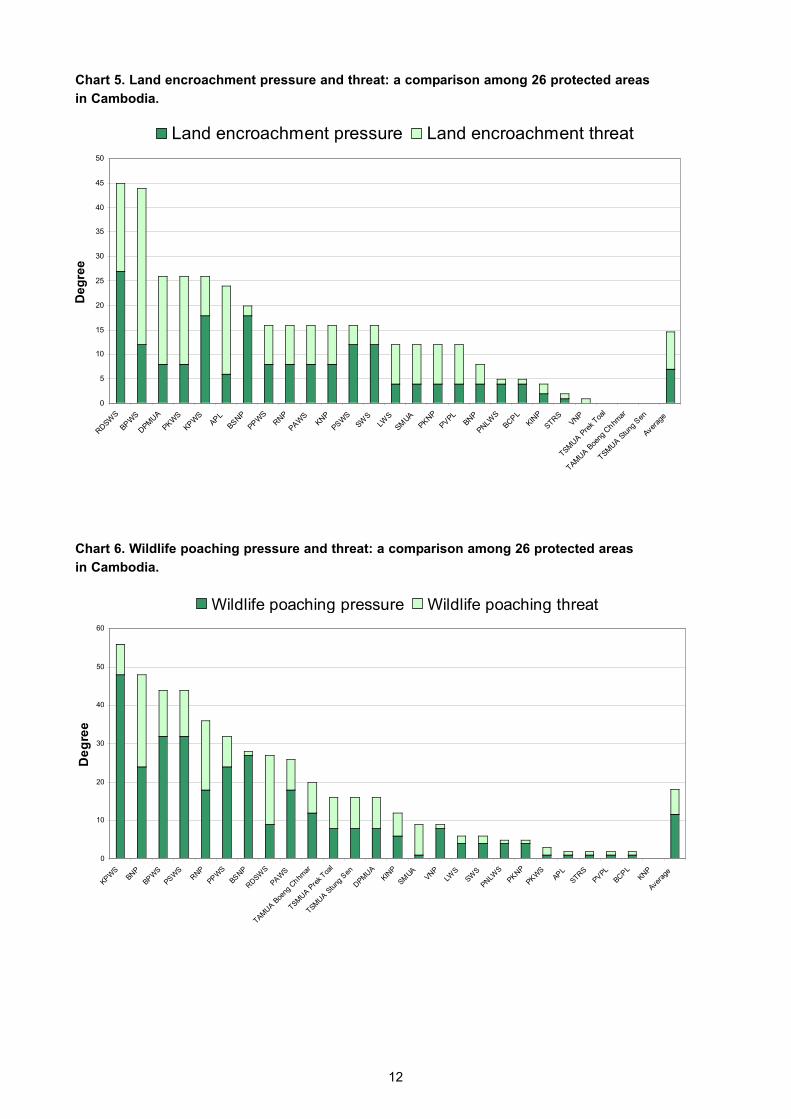
Chart 5. Land encroachment pressure and threat: a comparison among 26 protected areas
in Cambodia.
12
Chart 6. Wildlife poaching pressure and threat: a comparison among 26 protected areas
in Cambodia.
0
5
10
15
20
25
30
35
40
45
50
RDSW
S
BPW
S
DPM
UA
PKW
S
KPW
SAP
L
BSNP
PPW
SRNP
PAW
SKN
P
PSW
S
SWS
LWS
SMUA
PKNP
PVPL
BNP
PNLW
S
BCPL
KINP
STRS
VNP
TSMUA P
rek Toa
l
TAMUA B
oeng
Chhm
ar
TSMUA S
tung
Sen
Avera
ge
De
gre
e
Land encroachment pressure Land encroachment threat
0
10
20
30
40
50
60
KPW
SBN
P
BPW
S
PSW
SRNP
PPW
S
BSNP
RDSW
S
PAW
S
TAMUA B
oeng
Chhm
ar
TSMUA P
rek Toa
l
TSMUA S
tung
Sen
DPM
UA
KINP
SMUA
VNP
LWS
SWS
PNLW
S
PKNP
PKW
SAP
L
STRS
PVPL
BCPL
KNP
Avera
ge
De
gre
e
Wildlife poaching pressure Wildlife poaching threat

Biodiversity is not uniformly distributed across a sea
or landscape. As part of the assessment, participants
reviewed each protected area against ten different
biodiversity criteria: presence of rare or endangered
species, comparative levels of endemism, number of
species, provision of critical landscape function,
comparative range of plant and animal diversity,
relative contribution to representativeness in the
system of protected areas, presence of viable
population of key species, consistency of structural
diversity with historic norms, protection of
ecosystems whose range have greatly diminished,
and maintenance of the full range of natural
processes and disturbance regimes. Chart 7 shows
the cumulative values for the above criteria scored
as 5 (yes), 3 (mostly yes), 1 (mostly no) and 0 (no).
The same scoring is used for all subsequent charts.
In terms of biological importance, Kulen Promtep,
Phnom Samkos, Phnom Aural, and Phnom Prich
Wildlife Sanctuaries as well as Virachey National
Park stand out as the most important among the
sites of the Cambodian system of protected areas
that were the subject of this assessment, while
Angkor Protected Landscape and Kep National
Park scored the lowest.
The RAPPMap evaluation showed that sites within
protected areas identified for their biological
significance (including large areas of exemplary
plant communities, wildlife habitat, and other
perceived values) cover approximately 6,289 km² or
19% of the entire area of the protected areas
considered, 144 km of linear values and 77 point
locations. The extent and layout of these features
can provide an important input to zoning efforts
designed to improve management effectiveness in
protected areas.
13
Biological and Socio-economic Importance
Chart 7. Comparative biological importance among 26 protected areas in Cambodia.
A similar comparative analysis was made with
respect to the socio-economic importance of the 26
sites. Each protected area was assessed
according to its importance as: a source of
employment or natural resources for the
subsistence of local communities, a creator of
development opportunities through sustainable
resource use, a spiritual or religious site, an area of
exceptional aesthetic value, a haven for animal or
plant species of high social, cultural or economic
value, a site of exceptional recreational value, a
provider of significant ecosystem services and
benefits to communities, and a site of high
educational or scientific value.
In general, most protected areas scored high for
socio-economic importance with Virachey National
Park, Roniem Daun Sam Wildlife Sanctuary, Stung
Treng Ramsar Site, Boeng Per Wildlife Sanctuary,
and Bokor National Park scoring highest. Angkor
Protected Landscape also scored very high.
Indeed, Angkor is one of the most emblematic
0
5
10
15
20
25
30
35
40
45
50
KPW
SVN
P
PPW
S
PSW
S
PAW
SBN
P
TSMUA P
rek Toa
l
TAMUA B
oeng
Chhm
ar
TSMUA S
tung
Sen
BSNP
BPW
SLW
SRNP
STRS
RDSW
S
PNLW
S
PKW
SKIN
P
DPM
UA
SWS
SMUA
BCPL
PKNP
PVPL
APL
KNP
Avera
ge
Po
ints

cases of a protected area whose tourism value has
spurred very rapid and intense development -
one of the highest and more sustained in
Cambodia - and it has become a major source of
income for tour operators, the hotel and
transportation industries, and other associated
businesses not only locally, but elsewhere in the
country and even abroad. A 2003 investment report
(UN 2003) lists Cambodia as being among only 4
least developed countries with tourism receipts
exceeding $100 million per year and Angkor is
clearly the primary driver of this important revenue
stream. The case of Angkor illustrates the
enormous potential that some protected areas in
Cambodia may have in contributing to the
country’s poverty reduction and economic
development, but experience has shown that such
development must be well-planned and integrated
as part of an effort that would include, at least, the
Ministries of Tourism, Environment and Land
Management.
14
Chart 8. Comparative socio-economic importance among 26 protected areas in Cambodia.
A comparison between the cumulative degrees of
pressures and threats (chart 3) and biological
importance (chart 7) can be helpful in determining
the conservation priorities among the sites. The
result of such analysis can be seen in chart 9. The
chart reveals a group of nine protected areas that
are of high biological importance and that suffer
from high cumulative pressure and threat. This
group includes Kulen Promtep, Roniem Daun Sam
and Boeng Per Wildlife Sanctuaries and the core
zones of Tonle Sap Multiple Use Area in the
northwest, Phnom Aural and Phnom Samkos
Wildlife Sanctuaries and Ream and Bokor National
Parks in the southwest, and Phnom Prich Wildlife
Sanctuary in the east. These areas require urgent
and focused activities designed for threat
abatement with specific pressures and threats
guiding remediation efforts. For example, in the
north-western protected areas, priorities are
preventing the negative effects of land
encroachment, chamkar/shifting agriculture and
poaching whereas in Phnom Prich threat
abatement efforts must focus on curbing the
negative effects of mining, infrastructure
development, and poaching.
The chart also shows a second group of five
protected areas with high biodiversity, yet with
lower scores for external pressures and threats.
This group is comprised of Virachey National Park,
Lomphat Wildlife Sanctuary and Stung Treng
Ramsar site in the north-east, Kirirom National
Park in the south, and Phnom Nam Lyr Wildlife
Sanctuary in the east. In these areas, the focus
should be on preventive action to keep potential
threats at bay.
0
10
20
30
40
50
60
VNP
RDSW
SBN
P
BPW
S
STRS
APL
PAW
S
KPW
S
TAMUA B
oeng
Chhm
ar
TSMUA S
tung
Sen
RNP
PSW
S
PKW
SKIN
P
TSMUA P
rek T
oal
PNLW
S
SMUA
PKNP
PVPL
BCPL
SWS
BSNP
DPM
UA
PPW
SLW
SKN
P
Avera
ge
Po
ints

Chart 9. Conservation priorities among 26 protected areas.
15
A similar analysis was carried out for identifying
socio-economic priorities. A group of highly
threatened protected areas that have been ranked
high for their socio-economic importance stands
out. This group includes areas distributed
throughout the country including Kulen Promtep,
Boeng Per, Roniem Daun Sam, Phnom Aural,
Phnom Samkos, and Phnom Prich Wildlife
Sanctuaries and Ream National Park. Priority
activities for these areas should focus on resolving
land disputes and implementing community
development and poverty reduction strategies that
are compatible with sustainable resource use.
Chart 10. Socio-economic priority among 26 protected areas.
0
50
100
150
200
250
0 10 20 30 40 50
Cu
mu
lativ
e d
eg
ree
of p
ress
ure
s a
nd
thre
ats
BNP
BSNP
KNP
KINP
PKNP
RNP
VNP
BPWS
KPWS
LWS
PKWS
PNWS
PAWS
PPWS
PSWS
RDWS
SWS
APL
BPL
PVPL
DPM UA
SM UA
TSM UA Prek Toal
TAM UA Boeng Chhmar
TSM UA Stung Sen
STRS
0
50
100
150
200
250
0 10 20 30 40 50 60
Cu
mu
lativ
e d
eg
ree
of p
ressu
res a
nd
th
rea
ts
BNP
BSNP
KNP
KINP
PKNP
RNP
VNP
BPWS
KPWS
LWS
PKWS
PNWS
PAWS
PPWS
PSWS
RDWS
SWS
APL
BPL
PVPL
DPM UA
SM UA
TSM UA Prek Toal
TAM UA Boeng Chhmar
TSM UA Stung Sen
STRS

Widespread poverty in Cambodia creates a high
demand for resources, including those located
inside of protected areas. Vulnerability is higher
particularly in areas where access has been made
easier due to the construction of roads that cut
through them or reach their vicinity (see also map
4 and figures in the inside of the back cover). The
relatively high market value of land and the ease of
access to natural resources—especially in the
most populated parts of the country—function as
incentives for land encroachment and illegal
exploitation of resources such as timber and
wildlife. This problem is compounded by a lack of
enforcement. This is illustrated in chart 11, which
shows the relative importance of the ten causes of
vulnerability assessed as an average for all 26
protected areas. Chart 12 compares the different
degrees of vulnerability across the protected
areas. Roniem Daun Sam Wildlife Sanctuary, Kep
National Park, and the core zones of the Tonle Sap
Multiple Use Area stand out as the most vulnerable
areas in the system. Additionally, the RAPPMap
analysis revealed that of the most significant
threats to protected areas, 41% are driven by
subsistence-scale motivations, 32% by full
commercial exploitation, and 27% driven by local-
scale economics.
16
Vulnerability
Chart 11. Average vulnerability of protected areas.
Virachey National Park
© BPAMP 2004
0.0
1.0
2.0
3.0
4.0
5.0
Mar
ket v
alue
Illeg
al a
ctiv
ities
Eas
y ac
cess
ibili
ty
Dem
and fo
r re
sourc
es
Low la
w e
nforc
emen
t
Man
ager
under
pre
ssure
Diff
icul
ties w
ith rec
ruitm
ent
Corr
uption
Polit
ical
inst
abili
ty
Confli
cts w
ith b
elie
fs
Po
ints

Workshop participants reviewed the most critical
aspects of management of the system of protected
areas in Cambodia. Charts 13 through 16
represent a synthesis of the findings.
With respect to overall planning in terms of
objectives, legal security and protected area
design, chart 13 highlights key strengths and
weaknesses of the protected area system.
Some of the strengths of the system are:
• The overall design and layout of the system is
very good. There are clear “clusters” of
protected areas that in many cases are
connected by intact natural vegetation. In
several cases, blocks of protected areas
provide continuous protection throughout a
cluster through the complementarity of
protected areas under MoE and Protected
Forests under MAFF (e.g. the Central
Cardamom Protected Forest ensures
connectivity between Phnom Aural and Phnom
Samkos Wildlife Sanctuaries, the Mondulkiri
Protected Forest and Seima Biodiversity
Conservation Area ensure connectivity between
Lomphat, Phnom Prich and Snoul Wildlife
Sanctuaries). Connectivity is also provided by
the existence of protected areas in
neighbouring countries: Virachey National Park
is contiguous with Mom Ray Nature Reserve in
Vietnam and Dong Ampham Protected Area in
Laos P.D.R., Samlaut is contiguous with Klong
Krua Wai Wildlife Sanctuary and Namtok Klong
Keow in Thailand, and Banteay Chhmar
Protected Landscape is contiguous with Dta
Phraya National Park in Thailand.
• In terms of legal security, The only area
considered in the assessment without long-
term, legally binding protection is the Stung
Treng Ramsar Site. However, pending
protected area and wetland legislation is likely
to address this by providing explicit legal
machanisms for protection of this area.
17
Chart 12. Degree of relative vulnerability of protected areas.
Management
0
5
10
15
20
25
30
35
40
45
RDSW
SKIN
P
TAMUA B
oeng
Chhm
ar
TSMUA S
tung
Sen
STRS
KPW
S
BPW
SRNP
PAW
S
BSNP
PNLW
S
SWS
PVPL
BCPL
PSW
SKN
P
PKNP
BNP
SMUA
DPM
UA
TSMUA P
rek Toa
l
PPW
S
PKW
SAP
LVN
PLW
S
Avera
ge
Pio
nts

Chart 13. Overall planning of protected areas system wide.
18
Some of the weaknesses of the system are:
• With the exception of Virachey National Park,
practically all areas lack up-to-date
management plans. For that reason, very few
areas have defined clear and specific
biodiversity-related objectives that should
provide guidance to management. They also
lack a zonation which would enable
management to direct proposed development
activities away from zones designated for
higher levels of protection.
• Staffing and financial resources are often
insufficient to conduct critical law enforcement
activities.
• The boundaries of many protected areas have
not been demarcated at the site-level. This is a
factor that enhances the uncertainty about land
ownership, leads to land use conflicts, and
greatly increases the vulnerability of individual
sites.
• The marine habitat is poorly represented in the
overall system, as practically all protected
areas in the system are terrestrial1.
The design and configuration of one protected
area, Roniem Daun Sam Wildlife Sanctuary, was
identified as a major concern at PA level, and
should be revised, with a view to find a solution to
existing land use and ownership conflicts.
Bokor National Park © BPAMP
1At the time of the RAPPAM workshop, marine ares were poorly represented within the protected area system. However, the pending designation of KohSdach Marine Protected Area will represent a significant improvement in marine habitat protection.

The analysis of inputs in terms of staffing,
communication, infrastructure and facilities, and
financing (chart 14) reveals a system that is
chronically lacking resources in practically all
levels of management.
19
Chart 14. Summary of overall inputs to the system of protected areas.
Chart 15. Summary of overall process in the system of protected areas.
The analysis of process (chart 15) in terms of
management planning, decision-making and
research, shows that there is an increasing level of
cooperation between protected area managers
and local communities and other partners, as well
as good communication between protected area
staff and the national administration. Some areas
highlighted for improvements are:
0
1
2
3
4
5
STA
FFING
Per
form
ance
/Pro
gress
review
s
Level
Train
ing
Em
ploym
ent c
onditions
CO
MM
UNIC
ATIO
N
Com
munic
atio
n with
loca
lsData
Mea
ns of c
omm
unicat
ion
Mea
ns of c
ollect
ion
Mea
ns for pro
cess
ing
INFR
ASTR
UCTU
RE
Mai
ntenan
ce
Transp
ortat
ion
Sta
ff fa
cilit
ies
Field
equip
ment
Vis
itor fa
cilit
ies
FINANCIN
G
Finan
cial p
ractic
es
Allo
catio
n
Sta
bility
Funding in
the p
ast
Funding in
the fu
ture
0
1
2
3
4
5
MANAGEM
ENT P
LANNIN
G
Stra
tegy
for th
reat
s an
d pre
ssure
s
Work
pla
n
Monito
ring
Man
agem
ent p
lan
Inve
ntory
MANAGEM
ENT D
ECIS
ION M
AKIN
G
Com
munic
atio
n
Colla
boratio
n
Inte
rnal
org
anis
atio
n
Transp
arency
Local c
omm
unities
RESEA
RCH
Monito
ring
Soci
al res
earc
h
Eco
logic
al res
earc
h
Rese
arch n
eeds
iden
tified
Acce
ss to
scie
ntifi
c rese
arch
• Currently, there is no overarching legislation for
protected areas in Cambodia. A draft Protected
Areas Law has been prepared, but negotiations
for final approval have been delayed by
protracted discussions between the various
agencies involved in protected area
management . This lack of clear legislation for
protected areas jeopardises their legal and
institutional security, particularly when faced
with court cases and development proposals.
• Most protected areas are surviving with short-
term planning only, represented by the annual
operational plans. There is a pressing need to
develop longer term management plans.
• Very few biodiversity inventories have taken
place in the protected areas. This puts
constraints on the development of management
plans, as well the set-up of monitoring and
evaluation programmes for the areas.
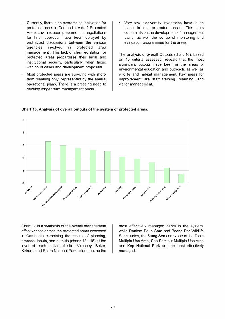
The analysis of overall Outputs (chart 16), based
on 10 criteria assessed, reveals that the most
significant outputs have been in the areas of
environmental education and outreach, as well as
wildlife and habitat management. Key areas for
improvement are staff training, planning, and
visitor management.
20
Chart 16. Analysis of overall outputs of the system of protected areas.
Chart 17 is a synthesis of the overall management
effectiveness across the protected areas assessed
in Cambodia combining the results of planning,
process, inputs, and outputs (charts 13 - 16) at the
level of each individual site. Virachey, Bokor,
Kirirom, and Ream National Parks stand out as the
most effectively managed parks in the system,
while Roniem Daun Sam and Boeng Per Wildlife
Sanctuaries, the Stung Sen core zone of the Tonle
Multiple Use Area, Sap Samlaut Multiple Use Area
and Kep National Park are the least effectively
managed.
0
1
2
3
4
5
OUTP
UTS
Outr
each/e
duca
tion
Wild
life/
habita
t mana
gemen
t
Threat
s pre
ventio
n
Sta
ff m
anagem
ent
Res
tora
tion
Train
ing
Res
earch
out
puts
Infrast
ruct
ure
Pla
nning/in
vento
ryin
g
Vis
itor m
anagem
ent

Chart 17. Analysis of overall management effectiveness of the system of protected areas.
21
Kavet People, Virachey National Park
J. Kitchens © BPAMP 2005
0.0
2.0
4.0
6.0
8.0
10.0
12.0
14.0
VNP
BNP
KINP
RNP
SWS
TSMUA P
rek Toa
l
BSNP
PNLW
S
PKNP
APL
PPW
S
PAW
SLW
S
STRS
PKW
S
BCPL
KPW
S
DPM
UA
PVPL
PSW
S
TAMUA B
oeng
Chhm
ar
KNP
SMUA
BPW
S
TSMUA S
tung
Sen
RDSW
S
Avera
ge
Outputs
Processes
Inputs
Planning

During the assessment workshop, a full day of
group and plenary discussions was dedicated to
the analysis of issues such as system-level design,
protected areas policies, and the overall policy
environment in Cambodia (questions 17 - 19 of the
RAPPAM questionnaire, Erwin 2003). Key system-
wide issues raised during this day are summarised
below:
Legal Framework
The system of protected areas of Cambodia is still
missing its “backbone”. Protected area specialists
involved in the assessment of the system of
protected areas in Cambodia urge the Ministry of
Environment to find solutions to the institutional
issues of competing mandates and attributions and
finalise the draft Protected Areas Law, and to
facilitate its approval by the Council of Ministers as
soon as possible.
Management Plans
Protected area management plans are essential to
ensure effective management and to enable
comprehensive evaluation of management
actions. The lack of up-to-date management plans
and clear zonation concepts is a major obstacle to
effective management. Development of
management plans, which clearly designate where
various strategies for preservation, conservation
management and sustainable use will best
accomplish management objectives, is a key
priority for most protected areas in Cambodia.
Boundary Demarcation
As a matter of urgency, a nation-wide effort should
be made to demarcate all protected areas in the
system by the end of 2005, including those under
the responsibility of the Ministry of Agriculture,
Forestry and Fisheries. This target should be a top
priority of the Strategic Plans of both Ministries. If
current funding is not sufficient for ensuring the
delivery on this target, potential donors should be
identified and proposals submitted as soon as
possible. The donor community, including
government aid agencies and international
environmental NGOs, are invited to consider
contributing to the achievement of this critical target.
In addition, the MoE should consider gazetting
Stung Treng Ramsar Site formally as a protected
area according to the existing national system.
Inter-ministerial Cooperation
Participants of the assessment called for the
strengthening of collaboration between at least
four ministries: Ministry of Environment, Ministry of
Agriculture, Forestry and Fisheries, Ministry of
Public Works and Transport, and the Ministry of
Tourism. Additional coordination should also be
sought with the Ministry of Water Resources and
Meteorology, Ministry of Land Management, Urban
Planning and Construction, Ministry of Industry,
Mines and Energy, and Ministry of Interior.
Although some of this coordination has already
been an objective of the DANIDA-funded National
Capacity and Development Project, it has targeted
only a subset of the above and has not focused
specifically on protected area management. As a
practical step, it was suggested that a pilot project
involving a task force with representatives from
each of these ministries be established to pursue a
limited set of goals with regard to protected areas
in the Lower Mekong Dry Forest ecoregion.
Cooperation with the Ministry of Defence
Some individuals in the Cambodian military are
currently alleged to be involved in illegal
exploitation and trade of natural resources
(particularly logging and hunting) in protected
areas. These individuals are damaging the national
and international reputation of the whole
Cambodian military corps, and causing the
environmental degradation of some key protected
areas in the system. The Ministry of Environment
and MAFF should actively engage in negotiations
with the Ministry of Defence to garner high level
support for resolving pending issues, particularly in
the areas where military bases are located inside
or in the vicinity of protected areas.
Transboundary Cooperation
One of the positive aspects of the design of the
system of protected areas in Cambodia is that
some of the protected areas form larger blocks of
relatively intact habitats due to their connectivity to
other protected areas in neighbouring countries. In
order to maximise the conservation potential of
these areas, and at the same time to reduce the
negative impacts of illegal international trade in
timber and wildlife species, the Ministry of
Environment was asked to lead an effort, in
cooperation with the Ministries of Interior and
22
System-level Issues

Foreign Affairs, and relevant authorities in
neighbouring countries, to develop transboundary
protected area cooperation agreements.
Furthermore, a task force should be put in place to
strengthen enforcement of environmental
regulations at transportation check points along
international borders. In addition, regular meetings
for joint planning and coordinated enforcement
should take place in transboundary protected areas.
Management Structure
There are currently two major actors responsible
for the planning and implementation of the national
system of protected areas in Cambodia: the
Department for Nature Conservation and
Protection (DNCP) of the Ministry of Environment,
and the Forestry Administration (FA) within the
Ministry of Agriculture, Forestry and Fisheries. This
should not lead to problems, if responsibilities are
clear and complementary, and efficient
coordination mechanisms are in place.
The current structures of the Ministry of
Environment and MAFF are not conducive to
planning, implementing, monitoring and evaluating
the national system of protected areas in a
coordinated and effective way. Some of the
problems are: conflicting mandates, absence of a
clear coordination function and structure, potential
conflicts of interest between forest protection and
production functions, particularly at MAFF-level,
and very low salaries for high ranking staff. This
last trend often results in qualified people pursuing
work with other governmental and non-
governmental organisations—sometimes with
conflicts of interest.
These issues should be addressed through
improving cooperation between the two agencies
and ensuring that roles and responsibilities are
clarified. In addition, four options have been
proposed how these issues can be addressed
through institutional change (Shields et al. 2004,
p.106-109):
Option 1: Operating with the same agencies. The
Forestry Administration of MAFF would be
responsible for forestry production objectives,
while an empowered DNCP, with a similar status
as the FA, would be responsible for forest
conservation objectives as part of its broader
mission of biodiversity conservation, which also
includes freshwater and marine habitats. This
option would imply the transfer of the Protected
Forests from MAFF to MoE.
Option 2: Reorganise within one of the existing
Ministries. This option would involve merging and
putting under the same umbrella the forestry
production and conservation objectives, under
either MAFF or MoE.
Option 3: Creating a new Ministry, the “Ministry of
Environment and Forestry”. This option would
combine the forest conservation and production
objectives under one institutional framework.
Option 4: Establish a new agency, the “Forest
Resource and Conservation Agency” which will be
autonomous and independent from any Ministry.
One of the disadvantages is that it would still put
under the same umbrella both forestry
conservation and forestry production objectives. In
theory, these two could be complementary and
mutually reinforcing. In practice, particularly where
systems of governance are weak, these two
objectives can be conflicting, with the conservation
aspects typically bending to powerful economic
interests.
To ensure the effective management of the
national protected area system, option 1 seems the
best solution according to which DNCP would be
strengthened to assume primary responsibility for
in-situ biodiversity conservation throughout the
country.
In the long-term a modified option 4 might be
considered. An autonomous “Cambodia Protected
Areas Agency”, exclusively responsible for the
conservation objective could be created, while the
forestry production objectives would be retained
under MAFF. This would be an effective solution,
particularly if this agency could count on the
support of a donor coordination unit.
Cluster Approach to Management
The assessment showed that the level of financial
and other input into the Cambodia system of
protected areas is very low. It also revealed some
regional patterns of common pressures, threats,
opportunities, etc. These two characteristics are
favourable to the development of a ‘Cluster
Approach’ that would build on “economies of scale”
to address issues such as threat abatement,
training, monitoring and evaluation, research, etc.
This approach could help maximise the limited
resources, foster interaction and collaboration
among protected areas and institutions, and
increase the impact and scale of interventions.
Examples of larger areas that could function as
23

major “clusters” are the dry forest protected areas in
the east, the Cardamom Mountains area, and the
coastal areas. DCNP should consider designating
responsibility for individual “protected area clusters”
to its deputy directors. Collaboration with partners
and NGOs should be explored for implementing the
various priority recommendations suggested in this
report. Such a collaboration could also be used, in
the short-term, to address the conflicting
competencies and absence of a clear coordination
function and structure discussed above. Inter-
ministerial and inter-organisational conservation-
oriented advisory committees could be formed for
the “clusters”. These committees should have
primarily technical functions and thus could
contribute to a better integration of inputs from all
stakeholders and to effective coordination of
conservation actions.
Coordinated Approach to Fundraising
Insufficient funding is a fundamental constraint to the
effective management of the system of protected
areas in Cambodia. Participants suggested that MoE
take the lead in creating a Protected Area
Subcommittee to represent a consistent protected
area agenda at the annual Consultative Group
Meeting. This Subcommittee would have the
responsibility for framing the role of protected areas
within the context of socio-economic development
and poverty reduction. It would also be responsible
for seeking and providing funding support for the
protected areas system, according to jointly agreed
priorities. The Protected Area Subcommittee should
meet at least twice each year, and it should consist
of high level representatives from MoE, MAFF, key
bilateral and multilateral aid agencies, and
international environmental NGOs. It should report to
the larger Donor Committee once a year, and it
should use this to increase the base of support and
funding for protected areas in the country.
Training and Building Capacity of
Rangers and Managers
Despite of its overall low level of funding, and when
compared to countries in similar situations, the
Cambodian protected areas system features a
reasonable number of rangers. What is lacking are
mid-level managers, and support staff. Staff
numbers alone cannot be used to assess effective
conservation in the field. This can be partly
achieved through a strong programme targeted at
training and building capacity of rangers and
managers. Training needs should be identified and
funding should be sought and committed.
Additional management and support staff need to
be recruited and trained. A key area for which
protected area managers and rangers asked for
urgent training is on raising awareness about their
role in law enforcement. The need for additional
training on laws and policies applicable to
protected area management and enforcement was
also identified.
System Design and Representativeness
Overall, the design and coverage of the system of
protected areas is very good. During the RAPPAM
the only area identified for expanding the system
was in the marine environment. However, the
pending designation of Koh Sdach Marine
Protected Area will address this deficiency in a
substantial way.
A RAPPAM assessment is not meant to be a
substitute for more objective and comprehensive
methods for identifying strategic actions with
regard to protected area systems. It is, by design,
a rapid and therefore “coarse-filter” process. Much
of it relies on subjective assessments and integrity
from a limited number of people with extensive on
the ground experience. Within these limitations,
RAPPAM provides clear patterns and allows for the
identification of specific strategic actions at the
system level, and in some cases at the site level.
Because it is cost-effective in terms of both time
and resources, it is an appropriate tool for more
frequent monitoring and prioritisation of actions.
A more detailed analysis following well-established
gap analysis and system planning methods will
provide a higher level of resolution and address
many issues that the RAPPAM process cannot
address. Such an endeavour is more resource-
intensive and will not likely be feasible at regular
intervals. Planners and managers will ultimately
benefit by seeing both RAPPAM and higher-
resolution system planning as part of a
comprehensive strategic planning cycle with the
same ultimate goal: improving conservation
decision-making to achieve national conservation
and development objectives.
24

Recommendations based on the RAPPAM
assessment are listed below. Responsible parties
and target dates for completion of the
recommendation are given in brackets.
Legal Framework
Finalise a clear and comprehensive Protected
Areas Law and get approval from the Council of
Ministers (Ministry of Environment in coordination
with other relevant ministries and agencies,
December 2005).
Management Plans
Finalise the manual “Participatory Development of
Management Plans for Protected Areas in
Cambodia” and distribute it to all protected area
directors, MoE, relevant NGOs and donors
(BPAMP, March 2005).
Seek funding for the development of management
plans for at least 5 protected areas (Ministry of
Environment, December 2005).
Boundary Demarcation
Carry out on-the-ground surveys to establish
ground control points in protected areas where this
has not yet been completed (Ministry of
Environment, June 2005).
Seek funding for the physical demarcation of the
boundaries of at least 10 protected areas (Ministry
of Environment, December 2005).
Inter-ministerial Cooperation
Establish a task force with representatives from at
least four ministries (Environment; Agriculture,
Forestry and Fisheries; Public Works and
Transport; and Tourism) to pursue a limited set of
goals with regard to protected areas in the Lower
Mekong Dry Forest ecoregion (Ministry of
Environment, October 2005).
Cooperation with the Ministry of Defence
Draft and adopt a clear code of conduct for military
personnel operating inside protected areas. The
code should include specific policies for border,
coastal, and other areas (Ministry of Environment
and Ministry of Defence, December 2005).
Transboundary Cooperation
Develop a transboundary cooperation agreement
for the Virachey - Mom Ray - Dong Ampham
Protected Area Complex as a model for other
transboundary protected areas (Ministry of
Environment, December 2005).
Management Structure
Explore the feasibility of empowering DNCP to
become exclusively responsible for the natural
resource conservation objectives, with forestry
production objectives retained under MAFF
(Ministry of Environment, Ministry of Agriculture,
Forestry and Fisheries, December 2005).
Cluster Approach to Management
Put in place mechanisms to coordinate
management, use of resources, training, and
monitoring and evaluation in “protected area
clusters” (Ministry of Environment, June 2005).
Explore the feasibility of establishing inter-
ministerial and inter-organisational conservation-
oriented advisory committees for “protected area
clusters”, with the aim to better integrate inputs
from all stakeholders and to effectively coordinate
conservation actions (Ministry of Environment,
December 2005).
Coordinated Approach to Fundraising
Lobby for the establishment of a Protected Area
Subcommittee to represent a consistent protected
area agenda at the annual Consultative Group
Meetings with the aim to seek funding for the
protected area system (Ministry of Environment,
Ministry of Agriculture, Forestry and Fisheries,
environmental NGOs and bilateral and multilateral
aid agencies, October 2005).
Training and Building Capacity of
Rangers and Managers
Develop a national training curriculum for rangers
and protected area mangers in cooperation with
NGOs (BPAMP and Ministry of Environment,
December 2005).
System Design and Representativeness
Finalise and adopt the National Protected Area
System Plan (BPAMP and Ministry of Environment,
June 2005).
25
Recommendations

Cambodian Government 2004: Sub-decree
Number 65 on the Designation of the
Southern Cardamoms Protected Forest.
Cambodian Government 2005 (pending): Sub-
decree on the Designation of Koh Sdach
Marine Protected Area.
Erwin, J. 2003: Rapid Assessment and
Prioritization of Protected Area Management
(RAPPAM) Methodology. - WWF. Gland.
Switzerland. 49 pp.
Hockings, M., Stolton, S. and Dudley, N. 2000:
Evaluating Effectiveness: A Framework for
Assessing the Management of Protected
Areas. - IUCN, Gland Switzerland and
Cambridge UK. x + 121 pp.
Shields, D., Hobley, M., Boscolo, M., Miller, F.,
Monan, J. and Turton, C. 2004: Cambodia
Independent Forest Sector Review. - GTZ,
JICA, DFID, DANIDA, World Bank, Phnom
Penh. 119 pp.
Tordoff, A. W., Timmins, R. J., Maxwell, A.,
Keavuth, H., Vuthy, L. and Hourt, K. E. 2005:
Biological Assessment of the Central
Indochina Dry Forest Ecoregion. - WWF
Cambodia Programme, Phnom Penh.
UN 2003: United Nations and International
Chamber of Commerce. An Investment
Guide to Cambodia: Opportunities and
Conditions. - United Nations, New York and
Geneva.
26
Abbreviations used
in this report:
Wildlife Sanctuaries
BPWS Boeng Per
KPWS Kulen Promtep
LWS Lomphat
PKWS Peam Krasaop
PAWS Phnom Aural
PNLWS Phnom Nam Lyr
PPWS Phnom Prich
PSWS Phnom Samkos
RDSWS Roniem Daun Sam
SWS Snoul
National Parks
BSNP Botum Sakor
KNP Kep
KINP Kirirom
BNP Phnom Bokor
PKNP Phnom Kulen
RNP Ream
VNP Virachey
Protected Landscapes
APL Angkor
BCPL Banteay Chmar
PVPL Preah Vihear
Multiple Use Areas
DPMUA Dang Peng
SMUA Samlot
TSMUA Tonle Sap
Ramsar Sites
STRS Stung Treng
BTCRS Boeng Tonle Chhmar
KKRS Koh Kapi
References andAcknowledgements
The authors would like to thank the following individuals for their invaluable contribution to this assessment:
Ros Thoeun, Peou Bunthan, Thorn Kim Hong, Ly Sun Eang, Phut Choup, Im Chhoeun, Yen Mouny, Kong
Sophal, Kang Sieng Theng, Nou Karun, Ngiel Thun, Meng Text, Chork Sokvichbout, Khouy Khun Chanrath,
Chrim Vutha, Dork Sothea, Sao Sithoun, Meas Ngiem, Ty Ouy Song, Mao Kunthea, Oung Someourn, Vin
Chay, Mam Kosal, Khim Rongdan, Chou Sokphany, Sou Sovouth, Heng Chan Thoeun, Kheng Socheat, Meng
Savuth, Hong Daravuth, Ouk Seiha, Y Lavy, Long Kheng, Chey Pichrathna, Kong Kimsreng, Ngor Hour, Koch
Savath, Kol Vathana, Ek Sery Sopheap, Touch Vina, Chou Sophark, Oum Saven, Chea Kimsien,Nick Cox,
Eang Pirun, Steven Schonberger, Mudita Chumroeun, Sok Vong, Kim Nong, Sam Chamroeun, Soun Punlork,
Phon Khemrin, Men Ounmonic, Meas Sarim, Lic Vuthy, So Kadeth, Mi Keo Thera, Than Chanthou, Chheang
Bopha, Lay Khim, Joe Walston, Sok Mary, Sok Sothea, Oun Honghak, Thuk Thavet, Tong Bunthoeun, Pich
Koeveasna, Sam Samom, Ken Sereyrotha, Ung Sokhakun, Sok Kheng Novin, Sok Vuthea, Soun Mean, and
David Ashwell.
Map 2. Landcover of Cambodia.
Lacerda, L., Schmitt, K., Cutter P. and Meas, S. 2004. Management EffectivenessAssessment of the System of Protected Areas in Cambodia using WWF’s RAPPAMMethodology. Ministry of Environment, Biodiversity and Protected Areas ManagementProject, Phnom Penh, Cambodia.
Front Cover Photograph: Virachey National Park J. Kitchens © BPAMP 2005
Figure 2. Aster satellite image showing forest clearing associated with a road
in the northwest of Kulen Promtep Wildlife Sanctuary.
Figure 3. Example of spatial data compiled during the RAPPMap workshop.
Values and threats were mapped with points, lines, and polygons depending on
the nature of the phenomenon and the level of knowledge available.
Map 1. Protected Areas of Cambodia.

Cambodia
Management Effectiveness Assessment
of the System of Protected Areas in Cambodia
using WWF’s RAPPAM Methodology
Project Liaison Office
Biodiversity and Protected Areas Management Project (BPAMP)
Department of Nature Conservation and Protection, Ministry of Environment
#48, Samdech Preah Sihanouk, Tonle Bassac, Chamkarmon, Phnom Penh, CAMBODIA
Tel/Fax: (855) 23 213 900 E-mail: [email protected]
Cambodia
Cambodia
Biodiversity and Protected AreasManagement Project
(BPAMP)