labrador-island transmission link
TRANSCRIPT

Executive Summary
Environmental Impact Statement
Labrador-Island Transmission Link


April 2012
NALCOR ENERGY
LABRADOR‐ISLAND TRANSMISSION LINK
ENVIRONMENTAL IMPACT STATEMENT
Executive Summary

This report has been printed on recycled Forest Stewardship Council‐certified paper.

Labrador‐Island Transmission Link Environmental Impact Statement Executive Summary
April 2012 Page i
TABLE OF CONTENTS
SECTION PAGE
1 INTRODUCTION................................................................................................................................................. 1 1.1 Project Overview ...................................................................................................................................... 1 1.2 Regulatory Context ................................................................................................................................... 1 5 1.3 Previous and Other Environmental Assessments ..................................................................................... 3 1.4 Organization of the Executive Summary .................................................................................................. 3
2 PROJECT RATIONALE AND PLANNING .............................................................................................................. 4 2.1 Alternatives to the Project ....................................................................................................................... 4
2.1.1 Economic Analysis of Project Alternatives .................................................................................... 4 10 2.2 Financial and Environmental Benefits of the Project ............................................................................... 5 2.3 Project Planning and Risk Management ................................................................................................... 5 2.4 Alternative Means of Carrying out the Project ........................................................................................ 5 2.5 Eventual Transmission Line Routing and Detailed Project Design ........................................................... 6 2.6 Project Management Systems and Policies .............................................................................................. 6 15
3 PROJECT DESCRIPTION ..................................................................................................................................... 7 3.1 Project Components ................................................................................................................................. 7 3.2 Construction ........................................................................................................................................... 13
3.2.1 Construction Infrastructure ........................................................................................................ 13 3.2.2 Construction Activities and Sequence ........................................................................................ 14 20
3.3 Operations and Maintenance ................................................................................................................. 16 3.4 Decommissioning ................................................................................................................................... 17 3.5 Environmental Protection Planning........................................................................................................ 17 3.6 Project Workforce .................................................................................................................................. 17 3.7 Project Cost and Expenditure ................................................................................................................. 18 25
4 EFFECTS OF THE ENVIRONMENT ON THE PROJECT ........................................................................................ 19
5 ACCIDENTS AND MALFUNCTIONS .................................................................................................................. 21
6 ENVIRONMENTAL SETTING AND CONTEXT .................................................................................................... 23 6.1 The Natural Environment ....................................................................................................................... 23 6.2 The Human Environment ........................................................................................................................ 24 30 6.3 Previous and Ongoing Human Activities ................................................................................................ 25 6.4 Environmental Studies ............................................................................................................................ 26 6.5 Likely Future Environmental Conditions without the Project ................................................................ 27
7 ABORIGINAL CONSULTATION AND ISSUE SCOPING ....................................................................................... 28
8 REGULATORY AND PUBLIC CONSULTATION AND ISSUES SCOPING ............................................................... 30 35
9 ENVIRONMENTAL ASSESSMENT APPROACH AND METHODS ........................................................................ 32
10 EXISTING BIOPHYSICAL ENVIRONMENT ......................................................................................................... 34 10.1 Atmospheric Environment ...................................................................................................................... 34 10.2 Terrestrial Environment ......................................................................................................................... 34

Labrador‐Island Transmission Link Environmental Impact Statement Executive Summary
April 2012 Page ii
10.2.1 Geology ....................................................................................................................................... 34 10.2.2 Vegetation ................................................................................................................................... 35 10.2.3 Caribou ........................................................................................................................................ 35 10.2.4 Moose and Black Bear ................................................................................................................. 35 10.2.5 Furbearers and Small Mammals ................................................................................................. 36 5 10.2.6 Avifauna ...................................................................................................................................... 36
10.3 Freshwater Environment ........................................................................................................................ 38 10.4 Marine Environment............................................................................................................................... 39
10.4.1 Geology, Bathymetry and Seabed Hazards ................................................................................. 39 10.4.2 Currents and Tides ...................................................................................................................... 39 10 10.4.3 Wind and Waves ......................................................................................................................... 39 10.4.4 Sea Ice and Icebergs .................................................................................................................... 40 10.4.5 Maine Ambient Noise ................................................................................................................. 40 10.4.6 Marine Water Quality ................................................................................................................. 40 10.4.7 Marine Fish and Fish Habitat ...................................................................................................... 40 15 10.4.8 Marine Mammals and Sea Turtles .............................................................................................. 42 10.4.9 Seabirds ....................................................................................................................................... 44
11 ATMOSPHERIC ENVIRONMENT: ENVIRONMENTAL EFFECTS ASSESSMENT ................................................... 45 11.1 Value Ecosystem Components ............................................................................................................... 45 11.2 Study Areas ............................................................................................................................................. 45 20 11.3 Effects Management .............................................................................................................................. 45 11.4 Likely Residual Project Effects and Significance ..................................................................................... 46 11.5 Analysis of Alternatives .......................................................................................................................... 46 11.6 Cumulative Environmental Effects and Significance .............................................................................. 46 11.7 Monitoring and Follow Up: Atmospheric Environment ......................................................................... 47 25 11.8 Accidents and Malfunctions ................................................................................................................... 47
12 TERRESTRIAL ENVIRONMENT: ENVIRONMENTAL EFFECTS ASSESSMENT ..................................................... 48 12.1 Valued Ecosystem Components ............................................................................................................. 48 12.2 Species of Special Conservation Concern ............................................................................................... 48 12.3 Study Areas ............................................................................................................................................. 49 30 12.4 Effects Management .............................................................................................................................. 50 12.5 Likely Residual Project Effects and Significance ..................................................................................... 50 12.6 Analysis of Alternatives .......................................................................................................................... 51 12.7 Cumulative Environmental Effects and Significance .............................................................................. 51 12.8 Monitoring and Follow up: Terrestrial Environment .............................................................................. 54 35 12.9 Accidents and Malfunctions ................................................................................................................... 54
13 FRESHWATER ENVIRONMENT: ENVIRONMENTAL EFFECTS ASSESSMENT .................................................... 55 13.1 Valued Ecosystems Components ............................................................................................................ 55 13.2 Species of Special Conservation Concern ............................................................................................... 55 13.3 Study Areas ............................................................................................................................................. 55 40 13.4 Effects Management .............................................................................................................................. 56 13.5 Likely Residual Project Effects and Significance ..................................................................................... 56 13.6 Analysis of Alternatives .......................................................................................................................... 56 13.7 Cumulative Environmental Effects and Significance .............................................................................. 56 13.8 Monitoring and Follow Up: Freshwater Environment............................................................................ 57 45

Labrador‐Island Transmission Link Environmental Impact Statement Executive Summary
April 2012 Page iii
13.9 Accidents and Malfunctions ................................................................................................................... 57
14 MARINE ENVIRONMENT: ENVIRONMENTAL EFFECTS ASSESSMENT ............................................................. 58 14.1 Valued Ecosystem Components ............................................................................................................. 58 14.2 Species of Special Conservation Concern ............................................................................................... 58 14.3 Study Areas ............................................................................................................................................. 58 5 14.4 Effects Management .............................................................................................................................. 59 14.5 Likely Residual Project Effects and Significance ..................................................................................... 60 14.6 Analysis of Alternatives .......................................................................................................................... 60 14.7 Cumulative Environmental Effects and Significance .............................................................................. 60 14.8 Monitoring and Follow Up: Marine Environment .................................................................................. 61 10 14.9 Accidents and Malfunctions ................................................................................................................... 62
15 EXISTING SOCIOECONOMIC ENVIRONMENT .................................................................................................. 63 15.1 Historic and Heritage Resources ............................................................................................................ 63 15.2 Communities ........................................................................................................................................... 64
15.2.1 Regions and Communities .......................................................................................................... 64 15 15.2.2 Community Infrastructure and Services ..................................................................................... 64 15.2.3 Community Health ...................................................................................................................... 66
15.3 Economy, Employment and Business ..................................................................................................... 67 15.3.1 Economy ...................................................................................................................................... 67 15.3.2 Employment ................................................................................................................................ 67 20 15.3.3 Business ....................................................................................................................................... 68
15.4 Land and Resource Use .......................................................................................................................... 68 15.4.1 Communities and Water Supply Areas ....................................................................................... 68 15.4.2 Transportation ............................................................................................................................ 68 15.4.3 Hunting and Trapping ................................................................................................................. 69 25 15.4.4 Recreational Fishing .................................................................................................................... 69 15.4.5 Aboriginal Contemporary Traditional Land Use .......................................................................... 70 15.4.6 Hunting and Fishing Outfitters .................................................................................................... 71 15.4.7 Motorized Recreational Vehicle Use ........................................................................................... 72 15.4.8 Cabins and Cottage Development Areas .................................................................................... 72 30 15.4.9 Recreational Activities ................................................................................................................. 73 15.4.10 Parks and Other Protected Areas ................................................................................................ 73 15.4.11 Forestry ....................................................................................................................................... 74 15.4.12 Mining and Onshore Oil and Gas Exploration ............................................................................. 74 15.4.13 Agriculture ................................................................................................................................... 74 35 15.4.14 Other Harvesting Activates ......................................................................................................... 75
15.5 Marine Fisheries ..................................................................................................................................... 75 15.5.1 Aboriginal Fisheries ..................................................................................................................... 76 15.5.2 Aquaculture ................................................................................................................................. 76 15.5.3 Recreational Fisheries ................................................................................................................. 76 40 15.5.4 Dowden’s Point ........................................................................................................................... 76
15.6 Tourism ................................................................................................................................................... 77 15.7 Visual Aesthetics ..................................................................................................................................... 77
16 SOCIOECONOMIC ENVIRONMENT: ENVIRONMENTAL EFFECTS ASSESSMENT .............................................. 80 16.1 Valued Environmental Component Selection ........................................................................................ 80 45

Labrador‐Island Transmission Link Environmental Impact Statement Executive Summary
April 2012 Page iv
16.2 Study Areas ............................................................................................................................................. 80 16.3 Effects Management .............................................................................................................................. 82 16.4 Likely Residual Project Effects and Significance ..................................................................................... 82 16.5 Analysis of Alternatives .......................................................................................................................... 83 16.6 Cumulative Environmental Effects and Significance .............................................................................. 84 5 16.7 Monitoring and Follow up: Socioeconomic Environment ...................................................................... 87 16.8 Accidents and Malfunctions ................................................................................................................... 87
17 COMMITMENTS, SUSTAINABILITY AND CONCLUSIONS ................................................................................. 88 17.1 Purpose of the Project ............................................................................................................................ 88 17.2 Commitments ......................................................................................................................................... 88 10 17.3 Description of the Environment with the Project .................................................................................. 88
17.3.1 Biodiversity .................................................................................................................................. 88 17.3.2 Renewable Resources ................................................................................................................. 89 17.3.3 Socioeconomic Environment ...................................................................................................... 89
17.4 Monitoring and Follow‐up Summary ..................................................................................................... 89 15 17.5 Alternative Evaluation and Final Right‐of‐Way Routing ......................................................................... 89 17.6 Overall Conclusion .................................................................................................................................. 90
18 REFERENCES .................................................................................................................................................... 92 20
LIST OF TABLES
Table 11‐1 Valued Environmental Component Selection and Key Indicators ........................................ 45 Table 11‐2 Local Study Area and Regional Study Area for the Atmospheric Environment
Valued Environmental Component ...................................................................................... 45 Table 11‐3 Cumulative Environmental Effects Summary: Atmospheric Environment .......................... 47 25 Table 12‐1 Valued Environmental Component Selection and Key Indicators ........................................ 48 Table 12‐2 Local Study Area and Regional Study Area for each Terrestrial Environment
Valued Environmental Component ...................................................................................... 49 Table 12‐3 Cumulative Environmental Effects Summary: Terrestrial Environment .............................. 52 Table 13‐1 Valued Environmental Component Selection and Key Indicators ........................................ 55 30 Table 13‐2 Local Study Area and Regional Study Area for each Freshwater Environment
Valued Environmental Component ...................................................................................... 55 Table 13‐3 Cumulative Environmental Effects Summary: Freshwater Environment ............................. 57 Table 14‐1 Valued Environmental Component Selection and Key Indicators ........................................ 58 Table 14‐2 Local Study Area and Regional Study Area for the Marine Environment Valued 35
Environmental Components ................................................................................................. 59 Table 14‐3 Cumulative Environmental Effects Summary: Marine Environment ................................... 61 Table 16‐1 Valued Environmental Component Selection and Key Indicators ........................................ 80 Table 16‐2 Local Study Area and Regional Study Area for each Socioeconomic Environment
Valued Environmental Component ...................................................................................... 81 40 Table 16‐3 Cumulative Environmental Effects Summary: Socioeconomic Environment ....................... 85

Labrador‐Island Transmission Link Environmental Impact Statement Executive Summary
April 2012 Page v
LIST OF FIGURES
Figure 1‐1 Labrador‐Island Transmission Link: Project Overview ........................................................... 2 Figure 3‐1 Illustration of 2 km Wide Study Corridor and Eventual 60 m Wide Right‐of‐Way ................. 7 Figure 3‐2 Transmission Towers .............................................................................................................. 8 Figure 3‐3 Cross Section of Rock Berm(a) and Side View of the Submarine Cable Crossing(b) ................. 9 5 Figure 3‐4 Strait of Belle Isle Submarine Cable Crossing Corridor ......................................................... 10 Figure 3‐5 L’Anse au Diable Shoreline Electrode ................................................................................... 12 Figure 3‐6 Dowden’s Point Shoreline Pond Electrode – Design Option 1 ............................................. 12 Figure 3‐7 Dowden’s Point Shoreline Pond Electrode – Design Option 2 ............................................. 13 10

Labrador‐Island Transmission Link Environmental Impact Statement Executive Summary
April 2012 Page i
LIST OF ACRONYMS
Acronym Description
% percent
ac alternating current
ADA Agricultural Development Area
AMEC AMEC Earth and Environment
ATV all‐terrain vehicle
BBMA black bear management area
BLM Bureau of Land Management
BMA Bear Management Area
BP before present
BTEX benzene, toluene, ethyl benzene, and xylenes
CAM Conseil Attikamek‐Montagnais
CCDA Capital Coast Development Alliance
CCME Canadian Council of Ministers of the Environment
CCRI Community‐based Coastal Resource Inventory
CEA Agency Canadian Environmental Assessment Agency
CEAA Canadian Environmental Assessment Act
CHS Canadian Hydrographic Services
CIV cable installation vessel
cm centimetres
CMA caribou management area
CMHC Canadian Mortgage and Housing Corporation
CNA College of the North Atlantic
COSEWIC Committee on the Status of Endangered Wildlife in Canada
CRTC Canadian Radio‐television Telecommunications Commission
CWQG Canadian Water Quality Guidelines
dB decibels
dBA A‐weighted decibels
dc direct current
DFO Fisheries and Oceans Canada
DFTA Designated Flight Training Area
DND Department of National Defence
e.g. for example
EA Environmental Assessment
EBSA Ecologically and Biologically Significant areas
EC Environment Canada
EI employment insurance
EIS Environmental Impact Statement

Labrador‐Island Transmission Link Environmental Impact Statement Executive Summary
April 2012 Page ii
Acronym Description
ELC ecological land classification
EMF electromagnetic fields
EMS Environmental Management System
EPP Environmental Protection Plan
GHG Greenhouse gas
GNL Government of Newfoundland and Labrador
GRH George River Herd
ha hectares
HADD Harmful Alteration, Disruption or Destruction
HDD horizontal directional drilling
HDPE high‐density polyethylene
HVac high voltage alternating current
HVdc high voltage direct current
Hz hertz
IBA Impacts and Benefits Agreement
i.e. that is
IPCC Intergovernmental Panel on Climate Change
ISO International Organization for Standardization
IUCN International Union for Conservation of Nature
KI Key Indicator
km kilometre
KOP key observation point
kV kilovolt
LGL LGL Limited
LILCA Labrador Inuit Lands Claims Agreement
LSA Local Study Area
LSDA Labrador Straits Development Association
LWCRT Labrador Woodland Caribou Recovery Team
m metre
m/s metres per second
m3 cubic metre
mm millimetre
MMAs Moose Management Areas
MMH Mealy Mountains Herd
MP Measurable Parameter
MW megawatt
NCC NunatuKavut Community Council
NEDC Nordic Economic Development Corporation
NEQA Northeastern Québec Agreement

Labrador‐Island Transmission Link Environmental Impact Statement Executive Summary
April 2012 Page iii
Acronym Description
NLDEC Newfoundland and Labrador Department of Environment and Conservation
NLDF Newfoundland and Labrador Department of Finance
NLDHCS Newfoundland and Labrador Department of Health and Community Services
NLDMA Newfoundland and Labrador Department of Municipal Affairs
NLDTCR Newfoundland and Labrador Department of Tourism, Culture and Recreation
NLDTW Newfoundland and Labrador Department of Transportation Works
NLEPA Newfoundland and Labrador Environmental Protection Act
NLESA Newfoundland and Labrador Endangered Species Act
NLH Newfoundland and Labrador Hydro
NLOSs Newfoundland and Labrador Operational Statements
NLSA Newfoundland and Labrador Statistics Agency
NNK Naskapi Nation of Kawawachikamach
OHSP Occupational Health and Safety Plan
OHV off‐highway vehicle
OPGW optical groundwire
PAL Protection of Aquatic Life
PAO Provincial Archaeology Office
PCB polychlorinated biphenyl
Project Labrador‐Island Transmission Link
PVC polyvinyl chloride
RCMP Royal Canadian Mounted Police
RNC Royal Newfoundland Constabulary
RORB Red Orche Regional Board
ROV remotely operated vehicle
ROW right‐of‐way
RSA Regional Study Area
RWMH Red Wine Mountains Herd
SARA Species at Risk Act
SCADA Supervisory Control and Data Acquisition
SGMA small game management area
SHERP Safety, Health and Environmental Emergency Response Plan
SSAC Species Status Advisory Committee
SSCC Species of Special Conservation Concern
TCH Trans‐Canada Highway
TL transmission line
TLH Trans‐Labrador Highway
TLH3 Trans‐Labrador Highway Phase 3
TPH total petroleum hydrocarbons
TSS total suspended solids

Labrador‐Island Transmission Link Environmental Impact Statement Executive Summary
April 2012 Page iv
Acronym Description
UNESCO United Nations Educational, Scientific and Cultural Organization
USDI United States Department of the Interior
UXO unexploded ordinance
VEC Valued Environmental Component
VRM Visual Resource Management
VOC volatile organic compounds

Labrador‐Island Transmission Link Environmental Impact Statement Executive Summary
April 2012 Page 1
1 INTRODUCTION
1.1 Project Overview
Newfoundland and Labrador has an immense and diverse energy warehouse. Guided by a long‐term Energy Plan to manage these energy resources, in 2008 the Government of Newfoundland and Labrador created Nalcor Energy, a new provincial Crown corporation. Nalcor Energy (Nalcor) is the proponent for the Labrador‐5 Island Transmission Link (Project).
Nalcor is proposing to develop the Project, a high voltage direct current (HVdc) transmission system extending from the lower Churchill River in central Labrador to Soldiers Pond on the Island of Newfoundland’s (Island) Avalon Peninsula. The proposed Project will extend over a distance of approximately 1,100 kilometres (km), and include alternating current (ac) to direct current (dc) converter stations at Muskrat Falls, Labrador and 10 Soldiers Pond, Newfoundland, overhead transmission lines, a submarine cable crossing of the Strait of Belle Isle, and electrodes in the Strait of Belle Isle and Conception Bay (Figure 1‐1).
An Environmental Impact Statement (EIS) has been prepared by Nalcor and its consultants as part of a joint federal‐provincial Environmental Assessment (EA) process, which is required before any approvals for Project development can be granted. The major findings and conclusions of the EIS are presented in this Executive 15 Summary.
1.2 Regulatory Context
The Project is undergoing an extensive and rigorous environmental review, to meet the requirements of both the Government of Newfoundland and Labrador and the Government of Canada. Provincial environmental assessment requirements are set out in the Newfoundland and Labrador Environmental Protection Act 20 (NLEPA), while federal EA requirements are found in the Canadian Environmental Assessment Act (CEAA).
The EA process for the Project was initiated in January 2009, when Nalcor filed the Project Registration/Description Document with both the federal and provincial governments. In March 2009, upon review of the Registration and consideration of comments received from the public, the provincial Minister of Environment and Conservation announced that an EIS was required for the Project. 25
In November 2009, the Canadian Environmental Assessment Agency (CEA Agency) issued a “Notice of Commencement” for the federal EA for the Project, indicating that several federal departments were required to ensure that a Comprehensive Study was conducted in relation to the development proposal. The CEA Agency has been identified as the Federal EA Coordinator for the CEAA assessment. Also, the Project has been identified as a major natural resource project, and therefore falls under the federal Major Projects 30 Management Office's process to track and monitor the progress of the Project through the federal regulatory system.
The EIS is being submitted by Nalcor in accordance with the requirements of the provincial and federal EA processes and the associated EIS Guidelines and Scoping Document issued by the provincial and federal governments in May 2011. 35

"
""S
"S
!
!
!
!
!
!
!
!
!
!
!
!
!
!
!
!
!
!
S t rai t
o f Be l l e
Is l e
Shoal Cove
Con
cept
ion
Bay
St. John's
Corner Brook
Red Bay
Forteau
Marystown
Deer Lake
Cartwright
St. Anthony
Clarenville
Mary's Harbour
North West River
Port Hope Simpson
Happy Valley-Goose Bay
Channel-Port aux Basques
Churchill Falls
GanderGrand Falls-Windsor
Labrador City / Wabush
0 75 150
Kilometres
FIGURE 1-1
Labrador - Island Transmission Link: Project Overview
±
G u l f
o f
S t . L a w r e n c e
A t l a n t i c
O c e a n
L A B R A D O R
Q U E B E C
N E W F O U N D L A N D"S Converter Station
Proposed Transmission Corridor
Submarine Cable Crossing Corridor
" Shoreline Electrode SoldiersPond
Muskrat Falls
0913341043-PD-001-GIS
Dowden's Point
L'Anse au Diable
!

Labrador‐Island Transmission Link Environmental Impact Statement Executive Summary
April 2012 Page 3
1.3 Previous and Other Environmental Assessments
The current planning, engineering and environmental work for the Project is building on previous studies related to the transmission of electricity between Labrador and the Island that began over 30 years ago. Although the current Project proposal has been defined and initiated under the direction of the Energy Plan released by the Government of Newfoundland and Labrador in September 2007, the concept of such a 5 transmission link has been the subject of consideration and analysis over several decades, including a number of previous development attempts and EAs.
In the mid‐1970s, in advance of the formal establishment of federal and provincial EA processes, a federal‐provincial Review Panel was appointed to coordinate an EA review. That process eventually involved the completion and submission of separate EA Reports for the Transmission Link and for the Lower Churchill 10 Hydroelectric Generation Facilities at Gull Island and Muskrat Falls, followed by public hearings and an eventual Panel Report and associated government decisions. On December 11, 1980, the federal Minister of Environment released and endorsed the report of the EA Panel, which concluded that the Transmission Link and the Lower Churchill Hydroelectric Generation Projects were environmentally acceptable, provided that certain environmental and socioeconomic measures were implemented. 15
Some initial construction work on the Transmission Link was carried out, particularly in the Strait of Belle Isle area, but the project was not completed for economic reasons. Subsequently, in November 1990, Newfoundland and Labrador Hydro (NLH) prepared and submitted an EA Registration for the transmission and generation developments under the then Newfoundland Environmental Assessment Act. The province subsequently determined that an EIS would be required and issued EIS Guidelines in May 1991. The EA process 20 did not progress beyond that point, as failure to reach agreement on access to external markets resulted in suspension of this development effort. In the late 1990s, the Labrador Hydro Project Office was established to plan and develop the Churchill River Power Project, which for a period included the transmission link project. A number of associated environmental baseline studies were undertaken in 1998. As a result of these previous EA activities and development efforts, there exists an extensive body of knowledge about the Project, the 25 natural and human environments through which it will extend, and the key questions and issues related to the Project and its potential interactions with the environment. This information and understanding has been, and will continue to be, invaluable in ongoing Project planning and design.
1.4 Organization of the Executive Summary
This Executive Summary has been organized to reflect the general content and organization of the EIS. The 30 Executive Summary provides the rationale for the Project, including a description of the alternatives considered (Section 2). The Project description (Section 3) provides information on Project components, activities, and environmental protection planning. Section 4 describes the potential effects of the environment on the Project, while Section 5 considers the different types of accidents and malfunctions that could occur. Section 6 provides contextual information about Nalcor’s policies and management systems and the 35 environmental setting of the Project. Aboriginal, public and regulatory consultation and issue scoping are described in Sections 7 and 8. The environmental assessment approach and methods are provided in Section 9, while Section 10 through Section 16 provides information on existing biophysical and socioeconomic conditions and the potential effects of the Project on the biophysical and socioeconomic environments. Section 17 provides a discussion on Project commitments made by Nalcor, sustainability and conclusions of the 40 EIS.

Labrador‐Island Transmission Link Environmental Impact Statement Executive Summary
April 2012 Page 4
2 PROJECT RATIONALE AND PLANNING
The Project is proposed by Nalcor as the least‐cost domestic electricity supply alternative to address the long term energy requirements of residents and industry on the Island.
The Project will address the growing demand for electricity by transmitting a clean, sustainable source of energy, and with the Project’s completion and full in‐service, oil‐fired generation at the Holyrood Thermal 5 Generating Station will cease.
The purpose of the Project is to establish the necessary transmission infrastructure that will allow for the least‐ cost provision of electricity to electricity consumers on the Island of Newfoundland. As a regulated utility, NLH’s mandate is to deliver reliable, least‐cost electricity to consumers in Newfoundland and Labrador. By building the Project, Nalcor will have developed a long‐term asset that will meet this requirement for least‐10 cost power. The rationale for the Project is that the provision of power from Muskrat Falls in Labrador is the least‐cost option to meet long‐term supply of power to the Island.
2.1 Alternatives to the Project
The provincial and federal EA legislations require consideration of alternatives to the Project.
The following alternatives to the Project to supply electricity to meet future requirements for the Island have 15 been considered:
management of electricity demand through utility‐based energy efficiency and conservation initiatives;
alternative generation sources for the Project, including nuclear, hydrocarbons (natural gas, liquefied natural gas, coal), renewable energy sources (wind, biomass, solar, wave and tidal energy), other hydro projects such as run‐of‐river projects, or combinations of generation sources; 20
the addition by the Proponent of more capacity at existing generation facilities; and
status quo or Isolated Island (no Project).
These options are initially considered and screened based on principles that align with Nalcor’s / NLH’s mandate, including security of supply and reliability, cost to ratepayers, environmental considerations, risk and uncertainty, and financial viability of non‐regulated elements. Those options that remain following the high‐25 level screening are input into generation planning software models for further analysis and ultimately for the recommendation of the preferred generation expansion plan.
2.1.1 Economic Analysis of Project Alternatives
Further analysis of Project alternatives involved developing a least‐cost generation expansion solution for two scenarios using the electricity supply options that advanced through the initial screening process. The Isolated 30 Island (no Project) alternative is a continuation of the status quo that relies on the continued operation of the Holyrood Thermal Generating Station, and optimizes the use of proven technologies and supply options that have been engineered to a level sufficient to ensure they can meet the required expectations from reliability, environmental and operational perspectives. The Interconnected Island (which includes the Project) alternative is an optimization of generation alternatives primarily driven by the Muskrat Falls hydroelectric 35 generating facility and the proposed Labrador‐Island Transmission Link.
Economic sensitivity analysis comparing the Isolated Island (no Project) electricity supply future against an Interconnected Island (Project) alternative results in an economic preference for the Interconnected Island (Project) alternative of $2.2 billion ($2010, present value).
Labrador‐Island Transmission Link Environmental Impact Statement Executive Summary
April 2012 Page 5
2.2 Financial and Environmental Benefits of the Project
The financial benefits of the Project will stem from the lower revenue requirements under the Interconnected Island (Project) alternative than under the Isolated Island (no Project) alternative. This is based on cost trends in NLH wholesale unit costs which are largely the same under both alternative scenarios until 2017, but which begin to diverge beyond 2020 reflecting the change in NLH cost structure under each scenario. The lower 5 revenue requirements means, all things being equal, that wholesale rates and thus retail rates will be lower under the Interconnected Island (Project) alternative than under the Isolated Island alternative.
Nalcor’s analysis of the Interconnected Island (Project) and Isolated Island (no Project) alternatives did not include a cost for greenhouse gas (GHG) emissions. However, the emissions associated with the two alternatives are significantly different over time based on forecasted fuel requirements for each scenario. The 10 GHG emissions associated with the two alternatives are largely similar until 2016, beyond which they diverge considerably such that the fuel consumption and associated GHG emissions from the Project alternative are substantially less than those for the Isolated Island (no Project) alternative.
2.3 Project Planning and Risk Management
Nalcor’s ongoing planning and design activities for the transmission line itself are generally based on a process 15 of initially identifying and analyzing potential transmission line study areas (approximately 10 km wide), and then defining transmission corridors (2 km wide) within this larger study area, followed by the actual selection of a specific routing (right‐of‐way (ROW), which will average approximately 60 metres (m) wide) ‐ at progressively narrower spatial scales and greater detail, based on technical, economic, social and environmental considerations and constraints. 20
Project planning and design are currently at a stage of having identified a proposed 2 km wide corridor for the overland transmission line and a 500 m wide corridor for the proposed Strait of Belle Isle cable crossing. The corridors will be the subject of further detailed engineering analysis, environmental review and Aboriginal, stakeholder and public consultation, and will remain the focus of the Project’s EA and associated consultations. The eventual transmission line itself will, however, once fully designed, occupy only a relatively narrow cleared 25 area within this overall study area, at which time the transmission corridor itself will cease to have any real relevance or meaning.
Nalcor believes that early risk (both opportunity and threats) planning is the key driving factor in increasing the predictability of the underlying business case for the Project. Given the scope and scale of the Project and its associated capital cost, Nalcor has implemented a comprehensive risk management framework for the Project 30 underneath the umbrella of Nalcor’s corporate Enterprise Risk Management program. Nalcor’s Project specific risk management framework considers commercial, financial, regulatory and stakeholder, technical, and Project execution factors. Extensive use of risk‐informed decision‐making techniques has afforded decision quality assurance that will help assure the predictability of the business case for the Project.
2.4 Alternative Means of Carrying out the Project 35
Provincial and federal EA legislation requires consideration of alternative means of carrying out a project, and specifies that this include only those means that are technically and economically feasible. Even with that filter, however, the linear nature and sheer geographic extent of the Project means that there are potentially a very large number of potential design options for such a project which may be feasible (although not necessarily preferable) and that may be considered to meet project objectives. Alternatives means of carrying 40 out the Project have been considered for the following:
HVdc vs. high voltage alternating current (HVac) Transmission System;
converter stations locations;
Strait of Belle Isle crossing approaches;

Labrador‐Island Transmission Link Environmental Impact Statement Executive Summary
April 2012 Page 6
Strait of Belle Isle landing sites and cable corridors;
electrode locations and layouts;
overland transmission corridor; and
approaches, sequencing and infrastructure for Project Construction and Maintenance.
The assessment of alternative means of carrying out the Project considered environmental, technical and / or 5 economic factors, in terms of the potential advantages and disadvantages of each identified alternative, as well as, where applicable, highlighting the rationale for the proposed option(s) that are the focus of the environmental effects assessment presented in this EIS. These evaluations were completed early in the Project planning stages to allow for a focussed and thorough environmental assessment of a feasible Project.
2.5 Eventual Transmission Line Routing and Detailed Project Design 10
Based on the results of the constraints mapping, further engineering analysis and aerial and ground surveys in the final design stage, a preferred transmission line route (for an on‐land ROW averaging approximately 60 m wide) will be selected. Again, this route will be evaluated and selected with consideration of technical, environmental and socioeconomic factors identified through the environmental and engineering studies. The current transmission corridor is intended to form the basis for eventual detailed route selection, subject to 15 further refinement as Project engineering and environmental work continues.
Once identified, and prior to final Project design and construction, Nalcor plans to conduct public consultations to present these transmission line routing(s) to the interested public and stakeholders. This will serve as a final check on its overall environmental acceptability, and allow for any final amendments to address any important remaining environmental issues, as required and possible. 20
2.6 Project Management Systems and Policies
This Project will be constructed and operated in accordance with an Environmental Management System (EMS), through which its associated environmental protection measures and mitigations will be managed and controlled. Nalcor and its subsidiaries have chosen the ISO 14001 EMS standard developed by the International Organization for Standardization (ISO). This decision has resulted in continual improvement of environmental 25 performance, while fulfilling the corporation’s mandate to provide customers with cost‐effective and reliable power.
Environmental protection planning is an integral part of Nalcor’s Construction, and Operations and Maintenance programs. Planning incorporates environmental effects mitigation measures identified during the EA process and relevant terms and conditions associated with any EA approval and subsequent permits. An 30 Environmental Protection Plan (EPP) provides direction on detailed environmental protection measures for implementation in the field. A Safety, Health and Environmental Emergency Response Plan (SHERP) outlines responsibilities and procedures to prevent and respond to unplanned accidents and emergency situations. Both EPPs and SHERPs have been developed and implemented for the Project’s environmental and engineering field studies; and, one or several activity‐specific EPPs and SHERPs will be prepared and 35 implemented for the Project’s construction phase, and operations and maintenance activities.
A Benefits Strategy has been developed for Project work that is performed in the province to help ensure employment and contracting opportunities for the people of Newfoundland and Labrador during the construction phase. The Benefits Strategy outlines the kinds of activities and procedures which will be followed by Nalcor, its contractors and sub‐contractors regarding employment and business benefits. Some of the 40 highlights of the Benefits Strategy relevant to this Project relate to engineering and project management, procurement and contracting, construction and assembly hours and hiring, gender equity, diversity, and monthly and quarterly reporting to the provincial government on employment (i.e., number of person hours for the Project).

Labrador‐Island Transmission Link Environmental Impact Statement Executive Summary
April 2012 Page 7
3 PROJECT DESCRIPTION
3.1 Project Components
The Project consists of the construction and operation of a ± 350 kilovolt (kV) HVdc electricity transmission system from Central Labrador to the Avalon Peninsula on the Island of Newfoundland. A 2 km wide study corridor has been identified within which a transmission line right‐of‐way (ROW) with an average width of 5 60 m will be selected (Figure 3‐1). The proposed transmission system will include the following key components:
Figure 3‐1 Illustration of 2 km Wide Study Corridor and Eventual 60 m Wide Right‐of‐Way
10
Muskrat Falls Converter Station: The Muskrat Falls converter station will convert electricity from ac to dc. It will be located near the ac switchyard for the Lower Churchill Hydroelectric Generation Project and will consist of a converter yard that contains HVdc equipment (i.e., converter transformers, converter valves, a valve cooling system, and possibly a diesel generator and fuel storage facilities.) The Muskrat Falls converter station will occupy an area of approximately 450 by 600 m. It will have a gravel surface, with a series of concrete 15 foundations and galvanized steel structures to support the electrical equipment and switchgear. A grounding grid will be installed beneath the foundations.
Overhead Transmission Line from Muskrat Falls to Forteau Point: Approximately 400 km of overhead HVdc transmission line will be installed between Muskrat Falls and Forteau Point in Labrador, within a 2 km wide on‐land transmission corridor. The specific routing of the transmission line within the selected corridor will be 20 conducted as part of the detailed Project design. The on‐land transmission line will consist of three wires, also referred to as poles, (i.e., two conductors and an optical groundwire (OPGW)) suspended on galvanized steel lattice towers approximately 35 to 45 m high (Figure 3‐2), connecting the Muskrat Falls converter station with Forteau Point and Shoal Cove with Soldiers Pond). The number of towers required between the Muskrat Falls converter station and the transition compound at Forteau Point will depend on tower span distances, as 25 determined by topographic, meteorological and associated technical requirements. It is expected that there will be approximately 910 to 1,305 towers included in the transmission line between Muskrat Falls and Forteau Point. To reduce the electrical resistance between the transmission tower and the ground, counterpoise (i.e., a galvanized steel wire, ploughed approximately 30 centimetres (cm) beneath the ground and buried) will be installed along the ROW. 30

Labrador‐Island Transmission Link Environmental Impact Statement Executive Summary
April 2012 Page 8
Figure 3‐2 Transmission Towers
Transition Compound at Forteau Point: Up to 1,000 m from the shoreline at Forteau Point, the overhead transmission line will enter a transition compound. The transition compound will consist of a concrete or 5 masonry block building approximately 50 m long by 50 m wide and up to 16 m high, and will house the end termination (i.e., the stand, insulator and ancillary equipment). From the transition compound, the cables will be buried underground in backfilled trenches approximately 1 m wide and 1 to 5 m deep to the cable landing site, where they will be spliced with the submarine cables (Figure 3‐3).
10

Labrador‐Island Transmission Link Environmental Impact Statement Executive Summary
April 2012 Page 9
Figure 3‐3 Cross Section of Rock Berm(a) and Side View of the Submarine Cable Crossing(b)
(a)
(b)
Strait of Belle Isle Submarine Cable Crossing: From the transition compound at Forteau Point, cables will extend under and across the Strait of Belle Isle and make landfall on the north‐west side of the Island’s Northern Peninsula, at Shoal Cove (Figure 3‐4). Near the landing points, the cables will be protected through 5 the use of horizontal directional drilling (HDD) technology. The HDD solution will provide three lined (steel or high‐density polyethylene (HDPE)) conduits for each shore approach. These will begin between 15 m and 50 m from the high water mark on the land side and extend 1.5 km to 2.5 km under and into the Strait of Belle Isle (Figure 3‐3). The Strait of Belle Isle submarine cable crossing will include three cables placed within a 500 m wide corridor approximately 150 m apart. Two cables will be used for electricity transmission and one will be 10 used as a spare. Each cable will be protected by a rock berm that is approximately 8 to 12 m wide and between 0.8 m and 1.5 m high (Figure 3‐3).
Transition Compound at Shoal Cove: At the Shoal Cove landing point, the submarine cables will be spliced with land cables that will travel underground, in backfilled trenches approximately 1 m wide and 1 to 5 m deep, to a transition compound. The transition compound is expected to be sited within 1,000 m of the shoreline. The 15 transition compound will be similar to the one located at Forteau Point, as described above.

L'Anse-AmourForteau
L'Anse-au-Clair
Flower's Cove
Savage Cove
Sandy Cove
Shoal Cove
PinesCove
GreenIslandCove
YankeePoint
MistakenCove
ForteauPoint
0 3 6
Kilometres
FIGURE 3-4
Strait of Belle Isle Submarine Cable Crossing Corridor
±
Proposed Transmission Corridor
Submarine Cable Crossing Corridor
Bathymetry Lines (10 m interval)
Existing Roads
St r a i t
o f B e l l e I s l e
L A B R A D O R
N E W F O U N D L A N D
0913341043-PD-027-GIS

Labrador‐Island Transmission Link Environmental Impact Statement Executive Summary
April 2012 Page 11
Overhead Transmission Line from Shoal Cove to Soldiers Pond: Approximately 700 km of overhead HVdc transmission line will be installed between Shoal Cove and Soldiers Pond within a 2 km wide on‐land transmission corridor. The specific routing of the transmission line within the selected corridor will be conducted as part of the detailed Project design. Galvanized steel lattice towers will be built along the final ROW within the transmission corridor between Shoal Cove and Soldiers Pond. The transmission towers and 5 associated equipment will be similar in design to that described for the Muskrat Falls to Forteau Point portion of the corridor. It is expected that there will be approximately 2,150 towers included in the transmission line between Shoal Cove and Soldiers Pond.
Soldiers Pond Converter Station: The Soldiers Pond converter station, ac switchyard, and synchronous condenser yard will be located north‐east of Soldiers Pond, near existing Nalcor transmission system 10 infrastructure. The converter station will consist of a converter yard that measures approximately 450 m by 600 m and will contain HVdc equipment, including converter transformers, converter valves, a valve cooling system, diesel generator and fuel storage facilities. The synchronous condenser yard will measure 150 m by 100 m and will contain three synchronous condensers, used to improve power system stability and maintain voltages at acceptable levels. The ac switchyard will be approximately 250 m by 350 m and will provide 15 interconnection to the 230 kV transmission lines. The Soldiers Pond converter station, ac switchyard, and synchronous condenser yard will have a gravel surface, with a series of concrete foundations and galvanized steel structures to support the electrical equipment and switchgear, and a grounding grid will be installed beneath the foundations.
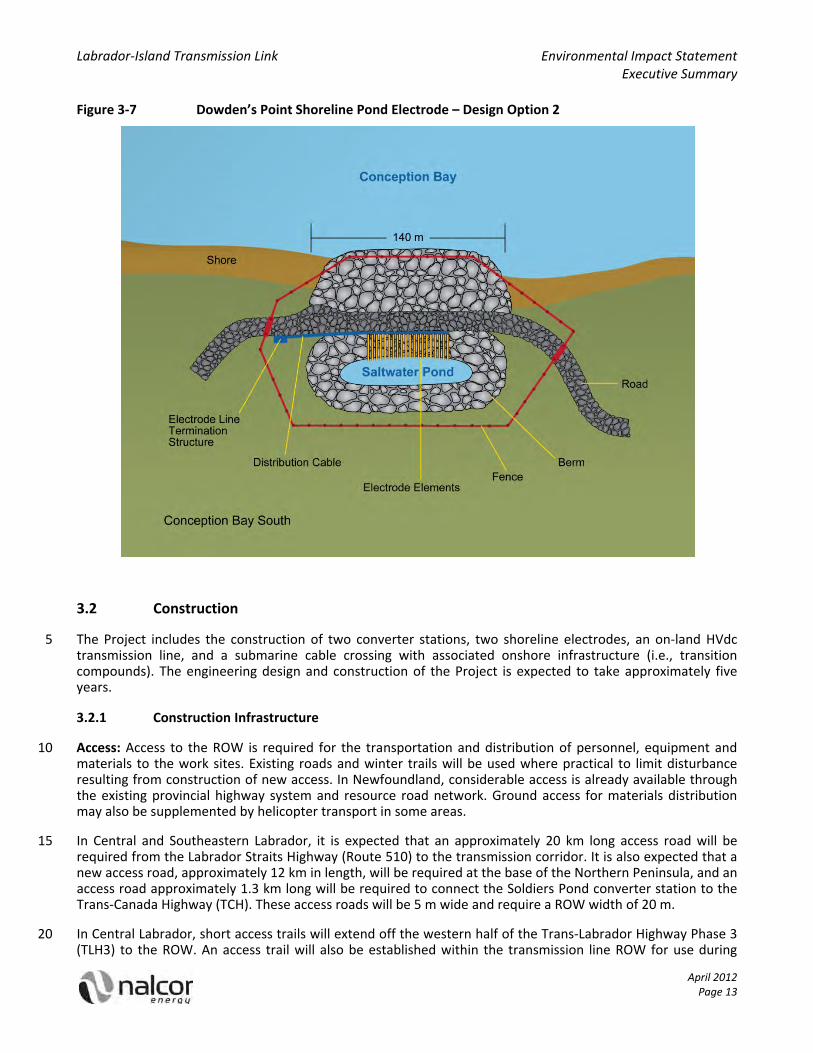
Shoreline Electrodes: Shoreline electrodes will be constructed and installed at two locations: in the Strait of 20 Belle Isle at L’Anse au Diable, Labrador (connected to the Muskrat Falls converter station) (Figure 3‐5) and in Conception Bay at Dowden’s Point, Newfoundland (connected to the Soldiers Pond converter station) (Figure 3‐6, Figure 3‐7). During normal operations, the electrodes provide a return path for a small amount of current generated by voltage imbalances. If a transmission conductor failure or a pole fault were to occur, the electrodes can provide a temporary ground return path for the current for the duration of the fault. The 25 electrode design consists of between 40 and 60 silicon cast iron electrode elements installed vertically in the water on the ‘pond’ side of a permeable berm. The permeable berm will be a rubble mound structure consisting of embankment materials and it is expected that the permeable berm centre line will be approximately 15 m high, the side slope ratio will be approximately 1:1.5 (rise:run), and the crest width will be approximately 9.5 m. The permeable berm creates a saltwater pond. Each electrode will be encased in rigid 30 polyvinyl chloride (PVC) conduit piping and will be attached to an electrode junction box at the top of the permeable berm. The junction boxes will be connected by a distribution cable running the length of the permeable berm. The electrodes will be connected to their respective converter stations by two low voltage, 43 millimetre (mm), metallic conductors suspended on standard single wood poles.
Island System Upgrades: A total of eight existing transmission lines will be connected to the Soldiers Pond 35 converter station, through which electricity from the Project will be transmitted to the Island grid. New towers will be built in the existing ROWs, within 1.6 km of the converter station for each of these existing transmission lines, and lightning protection (i.e., an overhead ground wire) will be installed. The transmission lines will be re‐built within three existing ROWs ranging from 70 m wide (two lines) to 110 m wide (three lines). Other system upgrades include the construction of three new synchronous condensers at the Soldiers Pond 40 converter station and the conversion of two of the Holyrood generating units to synchronous condensers. Also, the 230 kV and 138 kV circuit breakers at the Holyrood Thermal Generating Station, Sunnyside Terminal Station and Bay d’Espoir Hydroelectric Generating Station may be upgraded to allow for the isolation of power system components in response to system events (e.g., lightning strike, insulator failure, dropped conductor).

Labrador‐Island Transmission Link Environmental Impact Statement Executive Summary
April 2012 Page 12
Figure 3‐5 L’Anse au Diable Shoreline Electrode
Figure 3‐6 Dowden’s Point Shoreline Pond Electrode – Design Option 1
5
Labrador‐Island Transmission Link Environmental Impact Statement Executive Summary
April 2012 Page 13
Figure 3‐7 Dowden’s Point Shoreline Pond Electrode – Design Option 2
3.2 Construction
The Project includes the construction of two converter stations, two shoreline electrodes, an on‐land HVdc 5 transmission line, and a submarine cable crossing with associated onshore infrastructure (i.e., transition compounds). The engineering design and construction of the Project is expected to take approximately five years.
3.2.1 Construction Infrastructure
Access: Access to the ROW is required for the transportation and distribution of personnel, equipment and 10 materials to the work sites. Existing roads and winter trails will be used where practical to limit disturbance resulting from construction of new access. In Newfoundland, considerable access is already available through the existing provincial highway system and resource road network. Ground access for materials distribution may also be supplemented by helicopter transport in some areas.
In Central and Southeastern Labrador, it is expected that an approximately 20 km long access road will be 15 required from the Labrador Straits Highway (Route 510) to the transmission corridor. It is also expected that a new access road, approximately 12 km in length, will be required at the base of the Northern Peninsula, and an access road approximately 1.3 km long will be required to connect the Soldiers Pond converter station to the Trans‐Canada Highway (TCH). These access roads will be 5 m wide and require a ROW width of 20 m.
In Central Labrador, short access trails will extend off the western half of the Trans‐Labrador Highway Phase 3 20 (TLH3) to the ROW. An access trail will also be established within the transmission line ROW for use during

Labrador‐Island Transmission Link Environmental Impact Statement Executive Summary
April 2012 Page 14
construction, and operations and maintenance. The access trails will be approximately 4 m wide, with this width reduced at watercourse crossings to 3 m for a distance of 15 m.
The construction of access infrastructure for the Project will involve water crossings, including fording, culverts and / or bridges. Water crossings will be subject to stipulations contained in Certificates of Approval obtained from the Newfoundland and Labrador Department of Environment and Conservation (NLDEC) and 5 authorizations obtained from Fisheries and Oceans Canada (DFO).
Accommodation: Lodging for the construction work force will be provided through small, temporary construction camps established at strategic points along the ROW. As particular construction activities are phased and completed, workers and crews will move between camps. It is anticipated that a total of eleven temporary construction camps will be established at various times along but outside the ROW. Each camp will 10 occupy an area of approximately 135 by 135 m (1.82 hectares (ha)) and will accommodate a bunkhouse for 150 workers, a kitchen, a dining hall and a recreation area. Each camp will be equipped with a first aid station, communications system, helicopter pad, water treatment facility, waste water treatment system, water supply and a fuel supply.
Marshalling Yards and Laydown Areas: Marshalling yards will be established at strategic points to receive and 15 temporarily store materials and equipment during Project construction. Five marshalling yards (5 ha each) are proposed, two in Labrador and three on the Island. Lay down (staging) areas will also be established for temporary storage. Bulk material will be transported from the marshalling yards to the lay down areas by transport truck. At the lay down areas, smaller loads may be collected by off‐road tracked equipment for transportation to the ROW. Assembly yards may also be required for the Labrador portion of the transmission 20 line due to isolation. Approximately 10 assembly yards will be required and the location of each is yet to be identified. These yards will contain approximately 20,000 litres of stored fuel.
Quarries and Borrow Material: Project construction will require aggregate and borrow material. Processed aggregate will be required for the construction of the converter stations, marshalling yards and access roads, and for concrete mixing. Borrow material may be required for backfilling during the construction of the 25 converter stations, access roads and transmission tower foundations. The development of new quarries is not anticipated, as it is expected that the volume of material required can be obtained from existing quarries and / or purchased from local suppliers.
Concrete Production: Along the transmission line, minimal concrete is required for leveling rock foundations. Concrete for the Muskrat Falls converter station will be sourced from the Lower Churchill Hydroelectric 30 Generation Project construction site. Concrete for the Soldiers Pond converter station will be purchased from local suppliers. No concrete batch plants will be developed for the Project. Washwater from the cleaning of mixers, mixer trucks and concrete delivery systems will flow into closed system aggregate rinsing settling basins.
3.2.2 Construction Activities and Sequence 35
Converter Stations: Construction will take place simultaneously at each of the two converter stations during Year 3 and Year 4 of Project construction. Converter station construction will typically include the following activities:
construction of access roads, station roads and laydown areas;
site clearing, grubbing and grading, and rock compaction; 40
construction of foundations, including excavation, footings, formwork and reinforcements;
installation of station ground grid;
installation of water supply and sewer systems, erection of security fence;
erection of the steel building superstructure, roof and cladding;
Labrador‐Island Transmission Link Environmental Impact Statement Executive Summary
April 2012 Page 15
installation of ac switchgear and filters in the switchyard;
installation of transformers, structural components and cable trays inside the valve hall;
installation of buswork and termination of electrical cables;
installation of interior, electrical, heating, ventilation and air conditioning systems;
installation of converter transformers, transformers, valve hall switchgear, electronics used to protect 5 (i.e., monitor conditions) and control (e.g., open breakers), auxiliary supplies and battery banks;
installation of thyristor cooling plant; and
initiation of start‐up and complete system testing.
Transmission Line: Transmission line construction will begin after a two‐year design and fabrication phase. This two‐year period will allow the construction of necessary infrastructure and the clearing of the ROW before 10 the first materials have been fabricated and delivered for system installation. Transmission line construction will typically include the following activities:
surveying and construction of infrastructure (i.e., access roads, bridges, marshalling yards and temporary construction camps);
clearing of the transmission ROW and construction of the ROW access trail; 15
staking of towers and guy locations;
material distribution;
installation of tower foundations, assembly and erection of transmission towers, installation of conductors and counterpoise;
cleanup and reclamation; and 20
inspection and commissioning.
Strait of Belle Isle Cable Crossing: To complete the Strait of Belle Isle submarine cable crossing, the Project will employ a combination of HDD technology and a cable installation vessel (CIV). The HDD will provide three lined (steel or HDPE) conduits for each landfall (i.e., Forteau Point and Shoal Cove). Three cables will be laid on the sea floor, and each cable will be hauled through a conduit to the onshore landing point. The same connection 25 methods will be used for both landing sites. It is expected that the HDD process will take place 24 hours a day, seven days a week and it is expected to take approximately 2.5 years to complete the three conduits on each side of the Strait of Belle Isle. Two drill rigs will operate concurrently, one at Forteau Point and the other at Shoal Cove. Construction of the Strait of Belle Isle crossing will include the following activities:
HDD: Each HDD construction site will measure approximately 90 by 60 m (0.54 ha) and will contain a drill 30 rig, mud pumps and a drilling mud return pit, and storage facilities for the drill pipes, drill mud and bentonite.
Submarine cable installation: The first end of the cable, capped by a pulling head or prepared with cable grips, will be released near the first borehole exit on one side of the Strait of Belle Isle. A line will extend from an onshore winch at the mouth of the borehole, through the borehole, to the seafloor. Once the 35 cable is secured onshore, the CIV will lay the cable. This process will then be repeated from the opposite side of the Strait of Belle Isle until both cables are positioned at the joint location. The CIV will then position itself over the two cable ends, and complete the jointing process.
Rock berm construction: Each of the three submarine cables will be protected by its own rock berm constructed using a fallpipe vessel. Rock will be loaded onto the fallpipe vessel at a port, the vessel will 40 then travel to the submarine cable corridor, verify the location for rock placement, then place the rock. Successive passes will involve the adjustment of rock volume required for achieving the desired berm

Labrador‐Island Transmission Link Environmental Impact Statement Executive Summary
April 2012 Page 16
profile. It is expected that approximately one million tonnes of rock graded from 50 to 200 mm will be used for the berm. Rock berm construction is expected to take the fallpipe vessel approximately 55 trips.
Cable trenching: Between the transition compound and the submarine cable landing point, the land cables will be buried in trenches. The sod will be removed and stored separately, the trench excavated, and the cable laid. To close the trench the subsoil, topsoil and sod will be replaced in the reverse order that it was 5 removed, to facilitate reclamation if possible.
Electrodes: The construction and installation of the shoreline electrodes will include site clearing, excavation and building construction. At both Dowden’s Point and L’Anse au Diable, a permeable berm will be used to create a saltwater pond. To construct the permeable berm, trucks will haul appropriately sized material from quarries to the electrode sites. The rock core material will be placed up to the high tide water level, using an 10 excavator or front end loader, from the shore out onto the permeable berm. Armour stone will be placed on the face of the permeable berm, as the core is completed, to protect the core from damage. The permeable berm top core (and armour rock) will then be placed by an excavator as it works back toward the shoreline.
Construction of the overhead lines connecting the electrodes to the converter stations will be similar to that described for the HVdc transmission line. At each wood pole site, a single hole approximately 2 m deep will be 15 excavated, the pole will be raised and placed into the hole using a crane or backhoe, and the hole will be backfilled with material that came out of the hole to secure the pole in place.
Island System Upgrades: Upgrades to the Island system will occur within existing infrastructure sites and ROWs. Island system upgrades will consist of the following activities:
The conversion of Holyrood Unit #1 and Unit #2 from steam powered generators to synchronous 20 condensers will require the modification of electrical and mechanical components within Unit #1 and Unit #2.
Breaker replacement at the Holyrood Thermal Generating Station, the Sunnyside Terminal Station and the Bay d’Espoir Hydroelectric Generating Station will include the disconnection of the breakers, removal of the breakers from their foundations, inspection and / or replacement of the foundations, and installation 25 of the new breakers.
Rebuilding the eight transmission lines within 1.6 km of Soldiers Pond will follow the procedures described above for the construction of the new transmission line. Prior to rebuilding the transmission lines, the existing lines will be decommissioned, removed and disturbed areas reclaimed.
3.3 Operations and Maintenance 30
Project Operations: Upon commissioning, the Project will operate on a continuous basis. Operation of the Project involves the transmission of electricity through the conductors between the Muskrat Falls and Soldiers Pond converter stations, respectively, the conversion of ac to dc electricity and dc to ac electricity at the converters stations, and the operation of shoreline electrodes. The electrical equipment and facility systems will be remotely monitored and controlled using a Supervisory Control and Data Acquisition (SCADA) / 35 Operational Data System, monitored from the Energy Control Centre at Hydro Place in St. John’s.
Maintenance and Repairs: Project maintenance and repair will include the following activities:
Transmission line inspections will be conducted annually (i.e., using all‐terrain vehicles, snowmobiles or helicopter), with portions of the line scheduled for detailed inspection each year.
The Strait of Belle Isle crossing infrastructure and the shoreline electrode permeable berms will be 40 inspected by remotely operated vehicle (ROV).
Typical transmission line maintenance activities include minor adjustments and replacements (e.g., replacement of insulators). However, more extensive repairs may be required that could involve the

Labrador‐Island Transmission Link Environmental Impact Statement Executive Summary
April 2012 Page 17
replacement of anchors or guy wires, necessitating the use of heavy equipment such as backhoes or cranes.
The submarine cable has a 50‐year design life and is not expected to require repairs during its design life. The rock berms are also designed to be stable and not require repairs. If a fault does occur in a submarine cable, the cable may be repaired by locating and exposing the fault and undertaking the repair with a 5 joining kit.
The electrode elements can be continuously operated for 3.5 years before they may need to be replaced. Switches located in the electrode line termination structure can be used to turn off a series of electrode elements during maintenance activities, and the road constructed along the crest of the permeable berm will allow safe access to the electrode. 10
Vegetation Management: Nalcor will incorporate the Project into its integrated vegetation management program for its transmission and distribution systems. Vegetation that exceeds 2 m in height at maturity (e.g., spruce, alders, birch) will be removed because it can encroach on the transmission line clearance and can affect maintenance crew access. Vegetation will be controlled through a combination of herbicide application and manual cutting. 15
Project Emissions: HVdc systems and electrodes are commonly used worldwide for the bulk transmission of electrical power over long distances. During the operation of HVdc systems, there are limited emissions and discharges, including noise, heat, electric fields and electromagnetic fields (EMF). Technical analyses have been conducted to estimate the potential emissions that may be associated with the Project. These estimates were used for Project planning and design (e.g., conductor design, and voltage and current specifications) to ensure 20 that emissions remain within acceptable standards.
3.4 Decommissioning
The Project will be operated for an indeterminate time period and decommissioning is not anticipated. Should decommissioning activities eventually be considered for some or all Project components, decommissioning will be planned and conducted in accordance with relevant standards and regulatory requirements of the day. This 25 would include the development of a decommissioning plan that considers the mitigation of environmental and socioeconomic effects. The decommissioning plan will be submitted to the relevant regulatory authorities for approval.
3.5 Environmental Protection Planning
A construction EPP and an operations and maintenance EPP will be prepared for use by all Project personnel, 30 including employees of Nalcor and its contractors. The EPPs will incorporate applicable regulatory requirements and all construction, operations and maintenance related environmental commitments made as part of this EIS. Nalcor will also proactively identify potential safety, health and environmental emergencies related to Project construction, operations and maintenance. Prevention measures and response procedures will be described in the SHERP, and all Project personnel will receive SHERP training. Another key component 35 of environmental protection during Project construction is provided by on‐site environmental inspectors. In addition to advising on compliance with environmental regulations, on‐site environmental inspectors will provide information and advice to the planning process.
3.6 Project Workforce
Approximately 3,070 person‐years are required to construct the Project. Of this total, approximately 40 1,700 person‐years will be located on the Island of Newfoundland and 1,100 person‐years will be located in Labrador, with the remainder located elsewhere. Peak direct construction employment is expected in Year 3, with 540 person‐years of work occurring on the Island and 340 person‐years in Labrador. During the operations and maintenance phase, approximately 30 additional full‐time personnel will be required, in addition to specialized contractors. 45

Labrador‐Island Transmission Link Environmental Impact Statement Executive Summary
April 2012 Page 18
3.7 Project Cost and Expenditure
The total estimated capital cost for the Project is $2.1 billion in as‐spent dollars (including contingency and escalation). Approximately $1.25 billion will be spent on materials and equipment with labour accounting for approximately $560 million of the total capital costs. An escalation allowance of $230 million and historical costs of $42 million account for the remainder of the costs, bringing the total capital cost to approximately 5 $2.1 billion. Most costs will be incurred during the final three years of construction with the highest single year cost occurring in Year 3 (approximately $570 million).

Labrador‐Island Transmission Link Environmental Impact Statement Executive Summary
April 2012 Page 19
4 EFFECTS OF THE ENVIRONMENT ON THE PROJECT
The environment has played and will continue to play a key role in Project design. Although many effects of the environment have been mitigated through Project design, potential effects of the environment on the Project could result from:
Vegetation: Vegetation affected Project design primarily during the selection of the transmission corridor 5 and siting of Project components. Project construction will be affected by vegetation during siting of construction infrastructure and clearing activities. During Project operations, vegetation, such as trees, can cause power outages if they come into contact with the conductors.
Lightning: Project design considerations included lightning protection measures. During Project construction, lightning could strike a tower, which could affect Project personnel in the area. During 10 Project operations a lightning strike could result in flashover, leading to a power outage.
Forest fire: Forest fires are not anticipated to affect Project design, however, they could cause damage to Project infrastructure during construction and operations.
Wind, freezing precipitation and ice accretion: Meteorological conditions affected the selection of the transmission corridor and Project design loads. During Project construction, they could lead to schedule 15 delays. During Project operations, wind, freezing precipitation and ice accretion could lead to tower collapse, conductor failure or flashover.
Salt spray: Salt spray affected transmission corridor selection and the design of insulators. No effects are anticipated on Project construction, however, the accumulation of salt on the insulators during Project operations could result in flashover, leading to a power outage. 20
Bathymetry: Bathymetry affected submarine cable corridor selection, the selection of landing points, the selection of cable pull‐in location, the selection of electrode sites, and the design of the electrode berms. Bathymetry is not anticipated to affect submarine cable construction, however, it may affect shoreline electrode construction methods. Bathymetry is not expected to affect Project operations.
Currents and tides: Current and tide information was used in the decision to include HDD and a rock berm 25 in the design of the submarine cable crossing, and also affected the design of the shoreline electrode ponds. Currents and tides are not expected to affect the construction of the submarine cable crossing, but may affect the construction sequence for shoreline electrode berms. Currents and tides could affect the operations of the electrodes if the electrodes do not remain submerged during low tide events.
Waves: Wave activity informed the decision to include HDD in the design of the submarine cable crossing, 30 and also affected the design of the shoreline electrode berms. High wave activity may affect the Project construction schedule. During Project operations, waves are not expected to affect the submarine cable, but they may result in damage to the shoreline electrode berms.
Sea ice and icebergs: Sea ice and icebergs informed the decision to include HDD in the design of the submarine cable crossing, the design of the shoreline electrode berms, and the depth of the shoreline 35 electrode ponds. During Project construction, in‐water activities will be scheduled to avoid sea ice and ice bergs. During Project operations, sea ice and icebergs could result in damage to the submarine cables or shoreline electrodes due to iceberg scour, and changes in resistivity of the medium (i.e., water versus ice) surrounding the shoreline electrodes.
Seismicity: Project design standards considered seismic loading, as appropriate. No effects are anticipated 40 during Project construction. During Project operations, structural damage may result from earth movement, and flooding and / or structural damage could occur from a tsunami.
Climate change: Load calculations and design of marine infrastructure account for potential changes to weather patterns and sea level. Climate change is not expected to affect Project construction. During Project operations, effects may result from a potential increase in ice and wind loading (e.g., tower or 45

Labrador‐Island Transmission Link Environmental Impact Statement Executive Summary
April 2012 Page 20
conductor failure), the availability of dry vegetation to fuel forest fires, a change in frequency of lightning strikes, and the flooding of electrode sites.
Land and resource use: Land and resource use affected transmission corridor selection and the siting of Project components. Land and resource use is expected to affect construction scheduling, siting of construction infrastructure and clearing activities. There may also be effects resulting from the interaction 5 between land use activities and Project operations and maintenance activities.
Fisheries: Fishing activity informed the decision to include HDD and a rock berm in the design of the submarine cable crossing, and also the decision to include berms around the shoreline electrodes. During Project construction, there may be interaction between fishing activity and submarine cable installation activity and shoreline electrode pond construction. During operations and maintenance there may be 10 interaction between fishing lines, nets or rakes, and submarine cables.
Many of these potential effects have been primarily mitigated through the siting of the transmission corridor. Additional mitigation measures include vegetation control, the installation of OPGW and counterpoise, design of transmission infrastructure based on local meteorological conditions, cable protection (i.e., HDD and rock berm), and shoreline pond and berm design appropriate to local meteorological and seabed conditions. 15
The effects of the environment on the Project are not expected to affect Project construction or operations and maintenance in a manner that affects the Project’s technical or economic feasibility. The effects of the environment on the Project are therefore not considered significant.

Labrador‐Island Transmission Link Environmental Impact Statement Executive Summary
April 2012 Page 21
5 ACCIDENTS AND MALFUNCTIONS
An accident refers to an unplanned or unexpected event, related to Project activities, that interacts with the environment. A malfunction refers to the abnormal operation of a Project component with subsequent environmental consequences. In the following discussion, accidents and malfunctions (i.e., unplanned events) are jointly referred to as “incidents”. This section identifies and describes potential incidents related to Project 5 construction, and operations and maintenance. It also describes the potential environmental consequences (i.e., magnitude, extent, duration) of these incidents.
Potential incidents that could interact with the environment and that may occur during Project construction, or operations and maintenance include the following:
Transmission tower failure: The transmission towers are designed to withstand extreme meteorological 10 loads, however, a transmission tower failure is possible. During Project construction, a transmission tower could fail as a result of soil conditions, meteorological conditions or work crew error. During Project operations and maintenance, tower failure could result from meteorological conditions, natural erosional processes, or metal fatigue. If a tower does fail during Project operations and maintenance, adjacent towers may also be affected. 15
Electrocution: The transmission system will be designed to trip out in the event of a ground fault. If a conductor failure occurs (i.e., if the conductor breaks), the line will trip out before coming into contact with anything. If a tower failure occurs and the conductor touches the tower, the system will trip out and the risk of electrocution is removed, unless a person or animal is in direct contact with the tower. If the conductor does not touch the tower at any point during the fall, the live conductor could come into 20 contact with a person or animal on its way to the ground. Electrocution resulting from conductor or tower failure requires a specific combination of circumstances (e.g., tower failure during which the conductor does not touch the tower and a person or animal is located in the direct path of the falling conductor).
Spills and leaks of hazardous material: Spills or leaks of hydrocarbons could occur along the ROW, at the converter stations, along access roads and in the Strait of Belle Isle as a result of incidents involving heavy 25 equipment, vehicles and marine vessels that contain fuel, oil and lubricants. During Project operations and maintenance, there is a potential for spills or leaks of herbicide used for vegetation management along the ROW. Leaks or spills of fuel, battery acid, and transformer oils could also occur during converter station construction, and operations and maintenance.
Frac‐out during HDD: During the HDD process, there is a potential for the release of drilling mud into the 30 surrounding environment (i.e., frac‐out). Frac‐out of drilling mud may occur if the downhole mud pressure exceeds the resistance of the soil or rock formation and also can occur through an existing fault / crack in the rock formation.
Slope failure: Terrain along the access roads and ROW may be susceptible to slope movement, particularly where drainage associated with Project access roads results in the undercutting of slopes by streams and 35 rivers during high precipitation events. There is also a potential for erosion of shoreline fill at the electrode sites to result in slope failure, or seabed slope failure to occur during construction of the shoreline electrode ponds.
Fires (except forest fires): The storage of combustible material or waste at the marshalling yards or campsites, and the operation of kitchen appliances within the campsites could result in a fire during 40 Project construction. The storage of combustible material or waste, or equipment malfunction at a converter station could result in fire during the Project operations and maintenance. Flammable liquids within the converter station will be limited to non‐polychlorinated biphenyl (PCB) transformer oils.
Forest fires: The operation of combustion engines, blasting activity and general presence of workers have the potential to ignite forest fires. Both combustion engines and workers are expected to be present 45 during most Project construction, and operations and maintenance activities, and blasting may occur

Labrador‐Island Transmission Link Environmental Impact Statement Executive Summary
April 2012 Page 22
during foundation construction. Several Project activities will occur in forested areas where the ignition source could lead to a forest fire, depending on the season.
Waste management incidents: Sources of waste generated during Project construction, and operations and maintenance, include domestic waste, sewage and wastewater, and industrial waste. Waste management incidents could include failure of the wastewater treatment system (e.g., a break in the 5 sewage line) or a waste transport accident.
Motor vehicle collisions: The operation of vehicles and heavy equipment on provincial highways, Project access roads and the ROW could result in human or wildlife collision mortality or injury. Human incidents may involve vehicle‐vehicle collisions or vehicle‐pedestrian collisions. The potential for these types of collisions is influenced by traffic volumes, weather conditions and pedestrian access. 10
Marine vessel collisions: The operation of marine vessels in the Strait of Belle Isle could lead to a marine accident or incident. Vessel‐vessel or vessel‐ground collisions are influenced by marine traffic, weather conditions and vessel watch procedures. The potential for vessel‐wildlife interactions is influenced by the time of year (e.g., many marine mammals migrate through the Strait of Belle Isle during the summer or fall), the surrounding habitat type, and the time of day. 15
Aviation accidents: The operation of helicopters during Project construction, and operations and maintenance could lead to an aviation accident or incident. In slinging operations, there is a risk of dropped loads. The Project is also located in a region used for low‐level flight training by the Department of National Defence (DND). Flight training occurs at altitudes of 30 m above ground level and the transmission towers will reach a height of between 40 and 50 m. As a result, there is a risk of collision 20 between DND aircraft and Project helicopter traffic, and between DND aircraft and the transmission towers and lines during both Project construction, and operations and maintenance.
A most likely scenario and a reasonable worst case scenario are considered for each type of incident. A relative probability of occurrence is assigned to each scenario, based on Nalcor’s experience, historical records of occurrence, and the judgement of the assessors. The environmental consequences of each scenario are then 25 described in terms of the surrounding biophysical environment, and considered in terms of the magnitude, geographic extent, duration and frequency of an incident. The risk of each scenario is then evaluated with respect to probability of occurrence and environmental consequence.
Low risk incidents are assessed as part of the overall environmental effects assessment for relevant valued environmental components (VECs). Incidents that are considered to have a moderate to high risk are 30 addressed as specific events in the Accidents and Malfunctions sections of the Environmental Effects Assessment chapters. The following specific reasonable worst case scenarios are considered to have a moderate to high risk:
electrocution resulting from human contact with transmission lines, submarine cable, or electrodes;
large spill of diesel fuel during construction that spills over the ground and into a watercourse; 35
large fuel spill into the marine environment, during construction, due to vessel collision;
a forest fire affecting 470 ha (the average extent) in Labrador, originating along the access roads or ROW;
a forest fire in the vicinity of a populated community in Newfoundland, originating along the access or ROW;
vehicle‐vehicle or vehicle‐pedestrian collision resulting in one or more human fatalities; 40
vessel collision resulting in one or more human fatalities; and
an aviation accident or released sling load within a populated area resulting in serious injury or death.

Labrador‐Island Transmission Link Environmental Impact Statement Executive Summary
April 2012 Page 23
6 ENVIRONMENTAL SETTING AND CONTEXT
The transmission corridor will extend across a considerable portion of Newfoundland and Labrador, including the Strait of Belle Isle, and through a variety of natural and human environments. This section presents a general and high‐level overview of the Project’s existing environmental setting, as overall background and context for the Project and its EA, and to set the stage for the identification of potential environmental issues 5 and the environmental effects assessment.
6.1 The Natural Environment
The Labrador component of the transmission corridor and converter station extends from the lower Churchill River at Muskrat Falls and across southeastern Labrador to the Strait of Belle Isle, for a distance of approximately 400 km. The following provides an overview of the climate, topography, vegetation, wildlife and 10 freshwater environment in Central and Southeastern Labrador:
The climatic characteristics of Central and Southeastern Labrador vary from a continental regime in the low‐lying interior characterized by warm summers and long, cold winters, to warmer winters and cooler summers with abundant precipitation on the coast.
The area immediately surrounding the lower Churchill River is comprised primarily of undulating upland 15 topography and coastal plain, with flat river terraces. Further south‐east, the landscape is initially characterized by rolling terrain and broad river valleys covered by shallow till and glacial landforms such as drumlins and eskers. Further inland, the Eagle River Plateau occupies much of the area between Lake Melville and the coast.
The lower Churchill River valley is highly productive, with boreal plant species assemblages including large 20 conifers, and associated deciduous species and understory vegetation typical of the boreal forest. Further south‐east, the vegetation is comprised mostly of fairly open black spruce forests, with extensive ribbed fen and string bog complexes, and sporadic hardwoods and lichen‐covered wooded areas on drier sites. Along the coastal strip adjacent to the Strait of Belle Isle, low hill areas are covered primarily with barren vegetation and pockets of scrub spruce and bog. 25
The lower Churchill River valley supports a variety of wildlife species that reside there year‐round, seasonally, or use the waterway as a travel route. The interior of southeastern Labrador, with its open, stunted forests and extensive wetlands, also provides habitat for a range of wildlife species.
There are three recognized boreal populations of woodland caribou in Labrador, each of which is currently listed as threatened under provincial and federal legislation. 30
Watercourse crossings range in size from small, seasonal or intermittent streams to much larger rivers. There are several Scheduled Salmon Rivers in this general area.
The submarine cables cross the Strait of Belle Isle, a marine channel that separates the south‐east coast of Labrador from the north‐west portion of the Island of Newfoundland. The following provides an overview of the physical environment, and marine fish and wildlife in the Strait of Belle Isle: 35
Water depths within the Strait of Belle Isle vary significantly and reach over 120 m in places.
The Strait of Belle Isle is topographically complex, with seabed sediments generally consisting of thin, discontinuous glacial and marine sediments overlying bedrock.
Water movement through the Strait of Belle Isle is primarily through strong tidal currents.
Sea ice in the Strait of Belle Isle is a combination of locally formed ice and pack ice that drifts down from 40 the Arctic and Labrador Sea. Icebergs drift into the Strait each year.
A variety of fish and pelagic species are present in the Strait of Belle Isle, as well as a range of benthic invertebrates.

Labrador‐Island Transmission Link Environmental Impact Statement Executive Summary
April 2012 Page 24
Marine mammals, including whales, porpoises, dolphins and seals, are present in the Strait of Belle Isle at specific times of the year.
The Strait of Belle Isle is also used by a variety of avifauna for breeding, overwintering and / or as feeding and resting areas during migration through the area.
The transmission corridor on the Island of Newfoundland extends from the Strait of Belle Isle to the Avalon 5 Peninsula, over a distance of approximately 700 km. The following provides an overview of the climate, topography, vegetation, wildlife and freshwater environment in Newfoundland:
Central and eastern Newfoundland exhibit the most continental climate on the Island, with comparatively high summer temperatures, low rainfall and harsh winters. The Avalon Peninsula experiences cool summers and mild winters, high precipitation and frequent fog. 10
The north‐western edge of the Northern Peninsula, is a rocky, flat coastal stretch. Much of the interior is dominated by mountainous highland areas and plateaus associated with the Long Range Mountains. In central and eastern Newfoundland, the topography is predominantly low and rolling.
The vegetation cover on the Northern Peninsula is comprised almost exclusively of barren and tundra‐like assemblages, with alternating dry barrens and shallow fens. Along the western side and interior portions 15 of the Northern Peninsula, coastal, forested and barren areas are present. Central and eastern Newfoundland are the most heavily forested and distinctly boreal areas of Newfoundland. As the transmission corridor nears the Avalon Peninsula, it passes through an area of extensive maritime barrens. The Avalon Peninsula generally consists of barren heath, with pockets of forest, bogs and shallow fens.
Newfoundland is home to a number of woodland caribou aggregations, as well as other large and small 20 mammals that occupy the forest, scrub and aquatic habitats throughout the Island. Raptors, waterfowl and other avifauna are also found here.
This section of the transmission corridor will also cross and / or be located adjacent to a number of watersheds which are known to support a variety of fish species. There are Scheduled Salmon Rivers in the general area. 25
6.2 The Human Environment
Labrador has a rich history and cultural heritage. Today, nearly 30,000 people live in Labrador, distributed in some 30 communities which range from small settlements along the coast to larger centres in central and western Labrador. The following provides an overview of the archaeological resources and contemporary socioeconomic setting of Central and Southeastern Labrador: 30
Previous archaeological research in Labrador has focused primarily on the coast, and has generally established that historic resources in these areas are rich and abundant, particularly along the shoreline within the major bays.
Central Labrador has a population of just over 9,000 people, approximately one‐third of the population of Labrador. Happy Valley‐Goose Bay is the largest community in Labrador and has a well‐developed and 35 diverse economy, and a range of services and infrastructure.
The Labrador Straits region has a population of just less than 2,000 people. The economy of the Labrador Straits region has traditionally been based on the fishery, but the area has also seen a considerable expansion in the number and diversity of small businesses in recent years. The tourism sector also contributes greatly to the economy of the region. 40
The southern Labrador region includes a number of towns and smaller coastal settlements which are inhabited on a seasonal basis.
A number of Aboriginal communities and organizations reside in or near these regions, and undertake land use and harvesting activities and / or claim Aboriginal rights or title to portions of Labrador.

Labrador‐Island Transmission Link Environmental Impact Statement Executive Summary
April 2012 Page 25
A variety of land and resource use activities are undertaken in the general region, including hunting and trapping, harvest of forest resources and berries, and fishing.
Cabins are located throughout the area, and are used in association with various activities, including snowmobiling, hunting, fishing and gathering activities. There are also commercial outfitting camps throughout Labrador. 5
The economy of the areas on both sides of the Strait of Belle Isle has traditionally been based on the fishery. Fishing in the Strait of Belle Isle generally takes place between May and November, and especially in June and July, primarily by small vessels fishing close to their home communities. Fishing seasons, areas and techniques do however, vary considerably according to species. There is also a relatively high volume of general vessel traffic in the Strait of Belle Isle, particularly between June and late November. 10
The Island of Newfoundland is, like Labrador, characterized by distinct and varied socio‐cultural and economic landscapes. The following provides an overview of the archaeological resources and contemporary socioeconomic setting of Newfoundland:
There are several thousand known archaeological sites on the Island of Newfoundland, which range in age from nearly 9,000 years before present (BP) to sites dating to the 20th century. 15
The Island of Newfoundland comprises less than 30 percent (%) of Newfoundland and Labrador’s total land area, but is home to nearly 95% of its population. The Island’s residents live in approximately 250 municipalities as well as numerous smaller unincorporated communities.
The Northern Peninsula region has a long standing linkage to the fishery. The collapse of the groundfish sector and subsequent closure of many of the fish processing plants had a social and economic impact on 20 the region. However, recent years have seen transition, diversification and growth as a result of the harvesting and processing of alternative species such as shellfish. Tourism has also become a key component of the local economy.
The economy of Central Newfoundland has traditionally been based primarily on natural resource extraction and industrial development. Manufacturing, commercial, retail and government services also 25 employ a significant portion of the labour force, and tourism and recreational activities and associated facilities are currently a key component of the region’s economy.
The Avalon Peninsula has a well‐developed and diverse economy, being the provincial centre for government and many services and industries. Given its large and concentrated population, portions of the Avalon Peninsula are also subject to fairly intensive land use, such as residential and cottage development, 30 and industrial and agricultural areas.
6.3 Previous and Ongoing Human Activities
The Project will cross areas of Newfoundland and Labrador that have seen various types, and varying degrees, of past and existing development activities. These previous and ongoing human activities have influenced the existing environments in these areas, and are reflected in the description of the baseline environment. Also, 35 the current condition of the pre‐Project environment as a result of these anthropogenic and / or natural factors ‐ and thus, its likely sensitivity or resiliency to further disturbance or change ‐ has been integrally considered in the environmental effects analyses presented in this EIS, including the assessment of potential Project‐specific and cumulative effects. Information on previous and ongoing activities in the general area of the Project is provided below. 40

Labrador‐Island Transmission Link Environmental Impact Statement Executive Summary
April 2012 Page 26
The central Labrador region encompasses four communities: Happy Valley‐Goose Bay, North West River, Sheshatshiu and Mud Lake, which have a total population of less than 10,000 people. Development activities in the region are concentrated primarily within and near the communities and associated roadways and other infrastructure. The following activities have occurred or are ongoing in the Central and Southeastern Labrador area of the Project: 5
Canadian Forces Base Goose Bay (5 Wing Goose Bay), including a designated low‐level flying training area.
The Churchill Falls Generating Station and earlier hydroelectric developments in Labrador (e.g., Menihek Lake and Twin Falls).
The Trans‐Labrador Highway (TLH).
Nalcor’s existing 138 kV Transmission Line (TL 240). 10
The TLH3 and a number of quarries and other cleared areas associated with highway construction.
Several fishing outfitter camps.
Cabin areas, and hunting, fishing, wood cutting and snowmobile use by residents.
The Labrador Straits region itself includes eight communities with a total population of just less than 2,000 persons. These communities are connected by a paved highway that extends along the coastline. 15
There is considerable fishing in the Strait of Belle Isle at present, particularly during the summer months. In addition, there is a high volume of vessel traffic in the Strait of Belle Isle particularly between June and late November, including general vessel movements to and through the area, as well as the seasonal ferry services between St. Barbe and Blanc‐Sablon.
The following activities have occurred or are ongoing in the Newfoundland area of the Project: 20
communities dot the coastline along the northern and western edges of the Northern Peninsula;
cabins, outfitting camps, resource road networks, various harvesting and other land and resource use activities;
existing transmission lines and highways, including the Trans‐Canada Highway;
mineral exploration activity; and 25
forestry activity.
6.4 Environmental Studies
To assist in ongoing design and planning for the Project and in preparation for its EA, Nalcor undertook a series of studies to obtain information on the existing biophysical and socioeconomic environments in the general area of the Project and / or to assist in the eventual analysis of its potential environmental effects in the EA. 30 This has included environmental studies carried out by Nalcor from 2007 to 2011 related to a range of components, which have built upon previous work completed over the past several decades. These environmental studies are used and cited extensively in the EIS. These have also been produced and submitted as Component Studies, as required under the EIS Guidelines and Scoping Document (Government of Newfoundland and Labrador and Government of Canada 2011), for review and approval under the EA process. 35

Labrador‐Island Transmission Link Environmental Impact Statement Executive Summary
April 2012 Page 27
6.5 Likely Future Environmental Conditions without the Project
Environmental systems are not static in nature, but rather are constantly changing over time, both naturally (e.g., forest fires) and as a result of human activities and influences (e.g., forestry, access). Consideration of the existing, pre‐Project “baseline” environment therefore recognizes that aspects of the biophysical and socioeconomic environments are dynamic and will continue to change in the future, even without the Project. 5
Recognizing that it is somewhat speculative and certainly challenging to predict the likely future characteristics of the environment across Newfoundland and Labrador in the long‐term and with precision, a general overview of the manner in which the existing biophysical and socioeconomic environments may change in the future without the Project has been developed. Potential environmental effects that are likely to result from other future projects and activities in conjunction with the Project are also assessed as part of the cumulative 10 effects analysis presented for each VEC.

Labrador‐Island Transmission Link Environmental Impact Statement Executive Summary
April 2012 Page 28
7 ABORIGINAL CONSULTATION AND ISSUE SCOPING
Nalcor is committed to consulting Aboriginal communities and organizations appropriately on the Project. Nalcor has planned, offered and undertaken various consultation processes and activities with Aboriginal groups with the purpose of providing and receiving information on the Project and its potential environmental effects and collecting Aboriginal Ecological Knowledge on the existing environment for incorporation into the 5 EIS.
The key objectives and elements of Nalcor's Aboriginal consultation program include:
providing Aboriginal communities and organizations with information on the Project, including its purpose and associated components and activities;
identifying and documenting any questions or concerns about the Project and its potential environmental 10 and socioeconomic effects and benefits;
collecting and sharing information on contemporary land use activities by Aboriginal persons in or near the Project area, as well as relevant Aboriginal knowledge; and
discussing possible approaches and measures to avoid or reduce any likely adverse effects and enhance benefits of the Project on Aboriginal communities and organizations and their interests and activities, and 15 on the environment in general.
Consultation with Aboriginal communities and organizations for the Project has been ongoing for several years, including prior to, but primarily following, the registration of the Project under the provincial and federal EA processes in January 2009. Consultation activities included the following Aboriginal communities and organizations: Labrador Innu, Québec Innu and Naskapi Nation of Kawawachikamach, Labrador Inuit, and the NunatuKavut 20 Community Council (NCC).
Nalcor's consultation with Labrador Innu has occurred for over a decade, and has included consideration of both the Project and the Lower Churchill Hydroelectric Generation Project. Consultation activities have included various methods such as studies, funding mechanisms and direct consultation with the communities, including an open house in April 2011 in Sheshatshiu. Nalcor, the Government of Newfoundland and Labrador 25 (GNL) and Innu Nation have negotiated and concluded an Impacts and Benefits Agreement pertaining to both the Labrador ‐ Island Transmission Link and the Lower Churchill Hydroelectric Generation Project. The Impacts and Benefits Agreement (IBA), ratified by the membership of the Innu Nation and signed on November 18, 2011, defines how the Labrador Innu will participate in and benefit from these development projects.
Nalcor recognizes and acknowledges that Aboriginal communities often require additional resources and support 30 when engaging in consultation processes, particularly with regard to large development projects and their EAs. While there is no legal requirement for formal capacity arrangements, Nalcor has developed an approach to consultation which includes the provision of funding and / or other support to Aboriginal communities and organizations to facilitate Project‐related consultation, where appropriate. Nalcor's approach to planning, undertaking and supporting consultation is both group and Project‐specific. Nalcor has proposed to enter into 35 community engagement agreements with the following Aboriginal communities and organizations:
NCC;
Pakua Shipi;
Unamen Shipu;
Nutashkuan; 40
Ekanitshit;
Uashat mak Mani‐Utenam; and

Labrador‐Island Transmission Link Environmental Impact Statement Executive Summary
April 2012 Page 29
Matimekush ‐ Lac John.
Nalcor has entered into community engagement agreements with NCC (Phase I and Phase II), and Pakua Shipi (Phase I and Phase II). It has also recently entered into a community engagement agreement with Unamen Shipu.
Nalcor has continued to attempt to engage in consultation activities with Nutashkuan, Ekuanitshit, Uashat mak Mani‐Utenam and Matimekush ‐ Lac John through meetings, conference calls, phone calls and emails. 5
Although the Project does not cross through or near land areas covered by the Labrador Inuit Land Claims Agreement, Nalcor remains committed to open discussions with the Nunatsiavut Government and has and will continue to provide information on the Project and its EA to the Labrador Inuit. Consultation with the Labrador Inuit has also included an open house in Hopedale.
Nalcor has also initiated, and continues to seek opportunities to engage in appropriate consultation with the 10 Naskapi Nation of Kawawachikamach.
To gain an understanding of the interests, values, concerns, contemporary and historic land and resource use activities, including important issues facing Aboriginal groups, Nalcor has planned, offered and undertaken various consultation processes and activities with all Aboriginal communities and organizations that will be potentially affected by the Project. 15
During these consultation activities, issues and questions related to the Project were expressed and recorded. Issues and questions raised are addressed in the EIS. In general, these issues and questions included:
Project rationale and planning: overall rationale and need to consider effects and benefits together, rationale for electrode design choice.
Project description: need for further detail, ability of marshy or boggy land to support structures for the 20 power lines, use of existing roads / highways, effects of earthquakes, process for placing rock over the submarine cables.
Suggestions and alternatives: alternative routings of transmission corridor, alternative energies (e.g., wind, solar), location of Soldiers Pond converter station, below ground transmission line.
EA process and consultation: evaluation of mitigation measures, monitoring programs, importance of early 25 and meaningful consultation, consultation scheduling, compliance with regulation and accountability, EA approach, perceived knowledge gap with respect to baseline information for Lake Melville and potential role of Inuit knowledge.
Aquatic environment: effects on salmon, effects on “trophy sized” brook trout in Labrador, effects of herbicides and heavy equipment operation, effects and cumulative effects on fish stocks (e.g., spawning 30 grounds of the Alexis / St. Lewis River), effects on drinking water supplies, effects on surface water levels, effects of sedimentation on fish.
Terrestrial environment: effects of EMF, effects of herbicides on food plants, effects of increased human access, effects on caribou, use of timber resources, effects on medicinal plants, effects on migratory birds, habitat fragmentation, effects due to increased predator access. 35
Atmospheric environment: effects on climate change.
Marine environment: effects on salmon, effects of submarine cable and electrodes, effects of siltation on fisheries, effects of EMF, effects of rock placement on crab and fish, effects on osprey population.
Socioeconomic environment: effects of eco‐tourism, traditional use of Kenamu River, increased access, content of historic resource studies, attitudes and perceptions about land use studies, workplace 40 discrimination, training and employment, effects on traditional activities (e.g., hunting, trapping, fishing), community economic benefits, business opportunities, effects of submarine cable on human life, electricity needs, effects on scallop harvest, benefits to Labrador, equal benefits for all Aboriginal people and groups, effects on electricity rates, market for electricity, access to wood cleared from ROW, Aboriginal / community environmental monitors, long‐term employment, effects on chartering businesses, 45 effects on drinking water supplies, infrastructure funding.

Labrador‐Island Transmission Link Environmental Impact Statement Executive Summary
April 2012 Page 30
8 REGULATORY AND PUBLIC CONSULTATION AND ISSUES SCOPING
Consultation is the cornerstone of the EA process, and is a key aspect of Nalcor’s approach to its planning and development activities. Consultation and associated issues scoping activities for the Project involving government departments and agencies, stakeholder groups and the general public are described and summarized in this section. 5
Nalcor’s consultative initiatives have been designed and implemented from both an “information out” and an “information in” perspective ‐ using various mechanisms to provide interested and potentially affected groups and individuals with information on the Project, allowing them to review and consider this information and formulate their questions and issues, and then giving them the opportunity to provide their perspectives to Nalcor for consideration in Project planning and the EA. A key purpose and objective of Nalcor’s consultation 10 program to date has therefore been to identify questions, concerns and issues related to the Project and its potential environmental effects which require consideration in the EIS.
Over the past few years, nearly 100 meetings have been held with regulatory and / or stakeholder organizations, with a focus on face‐to‐face meetings and discussions. Nalcor’s consultation activities with government departments and agencies have also included extensive discussions and ongoing information 15 sharing through various other means such as letters, email, and telephone conversations.
A variety of methods and materials have been and are being used to provide all interested stakeholders with opportunities to participate in the EA process for the Project. These have included meetings with community and stakeholder groups, public meetings and open houses at locations throughout the province. Nalcor’s website (nalcorenergy.com) provides relevant information on an ongoing basis and a toll free number and 20 dedicated email address have also been established and advertised.
Nalcor held 12 open houses across the province focused specifically on the Labrador‐Island Transmission Link environmental assessment in 2010 and 2011. Furthermore, 17 open houses were held across the province in 2011 that provided information on and discussion of the Project. In addition to the open houses and stakeholder meetings, Nalcor has also received and responded to numerous Project related questions and 25 information requests by telephone, email, and other means.
During these consultation activities, issues and questions related to the Project were identified and recorded. Issues and questions raised are addressed in the EIS. In general, these issues and questions included:
Project rationale and planning: benefits of the Project (e.g., rates, availability), capacity, energy alternatives. 30
Project description: maintenance in challenging environments, technical challenges related to the design / construction of the submarine cable crossing.
Suggestions and alternatives: multiple converter stations, passenger tunnel under the Strait of Belle Isle, straighter transmission corridor, alternative routings of transmission corridor, follow existing ROWs, alternate converter station and electrode locations. 35
EA process and consultation: funding for stakeholder groups, duration of EA process, presentation of technical material, effects prediction and confidence.
Aquatic environment: effects of construction, effects of operations, use of herbicides, increased access.
Terrestrial environment: protection of the Limestone Barrens and mitigation for effects on rare plants, effects on timber resources, effects on protected areas, effects of increased access, ecosystem level 40 effects, effects of clearing and herbicides, habitat loss / fragmentation, wildlife disturbance, effects on caribou, timing of construction.
Atmospheric environment: effects of EMF and audible noise, air emissions, telecommunication interference.

Labrador‐Island Transmission Link Environmental Impact Statement Executive Summary
April 2012 Page 31
Marine environment: effects of electrodes and emissions from submarine cables, effects on species at risk, effects and cumulative effects on pelagic and groundfish species, effects on and through the seabed, construction effects on marine species, fishing restrictions, timing and duration of construction, effects on commercial fishery, sedimentation, noise.
Socioeconomic environment: employment opportunities, local hiring, training opportunities, workforce 5 demographics, local procurement / accommodation, port facilities, waste management, effects of increased access on game and crimes against property, effects of changes in viewscape and noise, effects on water supplies, increased use of infrastructure / services, health effects of EMF, land expropriation, effects on navigable waters, consideration of recreational land use and cabins, effects of herbicides, effects on archaeological resources, effects on tourism, effects on wildlife management. 10

Labrador‐Island Transmission Link Environmental Impact Statement Executive Summary
April 2012 Page 32
9 ENVIRONMENTAL ASSESSMENT APPROACH AND METHODS
This section describes the EA approach and methodology that has been used to conduct the environmental effects assessment reported in this EIS, including each of its key stages and components. The methods used are in keeping with current EA approaches and best practice, and have been developed and used to help ensure a thorough and rigorous analysis, while at the same time presenting the results of the EA in a clear, 5 concise and well‐organized manner. This EA is organized by and focussed on a series of identified VECs. VECs are aspects of the biophysical and socioeconomic environments which are of particular ecological and / or social importance, and which will likely be affected (adversely or positively) by the Project.
EA study areas (spatial and temporal boundaries) were established for each VEC to direct and focus the environmental effects assessment. These study boundaries are generally VEC‐specific, given the differences 10 between the VECs in terms of their overall characteristics and in the manner in which they may interact with the Project. Two types of spatial boundaries have been defined and are described for each VEC: a Local Study Area (LSA) (i.e., the locations within which Project components and activities that may affect the VEC will likely occur) and a Regional Study Area (RSA) (i.e., the area over which the Project’s potential effects on the VEC may extend, namely, its likely zone of influence). Temporal boundaries comprise the construction, and operations 15 and maintenance phases of the Project.
Potential environmental issues are then identified, including those in the EIS Guidelines and Scoping Document (Government of Newfoundland and Labrador and Government of Canada 2011), as well as those identified through Nalcor’s Aboriginal, regulatory, stakeholder and public consultation, by the EIS study team itself, and / or through other Project‐related environmental issues scoping activities. 20
To help ensure an appropriate focus and level of analytical rigour for the EA, the environmental effects assessment for each VEC identifies and focuses on relevant Key Indicators (KI) and associated Measurable Parameters (MP). A KI is an important component or aspect of the VEC which may be affected (changed) as a result of the Project (i.e., subsets of the VEC itself, aspects of the VEC which may be affected by the Project and / or which have a particular importance, and / or aspects that can serve as indicators of potential effects 25 to the VEC overall). A MP is associated with the KI, to which Project‐related changes can be detected and measured.
The potential ways that the Project may affect the VEC and each of its identified KIs are then identified to frame and focus the environmental effects assessment on important and likely issues and interactions. As specified in the EIS Guidelines and Scoping Document (Government of Newfoundland and Labrador and 30 Government of Canada 2011), and in keeping with standard EA practice, a variety of environmental effects criteria or “descriptors” have been developed and used to describe the nature and degree of the Project’s predicted environmental effects. These descriptors include:
Direction of the Effect: Adverse, positive or neutral.
Magnitude: The degree of change in the VEC / KI / MP from existing (baseline) conditions. 35
Geographic Extent: The spatial area within which the effect will occur (Local, Regional or Beyond Regional), based on the specific LSA and RSA developed for the VEC / KI.
Duration: The period of time over which the environmental effect will likely be evident. (Note that effect “reversibility” is not addressed separately, as it is addressed through consideration of the duration of effect and the EA’s temporal boundaries). 40
Frequency: How often an effect will occur (continuous, or at specific time intervals).
Significant environmental effects are those adverse effects that will cause a change in the VEC that will alter its status or integrity beyond an acceptable level. An environmental effect that does not meet the above criteria is considered not significant. Significance definitions are developed on a VEC‐specific basis, or on a KI‐specific basis as applicable. 45

Labrador‐Island Transmission Link Environmental Impact Statement Executive Summary
April 2012 Page 33
Environmental effects management (mitigation and optimization) measures are considered integrally and iteratively in the effects assessment. This includes those that have been “built‐in” to the Project through its planning and design, so as to proactively avoid or reduce potential environmental issues. From there, and with this base of general mitigation and optimization in place, the environmental effects assessment identifies and proposes further VEC‐specific effects management measures as required and appropriate. As a result, and in 5 keeping with standard EA approaches and to optimize efficiency, the environmental effects assessment is therefore focused upon assessing and describing the likely residual environmental effects of the Project – namely, those adverse environmental effects which cannot or will not be avoided or mitigated through the application of environmental control technologies, best management practices or other acceptable means.
The EA process allows for the identification, analysis and evaluation of potential alternative project concepts 10 and approaches, to help directly incorporate environmental considerations into project planning at an early stage. The EIS therefore also considers possible alternative means of carrying out the Project that are technically and economically feasible, and the environmental effects of any such alternative means.
The EIS also assesses and evaluates any cumulative environmental effects that are likely to result from the Project in combination with other projects or activities that have been or will be carried out. The cumulative 15 environmental effects assessment for each VEC considers the overall (total) effect on the VEC as a result of the Project’s likely residual environmental effects and those of other past, present and reasonably foreseeable projects and activities that would likely overlap in space and time with those of the Project. Past, present and reasonably foreseeable projects and activities that have been considered in the cumulative effects assessment include: 20
the Lower Churchill Hydroelectric Generation Project;
the TLH3 (Happy Valley‐Goose Bay to Cartwright Junction);
proposed 5 Wing Goose Bay supersonic flight training;
commercial forestry activity;
general economic and infrastructure development; 25
proposed Labrador West mining and related developments;
Maritime Link;
potential future changes to the intensity / nature / distribution of fishing activity in the Strait of Belle Isle;
Long Harbour Processing Plant; and
oil and gas activities. 30

Labrador‐Island Transmission Link Environmental Impact Statement Executive Summary
April 2012 Page 34
10 EXISTING BIOPHYSICAL ENVIRONMENT
This section describes the existing natural environment relevant to the Project, including its atmospheric, terrestrial, freshwater, and marine components. In doing so, it establishes the current, baseline environmental conditions from which likely Project‐related changes are assessed.
10.1 Atmospheric Environment 5
The existing conditions for the atmospheric environment are established by describing the climate (in terms of long‐term weather trends and GHG emissions), the ambient air quality (the quality of the air outdoors), and the ambient sound levels (outdoor noise levels) in Newfoundland and Labrador.
The western and central portions of Labrador are subject to long, cold winters and relatively stable weather patterns, and the eastern coast of Labrador experiences much unsettled weather due to storms influenced by 10 the Labrador Sea. The Island of Newfoundland experiences variable day‐to‐day weather due to a stormy maritime climate, especially in the winter, and a short and cool summer.
Climate change is widely recognized as being linked to global warming, which has been associated with the release of GHG to the atmosphere (Intergovernmental Panel on Climate Change (IPCC) 2007). Thus, the emissions of GHG are considered to be an indicator of the potential for climate change. Emissions from 15 Newfoundland and Labrador represent approximately 2% of the nation’s total GHG emissions, suggesting that the contribution by the province to global climate change is small.
In establishing the existing conditions for Air Quality, both emissions and ambient air quality are considered. Emissions are typical of other provinces in Canada, and the total emissions of air contaminants reported for the regions crossed by the Project range from 0.2 to 1.3% of the total national emissions, suggesting that the 20 emissions of air contaminants from these areas are relatively low. Ambient air quality is representative of that found in a rural and clean environment, most of the time. The transmission corridor through the Avalon Peninsula is in proximity to emission sources, and this affects ambient air quality on the Avalon Peninsula. The difference in ambient air quality between each of the regions crossed by the Project is not substantive.
The ambient sound levels for much of Newfoundland and Labrador are dominated by the sounds of nature, 25 predominantly the wind effects on vegetation, with local modification by animal sounds, or the sounds of running water. Background levels in such environments are low‐level, but variable, from as low as 25 A‐weighted decibels (dBA) to approximately 40 dBA. The ambient sound levels likely increase in the vicinity of towns and highways within and along the transmission corridor due to the increase in populations of these areas. However, sound is localized, and the majority of the transmission corridor is remote from human 30 presence.
10.2 Terrestrial Environment
The existing terrestrial environment includes a diversity of geological formations (i.e., bedrock, surficial and geomorphology), vegetation (i.e., habitat type, listed species, timber resources) and wildlife (i.e., caribou, moose and black bear, furbearers and small mammals, and avifauna). 35
The existing environment description for geological formations focuses on the transmission corridor and the known location of Project components. The existing environment description for vegetation and wildlife focuses on a 15 km wide area centred on the transmission corridor centre line.
10.2.1 Geology
The transmission corridor within Labrador is predominantly underlain at depth by intrusive igneous and 40 metamorphic rocks of the tectonic Grenville Province that are Proterozoic to Precambrian in age. In Newfoundland, the transmission corridor crosses four tectonic zones: the Humber, Dunnage, Gander and Avalon Zones (Williams 1979), which range from Cambrian to Devonian in age. Newfoundland and Labrador

Labrador‐Island Transmission Link Environmental Impact Statement Executive Summary
April 2012 Page 35
experienced numerous glaciation events during the late Cenozoic era, resulting in the erosion of bedrock and unconsolidated soils, and the subsequent deposition and redeposition of soils (Rogerson 1989). No areas of discontinuous permafrost are indicated. The majority of the Project components in Labrador (i.e., all but the Project components along the Strait of Belle Isle and inland approximately 20 km) and the Long Range Mountains in Newfoundland will cross lands classified as supporting isolated patches of permafrost (0 to 10%). 5
10.2.2 Vegetation
Vegetation in the Study Area represents a transition between Arctic ecosystems of the Taiga Shield Ecozone, typically associated with upland areas and higher elevations in the north, to the boreal forest ecosystems of the Boreal Shield Ecozone in the south. The majority of the Study Area in Southern Labrador and the Island of Newfoundland occurs within the Boreal Shield Ecozone. Most of the area consists of undisturbed, upland 10 coniferous forest vegetation that is typically interspersed with wetlands. Abundance and health of vegetation in the Study Area is presently influenced by factors such as forest fire, insect infestations, disease and commercial forest harvesting activities. The most common habitat types crossed by the Project include Open Conifer Forest, Conifer Forest, Mixedwood Forest, Wetland and Scrub / Heathland / Wetland Complex. The least common Habitat Types include Alpine Vegetated, Black Spruce Lichen Forest, Burn, Hardwood Forest, 15 Kalmia Lichen / Heathland, Rocky Barrens and Exposed Bedrock. Four listed plant species are known to exist within the Study Area for the Project: Fernald’s milk‐vetch (Astragalus robbinsii var. fernaldii); Long’s braya (Braya longii); Fernald’s braya (Braya fernaldii); and boreal felt lichen (Erioderma pedicellatum). The volume of timber resources for the transmission corridor is estimated at 4,578,331 cubic metres (m3).
10.2.3 Caribou 20
The George River Herd (GRH) of woodland caribou (Rangifer tarandus caribou) (migratory) has a vast range covering much of the Ungava Peninsula and can winter in the vicinity of the Study Area in Labrador. Calving and rutting areas for the GRH occur in the northern portion of the range with animals migrating southwards to wintering grounds (Bergerud et al. 2008).
The range of the Red Wine Mountains Herd (RWMH) and the Mealy Mountains Herd (MMH) of woodland 25 caribou also overlap the Study Area in Labrador. Population estimates for these sedentary herds are significantly lower than for the GRH. The RWMH range overlaps with the north‐west terminus of the Study Area. A portion of the range of the MMH and the Joir River subpopulation also overlap with the Study Area. The RWMH and MMH (including the Joir River subpopulation) are currently listed as threatened under the Newfoundland and Labrador Endangered Species Act (NLESA) and the federal Species at Risk Act (SARA). 30
In Newfoundland, woodland caribou are part of the Boreal Population, and belong to the sedentary ecotype (NLDEC 2009a, internet site), although some herds have traditionally exhibited behaviours similar to migratory caribou herds (Dyke 2011, pers. comm.). Caribou are distributed over much of the Island in differing densities, although certain areas receive higher use than others. On the Island, caribou are distributed over the Northern Peninsula, and Central and Eastern Newfoundland, as well as parts of the Avalon Peninsula. There is an overlap 35 between caribou distribution in Newfoundland and the Study Area in the Northern Peninsula, and the Central and Eastern Newfoundland regions.
10.2.4 Moose and Black Bear
Moose (Alces alces) were introduced to the Island of Newfoundland in the late 1800s and to Labrador in the 1950s (Chubbs and Schaefer 1997; Mercer and Kitchen 1968). The distribution and abundance of this large 40 ungulate has since expanded in both regions of the province. Although moose populations are increasing in the province overall, densities in Labrador remain relatively low compared to other areas near the northern extent of this species range (Minaskuat Inc. 2009; Chubbs and Schaeffer 1997; Boer 1992; Fryxell et al. 1988; Brassard et al. 1974), possibly associated with an overall low abundance of willow and alder browse (Jacques Whitford 1997). The Study Area in Labrador overlaps three Moose Management Areas (MMAs), and on the Island the 45 Project intersects 21 MMAs.

Labrador‐Island Transmission Link Environmental Impact Statement Executive Summary
April 2012 Page 36
Black bear (Ursus americanus) are known to be distributed throughout the Study Area in Labrador. There is recurrent use of the river valley, although the home range of bears extends beyond the lower Churchill River watershed (particularly in association with the landfill in Happy Valley‐Goose Bay) (Stantec 2010a). Although the black bear is noted as present within Southeastern Labrador, no detailed data pertaining to its distribution or use in the Study Area could be found. Black bear are also found throughout the Island of Newfoundland, 5 although relatively few published studies of black bear are available and of those that are, most focus on morphology and/or genetic distinctions between black bears on the Island compared to other areas in North America. The transmission corridor passes through the Labrador South Bear Management Area (BMA) in Labrador. BMAs on the Island of Newfoundland are the same as those for moose, and the Project intersects 21 of them. 10
10.2.5 Furbearers and Small Mammals
Furbearers comprise 18 of 41 mammal species in Labrador, and 13 of 30 mammal species in Newfoundland. In general, furbearers are widely distributed throughout the Study Area although some species have more restricted ranges. The lower number of furbearer species present in Newfoundland reflects the isolation of the Island from the North American mainland, which has impeded the ability of mammal species to colonize 15 Newfoundland. Furbearers represent a diverse group of species that occupy a variety of terrestrial and aquatic habitats in the Study Area. Aquatic furbearers (e.g., river otter (Lutra canadensis), mink (Mustela vison), muskrat (Ondatra zibethicus) and beaver (Castor canadensis)) spend most of their life cycle in and around wetlands, rivers and lakes. Other furbearers (e.g., red fox (Vulpes vulpes), wolf (Canis lupus), lynx (Lynx canadensis), weasel (Mustela nivalis), red squirrel (Tamiasciurus hudsonicus), northern flying squirrel 20 (Glaucomys sabrinus) and marten (Martes americana)) are found primarily in dryer upland sites, but may use riparian zones.
Sixteen small mammal species have been recorded in Labrador, 14 of which are native species. Eleven small mammal species have been recorded in insular Newfoundland, only four of which are native. The lower small mammal species richness in Newfoundland is attributable to the isolation of Newfoundland from continental 25 North America and the relatively poor dispersal capabilities of terrestrial small mammal species. Data for Central and Southeastern Labrador show that southern red‐backed vole (Clethrionomys gapperi) is by far the most abundant small mammal species in the ecoregions crossed by the Project. Other species recorded in this region of Labrador during the Small Mammal Monitoring Network program (2007 to 2009) in descending order of abundance included northern bog lemming (Synaptomys borealis), eastern heather vole (Phenacomys 30 ungava), masked shrew (Sorex cinerius), meadow vole (Microtus pennsylvanicus), and meadow jumping mouse (Zapus hudsonicus) (Rodrigues 2010). The data for Newfoundland shows that southern red‐backed vole and masked shrew were the most abundant small mammal species in the ecoregions crossed by the Study Area.
10.2.6 Avifauna
The Province of Newfoundland and Labrador is large and diverse, and as such, supports a variety of avian 35 communities. Many avian species are at the limit of their continental range in the province and their habitat requirements may be more specific than at the core of their distribution (Stantec 2010b). Geographic differences within the province, such as elevation, also influence where species are found. The Atlantic Flyway, one of four major North American routes followed by migratory birds, includes Newfoundland and Labrador. The Atlantic Flyway represents a broad front along which a large number of birds predictably fly between 40 northern (summer) and southern (winter) grounds (Welty 1982).
Waterfowl: In general, Central and Southeastern Labrador supports a moderate diversity of waterfowl during staging, breeding and moulting periods. However, densities are generally low in comparison to other regions of Labrador outside the Study Area such as the Churchill River and Lake Melville areas. In Newfoundland, the Northern Peninsula hosts a low to moderate variety of waterfowl species and is important in terms of 45 supporting relatively large numbers of breeding Harlequin Duck (Histrionicus histrionicus). The diversity of waterfowl in the Central and Eastern Newfoundland region is lower than in other regions of the Study Area. In the Avalon Peninsula, waterfowl numbers are low, however, the Avalon Peninsula provides habitat for

Labrador‐Island Transmission Link Environmental Impact Statement Executive Summary
April 2012 Page 37
breeding Greater Scaup (Aythya marila) and migrating Surf (Melanitta perspicillata) and Black Scoters (Melanitta americana) that are generally only found in this region of the Island (Warkentin and Newton 2009).
Passerines: Passerines in the Study Area include members of the flycatcher, corvid, thrush, warbler, finch and sparrow families, among others. Collectively, they occupy a wide range of terrestrial habitats from riparian areas to burns to mature forest. During 2008 surveys of the Study Area, warblers (18 species) and sparrows 5 (nine species) were the most diverse families observed. The most abundant species overall were Yellow‐bellied Flycatcher (Empidonax flaviventris), American Robin (Turdus migratorius), Northern Waterthrush (Parkesia noveboracensis), Fox Sparrow (Passerella iliaca) and White‐throated Sparrow (Zonotrichia albicollis); however, the most abundant species varied by ecoregion.
Raptors: Seventeen raptor species are known to occur in Central and Southeastern Labrador, eight of which 10 are known to breed within the region. Surveys in 1998 identified Rough‐legged Hawk (Buteo lagopus) as relatively “numerous” in the Study Area, with 10 observations being made, and also found one active (successful) nest of this species (Jacques Whitford 1999). During this same survey and studies conducted for the TLH3, Osprey (Pandion haliaetus), Red‐tailed Hawk (Buteo jamaicensis), Merlin (Falco columbarius), Northern Hawk Owl (Surnia ulula) and Short‐eared Owl (Asio flammeus), Bald Eagle (Haliaeetus leucocephalus), 15 Northern Goshawk (Accipiter gentilis), Northern Harrier (Circus cyaneus), American Kestrel (Falco sparverius), Great‐horned Owl (Bubo virginianus) and Boreal Owl (Aegolius funereus) were observed within the region (Jacques Whitford 2003a, b; Jacques Whitford and Minaskuat 2003). Primary habitat for Short‐eared Owl is mainly found in the Forteau Barrens Ecoregion, where it accounts for 31% of the Study Area within the region.
Diurnal raptors in Newfoundland include Osprey, Bald Eagle, Northern Harrier, Sharp‐shinned Hawk (Accipiter 20 striatus), Northern Goshawk, Rough‐legged Hawk, American Kestrel, Merlin and Gyrfalcon (Falco rusticolus) (Warkentin and Newton 2009; Whitaker et al. 1996; Montevecchi 1993). Owls breeding in Newfoundland include Great Horned Owl, Northern Hawk Owl, Short‐eared Owl and Boreal Owl (Aegolius funereus) (Warkentin and Newton 2009). All species are found throughout the Island; however, Northern Hawk Owl shows a preference for colder, more northern areas and is considered relatively uncommon (Warkentin and 25 Newton 2009). Snowy owl (Bubo scandiacus) is also found on the Island, though only during migration and over winter (Warkentin and Newton 2009).
Upland Game Birds: The term “Upland Game Bird” refers to non‐waterfowl species that are hunted for subsistence and include species such as grouse, ptarmigan and snipe that are not necessarily associated with upland sites. Within the Province of Newfoundland and Labrador, the main species that are hunted include 30 Ruffed Grouse (Bonasa umbellus), Spruce Grouse (Falcipennis canadensis), Willow Ptarmigan (Lagopus lagopus) and Rock Ptarmigan (Lagopus muta) (NLDEC 2009b). Few sightings of upland game birds have been recorded during avifauna surveys in the Central and Southeastern Labrador region. Willow Ptarmigan and Spruce Grouse would be expected to occur in higher numbers compared to Ruffed Grouse, based on availability of preferred habitat. Ruffed Grouse, Spruce Grouse, Rock Ptarmigan and Willow Ptarmigan are 35 resident species on the Island of Newfoundland (Warkentin and Newton 2009). Spruce Grouse are particularly associated with coniferous forests in Central Newfoundland, where they were first introduced, but have expanded their range to include the Northern Peninsula (Warkentin and Newton 2009).
Other Species of Special Conservation Status: Of the other species of special conservation status known to potentially occur in the province, Common Nighthawk (Chordeiles minor) and Red Knot (Calidris canutus) are 40 the only ones considered to occur in the vicinity of the Study Area. Red Knot is not known to breed in Labrador but is expected to occur along the coast during migration. Red Knot sightings have been reported on almost the entire coast of Newfoundland, but the majority have been at several locations on the west coast and at Bellevue Beach in Trinity Bay (Garland and Thomas 2009 and references therein). Although known to breed in Labrador, Common Nighthawk was not observed during baseline surveys in support of this Project (Stantec 45 2010b) and were not recorded during 13 years of the operation of the Happy Valley Breeding Bird Survey (Sauer et al. 2007), although this likely reflects the nocturnal behaviour of this species. Common Nighthawk are extremely rare, if present at all, on the Island (Environment Canada (EC) 2010, internet site). Earlier studies did

Labrador‐Island Transmission Link Environmental Impact Statement Executive Summary
April 2012 Page 38
not observe Common Nighthawk in Newfoundland (Todd 1963) and it is considered only a rare visitor on the Island (Committee on the Status of Endangered Wildlife in Canada (COSEWIC) 2007, internet site).
10.3 Freshwater Environment
In general, the freshwater environment is comprised of two freshwater sources, flowing watercourses and lentic waterbodies. Water flow within all features of the freshwater environment functions to provide plant 5 and animal habitat, nutrient cycling, and connectivity between watercourses, waterbodies and other aquatic ecosystems such as wetlands and the marine environment. Morphology, gradient and substrate composition are the primary determinants of watercourse habitat characterization. Water quality and quantity also influence freshwater environments and fish species presence. Water quality, as determined by physical and chemical parameters, is typically used as an indicator of freshwater ecosystem health. 10
The existing environment description for the freshwater environment focuses on the transmission corridor while also considering the general region containing the Project components. Watercourses within the Study Area range in size, flow morphology, riparian vegetation and dominant substrate type throughout the province (AMEC Earth and Environmental (AMEC) 2011, 2010a). The flow morphology in all regions was dominated by flats and riffles, accounting for over 80% of all identified watercourses. Flat flows were more prevalent in the 15 Central and Southeastern Labrador and Northern Peninsula regions whereas riffles were more prevalent in the Central and Eastern Newfoundland and Avalon Peninsula regions. Some watercourses were not able to be characterized due to cloud cover, no visible watercourse, or no available imagery. These watercourses are labelled as unclassified and account for approximately 9.0% of the total. Fine substrate was the dominant bottom type observed in each of the regions and was noted in approximately 60% of the watercourses. Coarse 20 substrate was identified in approximately 30% of the identified watercourses. Riparian vegetation varied in each of the regions with no type accounting for more than 40% of the total within any one region. Coniferous trees and treed bogs were the predominant types across all the regions, followed by bog riparian areas.
In general, baseline studies indicate that the water quality of watercourses within the less developed regions of the Study Area (e.g., Central and Southeastern Labrador) is typical for the province. Water resources located 25 in the Avalon Peninsula region, comprised of more developed and densely populated areas, tend to show more elevated levels of benzene, toluene, ethyl benzene, an xylene (BTEX), volatile organic compounds (VOC) and total petroleum hydrocarbons (TPH) compared to other regions with less development (AMEC 2010a). Metals results showed exceedances of the Canadian Council of Ministers of the Environment (CCME) Canadian Water Quality Guidelines (CWQG) Protection of Aquatic Life (PAL) (CCME 2002), at sample locations within 30 Central and Southeastern Labrador and several sites within the Northern Peninsula (AMEC 2010a). Sites located in the southern end of the Northern Peninsula have less exceeded metal values than those of the northern portion of the Northern Peninsula region. Overall, the most commonly exceeded parameter was cadmium.
The literature review identified a total of 20 fish species as occurring within watercourses in the four regions of 35 the Project. Six of the species identified in the literature review as occurring in the watercourses of the region were caught during field sampling; American eel (Anguilla rostrata), Atlantic salmon (Salmo salar), brook trout (Salvelinus fontinalis), brown trout (Salmo trutta), threespine stickleback (Gasterosteus aculeatus) and white sucker (Catostomus commersoni). It should be noted that the failure to capture any particular species identified in the literature as being present within the regions does not preclude it from being in that or any 40 nearby watershed. Three fish species have designations under the SARA (EC 2010, internet site), COSEWIC and / or the NLESA (COSEWIC 2011, internet site). The American eel is listed as a Species of Special Concern by COSEWIC and Vulnerable under the NLESA. The South Newfoundland population of Atlantic salmon is listed as Threatened by COSEWIC. Neither the American eel nor Atlantic salmon currently have a listing or a status under the SARA. The Newfoundland population of the banded killifish (Fundulus diaphanous) is listed as a 45 Species of Special Concern under Schedule 1 of the SARA and Vulnerable under the NLESA (NLDEC 2010, internet site; EC 2010, internet site).

Labrador‐Island Transmission Link Environmental Impact Statement Executive Summary
April 2012 Page 39
10.4 Marine Environment
The existing marine environment includes the physical (geology and bathymetry, currents and tides, winds and waves, sea ice and icebergs and marine water quality), and biological (marine fish and fish habitat, marine mammals and seabirds) environments, and the Study Area includes the Strait of Belle Isle and Conception Bay near Dowden’s Point. 5
10.4.1 Geology, Bathymetry and Seabed Hazards
The coast on the Labrador side of the Strait of Belle Isle is steep granite, which rises to flat‐topped ridges and summits from 300 m to 900 m above sea level. The Newfoundland coast is much lower, with shorelines rising to approximately 30 m. Water depths in the Strait of Belle Isle vary greatly, reaching over 125 m in places. Across most of the Strait of Belle Isle the seabed comprises a coarse‐grained armour of pebbles, cobbles and 10 boulders overlying glacial till and localized glaciomarine deposits.
The seabed of Conception Bay is composed of mainly gravel, very fine sand, and mud (Slatt 1974). Substrates in Conception Bay consist of large stable boulders intermixed with smaller boulders, cobbles, and sand patches (LGL Limited (LGL) 1993; Whittick and Hooper 1977).
Potential seabed hazards in the Strait of Belle Isle and Conception Bay include earthquakes, ocean disposal 15 sites, associated with the disposal of fish offal, the potential for unexploded ordinance (UXO) within the Strait of Belle Isle, abandoned submarine telegraph (trans‐Atlantic), and a Pilot Boarding Station.
10.4.2 Currents and Tides
Generally, currents in the Strait of Belle Isle follow the orientation of the Strait of Belle Isle. Currents in the Strait of Belle Isle are influenced by the tide and by meteorological conditions. Tides in the Strait of Belle Isle 20 are considered mixed, semi‐diurnal with two highs and lows during every lunar day (24 to 25 hours) (DFO 2010a, internet site). Tidal changes in water level are approximately 1.3 m for mean tides, and up to approximately 3 m for large tides. Current velocities are greatest on the surface, decreasing with depth, and are typically greatest near the Labrador coast (Garrett and Toulany 1981; Farquaharson and Bailey 1966). Maximum flows of 2.6 metres per second (m/s) have been recorded at the surface near the Labrador coast, 25 and a maximum of 2.4 m/s recorded at near‐surface mid‐Strait. Maximum bottom flows of 1.6 m/s were also observed near the Labrador coast and mid‐Strait.
The direction of current flow in Conception Bay is controlled by local topography, particularly basin shape at most locations, and are strongly variable (de Young and Sanderson 1995). The bottom (near seabed) current, shows a counter clockwise flow and the currents at Dowden’s Point are parallel to the shore flowing in a north‐30 east direction (Catto et al. 1999), while the surface current exhibits a clockwise flow. Tidal changes in water level at Holyrood are approximately 0.9 m for mean tides, up to approximately 1.3 m for large tides (Canadian Hydrographic Service (CHS) 2001). Surface currents in Conception Bay are weaker than those in the Strait of Belle Isle, averaging between 0 and 0.02 m/s (de Young and Sanderson 1995), but have been measured at speeds up to 0.43 m/s (Seaconsult 1990). Bottom currents in Conception Bay are also weak, averaging 35 between 0.01 and 0.02 m/s (de Young and Sanderson 1995).
10.4.3 Wind and Waves
Wind direction is generally aligned with the Strait of Belle Isle. Predominant wind direction is from the west or north‐west during winter months (January to March), while north‐east and south‐west winds are typical during the spring (April to June). Wind speeds are, on average, comparable from May through August averaging 5 to 40 10 m/s, increasing markedly in September and October.
Wave direction differs on the Labrador and Newfoundland sides of the Strait of Belle Isle and is influenced by wind direction. On the Labrador shore, the predominant wave direction is from the south‐west, with a typical wave height of 0 to 0.5 m and an extreme wave height of 7.0 m. On the Newfoundland shore, the predominant

Labrador‐Island Transmission Link Environmental Impact Statement Executive Summary
April 2012 Page 40
wave directions are west and south‐west, with typical wave heights of 0 to 0.5 m and an extreme wave height of 5.5 m (AMEC 2010b).
On the east coast of Newfoundland, including Conception Bay, prevailing winds are typically from the west during the fall and winter months (October through March) and south‐west during the spring and summer (April through September). Wind speeds are, on average, comparable between May and August (between 5 5.7 and 6.2 m/s), increasing through the fall months to an average high of 10.3 m/s in January.
Waves on the east coast of Newfoundland, including in Conception Bay, typically follow the wind direction, flowing mainly south‐west in the spring and summer months (March through October), and west in the winter (November through February). Wave height varies throughout the year, with the lowest waves typically occurring in July, with an average height of 1.6 m. The highest waves typically occur in December, with an 10 average height of 3.4 m (Environment Canada, Atlantic Climate Centre 2003).
10.4.4 Sea Ice and Icebergs
Sea ice in the Strait of Belle Isle is a combination of land‐fast ice formation and pack ice, which drifts in from the Labrador Sea. It typically begins formation in December and has melted or broken‐up by late May or early June. Land‐fast ice in the Strait of Belle Isle is typically <0.6 m thick (Hatch Mott MacDonald 2005, internet 15 site). The thickness and strength of pack ice changes over time as individual ice floes collide and freeze together.
Approximately 60 to 90 icebergs drift into the Strait of Belle Isle each year, most of them in May and June. C‐CORE (2004) suggest that the shoal located north‐east of the submarine corridor and Centre Bank North prevents large, deep icebergs from entering the Strait of Belle Isle. However, evidence of scouring has been 20 identified in the Study Area.
Conception Bay is known to contain ice, mainly composed of pack ice, during winter and spring months. The majority of ice in the bay is new ice, with some gray ice near the mouth of the bay (Ice also forms in the bay itself, largely from ice foot development from along the north‐west coast of the bay. Ice scour has resulted from icebergs and pack ice entering the bay (Kelly et al. 2009). 25
10.4.5 Maine Ambient Noise
Ambient noise analysis for the Strait of Belle Isle demonstrated that sound levels are well within the limits of prevailing noise for oceans. Below 100 hertz (Hz) real and pseudo‐noise from tidal flow dominates the measured noise. Tidal noise is amplitude modulated by the lunar cycle, with a minimum level at the neap tides. Above 100 Hz, vessel traffic was the most pronounced noise source during the summer months. During the 30 fall, increased storm activity increased the overall noise levels by 5 decibels (dB) (Jasco Applied Sciences (Jasco) 2011).
10.4.6 Marine Water Quality
Overall, the existing water quality in the Strait of Belle Isle and Conception Bay is nearly pristine, with the exception of a small number of coastal sites. Temperature, salinity, nutrient and pH levels are within historical 35 and acceptable limits, oxygenation and water clarity are high, and metal and petroleum hydrocarbon concentrations are low.
10.4.7 Marine Fish and Fish Habitat
Plankton: Phytoplankton in the vicinity of the Strait of Belle Isle is limited by light regimes and presence of sea ice (Harrison and Li 2008). This part of the Study Area is subject to high meteorological forcings, including tidal 40 mixing and upwelling, which not only supplies nutrients to the upper water column but also limits the amount of light available for phytoplankton growth (Sikumiut 2010). As for zooplankton, there is evidence that waters from the Labrador Shelf carry larvae through the Strait of Belle Isle and into the Gulf of St. Lawrence (Mullins 2010, pers. comm.).

Labrador‐Island Transmission Link Environmental Impact Statement Executive Summary
April 2012 Page 41
Richoux et al. (2003) reported observations of the timing of the phytoplankton bloom at their study site north‐west of Dowden’s Point where water depth exceeds 240 m. Between December 1998 and November 2000, the spring phytoplankton bloom began in early April to mid‐May, followed by a fall bloom in late August to September.
Macroalgae: Macroalgae observations reported during the 2008 and 2009 surveys of the submarine cable 5 crossing corridor were Corallinales, Agarum cribrosum, Ptilota sp., Desmerestia sp., Laminaria sp., Alaria sp., Ascophyllum nodosa, Fucus sp., brown filamentous algae, green filamentous algae, Palmaria palmate, Ascophyllum nodosa, Ulva sp., and Chorada sp. (AMEC 2010b). An abundance and diversity of macroalgae were observed during the October 2010 habitat surveys at L’Anse au Diable (Sikumiut 2011), including kelp, coralline algae, other red algae, green algae, and other brown algae. 10
The abundance and diversity of macroalgae observed during the October 2010 habitat surveys at Dowden’s Point were much lower than observed at L’Anse au Diable. Coralline algae accounted for more than 99% of macroalgae observed within the Dowden’s Point habitat.
Benthic Fauna: Benthic faunal data collected in the Strait of Belle Isle Study Area in 2008 and 2009 included a total of 26 macrofaunal taxa. Polychaetes were the most abundant benthos, followed by amphipods, 15 echinoderms, bivalves, gastropods, sponges and isopods. As reported in Sikumiut (2010), benthic invertebrate fauna were also collected in the Strait of Belle Isle Study Area during DFO Research Vessel surveys and sentinel fisheries conducted between 1999 and 2009. The species collected include hermit crab (Pagarus arcuatus), toad crab (Hyas sp.), rock crab (Cancer irroratus), soft corals (Alcyoniidae), sea anemones, sponges, tunicates, various echinoderms, and various non‐commercial shrimps. 20
Sponges and corals occur within Conception Bay, although apparently in very low densities (DFO 2010b; Kenchington et al. 2010). The Community‐based Coastal Resource Inventory (CCRI) database (Labrador Starits Development Association (LSDA) 2002) indicates the presence of whelk (Buccinum undatum), toad crab and sea urchins in the Dowden’s Point Study Area.
Fishery‐targeted Invertebrates: Invertebrate species harvested within the Strait of Belle Isle Study Area during 25 the 2004‐2008 include American lobster (Homarus americanus), northern shrimp (Pandalus borealis), Iceland scallop (Chlamys islandica), snow crab (Chionoecetes opilio), sea cucumber (Cucumaria frondosa), and whelk (Buccinum undatum). Of these six invertebrate species, only Iceland scallop and whelk have been harvested in the vicinity of the submarine cable crossing corridor during the 2004‐2008 period (Canning & Pitt Associates Inc. (Canning & Pitt) 2010). Canning & Pitt (2010) indicate that toad crab and rock crab may also be harvested 30 in the vicinity of the corridor.
Lobster is harvested commercially on suitable grounds located closer to shore within the Dowden’s Point Study Area, principally between Dowden’s Point and Lance Cove to the north‐east. The CCRI database (Capital Coast Development Alliance (CCDA) 2002) identifies the occurrences of American lobster, northern shrimp and snow crab within the Dowden’s Point Study Area. 35
Fishery‐targeted Fishes: Fish species harvested within the Strait of Belle Isle Study Area during the 2004‐2008 period include: Atlantic cod (Gadus morhua), capelin (Mallotus villosus), lumpfish (Cyclopterus lumpus), Atlantic mackerel (Scomber scombrus), Greenland halibut (Reinhardtius hippoglossoides), Atlantic herring (Clupea harengus), Atlantic halibut (Hippoglossus hippoglossus), American eel (Anguilla rostrata), winter flounder (Pseudopleuronectes americanus), and American plaice (Hippoglossoides platessoides). Of these ten 40 fish species, six (i.e., Atlantic cod, capelin, lumpfish, Atlantic mackerel, Atlantic herring, and Atlantic halibut) have been harvested in the vicinity of the submarine cable crossing corridor during the 2004‐2008 period (Canning & Pitt 2010). Although not harvested in the marine environment, the American eel is harvested in freshwater systems that empty into the Strait of Belle Isle Study Area near the submarine cable crossing corridor. Brook trout, Arctic char (Salvelinus alpinus) and Atlantic salmon also likely occur in the Strait of Belle 45 Isle Study Area, including the vicinity of the submarine cable crossing corridor, during migrations between the freshwater and marine environments (Sikumiut 2010).

Labrador‐Island Transmission Link Environmental Impact Statement Executive Summary
April 2012 Page 42
Fish species commercially harvested within the Dowden’s Point Study Area include capelin, Atlantic herring, Atlantic mackerel and lumpfish. Lumpfish are caught on suitable grounds located close to shore within the Dowden’s Point Study Area, principally between Dowden’s Point and Lance Cove to the north‐east. Atlantic cod was also identified as an occurring species within the Dowden’s Point Study Area (CCDA 2001).
Non‐fishery‐targeted Fishes: Identifiable non‐fishery‐targeted fishes observed during 2008 and 2009 video 5 camera habitat surveys within the Strait of Belle Isle included alligatorfish (Aspidophoroides monopterygius), sculpin (Myoxocephalus sp.), cunner (Tautogolabrus adspersus), and ocean pout (Zoarces americanus). In the description of the Strait of Belle Isle Ecologically and Biologically Significant Area (EBSA), DFO (2009; 2007) indicated that the Strait of Belle Isle Study Area is characterized by high concentrations of spiny dogfish (Squalus acanthias) and sand lance (Ammodytes spp.). The CCRI database (LSDA 2002; Nordic Economic 10 Development Corporation (NEDC) 2001; Red Ochre Regional Board (RORB) 2001) indicates the occurrence of sharks (unspecified species) and swordfish (Xiphias gladius) within the Strait of Belle Isle Study Area. The database also indicates spawning locations for sand lance within the Strait of Belle Isle but not in the vicinity of the submarine cable crossing corridor.
No non‐fishery‐targeted fishes were observed during the October 2010 drop video camera habitat survey 15 conducted at the Dowden’s Point shoreline electrode site. The CCRI database (CCDA 2001) indicates that flounder and sharks occur within the Dowden’s Point Study Area.
Species of Special Conservation Concern: Species of Special Conservation Concern (SSCC) include those marine invertebrate and fish species / populations designated as endangered, threatened or special concern under Schedule 1 of SARA; endangered, threatened or vulnerable under the NLESA; or endangered, threatened or 20 special concern by COSEWIC. Based on these criteria, 16 fish species with likelihood of occurrence in the Study Area are SSCC.
10.4.8 Marine Mammals and Sea Turtles
The Strait of Belle Isle and Conception Bay support a diverse assemblage of marine mammals, with the species composition and abundance varying by season and location. Twenty‐two species of marine mammals may 25 occur in the Strait of Belle Isle and Conception Bay, including 16 species of cetaceans (whales, dolphins and porpoises) and six species of pinnipeds (seals). Systematic data on marine mammal use of Conception Bay is less readily available; however, this area also supports a rich assemblage of marine mammals, primarily during the open‐water season. Most marine mammals are considered seasonal inhabitants of the Strait of Belle Isle Area and Conception Bay, with peak abundance in the Strait of Belle Isle occurring between May and August 30 (Jacques Whitford 2000).
Mysticetes: The following baleen whales may occur in the Strait of Belle Isle or Conception Bay:
Blue whales (Balaenoptera musculus) could occur in the Strait of Belle Isle Study Area, however their numbers are likely to be low and their presence sporadic. No blue whales have been observed within Conception Bay (based on DFO data). 35
Sightings of fin whale (Balaenoptera physalus) in the Strait of Belle Isle Study Area during the 1998 surveys were infrequent (Jacques Whitford 2000) but fin whales have been observed throughout the Strait of Belle Isle.
Sei whales (Balaenoptera borealis) may be present in both the Strait of Belle Isle Study Area and Conception Bay but they likely occur in low numbers. 40
Minke whales (Balaenoptera acuterostrata) were reportedly common in the Strait of Belle Isle from May to August of 2000 (Jacques Whitford 2000). Minke whales are considered one of the most frequently observed cetacean species in both the Strait of Belle Isle and Conception Bay (along with humpback whales (Megaptera novaeangliae)).

Labrador‐Island Transmission Link Environmental Impact Statement Executive Summary
April 2012 Page 43
Humpback whale sightings in the Strait of Belle Isle Study Area are quite common (Jacques Whitford 2000) and they are they are also frequently observed in Conception Bay.
Odontocetes: Nine species of odontocetes have been sighted in the Study Area for the Strait of Belle Isle or Conception Bay:
Five Atlantic long‐finned pilot whales (Globicephala melas) were recorded during summer 1998 surveys in 5 the Strait of Belle Isle (Jacques Whitford 2000). It is uncertain how abundant pilot whales are in Conception Bay in recent years but they have historically occurred there.
Harbour porpoise (Phocoena phocoena) are often sighted in the Strait of Belle Isle (Lesage et al. 2007; Jacques Whitford 2000).
Atlantic white‐sided dolphins (Lagenorhynchus acutus) can be considered regular visitors to the Strait of 10 Belle Isle, though surveys suggest that the numbers of white‐sided dolphins may vary widely from year to year (Jacques Whitford 2000). Sightings have not been reported from Conception Bay, although white‐sided dolphins have been observed beyond the mouth of the bay.
Peak observations of white‐beaked dolphins (Lagenorhynchus albirostris) in the Strait of Belle Isle have been made in August and September (Jacques Whitford 2000) when the animals are presumed to be 15 beginning their southward migration. Several sightings of this species have occurred inside Conception Bay, mainly along the east coast of the bay.
Surveys in 2002 and a stranding in 2005 demonstrate that the short‐beaked common dolphin (Delphinus delphis) is found in the Gulf of St. Lawrence and the Strait of Belle Isle.
Jacques Whitford (2000) report that killer whales (Orcinus orca) occur in the Strait of Belle Isle infrequently but 20 on a recurring basis. Killer whales have been observed in Conception Bay, also on an infrequent but recurring basis.
There is a low likelihood that beluga whales (Delphinapterus leucas) will occur within the Strait of Belle Isle or Conception Bay.
Pinnipeds: Six species of pinnipeds have been reported in or in close proximity to the Strait of Belle Isle Study 25 Area:
There is a high likelihood that harp seals (Pagophilus groenlandicus) will occur within the Strait of Belle Isle during both the ice‐covered and ice‐free seasons and could include breeding and non‐breeding animals, adults and juveniles. Based on the known distribution of harp seals (Perrin et al. 2002; Nowak 1999; Riedman 1990), some animals could occur in Conception Bay during the ice‐covered season but whelping 30 areas are not found near the bay.
Gray seals (Halichoerus grypus) can be expected in the Strait of Belle Isle during the ice‐free period between May and December (Lesage et al. 2007) and thus, individuals are likely to be moulting and feeding rather than pupping. Gray seals can also be expected in low numbers in Conception Bay during the ice‐free period (Perrin et al. 2002; Nowak 1999; Riedman 1990). 35
Based on observations, few harbour seals (Phoca vitulina) are expected in the Strait of Belle Isle and this species may also be present in small numbers in Conception Bay (Perrin et al. 2002; Nowak 1999; Riedman 1990).
Hooded seals (Cystophora cristata) are known to migrate through the Strait of Belle Isle during winter and spring (Bajzak et al. 2009) and to use pack ice there (Sjare 2010, pers. comm. in Sikumiut 2010). Small 40 numbers of vagrant hooded seals may occur within Conception Bay.
Bearded seal (Erignathus barbatus), and Atlantic walrus (Odobenus rosmarus rosmarus) are considered extralimital with sightings expected to be extremely unlikely (and in the case of walrus, historical) (Sjare 2010, pers. comm. in Sikumiut 2010; Lewis and Doutt 1942).

Labrador‐Island Transmission Link Environmental Impact Statement Executive Summary
April 2012 Page 44
Sea Turtles: There are currently seven recognized species of sea turtle found in the world’s oceans. Of these seven species, three are historically known to occur in eastern Canada: the loggerhead turtle (Caretta caretta), leatherback turtle (Dermochelys coriacea) and Kemp’s ridley turtle (Lepidochyls kempii). The first two species are known to occur in the Strait of Belle Isle Study Area and in the waters of eastern Newfoundland, including Conception Bay. In Canada, the leatherback and loggerhead turtles are both designated as Endangered by 5 COSEWIC (COSEWIC 2010, internet site; COSEWIC 2001; DFO 2010c). The leatherback turtle is listed as a Schedule 1 (Endangered) species under the SARA (Atlantic Leatherback Turtle Recovery Team 2006) whereas the loggerhead turtle currently has no status under the SARA. The International Union for Conservation of Nature (IUCN) (IUCN 2010, internet site) classifies the loggerhead turtle as Endangered (assessed in 1996 as facing a high risk of extinction in the wild in the near future), and the leatherback turtle as Critically 10 Endangered (assessed in 2000 as facing an extremely high risk of extinction in the wild in the immediate future).
10.4.9 Seabirds
Each season, different populations of seabirds use the waters around the two proposed shoreline electrode sites and the submarine cable crossing corridor. During the nesting season (May to September), nesting 15 colonies of pelagic seabirds strongly influence the composition and distribution of the bird community in the Strait of Belle Isle Study Area, whereas colonies of coastal waterbirds are most important in Conception Bay. During spring and autumn migration (March to April and October to November, respectively, for most species), species of pelagic seabirds, coastal waterbirds and shorebirds that nest in Arctic and Subarctic regions dominate the Strait of Belle Isle bird community. In Conception Bay, coastal waterbirds and shorebirds that 20 nest in Arctic and Subarctic regions are most numerous during the migrations. During winter (December to February), the avifauna of the Strait of Belle Isle Study Area is comprised mostly of coastal waterbirds and pelagic seabirds that nest in the Arctic, whereas in Conception Bay the avifauna is dominated by coastal waterbirds that nest in Subarctic and Arctic regions.
Species of Special Conservation Concern 25
Seabird species having special conservation concern status under the SARA and / or NLESA legislation that use the Strait of Belle Isle Study Area and Conception Bay Study Area are Ivory Gull (Pagophila eburnea), Harlequin Duck (eastern population), Barrow’s Goldeneye (eastern population) (Bucephala islandica) and Red Knot (rufa subspecies). Species that may occur include Piping Plover (Charadrius melodus) and Eskimo Curlew (Numenius borealis). Most of these seabird species are considered uncommon or rare in the Strait of Belle Isle and 30 Conception Bay.

Labrador‐Island Transmission Link Environmental Impact Statement Executive Summary
April 2012 Page 45
11 ATMOSPHERIC ENVIRONMENT: ENVIRONMENTAL EFFECTS ASSESSMENT
11.1 Value Ecosystem Components
Atmospheric Environment was selected as a VEC. The rationale for the VEC selection and the KIs that have been selected are presented in Table 11‐1.
Table 11‐1 Valued Environmental Component Selection and Key Indicators 5
VEC Rationale for selection Key Indicators
Atmospheric Environment
Intrinsic or natural value, in that its constituents are needed to sustain life and maintain the health and well‐being of humans, wildlife, vegetation and other biota
Air quality
Sound
Climate (GHGs)
11.2 Study Areas
EA study area boundaries are generally VEC‐specific, given the differences between the VECs in terms of their overall characteristics and in the manner in which they may interact with the Project. The LSA and RSA for the KIs Air Quality and Sound are presented in Table 11‐2. For the KI Climate (GHGs), the concept of defining a LSA 10 and RSA is not applicable for the assessment. With respect to GHG emissions and in recognition of the global nature of the potential environmental effects of a change in GHG emissions on global climate, the spatial boundary for the assessment is the global environment, with regional and provincial comparisons used to provide perspective. The temporal boundaries comprise the Construction, and Operations and Maintenance phases of the Project. 15
Table 11‐2 Local Study Area and Regional Study Area for the Atmospheric Environment Valued Environmental Component
VEC Atmospheric Environment
Local Study Area
Air Quality and Sound
2 km wide transmission corridor while also considering the general nature and location of other Project components and activities, and the 500 m wide Strait of Belle Isle submarine cable crossing corridor
Regional Study Area Air Quality and Sound
An area extending 1 km out from each side of the LSA
11.3 Effects Management
In addition to complying with all applicable permits and regulations, Nalcor has also committed to using best 20 management practices, where feasible. A general description of effects management measures specific to the Atmospheric Environment is discussed in this section.
Effects management measures that Nalcor has incorporated into the Project include measures to limit combustion emissions (e.g., compliance with emissions standards, minimizing idling), measures to limit dust emission (e.g., dust control such as curtailment of activity during windy conditions, as appropriate), and sound 25 reduction measures (e.g., use of mufflers, use of sound barriers (as appropriate), scheduling). Nalcor is proposing to use best management practices and accepted, proven mitigation options to avoid or limit the effects of the Project. Further, through their adaptive management process, Nalcor will assess issues that arise
Labrador‐Island Transmission Link Environmental Impact Statement Executive Summary
April 2012 Page 46
so that appropriate changes can be made to mitigation strategies or methods, and adopted in a timely manner.
11.4 Likely Residual Project Effects and Significance
This section summarizes the likely residual effects of Project Construction, and Operations and Maintenance activities on the Atmospheric Environment VEC, and their significance. 5
The likely residual effects on the Atmospheric Environment resulting from the Project are of the same type and magnitude that currently occur throughout the province. Environmental effects of the Project on the Atmospheric Environment are limited to GHGs, air contaminant emissions and noise primarily resulting from the operation of equipment and isolated blasting. The GHG emissions are estimated to be low. The air contaminant emissions and noise effects are likely to dissipate quickly and extend only a limited distance 10 (i.e., less than 1 km) from the work area. Within the LSA, Air Quality and Sound will likely be slightly affected at a given location due to contaminant and noise emissions while Operations and Maintenance activities are occurring and due to coronal discharge. Environmental effects on Air Quality and Sound are not likely to extend beyond the LSA. The quantities of GHGs released to the atmosphere are likely to be low relative to provincial and national emissions, and changes to the concentration of GHGs in the atmosphere are 15 considered low in the context of CEA Agency (2003) Guidelines.
The changes to the Atmospheric Environment resulting from the Project are unlikely to substantively influence ambient conditions within the RSA. Therefore, the Project is not likely to result in significant adverse effects on the Atmospheric Environment.
11.5 Analysis of Alternatives 20
A number of Project alternatives have been considered during the planning of the Project. All Construction and Operations and Maintenance activities discussed for the preferred option would be applied to these options, in the event that they were selected.
An evaluation for the environmental implications of the Project alternatives was completed for the Atmospheric Environment. While there are some changes in the alignment associated with the Project 25 alternatives, the differences are not enough to result in substantive changes in the releases of GHGs, ambient Air Quality or Sound, with the exception of one alternative where the reduced distance to sensitive receptors will likely result in a slight increase in the effect on sound.
11.6 Cumulative Environmental Effects and Significance
The cumulative effects assessment considered the overall effect on the Atmospheric Environment as a result 30 of the Project’s likely residual environmental effects in combination with those of other projects and activities that have been or will be carried out. The existing environment considers all projects and activities that have been undertaken in the past, or are ongoing. The future projects and activities considered for the cumulative effects assessment included those with likely overlapping environmental effects within the RSA.
Table 11‐3 presents the summary of likely cumulative environmental effects for the Atmospheric Environment 35 VEC.

Labrador‐Island Transmission Link Environmental Impact Statement Executive Summary
April 2012 Page 47
Table 11‐3 Cumulative Environmental Effects Summary: Atmospheric Environment
VEC Atmospheric Environment
Likely Cumulative Environmental Effects (within RSA) of Other Future Projects and Activities
Climate
Project‐related GHG emissions are rated not significant. The Project’s contribution to the residual change in GHG emissions is very small relative to provincial and global emissions, and the cumulative environmental effect on climate change is not substantive.
Air Quality
Contributions of air contaminants from the potential future projects will not add to the emissions from the Project such that ambient conditions would change noticeably, because each of the potential future projects will be located outside the RSA. Emissions of air contaminants from the Project will disperse quickly from the LSA, and when combined with emissions from potential future projects, are unlikely to measurably influence ambient air quality and thus are unlikely to overlap.
Sound
Contribution of sound from the future projects will not add measurably to the sound pressure levels from the Project, since they will be located outside the RSA. Sound pressure levels from the Project will disperse quickly from the LSA, and when combined with emissions from potential future projects, these are unlikely to cause the Health Canada (2009) criteria to be exceeded.
Cumulative Environmental Effects Summary
Climate
Not Significant
As noted above, because of the low magnitude of the Project‐related GHG emissions, the Project is not expected to bring about a substantive change in the environment. As a result, the likely cumulative environmental effects are rated not significant.
Air Quality / Sound
Not Significant
The likely cumulative environmental effects of the Project in combination with other projects and activities that have been or will be carried out are predicted to be not significant as they are unlikely to spatially overlap or to measurably influence ambient conditions.
11.7 Monitoring and Follow Up: Atmospheric Environment
A follow‐up program to measure ambient air contaminant concentrations for the purpose of verifying the environmental effects predictions or the effectiveness of mitigation is not warranted. Nalcor will employ a 5 complaint driven process to address the generation of excessive airborne dust and / or noise during any phase of the Project. The validity of the complaint will be ascertained by Nalcor and corrective actions implemented as warranted and appropriate. In the event of complaints, ambient measurements may be conducted, if required, to identify the source and / or extent of the issue.
11.8 Accidents and Malfunctions 10
Low risk incidents (e.g., small brush fire) are expected to occur within disturbed areas (e.g., the ROW) and would be limited spatially. The proposed prevention and mitigation measures are expected to limit the effect of such incidents. Moderate to high risk incidents (e.g., a large forest fire) have the potential to result in a reduction in air quality through the release of particulate matter and carbon dioxide into the atmosphere. Forest fire prevention and response measures will be provided in the EPP and SHERP, and firefighting 15 equipment will be available at all worksites. With these measures in place, moderate to high risk incidents are unlikely to occur; therefore, the effects are not likely to be significant.
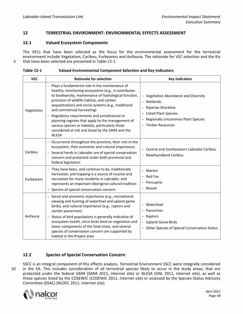
Labrador‐Island Transmission Link Environmental Impact Statement Executive Summary
April 2012 Page 48
12 TERRESTRIAL ENVIRONMENT: ENVIRONMENTAL EFFECTS ASSESSMENT
12.1 Valued Ecosystem Components
The VECs that have been selected as the focus for the environmental assessment for the terrestrial environment include Vegetation, Caribou, Furbearers and Avifauna. The rationale for VEC selection and the KIs that have been selected are presented in Table 12‐1. 5
Table 12‐1 Valued Environmental Component Selection and Key Indicators
VEC Rationale for selection Key Indicators
Vegetation
Plays a fundamental role in the maintenance of healthy, functioning ecosystems (e.g., it contributes to biodiversity, maintenance of hydrological function, provision of wildlife habitat, and carbon sequestration) and social systems (e.g., traditional and commercial harvesting)
Regulatory requirements and jurisdictional or planning regimes that apply to the management of various species or habitats, particularly those considered at risk and listed by the SARA and the NLESA
Vegetation Abundance and Diversity
Wetlands
Riparian Shoreline
Listed Plant Species
Regionally Uncommon Plant Species
Timber Resources
Caribou
Occurrence throughout the province, their role in the ecosystem, their economic and cultural importance
Several herds in Labrador are of special conservation concern and protected under both provincial and federal legislation
Central and Southeastern Labrador Caribou
Newfoundland Caribou
Furbearers
They have been, and continue to be, traditionally harvested, and trapping is a source of income and recreation for many residents in Labrador, and represents an important Aboriginal cultural tradition
Species of special conservation concern
Marten
Red Fox
Porcupine
Beaver
Avifauna
Social and economic importance (e.g., recreational viewing and hunting of waterfowl and upland game birds), and cultural importance (e.g., raptors and certain passerines)
Status of bird populations is generally indicative of ecosystem health, since birds feed on vegetation and lower components of the food chain, and several species of conservation concern are supported by habitat in the Project area
Waterfowl
Passerines
Raptors
Upland Game Birds
Other Species of Special Conservation Status
12.2 Species of Special Conservation Concern
SSCC is an integral component of this effects analysis. Terrestrial Environment SSCC were integrally considered in the EA. This includes consideration of all terrestrial species likely to occur in the study areas, that are 10 protected under the federal SARA (SARA 2011, internet site) or NLESA (GNL 2011, internet site), as well as those species listed by the COSEWIC (COSEWIC 2011, internet site) or assessed by the Species Status Advisory Committee (SSAC) (NLDEC 2011, internet site).

Labrador‐Island Transmission Link Environmental Impact Statement Executive Summary
April 2012 Page 49
12.3 Study Areas
EA study area boundaries are generally VEC‐specific, given the differences between the VECs in terms of their overall characteristics and in the manner in which they may interact with the Project. The LSA and RSA for each Terrestrial Environment VEC are presented in Table 12‐2. The temporal boundaries comprise the Construction, and Operations and Maintenance phases of the Project. 5
Table 12‐2 Local Study Area and Regional Study Area for each Terrestrial Environment Valued Environmental Component
VEC Vegetation Caribou Furbearers Avifauna
Local Study Area
The area where Project‐related components and activities that may affect vegetation will occur
Includes the 2 km wide transmission corridor while also considering the general nature and location of other Project activities and elements
The area where Project‐related components and activities that may affect caribou will occur
Includes the 2 km wide transmission corridor while also considering the general nature and location of other Project activities and elements, where these overlap with areas of caribou occupancy
The area where Project‐related components and activities that may affect furbearers will occur
Includes the 2 km wide transmission corridor while also considering the general nature and location of other Project activities and elements
The area where Project‐related components and activities that may affect avifauna will occur
Includes the 2 km wide transmission corridor while also considering the general nature and location of other Project activities and elements
Regional Study Area
A 15 km wide study area that surrounds the LSA, and is consistent with the habitat quality analyses
Defined with consideration of the potential spatial extent of other Project‐related disturbances, such as noise and dust, which can extend up to 1 km beyond the LSA
Central and Southeastern Labrador Caribou
The boundaries of recognized caribou herd ranges that intersect with the LSA
Newfoundland Caribou
Defined as the total Occupancy Area as provided by the NLDEC Wildlife Division distribution data
A 15 km wide study area that surrounds the LSA, and is consistent with the habitat quality analyses
Defined with consideration of the potential spatial extent of other Project‐related disturbances, such as noise and dust, which can extend up to 1 km beyond the LSA
Is large enough to encompass the home ranges of most of the furbearer species considered
A 15 km wide study area that surrounds the LSA, and is consistent with the habitat quality analyses
Defined with consideration of the potential spatial extent of other Project‐related disturbances, such as noise and dust, which can extend up to 1 km beyond the LSA
Generally encompasses the local seasonal movements of avifauna species during those times and life history stages during which they may interact with the Project

Labrador‐Island Transmission Link Environmental Impact Statement Executive Summary
April 2012 Page 50
12.4 Effects Management
In addition to complying with all applicable permits and regulations, Nalcor has also committed to using best management practices, where feasible. A general description of effects management measures specific to the Terrestrial Environment is discussed in this section.
Effects management measures that Nalcor has incorporated into the Project for Construction, and Operations 5 and Maintenance for Vegetation, include vegetation clearing procedures (e.g., selective clearing, harvest of merchantable timber, spill prevention), avoidance of vegetation communities that are identified as sensitive to disturbance, difficult to reclaim, or of stakeholder or management concern (to the extent practical), measures to prevent the introduction of non‐native and invasive species, and avoidance of wetland and riparian habitat (to the extent practical). 10
Effects management measures that Nalcor has incorporated into the Project for Construction, and Operations and Maintenance for Caribou, include measures to limit the loss or alteration of vegetation, measures to limit dust and noise associated with Project Construction, avoidance of the Primary Core area by at least 500 m (to the extent practical), appropriate waste disposal and spill prevention measures, and the development of an access control measures in consultation with regulators and stakeholders, to monitor and manage public off‐15 vehicle highway (OHV) use of Project roads and trails.
Effects management measures that Nalcor has incorporated into the Project for Construction, and Operations and Maintenance for Furbearers, include measures to limit the loss or alteration of vegetation, measures to limit dust and noise associated with Project Construction, appropriate waste disposal and spill prevention measures, and the development of an access control measures in consultation with regulators and 20 stakeholders, to monitor and manage public OHV use of Project roads and trails.
Effects management measures that Nalcor has incorporated into the Project for Construction, and Operations and Maintenance for Avifauna, include measures to limit the loss or alteration of vegetation, to avoid areas known to support high concentrations of waterfowl (to the extent possible), to provide separation between clearing activities and active raptor nests, to avoid Harlequin Duck breeding sites, and the development of an 25 access control measures in consultation with regulators and stakeholders, to monitor and manage public OHV use of Project roads and trails.
Nalcor will consult with appropriate regulatory authorities regarding final routing, as it relates to terrestrial components in the transmission corridor, including listed plants, Newfoundland marten and woodland caribou on the Island of Newfoundland, as relevant. 30
12.5 Likely Residual Project Effects and Significance
This section summarizes the likely residual effects of Project Construction, and Operations and Maintenance activities on the Terrestrial Environment VECs, and their significance.
The likely residual effects on Vegetation includes loss or alteration and degradation of habitat due to vegetation clearing, soil disturbance, drainage alteration and accidental release of contaminants, resulting in 35 site‐specific contamination, alteration of wetland form or function or riparian shoreline due to unavoidable disturbance during Construction, introduction and spread of non‐native or invasive species from equipment or vehicles entering the Project work sites, loss of habitat to support listed or regionally uncommon plants due to clearing or disturbance (e.g., at L’Anse au Diable electrode site), potential loss of timber resources due to forest fire, and similar effects as a result of vegetation management or major repair activities during 40 Operations and Maintenance. These habitat changes are likely to affect less than 5% of available habitat types or merchantable timber resources that occur within the LSA. Therefore, the Project is not likely to result in significant adverse environmental effects on the Vegetation VEC.
The likely residual effects on Caribou include habitat loss or alteration due to vegetation clearing, possible mortality directly due to collisions with vehicles or indirectly as a result of sensory disturbance and avoidance 45

Labrador‐Island Transmission Link Environmental Impact Statement Executive Summary
April 2012 Page 51
of human activity up to 250 m from Project activities or during Construction or Operations and Maintenance, a reduction in forage availability or access, and changes to migration or movement patterns. Less than 5% of caribou herd ranges in Labrador or caribou Primary Core areas in Newfoundland will be exposed to the effects of Construction, and Operations and Maintenance activities. These are not predicted to affect the viability or recovery of woodland caribou populations in Central and Southeastern Labrador or in Newfoundland. 5 Therefore, the Project is not likely to result in significant adverse environmental effects on the Caribou VEC.
The likely residual effects on Furbearers include habitat loss, alteration or fragmentation due to vegetation clearing, possible mortality directly due to collisions with vehicles or indirectly as a result of sensory disturbance and avoidance of human activity from Project activities during Construction or Operations and Maintenance, and increased mortality due to hunting or trapping pressure associated with increased access 10 along the ROW. As well as the adverse effects, the Project has the potential to increase the amount of suitable habitat for red fox (i.e., maintenance of semi‐open habitat during Operations and Maintenance), and maintenance activities along the ROW and at other Project related facilities are not likely to have an adverse effect on red fox or beavers, species that are relatively tolerant of human activities. The Project is predicted to affect only a small portion of available furbearer habitat within the LSA, and to have no measurable effect on 15 the regional distributions or populations of furbearer species. Therefore, the Project is not likely to result in significant adverse environmental effects on the Furbearers VEC.
The likely residual effects on Avifauna include loss or alteration of primary habitat due to vegetation clearing or wetland disturbance, sensory disturbance due to noise and avoidance of human activity during Construction or Operations and Maintenance depending on species tolerance to human activities and seasonal timing of 20 activity, and increased mortality due to collisions with motor vehicles or electrocution from interaction with high voltage transmission lines. Individual animals may be displaced for the short‐ to medium‐term, depending on the activity type, but the regional distribution of avifauna is not predicted to be affected. The loss of less than 1% of the primary habitat available for avifauna in the RSA is predicted to have a small measurable effect on habitat availability at the local scale and little, if any, effect at the regional scale. Therefore, the Project is 25 not likely to result in significant adverse environmental effects on the Avifauna VEC.
12.6 Analysis of Alternatives
A number of Project alternatives have been considered during the planning of the Project. All Construction and Operations and Maintenance activities discussed for the preferred option would be applied to these options, in the event that they were selected. 30
Likely effects on Terrestrial Environment VECs for each of these alternatives, in relation to the proposed (preferred) transmission corridor were similar and were mostly dependent on differences in habitat alteration. Some differences were also noted based on the locations of known SSCC, caribou Primary Core area, and habitat differences for Avifauna (e.g., wetlands).
12.7 Cumulative Environmental Effects and Significance 35
The cumulative effects assessment considered the overall effect on the Terrestrial Environment (Vegetation, Caribou, Furbearers, and Avifauna VECs) as a result of the Project’s likely residual environmental effects in combination with those of other projects and activities that have been or will be carried out. The existing environment considers all projects and activities that have been undertaken in the past, or are ongoing. The future projects and activities considered for the cumulative effects assessment included those with likely 40 overlapping environmental effects within the RSA.
Table 12‐3 presents the summary of likely cumulative environmental effects for the Terrestrial Environment VECs.

Labrador‐Island Transmission Link Environmental Impact Statement Executive Summary
April 2012 Page 52
Table 12‐3 Cumulative Environmental Effects Summary: Terrestrial Environment
VEC Vegetation Caribou Furbearers Avifauna
Likely Cumulative Environmental Effects (within RSA) of Other Future Projects and Activities
Potential cumulative effects include loss or alteration of habitat as a result of clearing, displacement of native vegetation from the introduction or spread of non‐native and invasive species, and vegetation disturbance or loss due to increased off‐highway vehicle (OHV) use.
Potential cumulative effects relate primarily to landscape disturbances from ongoing commercial forestry and other activities and projects (e.g., habitat loss or alteration due to clearing and / or the introduction or spread of non‐native and invasive species, alteration or disturbance of movement routes, sensory disturbance, and increased access with potential for mortality due to hunting and increased predation).
Potential cumulative effects include the loss or alteration of habitat, temporary disturbance, increased access and changes to small mammal prey densities.
Potential cumulative effects include habitat alteration or loss and fragmentation as a result of clearings and roads created by the Project and other developments, particularly forestry activities, as well as sensory disturbance and increased hunting pressure as a result of increased public OHV access.
Cumulative Environmental Effects Summary
Not Significant
While the contribution of the Project to cumulative environmental effects will likely extend through the life of the Project, they will be limited in scale to the RSA (relative to OHV access) and low in magnitude. Contributing projects have mitigation measures in place to minimize adverse effects and access control measures will be implemented to address increased public OHV use.
Central and Southeastern Labrador Caribou
MMH ‐ The overall level of contribution of the Project to cumulative effects on caribou is limited due to the mitigation proposed, including use of an existing disturbance corridor (i.e., TLH3) and access control. Also, the transmission corridor is relatively remote thereby reducing activities such as OHV use. The cumulative effects of the Project and other foreseeable Projects are not expected to affect the viability of the MMH, therefore the cumulative effects on the MMH are not significant.
RWMH ‐ The Project interaction with the RWMH is limited to the south‐eastern portion of the RWMH range. The effects of the Project are
Not Significant
The contribution of the Project to cumulative environmental effects will primarily be limited to the LSA or potentially the RSA (relative to OHV access along the transmission ROW or access trails) and will be low in magnitude, with a far future duration. The cumulative effects are not likely to affect the KI populations on a regional basis.
Not Significant
While the contribution of the Project to cumulative environmental effects will extend through the life of the Project, effects such as habitat alteration or loss will be limited in scale to the LSA or potentially RSA (relative to OHV access along the transmission ROW and access trails), and low in magnitude.
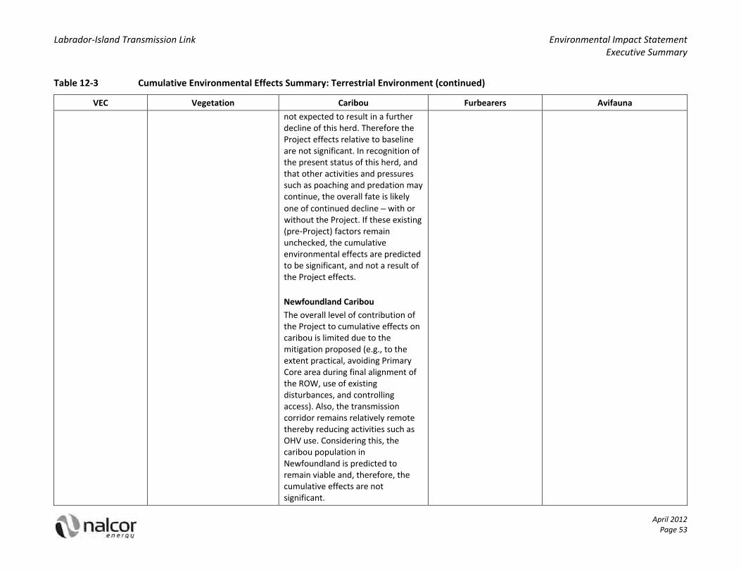
Labrador‐Island Transmission Link Environmental Impact Statement Executive Summary
Table 12‐3 Cumulative Environmental Effects Summary: Terrestrial Environment (continued)
April 2012 Page 53
VEC Vegetation Caribou Furbearers Avifauna
not expected to result in a further decline of this herd. Therefore the Project effects relative to baseline are not significant. In recognition of the present status of this herd, and that other activities and pressures such as poaching and predation may continue, the overall fate is likely
one of continued decline – with or without the Project. If these existing (pre‐Project) factors remain unchecked, the cumulative environmental effects are predicted to be significant, and not a result of the Project effects.
Newfoundland Caribou
The overall level of contribution of the Project to cumulative effects on caribou is limited due to the mitigation proposed (e.g., to the extent practical, avoiding Primary Core area during final alignment of the ROW, use of existing disturbances, and controlling access). Also, the transmission corridor remains relatively remote thereby reducing activities such as OHV use. Considering this, the caribou population in Newfoundland is predicted to remain viable and, therefore, the cumulative effects are not significant.

Labrador‐Island Transmission Link Environmental Impact Statement Executive Summary
April 2012 Page 54
12.8 Monitoring and Follow up: Terrestrial Environment
In consultation with Environment Canada and the NLDEC Wildlife Division, Nalcor is proposing to design a follow‐up program for the Vegetation VEC to target known locations of listed plant species and their important habitats, coupled with a review of OHV use facilitated by the Project. This will include evaluating the success of mitigation efforts undertaken to protect listed plants during Project Construction and developing a 5 reclamation strategy or other mitigation as appropriate.
As a Labrador Woodland Caribou Recovery Team (LWCRT) member, Nalcor will continue to support research to further understanding of the threatened Central and Southeastern Labrador woodland caribou population. Specifically, Nalcor will work with the NLDEC Wildlife Division to develop an effective monitoring program to support the RWMH population, and work with all stakeholders to monitor and control access and deter illegal 10 hunting.
Two follow‐up studies are proposed for the Furbearers VEC. The first program would investigate the effects of ROW Construction, and Operations and Maintenance on marten habitat use. The second study would involve assessing the degree of public access afforded by the ROW and access roads in the first winter following the completion of Project Construction. 15
Prior to Construction commencement Nalcor will conduct a study regarding Harlequin Duck on rivers that are affected by the Project and known to support this species, to determine the extent of breeding activities. Survey results will be used to design mitigation as appropriate in Labrador and to assist in selection of the final alignment in Newfoundland. Immediately following Project Construction and for a period of two years following commencement of Operations and Maintenance, follow‐up surveys will be conducted to assess the 20 effects of the Project on breeding pairs of Harlequin Duck. A follow‐up program to determine nesting success of Osprey and Bald Eagle will also be developed if nests identified within the LSA prior to Project Construction were relocated as a result of vegetation clearing activities.
12.9 Accidents and Malfunctions
Low risk incidents (e.g., brush fire, multiple tower failure, slope failure) on the Terrestrial Environment VECs 25 may result in alteration or loss of habitat types and associated human disturbance. Considering that these events would occur within disturbed areas (e.g., the ROW) and would be limited in scale, the proposed mitigation measures are expected to limit the effects. Moderate to high risk incidents (e.g., large spill of hydrocarbons, large forest fire) have the potential to result in direct mortality of wildlife, and the loss or alteration and fragmentation of habitat, and soil contamination. Forest fire and spill prevention and response 30 measures will be provided in the EPP and SHERP, and firefighting equipment and spill response kits will be available at all worksites. Prevention and response measures are in place and moderate to high risk incidents are unlikely to occur; therefore, the effects are not likely to be significant.

Labrador‐Island Transmission Link Environmental Impact Statement Executive Summary
April 2012 Page 55
13 FRESHWATER ENVIRONMENT: ENVIRONMENTAL EFFECTS ASSESSMENT
13.1 Valued Ecosystems Components
The VECs that have been selected as the focus for the environmental assessment for the Freshwater Environment include Freshwater Resources, and Freshwater Fish and Fish Habitat. The rationale for VEC selection and the KIs that have been selected are presented in Table 13‐1. 5
Table 13‐1 Valued Environmental Component Selection and Key Indicators
VEC Rationale for selection Key Indicators
Freshwater Resources
Importance to human life (i.e., drinking water) and in ecosystem function
Provides a pathway for interactions between the Project and other VECs
Water quality
Freshwater Fish and Fish Habitat
Valued from an ecological, economic and sustenance point of view
Federally or provincially‐listed fish species of conservation concern may occur in watercourses crossed by the Project
Fish habitat
Fish abundance and species assemblage
13.2 Species of Special Conservation Concern
SSCC are an integral component of this effects analysis. Freshwater Environment SSCC were integrally considered in the EA. This includes consideration of all freshwater species likely to occur in the study areas, 10 that are protected under the federal SARA (SARA 2011, internet site) or NLESA (GNL 2011, internet site), as well as those species listed by the COSEWIC (COSEWIC 2011, internet site) or assessed by the SSAC (NLDEC 2011, internet site).
13.3 Study Areas
EA study area boundaries are generally VEC‐specific, given the differences between the VECs in terms of their 15 overall characteristics and in the manner in which they may interact with the Project. The LSA and RSA for each VEC are presented in Table 13‐2. The temporal boundaries comprise the Construction, and Operations and Maintenance phases of the Project.
Table 13‐2 Local Study Area and Regional Study Area for each Freshwater Environment Valued Environmental Component 20
VEC Freshwater Resources Freshwater Fish and Fish Habitat
Local Study Area
Includes freshwater within the 2 km wide transmission corridor while also considering the nature and location of other Project activities and components
Includes freshwater within the 2 km wide transmission corridor while also considering the nature and location of other Project activities and components
Regional Study Area Encompasses an additional 1 km wide
buffer along both sides of the LSA Encompasses an additional 1 km wide
buffer along both sides of the LSA

Labrador‐Island Transmission Link Environmental Impact Statement Executive Summary
April 2012 Page 56
13.4 Effects Management
In addition to complying with all applicable permits and regulations, Nalcor has also committed to using best management practices, where feasible. A general description of effects management measures specific to the Freshwater Environment is discussed in this section.
Standard mitigation measures related to the freshwater environment reflect provincial and federal regulations 5 and guidelines. Nalcor will use accepted standard practices and adhere to permit conditions where permits are required to work on or near water. Areas of disturbance will be limited and occur only where necessary and permitted. Equipment will be in proper working order and where fording a permitted stream is required all precautions will be taken to conduct a clean, efficient crossing. Fording requires a permit which includes information on the stream’s morphology at the proposed crossing location. Substrate, water velocity and 10 depth, and bank slope are among some of the aspects reviewed by provincial authorities prior to granting the fording permit. This pre‐examination of the crossing will be undertaken by Nalcor to select the preferred location at each crossing.
13.5 Likely Residual Project Effects and Significance
This section summarizes the likely residual effects of Project Construction, and Operations and Maintenance 15 activities on the Freshwater Environment VECs, and their significance.
The likely residual effects on Freshwater Resources will be limited as of result of the effects management measures implemented. Any changes to the water quality (i.e., increase in total suspended solids (TSS), nutrients, herbicidal chemicals, toluene or ethylbenzene in exceedance of guidelines, or relative to baseline for those parameters that exceed guidelines under baseline conditions) that may occur as a result of the Project 20 are not expected to affect its baseline functions over the lifetime of the Project. Therefore, the Project is not likely to result in a significant effect on Freshwater Resources.
The likely residual effects on Freshwater Fish and Fish Habitat will be limited by effective mitigation, and proper location of fording and / or stream crossings will minimize disturbance. Fish disturbance from noise and vibration, and increases in suspended sediment and nutrient levels from Project activities will be transient in 25 nature. Changes to physical fish habitat will be localized to only a small section of each watercourse (i.e., at the stream crossing location). Any accidental releases of hydrocarbons that may occur will be responded to in a timely manner based on procedures outlined in the EPP and SHERP. Therefore, changes to Fish and Fish Habitat (i.e., changes in fish habitat or fish abundance / species assemblage) such that the freshwater environment is unable to recover are not likely to occur as a result of the Project. In addition, Nalcor is 30 committed to adhere to the associated legislation, Newfoundland and Labrador Operational Statements (NLOSs) and standard mitigation from both industry and government, and any permit conditions. Considering this, the effects to Fish and Fish Habitat are predicted to be not significant.
13.6 Analysis of Alternatives
A number of Project alternatives have been considered during the planning of the Project. All Construction and 35 Operations and Maintenance activities discussed for the preferred option would be applied to these options, in the event that they were selected.
Likely effects on Freshwater Environment VECs for each of these alternatives, in relation to the proposed (preferred) transmission corridor were similar.
13.7 Cumulative Environmental Effects and Significance 40
The cumulative effects assessment considered the overall effect on the Freshwater Environment (Freshwater Resources and Freshwater Fish and Fish Habitat) as a result of the Project’s likely residual environmental effects in combination with those of other projects and activities that have been or will be carried out. The

Labrador‐Island Transmission Link Environmental Impact Statement Executive Summary
April 2012 Page 57
existing environment considers all projects and activities that have been undertaken in the past, or are ongoing. The future projects and activities considered for the cumulative effects assessment included those with likely overlapping environmental effects within the RSA.
Table 13‐3 presents the summary of likely cumulative environmental effects for the Freshwater Environment VECs. 5
Table 13‐3 Cumulative Environmental Effects Summary: Freshwater Environment
VEC Freshwater Resources Freshwater Fish and Fish Habitat
Likely Cumulative Environmental Effects (within RSA) of Other Future Projects and Activities
Forest harvesting activities within the RSA may result in temporary increases in sediment and particulate matter; vegetation removal may increase risk of soil erosion, which may run off into watercourses
Maintenance of existing roads, including culverts and bridges, may result in temporary increases in sediment and particulate matter
Cumulative Environmental Effects Summary
Not Significant
Effects, such as increases in sediment resulting from the Project are short‐term, and unlikely to overlap temporally and spatially with effects of other projects
Not Significant
Sedimentation and vegetation removal as a result of the Project are localized, and unlikely to overlap temporally and spatially with effects of other projects
13.8 Monitoring and Follow Up: Freshwater Environment
Regular testing of TSS will be conducted in the LSA during Project Construction activities, to ensure that the CCME PAL guideline is not exceeded. Monitoring may be required as a condition of approval for a fording 10 permit or to ensure compliance with regulations regarding water releases and deleterious substances under the Fisheries Act and provincial Water and Sewer regulations. Nalcor will comply with regulatory requirements to monitor water quality during the Project. No monitoring or follow‐up programs are planned for fish SSCC.
13.9 Accidents and Malfunctions
Low risk incidents (e.g., small brush fire, multiple tower failure, slope failure) may result in the introduction of 15 material (e.g., soil, organic debris) into watercourses that provide fish habitat. Considering that these events would occur within disturbed areas (e.g., the ROW) and would be limited spatially, the proposed mitigation measures are expected to limit the effects. Moderate to high risk incidents (e.g., large spill of hydrocarbons, large forest fire) have the potential to result in the direct mortality of aquatic wildlife and vegetation, and a reduction in water quality and quality of fish habitat. Forest fire and spill prevention and response measures 20 will be provided in the EPP and SHERP, and firefighting equipment and spill response kits will be available at all work sites. Prevention and response measures are in place and moderate to high risk incidents are unlikely to occur; therefore, the effects are not likely to be significant.

Labrador‐Island Transmission Link Environmental Impact Statement Executive Summary
April 2012 Page 58
14 MARINE ENVIRONMENT: ENVIRONMENTAL EFFECTS ASSESSMENT
14.1 Valued Ecosystem Components
The VECs that have been selected as the focus for the environmental assessment for the Marine Environment include Marine Fish and Fish Habitat, Marine Mammals and Sea Turtles, and Seabirds. The rationale for VEC selection and the KIs that have been selected are presented in Table 14‐1. 5
Table 14‐1 Valued Environmental Component Selection and Key Indicators
VEC Rationale for selection Key Indicators
Marine Fish and Fish Habitat
Plays a fundamental role in the maintenance of a healthy, functioning marine ecosystem and social systems (e.g., traditional and commercial harvesting)
Benthic Habitat
Marine Water Quality
Fish
Marine Mammals and Sea Turtles
Strait of Belle Isle and Conception Bay represent important foraging and / or migration areas for many species of marine mammals and sea turtles
Several species are considered SSCC
Baleen Whales
Toothed Whales
Pinnipeds
Sea Turtles
Seabirds
Highly visible and have wide social as well as ecological and scientific importance
Strait of Belle Isle and Conception Bay support populations of seabirds that are globally significant in size (e.g., seaducks, alcids, and others)
Several species of seabirds are listed as SSCC, federally and / or provincially
Migrating Shorebirds
Nesting Seabirds
At‐sea Seabirds
14.2 Species of Special Conservation Concern
SSCC are an integral component of this effects analysis. Marine Environment SSCC were integrally considered in the EA. This includes consideration of all marine species likely to occur in the study areas, that are protected 10 under the federal SARA (SARA 2011, internet site) or NLESA (GNL 2011, internet site), as well as those species listed by the COSEWIC (COSEWIC 2011, internet site) or assessed by the SSAC (NLDEC 2011, internet site).
14.3 Study Areas
EA study area boundaries are generally VEC‐specific, given the differences between the VECs in terms of their overall characteristics and in the manner in which they may interact with the Project. The LSA and RSA for each 15 VEC are presented in Table 14‐2. The temporal boundaries comprise the Construction, and Operations and Maintenance phases of the Project.

Labrador‐Island Transmission Link Environmental Impact Statement Executive Summary
April 2012 Page 59
Table 14‐2 Local Study Area and Regional Study Area for the Marine Environment Valued Environmental Components
VEC Marine Fish and Fish Habitat Marine Mammals and Sea Turtles Seabirds
Local Study Area
The 500 m wide submarine cable crossing corridor in the Strait of Belle Isle and the two marine areas defined by buffers of 500 m radius from the proposed shoreline electrode sites at L’Anse au Diable in the Strait of Belle Isle, and Dowden’s Point in Conception Bay
The 500 m wide submarine cable crossing corridor in the Strait of Belle Isle and the two marine areas within a 500 m radius from the proposed shoreline electrode sites at L’Anse au Diable in the Strait of Belle Isle, and Dowden’s Point in Conception Bay
The 500 m wide submarine cable crossing corridor in the Strait of Belle Isle and the two marine areas defined by arcs of 500 m radius from the proposed shoreline electrode sites at L’Anse au Diable in the Strait of Belle Isle and Dowden’s Point in Conception Bay
Includes the terrestrial landing sites for the submarine cable
Regional Study Area
The Strait of Belle Isle RSA for the submarine cable crossing corridor and the L’Anse au Diable shoreline electrode site are comprised of the Strait of Belle Isle as well as part of the Gulf of St. Lawrence
Dowden’s Point RSA is a 10 km radius around Dowden’s Point
The Strait of Belle Isle RSA for the submarine cable crossing corridor and the L’Anse au Diable shoreline electrode site are comprised of the Strait of Belle Isle as well as part of the Gulf of St. Lawrence
Dowden’s Point RSA is a 10 km radius around Dowden’s Point
The Strait of Belle Isle RSA for the submarine cable crossing corridor and the L’Anse au Diable shoreline electrode site are comprised of the Strait of Belle Isle as well as part of the Gulf of St. Lawrence
The Conception Bay RSA consists of Conception Bay as well as Grates Point, Baccalieu Island and Cape St. Francis Important Bird Areas
14.4 Effects Management
In addition to complying with all applicable permits and regulations, Nalcor has also committed to using best 5 management practices, where feasible. A general description of effects management measures specific to the Marine Environment is discussed in this section.
Effects management measures that Nalcor has incorporated into the Project for Construction, and Operations and Maintenance, for Marine Fish and Fish Habitat include controlled rock placement during berm construction, selection of chemically‐benign rock for berm construction, minimizing construction time to 10 decrease the amount of exposure to vessel noise by invertebrates and fishes, the use of silt curtains during electrode site dredging, electrode design to minimize the electric and electromagnetic fields (e.g., through selection of electrode materials and maximization of electrode surface area), and minimizing the contact area between the shoreline pond and the berm to create a safe voltage gradient on the sea side of the berm.
Effects management measures that Nalcor has incorporated into the Project for Construction, and Operation 15 and Maintenance, for Marine Mammals and Sea Turtles include the maintenance of constant course and speed by Project vessels (whenever possible), avoidance of any concentrations of marine mammals and sea turtles (whenever possible), completion of construction as quickly as safety allows, electrode design that minimizes EMF (e.g., through electrode design, electrode materials, electrode surface area, low resistivity surroundings), and minimizing the contact area between the shoreline pond and the berm to create a safe voltage gradient 20 on the sea side of the berm.

Labrador‐Island Transmission Link Environmental Impact Statement Executive Summary
April 2012 Page 60
Effects management measures that Nalcor has incorporated into the Project for Construction, and Operations and Maintenance, for Seabirds include equipment maintenance and operations to limit noise and the potential for inadvertent release of contaminants, daily monitoring of seabird strandings, reduction of lighting (if deemed safe and feasible), and electrode design to minimize the electric and electromagnetic fields (e.g., through selection of electrode materials and maximization of electrode surface area). 5
14.5 Likely Residual Project Effects and Significance
This section summarizes the likely residual effects of Project Construction, and Operations and Maintenance activities on the Marine Environment VECs, and their significance.
The likely residual effects on Marine Fish and Fish Habitat include loss of bottom habitat and associated change in benthic community structure and biotic injury due to rock berm construction and dredging, 10 increased seawater turbidity due to rock berm construction and dredging, and invertebrate and fish behavioural responses to various underwater sounds and operations‐related electric fields and EMFs emanating from the submarine cable and shoreline electrodes. These effects will relate to less than 10% of bottom substrate, seawater and biota that occur in the RSA. The same is predicted for the effects that are unlikely to occur (e.g., changes to sediment chemistry and biotic health due to electrode electrolysis products). 15 Therefore, the Project is not likely to result in significant adverse environmental effects on the Marine Fish and Fish Habitat VEC.
The likely effects on Marine Mammals and Sea Turtles include behavioural responses to various underwater sounds and operations‐related EMFs emanating from the submarine cable and shoreline electrodes, and potential temporary hearing impairment from vessel operations. These effects will relate to less than 10% of 20 the marine mammals and sea turtles that occur in the RSA. In addition, Project activities that produce underwater sound will be most frequent and, hence, most likely to cause behavioural effects during a six‐month‐period of the Construction phase. During this time, marine mammals and sea turtles are predicted to exhibit localized and temporary avoidance responses that will not seriously affect migration or foraging. Therefore, the Project is not likely to result in significant adverse environmental effects on the Marine 25 Mammals and Sea Turtles VEC.
The likely effects on Seabirds include limited changes in behaviour and distribution of seabirds due to habitat alteration or habitat loss at the shoreline electrode sites, temporary displacement of some foraging seabirds during Construction, and potentially some mortality resulting from seabird strandings and collisions. No detectable change to the abundance, distribution, behaviour, habitat use or nesting success of seabirds in the 30 RSA is predicted to occur as a result of the Project. Therefore, the Project is not likely to result in significant adverse environmental effects on the Seabirds VEC.
14.6 Analysis of Alternatives
Based on the technology being used, there were no alternatives identified to the submarine cable corridor selected for the crossing of the Strait of Belle Isle; consequently, an evaluation for the environmental 35 implications of Project alternatives was not completed for the Marine Environment.
14.7 Cumulative Environmental Effects and Significance
The cumulative effects assessment considered the overall effect on the Marine Environment (Marine Fish and Fish Habitat, Marine Mammals and Sea Turtles, Seabirds) as a result of the Project’s likely residual environmental effects in combination with those of other projects and activities that have been or will be 40 carried out. The existing environment considers all projects and activities that have been undertaken in the past, or are ongoing. The future projects and activities considered for the cumulative effects assessment included those with likely overlapping environmental effects within the RSA.
Table 14‐3 presents the summary of likely cumulative environmental effects for the Marine Environment VECs.

Labrador‐Island Transmission Link Environmental Impact Statement Executive Summary
April 2012 Page 61
Table 14‐3 Cumulative Environmental Effects Summary: Marine Environment
VEC Marine Fish and Fish Habitat Marine Mammals and Sea
Turtles Seabirds
Likely Cumulative Environmental Effects (within RSA) of Other Future Projects and Activities
Effects (i.e., bottom substrate disturbance, introduction of underwater sound to the marine environment) are expected as a result of vessel traffic, dredging and other activities in the Strait of Belle Isle and Conception Bay.
Effects from vessel traffic associated with other activities would be primarily behavioural responses to underwater noise. Marine mammals and sea turtles may experience mortality from collisions with vessels not associated with the Project. In addition, harp and hooded seals are harvested in the RSA as part of the commercial hunt managed by Fisheries and Oceans Canada (DFO). Some marine mammals and possibly sea turtles may experience mortality as a result of fishing by‐catch.
Overlapping effects would be limited to those resulting from marine vessel traffic (i.e., primarily related to behavioural responses to underwater noise) associated with other activities within the RSA, and the related disturbance and potential for strandings.
Cumulative Environmental Effects Summary
Not Significant
Due to the small area affected and the new habitat created, the cumulative effect of likely Project effects that overlap both temporally and geographically with other past, present and reasonably foreseeable projects and activities is not likely to be significant.
Not Significant
Due to the low speeds under which the Project vessels will operate, the cumulative effect of likely Project effects that overlap both temporally and geographically with effects from other past, present and reasonably foreseeable projects and activities is not likely to be significant.
Not Significant
Due to the minimal effect and limited overlap, the cumulative effect of likely Project effects that overlap both temporally and geographically with effects from other past, present and reasonably foreseeable projects and activities is not likely to be significant.
14.8 Monitoring and Follow Up: Marine Environment
Monitoring of any compensation works as a result of HADD of marine fish habitat will be conducted according to a protocol acceptable to DFO. A follow‐up program will also be conducted by Nalcor to evaluate the EMFs 5 that will be generated by the operating submarine cable and electrodes, and the level of production of electrolysis products at the electrode sites. This program would provide in situ gradient‐to‐background electromagnetic measurements at varying distances from the sources. These monitoring and follow‐up programs would be designed in consultation with DFO and other relevant parties such as the Newfoundland and Labrador Department of Fisheries and Aquaculture and / or Environment Canada, as appropriate. 10
Specific monitoring and follow‐up programs for Marine Mammals and Sea Turtles are not proposed.

Labrador‐Island Transmission Link Environmental Impact Statement Executive Summary
April 2012 Page 62
Based on the results of the effects assessment, monitoring and follow‐up programs for the Seabirds VEC are not proposed. Nalcor will, during Project Construction and during their routine inspections during Operations and Maintenance, note any incidents related to effects to seabirds (e.g., stranding) and address these issues appropriately through their adaptive management process.
14.9 Accidents and Malfunctions 5
Low risk incidents (e.g., release of drilling mud, localized slope failure, vessel‐wildlife collision) may result in the introduction of material (e.g., mud, soil, organic debris) into marine habitat. Moderate to high risk incidents (e.g., large spill of hydrocarbons) have the potential to result in the direct mortality of wildlife, a loss of marine habitat, and a reduction of marine water quality. Spill prevention and response measures will be provided in the EPP and SHERP, and spill response kits will be available at all work sites. Prevention and response measures 10 are in place and moderate to high risk incidents are unlikely to occur; therefore, the effects are not likely to be significant.

Labrador‐Island Transmission Link Environmental Impact Statement Executive Summary
April 2012 Page 63
15 EXISTING SOCIOECONOMIC ENVIRONMENT
This section describes the existing human environment relevant to the Project, including each of its associated and relevant components. In doing so, it establishes the current, baseline environmental conditions from which likely Project‐related changes are assessed.
15.1 Historic and Heritage Resources 5
The Study Area for Historic and Heritage Resources encompasses the 2 km wide transmission corridor, the 500 m wide submarine cable corridor, as well as considering the location of other Project‐related components and activities. Also included in the Study Area are expanded areas on either side of the Strait of Belle Isle in recognition of their Historic and Heritage Resources potential.
Archaeological Resources: In Labrador, 115 archaeological sites are registered with the Provincial Archaeology 10 Office (PAO) within the Study Area. Areas with enhanced archaeological potential along the transmission corridor include several stream crossings (e.g., the Traverspine, Kenamu and St. Augustine rivers) and several large ponds. Two of these ponds have known Innu toponyms: Mush‐nipi and Tshiashku‐nipi. In addition, areas of enhanced archaeological potential were identified in the Muskrat Falls area, and the Strait of Belle Isle area in and around Forteau and L’Anse au Diable. Within the Strait of Belle Isle, only one marine archaeological site 15 (i.e., the remains of the HMS Raleigh) has been registered with the PAO. In Newfoundland, there are eleven archaeological sites registered with the PAO within the Study Area. Areas of enhanced archaeological potential were identified near major rivers, preserved marine or riverine terraces, including along the Strait of Belle Isle and the Shoal Cove area.
Sites of Cultural and Spiritual Importance: Sites of cultural and spiritual importance were identified by Innu 20 Nation and Pakua Shipi in the Study Area. These sites include the Manitu‐utshu (or the rock knoll), which is located on the north side of Muskrat Falls. Other sites identified by Innu Nation and Pakua Shipi include birth sites, burial sites, shaking tent ceremony locations, and the location of the Land‐based Family Treatment Programme Camp.
Palaeontological Resources: There are some sedimentary rocks (i.e., rocks with some potential for 25 palaeontological resources) near the Churchill River, however the palaeontological potential of this continental deposit is negligible and fossils have not been recorded here (Gower 1986; Williams et al. 1985, internet site). With the exception of the sedimentary rocks near the Churchill River, the portion of the transmission corridor from Muskrat Falls to the south Labrador coast passes over rocks that are not considered to be a fossil host. Where the transmission corridor crosses the south Labrador coast, it passes through the Forteau Formation 30 near L’Anse Amour. Outcrops of red limestone situated along the cliffs at the upper end of the beach and just offshore at L’Anse Amour, are the site of rare reef‐building fossils referred to as Archeocyathids (Dubrenne and James 1981; James and Dubrenne 1980; Fong 1967).
Approximately 5 km south of the transmission corridor at Flower’s Cove on the Northern Peninsula of Newfoundland, there are outcrops of thrombolites (large algal mounds) that can be seen on both sides of this 35 bay (Colman‐Sadd and Scott 1994; Kennard and James 1986). The transmission corridor inland of the Strait of Belle Isle crosses many areas covered by bog, where no fossils have been reported (Stantec 2010c). In Central and Eastern Newfoundland, the transmission corridor crosses formations that rarely contain fossils and a search of the literature produced no evidence of fossils in the vicinity of the transmission corridor (Stantec 2010c). Near the community of Chapel Arm on the Avalon Peninsula, there is an outcrop containing “small 40 shelly fossils” of unknown affinity (Landing et al. 1988).
Architectural Resources: A review of the assembled data for the Study Area indicates that there is only one building, structure or site meeting the criteria for protection on provincial lands within the Study Area; the Point Amour Lighthouse.

Labrador‐Island Transmission Link Environmental Impact Statement Executive Summary
April 2012 Page 64
15.2 Communities
The Study Area for Communities includes consideration of those regions that contain, are crossed by, or lie in close proximity to Project components, as well as the province as a whole. The regional discussions consider the Regional Economic Zones.
15.2.1 Regions and Communities 5
The Central and Southeastern Labrador region encompasses communities in the Upper Lake Melville area of Labrador (Happy Valley‐Goose Bay, North West River, Mud Lake and Sheshatshiu), together with the communities along the Labrador South Coast and in the Labrador Straits area. The total population of the region in 2006 was 13,615, a decline of 5.2% since 2001. Most of the communities in the region have populations of less than 500 with the main concentration of population in the Upper Lake Melville area and 10 specifically in Happy Valley‐Goose Bay.
There are number of Aboriginal communities and organizations in Labrador and Quebec several of which are located within, and/or which claim Aboriginal right to, portions of the Central and Southeastern Labrador region. Approximately one third of people living in Labrador are of Aboriginal descent, self‐identifying as Innu, Inuit or NCC. 15
There are approximately 80 communities in the Northern Peninsula region, from St. Anthony at the northern tip, south to Corner Brook on the west coast. The total population of the region in 2006 was 58,875, a decline of 2.8% since 2001, with the City of Corner Brook being the largest community in the region.
The Central and Eastern Newfoundland region is located to the southeast of the Northern Peninsula, through the north‐central portion of the Island, and southeast as far as the Isthmus of Avalon. In 2006 the population 20 of the region was 115,905, a decline of 4.4% since 2001. There are approximately 200 communities in the region of which Grand Falls‐Windsor, Gander and Clarenville are among the largest.
The Avalon Peninsula region includes approximately 140 communities ranging from the larger, cities of St. John’s and Mount Pearl and towns such as Conception Bay South, Paradise and Bay Roberts, to small rural communities in the south, southwestern and northwestern parts of the region. The population increased by 25 2.4% over the 2001‐2006 period to 243,835, which represents approximately 48% of the total provincial population.
15.2.2 Community Infrastructure and Services
Transportation Infrastructure: The TLH is the main highway serving Central and Southeastern Labrador. The three phases of the TLH now form a continuous route of approximately 1,150 km linking Labrador West and 30 Southern Labrador (Newfoundland and Labrador Department of Transportation and Works (NLDTW) 2009, internet site). On the Island, the main highways are Route 430 linking St. Anthony in the north and Deer Lake in the south, and the TCH linking Deer Lake, Grand Falls‐Windsor, Gander, Clarenville and St. John’s.
The coastal geography and the settlement history of the province mean that ports play an important role in many aspects of community life. By contrast there is only one railway in the province, in Labrador, and this has 35 a highly specialized role associated with iron ore shipments.
In Central and Southeastern Labrador, airports include the Goose Bay Airport and the Lourdes‐de‐Blanc Sablon Airport on the north shore of the St. Lawrence, in Québec. On the Island, there are airports in St. Anthony, Deer Lake, Gander, and St. John’s. Several small airstrips are also present in the province.
Waste Management: Currently, eight Regional Waste Management Authorities operate on the Island, and four 40 operate in Labrador. Each authority is responsible for waste management activities within its respective region, such as recycling, waste diversion and composting, as well as management of waste that is harmless to the environment, and disposing of true waste materials at one of the regional sites.

Labrador‐Island Transmission Link Environmental Impact Statement Executive Summary
April 2012 Page 65
The provincial government has yet to finalize a waste management plan for Labrador. Happy Valley‐Goose Bay is currently acting as an informal regional landfill site for the central part of the Study Area. A landfill serving the communities from L’Anse au Clair to Pinware is located at Crow Head, within the municipal boundaries of Forteau. This landfill is currently near capacity.
On the Northern Peninsula, the landfill at Castors River was decommissioned, and the St. Barbe and Straits 5 landfill sites were cleaned up and re‐developed into one consolidated landfill site. The dump sites at St. Lunaire‐Griquet and Cook’s Harbour are in the process of being closed out. In Central and Eastern Newfoundland, a waste disposal site is being built at Norris Arm, as well as seven local waste management facilities or transfer stations. The Norris Arm site will be the main waste disposal site for all communities on the Island west of Clarenville. On the Avalon Peninsula, a total of 42 landfill sites are planned to be closed, and 10 the Robin Hood Bay waste management site in St. John’s will be used as the main waste disposal site for all communities east of Clarenville.
Water Supply: Approximately 83% of the province’s population receives water from public sources and 17% from private sources. The majority of public water sources are surface water (88%) (i.e., lakes, ponds, reservoirs, rivers and streams), and the remaining are groundwater (12%) (i.e., dug and drilled wells). 15
Electrical Power: NLH, the main generator of electricity in the province, has an installed generating capacity of approximately 1,635 megawatts (MW) that is comprised of hydroelectric, oil‐fired thermal, gas turbine, and diesel plants, and thousands of kilometres of associated transmission and distribution lines. Newfoundland Power, the main distributor of electricity in the province, distributes power to approximately 240,000 customers on the Island, over 90% of which it purchases from NLH. In Labrador, customers are served by NLH 20 with power from the Churchill Falls Hydroelectric Generating Station in Labrador West, or from generators operated by NLH.
Communications: Telecommunications infrastructure and services in Newfoundland and Labrador are delivered by the private sector, regulated by the federal government through the Canadian Radio‐television and Telecommunications Commission (CRTC). Landline services are available throughout the province, but cell 25 phone coverage still varies geographically by availability, type and company. Access to the Internet has increased steadily in the province in recent years. In 2009, 69% of the population had Internet access from any location.
Policing, Fire Protection and Emergency Response: The Royal Newfoundland Constabulary (RNC) and the Royal Canadian Mounted Police (RCMP) have responsibility for policing in Newfoundland and Labrador. The 30 RNC currently polices the St. John's Metropolitan Area, Corner Brook and Labrador. Newfoundland and Labrador has the lowest requirement level for policing in Canada, reflecting the province’s relatively low crime rates.
Fire and Emergency Services: Fire and Emergency Services Newfoundland and Labrador is an agency that combines the roles of the Provincial Fire Commissioner with the Emergency Measures Organization. Its 35 mandate is to maintain an emergency management system across the province, in collaboration with such partners as municipalities. A road ambulance service is provided from 80 locations across the province (Newfoundland and Labrador Department of Health and Community Services (NLDHCS) 2011, internet site), and an emergency air ambulance program has been in place in this province since the early 1950s. Community fire protection services are provided across the province by local or regional fire departments, the majority of 40 which are staffed by either voluntary personnel or a composite of career and voluntary personnel. Forest fire protection is provided by the provincial government through the Forestry Services Branch, Department of Natural Resources.
Housing: The province has recently experienced a surge in house prices. This has been attributed to historically low interest rates, combined with overall economic strength, which has led to high overall market demand 45 (Canadian Mortgage and Housing Corporation (CMHC) 2010, internet site). Much of the recent economic growth in the province has occurred in the St. John’s Census Metropolitan Area and where prices have

Labrador‐Island Transmission Link Environmental Impact Statement Executive Summary
April 2012 Page 66
increased the greatest. In April 2011 the overall provincial rental vacancy rate was 2.1%, up from 1.1% in April 2010.
Education: Public school boards in Newfoundland and Labrador administer the daily operations of Kindergarten to Grade 12 schools within their district. In recent years, Newfoundland and Labrador has seen a decline in the number of schools, students and full‐time teachers, and in the student‐teacher ratio. Post‐5 secondary education and training in the province is provided through Memorial University, the College of the North Atlantic (CNA), and 27 registered private training institutions.
Income Support and Training Services: The Income and Employment Support Act and the Income and Employment Support Regulations govern Newfoundland and Labrador's social assistance program. In 2008/2009, Newfoundland and Labrador had the second lowest increase in social assistance cases in the country, likely 10 because of the high Employment Insurance (EI) coverage. The Department of Human Resources, Labour and Employment provides financial benefits and other services to eligible low‐income individuals and families to assist in meeting daily living expenses. In 2008, the incidence of Income Support varied from a low of 3.3% in Economic Zone 5 of the Central and Southeastern Labrador region to 11.8% in Economic Zone 12 in the Central and Eastern Newfoundland region. 15
15.2.3 Community Health
The Department of Health and Community Services administers health and community services in Newfoundland and Labrador. In 2002, there were 35 hospitals and health care centres, 21 nursing homes, three community clinics and 13 nursing stations in the province, which provided a total of 1,681 acute care beds and 2,839 long‐term care beds (NLDHCS 2002). The level of service, as defined by the number of nurses 20 and doctors per capita, is comparable to other provinces in Canada.
In 2007‐08, 61.8% of people living in Newfoundland and Labrador self‐assessed their health status as ‘excellent’ to ‘very good’. Of those, 73.0% believed their health status was ‘about the same’ as compared to the previous year. Forty‐three percent of people in 2007‐08 had some self‐perceived life stress, and 30.5% of Newfoundland and Labrador residents felt a very strong sense of belonging to community (Newfoundland and 25 Labrador Statistics Agency (NLSA) / Community Accounts 2011, internet site). The age‐adjusted suicide rate (the standardized rate based on the age distribution of the population as a whole) for Labrador in 2001 was estimated at 27 per 100,000, compared with 6.7 per 100,000 for the province as a whole (Statistics Canada 2001).
According to the 2008‐09 Canadian Community Health Survey (those sampled were 45 years and older), 79.4% 30 of people in Newfoundland and Labrador did not smoke. From the same survey, 53.6% considered themselves to be overweight, and 73.7% of survey participants said they had consumed alcohol in the past 12 months. Just over half (51.2%) of the entire population (over the age of 12 years) of Newfoundland and Labrador claimed they were physically inactive (NLSA / Community Accounts 2011, internet site).
Alcohol and solvent abuse is one of the most pressing health issues among Aboriginals in Labrador and is 35 believed to be at the root of many other social ailments such as homicide, child abuse and neglect, family dysfunction and suicide. In addition dietary practices are often poor with typical diets high in fat and deficient in fruits, vegetables and dairy products, as well as calcium and other important minerals.
For the province as a whole, 87.8% of people had access to regular medical doctor in 2007‐08 (NLSA/Community Accounts 2011, internet site). Diabetes and heart disease are two of the most common 40 diseases in Canada and they are more common in Newfoundland and Labrador than in Canada as a whole (NLDHCS 2008, internet site). In 2008‐09, for the healthy aging category (those 45 years plus), other chronic conditions affecting the people of Newfoundland and Labrador included arthritis, high blood pressure, back problems and thyroid condition.

Labrador‐Island Transmission Link Environmental Impact Statement Executive Summary
April 2012 Page 67
15.3 Economy, Employment and Business
The Study Area for Economy, Employment and Business is focused primarily on the province as a whole as well as considering the various regions from Central and Southeastern Labrador to the Island of Newfoundland within which Project activities will occur. Economic data for these regions were obtained from the provincial Economic Development Zones crossed by the Project. 5
15.3.1 Economy
For many years since Confederation, Newfoundland and Labrador had the slowest growing economy in Canada. This situation was aggravated in the late 1980s and early 1990s with closures in the groundfish industry. The performance of the Newfoundland and Labrador economy today has improved dramatically, largely a result of the growth of the offshore oil sector, mineral production in northern Labrador and iron ore 10 production in western Labrador.
Central and Southeastern Labrador: The economy of Central and Southeastern Labrador is based primarily on the service industry and raw material extraction. Major industries include hydro, aerospace, services to the mining industry, fish harvesting and processing, forest resources and tourism (NLDTW 2006, internet site).
Northern Peninsula: The fishery has historically been the main economic activity on the Northern Peninsula, 15 and the collapse of the groundfish sector and subsequent closure of many of the fish processing plants had a substantial social and economic effect. Recently, the area has experienced some economic diversification through harvesting and processing of alternative species such as shellfish. Tourism and the forestry sector are the other principal economic drivers within this region’s economy (NEDC 2008, internet site).
Central and Eastern Newfoundland: The economy of Central and Eastern Newfoundland has long been based 20 on resource extraction and related industrial activities, including fishing, mining, pulp and paper. The Grand Falls‐Windsor and Bishop’s Falls areas are major industrial, service and government centres in Central and Eastern Newfoundland, with the forestry and pulp and paper industries serving historically as major employers. The Town of Gander also serves as a public and private sector service centre and transportation hub for the region. In the eastern portion of the region, Clarenville is the commercial and government service 25 centre for the surrounding area, including the Bonavista and Trinity Bay areas. In the coastal areas of the Central and Eastern Newfoundland region, the fishery remains an important element of the economy.
Avalon Peninsula: The economy of the Avalon Peninsula region is dominated by activity in the St. John’s Census Metropolitan Area. As the main centre of government and the location for many of the province’s major industries, the Census Metropolitan Area has a more diverse and well‐developed economic base 30 compared to other parts of the province. Within the Census Metropolitan Area, a variety of industries, including professional, scientific, construction and retail trade, are forecast to experience strong growth in 2010 and beyond (City of St. John’s 2010, internet site).
15.3.2 Employment
The overall unemployment rate in the province fell from approximately 16.2% in 2001 to 13.2% in 2008. 35 Unemployment rose to 15.5% in 2009 during the recession. Employment losses and growth in the labour force have contributed to the recent increases in the unemployment rate. Assuming the continued recovery of the economy, annual average employment is projected to grow over the next four to five years (Newfoundland and Labrador Department of Finance (NLDF) 2010, internet site). There are a number of groups already in the labour market that are underrepresented and continue to face employment challenges and barriers that limit 40 their full participation, including women, persons with disabilities, Aboriginal groups, youth, and mature workers.
Data from 2006 indicate that the main sources of employment by industry were Business Services (14.2%), Retail Trade (12.3%), Health Care and Social Assistance (12.2%) and Other Services (20.1%). The industries that

Labrador‐Island Transmission Link Environmental Impact Statement Executive Summary
April 2012 Page 68
employed the fewest people were Finance and Real Estate (3.2%) and Wholesale Trade (2.7%) (Statistics Canada 2006).
15.3.3 Business
As of December 2009, there were 17,228 businesses in Newfoundland and Labrador, most of which (56.2%) employed one to four people. Retail Trade (15%), Health Care and Social Assistance (12%), and Construction 5 (11%) represented the largest specific businesses categories in 2009. The general category of Other Services (18.2%) was in fact the largest and, in recent years, the fastest growing category (NLSA 2009, internet site). Growth in this unspecified services category perhaps reflects an increasing diversification of business activity in the province.
15.4 Land and Resource Use 10
The Study Area for Land and Resource Use focuses on land and resource uses within or adjacent to the transmission corridor as well as consideration of the location of other Project‐related components and activities. A larger 15 km wide buffer on either side of the transmission corridor centre line was selected for resource harvesting activities that are more wide‐ranging and less geographically defined.
15.4.1 Communities and Water Supply Areas 15
Central and Southeastern Labrador: Central and Southeastern Labrador communities are located in the Upper Lake Melville area (Happy Valley‐Goose Bay, Northwest River, Sheshatshiu and Mud Lake), along the south‐eastern coast and along the Strait of Belle Isle. The transmission corridor crosses the boundary of L’Anse au Loup and Forteau in the Labrador Straits, including their water supply area. It also crosses portions of the L’Anse Amour’s water supply. 20
Northern Peninsula: The Northern Peninsula region includes nearly 100 small to medium sized communities from the northern points of Cook’s Harbour and Straitsview to Corner Brook in the south‐west and Hampden in the south‐east (Newfoundland and Labrador Department of Municipal Affairs (NLDMA) 2009). The Strait of Belle Isle submarine cable crossing will land at Shoal Cove on the Northern Peninsula. South of the landing location, the corridor overlaps the boundaries and water supply areas of four communities: Shoal Cove East, 25 Savage Cove‐Sandy Cove, Nameless Cove, and Flower’s Cove. Portions of the water supply of the Town of Hawke’s Bay are also crossed by the transmission corridor.
Central and Eastern Newfoundland: The Central and Eastern Newfoundland region includes approximately 275 communities from the east side of White Bay to the west side of Trinity Bay. The proposed transmission corridor overlaps the boundaries of nine communities in Central and Eastern Newfoundland: Grand Falls‐30 Windsor, Port Blandford, Clarenville, Goobies, Sunnyside, Arnold’s Cove, Southern Harbour, Norman’s Cove‐Long Cove, Chapel Arm. Portions of the water supply of the communities of Port Blandford, Clarenville, Arnold’s Cove, Southern Harbour, Norman’s Cove – Long Cove, Chapel Arm, Gander, Glenwood and Appleton are also within the corridor.
Avalon Peninsula: The Avalon Peninsula region includes nearly 90 communities on the north‐west and north‐35 east tips of the Avalon Peninsula, and includes the provincial capital of St. John’s. The transmission corridor overlaps the boundaries of five communities: Whitbourne, Blaketown, Avondale, Harbour Main‐Chapel’s Cove‐ Lakeview, Holyrood and the shoreline electrode is located within Conception Bay South. Portions of the water supply for St. John’s, Whitbourne, Avondale, and Harbour Main – Chapel’s Cove – Lakeview are also within the transmission corridor. 40
15.4.2 Transportation
Central and Southeastern Labrador: The transmission corridor parallels and crosses Route 510 a number of times along the recently completed TLH3 near Forteau. The transmission corridor also crosses the Designated Flight Training Area (DFTA) that begins at 5‐Wing Goose Bay and covers an area extending south, west and

Labrador‐Island Transmission Link Environmental Impact Statement Executive Summary
April 2012 Page 69
north and into Québec. DND Flying Orders include minimum altitudes of between 100 feet, 250 feet and 500 feet for this area (DND 2010).
Strait of Belle Isle: Marine traffic through the Strait of Belle Isle is limited to ice free periods, usually between April and January. Several types of vessels travel across and through the Strait when the channel is open. The Labrador Straits ferry crosses between Blanc‐Sablon and St. Barbe two to three times daily in each direction 5 during ice free periods. During winter 2010 and 2011 the ferry service was maintained year‐round by operating between Blanc‐Sablon and Corner Brook (NLDTW 2010).
Northern Peninsula: The transmission corridor crosses four highways on the Northern Peninsula: Route 430 between Shoal Cove and Savage Cove‐Sandy Cove, Route 432 inland, Route 420 near White Bay South, and Route 421 near Hampden. 10
Central and Eastern Newfoundland: The transmission corridor crosses five highways in Central and Eastern Newfoundland: Route 1 (TCH) at various locations, Route 370 near Buchans, Route 360 near Bay d’Espoir, Route 201 near Chapel Arm‐Bellevue, Route 203 near Fair Haven.
Avalon Peninsula: The transmission corridor crosses and / or parallels the TCH and a number of paved two‐lane highways that connect to communities from Chapel Arm to Conception Bay South. It crosses Route 1 15 (TCH) at various locations, Route 13 near Witless Bay Line, Route 63 near Avondale, Route 80 near Trinity Bay South, Route 81 near Markland, Route 90 near Salmonier Line, and Route 100 near the Argentia Access Road.
15.4.3 Hunting and Trapping
Central and Southeastern Labrador: The transmission corridor crosses six moose management areas (MMA) and one black bear management area (BBMA). The corridor also crosses portions of the Southern Zone small 20 game management area (SGMA), the Labrador South fur zone, two migratory game bird hunting zones, and a murre hunting zone in the Strait of Belle Isle.
Northern Peninsula: The transmission corridor crosses portions of six MMAs, six BBMAs and three caribou management areas (CMA). It also crosses portions of the Remainder of Island SGMA, the Northern Coastal, Northern Inland and Murre Hunting Zone 2, and Fur Zones 10 and 11 as well as Lynx Management Zone A. 25
Central and Eastern Newfoundland: The transmission corridor crosses portions of 13 MMAs and BBMAs and six CMAs. The corridor also crosses portions of the Remainder of Island, The Topsails and Avalon / Swift Current SGMAs and the Southern Inland migratory game bird hunting zone. The corridor crosses portions of six of the seven fur zones in Central and Eastern Newfoundland.
Avalon Peninsula: The transmission corridor crosses portions of five MMAs and BBMAs and one CMA. All of 30 the BBMA and the CMA are closed to hunting. The corridor crosses the Avalon / Swift Current SGMA, the Avalon‐Burin Inland migratory game bird hunting zone and Fur Zone 2.
15.4.4 Recreational Fishing
Central and Southeastern Labrador: The transmission corridor crosses the Forteau River, Angling Zone 14B and the Eagle Plateau Management Zone, a special trout management area. 35
Northern Peninsula: Three scheduled salmon rivers are crossed by the transmission corridor on the Northern Peninsula: Portland Creek feeder and tributary streams, East River and Castor River. The East River is currently closed to salmon fishing. A special trout management area includes Ten Mile Lake, Round Lake and all waters running in and out of both of these lakes and the St. Genevieve River System.
Central and Eastern Newfoundland: Ten scheduled salmon rivers are crossed by the transmission corridor in 40 this region. Five of these are partially closed to salmon angling.

Labrador‐Island Transmission Link Environmental Impact Statement Executive Summary
April 2012 Page 70
Avalon Peninsula: The transmission corridor crosses two scheduled salmon rivers: North Arm River and Northeast River.
15.4.5 Aboriginal Contemporary Traditional Land Use
Labrador Innu: Based on available information, there is little contemporary traditional land use within or adjacent to the transmission corridor. Rather, contemporary traditional land use activities are mainly practiced 5 along the Churchill River, near Happy Valley‐Goose Bay, in the Mealy Mountains area and in parts of Southwest Labrador.
Armitage (2010) reports that the Innu Nation cabin database shows a camp location potentially within the transmission corridor near Muskrat Falls. Outpost Programme records indicate that this camp, last occupied in 1993, may fall within the transmission corridor approximately 25 km south of Muskrat Falls (Armitage 2010). 10 Hunting of small game was reported in the area around Grand Lake and the Red Wine River as well as at a number of locations along and north of the TLH between Happy Valley‐Goose Bay and Churchill Falls. Partridge and porcupine kill sites were reported within the transmission corridor near Muskrat Falls (Armitage 2010). Based on available information there is no record of berry picking or medicinal plant harvesting in or near the transmission corridor. Three places of cultural significance fall within the Study Area, and potentially within the 15 transmission corridor. Manitu‐utshu, or the rock knoll, located on the north side of Muskrat Falls and within the transmission corridor, is considered by Innu Elders to be the home of giant otter‐like beings known as Uenitshikumishiteu. One birth place was recorded within about 10 km of Muskrat Falls. The location of a former shaking tent ceremony was at Muskrat Falls. The last shaking tent ceremony took place in 1969.
Labrador Inuit: Based on available information, there is no evidence of Labrador Inuit contemporary 20 traditional land use activities in the Study Area. Rather, Labrador Inuit contemporary traditional land use activities are focused on lands within the Labrador Inuit Land Claims Agreement (LILCA). Contemporary traditional land use activities include: hunting for seals, birds, rabbits, caribou and moose, as well as fishing and trapping. The general Lake Melville area has been used, and continues to be used, extensively by Labrador Inuit for a broad range of traditional activities, including hunting, fishing, trapping, wood cutting and 25 snowmobile travel. The transmission corridor does not overlap with land covered by the LILCA.
NCC: Members of NCC, who reside in the communities throughout Central and Southeastern Labrador, traditionally lived a subsistence lifestyle and utilized the land primarily for this purpose. Currently, members of NCC travel along many routes, in particular from the coast; however, travel along the TLH is the main mode of contemporary travel for land use and concentrations of cabins occur along the coast. Members of the NCC fish, 30 trap, hunt birds and game in Central and Southeastern Labrador. Based on information obtained under the Phase II Community Agreement involving interviews with members of NCC in 2011, fishing, trapping and hunting areas were identified where the transmission corridor follows the TLH3, near the headwaters of the Eagle River and in the southern section of the corridor near the Labrador Straits. Berry harvesting and wood harvesting areas were identified within the transmission corridor where the transmission corridor follows the 35 TLH3, and in the southern section of the corridor near the Labrador Straits. One area near Forteau Point and the Labrador Straits Highway was identified for harvesting juniper for medicinal purposes. Places of cultural significance were not identified near the transmission corridor during 2011 interviews with members of NCC.
Pakua Shipi: Based on available data, some contemporary traditional land use of the Innu of Pakua Shipi overlaps with the Study Area. While current traditional land use activities are practiced mainly near the 40 community, during the fall and winter some community members go on the land for longer periods of time and have identified some travel routes, camp sites, hunting and trapping areas as well as one cultural site along the transmission corridor. Nalcor is collecting additional land and resource use information with the Innu of Pakua Shipi as part of the Phase II Community Engagement Agreement. Data collected as a part of this agreement will be considered and incorporated where relevant, including the potential for mitigation and 45 adaptive management during detailed design and routing.

Labrador‐Island Transmission Link Environmental Impact Statement Executive Summary
April 2012 Page 71
Unamen Shipu: The contemporary traditional land use activities of the Innu of Unamen Shipu are based on a long history and tradition of hunting, fishing, travelling, gathering, and establishing encampments. As confirmed in interviews conducted for the Conseil Attikamek‐Montagnais (CAM) study (1983a) the Innu of Unamen Shipu traditionally were highly mobile and travelled over a large territory, with none overlapping the transmission corridor. Nalcor will collect additional primary land and resource use information as part of the 5 recent community engagement agreement with the community of Unamen Shipu. Detailed maps will be derived from the data collected under the community engagement agreement and will form part of the additional information that will be considered and incorporated where relevant, including the potential for mitigation and adaptive management during detailed design and routing.
Nutashkuan: Travelling along traditional routes to set up encampments to practice hunting, trapping, and 10 fishing activities remains an important part of the traditional activities of the Innu of Nutashkuan. Interviews conducted during the CAM study (1983b) describe the importance and details of contemporary seasonal hunting, trapping and fishing patterns, which involved many species of fish and wildlife. The contemporary traditional land use activities of the Innu of Nutashkuan occur mainly south‐west of the proposed transmission corridor, along the coast of the St. Lawrence River, at the mouth of rivers. Data do not indicate contemporary 15 traditional land use by the Innu of Nutashkuan in or near the transmission corridor.
Ekuanitshit: Historic land use practices have shaped the contemporary practices of the Innu of Ekuanitshit. Hunting, trapping and fishing are practiced near their community and as far north as Labrador. Based on the CAM study of 1983, it is apparent that land use activities occur more than 100 km west of the transmission corridor. The contemporary traditional land use activities of the Innu of Ekuanitshit occur mainly southwest of 20 the transmission corridor, along the coast of the St. Lawrence River, at the mouth of rivers. Also, in their submission to the Joint Review Panel for the Lower Churchill Hydroelectric Generation Project, representatives from Ekuanitshit indicated that there had been historic travel as far as North West River in Labrador. Available data does not indicate contemporary traditional land use by the Innu of Ekuanitshit in or near the transmission corridor. 25
Uashat mak Mani‐Utenam: The Innu of Uashat mak Mani‐Utenam continue to practice traditional activities within their traditional territory, where they travel, hunt, fish, gather and establish encampments (Uashaunnuat et al. 2010, internet site). Based on available information, the contemporary traditional land use activities of the Innu of Uashat mak Mani‐Utenam occur west of the transmission corridor, along the coast of the St. Lawrence River, at the mouth of rivers and along Route 138. Available data does not indicate 30 contemporary traditional land use by the Innu of Uashat mak Mani‐Utenam in or near the transmission corridor.
Matimekush‐Lac John: Based on the available information, the contemporary traditional land use activities of the Innu of Matimekush‐Lac John take place in all areas surrounding both communities but are limited by territory restrictions such as the Saguenay Beaver Reserve, which assigned specific territories to trappers. Their 35 contemporary traditional land use activities mainly occur west of the transmission corridor. Available data does not indicate contemporary traditional land use by the Innu of Matimekush‐Lac John in or near the transmission corridor.
Kawawachikamach: Based on a review of the available literature and information provided by the Naskapi Nation of Kawawachikamach (NNK), contemporary traditional land use activities by NNK members occur near 40 Schefferville and on the land set aside under the Northeastern Québec Agreement (NEQA). Henriksen (1978) and CAM (1982) have also identified travel routes and camp sites used by NNK members along the TLH in Labrador. Available data does not indicate that NNK members use areas in or near the transmission corridor.
15.4.6 Hunting and Fishing Outfitters
Central and Southeastern Labrador: The Central and Southeastern Labrador region has 25 outfitting camps 45 which are mainly located around the Minipi River, Eagle River, Paradise River, St. Lewis River, Pinware River and Forteau River systems (NLDTCR 2009b). No outfitting camps are located within the transmission corridor.

Labrador‐Island Transmission Link Environmental Impact Statement Executive Summary
April 2012 Page 72
Northern Peninsula: The 77 outfitting camps on the Northern Peninsula are located mainly in the Long Range Mountains with a concentration in the Main River area in the southern part of the peninsula, and several camps located near Main Brook and Roddickton in the northern part (Newfoundland and Labardor Department of Tourism Culture and Recreation (NLDTCR) 2009). Three outfitting camps are located within the transmission corridor. Although outfitting camps may not be located within the transmission corridor, guides 5 and their clients may travel through or use an area crossed by the transmission corridor.
Central and Eastern Newfoundland: Central and Eastern Newfoundland has a total of 75 outfitting camps which are located throughout the interior and along the river systems of the Indian River, West River, South Brook, Exploits River, Gander River and Terra Nova River. No outfitting camps are located within the transmission corridor (NLDTCR 2009). Although outfitting camps may not be located within the transmission 10 corridor, guides and their clients may travel through or use an area crossed by the transmission corridor.
Avalon Peninsula: No outfitting camps are located on the Avalon Peninsula.
15.4.7 Motorized Recreational Vehicle Use
Central and Southeastern Labrador: The transmission corridor crosses the Basques Whalers Trail and all‐terrain vehicle (ATV) trails in the Labrador Straits area north of Forteau. Motorized boats may be used inland at 15 outfitter fishing camps. Recreational boats are also used along the south‐eastern coast and in the Straits. Intercommunity boat traffic is common, as is using boats for recreational fishing along the coast.
Northern Peninsula: At least seven snowmobile trails are crossed by the transmission corridor. These are mainly located in four areas: in the communities near the cable landing site; adjacent to Route 432 which crosses the Northern Peninsula; south‐east of Hawke’s Bay; and near the Main River. The transmission corridor 20 also crosses ATV trails near communities along the Strait of Belle Isle and along Route 432.
Recreational boats are based in coastal communities. Intercommunity boat traffic is common, as is using boats for recreational fishing along the coast. Motorized boating occurs on some of the larger lakes and ponds with road access. The transmission corridor also overlaps Ten Mile Lake and Portland Creek Pond where boating occurs. 25
Central and Eastern Newfoundland: At least six segments of snowmobile trails (around Birchy Lake, Badger and Grand Falls ‐ Windsor) are crossed by the transmission corridor. The T’Railway Provincial Park and other snowmobile and ATV routes are crossed by or are parallel to the corridor at several locations, including near Badger, near Shoal Harbour, at Sunnyside and from Arnold’s Cove to Bellevue. Motorized boating occurs on some of the larger lakes including Birchy Lake and Thorburn Lake. 30
Avalon Peninsula: The transmission corridor crosses and parallels snowmobile trails, ATV trails and the T'Railway Provincial Park from the centre of the Avalon Peninsula, near the intersection of Route 71 (Makinsons), east to the intersection of Route 62 (Holyrood). The corridor also overlaps some of the larger ponds and lakes (e.g., Ocean Pond, Middle Gull Pond, Southwest Pond) where motorized boating occurs.
15.4.8 Cabins and Cottage Development Areas 35
Central and Southeastern Labrador: Seven cabins (one cottage and six remote cottages) are located within the transmission corridor in this region.
Northern Peninsula: One hundred and twenty eight cabins (59 cottages and 69 remote cottages) are located within the transmission corridor. These cabins are located on various waterbodies such as Green Island Brook, Eastern Lake, Round Lake, Pikes Feeder Pond, Eastern Blue Pond, River of Ponds, Flat Pond, Brians Pond, 40 Portland Creek Pond and in the Upper Humber River area.
Central and Eastern Newfoundland: There are 167 cottages (94 cottages and 73 remote cottages) located within the transmission corridor. These are located at Birchy Lake, Three Corner Pond, on and near the Exploits

Labrador‐Island Transmission Link Environmental Impact Statement Executive Summary
April 2012 Page 73
River between Badger and Grand Falls ‐ Windsor, Great Ratting Brook (Bay d’Espoir Highway), Sunday Lake, Hayne’s Lake, the Northwest and Southwest Gander River area, the Terra Nova River, Stephen’s Pond, Holloway’s Pond (near Port Blandford), Thorburn Lake, Andrews Pond, Loon Lake, John Penney Pond, Headwaters Pond, Goobies Pond, near Little Harbour Head and Grassy Point Pond.
Avalon Peninsula: There are 309 cottages within the transmission corridor, located on and near Goose Pond, 5 Hodgewater Pond, Grand Pond, Ocean Pond, Goulds Pond, Goulds Big Pond, Nine Island Pond, Colliers Big Pond, Jacks Pond, Second Junction Pond, Rocky Pond, Middle Gull Pond, Five Mile Pond West, Brigus Junction and Witless Bay Line.
15.4.9 Recreational Activities
Central and Southeastern Labrador: Although camping, hiking, golf, canoeing and kayaking amenities exist in 10 this region, none of these recreational amenities or activities are known to be located within the transmission corridor.
Northern Peninsula: The transmission corridor crosses sections of the International Appalachian Trail south‐east of River of Ponds, Portland Creek and Parson’s Pond, and proposed trails between Parson’s Pond and Main River. The corridor also overlaps portions of canoeing, kayaking and white‐water rafting areas. 15
Central and Eastern Newfoundland: Camping, golf, hiking, rafting, kayaking and skiing occur in this region. Known skiing recreational facilities and activities are located within the transmission corridor.
Avalon Peninsula: Hiking and skiing occurs along the T’Railway Provincial Park and trails in Butter Pot Provincial Park, both of which overlap with the transmission corridor. Freshwater canoeing / kayaking occurs predominately in areas where ponds and lakes are linked (e.g., Middle Gull Pond, Peak Pond) and paddlers can 20 avoid long portages. The transmission corridor crosses Middle Gull Pond near the TCH.
15.4.10 Parks and Other Protected Areas
Central and Southeastern Labrador: Existing or proposed parks in this region include the Mealy Mountains National Park Reserve, the Eagle River Waterway Provincial Park, Gannet Islands Ecological Reserve, and Pinware River Provincial Park. None of the existing or proposed parks are crossed by the transmission corridor. 25
Northern Peninsula: There are two United Nations Educational, Scientific and Cultural Organization (UNESCO) World Heritage Sites at Gros Morne National Park and L’Anse aux Meadows in this region. Provincial parks include Pistolet Bay, the Arches, Main River, Sir Richard Squires and Blow Me Down. Wilderness and ecological reserves include those at Burnt Cape, Watt’s Point, Hare Bay, Sandy Cove, Table Point and Flat Water Pond Park Reserve. The transmission corridor overlaps a small portion of the north western part of Main River 30 Waterway Provincial Park Reserve.
Central and Eastern Newfoundland: This region includes Terra Nova National Park and Notre Dame, Dildo Run, Deadman’s Bay, Lockston Path and the Dungeon provincial parks. Park reserves are located at Jonathan’s Pond (Gander), Windmill Bight (Wesleyville) and Jack’s Pond and Bellevue Beach on the Isthmus of the Avalon Peninsula. Ecological reserves are located at Little Grand Lake, West Brook, the Funk Islands and Bay du Nord. 35 The transmission corridor overlaps portions of the West Brook Ecological Reserve, the T’Railway Provincial Park and Jack’s Pond Provincial Park.
Avalon Peninsula: The Avalon Peninsula region has no national parks but several national historic sites including Signal Hill in St. John’s. Butter Pot Provincial Park and Salmonier Nature Park are located in the region. There are provincial park reserves at Fitzgerald’s Pond and Marine Drive. Wilderness and ecological 40 reserves are located at Baccalieu Island, Hawke Hills, Witless Bay and the large Avalon Wilderness Reserve. The transmission corridor overlaps portions of Hawke Hill, Witless Bay and the large Avalon Wilderness Reserve. The transmission corridor overlaps portions of Hawke Hill Ecological Reserve, the T’Railway Provincial Park and Butter Pot Provincial Park.

Labrador‐Island Transmission Link Environmental Impact Statement Executive Summary
April 2012 Page 74
15.4.11 Forestry
Central and Southeastern Labrador: The transmission corridor crosses portions of Forest Management Districts 19A 19C and 21. District 19A has a Five Year Operating Plan for the period 2008‐2012 during which 1,000,000 m3
of timber is scheduled to be harvested, and 73 km of forestry access roads are to be constructed. District 21 has a Five Year Operating Plan for the period 2007‐2011 during which 48,700 m3 is scheduled to be 5 harvested and 18.9 km of forestry access roads are to be constructed. Forestry activity is not planned for District 19C.
Northern Peninsula: The transmission corridor crosses portions of Forest Management Districts 16, 17 and 18 and a small portion of District 9. The extensive forestry access road system creates a high level of existing access for industries, commercial activity, recreation and subsistence on the Northern Peninsula. District 16 10 plans to harvest 892,875 m3 of timber. In District 17, operators plan to harvest 630,514 m3 of timber and to construct about 64 km of access roads.
Central and Eastern Newfoundland: The transmission corridor overlaps with portions of Forest Management Districts 1, 2, 4, 6, 9, 10, 11 and 12 and a small portion of District 16. Portions of Districts 6 and 9 are tenured to Corner Brook Pulp and Paper Limited. 15
Avalon Peninsula: On the Avalon Peninsula, the transmission corridor crosses Forest Management District 1. A total of 64,561 m3 of productive forest is scheduled to be harvested.
15.4.12 Mining and Onshore Oil and Gas Exploration
Central and Southeastern Labrador: As this area was recently made more easily accessible by the December 2009 connection of Route 510, mineral exploration activity is increasing in Central and Southeastern 20 Labrador. Fifteen quarries and four staked claims are located within the transmission corridor.
Northern Peninsula: The transmission corridor crosses staked mineral claims located to the north‐east of Daniel’s Harbour, near Portland Creek, and off Route 420 in the Upper Humber River Area. Two gravel quarries near Flower’s Cove are located within the transmission corridor. It also crosses the oil and gas exploration area near Parson’s Pond. 25
Central and Eastern Newfoundland: The transmission corridor overlaps portions of more than 40 staked claims around Birchy Lake, Sheffield Lake, Badger, Grand Falls‐Windsor, Southwest Gander River, Deer Pond, Thorburn Lake, north of Goobies, northeast and southeast of Arnold’s Cove and southeast of Chapel Arm. The Beaver Brook Antimony Mines Inc. overlaps with the transmission corridor near Gander. Twenty‐five gravel quarries are located within the transmission corridor; they are mainly between Badger and Grand Falls‐30 Windsor and from Port Blandford to the Isthmus of the Avalon, associated with the highways.
Avalon Peninsula: The Avalon Peninsula has no active mines. Six staked claims and three gravel quarries are located within the transmission corridor.
15.4.13 Agriculture
Central and Southeastern Labrador: Commercial agriculture activity is limited in Labrador, and the only 35 Agricultural Development Area (ADA) surrounds Upper Lake Melville. The transmission corridor crosses bakeapple harvesting areas near Forteau.
Northern Peninsula: The Northern Peninsula has no commercial agriculture activity.
Central and Eastern Newfoundland: There are numerous ADAs in Central and Eastern Newfoundland, and cranberry farms have been developed around Grand Falls‐Windsor, Bishop’s Falls and Terra Nova. A 40 commercial farm located at Badger is within the transmission corridor.

Labrador‐Island Transmission Link Environmental Impact Statement Executive Summary
April 2012 Page 75
Avalon Peninsula: The transmission corridor crosses areas supporting agricultural areas at Whitbourne, Brigus Junction and Salmonier Line. Three blueberry management units (areas reserved for commercial and subsistence blueberry harvesting), located in the Mahers ‐ Brigus Junction area, are located within the transmission corridor, and a regional pasture in the Soldiers Pond area is located near the transmission corridor. 5
15.4.14 Other Harvesting Activates
People throughout the province participate in a variety of harvesting activities including wood cutting, roadside gardening and gathering wild berries, fruits, flowers, plants, lichens and mushrooms. These activities have been an integral part of traditional subsistence and more recently, recreational activities.
15.5 Marine Fisheries 10
In the past two decades, marine fisheries underwent significant changes, owing largely to the collapse of groundfisheries (mainly Atlantic cod) and consequent fisheries moratoria and quota reductions within the area after 1993. Since the partial reopening of the cod fishery in 1997, groundfish catches have slowly increased. There has also been a substantial decline in the harvest of capelin since 2006. Other fisheries that have been important within the last 20 years are scallops, shrimp, herring, snow crab and lobster. 15
Current key fisheries species include several of the important species from 20 years earlier (e.g., lobster, cod, capelin, scallop, mackerel and herring), as well as other species that have grown in importance in more recent years, in particular shrimp and snow crab. In addition, some new fisheries are emerging and may have more economic potential in the future, such as rock crab, toad crab and sea cucumber. Seal harvesting in winter on the ice provides supplementary income mainly through the sale of harp skins for some fishers in most years. 20
The fishing gear used typically reflects the species fishery (e.g., pots for snow crab and lobster, or shrimp trawls for shrimp). Most groundfish are harvested using either gill nets or longlines. Pelagic species (capelin, herring and mackerel) are harvested using a variety of gear, including seines, gill nets and traps. Most of the harvest is taken by small‐boat (under 35 feet) enterprises.
The marine fisheries near the submarine cable crossing focus on a few traditional commercially harvested 25 species (mainly lobster, scallops and pelagic species) as well as some newer or emerging fisheries. In this area, the fisheries are pursued by local fishers from homeports on both sides of the Strait, and by fishers from outside the area who come there for specific fisheries (e.g., herring).
Pelagics: Capelin, herring and mackerel, though relatively low in price, are important for the large quantities they contribute to the fisheries. Capelin harvesting activities vary in response to market demand and thus can 30 fluctuate greatly from year to year. Herring landings experienced a rapid increase in landings during the mid to late 1990s but these levels were not sustained in subsequent years. Mackerel are taken mainly with purse seines, traps and handlines.
Lobster: The lobster fishery, which had been the highest value fishery in past years, has gone through a number of cycles over the last two decades. The lobster fishery occurs on the Newfoundland side of the Strait 35 of Belle Isle, along the shoreline between Anchor Point and Yankee Point in water depths less than 30 m.
Groundfish: The majority of the groundfish harvest is Atlantic cod, but Atlantic cod harvests dropped drastically after the closure of the fisheries in the 1990s. In recent years the other principal groundfish species have been lumpfish and halibut. In the past, most of the cod catch was by mobile gear (otter trawl). However, given resource conditions, the current catch is taken using fixed gear: nets, and hook and line. Lumpfish, which 40 are harvested for their high‐value roe, are caught using nets in waters along the shoreline between Forteau Point and Pinware on the Labrador side, and in the same area as the lobster fishery on the Newfoundland side. Halibut is fished with hook and line gear, in water depths of 12 m and deeper, on grounds located between Anchor Point and Green Island Cove.

Labrador‐Island Transmission Link Environmental Impact Statement Executive Summary
April 2012 Page 76
Scallops: The Icelandic scallop fishery exhibited a rapid increase in landings during the early 1990s followed by a gradual decline. Fishers report that, in recent years, only 10 to 14 vessels (using drags, dredges or rakes) have been actively involved due to poor market conditions, regulatory restrictions and other factors (Canning & Pitt 2010). Scallops are found throughout much of the Strait of Belle Isle, and grounds for this species extend as far as Red Bay. According to harvesters, the most suitable scallop beds are generally found where water depths 5 are greater than 60 m.
Whelk: Labrador‐based fishers report that whelk are generally found in the same areas and at the same water depths (e.g., 20 m and less), in which pelagic species such as herring are taken (Canning & Pitt 2010). Whelk fishers on the Newfoundland side of the Strait of Belle Isle say that they generally fish whelk in water depths of 30 m or deeper (Canning & Pitt 2010). 10
Eels: Eels are harvested on the Labrador side of the Strait of Belle Isle in various freshwater locations, such as Forteau Brook and L’Anse au Loup Brook. They are harvested using eel pots or fyke nets.
Seals: Fishers based in ports on both sides of the Strait of Belle Isle harvest seals. If the seals are in the area in the spring, most fishers choose to harvest them on the ice closest to their homeports.
Toad and Rock Crab: Toad and rock crab are quite abundant on the Labrador and Newfoundland sides of the 15 Strait of Belle Isle. On the Labrador side, toad crab are taken in water between 8 m to 10 m and about 100 m depth. On the Newfoundland side, toad crab are found in water depths between 12 m and 120 m, while rock crab tend to inhabit water depths less than 60 m (Canning & Pitt 2010).
Snow Crab: Although snow crab emerged as an important economic species in the years following the groundfish closures, snow crab catches in the north‐eastern Gulf of St. Lawrence have been low since 2002. 20 Most of the snow crab harvesting occurs away from the Project area, in other parts of the Gulf of St. Lawrence and off the Labrador coast (Canning & Pitt 2010).
Shrimp: Although some shrimp harvesting may occur in the general vicinity of the submarine cable corridor, the main activities are concentrated 65 km or more distant, well to the south‐west of the Project (see Canning & Pitt 2010). 25
15.5.1 Aboriginal Fisheries
DFO reports that food / social / ceremonial fishing licences have been issued to members of the Innu Nation and the NCC. These are licences to harvest trout, salmon and char within the Upper Lake Melville area and in the coastal area between Fish Cove Point (near Black Tickle) and Cape St. Charles. There are no commercial fish harvesting activities by any members of these Aboriginal groups or organizations. southwest of Cape 30 St. Charles.
15.5.2 Aquaculture
There are currently no licensed aquaculture sites in or the submarine cable crossing corridor area in the Strait of Belle Isle, with the closest existing aquaculture operations more than 75 km away.
15.5.3 Recreational Fisheries 35
The Area Chief of Resource Management (Ball 2010, pers. comm.) reports that the primary recreational fishing activity in the Strait of Belle Isle is for cod. Other recreational / food fisheries include those for capelin (harvested by hand or with cast nets), mackerel (taken with rod and reel gear) and scallop.
15.5.4 Dowden’s Point
Nearshore fishing grounds are used primarily for the harvest of pelagic species such as capelin, herring and 40 mackerel. Most of the catch is capelin, nearly all of which is harvested in larger 35 to 64 foot vessels using

Labrador‐Island Transmission Link Environmental Impact Statement Executive Summary
April 2012 Page 77
mobile gear such as purse seines and tuck seines. Lobster, herring and lumpfish are harvested on suitable grounds closer to shore in the area between Lance Cove and Dowden’s Point. Recreational fishing activities in the immediate vicinity of the shoreline electrode site include the harvest of brown trout by trolling gear close to shore, and cod using handlines, usually in water depths between 32 and 36 m (Lear 2011, pers. comm.)
15.6 Tourism 5
Central and Southeastern Labrador: This region has large wilderness areas that are used mainly for local recreational and subsistence activities. Most tourism activity relates to outfitting, and more specifically salmon fishing. Two large parks proposed for the area, Mealy Mountains National Park Reserve and Eagle River Waterway Provincial Park, will increase tourism and recreational opportunities. Top provincial destinations are Red Bay and Battle Harbour. In 2009 and 2010, the entire region experienced an increase in accommodations 10 occupancy which is likely a result of additional tourist, resident and commercial travel due to the connection of Happy Valley‐Goose Bay with Cartwright.
Northern Peninsula: The Northern Peninsula is best known by tourists as the location of Gros Morne National Park and L’Anse aux Meadows National Historic Site which are both UNESCO World Heritage Sites. Marble Mountain and the Humber River, both top recreation destinations, are located at the base of the Northern 15 Peninsula region. Annual accommodations occupancy has been fairly consistent with the patterns seen in the province as a whole. However, occupancy rates are lowest in the Gros Morne area, which is likely due to the fact that the area has mainly summer tourists rather than year‐round business travellers as does the Corner Brook area.
Central and Eastern Newfoundland: Top destinations include Twillingate, Fogo and Change Islands, Terra Nova 20 National Park, Bonavista, Trinity and White Hills Ski Resort. The annual regional average accommodations occupancy rate is consistent with that of the province which is rising steadily (NLDTCR‐S 2011, internet site). Most areas had a lower occupancy rate in 2005 but have recovered and seen increases.
Avalon Peninsula: Top natural and cultural destinations within the Avalon Peninsula region include Cape St. Mary’s, Cupids, Brigus, Ferryland, St. John’s and George Street. Natural attractions include ecological 25 reserves at Cape St. Mary’s, Baccalieu Island, Hawke Hill and Witless Bay. The region also encompasses the large Avalon Wilderness Ecological Reserve. Salmonier Nature Park is also located on the Avalon Peninsula. Accommodations occupancy is consistent with the province and within the region. However, the North West Avalon has lower occupancy rates. The St. John’s area has a strong year‐round tourism industry which is in part based on business, meetings and convention travel. 30
15.7 Visual Aesthetics
The visual aesthetics of the existing landscape along the transmission corridor is classified using a modified version of the Bureau of Land Management (BLM) Visual Resource Management (VRM) System (United States Department of the Interior (USDI) 1984). Twelve key observation points (KOP) were selected along the transmission corridor and classified. Visual inventory classes (Classes I to IV) are determined by a scenic quality 35 evaluation and a sensitivity level analysis. The scenic quality rating is determined by evaluating scenic factors such as landform, vegetation, water, colour, adjacent scenery, scarcity, and cultural modifications that measures visual appeal of a tract of land. The sensitivity levels are the measure of public concern for scenic quality determined by analyzing sensitivity factors such as type of user, amount of use, public interest, adjacent land uses, and special areas. 40
The Study Area is a variable width buffer extending out from the Project components to encompass the views from selected KOPs and considers the 15 km wide corridor along the transmission corridor presented in the Viewscapes Component Study (Stantec 2011).
The KOPs represent a series of points along a travel route where the Project components will likely be most noticeable. The KOPs were selected to represent views within the five regions crossed by the Project, including 45

Labrador‐Island Transmission Link Environmental Impact Statement Executive Summary
April 2012 Page 78
Central and Southeastern Labrador, Strait of Belle Isle, Northern Peninsula, Central and Eastern Newfoundland and the Avalon Peninsula. Based on visibility and viewer sensitivity, the study team selected 12 KOPs that offer the least obstructed view, most representative view, view likely to be seen by the greatest number of people and / or the worst‐case scenario of the Project with respect to visual aesthetics.
To augment this approach, Nalcor used the results of viewshed modelling completed for the Viewscapes 5 Component Study (Stantec 2011) to determine the potential effects of the Project on visual aesthetics. Computer modelling (details provided in Stantec 2011) was used to generate maps showing the potential number of transmission towers visible from a given location, and the visual exposure (i.e., figures that present the likely visibility of the proposed transmission towers). The conceptual illustrations of Project components in different regions, presented for ground level and elevated views, were also used to inform the assessment. 10
The Project will cross 1,100 km of the province, approximately 88% of which is uninhabited Crown land and is therefore rarely seen by the public; thereby, reducing overall visual sensitivity. The visual aesthetics of the Study Area are influenced by the variations in topography, vegetation composition and related colours, waterbody / wetland characteristics (e.g., ponds, rivers, bogs) and man‐made disturbances. Portions of the Project are within areas of the province that are natural and remote from urban centres. Other portions of the 15 Project cross areas of the province that support communities and areas that have been disturbed for forestry, transportation and other infrastructure, and tourism and recreational facilities.
KOP 01 is at the Kenamu River in Central and Southeastern Labrador. This view was selected because the Kenamu River is crossed by the TLH3, used for recreational purposes, and this is an area of interest based on consultation with stakeholders. The view was rated as Class III, which should partially retain the existing 20 landscape character; the level of change may be moderate and could attract attention but should not dominate the view.
KOP 02 is along the TLH3 in Central and Southeastern Labrador. This view was selected due to the presence of the TLH3 and because it was an area of interest based on consultation with stakeholders. The view was rated as Class IV, which can accommodate major modifications to the landscape character; the level of change may 25 dominate the view.
KOP 03 is near Forteau Point in Central and Southeastern Labrador. This view was selected because the transmission corridor crosses near existing highways and communities. The view was rated as Class IV, which can accommodate major modifications to the landscape character; the level of change may dominate the view.
KOP 04 is near Portland Creek Pond on the Northern Peninsula. This view was selected because of the 30 proximity to outfitters, boating, and the International Appalachian Trail. The view was rated as Class II, which should retain the existing landscape character; the level of change may be minimal and should not attract attention.
KOP 05 is located near Rack Lake on the Northern Peninsula. This view was selected because of the proximity to outfitters, the crossing of higher elevations and minimal tree cover. The view was rated as Class III, which 35 should partially retain the existing landscape character; the level of change may be moderate and could attract attention but should not dominate the view.
KOP 06 is near Four Ponds on the Northern Peninsula. This view was selected due to the proximity to outfitters and proposed trails of the International Appalachian Trail. The view was rated as Class III, which should partially retain the existing landscape character; the level of change may be moderate and could attract 40 attention but should not dominate the view.
KOP 07 is near Birchy Lake in Central and Eastern Newfoundland. This view was selected due to the proximity of the TCH and a recreation area. The view was rated as Class III, which should partially retain the existing landscape character; the level of change may be moderate and could attract attention but should not dominate the view. 45

Labrador‐Island Transmission Link Environmental Impact Statement Executive Summary
April 2012 Page 79
KOP 08 is along the Buchans Highway in Central and Eastern Newfoundland. This view was selected due to the proximity of tall tree cover, a highway, and the Exploits River. The view was rated as Class IV, which can accommodate major modifications to the landscape character; the level of change may dominate the view.
KOP 09 is along the Exploits River in Central and Eastern Newfoundland. This view was selected due to the proximity of the Exploits River, the use of the river for recreational rafting, and the Riverfront Chalet. The view 5 was rated as Class III, which should partially retain the existing landscape character; the level of change may be moderate and could attract attention but should not dominate the view.
KOP 10 is near Chapel Arm on the Avalon Peninsula. This view was selected because it shows the community entry road off the TCH. The view was rated as Class IV, which can accommodate major modifications to the landscape character; the level of change may dominate the view. 10
KOP 11 is near the Witless Bay Line on the Avalon Peninsula. This view was selected as it shows an existing power transmission line on an expanse of flat terrain, and silhouetted against the sky. The view was rated as Class IV, which can accommodate major modifications to the landscape character; the level of change may dominate the view.
KOP 12 is near Soldiers Pond on the Avalon Peninsula. This view was selected as it shows the proposed location 15 for the Soldiers Pond converter station near the TCH. The view was rated as Class IV, which can accommodate major modifications to the landscape character; the level of change may dominate the view.

Labrador‐Island Transmission Link Environmental Impact Statement Executive Summary
April 2012 Page 80
16 SOCIOECONOMIC ENVIRONMENT: ENVIRONMENTAL EFFECTS ASSESSMENT
16.1 Valued Environmental Component Selection
The VECs that have been selected as the focus for the Socioeconomic Environment effects include Historic and Heritage Resources; Communities; Economy, Employment and Business; Land and Resource Use; Marine Fisheries; Tourism; and Visual Aesthetics. The rationale for VEC selection and the KIs that have been selected 5 are presented in Table 16‐1.
Table 16‐1 Valued Environmental Component Selection and Key Indicators
VEC Rationale for selection Key Indicators
Historic and Heritage Resources
historic, cultural, spiritual, natural, scientific and aesthetic importance
Archaeological resources
Palaeontological resources
Sites of cultural‐historical importance
Communities importance of strong and healthy
communities in contributing to quality of life in the province
Transportation infrastructure and services
Waste disposal infrastructure and services
Safety and security services
Health conditions
Community well‐being
Economy, Employment and Business
importance to the lives and livelihoods of the people of Newfoundland and Labrador
Employment
Economy
Business
Land and Resource Use
important and integral component of Newfoundland and Labrador’s human environment and overall cultural landscape, and reflects the characteristics, traditions and values of its people
Commercial / municipal land and resource use
Recreational land and resource use
Aboriginal contemporary traditional land use
Protected areas
Marine Fisheries
importance of marine fish harvesting activities in Newfoundland and Labrador for economic, social and cultural reasons
Commercial fisheries
Recreational fisheries
Tourism plays a key role in the provincial economy,
and because it may be affected both directly and indirectly by the proposed Project
Quality of tourism experience
Tourism visitation and expenditures
Visual Aesthetics
areas with pristine landscapes and noteworthy viewscapes are valued
View of the ROW
View of transmission towers and conductors
View of other Project components
16.2 Study Areas
EA study area boundaries are generally VEC‐specific, given the differences between the VECs in terms of their 10 overall characteristics and in the manner in which they may interact with the Project. The LSA and RSA for each VEC are presented in Table 16‐2. The temporal boundaries comprise the Construction, and Operations and Maintenance phases of the Project.

Labrador‐Island Transmission Link Environmental Impact Statement Executive Summary
April 2012 Page 81
Table 16‐2 Local Study Area and Regional Study Area for each Socioeconomic Environment Valued Environmental Component
VEC Historic and Heritage Resources
Communities Economy,
Employment and Business
Land and Resource Use
Marine Fisheries Tourism Visual
Aesthetics
Local Study Area
The 2 km wide transmission corridor, and the footprints of the electrode sites, access trails, laydown areas, construction camps and other Project infrastructure
The 500 m wide submarine cable crossing corridor in the Strait of Belle Isle
Includes the Project area itself, as well as any communities or other locations where people and communities may be directly affected by the Project (e.g., through direct interaction with Project personnel and works, demands for services)
Assessed primarily at the overall provincial level
The 2 km wide transmission corridor while also considering the general nature and location of other Project components
The 500 m wide submarine cable crossing corridor in the Strait of Belle Isle
The 500 m wide submarine cable crossing corridor in the Strait of Belle Isle
The two marine areas defined by arcs of 500 m radius from the proposed shoreline electrode sites at L’Anse au Diable in the Strait of Belle Isle and Dowden’s Point in Conception Bay
Includes the Project area itself, as well as any communities or other locations where tourism attraction, activities and/or supporting infrastructure and services may be directly affected by the Project
2 km wide transmission corridor within which Project‐related components and activities will occur, while also considering the general nature and location of other Project components
Regional Study Area
Considers the overall cultural history of the various regions through which the Project extends, as well as the province as a whole
Encompasses the regions that overlap with and extend beyond the LSA, where relevant and as required, the environmental effects assessment for Communities also takes a larger, provincial perspective
Assessed primarily at the overall provincial level
Extends beyond the above described LSA to capture the land and resource use activities that overlap with, but extend beyond, the LSA (e.g., outfitting, hunting, trapping, angling, forestry)
Encompasses the Strait of Belle Isle area to the east and west of the cable corridor that represents the likely extent of fishing activity by enterprises from local area homeports (including the L’Anse au Diable shoreline electrode site) and the marine area within a 2.5 km radius of the Conception Bay electrode site
Comprises the overall tourism industry of Newfoundland and Labrador
Locations up to 4.8 km from the ROW (the distance encompasses views that could potentially have a foreground or middle‐ground view of the Project)

Labrador‐Island Transmission Link Environmental Impact Statement Executive Summary
April 2012 Page 82
16.3 Effects Management
In addition to complying with all applicable permits and regulations, Nalcor has also committed to using best management practices, where feasible. A general description of effects management measures specific to the Socioeconomic Environment is discussed in this section.
Effects management measures that Nalcor has incorporated into the Project for Construction, and Operations 5 and Maintenance for Historic and Heritage Resources include the avoidance of known Historic and Heritage Resources in Project design and planning, further study in high potential regions prior to Project work in these areas, and the implementation of standard precautionary and reporting procedures.
Effects management measures that Nalcor has incorporated into the Project for Construction, and Operations and Maintenance for Communities include camp accommodation for construction workers, communication 10 and consultation with communities, and the development of a SHERP.
The Project’s socioeconomic benefits can be optimized if the province’s residents and firms can and do take advantage of the employment and business opportunities that arise. In addition, the more people and businesses that are involved in these opportunities, the greater the revenues to government from personal, corporate and other types of tax, which, when reinvested in the province, also then benefits the overall 15 population. Effects management measures that Nalcor has incorporated into the Project for Construction, and Operations and Maintenance for Economy, Employment and Business include establishing hiring and purchasing protocols, implementing a Gender Equity Program and a Diversity Program, and pre‐construction training initiatives.
Effects management measures that Nalcor has incorporated into the Project for Construction, and Operations 20 and Maintenance for Land and Resource Use include avoidance of known land and resource use components and activities where possible during Project planning, maximizing the use of existing access roads and trails, and communication and consultation strategies.
Effects management measures that Nalcor has incorporated into the Project for Construction, and Operations and Maintenance for Marine Fisheries include the establishment of a Fisheries Liaison Committee to facilitate 25 information exchange and communication between Nalcor and the fishing industry, the establishment of a safety zone around working Project vessels, issuing marine notifications, and the development of a Vessel Traffic Management Plan. During Construction, compensation to cover damage to commercial fishing gear or other equipment / or loss of fishing income as a result of Project activities will be considered.
Effects management measures that Nalcor has incorporated into the Project for Construction, and Operations 30 and Maintenance for Tourism include avoidance of known and key tourisms attractions and sites during Project planning, housing of construction workers in temporary construction camps, coordinating and scheduling Project‐related transportation of significant equipment and materials to avoid heavy seasonal tourism traffic to the extent practical, and regular communication and consultation with relevant agencies and tourism industry organization and representatives. 35
Effects management measures that Nalcor has incorporated into the Project for Construction, and Operations and Maintenance for Visual Aesthetics include avoidance of visually sensitive areas, following existing disturbance corridors where practical, construction in remote / uninhabited areas, retaining a vegetative buffer zone at watercourses and major highway crossings, to the extent practical.
16.4 Likely Residual Project Effects and Significance 40
This section summarizes the likely residual effects of Project Construction, and Operations and Maintenance activities on the Socioeconomic Environment VECs, and their significance.
A significant residual adverse effect to Historic and Heritage Resources would include the known loss or disturbance of identified archaeological resources and / or palaeontological resources without the appropriate
Labrador‐Island Transmission Link Environmental Impact Statement Executive Summary
April 2012 Page 83
documentation, or salvage and retrieval of the material‐culture and / or the scientific information it contains, and without prior approval from the PAO. With the implementation of the effects management measures described above, the Project is not likely to result in significant adverse effects on Historic and Heritage Resources.
A significant residual effect on Communities would include a change in the overall availability and quality of 5 infrastructure and services for current users and / or in the health and well‐being of affected individuals or communities, such that there are associated, detectable and sustained decreases in the overall quality of life and / or health of a population. With the implementation of the planned effects management measures, the Project is not likely to result in significant adverse effects on Communities.
A significant adverse residual effect on Economy, Employment and Business would be one that resulted in an 10 overall, detectable and sustained decrease in one or more of the KIs / MPs throughout any phase of the Project. Based on the current economic climate in the province and implementation of the planned effects management measures, the overall (net) economic outcomes of the Project are predicted to be overwhelmingly positive, and no significant adverse effects on Economy, Employment and Business are therefore likely to occur. 15
A significant adverse residual effect on Land and Resource Use would include a detectable decrease in activity levels and overall revenues over several years for one or more commercial enterprises, an overall decrease in levels of contemporary land use for traditional purposes, an overall decrease in levels of recreational land and resource use, or occurrence of Project components and activities within the boundaries of a community without the required approval(s) from the relevant authorities, and which prevents or substantially restricts 20 overall levels of ongoing development in and planned growth by the community. With the implementation of the planned effects management measures, the Project is not likely to result in significant adverse effects on Land and Resource Use.
For commercial marine fisheries, a significant adverse environmental effect is defined as one which would result in a measurable decrease in overall net fishing incomes for one or more fishing enterprises that operate 25 in the RSA, in such a way as to challenge the successful operation and overall economic viability of one or more fishing enterprises in the area. A significant adverse environmental effect on recreational fisheries would result in a measurable decrease in overall participation levels. With the implementation of the planned effects management measures, the Project is not likely to result in significant adverse effects on Marine Fisheries.
A significant adverse effect on Tourism is defined as one where the Project causes a decrease in the overall 30 quality and enjoyment of Newfoundland and Labrador’s tourism product, which results in a detectable decrease in tourism visitation and expenditure levels in one or more regions of the province and / or which threatens the successful operation and overall economic viability of one or more tourism enterprises. With the implementation of the planned effects management measures, the Project is not likely to result in significant adverse effects on Tourism. 35
A significant adverse effect of the Project on Visual Aesthetics is defined as an effect that decreases the quality of the visual landscape of a region such that the view of the Project dominates. Based on the findings of the visual effects assessment, the Project, although visible from locations along the transmission corridor, will not dominate regional landscape views. Therefore, the Project is not likely to result in significant adverse effects on Visual Aesthetics. 40
16.5 Analysis of Alternatives
A number of Project alternatives have been considered during the planning of the Project. All Construction and Operations and Maintenance activities discussed for the preferred option would be applied to these options, in the event that they were selected.
Likely effects on Socioeconomic Environment VECs for each of these alternatives, in relation to the proposed 45 (preferred) transmission corridor were similar, with no difference in likely effects for Communities. For Historic

Labrador‐Island Transmission Link Environmental Impact Statement Executive Summary
April 2012 Page 84
and Heritage Resources, only one alternative includes areas of high potential for archaeological and paleontological resources, and these could be avoided by Project design. The likely effects on Economy, Employment and Business were similar, and positive, with slight differences due to the length of a given corridor segment. Differences in the likely effects on Land and Resource Use and Tourism for different alternatives were dependent on the proximity to land and resource uses and tourism attractions. The likely 5 effects on Visual Aesthetics differed for several of the alternatives; some resulted in reduced adverse effects and others resulted in greater adverse effects. No technically and economically feasible alternatives for the submarine cable crossing or the shoreline electrode sites were identified, and therefore marine Project alternatives were not evaluated for Marine Fisheries.
16.6 Cumulative Environmental Effects and Significance 10
The cumulative effects assessment considered the overall effect on the Socioeconomic Environment (Historic and Heritage Resources; Communities; Economy, Employment and Business; Land and Resource Use; Marine Fisheries; Tourism; and Visual Aesthetics VECs) as a result of the Project’s likely residual environmental effects in combination with those of other projects and activities that have been or will be carried out. The existing environment considers all projects and activities that have been undertaken in the past, or are ongoing. The 15 future projects and activities considered for the cumulative effects assessment included those with likely overlapping environmental effects within the RSA.
Table 16‐3 presents the summary of likely cumulative environmental effects for the Socioeconomic Environment VECs.

Labrador‐Island Transmission Link Environmental Impact Statement Executive Summary
April 2012 Page 85
Table 16‐3 Cumulative Environmental Effects Summary: Socioeconomic Environment
VEC Historic and Heritage Resources
Communities Economy,
Employment and Business
Land and Resource Use
Marine Fisheries
Tourism Visual Aesthetics
Likely Cumulative Environmental Effects (within RSA) of Other Future Projects and Activities
Ground disturbance from the Lower Churchill Hydroelectric Generation Project, and general infrastructure work and increased OHV access associated with forestry roads could contribute to cumulative effects near communities
May be some overlapping demand for and, therefore, cumulative effects on health‐related infrastructure and services during Project construction
Most health‐related concerns are associated with Project operations, are long‐term (life of the Project) in nature, and unique to this type of project (associated with EMF)
Any project requiring labour or goods and services and generating revenue may have effects that overlap with the Project effects
May result in labour shortages and high labour costs, and there could be adverse effects on production or service
The capacity of provincial companies to supply materials, goods and services to the Project and other projects may be compromised
Provincial revenue benefit from the Project and other projects
Limited proposed development activity or likely changes in nature and intensity of existing activities
No known or likely changes to the nature and intensity of vessel traffic, or any other proposed development projects in the area
Insufficient supply of short‐term accommodation and increased demand for restaurants and retail services increased traffic on Route 510 and Route 430
Increased number of workers as a result of general economic development could affect the ability of tourists to find available accommodation during the peak tourism season
Alterations to the existing viewscapes due to vegetation clearing to accommodate activities, or infrastructure construction related to other projects (e.g., infrastructure developments, forestry access roads and ROWs, and harvesting, agriculture, cottages, quarries)

Labrador‐Island Transmission Link Environmental Impact Statement Executive Summary
Table 16‐3 Cumulative Environmental Effects Summary: Socioeconomic Environment (continued)
April 2012 Page 86
VEC Historic and Heritage Resources
Communities Economy,
Employment and Business
Land and Resource Use
Marine Fisheries
Tourism Visual Aesthetics
Cumulative Environmental Effects Summary
Not Significant
Very low potential for effects from specific projects or activities since development activities are subject to the Historic Resources Act (1985) and will be governed by application of the assessment and mitigation policies
The cumulative effects of the overall understanding of the history of the region or the province as a whole is not likely to be significant
Not Significant
Any potential adverse cumulative effects are predicted to be not significant
Not Significant
Overall economy, employment and business benefits to Newfoundland and Labrador as a result of this Project and others
Any adverse effects will not be significant as there will be an overall increase in the economy, employment and business
Potential labour shortages will continue to be addressed through a variety of effects management strategies
Not Significant
Project‐related environmental effects management measures along with the appropriate management, regulation and enforcement of other ongoing and future developments and activities will minimize cumulative effects
Significant adverse cumulative environmental effects are not likely to occur
Not Significant
Project effects are evaluated as not significant, and there are few if any other projects and activities in the area to contribute to cumulative effects
Not Significant
Very low potential for cumulative effects
Level of contribution of the Project to cumulative effects on tourism is limited, considering mitigations such as a traffic management plan, accommodation camps, adjustments to Project schedule to accommodate high tourism season
Not Significant
Very low potential for cumulative effects
Level of contribution of the Project to cumulative effects on visual aesthetics is limited, considering the remoteness of much of the corridor and the use of existing corridors where practical

Labrador‐Island Transmission Link Environmental Impact Statement Executive Summary
April 2012 Page 87
16.7 Monitoring and Follow up: Socioeconomic Environment
A number of post‐EA study and / or planning initiatives related to Historic and Heritage Resources are proposed, including archaeological field surveys along those sections of the eventual ROW that cross through identified high potential areas. Nalcor will consult with the PAO on this issue during detailed Project design, as well as on the specific nature and locations of such field surveys. 5
Services and social characteristics related to infrastructure and services and community health and well‐being are typically the responsibility of municipal, Aboriginal, provincial and / or federal authorities. Nalcor will continue to provide Project information to those authorities as input to their monitoring and decision‐making processes, and to consult with relevant groups throughout the Project.
During Project Construction, Nalcor will report monthly and quarterly to the Government of Newfoundland 10 and Labrador on employment statistics and the purchase of goods and services. Nalcor will also continue to provide information and updates on Project activities and effects related to Economy, Employment and Business on a regular basis as part of its ongoing governmental, Aboriginal, stakeholder and public consultation activities throughout the Project.
Nalcor will continue to use information collected during past and ongoing discussions with potentially affected 15 Aboriginal groups and communities to avoid conflicts with contemporary land use for traditional purposes to the extent practical. Nalcor has a continued commitment to undertake and finalize land and resource use studies under the current community engagement agreements with NunatuKavut Community Council, Pakua Shipu and Unamen Shipu. Any information and data obtained by Nalcor will be considered and incorporated, where relevant, including the potential for mitigation and adaptive management during detailed design and 20 routing.
Commercial and recreational marine fisheries in Newfoundland and Labrador are the subject of ongoing management, regulatory enforcement and monitoring by appropriate federal government agencies. Nalcor has neither the mandate nor the expertise to monitor the fishing industry in the Project areas, but has provided, and will continue to provide, Project information to such agencies as required and requested. 25
The tourism industry in Newfoundland and Labrador is subject to ongoing management, regulatory enforcement and monitoring (through, for example, the collection of statistical data on visitation and accommodation occupancy rates, expenditures, quality and satisfaction rates) by the appropriate government departments and agencies, industry organizations and others. Nalcor has neither the mandate nor the expertise to monitor the tourism industry in the Project areas, but has, and will continue to, provide Project 30 information to such agencies as required and requested.
Monitoring or follow‐up programs related to visual aesthetics are not considered to be warranted due to the findings of the assessment and the individual, subjective nature of the perception related to viewing the Project components.
16.8 Accidents and Malfunctions 35
Low risk incidents (e.g., brush fire, multiple tower failure, slope failure) on the Socioeconomic Environment VECs would occur within disturbed areas (e.g., the ROW) and would be limited in scale, and the planned mitigation measures are expected to limit the effects. Moderate to high risk incidents (e.g., large spill of hydrocarbons, large forest fire) have the potential to result in reduced quality of experience by tourists and land users, and reduced quality of viewscapes. Other moderate to high risk incidents (e.g., electrocution, 40 vehicle accident, vessel‐vessel or aircraft collision) have the potential to result in human injury or loss of life. Forest fire and spill prevention and response measures will be provided in the EPP and SHERP, and firefighting equipment and spill response kits will be available at all worksites. The EPP, SHERP and the Occupational Health and Safety Plan (OHSP) will also contain measures for the prevention of and response to electrocution incidents, including fencing, signage and system design, and operational training and safety measures to 45 address human safety in the event of other types of vehicle, vessel or aircraft accidents. Prevention and response measures are in place and moderate to high risk incidents are unlikely to occur; therefore, the effects are not likely to be significant.

Labrador‐Island Transmission Link Environmental Impact Statement Executive Summary
April 2012 Page 88
17 COMMITMENTS, SUSTAINABILITY AND CONCLUSIONS
Nalcor’s vision is to help build a strong economic future for successive generations of Newfoundlanders and Labradorians. Nalcor considers the Project to be the best option, from an engineering and environmental perspective, to support this vision, i.e., by transporting the hydroelectricity generated at the Muskrat Falls Generating Station in Labrador to the converter station at Soldiers Pond in Newfoundland. 5
Nalcor will use the EIS as they enter the detailed design phase, to refine and optimize technical, economic and environmental features, in consultation with regulators, Aboriginal groups, and stakeholders, as outlined throughout the EIS.
17.1 Purpose of the Project
The purpose of the Project is to provide the least‐cost domestic electricity supply alternative, and address the 10 current and future energy requirements of residents and industry on the Island of Newfoundland. The Project will address the growing demand for electricity by transmitting a clean, sustainable source of energy, thereby reducing reliance on oil‐fired thermal generation and bringing about lower and more stable electricity rates in the province over the long term.
17.2 Commitments 15
The Project is being planned by Nalcor in a manner that considers environmentally (i.e., biophysical and socioeconomic) sensitive areas of the province and has avoided these areas to the extent practical. Nalcor has incorporated best industry practices and mitigation options for routing, Construction, and Operations and Maintenance to limit residual adverse effects; has used Traditional and Community Knowledge of the existing environment; and, will continue to engage in consultation with government, Aboriginal, and public 20 stakeholders.
Throughout the EIS Nalcor has committed to mitigation, consultation, monitoring and follow‐up to limit the adverse effects of the Project and maximize the benefits of the Project, from both environmental and socioeconomic perspectives. The list of specific commitments is provided in Table 17.4‐1 of the EIS.
17.3 Description of the Environment with the Project 25
The natural environment of the province with the Project is summarized through a discussion on biodiversity and renewable resources, related to their availability to future generations (i.e., sustainability). The socioeconomic environment of the province with the Project is summarized through a discussion of the opportunities available during and after the Project, as it relates to all Newfoundlanders and Labradorians.
17.3.1 Biodiversity 30
Biodiversity is not simply a function of the number of species present but rather includes an evaluation of the function of ecosystems and the effects that the Project may have on it (Chapin et al. 2000). For the purpose of this EA, Nalcor considered biodiversity at the landscape level, the ecosystem (e.g., vegetation community) level, and the species level.
Landscape pattern refers to the mosaic of habitat types (e.g., wetlands, riparian, black spruce forest, deciduous 35 forest, and freshwater and marine). Due to the primarily linear nature of the Project, the Project footprint within any one ecoregion is limited and effects are predicted to be not significant.
Nalcor developed an ecological land classification (ELC) (Stantec 2010d, e) for the Project that includes a 15 km wide area, centred on the transmission corridor. This ELC was used as the basis for assessment of the various habitat types crossed by the Project components, including terrestrial and freshwater habitat. The marine 40 habitat was described for the Strait of Belle Isle, within the 500 m wide submarine cable crossing corridor, and

Labrador‐Island Transmission Link Environmental Impact Statement Executive Summary
April 2012 Page 89
for a portion of Conception Bay at Dowden`s Point. The effects of the Project are predicted to be local and will not disproportionately affect any particular habitat type.
At the species level, the various habitat types crossed by the Project will continue to be represented within the LSA and RSA, and effects of the Project on population viability are predicted to be not significant.
The assessment predicts that the effects of the Project will not affect the sustainability of populations, 5 distributions or composition of fish, vegetation, and wildlife at the regional level, in any of the regions crossed by the Project. This indicates the continued functionality of all the ecological and biological processes by which the landscape, ecosystems and species levels are linked, as they were evaluated in relation to the Project. As such, any likely effects on biodiversity within the LSA and RSA, and the province as a result of the Project, are predicted to be not significant. 10
17.3.2 Renewable Resources
Considering the findings for each of the VECs in this EIS (i.e., no significant residual Project effects) and those noted for the assessment on biodiversity in the previous subsection (i.e., any likely effects on biodiversity of the LSA, RSA and the province as a result of the Project, are predicted to be not significant), the Project is not likely to result in significant effects on renewable resources. As it is predicted that the functionality of all the 15 ecological and biological processes by which the landscape, ecosystems and species levels are linked will continue, the capacity of renewable resources to meet present and future needs is expected to continue, following Construction of the Project, extending through Operations and Maintenance.
17.3.3 Socioeconomic Environment
The socioeconomic benefits generated through the Construction and Operations and Maintenance phases of 20 the Project will include direct, indirect and induced employment, and business opportunities related to the requirement for goods and services. The energy transported by the Project is expected to facilitate continued development and growth in Newfoundland and Labrador’s energy sector and overall economy. The electrical power that is provided will benefit current residents and businesses, as well as help attract new industry to the province. This will assist in the continued diversification of opportunities for all Newfoundlanders and 25 Labradorians, including future generations, while at the same time, not precluding their use and enjoyment of the province’s renewable resources and natural beauty (i.e., sustainable development).
17.4 Monitoring and Follow‐up Summary
Monitoring and follow‐up programs are summarized in Sections 11, 12, 13, 14 and 16. The details of the programs will be finalized through discussions with the appropriate regulators, Aboriginal groups and 30 stakeholders. Nalcor will use information provided by Aboriginal and / or stakeholder groups, or obtained during any of the monitoring and / or follow‐up programs undertaken to feed into their adaptive management process for continued improvement. The adaptive management process will ensure timely, proactive responses to identified issues to limit the resulting effect.
17.5 Alternative Evaluation and Final Right‐of‐Way Routing 35
As discussed in Section 2.5, an important principle of EA is that it should occur at an early stage of, and therefore refine and optimize, Project planning and design. Therefore, in conjunction and concurrent with the EA process, Nalcor will continue with its technical and environmental analysis of the identified transmission corridors to identify and eventually select a specific routing for the transmission line.
Section 4.3.2.2 of the EIS Guidelines and Scoping Document (Government of Newfoundland and Labrador and 40 the Government of Canada 2011) indicates that alternative means of carrying out the Project, which are technically and economically feasible, and the environmental effects of any such alternative means need to be discussed. The following paragraphs discuss how Nalcor is continuing to refine and optimize the Project (e.g., corridor selection) through planning and design, as more detailed information is collected.

Labrador‐Island Transmission Link Environmental Impact Statement Executive Summary
April 2012 Page 90
The selection of a final ROW for the Project involves a “filter” approach that determines the final alignment through the consideration of engineering requirements or constraints and the avoidance of environmental, social or cultural issues, where possible and practical, at finer levels of scale, and as more detailed information is collected and considered.
The evaluation of the alternative corridor segments is based on consideration of technical and engineering 5 requirements, cost, and environmental and social issues. This evaluation of the alternative corridor segments will consider the information from the Evaluation of Project Alternatives section in Chapter 11, Chapter 12, Chapter 13, Chapter 14 and Chapter 16. The final corridor selected will represent a balance between engineering and technical requirements, cost, environmental protection, and socioeconomic considerations.
During the preparation of this EIS, Nalcor continued to collect information related to engineering and costs for 10 the Project. Considering the engineering requirements, cost and environmental factors, the corridor that is currently favoured includes the alternative segments A2, A4, A6, and A7 with A8. Nalcor has determined that at this stage of engineering and Project planning it is this corridor alignment that is technically and economically feasible, and respects the environmental and social sensitivities identified.
Based on the results of the above considerations, further engineering analysis, and aerial and ground surveys 15 in the final design stage, a preferred transmission line on‐land ROW averaging approximately 60 m wide will be selected (i.e., finest filter stage). To facilitate ROW routing, Nalcor’s analysis will include a constraints mapping exercise. Inputs to this analysis and planning process will include available information on the biophysical and socioeconomic environments, any additional information collected and issues identified as part of the EA process, as well as the results of the associated Aboriginal, public and stakeholder consultations, discussions 20 with regulators, and any associated terms and conditions of EA approval (e.g., requirements to avoid certain environmental components in the selection of a ROW). The final alignment of the three submarine cables within the 500 m wide corridor across the Strait of Belle Isle will be selected during final engineering and driven by technical requirements, with consideration of environmental and socioeconomic inputs and assessment. 25
Regardless of final ROW alignment and location of associated Project components (e.g., access), this EIS provides a comprehensive assessment of the environmental and socioeconomic effects likely to result from the Construction, and Operations and Maintenance of the Project.
Once identified, and prior to final Project design and construction, Nalcor will conduct public consultations to present the proposed final transmission line route to the interested public and stakeholders for input. This will 30 serve as a final check on the overall environmental acceptability of the ROW, and allow final amendments to address any important remaining environmental or social issues, as required and possible. It is also important to note that many Project components and activities will require additional specific regulatory permits and / or other provincial, federal and municipal authorizations. This post‐EA permitting process will provide additional opportunities for relevant regulatory departments and agencies to receive and review these detailed designs, 35 and to establish specific terms and conditions to avoid or reduce environmental effects. Nalcor and / or its contractors will identify, apply for and adhere to all permit terms and other authorizations that are required for Project Construction and / or Operations and Maintenance.
17.6 Overall Conclusion
The Project consists of the construction and operation of a ± 350 kV HVdc electricity transmission system from 40 Central Labrador to the Avalon Peninsula on the Island. A two kilometre (km) wide corridor has been identified within which a transmission line ROW with an average width of 60 m will be selected.
The Project will extend over a distance of approximately 1,100 km, and at this stage of engineering and planning includes the following key components:
an ac to dc converter station at Muskrat Falls near the lower Churchill River in Central Labrador; 45

Labrador‐Island Transmission Link Environmental Impact Statement Executive Summary
April 2012 Page 91
an overhead transmission line from Muskrat Falls to the Strait of Belle Isle (approximately 400 km), using the A2 alternative corridor segment;
marine cable crossings of the Strait of Belle Isle with associated infrastructure (transition compounds and land cables at both cable landings);
an overhead transmission line from the Strait of Belle Isle to Soldiers Pond on the Island’s Avalon Peninsula 5 (approximately 700 km), using the A4, A6 and A7 plus A8 alternative corridor segments;
a dc to ac converter station at Soldiers Pond, with some associated Island system upgrades; and
electrodes, or high capacity grounding systems, in the Strait of Belle Isle (L’Anse au Diable) and Conception Bay (Dowden’s Point), connected to their respective converter stations by small overhead transmission lines. 10
In this EIS, Nalcor has demonstrated adherence to the basic principles of environmental assessment as outlined in Section 2 of the EIS Guidelines and Scoping Document (Government of Newfoundland and Labrador and the Government of Canada 2011). These principles are: using environmental assessment as a planning tool; Aboriginal and public participation is a central objective; collection and consideration of Aboriginal Traditional and Community Knowledge; promotion of sustainable development; and applying a precautionary 15 approach (as per the Precautionary Principle) in the planning and assessment of the Project.
The conclusion of this EIS is that the residual environmental effects (positive or negative) that result from the Construction, and Operations and Maintenance of the Project, are not likely to be significant. Considering this, and the commitments made in this EIS, Nalcor respectfully submits that the Project will be constructed, and operated and maintained in an environmentally responsible manner, respecting the principles of sustainable 20 development. The Project will preserve ecosystem integrity, respect the right of future generations to the sustainable use of renewable and non‐renewable resources, and enhance the lives of all Newfoundlanders and Labradorians.

Labrador‐Island Transmission Link Environmental Impact Statement Executive Summary
April 2012 Page 92
18 REFERENCES
AMEC (AMEC Earth and Environmental). 2010a. Trans Labrador Highway Transportation Impacts and Business Opportunities Project. Report Prepared by AMEC Earth & Environmental for Transportation Working Group. Available at: http://www.cledb.ca/home/files/pg/microsoft_word‐tlh_jan_13.pdf. Accessed: October 2010. 5
AMEC. 2010b. Labrador – Island Transmission Link: Marine Flora, Fauna and Habitat Survey – Strait of Belle Isle Submarine Cable Crossing Corridors, 2008 and 2009. Prepared for Nalcor Energy, St. John’s, NL.
AMEC. 2011. Labrador‐Island Transmission Link. Freshwater Environment ‐ Fish and Fish Habitat and Water Resources Component Study: Supplementary Report. Labrador Transmission Corridor Option: Muskrat Falls to the Strait of Belle Isle. February 18, 2011. 10
Armitage, P. 2010. Innu of Labrador Contemporary Land Use Study. Report submitted to Innu Nation, Sheshatshiu and Natuashish, NL.
Atlantic Leatherback Turtle Recovery Team. 2006. Recovery Strategy for Leatherback Turtle (Dermochelys coriacea) in Atlantic Canada. Species At Risk Act Recovery Strategy Series. Fisheries and Oceans Canada, Ottawa. vi + 45 pp. 15
Ball, D. 2010. Area Chief of Resource Management. DFO. Corner Brook. Personal Communication. October 8 and 13, 2009; February 26, 2010.
Bajzak, C.E., S.D. Côte, M.O. Hammill and G. Stenson. 2009. Intersexual Differences in the Postbreeding Foraging Behaviour of the Northwest Atlantic Hooded Seal. Marine Ecology Progress Series. 385: 285‐294.
Bergerud, A.T., S.N. Luttich and L. Camps. 2008. The return of caribou to Ungava. McGill‐Queens University 20 Press, Montreal, QC and Kingston, ON.
Boer, A. 1992. Fecundity of North American Moose (Alces alces): A review. Alces Supplement 1: 1‐7.
Brassard, J.M., E. Audy, M. Crête and P. Grenier. 1974. Distribution and winter habitat of moose in Québec. Le Naturaliste Canadien 101: 67‐80.
CAM (Conseil Attikamek‐Montagnais). 1982. Recherche sur l’occupation et l’utilisation du territoire – 25
Nitassinan.
CAM. 1983a. Occupation et utilisation du territoire par les Montagnais de la Romaine.
CAM. 1983b. Occupation et utilisation du territoire par les Montagnais de Natashquan.
Canning & Pitt (Canning & Pitt Associates Inc.). 2010. Labrador – Island Transmission Link Marine Fisheries in the Strait of Belle Isle Component Study, Final Report. Prepared for Nalcor Energy, St. John’s, NL. 30
Catto, N.R., M.R. Anderson, D.A. Scruton, J.D. Meade and U.P. Williams. 1999. Coastal classification of Conception Bay and Adjacent Areas. Canadian Technical Report on Fisheries and Aquatic Sciences No. 2186: v + 72p.
CCDA (Capitol Coast Development Alliance). 2001. Coastal Resource Inventory Database. St. John’s, NL.
CCDA (Capitol Coast Development Alliance). 2002. Coastal Resource Inventory Database. St. John's, NL. 35
CCME (Canadian Council of Ministers of the Environment). 2002. Canadian environmental quality guidelines: Summary Table. Winnipeg, MB.

Labrador‐Island Transmission Link Environmental Impact Statement Executive Summary
April 2012 Page 93
C‐CORE. 2004. Iceberg Scour and Risk in the Strait of Belle Isle. Contract report prepared for SGE Acres Limited. C‐CORE Report R‐04‐004‐011.
Chapin, F.S., E.S. Zavaleta, V.T. Eviners, R.L. Naylor, P.M. Vitousek, H.L. Reynolds, D.U. Hooper. S. Lavorel, O.E. Sala, S.E. Hobbie, M.C. Mack and S. Diaz. 2000. Consequences of Changing Biodiversity. Nature 405: 234‐242. 5
CHS (Canadian Hydrographic Service). 2001. Marine Chart, Conception Bay. Chart Number 484701. Scale 1:60,000.
Chubbs, T.E. and J.A. Schaefer. 1997. Population growth of moose, Alces alces, in Labrador. Canadian Field‐Naturalist 111 (2): 238‐242.
City of St. John’s. 2010. Annual Economic Update. Available at: 10 http://www.stjohns.ca/business/pdfs/EconomicOutlook2010.pdf. Accessed: October 2010.
CMHC (Canadian Mortgage and Housing Corporation). 2010. Housing Market Outlook Canada Edition. Canada Mortgage and Housing Corporation. Available at: http://www.cmhc‐schl.gc.ca/odpub/esub/61500/61500_2010_Q04.pdf. Accessed: May 2011.
Colman‐Sadd, S.P. and S.A. Scott. 1994. Newfoundland and Labrador Traveler’s Guide to the Geology and 15 Guidebook to Stops of Interest. Canada‐Newfoundland Cooperation Agreement on Mineral Development.
COSEWIC (Committee on the Status of Endangered Wildlife in Canada). 2001. COSEWIC Assessment and Update Status Report on the Leatherback Turtle, Dermochelys coriacea in Canada. COSEWIC Committee on the Status of Endangered Wildlife in Canada. Ottawa. vii + 25 pp.
COSEWIC. 2007. COSEWIC assessment and status report on the common nighthawk, Chordeiles minor, in 20 Canada. Committee on the Status of Endangered Wildlife in Canada, Ottawa, ON. vi + 26 pp. Available at: http://www.gov.ns.ca/natr/wildlife/biodiversity/pdf/statusreports/sr_CommonNighthawk.pdf.
COSEWIC. 2010. COSEWIC Assessment Summary and Status Report on the Loggerhead Sea Turtle Caretta careta in Canada. Committee on the Status of Endangered Wildlife in Canada. Ottawa. viii + 75 pp. Available at: 25 http://www.sararegistry.gc.ca/virtual_sara/files/cosewic/sr_Loggerhead%20Sea%20Turtle_0810_e1.pdf.
COSEWIC. 2011. Wildlife Species Search. Available at: http://www.cosewic.gc.ca/eng/sct1/index_e.cfm. Accessed: April 2011.
de Young, B. and B. Sanderson. 1995. The Circulation and Hydrography of Conception Bay, Newfoundland. 30 Atmosphere Ocean. 33: 135‐162. Cited in C.C. Parrish. 1998. Lipid Biogeochemistry of Plankton, Settling Matter and Sediments in Trinity Bay, Newfoundland. I. Lipid Classes. Organic Geochemistry. 29(5‐7): 1531‐1545.
DFO (Department of Fisheries and Oceans Canada). 2007. Ecologically and Biologically Significant Areas (EBSA) in the Estuary and Gulf of St. Lawrence: Identification and Characterization. DFO Can. Sci. Advis. Sec., Sci. 35 Adv. Rep. 2007/016.
DFO. 2009. An Assessment of the Iceland Scallop (Chlamys islandica) Resource in the Strait of Belle Isle and the Lilly Carson Canyons. DFO Can. Sci. Advis. Sec. Sci. Advis. Rep. 2009/043.
DFO. 2010a. Canadian Hydrographic Service, Tides, Currents and Water Levels. Available at: http://www.waterlevels.gc.ca/english/Canada.shtml. Accessed: October 2010. 40

Labrador‐Island Transmission Link Environmental Impact Statement Executive Summary
April 2012 Page 94
DFO. 2010b. Occurrence, Susceptibility to Fishing, and Ecological Function of Corals, Sponges, and Hydrothermal Vents in Canadian Waters. DFO Can. Sci. Advis. Sec. Sci. Advis. Rep. 2010/041.
DFO. 2010c. Recovery Potential Assessment for Loggerhead Sea Turtles (Caretta caretta) in Atlantic Canada. Canadian Science Advisory Secretariat Science Advisory Report 2010/042.
DND (Department of National Defence). 2010. Designated Military Flight Training Area and Flying Orders. 5 5 Wing Goose Bay. Happy Valley‐Goose Bay, NL.
Dubrenne, F. and N. P. James. 1981. Reef associated archeocyathids from the lower Cambrian of Labrador and Newfoundland. Palaeontology, 24:343‐378.
Dyke, C. 2011. Newfoundland and Labrador Department of Environment and Conservation, Wildlife Division, Corner Brook, NL. Personal communication. 2011. 10
EC (Environment Canada). 2010. Species at Risk Registry. Available at: http://www.sararegistry.gc.ca. Accessed: June 2010 and August 2010.
Environment Canada, Atlantic Climate Centre. 2003. Marine Atlas – Atlantic Coast (1958‐1997): AES40 Dataset. Environment Canada, Fredricton, NB.Farquharson, W.I. and W.I. Bailey. 1966. Oceanographic study of Belle Isle Strait, 1963. Bedford Institute of Oceanography Report 66‐9. Programmed by the Canadian Committee 15 on Oceanography, BIO, Dartmouth, NS.
Farquaharson, W.I. and W.I. Bailey. 1966. Oceanographic study of Belle Isle Strait, 1963. Bedford Institute of Oceanography Report 66‐9. Programmed by the Canadian Committee on Oceanography, BIO, Dartmouth, NS.
Fong, C.C.K. 1967. Palaeontology of the Lower Cambrian Archeocyathid‐bearing Forteau Formation in Southern 20 Labrador. Unpublished M.Sc. thesis, Memorial University of Newfoundland, St. John’s, NL. 227 pp.
Fryxell, J.M., W.E. Mercer and R.B. Gellately. 1988. Population dynamics of Newfoundland moose using cohort analysis. Journal of Wildlife Management 52: 14‐21.
Garrett, C. and B. Toulany. 1981. Variability of the Flow through the Strait of Belle Isle. Journal of Marine Research. 39: 163‐189. 25
GNL (Government of Newfoundland and Labrador). 2011. Department of Environment and Conservation. Species at Risk. Available at: http://www.env.gov.nl.ca/env/wildlife/endangeredspecies/index.html. Accessed: March 2011.
Government of Newfoundland and Labrador and Government of Canada. 2011. Environmental Impact Statement Guidelines and Scoping Document, Labrador‐Island Transmission Link. Prepared for Nalcor 30 Energy. St. John’s, NL.
Gower, C. F. 1986. Geology of the Double Mer White Hills and surrounding region, Grenville Province, eastern Labrador. Geological Survey of Canada Paper, 86‐15.
Harrison, W.G. and W.K.W. Li. 2008. Phytoplankton growth and regulation in the Labrador Sea: Light and nutrient limitation. Journal of Northwest Atlantic Fisheries Science, 39: 71‐82. 35
Hatch Mott MacDonald. 2005. Fixed Link between Labrador and Newfoundland, Pre‐feasibility Study. Final Report. Available at: http://www.gov.nl.ca/publicat/fixedlink/. Accessed: October 2010.
Health Canada. 2009. Draft Health Canada Guidance on Noise Assessment for CEAA Projects.

Labrador‐Island Transmission Link Environmental Impact Statement Executive Summary
April 2012 Page 95
Henriksen, G. 1978. Land Use and Occupancy Among the Naskapi of Davis Inlet. Unpublished report for the
Naskapi Montagnais Innu Association.
Historic Resources Act. 1985. Newfoundland and Labrador Department of Tourism, Culture and Recreation. Available at: http://www.assembly.nl.ca/legislation/sr/statutes/h04.htm.
IPCC (Intergovernmental Panel on Climate Change). 2007. Climate Change 2007: The Physical Science Basis, 5 Summary for Policymakers, Contribution of Working Group I to the Fourth Assessment Report of the Intergovernmental Panel on Climate Change, IPCC Secretariat, Geneva, 21p.
IUCN (International Union for Conservation of Nature). 2010. 2010 IUCN Red List of Threatened Species. Available at: http://www.redlist.org. Accessed: December 2010.
Jacques Whitford (Jacques Whitford Environment Limited). 1997. Star Lake Hydroelectric Development Fall 10 1997 Buchans Plateau Caribou Migration Results of Monitoring. Jacques Whitford Environment Limited report prepared for the Star Lake Mini ‐ Hydro Electric Development.
Jacques Whitford. 1999. Osprey and Bald Eagle Study. Prepared for the Churchill River Power Project. 1998 Environmental Studies, LPH 98‐11. Newfoundland and Labrador Hydro. St. John’s, NL. 30 pp. + Appendices.
Jacques Whitford. 2000. Marine Mammals and Seabirds in the Strait of Belle Isle. LHP 98‐12. Prepared for the 15 Labrador Hydro Project, Newfoundland and Labrador Hydro, St. John’s, NL.
Jacques Whitford. 2003a. Songbird Inventory Central Labrador Data Report. Prepared for Department of Work Services and Transportation. St. John’s, NL.
Jacques Whitford 2003b. Raptor Component Study Trans Labrador Highway (Happy Valley Goose‐Bay to Cartwright Junction). Department of Works, Services and Transportation. St. John’s, NL. 20
Jacques Whitford and Minaskuat (Jacques Whitford Environment Limited and Minaskuat Limited Partnership). 2003. Raptor Component Study Addendum: Cartwright Junction to Happy‐Valley Goose Bay Trans Labrador Highway. Prepared for Department of Work Services and Transportation. St. John’s, NL.
James, N. P. and F. Dubrenne. 1980. First regular archeocyaths from the northern Appalachians, Forteau Formation, western Newfoundland. Canadian Journal of Earth Sciences, 17: 1609‐1615. 25
Jasco (Jasco Applied Sciences). 2011. Labrador – Island Transmission Link: Strait of Belle Isle Ambient Noise and Marine Mammal Survey. Prepared for Nalcor Energy, St. John’s, NL.
Kelly, J., R. Power, L. Noble, J. Meade, J. Kelly, K. Reid, S. Kuehnemund, C. Carley, C. Grant, M. Roberge, E. Lee and M. Teasdale. 2009 (Draft). A System for Characterizing and Quantifying Coastal Marine Habitat in Newfoundland and Labrador. Fisheries and Oceans Canada, Marine Environment and Habitat 30 Management, St. John’s NL. v + 81 pp (Draft, February 2009).
Kenchington, E., C. Lirette, A. Cogswell, D. Archambault, P. Archambault, H. Benoit, D. Bernier, B. Brodie, S. Fuller, K. Gilkinson, M. Lévesque, D. Power, T. Siferd, M. Treble and V. Wareham. 2010. Delineating Coral and Sponge Concentrations in the Biogeographic Regions of the East Coast of Canada Using Spatial Analyses. DFO Can. Sci. Advis. Sec. Res. Doc. 2010/041. vi + 202 pp. 35
Kennard, J. and N.P. James. 1986. Thrombolites and stromatolites: Two distinct types of microbial structures. Palaios, 1: 492‐503.
Landing, E., G.M. Narbonne, A.P. Benus and P. Myrow. 1988. Avalon subtrilobitic small shelly fossils: facies and diagenetic restrictions on the correlation of the lowest Cambrian. Pp. 113‐14. In: E. Landing, G.M.
Lear, W. 2011. Fisher. Seal Cove. Personal Communication. April 11, 2011. 40

Labrador‐Island Transmission Link Environmental Impact Statement Executive Summary
April 2012 Page 96
Lesage, V., J.‐F. Gosselin, M. Hammill, M.C.S Kingsley and J. Lawson. 2007. Ecologically and Biologically Significant Areas (EBSAs) in the Estuary and Gulf of St. Lawrence – A Marine Mammal Perspective. DFO Canadian Science Advisory Secretariat Research Document 2007/046.
Lewis, H.F. and J.K. Doutt. 1942. Records of the Atlantic Walrus and the Polar Bear in or Near the Northern Part of the Gulf of St. Lawrence. Journal of Mammalogy. 23(4): 365‐375. 5
LGL (LGL Limited). 1993. A Geophysical and Biological Monitoring Program Related to Emissions from the Holyrood Thermal Generating Station at Seal Cove, Newfoundland. Prepared for Newfoundland and Labrador Hydro by LGL Limited.
LSDA (Labrador Straits Development Association). 2002. Coastal Resource Inventory Database. St. John’s, NL.
Mercer, W. E. and D. A. Kitchen. 1968. A preliminary report on the extension of moose range in the Labrador 10 Peninsula. Pp. 62‐81. In: Proceedings of the 5th North American Moose Conference and Workshop. Kenai, AK.
Minaskuat Inc. 2009. The Lower Churchill Hydroelectric Generation Project Environmental Baseline Report: Caribou (Rangifer tarandus caribou). Report prepared for the Lower Churchill Hydroelectric Generation Project. 15
Montevecchi, W.A. 1993. Habitat relationships and feeding ecologies of birds of prey, woodpeckers and cone‐dependant finches in the Western Newfoundland Model Forest. Report 2‐205‐001 prepared for the Western Newfoundland Model Forest, Corner Brook, NL.
Mullins, C. 2010. Personal Communication. Coordinator, Oceans and Coastal Management, Department of Fisheries and Oceans, St. John’s, NL. Phone Call. March 31st, 2010. 20
NEDC (Nordic Economic Development Corporation). 2001. Coastal Resource Inventory Database. St. John’s, NL.
NEDC. 2008. Strategic Economic Plan April 2008 to March 2011. Nordic Economic Development Corporation, Flower’s Cove NL. Available at: http://www.nedc.nf.ca/SEP_2008_2011.pdf. Accessed: October 2010.
NLDEC (Newfoundland and Labrador Department of Environment and Conservation). 2009a. Woodland 25 Caribou. A Natural Balance publication prepared for Canadian Environment Week May 31 ‐ June 6, 2009. Government of Newfoundland and Labrador, St. John’s, NL. Available at: http://www.env.gov.nl.ca/env/publications/wildlife/5a20c39cd01.pdf. Accessed: March 24, 2011.
NLDEC. 2009b. Hunting and Trapping Guide 2009‐2010. Government of Newfoundland and Labrador, St. John’s, NL. 30
NLDEC. 2010. General Status of Species. Available at: http://www.env.gov.nl.ca/env/wildlife/all_species/general_status.html. Accessed: May 2010.
NLDEC. 2011. Species status Advisory Committee. General Status of Species. Available at: http://www.env.gov.nl.ca/env/wildlife/all_species/general_status.html. Accessed: September 2011.
NLDF (Newfoundland and Labrador Department of Finance). 2010. Labour Force Characteristics by Gender. 35 Newfoundland and Labrador Statistics Agency, Newfoundland and Labrador Department of Finance, St. John’s, NL. Available at: http://www.stats.gov.nl.ca/Statistics/Labour/PDF/LFC_Gender.pdf. Accessed: October 2010.
NLDHCS (Newfoundland and Labrador Department of Health and Community Services). 2002. Reaching Consensus and Planning Ahead; Health Forums 2001. Regional Health Profile: Health and Community 40 Services, Labrador Region.

Labrador‐Island Transmission Link Environmental Impact Statement Executive Summary
April 2012 Page 97
NLDHCS. 2008. Health Reflections: Newfoundland and Labrador Report. Government of Newfoundland and Labrador Department of Health and Community Services. Available at: http://www.health.gov.nl.ca/health/publications/healthreflections.pdf. Accessed: May 2011.
NLDHCS. 2011. Government of Newfoundland and Labrador Department of Health and Community Services Website. Available at: http://www.health.gov.nl.ca/health/. Accessed: May 2011. 5
NLDMA (Newfoundland and Labrador Department of Municipal Affairs). 2009. Unpublished Data on Municipal Boundaries, Planning Areas, Local Service Districts and Protected Roads.
NLDTCR (Newfoundland and Labardor Department of Tourism Culture and Recreation). 2009. Unpublished Data on Locations of Outfitter Camps. St. John’s, NL.
NLDTCR‐S (Newfoundland and Labrador Department of Tourism Culture and Recreation, Tourism Statistics). 10 2011. Province of Newfoundland and Labrador, Occupancy Rates for 2010. Available at: http://www.tcr.gov.nl.ca/tcr/stats. Accessed: April 2011.
NLDTW (Newfoundland and Labrador Department of Transportation Works). 2006. The Development of a Sustainable Transportation Plan for Labrador, Consultation Document. Available at: http://www.tw.gov.nl.ca/publications/ltp_consultation.pdf. Accessed: December 2010. 15
NLDTW. 2009. Trans Labrador Highway Phase III Now Open ‐ Connecting Labrador West, Through Lake Melville, to Southern Labrador. News release. Available at: http://www.releases.gov.nl.ca/releases/ 2009/tw/1216n07.htm. Accessed: June 2011.
NLDTW. 2010. Details Announced for 2011 Winter Ferry Service Across Strait of Belle Isle. News Release. December 22, 2010. St. John’s, NL. 20
NLSA (Newfoundland and Labrador Statistics Agency). 2009. Number of Businesses. Industry Classification (NAICS). Available at: http://www.stats.gov.nl.ca/statistics/Trade. Accessed: December 2010.
NLSA (Newfoundland and Labrador Statistics Agency) / Community Accounts. 2011. Available at: http://www.communityaccounts.ca. Accessed: May 2011.
Nowak, R.M. 1999. Walker’s Mammals of the World. Volume II. The Johns Hopkins University Press. Baltimore 25 and London.
Perrin, W.F., B. Würsig and J.G.M. Thewissen (ed.). 2002. Encyclopaedia of Marine Mammals. Academic Press. San Diego, CA.
Richoux, N.B., R.J. Thompson and D. Deibel. 2003. Population Biology of Hyperbenthic Crustaceans in a Cold Water Environment (Conception Bay, Newfoundland). II. Acanthostepheia malmgreni (Amphipoda). Mar 30 Biol. 144(5): 895‐904.
Riedman, M. 1990. The Pinnipeds: Seals, Sea Lions, and Walruses. University of California Press. Berkeley, CA.
Rodriques, B. 2010. Newfoundland and Labrador Small Mammal Monitoring Network 2009 Season Report. Prepared for Newfoundland and Labrador Department of Environment and Conservation. Corner Brook, NL. 35
Rogerson, R.J. 1989. The Glacial History of Newfoundland and Labrador. In: J.P. Hodych and A.F. King (ed.). Geology of Newfoundland and Labrador. Newfoundland Section of the Geological Association of Canada. Volume 10: 117‐134.
RORB (Red Ochre Regional Board). 2001. Coastal Resource Inventory Database. St. John’s, NL.

Labrador‐Island Transmission Link Environmental Impact Statement Executive Summary
April 2012 Page 98
SARA (Species at Risk Act). 2011. Species at Risk Public Registry. Available at: http://www.sararegistry.gc.ca/default_e.cfm. Accessed: March 2011.
Sauer, J.R., J.E. Hines and J. Fallon. 2007. The North American Breeding Bird Survey, Results and Analysis, 1966‐2006. Version 10.13.2006. USGS Patuxent Wildlife Research Center, Laurel, MD.
Seaconsult. 1990. Data Report: Oceanographic and Weather Data, Conception Bay, Newfoundland, May 16 to 5 November 14, 1988. Volume 1. Prepared for Department of Fisheries and Oceans, St. John’s, NL.
Sikumiut. 2010. Marine Fish and Fish Habitat in the Strait of Belle Isle: Information Review and Compilation. Labrador – Island Transmission Link. Prepared for Nalcor Energy. St. John’s, NL. 173 pp.
Sikumiut. 2011. Marine Water and Sediment and Nearshore Habitat Survey – Potential Electrode Sites. Labrador – Island Transmission Link. Prepared for Nalcor Energy. St. John’s, NL. 10
Sjare, B. 2010. Personal Communication. Marine Mammal Research Scientist. Department of Fisheries and Oceans. St. John’s, NL. Meeting, April 19th, 2010.
Slatt, R.M. 1974. Formation of Palimpsest Sediments, Conception Bay, Southeastern Newfoundland. Geological Society of America Bulletin. 85(5): 821‐826.
Stantec. 2010a. Labrador – Island Transmission Link: Moose and Black Bear Component Study. Prepared for 15 Nalcor Energy. St. John’s, NL.
Stantec. 2010b. Labrador – Island Transmission Link: Avifauna Component Study. Prepared for Nalcor Energy. St. John’s, NL.
Stantec. 2010c. Labrador – Island Transmission Link. Historic and Heritage Resources Component Study. Report prepared for Nalcor Energy, St. John’s, NL. 20
Stantec. 2010d. Ecological Land Classification. Labrador‐Island Transmission Link. Final Report. Prepared for Nalcor Energy, St. John’s, NL.
Stantec. 2010e. Wetlands Inventory and Classification. Labrador ‐ Island Transmission Link. Final Report. Prepared for Nalcor Energy, St. John’s, NL.
Stantec. 2011. Labrador – Island Transmission Link: Viewscapes Component Study: Conceptual Illustrations and 25 Viewshed Modeling. Prepared for Nalcor Energy, St. John’s, NL.
Statistics Canada. 2001. 2001 Census of Canada, Newfoundland. Ottawa, Ontario: Statistics Canada.
Statistics Canada. 2006. 2006 Census of Canada, Newfoundland. Ottawa, Ontario: Statistics Canada.
Todd, W.E.C. 1963. Birds of the Labrador Peninsula and adjacent areas. University of Toronto Press in association with Carnegie Museum. Toronto. 819 pp. 30
Uashaunnuat et Conseil Innu Takuaikan Uashat mak Mani‐Utenam. 2010. Memoire au BAPE des Uashaunnuat,
Projet hydroélectrique La Romaine. Available at:
http://www.bape.gouv.qc.ca/sections/mandats/La%20Romaine_raccordement/documents/DM11.pdf.
Accessed: January 2011.
USDI (United States Department of the Interior, Bureau of Land Management). 1984. Visual Resource 35 Management. BLM Manual Handbook, H‐8400, Ref. 8‐24. Washington DC.
Warkentin, I. and S. Newton. 2009. Birds of Newfoundland Field Guide. Boulder Publications. Portugal Cove‐St. John’s, NL. 304 pp.

Labrador‐Island Transmission Link Environmental Impact Statement Executive Summary
April 2012 Page 99
Welty, J.C. 1982. The Life of Birds (Third Edition). CBS Publishing, USA.
Whitaker, D.M., W.A. Montevecchi and J.W. Gosse. 1996. Breeding season irruptions of Rough‐legged Hawks (Buteo lagopus) of insular Newfoundland. Arctic 49(3): 306.
Whittick, A. and R.G. Hooper. 1977. A Limited Study on the Effects of the Thermal Effluent from the Holyrood Generating Station on the Plant and Animal Benthos of Conception Bay. Centre for Research in Labrador 5 Memorial University of Newfoundland. St. John's, NL.
Williams, H. 1979. Appalachian Orogen in Canada. Canadian Journal of Earth Sciences. 16: 792‐807.
Williams, G. L., L. R. Fyffe, R. J. Wardle, S. P. Colman‐Sadd, R. C. Boehner, J. A. Watt, J. Bryant, M. D. Daneau, W. C. MacMillan, K. M. Reardon and D. E. Webber (ed..). 1985. Lexicon of Canadian Stratigraphy. Volume 6, Atlantic Region (New Brunswick, Newfoundland and Labrador, Nova Scotia, Prince Edward Island, Offshore 10 Eastern Canada). Canadian Society of Petroleum Geologists. Available at: http://cgkn1.cgkn.net/weblex/weblex_search_e.pl. Accessed: July 2007.


Nalcor EnergyHydro Place. 500 Columbus DriveP.O. Box 12800. St. John’s. NLCanada A1B 0C9
T. 709.737.1833 or 1.888.576.5454F. 709.737.1985nalcorenergy.com/lowerchurchillproject.com