lab1: field trip to mer bleue. lab objectives identify dominant plant species in mer bleue summarize...
TRANSCRIPT

Lab1: Field trip to Mer Bleue

Lab objectives• Identify dominant plant species in Mer Bleue
• Summarize and report quantitative data efficiently and accurately in graphs and tables.
• Understand how sampling variability influences our ability to elaborate and test scientific hypotheses.
• Formulate an hypothesis concerning the factors limiting the distribution of different plant species.
• Predict the effect of a change in water levels in Mer Bleue on the distribution of different plant species.

Lab1: Field trip to Mer Bleue
• Starts week of Sept. 15th and continues over 2 weeks. See dates in Lab Manual
• Arrive at 2:20 if possible……..Buses leave at 2:30PM sharp• Meeting point: In front of Lamoureux Hall. • Meet your TAs in front of your assigned bus.
Do not get on the bus without talking to a TAs first!
• Assigned bus list on Lab Website

buses
BSC
CENTRE

Mer Bleue site
MER BLEUESITE
MER BLEUESITE
CampusCampus

Mer Bleue Site
crête Dolmancrête Dolman
crête Borthwickcrête Borthwick
BogBog
500 m500 m
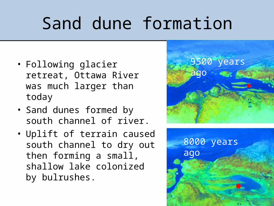
Sand dune formation
• Following glacier retreat, Ottawa River was much larger than today
• Sand dunes formed by south channel of river.
• Uplift of terrain caused south channel to dry out then forming a small, shallow lake colonized by bulrushes.
9500 years ago
8000 years ago
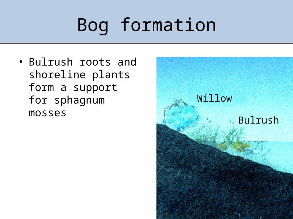
Bog formation
• Bulrush roots and shoreline plants form a support for sphagnum mosses Willow
Bulrush

Bog formation
• A floating carpet of vegetation begins to grow toward the center of the bog.
• Deoxygenated water (no O2 input) slows down decomposition, resulting in acidic conditions.
• Organic matter accumulates at bottom
Sphagnum moss
Cassandra
Labrador tea

Bog evolution (cont’d)
• Water surface completely covered with sphagnum resulting in raised surface, colonization by trees
• Mineral salts derived from precipitation only.
• Age: about 5000 years
Larch
Black spruce
Sphagnum
Peat

Your task
• Predict the impact of a water drainage from Mer Bleue on the abundance of one particular plant species (« Your plant ») in the zone where its current incidence is highest.
• Find out what plant is “your plant” using the plant assignment tool on the Lab website (lab1 assignment tool)

Procedure
1. Make observations of plants in 5 different stations in Mer Bleue
2. Produce a graph presenting the distribution of one particular plant
3. Formulate a hypothesis regarding the role of water availability on the abundance of your plant
4. Predict the effect of a change in the water level in Mer Bleue on your plant

Observations• Observe plant species in
an area of 10m2 (2m x 5m) at each station.
• Record the presence or absence (no quantification) of each plant on the data sheet
5m
2m

Sampling stations
1 – Old field2 – Marsh3 – Bog4 – Ecotone5 – Forest
1
2
3 4
5
Parking

Station 1: The old Field
Dry, located on top of sand dune
2 juillet 2003, © Antoine Morin ([email protected])


2 juillet 2003, © Antoine Morin ([email protected])
Station 3: The bog
Several metres of peat moss covered by sphagnum moss and other plants
2 juillet 2003, © Antoine Morin ([email protected])

Station 4: The ecotone
Ecotone: sandy area located in between the bog and the marsh (transition zone)
2 juillet 2003, © Antoine Morin ([email protected])

Station 5: The Forest
Two distinct environments:-Lower Forest: relatively humid, close to condition found in the ecotone (but more sandy soil)- High forest: dry and shaded environment on top of sandy hill
Basse forêtBasse forêt
haute forêthaute forêt
2 juillet 2003, © Antoine Morin ([email protected])

What is the source of water ?
• Not the same in all stations• Stations at different elevation• Lower stations (bog, ecotone, lower forest)
receive water from march and rain• Higher stations (field, high forest) only receive
rain waterSome stations are drier than others (which ones?)
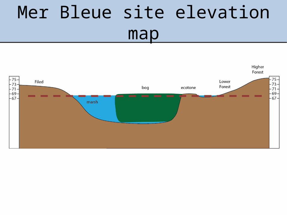
Mer Bleue site elevation map

Back from Mer Bleue …
• Submit your observations the lab website before noon the day after your field trip to MB in order to combine class data (before noon the next day)
• Download the combined data file from website to plot your graph
• One week after the lab: hand in your report
• Anytime: Find out the plant that has been assigned to you for your lab report using the plant assignment tool on the Lab website (lab1 assignment tool)

Combined data file
• Available after 4PM the day following your field trip
This is the incidence you need to plot4 or 5 groups depending on the daysPlot groups individually (no average)
Repeat for all stations (5 in total)
Data continues (5 stations are presented)

Instructions regarding the graph
• Dot plot graph showing the incidence of your plant in each station
• The incidence in each group is plotted as one data point (no average)
• Stations on the X axis must be ordinated along a moisture gradient (dry moist)
• Read carefully instructions in the appendix of lab manual (even if you think you know how to graph data)

Example: Kalmia angustifolia
StationOld field Forest Ecotone Bog Marsh
Inci
denc
e
0.0
0.2
0.4
0.6
0.8
1.0
SAMPLE GRAPH (contains errors)
READ INSTRUCTIONS FORM LAB MANUAL
Caption of the graph

Mer Bleue Report: content
1. A title page (see example in lab manual intro)2. A graph showing the distribution of your
plant in the 5 stations of Mer Bleue3. Answers to the questions printed in the
instruction file (on website) : Hypothesis and prediction

Mer Bleue Report: timeline
• Before noon the day after your field trip: enter data on virtual campus (better if done right after trip)
• Combined data will be available the day after field trip after 4PM.
• 1 week after field trip: Hand in version 1 of lab report• 2 weeks: corrected version1 handed back (during
lab2)• 3 weeks: Hand in version 2 of lab report(optional)• Mer Bleue final mark = V1+V2 or 2xV1

Field trip instructions
• Dress appropriately for field conditions!• In case of rain bring only necessary items on the field. • You can store your effects in the lockers located in the
hallway of the 3rd floor BSC building (BRING a lock!)• Be on time • Everyone must take the bus to and from the site (no
exception)• Stay on the paths, trails and boardwalks.• Do not pick any flowers or remove vegetation.• Do not leave anything behind, including garbage.• Use the same bus going to and returning from the site.• Take a plastic bag to store items in case of rain (wallet, phone)

To do before the field trip
• Learn to identify major plants of Mer Bleue (lab manual and web site)
• Read the documents posted on the “Lab1” page of the website.
• Check what is your assigned plant (for your report)