la paloma #1 and #2 mining plan of...
TRANSCRIPT
United States Department of Agriculture Forest Service February 2016
La Paloma #1 and #2 Mining Plan of Operations Preliminary Environmental Assessment
Kern River Ranger District, Sequoia National Forest
Tulare County, California

For More Information Contact: Alfred Watson, District Ranger
Kern River Ranger District, Sequoia National Forest 105 Whitney Road Kernville CA 93238
Phone: 760-376-3781x 610 Email: [email protected]
Fax: 760-376-3795
The U.S. Department of Agriculture (USDA) prohibits discrimination in all its programs and activities on the basis of race, color, national origin, age, disability, and where applicable, sex, marital status, familial status, parental status, religion, sexual orientation, genetic information, political beliefs, reprisal, or because all or part of an individual’s income is derived from any public assistance program. (Not all prohibited bases apply to all programs.) Persons with disabilities who require alternative means for communication of program information (Braille, large print, audiotape, etc.) should contact USDA's TARGET Center at (202) 720-2600 (voice and TDD).
To file a complaint of discrimination, write to USDA, Director, Office of Civil Rights, 1400 Independence Avenue, S.W., Washington, D.C. 20250-9410, or call (800) 795-3272 (voice) or (202) 720-6382 (TDD). USDA is an equal opportunity provider and employer.
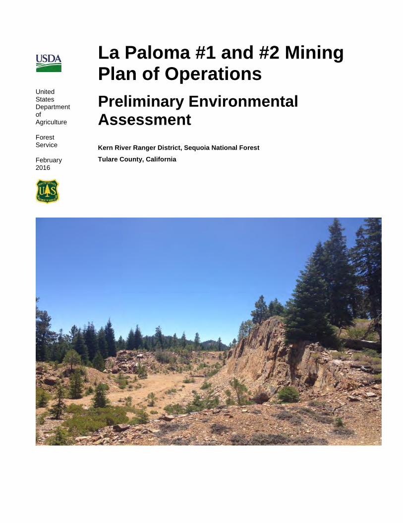
Cover photo: La Paloma Mining Claim #1, Locus 1, view to the southeast, showing the site of proposed scaling of existing rock face, and floor of mining pit, as seen in 2014 (USFS photo)

La Paloma #1 and #2 Mining Plan of Operations Preliminary Environmental Assessment
i
TABLE OF CONTENTS Table of Contents ..................................................................................................................... i CHAPTER 1-Purpose of and Need for Action ....................................................................... 1
Introduction .............................................................................................................................. 1
Proposed Project Location and Description .............................................................................. 1
Background .............................................................................................................................. 1
Purpose of and Need for Action ............................................................................................... 3
Proposed Action (Alternative 1) ................................................................................................ 3
Modified Proposed Action (Alternative 2) ................................................................................. 5
Alternatives Considered but Dismissed from Further Analysis ................................................. 5
Decision to be Made ................................................................................................................ 5
Land Management Direction .................................................................................................... 6
Statutory Authorities ............................................................................................................. 6
Land and Resource Management Plans .............................................................................. 7
Public Involvement ................................................................................................................... 7
Issues .................................................................................................................................. 8
CHAPTER 2- Alternatives, Including the Proposed Action .................................................. 8
Alternatives .............................................................................................................................. 8
Alternative 1 - Proposed Action ............................................................................................ 8
Alternative 2 – Modified Proposed Action ............................................................................. 9
Monitoring ............................................................................................................................ 9
Comparison of Alternatives ...................................................................................................... 9
CHAPTER 3 – Existing Conditions and Environmental Consequences............................ 10
Existing Condition .................................................................................................................. 10
Environmental Consequences of the Proposed Action and Alternatives ................................ 13
Alternative 1 – Proposed Action ............................................................................................. 13
Air Quality and Climate Change ......................................................................................... 13
Water Quality ..................................................................................................................... 14
Solid Wastes ...................................................................................................................... 15
Scenic Values .................................................................................................................... 16
Fisheries and Wildlife Habitat ............................................................................................. 16
Botany-Sensitive Plants ..................................................................................................... 17
Cultural Resources............................................................................................................. 18

La Paloma #1 and #2 Mining Plan of Operations Preliminary Environmental Assessment
ii
Reclamation- Mineral resources ......................................................................................... 19
Recreation ......................................................................................................................... 19
Alternative 2 – Proposed Action ............................................................................................. 20
Air Quality and Climate Change ......................................................................................... 20
Water Quality ..................................................................................................................... 20
Solid Wastes ...................................................................................................................... 21
Scenic Values .................................................................................................................... 21
Fisheries and Wildlife Habitat ............................................................................................. 21
Botany-Sensitive Plants ..................................................................................................... 22
Cultural Resources............................................................................................................. 22
Reclamation- Mineral resources ......................................................................................... 23
Recreation ......................................................................................................................... 23
Cumulative Effects ................................................................................................................. 23
Finding Of No Significant Impact (FONSI) .............................................................................. 25
CHAPTER 4 - Consultation and Coordination..................................................................... 26
Interdisciplinary Team Members ........................................................................................ 26
References ............................................................................................................................ 27
Management Guidance .......................................................................................................... 27
Specialist Reports .................................................................................................................. 27
Federal, State, and Local Agencies and Tribes Consulted ..................................................... 27
Appendix A: Scoping Issue Matrix ......................................................................................... i Individuals / Groups Who Commented during Scoping ............................................................. i
Appendix B: Conditions Of Approval for Alternative 2 ....................................................... ix

La Paloma #1 and #2 Mining Plan of Operations Preliminary Environmental Assessment
1
CHAPTER 1-PURPOSE OF AND NEED FOR ACTION
INTRODUCTION The Sequoia National Forest has prepared a preliminary environmental assessment (EA) for the La Paloma #1 and #2 Mining Plan of Operations (PoO). The La Paloma Mine consists of two existing surface barite mining claims located on 40 acres of the Kern Plateau in Tulare County, within the Sequoia National Forest, Kern River Ranger District. Under the proposed action, the project area includes about one acre proposed for disturbance over a period of five years.
This Environmental Assessment discloses the direct, indirect and cumulative environmental effects predicted to result from implementing the project. Two alternatives were considered: Alternative 1, the Proposed Action and Alternative 2, a Modified Proposed Action.
Alternative 1, the Proposed Action is the PoO as submitted by the mining claimant. Alternative 2, a Modified Proposed Action, responds to the PoO to assure compliance with standards and guidelines. The Modified Proposed Action establishes appropriate terms and conditions for the PoO under which Patrick Embree may exercise his right to mine an existing claim, as established by the General Mining Law of 1872, while protecting national forest surface resources consistent with other applicable laws, regulations, and policies, including the standards and guidelines in the Sequoia National Forest Land and Resource Management Plan (1988).
This preliminary EA was prepared to determine whether the project may significantly affect the quality of the human environment and thereby require the preparation of an environmental impact statement. Preparation of this EA, fulfills agency policy and direction to comply with the National Environmental Policy Act (NEPA).
PROPOSED PROJECT LOCATION AND DESCRIPTION The La Paloma Plan of Operation is located on the Kern Plateau in the Kern River Ranger District of the Sequoia National Forest. The Plan of Operation proposes continued geological exploration and sampling for a period of five years within previously mined barite claims held by Patrick Embree. Pat Embree submitted a Plan of Operation (PoO) in June of 2013 for the project.
The La Paloma mining claims are located near Paloma Meadow in Tulare County in Sections 4, 9, and 10, T22S, R34E, MDB&M (see Maps 1 and 2). The area is accessed from Lookout Mountain Road (22S41) and West Road (Road No. 22S24) off of Sherman Pass Road (Road No. 22S05). La Paloma is about 10 miles west of the Kennedy Meadows community (Figure 1). The site is within the USGS Bonita Meadow quadrangle.
BACKGROUND Barite deposits were discovered at La Paloma and the first mining claims were staked by L. G. Embree (the father of the current owner) in 1949. The site has been periodically mined since the 1960s by various operators. A new Plan of Operation (PoO) was submitted to the Forest Service in March 2013 and lays out a program of sampling and geological exploration of the La Paloma #1 and #2 mining claims over a period of five years.

La Paloma #1 and #2 Mining Plan of Operations Preliminary Environmental Assessment
2
Figure 1: Vicinity Map
The La Paloma mining claims are significant as they are located on the Bald Mountain Barite Deposit, one of two remaining barite deposits known in the Sierra that have not been extensively mined (USGS, 1963). Barite (barium sulfate) is a naturally occurring, nonmetallic, locatable mineral used for drilling slurry and medical products. The majority of barite in California has been obtained from six previously mined

La Paloma #1 and #2 Mining Plan of Operations Preliminary Environmental Assessment
3
deposits in the Sierra Nevada and Klamath Mountains. The United States imports approximately 75% of the barite now used (USGS, 2012).
The following is a chronology of previous mining uses of the La Paloma site:
• 1960’s-1970’s -The first mining at La Paloma occurred
• 1966 - The access road to the claims was constructed under a Special Use Permit (SUP).
• 1973 -The claims were transferred to the Kern Barite Corporation
• 1977 - A Notice of Intent to Operate was reviewed by the Forest Service
• 1980 - La Paloma was purchased by A. W. Arnold and Associates of Houston, Texas. The claims were held by various owners until 1992.
• 2008 - The Embree family refiled on the La Paloma #1 and #2 claims. A one-year Plan of Operation (PoO) for the La Paloma #1 was approved in 2008 and the sampling operations laid out in that plan were completed by the end of the year.
• 2013 - The Forest Service began processing a current PoO request in compliance with mining directives.
PURPOSE OF AND NEED FOR ACTION The purpose of this action is to assure resource protection while allowing for the proposed sampling and geological exploration from the existing La Paloma #1 and #2 barite mining claims. The action is needed to establish appropriate terms and conditions under which Patrick Embree may exercise his right to mine an existing claim, as established by the General Mining Law of 1872, while protecting national forest surface resources consistent with other applicable laws, regulations, and policies, including the standards and guidelines in the Sequoia National Forest Land and Resource Management Plan (1988).
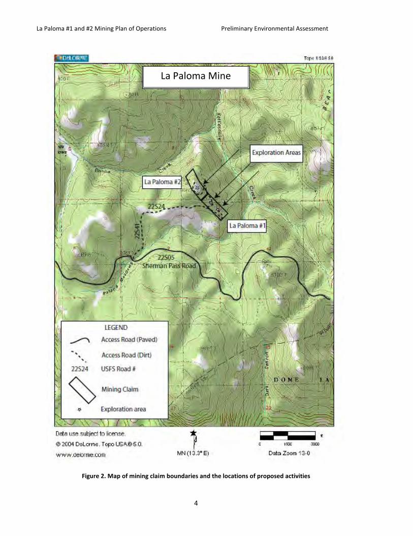
PROPOSED ACTION (ALTERNATIVE 1) The claimant has submitted a Plan of Operation for ore testing, and continued geological exploration and sampling for a period of five years, not to exceed 990 cubic yards of crude barite ore. Proposed activities in the La Paloma Plan of Operation include “scaling” (removing loose material from the existing working face) and/or retrieving caved ore from the base of the existing working face of Locus 1 (See Figures 2 and 3). A program of exploratory drilling would also be conducted near Loci 1, 2 and 3 within previously disturbed areas.
No ore processing will take place within the La Paloma mining claim—all ore samples would be hauled from the site by dump trucks. The Plan of Operation would be in effect for a period of five years beginning at the date of its approval by the responsible official.
Chapter 2 provides a more detailed description of the Proposed Action and the Modified Proposed Action alternatives. Chapter 3 provides effects analysis of the alternatives.
La Paloma #1 and #2 Mining Plan of Operations Preliminary Environmental Assessment
4
Figure 2. Map of mining claim boundaries and the locations of proposed activities
La Paloma Mine

La Paloma #1 and #2 Mining Plan of Operations Preliminary Environmental Assessment
5
MODIFIED PROPOSED ACTION (ALTERNATIVE 2) Activities proposed under Alternative 2 are identical to those proposed under Alternative 1. Alternative 2 differs from Alternative 1, however, in that it addresses comments from the public and additionally stipulates the standards and guidelines identified by forest staff, reclamation measures meeting the forest’s Best Management Practices, and bonding that are conditions for approval for the plan of operation.
ALTERNATIVES CONSIDERED BUT DISMISSED FROM FURTHER ANALYSIS No Action Alternative - A No Action alternative, often analyzed in Environmental Assessments, was dropped from consideration as no action on the forest’s part is not consistent with law, regulation and policy direction in regards to mining plans of operation. The Forest Service must consider and cannot deny a locatable mineral Plan of Operations where the proposed activities are reasonably incident to mining and would comply with other Federal laws. Therefore, a No Action alternative has not been analyzed. See the section below on “Decision to be Made” for actions that the Forest Service may take in response to a Plan of Operations.
DECISION TO BE MADE The Responsible Official for this proposal is the Kern River District Ranger of the Sequoia National Forest. 36 CFR 228.5 and FSM 2817.23 provide direction as to how a District Ranger may proceed once a PoO has been submitted. There are five options, as follow:
(1) Notify the operator that he has approved the plan of operations; or
(2) Notify the operator that the proposed operations are such as not to require an operating plan; or
(3) Notify the operator of any changes in, or additions to, the plan of operations deemed necessary to meet the purpose of the regulations in this part; or
(4) Notify the operator that the plan is being reviewed, but that more time, not to exceed an additional sixty (60) days, is necessary to complete such review
(5) Notify the operator that the plan cannot be approved until a final environmental statement has been prepared and filed with the Council on Environmental Quality as provided in §228.4(f).
In the case of the La Paloma Plan of Operation the ranger selected option 5, that an environmental statement must be prepared. He will decide whether to approve the Plan of Operation as submitted (Alternative 1-the Proposed Action) or to request modifications to that Plan of Operation reflective of recommended standards and guidelines (Alternative 2-the Modified Proposed Action).
The ensuing Decision Notice (DN) linked to this EA will not directly result in the approval of the claimant’s PoO. Rather, the Decision Notice fulfills legal requirements and provides rationale for establishing “Conditions of Approval for Plan of Operations” such as for fire prevention measures, hazmat spill requirements, reclamation requirements, posting of a bond and compliance with other Federal, State, and Local Requirements. The La Paloma PoO would subsequently be authorized when both the responsible official and the claimant have signed the Conditions of Approval for Plan of Operations and the Decision Notice has been signed by the responsible official.
The Responsible Official will make a decision based upon the information disclosed in this Environmental Assessment, the associated project record, and public feedback. The decision to be made would address

La Paloma #1 and #2 Mining Plan of Operations Preliminary Environmental Assessment
6
Conditions of Approval for Plan of Operations so as where feasible, to minimize adverse environmental impacts on National Forest surface resources” (36 CFR 228.8). This proposed decision is subject to objection pursuant to 36 CFR 218, Subparts A and B.
LAND MANAGEMENT DIRECTION The Forest Service does not initiate mining of locatable materials, but responds to private party requests for exploration and development. With the exception of areas such as wilderness that are withdrawn from for mineral use, more than half of the Forest is open to mineral development, subject to standards and guidelines and mitigation of impacts to surface resources. The principal statutes, regulations and policy governing mineral management on National Forest lands are listed below.
STATUTORY AUTHORITIES The General Mining Law of 1872, as amended (30 USC 21-54) governs prospecting, locating and developing mineral resources. Mineral rights on all lands are administered by the US Department of the Interior, Bureau of Land Management. Except as otherwise provided, all valuable mineral deposits, and the lands in which they are found, are free and open to exploration, occupation, and purchase under regulations prescribed by law.
36 CFR 228 Subpart A, provides that mining activities be conducted to protect non-mineral values of National Forest System lands. As directed under 36 CFR 228.8, Requirements for Environmental Protection: “All operations shall be conducted so as, where feasible, to minimize adverse environmental impacts on National Forest surface resources”
Organic Administration Act of June 4, 1897, (30 Stat. 11, as amended; 16 U.S.C. 473-475, 477-482, 551). This act provides the Secretary of Agriculture the authority to regulate the occupancy and use of NFS lands. It provides for the continuing right to conduct mining activities under the general mining laws if the rules and regulations covering NFS lands are followed. This act recognizes the rights of miners and prospectors to access NFS lands for all proper and lawful purposes, including prospecting, locating, and developing mineral resources.
Multiple-Use Sustained-Yield Act of June 12, 1960, (74 Stat. 215; 16 U.S.C. 528-531). This act requires that NFS lands be administered in a manner that considers the values of the various resources when making management decisions and specifically provides that nothing in the act be construed to affect the use or administration of the mineral resources on NFS lands.
Mining and Minerals Policy Act of December 31, 1970, (84 Stat. 1876; 30 U.S.C. 21a). Congress declared that it is the continuing policy of the Federal Government, in the national interest, to foster and encourage private enterprise in the development of economically sound and stable industries, and in the orderly and economic development of domestic mineral resources to help assure satisfaction of industrial, security, and environmental needs. In the case United States v. Weiss, 642 F.2d 296, 299 (1981), the Ninth Circuit declared there is nothing in the 36 Code of Federal Regulations which authorizes the Forest Service to prohibit the claimant’s right to the possession and enjoyment of their claims, or to encroach impermissibly upon those rights, by circumscribing their use in a manner that amounts to a prohibition.
Forest Service Manual section 2800 provides direction on management of Forest mineral resources. Objectives and policies include to “encourage and facilitate the orderly exploration, development, and production of mineral and energy resources on National Forest System lands to maintain a viable, healthy minerals industry.” (FSM 2802). In addition FSM 2817 provides objectives: “In managing the use of the surface and surface resources, the Forest Service should attempt to minimize or prevent, mitigate, and repair adverse environmental impacts on National Forest System surface and cultural resources as a result

La Paloma #1 and #2 Mining Plan of Operations Preliminary Environmental Assessment
7
of lawful prospecting, exploration, mining, and mineral processing operations, as well as activities reasonably incident to such uses . . This should be accomplished by imposition of reasonable conditions which do not materially interfere with such operations. .. . The statutory right of the public to prospect, develop, and mine valuable minerals and to obtain a patent shall be fully honored and protected.”
The Clean Water Act (CWA) of 1948 (as amended in 1972 and 1987, 33 USC 1251-1388) establishes, as Federal policy, the control of both point and non-point source pollution and assigns to the states the primary responsibility of governing water quality. All Plans of Operation are subject to CWA standards.
LAND AND RESOURCE MANAGEMENT PLANS
The Sequoia National Forest LRMP, 1988, provides the following direction for managing mineral resources.
• Encourage and facilitate the orderly exploration, development and production of mineral and energy resources (Vision, p. 1-2).
• Encourage exploration and development of mineral resources outside of classified and withdrawn area with emphasis on energy resources (Goals, p. 4-4).
• Evaluate Requests for leasable minerals and mineral material on a project basis. Before authorizing users, ensure that these activities can be conducted in an environmentally sound manner and that they are integrated with the planning and management of other National Forest resources.
• Include provisions to minimize adverse environmental impacts to surface resources in the operating plans (36 CFR 228). Upon the completion of any mineral activities on the Forest, provisions will be made for the timely reclamation of a disturbed area with the ultimate goal being full surface production and use of land (Management Direction, Forest-Wide Standards and Guidelines, p. 4-36).
Sierra Nevada Forest Plan amendment (ROD 2004)-Management Standards and Guidelines (p. 58-59):
64. Ensure that plans of operation, reclamation plans, and reclamation bonds address the costs of: (1) removing facilities, equipment, and materials; (2) isolating and neutralizing or removing toxic or potentially toxic materials; (3) salvaging and replacing topsoil; and (4) preparing the seed bed and revegetating to meet the objectives of the land allocation in which the operation is located.
65. Ensure that mine owners and operators limit new road construction, decommission unnecessary roads, and maintain needed roads consistent with Forest Service roads policy and management direction for the land allocation.
66. Require mine reclamation to be conducted in a timely manner.
67. Inspect and monitor mining-related activities on a regular basis to ensure compliance with laws, regulations, and operating plans. Base the frequency of inspections and monitoring on the potential severity of mining activity-related impacts.
68. During mining-related activities, limit the clearing of trees and other vegetation to the minimum necessary. Clearing of vegetation should be pertinent to the approved phase of mineral exploration and development.
PUBLIC INVOLVEMENT The La Paloma Plan of Operation has been listed online in the Schedule of Proposed Actions for the Sequoia National Forest since October 1, 2013. In accordance with 36 CFR 218, the proposal was provided to the public and other agencies for comment during scoping between May 6 and June 5, 2014. A total of 40 public scoping notices were mailed to interested members of the public, government agencies and tribal

La Paloma #1 and #2 Mining Plan of Operations Preliminary Environmental Assessment
8
governments. A total of three comments were received from this public scoping effort. Using the comments received from the public, government agencies, and tribal governments (see Issues section) the interdisciplinary team developed a list of issues to address.
ISSUES An issue is a point of debate, dispute, or disagreement regarding anticipated effects of the proposed action identified in public comment. Issues may be resolved or mitigated through project design, development of alternatives to the proposed action, or used as measures against which alternatives are evaluated. Other comments may be informative but do not form issues, or they may be comments which are defined as: 1) outside the scope of the proposed action; 2) already decided by law, regulation, Forest Plan or other higher level decision; 3) irrelevant to the decision to be made; 4) conjectural and not supported by scientific or factual evidence; or 5) a statement of opinion or comment not related or irrelevant to effects of the proposed action.
Appendix A contains a list of public scoping comments and how they are addressed. Issues identified through public scoping are summarized below. Issue statements are written as cause and effect relationships and may be from several sources.
After careful consideration of comments from the public and internal review by project specialists, the Inter-Disciplinary Team (IDT) developed a list of issues to address:
1. Water resources should be protected during project activities. The proposed action will include conditions of approval, such as best management practices (BMPs), to protect water resources.
2. Project should minimize impacts to nesting birds, and other sensitive species, if habitat or species are found to be present.
CHAPTER 2- ALTERNATIVES, INCLUDING THE PROPOSED ACTION Chapter 2 includes a description of each alternative considered. The section also compares the alternatives in Table 1 to define the differences between each alternative. Information used for comparison is based upon the design of the alternatives as well as the environmental, social, and economic effects of each alternative.
ALTERNATIVES
ALTERNATIVE 1 - PROPOSED ACTION The project claimant has submitted a Plan of Operation covering a program of sampling and exploring his mining claims. As noted earlier, the plan covers a 5-year period beginning upon its approval by the responsible official. Specific activities proposed by the Plan include:
• Remove up to 990 cubic yards of crude barite ore by scaling (removing loose material from the previously worked face of a mine, cutbanks, and other mining surfaces) and/or retrieving caved ore from the base of the existing working face of Locus 1 (See Cover photo and Figures 2 and 3);

La Paloma #1 and #2 Mining Plan of Operations Preliminary Environmental Assessment
9
• Ore would be hauled from the site by dump trucks and be processed at existing industrial mineral mills (mostly grinding ore to a small, uniform size);
• Conduct exploratory drilling with a tracked or tired drill rig, drilling to depths of up to 500 feet at up to ten locations;
• Remove fallen trees and other obstructions from road No. 22S24;
• Temporarily remove water bars and berms from the road to allow passage of equipment (water bars and berms would be re-established at the close of the operations each season per Forest Service guidelines);
• Transport water for drilling and dust suppression with a water truck from a private underground water source
Less than one acre is expected to be disturbed by the proposed activities.
ALTERNATIVE 2 – MODIFIED PROPOSED ACTION Alternative 2 represents the claimant’s proposed program of sampling and geological exploration as described in the Plan of Operation (see Alternative 1 above) with modifications to assure compliance with standards and guidelines to minimize adverse environmental effects to National Forest surface resources. Under Alternative 2 the Plan of Operation would be amended to include those Conditions of Approval identified by the forest, as listed in Appendix B- Project Conditions of approval. Annual monitoring would occur to ensure that the Conditions of Approval are carried out. Specific standards and guidelines, reclamation measures meeting the forest’s Best Management Practices, and bonding are addressed in Appendix B.
MONITORING The Forest Service would conduct unannounced and scheduled on-site inspections of surface operations to ensure compliance and bond administration. Random evaluations would be conducted each year to evaluate the operation as listed in Appendix B.
COMPARISON OF ALTERNATIVES Table 1 provides a summary of the effects of implementing each alternative. Information in Table 1 is focused on those activities and effects that can be distinguished quantitatively or qualitatively between the alternatives.
Table 1: Comparison of Alternatives
Issue
Alternative 1 – Proposed Action (Plan of Operations)
Alternative 2 – Modified Proposed Action (with Conditions of Approval for Plan of Operations)
Purpose and Need
Would meet purpose and need by authorizing the Plan of Operation as submitted but would not stipulate any standards and guidelines beyond those proposed in the Plan of Operation as submitted.
Would meet purpose and need by authorizing the PoO and would better meet standards and guidelines by stipulating in the Conditions of Approval for Plan of Operation.

La Paloma #1 and #2 Mining Plan of Operations Preliminary Environmental Assessment
10
Botany, cultural, fire, fuels, air- quality, vegetation, wildlife
Minimal long term effects to botanical, cultural, fire, fuels, and air quality, forest vegetation, wildlife resources or roads. Standards and guidelines and reclamation efforts limited to those proposed in the Plan of Operation.
No long term effects to botanical, cultural, fire, fuels, and air quality, forest vegetation, wildlife resources or roads as long as reclamation is completed and standards and guidelines are adhered to as in the Conditions of Approval for Plan of Operation.
Soil and Hydrology
Some short-term soil, hydrology impacts and road impacts. Standards and guidelines and reclamation efforts limited to those proposed in the Plan of Operation as submitted.
Limited short-term soil, hydrology and road impacts. Once sampling and geological exploration activities are completed, Conditions of Approval for Plan of Operation provide standards and guidelines to restore resources.
Forest Plan requirements
Improves opportunities for geological exploration.
Improves opportunities for geological exploration.
Monitoring and inspections
Not stipulated. Inspections and monitoring required.
CHAPTER 3 – EXISTING CONDITIONS AND ENVIRONMENTAL CONSEQUENCES Chapter 3 summarizes the physical, biological, and social environments of the locality of the mining claims as well as the potential changes to those environments due to implementation of the alternatives. The chapter presents the scientific and analytical basis for comparison of alternatives and also describes the factors of significance as described in Regulations for Implementing the Procedural Provisions of the National Environmental Policy Act (40 CFR Parts 1500-1508, Section 1508.27, July 1, 1986).
EXISTING CONDITION The La Paloma #1 and #2 Barite Mine consists of two 20-acre mining claims. The mining features on the site date to the mid-1960s and typify small-scale 20th century open-pit mining. The site receives minor recreational visitation. The site is located at about 8500 feet elevation in an eastside mixed conifer community. The dominant vegetation is Ponderosa pine (Pinus ponderosa). White thorn, manzanita and a variety of shrubs, forbs and grasses balance out the floral community. In 2002, the McNally Fire burned to the edge of mining claims.
The La Paloma mining claims contain four man-made features—West Road (22S24) and three mine excavations (see cover photo, and Figures 4 and 5). West Road (22S24) is a Level 2 route constructed under Special Use Permit in 1966 in order to access La Paloma Mines. Following the brief sampling activities at the site in 2008 the road was water-barred to Level 2 road standards. In 2014 meter-deep grass was growing in the center of the road. Several spurs unrelated to mining lead off the road to logging decks.
La Paloma is located within a barite deposit known as the Bald Mountain Deposit. In 1965 Harold Weber, a geologist for the California Division of Mines and Geology, described the significance of the Bald Mountain orebody as “the largest remaining body of barite rock (of at least 4.0 specific gravity) in the state and it appears to be one of the largest ever developed.”

La Paloma #1 and #2 Mining Plan of Operations Preliminary Environmental Assessment
11
Figure 3: Map of the La Paloma Barite Mine

La Paloma #1 and #2 Mining Plan of Operations Preliminary Environmental Assessment
12
There are three areas within La Paloma that have been previously mined and are proposed for sampling and geological exploration in the Plan of Operation (See figure 3). Locus 1 is the largest of the three mine excavations, measuring approximately 165 yards in length by 55 yards in width (see cover photo). The floor of the excavation has an undulating quality. Much of the eastern margin of the excavation is extensively piled with ore pulled from the working face of the locus. Waste rock deposits are located below the eastern periphery of the locus. Some degree of reforestation has occurred within the margins of the excavation with small stands of young ponderosa mingling with the piled ore.
Figure 4. Area of proposed geological exploration near Locus 2
Locus 2 is the smallest of the mine excavations, measuring 35 yards by 20 yards (Figure 4). Like Locus 1, the working face of the pit is nearly vertical. A three-foot diameter culvert pipe is stored near the southern corner of the excavation—likely the culvert was intended for the road. The mine road crosses the eastern margin of the excavation.
Locus 3 is the lowest of the three pits and measures 60 yards by 25 yards (Figure 5). As with the other pits, the working face is nearly vertical. A pile of logs is located near the southeastern corner of the excavation. The floor of the pit is more heavily vegetated than the other loci, being populated fairly evenly with sagebrush. A logging deck that does not appear related to the La Paloma claims is located 100 or so yards to the west of the pit.

La Paloma #1 and #2 Mining Plan of Operations Preliminary Environmental Assessment
13
Figure 5. Area of proposed sampling and geological exploration near Locus 3.
ENVIRONMENTAL CONSEQUENCES OF THE PROPOSED ACTION AND ALTERNATIVES The specialist reports are summarized and incorporated by reference in the following effects analysis. The specialist reports and other supporting documentation are available on the project webpage at: http://www.fs.usda.gov/project/?project=42938. 36 CFR 228.8 identifies requirements for environmental protection during operations, which are discussed below. Project conditions of approval to meet standards and guidelines are included in Appendix B.
ALTERNATIVE 1 – PROPOSED ACTION
AIR QUALITY AND CLIMATE CHANGE
Direct and Indirect Effects
Management activities on Forest Service lands have the potential to emit various levels of emissions during the course of their operations. For the La Paloma Plan of Operation possible sources of emissions include dust from roads and ground-disturbing activities, and consumption of fossil fuels. The Plan of

La Paloma #1 and #2 Mining Plan of Operations Preliminary Environmental Assessment
14
Operations (p.4) indicates that vehicles will move at minimum speeds and water will be applied on roads for dust suppression.
Under Alternative 1, due to the small volume of activity (990 cubic yards), there would not be significant direct or indirect effects on GHG emissions, carbon cycling, or climate change. Demand for barite persists and would continue to be primarily filled by receiving supplies from other more distant sources. The US imports 75% of its barite. India, China and Morocco are the leading producers of barite (USGS 2012).
Cumulative Effects Per direction given by the Council on Environmental Quality (40 CFR 1508.7 & 1508.8), the environmental effects of the La Paloma Plan of Operation on climate change, greenhouse gas (GHG) emissions, and carbon cycling were considered in terms of their context and intensity to the activities being proposed.
At the present time, climate change projections are inherently uncertain and vary on a local, regional and planetary basis. In addition, because the emissions associated with the La Paloma Plan of Operation are extremely small in a global atmospheric context and readily mix into the global GHG pool, it is not currently possible to distinguish the effects of the proposed management activities from all other sources worldwide.
WATER QUALITY
Direct and Indirect Effects
Direct effects may include increased wear on the road system used to access the sampling and drilling sites, with the possibility of increased erosion from the road prism. Potential water quality impacts would be mitigated by the following stipulations in the Plan of Operation (p. 5) as submitted:
“The project will minimize erosion by conducting operations during minimal runoff periods. Operations will be scheduled and conducted to minimize erosion and sedimentation when ground conditions are such that excessive rutting and soil compaction would not occur. Water breaks will be reinstalled after each active season. Water for drilling and dust suppression will be brought in to site from an approved source. Drill holes will be grouted as according to the Tulare County Department of Health drilling permit.”
Direct effects from the scaling and drilling operations will be negligible since these activities are small in scope and occurring in areas previously disturbed and not subject to accelerated erosion (i.e., these areas are dominated by bedrock). Proposed activities will be at least 1,000-1,800 feet away from the nearest perennial waterbody, and thus are not hydrologically connected; as such, no impact to water quality is expected.
Water sourced from a private well in Kennedy Meadows would be used for drilling. This groundwater is not subject to State water rights approval or under Forest Service jurisdiction. The limited amount of water used is not expected to result in significant impacts. The Plan of Operation as submitted does not stipulate one way or another whether adjunct lubricants will be added.
The drilling will stay within the same metasedimentary formation (Calaveras Group), and thus no alteration of the hydrogeology (e.g., communication with granitic aquifers) or water chemistry is expected.
Although most of the barite talus produced as part of the proposed action will be removed from the site for processing, remnant talus (gangue) would not contribute sulfate (SO42-) to ground or surface waters because: 1. Barite ore is essentially insoluble in fresh water (Ksp=10-10); and 2. The size of the talus will be greater than cobble-sized and thus have a relatively low surface area/volume ratio, greatly reducing the exposed talus surfaces to weathering.

La Paloma #1 and #2 Mining Plan of Operations Preliminary Environmental Assessment
15
Cumulative Effects
Cumulative watershed effects (CWE) are those that result from the incremental impacts of the proposed action when added to past, present, and reasonably foreseeable future actions. Cumulative watershed effects can result from individually minor but collectively significant actions taking place over space and time. The objective of CWE analysis is to protect the identified beneficial uses of water from the combined effects of multiple management activities.
This method assumes that an acre of road represents the greatest (common) management disturbance, and normalizes all other activities to this standard, called Equivalent Roaded Acres (ERAs). Established coefficients are used to convert acres of other land disturbing activities into ERAs.
Local subdrainages (“HUC14”) are used for spatial analysis for ERA’s; these subdrainages range in size from 250 to 2000 acres. The CWE model evaluates six watershed characteristics used to set watershed sensitivity and assign threshold values. These include soil, topography, climate, geology, vegetation, and fluvial geomorphology. Disturbance modeling focuses on chronic sedimentation through the adoption of disturbance coefficients derived from studies performed on the Idaho Batholith. The modeling coefficients used to derive ERA values are determined by silvicultural prescription and logging system, as well as a suite of variables used in the model to evaluate the cumulative ERA’s. ERAs for vegetation management and logging are prorated by their age, assuming that 95% recovery occurs over 30 years. Assuming 95% recovery over time, as opposed to 100% recovery, takes into account major skid roads and landings, which may not fully recover to pre-disturbance conditions.
Disturbance activities include roads and OHV trails; past, present, and foreseeable vegetation management and logging activity, grazing; and land development. All known disturbances that occurred within the past 30 years and all reasonably foreseeable disturbances are included in the CWE analysis.
The proposed scaling would disturb less than 0.8 acres, which equates to an ERA value of less than 0.05. This would have a negligible cumulative effect and thus no significant CWE response is expected from the proposed action.
All newly approved Plans of Operations for mining operations on National Forest System lands must comply with the Federal Water Pollution Control Act of 1972, 33 U.S.C §§ 1251-1388 (Clean Water Act or CWA). Under Alternative 1, the La Paloma Plan of Operation would address water quality by “will minimize erosion by conducting operations during minimal runoff periods. Operations will be scheduled and conducted to minimize erosion and sedimentation when ground conditions are such that excessive rutting and soil compaction would not occur. Water breaks will be reinstalled after each active season. Water for drilling and dust suppression will be brought in to site from an approved source.” The standards set by the agency’s Best Management Practices (BMPs) would not necessarily be met during the lifespan of the Plan of Operations and detrimental soil disturbances, impacts to water quality may occur.
SOLID WASTES
Direct and Indirect Effects
Under Alternative 1, the La Paloma Plan of Operation addresses solid waste as follows: “Drill cuttings will be disposed of according to the Tulare County Department of Environmental Health as dictated by the County drilling permits or as Forest Service deems necessary.” No standards and guidelines for other solid wastes are included.

La Paloma #1 and #2 Mining Plan of Operations Preliminary Environmental Assessment
16
Cumulative Effects
No significant cumulative effects expected for Alternative 1 due to the limited scale of the proposed sampling and geological exploration which will disturb less than one acre.
SCENIC VALUES
Direct and Indirect Effects
The activities proposed in the La Paloma Plan of Operation would not alter the size or shape of the existing mining pits, would not excavate new pits and the existing road system would be utilized. Direct and indirect effects to scenic values would therefore be confined to the sights, sounds and other impacts associated with the actual operation of equipment during periods of operation. Under Alternative 1 the La Paloma Plan of Operation would not address the direct or indirect visual effects of the proposed sampling and geological exploration, relying on the remoteness of location to minimize impacts.
Cumulative Effects
No significant cumulative effects are expected for Alternative 1 due to the limited scale of the proposed sampling and geological exploration which will disturb less than one acre.
FISHERIES AND WILDLIFE HABITAT
Threatened, Endangered, and Sensitive Species - Direct and Indirect Effects
There are no Threatened or Endangered species, critical habitats for such species or species proposed for listing under the Endangered Species Act of 1973 that would be jeopardized by the implementation of this Plan of Operation. The mining claims are located within the historic range of the northern distinct population segment of the mountain yellow frog (MYLF). However, no MYLF have been found on the Kern Plateau since 1985, despite repeated searches by qualified individuals. The nearest extant population of MYLF is on the north side of the Kern Canyon, approximately 15-20 miles distant. All land disturbances associated with this Plan of Operation would be outside of suitable habitat for the MYLF. Water for the sampling and geological exploration program would be drawn from a private source in Kennedy Meadows and would be recycled as much as possible—water drafting is therefore not a risk.
The La Paloma Plan of Operation was included with all other ongoing and planned projects on National forest system lands within the historic range of this species in a programmatic biological assessment with a determination of may affect, likely to adversely affect. The US Fish and Wildlife Service issued a biological opinion for all the projects, including this one, with the determination that the potential take from these activities would not jeopardize the continued existence of this species or population segment. Further project specific review of potential impacts on this species affirms that given the lack of detection for the species in the area of project impact is not likely to have direct or indirect effects.
The California spotted owl, great gray owl, Pacific fisher, northern goshawk, Kern Plateau slender salamander (a species of local concern), Townsend’s big-eared bat, western red bat, and pallid bat may be found in the vicinity of the mining claims although the claims themselves do not provide suitable habitat (the area of the mining claims does not provide adequate canopy cover to even meet suitable foraging habitat for these species, but the openings are relatively small, such that it is expected that they could be used for foraging). Ongoing monitoring by the forest service indicates that there are no populations of Sierra Nevada red fox within the Sequoia National Forest or project area.

La Paloma #1 and #2 Mining Plan of Operations Preliminary Environmental Assessment
17
There are two spotted owl territories and one goshawk territory in the vicinity of the mining claims. These territories have not been occupied since severe fire effects on habitat during the 2002 McNally Fire. The adjacent area may still be used as foraging habitat. Fisher scat has been detected, post fire, in in the drainages below the mine, but appears to be absent from the drier ridgetops and more severely burned areas adjacent to the mine. The disturbed areas of the mine lack the moisture and down logs that would be likely to support the Kern Plateau slender salamander or other salamanders. The exposed rock faces and ground-based rock piles are not likely to support roosting bats. Based on this discussion, the potential effects of this Plan of Operation would not lead to loss of viability or necessitate protection under the endangered species act for the above Forest Service sensitive species. Under Alternative 1 the Plan of Operation would further mitigate potential direct and indirect effects by confining activities to “existing roads and mine sites.”
Management Indicator Species (MIS) Management Indicator Species (MIS) are animal species identified as representative indicators for specific habitats that may be affected by management activities. None of the tracked MIS habitats would be affected except montane shrub. As the sampling and geological exploration would occur in an already disturbed area of less than one acre, the area of montane shrub habitat affected would not be significant and would not affect trends in habitat or populations of fox sparrows which are the indicator species for this habitat.
Cumulative Effects
No significant cumulative effects are expected for Alternative 1 due to the limited scale of the sampling and geological exploration which will disturb less than one acre.
BOTANY-SENSITIVE PLANTS
Direct, Indirect and Cumulative Effects
A biological evaluation (BE) was completed to assess the mining claims for known or possible occurrences of federally-listed threatened, endangered, proposed, and sensitive (TEPS) plant species, and to determine what effects, if any, the proposed management activities may have on those species. The Sequoia National Forest currently has two plant species federally listed by the United States Department of the Interior Fish and Wildlife Service (FWS) and 79 species designated as Forest Service Sensitive Plants. Springville clarkia (Clarkia springvillensis), is listed by the FWS as threatened and is restricted to the foothills of the Tule River drainage. Bakersfield cactus (Opuntia basilaris var. treleasei), is listed by the FWS as threatened. The cactus is endemic to a limited area of central Kern County in the vicinity of Bakersfield. There is no potential habitat or likelihood for either of these species to exist in the mining claims and there will be no direct, indirect or cumulative effects associated with the La Paloma project on these species.
The USFWS lists critical habitat for Kecks Checkermallow (Sidalcea keckii) that may occur within the Forest. Kecks Checkermallow is only known from west of the Forest in heavy clay soils below 1,400 feet. These soils are developed from gabbro, a mafic (dark) intrusive rock, associated with the Kings River Ophiolite which does not occur on the Sequoia National Forest. Additionally, the USFWS proposed critical habitat for this species falls entirely outside the National Forest boundary; therefore it was eliminated from further consideration.
There are known populations of other R5 Sensitive species within 1 to 2 miles of the mining claims at similar elevations and habitats, including Kern Plateau Milk-Vetch (Astragalus lentiginosus var. kernensis), Hidden Rockcress (Boechera evadens), Nine Mile Canyon Phacelia (Phacelia novenmillensis), and DeDecker’s Clover(Trifolium dedeckerae). Although some suitable habitat was observed within the area,
La Paloma #1 and #2 Mining Plan of Operations Preliminary Environmental Assessment
18
plant surveys for these did not find any new individuals or populations within or adjacent to existing open pits, rock faces, and exploratory drilling sites.
In addition, several other R5 Sensitive plant species are known to occur within the general area of the Kern Plateau. These include Tulare Rock Cress (Boechera tularensis), Pygmy pussypaws (Calyptridium pygmaeum), Kern River Daisy (Erigeron multiceps, Kern Plateau Horkelia (Horkelia tularensis) and Flax-like monardella Monardella linoides ssp. Oblonga. There were no observations of these species during site visits. In addition, the new disturbance proposed is relatively minor and has a small footprint within the previously disturbed area.
Therefore, the La Paloma Plan of Operation under Alternative 1 may affect undiscovered individuals but the cumulative effects of the sampling and geological exploration are not likely to lead to a loss of viability or lead towards Federal listing.
Cumulative Effects
No significant cumulative effects are expected for Alternative 1 due to the limited scale of the sampling and geological exploration which will disturb less than one acre.
CULTURAL RESOURCES
Direct and Indirect Effects
An archaeological assessment (R2014051354032) was conducted for the proposed activities associated with the La Paloma Plan of Operation. The La Paloma #1 and #2 mining claims were analyzed by a Forest Service archaeologist in 2014. The assessment included an archaeological records search and an intensive field survey of the Area of Potential Effect (APE) for the proposed areas of sampling and geological exploration. Plans of Operation are subject to provisions of Section 106 of the National Historic Preservation Act (NHPA) of 1966, as amended, and its implementing regulations (36 CFR 800) relating to the identification and protection of cultural resources on projects involving federal lands.
The Plan of Operation was further reviewed under the Programmatic Agreement Among the U.S.D.A. Forest Service, Pacific Southwest Region (Region 5), California State Historic Preservation Officer, Nevada State Historic Preservation Officer, and Advisory Council on Historic Preservation Regarding the Process for Compliance With Section 106 of the National Historic Preservation Act for Management of Historic Properties by the National Forest of the Pacific Southwest Region (Regional PA).
The La Paloma mining claims, though of age to be considered historic properties, were evaluated as not eligible to the National Register of Historic Places in 2014. The mining claims lack the historical significance and data potential necessary for National Register significance. Given the finding of not eligible, Alternative 1 would not pose an adverse effect to cultural resources.
No other cultural resources have been identified in or immediately adjacent to the mining claims.
Cumulative Effects
No significant cumulative effects are expected for Alternative 1 due to the limited scale of the proposed sampling and geological exploration.

La Paloma #1 and #2 Mining Plan of Operations Preliminary Environmental Assessment
19
RECLAMATION- MINERAL RESOURCES
Direct and Indirect Effects
National Forest System (NFS) land is generally open to mineral exploration and development, with the exception of those areas formally withdrawn to mineral entry. The Forest Service is responsible for minimizing adverse environmental impacts from mining on surface resources in the national forests through environmental analysis of Plans of Operations. These processes allow the forest to work with mining applicants to make sure the mining is done in a sustainable way. Mineral materials play only a minor role to the social, economic and ecological sustainability of the Sequoia National Forest. Under Alternative 1, the operator would engage in reclamation efforts “immediately after sampling is completed at the end of each . . . season of the Plan of Operations. Any disturbed area will be contoured/filled back to original slope/condition. Water breaks and berms will be reconfigured back to their previous state as outlined by Forest Service guidelines.”
Cumulative Effects
Current mining activity in the Kern River Ranger District is mostly gold prospecting in the Kern River and its tributaries. In 2010 there were 36 active mining claims on the Kern River Ranger District (BLM claim records 2010). Mineral exploration, the filing of new mining claims and the opening of older closed mining claims may increase or decrease in response to market conditions. A few lode claims are still maintained within the ranger district, but none have performed any significant work in recent years. The Sequoia National Forest has inventoried over 250 abandoned mine sites. Abandoned mine sites often have old access routes that were never designed or engineered and therefore do not meet current Forest Service requirements for steepness or erosion control and drainage. Many are badly eroded, unsafe for vehicle travel and lead users close to hazardous mine openings, dilapidated buildings, and other health and safety issues that are an attractive nuisance for a dangerous situation. The activities proposed in the La Paloma Plan of Operation under Alternative 1 would not alter the size or shape of the existing mining pits, would not excavate new pits and the existing road system would be utilized; the activities proposed under Alternative 1 would not contribute to the cumulative effects of past mining.
RECREATION
Direct and Indirect Effects
The Kern Plateau is used seasonally as a recreational area, typically from May-December. La Paloma is accessed from Lookout Mountain Road (22S41) a level 3-4 dirt road, and West Road (Road No. 22S24), a level 2, high-clearance dirt road. These are accessed via Sherman Pass, a paved Level 5 Road (Road No. 22S05). Visitor use is greatest on weekends, especially holiday weekends. Activities proposed in the Plan of Operation under Alternative 1 could pose modest direct or indirect effects to the flow of traffic and visitation to the site.
Cumulative Effects
No significant cumulative effects are expected for Alternative 1 due to the limited scale of the project.

La Paloma #1 and #2 Mining Plan of Operations Preliminary Environmental Assessment
20
ALTERNATIVE 2 – PROPOSED ACTION
AIR QUALITY AND CLIMATE CHANGE
Direct and Indirect Effects The direct and indirect effects of the sampling and geological exploration activities proposed under Alternative 2 are identical to those of Alternative 1. Standards and guidelines stipulated under Alternative 2, however, address dust abatement and compliance with Federal and State air quality standards, including the requirements of the Clean Air Act, as amended (42 U.S.C. 1857 et seq.) as well as to San Joaquin Air Pollution Control District rules and regulations, Title 17 of the California Code of Regulations (see Appendix B, Section A).
As noted earlier, the La Paloma Plan of Operation is not expected to produce emissions outputs that violate National Ambient Air Quality Standards, reduce visibility or degrade air quality in Class 1 airsheds. Direct and indirect effects would be mitigated by following all applicable Federal, State, and local laws and regulations, and by following additional project standards and guidelines (see Appendix B, Section A). Project standards and guidelines include dust abatement on roads and areas of sampling and geological exploration.
Cumulative Effects
Air Quality and climate change effects would be identical to those discussed for Alternative 1.
WATER QUALITY
Direct and Indirect Effects
Direct effects may include increased wear on the road system used to access the sampling and drilling sites, with the possibility of increased erosion from the road prism. Standards and guidelines would be applied to road use and maintenance (BMPs 2.3, 2.4, 2.13). Direct effects from the scaling and drilling operations will be negligible since these activities are small in scope and occurring in areas previously disturbed and not subject to accelerated erosion (i.e., these areas are dominated by bedrock). Proposed activities will be at least 1,000-1,800 feet away from the nearest perennial waterbody, and thus are not hydrologically connected; as such, no impact to water quality is expected.
Water sourced from a private well in Kennedy Meadows will be the only drilling lubricant; no other adjunct lubricants will be added. The drilling will stay within the same metasedimentary formation (Calaveras Group), and thus no alteration of the hydrogeology (e.g., communication with granitic aquifers) or water chemistry is expected.
Although most of the barite talus produced as part of the proposed action will be removed from the site for processing, remnant talus (gangue) would not contribute sulfate (SO42-) to ground or surface waters because: 1. Barite ore is essentially insoluble in fresh water (Ksp=10-10); and 2. The size of the talus will be greater than cobble-sized and thus have a relatively low surface area/volume ratio, greatly reducing the exposed talus surfaces to weathering.
The La Paloma Plan of Operation would employ a wide range of activity-specific Best Management Practices (BMPs) in order to minimize detrimental soil disturbance, protect water quality, and maintain physical stability and hydrologic connectivity of riparian and aquatic habitats. . All newly approved Plans of Operations for mining operations on National Forest System lands must comply with the Federal Water Pollution Control Act of 1972, 33 U.S.C §§ 1251-1388 (Clean Water Act or CWA). Alternative 2 includes
La Paloma #1 and #2 Mining Plan of Operations Preliminary Environmental Assessment
21
project conditions of approval to meet Federal and State water quality standards (Appendix B, Sections B, F and G.)
Cumulative Effects
Cumulative watershed effects (CWE) would be identical to those discussed for Alternative 1.
SOLID WASTES
Direct and Indirect Effects
Direct and indirect effects of activities proposed in the Plan of Operation are similar to those described under Alternative 1. All solid wastes, garbage, refuse, or waste, should either be removed from National Forest lands or disposed of or treated so as to minimize, so far as is practicable, its impact on the environment and the forest surface resources. All tailings, dumpage, deleterious materials, or substances and other waste produced by operations should be deployed, arranged, disposed of or treated so as to minimize adverse impact upon the environment and forest surface resources. Alternative 2 project conditions of approval requiring removal of all solid wastes from the site are included in Appendix B Section C.
Cumulative Effects
No significant cumulative effects are expected under Alternative 2 due to the limited scale of the proposed sampling and geological exploration which will disturb less than one acre.
SCENIC VALUES
Direct and Indirect Effects
Direct and indirect effects of activities proposed in the Plan of Operation are similar to those described under Alternative 1. The Operator should to the extent practicable, harmonize operations with scenic values through such measures as the design and location of operating facilities, including roads and other means of access, vegetative screening of operations, and construction of structures and improvements which blend with the landscape to meet Forestwide Standards and Guidelines 68 (SNFPA ROD p. 59). At the time of reclamation the site should be restored to pre-mining conditions. Alternative 2 project conditions of approval to meet standards and guidelines are included in Appendix B, Sections D and G.
Cumulative Effects
No significant cumulative effects are expected under Alternative 2 due to the limited scale of the proposed sampling and geological exploration which will disturb less than one acre.
FISHERIES AND WILDLIFE HABITAT
Threatened, Endangered, and Sensitive Species - Direct and Indirect Effects
The direct and indirect effects of the sampling and geological exploration program laid out in the Revised Plan of Operation under Alternative 2 are identical to Alternative 1. As noted earlier, all land disturbances associated with this Plan of Operation would be outside of suitable habitat for the MYLF and no downstream effects are anticipated with the appropriate application of best management practices for water quality control which would limit any impacts. The potential effects of the Revised Plan of Operation under Alternative 2 would not lead to loss of viability or necessitate protection under the endangered

La Paloma #1 and #2 Mining Plan of Operations Preliminary Environmental Assessment
22
species act for the above Forest Service sensitive species. Alternative 2 project conditions of approval that provide environmental standards and guidelines are included in Appendix B, Section B, E, F and G.
Management Indicator Species (MIS) As noted with Alternative 1, none of the tracked MIS habitats would be affected except montane shrub. As the sampling and geological exploration would occur in an already disturbed area of less than one acre, the area of montane shrub habitat affected would not be significant and would not affect trends in habitat or populations of fox sparrows which are the indicator species for this habitat.
Cumulative Effects
No significant cumulative effects are expected under Alternative 2 due to the limited scale of the sampling and geological exploration which will disturb less than one acre.
BOTANY-SENSITIVE PLANTS
Direct, Indirect and Cumulative Effects
As noted with Alternative 1, while some suitable habitat was observed within the area, plant surveys for Kern Plateau Milk-Vetch, Hidden Rockcress, Nine Mile Canyon Phacelia, and DeDecker’s Clover did not find any new individuals or populations within or adjacent to existing open pits, rock faces, and exploratory drilling sites. Therefore, the La Paloma Plan of Operation may affect undiscovered individuals but the cumulative effects of the sampling and geological exploration are not likely to lead to a loss of viability or lead towards Federal listing. Project conditions of approval that provide environmental standards and guidelines under Alternative 2 are included in Appendix B, Section I.
Cumulative Effects
No significant cumulative effects are expected under Alternative 2 due to the limited scale of the sampling and geological exploration which will disturb less than one acre.
CULTURAL RESOURCES
Direct and Indirect Effects
The direct and indirect effects analysis for Alternative 2 is similar to that for Alternative 1. No other cultural resources have been identified in or immediately adjacent to the mining claims. All proposed project activities are located in previously disturbed contexts and have no potential to directly or indirectly affect any historic properties. If any additional or previously unidentified cultural resources are located during the lifespan of the Plan of Operation, the find must be protected from operations and reported immediately to the Heritage Resource Staff. All operations in the vicinity of the find will be suspended until the site is visited and appropriate recordation and evaluation is made by the Heritage Resources Staff.
Project conditions of approval that provide environmental standards and guidelines under Alternative 2 are included in Appendix B, Section J.
Cumulative Effects
No significant cumulative effects are expected due to the limited scale of the proposed sampling and geological exploration.
La Paloma #1 and #2 Mining Plan of Operations Preliminary Environmental Assessment
23
RECLAMATION- MINERAL RESOURCES
Direct and Indirect Effects
Direct and indirect effects of activities proposed in the Plan of Operation are similar to those described under Alternative 1. Under Alternative 2, a bond would be required to ensure conditions of approval described in Appendix B are put in place as scheduled. A program of seasonal and spot-monitoring and inspection would be instituted to ensure compliance with the stipulations prescribed for the revised Plan of Operation. Project conditions of approval to meet environmental standards and guidelines for mineral resources under Alternative 2 are included in Appendix B, Section I.
Cumulative Effects
Cumulative effects of Alternative 2 are identical to Alternative 1.
RECREATION
Direct and Indirect Effects Direct and indirect effects of activities proposed in the Plan of Operation are similar to those described under Alternative 1. To avoid potential recreation conflicts, it may be appropriate to use traffic control or closures on roads and trails as needed for public safety during those periods when sampling and geological exploration activities are occurring. Visitor use is greatest on weekends, especially holiday weekends. Conditions of approval incorporated into Alternative 2 mitigate visitor-use conflict by stipulating traffic control and limited or no operation on weekends and holidays—see Appendix B, Section K.
Cumulative Effects
No significant cumulative effects are expected under Alternative 2 due to the limited scale of the project.
CUMULATIVE EFFECTS The cumulative effects analyses in this EA rely on current environmental conditions as a proxy for the impacts of past actions. Existing conditions reflect the aggregate impact of all prior human actions and natural events that have affected the environment and might contribute to cumulative effects. The approach taken is consistent with the June 24, 2005 memorandum from the Council on Environmental Quality (CEQ), which states, “agencies can conduct an adequate cumulative effects analysis by focusing on the current aggregate effects of past actions without delving into the historical details of individual past actions.” The forest’s approach is also consistent with Forest Service National Environmental Policy Act (NEPA) Regulations (36 CFR 220.4(f)) (July 24, 2008). Therefore, the analysis of past and present actions in this section is based on current environmental conditions.
For the La Paloma Plan of Operation, the list of past, present, and reasonably foreseeable activities and projects that Interdisciplinary Team (IDT) members considered for possible cumulative effects include previous mining activities, previous wildfire suppression and BAER (Burned Area Emergency Response) actions taken during and after the McNally of 2002, grazing, timber harvest, reforestation, recreation, including OHV use, road maintenance and other foreseeable actions.
Table 3 below lists past, current, and reasonably foreseeable actions either contributed to the existing condition or may be considered in the cumulative effects analysis of the Proposed Action and other alternatives:
La Paloma #1 and #2 Mining Plan of Operations Preliminary Environmental Assessment
24
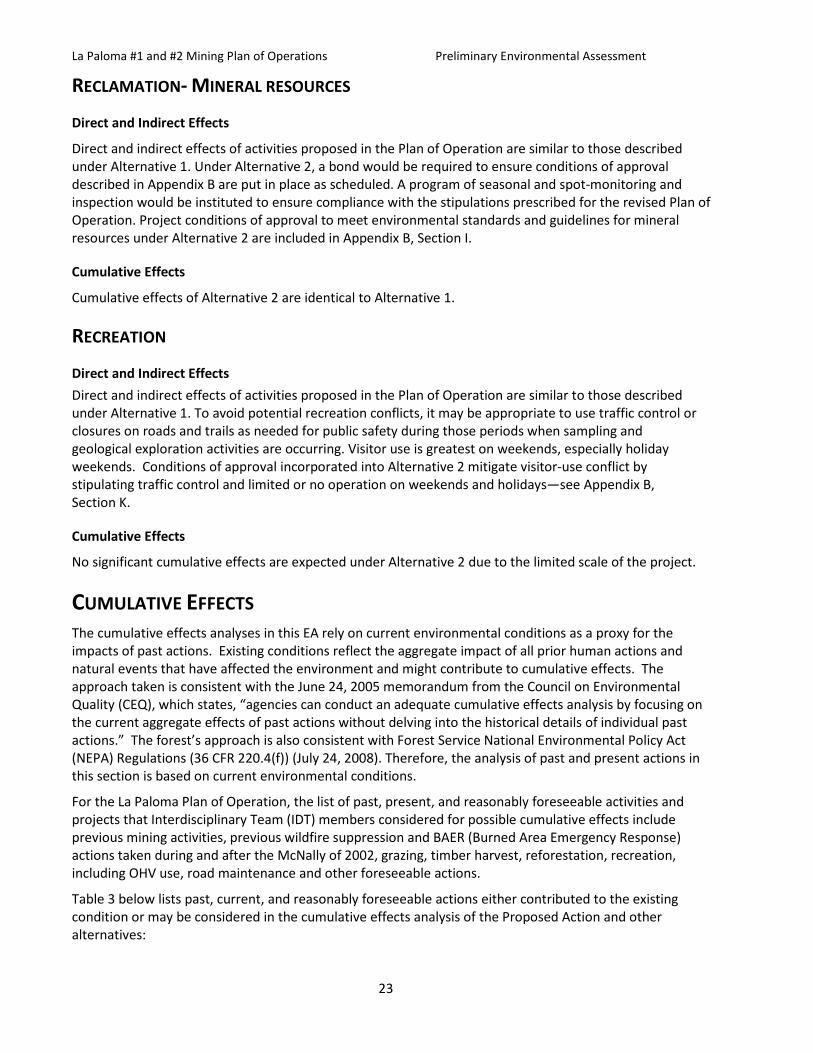
Table 3: Past, Current, and Reasonably Foreseeable Actions Type of Action Description Date(s) Location Scope
Historic Mining
36 active and 250 abandoned mines on the Sequoia National Forest
1800-s present
Throughout project
area and beyond
Little industrial mining has occurred on the Kern Plateau other than some modest tungsten mining on the western escarpment in the area of Sherman Peak.
Timber Harvest
16 Timber sales
1956 - 2005 Throughout project area and beyond
The majority of timber harvest on the Kern Plateau before 1983 was high-risk sanitation and salvage of blowdown, or drought and insect related mortality (individual tree selection). Regeneration harvest (group selection, clear-cut, or shelterwood) has resulted in approximately 295 acres of logging created openings within the 6th order watershed (HUC). Most of the logging created openings are less than 10 acres in size but may be up to 40 acres. Overall the logging-created openings appear to represent a fine-grained mosaic of habitat conditions that are known to be occupied by fisher, spotted owl and goshawk at the landscape scale across the Sequoia National Forest.
Air Pollution Air pollution from dust
and burning carbon based
fuels
Past, current,
and reasonably foreseeable
Throughout project
area and beyond
Air pollution from industrial and vehicle sources contribute to greenhouse gasses and PM-10
emissions. Recreational use of roads may contribute to dust.
Wildfires Historic Fires 1910-2010 Reasonably Foreseeable
Throughout project
area and beyond
Past wildfires have reduced the amount of mature closed canopy forest in adjacent watersheds and
across the forest in general. Cumulative watershed effects may increase immediately following wildfires
due to timing and scale of runoff and sediment delivered.
Road Construction
Mining, Logging,
Ranching, & Recreation
1950s-1993 Throughout project
area and beyond
The road system proposed for use already exists. There has been no new road construction and none
is proposed.
Fuelwood Gathering
Salvage of individual
dead trees by members of
the public for personal use.
Past, Current and Reasonably Foreseeable
Along the existing
road system
during the spring,
summer, and fall
This activity reduces the accumulation of down woody debris within a limited area, generally
adjacent to or within 100’ of roads or other access points.

La Paloma #1 and #2 Mining Plan of Operations Preliminary Environmental Assessment
25
Type of Action Description Date(s) Location Scope
Noxious Weeds
Monitoring and
Treatment
Treatment of roadside
weed infestations
by hand pulling.
Monitoring of treated sites
for effectiveness
of the treatment.
Past, Current and Reasonably Foreseeable
Throughout project
area
Conducted under the guidelines established in SNFPA (2004). Portions of the area were monitored for potential noxious weeds post McNally Fire, but
no infestations were observed.
Grazing Foraging livestock.
Past, Current,
and Reasonably Foreseeable
Throughout project
area and beyond.
Seasonal use permitted within one grazing allotment. This may have some effects of reducing
herbaceous vegetation and some increased erosion. Current grazing effects are within permitted
thresholds and are monitored on an annual basis. Recreational
Activities OHV, bike, or
pedestrian use of trails, along with camping, fishing,
hunting and bird watching
Past, Current and Reasonably Foreseeable
Throughout project
area
Recreation may affect wildlife with disturbance, or affect watersheds with compaction or overuse.
These activities have been mitigated or accounted for by limiting access during periods of high ground moisture, by implementing BMPS, and by restricting
access if needed for wildlife protection.
General motor
vehicle and off–road
vehicle use on roads
When roads are dry
enough to drive on.
Past, Current and Reasonably Foreseeable
Throughout project
area
Sequoia National Forest Motorized Travel Management ROD 2009. Weather and season
regulated.
Road Maintenance
Basic brushing,
blading and cleaning of drainage
structures.
Past, Current and Reasonably Foreseeable
Throughout project
area
Periodic maintenance
No significant cumulative effects are expected under Alternative 2 due to the limited scale of the proposed sampling and geological exploration which will disturb less than one acre.
FINDING OF NO SIGNIFICANT IMPACT (FONSI) CEQ regulations define a finding of no significant impact (FONSI) as a document by a Federal agency briefly presenting the reasons why an action, not otherwise excluded (40 CFR 1508.4), will not have a significant effect on the human environment and for which an environmental impact statement therefore will not be prepared. It shall include the environmental assessment or a summary of it (40 CFR 1501.7(a)(5)).
The responsible official has evaluated the effects of the proposed Plan of Operation relative to the definition of significance established by the CEQ Regulation (40 CFR 1508.13). Based on review and
La Paloma #1 and #2 Mining Plan of Operations Preliminary Environmental Assessment
26
consideration of the EA and documentation included in the project record, the responsible official has determined that the proposed action and alternatives will not have a significant effect on the quality of the human environment. As a result, an environmental impact statement will not be prepared.
CHAPTER 4 - CONSULTATION AND COORDINATION INTERDISCIPLINARY TEAM MEMBERS The following personnel participated in the preparation of the La Paloma #1 and #2 Mining Plan of Operations Preliminary Environmental Assessment:
Name Role
Steve Anderson Wildlife Biologist
Brenda Ehmann Forest Planner/Environmental Coordinator
Nina Hemphill Aquatic Ecologist
Tim Kelly Archaeologist
Emilie Lang Fisher Analysis
Fletcher Linton Botanist
Cody Norris Public Affairs
Marcos Rios Roads Engineer
Penelope Shibley District Planner
Andy Stone Hydrologist

La Paloma #1 and #2 Mining Plan of Operations Preliminary Environmental Assessment
27
REFERENCES
MANAGEMENT GUIDANCE USDA Forest Service. 1988. Sequoia National Forest Land and Resource Management Plan, Record of Decision.
USDA Forest Service. 1990. Mediated Settlement Agreement to the Sequoia National Forest Land and Resource Management Plan.
USDA Forest Service. 1996. Soil Survey Sequoia National Forest. Pacific Southwest Region, Vallejo, California.
USDA Forest Service. 2004. Sierra Nevada Forest Plan Amendment, Record of Decision. January 21, 2004.
SPECIALIST REPORTS Hydrology Specialist Report, La Paloma #1 and #2 Mining Plan of Operations, October 30, 2015 Andy Stone, Hydrologist, Sequoia National Forest
La Paloma Barite Mine Determination of Eligibility and Effects Analysis for the La Paloma Plan of Operation, R2014051354032 July 2014– Tim Kelly, Archaeologist, Kern River Ranger District, Sequoia National Forest
Sequoia National Forest Biological Evaluation/Assessment Short Form, La Paloma #1 and #2 Mining Plan of Operations, Fletcher Linton, Forest Botanist, Sequoia National Forest
FEDERAL, STATE, AND LOCAL AGENCIES AND TRIBES CONSULTED The Forest Service consulted the following federal, state, and local agencies and tribes during the development of this environmental assessment:
Bureau of Land Management, Bakersfield Field Office
California Department of Fish and Wildlife
California Office of Mine Reclamation
California Department of Water Resources, Central Valley Regional Water Quality Control Board
Tule River Tribal Council
US Fish and Wildlife Service
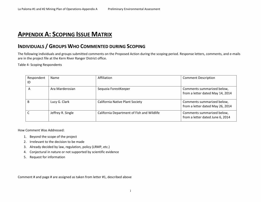
La Paloma #1 and #2 Mining Plan of Operations-Appendix A Preliminary Environmental Assessment
i
APPENDIX A: SCOPING ISSUE MATRIX
INDIVIDUALS / GROUPS WHO COMMENTED DURING SCOPING The following individuals and groups submitted comments on the Proposed Action during the scoping period. Response letters, comments, and e-mails are in the project file at the Kern River Ranger District office.
Table 4- Scoping Respondents
Respondent ID
Name Affiliation Comment Description
A Ara Marderosian
Sequoia ForestKeeper Comments summarized below, from a letter dated May 14, 2014
B Lucy G. Clark California Native Plant Society Comments summarized below, from a letter dated May 26, 2014
C Jeffrey R. Single California Department of Fish and Wildlife Comments summarized below, from a letter dated June 6, 2014
How Comment Was Addressed:
1. Beyond the scope of the project 2. Irrelevant to the decision to be made 3. Already decided by law, regulation, policy (LRMP, etc.) 4. Conjectural in nature or not supported by scientific evidence 5. Request for information
Comment # and page # are assigned as taken from letter #1, described above
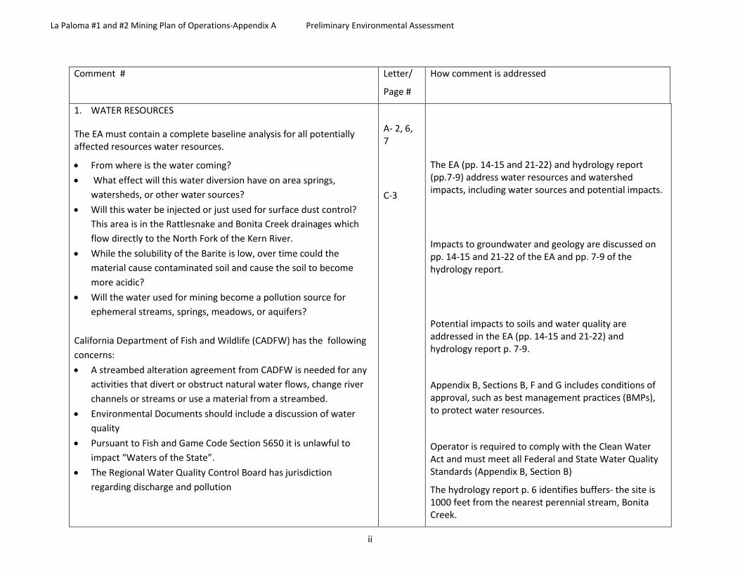
La Paloma #1 and #2 Mining Plan of Operations-Appendix A Preliminary Environmental Assessment
ii
Comment # Letter/
Page #
How comment is addressed
1. WATER RESOURCES
The EA must contain a complete baseline analysis for all potentially affected resources water resources.
• From where is the water coming? • What effect will this water diversion have on area springs,
watersheds, or other water sources? • Will this water be injected or just used for surface dust control?
This area is in the Rattlesnake and Bonita Creek drainages which flow directly to the North Fork of the Kern River.
• While the solubility of the Barite is low, over time could the material cause contaminated soil and cause the soil to become more acidic?
• Will the water used for mining become a pollution source for ephemeral streams, springs, meadows, or aquifers?
California Department of Fish and Wildlife (CADFW) has the following concerns: • A streambed alteration agreement from CADFW is needed for any
activities that divert or obstruct natural water flows, change river channels or streams or use a material from a streambed.
• Environmental Documents should include a discussion of water quality
• Pursuant to Fish and Game Code Section 5650 it is unlawful to impact “Waters of the State”.
• The Regional Water Quality Control Board has jurisdiction regarding discharge and pollution
A- 2, 6, 7
C-3
The EA (pp. 14-15 and 21-22) and hydrology report (pp.7-9) address water resources and watershed impacts, including water sources and potential impacts.
Impacts to groundwater and geology are discussed on pp. 14-15 and 21-22 of the EA and pp. 7-9 of the hydrology report.
Potential impacts to soils and water quality are addressed in the EA (pp. 14-15 and 21-22) and hydrology report p. 7-9.
Appendix B, Sections B, F and G includes conditions of approval, such as best management practices (BMPs), to protect water resources.
Operator is required to comply with the Clean Water Act and must meet all Federal and State Water Quality Standards (Appendix B, Section B)
The hydrology report p. 6 identifies buffers- the site is 1000 feet from the nearest perennial stream, Bonita Creek.

La Paloma #1 and #2 Mining Plan of Operations-Appendix A Preliminary Environmental Assessment
iii
Comment # Letter/
Page #
How comment is addressed
• Buffers should be provided to protect riparian vegetation and wildlife. A 250- foot buffer is recommended.
2. WATER RESOURCES
The project must address whether the claimant has a water right for the water.
Drilling core holes has the potential to alter the physical and chemical composition of surface and ground water through the mixing of waters from different sources.
The Forest Service must consider the impact that drilling and drilling fluids will have on water quality, including the requisite baseline analysis. In Idaho Conservation League v. U.S. Forest Service, 2012 WL 3758161, *17 (D. Idaho 2012), the court concluded that the USFS violated NEPA by authorizing exploratory hardrock mineral drilling without adequately analyzing the baseline groundwater and hydrology. The court explained that the USFS cannot rely on assumptions or mitigation measures, such as a closed drilling system, to satisfy NEPA’s obligations. The EA must include “a baseline hydrogeologic report.
A-6
Water rights are addressed in the EA p. 14.
Hydrology report p. 8 indicates the drilling will stay within the same metasedimentary formation (Calaveras group) and thus no alteration of the hydrogeology (e.g., communication with granitic aquifers) or water chemistry is expected, and that barite is essentially insoluble in fresh water.
3. ROADS • The EA must contain a complete baseline analysis for all
potentially affected resources such as transportation. • Is the road that will be used currently suffering any trespass or
is there native vegetation screening it? • Will new tracks create an attractive nuisance? • Are the roads that would be used of sufficient quality to
support the weight of the trucks? Although the scoping letter mentions that the ore will be processed off-site, no information is given. The EA must fully analyze all issues associated with the transportation of the ore, as well as the processing (e.g. impacts from ore transportation on air quality, traffic, recreation, etc.).
A- 2, 7, 8
Roads and traffic control are discussed in the EA pp.20, 21, 23 and 25.
Project conditions of approval to meet standards and guidelines for roads and reclamation are included in Appendix B, Sections F and G.
Scenic Values are addressed in the EA p. 16 and 21 and in Appendix B, Section D.

La Paloma #1 and #2 Mining Plan of Operations-Appendix A Preliminary Environmental Assessment
iv
Comment # Letter/
Page #
How comment is addressed
4. MINING Are they currently sealed to prevent human entry? Will they be resealed or guarded during the project to prevent accidental entry?
• Will there be tailing piles left in the vicinity? The agency must require full-cost bonding/financial assurance (part of its 36 CFR Part 228 responsibilities), which should be subject to public review as part of the NEPA process.
A-2, 3
The mining site has no shafts as it is an open pit mine- see EA cover photo
Proposed activities and reclamation are discussed in the EA p. 19 and 23.
Project conditions of approval to meet standards and guidelines for reclamation are included in Appendix B, Section G.
5. MINING
The applicant has not submitted a detailed mining plan of operation as required by 36 CFR § 228.4(c)(3) & (d), § 228.8, and § 228.12 and as defined by § 228.3(a).
The agency proposes to authorize a mining operation without knowing where, or how, the ore will be processed.
It is the agency’s duty to make sure that the PoO is complete, reasonable, and can be accomplished, which includes the mandate to require and analyze a plan to mill/process the ore. Deferring the requirement to the company to submit a complete mine plan, and deferring any analysis of the connected actions and/or cumulative impacts from the smelter/mill, not only violates NEPA, it contradicts the USFS’ own regulations and policies. See “Anatomy of a Mine, From Prospect to Production,” USDA Forest Service, General Technical Report INT-GTR-35, Revised February 1995, at 64-65 (detailing how smelting/processing of ore is an integral part of a complete mining plan).
A- 8-12
Alternative 2 includes additional conditions of approval to mitigate the plan of operations (see Appendix B). See response 4 above.
.

La Paloma #1 and #2 Mining Plan of Operations-Appendix A Preliminary Environmental Assessment
v
Comment # Letter/
Page #
How comment is addressed
It is well established that the Forest Service must reject an unreasonable PoO, especially one without a definite plan to transport and process the ore. “
Here, there is no evidence that this mine can be reasonably operated, as there is no plan to mill and process the ore. Without such a plan, the ore is essentially of no value. The Forest Service would be violating its duties under the Organic Act and Part 228 regulations if it approved a plan without sufficient evidence that it was economic and therefore reasonable.
Due to causal connection between the Project (and the USFS’s approval) and the processing of the ore, the EA must fully review these activities as connected actions under NEPA (as well as review the direct, indirect, and cumulative impacts). See list of Court cases in letter.
6. WILDLIFE
A full review of all potentially affected wildlife species is required. Are there bats in the cave? What species? Has any mitigation been proposed? There are Spotted Owls and fisher in the area, are there any light or noise restrictions?
CDFW has concerns regarding special status species including:
• nesting birds- permits may be needed for a take under Fish and Game Code Sections 3503, 3503.5 or 3513; mitigation measures protecting birds should be added to the environmental document
• Mountain yellow-legged frog (Rana muscosa)- This project is within the range of SMYF habitat. A biologist should determine if potential habitat occurs. If so these areas should be surveyed.
A-2
C-2, 3
The EA pp. 16-17 and 22 considers potential effects to wildlife.
Project conditions of approval to meet standards and guidelines for wildlife are included in Appendix B, Section E.
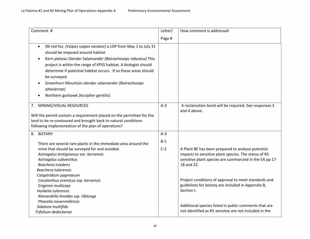
La Paloma #1 and #2 Mining Plan of Operations-Appendix A Preliminary Environmental Assessment
vi
Comment # Letter/
Page #
How comment is addressed
• SN red fox (Vulpes vulpes necator) a LOP from May 1 to July 31 should be imposed around habitat
• Kern plateau Slender Salamander (Batrachoseps robustus) This project is within the range of KPSS habitat. A biologist should determine if potential habitat occurs. If so these areas should be surveyed.
• Greenhorn Mountain slender salamander (Batrachoseps altasierrae)
• Northern goshawk (Accipiter gentilis)
7. MINING/VISUAL RESOURCES
Will the permit contain a requirement placed on the permittee for the land to be re-contoured and brought back to natural conditions following implementation of the plan of operations?
A-3 A reclamation bond will be required. See responses 3 and 4 above.
8. BOTANY
There are several rare plants in the immediate area around the mine that should be surveyed for and avoided. Astragalus lentiginosus var. kernensis Astragalus subvestitus Boechera evadens
Boechera tularensis Calyptridium pygmaeum
Corylanthus eremicus ssp. kernensis Erigeron multiceps
Horkelia tularensis Monardella linoides ssp. Oblonga Phacelia novenmillensis
Sidalcea multifida Trifolium dedeckerae
A-3
B-1
C-2
A Plant BE has been prepared to analyze potential impacts to sensitive plant species. The status of R5 sensitive plant species are summarized in the EA pp 17-18 and 22.
Project conditions of approval to meet standards and guidelines for botany are included in Appendix B, Section I.
Additional species listed in public comments that are not identified as R5-sensitve are not included in the

La Paloma #1 and #2 Mining Plan of Operations-Appendix A Preliminary Environmental Assessment
vii
Comment # Letter/
Page #
How comment is addressed
Concerns regarding protection of plants in the area including oaks and conifers due to vehicular ground disturbance.
CDFW has concerns regarding special status plants including the following California 1B rank listed :
• Gray leaved violet (Viola pinetorum ssp. Grisea) • Dedecker’s clover (Trifolium dedeckerae) • Kern Plateau milk-vetch (Astragalus lentiginosus var kernensis) • Pygmy pussypaws (Calyptridium pygmaeum) • Kern Plateau horkelia (Potentilla tularenis) • Field ivesia (Ivesia campestris)
The project claimant should contact CDFW to determine if any permits are needed.
project analysis as they have no special status. Viola pinetorum is no longer an R5 sensitive species.
Project conditions of approval to meet standards and guidelines for protection of trees are included in Appendix B, Section G (xi) (d) and (o).
9. CLIMATE CHANGE Barite is used in oil exploration as a drilling agent. Because this mine would be increasing the use of petrochemicals not only directly through the use of trucks and equipment that require petrochemicals and the production of greenhouse gasses (GHG’s) but also indirectly through the production of hydrocarbons wells where the Barite will be used, which would exacerbate climate change and produce air pollution which the forest service must address. http://nca2014.globalchange.gov/
A-2
The EA pp. 13-14 and 20 addresses air quality and climate change.
Project conditions of approval to meet standards and guidelines for air quality are included in Appendix B, Section A.
10. AIR QUALITY Sequoia National Forest (SQF) and Sequoia-Kings Canyon National Parks (SEKI) are the most polluted parks and forests in the federal system. The EA must contain a complete baseline analysis for air quality. The forest service must address air quality impacts on humans, plants and animals including
A-5-6
See responses 6 and 9 above.

La Paloma #1 and #2 Mining Plan of Operations-Appendix A Preliminary Environmental Assessment
viii
Comment # Letter/
Page #
How comment is addressed
amphibians and yellow legged frogs due to ozone, sulphur dioxide (SO2), Nitrogen Oxide (NOx), Nitric acid (HNO3)
http://webcam.srs.fs.fed.us/pollutants/ozone/index.shtml
http://cfpub.epa.gov/ncer_abstracts/index.cfm/fuseaction/display.abstractDetail/abstract/5979/report/F http://www.wmrs.edu/projects/cerec/pdfs/BytnerowiczCEREC.pdf
http://www.fs.fed.us/psw/topics/climate_change/publications/climate_wrksp/Bytnerowicz.pdf
http://cfpub.epa.gov/ncer_abstracts/index.cfm/fuseaction/display.abstractDetail/abstract/5979/report/0
http://www.fs.fed.us/psw/southernsierrascience/speakers/pdf/cisneros.pdf
An assessment of air quality in the southern Sierra Nevada: Ricardo Cisneros, Andrzej Bytnerowicz and Trent Procter; US Forest Service Sequoia-Kings Canyon National Park most affected Park in the nation by air pollution
11. RECREATION the EA must contain a complete baseline analysis for all potentially affected resources such as recreation
A-3
The EA pp. 19 and 23 addresses potential impacts to recreation.
Project conditions of approval to meet standards and guidelines for recreation are included Appendix B, Section A.
12. CULTURAL RESOURCES
the EA must contain a complete baseline analysis for all potentially affected resources such as Native American cultural/religious issues (including the consultation requirements of the NHPA),
A-7
The EA p. 18 and 22 addresses potential impacts to cultural resources.
A cultural resources report has been prepared to which identified no significant impacts. Project conditions of approval to meet standards and guidelines for cultural resources are included in Appendix B, Section J.
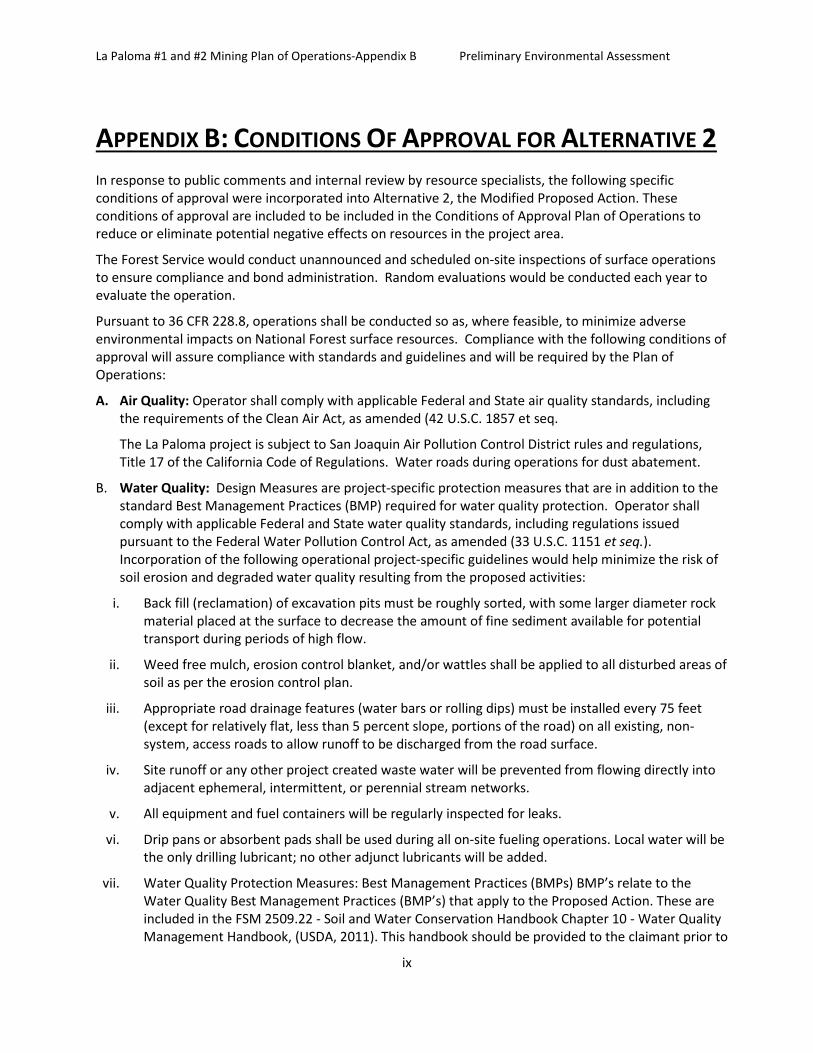
La Paloma #1 and #2 Mining Plan of Operations-Appendix B Preliminary Environmental Assessment
ix
APPENDIX B: CONDITIONS OF APPROVAL FOR ALTERNATIVE 2 In response to public comments and internal review by resource specialists, the following specific conditions of approval were incorporated into Alternative 2, the Modified Proposed Action. These conditions of approval are included to be included in the Conditions of Approval Plan of Operations to reduce or eliminate potential negative effects on resources in the project area.
The Forest Service would conduct unannounced and scheduled on-site inspections of surface operations to ensure compliance and bond administration. Random evaluations would be conducted each year to evaluate the operation.
Pursuant to 36 CFR 228.8, operations shall be conducted so as, where feasible, to minimize adverse environmental impacts on National Forest surface resources. Compliance with the following conditions of approval will assure compliance with standards and guidelines and will be required by the Plan of Operations:
A. Air Quality: Operator shall comply with applicable Federal and State air quality standards, including the requirements of the Clean Air Act, as amended (42 U.S.C. 1857 et seq.
The La Paloma project is subject to San Joaquin Air Pollution Control District rules and regulations, Title 17 of the California Code of Regulations. Water roads during operations for dust abatement.
B. Water Quality: Design Measures are project-specific protection measures that are in addition to the standard Best Management Practices (BMP) required for water quality protection. Operator shall comply with applicable Federal and State water quality standards, including regulations issued pursuant to the Federal Water Pollution Control Act, as amended (33 U.S.C. 1151 et seq.). Incorporation of the following operational project-specific guidelines would help minimize the risk of soil erosion and degraded water quality resulting from the proposed activities:
i. Back fill (reclamation) of excavation pits must be roughly sorted, with some larger diameter rock material placed at the surface to decrease the amount of fine sediment available for potential transport during periods of high flow.
ii. Weed free mulch, erosion control blanket, and/or wattles shall be applied to all disturbed areas of soil as per the erosion control plan.
iii. Appropriate road drainage features (water bars or rolling dips) must be installed every 75 feet (except for relatively flat, less than 5 percent slope, portions of the road) on all existing, non-system, access roads to allow runoff to be discharged from the road surface.
iv. Site runoff or any other project created waste water will be prevented from flowing directly into adjacent ephemeral, intermittent, or perennial stream networks.
v. All equipment and fuel containers will be regularly inspected for leaks.
vi. Drip pans or absorbent pads shall be used during all on-site fueling operations. Local water will be the only drilling lubricant; no other adjunct lubricants will be added.
vii. Water Quality Protection Measures: Best Management Practices (BMPs) BMP’s relate to the Water Quality Best Management Practices (BMP’s) that apply to the Proposed Action. These are included in the FSM 2509.22 - Soil and Water Conservation Handbook Chapter 10 - Water Quality Management Handbook, (USDA, 2011). This handbook should be provided to the claimant prior to

La Paloma #1 and #2 Mining Plan of Operations-Appendix B Preliminary Environmental Assessment
x
project activates. BMPs and erosion control measures will be employed to protect the beneficial uses of water and address watershed management concerns within the affected watersheds. BMPs are measures designed to protect watershed resources and water quality. Implementation and effectiveness monitoring would ensure that water quality objectives are being met.
viii. Erosion Control Plan and BMP Checklist: BMP 2.13 Erosion Control Plan Implementation of this BMP effectively limits and mitigates erosion and sedimentation from ground-disturbing activities. This plan will include those elements identified under BMP 2.13 and include the following:
a. List of anticipated ground-disturbing actions associated with the project.
• Use of existing L2 roads o Installation of water bars o Removal of debris and brush along the road bed for access o Add slash on access road to further prevent erosion
• Closing skid roads after project completion • Ground-based/ mechanized work with possible equipment:
o Excavators, loaders, dump trucks, water trucks, and portable drilling rigs.
b. Checklist which assures compliance with standards and guidelines required by project NEPA, requirements to meet BMPs, project plans, specifications, and permits, if any. The selection of erosion and sedimentation control measures shall be based on assessments of site conditions and how storm events may contribute to erosion.
• Dust Abatement on access routes • Water-bars and grading of access routes • Use of developed draft sites • Use of developed mine sites • Location of all refueling sites a minimum of 100 feet from riparian features • Installation of berms and trenches around refueling sites • Development of SCC spill plan • Project implementation during dry conditions • Development of erosion control plan • Pre project monitoring to establish baseline conditions • Post project monitoring to evaluate project effectiveness
c. Illustrations of control practices designed to prevent erosion and sedimentation. Illustrations must show construction and installation details for control practices, and must be included in the erosion control plan. (for example, California Stormwater Quality Association BMP standard specifications CASQA at http://www.cabmphandbooks.com, or Caltrans Stormwater and Water Pollution Control guides at http://www.dot.ca.gov/hq/construc/stormwater/stormwater1.htm)
• The access roads will have water bars to prevent erosion and sedimentation. The design procedures can be read in the Forest Service Handbook (FSH) 7709.56 Chapter 40.
• Under the Sierra Nevada Forest Plan Revision Standard and Guides, ground-based systems (e.g., excavators) will not operate on sustained slopes over 35%.
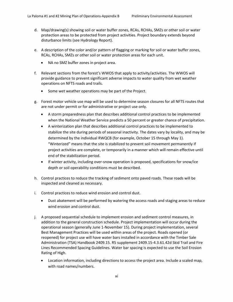
La Paloma #1 and #2 Mining Plan of Operations-Appendix B Preliminary Environmental Assessment
xi
d. Map/drawing(s) showing soil or water buffer zones, RCAs, RCHAs, SMZs or other soil or water protection areas to be protected from project activities. Project boundary extends beyond disturbance limits (see Hydrology Report).
e. A description of the color and/or pattern of flagging or marking for soil or water buffer zones, RCAs, RCHAs, SMZs or other soil or water protection areas for each unit.
• NA no SMZ buffer zones in project area.
f. Relevant sections from the forest’s WWOS that apply to activity/activities. The WWOS will provide guidance to prevent significant adverse impacts to water quality from wet weather operations on NFTS roads and trails.
• Some wet weather operations may be part of the Project.
g. Forest motor vehicle use map will be used to determine season closures for all NFTS routes that are not under permit or for administrative or project use only.
• A storm preparedness plan that describes additional control practices to be implemented when the National Weather Service predicts a 50 percent or greater chance of precipitation.
• A winterization plan that describes additional control practices to be implemented to stabilize the site during periods of seasonal inactivity. The dates vary by locality, and may be determined by the individual RWQCB (for example, October 15 through May 1). “Winterized” means that the site is stabilized to prevent soil movement permanently if project activities are complete, or temporarily in a manner which will remain effective until end of the stabilization period.
• If winter activity, including over-snow operation is proposed, specifications for snow/ice depth or soil operability conditions must be described.
h. Control practices to reduce the tracking of sediment onto paved roads. These roads will be inspected and cleaned as necessary.
i. Control practices to reduce wind erosion and control dust.
• Dust abatement will be performed by watering the access roads and staging areas to reduce wind erosion and control dust.
j. A proposed sequential schedule to implement erosion and sediment control measures, in addition to the general construction schedule. Project implementation will occur during the operational season (generally June 1-November 15). During project implementation, several Best Management Practices will be used within areas of the project. Roads opened (or reopened) for project use will have water bars installed in accordance with the Timber Sale Administration (TSA) Handbook 2409.15. R5 supplement 2409.15-4.3.61.42d Skid Trail and Fire Lines Recommended Spacing Guidelines. Water bar spacing is expected to use the Soil Erosion Rating of High.
• Location information, including directions to access the project area. Include a scaled map, with road names/numbers.

La Paloma #1 and #2 Mining Plan of Operations-Appendix B Preliminary Environmental Assessment
xii
• Directions from Kernville, CA are as follows: Drive north on Sierra Way (Mountain Highway 99) for approximately 19 miles to Sherman Pass Road (Forest Road 22S05). Take Sherman Pass Road over Sherman Pass to the junction of Forest Road 22S41 (Bonita Meadow turn off). Drive approximately 0.4 miles along Forest Road 22S41 to Forest Road 22S24 and bear right at the Y. Drive approximately 1.0 miles on Forest Road 22S24 to reach the project area. Contact information of project personnel, including name and cell phone number (that is, sale administrator, contracting officer’s representative, project manager, project supervisor, contractor, site superintendent, hydrologist, permit administrator and so forth)
Keith Andy Stone- District Hydrologist- 760- 376-3781 x683
k. Maps requirements: Maps must be clear, legible, and of a scale such that depicted features are readily discernible. For example, sale area maps may be used to satisfy the mapping requirements outlined in b.ii, below, if they meet this intent
Acres and locations of usable roads, skid trails, storage and landings are discussed in the Timber Sales Contract.
a. As a means of determining BMPs and erosion control measures, a topographic map should be in the project file. The map should extend beyond the boundaries of the project site, showing the project site boundaries, and surface and subsurface water bodies (ephemeral and intermittent waters, springs, wells, and wetlands) that could be at risk of water-quality impacts from project activities.
l. N/A
m. Diversion of Live Streams: If the project involves stream diversions for crossing construction, the erosion control plan must include detailed plans for these activities, including storm contingencies. See BMP 2.8 - Stream Crossings. NA
n. Non-Storm Water Management: The erosion control plan shall include provisions which eliminate or reduce the discharge of materials other than storm water to the storm sewer system and/or receiving waters. Such provisions shall ensure that discharged materials shall not have an adverse effect on receiving waters. Materials other than storm water that are discharged shall be listed, along with the estimated quantity of the discharged material.
Roads will be designed/maintained to reduce the potential for erosion through the installation of properly spaced water bars. Water bars will be installed in accordance with TSA Handbook 2409.15. R5 Supplement 2409.15-4.3.61.42d Skid Trail and Fire Lines Recommended Spacing Guidelines. Water bar spacing is expected to use the Soil Erosion Rating of High.
Ground disturbance associated with the Project will occur under dry conditions, during period of operation (generally June 1- November 15).
o. Waste Management and Disposal: The erosion control plan shall describe waste management and disposal practices to be used at the project site. All wastes (including equipment and maintenance waste) removed from the site for disposal shall be disposed of in a manner that is

La Paloma #1 and #2 Mining Plan of Operations-Appendix B Preliminary Environmental Assessment
xiii
in compliance with Federal, State, and local laws, regulations, and ordinances. Include plan for project-specific activities that produce waste products, such as concrete truck/chute/pump washout, equipment servicing, equipment washing, and so forth.
p. Maintenance, Inspection, and Repair: The erosion control plan shall include inspection, maintenance and repair procedures to ensure that all pollution-control devices identified in the erosion control plan are maintained in good and effective condition and are promptly repaired or restored. A qualified person shall be assigned the responsibility to conduct inspections. The name and telephone number of that person shall be listed in the erosion control plan. A tracking and follow-up procedure shall be described to ensure that all inspections are done by trained personnel and that adequate response and corrective actions have been taken in response to the inspection. This procedure may be in the form of a written checklist, with inspections signed and dated. Photo documentation is encouraged.
Claimant shall maintain all equipment operating on the project area in good repair and free of abnormal leakage of lubricants, fuel, coolants, and hydraulic fluid. Servicing of equipment will not take place on National Forest System lands. The District Hydrologist (or another qualified staff) will routinely inspect the operations to make sure all pollution-control devices are working and in place.
q. Other Plans: This erosion control plan may incorporate, by reference, the appropriate elements of other plans required by local, State, or Federal agencies. A copy of any requirements incorporated by reference shall be kept in the project file.
Substance Spill Prevention Control and Countermeasure (SPCC) Plan will be incorporated as described in BMP 7.4.
r. Post-Project Storm Water Management: The erosion control plan shall describe the storm water control structures and management practices that will be implemented to minimize pollutants in storm water discharges after project activity phases have been completed at the site. It shall also specify controls to be removed from the activity site(s) and methods for their removal. The discharger must consider site-specific factors and seasonal conditions when designing the control practices that will function after the project is complete.
Roads will be designed/maintained to reduce the potential for erosion through the installation of properly spaced water bars or rolling dips. Water bars will be installed in accordance with TSA Handbook 2409.15. R5 supplement 2409.15-4.3.61.42d Skid Trail and Fire Lines Recommended Spacing Guidelines. Water bar or rolling dip installation spacing is expected to use the Soil Erosion Rating of High.
Effectiveness monitoring through Best Management Practices will be completed as directed by the Forest Service Handbook (FSH) 2509.22, Chapter 10, as amended on December 5, 2011.
s. Preparer: The erosion control plan shall include the title and signature of the person responsible for preparation of the erosion control plan, the date of initial preparation, and the person and date responsible for any amendments to the erosion control plan.

La Paloma #1 and #2 Mining Plan of Operations-Appendix B Preliminary Environmental Assessment
xiv
BMP Name, Objective, and Direction Application to the La Paloma #1 and #2 Mining Plan of Operation
BMP 2.3 Road Construction and Reconstruction: To minimize erosion and sediment delivery from roads during road construction or reconstruction and their related activities.
For reconstructed roads: No side-casting in SMZs/RMAs. Schedule operations when precipitation is less likely, soil moisture is optimal for construction, and rutting does not occur.
BMP 2.4 Road Maintenance and Operations: To ensure water quality protection by providing adequate and appropriate maintenance and by controlling road use and operations.
Roads needed for project activities would be brought to current engineering standards of alignment, drainage, and grade before use, and would be maintained through the life of the project.
Roads would be inspected at least annually to determine what work, if any, is needed to keep ditches, culverts, and other drainage facilities functional and the road stable.
Identify road maintenance measures to protect and maintain water, aquatic, and riparian resources, including surfacing, out-sloping, dips and cross drains, armoring ditches, spot rocking, replacing culverts, and installing new drainage features.
Where economically feasible, place aggregate on existing native surface roads located in areas with High and Very High Soil Erosion Hazard ratings. Require aggregate on road slopes greater than 5% in areas with High and Very High Soil Erosion Hazard ratings.
Maintain road surfaces to dissipate water uniformly using out-sloping, rolling dips, or cross- drains. Where feasible, use out-sloping with rolling dips as the primary technique.
Adjust surface drainage structures to minimize hydrologic connectivity by discharging runoff into areas with high infiltration and surface roughness; armoring outlets; or increasing the number of drainage structures.
Clean ditches only as often as needed to keep them functional. Prevent unnecessary vegetation disturbance. Avoid undercutting the toe of the cut-slope.
Install erosion control measures when grading hydrologically connected segments and ditches.
BMP 2.11 Equipment Refueling and Servicing: To prevent fuels, lubricants, cleaners, and other harmful materials from discharging into nearby surface waters or infiltrating through soils to contaminate groundwater resources.
Project personnel would be aware of the Forest Spill Plan, including who to contact and other steps to take in case of a spill. A spill kit would be kept on-site. All waste oil, containers, and other materials would be removed from NFS lands, and properly disposed of.
For heavy equipment: Storage of hazardous materials (including fuels) and servicing and refueling of equipment would be conducted at pre-designated locations outside of RCAs. If fueling and/or storage of hazardous materials are needed in these areas, sites must be reviewed and approved by the hydrologist or aquatic biologist prior to contractual agreements by the SA. Additional protection measures, such as

La Paloma #1 and #2 Mining Plan of Operations-Appendix B Preliminary Environmental Assessment
xv
BMP Name, Objective, and Direction Application to the La Paloma #1 and #2 Mining Plan of Operation
containment devices, may be necessary.
For chainsaws and other gas powered equipment: Refueling may not occur in SMZs or RMAs. In the remainder of the RCA, refueling may occur with the use of an absorbent spill pad.
BMP 2.13 Erosion Control Plan: To effectively limit and mitigate erosion and sedimentation from any ground- disturbing activity, through planning prior to commencement of project activity, and through project management and administration during project implementation.
BMP checklists would be prepared by the hydrologist for all project activities, even when an Erosion Control Plan is not necessary.
Erosion Control Plan requirements are detailed in FSH 2509.22, 12.21 Exhibit 13. (Appendix B for ECP). SEE BMP 2.13 below.
BMP 5.6 Soil Moisture Limitations for Mechanical Equipment Operations: To prevent compaction, rutting, and gullying, with resultant sediment production and turbidity.
The soil moisture provisions described in BMP 1.5 would apply to mechanical operations conducted by any entity (contractor or USFS) for any treatment. Fuels clean-up, site preparation, or any other treatment utilizing mechanical equipment would occur only when soil moisture is within an appropriate range as determined by a soil scientist, if necessary.
BMP 7.4 Oil and Hazardous Substance Spill Contingency Plan and Spill Prevention Containment and Countermeasure (SPCC) Plan: To prevent contamination of water from accidental spills.
For small quantities of hazardous materials, the Forest Spill Plan would be used (see BMP 2.11)
A spill contingency plan and spill prevention and countermeasure plan (SPCC) must be prepared if hazardous materials (including fuels and oils) stored on the Sequoia NF exceed 1320 gallons, or if a single container exceeds 660 gallons.
The plan will at a minimum include: the types and amounts of hazardous materials located in the project area, pre-project identified locations for hazardous materials storage and fueling/maintenance activities (must be located outside of RCA unless prior approval by District Hydrologist or Aquatic Biologist is obtained), methods for containment of hazardous materials and contents of on-site emergency spill kit, and a contingency plan (including contact names with phone numbers) to implement in the event of a spill.
The SPCC plan must be approved by the Forest Service prior to project implementation.
C. Solid Wastes: Operator shall comply with applicable Federal and State standards for the disposal and treatment of solid wastes. All garbage, refuse, or waste, shall either be removed from National Forest lands or disposed of or treated so as to minimize, so far as is practicable, its impact on the environment and the forest surface resources. All tailings, dumpage, deleterious materials, or substances and other waste produced by operations shall be deployed, arranged, disposed of or treated so as to minimize adverse impact upon the environment and forest surface resources.

La Paloma #1 and #2 Mining Plan of Operations-Appendix B Preliminary Environmental Assessment
xvi
D. Scenic Values: Operator shall, to the extent practicable, harmonize operations with scenic values through such measures as the design and location of operating facilities, including roads and other means of access, limit clearing of trees and removal of vegetation to the minimum necessary, vegetative screening of operations, and construction of structures and improvements which blend with the landscape. Clearing of vegetation should be pertinent to the approved phase of mineral exploration and development.
E. Fisheries and Wildlife Habitat: In addition to compliance with water quality and solid waste disposal standards required by this section, operator shall take all practicable measures to maintain and protect fisheries and wildlife habitat which may be affected by the operations.
If any new Threatened, Endangered, Proposed, or Sensitive species is found at any point in time prior to or during implementation of this project, work will be halted until the appropriate Forest Service specialist is consulted and necessary compliance with standards and guidelines are enacted. Implement a limited operating period for mechanical ground disturbing activities from March 1 to June 30 to protect habitat.
No mechanical treatment is proposed within spotted owl or goshawk territories. However, should any spotted owl or goshawk territories be detected in mechanical treatment units, additional LOPs shall be implemented. Exclude areas of wildlife habitat from project operations to avoid impacts to legacy structures such as snags and other high-value wildlife features.
F. Roads: Operator shall maintain all roads so as to assure adequate drainage and to minimize or, where practicable, eliminate damage to soil, water, and other resource values. Unless otherwise approved by the authorized officer, roads no longer needed for operations:
i. Shall be closed to normal vehicular traffic,
ii. Bridges and culverts shall be removed,
iii. Cross drains, dips, or water bars shall be constructed, and
iv. The road surface shall be shaped to as near a natural contour as practicable and be stabilized.
v. NFS roads would be left open at all times during operations, except when those operations would pose a hazard to the public. There may be five to ten minute delays to move equipment off the roadway. The roads will be signed in two places to alert the public of delays; (1) at the intersection of Sherman Pass (22S05) Road and Lookout Mountain Road (22S41); (2) at the intersection of Lookout Mountain Road (22S41) and West Road (Road No. 22S24 One to two of the operator’s assistants would be assigned to communicate with the public and the operator in order to allow for efficient traffic flow. Upon arrival of traffic, the assistant will stop traffic and notify the operator. Operations will be stopped to allow for the passage of vehicles. Vehicles will be guided around any open excavation No holes in the road will be left open at night or when the operator is not at the site.
vi. Once auger holes are completed, road reconditioning will be completed to repair and restore the condition of the road to pre-project conditions. Standards are derived from National Forest System road maintenance guidelines and include:
vii. Reconditioning of ditches, shoulders, and roadbed surfaces. All slide material, sediment, vegetation, and other debris from the existing ditches and culvert inlets and outlets would be removed. Ditches and culvert inlets and outlets would be reshaped to achieve positive drainage and a uniform ditch width, depth, and grade. Waste disposal sites, if needed, would be coordinated with the Forest Service.

La Paloma #1 and #2 Mining Plan of Operations-Appendix B Preliminary Environmental Assessment
xvii
viii. Soft and unstable areas would be repaired. All slide material, vegetation, and other debris would be removed from existing shoulders including shoulders of parking areas, turnouts, and other widened areas. Shoulders would be reshaped as necessary.
ix. All organic, deleterious, or oversize material larger than 6 inches would be removed from the top 6 inches of subgrade. The road would be scarified to a 6 inch depth, surface irregularities would be removed, and the road shaped to provide a uniform surface. Road surfaces would be required to meet standards for line, cross-section, and grade. The road would then be compacted. No culvert replacement or removal would be authorized.
G. Reclamation: Upon exhaustion of the mineral deposit or at the earliest practicable time during operations, or within 1 year of the conclusion of operations, unless a longer time is allowed by the authorized officer, operator shall, where practicable, reclaim the surface disturbed in operations by taking such measures as will prevent or control onsite and off-site damage to the environment and forest surface resources including:
i. Control of erosion and landslides;
ii. Control of water runoff;
iii. Isolation, removal or control of toxic materials;
iv. Reshaping and revegetation of disturbed areas, where reasonably practicable; and
v. Rehabilitation of fisheries and wildlife habitat.
vi. Annual reclamation would include removal of all equipment from Federal land Annual reclamation would be completed no later than November 15th of each year. Final reclamation would include removal of all equipment and debris located on the claim. The entire disturbed area including excavations and disturbed portions of the access road would be seeded with native vegetation and covered with weed free mulch. The area would be monitored for up to three years to ensure that proper re-vegetation has occurred, that the streambed is stabilized, and that the area is returned to a natural state.
vii. The timeframe for the proposed operation is five years from the date of plan approval. Seasonal operations would occur between May and November depending upon weather conditions. All operations under this plan would be concluded within 5 years from date of approval.
viii. Any excavations that are left open overnight will need to be fenced with high visibility safety fencing. Regular inspections of the site would be implemented to ensure that the claimant’s activities fall within the scope of the Plan of Operations and Conditions of Approval and to ensure that reclamation is being performed in a timely manner.
ix. A reclamation bond equivalent to the actual cost of mitigation and reclamation would be held in accordance with 36 CFR 228.13. The bond is subject to annual evaluation to reflect changes in operations and reclamation costs (required if over 10,000 cubic yards/for this project is at the discretion of deciding official).
x. A bond which covers the potential costs of road repair and stabilization will be in place prior to the start of operations. Road reclamation would be inspected by National Forest road engineers to ensure an acceptable level of reconstruction and to ensure safety and stability prior to the release of this bond.
xi. To minimize the increase of detrimental compaction, no heavy equipment use will be authorized when soils are wet. The following design criteria, mitigation measures and best management
La Paloma #1 and #2 Mining Plan of Operations-Appendix B Preliminary Environmental Assessment
xviii
practices will be implemented to meet Forest Plan standards and guidelines and to eliminate or minimize potential impacts to soils, hydrology, vegetation, fish, wildlife, and heritage resources:
a) Limit trench excavation and backhoe off-road travel to slopes < 35%. b) Top soil at new excavation sites will be removed and stockpiled separately from overburden,
for use in reclamation of the trench. c) All excavation of new trenches will take place outside a 50-ft buffer from Forest Service
System roads and trails (measured from the edge of road prism or trail, each side). d) Backhoe cross-country travel routes (and excavations) will be will be located to avoid large
(>20” dbh) trees and snags, staying outside of the drip line of living trees and outside the falling radius of snags.
e) Limit cross country travel to periods when soil conditions are dry.
f) Equipment operating off of roads will be cleaned prior to entering the Project Area, to remove all mud, dirt, and plant parts. The intent is to prevent establishment and spread of invasive species.
g) Trenches will be reclaimed before the backhoe demobilizes from the site (see next measure). Backhoe trails will be scarified, reseeded, and covered with organic material (including large logs or stumps), during demobilization from trenches. If soil compaction is indicated in year 3 following demobilization, then the miner will decompact that backhoe trail to a depth of at least 18 inches, by the end of year 3. Final reclamation will entail refilling and reclaiming the existing pit, and the spur road into the pit. All disturbed areas will be reseeded with native grasses and forbs approved by a Forest Service Botanist, and any mulch used will be certified as weed-free.
h) Each new trench will be refilled with stockpiled overburden, covered with reserved topsoil, seeded according to the approved Reclamation Plan, and then covered with organic debris.
i) Upon completion of all activities:
j) The pit will be refilled with stockpiled overburden (restoring the natural contour), covered with topsoil, reseeded with native species approved by the District botanist, and covered with organic debris (if mulch is used, it must be certified weed-free).
k) the spur road to the pit will be obliterated by restoring the natural contour, decompacting with an excavator to a depth of at least 18 inches, reseeding with native grasses and forbs, and covered with organic debris.
l) The project area will be monitored for invasive species by the Forest Service for 5 consecutive years following final reclamation. Invasive species would be treated manually by the Forest Service. No herbicide use would be authorized under the decision for this project. A forest-wide Environmental Impact Statement addressing local use of herbicides is in preparation, and herbicides may be utilized in the future on this mining claim, depending on the outcome of that decision.
m) Disturbed soils will be seeded in fall (in the year of disturbance) with a genetically appropriate native seed mix for the watershed area. The seed mix must be approved in advance by the District botanist. If desired species are not available, then as an interim measure, a non-native, non-persistent seed mix may be used.

La Paloma #1 and #2 Mining Plan of Operations-Appendix B Preliminary Environmental Assessment
xix
n) All disturbed areas should also be mulched with certified weed free straw or weed free mulch after seeding.
o) There will be no removal of standing trees (living or dead), unless they pose a hazard to the operation, and then only with prior Forest Service approval and within limits set forth under this environmental analysis (see measure no. 8, above). As much as possible, backhoe routes will be selected to avoid large trees (>20” dbh, living and dead). Felled trees will be left on site or used for reclamation.
H. Certification or other approval issued by State agencies or other Federal agencies of compliance with laws and regulations relating to operations will be accepted as compliance with similar or parallel requirements of these regulations.
I. Botanical Resources: To prevent the establishment or spread of noxious weeds during operations, all off road equipment would be washed prior to entering the Forest. Staging of equipment would be in weed free areas. Mulches, gravel, or fill used in the project, if any, would be certified weed free. Topsoil would be stockpiled for use in re-vegetation. Re-vegetation efforts would use native seed from local sources. All seeding and planting will use only locally collected, native seed sources. Seed zones for grasses will be used when possible, otherwise plant and seed material will be collected from as close as possible to the project area, from within the same watershed and at a similar elevation.
J. Cultural Resources: If any additional or previously unidentified cultural resources are located during project implementation, the find must be protected from operations and reported immediately to the Heritage Resource Staff. All operations in the vicinity of the find will be suspended until the site is visited and appropriate recordation and evaluation is made by the Heritage Resources Staff.
K. Recreation: Use traffic control or closures on roads and trails as needed during treatment activities for public safety. Unless agreed otherwise, no hauling will be allowed on major holidays, Saturdays, Sundays, or the day preceding the general opening of deer season, Memorial Day, Fourth of July, and Labor Day.
L. Necessary Approvals
Approvals required for the development of the La Paloma #1 and #2 mining claims may include, but not be limited to, the following:
Forest Service
• Approval of Plan of Operations • Approval of Fire Plan
California State Board of Water Resources
• Approval of water discharge
San Joaquin Valley Air Pollution Control District
• Permit for Portable Equipment
Any other county, state or federal permits required (e.g. Tulare County Environmental Health for well drilling)