la niña mpacts b and utloo november 2016
TRANSCRIPT

Contacts: Doug Kluck ([email protected]) NatalieUmphlett([email protected])
Missouri Basin Region La Niña Impacts and Outlook | November 2016 https://www.drought.gov/drought/dews/missouri-river-basin
La Niña Impacts and Outlook
Missouri Basin Region November 2016
Typical La Niña Winter Pattern
La Niña EvolutionWinter Temperature and Precipitation Outlooks La Niña Outlook
Valid for December 2016 - February 2017 Through Summer 2017
La Niña in WinterA La Niña develops when sea-surface temperatures in the equatorial Pacific Ocean are cooler than average for an extended period of time. This affects the location of jet streams, causing impacts in North America. The most notable impacts occur in the winter, when the wind patterns in the atmosphere are strongest.
The typical La Niña winter weather pattern brings the polar jet stream into Alaska, then plunging into the central and eastern U.S. This path can bring below-normal temperatures into the northern U.S., especially the northern Rockies across the northern Plains and into the Great Lakes. Meanwhile, the southern Plains often are left warm and dry. The Pacific jet stream tends to track close to the Pacific Northwest, bringing increased chances for moisture there. Finally, odds increase slightly for wetter-than-normal conditions in the Ohio River Valley.
For the Missouri Basin, this typically means increased chances for below-normal temperatures in the upper Basin. Additionally, the northern Rockies also may have increased chances for an above-normal snowpack.
A La Niña was officially declared this fall; however, it is predicted to remain weak with a possible transition back to neutral conditions later this winter. The chart above shows the likelihood of La Niña, El Niño, and neutral conditions over the next several months. The odds are highest for La Niña (blue bars) through winter, then the highest odds shift toward neutral (green bars) in the early spring and summer. El Niño (red bars) chances then increase through the summer but remain relatively small. This is a typical evolution of the ENSO pattern. For more information, please see: http://iri.columbia.edu/our-expertise/climate/forecasts/enso/current/.
Despite the relative weakness of the current La Niña, the winter outlook largely follows a typical La Niña pattern for the Missouri Basin states. Above-normal precipitation is favored for areas of the northern Rockies, Wyoming, and the Dakotas. Meanwhile, increased chances for below-normal precipitation exist for southern areas of Colorado and Kansas. For temperatures, below-normal conditions are favored to the north, while above-normal conditions could occur across portions of Wyoming, Colorado, and Kansas. These temperature and precipitation outlooks are consistent with a more active storm track across the northern half of the region this winter. Learn more about the limitations of this forecast on page 2.
The seasonal outlooks above combine many factors including climate models, the effects of long-term trends, soil moisture, and the El Niño Southern Oscillation cycle (ENSO). Because these outlooks combine many inputs, they do not match the typical La Niña conditions exactly. To learn more, or to retrieve the latest temperature, precipitation, and drought outlooks, please visit the Climate Prediction Center at: http://www.cpc.ncep.noaa.gov.
The image above shows the typical pattern in the winter during La Niña events. The polar jet stream tends to traverse right through the Missouri Basin region, making it the dividing line between cold and warm air masses. This means that colder conditions could be in store for areas of the upper Basin, while the southern Plains could be warm and dry.
Image courtesy of the National Oceanic and Atmospheric Administration.For more information please visit: https://www.climate.gov/news-features/department/enso-blog.
PrecipitationTemperature
EC: Equal chances of above, near or below normal, A: Above normal, B: Below normal
Early Nov CPC/IRI Official Probabilistic ENSO Forecast
Potential Winter and Spring Impacts
Contacts: Doug Kluck ([email protected]) NatalieUmphlett([email protected])
Missouri Basin Region La Niña Impacts and Outlook | November 2016 https://www.drought.gov/drought/dews/missouri-river-basin
Missouri Basin PartnersComparisons and LimitationsHigh Plains Regional Climate Centerwww.hprcc.unl.eduInternational Research Institute for Climate and Societyhttp://iri.columbia.eduNational Drought Mitigation Centerwww.drought.unl.eduNational Integrated Drought Information Systemwww.drought.govNational Oceanic and Atmospheric Administration
National Weather Service - Central Regionwww.crh.noaa.gov/crhNational Centers for Environmental Informationwww.ncdc.noaa.govClimate Prediction Centerwww.cpc.ncep.noaa.gov
American Association of State Climatologistswww.stateclimate.orgU.S. Army Corps of Engineers - Missouri River Basin Water Management Divisionwww.usace.army.milU.S. Department of Agriculture - Climate Hubswww.usda.gov/oce/climate_change/regional_hubs.htm
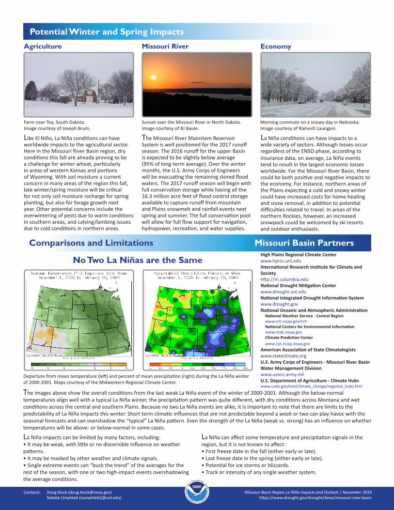
No Two La Niñas are the Same
The images above show the overall conditions from the last weak La Niña event of the winter of 2000-2001. Although the below-normal temperatures align well with a typical La Niña winter, the precipitation pattern was quite different, with dry conditions across Montana and wet conditions across the central and southern Plains. Because no two La Niña events are alike, it is important to note that there are limits to the predictability of La Niña impacts this winter. Short term climatic influences that are not predictable beyond a week or two can play havoc with the seasonal forecasts and can overshadow the “typical” La Niña pattern. Even the strength of the La Niña (weak vs. strong) has an influence on whether temperatures will be above- or below-normal in some cases.
Sunset over the Missouri River in North Dakota.Image courtesy of BJ Baule.
Missouri River EconomyAgriculture
The Missouri River Mainstem Reservoir System is well positioned for the 2017 runoff season. The 2016 runoff for the upper Basin is expected to be slightly below average (95% of long-term average). Over the winter months, the U.S. Army Corps of Engineers will be evacuating the remaining stored flood waters. The 2017 runoff season will begin with full conservation storage while having all the 16.3 million acre feet of flood control storage available to capture runoff from mountain and Plains snowmelt and rainfall events next spring and summer. The full conservation pool will allow for full flow support for navigation, hydropower, recreation, and water supplies.
Farm near Tea, South Dakota.Image courtesy of Joseph Brum.
Morning commute on a snowy day in Nebraska.Image courtesy of Ramesh Laungani.
Like El Niño, La Niña conditions can have worldwide impacts to the agricultural sector. Here in the Missouri River Basin region, dry conditions this fall are already proving to be a challenge for winter wheat, particularly in areas of western Kansas and portions of Wyoming. With soil moisture a current concern in many areas of the region this fall, late winter/spring moisture will be critical for not only soil moisture recharge for spring planting, but also for forage growth next year. Other potential concerns include the overwintering of pests due to warm conditions in southern areas, and calving/lambing issues due to cold conditions in northern areas.
La Niña conditions can have impacts to a wide variety of sectors. Although losses occur regardless of the ENSO phase, according to insurance data, on average, La Niña events tend to result in the largest economic losses worldwide. For the Missouri River Basin, there could be both positive and negative impacts to the economy. For instance, northern areas of the Plains expecting a cold and snowy winter could have increased costs for home heating and snow removal, in addition to potential difficulties related to travel. In areas of the northern Rockies, however, an increased snowpack could be welcomed by ski resorts and outdoor enthusiasts.
Departure from mean temperature (left) and percent of mean precipitation (right) during the La Niña winter of 2000-2001. Maps courtesy of the Midwestern Regional Climate Center.
La Niña impacts can be limited by many factors, including:• It may be weak, with little or no discernible influence on weather patterns.• It may be masked by other weather and climate signals.• Single extreme events can “buck the trend” of the averages for the rest of the season, with one or two high-impact events overshadowing the average conditions.
La Niña can affect some temperature and precipitation signals in the region, but it is not known to affect:• First freeze date in the fall (either early or late).• Last freeze date in the spring (either early or late).• Potential for ice storms or blizzards.• Track or intensity of any single weather system.