la florida/namaan: the site, its monuments, and directions
TRANSCRIPT

La Florida/Namaan: The Site, its Monuments, and Directions for Future Research Joanne Baron
6/5/2014 In July of 2013 and May of 2014 I visited the site of La Florida, Guatemala with Liliana Padilla and Christopher Martinez. During these visits, we took many photographs of the ruins and its carved monuments, recorded the locations of unmapped portions of the site, and met with local municipal authorities. The purpose of these visits was to assess the feasibility of a long-term research project at the site and to establish relationships locally with people who can help us in this endeavor. In this report, I will present background information on the site of La Florida, describe our explorations in 2014, and discuss future plans for the site. Background The site of La Florida, Peten, is located on the southern bank of the San Pedro Martir river, approximately 20km from the western border with Mexico and approximately 60km from El Peru. It is located in town of El Naranjo, previously the finca of El Naranjo or La Florida, in the jurisdiction of La Libertad. For this reason, the site has been variously called La Florida (Shook 1943; Morley and Thompson 1944; Graham 1970) and El Naranjo-Frontera (Morales 1998). It was briefly called Ocultun by Graham (1970) before he realized that the site was actually the La Florida discovered by Shook. Some maps mistakenly record Ocultun and La Florida as two separate sites, but this is not the case. The site was discovered in 1943 by Edwin Shook. In his notes about the visit, he writes,
“From El Paso throughout the N. W. Peten, no arch. sites have been reported except along the Usumacinta River, and after Morley-Ricketson’s trip down the Rio S. Pedro in 1921 + without reporting a site, I had no expectations of seeing or hearing of any Maya city of any consequence. The main purpose of making this trip was to see the country and the reason for lack of important Maya sites. I made inquiries all along, but found only one native who knew of a ‘Cerrito’ near ‘La Florida.’” (Shook 1943:20a).
While we now know that several sites lie along the San Pedro River, the vague knowledge of the site by local inhabitants continues to this day. Shook also wrote about the advantages of the site of La Florida for the ancient Maya:
“Don Salamon picked the site because of the richness of the soil for cultivating corn, red + black beans, chile, squash, + etc. He reports the soil exceedingly productive, which is interesting because of the large archaeological site.” (Shook 1943:20a). “The archaeological site of La Florida is large and important for several reasons. It is strategically located for trade by river with the Tabasco plain area (easily accessible by cayuco) and land trade from the Usumacinta sites (Piedras Negras, Yaxchilan, + etc.) and by river to the heart of the Old Empire Maya of Central Peten. Trade between the Usumacinta cities and Central Peten would

almost of necessity pass La Florida, as would trade from the lower Usumacinta with Tabasco plains area.” (Shook 1943:24).
The San Pedro River flows mostly westward in the Peten, passing near the important sites of El Peru and La Joyanca. La Florida is the furthest major site west along this section of the river. Shortly after the Mexican border, the San Pedro turns and flows northward for approximately 60km before turning west again to join the Usumacinta. This would have made La Florida the ideal transshipment point for goods and people travelling between the Central Peten or the Calakmul-allied cities to the north and the Usumacinta cities of Yaxchilan and Piedras Negras. As the crow flies, La Florida is located approximately 40km from Yaxchilan and 50km from Piedras Negras. Both sites apparently took an interest in La Florida at some point in history. La Florida also had relations with Motul de San Jose, El Peru, and possibly Calakmul (see below).
Map showing location of La Florida. Green indicates sites that probably had friendly relations with La Florida. Red indicates an antagonistic relationship. Shook (1943) visited the site for only one day, making a sketch map and noting the presence of three monuments. He also collected a small sample of sherds from the surface. The following year, Sylvanus Morley and his wife visited the site for two days. Morley was primarily concerned with monuments and discovered several more (Morley and Thompson 1944; Graham 1970:appendix B). In 1954, Inocencio del Busto Rodriguez visited and took more photographs. Ian Graham visited the site for four days in 1965 (Graham 1970). He made drawings of the monuments, a map of the site, and a testpit. In 1996, Edgar García noted La Florida in his regional survey of Southeast Peten, although he did not undertake work there (García 1996:64). In 1997, Paulino Morales made another survey of the site and collected surface material (Morales 1998). In 2011, Guido Krempel visited the site in order to take photographs of Stelae 1 and 2 (see below). Finally, while no archaeological work has been done at the site since 1997, it appears on regional maps produced by the Proyecto Peten-Noroccidente (PNO), which focuses

on the sites of the ancient Hix Witz polity: La Joyanca, El Pajaral, and Zapote Bobal. (Arnauld et al. 2001:284; Lemonnier 2009:99). Morales (1998) described the main part of the site as falling into three groups. The West Group consists of two plazas. The northernmost of these two plazas is closed on all sides. The largest structure in the group is Structure 1, more than 12 meters tall (Morales 1998:130). Morales proposes that the eastern and western sides of this plaza are created by an E-group complex. The eastern side does have three structures in a row but I hesitate to call the complex and E-group without further investigation. This plaza originally contained three stelae and four altars (Graham 1970). The North Group is located next to the river. It consists of a plaza delimited on the east and west by 12m structures (Morales 1998:131). This group originally contained five stelae and two altars. The East Group is dominated by a set of two closed patios, possibly representing a palace complex. Numerous other small structures are scattered nearby. Five stelae and three altars were originally located in this area.
Map of the main part of La Florida, after map by Paulino Morales (1998). Red represents approximate current locations of monuments. Ceramics collected by Shook consisted of Tepeu sherds, mold-made figurines, and one Fine Orange sherd (Shook 1943:23a). Ceramics collected by Ian Graham (1970) were analyzed by Jeremy Sabloff. He observed that the assemblage mostly dated to Tepeu 2 and Tepeu 3 with a small amount of Early Classic and Preclassic material. Morales (1998) collected 76 sherds from the surface, of which 15% dated to the Early Classic and 75% dated to the Late Classic.

The Epigraphy of La Florida The name of La Florida is variously given as Maan and Namaan. These two names appear to be interchangeable, as both are used to describe Lady K’atun Ajaw at Piedras Negras. The logogram MAAN depicts the markings of a snake but the precise meaning of the glyph is unknown (Closs 1988; Stuart 1985 in Closs 1988). Lopez (2003) proposes that the word can be connected to Colonial Yucatac and Ch’ontal words for “vision” or “ghost” and that the occasional na- prefix served as an optional modifier. He also notes that the impersonation of a deity called K’ahk’ Maan Chan Chaak is mentioned on two monuments from Palenque and Yaxchilan, one of which depicts the ruler of Palenque dressed as Chaak and holding an axe whose handle is composed of a fire-spitting snake. The connection between the word maan and a mythical snake that spits fire can also be seen on K1670, a vase belonging to a La Florida lord, discussed further below. Part of the PSS of this vessel reads k’ahk’ namaan tzuun K’awiil chan nal uch’aab chan, meaning “fire namaan [?] K’awiil sky place is his sacrifice snake” (Lopez 2003). The vessel depicts two scenes. The left scene shows a young lord seated on a throne, possibly the god Juun Ajaw. In front of him is a curled up snake that shoots fire from its mouth and tail. He gestures to the snake as if to tame it. In the right hand scene, the same lord has tamed the snake, which now curls around his body and over his lap. This scene and caption lends support to the idea that namaan or maan is a snake that spits fire, connected to the concept of K’awiil, the lightning god. K’awiil is depicted as the personified axe of chaak, and his foot terminates in a snake’s body that represents a streak of lighting. Thus, namaan or maan is another version of this fiery lightning snake. It remains unclear why the site of La Florida was named for this mythical beast. As early as the 1980s, epigraphers suggested that the Maan site, which was mentioned in the inscriptions of several other polities, corresponded to La Florida (Lopez 2003). In 1998, Stanley Guenter revived this hypothesis by noting in an unpublished paper that the Maan emblem glyph appears on La Florida Stela 7. The same observation was made independently by Alexandre Safronov in 2000 (Zender 2002). In 2011, Guido Krempel added further evidence for the identification of La Florida with Namaan, by observing the emblem glyph on Stela 2 as well (Krempel 2011). These observations allow us to link the site of La Florida with the many mentions of the Namaan polity in other inscriptions, cataloged by Luís Lopez (2003). I made further photographs and drawings of these two emblem glyphs during the 2014 visit, which I will discuss below. Stelae 1, 2, 5, 6, 7, 8, 9, Altar G and Altar H have all been recorded as having legible text (Graham 1970; Morales 1998; Krempel 2011). Of these, drawings are available for all except for Stela 2. Stela 1, which was sketched by Shook during his 1943 visit, depicts a ruler standing with a ceremonial bar (Shook 1943:15). A captive or subsidiary lord kneels at his feet. Hieroglyphic captions accompany both figures. No date is legible. Stela 2 is badly damaged but Krempel (2011) was able to make out a possible emblem glyph reading (na-?)maan ajaw. Stela 5 is fragmentary and depicts a ruler holding a K’awiil scepter. A hieroglyphic text runs down the right side of the monument. Most of the glyphs are illegible but one contains a female prefix naming a woman, possibly the ruler’s mother.

A drawing of Stela 6 was made by Morales (1998). Only the top part of Stela 6 is preserved. It has a legible calendar round date corresponding to 12 Ajaw 8 Keh (reported as 12 Ajaw 8 K’ank’in by Morales). This is probably the long count date 9.11.0.0.0 or AD 652. Stela 7 depicts a standing ruler. The monument gives the dedicatory date of 7 Ajaw 18 Pohp, corresponding to 9.16.15.0.0 or AD 766 (Graham 1970). Following the date is the t’abay dedication verb. The next set of glyphs, which appear near the ruler’s leg, undoubtedly starts with ulakamtuun (his stela) although this glyph is badly eroded. This is followed by the name of the ruler and the titles “4 K’atun” Ajaw and K’uhul Maan Ajaw. Stela 8 is carved on both sides. The front probably depicted a ruler and has a small glyphic caption, now illegible. The back is all glyphic. Unfortunately, the dates are too illegible to work out, but a large distance number appears, indicating that the monument recalls events from the distant past. Graham suggests that one of the calendar rounds may be read 3 Ajaw 3 Xul, corresponding to 9.12.5.0.0 or AD 677, but this is only a tentative reading. The name of the ruler is preserved, however, and may read Bahlam K’awiil. He is given the title “4 K’atun” Ajaw. Stela 9 depicts a woman in the act of scattering. The date is given as 4 Ajaw 13 Yax or 9.15.0.0.0 AD 731 (Graham 1970). The text that follows gives the names and titles of the woman. She is named Ix Chak [?] and was the mother of the ruler. Glyphs following these titles also name her as an Ix Sajal. Altar G was originally paired with Stela 9 and carries a short inscription on the top. The opening glyphs, containing the date, are in poor condition but the presence of the coefficient 13 on the haab date confirms that this must have carried the same date as Stela 9. After the dedicatory verb, the name of the altar’s owner is given. The much eroded glyph is consistent with the name K’ahk’ Chan Yopaat, seen on an unprovenienced vessel K5418 (see below). We are then told that this ruler was the grandson of another individual, apparently read UH /ja-?-ku-yu. This individual may be an earlier ruler of La Florida. In fact, the name, although it lacks the fire glyph, closely resembles the name of K’ahk’ Ti’ K’uy as shown on Yaxchilan Lintel 45 (see below). The king named on Altar G (whose mother appears on Stela 9) is probably the same as on Stela 7. Stela 7 is 35 years later than Altar G but names its protagonist as a “4 K’atun” Ajaw (a lord who is between 60 and 80 years old). This king may also appear on an unprovenienced vessel K5418 (see below). Mention of the Maan or Namaan polity is made on the monuments of Yaxchilan, Piedras Negras, and El Peru. Yaxchilan seems to have had a hostile relationship with La Florida. Captives from La Florida are mentioned on Yaxchilan Lintel 45, Stela 5, Stela 15, Stela 19, Stela 21, and Hieroglyphic Stairway 5 (Lopez 2003). From Lintel 45, we learn that the ruler of La Florida in 681 was named K’ahk’ Ti’ Kuy. This name is similar to the ruler named as the grandfather of the owner of La Florida Altar G. Piedras Negras’ relationship with La Florida appears to have been friendly. Piedras Negras Ruler 3 married a woman from La Florida in 706, and she is prominently mentioned on his stelae 1, 3, 8 and on grave goods from Burial 5 (Lopez 2003). She was an important figure in the Piedras Negras court until at least 729. Stela 8 also describes Ruler 3’s mother as a ch’ook namaan (young person from La Florida). While his father was Ruler 2, his mother seems to have arrived at Piedras Negras only after giving birth to Ruler 3. The two marriages to women from La Florida indicate that Piedras Negras had a strong interest in maintaining friendly relationships during this period.

El Peru Stela 34, which dates to 692, contains a number of scribal signatures. One of these is a person of Ajaw status from La Florida (Lopez 2003), indicating friendly relations between the two sites. Finally, two ceramic vessels excavated at La Corona in 2013 (Canuto and Barrientos 2013) make reference to La Florida. The first of these names a number of different lords, probably from different sites. One is given the title wi’te’ naah. This, along with the form of the vessel, suggests an Early Classic date (consistent with the early context where it was found). The glyphs are arranged into four columns of three glyphs each. One of these columns is missing and it is difficult to tell where one name ends and the next begins. However, the name of the La Florida lord is given as Sihyaj Chan K’awiil. The other vessel appears to date to the early 600s (Caroline Parris, personal communication). The owner of the vessel is named as Aj Paat Chan Ajaw, with additional titles as well. While this plate does not contain the La Florida emblem glyph, it does have a number of features linking it to two other plates from La Florida, discussed below. This suggests that this plate names yet another ruler from La Florida and that the scribe simply ran out of room for the emblem glyph. A number of unprovenienced vessels mention La Florida. However, given the lack of looting at the site, it is likely that these vessels were not looted from La Florida itself, but rather from other sites, to which they would have been given as gifts in antiquity. Three vessels name another ruler of La Florida. These include a plate now in Brussels, a plate in the Pomona site museum, and an unprovenienced vase (Lopez 2003). While his name/title string is quite long, one common element seems to be chakaj, which on one of the vessels is followed by Chaak (the rain god). Thus, the main part of this ruler’s name is probably Chakaj Chaak (“reddening Chaak”). The Pomona plate gives this ruler the title K’uhul Chatahn Winik, which is more commonly associated with the kingdoms further north under the sway of the Kaan dynasty. The Brussels plate also names the mother of this individual. She carries the name “Six Sky [?] Ajaw,” a name also carried by women from La Corona and Dos Pilas. The two plates have features linking them to the second La Corona plate discussed. First, like the La Corona plate, the type of vessel is described in the PSS as yajaljib, a rare term discussed by Boot (2003). Second, all three plates make use of an undeciphered title, possibly involving the kaban sign. Lopez (2003) discusses another vase which names the son of Chakaj Chaak. Although his name is not given, his parents are listed: his mother is called Ix K’in Ajaw, and his father is Chakaj. K1670 names ruler Sihyaj Chan K’awiil, the same ruler mentioned on the other La Corona vessel. In this case, he is also given the title K’uhul Chatahn Winik, as on the Pomona plate. The vessel also apparently discusses an ancestor or grandfather of his, although his name phrase is difficult to interpret (Lopez 2003). Interestingly, this vessel bears a strong resemblance to K4427, which also names a distant ancestor. However, K4427 has not been recognized as a La Florida reference previously, because the emblem glyph of the owner appears to read Yax-Ha-Ajaw. I believe, however, that this is the result of overpainting by the restorer of the vessel. The actual emblem glyph of Yaxha does not use the HA’ logogram, but always the syllable a. If we compare K4427 to K1670, the two texts are quite similar in style and content, and the na- syllable on the namaan emblem glyph on K1670 is somewhat angular, vaguely resembling the YAX sign.

K5418 is owned by K’inich Lamaw Ek’, ruler of Motul de San Jose. A date on the vessel corresponds to 756, and it appears to depict a ruler of La Florida named K’ahk’ [?] Chan Yopaat (Lopez 2003). This is probably the same ruler depicted on La Florida Stela 7, who is said to be a “4 K’atun” Ajaw ten years later in 766, and on Altar G, where the name of the ruler is consistent with K’ahk’ [?] Chan Yopaat. Another vessel that indicates a friendship between these two sites is K2784 (Lopez 2003). This vessel depicts a La Florida lord seated on a throne and names him as Tahn Tuun Chaak, K’uhul Maan Ajaw (Velásquez García 2009). Although this text contains a date, it only consists of the Tzolk’in and is therefore insufficient for dating. However, the vessel itself is said to belong to the son of the king of Motul de San Jose, Sak Muwaan. This ruler was in power at Mutul de San Jose between 700 and 726, so it is likely that Tahn Tuun Chaak was in power at La Florida in the same general period (Velásquez García 2009). He probably ruled, therefore, just before K’ahk’ [?] Chan Yopaat, the king named on Stela 7, Altar G, and K5418. Chemical analysis of the vessel revealed that it was probably manufactured at or near La Florida and given as a gift to the prince from Motul de San Jose (Reents-Budet and Bishop 2003:27). Two other unprovenienced vessels name elites (but probably not rulers) from La Florida. The PSS of K5193 indicates that it was owned by a ti’ huun of the La Florida court, while the PSS of K8713 indicates that it was owned by a lord carrying the titles Ch’ahoom and Namaan Ajaw (Lopez 2003). From these many clues, it is possible to reconstruct both a rough dynastic history of La Florida, as well as its relationships with other polities:
• The earliest known ruler of La Florida would be the ancestor named on K1670 and possibly also on K4427. Unfortunately, we have no time frame in which to place this individual.
• The next known ruler of the site would be Sihyaj Chan K’awiil, mentioned on K1670 and on the newly discovered vessel from La Corona. His apparent friendship with La Corona as well as his use of the K’uhul Chatahn Winik title may indicate that at this time, La Florida fell under the sphere of influence of the Kaan dynasty. Unfortunately, while these vessels place him probably sometime in the 6th century, it is difficult to be more precise about his chronology.
• The other La Corona vessel names the next known ruler of La Florida, Aj Paat Chann Ajaw, who probably ruled sometime during the early 7th century. As with the other vessel, the plate on which he is named probably indicates a friendship with La Corona that continued during this time.
• Chakaj Chaak, named on three unprovenienced vessels, can also be placed in the early 7th century. His mother’s name is given as “Lady Six Sky Ajaw.” His continued use of the K’uhul Chatahn Winik title may indicate a continued relationship with the Kaan alliance. Further evidence for this alliance comes from the fact that K8713 was looted from a site in Campeche. According to the donor, it was found in a mound somewhere between 25 and 40 miles north of the Guatemalan border (Zender n.d.). This could well be within the vicinity of Calakmul.

• Chakaj Chaak’s son is named on yet another unprovenienced vessel, although his name is not given. His mother, and presumably the wife of Chakaj Chaak is called “Lady K’in Ajaw.”
• Stela 8, which dates to 677 names the ruler as Bahlam K’awiil. He may also have been responsible for Stela 6, which probably dates to 652. The mother of Ruler 3 of Piedras Negras may have been his daughter.
• K’ahk’ Ti’ Kuy was the ruler of La Florida by 681. Lady K’atun Ajaw, the wife of Piedras Negras Ruler 3, may have been his daughter. She married the Piedras Negras ruler in 706. Her importance at Piedras Negras until at least 729 indicates a friendship between the sites. In 692, a carver from La Florida helped to carve El Peru Stela 34, indicating a friendship with that site as well. La Florida appears to have had an antagonistic relationship with Yaxchilan during this time, however. In 681, Itzamna Bahlam III captured Aj Nik’, a vassal of K’ahk’ Ti’ Kuy as part of his pre-inaugural rites.
• A ruler with a similar name, possible Uh Ti’ K’uy is named on Altar G as the grandfather of K’ahk’ [?] Chan Yopaat.
• Tahn Tuun Chaak was in power at La Florida probably in the early 700s. His accesstion is depicted on K2784, a vase which belonged to the son of the ruler of Motul de San Jose. This indicates a friendship, if not an overlordship, between these sites.
• K’ahk’ [?] Chan Yopaat is mentioned on Altar G (731), K5418 (756) and probably on Stela 7 (766), where he is named as a 4 K’atun Lord. Altar G was paired with Stela 9, which depicts his mother. Altar G lists Uh Ti’ Kuy as his grandfather (one wonders if he was a maternal grandfather given the emphasis on his mother). Since K5418 is a vessel belonging to the ruler of Motul de San Jose, there was probably a continued friendship between the sites at this time.
• The date of Stela 1 is unknown, but its style was judged by Shook (1943:16a) to place it around 9.18.0.0.0 (790). The name of the ruler does not appear to be the same as any of the previously listed rulers. Antagonistic relations continued with Yaxchilan during this timeframe. The monuments of Itzamna Bahlam IV describe probably two different captives from Namaan, one sometime before 788 and one in 796 (Lopez 2003).
In summary, the dynasty of La Florida can be roughly reconstructed from the 6th century to the end of the 8th, just prior to the collapse. The known inscriptions indicate that La Florida maintained ties with the sites of the Kaan alliance during the 6th and early 7th centuries, but that its focus shifted toward a strong relationship with Piedras Negras and Motul de San Jose during the late 7th and 8th centuries. This is peculiar, given the fact that the Kaan dynasty reached its heights of influence precisely during this time.

2014 visit to La Florida Understanding the Town of El Naranjo One of our main goals during the 2014 season was to establish relationships within the town of El Naranjo in order to gain support for research in the future. We started with the municipal government. The town of El Naranjo is under the jurisdiction of La Libertad, located about two hours away. We stopped at La Libertad on our way to El Naranjo, but unfortunately the mayor, Gustavo Diaz, was not in. Once we reached El Naranjo, we met with the local auxiliary mayor, named Edgar Rolando Oliva Rodriguez. We explained that we are archaeologists looking to start a long-term project at the ruins. We told him that, as long as it was acceptable with him, we would be walking around the ruins and taking photographs. And we told him that we hoped a long-term project at the ruins would bring economic benefits to the town in the form of employement and tourist dollars. Mr. Oliva immediately expressed to us that his main concern was protecting the ruins from development. Already, many houses have been constructed around the site, some of them encroaching upon structures that were mapped by Morales in 1998. He told us that although he tried to prevent people from building on the municipal lands on which the site is located, people simply ignored him. He wanted to have a paper that he could show people that officially told them they could not settle on these lands, and a map indicating which areas were registered as an ancient site. Unfortunately, we could not supply Mr. Olivar with exactly what he was looking for. We did give him both Graham’s and Morales’ maps, which show the ancient structures. But these maps do not include the location of modern roads or buildings. Such a map once existed but it has been lost. We plan to map the site during a 2015 field season, which should allow us to replace this missing map. We also spoke with an official from the mayor’s office named Professor Victor Hugo Carranza. He lives in El Naranjo but his duties frequently take him to La Libertad. He met with us and was primarily responsible for the roofing of the monuments (see below). Professor Carranza expressed a strong interest in the site. He is called Professor because he used to teach in the local school and took his classes out to explore the ruins. He has seen several mayoral administrations come and go; some of them support protecting the ruins and others don’t care. The current administration, he tells us, is interested in archaeology at El Naranjo, but only because it can supply jobs to the town rather than any sense of cultural patrimony. He, on the other hand, has many plans for the site. Local town offices include a large storage area which he hopes to convert into a museum. He recently tried to find a stela fragment that had been deposited there (this must be the fragment of Stela 6 described by Morales (1998)). Unfortunately, it is currently being used to support electrical equipment. He hopes that if we do start a long-term project, this space can be used to display our finds or it can store the monuments of the site. We believe Professor Carranza’s support will be of utmost importance in coming years. It is clear that the local government has been in conflict with residents of El Naranjo when it comes to property ownership near the ruins. Mr. Oliva characterizes the settlement as an “invasion,” equivalent to that which occurs in the protected rainforest further north. Because of these obvious tensions, we considered it imprudent to talk to local landowners about anything they had found on site or the potential of future research on their house lots. This had been one of the original goals of the visit, but it is a challenge that we will have to confront much more gradually as the project progresses. Over the course of our visit, we did have a chance to speak

with several school children who live in the town. They told us stories of finding figurines and ceramics. Part of the site of La Florida is occupied by an army base which supports the local border station and patrols the rainforest areas to the north. When we visited the site in 2013, we found the local commander to be very friendly and welcoming. This year, the commanders had changed and, while less enthusiastic about our presence, the captain still allowed us to come inside the ruins to photograph the monuments. We were not allowed to wander all through the camp as we had been in 2013, but we quickly photographed the handful of monuments inside the base (see below). The captain also allowed the municipal workers to store roofing materials for the monuments within the base overnight and verbally expressed support for future research. The Carved Monuments Moving carved monuments requires explicit permission from the General Directorate of Cultural and Natural Patrimony and its administrative arm, IDAEH. However, we were unable to acquire such a permit due to demonstrations outside of the IDAEH headquarters in Guatemala City. Nevertheless, we were able to photograph and take GPS points of the monuments that remain on-site and we supplied materials to the municipality with which they repaired the roof over several stelae. Stelae 7, 9, and parts of 8 and 10 are gathered together outside of the military base in front of the river. The rotted support beams for their former roof still stood around them but the thatched roof had completely disappeared, as we observed in 2013. Mr. Oliva and Professor Carranza informed us that they wanted to repair this roof but could not find funds within the municipal budget for the undertaking. We supplied them with metal supports (wood being hard to come by in El Naranjo), metal sheeting, screws, and soldering sticks. This project happened surprisingly quickly, demonstrating the enthusiasm of the town officials for protecting the ruins. Ultimately, however, the carved monuments will need to be moved to a new location, hopefully to the space being created in the municipal offices. Rain is very damaging to their limestone surfaces. Note, for example, the damage sustained by Stela 9 between 2013 and 2014 due to rain. While Stela 9 and its companions are now protected from the rain by the new roof, they are perilously close to a road. Several people told us that a bucket-loader re-graveling the road had come within a few feet of the monuments this year, and dumped road fill right up against the backs of some of the stelae. Monuments have also been deliberately defaced. Stela 1, located in the “Campo Maya” has been carved with names and other graffiti, while Stela 9 has suffered from attempts to loot portions of the text (note the drill holes along the bottom and the removal of parts of the text). Many monuments or monument fragments are also simply missing. The majority of the missing monuments were reported as uncarved by Graham (1970) and it is likely that they found their way into houses or road fill. However, Altar G and Altar H, both of which were carved, are either missing or are so eroded as to be unrecognizable. Stela 5 is probably present in its original location but is also weathered beyond recognition.

Rotten posts of old monument roof.
Completing the new roof.

Stela 9 as drawn by Graham in 1970 Stela 9 in 2013 Stela 9 in 2014 Stela 1 fragment with graffiti

There is an altar inside the military base in front of the largest structure of the North Group. It is round, about 1.45m in diameter, with two concentric circles of glyphs. While the lighting was poor and we had to hurry through the base, it was clear that with proper documentation, many of the glyphs on this altar would be legible. One of them even appears to contain the Ajaw glyph and may turn out to be another example of the site’s emblem glyph. The identity of this altar is mysterious. While Graham’s (1970) map marks this as the location of Altar F, his description of Altar F is too small. Altar J is also too small and the altar doesn’t match the illustrations of Altars G or H. This leaves four possibilities: Altar A, E, I, or a new monument. Altar A was originally located in the West group (“Campo Maya”) with Stela 1. Graham (1970) reports it as 1.40m in diameter, which closely matches the mystery altar. Shook (1943) describes it as having badly weathered carving, but Graham did not observe this carving. He does not state whether he flipped the altar over. The original location of Altar A is quite distant from the current location of the mystery altar, but it may have been moved. Altar E may be a better candidate. It was noted by Shook (1943) as associated with Stela 7 of the North group. When Graham visited in 1965, he did not observe the altar, but surmised that it may have been under the fallen Stela 7. Stela 7 has since been moved to the roof area and so it is possible that Altar E was simultaneously moved across the plaza to the current location of the mystery altar. Unfortunately, Shook did not describe the dimensions of Altar E or whether it was carved. On the other hand, Shook’s altar may in fact be Stela 8, which Graham found 5m from Stela 7 and partially buried. Shook may have mistaken it for an altar. Graham (1970) lists Altars A-H and Altar J. The most likely scenario is that he skipped the letter I in his list. It is also possible that there was an Altar I that he forgot to describe, but this seems less likely. Finally, the mystery altar may be a monument never described by either Shook or Graham. For the time being, it will not be identified with any letter as further study of its inscription may reveal information allowing it to be identified.
Mystery Altar

Monument Description (Graham 1970/Morales 1998)
Location (Graham 1970/Morales 1998) Location in 2014
Stela 1 Ruler with ceremonial bar and captive. West group.
West group. 3 fragments. Scattered.
Stela 2 Badly eroded. (Krempel 2011 made out possible Maan EG) West group. West group.
Stela 3 Uncarved/illegible. North group. North group. Stela 4 Uncarved/illegible. North group. North group.
Stela 5 Fragmentary: ruler holds k'awiil scepter. North group. North group.
Stela 6 Only date is preserved. West group (south plaza).
West group (south plaza) and a fragment supporting electical equipment in El Naranjo.
Stela 7 Two pieces: standing ruler. North group. Under roof outside military base.
Stela 8 Carved front and back. North group.
Two fragments under roof outside military base. Rest of monument missing.
Stela 9 Woman scattering. East group. Under roof outside military base.
Stela 10 Iconography, illegible text. East group.
Fragment drawn by Morales under roof outside military base. Rest of monument missing.
Stela 11 Uncarved/illegible. East group. Missing. Stela 12 Uncarved/illegible. East group. Missing. Stela 13 Uncarved/illegible. East group. Missing.
Stela 14 Depicts standing ruler. North group (marked with stars on Morlaes map). North group.
Stela 15 ?
West group (behind the east platform of the main plaza).
West group (behind east platform of the main plaza).
Altar A Uncarved/illegible. West group (Stela 1). Missing.
Altar B (Morley's Stela 3) Uncarved/illegible. West group. West group. Altar C Uncarved/illegible. West group. West group. Altar D Uncarved/illegible. West group. West group.
Altar E Uncarved/illegible. North group (sith Stela 7). Missing. Altar F Uncarved/illegible. North group (with Stela 5). Missing. Altar G Glyphic. East group (with Stela 9). Missing.

Altar H Uncarved/illegible. East group (with Stela 12). Missing. Altar I Never described. Does it exist? Altar J Uncarved/illegible. East group. Missing. Mystery Altar Glyphic. ? North group.
Table of the monuments in El Naranjo The Maan/Namaan Emblem Glyph One of the major epigraphic questions at La Florida is a confirmation of the site as the location of the Namaan Emblem Glyph, as proposed by Guenter, Safronov, and Krempel (see above). Two important contexts exist for this Emblem Glyph at La Florida. The first is on Stela 7, one of the now re-roofed monuments. The fragment in question is now positioned upside-down but the vital glyph is visible. Ideally, this glyph should be photographed at night, when lighting can be carefully controlled. However, we thought it imprudent to conduct suspicious nighttime activities immediately outside of a well-armed military installation. Although it is not possible to say for certain whether the vital glyph block actually contains the MAAN sign, the carving is totally consistent with this reading. The –ni phonetic complement is clearly visible, just as drawn by Graham in 1970. As for the main sign, he drew it with a horizontal line and three vertical lines below. To me, these marks look more consistent with the three lumps of the MAAN glyph. Furthermore, diagonal lines may be present above, which is also consistent with MAAN.
Photograph and drawing of possible MAAN Emblem Glyph on Stela 7 The other possible Maan Emblem Glyph is found on Stela 2, and was recognized in 2011 by Guido Krempel (see above). It is a wonder that he was able to recognize this glyph, given the extremely poor preservation of the monument and the awkward position required to view it. Although he noted a figure and several glyphs, I was only able to identify the part he believed to be the Maan Emblem Glyph. As with Stela 7, my photos cannot confirm or deny his identification, though they are clearer than those he published. In this case, the carving is
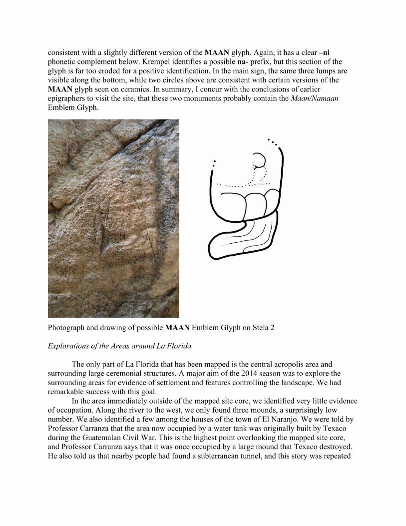
consistent with a slightly different version of the MAAN glyph. Again, it has a clear –ni phonetic complement below. Krempel identifies a possible na- prefix, but this section of the glyph is far too eroded for a positive identification. In the main sign, the same three lumps are visible along the bottom, while two circles above are consistent with certain versions of the MAAN glyph seen on ceramics. In summary, I concur with the conclusions of earlier epigraphers to visit the site, that these two monuments probably contain the Maan/Namaan Emblem Glyph.
Photograph and drawing of possible MAAN Emblem Glyph on Stela 2 Explorations of the Areas around La Florida The only part of La Florida that has been mapped is the central acropolis area and surrounding large ceremonial structures. A major aim of the 2014 season was to explore the surrounding areas for evidence of settlement and features controlling the landscape. We had remarkable success with this goal. In the area immediately outside of the mapped site core, we identified very little evidence of occupation. Along the river to the west, we only found three mounds, a surprisingly low number. We also identified a few among the houses of the town of El Naranjo. We were told by Professor Carranza that the area now occupied by a water tank was originally built by Texaco during the Guatemalan Civil War. This is the highest point overlooking the mapped site core, and Professor Carranza says that it was once occupied by a large mound that Texaco destroyed. He also told us that nearby people had found a subterranean tunnel, and this story was repeated
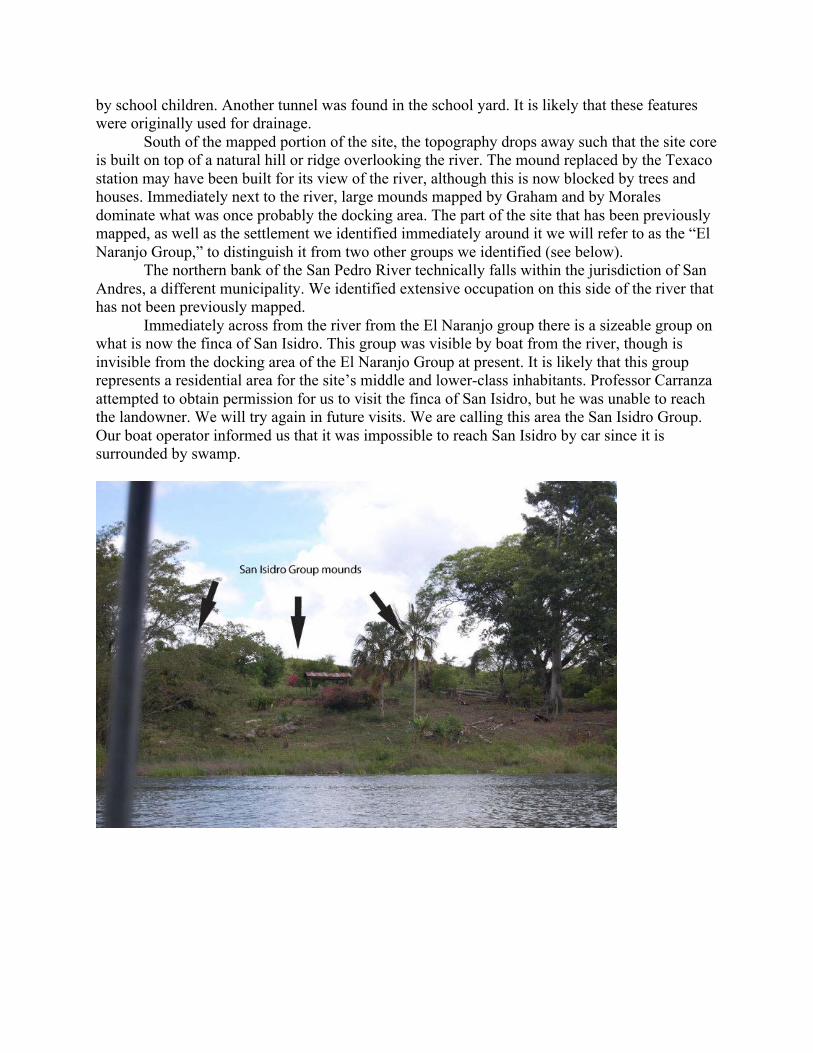
by school children. Another tunnel was found in the school yard. It is likely that these features were originally used for drainage. South of the mapped portion of the site, the topography drops away such that the site core is built on top of a natural hill or ridge overlooking the river. The mound replaced by the Texaco station may have been built for its view of the river, although this is now blocked by trees and houses. Immediately next to the river, large mounds mapped by Graham and by Morales dominate what was once probably the docking area. The part of the site that has been previously mapped, as well as the settlement we identified immediately around it we will refer to as the “El Naranjo Group,” to distinguish it from two other groups we identified (see below). The northern bank of the San Pedro River technically falls within the jurisdiction of San Andres, a different municipality. We identified extensive occupation on this side of the river that has not been previously mapped. Immediately across from the river from the El Naranjo group there is a sizeable group on what is now the finca of San Isidro. This group was visible by boat from the river, though is invisible from the docking area of the El Naranjo Group at present. It is likely that this group represents a residential area for the site’s middle and lower-class inhabitants. Professor Carranza attempted to obtain permission for us to visit the finca of San Isidro, but he was unable to reach the landowner. We will try again in future visits. We are calling this area the San Isidro Group. Our boat operator informed us that it was impossible to reach San Isidro by car since it is surrounded by swamp.

The El Naranjo ferry, located to the east of the El Naranjo Group, drops vehicles off in the small village of Santa Marta on the northern bank of the river. The village is situated on a fairly steep hill that climbs away from the river. On the lower elevations of the hill we found a few small mounds, but no substantial settlement. We also found a possible uncarved altar in the local soccer field. At the top of the hill, however, we found a new monumental group, which we have named the Santa Marta Group. The largest of the structures appears to be about 6m high. These mounds are thus smaller than those of the El Naranjo group but are still substantial in size. Many of them have looter’s trenches, whereas only one mound in the El Naranjo group appears to be looted. The Santa Marta Group contained two uncarved altars, and several large pieces of stone may once have been monuments as well. We also found several places where large chunks of plaster floor were eroding out of the ground—the plaza floor must have once been impressively thick and durable. We also found what may have been a ballcourt. This is of interest because no ballcourt has yet been found in the El Naranjo Group, although Professor Carranza made reference to one that has since disappeared under development. There were very few ceramics lying around, possibly because the thick floor prevents them from eroding out of the soil. Most of the sherds that we did see were utilitarian in nature and impossible to date with much precision.

Sketch map of Santa Marta Group by Christopher Martinez
Mounds of the Santa Marta Group.

Uncarved altar from Santa Marta Group
Plaster floor from the Santa Marta Group.

Possible ballcourt from the Santa Marta Group. The Santa Marta Group conveniently lay in milpa that had recently been burned. We encountered several farmers who were planting corn. They told us that they didn’t actually own the land, but did not see a problem with us wandering around and photographing the structures. One of them referred to these mounds as “tombs.” They all told us that the group only extended as far as the mounds that were immediately visible. However, we found that many residents are unaware of the extent of ruins in the area, and we can’t be sure that these farmers were correct about the extent of the site. In fact, nobody we spoke with in the town of El Naranjo was aware of the Santa Marta Group, including Professor Carranza, who is greatly interested in the El Naranjo ruins and was aware of the San Isidro Group. Like the El Naranjo group, the Santa Marta Group is located on a hill overlooking the river. The shortest path between the group and the river was blocked by private land. However, we approached by boat from the river. We found that the topography dropped away gently and it is likely that this area would have been suitable for a dock. Today, the area serves as a dock for a property that was once used as a hotel but is now used as a house. It belongs to a family that resides in Flores and owns several hotels there. They rent it to a frequently-absent tenant from Guatemala City. Under these circumstances, it was impossible to obtain permission to visit this area but it may be possible in the future.

View from the Santa Marta Group.
Possible docking area for Santa Marta Group.

Between the docking areas of the El Naranjo and Santa Marta groups there are two sharp bends in the river, making the boat ride 4km long. As the crow flies, the groups are only 2.3km apart from one another. The three groups are situated in such a way as to ideally control traffic along the San Pedro River. The high-elevation of the El Naranjo and Santa Marta groups suggests both a defensive orientation and a desire to see long distances up and down the river. The location at a place where the river bends twice also would have conferred a defensive advantage over boat traffic, which would not have been able to see far upriver or downriver. The El Naranjo Group and San Isidro Group would have easily controlled traffic approaching from the west but would not have been able to see traffic from the east. Likewise, the Santa Marta Group could easily spot traffic from the east but not from the west. By signaling to one another, the different areas of the site could have coordinated to spot approaching merchant traffic or military expeditions.
Map of La Florida landscape The residents of La Florida would probably also have been concerned with approaches to the site from the south, since they had hostile relations with Yaxchilan. To reach La Florida from Yaxchilan, one must first cross the Sierra Lacandon mountain range, emerging through a narrow valley onto the plane of the San Pedro River and then north to the site. The modern road from El Naranjo to La Libertad mirrors part of this route, south from El Naranjo to the foothills of the

mountain range. We conducted a visual survey along the road and spotted several mounds on ranch land.
Mound visible in the distance near the road to El Naranjo Site Nomenclature Given that the site has been called by a number of different names over the years, we would like to propose nomenclature for future work. Most of the academic community knows the site as La Florida, but the residents of the town of El Naranjo are unfamiliar with that name. Furthermore, both La Florida and El Naranjo are names that have been given to other sites, creating confusion. Just as the site of El Peru is now known as El Peru/Waka’, we propose to call the site La Florida/Namaan to distinguish it from the other La Florida by its ancient name. We propose that the three sections of the site be named for the modern locations where they are found. Thus, the area mapped by Morales is the El Naranjo Group. The two groups identified this year are the San Isidro and Santa Marta Groups. This will make it easy for us to identify these areas to local inhabitants of the area. Plans for the Future Starting next year, I hope to begin a long-term program of mapping and excavation at La Florida along with Liliana Padilla. One of the chief aims of this research will be to investigate La Florida’s economic relationships with other Maya polities. As I have already noted, its location was strategic in its ability to control the San Pedro waterway and possibly as a transshipment point for travel between Central Peten, Tabasco, and the Usumacinta River. What kinds of products moved along these routes? Who benefited from this exchange? How did economic relationships shape the political history and prosperity at La Florida? Given the fertile soils found

downstream in Tabasco, it is possible that La Florida was involved in the exchange of agricultural products like staple foods, cotton, or chocolate. This may have been the reason that so many other polities made a point of allying with La Florida, or perhaps why Yaxchilan sought to control it. It remains to be seen whether La Florida was an active member of the alliance led by the Kaan Dynasty based at Calakmul. Nearby Kaan allies include La Corona, El Peru, La Joyanca, Santa Elena and Moral Reforma. Even Piedras Negras seems to have been on friendly terms with Calakmul. However, the inscriptions of La Florida have not yet given a clear indication of alliance or subordination to the Kaan Dyansty. Possible affiliations with the Kaan alliance all seem to date to the early 7th century or earlier, before the Kaan Dynasty was actually based at Calakmul. We hope to be able to obtain more archaeological or epigraphic evidence to understand La Florida’s political relationships during the mid- and late-7th century and early 8th century and whether or not Calakmul played a role. The most pressing task is to complete an accurate map of the site. Only the El Naranjo Group has been mapped: Graham (1970) spent a single day mapping it with a prismatic compass, tape and hand level, and he was unable to complete the task:
“It was hot enough work; I noticed the bubble in the hand-level growing steadily smaller, until finally the glass tube exploded. Then in the middle of the day, while we were working in the Great Plaza, men appeared with firebrands, putting them to the dry brushwood. Within a few moments flames were leaping high and we had to run for our lives….There was nothing to do but sit around the rest of the day and fume.”
Morales completed the map of this part of the site in 1997 (Morales 1998) but does not specify his methods. However, there appear to be a few errors in his map, leading me to believe that it is based upon a sketch rather than total station data. None of the structures across the river have been mapped, nor many of the smaller mounds around the town of El Naranjo. The 2015 season will be devoted to accurately mapping all of these areas. Topographical data will also be collected, as current topographic maps are not precise enough to show the site’s use of high and low ground. Excavation will proceed in future seasons. There is also much epigraphic work to be done. As mentioned above, we hope to move the monuments to a new home indoors where they can be protected, displayed and studied. While some of the monuments have been moved, others are in the same position as when Shook first saw them. Stela 2, for example, has not moved, and it is possible that the part of it buried underground may have legible text. Archaeology at La Florida offers opportunities somewhat unique to Peten archaeology to work together with a local community. Already the municipal authorities have shown enthusiasm for site preservation and development. The town’s convenient location along a highway connecting Flores to Palenque gives it the potential to host low-level tourism. In fact, I spoke to two tour operators in Flores and a professional guide about this possibility. Surprisingly, the operators continued to use a much longer route to get to Palenque rather than the border crossing that opened in 2011 and is now used commercially. All three told me that in order to get tour busses to stop at El Naranjo, it would be necessary to restore structures on site. Hopefully we will be able to raise money for this in the future.

The El Naranjo group is immediately next to the local school house, and we also hope to run educational programs there. Several school children visited us in 2014 on their Saturday off from school and had many stories to tell about ruins and finds in El Naranjo. Evidence of previous educational programs involving the ruins can be seen in the form of murals decorating a local gas station. The murals depict important events in the cultural history of Guatemala and the local area. None of the employees could tell us who had painted them, only that they had been there for at least 10 years. Hopefully such activities can be revived in future years.
Murals depicting the Conquest at a site resembling La Florida, the K’iche’ hero Tecun Uman, and a Lacandon Maya next to Stela 9 of La Florida.

References Cited Arnauld, Charlotte M., Erick Ponciano, Véronique Breuil-Martínez, et al. 2001 El Sitio Arqueólogico La Joyanca en una Perspectiva Regional: Investigaciones durante la Segunda Temporada de Campo (2000). In XIV Simposio de Investigaciones Arqueológicas en Guatemala, 2000, edited by Juan Pedro Laporte, Ana Claudia de Suasnávar, and Bárbara Arroyo, pp.275–296. Ministerio de Cultura y Deportes, Instituto de Antropología e Historia, Asociación Tikal, Guatemala City.
Boot, Erik 2003 A New Classic Maya Vessel Type on a Uaxactun-Style Plate. Mesoweb. www.mesoweb.com.
Canuto, Marcello, and Tomás Barrientos 2013 Hallazgos e Interpretaciones Recientes en el Sitio La Corona y el Noroccidented de Petén presented at the XXVII Simposio de Investigaciones Arquológicas en Guatemala, Guatemala City.
Closs, Michael P. 1988 A Phonetic Version of the Maya Glyph for North. American Antiquity 53(2): 386–393.
García, Edgar Vinicio 1996 Breve Reconocimiento en el Suroeste de Petén: Acercamiento Preliminar (Ríos San Pedro-Pasión-Usumacinta). In IX Simposio de Investigaciones Arqueológicas en Guatemala, 1995, edited by Juan Pedro Laporte and Héctor Escobedo, pp.59–78. Ministerio de Cultura y Deportes, Instituto de Antropología e Historia, Asociación Tikal, Guatemala City.
Graham, Ian 1970 The Ruins of La Florida, Peten, Guatemala. In Monographs and Papers in Maya Archaeology, edited by William R. Bullard, 61:pp.427–455. Papers of the Peabody Museum. Harvard University, Cambridge, MA.
Krempel, Guido 2011 Notes on Stela 2 of La Florida, Peten, Guatemala. Mexicon XXXIII(1): 7–10.
Lemonnier, Éva 2009 La Structure de l’Habitat du Site Maya Classique de La Joyanca (Peten Nord-Oeste, Guatemala) dans son Environment Local. BAR International Series 2016. British Archaeological Reports, Oxford.

Lopez, Luís 2003 The Maan Polity in Maya Inscriptions. Unpublished manuscript.
Morales, Paulino I. 1998 Asentamiento Prehispánico en El Naranjo-Frontera, La Libertad, Peten. In XI Simposio de Investigaciones Arqueológicas en Guatemala, 1997, edited by Juan Pedro Laporte and Héctor Escobedo, pp.128–143. Ministerio de Cultura y Deportes, Instituto de Antropología e Historia, Asociación Tikal, Guatemala City.
Morley, Sylvanus G., and J. E. S. Thompson 1944 Reconnaissance in Mexico and Guatemala. Carnegie Institution of Washington Year Book 43: 169–172.
Reents-Budet, Dorie, and Ronald L. Bishop 2003 What can we Learn from a Maya Vase? Archaeology Magazine 56(2): 26–29.
Shook, Edwin M. 1943 Field Notes of Edwin M. Shook, Book 286. Department of Archaeology, Universidad del Valle de Guatemala.
Velásquez García, Erik 2009 Los Señores de la Entidad Política de “Ik.” Estudios de Cultura Maya 34: 45–64.
Zender, Marc 2002 Toponyms of El Cayo, Piedras Negras, and La Mar. In Heart of Creation: the Mesoamerican World and the Legacy of Linda Schele, edited by Andrea Stone, pp.166–184. University of Alabama Press, Tuscaloosa, Alabama.
Zender, Marc n.d. Comments on the Inscription of the Williams College Vessel (K8713). http://www.mayavase.com/8713/com8713.html.