l'-:lcweb2.loc.gov/master/pnp/habshaer/md/md1400/md1402/data/md140… · foundation is a...
TRANSCRIPT

BOSTON STREET BRIDGE (Lakewood Avenue Drain Headwall and Bridge) Boston Street over Harris Creek Sewer Baltimore Baltimore 6-e-un-£-y \'l'-:■ ■•- Maryland
HAER No. MD-UO
V
i , .... ,->
;0>V
PHOTOGRAPHS
WRITTEN HISTORICAL AND DESCRIPTIVE DATA
HISTORIC AMERICAN ENGINEERING RECORD National Park Service
Northeast Region Philadelphia Support Office
U.S. Custom House 200 Chestnut Street
Philadelphia, P.A. 19106
Mb
HISTORIC AMERICAN ENGINEERING RECORD
BOSTON STREET BRIDGE HAER NO. MD-110 (Lakewood Avenue Headwall and Bridge)
Location: Boston Street over Harris Creek Sewer, Baltimore, Baltimore County, Maryland
UTM: 18.364260.4348860 Quad: Baltimore East, Maryland
Date of Construction: 1902
Engineer: O.W. Connet, Assistant City Engineer of the City of Baltimore, Maryland
Fabricator: Office of the City Engineer, City of Baltimore, Maryland
Present Owner: City of Baltimore
Present Use: Vehicular
Significance:
Project Information:
The Boston Street Bridge (Lakewood Avenue Drain Headwall and Bridge), built by the City of Baltimore in 1901-1902, is significant for its historic association with an important Baltimore crossing in the Canton neighborhood of the city. The bridge is also significant as a good example of early twentieth century brick arch bridge construction in Baltimore and Maryland. An economical and expedient choice for crossings where timber or meta! bridges would quickly corrode, brick arches, with stone masonry facing, were built by municipal authorities to carry important streets over sewers, also often of brick arch design. Replacing a deteriorated metal girder bridge, the stone-faced brick arch Boston Street Bridge was built to carry the key Canton waterfront thoroughfare of Boston Street over the outlet of Harris Creek Sewer, a major municipal sewer constructed by the city during the 1880s.
This documentation was undertaken from August through September 1994 by the City of Baltimore as a mitigation measure prior to the initiation of the city's project for improvement of the Boston Street corridor.
P.A.C. Spero and Company Historic Structures Consultants Baltimore, Maryland for the City of Baltimore

BOSTON STREET BRIDGE (Lakewood Avenue Drain Headwall and Bridge)
HAERNo. MD-110 (Page 2)
The Boston Street Bridge (Lakewood Avenue Drain Headwail and Bridge) is located on Boston Street in the Canton neighborhood of east Baltimore, immediately west of the Shipyards Apartments. Facing the harbor and spanning the Harris Creek Sewer outlet (also known as the Lakewood Avenue Drain into the Northwest Branch of the Patapsco River) the bridge carries vehicular traffic on Boston Street over the sewer. The current south wall of the bridge serves as the headwall of the Harris Creek Sewer. Approximately seventy feet in length with a 26.55 foot clear arch span, the structure is constructed primarily of brick, with cut stone masonry facing and voussoirs. The bridge completely encloses the outlet of the Harris Creek Sewer.
The arch is defined by articulated granite voussoirs, including a keystone bearing the chiselled date "1902." The basic building material, aside from the stone voussoirs and granite faced headwall, is brick laid in several concentric rings varying in thickness to support two fourteen foot pedestrian walkwaysJ a forty-two foot roadway and a single railroad track. While the bridge's low stone parapet originally featured an iron railing, this was subsequently replaced by a concrete parapet extension. The bridge's substructure consists of masonry abutments, with skewbacks cut into them to support the brick arch. The bridge's foundation is a timber grillage on timber piles. The Boston Street Bridge, which carries two lanes of vehicular traffic on Boston Street, has served since its construction as the headwall and drain opening for the Harris Creek Sewer.
Historical research indicates that the Boston Street bridge was designed and built between September 1901 and May 1902 by the Office of the City Engineer of the City of Baltimore, under direct supervision of Assistant City Engineer O.W. Connet. The new masonry brick and stone arch was built as a solution to the problem of corrosion from sewer gases which had severely damaged the exposed steel girders of an earlier bridge built in 1890. The present Boston Street Bridge is significant for its association with an important Baltimore crossing in the Canton neighborhood of the city. The bridge is also significant as a good example of early twentieth century brick arch bridge construction in Baltimore and Maryland. An economical and expedient choice for crossings where timber or metal bridges would quickly corrode, brick arches, with stone masonry facing, were built by municipal authorities to carry important streets over sewers, also often of brick arch design. Replacing a deteriorated meta! girder bridge, the stone-faced brick arch Boston Street Bridge was built to carry the key Canton waterfront thoroughfare of Boston Street over the outlet of Harris Creek Sewer, a major municipal sewer constructed by the city during the 1880s.
Historically an important waterfront road, Boston Street remains a major vehicular transport route in the project area. The area surrounding Boston Street Bridge is a waterfront neighborhood presently characterized by a mix of old factories and warehouses, apartments, townhouses, condominium buildings, commercial wharves, and recreational marinas. Historical development of Boston Street and its vicinity has been closely linked with the economic and industrial growth of Canton and the City of Baltimore.
Baltimore was founded in 1729 as one of three eighteenth-century port towns on the harbor of the lower Patapsco River. By the 1790s, the city had outstripped its two rivals Fells

BOSTON STREET BRIDGE (Lakewood Avenue Drain Headwall and Bridge)
HAERNo. MD-110 (Page3)
Point and Jonestown, which were soon officially absorbed. Baltimore's prime Chesapeake watershed location made it a mercantile success; industrialization spurred population growth throughout the nineteenth century. Before the Civil War, the Baltimore and Ohio Railroad ensured access to western markets and products, while the Baltimore and Susquehanna Railroad and the Philadelphia, Wilmington, and Baltimore Railroad linked the city to northern economic centers. The latter railroad angled southwesterly into the city along Boston Street in Canton and terminated during the Civil War era at the President Street Station, immediately east of today's Inner Harbor developments.
In 1822, Baltimore officials attempted to lend overall order to the city's unpredictable expansion. Engineer-surveyor Thomas H. Poppleton drafted a Plan of the City of Baltimore which laid out streets and blocks with "striking regularity" in the newly-annexed parts of the city. At the heart of Poppleton's system was a fixed grid of standard blocks incorporating a descending hierarchy of street widths -- front, side, and alley -- with an array of open public squares. The Poppleton Plan's most serious drawback was its lack of attention to the varied topography of the city. No long-range planning provision was made for such gravity- related city services as water supply, sewerage, and storm drainage. Despite this lack, the Poppleton Plan was adopted and governed the residential expansion of the city until the late 1880s. Ideally suited to the plan's block scheme, rowhouses were built on speculation and became the distinctive core of neighborhood after neighborhood.
Fueled by industrialization and a consequent steady flow of immigrants, Baltimore's eastward expansion was well underway by the mid-nineteenth century. The Oldtown area east of the Jones Falls valley filled up prior to the Civil War. Above Fells Point, which retained its mercantile importance throughout the antebellum era, the mixed ethnic communities of Washington Hill and Madison Park grew along the axis of the boulevard- width Broadway. Port-related industry and such new service-oriented employers as Johns Hopkins Hospital (founded in 1889 on its present site) anchored the local economies of these communities during the years after the Civil War. East of Broadway, streets such as Eastern Avenue gave access to the valley of Harris Creek, which rose in Patterson Park (already in place in 1869). As city officials looked hopefully east, however, their view took in the commercial property and leased lots of the successful and ambitious Canton Company, which had carefully set the entire pace of industrial and residential development in Canton and much of Highlandtown since 1828.
Though it was later to be a planned community, Canton began as a desirable location for farms and plantations laid out with easy access to the Northwest Branch of the Patapsco River. Between 1786 and 1796, Baltimore investor and former sea captain John O' Donnell acquired a series of large tracts between Harris Creek, the harbor, and the Old Philadelphia Road, located approximately along today's Eastern Avenue. O'Donnell may have given his estate the name "Canton", after the only Chinese port then open to foreign trade. While O'Donnell cultivated his plantation in peaches and other crops, shipbuilding became an early activity near the mouth of Harris Creek. Located at the creek near what are now the American Can Company buildings on Boston Street, David Stoddert'sshipyard, in 1797, built the U.S.S. Constellation. Major shipyards remained at the Harris Creek locale for nearly a

BOSTON STREET BRIDGE (Lakewood Avenue Drain Headwall and Bridge)
HAERNo. MD-110 (Page 4)
century, with the Booz Shipyard building clipper ships in the 1850s and A.W. Denmead & Son constructing the U.S.S. Monocacv. a side-wheel gunboat that served in the Asiatic Squadron from 1864 to 1903.
In 1828, the Canton Company was officially founded when O'Donnetl's heirs sold 3000 acres, including the captain's plantation and the waterfront between Fells Point and Lazaretto Point to Peter Cooper, Amos Binney, and Edmund Monroe. The latter two purchasers named Boston Street after their hometown. Cooper soon relinquished his land holdings for stock in the company, although he retained a lot near Harris Creek at the current intersection of Boston and Hudson Streets, where he built an iron works. The Maryland legislature authorized the Canton Company to improve "lands which shall belong to said company, by laying out streets, etc., in the vicinity of Baltimore on or near navigable water, and erecting and constructing wharves, ships, workshops, factories, stores, dwellings, and such other buildings and improvements as may be deemed necessary, ornamental, and convenient."
Despite an initial reputation as a purely speculative venture, the company held repeated public sales of lots and by 1846 had attracted a cotton mill, Gary's Chesapeake Furnace, and the Bryan & Maitland Distillery. Horace Abbott of Massachusetts took over Cooper's Iron Works and doubled its capacity by the Civil War, when the factory produced the armor for the U.S.S. Monitor before its fight with the C.S.S. Virginia. In 1850, the Baltimore Copper Smelting Company went into business on South Clinton Street and greatly expanded during the 1860s after merger with the Gunpowder Copper Works. Later to become the Edward Renneburg & Sons machine and boiler works (1912) and the Shipyards Apartments (1988), the Chipman Chair Company Works on Boston Street just east of the current Boston Street Bridge was in business in 1870.
Oil refining and the canning industry also boosted the Canton economy during the post-Civil War era. By 1870, Thomas Poultney and Joseph Moale relocated their Locust Point refinery to Canton, floating the tanks across the harbor for reuse. The area bracketed by Boston and Clinton Streets was an early center of the Baltimore petroleum business; numerous locally-run refineries combined under Standard Oil auspices to form the Baltimore United Oil Company in 1877. This firm ultimately sold all its holdings to Standard Oi! in 1892, and the latter company as Esso and Exxon has continued since then as owner and developer of much of the original refinery property, although refining there ended in 1957.
Canneries and their attendant suppliers by contrast centered their operations in west Canton along the Boston Street waterfront in the vicinity of Harris Creek. Known as "Canner's Row", the four blocks between 2300 and 2600 Boston Street held five canners and packers during the 1890s. The canneries were consolidated during the late nineteenth and early twentieth centuries by the American Can Company, located immediately across Boston Street from the present Boston Street Bridge. Canton also provided box companies, cork and seal manufacturers, and bottlers for locally-produced beer and other fluids. The Harris Creek mouth area was also home to the J.S. Young Extracts Company, maker of licorice, dyes, and tanner extracts, between 1870 and 1930.

BOSTON STREET BRIDGE (Lakewood Avenue Drain Headwall and Bridge)
HAERNo. MD-110 (Page 5)
An examination of historic maps serves to underscore the importance of Boston Street, and the bridge over the Harris Creek Sewer, as a link between Canton industrial facilities and Baltimore proper. According to a Sanborn fire insurance map of 1890, the bridge over the Harris Creek Sewer bordered the large G. Tyler Lumber Yard situated between Boston Street and South Patapsco Avenue. A 1902 revision of the fire insurance map showed the Canton Box Company immediately west of the bridge. While the lumber yard was not shown on the 1902 map, the box company operated a sizeable factory including a planing and sawing shop, box factory building, several lumber storage areas and an office along Boston Street. By 1914 the Canton Box Company had expanded to include an "iron-clad" addition to the sawing and planing shop, several additional storage buildings and a "fire-proof" concrete 1 and 2-story building which included a print shop. Along the northeast side of Boston Street, opposite the Canton Box Company, the 1914 map showed the can storage building of the American Can Company. A1936 revision of the fire insurance map revealed that the Canton Box Company property had become the H.J. McGrath Cannery consisting of a large 2-story factory building and 3-story warehouse. The map revealed the construction of a large steel and concrete train shed located on the northeast side of Boston Street with a series of tracks connecting at Boston Street adjacent to the American Can Company storage building.
Directly related to Canton's steady and significant industrial development, the residential character of Canton was greatly influenced by the Canton Company. Historian D. Randall Beirne has accurately noted that the Canton Company deliberately encouraged "residential growth and stability" in Canton during the latter nineteenth century, in addition to offering wharfage facilities and feeder railroads to industrialists willing to locate in the community, the company built rowhouses, churches, schools and parks for local workers and their families. The company worked with Baltimore officials to bring an omnibus horsecarline into Canton in 1859. The canning industry found a source of inexpensive labor in local women whose husbands or sons worked in the heavier factories; those women added their income to household savings accumulated in east Baltimore's distinctive neighborhood "building and loan" associations.
As Baltimore expanded, Canton was inevitably involved in official deliberations and plans regarding the larger city's many daunting problems. In the late nineteenth century, one of the knottiest of these concerned proper storm drainage and sewerage. Situated near the boundary between east Fells Point and west Canton, the Boston Street Bridge was a significant structural consequence of the major municipal attempt to address the drainage question during the 1880-1900 period. The history of the Canton neighborhood, within the City of Baltimore, is in large measure a record of efforts by city authorities and Canton Company officers to cope with the constant, difficult demands of rapid residential and industrial expansion. Although Canton from an early date became an outstanding example of a planned, company-supervised community, its larger neighbor (and eventual 1919 annexer) Baltimore faced many difficult planning challenges. Built in 1902, the Boston Street Bridge represented a city-engineered solution to a nagging, expansion-related problem of the 1890s: how to prevent destruction of an important bridge and road crossing by corrosive gases from the outlet of a major city sewer.

BOSTON STREET BRIDGE (Lakewood Avenue Drain Headwall and Bridge)
HAERNo.MD-110(Page6)
From 1796 until 1898, governmental responsibility for public works projects in Baltimore was vested in the Office of the City Commissioner. Responding to the rise of the engineering profession after the Civii War, the city appointed engineers to the posts of assistant city commissioners and often to the Commissioner's post itself, in 1898, a new city charter created a Department of Public Improvements, with a City Engineer's Office within it to perform the previous functions of the City Commissioner's Office. A final reorganization in 1925 produced the present-day Department of Public Works.
In its near-century tenure as chief municipal planner, the City Commissioner's Office tried to aid Baltimore's growth from a town where the streets themselves were the only storm drains to a prominent port with drainage and sewerage systems ready to handle future as well as present needs. Continually frustrating this goal was the unplanned, rapid build-up of the city by private speculators. Expected to efficiently provide the infrastructure to make the city and its annexes liveable, municipal engineers were rarely privy to builders' blueprints or developers' intentions. Funded infrequently, long-range studies of civic demands stood as hopeful, academic benchmarks rather than useful field references.
Under such circumstances, the Commissioner's staff nevertheless responded to immediate, pressing needs and attempted to build in extra capacity and flexibility where possible. With the theory of planning and forecasting still in its infancy, however, city engineers did not anticipate all project effects. The history of the Harris Creek Storm Sewer, the earliest Lakewood Avenue Drain project and the one that occasioned construction of the present Boston Street Bridge, illustrates the great challenges and difficulties of late nineteenth century civil engineering in Baltimore.
In the 1870s and 1880s, East Baltimore above Fells Point was largely filled in with block after block of unbroken lines of brick rowhouses. The region was still served by a single large drain, the Harford Run Sewer, that collected runoff and sewerage from the surrounding streets and hills. Built in the 1820s and successively enlarged, the sewer enclosed the original stream itself in a circular drain or canal that tunnelled under present Central Avenue (one mile west of the present-day Boston Street Bridge) to the harbor. By 1873, as Commissioner J.H.Tegmeyer's annual report indicated, the Harford Run Sewer was thoroughly unreliable. "A large portion of this sewer... also runs under and through private property,...is irregular in section and line, and but partially arched." Tegmeyer noted that in the summer "the back building of a house fronting on Bond Street, and built upon this sewer, was demolished by the foundation being undermined, which dammed up the water to such an extent as to inundate the surrounding property, and to seriously injure a portion of the part we had just completed on Ann Street, near Belair avenue."
With the Harford Run Sewer's capacity exceeded and storm water overflowing into Broadway and other north-south streets, planners initially focussed on a series of smaller, localized relief drains under Ann, Eden, and Bank Streets in Fells Point. By 1879, Tegmeyer and his assistants looked instead toward a total diversion of all flow from the upper part of the sewer into Harris Creek, the next natural watershed to the east. The diversion tunnel was to start "from the west branch of Harris' Creek, at the intersection of East Monument and
BOSTON STREET BRIDGE (Lakewood Avenue Drain Headwall and Bridge)
HAER No. MD-110 (Page 7)
Patapsco streets [present-day Lakewood Avenue]," and proceed "along Monument to Chester street; thence along Chester to Eager street, and along Eager to Ann street, where it will connect with the Harford run sewer." Even as construction proceeded, however, the Commissioner doubted the wisdom of pouring wastewater into a stream already bracketed by rowhouses and factories. To "convey the drainage from Monument street to tidewater," he suggested that "a tunnel should be constructed... in the bed of Patapsco street, to Lancaster street, of sufficient capacity to receive the waters of Harford run and Harris' Creek" (Lancaster Street is the present-day Fait Avenue in Canton).
Although an initial Harford Run diversion sewer to Harris Creek was completed in 1881, the City Council did not fully implement Tegmeyer's suggestion until 1884, when a bond issue was authorized to pay for completion of "the improvement of Harford Run by the construction of a sewer from the terminus of the lateral sewer of Harford Run at Monument and Patapsco streets, and running thence under the bed of Patapsco street to tide-water." Charles A. Hook, chief engineer of the Harford Run Improvement of 1879-1881, was placed in charge of operations and conducted initial surveys in January 1885. After some delay due to right-of-way proceedings, Jones & Thorne were awarded the construction contract on October 27, 1885. With Canton Company permission, work began on the southern end of the drain tunnel on December 29, 1885. Hook's plans called for the drain to run down Patapsco Street "to a point near Hudson street; thence by a curve (with a radius of 500 feet) into Harris' Creek, to the north building line of Boston street."
Construction went forward between 1885 and 1889 amid further legal difficulties involving rights to Harris Creek and the bed of Patapsco Street. Periodically, Chief Engineer Hook offered progress reports that shed light on the configuration of the southern part of the sewer extending to tidewater at Boston Street. At the end of 1886, he noted that the brick drain in that vicinity was enlarged to accommodate "back water from high tide" as well as heavy flow. "The lower section, or the one running from the gashouse north of Lancaster street to the terminus, has a span of 24 feet, with a height of 4 feet from the bottom to the springing line, and a rise in the center of 51/a feet, or a total height of 9V6 feet." The side- walls of the lower section were of cut stone (rock ashlar), "upon which is set a skewback, from which an 18-inch arch springs, and which is thoroughly backed with heavy rubble masonry."
The large size of the Harris Creek Diversion Sewer necessitated raising, regrading, and repaving nearly all streets in the low lying district near the mouth of Harris Creek. The Lancaster-to-Boston Street section was built on a pile foundation with a timber platform, or grillage, anchored to the pileheads. Completed in 1889, the entire sewer was more than three miles long and drained some 2000 acres, the largest area tributary to a drain in Baltimore City. Later construction of a lateral sewer to carry the Harris Creek feeder, Ogier Run, in Patterson Park added another 680 acres of drainage area to the Harris Creek Sewer. Without doubt, the project was the largest and most significant of its kind undertaken in Baltimore between 1880 and 1900. Chief Engineer Hook was certain that the deliberately enlarged capacity of the drain assured that it would not soon become obsolete. The sheer scope of the Harris Creek Sewer construction prompted public discussion of the city's
BOSTON STREET BRIDGE (Lakewood Avenue Drain Headwall and Bridge)
HAER No. MD-110 (Page 8)
drainage needs. An 1897 Sewerage Commission report noted further expansion of Baltimore toward Canton but found the drain to be generally of ample size to handle all but the heaviest storms. During the twentieth century, the brick drain has remained in place but was entirely paved over north of Boston Street. Between 1975 and 1980, a Lakewood Avenue Relief Drain was built to handle runoff that the 1885-1889 Harris Creek Sewer could no longer accommodate.
At work on the Harris Creek Sewer during the late 1880s, Engineer-in-chief Charles Hook examined possible desirable changes to the area surrounding and including the mouth of Harris Creek. As planned, the drain was to terminate at the north building line of Boston Street, where an important bridge carried wheeled traffic, pedestrians, and the Philadelphia, Wilmington and Baltimore Railroad (P.W.& B. Railroad) across the creek. Wooden and about one hundred feet long, this Boston Street Bridge was a successor to a prior timber crossing, authorized in 1846 and most likely burned during the Civil War. According to a resolution passed by the City Council's Joint Committee on Bridges on March 26, 1846, the 1846 bridge was constructed to replace an existing unsatisfactory span which adjoined a Philadelphia, Wilmington and Baltimore Railroad bridge in the same vicinity. Built to be similar to the railroad bridge which it adjoined, the 1846 bridge included two timber truss frames, a twenty foot roadway and a six foot pedestrian crossing. Signed by many prominent merchants in the Canton area, the original petition for the 1846 bridge underscored the vibrant economic activity of Canton and the economic need for a reliable link with Baltimore.
By 1886, however, the Boston Street span at Harris Creek had become notoriously unreliable. In his 1886 report, Charles Hook described how the sewer construction could greatly improve the crossing through the installation of a more permanent span at the site. "The plan is simply to continue the [sewer's] side walls (which would be the bridge abutments) from the mouth of the sewer across to the south building line of Boston street, making the span for the bridge about 28 feet, then by building retaining walls along the south building line of Boston street, the city would be enabled to remove the old bridge and fill up the low ground." Hook observed that the P.W. & B. Railroad might be willing to pay a portion of the expense of improving "one of the most frequented thoroughfares of the city."
As built, the sewer ended at Boston Street's north building line in a "portal and head wall...of cut stone" which made "a very creditable appearance from Boston street bridge." Hook continued to press for adoption of his suggestion, noting in 1887 that the old hundred- foot wooden bridge, "which is in very bad condition," could be replaced with a span of only 261/a feet, "which will agree with the Philadelphia, Wilmington and Baltimore Railroad Company's abutments for their bridge at the same place." In 1889, the City Council directed the City Commissioner "to construct the abutments and wing walls of a bridge on Harris' Creek at Boston street, according to plans and specifications on file in his office, and... to advertise for an iron superstructure for the same," spending no more than $19,000 for such purchase and construction. By year's end, Hook made plans for the new bridge and sewer extension. Contracts for piiedriving and lumber were let and the foundation was prepared during the low tides of the 1889-1890 winter season.

•
•
BOSTON STREET BRIDGE (Lakewood Avenue Drain Headwall and Bridge)
HAER No. MD-110 (Page 9)
Hook's 1890 report summarized the building of the new bridge. Benjamin Glenn drove the piles and John Curley delivered the rock ashiar and the coping stone. P.M. Womble provided the lumber, while John Bullock & Son handled cement needs. The iron superstructure was furnished by the Youngstown Bridge Company for $1,392, and H. Ashton Ramsay erected the railing on the retaining walls. A total of $17,686 was spent to remove the old bridge and construct the new 26V& foot crossing atop the extended sewer outlet and side walls. The bridge consisted of twelve 20-inch wrought iron plate girders 29 feet long, which spanned the abutments, with a double flooring of Georgia pine planks 21/z and 3 inches thick. The single track of the railroad was carried on the roadway. Built on a pile foundation, the retaining walls were capped with stone coping axed to a smooth surface, on which was set the iron railing. The bridge approaches were paved with Belgian block pavement, and four small inlets to the sewer were built to take runoff from the street. During construction of the retaining walls, the adjoining basin was dredged to a twenty-foot depth, eliminating "an exposed mass of vegetable matter liable to produce disease in the neighborhood."
As depicted in the 1890 Sanborn Fire Insurance Map of Baltimore, the extended Harris Creek Sewer outlet and its new Boston Street crossing completed the enclosed channeling of Harris Creek almost to its mouth. Between 1890 and 1900, several major lateral sewers increased the heavy flow through the drain. Meanwhile, the Boston Street Bridge above the sewer carried a heavy burden as a major waterfront transport route and rail link. By the iate 1890s, maintenance was a constant problem though the metal girder bridge was an improvement upon its timber precursors. In 1896, the north and south roadways were renewed and the footways patched. In 1897 and 1898, the sidewalks and the roadway were again replaced. The 1899 City Commissioner's Report detailed further repairs and a more serious deterioration. "The plate girders on Boston-street bridge over Harris-creek sewer are very badly eaten by the gases from the sewer, the lower flange of the outside girder being entirely eaten through in a few places." Although the girders under the roadway were still in fair condition, here was a dilemma that engineer Hook had not anticipated in his plan for the bridge.
By 1900 Assistant City Engineer O.W. Connet was responsible for solving the Boston Street Bridge problem. After a new roadway was again installed on Boston Street Bridge in 1900, Connet warned that "the gases and acids" were "rapidly destroying the plate girders" and suggested renewing or strengthening one or more of them. Noting that certain Philadelphia bridges over railways had their lower parts sealed with matched lumber, Connet initially proposed employment of that remedy on the Boston Street Bridge "so as to keep the gases from the iron." On October 28,1901, however, the City Council authorized complete replacement of the iron bridge with "a permanent brick arch." Regrading and raising of Boston Street was also directed to accommodate the new structure, which when completed in 1902 became the present Boston Street Bridge.
The city's choice of a brick arch bridge for the site reflected a decision in favor of an unusual but proven type of permanent masonry structure. Arch construction in brick may be dated to ancient times, when the Romans developed the art of building brick sewers. In
BOSTON STREET BRIDGE (Lakewood Avenue Drain Headwall and Bridge)
HAERNo.MD-HO(Page 10)
Europe, Great Britain, and the nineteenth century United States, brick was often selected as a buiiding material in coastal areas where stone masonry was less available and more expensive to quarry and ship to site. In 1850, British civil engineer G. Drysdale Dempsey published a treatise with the fulsome title Brick Bridges, Sewers, and Culverts, a Series of Examples Adapted for Application in the Construction of Roads and Railways, and in the Draining of Towns and Districts... Dempsey's work included specifications for dimensions and material quantities for "bridges for cuttings from seven feet to sixty feet in depth, and for embankments from seven feet to sixty feet in height" and for "culverts from two feet to eight feet in diameter, of approved sectional form, designed according to a system of proportions readily applicable to all other dimensions..." Dempsey's study received wide circulation; during the 1850s and 1860s, numerous brick arch bridges were built by U.S. railroads such as the Central of Georgia, which employed engineer Augustus Schwaab and architect Martin P. Mueller to design and build two brick approach viaducts leading to the railroad's terminal station and shops in Savannah. As in brick building construction, the use of brick in bridges permitted some freedom of architectural expression and detailing; the Central of Georgia viaducts featured elaborate belt courses, small arched pilaster and parapet niches, and triple rings of brick voussoirs.
By the late nineteenth century, brick arches were built fairly frequently by American cities seeking low-cost expansion of their ali-too-inadequate sewer systems. In most cities, bricks were readily available and could be adapted to a wide range of uses; bricks were extensively utilized in sewers constructed to replace inadequate timber drains. Municipal engineers directly involved with sewer construction were also often the same officials charged with building and maintaining a growing set of city bridges. The low-cost option of brick arches was promoted by Ira 0. Baker, Professor of Civil Engineering at the University of Illinois, in his frequently reprinted handbook A Treatise on Masonry Construction, the ninth edition of which was issued in 1899. Baker noted that "brick could many times be profitably substituted for iron, stone, or timber in engineering structures" due to "recent improvements in the process of manufacture" which decreased the cost while increasing the quality and uniformity of the product.
Such improvements included the late nineteenth century introduction of soft-mud machines and stiff-mud machines, which automatically varied the consistency of the ciay used as raw material; the use of dry-clay machines, which forced dry clay into brick moulds through application of heavy pressure; and the spread of permanent, high-temperature, chemically-variable kilns in brickyards. Baker noted that in the United States, no legal standard size for bricks existed; bricks used in the east were slightly larger than those preferred in the west, though the National Brickmaker's Association in 1887 and the National Traders and Builders' Association in 1889 adopted 8-1/4 X 4 X 21/a inches as the standard size of brick. The Atchison, Topeka and Santa Fe Railroad had adopted widely-circulated specifications for brick arch masonry: "the bricks must be of the best quality of smooth, hard-burnt, paving bricks, well tempered and moulded, of the usual size, compact, well- shaped, free from lime, cracks, and other imperfections, and must stand a pressure of 4000 pounds per square inch without crushing."

BOSTON STREET BRIDGE (Lakewood Avenue Drain Headwall and Bridge)
HAER No. MD-110 (Page 11)
in his 1899 edition, Baker observed somewhat ruefully that "brick masonry is not much used, except in the walls of buildings, in lining tunnels, and in constructing sewers, the general opinion being that brick-work is in every way inferior to stone masonry." He regarded this prejudice against brick was unfounded since new production methods were introduced, and "there are many engineering structures in which brick could be profitably employed instead of stone; as, for example, the walls of box-culverts, cattle-guards, etc., and the less important bridge piers and abutments, particularly of highway bridges." Baker enumerated the eight advantages of brick over stone masonry as follows: (1) "in many localities brick is cheaper than stone, since the former can be made near by while the latter must be shipped"; (2) brick costs less to lay than stone because less-skilled masons may be employed; (3) brick is more easily handled than stone and could be laid without hoists; (4) less fitting at corners and openings was required for brick; (5) brick masonry was less liable to "great weakness through inaccurate dressing or bedding"; (6) as a fire-resistant material, brick's only rival was sandstone; (7) good brick could stand effects of weathering and acids better than sandstone, and approached the durability of some harder stones; (8) since all masonry failed when "the mortar in its joints disintegrates or becomes dislodged", brick masonry might endure even better than stone because brick had thinner joints than stonework. Baker noted that brickwork was not as strong as ashlar masonry but was stronger than ordinary rubble; brick construction cost less than ashlar but more than rubble.
The engineering principles involved in designing and constructing stone masonry arches applied equally to brick arches, according to Ira Baker. Like stone masonry arch bridges, brick arches were temporarily supported on timber or metal centering while under construction. The centering was removed after a stipulated period during which mortar was allowed to harden. "Keying" brick arches as well as stone arches involved careful placement of the keystone bricks or stones, located on the arch rings at the highest point, or crown, of the arch. Baker noted that "the only matter requiring special mention in connection with brick arches is the bond employed"; when the thickness of the arch exceeds "a brick-and-a- half, the bond from the soffit [the inner, concave surface of the arch] is a very important matter." Baker described three general methods of bonding brick arches: (1) concentric rings, or rowlock bond, in which all bricks were laid as stretchers and only the tenacity of the mortar united the several rings; (2) continuous radial joints, or header and stretcher bond, in which "part of the brick may be laid as stretchers and part as headers, as in ordinary walls, by thickening the outer ends of the joints - either by using more mortar or by driving in thin pieces of slate - so that there shall be the same number of bricks in each ring"; and (3) block in course bond, in which the arch was divided into "sections similar in shape to the voussoirs of stone arches" and brick was laid in each section with any desired type of bond, but taking care to make the radial joints between the sections continuous from intrados (the concave line of intersection of the soffit, with a vertical plane perpendicular to the axis or length of the arch) to extrados (the convex curve, in the same plane as the intrados, binding the outer extremities of the joints between the voussoirs). The latter method often included laying one section in rowlock bond, and the other, much narrower section, with continuous radial joints.

•
BOSTON STREET BRIDGE (Lakewood Avenue Drain Headwall and Bridge)
HAER No. MD-110 (Page 12)
Baker indicated that although rowlock bond in concentric arch rings was by far the most common bonding method employed in brick arches, its inherent danger derived from the fact that the load on each individual arch ring could not be accurately determined; a "ring may be called upon to support considerably more than its proper share of the load." This difficulty nevertheless was rarely problematic, since a single arch ring could generally carry the entire load under the fairly low mean unit working pressure of typical brick arches (varying from 20 to 40 pounds per square inch). Concentric ring bond or rowlock bond gave large (four inch) toothings for connecting with succeeding sections, required less cement, was more rapidly laid, was less liable to be poorly executed, and possessed "certain advantages in facilities for drainage, when laid in the presence of water." The prime objection to the continuous radial joint, or header-and-stretcher, method of bonding was that "the outer ends of the joints, being thicker than the inner, will yield more than the latter as the centers are removed, and hence concentrate the pressure on the intrados." Baker highly recommended the third bonding method, block in course bond, "when the brickwork is to be subject to a heavy pressure." The objection to the continuous radial joint, or header and stretcher method, disappeared when it was used in connection with an overall plan of block in course bond.
The Boston Street Bridge utilized the concentric ring or rowlock bond method of brick arch construction. Plans approved in 1901 called for the removal of the previous bridge girders and the construction of an arch with a 26.55 foot span and a length of 70 feet. The roadway width, including the railroad tracks in the center, was 42 feet and was flanked by 14 foot walkways on either side. As was common in masonry arch construction, a timber falsework was erected to support the brickwork prior to completion. The bridge's substructure was to consist of masonry abutments, with masonry skewbacks cut into them to support the brick arches. The City Water Board also submitted plans in 1901 for a ten inch water main to be laid through the Boston Street Bridge directly below the railroad tracks. Due to the size of the pipe connections, two special voussoir stones were manufactured and installed with a cut to accommodate the coupling points on the underside of the arch. Supporting the pipe was a series of 2W tram rails laid transversely beneath the pipe.
To support the bridge, a series of wooden piles were driven into the Harris Creek bed at the creek's mouth. These piles supported a timber grillage, or platform, which directly supported the bridge. Typical grillage for brick arches, as described by Ira Baker in 1899, consisted of "a stout frame of one or more courses of timber drift-bolted or pinned to the tops of piles and to each other upon which a floor of boards is placed to received the bottom courses of the masonry." Although this form of timber support was not suitable for all applications, Baker was careful to point out the usefulness and durability of timber supports when permanently submerged in water.
. By the end of 1901, about 75% of the work was finished, and Connet offered a progress report. The brick arch was "four rings thick under the footway, five under the roadway, and six entire rings and seven partial rings thick up to the top of the haunching under the railway." The arch was built in three sections, with the P.W. & B. rail track moved

•
•
BOSTON STREET BRIDGE (Lakewood Avenue Drain Headwall and Bridge)
HAER No. MD-110 (Page 13)
to one side while the second or middle section was constructed. False work consisted of 7 ribs, spaced 3 feet 9 inches center to center and cut from 2" X 12" Georgia pine. Each rib was of double thickness, its two planks bolted together "so as to break joints." Boston Street was raised about four feet at the bridge, and new sewer inlets were furnished on the roadway. The railroad company financed building of the nine feet of the bridge under its tracks. A small temporary wooden toolhouse accommodated the bridge workers. Connet's 1901 report included a construction photograph of the bridge project, taken after completion of the middle section.
The 1902 report furnished a full account of the construction of the Boston Street Bridge. Work was begun September 18, 1901 and finished April 30, 1902. Cost was increased due to the need to keep the railroad functioning and the decision to build the bridge in the winter months. The.arch barrel terminated at the south portal "in a row of 18- inch ring-stones which have an average length of 15 inches in the direction of the axis of the arch." Such stones were cut on the ground from "part of the stone of the bridge seat of the old bridge." As the grade of Boston Street was considerably raised, retaining walls east and west of the arch were built up to the level of the new grade. The 1902 report noted that "on account of the flat crown of Boston Street, the P.W.& B. R.R. Co. raised their tracks in the center of the street for about 200 feet eastward of O'Donnell Street to remedy the trouble from water and ice on the tracks." The total stone masonry utilized, including the retaining wall, headwall and parapet at the south portal, was 230.6 cubic yards. Total brick masonry in the arch was 159.6 cubic yards. Work was performed entirely by the City of Baltimore.
The street met its old grade at 440 feet to the west and 280 feet to the east of the structure. Project costs included $35.66 for toolhouse and fences, $138.97 for removal of the old bridge and excavation, $595.62 in foreman's wages, $164.34 to build a derrick, $3,152.70 for grading and repaving Boston Street, and $164.02 for "cutting skew-back on old walls." The brick masonry cost $1,355.09 and the stone masonry $1,702.94. Expenditure on the "south portal ringstones" (the stone voussoirs) was $96.68. The P.W. & B. Railroad paid the city $399.13 for its section of the bridge. Total cost of the Boston Street Bridge of 1901-1902 was $7,880.66.
Baltimore public works records for the early twentieth century indicate that the bridge succeeded admirably as a sturdy crossing that effectively prevented sewer gases from causing further deterioration. Noting that the structure was "skewbacked on the old side walls," the 1910 City Engineer's list of jurtsdictional bridges described a forty-two foot roadway paved with granite blocks and two fourteen-foot brick sidewalks at the span. In 1920, the bridge railing (possibly the original railing, which featured ornamental posts) was given two coats of bronze-green Nev-A-Rust paint. No other pre-1925 records of repairs or maintenance were located. Between 1925 and 1964, Department of Public Works annual reports individually described only major construction and repair jobs, listing all minor repairs and maintenance work under a lump heading. For this period, no references to repair work on the Boston Street Bridge were made in such reports. The visual appearance of the present structure, however, clearly indicates that it is little changed since 1902. The most significant alteration, unrecorded in city reports, has been the installation of a concrete

BOSTON STREET BRIDGE (Lakewood Avenue Drain Headwall and Bridge)
HAERNo.MD-110(Page 14)
parapet extension to replace the original metal railing which stood atop the low, original stone parapet. The bridge was profiled in city plans of 1932, possibly drawn for improvement of the Harris Creek (Harford Run Intercepting) Sewer. No evidence has been found, however, indicating that changes were made to the Boston Street Bridge in 1932.
•
BOSTON STREET BRIDGE (Lakewood Avenue Drain Headwall and Bridge)
HAERNo.MD-110(Page 15)
•
BIBLIOGRAPHY
Baker, IraO. A Treatise on Masonry Construction. New York: John Wiley and Sons, 1899.
Beirne, D. Randall. "Residential Growth and Stability in the Baltimore Industrial Community of Canton During the Late Nineteenth Century." Maryland Historical Magazine, Vol. 74, No.1 (Mar. 1978): 39-51.
Bromley, George W. and Walter S. Bromley. Atlas of the City of Baltimore, Maryland. Philadelphia: G.W. Bromley and Co., 1887.
Bromley, George W. and Walter S. Bromley. Atlas of the City of Baltimore, Maryland. Philadelphia: G.W. Bromley and Co., 1896.
Bromley, George W. and Walter S. Bromley. Atlas of the City of Baltimore, Maryland. Philadelphia: G.W. Bromley and Co., 1906.
Canton Company. Annual Reports of the President and Directors of the Canton Company, Made to the Stockholders at Their Annual Meeting... Baltimore: various publishers, 1828- 1920.
City of Baltimore. City Commissioner. Annual Report. Baltimore: Various publishers, 1826- 1898.
City of Baltimore. "Report of Resolution from the Joint Committee on Bridges Relative to a Bridge over Harris Creek." Original City Council Resolution dated 1846 in City Council Records, Baltimore City Archives, Baltimore, Maryland.
City of Baltimore. City Engineer. Annual Report. Baltimore: Various publishers, 1899-1925.
City of Baltimore. City Engineer. "Proposed Improvement at Boston Street and S. End of Harford Run Sewer." Original plan dated June 29, 1901 on microfilm in Public Works Records, Baltimore City Archives, Baltimore, Maryland.
City of Baltimore. Department of Public Improvements. Sub Department Water Board. "10-Inch Pipe Crossing Harford Run Sewer at Boston Street." Original plan dated November 16,1901 on microfilm in Public Works Records, Baltimore City Archives, Baltimore, Maryland.
City of Baltimore. Department of Public Works, Bureau of Sewers. "Plan Sections, Harford Run Drain, Lakewood Ave. Between Monument & Boston Sts." Original plan dated 1932 in Baltimore City Department of Public Works, Baltimore, Maryland.
City of Baltimore. Department of Public Works, Bureau of Sewers. "Profile & Sections - Harford Run Drain, Lakewood Ave. Between Monument & Boston Sts." Original plan dated
#
BOSTON STREET BRIDGE (Lakewood Avenue Drain Headwall and Bridge)
HAERNo. MD-110 (Page 16)
1932 in Baltimore City Department of Public Works, Baltimore, Maryland.
City of Baltimore. Department of Public Works. Annual Report. Baltimore: Various publishers, 1925-1964.
DeLony, Eric. Landmark American Bridges. New York: American Society of Civil Engineers, 1992.
Euchner, Charles C. "The Politics of Urban Expansion: Baltimore and the Sewerage Question 1859-1905." Maryland Historical Magazine. Vol. 86, No. 3 (Fall 1991): 39-51.
Harrison, William, William Dean, et. al. "Petition for Bridge Replacement over Harris Creek" dated 1846. Original petition in City Council Records, Baltimore City Archives, Baltimore, Maryland.
Hopkins, G.M. City Atlas of Baltimore, Maryland, and Environs. Philadelphia: G.M. Hopkins, 1876.
Hyde, Henry M. "Boston Street Has Traditions of a Century." Undated newspaper clipping in Vertical File, Maryland Historical Society, Baltimore, Maryland.
Kelly, Jacques. "Canton History is Packed in American Can Building." Baltimore Sun. June 27, 1988.
Kelly, Jacques. "Progress Knocks on Canton's Door." Baltimore Sun, July 28, 1988.
Kelsey, Stephen T. "Canton Company of Baltimore." Baltimore, August 1954.
Landon, Philip J. "Washington Hill: A Brief History." Pamphlet dated 1979 in files of Commission on Historical and Architectural Preservation, Baltimore, Maryland.
Lantz. Emily Emmerson. "Unusual Width and Name of East Baltimore Thoroughfare Due to Use as "Ropewalk"." Baltimore Sun, December 16 1923.
McCreary, George W. Street Index. Baltimore: Press of Kohn and Pollock, 1900.
Mayor and City Council. Ordinances and Resolutions of the Mayor and City Council of Baltimore, Passed at the Annual Session of 1884 and 1885. Baltimore: City Printer, 1885.
Mayor and City Council. Ordinances and Resolutions of the Mayor and City Council of Baltimore. Passed at the Annual Session, 1901-1902. Baltimore: John D. Lucas Printing Co., 1902.
Olson, Sherry H. Baltimore: The Building of An American City. Baltimore and London: Johns Hopkins University Press, 1980.
BOSTON STREET BRIDGE (Lakewood Avenue Drain Headwall and Bridge)
HAERNo. MD-110 (Page 17)
P.A.C. Spero & Co. "Historic Bridges in Maryland: Historic Context Report." Unpublished report prepared for Maryland State Highway Administration, September 1994.
P.A.C. Spero & Co. "Lakewood Avenue Drain, Headwall and Bridge Under Boston Street, Baltimore City, Determination of Eligibility." Unpublished report prepared for U.S. Department of Transportation, Federal Highway Administration, Maryland State Highway Administration, Baltimore City Department of Transportation, June 1991.
Papenfuse, Edward C. and Joseph M. Coale, III. The Hammond-Harwood Home Atlas of Historical Maps of Maryland 1608-1908. Baltimore and London: Johns Hopkins University Press, 1982.
Rukert, Norman G. Historic Canton: Baltimore's Industrial Heartland and Its People. Baltimore: Bodine and Associates, Inc., 1978.
Sachse, Edward. Birdseye View of Baltimore. Philadelphia: E. Sachse and Co., 1869.
Sanborn Company. Map of Baltimore. New York: Sanborn Company, 1890.
Sanborn Company. Map of Baltimore. New York: Sanborn Company, 1902.
Sanborn Company. Map of Baltimore. New York: Sanborn Company, 1914.
Sanborn Company. Map of Baltimore. New York: Sanborn Company, 1914-1951, revised edition.
Scharf, J. Thomas. History of Baltimore City and County. Baltimore: Regional Publishing Company, 1971; reprint of 1881 original.
Sewerage Commission of the City of Baltimore. Report of the Sewerage Commission of the City of Baltimore... Baltimore: Public Printer, 1897.
Shivers, Natalie W. Those Old Placid Rows: The Aesthetic Development of the Baltimore Rowhouse. Baltimore: Maclay & Associates, 1981.
Unpublished notes on the Lakewood Avenue Relief Drain Project. !n Archives of Baltimore City Museum of Public Works, Baltimore, Maryland.

BOSTON STREET BRIDGE (Lakewood Avenue Drain Headwall and Bridge)
HAER No. MD-110 (Page 18)
\ POM
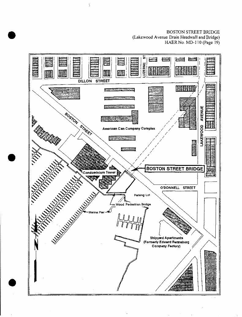
BOSTON STREET BRIDGE (Lakewood Avenue Drain Headwal! and Bridge)
HAERNo. MD-I10 (Page 19)
mm. jU
t_^
p*******
m m
m
i i
DILLON STREET / -^~
/ , 7
- ui _> * .■
in ' ■' -^ :> « Q u