kzr - ky public service commission cases/2011-00173/20110727_east...kzr !":j't"- -_1(...
TRANSCRIPT

Kzr !":J'T"- -_1(
L- B I!-- lit I*- COMMONWEALTH OF KENTUCKY
BEFORE THE PUBLIC SERVICE COMMISSION
JUL 2 7 2021 In the matter of: PUBLIC: SERVICE c 0 M i\/l IS s ION
THE APPLICATION OF EAST KENTUCKY NETWORK LIMITED LIABILITY COMPANY FOR THE ISSUANCE OF A CERTIFICATE OF PUBLIC CONVENIENCE AND NECESSITY TO CONSTRUCT A TOWER IN CLAY COUNTY, KENTUCKY).
) ) ) CASE NO 20 10-00 173 1
East Kentucky Network, LLC , d/b/a Appalachian Wireless, was granted authorization to
provide Personal Comriiuiiicatioiis Service ("PCS") in the Corbin, KY Basic Trading Area
(BTA098) by the Federal Communications Commission (FCC). FCC license is iricluded as
Exhibit 1. East Kentucky Network, LLC merger documents were filed with the Commission on
February 2,200 1 in Case ## 200 1-022.
In an effort to improve service in Clay County, East Kentucky Network, LLC pursuant to IuiS
278.020 Subsection 1 and 807 I M 5:OOl Section 9 is seeking tlie Commission's approval to consti-uct
a 180 foot self-supporting tower on a tract of land approximately 800' North of Junction of Hwy 1 1 and
Hwy 421, Manchester in Clay County, Keritucly (37"13"8.03"N 83"47'01.38"W). A map and
detailed directions to the site can be found in Exhibit 8.
Exhibit 2 is a list of all Property owners or residents according to the property valuation
administrator's record who reside or own property within 500 feet of tlie proposed tower in
accordaiice with the Public Valuation Administrator. No other properties are contiguous with East
I< entucky Network' s property.
Pursuant to 807 KAR 5:063 Section 1 (1)(L) and Section 1( l)(n)( 1) all affected property
owners according to the property valuation administrator's record who reside or own property
within 500 feet of tlie proposed Tower were notified by certified inail return receipt requested of
East Kentucky Network, LLC's proposed construction and inforrned of their right to intervene.
They were given the docket number under which this application is filed. Enclosed in Exhibit 2 is
a copy of that notification.
Clay County has no formal local plaiming unit. In absence of this unit tlie Clay County
Judge Executive’s office was notified by certified inail, return receipt requested of East Kentucky
Network Limited Liability Company’s proposal and informed of their right to intervene. They
were given the docket number under which this application is filed. Enclosed in Exhibit 3 is a
copy of that notification.
Notice of tlie location of the proposed construction was published in the Manchester
Enterprise’s July 28t” & August 4th weekly editions. Enclosed is a copy of that notice in Exhibit 3.
The Manchester Enterprise is tlie newspaper with the largest circulation in Clay County.
A geologist was employed to determine soil and rock types and to ascertain the distance to
solid bedrock. The geotechnical repoi-t is enclosed as Exhibit 4.
A copy of the tower design information is enclosed as Exhibit 5. The proposed tower has
been designed by engineers at Allstate Tower, Inc. and will be constructed under their supervision.
Their qualifications are evidenced in Exhibit 5 by the seal and signature of the registered
professional engineer responsible for this project.
The tower will be erected by S & S Tower Services of St. Albans, West Virginia. S & S
Tower Services has vast experience in the erection of coininuiiications towers.
FAA and Kentucky Airport Zoiiiiig Cominission applications are included as Exhibit 6.
No Federal Conimunications Coinmission approval is required prior to construction of this
facility. Once service is established from this tower we must immediately notify the Federal
Cominunications Coininission of its operation. Prior approval is needed only if the proposed
facility increases the size of the cellular geographic service area. This cell site will not expand the
cellular geographic service area.

East Kentucky Network, LLC will finance the sub,ject Construction with earned surplus in
its General Fund.
Estimated Cost of Construction $ 350,000.00 Annual Operation Expense of Tower $ 12,500.00
Two notice signs meeting the requirements prescribed by 807 KAR 5:063, Section 1(2),
measuring at least two (2) feet in height and four (4) feet in width and containing all required
language in letters of required height, have been posted, one at a visible location on the proposed
site and one on the nearest public road. The two signs were posted on July 20, 201 1 and will
remain posted for at least two weelts after filing of this application as specified.
Enclosed in Exhibit 9 is a copy of East Kentucky Network LLC’s lease agreements with
deed descriptions to the site.
The proposed construction site is on a very rugged mountaintop some feet from the nearest
structure. Prior to construction the site was wooded.
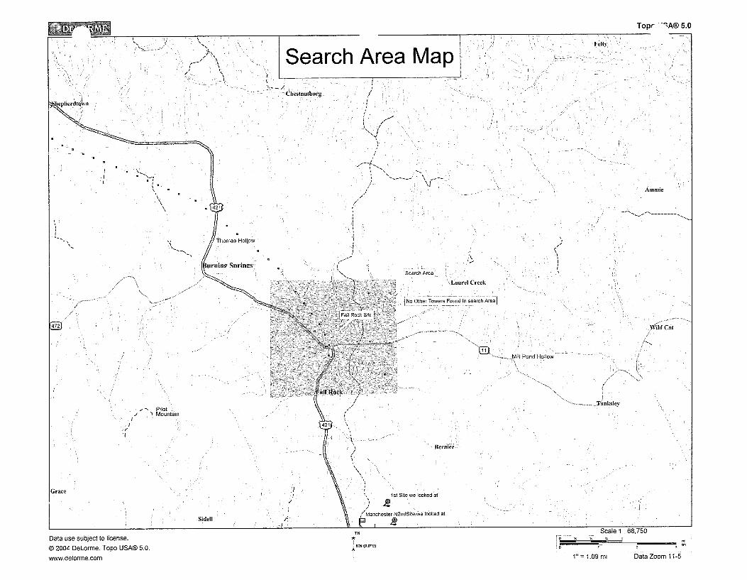
Due to the steep hillside surrounding the proposed site, the property in close proximity is
unsuitable for any type of development. East Kentucky Network LLC’s operation will not affect
the use of nearby land nor its value. No more suitable site exists in the area. A copy of the search
area map is enclosed in Exhibit 8. No other tower capable of supporting East Kentucky Network
LLC’s load exists in the general area; therefore, there is no opportunity for co-location of our
facilities with anyone else.
Enclosed, and filed as Exhibit 10 is a survey of the proposed tower site signed by a
Kentucky registered professional engineer.
Exhibit 12 contains a vertical sketch of the tower supplied by Coleman Engineering.

WHEREFORE, Applicant respectfully requests that the PSC accept the foregoing
Application for filing, and having met the requirements of KRS [278.020( I ) , 278.650, and
278.6651 and all applicable rules and regulations of the PSC, grant a Certificate of Public
Convenience and Necessity to construct and operate the proposed tower.
The foregoing document was prepared by Lynn Haney, Compliance Coordinator of East
Kentucky Network, LLC d/b/a Appalachian Wireless. All related questions or correspondence
concerning this filiiig should be mailed to the attention of Lynn Haiiey at East Kentucky Network,
LLC d/b/a/ Appalachian Wireless, 101 Technology Trail, Ivel, ICY 4 1642.
SUBMITTED BY: DATE: T/J$h/ U
Lynn Haiiey, Compliance
APPROVED BY: DATE: 7- Is-&-//
Gerald Robinette, General Manager
CONTACT INFORMATION:
Gerald Robinette, General Manager Phone: (606) 791-2375, Ext. 110 Email: grobinettel [email protected]
Lynn Haney, Compliance Coordinator Phone: (606) 791-2375, Ext. 1007 Email: [email protected]
Mailing Address:
East Kentucky Network, LLC d/b/a Appalachian Wireless 101 Technology Trail Ivel, KY 41642

Copies of Cell Site Notices to Land
Notification of County Judge Executive and Newspaper Advertisement
Universal Soil Bearing Analysis
FAA & Kentucky Airport Zoning Commission Applications
Audited Financial Statements
Driving Directions from County Court House and Map to Suitable Scale
Lease Agreements for Proposed Site with Deed Descriptions
Survey of Site SignedISealed by Professional Engineer Registered in State
__ _=- -~~~ I ---
Site Survey Map with Property Owners identified in Accordance with PVA of
Vertical Profile Sketch of Proposed


ULS License - PCS Broadband License - WQHG464 - East Kentucky Network, LLC d/b/ ... Page 1 of 2
ULS License
and License - LLC d/b/a Appalachian Wireless
Call Sign WQHG464 Radio Service CW - PCS Broadband
Status Active Auth Type Regular
Market Market BTA098 - Corbin, KY Channel Block F
Submarket 0
Dates Grant 07/23/2007
Effective 1 1/11/2009
Buildout Deadlines
1st 07/23/2012
Notification Dates
1st
Licensee
FRN 0001786607
Licensee
Associated 00i890.00000000-
(MHz) 001970.00000000- Frequencies 001895.00000000
001975.00000000
Expiration 07/23/20 17
Cancel la t io n
2nd 07/23/2017
2nd
TY Pe Limited Liability Company
East Kentucky Network, LLC d/b/a Appalachian Wireless P: (606)477-2355 101 Technolow Trail F: (606)874-7551 Ivel, KY 41642’ AlTN Gerald Robinette, Manager
Contact
Liikas, Nace, Gutierrez & Sachs, LLP Pamela L Gist Esq 8300 Greensboro Drive McLean, VA 22102
P: (703)584-8665 F: (703)584-8695 E:[email protected]
Ownership and Qualifications
Radio Service Fixed, Mobile TY Pe Regulatory Status Common Carrier, Interconnected Yes
Non-Common Carrier
Alien Ownership The Applicant answered “No” to each of the Alien Ownership questions.
http://wireless2.fcc.gov~JlsApp/~JlsSe~c~license.~ sp?licICey=293 1 1 3 1 &printable 7/25/20 1 1

TJLS License - PCS Broadband License - WQHG464 - East Kentucky Network, LLC d/b/ ... Page 2 of 2
Basic Qua I ifica tions The Applicant answered "No" to each of the Basic Qualification questions.
Tribal Land Bidding Credits This license did not have tribal land bidding credits.
Demographics
Race
Ethnicity Gender
http://wireless2.fcc.gov/T_JlsApp/U1sSearcWlice1~se.j sp?licKey=29.3 1 1 3 1 &printable 7/25/20 1 I

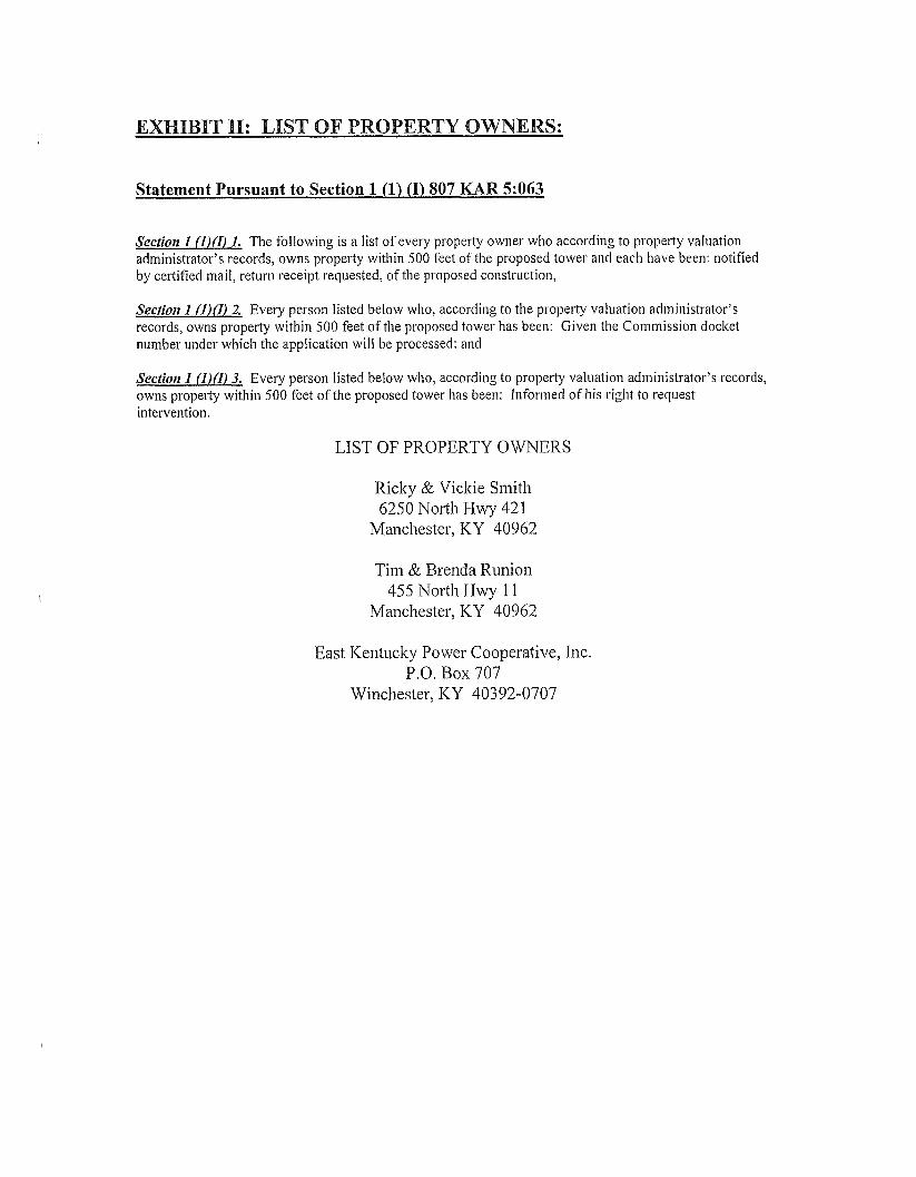
Statement Pursuant to Section 1 (1) (I) 807 KAR 5:063
Section 1 (l)(I) 1. The following is a list of every property owner who according to property valuation administrator’s records, owns property within SO0 feet of the proposed tower and each have been: notified by certified mail, return receipt requested, of the proposed construction,
Section I (l)(I) 2. Every person listed below who, according to the property valuation administrator’s records, owns propei-ty witliin SO0 feet of the proposed tower has been: Given the Commission docket number under which the application will be processed: and
Section 1 (l)(I) 3. Every person listed below who, according to property valuation administrator’s records, owns property within 500 feet of the proposed tower has been: Informed of his right to request intervention.
LIST OF PROPERTY OWNERS
Ricky & Vicltie Smith 6250 North Hwy 421
Manchester, KY 40962
Tim & Brenda Runion 455 Nortli Hwy 1 1
Manchester, ICY 40962
East Kentucky Power Cooperative, Inc. P.O. Box 707
Winchester, ICY 40392-0707

EAST KENTUCKY NETWORK
707 TECHNOLOGY TRAIL
IVEL, ICY 47642
PHONE: (606) 874-7550
FAX (606) 874-7551
\ : INFOGEKN COM
\ A T E : WWV$.EKN.COM
VIA: US. CERTIFIED MAIL
PUBLIC NOTICE
July 25,20 1 1
Ricky & Viclie Smith 6250 North Hwy 42 1 Manchester, ICY 40962
RE: Public Notice-Public Service Commission of Kentucky (Case No. 20 1 1-00 173)
East Kentucky Network, LLC d/b/a Appalachian Wireless is applying to the Public Service Commission of I< entucky for a Certificate of Public Convenience and Necessity to coiistruct and operate a new facility to provide cellular telecommunications service in Clay County. The facility will include a 180 foot self supporting tower with attached antennas extending upwards, and an equipment shelter located on a tract of land approximately 800’ North of the Junction of Hwy 1 1 and Hwy 421 in Manchester, Clay County, Kentucky. A map showing the location of the proposed new facility is enclosed. This notice is being sent to yau because you may own property or reside within a 500’ radius of the proposed tower or within a 200’ radius of the proposed or existing access road.
The Commission invites your comments regarding the proposed construction. You also have the right to intervene in this matter. The Conmission must receive your iiiitiai communication within 20 days of the date of this letter as shown above.
Your comments and request for interventioii should be addressed to: Executive Director’s Office, Public Service Commission of Kentucky, P.O. Box 6 15, Franlcfort, KY 40602. Please refer to Case No. 201 1-00173 in your correspondence.
If you have any questions for East Kentucky Network, LLC, please direct them to my attention at the following address: East Kentucky Network, LLC, 101 Technology Trail, Ivel, ICY 41642 or call me at 606-791-2375, Ext. 1007.
Sincerely,
Lynn Haney Compliance Coordinator
Enclosure 1

EAST KENTUCKY NETWORK
101 TECHNOLOGY TRAIL
IVEL, ICY 41642
PHONE: (606) 874.7550
FAX: (606) 874-7551
k-.dITE: WWW EI(N.COM E A S T K E N T U C K Y
VIA: U.S. CERTIFIED MAIL
PUBLIC NOTICE
July 25,201 1
Tiin & Brenda Runion 455 Noifli Hwy 11 Manchester, KY 40962
RE: Public Notice-Public Service Commission of ICentucky (Case No. 20 1 1-00 173)
East Keiitucky Network, LLC d/b/a Appalacliian Wireless is applying to the Public Service Commission of Kentucky for a Certificate of Public Convenience and Necessity to construct and operate a new facility to provide cellular telecommunications service in Clay County. The facility will include a 180 foot self supporting tower with attached antennas extending upwards, and an equipment shelter located on a tract of land approximately 800’ Nortli of the Junction of Hwy 11 and Hwy 421 in Manchester, Clay County, Kentucky. A map showing the location of the proposed new facility is enclosed. This notice is being sent to you because you may own property or reside within a 500’ radius of the proposed tower or within a 200’ radius of the proposed or existing access road.
The Commission invites your coinineiits regarding the proposed construction. You also have the riglit to intervene in this matter. The Coinmission must receive your initial commmiicatioii within 20 days of the date of this letter as shown above.
Your comments and request for intervention should be addressed to: Executive Director’s Office, Public Service Coinmission of Kentucky, P.O. Box 6 IS, Frankfort, ICY 40602. Please refer to Case No. 201 1-001 73 in your correspondence.
If you have any questions for East Kentucky Network, LLC, please direct them to my attention at the following address: East Kentucky Network, LLC, 10 1 Technology Trail, Ivel, ICY 41642 or call me at 606-791-2375, Ext. 1007.
Sincerely,
U
Compliance Coordinator
Enclosure 1

EAST KENTUCKY NETWORK
101 TECHNOLOGY TRAIL
IVEL, ICY 41642
PHONE: (606) 874-7550
FAX: (606) 874-7551
’ ’ INFOQEKN COM
\ [E: WWW EKN.COM
VIA: U.S. CERTIFIED M U
PTJBLIC NOTICE
July 25,201 1
East Kentucky Power Cooperative, Inc. P.O. Box 707 Wiricliester, KY 40392-0707
RE: Public Notice-Public Service Commission of Kentucky (Case No. 201 1-001 73)
East Kentucky Network, LLC d/b/a Appalachian Wireless is applying to tlie Public Service Coinmission of Kentucky for a Certificate of Public Coiiveiiience and Necessity to construct and operate a new facility to provide cellular telecommunications service in Clay County. Tlie facility will iiiclude a 180 foot self suppoi-ting tower with attached antennas extending upwards, and an equipment shelter located on a tract of land approximately 800’ North of tlie Junction of Hwy 11 and Hwy 421 in Manchester, Clay County, Keiitucky. A map showing the location of the proposed new facility is enclosed. This notice is being sent to you because you may own property or reside within a 500’ radius of the proposed tower or witliiii a 200’ radius of the proposed or existing access road.
Tlie Commission invites your comments regarding the proposed construction. You also have the right to intervene in this matter. The Coinmission must receive your initial coinmunication within 20 days of the date of this letter as shown above.
Your comments and request for intervention should be addressed to: Executive Director’s Office, Public Service Commission of K.entucky, P.O. Box 61 5, Frankfort, ICY 40602. Please refer to Case No. 201 1-00173 in your coi-respondence.
If you have any questions for East Kentucky Network, LLC, please direct them to my attention at the following address: East Kentuclcy Network, LLC, 10 1 Technology Trail, Ivel, RY 4 1642 or call me at 606-79 1-2375, Ext. 1007.
Sincerely,
V Lynn Haney Compliance Coordinator
Enclosure I


EAST KENTUCKY NETWORI<
101 TECHNOLOGY TRAIL
IVEL, I<Y 41642
PHONE: (606) 874-7550
FAX (606) 874-7551
' ' [email protected] ' ATE: WWW.EKN.COM
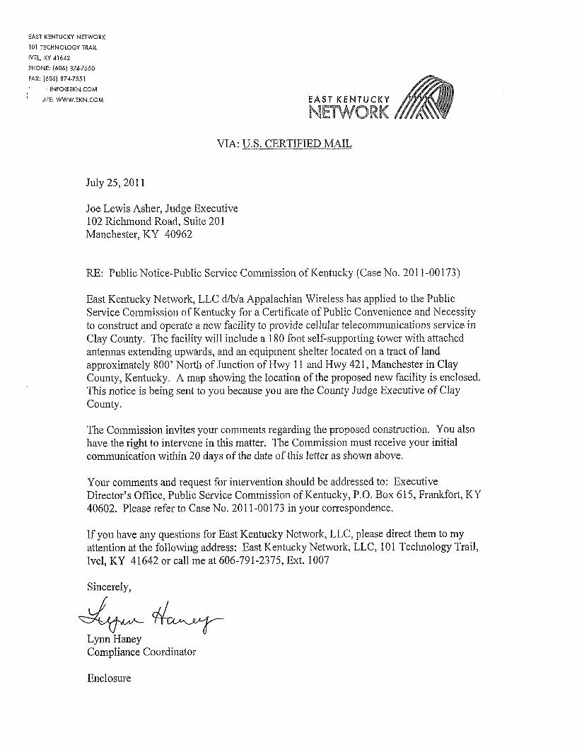
VIA: U.S. CERTIFIED MAIL
July 25,201 1
Joe Lewis Aslier, Judge Executive 102 Riclunond R.oad, Suite 20 1 Manchester, 1C.Y 40962
RE: Public Notice-Public Service Coininission of Kentucky (Case No. 20 1 1-00 173)
East Kentucky Network, LLC d/b/a Appalachian Wireless has applied to the Public Service Coininissioii of Kentucky for a Certificate of Public Convenience and Necessity to construct and operate a new facility to provide cellular telecorninuiiicatioiis service ill Clay County. The facility will iiiclude a 180 foot self-supporting tower with attached antennas extending upwards, and an equipment shelter located on a tract of land approximately 800' North of Junction of Hwy 1 1 and Hwy 42 1, Manchester in Clay County, Kentucky. A niap showing the location of the proposed new facility is enclosed. This notice is being sent to you because you are the County Judge Executive of Clay County.
The Coininission invites your coniineiits regarding the proposed construction. You also have the right to intervene in this matter. The Commission must receive your initial coinrnunicatioii within 20 days of the date of this letter as shown above.
Your coiments and request for intervention should be addressed to: Executive Director's Office, Public Service Commission of ICeiitucky, P.O. Box 61 5, Franltfoi-t, ICY 40602. Please refer to Case No. 20 1 1-00 173 in your correspondence.
If you have any questions for East Kentucky Network, LLC, please direct them to my attention at the following address: East Kentucky Nehvorlt, LLC, 10 1 Technology Trail, Ivel, KY 41642 or call me at 606-791-2375, Ext. 1007
Sincerely,
Lynn Haney Compliance Coordinator
Y
Enclosure


Please place the following Public Notice Advertisement in the Manchester Enterprise for the next two weeks.
PUBLIC NOTICE:
RE: Public Service Commission of Kentucky (CASE NO. 201 1-00173)
Public Notice is hereby given that East Kentucky Network, LLC, dba Appalachian Wireless has applied to the Kentucky Public Service Commission to construct a cellular telecommunications tower on a tract of land located approximately 800' North of Junction of Hwy 11 and Hwy 421 in Clay County, Kentucky. The proposed tower will be a 180 foot self-supporting tower with attached antennas. If you would like to respond to this notice, please contact the Executive Director, Public Service Commission, 21 1 Sower Boulevard, PO Box 615, Frankfort, Kentucky 40602. Please refer to Case No. 201 1-00173.
If you have any questions about the placement of the above mentioned notice, please call me at 606-791-2375, ext. 1007.
Thank you,
Lynn Haney Compliance Coordinator

Page 1 of 1
Lynn Haney
From: Lynn Haney [[email protected]
Sent: Monday, July 25, 201 1 2:14 PM
To: 'Rodney Miller'
Subject: Legal Ad
Attachments: Public Notice Advertisement.doc Rodney,
Please place the attached public notice ad in the Manchester Enterprise and run for 2 weeks You can send the bill to my attention at 101 Technology Trail, Ivel, KY 41642.
Please respond to this email with the publication dates
Feel free to contact me with any questions
Thank you,
Lynn Haney Staff Accountant-Fixed Assets East Kentucky Network, LLC dha Appalachian Wireless
(606) 791 -2375 ext. 1007 (606) 791 -2225 (fax)
7/25/2011

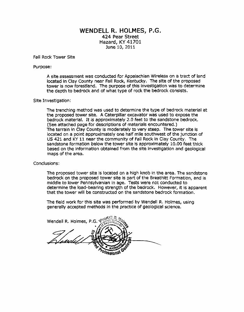
HOLMES, P.G. 424 Pear Street
Hazard, KY 41701 June 10, 2011
Fall Rock Tower Site
Purpose:
A site assessment was conducted for Appalachian Wireless on a tract of land located in Clay County near Fall Rock, Kentucky. The site of the proposed tower is now forestland. The purpose of this investigation was to determine the depth to bedrock and of what type of rock the bedrock consists.
Site Investigation :
The trenching method was used to determine the type of bedrock material at the proposed tower site. A Caterpillar excavator was used to expose the bedrock material. It is approximately 2.0 feet to the sandstone bedrock. (See attached page for descriptions of materials encountered .) The terraln in Clay County fs moderately to very steep. The tower site is located on a point approximately one half mile southwest of the junction of US 421 and KY 11 near the community of Fall Rock in Clay County. The sandstone formation below the tower site Is approximately 10.00 feet thick based on the information obtained from the site investigation and geological maps of the area.
Conclusions:
The proposed tower site is located on a high knob in the area. The sandstone bedrock on the proposed tower site is part of the Breathitt Formation, and is middle to lower Pennsylvanian in age. Tests were not conducted to determine the load-bearing strength of the bedrock. However, it is apparent that the tower will be constructed on the sandstone bedrock formation.
The field work for this site was performed by Wendell R. Holmes, using generally accepted methods in the practice of geological science.

WENDELL R. HOLMES, P.G.
---I_-. -- _------ Unit Total Strata
I-----
Thickness depth I-- --
2.00' 2.00' Soil
2,50' 4.50' Sandstone
10 .OO'+ 14.50' Sandstone
..-- -____I-
--I__-- --.-I --
424 Pear Street Hazard, Ky. 4170'l
(608)438-7250
-
Description -_- Brown with Sandstone and Plant Fragments
Weathered, Brown and Broken
Brown and Gray
.I ...-
I--------- -.--
Geologist Log
Location: Fall Rock Tower Site


/I N
.. TYPE I ELEVATION N P E LP.04' Lighlninq Rod I182 (3) 11'Gale Mounl(s) L-tighling Beacon (2) 72' x 1 2 x 6" Typ Flal Panel Anlenna(s) (1 518' Hellax)
(2) 72" x 12" x 6" Typ Flal Panel
i Antenna($ (1 518" Hellax)
(2) 72" x 12' x 6" Typ Flal Panel -----..--..-----.i-_- Anlenna(s) (1 38' Hellax)
j 180 (2) 72' x 12" x 6 Typ Flal Panel Anlenna(s) (1 518" Hellax)
(2) 72" x 12" x 6"Typ Flal Panel An!enna(s) (1 518" Heliax)
(2) 72" x 12" x 6" Typ Flal Panel Anlenna(s) ( I Y8" Hellax)
(3) 1 I' Gale Mounl(r)
1 180
i 180
1 180
180.0 R
160.0 R
140.0 n
120.0 R
100.0 ll
80.0 n
2*
ELEVATION 1 165
1%
150
150
tsa ~
I
I
n
I
(3) 11' Gale Mounl(s) I180
Anlenna(s) (1 518" Hellax)
(2) 72' x 12" x 6' Typ Flal Panel Anlenna(s) (1 518" Hellax) I (2) 7r x 12" x 6' Typ Flal Panel Anlenna(s) (1 518" Hellax)
(2)72*xl2"x6"Typ FlalPanei 1 1 6 5 -
i ___ ! 165
4'SId Dishw/oRadome(1.5/8~ 135 Hellax)
4'Std Dlsh w10 Radome (1.518' 135 Hellax) L-Side LigM I ObslNclion UqM 90
L-Side Liqhl I ObslNClion Ugh1 90
1
! L-Slde Ugh1 I ObSlNCliOn Ugh1 90 I
-
GRADE 1 FY
TOWER DESIGN NOTES 1 Tower designed for a 70 mph basic wind in accordance with the TINEIA-222-F Standard 2 Tower is also designed for a 61 rnph basic wind with 0 50 in ice 3. Deflections are based upon a SO mph wind 4. Tower designed for step bolts 5 All bolted legs and/or weld together tower sections have flange connections 6 Structural connections use galvanized A325 bolts and/or equivalent with nuts and/or nut
locking devices Installation per TINEIA-222 and AlSC Specifications 7 Tower members are"hot dipped" galvanized in accordance with ASTM A123 and ASTM
AIS3 Standards 8 All structural steel welding will be in compliance with AWS D i 1 latest revision and fabricated
with ER-70s-6 electrodes 9 Struciure Is designed to arrange feedlines based on using stackable hangers currently
available in the communications industry unless specified otherwise by customer See plan view of sheet E-7 for feedline arrangement used for the design of this structure
10 *' Preliminary Design - Not For Construction **
Fu I GRADE I FY Fu
TOWER INC. P O BOX25
HENDERSON, KY 42419 Phone 270-830-85 12

__
__
.,o-. t t -
,,o-,11-
I I
< _J


Notice of Proposed Construction or Alteration - Off Airport
Notice of Proposed Construction or Alteration - Off Airport
Details for Case : Fall Rock
Show Project Suinrnary
! Case Status
i Status: Accepted
' ASN: 2011-ASO-4485-0E
,
1 Construct ion / A l te ra t ion I n f o r m a t i o n
,Notice Of: Construction
1 Duration: Permanent
i if Temporary : Months: Days: ! ~ Work Schedule -Start : 08/01/2011
1 *For temporary cranes-Does the permanent structure require separate notice to the FAA? ' To find out, use the Notice Criteria Tool. If separate notice is required, please ensure it is filed. i I f it is not filed, please state the reason in the Description o f Proposal.
i State Filing: I
i Struc ture Detai ls
I
i Work Schedule - End: 0~/10/2011
Filed with State ,
I ' Latitude:
i Longitude: I 'Horizontal Datum:
Site Elevation (SE):
/Structure Height (AGL): i * I f the entered AGL is a proposed change to an 1 existing structure's height include the current IAGL in the Description of Proposal.
Requested Marking/Lighting:
I
;Recommended Marking/Lighting:
1 Current Marking/Lighting:
/Nearest City:
Nearest State:
Descriotion of Location:
Other :
Other :
1 On the Project Summary page upload any certif ied survey.
I Description of Proposal:
37O 13' 58.03" N
83O 47' 1.37'' W
NAD83
1144 (nearest foot)
190 (nearest foot)
None
N/A New Structure
Fall Rock
Kentucky
Approx. 0.9 mi north of Fall Rock (Clay), KY
A new 180' tower with top-mounted antennas (overall height of 190' AGL).
,
Date Accepted: 07/18/2011 , I
Date Determined: I I ! Letters: None
Documents: 07/18/2011 a Fall Rork .Sjurvey p d f !
Struc ture Summary
Structure Type: Tower
Structure Name: Fall Rock
NOTAM Number:
FCC Number:
Prior ASN:
Common Frequency Bands
Low F r e q 698 806 824 851
869 896 901 930 931 932 935 940 1850 1930 2305 2345
High F r e q 806 824 849 866 894 901 902 931 932
932 5 940 941 1910 I990 2310 2360
Speci f ic Frequencies
F r e q Unit MHz MHz MHz
MHz
MHz
MHz MHz
MHz
MHz MHz
MHz
MHz
MHz
MHz
MHz
MHZ
ERP 1000 500 500 500 500 500 7
3500 3500
17 1000 3500 1640 1640 2000 2000
W W W W W W W W W
dBW W W W W W W
i
I
! i 1
j
i ERP Unit/
1 o f 2 7/18/2011 11:39 AM
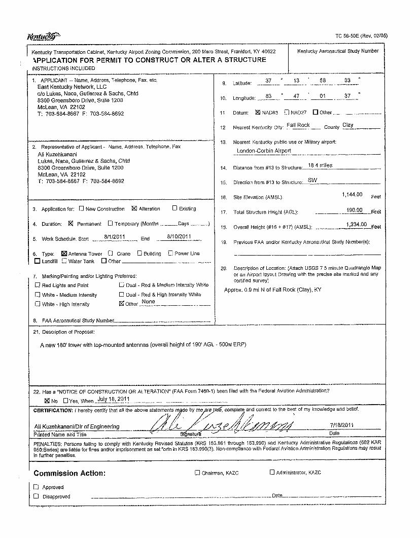
K ! & V TC 56-50E (Rev, 02/05)
Kentucky Transportatlon Cabinet, Kentucky Airport Zaning Commission, 200 Mer0 Street, Frankfort, KY 40622 Kentucky Aeronautical Study Number
'APPLICATION FOR PERMIT TO CONSTRUCT OR ALTER A STRUCTURE I INSTRUCTIONS INCLlJDED
1, APPLICANT -- Name, Address, Telephone, Fax, etc East Kentucky Network, LLC c/o Lukas, Nace, Gutierrez & Sachs, Chtd 8300 Greensboro Drive, Suite 1200 McLean, VA 22102 T 703-584-8667 F: 703-584-8692
2 Representative of Applicant -- Name, Address, Telephone, Fax Ali Kuzehkanani Lukas, Nace, Gutierrez & Sachs, Chtd 8300 Greensboro Drive, Suite 1200 McLean, VA 221 02 T: 703-584-8667 F' 703-584-8692
3. Application for: 0 New Construction a Alteration 0 Existing
4. Duration: a Permanent c] Temporary (Months ---Days .-.-.--)
811 0/2011 5. Work Schedule, Start ,."- 8'1/201 _-_ End ., ...-.
6. Type: Antenna Tower a Crane 0 Building 0 Power Line Landfill 0 Water Tank Other _______I_.,I__ ~ - - -
7. MarkinglPainting and/or Lighting Preferred:
[7 Red Lights and Paint
0 White - Medium Intensity
0 White - High Intensity
0 Dual - Red & Medium intensity White
0 Dual - Red & High Intensity White
a Other l_-._..llll...l.. ~
None
8. FAA Aeronautical Study Nurnbet- "-"" ^-. "---- - -- 21. Description of Proposal:
9.
10.
11.
I2
13
14.
15.
16
17.
18.
19.
20
37 ' 13 * 58 03 I' Latitude: ~ ....l.___.......l.l ___..- ~ ____
Longitude: l_l__ -___ ~. ~
Datum: a NAD83 0 NAD27 Other ._l____...l..__..,., _.ll.l
Nearest Kentucky City. Fa'' Rock
83 47 ' 01 37 I'
County Clay _ _ , . _ _ _ ~
Nearest Kentucky public use or Military airport:
London-Corbin Airport "..I." ~ "--...---
Distance from # I 3 to Structure:
Direction from #13 to Structure.
Site Elevation (AMSL).
18"4 miles
sw
1,144.00 Feet
Total Structure Height (AGL):
Overall Height (#I6 + #17) (AMSL): _,.I____._1
190 00
1,334.00 pael
Previous FAA andlor Kentucky Aeronautical Study Number(s):
Description of Location: (Attach USGS 7 5 minute Quadrangle Map or an Airport layout Drawing with the precise site marked and any certified survey)
Approx. 0 9 mi N of Fall Rock (Clay), KY
---_~__--____ I-___--
A new 180' tower with top-mounted antennas (overall height of 190' AGL .. 500w ERP)
22. Has a "NOTICE OF CONSTRUCTION OR ALTERATION' (FAA Form 7460-1) been filed with the Federal Aviation Administration?
Ix] No UYes, When July 18, 201 I - - - _-- --- CERTIFICATION I hereby certify that all the
Ali KuzehkananilDlr of Engineering Printed Name and Title
PENALTIES: Persons failing to comply with Kentucky Revised Statutes (KRS 183.861 through 183.990) and Kentucky Adrninistrative Regulations (602 KAR 050 Series) are liable for fines and/or imprisonment as set forth in KRS 183 990(3). Non-compliance with Federal Aviation Administration Regulations may result in further penalties
and correct to the best of my knowledge and belief.
- 711 81201 1 Date
---- ----- -I___--
---
_--_- Commission Action: 0 Chairman, KAZC [7 Administrator, KAZC
El Approved
0 Disapproved _I.._ l_l___.__.l__._,..... "_ ._.__..__I_.--_.....__I Dz!a .......-I,.-"
.-


r
EAST KENTUCKY NETWORK, LLC DBA APPALACHIAN WIRELESS
PINANCIAL REPORT
December 31,2010

F
f
r r
r f
r
WEPENDENT AUDITOR'S REPORT ON THE FINANCIAL STATEMENTS
FINANCIAL STATEMENTS
Balance sheets Statements of income Statements of members' equity Statements of cash flows Notes to financial statements
C O N T E N T S
INDEPENDENT AUDITOR'S REPORT ON THE SUPPLEMENTARY INFORMATION
SUPPLEMENTARY INFORMATION
Statements of income detail
Page
1
2 3 4 5
6-15
16
17 and 18

v F
INDEPENDENT AUDITOR’S REPORT
To the Members East Kentucky Network, L I X dba Appalachian Wireless Ivel, ICentucky
We have audited the acconipanying balance sheets of East Kentucky Network, L I X , dba Appalachian Wireless as of December 3 1, 20 10 and 2009 and the related statements of income, members’ equity and cash flows for the years then ended. Thesc financial statements are the responsibility of the Conipany’s management. Our responsibility is to express an opinion on tlicse financial statements based on our audits.
We conducted our audits in accordance with auditing standards generally accepted in the IJnited States of America. Those standards require h t wc plan and perform the audit to obtain reasonable assurance about whether the financial statements arc free of material niisstate~nent. An audit includes examining, on a rest basis, evidence supporting the amounts and disclosures in the financial statements. An audit also includes assessing the accounting principles used and significant estimates made by management, as well as evaluating the overall financial statement prescntation. We believe that our audits provide a reasonable basis for our opinion.
In our opinion, the financial statements referred to above present fairly, in all material respects, the financial position of East Kentucky Network, LLC, dba Appalachian Wireless as of December 31, 2010 and 2009 and the results of its operations and its cash flows for the years then ended in conformity with accounting principles generally accepted in the United States of America.
Louisville, I<entucky February 26,20 1 1
- 1 -

EAST KENTUCKY NETWORK, LLC DBA APPALACHIAN WIRELESS
BALANCE SHEETS December 31.2010 and 2009
ASSETS
ClJRRENT ASSETS Cash and cash equivalents Short-term investments (Note 9) Accounts receivable, less allowance for doubtful
Accounts receivable, members (Notes 5 and 6) Inventory Prepaid expenses
accounts of $1,473,291 in 2010 and $1,405,597 in 2009
Total current assets
PROPERTY, PLANT AND EQUIPMENT (Note 3) Plant in service:
General support MTSO equipment Cell equipment Paging equipment Fiber ring
Unfinished plant
Less accumulated depreciation
OTHER ASSETS Investment in affiliated company, RTFC Intangible assets, net of accumulated amortization
of $5,075,703 in 2010 and $4,389,605 in 2009 (Note 2)
2010 2009
$ 11,517,807 $ 2,874,412 100,000 100,000
8,s 10,532 7,806,7 18 120,279 87,192
5,473,GO 1 5,699,380 5 10,762 537,143
$ 26,232,981 $ 17,104,845
$ 29,593,635 17,622,843 62,992,099 2,452,567 7,802,053 5,s 13,391
$126,276,588 53.2 17.856
$ 73,058,732
$ 27,455,560 22,282,589 64,198,98 1 3,321,068 7,675,975 3.675.759
$128,609,932 57,070,186
$ 71,539,746
$ 112,712 $ 112,712
3,912,368 4,598,466 $ 4.025.080 $ 4.711.178
$103,3 16,793 $ 93,355,769
The Notes to Financial Statements are an integral part of these statements.

P i
LIABILITIES AND MEMBERS' EQUITY
CURRENT LIABILITIES Current maturities of long-term debt (Notes 3 and 9) Accounts payable Accounts payable, members (Notes 5 and 6 ) Accrued expenses Deferred revenue, advance billings Customer deposits
Total current liabilities
LONG-TERM DEBT, less current maturities (Notes 3 and 9)
INTEREST RATE SWAPS (Notes 8 and 9)
MEMBERS' EQUITY Members' capital accounts Accumulated other comprehensive (loss)
2010 2009
$ 2,685,714 !$ 2,685,714 2,339,497 2,033,336
27,707 35,206 1,970,165 1,s 19,862 2,454,257 2,13 3,743
5 70,3 75 5 74,996 $ 10,047,715 $ 8,982,857
$ 10,873,492 $ 13,559,207
$ 1,301,598 $ 1,384,261
$ 82,395,586 $ 70,813,705 ( I ,301,598) (1,384,261)
$ 81,093,988 $ 69,429,444
$103,316,793 $ 93,355,769

EAST KENTUCKY NETWORK, LLC DBA APPALACHIAN WIRELESS
STATEMENTS OF INCOME Years Ended December 31,2010 and 2009
REVENUE Retail Roamer Long distance Paging Equipment sales, cellular Equipment sales, paging Other
Total revenue
EXPENSES Cost of cellular service Cost of paging service Cost of equipment sales, cellular Cost of equipment sales, paging Customer service Billing Selling Maintenance Utilities Bad debts Cell site rental Taxes and licenses Advertising General and administrative Occupancy Depreciation Amortization
Total expenses
Income from operations
OTHER INCOME (EXPENSE) Interest income Interest expense Universal Service Fund income (Note 7)
Net income
2010
$ 49,761,597 19,899,728
150,913 402,3 17
3,194,207 63,355
2,975,390 $ 76,447,507
$ 14,859,401 361,793
14,723,995 35,112
1,482,3 12 I ,730,63 I 4,994,147 2,888,565
976,530 732,290 294,170
2,026,428 3,900,53 1 4,220,443
574,325 9,808,536
852,538 $ 64,461,747
$ 11,985,760
$ 25,278 (1,028,373) 7,37 1,103
$ 6,368,008
2009
$ 46,125,449 16,777,789
195,754 488,500
2,6 13,489 93,942
3,203,88 1 $ 69,498,804
$ 15,223,905 339,05 1
13,508,5 10 57,023
1,364,596 1,657,074 4,188,213 2,595,663
869,O 16 473,634 244,023 446,482
3,s 15,728 3,666,329
632,810 9,105,095
839,546 $ 59,026,698
$ 10,472,106
$ 31,040 (1,424,984) 7,045,378
$ 5,651,434
$ 18.353.768 $ 16.123.540
The Note to Financial Statements are an integral part of these statements.
- 3 - Jones, Nnk 8. Mnttingb PL.C

r
Balance, January 1,2009 Comprehensive income: Net income Change in fair value of
interest rate swaps Total comprehensive
income
Capital distributions BaIance, December 3 1,2009
Comprehensive income: Net income Change in fair value of
interest rate swaps Total comprehensive
income
Capital distributions Balance, December 3 1,201 0
EAST KENTUCKY NETWORK, LLC DBA APPALACHIAN WIRELESS
STATEMENTS OF MEMBERS' EQUITY Years Ended December 31,2010 and 2009
Peoples Rural
Telephone Gearhart Mountain coop-
Communi- Tele- Thacker- erative Cellular cations communi- Grigsby corp- Services, Company, cations, Telephone oration,
LLC Inc. Inc. Co., Inc. Inc. Total
$1 1,693,564 $1 1,693,564 $1 1,693,564 $1 1,693,563 $1 1,693,564 $58,467,819
3,224,708 3,224,708 3,224,708 3,224,708 3,224,708 16,123,540
136,712 136,7 12 136,7 12 136,7 12 136,712 683,560
$ 3,361,420 $ 3,361,420 $ 3,361,420 $ 3,361,420 $ 3,361,420 $16,807,100
(1,169,095) (1,169,095) ( 1,169,095) (1,169,095) (1,169,095) (5,845,475) $13,885,889 $13,885,889 $13,885,889 $13,885,888 $13,885,889 $69,429,444
3,670,754 3,670,753 3,670,753 3,670,754 3,670,754 18,353,768
16,532 16,532 16,533 16,533 16,533 82,663
$ 3,687,286 $ 3,687,285 $ 3,687,286 $ 3,687,287 $ 3,687,287 $18,436,431
(1,354,377) (1,354,377) (1,354,378) (1,354,377) (1,354,378) (6,771,887) $1 6,218,798 $16,218,797 $16.218.797 $16,218,798 $16,218.798 $81,093,988
The Notes to Financial Statements are an integral part of these statements.
-4- Jones, Nnk &Manin& PLC

EAST KENTUCKY NETWORK, LLC DBA APPALACHIAN WIIRE1,ESS
STATEMENTS OF CASH FLOWS Years Ended December 31,2010 and 2009
CASH FLOWS FROM OPERATING ACTIVITIES Net income Adjustments to reconcile net income to net cash provided
by operating activities: Depreciation Amortization Loss on disposition of property, pIant, and equipment Changes in assets and liabilities, net of the effects
of investing and financing activities: (Increase) in accounts receivable (Increase) decrease in accounts receivable, members (Increase) decrease in inventory (Increase) decrease in prepaid expenses Increase in accounts payable (Decrease) in accounts payable, members Increase in accrued expenses Increase in deferred revenue, advance billings (Decrease) in customer deposits
Net cash provided by operating activities
CASH FLOWS FROM INVESTING ACTIVITIES Purchase of property, plant and equipment
Net cash (used in) investing activities
CASH FLOWS FROM FINANCING ACTIVITIES Capital distributions Proceeds from long-term borrowings Payments on long-term borrowings
Net cash (used in) financing activities
Net increase (decrease) in cash and cash equivalents
Cash and cash equivalents: Beginning
Ending
SUPPLEMENTAL DISCLOSURE OF CASH FLOW INFORMATION Cash payments for interest (net of capitalized interest of
of $1 17,887 in 20 10 and zero in 2009)
2010 2009
$ 18,353,768 $ 16,123,540
9,808,536 9,105,095 839,546 852,538
593,729 82,302
(703,8 14) (33,087) 225,779 26,38 1
306,161
450,303 320,5 14
(4,621) $ 30,188,688
(7,499)
(1,559,749) 886
(2,645,935) (125,195) 261,098 (14,373) 3 1 1,724 246,5 13 (25,876)
$ 22,599,576
$ (12,087,691) $ (15,028,659) $ (12,087,691) $ (15,028,659)
$ (6,771,887) $ (5,845,475) - - 10,200,000
(2,685,715) (14,196,195) $ (9,457,602) $ (9,84 1,670)
$ 8,643,395 $ (2,270,753)
2,874,412 5,145,165
$ 11,517,807 $ 2.874.412
$ 1,045.454 !$ 1.431.014.
The Notes to Financial Statements are an integral part of these statements.
- 5 - Jones, Nnk- & Mnttingly PLC

r
r f
I" r I r F r r
r f r r P r
EAST KENTUCKY NETWORK, LLC DBA APPALACHIAN WIRELESS
NOTES TO FINANCIAL STATEMENTS
Note 1. Summary of Significant Accounting Policies
Nature of operations
East Kentucky Network, LLC, dba Appalachian Wireless, is a Kentucky limited liability company formed by the merger of Appalachian Cellular, LLC, Mountaineer Cellular, LLC and East Kentucky Network, 1,LC on January 1, 2000. The Company is engaged in cellular telephone communications and paging services to residential and commercial customers located in eastern Kentucky. The Company's five members consist of Cellular Services, LLC; Gearheart Communications Company, Inc.; Mountain Telecommunications, Inc.; Peoples Rural Telephone Cooperative Corporation, Inc.; and Thacker-Grigsby Telephone Co., Inc.
Use of estimates
Management uses estimates and assumptions in preparing financial statements. Those estimates and assumptions affect the reported amounts of assets and liabilities, the disclosure of contingent assets and liabilities, and the reported revenues and expenses.
Cash and cash equivalents
For purposes of the statement of cash flows, the Company considers temporary investments having original maturities of three months or less to be cash equivalents. The Company maintains its cash balances, which may exceed the federally insured limit, with several financial institutions. These financial institutions have strong credit ratings and management believes that credit risk related to the accounts is minimal. .
Short-term investments
Certificates of deposit having original maturities between three and nine months are classified as short-term investments, are carried at cost, which approximates fair value, and are held to maturity. Fair value is determined by quoted prices for similar certificates of deposit in active markets (Level 2) as defined by the Fair Value Measurements Topic of the FASB Accounting Standards Codification (see Note 9).
Accounts receivable
Accounts receivable are recorded at net realizable value consisting of the carrying amount less an allowance for uncollectible accounts. The Company uses the allowance method to account for uncollectible accounts receivable balances. Management charges off uncollectible receivables to the allowance when it is determined the amounts will not be realized .
- 6 - Jones, Nab & Maningy PLC

NOTES TO FINANCIAL STATEMENTS
Note 1.
r
F r r F r i
r Ir F F r r P [
Summary of Significant Accounting Policies (Continued)
Inventory
Inventory is composed of cellular telephone equipment, paging equipment, and accessories purchased for resale during the ordinary course of business. The inventory is valued at the lower of cost or market, cost being determined by the first-in, first-out (FIFO) method.
Investment
The investment in affiliated company is composed of equity certificates in Rural Telephone Finance Cooperative and is reported at cost.
Intangible assets
The customer lists, non-compete agreements, FCC licenses, bond issuance costs, loan fees and use of name are recorded at cost and are being amortized over the life of the asset by the straight-line method.
Revenue recognition
Revenue consists primarily of charges for access, airtime, roaming, long distance, data and other value-added services provided to the Company’s retail customers; charges to other cellular carriers whose customers use the Company’s network when roaming; and sales of phones and accessories.
Revenue from cellular service is recognized monthly when earned, phone and accessory sales are recognized at the point of sale, activation fees are recognized when activation of service occurs, and cancellation penalties are recognized at the time of disconnection from service. Deferred revenue consists of monthly access and feature charges billed one month in advance and recognized as revenue the following month.
The Company’s sales contracts are considered multiple deliverable arrangements that generally involve delivery and activation of a cetlulat phone, plus phone service. Each is treated as a separate unit of accounting. Contracts are subject to one to two-year terms and require the customer to pay a cancellation fee if the customer cancels the contract. There is a one-time activation fee and a monthly fee for the ongoing service. All fees are nonrefundable. The phone and activation are delivered first, foIlowed by the phone service (which is provided over the contract period). Delivery and activation of the phone are considered one element because activation is necessary for the functionality of the phone. Revenue from phone service is recognized separately over the life of the service arrangement.
Advertising
Advertising costs are expensed as incurred. At December 31, 2010 and 2009, these costs were $3,900,531 and $3,815,728, respectively.
- 7 - Jones, Nab 4. Mattingty P1.C

I NOTES TO FINANCIAL STATEMENTS
f
f
I T'" r F r
r
r
Note 1. Summary of Significant Accounting Policies (Continued)
Income taxes
Under existing provisions of the Internal Revenue Code, the income or loss of a limited liability company is recognized by the members for income tax purposes. Accordingly, no provision for federal income taxes has been provided for in the accompanying financial statements.
The Company's accounting policy provides that a tax expenselbenefit from an uncertain tax position may be recognized when it is more likely than not that the position will be sustained upon examination, including resolutions of any related appeals or litigation processes, based on the technical merits. Management believes the Company has no uncertain tax positions resulting in an accrual of tax expense or benefit.
The Company recognizes interest accrued related to unrecognized tax benefits in interest expense and penalties in operating expenses. The Company did not recognize any interest or penalties during the years ended December 3 1,2010 and 2009.
The Company's federal and state income tax returns are subject to possible examination by the taxing authorities until the expiration of the related statutes of limitations on those tax returns. In general, the federal income tax returns have a three year statute of limitations, and the state income tax returns have a four year statute of limitations.
Comprehensive income
Comprehensive income consists of net income and other comprehensive income. Other comprehensive income includes the change in fair value of interest rate swaps which is also recognized as a separate component of equity.
Subsequent events
Management has evaluated subsequent events through February 26, 201 1, the date the financial statements were available to be issued.
Reclassification
Certain amounts presented in the priar period have been restated to conform with the current year presentation.
P
r - 8 -

NOTES TO FINANCIAL STATEMENTS
Note 2. Intangible Assets
Intangible assets consist of the following at December 3 1, 20 10:
Weighted Gross Accumulated Average
Amount Amortization Life (in years)
Customer lists $ 5,363,530 $ (3,583,198) 15
FCC licenses 2,452,368 (889,418) 14 Use of name 10,000 (7,002) 15
Nan-compete agreements 220,348 (180,336) 15
Other 941,825 (41 5,749) 7 $ 8,988,071 $ (5,075,703)
Intangible assets consist of the following at December 3 1,2009:
Weighted Gross Accumulated Average
Amount Amortization Life (in years)
Customer lists $ 5,363,530 $ (3,225,881) 15 Non-compete agreements 220,348 (165,657) 15 FCC licenses 2,452,368 (7 17,074) 14 Use of name 10,000 (6,335) 15 Other 941,825 (274,658) 7
$ 8,988,071 $ (4,389,605)
Aggregate amortization expense related to these intangible assets for the years ended December 3 1, 2010 and 2009 totaled $686,098 and $682,25 1 respectively. The following represents the total estimated amortization o f intangible assets for each of the succeeding five years:
Year ending December 3 1 :
201 1 2012 2013 2014 2015
- 9 -
$ 680,000 680,000 660,000 620,000 550,000
i
NOTES TO FINANCIAL STATEMENTS
r
r
r
r P r r r I"
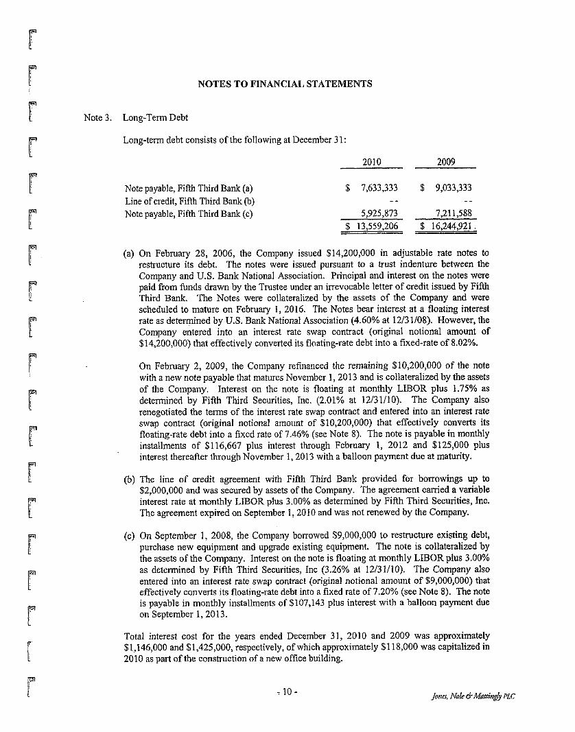
Note 3. Long-Term Debt
Long-term debt consists of the following at December 3 1
2010 2009 - Note payable, Fifth Third Bank (a) $ 7,633,333 $ 9,033,333
Note payable, Fifth Third Bank (c) 5,925,873 7,211,588 Line of credit, Fifth Third Bank (b) - - - -
$ 13,559,206 $ 16,244,921 I
(a) On February 28, 2006, the Company issued $14,200,000 in adjustable rate notes to restructure its debt. The notes were issued pursuant to a trust indenture between the Company and U.S. Bank National Association. Principal and interest on the notes were paid from finds drawn by the Trustee under an irrevocable letter of credit issued by Fifth Third Bank. The Notes were collateralized by the assets of the Company and were scheduled to mature on February I, 2016. The Notes bear interest at a floating interest rate as determined by US. Bank National Association (4.60% at 12/31/08). However, the Company entered into an interest rate swap contract (original notional amount of $14,20O,OOO) that effectively converted its floating-rate debt into a fixed-rate of 8.02%.
On February 2, 2009, the Company refinanced the remaining $10,200,000 of the note with a new note payable that matures November 1,2013 and is collateralized by the assets of the Company, Interest on the note is floating at monthly LIBOR plus 1.75% as determined by Fifth Third Securities, Inc. (2.01% at 12/31/10). The Company also renegotiated the terms of the interest rate swap contract and entered into an interest rate swap contract (original notional amount of $10,200,000) that effectively converts its floating-rate debt into a fixed rate of 7.46% (see Note 8). The note is payable in monthly installments of $116,667 plus interest through February 1, 2012 and $125,000 plus interest thereafter through November 1,2013 with a balloon payment due at maturity.
(b) The line of credit agreement with Fifth Third Bank provided for borrowings up to $2,000,000 and was secured by assets of the Company. The agreement camed a variable interest rate at monthly LIBOR plus 3.00% as determined by Fifth Third Securities, Inc. The agreement expired on September I , 20 10 and was not renewed by the Company.
(c) On September 1, 2008, the Company borrowed $9,000,000 to restructure existing debt, purchase new equipment and upgrade existing equipment. The note is collateralized by the assets of the Company. Interest on the note is floating at monthly LIBOR plus 3.00% as determined by Fifth Third Securities, Inc (3.26% at 12/31/10). The Company also entered into an interest rate swap contract (original notional amount of $9,000,000) that effectively converts its floating-rate debt into a fixed rate of 7.20% (see Note 8). The note is payable in monthly installments of $107,143 plus interest with a balloon payment due on September 1,20 13.
Total interest cost for the years ended December 3 1, 2010 and 2009 was approximately $1,146,000 and $1,425,000, respectively, of which approximately $1 18,000 was capitalized in 2010 as part of the construction of a new office building.
r Y 10- Joner, Nak &Mattingb PLC

Note 3.
Note 4.
Note 5.
NOTES TO FINANCIAL STATEMENTS
Long-Term Debt (Continued)
Under terms of the Notes, the Company has also agreed, among other things, to limit distributions, to maintain minimum debt service coverage, and to maintain minimum debt to tangible worth ratios.
Approximate maturities or payments required on principal under note payable agreements for each of the succeeding five years are as follows:
Year ending December 3 1 : 201 1 2012 2013 2014 2015
$ 2,685,714 2,769,048 8,104,444
$ 13,559,206
Retirement Plans
The Company has a 401(k) plan for qualifying employees who have reached twenty-one years of age. Eligible employees are allowed to invest up to 15% of their compensation and the Company has agreed to match 100% of the first 3% of the employees' contribution and 50% of the employees' contribution between 3% and 5%. The Company contributed $139,405 and $124,071 in matching funds for its 401(k) plan during the years ended December 3 1,2010 and 2009, respectively.
The Company also offers an employer sponsored retirement savings plan for qualified employees who have reached twenty-one years of age. The Company has agreed to contribute 9% af the eligible employee's compensation, plus an additional 5% of the original contribution.
The Company contributed $638,293 and $421,669 to its retirement savings plan during the years ended December 3 I , 20 IO and 2009, respectively.
Related Party Transactions
The Company shares personnel with three of its members. The Company paid $251,384 and $210,990 for shared personnel during the years ended December 31, 2010 and 2009, respectively. The Company also leased offices and warehouse space fiom three members. The leases are for an unspecified length of time, The annual lease expense related to these leases was $20,483 for both years ended December 3 1,201 0 and 2009.
The Company incurred interconnection, telephone, cable and internet access charges fiom its members aggregating $1,206,230 and $1,111,25 1 for the years ended December 3 1,2010 and 2009, respectively.
- 11 -

NOTES TO FINANCIAL STATEMENTS
Note 5. Related Party Transactions (Continued)
The Company leases two cellular tower sites from the officers and majority shareholders of a member. The annual lease expense related to these leases was $2,400 for both years ended December 31, 2010 and 2009. The leases are for an unspecified length of time. The Company also pays part of an annual lease for sharing a tower with a member for an annual fee of $450. In addition, the Company leases one other site from a company owned by a member. The annual lease expense related to this lease for the years ended December 31, 2010 and 2009 amounted to $13,350 and $1 1,700, respectively. The Company leases cellular tower sites from the parent company of one of its other members. The annual lease expense related to these leases was $12,463 for both years ended December 31, 2010 and 2009. The leases are for five years with options to renew.
The Company pays commissions to its members for phone sales to customers. The amount of commissions paid to related parties during the years ended December 31,2010 and 2009 was $55,035 and $45,420, respectively.
The Company pays fees to companies owned by its members for advertisement in telephone directories, television and on local billboards. The amount of advertising paid to related parties was $61,534 and $54,522 for the years ended December 31, 2010 and 2009, respectively.
Note 6. Operating Leases
The Company has entered into operating leases with its members and other customers to provide fiber optic transmission capacity and ancillary services. The terms of these leases are for 15 years. Total rental income earned from these operating lease commitments included in the statements of income was $1,214,408 and $1,194,626 for the years ended December 31, 2010 and 2009, respectively. Rental income earned from the Company's members from these leases was $1,008,827 and $799,054 for the years ended December 31, 2010 and 2009, respectively.
Investments in operating leases are as follows at December 3 1 :
2010 2009
Fiber ring $ 7,802,053 $ 7,675,975 Accumulated depreciation (3,120,944) (2,623,141)
$ 4,681,109 $ 5,052,834
The future minimum rental payments expected to be received under these lease agreements for each of the succeeding five years are approximately $1,200,000 each year.
- 12-

NOTES TO FINANCIAL STATEMENTS
Note 6. Operating Leases (Continued)
The Company has also entered into lease agreements to obtain fiber optic transmission and digital microwave transmission services; and to rent retail office facilities. The terms of these leases are between 5 and 15 years. Total rental expense incurred from these operating lease commitments included in the statements of income was $1,055,717 and $1,070,826 for the years ended December 31, 2010 and 2009, respectively. Rental expense incurred from the Company’s members from these leases was $41 1,196 and $488,725 for the years ended December 31, 2010 and 2009, respectively. The future minimum lease payments required under these lease agreements for each of the succeeding five years are approximately $1,100,000 each year.
Note 7. Eligible Telecommunication Carrier
During 2005, the Company was granted Eligible Telecommunication Carrier (ETC) status by the Kentucky Public Service Commission. As an ETC, the Company receives funding from the federal Universal Service Fund (USF) to support the high cost of providing local telephone service in rural areas. ‘CJSF payments amounted to $7,371,103 and $7,045,378 for 2010 and 2009, respectively.
Note 8. Derivative Financial Instruments, Interest Rate Swaps
The Company entered into two interest rate swap contracts with Fifth Third Bank for the purpose of converting floating-rate interest on its long-term debt to fixed rates. The interest rate swap effectively fixed $10,200,000 at a rate of 7.46% until February 1, 2016 and fixed $9,000,000 at a rate of 7.20% until September 1,2013.
Under the swap contracts, the Company pays interest at 5.71% and 4.20% on the notional amounts and receives interest at LIBOR observed monthly (0.26% at December 31, 2010). The interest rate swaps qualify as, and are designated as, cash flow hedges. The swaps are designed to hedge the risk of changes in interest payments on the notes caused by changes in LIBOR. The notional amounts do not represent actual amounts exchanged by the parties, but instead represent the amounts on which the contracts are based.
The swaps were issued at market terms so that they had no fair value or carrying value at their inception. The carrying amount of the swaps has been adjusted to their fair value at the end of the year, which because of changes in forecasted levels of LIBOR, resulted in reporting a liability for the fair value of the future net payments forecasted under the swaps. The swap contracts permit settlement prior to maturity only through termination by the Company. The settlement amounts are determined based on forecasted changes in interest rates required under fixed and variable legs of the swaps. The Company believes the settlement amounts are the best representation of the fair value of the swaps and has adjusted their carrying amounts to the settlement amounts at the end of the year.
- 13-

Note 8.
Note 9.
NOTES TO FINANCIAL STATEMENTS
Derivative Financial Instruments, Interest Rate Swaps (Continued)
The carrying amounts of the swaps are classified as noncurrent since management does not intend to terminate the swaps during 201 1. Since the critical terms of the swaps and the notes are approximately the same, the swaps are assumed to be effective as hedges, and none of the changes in fair values are included in income. Accordingly, all of the adjustment of the swaps' carrying amount is reported as other comprehensive income or loss in the accompanying statements of members' equity. If the swaps are terminated earlyj the corresponding carrying amount would be reclassified into earnings. The Company does not hold or issue interest rate swaps or other financial instruments for trading purposes.
Fair Values of Financial Instruments
The Fair Value Measurements Topic of the FASB Accounting Standards Codification defines fair value, establishes a framework for measuring fair value, and expands disclosures about fair value measurements. The Fair Value Measurements Topic establishes a fair value hierarchy about the assumptions used to measure fair value and clarifies assumptions about risk and the effect of a restriction on the sale of an asset. The Fair Value Measurements Topic defines fair value as the exchange price that would be received for an asset or paid to traixjfer a liability (an exit price) in the principal or most advantageous market for the asset or liability in an orderly transaction between market participants on the measurement date. However, in many instances, there are no quoted market prices for the Company's various financial instruments. In cases where quoted market prices are not available, fair values are based on estimates using present value or other valuation techniques, Those techniques are significantly affected by the assumptions used, including the discount rate and estimates of future cash flows. Accordingly, the fair value estimates may not be realized in an immediate settlement of the instrument. The Fair Value Measurements Topic also establishes a fair value hierarchy which requires an entity to maximize the use of observable inputs and minimize the use of unobservable inputs when measuring fair value.
The Fair Value Measurements Topic describes three levels of inputs that may be used to measure fair value:
Level 1 -
Level 2 -
Level 3 -
Quoted prices (unadjusted) or identical assets or IiabiIities in active markets that the entity has the ability to access as of the measurement date.
Significant other observable inputs other than Level 1 prices, such as quoted prices of similar assets or liabilities, quoted prices in markets that are not active, and other inputs that are observable or can be corroborated by observable market data.
Significant unobservable inputs that reflect a company's own assumptions about the assumptions that market participants would use in pricing an asset or liability.
- 1 4 -

I MOTES TQ FINANCIAL STATEMENTS
Note 9. Fair Values of Financial Instruments (Continued)
Financial instruments of the Company that are subject to fair value measurements are limited to short-term investments, long-term debt and interest rate swaps. Fair values of these financial instruments are measured using Level 2 inputs.
The fair value of short-term investments approximates its carrying amount due to the short- term nature of these instruments.
The fair value of long-term debt approximates its carrying amount because its variable rate terms are similar to market terms.
The fair value of the interest rate swaps are based on the approximation of market value derived Erom proprietary models. This fair value takes into consideration the prevailing interest rate environment and the specific terms and conditions of the derivative financial instrument. The fair value was estimated by comparing the Company's fixed swap rates with the current market rates on identical swaps for the remaining terms. The interest due on each remaining payment date is calculated at the existing swap rate and the current market rate. Fair market value is the present value of the difference between those payment streams. The value represents the estimated exit price the Company would pay to terminate the agreement.
- 15 - Jones, Nak & Matting4 PLC

Directions to Fall Rock Site
Starting fiom the courthouse in Clay County Ky. Take Hwy 421 North 5.9 miles to Gravel road Turn right onto Gravel road and go .2 miles to Road turning up the hill to site. The proposed road is marked with Blue and white ribbons fiom that point to the site. Road is not constructed due to the NEPA report not being completed at this time.
Directions were written by:
Marty Thacker Appalachian Wireless 606-634-9505 Cell Phone 606-785-2203 Office m. thacker63,tgtel. com email


LEASE AGREEMENT
THIS LEASE AGREEMENT is made and entered into on the d?)*day of
ay2QXdgw , zoia, by and between R i c e and Vickie Smif&, his wife, of 6250 North
Hwy. 421 Manchester, Icy 40962, LESSORS, and East Kentucky Network, LLC, d/b/a
Appalachian Wireless, of io1 Technology Trail, Ivel, Kentucky 41642, LESSEE:
WITNESSETH:
That for and in cansideration of the rents arid other considerations hereinafter set
out and subject to the terms and conditions therefore, Lessor’s do hereby lease, let and
demise unto Lessee, its successors and assigns, to have and to hold for the term
hereinafter set out and subject to the Lessee’s right to surrender or terminate this Lease
and provided hereinafter, the following described premises (Leased Premises), which
term shall include all real property, rights and privileges herein granted:
BEING the same property described by metes and bounds in the description attached hereto and made a part hereof as Exhibit “A”, and as shown on the plat dated ii* day of November, 2010, prepared by James W. Caudill, Licensed Professional Land Surveyor, and attached hereto and made a part hereof as Exhibit A & B.
The Lessor grants unto Lessee full and complete right of ingress, egress and regress
over roads located upon this property controlled by Lessor to and from the Leased
Premises, and the non-exclusive right to use any existing road located on this property.
In the event the Lessee desires to relocate all or any portion of an existing roadway or to
construct another access road to the Leased Premises, the location of such roadway shall
be mutually agreed upon by Lessor and Lessee. Lessor further grants to the Lessee a right

of way and easement to construct and maintain and operate telephone and power
transmission lines over Lessor’s remaining property to the Leased Premises for service of
the tower and related facilities only, said lines to be located where feasible along the
access road to the Leased Premises, with Lessor having input as to location of said power
transmission lines in the event Lessee changes the location of its access road. Lessee shall
have the right to trim or remove trees, limbs or underbrush which interferes with its
access road or power/telephone lines wherever such road and lines are located or may
damage tower if they fall. Lessee shall help maintain the existing road with gravel and
needed repairs.
This Lease is made on the following terms and conditions:
I. TERM OF LEASE. The term of this lease shall be for a period of five (5) years
from the date of this Lease Agreement with an additional seven (7) automatic renewals of
five (5) year terms unless Lessee gives Lessor written notice at least sixty (60) days prior
to expiration of said Term that Lessee does not wish to renew.
2. CANCELLATION. Lessee shall have the right to terminate this Lease and
abandon the Premises at any time under its sole discretion, upon six (6) month written
notice to Lessor of its intention to do so. In the event that Leased Premises fail the
process for approval as an acceptable cellular tower site by the Federal Communications
Commission or any tests or requirements as required for such approval (the “FCC
Process”) or approval by the Public Service Commission of Kentucky (the “PSC”), then in
its sole discretion Lessor may terminate this Lease Agreement upon thirty (30) days
written notice to Lessor of such intention. In the event of termination by Lessee, the

Lessor shall have no obligation to refund all or any portion oi the annual Leasehold rental
payment that has been paid through the date of termination. Upon termination of this
Lease, Lessee shall have one hundred eight (180) days thereafter to remove all structures
it has erected upon the Leased Premises, and to reclaim the premises. Payrnent shall
continue until said structures are removed.
3. RENTAL. As rental for the Leased Premises, Lessee shall pay Lessor as follows:
$300.00 per month for the first five (5) year term. After the first five (5) year term each
additional five (5) year term will have an increase of 5% per five year term.
4. USE OF PREMISES. Lessee shall have the exclusive rights and privileges of the
use of the Leased Premises for the purpose of constructing buildings, towers, and other
related facilities, including, but not limited to telephone lines, coaxial lines, power lines
and the installation of any and all other equipment deemed necessary by Lessee to receive
and transmit any and all electronic signals in the rural service area now or hereafter to be
served by the facility. The parties hereto recognize that technology in the
communications field is advancing at a rapid rate and that this site may be used for any
other purpose now in the development stage or which may later be developed in the
communications industry to carry out the objectives of Lessee, that being to transmit and
receive signals and communications by wire, fiber optics, radio and satellite. Lessee shall
not use the Leased Premises for purposes other than maintenance or use as a site for
communications by the use of methods now or hereafter known.
Lessee shall have the right to relocate the road to the site at Lessee’s expense, at a
mutually agreed upon route, so as long as Lessor has the right to use the new road, which

use by Lessor shall not interfere with Lessee's use thereof or pose a threat to the security
of Lessee's operations or the Leased Premises.
Lessee agrees to maintain the Leased Premises in a neat and orderly manner.
5. INDEMNITY. Lessee agrees to indemnify and save harmless the Lessor from
any liability by virtue of Lessee's activities upon the Leased Premises or in the exercise of
any rights and privileges granted herein, specifically including but not limited to any
claim, loss, fine, penalty and costs (including reasonable attorney's fees) arising out of
any violation of any environmental laws or regulations. This provision shall survive the
termination of the lease. Lessee shall maintain and keep in full force and effect public
liability and property damage insurance in an amount of at least One Million Dollars
($~,OOO,OOO.QO). Lessor shall not be held liable for personal injury or property damage on
the Leased Premises whether or not associated with Lessee.
6. TAXES. Lessee shall pay all personal property taxes assessed on or any portion
of such taxes attributable to the equipment used by Lessee on the Premises. Lessor shall
pay when due all real property taxes and all other fees and assessments attributable to the
Premises. Lessee shall reimburse the Lessor as additional compensation for any increase
in real estate taxes levied against the Lessor (or its successors or assigns) which are
attributable to or arise as a result of the improvements constructed by the Lessee, its
successors or assigns.
7. MISCELLANEOUS PROVISIONS. All notices, demands, or other writings in
this Lease Agreement provided to be given, made or sent, or which may be given or made
or sent, to either party hereto to the other, shall be deemed to have been fully given or

made or sent when made in writing and deposited in the United States Mail, certified and
postage prepaid, to Lessor and Lessee at the addresses stated in the caption of this Lease
Agreement. Such addresses may be changed by written notice given by such party as
above provided.
8. SUCCESSORS AND ASSIGNS. This Lease Agreement shall be binding upon
the parties hereto, their heirs, executors, administrators and assigns.
WITNESS OUR HANDS, the day and year aforesaid.
LESSORS:
Vickik Smith
LESSEE:
EAST ICENTUCICY NETWORK, LLC d/b/a APPALACHLAN WIRELESS
STATE OF CQUNTYOF Q
dQ, G The foregoing Lease Agreement was this day o f h * , produced and acknowledged before me by Riclcy Smith and Vicltie Smith, his wife, Lessor.
NOTARY PUBLIC COMMISSION EXPIRES: I *q- 3

The foregoing Lease Agreement was this day of a , ms2, produced and acknowledg Network, LLC, dba Appalachian Wireless by . ,Lessee.
NOTARY PUBLIC COMMISSION EXPIRES: / -39 - / 3
STATE OF KENTUCKY
COUNTY OF CLAY Clerk’s Certificate of Lodgment and Record
1, , Clerk of the County for the County and State aforesaid, certify that the foregoing Lease Agreement was on the - day of
, 20- lodged for record, whereupon the same, with the foregoing and this certificate have been duly recorded in my office.
WITNESS my hand, this - day of J ”-*
Clerk
BY D.C.
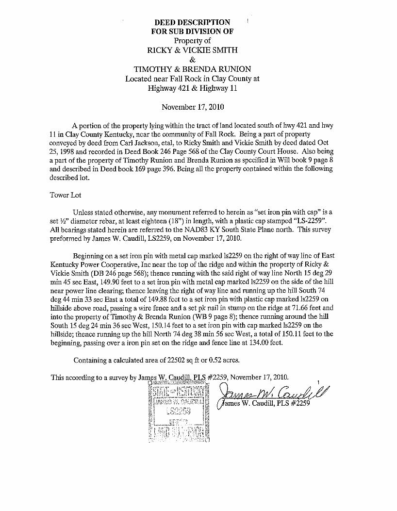
DEED DESCRIPTION FOR SUB DIVISION OF
Property of RICKY & VTCLUE SMITH
& TIMOTHY & BRENDA RUNION
Located near Fall Rock in Clay County at Highway 421 & Highway 11
November 17,2010
A portion of the property lying within the tract of land located soit,, o hwy 421 and hwy 11 in Clay County Kentucky, near the community of Fall Rock. Being a part of property conveyed by deed from Carl Jackson, etal, to Ricky Smith and Vickie Smith by deed dated Oct 25,1998 and recorded in Deed Book 246 Page 568 of the Clay County Court House. Also being a part of the property of Timothy Runion and Brenda Runion as specified in Will book 9 page 8 and described in Deed book 169 page 396. Being all the property contained within the following described lot.
Tower Lot
Unless stated otherwise, any monument referred to herein as “set iron pin with cap” is a set W diameter rebar, at least eighteen (18”) in length, with a plastic cap stamped “LS-2259”. All bearings stated herein are referred to the NAD83 KY South State Plane north. This survey preformed by James W. Caudill, LS2259, on November 17,2010.
Beginning on a set iron pin with metal cap marked 1~2259 on the right of way line of East Kentucky Power Cooperative, Inc near the top of the ridge and within the property of Ricky & Vickie Smith (DB 246 page 568); thence running with the said right of way line North 15 deg 29 min 45 sec East, 149.90 feet to a set iron pin with metal cap marked 1~2259 on the side of the hill near power line clearing; thence leaving the right of way line and running up the hill South 74 deg 44 min 33 sec East a total of 149.88 feet to a set iron pin with plastic cap marked 1~2259 on hillside above road, passing a wire fence and a set pk nail in stump on the ridge at 71.66 feet and into the property of Timothy & Brenda Runion (WB 9 page 8); thence running around the hill South 15 deg 24 min 36 sec West, 150.14 feet to a set iron pin with cap marked 1~2259 on the hillside; thence running up the hill North 74 deg 38 min 56 sec West, a total of 150.11 feet to the beginning, passing over a iron pin set on the ridge and fence line at 134.00 feet.
Containing a calculated area of 22502 sq ft or 0.52 acres.
This according to a survey by Ja ,2259, November 17,2010. h
ames W. Caudill, P l S #2259

LEASE AGREEMENT
THIS LEASE AGREEMENT is made and entered into on the day of
*be*T, 2010, by and between Tim and Brenda Runion, his wife, of 455 North
Hwy. 11. Manchester, Ky. 40962, LESSORS, and East Kentucky Network, LLC, d/b/a
Appalachian Wireless, of 101 Technology Trail, Ivel, Kentucky 4164.2, LESSEE:
WITNESSETH:
That for and in consideration of the rents and. other considerations hereinafter set
out and subject to the terms and conditions therefore, Lessor do hereby lease, let and
demise unto Lessee, its successors and assigns, to have and to hold for the term
hereinafter set out and subject to the Lessees right to surrender or terminate this Lease
and provided hereinafter, the following described premises (Leased Premises), which
term shall include all real property, rights and priviIeges herein granted:
BEING the same property described by metes and bounds in the description attached hereto and made a part hereof as Exhibit "A", and as shown on the plat dated iith day of November, 2010, prepared by James W. Caudill, Licensed Professional Land Surveyor, and attached hereto and made a part hereofas Exhibit A & B.
The Lessor grants unto Lessee full and complete right of ingress, egress and regress
over roads located upon this property controlled by Lessor to and from the Leased
Premises, and the nonexclusive right to use any existing road located on this property. In
the event the Lessee desires to relocate all or any portion of an existing roadway or to
construct another access road to the Leased Premises, the location of such roadway shall
be mutually agreed upon by Lessor and Lessee. Lessor further grants to the Lessee a right
of way and easement to construct and maintain and operate telephone and power
transmission lines over Lessors remaining property to the Leased Premises for service of
the tower and related facilities only, said lines to be located where feasible along the
access road to the Leased Premises, with Lessor having input as to location of said power
transmission lines in the event Lessee changes the location of its access road. Lessee shall
have the right to trim or remove trees, limbs or underbrush which interferes with its
access road or power/telephone lines wherever such road and lines are located or may
damage tower if they fall. Lessee shall help maintain the existing road with gravel and
needed repairs.
This Lease is made on the following ternis and conditions:
1. TEEM OF LEASE. The term of this lease shall be for a period of five (5) years
from the date of this Lease Agreement with an additional seven (7) automatic renewals of
five (5) year terms unless Lessee gives Lessor written notice at least s i x t y (60) days prior
to expiration of said Term that Lessee does not wish to renew.
2. CANCELLATION. Lessee shall have the right to terminate this Lease and
abandon the Premises at any time under its sole discretion, upon six (6) month written
notice to Lessor of its intention to do S O . In the event that Leased Premises fail the
process for approval as an acceptable cellular tower site by the Federal Communications
Commission or any tests or requirements as required for such approval (the “FCC
Process”) or approval by the Public Service Commission of Kentucky (the “PSC”), then in
its sole discretion Lessor may terminate this Lease Agreement upon thirty (30) days
written notice to Lessor of such intention. In the event of termination by Lessee, the

Lessor shall have no obligation to refund all or any portion of the annual Leasehold rental
payment that has been paid through the date of termination. Upon termination of this
Lease, Lessee shall have one hundred eight (180) days thereafter to remove all structures
it has erected upon the Leased Premises, and to reclaim the premises. Payment shall
continue until said structures are removed.
3. RENTAL. As rental for the Leased Premises, Lessee shall pay Lessor as follows:
$200.00 per month for the first five (5) year term. After the first five (5) year term each
additional five (5) year term will have an increase of 5% per five year term.
4. USE OF PREMISES. Lessee shall have the exclusive rights and privileges of the
use of the Leased Premises for the purpose of constructing buildings, towers, and other
related facilities, including, but not limited to telephone lines, coaxial lines, power lines
and the installation of any and all other equipment deemed necessary by Lessee to receive
and transmit any and all electronic signals in the rural service area now or hereafter to be
served by the facility. The parties hereto recognize that technology in the
communications field is advancing at a rapid rate and that this site may be used for any
other purpose now in the development stage or which may later be developed in the
communications industry to carry out the objectives of Lessee, that being to transmit and
receive signals and communications by wire, fiber optics, radio and satellite. Lessee shall
not use the Leased Premises for purposes other than maintenance or use as a site for
communications by the use of methods now or hereafter known.
Lessee agrees to maintain the Leased Premises in a neat and orderly manner.

5. INDEMNITY. Lessee agrees to indemnify and save harmless the Lessor fiom
any liability by virtue of Lessee's activities upon the Leased Premises or in the exercise of
any rights and privileges granted herein, specifically including but not limited to any
claim, loss, fine, penalty and costs (including reasonable attorney's fees) arising out of
any violation of any environmental laws or regulations. This provision shaI1 survive the
termination of the lease. Lessee shall maintain and keep in full force and effect public
liability and property damage insurance in an amount of at least One Million Dollars
($I,OOO,~OO.OO). Lessor shall not be held liable for personal injury or property damage on
the Leased Premises whether or not associated with Lessee.
6. TAXES. Lessee shall pay all personal property taxes assessed on or any portion
of such taxes attributable to the equipment used by Lessee on the Premises. Lessor shall
pay when due all real property taxes and all other fees and assessments attributable to the
Premises. Lessee shall reimburse the Lessor as additional compensation for any increase
in real estate taxes levied against the Lessor (or its successors or assigns) which are
attributable to or arise as a result of the improvements constructed by the Lessee, its
successors or assigns.
7. MISCELLANEOUS PROVISIONS. All notices, demands, or other writings in
this Lease Agreement provided to be given, made or sent, or which may be given or made
or sent, to either party hereto to the other, shall be deemed to have been fully given or
made or sent when made in writing and deposited in the United States Mail, certified and
postage prepaid, to Lessor and Lessee at the addresses stated in the caption of this Lease

Agreement. Such addresses may be changed by written notice given by such party as
above provided.
8. SUCCESSORS AND ASSIGNS. This Lease Agreement shall be binding upon
the parties hereto, their heirs, executors, administrators and assigns.
WITNESS OUR HANDS, the day and year aforesaid.
c Tim Runion LEs-
nn r n l Ifd’ri’dY Runi on
-
LESSEE:
EAST KENTUCKY NETWORK, LLC
ITS:
STATE OF 6 , e n - I - u ~ COUNTY OF- 3 &n,cOd
4.L The foregoing Lease Agreement was this AA day of -dW-, LO&,
produced and acknowledged before me by Tim and Brenda Runion, his Wife Lessor.
COMMISSION EXPIRES: -29- 13

The foregoing Lease Agreement was this 20 olh, day of h b , 2Qh2, produced and acknowled Appalachian Wireless by
NOTARY PUBLIC COMMISSION EXPIRES: I - 27- 13
STATE OF KENTUCICY
COUNTY OF CLAY Clerk's Certificate of Lodgment and Record
I, , Clerk of the County for the County and State aforesaid, certify that the foregoing Lease Agreement was on the __ day of
-7 20- lodged for record, whereupon the same, with the foregoing and this certificate have been duly recorded in my office.
WITNESS my hand, this - day of , 20-.
Clerk
BY D.C.

DEED DESCRIPTION FOR SUB DIVISION OF
Property of RICKY & VICKIE SMITH
& TIMOTW & BRENDA RUNION
Located near Fall Rock in Clay County at Highway 421 & Highway 11
I
November 17,2010
A portion of the property lying within the tract of land located south of hwy 421 and hwy 11 in Clay County Kentucky, near the community of Fall Rock. Being a part of property conveyed by deed from Carl Jackson, etal, to Ricky Smith and Vickie Smith by deed dated Oct 25,1998 and recorded in Deed Book 246 Page 568 of the Clay County Court House. Also being a part of the property of Timothy Runian and Brenda Runion as specified in Will book 9 page 8 and described in Deed book 169 page 396. Being all the property contained within the following described lot.
Tower Lot
Unless stated otherwise, any monument referred to herein as “set iron pin with cap” is a set W diameter rebar, at least eighteen (18”) in length, with a plastic cap stamped “LS-2259”. All bearings stated herein are referred to the NAD83 KY South State Plane north. This survey preformed by James W. Caudill, LS2259, on November 17,2010.
Beginning on a set iron pin with metal cap marked 1~2259 on the right of way line of East Kentucky Power Cooperative, Inc near the top of the ridge and within the property of Ricky & Vickie Smith (DE 246 page 568); thence running with the said right of way line North 15 deg 29 min 45 sec East, 149.90 feet to a set iron pin with metal cap marked Is2259 on the side of the hill near power line clearing; thence leaving the right of way line and running up the hill South 74 deg 44 min 33 sec East a total of 149.88 feet to a set iron pin with plastic cap marked 1~2259 on hillside above road, passing a wire fence and a set pk nail in stump on the ridge at 71.66 feet and into the property of Timothy & Brenda Runion (WB 9 page 8); thence running around the hill South 15 deg 24 min 36 sec West, 150.14 feet to a set iron pin with cap marked 1~2259 on the hillside; thence running up the hill North 74 deg 38 min 56 sec West, a total of 150.11 feet to the beginning, passing over a iron pin set on the ridge and fence line at 134.00 feet.
Containing a calculated area of 22502 sq ft or 0.52 acres.
This according to a survey by J #2259, November 17,2010.


a
3
-I
3 v
) 0 * r m A II
R, 04
0.
crl 0


LAND OWNERS: APPALACHIAN WIRELESS 101 TECHNOLOGY TRAIL 0 ’ IVEL, KY 41642
RICKY & VlCKlE SMITH FALL 126 JERRY ROCK SHEPHERD KY 40932 RD 0 TIMOTHY RUNION 145 NORTH HWY 11 0 FALL ROCK KY 40932
EAST KENTUCKY POWER COOPERATIVE, INC
WINCHESTER. KY 40392-0707 @ 4 P.O. BOX 707 I
POWER LINE RIGHT OF WAY
0 SCALE 1 ” =200’
200 400 600
MAP SHOWING STRUCTURES & LAND OWNERS WITHIN 500 FT OF THE PROPOSED TOWER


1
a * 7 n I- b
OD-
0 u
I
u
u
3
0
7cl - 8 P < m
z 0
1-3
1-3
0
0
-In