kuma exploration update - rns submit · kuma exploration update ... solgold plc uk company no....
TRANSCRIPT

SolGold plc UK Company No. 5449516 ARBN 117 169 856 Phone: +61 (0) 7 3303 0660 Email: [email protected] Website : www.solgold.com.au
13 May, 2014
SolGold plc (“SolGold” or the “Company”)
Kuma Exploration Update ‐ Solomon Islands
The Board of SolGold (AIM code: SOLG) is pleased to provide the following exploration update for the Company’s Kuma copper‐gold porphyry project in the Solomon Islands. Highlights: Internal technical review and model of the Kuma prospecting license completed;
Objective to define porphyry copper‐gold drill targets beneath the extensive Kuma lithocap;
Exploration program of USD150,000 for 2014 (September quarter) defined and approved;
Grid soil sampling and diagnostic clay mapping (TerraSpecTM) to be conducted over 6.5 km2 to identify centre of the system;
Copper and gold mineralisation to 13.05g/t gold and 11.7% copper at lower topographic elevation off the lithocap margin suggest strong targets may exist under or near the lithocap; and
3D inversion modelling of magnetic anomalies below the Kuma lithocap to be conducted.
Commenting on today’s update, SolGold CEO and Managing Director, Alan Martin said: “Over the last 12 months SolGold has prioritised its project portfolio which has meant that we can focus the Company’s exploration efforts on the best opportunities to create value for shareholders. The Kuma copper‐gold project in the Solomon Islands contains a major porphyry copper‐gold target for SolGold. The Kuma project is an exciting early‐stage porphyry target that has not yet been tested by drilling. A third phase of groundwork is about to commence to define drill targets under the lithocap”.
“The program we will be conducting is a very low‐cost, high‐value program which is aimed at adding value to the Kuma Project rapidly” Mr Martin concluded.
SolGold’s General Manager of Exploration, Dr Bruce Rohrlach added, “The exploration model at Kuma is a porphyry copper‐gold deposit associated with a leached silica‐clay lithocap. Leached caps with depleted copper are a common feature of many porphyry systems. The Kuma lithocap is extensive and coincident with widespread gold‐silver‐arsenic‐molybdenum anomalism at its northwest end and a complex magnetic signature. As such the alteration system at Kuma represents a compelling porphyry copper‐gold target. The lithocap covers an area of at least 2.5km2, similar to the Cascabel and Tujuh Bukit lithocaps.”

SolGold plc UK Company No. 5449516 ARBN 117 169 856 Phone: +61 (0) 7 3303 0660 Email: [email protected] Website : www.solgold.com.au
FURTHER INFORMATION The Kuma prospecting license (PL) lies inland from the southern ‘Weather Coast’ of the main island of Guadalcanal in Solomon Islands, approximately 40 kilometres south‐southeast of the capital, Honiara (Figure 1). The lithology of the license area is dominated by the Suta Volcanics, a Late Oligocene to Pleistocene age sequence of basic volcanic rocks dominated by basalt and basaltic andesite lava flows. This volcanic sequence is intruded by phases of the Koloula Diorite which are associated with porphyry copper‐gold mineralisation at Chikora (Koloula) and at SolGold’s Big Frog and Pepechichi prospects on the Lower Koloula license (Figure 2).
Figure 1 – Location of the Kuma PL on the ‘Weather Coast’ of Guadalcanal, Solomon Islands, showing routes to the license area by boat and by helicopter.

SolGold plc UK Company No. 5449516 ARBN 117 169 856 Phone: +61 (0) 7 3303 0660 Email: [email protected] Website : www.solgold.com.au
Figure 2 – Location of the Kuma lithocap along the Tabala Ridge on the eastern part of the Kuma PL. The lithocap overlies a near 3.5‐kilometre wide, annular, caldera‐like topographic feature. Annular and nested topographic anomalies in the region suggest the presence of extensive batholiths of the Koloula Diorite beneath the volcanic cover of the Suta Volcanics. The geochemically anomalous portion of the Kuma lithocap (northwest end) lies within the annular topographic anomaly.
Outcomes of Kuma Project Technical Review
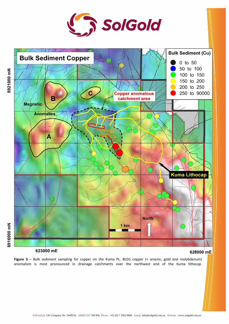
The eastern part of the Kuma PL hosts an extensive lithocap that lies along the northwest‐trending Tabala Ridge between elevations of 200m and 1000m above sea‐level (Figure 2). The lithocap is hosted by the Suta Volcanics and comprises silicic, advanced argillic and argillic alteration assemblages that have been mapped over an area of approximately 2.5 kilometres by 1 kilometre. Mapping has revealed that the most intensely altered part of the lithocap lies at the northwest end where there are clustered areas of silicic and advanced argillic alteration. Initial exploration activity conducted by SolGold (operating as Solomon Gold Plc; March to May 2007) included reconnaissance mapping and rock chip sampling along drainages across the southeast part of the PL. Subsequent work during a joint venture with Newmont Mining Corporation between April 2009 and August 2012 involved a BLEG (Bulk Leach Extractable Gold) stream sediment sampling program over the southeast part of the license (85 samples). Strongly anomalous copper (Cu), molybdenum (Mo), gold (Au) and arsenic (As) anomalies from bulk sediment samples were defined in streams draining the northwest end of the Kuma lithocap (Figure 3).
SolGold plc UK Company No. 5449516 ARBN 117 169 856 Phone: +61 (0) 7 3303 0660 Email: [email protected] Website : www.solgold.com.au
Figure 3 – Bulk sediment sampling for copper on the Kuma PL. BLEG copper (+ arsenic, gold and molybdenum) anomalism is most pronounced in drainage catchments over the northwest end of the Kuma lithocap.

SolGold plc UK Company No. 5449516 ARBN 117 169 856 Phone: +61 (0) 7 3303 0660 Email: [email protected] Website : www.solgold.com.au
Initial rock chip sampling during mapping programs by SolGold in 2007 identified two anomalous areas located north‐northwest and south‐southeast of the Kuma lithocap: Five float samples from the upper reaches of the Kuma River (2‐3 kilometres north‐northwest of Tabala
Ridge) assayed 6.67% Cu, 2.36% Cu, 3.07% Cu, 7.95% Cu and 1.00% Cu (Figure 4).
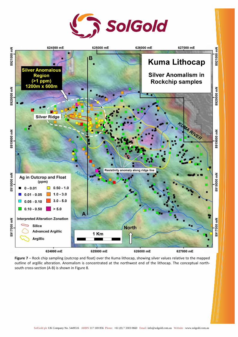
A float sample assayed 13.05 g/t Au, 11.70 % Cu from south‐southeast of the lithocap (Figure 4). Subsequent outcrop and float sampling across the Kuma lithocap (Tabala Ridge) during the Guadalcanal Joint Venture with Newmont identified coherent and elevated anomalism in Au, Ag, As and Mo (Figures 5, 6 and 7). Ag and As define the most consistent anomalies that cover the most extensive area over the northwest part of the lithocap. This area of strong Ag and As anomalism in known as “Silver Ridge”. The rock chip anomalies cover a significant area: Gold: 900m x 500m (> 0.2 g/t – Figure 5) Silver: 1200m x 600m (> 1.0 ppm – Figure 6) Arsenic: 1200m x 700m (>50 ppm – Figure 7) Molybdenum: 900m x 500m (> 20 ppm) This element association (As, Au, Ag +/‐ Cu/Mo) is a typical high‐sulphidation epithermal signature and is commonly found within lithocaps above porphyry copper‐gold deposits. The relative paucity of copper over the Kuma lithocap is interpreted to reflect leaching of the cap. Such leaching can increase the likelihood of forming high‐grade supergene copper mineralisation at depth if leached copper re‐precipitates at deeper levels. This process occurs during weathering and oxidation of sulphide (pyrite) within the cap which generates acidic ground water that leaches copper from surface outcrops.

SolGold plc UK Company No. 5449516 ARBN 117 169 856 Phone: +61 (0) 7 3303 0660 Email: [email protected] Website : www.solgold.com.au
Figure 4 – Rock‐chip sampling over the Kuma lithocap. Outline of mapped argillic alteration (approximately 2.5 km x 1 km) is shown by the dashed yellow line. Float samples with elevated copper (Cu) lie at lower elevations around the periphery of the lithocap. Strongly copper mineralised float samples occur north‐northwest and south‐southeast of the Kuma lithocap.

SolGold plc UK Company No. 5449516 ARBN 117 169 856 Phone: +61 (0) 7 3303 0660 Email: [email protected] Website : www.solgold.com.au
Figure 5 – Rock chip sampling (outcrop and float) over the Kuma lithocap, showing gold values relative to the mapped outline of argillic alteration. Anomalism is concentrated at the northwest end of the lithocap. Planned soil sample sites are shown by red crosses. Gold and advanced argillic alteration are expected above porphyry targets.

SolGold plc UK Company No. 5449516 ARBN 117 169 856 Phone: +61 (0) 7 3303 0660 Email: [email protected] Website : www.solgold.com.au
Figure 6 – Rock chip sampling (outcrop and float) over the Kuma lithocap, showing arsenic values relative to the mapped outline of argillic alteration. Anomalism is concentrated at the northwest end of the lithocap. Planned soil sample sites are shown by red crosses. Arsenic is a classic high level pathfinder for some porphyry systems.
SolGold plc UK Company No. 5449516 ARBN 117 169 856 Phone: +61 (0) 7 3303 0660 Email: [email protected] Website : www.solgold.com.au
Figure 7 – Rock chip sampling (outcrop and float) over the Kuma lithocap, showing silver values relative to the mapped outline of argillic alteration. Anomalism is concentrated at the northwest end of the lithocap. The conceptual north‐south cross‐section (A‐B) is shown in Figure 8.

SolGold plc UK Company No. 5449516 ARBN 117 169 856 Phone: +61 (0) 7 3303 0660 Email: [email protected] Website : www.solgold.com.au
The conceptual model for the Kuma prospect is a leached alteration lithocap overlying a buried porphyry copper‐gold system (Figure 8).
Figure 8 – Conceptual north‐south cross‐section and model of the Kuma prospect.

SolGold plc UK Company No. 5449516 ARBN 117 169 856 Phone: +61 (0) 7 3303 0660 Email: [email protected] Website : www.solgold.com.au
Exploration Program Approved An exploration program has been designed to identify drill targets at Kuma. A budget totalling USD150,000 has been approved for the program and field work is planned for the September quarter. There are four components to this phase of exploration:
Systematic definition of soil geochemical anomalies over the lithocap on a 400m by 100m,
200m by 100m and 100m by 100m grid. Soil samples will undergo multi‐element analyses.
Samples for TerraSpecTM spectral analysis (to identify diagnostic clay alteration minerals) will be collected from each soil sampling site, and alteration maps compiled from the data.
Additional reconnaissance rock chip sampling will be undertaken to identify the source of high grade copper samples north‐northwest, south and south‐southeast of the lithocap.
3D inversion modelling of magnetic data will be undertaken to assist in drill target definition, as for Cascabel.
Figure 9 – View looking southwest over the Kuma lithocap, showing the extent of the lithocap defined by two phases of mapping, the location of anomalous pathfinder element, arsenic, in rock chip samples and the location of planned soil sampling sites (red crosses). 3D Inversion Magnetic Modelling Planned 3D inversion modelling of airborne magnetic data previously acquired over the prospecting license area will be conducted by Chris Moore of Moore & Associates (Aust) Pty Ltd. This work will be undertaken to identify possible magnetic targets that may underlie the central or peripheral portions of the lithocap, and to identify the areas of most intense magnetite‐destructive alteration that often directly overlie the top of porphyry copper‐gold deposits.

SolGold plc UK Company No. 5449516 ARBN 117 169 856 Phone: +61 (0) 7 3303 0660 Email: [email protected] Website : www.solgold.com.au
Chris Moore acquired his Master Degree in Geophysics from the University of Witwatersrand, Johannesburg, South Africa in 1994. Since then, Chris has worked and provided consulting services to over 60 companies in regions such as North and South America, Africa, Asia and the southwest Pacific. Chris was instrumental in the geophysical modelling of such major deposits as Prominent Hill in South Australia, Reko Diq in Pakistan and Tuju Bukit in Indonesia. He is now principle for Moore Geophysics (based in Melbourne) and has provided geophysical consulting services to companies including Rio Tinto, BHP Billiton, Anglo American, Intrepid Mines and Glencore.
Figure 10 – Reduced‐to‐Pole (RTP) magnetic imagery from over the Kuma lithocap. The areas of strong magnetic signature (white and red) in the southeast are interpreted to represent an intrusive batholith, the source of copper and gold for porphyry systems. The area of more complex and subdued magnetic response (blue) around the northwest end of the lithocap is currently interpreted as a vertically extensive alteration system. The lithocap straddles a 3.5‐kilometre wide annular feature in the magnetic data‐set. Planned soil sampling sites are shown by the black points.

SolGold plc UK Company No. 5449516 ARBN 117 169 856 Phone: +61 (0) 7 3303 0660 Email: [email protected] Website : www.solgold.com.au
About Kuma SolGold has 100% ownership of the Kuma prospecting license (PL 08/06) in the Solomon Islands. The license is granted to Australian Resource Management (“ARM”) a 100%‐owned subsidiary of the Company. The Kuma project is located on Guadalcanal in Solomon Islands. Other prospecting licenses held by the Company on Guadalcanal are the adjoining Lower Koloula PL and the Malukuna PL.
Qualified Person: Information in this report relating to the exploration results is based on data reviewed by Dr Bruce Rohrlach (BSc (Hons), PhD,), the GM Exploration of the Company. Dr Rohrlach is a Member of the Australasian Institute of Mining and Metallurgy who has in excess of 26 years’ experience in mineral exploration and is a Qualified Person under the AIM Rules. Dr Rohrlach consents to the inclusion of the information in the form and context in which it appears.
By order of the Board Karl Schlobohm Company Secretary Contacts:
Mr Alan Martin SolGold Plc (CEO and Managing Director) Tel: +61(0) 488 223 828 [email protected] Mr Nicholas Mather Tel: +61 (0) 7 3303 0665 SolGold Plc (Executive Director) [email protected] Mr Karl Schlobohm Tel: +61 (0) 7 3303 0661 SolGold Plc (Company Secretary) [email protected] Mr Ewan Leggat/Ms Katy Birkin Tel: +44 (0) 20 3463 2260 SP Angel Corporate Finance LLP (Nominated Adviser and Broker) [email protected] Mr Dominic Barretto / Ms Anna Legge Tel: +44 (0) 20 3664 4087 Yellow Jersey PR Limited (Financial PR) [email protected] NOTES TO EDITORS SolGold's exploration projects are located in northern Ecuador, Australia, and the Solomon Islands. In Ecuador, they consist of a JV with Cornerstone Capital Resources Inc. on the Cascabel copper‐gold project. In Australia, SolGold holds 100% of the Rannes, Mt Perry, Cracow West and Normanby Projects, all in southeast Queensland. In the Solomon Islands they comprise the Fauro Project (located on Fauro Island), and the Lower Koloula, Malukuna and Kuma licenses, which are located on Guadalcanal. The Cascabel copper‐gold project is located approximately 180 km by sealed road north of Ecuador's capital, Quito, 20 km south of the Colombian border, and 75 km inland from the coastal city of San Lorenzo.

SolGold plc UK Company No. 5449516 ARBN 117 169 856 Phone: +61 (0) 7 3303 0660 Email: [email protected] Website : www.solgold.com.au
At the Rannes project SolGold has announced indicated and inferred resources of 18.7 million tonnes at 0.9 g/t gold equivalent (gold + silver) for 550,146 ounces of gold equivalent (296,657 ounces of gold and 10,137,736 ounces of silver; see announcement dated 23 May 2012 for details of the resource statement and gold equivalent ratios). The Rannes project is currently under review. In the Solomon Islands, a soil geochemical survey and 3D modelling of magnetic data is being considered at Kuma, while a JV partner is being sought for the Fauro project to pursue drilling of gold‐copper targets defined in the 2011 exploration program. SolGold’s objective is to create substantial shareholder value by discovering and defining world‐class copper‐gold deposits. SolGold’s Board includes accomplished professionals with strong track records in the areas of exploration, mine development, investment, finance and law. Board and Management have significantly vested interests in the Company, holding approximately 14% of its issued share capital. SolGold is based in Brisbane, Queensland, Australia. The Company listed on London's AIM Market in 2006, under the AIM code ‘SOLG’ and currently has a total of 652,153,202 fully paid ordinary shares, 16,666,000 options exercisable at 50p, 10,550,000 options exercisable at 28p, 7,550,000 options exercisable at 14p, and 3,000,000 options exercisable at 6p on issue.