kirribilli and port lincoln at port huon in april 1962 ... · both ‘front of house’ and as a...
TRANSCRIPT

Our maritime history & present day news. No 58 Autumn (March) 2017. $2.50 where sold.
Tasmanian Ports
THE MARITIME MUSEUM OF TASMANIA AT THE 2017 AUSTRALIAN WOODEN BOAT FESTIVAL
TRADE AND TOURISM, FISHING AND RECREATION and A NEW ANTARCTIC RESEARCH VESSEL VISITS
Kirribilli and Port Lincoln at Port Huon in April 1962 Photo: Rex Cox

2 | Maritime Times of Tasmania Autumn 2017
Maritime Museum of Tasmania
CARNEGIE BUILDING Cnr Davey & Argyle Streets Hobart, Tasmania
Postal Address: GPO Box 1118, Hobart, Tasmania 7001, AUSTRALIA
Phone: (03) 6234 1427 Fax: (03) 6234 1419
Contributions may be historical or newsworthy and with themes reflecting the Museum’s mission to promote research into, and the interpretation of, Tasmania’s maritime heritage.
They may be short notes, or articles with text about 700–1200 words, accompanied by images if possible. Text may be edited, and publication is at the discretion of the editor.
Ideally, your contributions will be in a Word document, with embedded images and/or with separate 300dpi JPEG or TIFF files. We can accept legible handwritten articles, with loose photographs, which we will copy.
Images should have a caption, be credited to the photographer or to the source, and have written permission to publish.
Please submit contributions to The Editor at the postal address above or email to [email protected]
Alternatively, you can leave your contribution at the front desk of the Museum at the street address above. Please remember to include your contact details.
Deadline for the next edition is 15 May 2017.
Bac
kgro
und
imag
e: M
ay Q
ueen
in D
’Ent
reca
stea
ux C
hann
el
Pho
to: P
eter
Cam
pbel
l
MARITIME TIMES OF TASMANIA WELCOMES ORIGINAL ARTICLES FOR PUBLICATION
email: [email protected]
www.maritimetas.org
Open Daily 9am–5pm (except for Good Friday & Christmas Day)
Layout: fineline studios
The Maritime Museum of Tasmania acknowledges the support of the City of Hobart, Murdoch Clarke Lawyers, and TasPorts.
MMT Committee Members for 2017
Kim Newstead, President 03) 6224 6660 [email protected]
Beth Dayton, Secretary 0407 873 852 [email protected]
Michael Stoddart 0409 854 847 [email protected]
Chris Tassell [email protected]
Rex Cox, Vice President 03) 6234 1865 [email protected]
Ross Studley, Treasurer [email protected]
The Committee also includes representatives from external organisations: Alderman Eva Ruzicka (Hobart City Council), Scott Carlin (TMAG), and Kevin Moore (TasPorts)
Roscoe Barnett 0438 300 229 [email protected]

Maritime Times of Tasmania Autumn 2017 | 3
from the president’s logby Kim Newstead
• Currie Harbour, King Is. - the lighthouse
• Stanley - construction of the wharves
• Launceston - AMC and training ship Wyuna
• Hobart - Antarctic Circumnavigation Expedition
• St Helens - the barway
• Devonport, and more ...
• Willwatch: a Small Ship of the Strait
• Book reviews, news, and regular features
in this issue –
It was a pleasure to attend the members’ annual Christmas Lunch, held in December at the Motor Yacht Club, with Vice President Rex, Secretary Beth, Treasurer Ross and committee members. I was delighted to present life membership badges to four most deserving members.
Sue Andrewartha besides being a long-serving volunteer both ‘front of house’ and as a tour guide, is actually the third generation of her family to be involved with the Maritime Museum of Tasmania. Her grandfather, Bert Potter, was a member of the original Shiplovers Society from the early 1930s and her father, Albert Potter, was the Shiplovers representative on our committee after the two organisations amalgamated in 1987.
Don Mitchell has been a long-term supporter having been on roster every Wednesday since we moved to the Carnegie building in 2000. Don has conducted many port tours in his role as tour guide and has guided many school groups around the Museum.
Mary Marsh is a familiar face behind the front desk counter and has for many years tended our front garden. She has volunteered in a number of other roles: guiding groups around the Museum, organising the volunteers’ social program, and spending time on the committee. Mary remains a stalwart supporter of May Queen and we recently celebrated a ‘mile-stone’ birthday during one of her Saturday morning sessions aboard.
Tiiu Raabus has been involved in running our shop for over ten years, first as Rolph’s assistant and now holding the reins herself. Without the profit contribution from this popular section of the Museum we would find it very difficult to operate at our present activity level. Tiiu has also been part of the team running our school holiday programs.
The four-day Australian Wooden Boat Festival brought many interstate and overseas visitors, and more than 800 people visited the Museum. I think this is a record; it certainly kept the volunteers on the front desk busy. Well done to all who survived that marathon effort.
During the Festival I had the opportunity to meet with Australian National Maritime Museum (ANMM) director and CEO, Kevin Sumption along with Head of Foundation, Andrew Markwell. They are both extremely supportive regarding MMT and indicated a willingness to continue providing support and assistance. I represented the Museum at the Australian Maritime Museum Council dinner and met with Peter Rout, Assistant Director of ANMM, and with a number of like-minded individuals from maritime museums in South Australia, Queensland, Western Australia and Victoria.
In 2015, Sue and I sailed on the 54’ Storm Bay (1925) from Strahan to Sorrento with Tim and Sally Phillips. From his Wooden Boat Shop, Tim undertook a meticulous ten-year restoration of this Percy Coverdale built vessel. On arriving in Sorrento I saw a majestic flagpole with yards, dominating
the end of the main street. Tim proudly told me he had built it at his boat yard. I asked if he could make one for our Museum and he willingly said ‘Yes’. Unfortunately, after an inspection by Tim at this year’s Festival, he has advised that it would not be practical. We simply don't have enough area at the base to enable correct anchoring. There goes my pet project, which is a pity because I have long thought the exterior of our building would be enhanced by some colour and movement. Any suggestions are welcome as to how we could make the external appearance of our heritage building more enticing, but dare I say within a raft of planning regulations.
Your MMT committee continues to beaver away on a number of initiatives that are all aimed at improving the overall presentation of the Museum, and on the many associated housekeeping tasks. The committee has approved a work plan to restore items on display in the front garden, and to install new interpretive signage. It has also developed a program for the Carnegie Gallery until the end of 2018, and has listed several potential exhibitions for display over the next five years.
Welcome to new committee member Michelle Blake who joins our crew to bring some much needed youth to the table. Michelle has already shown an interest in utilising Westward with younger sailors, and has marketing and media ideas. We are pleased to have her join us.
Among our new MMT members is Ross Muir. Ross and I have sailed together at Hamilton Island Race Week. It’s great to have the Muir family's continuing support. Welcome aboard Ross.
In mid-February we had a visit from Ulla Tofte, who is CEO of The Maritime Museum of Denmark. She visited to see our collection and to discuss possible areas of cooperation. How we would love her brand new, purpose-built stunning building. Look it up on the web and let me know of any maritime Danish/Tasmanian connections you are aware of. (continued on page 5)
Tasmanian Ports

4 | Maritime Times of Tasmania Autumn 2017
new members
As reported elsewhere in this edition, the Maritime Museum experienced a very busy, and very successful, MyState Australian Wooden Boat Festival (AWBF) weekend in early February. I add my thanks to all those volunteers who helped with preparations, manned the Museum or our stall aboard May Queen, our exhibits and vessels (page 18), and those who helped put everything away afterwards. We must also thank those volunteers and members who are more directly involved in the festival, either by participating with their own boat or through volunteering with the festival itself. Without the boat owners and festival staff and volunteers there would be no festival for us to enjoy. The whole event has grown hugely since becoming a free event and is of significant importance to Tasmania’s economy.
Our Museum is currently hosting the Australian National Maritime Museum’s travelling exhibition ‘War at Sea: the RAN in WWI’ (details page 5). The opportunity to host this exhibition came about partly through our involvement with the Australian Maritime Museums Council, a body which seeks to connect maritime museums, maritime-themed history groups and practitioners around Australia and helps in the promotion of our maritime heritage to the wider community.
Immediately before the AWBF, our Museum helped organise a seminar hosted by the Australian Maritime Museums Council on the topic of preparing travelling exhibitions. The workshop, attended by over 40 representatives of museums from every State and Territory (except the ACT), looked at the idea of building a pool of two-dimensional exhibitions presented on pull-up banners that are easy to transport and install. The exhibitions would present stories of national interest that would appeal to a wide audience, and would be designed so that hosts of the exhibitions would be able to add their own local stories, and perhaps objects, when hosting the exhibition. The first theme to be developed under this program is 'Shipwrecks', with an exhibition that will draw on a tiny fraction of the shipwreck stories that can be found all around our coastline. These exhibitions will be nowhere near the size and scale of the War at Sea display, but will be of a size that can be hosted in small regional museums or history group rooms, libraries, schools, office foyers or other community spaces. Our Migration, Surfing and Commercial Fishing exhibitions continue to prove popular in their travels around the State.
In this issue we reflect on the MyState Australian Wooden Boat Festival and take a quick look at some of the ports around Tasmania’s coasts. We can read about the exciting Swiss Polar Institute's project, taking an international team of scientists on a circumnavigation of Antarctica while conducting 22 projects and hopefully inspiring future generations of polar researchers.
Thank you to all our contributors. We hope you enjoy this autumn edition of Maritime Times of Tasmania.
Not already a member? You can show your support for the Maritime Museum of Tasmania, and enjoy the benefits, by becoming a member. You can join online, or download an application from at: www.maritimetas.org/support-us/become-member
Membership Fees
Categories of membership and annual fees effec-tive each year 1 July to 30 June (including GST) are:Individual $30
Family $40
Concessions $20
Interstate $20
Overseas $20
Quarterdeck $25 plus $275 donation
Perennial $1000
Perennial is once only, or four years Quarterdeck membership
Tony Thiele Barry JenningsJohn Latham Ross MuirGraeme Bennett Elizabeth Bourke
We welcome new members:
top: Maritime Museum volunteers, Marcella (left) and Fay, preparing for visitors on May Queen during the AWBF Photo: David Smith above: Queen Mary 2 (345m) , Port Arthur, Feb 2017 Photo: Rex Cox
from the brig

Maritime Times of Tasmania Autumn 2017 | 5
The Maritime Museum of Tasmania is pleased to host
WAR AT SEA – the Navy in WWI
a major travelling exhibition from the Australian National Maritime Museum
at our Carnegie Gallery until 18 June 2017
Open during Museum hours, daily 9am – 5pm.
the carnegie gallery
from the president's log (cont. from page 3)
We have entered into a partnership with an IT postgraduate from UTAS who is designing an ‘audience interactive’ device based on the diving suit. This will involve a visitor activating stories linking the suit to its use in the port. Trials will take place before the end of March. The student will be building a device designed to display information on the user’s mobile phone (page 24). Another UTAS connection sees committee member Michael Stoddart, with Mark, attending the ICT Department's 'Speed Dating’ session with a view to enthusing a group of students to take on the development of a Waterfront Walk app as a project on our behalf.
The Maritime Museum was very well represented at the Australian Wooden Boat Festival thanks to our energetic staff and volunteers. We had a display at Princes Wharf featuring our Rainbow Yacht, Rhythm, and the Egeria tender. Westward and May Queen featured prominently in Constitution Dock with many onlookers and onboard visitors, again all manned by volunteers (page 18). Well done, everybody!
Peter Higgs is currently working on behalf of the ANMM to identify Tasmanian vessels worthy of inclusion on the Australian Register of Heritage Vessels. Surprisingly Tasmania is under-represented. However, I am confident this is about to change. —Kim Newstead
The five ARHV awardees were: Sao – Geoff and Kate Doolan Olga – David Pittaway Utiekah III – Matt Hannon and Charlotte Boss-Walker Mil – Colin Williams Rhythm – Maritime Museum of Tasmania
On Thursday, 9 February, a function was held at the Maritime Museum of Tasmania where David Payne from the ANMM presented the Museum with a burgee for Rhythm, our Rainbow yacht, which was accepted onto the Australian Register of Heritage Vessels (ARHV). It joins Westward, which is already on this valuable register.
Australian National Maritime Museum staff and boat owners with their ARHV burgees Photos: Sharon Babbage ANMM
exhibition now at
the Maritime Museum of Tasmania

6 | Maritime Times of Tasmania Autumn 2017
King Island MuseumIn 1980, the former lighthouse-keeper's cottage (left) built in 1879, became available for use by the King Island Historical Society (founded 1968). Photo (2015): Lisa Wood
King Island Museum 36 Lighthouse Street, Currie 7256 (03) 6462 1512 [email protected]
Open September – June. Daily, 2–4pm
Currie HarbourKing Island
Building the Currie Lighthouse

Maritime Times of Tasmania Autumn 2017 | 7
Six years after this extract from the Colonial Times appears, in 1861, the first lighthouse on King Island was erected at Cape Wickham, the most northern point of the island. Built from local quarried stone the Cape Wickham Lighthouse remains the tallest permanent maritime beacon in the southern hemisphere. Regrettably however, its position brought confusion to a number of navigators entering the Bass Strait during severe weather conditions. Failing to distinguish the Cape Wickham Light from the Cape Otway Lighthouse, a number of vessels were mistakenly steered south-east toward the west coast of King Island and to their doom. In fact between 1861 and 1875 a staggering 17 ships are known to have been wrecked on King Island, 11 of which came to grief on the western coastline, an area littered with reefs of jagged peaks of basalt. Among these wrecks, during this 14-year period, the deadliest was the wreck in 1874 of British Admiral. This iron clipper, on its maiden voyage from England to Melbourne carrying 88 souls onboard, slammed into reefs about 2.4km south of Currie Harbour – sadly all except nine perished.
It was largely due to this disaster, and for this reason, that initiatives to correct the ‘navigational mix-up’, and to reduce the death toll and loss of property, were put into effect without delay thanks to the Victorian Chamber of Commerce, the Shipowners’s Association and the Underwriters Association of Victoria. Plans to establish a new lighthouse on the island’s west coast were sanctioned after entreaties to the Victorian Comisssioner of Customs and on the advice of the Admiralty surveyor.
by Luke Agati, King Island Historical Society
The most suitable location for the erection of a second lighthouse was at Currie Harbour. To reduce costs the acquisition for a prefabricated iron structure, instead of stone, was chosen. An exact copy of an iron lighthouse erected in 1868 at Sombrero Island in the British territory of Anguilla was, economically, most advantageous. Built by Chance Brothers & Co. Lighthouse Engineers and Constructors (England) in 1877, the Currie Lighthouse was eventually shipped in sections on the steamer Rosedale in January 1879, for re-assembly. Photographs and plans received by Rear-Admiral Barnard were passed to the builders Johnstone & Co. Standing 150ft (45.7m) above sea level on the south end of Currie Harbour the new beacon emitted five flashes every minute, while Cape Otway was distinguished by its emission of one bright flash per minute. King Island’s second lighthouse dramatically reduced the number of shipwrecks on the west coast from 1880, the year the lighthouse was first lit. Listed on the Tasmanian Heritage Register, Currie Lighthouse proudly stands as testimony to the island’s maritime history.
Named after Archibald Currie (1830–1914), a Melbourne shipping businessman, Currie Harbour is a small and natural anchorage site, which now serves the island’s fishing and crayfish fleets. During the island’s early years of settlement the harbour was a thriving trading post with coastal steamers conveying passengers and taking cattle, horses, and butter, among other local produce, to Tasmanian and mainland markets. Today Currie Harbour is managed by Tasports.
left: Monument to William Dalzell Nicholson*
*William Dalzell Nicholson drowned on the wreck of the British Admiral in 1874. The great loss of life from this wreck prompted the erection of Currie Lighthouse. Nicholson was the son of the Victorian Premier and Mayor of Melbourne, William Nicholson. He was also Chairman of the Chamber of Commerce (1859-60). Photos this page: Luke Agati
facing page: Currie Lighthouse completed in early 1880 with builders, probably Johnstone & Co. employees. inset: Currie Lighthouse during its assembly probably at the Chance Bros factory in England. Photos: King Island Museum Collection
below: View of Currie Harbour from the lighthouse.
The subject of a lighthouse on King’s Island, has been occupying the attention of the Melbourne Chamber of Commerce. The frequent disasters to vessels ... and the extensive shipping trade to [and from] the colonies [which pass King’s Island] must render it a deep interest to ... Australia generally. Colonial Times (Hobart) 1855

8 | Maritime Times of Tasmania Autumn 2017
Bass Strait was experiencing strong to gale force winds and rough seas. Vic Hardy, sheltering under Three Hummock Island in his fishing boat VSP, recalled: ‘The swell was unusually large with a very strong wind. We did have a pretty hard time with the weather, though it did ease up that evening, but we had had all we wanted.'
Captain McCarthy reported that deck cargo on Willwatch had been shifted aft, but the ship’s pumps remained inoperative owing to the bow down trim. He said he would set a safer downwind course for Westernport, over 100 nautical miles from Three Hummock Island. He calmly reported on the grave situation and asked that the owner, Archibald Kimberley, be informed. He sought no help.
Willwatch had been launched 63 years earlier on Brisbane Water in NSW. The 96-gross ton ketch worked the east coast and Tasman Sea trade for many years until Straits Fisheries Pty Ltd purchased the vessel in 1951 for the interstate timber trade from Launceston. The company applied to the Commonwealth Director of Navigation for a certificate of survey but it was found that extensive work was necessary to bring the vessel up to standard. So the Launceston Marine Board was asked for a state survey certificate but once again it was found that the requirements could not be met and the old ketch was laid up.
In 1955, the Willwatch moved to the Mersey River for repairs prior to seeking a survey certificate for intra-state trade from the Devonport Marine Board. The certificate was issued but the work fell far short of that deemed necessary by the Commonwealth Director of Navigation. Apparently, the standards in Devonport were less demanding. During the repairs Archibald Kimberley purchased the ketch for £15,000. Willwatch would be used to ship cargo from his Tasmanian base to King Island where he had a major contract, building houses and barns on soldier settler properties.
Kimberley lacked maritime experience but spent a considerable sum trying to maintain Willwatch.
In 1956 the old ketch sprang a plank in the forward sections and nearly sank when rounding Stokes Point, King Island. Captain McCarthy discharged the cargo at Naracoopa, borrowed emergency pumps and sailed to Devonport for more hull repairs. In a further attempt to extend Willwatch’s working life, Kimberley installed a new marine engine. Subsequently the sails were seldom set.
Before the fateful 1958 voyage, McCarthy supervised the loading of cargo from the Leven River wharf at Ulverstone. Seventy-five drums of diesel fuel were stowed in the hold together with a quantity of fencing droppers, 400 cases of Coca Cola and some general cargo. On deck were 50 drums of petrol, more fencing droppers and a few bales of hay. Last to be loaded were two draught horses and a cob in single horse floats on the hatch covers.
Seaman Graeme Thomas helped load the cargo but was sick so McCarthy ordered him from the hold. Bill Johnson had delivered the Coca Cola to Willwatch and saw that Thomas was unwell. 'The sick person had the ‘flu and I listened to the conversation as he was told not to be a weakie. They tried to talk him into staying and I thought he had been persuaded to,' said Johnson. Nevertheless, Thomas disembarked and former crew member Tony Dick was recruited at the very last minute from his workplace at the local vegetable factory as a replacement. Also in McCarthy’s crew were engineer Peter Hanson, cook Neville Chitts and young deckhand, John Mercer.
Local farmer, Warren Barker, stepped from the stern as Willwatch’s bow swung into the stream. He was the last to leave. 'It was a light run and Willwatch was not overloaded. They had decided to do a final run to King Island before Christmas without a full load,' said Barker, who had travelled on earlier voyages. He noted that the plywood lifeboat stowed athwartships under the mizzen boom was in poor condition.
Kimberley first heard that Willwatch was in difficulty when his King Island manager relayed McCarthy’s
The ageing auxiliary ketch Willwatch put to sea late on Tuesday 16 December 1958 on a voyage from Ulverstone in north-western Tasmania bound for Currie, King Island, carrying general cargo for Kimberley (King Island) Trading Pty Ltd.
The following morning Peter Snodgrass arrived early at Kimberley’s Currie office to monitor a routine radio report from the vessel’s master, Captain George McCarthy. At 7.10 am McCarthy’s voice crackled from the speaker: ‘Willwatch is six miles NNW of the Hummocks, the forecastle is full of water, we are down by the head and in difficulty’.
A Small Ship of the Strait The story of the auxiliary ketch Willwatch

Maritime Times of Tasmania Autumn 2017 | 9
message on Wednesday morning. In the meantime, McCarthy was trying to contact Melbourne Coastal Radio.
At 8.16 am Melbourne received its first clear message from Willwatch. McCarthy said their position was 24 miles north-west of Cape Rochon, the northern tip of Three Hummock Island. Willwatch was in open seas more than 20 miles from the nearest shelter and McCarthy said they were taking water and out of control. He asked that a vessel stand by and added that they were running in a northerly direction. It was not a distress call and not made on the distress frequency. Melbourne Radio called for help. A response came from James Warren’s fishing boat Olympic, three hours steaming from Willwatch’s position. Warren weighed anchor immediately to support the small ship in trouble.
At 9.15 am McCarthy radioed that things were getting worse. The bulkhead aft of the forecastle was holding and the limber holes had been plugged with blankets. Cargo in the hold was being moved aft to counteract the weight of water in the forecastle that made Willwatch uncontrollable.
At 9.30 am Vic Hardy aboard VSP turned his radio on for the first time to listen to the regular small ship schedule and heard Olympic trying to reach Willwatch. Hardy knew McCarthy well so he called him by radio. 'I then asked McCarthy was there anything we could do to help. Mac replied, "Well I wouldn’t say no at a time like this, I have my crew to think of." He gave us his position or as near as he could, 27 miles north by west of our position…we got under way straight away. It was round about ten o’clock. We left the radio on, and Mac came on again about 10.20 am and said that his position had deteriorated very badly. He said he had let 50 drums go off the deck, and he also put a rocket up to see if we could get his position. We didn’t see the rocket and neither did Olympic.'
At 10.30 am McCarthy radioed that the vessel was awash and they were unable to launch the lifeboat. He gave no reason but said he hoped it would float off the deck as the ship sank.
By 10.37 the ship was foundering and he called. ‘I’ve ordered the crew over the side in their life jackets.' His final words were, ‘Well cheerio, we’ll see you later'. Olympic and VSP continued the search in difficult conditions.
At 7.30 pm a Lincoln bomber from RAAF Laverton dropped a smoke flare directing VSP to some wreckage. Vic Hardy picked up a life jacket, mattress, cases of apples, a gas bottle and a wooden stanchion. Nearby were several bales of straw, a 44-gallon drum and the deckhouse door. There were no traces of survivors.
The master, 29-year-old Captain George McCarthy, left behind a wife and three children, the youngest only 17 days old. Engineer Peter Hanson was married with four children. Three crew members were unmarried, including the unlucky replacement crew, Tony Dick, and cook Neville Chitts from King Island. Perhaps the saddest story was that of the 16-year-old deckhand, John Mercer, whose mother abandoned him as a child. He had just landed his first job after a troubled adolescence and believed that at last his life was changing—only to drown at sea in dramatic circumstances.
The loss of Willwatch with all hands devastated Archibald Kimberly. The builder who had done so much for Ulverstone was unable to cope. He started drinking heavily, and died in 1964 aged just 50 years.
A Court of Marine Inquiry concluded that much of the blame for the disaster lay with the master. He should have been aware of problems with the old and much repaired Willwatch and taken earlier steps to seek shelter or assistance. The inquiry criticised survey procedures in Tasmania, a conclusion that eventually led to the removal of this function from Marine Boards when the Navigation and Survey Authority of Tasmania was formed in 1963.
Photo page 8: Willwatch in Emu Bay – © Fred Reid Collection, Pioneer Village Museum, Burnie Photo page 9: Willwatch ashore for maintenance, Leven River Ulverstone – © State Library of Tasmania
References
Archives Office of Tasmania, TA301, In the Court of Marine Inquiry: In the Matter of the AK Willwatch, CBE49/1 Report transcript of evidence and associated papers, 1959
Broxam, Graeme & Nash, Michael, Tasmanian Shipwrecks, Vol 2 1900-1999, Navarine Publishing, Hobart, 2000
National Archives of Australia, CA 1689 Deputy Director of Lighthouses & Navigation Tasmania, P2802 Docking Book Hobart Vol 1 – Docking Book Entries 1923 - 1953
Salter, Harold, Bass Strait Ketches, St David’s Park Publishing, Hobart, 1991
The Advocate Newspaper, Burnie, various issues December 1958 and March 1959
The Mercury Newspaper, Hobart, various issues December 1958 and March 1959Determination of the Court of Inquiry, Tasmanian Government Gazette, 22 April 1959, No. 133
by Colin Denny

10 | Maritime Times of Tasmania Autumn 2017
The Port of Stanley
Kamona at the foreshore wharf at Stanley in 1955
Photo: Stanley Discovery Museum
Stanley in 1955Those were the days! Note the railway line and the array of produce bought to the jetty, which included potatoes, swedes, timber and blackwood staves.
MV Kamona was built in 1949 in the Leith shipyards in Scotland for the Union Steamship Co. New Zealand (Melbourne) for sailings between Tasmania and mainland Australia.
Dal O'Connor and his bullock team hauling blackwood logs to Stanley wharf, c. 1920. Dal was the brother of Adeline O'Connor, the Granny in the story below.
Photo: O'Connor family archive
by Heather Rossiter
When my Granny was little she lived at Forest in northwest Tasmania. The view was Bass Strait. Enrolled at Collegiate School, Hobart, in the early 1890s, twice a year she boarded a coastal trader at Stanley and sailed down the wild west coast; twice a year she returned. Once, days after Granny sailed, the Roaring Forties whipped up a turbulent fury. When her ship did not make port, the family waited ... and waited. The ship was given up for lost. Imagine the joy when the little ship breezed into harbour. The master had run it into Port Davey to ride out the south-westerly gale. No one of my generation has asked where it sheltered. So I am going in search.
The complete story, and the location of Granny's refuge, is at http://heatherrossiter.com/granny-was-here.html
Granny was here
Maritime Times of Tasmania Autumn 2017 | 11
Marine Board was confident that its wharves now had protection. However, easterly storms and wild waves continued to wreak havoc and in December 1911 heavy seas washed parts of the crown down on the harbour side.
Major repairs, which meant virtually a new breakwater and wharf, began in June 1912 and when they were nearing completion in April 1914, it was reported in the local newspaper, The Chronicle, that Stanley would have 'a breakwater for all time'. Up to 20 men had been working for 18 months; some quarrying boulders weighing 30 tons near the summit of the Nut.
A 30ft by 20ft wooden barge had been built to take rocks from the quarry to the breakwater wall and the steam crane used on the original structure had been recommissioned to lift them. About 5000 casks of Portland cement had been imported to Stanley and the breakwater had been concreted for a length of 528ft to a width of 19ft (Pink and Vowles). Only two weeks later, on 20 April 1914, violent seas almost demolished 18 months of work in just three hours. The Chronicle reported that it was 'a scene of total devastation'. From this experience came the eventual solution of later years—the placing on the outer side of large concrete abutments designed to dissipate the wave energy generated by the easterly storms.
In order to cater for growing trade, and needing space for cargo, a foreshore wharf was developed based on the reclamation of a large area around the town pier in 1917 and was completed in September 1923. No major changes occurred until the construction of the roll-on roll-off terminal at the eastern end of the foreshore wharf in 1971–72. The Fishermen’s Dock is another story.
The container and roll-on roll-off vessel, Bass Reefer, made its final call in July 1992 when Stanley ceased to be a cargo port. There were three bentonite shipments
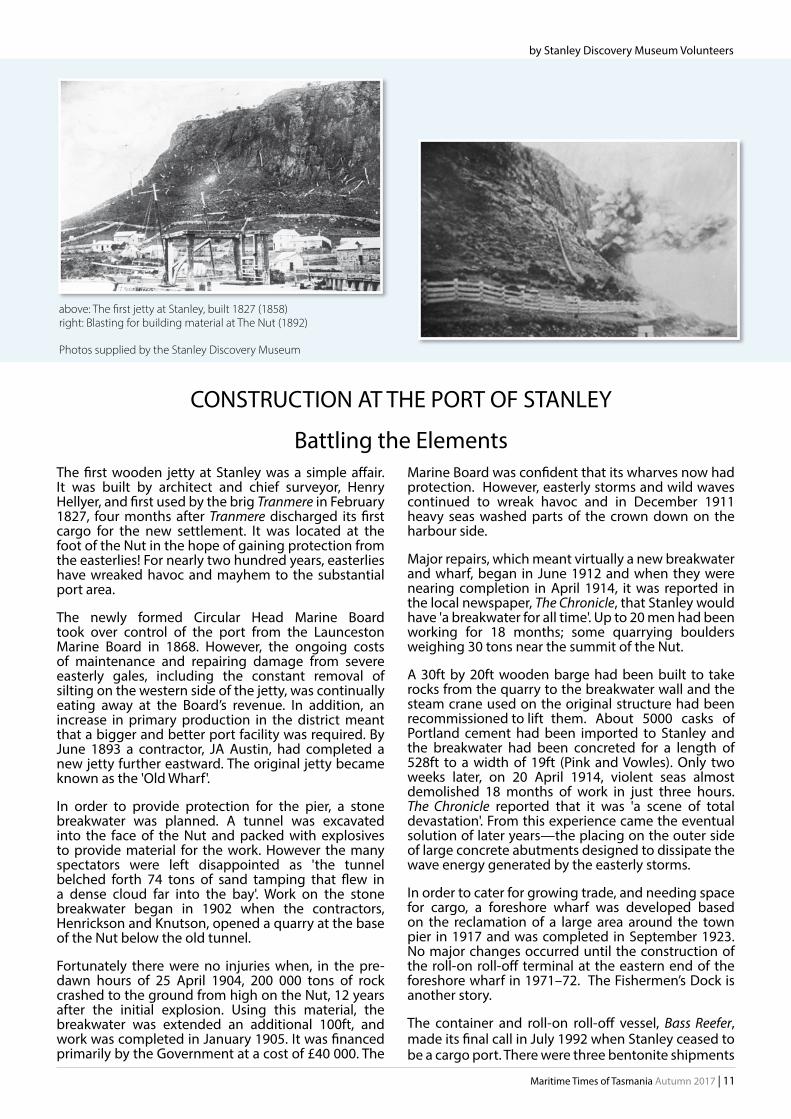
by Stanley Discovery Museum Volunteers
CONSTRUCTION AT THE PORT OF STANLEY
Battling the ElementsThe first wooden jetty at Stanley was a simple affair. It was built by architect and chief surveyor, Henry Hellyer, and first used by the brig Tranmere in February 1827, four months after Tranmere discharged its first cargo for the new settlement. It was located at the foot of the Nut in the hope of gaining protection from the easterlies! For nearly two hundred years, easterlies have wreaked havoc and mayhem to the substantial port area.
The newly formed Circular Head Marine Board took over control of the port from the Launceston Marine Board in 1868. However, the ongoing costs of maintenance and repairing damage from severe easterly gales, including the constant removal of silting on the western side of the jetty, was continually eating away at the Board’s revenue. In addition, an increase in primary production in the district meant that a bigger and better port facility was required. By June 1893 a contractor, JA Austin, had completed a new jetty further eastward. The original jetty became known as the 'Old Wharf'.
In order to provide protection for the pier, a stone breakwater was planned. A tunnel was excavated into the face of the Nut and packed with explosives to provide material for the work. However the many spectators were left disappointed as 'the tunnel belched forth 74 tons of sand tamping that flew in a dense cloud far into the bay'. Work on the stone breakwater began in 1902 when the contractors, Henrickson and Knutson, opened a quarry at the base of the Nut below the old tunnel.
Fortunately there were no injuries when, in the pre-dawn hours of 25 April 1904, 200 000 tons of rock crashed to the ground from high on the Nut, 12 years after the initial explosion. Using this material, the breakwater was extended an additional 100ft, and work was completed in January 1905. It was financed primarily by the Government at a cost of £40 000. The
above: The first jetty at Stanley, built 1827 (1858) right: Blasting for building material at The Nut (1892)
Photos supplied by the Stanley Discovery Museum

12 | Maritime Times of Tasmania Autumn 2017
Port of Stanley (cont.)
for Port Latta after that date, the final one being with Lucy Oldendorff in May 1995. In June 1997, a visit by an 86-metre catamaran built by Hobart’s Incat on its delivery voyage to England attracted hundreds of spectators. In 1997 the Marine Boards of Circular Head and Hobart became the Hobart Ports Corporation.
The Port of Stanley currently services King Island, with live cattle shipments and transporting stock to Greenham’s Abbatoirs in Smithton, and the Fishermen’s Dock is still a hive of activity with a busy, viable fishing industry handling crayfish, scallops, octopus, and various species of fish.
The Stanley Discovery MuseumThe Museum retails reprinted copies of the Circular Head Local History Journals which contain a variety of local articles. On display is a photographic timeline of the port area from 1858 until 2000, which includes trading vessels and the fishing industry.
The Stanley Discovery Museum 31 Church St, Stanley, Tas. Open September to May: Daily, 11am – 3pm. Email: [email protected] (03) 6458 2091 / 0428 581285
References
Trethewie, Harold (1986). 'The Place for a Port.' Circular Head Local History Journal. September, 1986
Pink, Kerry & Vowles, Gill (1998). Against the tide : a maritime history of Circular Head. Hobart Ports Corporation, Hobart, Tas.
below: An overview of the port area at Stanley in 2012, showing the breakwater jetty on the left. Some alteration has been made since then to the roll-on roll-off berth.
top right: Construction of the foreshore wharf at Stanley, 1921–1923
above: Bass Reefer (left) and Straitsman (roll-on roll-off ) berthed at Stanley in September 1990. It was the first voyage for Bass Reefer and the final voyage for Straitsman.
Photos supplied by the Stanley Discovery Museum

Maritime Times of Tasmania Autumn 2017 | 13
The Mersey River, named by Edward Curr in 1826, has undergone significant changes over the years to become a thriving port in its heyday and the busy port it is still today. In the early 1800s, the area of the present harbour was very shallow with sand and shingle banks and small sailing vessels could only cross the bar at high tide. The sand banks and silting were major issues for the estuary and prevented larger ships reaching Latrobe, the main settlement in the northwest at the time. The first wharf on the Mersey was built at the settlement of Torquay on the eastern side of the river but the coming of the railway in the 1880s was the catalyst of change for the district and the Mersey. New wharf facilities were built at Formby on the western side of the river to accommodate the increased economic activity which resulted.
Work was undertaken on the silting issue but dredging proved to be futile. Harbour consultant Napier Bell recommended a training wall be established to prevent the sand bar from forming and that wall still forms part of the present-day port. A fire in 1895 destroyed the warehouses at Bell’s Parade at Latrobe which ended any regular shipping to that port and saw the Mersey become the main port for the county of Devon. Two towns, Formby and Torquay, amalgamated in 1890 to become the town of Devonport. This was the impetus for further development. Some of the key changes throughout the years included: - a larger wharf, built on the eastern side near the location of the present Bass Strait Ferry terminal, - the Mussel Rock beacon, erected in 1896 to aid navigation in the estuary, - the removal of the first section of Police Point at the mouth of the river on the eastern side, following the demolition of the Victoria Hotel, and - the commencement of the training wall at the eastern side of the entrance to the river.
- In 1911, the suction dredge Macquarie undertook extensive work to deepen the harbour. - In 1928, the second section of Police Point was removed which resulted in a 6.5m deep channel, 65m in width, leading to wharves where 8000t ships could berth in 8.5m of water. - In 1938, a retaining wall was built from the old East Devonport wharf to the Victoria bridge. - In 1953, the material from the dredging of the swinging basin was used to reclaim an area west of the esplanade at East Devonport. - In 1959, more development occurred on the eastern shore with the introduction of the roll-on, roll-off ferry Princess of Tasmania. - In 1969 the remains of Police Point were removed and the widening of the channel, to 105m by 8.1m deep, allowed ships of 16 000 tons to visit the port. - In 1998 the swinging basin was extended to cater for bigger ships.
As of 2014, the entrance channel to the Mersey was documented as 105m wide with a depth of 9.2m at low tide, and the swinging basin 300m in diameter and
9.2m deep at low tide. In May–June 2015, the Trailing Suction Hopper Dredge Brage R conducted dredging operations in the main channel and swing basin. Approximately 250 000 cubic metres of material were removed to restore and maintain safe navigational access for vessels owned by companies including TT-Line, Searoad and Cement Australia.
A significant storm event in June 2016 saw the Port closed for four days due to the damage to infrastructure and debris in the main channel. According to the local 'Old Salts' it was unprecedented. TasPorts undertook work to clear the channel but there are some issues with depth south of the turning basin still to be addressed.
Information was provided by volunteer Max Chandler from his presentation 'Waves of Change'.
DevonportSand, shingle, and silt ...
Bass Strait Maritime Centre
Open 7 days a week - from 10am to 5pm (Christmas Day and Good Friday excluded)
Entry: Adult $10 Child $5 Student or Concession $8, and Family (five) $25
Simulator: 'Take the Helm' passes: $2.00 per ‘Mission’ (three attempts)
Bass Strait Maritime Centre 6 Gloucester Avenue, Devonport (03) 6424 7100 [email protected]
Photos supplied by Bass Strait Maritime Centre
by Margaret Griggs, Bass Strait Maritime Centre
Sandbar (above) early 1800s Reclamation (below) 1950s

14 | Maritime Times of Tasmania Autumn 2017
Akademik Tryoshnikov at Macquarie Wharf, Hobart, January 2017 Photo: ©2017 Eliza Grey, AAD
150 RESEARCHERS | 30 NATIONS
22 PROJECTS | 1 SHIP
It seemed a simple, but not previously explored, idea:
Antarctica holds clues to climate change so take a research ship to make scientific observations while circumnavigating Antarctica via the surrounding islands (see map opposite).
The circumnavigation would be conducted in three legs: Cape Town to Hobart; Hobart to Punta Arenas, Chile; and Chile to Cape Town.
The icebreaker Akademik Tryoshnikov (Treshnikov) was built in 2012; length 134m, and GT 12 711. It left Bremerhaven, Germany to sail to Cape Town from where it began the three-month voyage circumnavigating Antarctica. Onboard were scientists from many nations preparing to make observations in oceanography, glaciology, climatology, biochemistry and biology.
The Antarctic Circumnavigation Expedition (ACE) is sponsored by the Swiss Polar Institute in collaboration with École polytechnique fédérale in Lausanne, Switzerland (EPFL), the Swiss Institute of Forest, Snow and Landscape research, the University of Bern and Editions Paulsen. The Australian Antarctic Division (AAD), the British Antarctic Survey (BAS) and others are partner organisations. The initial idea of a multinational venture may appear to be simple, but the logistics of getting all the equipment, supplies, and personnel aboard and operational, are complex and challenging.
During the voyage from Bremerhaven to CapeTown the ship became the ACE Maritime University with 50 young scientists onboard. They attended lectures and conducted oceanographic and other practical work, before leaving the ship at Cape Town. One of the aims
of this expedition is to inspire a new generation of polar researchers who will work toward developing an interdisciplinary culture and greater international collaboration.
Some of the 22 projects accepted for the expedition (from over 100 submitted) are:
- Reading Antarctica's past in ice cores - Tracing the factors that maintain Earth's climate - Monitoring threatened albatrosses and penguins - Analyzing why the ocean has become less salty - Measuring changes in the ocean's capacity to absorb carbon dioxide - Tracing the evolution of sub-Antarctic ecosystems - Investigating air-sea interactions - Evaluating the impact of microplastic pollution in the ocean on the food web, and - Gaining greater understanding of phytoplankton as a climate regulator.
A researcher from the AAD in Tasmania is acoustically mapping whales, particularly blue whales, in Antarctic waters. http://spi-ace-expedition.ch/the-man-who-listens-to-whales/
There was an attempt to sample the area around Mawson's huts at Cape Denison to see if activities there had changed the native invertebrate population, but the team was defeated by the strong katabatic winds!
Biosecurity standards are observed to avoid transferring animals or plants from one site to another. All data collected on this expedition, after researchers have published their findings, will be held at the Swiss Polar Institute in a joint database. This means the data will be accessible by other researchers in a gesture that encourages collaboration and cooperation.
toward a better understanding of Antarctica and the planet

Maritime Times of Tasmania Autumn 2017 | 15
a report by Anna Lucas
and on Twitter @ACE_Expedition
The author would like to thank staff at the Swiss Embassy and at the AAD, and members of the expedition who supplied information and images for this article.
Follow the progress of the Swiss Polar Institute's ACE with their regularly updated blogs, images and videos at http://spi-ace-expedition.ch/
In Hobart, after an informative press briefing and presentations at Government House, the Swiss Ambassador hosted an event at the Wrest Point Entertainment Centre for the ACE participants and local associates. It was a social occasion, and a great opportunity to meet the researchers but already you could sense their longing to be on their way.
After leaving Hobart, the next intended stop was Macquarie Island, but a severe storm made landing impossible and the decision was made to proceed to the Mertz Glacier on the Antarctic coast. Here changes in ecosystems (after the calving of a giant 80km iceberg from the glacier tongue) were investigated using the remotely operated platform for ocean science's remotely operated vehicle (ROPOS ROV). The ROV, the size of a amall van, was loaded at Macquarie Wharf in Hobart. There is an interesting account of this project led by a Canadian scientist, showing the deployment of the ROV, and the results of its 'deep dive under a glacier'.
Go to http://spi-ace-expedition.ch/ and follow the arrows for a comprehensive account of the diverse activities on this special expedition.
Soft Coral and Brittle Stars from the depths of the Southern Ocean ©2017 Noé Sardet, Parafilms: EPFL
ANTARCTIC CIRCUMNAVIGATION EXPEDITION DECEMBER 2016 – MARCH 2017
The Port of Hobart welcomed a new Antarctic research vessel
Background image: aerial mapping of the Balleny Islands ©2017 Noé Sardet, Parafilms: EPFL
Map and poster of the ACE ©2016 EPFL

16 | Maritime Times of Tasmania Autumn 2017
St Helens is situated on Georges Bay on the upper part of the East Coast of Tasmania. The largest town on the East Coast, it has a resident population of approximately 2000 (ABS). The whole regional population for the Break O’Day municipality totals 6466 (ABS). The population of St Helens increases drastically in summer with 12 836 visitors having already seen St Helens for the month of January 2017 alone. On the southern access into St Helens, the first thing to see is the large Georges Bay, a very secluded bay that hosts a myriad of water-based recreational pursuits be it fishing, swimming or boating.
A number of Aboriginal groups made up the North East Nation. The local hearth group within the St Helens district, the pan.per.kanna people, named their area larapuna. Europeans know it as the Bay of Fires. This name was coined by Captain Tobias Furneaux due to the many native fires seen from Eddystone Point to Binalong Bay. Captain Furneaux also named St Helens Point area (1773) when he spied the land from his ship Adventure, the second of Captain Cook’s vessels. It reminded him of his home, St Helens, on the Isle of Wight.
The first land grant here was in 1834. Barracks built at St Helens Point to apprehend absconded convicts and bushrangers were established in the 1830s. The oldest home in the area, formerly known as the ‘Black Swan Inn’, is where they were licensed to sell rum and plug tobacco to the local sealers, whalers and swanners (1840s). St Helens became firmly established as a town when, in 1874, tin was found in the area. Rivers were full of tin, and alluvial miners followed these rivers until they came to the source of the mineral at the Blue Tier, where the lode bearing ore was finally mined at the Anchor Mine.
The calm of the secluded and sheltered waters of Georges Bay, on which St Helens is situated, belies the ferocity of the entrance to this body of water, known locally just as 'the barway’. Many a vessel has encountered problems and difficulties and a great
many more have come to grief trying to navigate its changing channels. Recent works have just been completed on the barway.
The original rock wall was built in two stages in the early 1980s based on a report compiled by Pitt and Sherry, consulting engineers. The report detailed a program of future work, which was never implemented due to constraints of time and money. In 2002, a barway committee was formed by Break O’Day Councillor John McGiveron to highlight the issues associated with Georges Bay and to lobby governments to provide funding to carry out essential works. Once these original works were completed, the wall provided a space on the southern side for the collection of sand which worked reasonably well until the mid-2000s, when the entrance filled up with sand once more, and the navigational channel again changing depending on weather conditions, water flows and floods.
A dredging contractor was engaged during this time to dredge the barway using a method developed by Mr Noel Harper called agitation dredging. This successfully achieved a depth of approximately four metres. Unfortunately the operation could not be sustained and dredging was discontinued because of funding problems.
Around 2005–2006, engineering reports confirmed that a massive sand build up in the bay was again causing shallowing and instability on the barway. Excessive sand was entering Georges Bay again and major erosion was creating serious shallowing at Pelican Point inside the bay. Following approaches to the State Government an amount of $2 million was allocated to address the problem. In 2009, following further engineering advice, a decision was made to remove 240 000 cubic metres of sand from Blanche Beach to allow an area to collect sand gravitating from the barway. After this work was carried out, the barway remained fairly stable for about six years until the new space from the sand removal filled up. A decision was
St Helens Harbour The calm of the secluded and sheltered waters of Georges Bay, on which St Helens is situated, belies the ferocity of the entrance to this body of water, known locally just as 'the barway'.
Seawall on the barway

Maritime Times of Tasmania Autumn 2017 | 17
by Kym Matthews, St Helens History Room
The St Helens History Room Visit the St Helens History Room and learn first-hand about this interesting area before setting off to explore the beautiful beaches or the marvellous mountainous hinterland.
Situated at the St Helens History and Visitor Information Centre, behind the St Helens Library building, and opposite the Post Office in Cecilia Street, it presents the history of settlement and is open 7 days a week from 9am to 5pm. There's a friendly Tin Dragon pointing in the right direction.
Textile Triptych, St Helens History Room Photo: Kym Matthews
Looking into Blanche Beach near St Helens Photos supplied by the author
and the barway
made to extend the wall, rather than excavate any more sand from this beach. The main reasons were to provide sand storage and to try to prevent more sand from entering the bay and creating navigational issues inside. Consequently another $2.2 million was allocated to the barway, with the State Government, MAST and the Break O’Day Council providing funds for the project.
The work on the first stage of the 160m wall extension was completed in the latter part of 2016 and more work is to be carried out inside the bay once the internal channels settle, soon after March 2017. Stage 3, dependent on the success of the previous work and future funding, will consist of a further extension of the southern sea wall. Work will continue, monitoring the area to maintain the barway and the navigational capability of the entrance into Georges Bay.
It is important to remember that this is a barway and as such there will always be times when it may be difficult to cross, but the aim is to improve stability and maintain a reasonable depth of water inside and out. To date, there have been approximately $5 million spent on maintaining the safety of the barway.
St Helens has a safe harbour. Getting into that harbour’s entrance should also be safe. The St Helens Marine Rescue is always available on radio, and for escorting boats when required.
References: Deputy Mayor Mr John McGiveron, Break O’Day Council.
St Helens Barway works, Justin Foster, Manager – MAST Assets, Marine and Safety Tasmania.

18 | Maritime Times of Tasmania Autumn 2017
top left - May Queen visitors centre - Bob Chesterman greets visitors to May Queen bottom left -John Wadsley takes visitors on a tour Photos: Sharon Babbage, ANMM
centre right - Bob Andrewartha (left) and John Wedd on Westward (Westward signage by Louis Rodway) Photo: David Smith
The Maritime Museum of Tasmania at the 2017 AWBF
top right - MMT's Rainbow dinghy Rhythm at PW1 with the Fazackerly-built Egeria tender in the foreground centre left - Visitors at the MMT display in PW1 bottom right - Stuart Harris (left) and MIchael Stoddart examining Stuart’s International One Metre class model yacht, Scapa. This model is a Mk5 Corbie design built by Jeff Byerley. Photos: John Wadsley

Maritime Times of Tasmania Autumn 2017 | 19
Wyuna was built in Glasgow in 1953 for the Port Phillip Pilots and was registered in Melbourne. (GRT 1313; Length 208.6ft; Beam 39.1ft; Draught 15ft.) It operated out of Queenscliff and its station was just outside the ‘Rip’ where the heavy outfalls from Port Phillip formed clear of the entrance to the bay. Because it had to work on an exposed coast, it was built as a very seaworthy vessel.
The Australian Maritime College (AMC) purchased Wyuna in 1980. Conversions gave it an additional bridge for training and a chartroom. It was a diesel electric propelled ship with three diesel engines for prime movers, and it could produce either a lot of power with everything running, producing 15 knots in emergencies, or just run on one in calm weather going at 9 knots using very little fuel. The layout, modern navigation and communication equipment made it the envy of many countries training seafarers. The hull of the ship was the same line as the Royal Yacht Britannia.
I joined Wyuna in 1982 and started working out extensive training programs for nautical, engineering and radio students. We spent most of the time round the coast of Tasmania on five-day voyages. In 1983 we went to SW Tasmania, the first of several visits to Bathurst Harbour in the wilderness area. After arriving back at our base at Beauty Point on the River Tamar, we found we were the largest vessel to have entered the harbour. The record is likely to stand for ever as larger vessels are now banned from the natural harbour.
We did a few trips to Sydney including being the safety and communications vessel for the 1984 Sydney Hobart Race, with a volunteer crew aboard. My family were with me to witness the worst weather encountered by the race to date. Out of 156 starters only 46 boats arrived at Hobart. At one single time we dealt with eight distress calls. The vessel received a lot of recognition by all after the race. Wyuna did three more races. In 1986, Tamara, our daughter,
accompanied me to Sydney before the race where she was taking part in a Naval Reserve Cadet function.
In 1987 we sailed for Fremantle, Western Australia to be the control ship for the America’s Cup Race. The number of cadets I had onboard was greater than the total number the UK had at that time. We had a great time and a busy time. We struck up a good relationship with the new barquentine Leeuwin, and I managed to sail on that training vessel prior to the races.
In 1988 Wyuna featured in the bicentenary celebrations, beating the Royal Australian Navy for the role of safety control and communications vessel for the International Tall Ships Race. The RAN was not too happy as their vessels were under our direction during the race. Before we sailed from Hobart, the President of the Sail Training Association, Lord Burham, congratulated me for setting the standards and methods for sail training. The race was from Hobart to Sydney. Sydney was the highlight on the day of the bicentenary, and the parade of all the Tall Ships was a sight to remember. We were in the sail past where the Prince of Wales was taking the salute. The previous day we had been honoured by receiving a trophy for our work from the Governor General on the stage at the Sydney Opera House.
As we operated all the year round, we were often in rough weather especially going through Banks Strait. The ship was always able to handle the conditions but the trainees sometimes could not. On one such occasion during winter we had come through the Strait and we had a gale from right ahead. I decided
Port of Launceston Australian Maritime College and Training Vessel Wyuna
by Mike Webb
Wyuna on duty for the AMC, 1995 Cadet A. Shelverton on the bridge of Wyuna, and in charge of the watch Photos: Mike Webb Collection
After a proud history with the Port Phillip Pilots and as a training vessel with the Australian Maritime College, Wyuna now languishes at Bell Bay. Former master of Wyuna, Mike Webb, recalls incidents from the years that he was associated with the ship.

20 | Maritime Times of Tasmania Autumn 2017
to anchor three quarters of a mile off Bridport for the night. The watch went up forward to check the anchor at midnight. It was blowing force nine then. They looked over the side to look at the anchor cable and heard a voice saying, 'I‘ve come to save you.' There was a man fully clothed hanging onto the cable. We launched the safety boat and hauled the man out. He had been released from a psychiatric ward in Launceston the day before. If the watch had not had heard him he'd have perished of hypothermia as he was not far from it when he was recovered.
As a Commonwealth vessel, a lot of our work was with government departments. Canberra maritime surveillance wanted us to track a manned life-raft in Bass Strait for 12 hours. We launched a 20-man raft, with students and an instructor. There was to be no water or food, but they had a VHF set for emergencies. It was fairly calm weather, but the motion of a life-raft is not the best. We left them to survive the night until breakfast the following morning. What a ghastly sight they were when they were recovered. We found that one student had smuggled onto the raft a large rich birthday cake!
Apart from training, we did a lot of interesting research for government organisations. However practical training was in the forefront and it placed demands on all the crew. Our reward was the results. I trained over 3000 students onboard Wyuna. Many whom I've met in later years say they gained a lot from their time on the ship and remember it with great affection.
After over nine years on the vessel I was, for the second time, put ashore for medical reasons. I became Superintendent for a year for the AMC vessels. Toward the end of my time I had a call at 6am to say Wyuna had struck a rock near Flinders Island. The rock had ripped out the bottom by the engineroom, the pumps could only just hold the intake of water, and the ship was leaking diesel fuel. It arrived back at Beauty Point at 20:00. I had a diver and salvage pumps ready. In an hour we had contained the intake of water and sealed most of the holes. I managed to get the money from Canberra for the extensive repairs. Nearly a year later it went up on rocks at the entrance of the River Tamar, but with less damage that time.
Wyuna was sold in 2004 to a Clive Palmer organisation after 50 years of service to the Port Phillip pilots and the AMC.
The new engine simulator, being demonstrated by Gamini Lokuketagoda. Photo: Chris Crerar.
The College is particularly well-known for its specialist teaching, learning and research facilities, which are among the most advanced in the world. Recent upgrades include a new engine room simulator (above), which takes advantage of the latest in immersive technology to train future engineers on day-to-day and emergency engine operations.
A new autonomous underwater vehicle research laboratory has also been completed and is set to house a fleet of underwater robots, including a new polar vehicle designed to dive beneath thick ice sheets. This vehicle is currently undergoing trials and is set to arrive in Tasmania in 2017.
The Australian Maritime College
After its time with the AMC, Wyuna was at first destined for the Pilbara as an accommodation vessel. Other plans included its conversion to a super yacht, but it never left the Port of Launceston. It is now swinging on an anchor at Bell Bay. Wyuna is possibly the last pilot cutter of its type left in Australia, but finding funds to save it is a huge challenge. Current owners, the Western Port Oberon Association, have a long-term project to return the ship to the Victorian Maritime Centre at Crib Point as a tourist attraction and as a means of educating people about Australia's maritime history.
www.maritimecentre.com.au
Shaun Denehy (left) from the AMC was awarded the Naval Architecture Prize for his conference paper: 'Mooring arrangement design to minimise berthed ship motions due to a passing ship'. He is shown here receiving his award from President of the Australian Division of the Royal Institute of Naval Architects, Professor Martin Renilson. Photo supplied by AMC.
Port of Launceston, AMC and Wyuna (cont.)
The Australian Maritime College, a specialist institute of the University of Tasmania in Launceston, provides maritime education, training, research and consultancy to inspire and shape the maritime world.

Maritime Times of Tasmania Autumn 2017 | 21
by Clio
book reviews
South West Tasmania is unknown to many of us, except from beautiful images of its mountains, waterways and dense forests. It's a wilderness. The South West National Park is part of the Tasmanian Wilderness Heritage Area. And it's huge—more than 600 000 hectares of wild country.
This book takes us deep into that wilderness, through its tracks and along its coast with evocative descriptions. We are also introduced to a diverse range of people: those who sailed past, those who were shipwrecked there, and those who chose to live and work there, extracting resources in the challenging conditions. It takes us from the time when the Port Davey area was occupied by the Ninene people, to the early twentieth century, the introduction of ships' radios and other technology, and the threat of war. And there are hints of the tourism to come.
It's thematically organised: early seafarers (French, Dutch and British), the convicts, the zealous missionaries intent on the propagation of their faith and culture, the explorers, gold prospectors, whalers seeking refuge, timber getters seeking Huon pine, boatbuilders, surveyors, tin miners, and desperate castaways. The themes intertwine as the parade of characters interacts, creating history in parallel with changes in government policy. We learn of the people's hopes and experiences, how they lived, what they ate, and often what they thought if they
kept a journal. Their stories, amusing or poignant but always informative, are incredible accounts of the harsh realities. We learn about politicians, their interest or disinterest (the vice-regal Franklins visited), the influence of bureaucrats and newspaper editors, and how the succession of industries brought changes to the South West. We learn too about the area's geology, vegetation and native species. The research is admirably thorough and meticulously referenced; the author's approach is objective and the presentation is entertaining.
Illustrated with maps, photographs, and sketches, with historical and current placenames given to aid identification, this book is not only a good read, it is, and will continue to be, a most valuable reference.
A HISTORY OF PORT DAVEY SOUTH WEST TASMANIA Volume 1 Fleeting Hopes
by Tony Fenton (2017)
Forty South Publ. Pty Ltd ISBN 9780995408241 (pb) (hard cover also available) xxii; 312 pages
We all love an adventure story, and this book uncovers a cracker from not so long ago. In 1923, Alan Villiers (20), one of 12 young men selected in Hobart to work aboard a Norwegian whaler, sailed south and recorded the voyage on film and in notebooks for a series of illustrated Mercury articles. These were the first of 132 boys, mainly from Tasmania, who went to hunt whales in the Ross Sea over the next seven seasons.
The book outlines the development of whaling in Tasmania, and emphasises the economic significance of the industry to the young colony. Following the collapse in the price of whale oil in the early twentieth century, Norwegian interests sought to develop Antarctic whaling grounds. We learn of difficulties encountered in obtaining licences from the British, of negotiating Australia’s Federal regulations that nearly lost the whole enterprise to New Zealand, and how little Australian interest there was in the industry. Despite the lack of interest from government or investors, the arrival of Norwegians in Hobart brought ‘sizeable’ crowds to the wharf and Captain CA Larsen, was able to choose his 12 hands from a large number of hopeful applicants.
Four Tassie Boys in a blue whale's mouth
Hudson Collection, MMT
Principal sources for this story are the boys’ diaries and the grainy photographs some of them found time to take. They describe food, accommodation and daily tasks, both onboard and often on the ice. The food and the relentless cold seemed to challenge the boys more than hard work. One voyage was enough for many of the boys, although a significant number joined two or more expeditions and all were captivated by the unique beauty of the Antarctic. Clearly considerable amounts of money could be made from whaling but many recognised that whaling on that scale could not be maintained. Their motivation was purely adventure and in many cases their voyage earned them little money.
Voyages are described chronologically and the dangers and discomfort of life in the Ross Sea emphasised. Photographs of the expeditions, and of many of the whale boys, illustrate the book. Appendices tabulate the volume and value of the oil yielded and list the boys by voyage. Biographical details of some boys’ later lives are included. Endnotes provide details for further reading.
TASSIE'S WHALE BOYS Whaling in Antarctic Waters
by Michael Stoddart (2017)
Forty South Publ. Pty Ltd
ISBN 9780995408227 xv, 192 pages

22 | Maritime Times of Tasmania Autumn 2017
STRAHAN
Pacific Bold (left) in October 1979. It was the last cargo vessel to use the Port of Strahan. It discharged explosives at the old Regatta Point wharf, which had been used for many years by ships loading copper pyrites for Melbourne. Photo: Kingsley Barr
BURNIE
The Port of Burnie is a major exporter of minerals and timber. Cranes with a capacity of up to 80 000 tonnes facilitate loading. This photograph (right) was taken in 2012 of the harbour, which is protected by two breakwaters. Photo: Rex Cox
PORT HUON 29-30 April 1962
Kirribilli (1956) owned by the Transatlantic Line, Gothenburg, Sweden, and Port Lincoln (1946) Port Line Ltd, London, loading fruit. The Port Line operated a general cargo service from the UK to Australian and NZ ports. They handled large quantities of Tasmanian apples and pears in the export season. Today at Port Huon, an 80-berth marina services boats which cruise or fish in the Huon River, the D'Entrecasteaux Channel, and beyond. Photo: Rex Cox
Notes on Tasmanian Ports and Harbours
TRIABUNNA
Nego Triabunna (right) on 13 April 1971, the first ship alongside to load at the opening of the Spring Bay wood-chipping mill, which closed in 2011 after acrimonious debate. The Maria Island Ferry departs daily from Triabunna. Photo: Kingsley Barr

Maritime Times of Tasmania Autumn 2017 | 23
This intriguing photo of a rusting hulk, with Oceaneer painted on its side, raised a few questions. We found it was built in 1969 at Carrington Slipway in Newcastle, NSW, as an off-shore supply ship/tug. IMO 6924387. Its GT is 326 tonnes; it has an overall length of 36.6m and a beam of 9.0m. Its original name was San Pedro Sound; that was changed in 1992 to Oceaneer, then in 1998 it became Taipan II. But some questions weren't answered. What's its working history? How did it come to be at Bridport? Was this the end of the line?
PORT LATTA, on the northern coast of Tasmania 57km west of Burnie, is a major exporter of iron ore. The ore is transported first in slurry form via an 85km pipeline from the Savage River mine then, after the water is extracted, as pellets on a 1.6km conveyor belt to the ships. Bulk carriers, about 40 000 tonnes, take
The long conveyor belt at Port Latta Photo: Rex Cox
TUGBOATS are indispensable vessels in ports and harbours. Strongly built, with a greater power to tonnage ratio, and a greater width to length ratio than most vessels, they provide towage, stability in manouevring operations and sometimes firefighting assistance. TasPorts has a fleet of ten, including Storm Cove and Watagan, seen with bulk carrier New Life (right) in Hobart, March 2016. Photo: Rex Cox
the ore to Port Kembla in NSW. Larger ships, about 75 000 tonnes, transport it to China. In the open-water port, operations are dependent on weather conditions, and tugboats are constantly on duty when a ship is in port. Port Latta is managed by TasPorts. http://www.tasports.com.au/pdf/NWS%26T_Port_Latta.pdf
Oceaneer at Bridport, 2010 Photo: David Cooper
BRIDPORT
About 85km north-east of Launceston, is the town of Bridport with white sandy beaches, coastal walks, and golf courses. Timber was once brought to Bridport by tram from Forester 28k away, for shipment to Melbourne, but in the 1930s the wooden pier was destroyed by fire. Today, commercial fishing operates out of Bridport and a ferry connects with Flinders Island.
Send us your stories
In a future issue of Maritime Times of Tasmania, (in 2018) we hope to have 'Tugs' as our theme.
We welcome your photos, stories and memories of tugboats in Tasmania. There's plenty of time to prepare. Please send them to us before the end of January 2018.
Details for submission of articles are on page 2.

24 | Maritime Times of Tasmania Autumn 2017
notes from the curatorby Rona Hollingsworth
been unsuccessful, with one swept through the hole and shot into the river at breakneck speed.)
Joe Hodgson worked around the port of Hobart for many years, even gaining an Australasian deep diving record of 119 feet in 1920 when he raised a Marine Board punt which had been sunk by HMAS Australia. (All previous attempts by RAN divers had failed.) A few years later, he removed heavy equipment and then blew up a coal hulk which sank at its Hobart moorings— freeing up the pier for the impending visit of the British Service Squadron and for the busy fruit season. In 1918 he concreted the piles at Franklin Pier, the first work of its kind ever undertaken in Hobart, and in 1922 he began a 3-month job in Constitution Dock re-planking rotten walls.
As the headlines proclaim, encounters with undersea wildlife could be very scary. In 1920 Joe trod on a large conger eel (about 7 ft long and 9-12 inches thick), while diving off Government Point. 'He suddenly whisked up his tail, and struck me such a heavy blow that it sent me groggy.' While reparing the apron of the breakwater at Burnie, he encountered an octopus, which he estimated weighed 1 cwt with 15 ft tentacles. He saved himself after a ‘gigantic struggle’ and repeated thrusts of his 9-inch knife blade. Hodgson had a similar experience with a giant octopus at the Domain Slip in 1921. His attendants had to drag him to the surface and chop the octopus from his neck to prevent strangulation.
But labouring underwater was not always so exciting—the attendants would sometimes hear him singing, or even snoring, through their communication system!
Given a Maritime Times with the theme ‘Tasmanian Ports’ and a new project to develop an interactive app based on the Museum’s diving gear exhibit, my thoughts turned to the hard hat divers who serviced our ports from the mid-1800s through to the 1970s. Headlines from old newspapers (above) attest to the awe and excitement inspired by their work!
HJ Hodgson was possibly the first truly professional Tasmanian
diver. Calling himself an ‘iron breaker, bridge and wharf builder and diver', he constructed the fourth span of Princes Wharf, examined
the hulls of large vessels in port, helped to re-
float sunken river craft and did all the diving required to remove the Kennedy Slip. (He also broke up the old muzzle-loaded cannon, used for 14 years to fire the 1 o’clock signal from Battery Point.)
Hodgson’s son, Joe, began diving at age 17 in 1912. One of his first dives, under the supervision of his father, was
to repair a hole in the Duck Reach Dam.
(Mainland divers brought over to do the job had
UTAS Master’s student, Meredith Castles, is developing an exciting interactive display for us, using our diver as the centrepiece—and you can be the first audience! She is looking for people of all ages as guinea pigs sometime in March. Please contact the MMT office if you're interested.
A new display initiative
IN THE GRIP OF A GIANT OCTOPUS
Every moment flirting with death DEATH HORRIBLE TO CONTEMPLATE –from suffocation, air pressure
or injuries caused by denizens of the deep
left: The diving suit in our gallery, kindly lent by Mr Ivan and Mrs Deidre Pearson

Maritime Times of Tasmania Autumn 2017 | 25
high and dryWell, I don’t know about you, but I’m rather knackered. And I haven’t done as much as many of our members. It was a very busy time at the Maritime Museum during the Australian Wooden Boat Festival in February. Not only did we have a record (?) attendance of 850 people coming into the Museum over the four days, but we also were busy crewing Westward and May Queen with our trusty volunteers. Plus we brought in some of our dinghy collection for display at PW1 to go with a new pictorial display titled ‘Messing about in boats’ … and we supported the Australian National Maritime Museum seminar. Phew!Somewhere in all that, I spent some time wandering around this amazing event. Not only was the weather generally kind (a bit drizzly on the last day), but as far as I could tell most of the attractions went ahead with no problems. It was great to see our friends from Devonport taking Julie Burgess out for short cruises on the Derwent, joining Rhona H and Windeward Bound, as well as having some big guns down from the north island. Too many highlights to mention them all, but here are a few: the Four Foot Two model yachts on display in the Henry Jones Atrium—simple, elegant craft of a time long gone; drooling over some superb wooden motor boats, especially an electric powered beauty; and what about Tenacious, offering amazing experiences for able and disabled crew? And didn’t Sullivans Cove look a cracker through all this?
And then of course there was the Royal Hobart Regatta, 179 years old and still going strong; the Roulettes, upside down for much of the time; and HMAS Choules standing proud in the middle of the river, looking over a full program of water-based events.
Yes, these are the reasons we live in Tassie. The only downsides, for me: there were not enough sinkings in the Quick and Dirty Boat Challenge; and I was politely told I did not need to buy a dagwood dog at the Regatta. Come on now, that’s not fair!
by John Wadsley, Maritime Heritage Coordinator
Our regular feature 'knot so hard' by Frank Charles Brown will return next issue
Joe Hodgson in diving gear (right), and a helmet adjustment (above) The image at right is also part of the display, as a cutout, in our gallery. Photos: Dennison/Mercury Collection, MMT

26 | Maritime Times of Tasmania Autumn 2017
from the galleyCooking in Port
I reckon if I were a seaman and my ship were in port then the last thing I’d want to be doing is cooking aboard ship. A port such as Hobart, where the business of shipping these days takes second place to the business of eating and drinking, has a wide variety of culinary choices for a visiting seaman to explore. How many of those places could be enjoyed on a seaman’s wage, though, I’m not so sure.
I guess life aboard ship would go on pretty much as usual when in port. The economics of modern shipping minimise time in port, all but eliminating the chance for crew to get ashore. Even cruise ships today seldom stay for tea, most heading off down the river at five o’clock, with nothing but another ‘all-you-can-eat’ buffet for the passengers to look forward to. Which strikes me as a bit odd as one of the attractions of Hobart is supposed to be our gourmet Tasmanian fare!
It wasn’t so long ago that cargo-handling methods required ships to stay longer in port. The Mission to Seafarers in Hobart served suppers to visiting seamen up until the mid-1980s, with a record number of 8,305 suppers served in 1950. The Mission still offers tea, coffee and snacks and still meets every ship with the offer to take crewmen to the supermarket to stock up on their own consumables.
Mike Webb has a story about visiting Glasgow aboard ship one Christmas many years ago. The ship’s cook asked for Christmas Day off to visit relatives, offering to leave dinner prepared for those crew remaining aboard. This was agreed to, with Mike and his colleagues being left so much food that they ended up taking mountains of Christmas Dinner and seasonal leftovers to an orphanage outside the dock gates.
After all is said and done though, the port I’d rather be cooking in would be the wine. So here is such a recipe:
BEEF IN PORT CASSEROLE
Ingredients
500g casserole beef, diced
flour, seasoned with salt and pepper
a large onion, chopped
1 or 2 sticks of celery, chopped
1 or 2 tablespoons tomato puree
1 tablespoon red wine vinegar
1 teaspoon sugar (or to taste)
2 good handfuls button mushrooms (quartered if large, whole if small)
oil for frying
Oh, and don’t forget the bottle of port.
Method
Put the meat and seasoned flour in a plastic bag and shake to coat the meat.
Heat the oil in a large casserole and brown the meat quickly in batches on a high heat, removing each batch with a slotted spoon.
On a lower heat, soften the onion and celery.
Return the meat to the pan and add half of the bottle of port. Cook uncovered on a high heat.
Add the tomato paste, vinegar and sugar, adjusting quantities to taste. It may need a little more salt and pepper.
Cover, reduce the heat and simmer for a couple of hours on a very low heat.
Add the mushrooms half an hour or so before the end of cooking.
Serve with mash and green vegetables.
Enjoy the rest of the port.

Maritime Times of Tasmania Autumn 2017 | 27
Lady Nelsonsailing most weekends
& public holidays(1½ hour duration)
$30 adults | $10 children
Phone 03 6234 3348www.ladynelson.org.au Contact us for a full list of
prices and availability in our next issue.
Contact details on page 2
WANT TO ADVERTISE HERE?
fineline studios
EDITING &
PROOFREADING
Books, Memoirs, Articles Theses, Essays, etc.
Academic and general work,
text and image editing.
Absolute confidentiality, friendly professional advice.
Member Institute of Professional Editors

Rolph's Nautical Gift & Book ShopOPEN 7 DAYS — 9am–5pm — CALL IN AND BROWSE
10% DISCOUNT for MMT members (+ postage & handling) [email protected]
Books are available in Rolph’s Nautical Gift & Book Shop at the Maritime Museum. Call in to see the full range—clocks, barometers, mugs, globes, ships' models, etc.
Book reviews on page 21
New Books by
Maritime Museum
members
TASSIE'S WHALE BOYS Whaling in Antarctic waters by Michael Stoddart