kineton sewage treatment works, brookhampton lane, …
TRANSCRIPT

Kineton Sewage
Treatment Works,
Brookhampton Lane,
Kineton, Warwickshire
CV35 0JD
PLANNING, DESIGN AND ACCESS STATEMENT
Installation of a motor control centre kiosk and a lab and sludge thickening building

Contents 01 Introduction ................................................................................................................ 1
Severn Trent Water ................................................................................................................................................ 1
Scope of Project/Background ............................................................................................................................... 1
STWL/External Driver............................................................................................................................................. 1
02 Site and Surrounding Area ......................................................................................... 2
03 The Development Proposal ........................................................................................ 2
Amount and Scale .................................................................................................................................................. 2
Layout ..................................................................................................................................................................... 3
Appearance ............................................................................................................................................................ 3
Landscaping ........................................................................................................................................................... 3
Access .................................................................................................................................................................... 3
Flood Risk/Drainage .............................................................................................................................................. 3
Ecology ................................................................................................................................................................... 4
Noise ....................................................................................................................................................................... 5
Heritage .................................................................................................................................................................. 5
Odour ....................................................................................................................................................................... 6
04 Planning Policy ........................................................................................................... 7
Stratford on Avon District Core Strategy 2011-2031 (July 2016) ...................................................................... 7
Warwickshire County Council Waste Core Strategy (July 2013) ..................................................................... 12
National Planning Policy Framework NPPF (2019) .......................................................................................... 13
National Planning Practice Guidance (NPPG) - Water supply, wastewater and water quality (22 July 2019) ............................................................................................................................................................................... 15
05 Planning Policy Assessment .................................................................................... 16
06 Conclusion ................................................................................................................ 18

Document Author Version Date Approved By Comments
Antonia Wyatt LLB (Hons) MSc MRTPI
A 05/04/2020 Sarah DeRenzy-Tomson
06/04/2020

1
01 Introduction
Severn Trent Water
Severn Trent Water Limited (STWL) is a regulated business with statutory responsibilities for the provision of water and sewerage services to over eight million people and businesses in an area stretching across the heart of the UK, from the Bristol Channel to the Humber, and from the West to the East Midlands.
STWL is currently implementing its Asset Management Plan for AMP7 (April 2020 to March 2025), which is the mechanism by which the regulator OFWAT defines in a five-year capital expenditure programme for all water companies. Investment during the AMP7 period is in response to a number of key challenges including population growth and the importance of protecting the environment. Investment during this period seeks to build the resilience of water supply, reduce leakage and pollution incidents. There will also be investment in treatment works and plans to protect the environment.
Scope of Project/Background
This document has been prepared on behalf of STWL to support the planning application seeking consent for the installation of a new Motor Control Centre (MCC) Kiosk and a lab and sludge thickening building within the existing sewage treatment works at Kineton.
This application should be read alongside the following plans and documents:
• A7S13289 PA03601 A Site Location Plan
• A7S13289 PA03602 A Existing Site Layout Plan
• A7S13289 PA03603 A Proposed Site Layout Plan
• A7S13289 PA03604 A Motor Control Centre Kiosk Plan & Elevations
• A7S13289 PA03605 A Lab and Sludge Thickening Building Plan & Elevations
• Preliminary Ecological Appraisal Middlemarch Environmental Ltd (May 2019)
• Kineton ISIS Tuflow Modelling Technical Note 1 Stantec (October 2019)
STWL/External Driver
The proposed works are necessary in order for Severn Trent to meet the requirements of the Water Framework Directive and a growing population in the catchment area.

2
02 Site and Surrounding Area
The proposed site is situated to the south-west of the village of Kineton, on the south side of Brookhampton Lane, at grid reference: SP 32669 50810 (Easting: 432669, Northing: 250810). The site falls within the jurisdictional areas of the Stratford on Avon District Council and Warwickshire County Council.
The application site comprises an area of amenity grassland and existing hardstanding within the operational boundary of Kineton STW. The site is bounded to the south and west by the River Dene, and to the north, east by vegetation. There is a track along the outer northern edge of the site leading from Brookhampton Lane. Beyond the boundaries of the site, there is agricultural land to the north, west and south, and to the east of the site is a small industrial park.
The site is located outside the Built-up Area Boundary of Kineton and the eastern tip of the site adjoins an Area of Restraint (Policy CS.13).
There is an area of Flood Zone 2 and 3 which runs north-east through the site. This principally affects the southern parts of the site, following the route of the River Dene. The proposed kiosk and sludge thickening building will be located outside the flood risk area.
There are two Sites of Special Scientific Interest in proximity to the site. These are Lobbington Hall Farm Meadow SSSI approximately 1.5km to the south-west of the site, and Oxhouse Farm SSSI approximately 1.8km to the west.
The nearest significant heritage assets to the site are two Scheduled Ancient Monuments. These are “King John’s Castle”, located approximately 230m to the north-east of Kineton STW, and a “medieval settlement at Brookhampton” approximately 615m south-west of the site.
There are also a number of listed buildings in the surrounding area. The nearest are the Warwickshire Hunt Stables and Kennels (Grade II) approximately 400m to the south-east of the site, and the farm buildings at Pittern Hill Farmhouse (Grade II) approximately 500m to the north. There are also a number of listed buildings within the centre of Kineton approximately 760m to the east of the site.
There is also a Registered Battlefield (Battle of Edgehill 1642) approximately 740m south-east of the STW.
The nearest residential properties to the site are approximately 350m to the south-east of the site separated from the site by the River Dene and woodland along its banks and agricultural land.
The track along the northern boundary of the site, which crosses the entrance to the Kineton STW is a dismantled railway line. There is a public footpath leading along this track.

2
03 The Development Proposal
The works proposed at Kineton STW are required to upgrade the existing infrastructure to meet the requirements of the Water Framework Directive, and to meet the needs of the anticipated future population growth in the catchment area.
The works will be predominantly located in the north-eastern section of the existing STW which currently comprises amenity grassland, and will include the installation of:
- A new Activated Sludge Treatment Tank
- Chemical Dosing Equipment
- Tertiary Pumping Station
- Washwater Pumping Station
- Tertiary Filter
- Back Wash and LR Pumping Station
- Sludge Holding Tank
- Storm Overflow,
- A Motor Control Centre (MCC) Kiosk,
- A Lab and Sludge Thickening Building, and
- The extension of the existing road within the site to access the new items of plant and machinery in the north-eastern part of the site.
All of the works proposed above comprise permitted development, as set out under out in Schedule 2, Part 13, Class B of the Town and Country Planning (General Permitted Development) (England) Order 2015, with the exception of the MCC kiosk, the Lab and Sludge Thickening Building. These items will exceed the relevant thresholds set out in Part 13 and will require planning permission.
This application therefore seeks permission for the installation of the MCC kiosk and the Lab and Sludge Thickening Building. However, for completeness and to provide context, the permitted elements of the proposed works have been included on the Proposed Site Layout Plan (A7S13289 PA03603) edged in green.
Amount and Scale
The proposed kiosk will measure 14m (L) x 3.0m (W) x 3.2m (H). It will have a capacity of approximately 134.4m3 and a footprint of 42m2.

3
The proposed Lab and Sludge Thickening Building will measure approximately 11m (L) x 8.0m (W) x 3.2m (H). It will have a capacity of approximately 281.6m3 and a footprint of approximately 88m2.
Layout
The layout of the proposed development is shown on Drawing No. A7S13289 PA03603, which has been submitted as part of this application.
Appearance
The proposed MCC Kiosk will be constructed from Glass-Reinforced Plastic (GRP) and will be coloured Goose Grey (BS4800 00-A-05). On the southern elevation (Elevation A) it will have 2no. access doors, a single door at the western end, and a double door at the eastern end. For further information refer to Drawing No. A7S13289 PA03604.
The Lab and Sludge Thickening Building will also be constructed from GRP coloured Goose Grey (BS4800 00-A-05). It will have 2no. single access doors as well as a Roller Shutter Door on its north-eastern elevation (Elevation D). For further information see Drawing No. A7S13289 PA03605.
Landscaping
The site benefits from dense boundary screening along each of its boundaries which screens the site from views from the surrounding landscape as well as elevated views from Brookhampton Lane. This boundary vegetation will be retained as part of the works, and therefore it is not anticipated that the proposed works within the site will result in an adverse visual impact on the surrounding landscape.
Access
The site is accessed from Brookhampton Lane to the north of the site. The gates to the site are set back down the access track to ensure that any vehicles visiting the site are able to pull fully off the road before stopping to open the gates.
There is sufficient space for vehicles to park and turn within the site, and it is not anticipated that the proposed works will adversely affect highway safety, either during construction or post-completion.
Flood Risk/Drainage
There is an area of Flood Zone 2 and 3 which runs north-east through the site and has a medium-high probability of flooding. This principally affects the southern parts of the site, following the route of the River Dene. Flood risk modelling has been undertaken for the Kineton STW (Stantec, 2019) which shows that the proposed kiosk and sludge thickening building
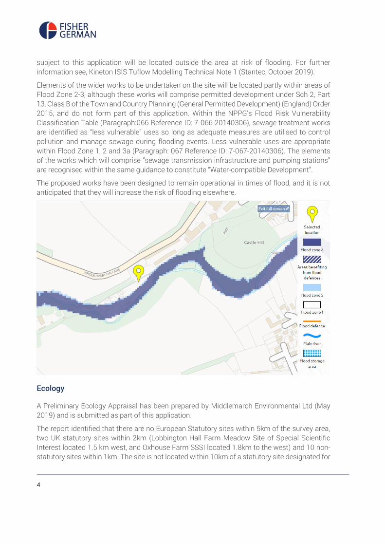
4
subject to this application will be located outside the area at risk of flooding. For further information see, Kineton ISIS Tuflow Modelling Technical Note 1 (Stantec, October 2019).
Elements of the wider works to be undertaken on the site will be located partly within areas of Flood Zone 2-3, although these works will comprise permitted development under Sch 2, Part 13, Class B of the Town and Country Planning (General Permitted Development) (England) Order 2015, and do not form part of this application. Within the NPPG’s Flood Risk Vulnerability Classification Table (Paragraph:066 Reference ID: 7-066-20140306), sewage treatment works are identified as “less vulnerable” uses so long as adequate measures are utilised to control pollution and manage sewage during flooding events. Less vulnerable uses are appropriate within Flood Zone 1, 2 and 3a (Paragraph: 067 Reference ID: 7-067-20140306). The elements of the works which will comprise “sewage transmission infrastructure and pumping stations” are recognised within the same guidance to constitute “Water-compatible Development”.
The proposed works have been designed to remain operational in times of flood, and it is not anticipated that they will increase the risk of flooding elsewhere.
Ecology
A Preliminary Ecology Appraisal has been prepared by Middlemarch Environmental Ltd (May 2019) and is submitted as part of this application.
The report identified that there are no European Statutory sites within 5km of the survey area, two UK statutory sites within 2km (Lobbington Hall Farm Meadow Site of Special Scientific Interest located 1.5 km west, and Oxhouse Farm SSSI located 1.8km to the west) and 10 non-statutory sites within 1km. The site is not located within 10km of a statutory site designated for
5
bats. There are also three separate non-statutory sites surround the survey area, namely King John’s Castle Local Wildlife Site (LWS / potential (p)LWS, River Dene pLWS and Headwaters and Stratford upon Avon to Fenny Compton Disused Railway pLWS. The survey considered that there was potential for the proposed works to impacts either directly or indirectly on a number of these sites as a result of increased dust, noise and pollution, and therefore recommendations to minimise the potential impacts have been included within the report.
The report has also identified records of protected and notable species including bats, badger, hedgehog, water vole, brown hare, amphibians, reptiles, birds and invertebrates in proximity to the site. In order to minimise any potential adverse impacts to these species as a result of the works, and to ensure compliance with wildlife legislation and relevant planning policy a number of recommendations have been made.
It is proposed to undertake the works in accordance with the recommendations set out in the report. However, as the report was prepared before the solution for the works on site was finalised, it is not considered that the Otter and Water Vole surveys recommended will now be required, as all of the works to be undertaken on site will be considerably further than 10m from the edge of the river bank. Best practice guidance for minimising dust and pollution will be followed to avoid these species becoming indirectly affected by the proposed works.
Noise
There may be temporary short-term impacts associated within the installation of the proposed works. However, once the upgrading works are complete, it is not anticipated that the site will generate increased levels of noise which could adversely affect local amenity.
Heritage
The nearest significant heritage assets to the site are two Scheduled Ancient Monuments. These are “King John’s Castle”, located approximately 230m to the north-east of Kineton STW, and a “medieval settlement at Brookhampton” approximately 615m south-west of the site.
There are also a number of listed buildings in the surrounding area. The nearest are the Warwickshire Hunt Stables and Kennels (Grade II) approximately 400m to the south-east of the site, and the farm buildings at Pittern Hill Farmhouse (Grade II) approximately 500m to the north. There are also a number of listed buildings within the centre of Kineton approximately 760m to the east of the site.
There is also a Registered Battlefield (Battle of Edgehill 1642) approximately 740m south-east of the STW.
As the proposed works will all be within the existing boundaries of the operational site, which benefits from dense and mature screening along its boundaries, it is considered unlikely that any of these heritage assets will be adversely affected by the proposed works. Any impact to their setting resulting from construction will be purely temporary in nature.

6
Odour
It is considered unlikely that the proposed works will generate levels of odour which would adversely affect local amenity.

7
04 Planning Policy
Planning policy relating to the application site is formed through:
• Local Planning Policy
• National Planning Policy
Section 38(6) of the Planning and Compulsory Purchase Act 2004 requires applications for planning permission to be determined in accordance with the Development Plan unless material considerations indicate otherwise. The development Plan material to the proposal consists of:
• Stratford on Avon Core Strategy 2011-2031 (adopted July 2016)
• Warwickshire County Council Waste Core Strategy (adopted July 2013)
In addition to the Development Plan, applications should also have regard to the National Planning Policy Framework (NPPF), National Planning Practice Guidance and Landscape Character and Design Supplementary Planning Document (SPD), which are material considerations in any determination.
Stratford on Avon District Core Strategy 2011-2031 (July 2016)
Summarised below are the most relevant policies:
Policy CS.1 – Sustainable Development
The Council supports and will apply the principle that planning to secure a high-quality environment, managed economic growth and social equity are of equal importance.
All development proposals should contribute towards the character and quality of the District and to the well-being of those who live and work in and visit the District.
Development should be located and designed so that it contributes towards the maintenance of sustainable communities within the District.
When considering development proposals, the Council will take a positive approach that reflects the presumption in favour of sustainable development contained in the National Planning Policy Framework (NPPF). It will work proactively with applicants to find solutions which mean that proposals can be approved wherever possible, and to secure development that improves the economic, social and environmental conditions in the area.

8
Planning applications that accord with the policies in the Core Strategy (and, where relevant, with policies in neighbourhood plans) will be approved without delay, unless material considerations indicate otherwise.
Where there are no polices in the Core Strategy that are relevant to the application, the Council will grant permission unless material considerations indicate otherwise, taking into account whether:
• Any adverse impacts of granting permission would significantly and demonstrably outweigh the benefits, when assessed against the policies in the NPPF when taken as a whole; or
• Specific policies in the NPPF indicate that development should be restricted.
Policy CS.4 – Water Environment and Flood Risk
All development proposals will take into account, dependant on their scale, use and location, the predicted impact of climate change on the District’s water environment. Measures will include sustainable use of water resources, minimising water consumption, protecting and improving water quality, and minimising flood risk from all sources, as set out in the most up-to-date Strategic Flood Risk Assessment.
A. Flood Risk Areas
The policy sets out that where possible, development should be located in Flood Risk Zone 1 (Low Probability Flood Risk).
B. Surface Water Runoff and Sutainable Urban Drainage Systems
It states that development will not be permitted where it would result in an increase in the risk of flooding elsewhere, and required surface water to be appropriately managed.
C. Enhancing and protecting the Water Environment.
It states that development proposals that lie adjacent to a canal, river, or tributary should ensure that the natural features and functions of the water course and its wider corridor are retained, or where possible reinstated and that appropriate habitat buffers are established.
It states that development proposals will take full account of the biodiversity value of water courses and river corridors and their role in supporting local ecological networks. Impacts from lighting, noise, and visual disturbances should be avoided and mitigated and opportunities to create, enhance and restore adjacent habitats for biodiversity will be encouraged.
D. Water Quality
In accordance with the Water Framework Directive’s Objectives, development must not affect the water bodies’ ability to reach good status or potential as set out in the Rivers Severn, Humber and Thames River Basin Management Plans (RBMP).

9
Development will not be permitted where proposals have a negative impact on water quality, either directly through pollution of surface or ground water, or indirectly through the overloading of Wastewater Treatment Works. Prior to any potential development, consultation must be help with Severn Trent Water or Thames Water as appropriate to ensure that the required wastewater infrastructure is in place in sufficient time.
Policy CS.5 – Landscape
The landscape character and quality of the District will be maintained by ensuring that development takes place in a manner that minimises and mitigates its impact and, where possible, incorporates measures to enhance the landscape. The cumulative impact of development proposals on the quality of the landscape will be taken into account.
Policy CS.6 – Natural Environment
Development will be expected to contribute towards a resilient ecological network throughout the District that supports ecosystems and provides ecological security for wildlife, people, the economy and tourism.
Developments that are likely to have an adverse effect either directly, indirectly or cumulatively upon a site designated through the EC Habitats Directive or Birds Directive will not be permitted.
A. Proposals will be expected to minimise impacts, and where possible, secure a net gain in biodiversity, and this policy sets out a number of ways in which this might be achieved.
Policy CS.8 – Historic Environment
A. Protection and Enhancement
The District’s historic environment will be protected an enhanced for its inherent value and for the enjoyment of present and future residents and visitors.
Priority will be given to protecting and enhancing the wide range of historic and cultural assets that contribute to the character and identity of the District, including:
1. Designated heritage assets such as Listed Buildings, Conservation Areas, Registered Gardens, the Battle of Edgehill Historic Battlefield, Scheduled Monuments, and sites of archaeological importance, and their settings;
2. non-designated heritage assets and their settings;
3. Stratford-upon-Avon’s historic townscape and street scene, and sites associated with William Shakespeare, to maintain the town’s international and cultural importance;
4. the distinctive character of the market towns, villages and hamlets, including their settings, townscapes, streets, spaces and built form;

10
5. features that reflect the historic interaction of human activity on the landscape, including local vernacular building styles and materials, traditional farm buildings, and historic features associated with canals, navigations and railways;
6. working with the highways authority and infrastructure providers to ensure works to streets and the public realm do not detract from the historic value of the street scene; and;
7. seeking to reduce the number of heritage assets at risk.
B. Proposals Affecting the Significance of a Heritage Asset
Where proposals will affect a heritage asset, applicants will be required to undertake and provide an assessment of the significance of the asset using a proportionate level of detail relating to the likely impact the proposal will have on the asset's historic interest.
Proposals which would lead to substantial harm to, or total loss of significance of, designated heritage assets will only be permitted where substantial public benefits outweigh that harm or loss and it is demonstrated that all reasonable efforts have been made to sustain the existing use or find reasonable alternative uses.
Where a development proposal will lead to less than substantial harm to the significance of a designated heritage asset, this harm must be justified and weighed against the public benefits of the proposal, including securing its optimum viable use.
For non-designated heritage assets, proposals will be assessed having regard to the scale of any harm or loss and the significance of the heritage asset.
Where harm or loss of a heritage asset can be fully justified, as part of the implementation of the proposal the District Council will require archaeological excavation and/or historic building recording as appropriate, followed by analysis and publication of the results.
C. Appreciation, Design and Management
Proposals will be high quality, sensitively designed and integrated with the historic context. The design and layout of development proposals will be informed by an understanding of the significance of the historic asset and environment
Policy CS.9 – Design and Distinctiveness
A. Ensuring Local Distinctiveness
All forms of development will improve the quality of the public realm and enhance the sense of place, reflecting the character and distinctiveness of the locality. Proposals that would damage or destroy features which positively contribute to local distinctiveness will not be permitted. Understanding local context is key to achieving good design and proposals should take into account any relevant design principles and contextual analysis set out in local guidance. Where required as part of a planning application, Design and Access Statements will set out how new development responds to its unique context and enhances local distinctiveness.
B. Ensuring High Quality Design

11
High quality design will be achieved by ensuring that all development is:
1. Attractive: Proposals will be of a high quality architectural design and include appropriate landscaping to create places where people want to live, work and visit. Proposals should use a limited palette of materials to give coherence to the overall design. The provision of landscaping will be accompanied by appropriate mechanisms to ensure its ongoing management and maintenance.
2. Sensitive: Proposals, including layout and orientation, will be sensitive to the setting, existing built form, neighbouring uses, landscape character and topography of the site and locality. Proposals will reflect the context of the locality, ensuring a continuity of key design features that establishes the identity of the place, making best use of on-site assets including landscaping features as well as public views and vistas and not harming existing ones.
3. Distinctive: The layout of proposals will be easy to navigate with buildings designed and positioned to define and enhance a hierarchy of streets and spaces, taking account of the relationship between building height and street width. Public and private spaces should be clearly defined and areas that have little or no public or biodiversity value should be avoided. Densities should be appropriate to the site taking into account the fact a key principle of good design is the relationship between the height, width and depth of buildings.
4. Connected: Proposals will be well-integrated with existing built form, enhancing the network of streets, footpaths and green infrastructure across the site and the locality, and retaining existing rights of way.
5. Environmentally Sustainable: Proposals will respond to climate change. Measures should include energy efficiency technologies, low carbon and renewable energy sources, the use of local materials where possible, effective water management and flood protection, and appropriate landscaping.
6. Accessible: Proposals will encourage walking and cycling and provide for or be close to, community facilities, having good access to public transport.
7. Safe: Proposals will incorporate effective measures to help reduce crime and the fear of crime and to minimise danger from traffic. Schemes linked to the evening and night-time economy will incorporate measures to help manage anti-social behaviour and to avoid unacceptable impact on neighbouring uses, residents and the surrounding area. Measures should include pedestrian and cycle friendly streets and opportunities for natural surveillance whilst avoiding large parking courts and blank building elevations.
8. Healthy: Proposals will ensure a good standard of space and amenity for occupiers. Occupants of new and neighbouring buildings will be protected from unacceptable levels of noise, contamination and pollution, loss of daylight and privacy, and adverse surroundings.

12
C. Design Innovation
High quality design innovation will be encouraged where it reflects and complements the immediate local environment and maximises sustainability benefits. Where such an approach is appropriate it should be based on the characteristics of the built environment in the local area and have a beneficial purpose.
Policy CS.25 – Healthy Communities
A. Infrastructure, Services and Community Facilities
With the release of land for development, suitable arrangements will be put in place to improve infrastructure, services and community facilities to mitigate impact of development and integrate it with the existing community.
Policy AS.10 – Countryside and Villages
In order to help maintain the vitality of rural communities and a strong rural economy, provision will be made for a wide range of activities and development in rural parts of the District. All proposals will be thoroughly assessed against the principles of sustainable development, including the need to:
• minimise impact on the character of the local landscape, communities and environmental features;
• minimise impact on the occupiers and users of existing properties in the area;
• avoid a level of increase in traffic on rural roads that would be harmful to the local area;
• make provision for sustainable forms of transport wherever appropriate and justified;
• prioritise the re-use of brownfield land and existing buildings; and
• seek to avoid the loss of large areas of higher quality agricultural land.
Warwickshire County Council Waste Core Strategy (July 2013)
Policy CS2 – The Spatial Waste Planning Strategy for Warwickshire
This policy sets out the locations where preference will be given for the location of waste management facilities. Within the broach locations identified, the policy states that new waste developments will be directed to certain kinds of sites, including:
• land within or adjoining a sewage treatment works.

13
Policy DM1 – Protection and enhancement of the natural and built environment
New waste development should conserve, and where possible enhance, the natural and built environment by ensuring that there are no unacceptable adverse impacts upon:
• Natural resources (including water, air and soil);
• Biodiversity
• Geodiversity
• Archaeology
• Heritage and cultural assets and their settings
• The quality and character of the landscape
• Adjacent land uses of occupiers; and
• The distinctive character and setting of the County’s settlement.
Waste management proposals should demonstrate that valued landscapes and sites, species, habitats and heritage assets (and where relevant, their settings) of international importance will be preserved or conserved and where possible, enhanced.
National Planning Policy Framework NPPF (2019)
National planning policy guidance is set out in the NPPF, the relevant paragraphs are summarised below:
Paragraph 8 states that the planning system has three overarching objectives, which are interdependent and need to be pursued in mutually supportive ways. The first of these is an economic objective, to help build a strong, responsive and competitive economy by ensuring that sufficient land of the right type is available in the right places and at the right time to support growth, innovation and improved productivity; and by identifying and co-ordinating the provision of infrastructure.
Paragraph 11 states that there should be a presumption in favour of sustainable development. Local plans should positively seek opportunities to meet the development needs of their area and development proposals which accord with an up-to-date development plan should be approved without delay. Where there are no relevant development plan policies, or the policies are out-of-date, permission should be granted unless policies in the Framework that protect areas or assets of particular importance prove a clear reason for refusing the proposed development, or the adverse impacts of doing so would significantly and demonstrably outweigh the benefits, when assessed against the policies in this Framework taken as a whole.

14
Paragraph 12 states that where a planning application conflicts with an up-to-date development plan Local Planning Authorities may take decisions that depart from an up-to-date development plan where material considerations in a particular case indicate that the plan should not be followed.
Paragraph 20 states that strategic policies should set out an overall strategy for the pattern, scale and quality of development, and make sufficient provision for:
b) infrastructure for transport, telecommunications, security, waste management, water supply, wastewater, flood risk, coastal change management and the provision of minerals and energy.
Paragraph 25 states that authorities should collaborate to identify the relevant strategic matters which they need to address in their plans, and should engage with infrastructure providers.
Paragraph 26 states that effective and on-going joint working between strategic policy-making authorities and relevant bodies is integral to the production of a positively prepared and justified strategy. In particular, joint working should help to determine where additional infrastructure is necessary.
Paragraph 28 non-strategic policies should be used by local planning authorities and communities to set out more detailed policies for specific areas, neighbourhoods or types of development. This can include the provision of infrastructure.
Paragraph 80 states that planning policies and decisions should help to create the conditions in which businesses can invest, expand and adapt.
Paragraph 81 states that planning policies should seek to address potential barriers to investment, such as inadequate infrastructure, services or housing, or a poor environment.
Paragraph 122 states that planning policies and decisions should support development that makes efficient use of land, taking into account the availability and capacity of infrastructure and services – both existing and proposed – as well as their potential for further improvement.
Paragraph 149 confirms that plans should take a proactive approach to mitigating and adapting to climate change, taking into account the long-term implications for flood risk, coastal change, water supply, biodiversity and landscapes, and the risk of overheating from rising temperatures. Policies should support appropriate measures to ensure the future resilience of communities and infrastructure to climate change impacts.
Paragraph 193 states that when considering the impact of a proposed development on the significance of a designated heritage asset, great weight should be given to the asset’s conservation. This is irrespective of whether any potential harm amounts to substantial harm, total loss or less than substantial harm to its significance.
Paragraph 196 states that where a development proposal will lead to less than substantial harm to the significance of a designated heritage asset, this harm should be weighed against the public benefits of the proposal including, where appropriate, securing its optimum viable use.

15
National Planning Practice Guidance (NPPG) - Water supply, wastewater and water quality (22 July 2019)
The NPPG provides guidance on water supply, wastewater and water quality. It states that adequate water and wastewater infrastructure is needed to support sustainable development. A healthy water environment will also deliver multiple benefits, such as helping to enhance the natural environment generally and adapting to climate change.

16
05 Planning Policy Assessment
This application seeks consent for the installation of a new Motor Control Centre (MCC) Kiosk and a new lab and Sludge Thickening Building within the existing boundaries of Kineton STW. These features form part of a wider scheme of works being undertaken on the site to meet the requirements of the Water Framework Directive and a growing population in the catchment area.
The provision of infrastructure to meet existing and future requirements is supported in both local and national planning policy, and local authorities should seek to address potential barriers to investment, such as inadequate infrastructure, services or housing, or a poor environment (NPPF Paragraphs 8, 20, 25, 28 and 81).
The NPPF (paragraph 11) states that there should be a presumption in favour of sustainable development and that local authorities should positively seek opportunities to meet the development needs of their area. Proposals which accord with an up-to-date plan should be approved without delay. Policy CS.1 states that the Council will adopt this principle of sustainable development and will work proactively with applicants to find solutions which mean that proposals can be approved wherever possible, and to secure development that improves the economic, social and environmental conditions in the area.
The proposed works have been designed to be the minimum necessary to meet operational requirements, and the units will be coloured to assimilate within the existing infrastructure on site. Policy CS2 supports the development of waste management facilities on land within existing sewage treatment works, and as the vegetation providing screening along the boundaries of the site will be retained it is not anticipated that the proposed works will result in an adverse visual impact on the surrounding landscape. It is therefore considered that the works accord with Policies CS.5, CS.9, AS.10 and DM1.
A Preliminary Ecological Appraisal has been undertaken by Middlemarch Environmental (May 2019) and has set out a number of recommendations which will be adhered to where relevant to the development proposed. As such, it is considered that the proposed works are in accordance with Policies CS.6 and DM1.
The proposed works subject to this application are located in an area of Flood Zone 1. Although wider permitted development works will be located partly within Flood Zone 2-3, sewage treatment works are identified as “less vulnerable” uses within the NPPG’s Flood Risk Vulnerability Classification Table so long as adequate measures are utilised to control pollution and manage sewage during flooding events are in place, and such less vulnerable uses are appropriate within Flood Zone 1, 2 and 3. The elements of the works which will comprise “sewage transmission infrastructure and pumping stations” are recognised within the same guidance, to constitute “Water-compatible Development”. The proposed works have been designed to remain operational in times of flood, and it is not anticipated that they will increase

17
the risk of flooding elsewhere. Additionally, a driver of the works is to meet the requirements of the Water Framework Directive which seeks to protect and improve the water quality and water environment and it is therefore considered that the proposed works will comply with Policy CS.4.
While there are a number of heritage features in proximity to the site, as the proposed works will be contained within the existing boundaries of the operational site, which benefits from dense and mature screening along its boundaries, it is considered unlikely that any of these heritage assets will be adversely affected by the proposed works in accordance with Policy CS.8 and NPPF Paragraphs 193 and 196.
The nearest residential properties to the site are approximately 350m to the south-east of the site, separated by the River Dene and woodland screening along its banks and agricultural land. It is not considered likely that the proposed works will adversely affect the amenity of these properties. There is a footpath along the northern boundary of the site, however, it is also not considered likely that this will be adversely impacted by the proposed works.
The proposed works are considered to accord with both local and national planning policy.

18
06 Conclusion
This application seeks consent for the installation of a new Motor Control Centre (MCC) Kiosk and a new lab and Sludge Thickening Building within the existing boundaries of Kineton STW. These features form part of a wider scheme of works being undertaken on the site to meet the requirements of the Water Framework Directive and a growing population in the catchment area.
The proposed works will be positioned within the boundaries of the existing operational site. They have been designed to be the minimum scale necessary to meet operational requirements, and existing boundary screening will help to ensure they do not have an adverse visual impact on the surrounding landscape.
The works are not considered likely to result in any significant adverse impacts on any nearby heritage assets, local ecology, flood risk or amenity.
The works are considered to accord fully with all relevant national and local planning policy and it is respectfully requested that the application be approved.