kerneels terblanche terblanche transport secunda …rhdhv.co.za/media/charlie 1...
TRANSCRIPT

Kerneels Terblanche Terblanche Transport Secunda
Nomsa Thabethe Gert Sibande District Municipality
Dineo Tswai
Mpumalanga Department of Economic Development Environment &
Tourism
Angela van Rooyen Govan Mbeki Local Municipality
Naomie Victor Govan Mbeki Local Municipality
G Vosloo Agri Enviro Lab
Terry Williams Discovery Training
Thamsanqa Xesibe Mpumalanga Department of Water Affairs (DWA)
Nhlakanipho Zuma SACP

E2: Advertisements &
Notifications (To Be Provided in Final Consultation EIR)

E3: Issues Trail

ISSUES TRAIL – SCOPING PHASE
THE CHARLIE 1 LANDFILL OPTIMISATION AND STORMWATER MANAGEMENT PROJECT, SASOL SYNFUELS, SECUNDA, MPUMALANGA
DEA REF: 12/9/11/L49416/6
SEPTEMBER 2015

TABLE OF CONTENTS
1. EIA PROCESS & LEGISLATIVE REQUIREMENTS 1
2. DESIGN AND LAYOUT OF LANDFILL AND POLLUTION CONTROL PONDS 1
3. VISUAL 2
4. AIR 3
5. BIODIVERSITY 3
6. WATER 4
7. GENERAL 4

THE CHARLIE 1 LANDFILL OPTIMISATION AND STORMWATER MANAGEMENT PROJECT, SASOL SYNFUELS, SECUNDA, MPUMALANGA
1
1. EIA PROCESS & LEGISLATIVE REQUIREMENTS
ISSUE/COMMENT RAISED BY RESPONSE
1. Must comply with the Govan Mbeki Municipality (GMM) Land Use Scheme by making application for Utility Land Use to ensure the following objectives is met in the process:-
� To ensure that land used for service provision is appropriately located away from residential or other land uses where they detract from levels of amenity or safety.
� To protect residential areas, health and educational facilities from any potential negative impacts or health hazards.
� To ensure that any disruption to natural areas and water courses by adhering to environmental management principles.
2. The applicant should comply with Legislative prescripts and By-laws related to General Work/s
Kamesh Rohan Manager: Physical Development Govan Mbeki Local Municipality Tel: 017 620 6075 Email: [email protected] Received: 14 September 2015
1. Sasol submitted a Land use Rights Application for Discretionary Land Use to the Govan Mbeki Municipality to change the existing land use from agricultural to agricultural industrial.
2. GMM By-laws have been considered in the ESR. Refer to Section 5.5 of the ESR.
2. DESIGN AND LAYOUT OF LANDFILL AND POLLUTION CONTROL PONDS
ISSUE/COMMENT RAISED BY RESPONSE
1. It was stipulated in the presentation that the rainfall will increase the contamination levels at the landfill and that v-drains have been designed around the perimeter of the Charlie 1 Landfill site. The capacity of the ponds are approximately 15000 m
3 which
converts to approximately 15 000 000 ℓ. When examining the weather data from the Driefontein Weather Station, a 1:50 year storm will produce approximately 126 mm of rainfall per day. The area of the landfill site is 31 ha and will produce approximately 45 000 m
3 of stormwater runoff. Is the
capacity of the proposed ponds sufficient to handle the stormwater generated by a 1:50 year storm event or will Sasol create an overflow into the adjacent stream?
Willem Burger Construction Contractor Ricky B Transportation and Plant Hire Tel: 071 353 7975 Email: [email protected] Received: 27 August 2015
1. It is important to note that the landfill will be divided and operated in different sections / cells. There might be six (6) cells overall however only one cell will be operational at any given time. Deposition will only occur in that one cell and once the height has been reached, the cell will be capped and rehabilitated. There will never be an instance where runoff from the entire landfill site will be channelled to the ponds. Therefore there will be sufficient capacity in both ponds to handle a 1:50 year storm event.
2. The design plan will be available once Sasol has reached Beneficial Operation (BO). Currently the existing operating procedure will be followed. Once BO has been reached, a new operating procedure and plan will be implemented which will stipulate the new design specifications and provide necessary information regarding the operation of the facility.
As part of the next phase, as mentioned above, an operational plan will be established. Once the new operational plan has been made available, it may be possible to test this plan with the operation contractors. This will

THE CHARLIE 1 LANDFILL OPTIMISATION AND STORMWATER MANAGEMENT PROJECT, SASOL SYNFUELS, SECUNDA, MPUMALANGA
2
ISSUE/COMMENT RAISED BY RESPONSE
2. Please can a plan be provided depicting the future slope and height requirements? Ricky B is involved in the operations at Charlie 1 Landfill and as part the contract Sasol requires Ricky B to do the sloping and runoff for the site. Therefore a plan of the design would assist Ricky B in shaping the landfill correctly.
Testing the slope and stormwater management designs would assist Ricky B in constructing the landfill to Sasol specifications which will save future costs.
be examined in more detail near BO.
Sasol will have a discussion regarding this and will revert to you once a decision has been made regarding testing of the operational plan.
1. A buffer must be created between the landfill site and the Secunda Airfield
Kamesh Rohan Manager: Physical Development Govan Mbeki Local Municipality Tel: 017 620 6075 Email: [email protected] Received: 14 September 2015
1. The existing buffer between the existing Charlie 1 landfill site and the Secunda Airfield will be maintained.
3. VISUAL
ISSUE/COMMENT RAISED BY RESPONSE
1. Due to the fact that the height of the Charlie 1 Landfill will increase, potential visual impacts could occur. What mitigation measures are proposed to deal with these impacts?
Currently a hedge runs the length (approximately 2 km) of the landfill site. According to Department of Environmental Affairs (DEA), the type of plant that is used for the hedge is a Category 1B invasive plant. It is anticipated that the entire hedge will need to be removed. If trees are planted, they need to be indigenous.
In America, the use of Willow trees around landfill sites has been very effective by providing firstly sufficient screening from receptors and secondly by absorbing some the contamination. It might be useful for Sasol to assess whether this would be a viable
Willem Burger Construction Contractor Ricky B Transportation and Plant Hire Tel: 071 353 7975 Email: [email protected] Received: 27 August 2015
1. A visual impact assessment has been conducted to determine the different receptors (for example the Graceland Hotel and the Secunda Mall) and various mitigations measures have been proposed. Visual modelling has been utilised to determine where the different receptors are located and how they will be affected by the increased height of the Charlie 1 Landfill. The main mitigation measure is the utilisation of vegetation / tree as a screening measure which would limit the receptor’s view of the landfill. During the Environmental Impact Assessment (EIA) phase, which is the next phase in the project, the actual visual impacts and the ratings will be determined.
Provision will be made to acquire indigenous vegetation and trees to provide a screening function for the Charlie 1 Landfill site.
A Willow tree is also an invader species and cannot be utilised as Sasol does not wish to replace one invader with another. There may be an alternative indigenous species that could provide a similar function as the

THE CHARLIE 1 LANDFILL OPTIMISATION AND STORMWATER MANAGEMENT PROJECT, SASOL SYNFUELS, SECUNDA, MPUMALANGA
3
ISSUE/COMMENT RAISED BY RESPONSE
option for screening at the Charlie 1 Landfill.
It should be noted that a Category 2 invader can be utilised as long as it provides a necessary purpose.
Willow tree. Sasol will assess the various options that might be available.
Key is the operation of the Charlie 1 Landfill. The proposed 20 m height will not be reached in the near future. Also cells located at the southern area of the landfill site (facing the Secunda Complex) will be utilised initially to prevent receptors from being impacted. This strategy and other strategies (such as rehabilitation and cover) have been determined in the Visual Impact Assessment and will be employed during operations.
4. AIR
ISSUE/COMMENT RAISED BY RESPONSE
1. The construction of suitable infrastructure to
accommodate the newly developed environmental
footprint in terms of the atmospheric pollution for the
minimisation of airborne nuisance and or health
impacts.
Miss N Lukele Municipal Health and Environmental Services Gert Sibande District Municipality Tel: 017 801 7000 Email: [email protected] Received: 08 September 2015
1. Dust generation has a potential impact on air quality at the Charlie 1 landfill site. The site’s operational plan and the Environmental Management Programme (EMPr) to be compiled in the next phase of the study will make further recommendations for the management of dust and/or any associated health impacts.
5. BIODIVERSITY
ISSUE/COMMENT RAISED BY RESPONSE
1. Mpumalanga Agriculture is one of nine provincial affiliates of AgriSA. One of our tasks is to keep an eye on our natural resources. We believe that your client, in this case Sasol, is a responsible company that will make sure they comply to the existing regulations. However we again want to bring under your attention the importance of protecting our natural resources (in this case water) for food security in future. You must keep in mind that agriculture and industry are in competition in regards natural resources, like water. Please be responsible in the total process of research (EIA study) as well as in putting together the ESR and Environmental
Robert Davel Assistant Director Mpumalanga Landbou/Agriculture Tel: 017 819 1295 Email: [email protected] Received: 13 August 2015
1. Baseline studies have been conducted for this project to determine the current status of the environment. Sasol is conducting the EIA process to determine all potential negative environmental impacts that may occur and to employ all recommended mitigation to the proposed project.
Furthermore, through the development of a pollution control pond area, the contaminated stormwater run-off and leachate will be intercepted, collected and treated in ponds to ensure an effective water management system at the Charlie 1 landfill site preventing risks of contamination to water resources as well as potential health risks.

THE CHARLIE 1 LANDFILL OPTIMISATION AND STORMWATER MANAGEMENT PROJECT, SASOL SYNFUELS, SECUNDA, MPUMALANGA
4
ISSUE/COMMENT RAISED BY RESPONSE
Impact Assessment Report (EIAR) that will be submitted to DEA.
6. WATER
ISSUE/COMMENT RAISED BY RESPONSE 1. Kindly note that DWS will send comments directly to
DEA on request and not to the consultants. However DWS do get involved in all solid waste projects to ensure compliance with Section 19 of the NWA. I would be grateful if you will contact me directly on all solid waste projects as I am responsible person for the Upper Vaal sub-catchment.
Thya Pather Solid Waste Department of Water and Sanitation Tel: 082 809 5729 Email: [email protected] Received: 14 September 2015
1. The comment has been noted. Mr. Pather’s contact details have been included in the I&AP database and he will be included in all future correspondence related to the project.
7. GENERAL
ISSUE/COMMENT RAISED BY RESPONSE 1. The Gert Sibande District Municipality is in
possession of an Environmental Management Framework (EMF) document for Govan Mbeki Local Municipality.
Miss N Lukele Municipal Health and Environmental Services Gert Sibande District Municipality Tel: 017 801 7000 Email: [email protected] Received: 08 September 2015
1. A copy of the EMF has been requested and the relevant sections of the report i.e. Section 4 Project Need and Desirability will be updated accordingly.
Appendix F: Preliminary
Ecological Survey


PRELIMINARY ECOLOGICAL HABITAT
ASSESSMENT FOR THE PROPOSED
SASOL CHARLIE 1 OPTIMISATION AND
STORMWATER MANAGEMENT PROJECT,
SECUNDA;
MPUMALANGA PROVINCE
Compiled for Royal HaskoningDHV
Vegetation Aspect by: Prof. LR Brown Pr.Sci.Nat. 400075/98
Faunal Aspect by: Mr. C.L.COOK Pr.Sci.Nat. 400084/08
SUBMITTED: 15th
of MAY 2015

Table of Contents
1. Background Information ........................................................................................... 1
1.1 Objectives of the initial faunal survey/ habitat assessment ....................................................... 2
1.2 Scope of study ........................................................................................................................... 2
2. Methodology ................................................................................................................ 4
2.1 Predictive methods .................................................................................................................... 4
2.2 Literature Survey ....................................................................................................................... 4
2.3 Site Investigation Methodology.................................................................................................. 4
2.3.1 Vegetation............................................................................................................................... 4
2.3.2 Fauna ...................................................................................................................................... 5
2.4 Uncertainties in Predicting Results ............................................................................................ 5
2.5 Gaps in the Baseline Data ......................................................................................................... 6
3. Description of the Affected Environment ...................................................................... 6
3.1 Climate ....................................................................................................................................... 6
3.2. Vegetation Type ....................................................................................................................... 8
3.3 Vegetation of study site ........................................................................................................... 11
3.3.1 Pasture Field ........................................................................................................................ 11
3.3.2 Degraded Area ..................................................................................................................... 13
3.4 Protected Tree Species ........................................................................................................... 15
3.5 Red Data / Endemic Species................................................................................................... 15
3.5 Alien Vegetation ...................................................................................................................... 16
3.6 Land Degradation .................................................................................................................... 16
4. Results of the Preliminary Faunal Survey or Habitat Assessment ............................. 16
4.1 Vegetation and Faunal Habitat Availability .............................................................................. 16
4.1.1 Moist Soweto Highveld Grassland ....................................................................................... 17
4.1.2 Transformed Grasslands and Old Agricultural lands............................................................ 18
4.1.3 Wetlands ............................................................................................................................... 19
4.2 Existing Impact on the Proposed Project Site ......................................................................... 22
4.2 Mammals ................................................................................................................................. 23
4.2.1 Threatened Species ............................................................................................................. 24
4.3 Avifaunal (Bird) Survey ............................................................................................................ 26
4.3.1 Habitat Available for Sensitive or Endangered Species ....................................................... 27
4.4 Reptiles .................................................................................................................................... 28
4.4.1 Habitat Available for Sensitive or Endangered Species ....................................................... 31
4.5 Amphibians .............................................................................................................................. 31
4.5.1 Threatened Species ............................................................................................................. 33
5. Sensitive Habitats on the Site and Adjacent Areas .................................................... 34
6. Potential Impacts ....................................................................................................... 40
6.1 Loss of Faunal Habitats ........................................................................................................... 40
6.2 Surface Run-off: Erosion (Sedimentation) and Possible Siltation ........................................... 41
6.3 Surface and Groundwater ....................................................................................................... 41
6.4 Migratory Routes (Fencing) ..................................................................................................... 41

6.5 Artificial Lighting ...................................................................................................................... 42
6.Conclusion and Recommendations ............................................................................ 42
7. References ................................................................................................................ 43
List of Tables
Table 1: List of red data species that could possibly occur in the larger Secunda area ................... 15
Table 2: Mammal species recorded from the 2629 BA QDGC according to MammalMAP .............. 25
Table 3: Red Data List bird species previously recorded from the 2630_2905 pentad .................... 26
Table 4: Reptile species recorded from the 2629 CA QDGC according to ReptileMAP (SARCA
2014). ................................................................................................................................................. 30
Table 5: Frog species recorded from the 2629 CB QDGC according to Frog Map (SAFAP) ........... 32
Table 6: The impact rating criteria used for determining potential impacts of the proposed project . 38
Table 7: Summary table of the potential impacts and ratings for the proposed project .................... 39
List of Figures
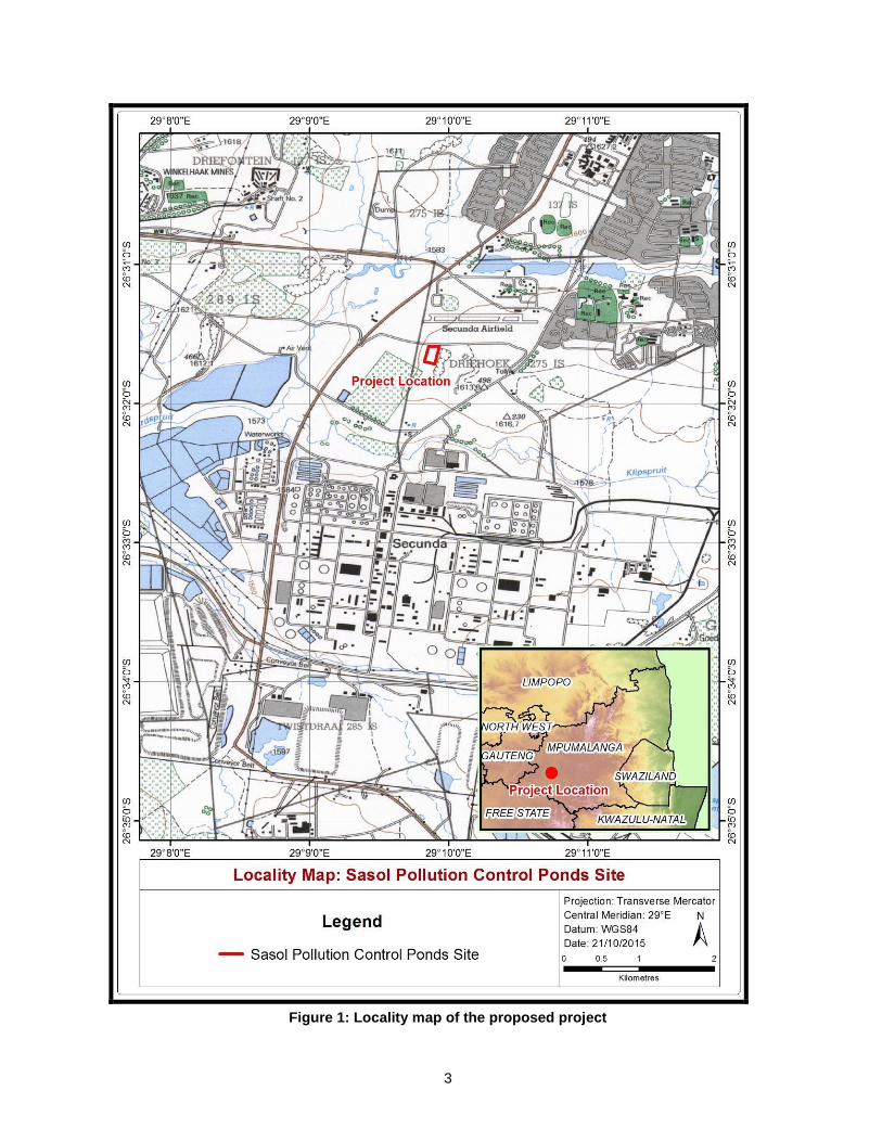
Figure 1: Locality map of the proposed project ................................................................................... 3
Figure 2: Average monthly rainfall and temperatures for the study area ............................................ 7
Figure 3: Vegetation map of the proposed site (adapted from Mucina & Rutherford, 2006) ............ 10
Figure 4: Patches of moist grasslands .............................................................................................. 17
Figure 5: Examples of transformed grasslands ................................................................................. 18
Figure 6: Collage of photographs all the dominant wetland types found within the Secunda-Evander
area .................................................................................................................................................... 19
Figure 7: Collage of photographs displaying the dominant vegetation observed on the site ............ 21
Figure 8: A Scrub Hare (Lepus sextalis) was flushed from the planted Setaria pallide-fusca pastures
on the site .......................................................................................................................................... 24
Figure 9: Reptile species likely to occur on the site and adjacent areas........................................... 29
Figure 10: Frog species recorded in the Secunda area .................................................................... 32
Figure 11: Mpumalanga Biodiversity Sector plan for the proposed project....................................... 36
Figure 12: Preliminary ecological sensitivity map for the proposed project ...................................... 37

1
1. Background Information
The Sasol Synfuels, Secunda, Charlie 1 landfill site was authorised in 1993 as a Class II Site, in
terms of the Environmental Conservation Act (ECA) (No. 73 of 1989). Recent changes in legislation
such as the National Environmental Management: Waste Act, 2008 (No. 59 of 2008) and the Waste
Classification and Management Regulations, 2013 (GN R. 634) have implications for the
management of waste disposal sites.
The latest audits conducted at Charlie 1 landfill site highlighted that the water management is not in
accordance with the permit requirements. Sasol South Africa Pty Ltd (Sasol) therefore propose to
construct a contaminated leachate and stormwater pond within a pollution control pond area,
adjacent to the western boundary of the existing landfill site on the farm Driehoek 275 IS, to ensure
compliance with the existing permit requirements and ensure the effective management of leachate
and stormwater at the Charlie 1 Landfill site.
The estimated size of the ponds is as follows:
Contaminated leachate pond (CLP) – 1500 m3.
Contaminated stormwater pond (CSP) – 15000 m3.
The ponds will be constructed on agricultural land adjacent to the western boundary of the existing
landfill site. The overall footprint of the pollution control pond area is approximately 2 ha.
Royal HaskoningDHV as an Independent Environmental Practitioner has appointed Prof. L. R.
Brown to undertake the vegetation aspect and Mr. C.L. Cook to undertake the faunal aspect of the
biodiversity or ecological habitat assessment for the proposed Charlie 1 pollution control dam
project. The purpose of this document is to highlight potential impacts on the biodiversity of the
proposed Charlie 1 pollution control dam site and the description of the vegetation type and
vegetation units and faunal component (mammals, avifauna (birds) reptiles and amphibian). A
preliminary site investigation was undertaken on the 23rd
of April 2015.
The vegetation on the site consists entirely of transformed Soweto Highveld Grassland (Gm8)
(Mucina and Rutherford, 2006). Large areas of the vegetation on the site have been transformed
during previous and current agricultural activities. The majority of the site has been annually
ploughed and planted with planted Setaria pallide-fusca pastures. The dumped soil piles and
disturbed areas are dominated by pioneer weedy plant species such as Rumex crispus, Lepidium
bonariense, Cosmos bipinnatus, Chenopodium album, Tagetes minuta , Gomphocarpus fruticosus,
Conyza bonariensis, and Flaveria bidentis, Cyperus esculentus, Verbena bonariensis, Cirsium
vulgare and weedy grasses such as Hyparrhenia hirta Eragrostis curvula, Cynodon dactylon,
Polypogon monspeliensis, Echinochloa pyramidalis. The highly invasive Kikuyu (Pennisetum
clandestinum) is also present on old soil dumps and disturbed areas.
A brief field survey was conducted to determine the current environmental status of the site with
emphasis placed on the potential occurrence of Red Listed/Data animal species likely to occur on

2
or immediately adjacent to the proposed project site. By surveying the site for specialised habitats,
as well as the remaining vegetation and specific habitats, one can make an assumption of the
possible presence or absence of threatened plant and animal species. Due to the high levels of
habitat transformation and impoverished habitats on the site; no additional vegetation or faunal
surveys will be required.
1.1 Objectives of the initial faunal survey/ habitat assessment
To provide a basic description of the dominant vegetation units and faunal composition
(mammals, birds, reptiles and amphibians) occurring or likely to occur on the proposed site.
To provide a basic description of any red listed plant or animal species (mammals, birds,
reptiles and amphibians) occurring or likely to occur on the proposed site.
To describe the available habitats on site including areas of important conservation value or
areas most likely to form important habitat for remaining threatened species on or around
the proposed site.
1.2 Scope of study
An initial ecological survey with special emphasis on the current status of threatened plant
and animal species (Red Listed/Data Species), within the proposed site and adjacent
areas.
An assessment of the ecological habitats, evaluating conservation importance and
significance with special emphasis on the current status of threatened animal species (Red
Data Species), within the proposed site and immediate adjacent areas.
Documentation of the findings of the study in a report.
3
Figure 1: Locality map of the proposed project

4
2. Methodology
2.1 Predictive methods
A 1:50 000 map of the study area was provided showing existing infrastructure and the proposed
Charlie 1 pollution control dam site. This was used as far as possible in order to identify potential
“hot-spots” or specialised habitats e.g. Patches of undisturbed moist Soweto Highveld grassland,
palustrine wetlands, dams as well as transformed areas including the Sasol plant, agricultural
lands, old borrow pits, roads, mines and existing homesteads. Satellite imagery of the area was
obtained from Google Earth was studied; in order to get a three dimensional impression of the
topography and land use as well as potential wetland habitats on or immediately adjacent to the
proposed Charlie 1 pollution control dam site.
2.2 Literature Survey
A detailed literature search was undertaken to assess the current status of threatened fauna that
have been historically known to occur in the Secunda-Evander area. The literature search was
undertaken utilising The literature search was undertaken utilizing The Vegetation of South Africa,
Lesotho and Swaziland (Mucina & Rutherford 2006) for the vegetation description as well as
National Red List of Threatened Plants of South Africa (Raimondo et al, 2009) as well as internet
using POSA (http://posa.sanbi.org accessed on the 14th
of May 2015). The Mammals of the
Southern African Subregion (Skinner & Chimimba 2005) and The Red Data Book of the Mammals
of South Africa: A Conservation Assessment (Friedmann and Daly (editors) 2004) as well as ADU’s
MammalMap (http://vmus.adu.org.za/vm_sp_list.php accessed on the 10th
of February 2015) for
mammals. The Eskom Red Data Book of Birds of South Africa, Lesotho and Swaziland. (Barnes
2000), Roberts- Birds of Southern Africa VIIth ed. (Hockey et al. 2005) as well as SABAP2
(http://sabap2.adu.org.za) for birds. The Atlas and Red Data Book of the frogs of South Africa,
Lesotho and Swaziland (Minter et al. 2004) for amphibians as well as SAFAP FrogMap
(http://vmus.adu.org.za accessed on the 14th
of May 2015) The Field Guide to the Snakes and other
Reptiles of Southern Africa (Branch 2001) and South African Red Data Book-Reptiles and
Amphibians (Branch 1988) as well as SARCA ReptiMAP (http://sarca.adu.org.za accessed on the
14th
of May 2015) for reptiles. The Atlas and Red Data Book of the frogs of South Africa, Lesotho
and Swaziland (Minter et al. 2004) for amphibians as well as SARCA FrogMAP
(http://sarca.adu.org.za accessed on the 14th
of May 2015).
2.3 Site Investigation Methodology
2.3.1 Vegetation
The Braun-Blanquet survey principles (Brown et. al 2013) was used to describe plant communities
as ecological units were used for this study. An overview of the vegetation was first obtained from
relevant literature. Ecological sensitivity of the plant communities were assessed and categorised
according to habitat and plant species assemblages. Aerial photographs and topographical maps
were used to study the site and delineate the different vegetation units prior to the site visit. All
these units were verified on foot on the site and vegetation sample plots placed in each.
5
Data recorded included:
A list of all plant species present, including trees, shrubs, grasses, forbs, geophytes and succulents
were compiled. All identifiable plant species were listed. Notes were additionally made of any
other features that might have an ecological influence.
Red data species
An investigation was also carried out on rare and protected plants that might possibly occur in the
region. For this investigation the National Red List of Threatened Plants of South Africa, Lesotho &
Swaziland, compiled by the Threatened Species Programme, South African National Biodiversity
Institute (SANBI) was used. The internet source “Plants of Southern Africa” (POSA - SANBI) was
also consulted. The presence of rare and protected species or suitable habitat was recorded during
the field visit.
Data processing
A classification of vegetation data was done to identify, describe and map vegetation types. The
descriptions of the vegetation units include the tree, shrub and herbaceous layers. The
conservation priority of each vegetation unit was assessed by evaluating the plant species
composition in terms of the present knowledge of the vegetation of the Savanna Biome of South
Africa.
2.3.2 Fauna
A preliminary assessment of the status, spatial requirements and habitat preferences of all priority
faunal species likely to occur in the proposed site. For certain species, an estimate of the expected
or historical distribution for the area could be extrapolated from published information and
unpublished reports, while habitat and spatial requirements were generally derived from the
literature. For other species, little of this information was readily available and conservation targets
remain speculative. Species assessments will be updated when additional data becomes available
and where appropriate, proposed conservation targets will be revised.
2.4 Uncertainties in Predicting Results
Limitation to a single site visit for only 1 day (6 hours) during the late summer months (April
2015).
The majority of threatened faunal species are seasonal only emerging after sufficient early
heavy summer rainfalls between October and December.
The majority of threatened animal species are extremely secretive and difficult to observe even
during intensive field surveys conducted over several years.
Limitation of historic data and available databases. Insufficient knowledge on the detailed
habitat requirements (migratory, foraging and breeding) of the majority of threatened faunal
species.

6
The presence of threatened species on site is assessed mainly on habitat availability and
suitability as well as desk research (literature, personal records and previous surveys
conducted in Secunda-Evander and similar habitats between1999-2015).
2.5 Gaps in the Baseline Data
Little long-term, verified data of faunal species distribution on micro-habitat level on the actual
site and immediate surrounding area.
Little long-term, verified data on impacts of habitat destruction during previous and current
mining and agricultural activities (pasture grassland, maize, soya bean and cattle) as well as
industrial activities on the environment especially water quality, air pollution etc and the effects
of massive habitat degradation on the fauna in the area.
3. Description of the Affected Environment
3.1 Climate
The study area is located in the summer rainfall area of the country and has an annual average
rainfall of 560 mm. The lowest rainfall is in June and July (0 mm) with the highest in November,
December and January (101-105 mm). The average midday temperature for the study area ranges
between 16C and 25C in June and January respectively. The coldest months are June and July
with relatively mild summer temperatures (http://www.saexplorer.co.za/south-
africa/climate/secundal_climate.asp).

7
Figure 2: Average monthly rainfall and temperatures for the study area

8
3.2. Vegetation Type
The vegetation of the site falls within the Soweto Highveld Grassland (Gm8) vegetation unit
(Mucina & Rutherford, 2006) or Moist Clay Highveld Grassland (35) (Low & Rebelo, 1995).
Synonyms:
Turf Highveld (A52), Themeda triandra-Aristida bipartita Grassland.
Statistics:
10 265 km2; ~ 79% transformed; 0.00% conserved.
Locality & Physical Geography:
Mpumalanga, Gauteng (and to a very small extent into neighbouring Free State and North-West)
Provinces: In a broad band roughly delimited by the N17 road between Ermelo until Johannesburg
in the north, Perdekop in the southeast and the Vaal River (border with the Free State) in the south
it extends further westwards along the southern edge of the Johannesburg Dome (including part of
Soweto) as far as the vicinity of Randfontein. In southern Gauteng, it includes the surrounds of
Vanderbijlpark and Vereeniging as well as Sasolburg in the northern Free State. Found in the
Bethal-Standerton area in the southern parts of Mpumalanga, on flat to slightly undulating plains, at
1 420-1 760 m.l.
Vegetation & Landscape Features: The vegetation is dominated by grasses species reaching a
height of ~1.0 m (Themeda triandra) while the herbaceous component (averages 0.9 m tall)
comprises a cover of about 5%. Dominant species are Themeda triandra and Hyparrhenia hirta. In
places not disturbed, only scattered small wetlands, narrow stream alluvia, pans and occasional
ridges or rocky outcrops interrupt the continuous grassland cover. No patches of natural Themeda
triandra grassland, ridges or large rocky outcrops were observed on the site or adjacent areas.
.
Geology and Soils Shale, sandstone or mudstone of the Madzaringwe Formation (Karoo
Supergroup) or the intrusive Karoo Suite dolerites which feature prominently in the area. In the
south, the Volksrust Formation (Karoo Supergroup) is found and in the west, the rocks of the older
Transvaal, Ventersdorp and Witwatersrand Supergroups are most significant. Soils are deep,
reddish on flat plains and are typically Ea, Ba and Bb land types. The predominating soils along the
drainage lines are very clayey, black vertic or near vertic, mostly of montmorillonitic clays.
Vegetation:
Red grass Themeda triandra exclusively dominates areas which are not severely degraded.
Characteristic species are Three-awn Rolling Grass Aristida bipartita, Blackseed Fingergrass
Digitaria ternata, Largeseed Setaria Setaria nigrirostris, S. incrassata and Panicum coloratum.
Other important species are Weeping Lovegrass Eragrostis curvula, Speargrass Heteropogon
contortus, Golden Setaria Setaria sphacelata, Elionurus muticus, Microchloa caffra, Brachiaria
serrata, Eragrostis plana with Feathered Chloris Chloris virgata, Couchgrass Cynodon dactylon and
Tassel Bristlegrass Aristida congesta prominent at degraded sites.

9
Dicotyledonous forbs are prominent and include Berkheya pinnatifida, Flower-in-a-cage Crabbea
acaulis, Hairflower Chaetacanthus costatus, Salvia repens, Pseudognaphalium luteo-album,
Abildgaardia ovata, Anthospermum pumilum, Bulbostylis contexta and Evolvulus alsinoides.
IMPORTANT TAXA
Graminoids (Grasses): Andropogon appendiculatus, Brachiaria serrata, Cymbopogon pospischilii,
Cynodon dactylon,, Elionurus muticus, Eragrostis capensis, E. chloromelas, E. curvula, E. plana, E.
planiculmis, E. racemosa, Heteropogon contortus, Hyparrhenia hirta, Setaria nigrirostris, S.
sphacelata, Themeda triandra, Tristachya leucothrix, Andropogon schirensis, Aristida
adscensionis, A. bipartita, A. congesta, A. junciformis subsp. galpinii, Cymbopogon caesius,
Digitaria diagonalis, Diheteropogon amplectens, Eragrostis micrantha, E. superba, Harpochloa falx,
Microchloa caffra, Paspalum dilatatum.
Herbs: Hermannia depressa, Acalypha angustata, Berkheya setifera, Dicoma anomala, Euryops
gilfillanii, Geigeria aspera var. aspera, Graderia subintera Haplocarpha scaposa, Helichrysum
miconiifolium, H. nudifolium var. nudifolium, H. rugulosum, Hibiscus pusillus, Justicia anagalloides,
Lippia scaberrima, Rhynchosia effusa, Schistostephium crataegifolium, Selago densiflora, Senecio
coronatus, Vernonia oligocephala, Wahlenbergia undulata.
Geophytic Herbs: Crinum spp., Haemanthus humilis subsp. hirsutus, H. montanus.
Herbaceous Climber: Rhynchosia totta.
Low Shrubs: Anthospermum hispidulum, A. rigidum subsp. pumilum, Berkheya annectens, Felicia
muricata, Ziziphus zeyheriana.
Key Environmental Parameters:
This vegetation type is restricted to very clayey soils of the high rainfall areas of the southern
Mpumalanga highveld.
Economic Uses:
The clay soils are often not ploughed, and mostly utilised for grazing by cattle and sheep. The site
is currently utilised for soya bean lands and extensive cattle grazing activities along the valley
bottom wetland and mist grassland.
Conservation Status:
Soweto Highveld grasslands are considered to be Endangered. The conservation target is 24%.
Only a handful of patches statutorily conserved (Waldrift, Krugersdorp, Leeuwkuil, Suikerbosrand,
Rolfe's Pan Nature Reserves) or privately conserved (Johanna Jacobs, Tweefontein, Gert Jacobs,
Nikolaas and Avalon Nature Reserves, Heidelberg Natural Heritage Site). Almost half of the area
already transformed by cultivation, urban sprawl, mining and building of road infrastructure. Some
areas have been flooded by dams (Grootdraai, Leeukuil, Trichardtsfontein, Vaal, Willem Brummer).
Erosion is generally very low (93%).

10
Figure 3: Vegetation map of the proposed site (adapted from Mucina & Rutherford, 2006)

11
3.3 Vegetation of study site
The study site occurs on dark clay soil on a relatively flat area. Two vegetation units were identified
during the ecological survey namely the 1) Pasture field and the 2) Degraded area:
3.3.1 Pasture Field
Status Transformed
Land practice Harvesting of grasses for pasture purposes
Rock cover: 0% Soil Clay
Signs of animals Birds & insects
Conservation Priority Low
This unit comprises the largest part of the study site and is located in the southern section of the
site. The soil is dark clay with no rocks present. The area is mostly level with a slight 10 northern
slope. The vegetation is dominated by the grass, Setaria pallide-fusca which is harvested for
pasture purposes. The pioneer forb, Solanum panduriforme is prominent in some areas where few
grasses grow. Other species present include the grasses: Hyparrhenia hirta, Cynodon dactylon,
Eragrostis curvula and the forbs: Amaranthus hybridus, Tagetes minuta, Plantago lanceolata and
Oenothera rosea.

12
The alien invasive grass Pennisetum clandestinum is present in some localities while large
numbers of the declared Category 1 weed Cirsium vulgare is present throughout this unit.
Medicinal plants
No medicinal plants were identified within this vegetation unit.
Red data species
No red data plant species or suitable habitat for such species was observed in this vegetation unit.
The following is a list of species identified on the site (Red = alien invasive species):
GRASSES
Cynodon dactylon (L.) Pers.
Eragrostis curvula (Schrad.) Nees
Hyparrhenia dregeana (Nees) Stapf
Hyparrhenia hirta (L.) Stapf
Panicum schinzii Hack.
Paspalum dilatatum Poir.
Pennisetum clandestinum Chiov.
Urochloa panicoides P.Beauv.
FORBS
Amaranthus hybridus L.
Bidens pilosa L.
Chenopodium album L.
Cirsium vulgare (Savi) Ten.
Conyza canadensis (L.) Cronquist
Cosmos bipinnatus Cav.
Oenothera rosea L'Hér. ex Aiton
Plantago lanceolata L.
Senecio species
Solanum panduriforme E.Mey.
Tagetes minuta L.
Verbena bonariensis L.
Verbena brasiliensis Vell.

13
3.3.2 Degraded Area
Status Transformed
Land practice Open area not used but heavily degraded
Rock cover: 0% Soil Clay
Signs of animals Insects
Conservation Priority Low
This unit is located in the northern and eastern side of the study area. The soil is dark clay with no
rocks present. The area is mostly level with a slight 10 northern slope though artificial soil heaps
previously dumped on the area are present. The area has a patchy vegetation cover with grasses in
some areas, forbs in the others and open or barren soil in others. The forb layer is the most
conspicuous with the forb Rumex crispus and the alien invasive weed (Category 1) Cirsium vulgare
dominant. Other species present include the grasses: Eragrostis curvula, Cynodon dactylon,
Polypogon monspeliensis, Echinochloa pyramidalis and the forbs: Lepidium bonariense, Cosmos
bipinnatus, Chenopodium album, Tagetes minuta , Gomphocarpus fruticosus, Conyza bonariensis,
and Flaveria bidentis. Alien invasive species include declared Category 2 invader tree, Casuarina
cunninghamiana, the grass, Pennisetum clandestinum and the forbs: Cirsium vulgare and Datura
stramonium.