kerala state disaster management authority
TRANSCRIPT
1
Government of Kerala
Kerala State Disaster Management Plan Profile
Kerala State Disaster Management Authority

2
Table of Contents
Chapter Title
Page
Foreword
3
I State Profile
5
II Hazard & Vulnerability Profile
10
III Prevention & Mitigation Measures
30
IV Policy, Institutional, Techno-Legal & Financial
Framework
44
V Preparedness & Capacity Building Measures
50
VI State Response Plan
56
Annexure I – Emergency Contact Numbers
66

3
Foreword
Kerala State is vulnerable in varying degrees to a large number of natural and man-
made disasters of recurrent nature that result in loss of life, livelihoods, infrastructure and
property, and cause immense hardships to the affected population, besides resulting in
disruption of economic activity. The increasing vulnerabilities due to a variety of factors such
as rapid urbanisation, environmental degradation, growing population and climate change
compounded the disaster risks in the State and this mandated a paradigm shift from a relief
centric approach to a proactive and comprehensive mindset towards disaster management
covering all aspects from prevention, mitigation, preparedness to response and recovery. The
enactment of Kerala State Disaster Management Rules, 2007 and promulgation of Kerala
State Disaster Management Policy, 2010 in line with National DM Act, 2005 marked defining
steps towards holistic disaster management in the State.
The Disaster Management Act, 2005 provides that there shall be a plan for disaster
management for every State to be called the ‗State Disaster Management Plan‘ and enjoins
upon the State Government to make provisions for financing the activities to be carried out
under the State Plan. While the process of ‗hazard, vulnerability and risk analysis‘ on which
DM Plans should ideally be made has begun, it is highly felt that the preparation of plans
should not await the outcome of risk analysis, rather it should be formulated on the basis of
extant information and knowledge. Taking in to account past lessons and experiences and
building on the good existing systems to further streamline them, a makeshift Disaster
Management Plan for the State has been prepared by Department of Disaster Management.
The State Disaster Management Plan Profile launched herewith establishes operational and
management procedures for DM and include broad vulnerability of the State, strategies to be

4
adopted for the prevention and mitigation of disasters, capacity building measures to be taken
and the roles and responsibilities of different Departments of the State in responding to
threatening disaster situations.
Pending micro-level ‗hazard, vulnerability and risk analysis‘ and short, medium and
long term structural and non-structural prevention and mitigation plans based on the outcome
of the risk analysis may be incorporated in the plan later on to develop an holistic State
Disaster Management Action Plan with financial arrangements to address all the hazards the
State is vulnerable to.
Dr. Nivedita P Haran IAS
Additional Chief Secretary
Revenue and Disaster Management
Kerala State

5
Chapter I
State Profile
Kerala, the ‗Gods own country‘ as it is popularly known, is a land blessed with natural
resources. A narrow strip of land in the south-western margin of the Indian Peninsula, Kerala
State is bounded by Western Ghats in the east and Arabian Sea in the west. On the
longitudinal profile the land may be divided in to three zones, namely the high land, the mid
land and the low land including the coastal plain. The state of Kerala consists of 14 Districts,
63 Taluks, 21 Revenue divisions, 152 Blocks, 999 Panchayaths and 1452 Villages.
Kerala is home to 3.44% of India's population. Kerala‘s rate of population growth is
India's lowest, and Kerala's population as per Census 2001 was 318.41 lakh consisting of
154.69 lakh males and 163.72 lakh females. The sex ratio of Kerala has gradually increased
from 1004:1000 in 1901 to 1028:1000 in 1951 and then to 1058:1000 in 2001. With 819
persons per km², it is nearly three times densely populated compared to the rest of India. In
Kerala, 74% of the population lives in rural areas. It is a noteworthy feature of Kerala that the
percentage of aged population (above 60 years) is rising fast.
Kerala's human development indices— primary level education, health care and
elimination of poverty—are among the best in India. Kerala has one of the highest literacy
rates (97.0%) among Indian states and life expectancy (73 years) was among the highest in
India. Kerala's rural poverty rate fell from 69% (1970–1971) to 19% (1993–1994); the overall
(urban and rural) rate fell 36% between the 1970s and 1980s. By 1999–2000, the rural and
urban poverty rates dropped to substantially.
Since independence, Kerala has been primarily welfare economy. Per-capita GSDP of
the State is Rs. 11,819 (US$ 243.47) which is above the Indian average. Kerala's economy
largely depends on emigrants working in foreign countries (mainly in the Gulf countries)
and the remittances annually contribute more than a fifth of GSDP. The service sector
(including tourism, public administration, banking and finance, transportation, and
communications) and the agricultural and fishing industries dominate the economy.
Kerala has a tropical climate, the dominant climatic phenomena being the monsoons
called the South-West (June to September) and the North-East (October to December)
monsoons, the former is more significant than the latter with respect to the amount of rainfall

6
(80% of total rainfall). In Kerala, there are forty four (44) rivers, of which only three (3) are
east flowing.
Disaster Scenario in Kerala State
The State‘s geographical location, weather pattern and high population density makes it
prone to severe natural as well as human-induced disasters which can be countered only
through organised mitigative actions. The State of Kerala is prone to a host of natural hazards
such as coastal erosion, flood, drought, lightening, landslide and earthquake. All most all
districts of Kerala are multi-hazard prone (Figure I). In Kerala lightning, landslides (debris
flows) and floods are the most commonly occurring natural hazards. Droughts and minor
earth tremors also occur occasionally. The recent Tsunami of 26 December 2004 added a new
dimension to the disaster profile of the state.
Kerala is prone to high incidence of lightning, especially during the months of April,
May, October and November. It is estimated that about 70 people die every year due to
lightning. About 14.8% of the state is prone to flooding (CESS, 2010). Apart from floods the
mountain regions of the state experience several landslides during the monsoon season. It is
known that a total of 65 fatal landslides occurred between 1961 and 2009 causing the death of
257 individuals (Kuriakose, 2010). Between 1871-2000, the state experienced 12 moderate
drought years. The 570 km long coast line of Kerala is prone to erosion, monsoon storm
surges and sea level rise. Land subsidence due to tunnel erosion or soil piping which is a slow
hazard, is recently noticed to be affecting the hilly areas in the state. This often goes
unnoticed and is a hazard with potential of causing landslides, infrastructural damages and
crop loss covering vast areas in the high land regions of the state (Kuriakose, 2009).
Kerala is also prone to several anthropogenic disasters such as road accidents, rail
accidents, boat capsizing, industrial accidents, epidemics, pest infestation, stampedes,
building collapses and fire accidents. As many of the dams in the state have exceeded their
design life, they are potentially disastrous to people living in the downstream.
Population pressure and unsustainable land use practices prevailing in the state are the
main reason for many of the hazards to turn into disaster events. Lack of proper infrastructure
facilities and exceeding of carrying capacity are the cause of many of the anthropogenic
hazards.

7

8
Figure I : Multi-hazard zonation map of Kerala (CESS, 2010)
Kerala is a place of high incidence of lightning compared to most of the other parts in
India. Weather patterns and placement of Western Ghats together cause formation of more
lightning clouds. Relatively higher population of more lightening clouds.Relatively higher
population density and vegetation density result in more causality. Accidents caused by
ground conduction from trees, which is a special feature of Kerala.April, May, October,
November have relatively much higher lightning incidence. It is estimated that approximately
70 people die and property worth millions of rupees are damaged in the state annually due to
lightning.
Although the Kerala state does not experience floods as severe as in the Indo-Gangetic
Plains, incidence of floods in the state is becoming more frequent and severe. High intensity
of rainfall during the monsoons causes severe floods. Increasing flood plain occupancy and
reclamation of water bodies and wetlands results in increasing flood damages.14.8% of the
total area in the state is prone to flood. Kerala has been experiencing seasonal drought
conditions every year during summer months. During the period 1871-2000 Kerala state
experienced drought years out of which 12 each were moderate droughts. Increasing
incidence of droughts is mainly due to weather anomalies change in land use, traditionl
practices and life style of people.
With a length of 570 km and covering about 15% of state‘s total area the coastal zone of
Kerala is an important physiographic unit. Hazards in the coastal zone are erosion, monsoon,
storm surges, sea level rise etc. More than 300 km of sea shore is erosion prone. Extensive sea
wall construction along with gabion-box and groins has failed to arrest the erosion in many
cases. The tsunami of 2004 which was experienced along most of the coastal regions of the
state has added a new dimension to the disaster scenario of the state.
The western flank of the Western Ghats covering the eastern part of Kerala is identified
as one of the major land slide prone areas of the country. The Landslides in the state include
rock falls, rock slips, debris flow and in a few cases rotational types of slides. But the most
prevalent recurring and disastrous type of earth or tectonic movement noted in Kerala are the
debris flow (urulpottal) characterized by the swift and sudden down slope movement of
highly water saturated overburden ranging in size from soil particles to boulders destroying

9
and carrying with it everything that is lying in its path. About 1500 km2 area in the Western
Ghats is prone to landslides. Every year with the onset of monsoon, land slips and landslides
are reported. Population growth and high rain fall are identified as the major driving forces
behind the land sliding.

10
Chapter II
Hazard and Vulnerability Assessment
2.1. History of vulnerability of the state to the disasters of different types
The state of Kerala is vulnerable to a multitude of hazards and is categorized as a
multiple-hazard prone state. The state experiences various kinds of disasters of recurrent
nature that results in loss of life, livelihood and property, and disruption of economic activity,
besides causing immense hardship to the affected population.
2.2. Specific vulnerabilities of the state
Kerala has a long coast line of 590kms out of which, 322 km is prone to severe sea
erosion
The density of population is 819 persons per sq.km which is the second highest density in
the country.
About 96.9% of the total area in the state lies in the 140.4km/h wind zone which is
classified as Moderate Damage Risk Zone by the BMPTC Atlas while the remaining area
lies in 118.8km/h wind zone.
The mean maximum storm surge height in the state is 3.5m and minimum is 2.3m. If the
storm surge is during high tide, the maximum surge height in the state will be 4.2m and
minimum storm height will reach up to 3m, as observed by the Meteorological
Department, Thiruvanthapuram.
The coastal belt of Kerala is one of the most densely populated regions in the country,
which adds to its vulnerability.
The Western flank of the Western Ghats covering the eastern part of Kerala is identified
as one of the major landslide prone areas of the country.
2.3. Floods
In Kerala, riverine flooding is a recurring event consequent to heavy or continuous
rainfall exceeding the absorptive capacity of soil and flow capacity of streams and rivers. This
causes a water course to overflow its banks onto flood plains; which by definition is a
relatively flat land adjacent to a natural water course, composed primarily of unconsolidated
depositional material derived from sediments transported by the related stream and subjected
to periodic flooding. Reclamation and settlement in floodplain areas is a major cause of flood
damage in Kerala. Defining the entire flood potential in a given area is a delicate task.

11

12
In order to evaluate flood hazard, one has to know where floodplains are, how often
and how long the flood plain is covered by water and at what time of the year flooding can be
expected. Gathering hydrologic data directly from rivers and streams for many years is useful
in determining the statistical frequency of flood events, but is a time consuming effort. In the
absence of stream gauging records for all the rivers in Kerala that too at close intervals, a
direct measurement is not possible. The flood prone areas of the state are depicted in map
given below. The district level maps depict the areas prone to flood in each district with
greater precision. The following table gives the areas in sq.km and in percentage prone to
flood at taluk, district and state level caused by high rainfall. The flood prone areas of the
state are depicted in the above map. Table 1 gives the areas in sq.km and in percentage prone
to flood at district level (CESS, 2010).
Table 1 Flood prone area in each district
District Area km² Area% District Area km² Area%
Thiruvananthapuram 268.09 12.23 Idukki 38.78 0.89
Kollam 283.62 11.41 Thrissur 688.44 22.65
Alappuzha 762.57 53.77 Malappuram 601.67 16.93
Pathanamthitta 212.76 8.00 Palakkad 567.16 12.66
Kottayam 461.33 20.95 Kozhikkode 288.83 12.30
Ernakulam 718.94 23.50 Wayanad 215.39 10.11
Kannur 339.18 11.45 Kasargod 198.79 9.99
Consult CESS, 2010. Plan Project 249 for taluk wise area
The study (CESS, 2010) shows that 5642.68 sq.km of area which is 14.52% of the total
area of the state is prone to floods. In Allepey district more than 50% percentage of area is
identified as flood prone. These are mostly confined to the Kuttanad region that host
seasonally waterlogged flat lands with anastomosing waterways connected to Vembanad lake.
The Kole lands of Thrissur district, the coastal tracts of Ernakulam and Malappuram districts
and the western part of Kottayam district flanking Vembanad lake are other major areas prone
to floods. Even though Wayanad district is located in an elevated plateau region flood prone
areas are noted in the broad flat bottom valleys and flood plains adjacent to Mananthavadi

13
river. Idukki district is the least flood prone area in Kerala owing to the rugged topography
and absence of flat bottom valleys.
2.4. Landslides
In Kerala, landslides commonly occur in localised areas of the Western Ghats region
where the slope is steep and the soil is over saturated as a result of prolonged rainfall. These
events vary from events affecting a parcel of land to those larger ones with much causality.
Only the larger ones with losses of lives have been highlighted and studied in detail. The
smaller events also indicate landslide potential of an area. Case studies by CESS show that
most of the events are of debris flow type triggered by excess rainfall and are influenced by
terrain factors like slope, overburden thickness, landuse, relative relief, disposition of streams,
landform at micro level etc.
The area of the state is about 38863 sq.km of which 40% lies in the highland region
forming the western slopes of Western Ghats. A considerable part of all districts of Kerala
except the coastal district of Alleppey falls within this region. The western declivity of the
Western Ghats is steep and usually terraced resembling ghat or landing stairs from which it
derives the name. This region is characterized by rugged hills with steep slopes on which rests
the soil and earth materials. The slope in the Western Ghats region is generally steep to very
steep with plateau edges highly indented having > 25 slope.
The term landslide includes a broad range of different types of motion whereby earth
material is dislodged by falling, sliding and flowing under the influence of gravity. In fact
mass movements such as landslides are natural phenomenon that causes landscape changes,
threat to life and destruction of property. The most common type of landslides in Kerala is
debris flows.
Table 2: Landslide prone area in each district
District Area km² Area % Area km² Area %
High Low
Thiruvananthapuram 45.59 2.08 114.90 5.24
Kollam 75.61 3.04 191.07 7.69
Pathanamthitta 170.28 6.41 426.25 16.04
Alappuzha 0.00 0.00 0.00 0.00

14
Kottayam 61.78 2.81 190.50 8.65
Idukki 388.32 8.90 873.71 20.02
Ernakulam 61.42 2.01 229.05 7.49
Thrissur 108.15 3.56 217.40 7.15
Palakkad 324.62 7.25 366.88 8.19
Malappuram 198.34 5.58 267.56 7.53
Kozhikode 109.00 4.64 206.71 8.80
Wayanad 102.56 4.82 196.57 9.23
Kannur 168.64 5.69 272.55 9.20
Kasargod 33.67 1.69 205.90 10.35
Total for the state 1847.98 4.75 3759.07 9.67
Consult CESS, 2010. Plan Project 249 for taluk wise area

15

16
The landslide prone area in each district is given in table 2. The study reveals that
1848 km2 or 4.71% of the state is under high and 3759 km2 or 9.77% under low hazard
category. Devikulam, Vythiri, Nilambur, Mannarkad and Ranni are the most landslide prone
taluks in the state. The landslide prone areas of the state are depicted in the above map. The
graph below shows the increasing trend of fatal landslides (landslides that have killed at least
one human being) in Kerala since 1961 (Kuriakose, 2010). A detailed description of the
history and chorology of landslide prone areas of the state can be found in Kuriakose et al.,
2009.
Graph 1: Number of fatal landslides in Kerala from 1961 to 2009 (Kuriakose, 2010)
2.5. Tsunami
The Kerala coast located in the shadow zone with respect to the direction of
propagation of the tsunami, encountered unexpected devastation on 26 December 2004.
Although tsunami affected parts of Kerala coast, maximum devastation was reported in the
low coastal land of Kollam, Alleppey and Ernakulam districts, particularly a strip of 10 km in
Azhikkal, Kollam district. The tsunami waves attained heights of 3 to 5 meters and inundated
the coastal areas at different times. The figure below shows the time of maximum indundation
at different locations, Kerala coast (Kurian et al., 2006).
This varying effect along the coast could be attributed to local amplification of
tsunami waves in certain regions. About 176 people were killed and 1600 injured in the
coastal belt8. Further, the tsunami pounded 187 villages affecting nearly 25 lakh persons in
Kerala. As many as 6280 dwelling units were completely destroyed, 11175 were partially
damaged and nearly 84773 persons were evacuated from the coastal areas and accommodated
in 142 relief camps after tsunami.
0
1
2
3
4
5
6
7
8
9
10
19
61
19
64
19
67
19
70
19
73
19
76
19
79
19
82
19
85
19
88
19
91
19
94
19
97
20
00
20
03
20
06
20
09
Fata
l Lan
dsl
ides

17
Tsunami run-up level along the Kerala
It was concluded by Kurian et al. (2006) that the superimposition of tsunami waves
with high tide was a factor that compounded the inundation resulted in higher intensity of
damage. The worst affected part of the coast in terms of inundation, run-up and erosion was
the 10 km segment of Azhikkal coast. Satellite imagery of this tract a day after the tsunami
clearly shows highly turbid sediment-laden water. Many concrete houses, fishing boats canoes
and automobiles of this area were uprooted and thrown to distances of 100 to 200 m. Even
blocks of rocks (1m size) of the seawall were thrown ashore to 150m by the rushing tsunami
waves.
2.6. Coastal hazards
In Kerala, out of 14 districts, 9 districts are bordering the sea coast vulnerable to
various disasters such as floods, cyclones, coastal erosion, landslides etc.
Table 3: Eroding sectors along the coast in each District, Taluk and whole State
District Length Length Length
km % km % km %
High (without sea wall) High (with Sea wall) Low
Thiruvananthapuram 11.9 15.86 15.66 20.88 30.84 41.11
Kollam 1.14 2.34 37.77 77.58 0.91 1.86
Alappuzha 29.98 37.84 3.7 4.67
Ernakulam 33.39 69.02
Thrissur 2.58 3.43 17.37 23.16 0.98 1.3
Malappuram 15.4 31.63 6.44 13.23
Kozhikode 35.4 44.68 8.47 10.69
Run-up level along the Kerala Coast (after Kurian et al,2006)

18
Kannur 9.33 14.27 17.38 26.58
Kasargod 1.3 1.47 4.34 4.93 28.31 32.15
Total 16.91 3.02 198.63 35.47 97.02 17.33
Consult CESS, 2010. Plan Project 249 for taluk wise area

19

20
These nine districts are namely, Kasargode, Kannur, Kozhikode, Malappuram,
Thrissur, Ernakulam, Alappuzha, Kollam and Thiruvananthapuram. The state has 223 coastal
villages which has the probability of being affected by cyclone. Natural causes of coastal
erosion are due to the action of waves, winds, tides, near shore currents, storm surges and sea-
level rise. Human activities such as the construction of harbours, jetties and groynes, river
training works, mining and dredging can also lead to erosion of certain regions. Some of the
coastal stretches in Kerala have shown long-term erosion with net loss of land. It is reported
that about 480 km length of the coast is under the threat of erosion. The rocky coasts with
pocket beaches have minimum level of erosion. In areas with laterite cliffs, under cutting of
the softer clay layers lead to slumping with a net landward migration of the shoreline. In the
sandy areas some of the segments show long term erosion while others with either accretion
or stable condition. Studies have also shown that in areas undergoing erosion a reversal can
take place after a long period. The map below shows the areas prone to coastal hazards in the
state while the table (Table 3) shows the length of coastline prone to erosion in each district.
2.7. Earthquakes
Kerala has experienced occasional mild tremors since historical times. None of them
are reported to have caused casualties or major damages to built-up structures as in the case of
Lathur earthquake. A seismic hazard map with 10% probability of exceedance in 50 years
assigns low-level hazard to regions falling in Kerala. However pockets of higher ground
acceleration have been identified in central Kerala. In this region higher levels of earthquake
hazard are expected calling for the introduction of better building practices. Experience shows
that sudden release of accumulated strain energy along planes of weakness in the earth‘s crust
can generate large earthquakes and no region is safe from earthquakes (Latur earthquake). In
Kerala, several deep seated faults exist, the notable among them are Periyar fault, Idamalayar
fault, Muvattupuzha fault, Bhavali fault and Kuthuparamba fault. Besides there are many
more minor faults and fractures that can generate minor tremors as a result of crustal
readjustment. Minor tremors in Kerala are also explained by hydroseismicity model wherein
pressure transients generated due to sudden increase in hydrostatic heads especially after rains
results in increased pore pressure and movement along pre-existing faults (Radhakrishnan,
2007).

21
Past earthquake incidents in Kerala
Sl No Data Location Remarks
1 8th February 1900 Coimbatore area of Tamilnadu
Felt over a large section of
south India, the lagest
event duing the historailcal
period
2 27th April 1901 Off the Kerala Coast Maximum observed
intensity is 5
3 26th July 1953 Tekkumuri area, Kerala Maximum observed
intensity 5
4 Octber 1964 Kozhikode area, Kerala Maximum observed
intensity 5
5 7 June 1988 Kalar- Idukki area Three events recorded,
largest magnitude is 4.5 Ms
6 12th December Idukki- Kottayam area,
Kerakla
Local magnitude of 5.0 felt
strongly in Kochi, Idukki,
Kottayam, Alappuzha and
Ernakulam
7 7th January 2001 Idduki –Kottayam area, Kerala
Felt thoughout the Tamil
Nadu, local magnitude of
4.8
8 2nd September
2001 North Indian Ocean
Felt in the city of
Thiruvanthapuram in
Kerala
9 28 October 2001 Laccadive Sea Magnitude 4.4
In the past fifty years, only four earthquakes have occurred in Kerala with more than 4
M. In the regional seismic zonation map of India, Kerala has been placed in Zone III where
the maximum expected intensity is VIII in MM scale or 5.6 M in Richter scale. Though small
and medium earthquakes have occurred in Kerala region, large earthquakes with casualty are
yet to occur. The destruction due to earthquakes is limited to ground cracks and damages to
buildings. The locations of the earthquakes that have occurred in the Kerala region for which
records are available are plotted on to the district maps (map 3). Based on the magnitude they
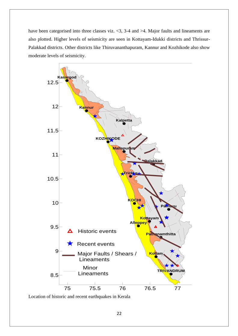
22
have been categorised into three classes viz. <3, 3-4 and >4. Major faults and lineaments are
also plotted. Higher levels of seismicity are seen in Kottayam-Idukki districts and Thrissur-
Palakkad districts. Other districts like Thiruvananthapuram, Kannur and Kozhikode also show
moderate levels of seismicity.
Location of historic and recent earthquakes in Kerala
75 75.5 76 76.5 77
8.5
9
9.5
10
10.5
11
11.5
12
12.5
TRIVANDRUM
Kollam
Pathanamthitta
Alleppey
Kottayam
Painavu
KOCHI
Trichur
Palakkad
Mallapuram
KOZHIKODE
Kalpetta
Kannur
Kasargod
Historic events
Recent events
Major Faults / Shears / Lineaments
Minor Lineaments

23
2.8 Lightning
Lightning is a weather phenomenon. It is essentially an electrical discharge. This is not
a phenomenon peculiar to Kerala. It is part of a global electrical system known as the ‗Global
Electric Circuit‘ involving the earth, ionosphere, and the atmosphere in between. On an
average about 70 people in the state die due to lightning. This figure is based on felt reports
available with village offices and old news papers for 17 years between 1986 and 2002. That
is, when an event of injury or loss of property is reported it becomes one datum. The degree
of destruction seen in the data is an under estimate because destruction of some property like
house hold objects and trees goes unreported. The magnitude of the problem as seen from this
felt report data is presented as dot map below. The dots indicate that lightning has occurred in
that location. There are numerous overlaps of dots in the plot. It can be seen that there is a
relative void in incidents in an area west of the Palakkad. More specifically the region west of
Palakkad namely the region near Thrisur has less incidence. This is because the mountain
range has a gap in Palakkad and so the absence of mountain results in less Cb formation and
lightning incidence. The two figures indicate that the mid land of Kerala has more lightning.
The high lands have the least of incidence and the frequency and distribution in the low lands
falls between the other two.
District Wise Distribution of Accidents
District wise distribution of lightning taken from the same data is given in graph 2. The
bar graph gives a picture of the relative distribution of incidence in different parts of the state.
The proximity of a mountain in forming a Cb to cause lightning seems to be the reason for
the difference in incidence in different districts.
Graph 2: District wise distribution of lightning incidence in Kerala
LIGHTNING - DISTRICT WISE
159
257
51
218
92
125104
36
83
242 249
19
353
108
0
50
100
150
200
250
300
350
400
Triv
andr
um
Kol
lam
Ala
ppuz
ha
Kot
taya
m
Iddu
ki
Path
anam
thitt
a
Ern
akul
am
Thr
issu
r
Pala
kkad
Koz
hikk
ode
Mal
appu
ram
Way
anad
Kan
nur
Kas
arag
od
District (Name)
Eve
nts
, Dea
th &
Inju
ry (N
o.)
Death
Injury
Evets

24
Lightning hits plotted over the physiography map of Kerala
Month wise Distribution of Incidents

25
The Cb clouds usually form and produce lightning in, so to say, two seasons in an
year. The first season comprises of months April and May and the second is for the two
months of October and November. This is seen depicted in the bar graph of month wise
fraction shown in graph 3.
Graph 3: Plot of month wise fraction of lightning incidents
Analysis of the 17 year‘s data yielded the most probable time for lightning to occur in
a day also. Of the cases where time was available it was found that 83% of the events have
happened between 1500 h and 1900 h.
2.9. Drought
Drought is a natural disaster and represents a period of 'drier-than-normal' conditions that
results in water related problems. The table below shows the occurrence and intensity of
drought (as per IMD criteria) in Kerala between 1871 and 2000. So far no studies have been
attempted to map the drought prone areas of the state. Drought is not very well studied in
Kerala from a risk reduction perspective.
Occurrence and intensity of droughts over Kerala during 1871-2000
Decade
Intensity and occurrence of drought
Mode
rate Large Severe Disastrous Total %
1871-80 0 0 1 5 6 60
1881-90 0 2 2 5 9 90
Month - wise Fraction of Total Incidence
1
45
21 22
7
31
4
19
10
2
0
5
10
15
20
Jan Feb Mar Apr May Jun July Aug Sep Oct Nov Dec
Months (Name)
Fra
ctio
n (
%)

26
1891-00 0 1 1 2 4 40
1901-10 2 0 2 2 6 60
1911-20 1 1 1 2 5 50
1921-30 2 1 0 1 4 40
1931-40 0 1 1 1 3 30
1941-50 1 0 0 2 3 30
1951-60 0 1 0 1 2 20
1961-70 3 1 1 1 6 60
1971-80 3 2 1 1 7 70
1981-90 0 0 0 6 6 60
1991-00 0 1 2 2 5 50
Total 12 11 12 31 66 51
Drought
intensity, % 18.2 16.7 18.2 46.9 - -
2.10. Man Made Disasters
2.10.1 Road Safety In Kerala
India has one of the worst road crash rates in the world, 6 to 8 times more than most
motorized countries. Within India, Kerala has one of the worst crash records in terms of
deaths per vehicle registered. Since the beginning of the present century, Kerala has
registered more than 2.38 lakh accidents in which about 2.50 lakh persons were injured, and
more than 15,000 persons were killed. Though accidents have been declining in developed
countries, Kerala registered a figure of 41,681 accidents in 2005, surpassing all the previous
records. From 1960 to 2005, there is a steady increase in number of accidents, number of
persons injured and number persons killed. Annual cost of these accidents to the exchequer is
of the magnitude of Rs. 450 cores, which is equivalent to about 1.5 percent of the State
Domestic Product. This is in part due to the high population density of the State. Awareness
of this situation is, in large part due to work undertaken at NATPAC. The present state of the
road network has much to do with the road safety problem. Little money is spent on
maintenance and minor improvements, and investment in Kerala‘s excellent health and
education systems has often been at the expense of road funding.
Growth of Accidents in Kerala

27
Year Number of
accidents
Persons
Injured
Persons
Killed
Number of
Vehicles in
lakhs
Accidents/1000
vehicles
1960 1528 1663 235 0.24 63.67
1965 2871 2982 368 0.55 56.34
1970 4214 4300 500 0.86 49
1975 5639 7107 842 1.31 44.69
1980 7064 9913 1184 1.75 40.37
1985 13756 18455 1489 3.78 37.78
1990 20447 26996 1793 5.81 35.19
1995 36086 49950 2519 10.06 35.87
2000 37072 49399 2710 19.1 19.41
2005 42363 51127 3203 31.22 13.57
2006 41647 49881 3589 35.59 11.7
2007 39917 48248 3778 40.25 7.28
2008 37263 43841 3897 44.42 8.39
2009 35434 41226 3742 48.8 7.26
Source: NATPAC
2.10.2. History of Major Accidents in Kerala (Road / Rail/Boat)
Perumon Tragedy, 8 July 1988. The Bangalore kanyakumari Island Express Train derailed
on Perumon bridge over Ashtamudi lake, near Perinad, Kollam and fell into the lake,
killing 107 people. Railway claims that the cause of the accident was a Tornado while the
real cause still remains a mystery.
Nine home-bound children of a primary school, eight of them girls, were killed and 11
injured when a van ran over them near Irikkur, about 22 km from Kannur, on 4th
December 2008
18 dead as boat capsized at Thattekkad -Periyar River on 20 Feb 07.The accident
happened at the Periyar river at the vicinity of the Bird Sanctuary, 55 km east of the port
city of Kochi.
Kumarakom Boat Accident: 29 persons who lost their lives in the boat accident on July
27, 2002 that a boat from Muhamma, carrying mostly youngsters who were coming to
Kottayam to appear for a test conducted by the Kerala Public Service Commission,

28
capsized off Kumarakom coast in the Vembanad lake. Twenty-nine lives were lost on the
spot, while another person who had received injuries succumbed to it a year later
The Kadalundi River rail disaster was one of the biggest accidents on the Indian railway
network in 2001. On 21 July, the Mangalore Mail commuter train heading for Chennai
was crossing the Kadalundi River in the state of Kerala near Calicut on Bridge 924, when
four carriages derailed and fell into the river. a figure of 57 people was eventually reported
as killed or missing, including at least eight women and two children, whilst between 117
and 300 were injured and transported to nearby hospitals. These figures were still
challenged by some, who said the toll was higher and that a number of people were still
missing.
2.11. Industrial & Chemical Disasters
There is hardly any information regarding the hazard potential of industries in the state.
However, it is reported that 55% of LPG that is required in the state is transported from
Mangalore and 45 % of it is transported by road. Presently, road transportation of dangerous
goods is a very weak area.
References
1. Kurian,N.P., Abhilash,P.P., Rajith,K., Murali Krishnan,B.T. & Kalairasan,P. (2006):
Inundation characteristics and geomorphological impacts of December 2004 tsunami on
Kerala coast. Current Science, 90, 240-249.
2. CESS, 2010. Plan Project 239. Detailed Project Report.
3. Kuriakose, S.L., 2010. Physically-based dynamic modelling of the effect of land use
changes on shallow landslide initiation in the Western Ghats of Kerala, India. PhD thesis
University of Utrecht. 254 p., ISBN: 978-90-6164-298-5.
www.itc.nl/library/papers_2010/phd/kuriakose.pdf
4. Kuriakose, S.L., Sankar, G. and Muraleedharan, C., 2009. History of landslide
susceptibility and a chorology of landslide prone areas in the Western Ghats of Kerala,
India. Environmental Geology, 57(7): 1153-1568.
5. NATPAC Studies.

29
Chapter III
Prevention and Mitigation Measures
Introduction
Preventing the occurrence of many of the natural hazards is impossible. However, life
and property loss due to such extreme events can substantially be reduced by adopting
mitigation measures (ADPC, 2005). Clear guidelines that address adoptable mitigation
measures relating to individual natural and anthropogenic hazards is yet not complete for the
state. Mitigation measures can be structural and non-structural; structural being construction
of levees, check dams, control walls, etc. and non-structural being policies, awareness,
methods and operating practices etc. It is known from the experiences of other States that that
proper mitigation measures can result in huge economic benefit compared to a situation
where no mitigation measures are adopted (Govt. of India, 1997).
It may be noted that although several studies addressing individual hazards have been
conducted in the state ever since the colonial era, a focussed attempt to develop them into
detailed mitigation plans suitable for various hazard prone regions of the state is still lacking.
Further, a mitigation plan applicable to the entire state for a given type of hazard is nothing
more than a myth. Based on available research from the State and elsewhere from the
country, some general approaches for mitigating individual hazards are provided below
which may be made use of by departments of the State for preparing their DM Plans and by
District disaster Management Authority for preparing District DM Plans. Attempts are
ongoing under the combined auspices of SDMA and CESS to compile and validate these
approaches and eventually evolve detailed hazard mitigation plans.
Floods
A vast area in the state is prone to floods. It is required to introduce flood
management system as a part of the integrated management plans of the river basins of the
state. Drainage improvement shall be integrated into the master plan for water management in
the urban areas with a specific focus on flood control.
Mapping of the flood prone areas is the primary step involved in planning mitigation
measures. Historical records give the indication of the flood inundation areas, the period of
occurrence and the extent of the coverage. It is better to reduce population density in flood
prone areas. In flood prone areas where people already have built their settlements, measures
30
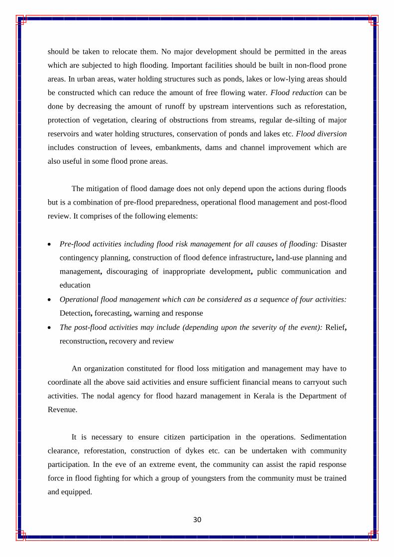
should be taken to relocate them. No major development should be permitted in the areas
which are subjected to high flooding. Important facilities should be built in non-flood prone
areas. In urban areas, water holding structures such as ponds, lakes or low-lying areas should
be constructed which can reduce the amount of free flowing water. Flood reduction can be
done by decreasing the amount of runoff by upstream interventions such as reforestation,
protection of vegetation, clearing of obstructions from streams, regular de-silting of major
reservoirs and water holding structures, conservation of ponds and lakes etc. Flood diversion
includes construction of levees, embankments, dams and channel improvement which are
also useful in some flood prone areas.
The mitigation of flood damage does not only depend upon the actions during floods
but is a combination of pre-flood preparedness, operational flood management and post-flood
review. It comprises of the following elements:
Pre-flood activities including flood risk management for all causes of flooding: Disaster
contingency planning, construction of flood defence infrastructure, land-use planning and
management, discouraging of inappropriate development, public communication and
education
Operational flood management which can be considered as a sequence of four activities:
Detection, forecasting, warning and response
The post-flood activities may include (depending upon the severity of the event): Relief,
reconstruction, recovery and review
An organization constituted for flood loss mitigation and management may have to
coordinate all the above said activities and ensure sufficient financial means to carryout such
activities. The nodal agency for flood hazard management in Kerala is the Department of
Revenue.
It is necessary to ensure citizen participation in the operations. Sedimentation
clearance, reforestation, construction of dykes etc. can be undertaken with community
participation. In the eve of an extreme event, the community can assist the rapid response
force in flood fighting for which a group of youngsters from the community must be trained
and equipped.

31
Drought
Most of the water sources in Kerala are partially perennial and hence many parts of
the state are prone to hydrological drought between the months of January and June (cf.
Chapter 3). Many of the traditional sources of water in the state are neglected and the
traditional practices are gradually dying out due to a variety of reasons. It should be
highlighted that the practice of taking circular basins around coconut palms during monsoon
season is largely declining in the recent past. The same is the case with the practice of
ploughing. As a combined effect of several such factors the severity of drought is highly
pronounced in the recent times when the northeast monsoon is below normal and/or the
summer showers fail.
Drought, different from other natural disasters, do not cause any structural damages.
The impacts of drought can be reduced through preparedness planning by identifying
principal activities, groups, or regions most at risk and developing mitigation actions and
programs that alter these vulnerabilities. Such a detailed drought mitigation plan is yet to be
prepared for the state and hence only general directions for drought mitigation is provided
herein.
Similar to the management of floods, a watershed based management approach is the
most ideal for drought mitigation. From an evaluation study on the impact of soil and water
conservation methods in three watersheds under the Western Ghats Development
Programme, it is known that established watershed management techniques can improvement
lean flow during summer months, reduction in recession of ground water table, improve the
soil moisture and increase the productivity of cash crops. Locally increasing the water
availability in each micro watershed would naturally lead to alleviation of drinking water
scarcity in the treated areas and benefit all the crops, in both uplands and lowlands. The
Hariyali project funded by the Department of Land Resources, Govt. of India that is being
executed in Chadayamangalam block, Kollam district is an excellent example for revitalizing
local water resources and thereby tackling hydrological drought conditions (Hariyali detailed
project report, 2010).

32
The state Agriculture and Soil Conservation Departments have standardized
structural/mechanical and agronomic measures for soil and water conservation strategies. An
obvious structural method of meeting the water scarcity is to store the excess water during the
monsoon period by creating large and small (check dams) reservoirs along the river course
and utilize the stored water during the dry period. Agronomic measures include contour
farming, off-season tillage, deep tillage, mulching and providing vegetative barriers on the
contour. A number of such schemes have been already implemented in the state, while the
actual results of such interventions are yet to be quantified in scientific terms.
An attempted to revitalize the traditional water sources may be of great leverage in
tackling local drought conditions. In a survey carried out by the CWRDM, about 1000 ponds
and tanks, each capable of irrigating a minimum of 2 ha of land were identified (CWRDM,
1989). Farm ponds extending up to 25 acres exist in Palakkad district. There are several
interconnected/ networked ponds in Palakkad, Trivandrum and Ernakulam districts. Another
survey conducted by CWRDM (1988) gave information on 250 springs in Kerala. Several
springs were seen in the high range districts of Wayanad and Idukki and in the Attappady
block of Palakkad district. It is very much important to rejuvenate these traditional sources of
water. The construction of check darns across the streams and diversion of water to the
adjacent plots for irrigation were age-old practices prevailed in Kerala. Restriction on
Conversion of Paddy Fields and Wetlands will help in enhancing the excess rainwater
retention in these natural bowls, which in turn reduce the flood discharge and increase the
groundwater potential.
The existing drought management system has increased the dependence of people and
communities on the State. As a result, people in drought-prone areas have abandoned
traditional practices of drought management. There are government‘s initiatives in drought-
proofing like the Drought Prone Areas Programme (DPAP), the Desert Development
Programme (DDP), Integrated Wasteland Development Programme (IWDP) and
Employment Assurance Scheme (Watershed). Unfortunately, most of these central schemes
do not cover the State of Kerala.
Landslide
Unlike other hazards occurring in Kerala, landslides, particularly debris flows (Urul
Pottal) are well studied by several researchers in several regions of the state (Kuriakose,
33
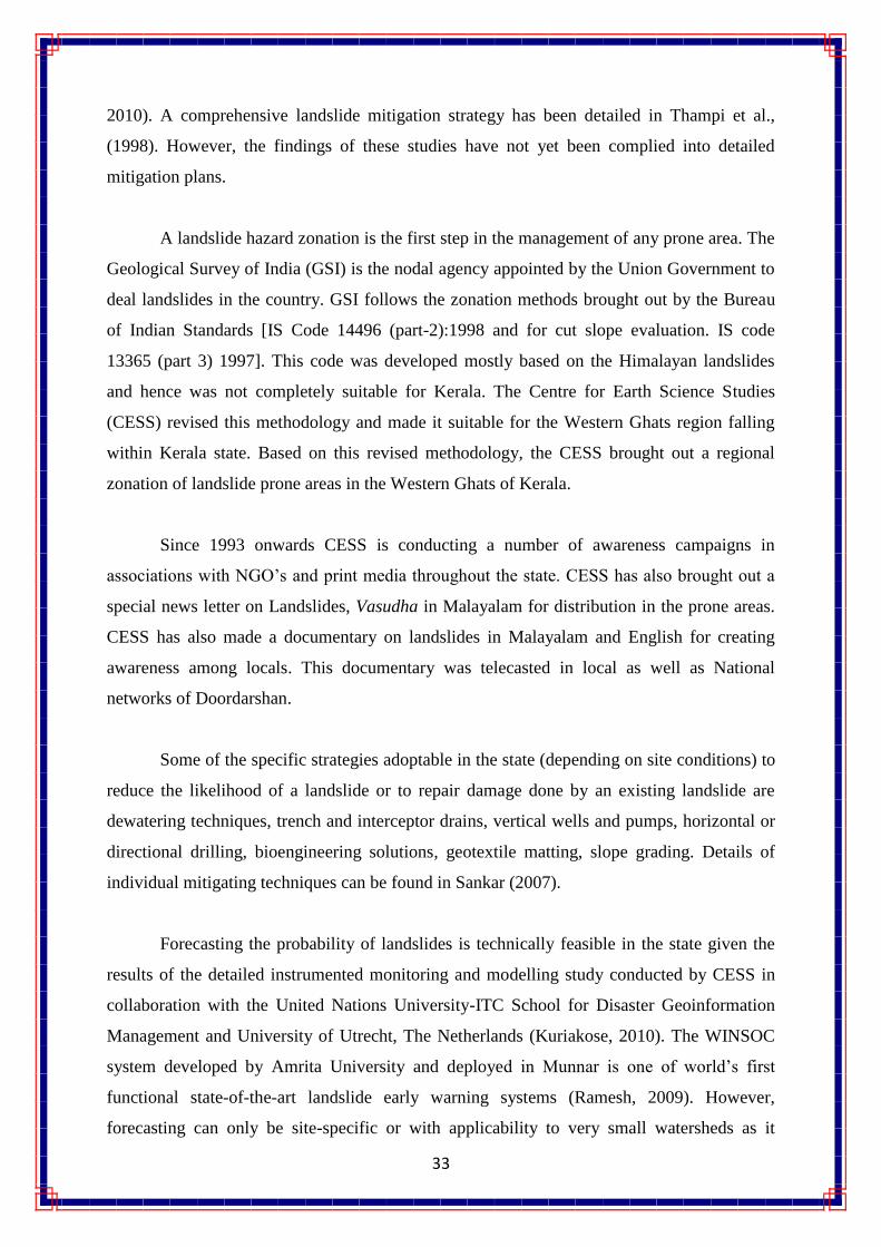
2010). A comprehensive landslide mitigation strategy has been detailed in Thampi et al.,
(1998). However, the findings of these studies have not yet been complied into detailed
mitigation plans.
A landslide hazard zonation is the first step in the management of any prone area. The
Geological Survey of India (GSI) is the nodal agency appointed by the Union Government to
deal landslides in the country. GSI follows the zonation methods brought out by the Bureau
of Indian Standards [IS Code 14496 (part-2):1998 and for cut slope evaluation. IS code
13365 (part 3) 1997]. This code was developed mostly based on the Himalayan landslides
and hence was not completely suitable for Kerala. The Centre for Earth Science Studies
(CESS) revised this methodology and made it suitable for the Western Ghats region falling
within Kerala state. Based on this revised methodology, the CESS brought out a regional
zonation of landslide prone areas in the Western Ghats of Kerala.
Since 1993 onwards CESS is conducting a number of awareness campaigns in
associations with NGO‘s and print media throughout the state. CESS has also brought out a
special news letter on Landslides, Vasudha in Malayalam for distribution in the prone areas.
CESS has also made a documentary on landslides in Malayalam and English for creating
awareness among locals. This documentary was telecasted in local as well as National
networks of Doordarshan.
Some of the specific strategies adoptable in the state (depending on site conditions) to
reduce the likelihood of a landslide or to repair damage done by an existing landslide are
dewatering techniques, trench and interceptor drains, vertical wells and pumps, horizontal or
directional drilling, bioengineering solutions, geotextile matting, slope grading. Details of
individual mitigating techniques can be found in Sankar (2007).
Forecasting the probability of landslides is technically feasible in the state given the
results of the detailed instrumented monitoring and modelling study conducted by CESS in
collaboration with the United Nations University-ITC School for Disaster Geoinformation
Management and University of Utrecht, The Netherlands (Kuriakose, 2010). The WINSOC
system developed by Amrita University and deployed in Munnar is one of world‘s first
functional state-of-the-art landslide early warning systems (Ramesh, 2009). However,
forecasting can only be site-specific or with applicability to very small watersheds as it

34
largely dependents on the local rainfall characteristics, vegetation characteristics, soil depth,
slope hydrological responses and the availability of historical landslide database (Kuriakose,
et al., 2009).
At present, Indian Meteorological Department (IMD) is capable of issuing heavy
rainfall warning only at district level which is insufficient for issuing landslide early
warnings. In the state it is the Revenue Department that maintains data pertaining to disasters
such as landslides. Apart from governmental departments and agencies, many newspapers
keep archival data. It may be noted here that the reported occurrences of landslides are only a
minor percentage of the actual happenings in the region. Normally the landslides with loss of
life and property or considerable damage to public utilities like communication lines attract
the attention of the authorities. Considerable part of the happenings in large scale plantations
and forest land is not properly documented. These constrains limit the effective functioning
of early warning systems.
Lightning
Some parts of Kerala are highly prone to lightning (cf. Chapter 3). Once lightning is
initiated, it is impossible to escape from a lightning flash. This is because the whole
phenomenon of one lightning flash, actually consisting of several flashes, will be over within
about 1/10th
of a second and the minimum time of response of a human being is also of the
same order. However, an understanding of lightning can go a long way in reducing the
hazard due to lightning.
Kerala is a region with high density of vegetation. This results in most of the houses,
RCC roof or otherwise, having a good number of trees nearby. In most of the cases the
nearby trees are taller than the building which limits the lightning conductor installed atop
them from protecting the trees. On lightning hitting one of the trees nearby, because of the
electrical wiring and earthing of the house the lightning energy enters the house through the
ground. The lightning rod does not prevent this. A ring conductor installed around the house
can prevent such destruction to a large extent.
Electrical and electronic equipment, irrespective of whether they are inside a safe
building or not, can go bad due to lightning energy entering their circuit directly or
through telephone, internet and cable television networks. These equipments can be protected

35
to a considerable extent from lightning damage by installing a Lightning Arrestor. The CESS
has issued best practices guidelines to reduce loss of life and property due to lightning
(Muralidas, 2007).
Earthquakes
The seismicity pattern of Kerala exhibits crude spatial clustering around 1)
Achankovil-Punalur 2) Idukki-Pala and 3) Thrissur-Palakkad areas, with minor activity near
Trivandrum and Calicut. Although the mechanisms leading to earthquakes occurring in the
state has been well documented, there have not been attempts to develop detailed mitigation
plans. Available techniques and recommendations are all based on the Indian Standard
Codes.
The present earthquake monitoring network and its state of affairs are detailed in
Radhakrishnan (2007). Two sophisticated seismic observatories are function in the state since
1999, they being, the Peechi station of CESS and the Thiruvananthapuram station of IMD.
After the 2000/2001 Irattupettah earthquakes, a major programme on time evolving-
deformation based on GPS geodesy was initiated by CESS in and around Palghat gap and by
Cochin University of Science and Technology (CUSAT) in and around Achankoil shear zone
in collaboration with C-MMACS, Bangalore. Studies related to mapping geological
structures to understand previous movements on selected faults have been initiated at CESS.
Geophysical studies (Gravity and Magnetic) initiated at CESS and CUSAT along some of the
major fault / shear zones such as Bavali shear, Palghat shear, Periyar and Idamalayar faults
and Achankovil shear have shed light on the structural and tectonic aspects of these regions
(Radhakrishnan, 2007). There is still need to strengthen instrumented monitoring, especially
for monitoring micro tremors. Detailed seismic micro-zonation of the urban areas especially
those situated on reclaimed wetlands such as parts of Kochi city are still lacking.
Buildings being the most severely affected structures need to be designed and built to
withstand ground shaking. It is necessary to analyze soil type before construction and
permission shall not be given to build structures on soft soil. Enforcement of construction
byelaws, restriction on density and height of buildings and strengthening of important lifeline
buildings are priority mitigatory steps to be adopted in Kerala.

36
Community based earthquake risk management strategies should be developed.
Retrofitting of schools and important buildings, purchase of emergency response equipment
and facilities, establishing proper insurance can be the programmes under Earthquake Risk
Management Project. Local masons and engineers needs to be trained in disaster resistant
construction techniques.
Cyclone
The coastal areas of the state are subjected to severe wind storms and cyclonic storms.
Low pressure and the development of cyclones can be detected hours or days before its
damage effects start. IMD uses satellites such as INSAT to track the movement and use
geospatial technologies to project the likely path. Cyclone warning is disseminated by several
means such as satellite based disaster warning systems: radio, television, telephone, fax, high
priority telegram, public announcements and bulletins in press. Very few studies have been
conducted pertaining to cyclone hazard, vulnerability and risk reduction in the state. Known
techniques for cyclone risk reduction are based on experiences elsewhere and are briefly
described blow.
Cyclone hazard mapping requires meteorological records of the wind speed and
direction based on which the probability of extreme wind speeds is derived. Past records and
paths can give the pattern of occurrence for particular wind speeds. A hazard map will
illustrate the areas vulnerable to in any given year. Optimal construction practices should be
adopted such as:
It is advised to construct houses and other infrastructure on stilts or on earth mound. All
elements holding the structures need to be properly anchored to resist the uplift or flying
off of the objects
A row of trees surrounding coastal settlements can act as a shield. Many coastal villages
in Kerala have this vegetation belt
Buildings storing food supplies must be protected against the winds and water
Communication lines should be installed underground and satellite radio communication
should be made available in all coastal villages
Provide strong halls for community shelter in vulnerable locations
In conclusion, cyclone hazard requires to be studied in detail and location specific best
practices for hazard mitigation needs to be developed along the coastal areas of the state.

37
Transportation Accidents
Kerala has one of the worst crash records in terms of deaths per vehicle registered.
This is in part due to the high population density of the State, but there are many other
contributing factors and road crashes are costing Kerala between 1 and 2% of its GDP, or
conservatively, INR 450 crore per year. Transportation of hazardous materials by road has
also caused several catastrophic accidents. However, detailed studies related to such
accidents and mitigation strategies are yet to be conducted in the state. Strategies related to
the mitigation of rail accidents are not currently available. The Indian Railway has standard
procedures for ensuring the safety of rail traffic.
According to the yearly statistics published by the Govt. of Kerala, about 98% of all
road accidents in the State are deemed to have been caused by the negligence of motor
vehicle drivers. Inadequacies in the infrastructure, especially in the width of carriage-way,
availability of pavements or shoulders, and their upkeep, obstructions caused by unscientific
digging of roads and shoulders, raised or sunken man-holes, lack of basic discipline among
pedestrians and cyclists, inadequacies in road markings and cautionary signs and want of
strict enforcement of traffic rules by the police also play a role in leading to such large
number of road accidents in the state.
Since the development of road infrastructure to cope with the increase in traffic is
bound to be costly and time-consuming, our immediate priority ought to be for making the
best possible use of the available road space and creating proper awareness of road safety
matters among the people. In this context, a few aspects of special importance which are not
sufficiently known and appreciated at present are observance of ―Keep Right‖ by pedestrians,
avoidance of dark clothes at night by pedestrians, cyclists and two-wheeler riders, avoidance
of unplanned digging of roads and teaching road safety rules and best driving practices as
part of the school curriculum.
Forest Fire
In Kerala there are no comprehensive data to indicate the loss to forests in terms of
area burned, values, and volume and regeneration damaged by fire. The majority of the forest
fires (in the state are human caused. It is widely acknowledged that most of these fires are

38
caused by the people deliberately and have a close relationship to their socio-economic
conditions. Grazing, shifting cultivation, carelessness of the picnickers, travellers, and
camper and collection of minor forest products by villagers are major causes of forest fires.
The state forest and wildlife department has standard procedures such as fire line construction
and vista clearance that are meant to reduce the probability of forest fires.
Chemical and Industrial Accidents, and Urban Fire outbreaks
At present, no information on chemical and industrial risk reduction is available for the
state. Individual industrial complexes such as the Kochi Refineries Limited have their own
off-Site and On-Site DM Plans. However, considering the fact that HAZCHEM are
transported across the state by road, there is a need to address the transportation of hazardous
substances under prevention and management of chemical accidents by respective ministries /
State Departments in fine tuning the present legislative framework by introducing fresh rules,
guidelines and facilities for the prevention and management of transportation emergencies.
Although reasons for urban fire outbreaks are known, there is hardly any hazard or
vulnerability assessment carried out in this regards and hence specific risk reduction
strategies are not available.
Epidemics
The state Health Department is responsible for the control and mitigation of epidemic
outbursts. Structuring the health services is important to have clear understanding of roles and
responsibilities of the public health system. Organizational preparedness and the coordination
mechanism are required right from the State and District to the sub center level which is
manned by the Village Health Nurses or the Health Workers.
An early warning system through a surveillance system is the primary requirement so
as to have an effective response and prevent any outbreaks. For this, surveillance needs to be
carried out at a regular basis through the routine surveillance system by involving the health
tier system. Maps of all the health facilities in the region with an inventory of drugs and
vaccines, laboratory set ups, list of number of doctors and supporting staff etc. need to be
kept ready and updated at regular intervals. Training need to be given to so as to build the
capacity at all levels. Training will help to cope better during the emergency response period
for epidemics. Personnel protection through vaccination is an effective mitigation strategy
and will protect the persons at risk.

39
Mainstreaming Disaster Mitigation in to Development Plans
The Disaster Management Act, 2005 (section 23.4.C) states that the State Disaster
Management Plan shall include the manner in which the mitigation measures shall be
integrated with the development plans and projects. The Eleventh Five Year Plan also
emphasises the necessity of mainstreaming disaster management into development planning
and requires that every development plan of a department should incorporate elements of
impact assessment, risk reduction, and the ‗do no harm‘ approach. The Second
Administrative Reforms Commission (SARC) has recommended that disaster plans should be
included in the development plans of the line departments of State Governments and local
bodies.
Framework for Mainstreaming Disaster Management
Kerala State believes that disaster mitigation should be a part of the plan process and
that the expenditure therein should be met out of the plan resources of the respective
departments of the State. Although disaster mitigation is not generally associated with plan
financing, there are in fact a number of plan schemes in operation, on sectors such as
housing, health, infrastructure development and agriculture and on specific projects like
drought proofing, afforestation, drinking water etc., which deal with the prevention and
mitigation of the impact of disasters. It is advised that these schemes at the State level should
be targeted towards mitigation, even though the current levels of funding of these schemes
may not be adequate. The State Disaster Management Plan Profile calls for a framework for
mainstreaming disaster management in the State and necessitates the departments of the State
Government to give priority to hazard identification and risk assessment in their plans and
schemes and allocation of a portion of plan funds for efforts that directly or indirectly help in
disaster management.
The State Disaster Management Plan envisages formulation of a strategy for
mainstreaming disaster management in the State which includes awareness generation,
advocacy for political commitment, legislation, training and technical support, development
of tools and monitoring and evaluation, and development of a set of indicators and
assessment methodology.

40
a) Ways of mainstreaming Disaster Management
Structural Measures :
Ensuring all new critical infrastructure projects like power, water, communication etc
compulsorily comply with the safety standards of disaster reduction.
Implementation of techno-legal regime such as adoption of BIS codes.
Ensuring all the existing infrastructure projects are retrofitted from future disasters, to
the extent possible.
Ongoing projects/programmes and already completed projects/programmes need to be
audited to ensure that resilience to specific disasters to which the concerned locations
are vulnerable.
Non – Structural Measures :
Amendment of Building by-laws, Land Use Regulations etc.
Master plans for Earthquake Proofing /Flood Management etc.
Flood Plane zoning
Specific Disaster Mitigation Programmes :
Implementation of Cyclone Risk Mitigation Programme
Implementation of Earthquake Risk Mitigation Programme
Implementation of State/District/local mitigation projects
b) Thematic / Sectoral linkages
Identify Key Sectors : To mainstream disaster management, key sectors such as
housing, infrastructure development, education, health and agriculture may be
identified.
Develop appropriate guidelines for different sectors :
Housing – Promote increased use of hazard-resilient designs (flood proofing, seismic
safety etc.,) in housing in hazard-prone areas, Utilization of national building codes
and compliance and enforcement of codes and standards in hazard prone areas

41
Infrastructure: Public Works, Roads and Construction - Promote use of hazard risk
information in land-use planning and zoning regulations, Conduct disaster risk impact
assessments as part of the planning process before the construction of new roads or
bridges.
Agriculture - Promote contingency crop planning to deal with year to year climate
variations, Promote crop diversification including the use of hazard resistant crops to
deal with shifts in climate patterns, Ensure sustainable livelihoods in areas of recurrent
climate risks (i.e. arid and semi-arid zones, flood and cyclone prone areas) by
promoting supplementary income generation from off-farm (e.g. animal husbandry)
and non-farm activities (e.g. handicrafts), Promote effective insurance and credit
schemes to compensate for agricultural related damage and losses to livelihoods due to
natural hazards.
Education - Incorporate DRR modules into the school curriculum, Construct all new
schools located in hazard-prone areas to higher standards of hazard resilience,
Health – Conduct vulnerability assessment of hospitals in hazard-prone areas, Promote
hazard resilient construction of new hospitals, Implement disaster preparedness plans
for hospitals.
Identify Key Programmes within each identified sector : Specific programmes
such as Indira Avas Yojana, Sarva Siksha Abhayan and JNNURM may be identified
for mainstreaming.
Identify entry points and develop and employ mainstreaming tools in the project
management cycle
Collecting and Using Information on Hazards, Environmental Assessment,
Vulnerability Analysis, Social Impact Assessment, Risk Assessment, Economic
Analysis, Safe Construction Design, Building Standards and Site Selection etc,.
Application of Checklists - Setting a series of questions relating to disaster risk
reduction, which must be answered during developing project planning documents.

42
Chapter IV
POLICY, INSTITUTIONAL, TECHNO – LEGAL & FINANCIAL FRAME WORK
FOR DISASTER MANAGEMENT IN THE STATE
Kerala State has established a ‗Policy, Institutional and Techno – Legal Frame Work‘ for
disaster management‘ in the State which creates an enabling regulatory environment and
compliance regime in the State and facilitates the activities of different phases of disasters.
Execution of Disaster Management Act, 2005 and enactment of Kerala State DM rules
The State Government, in line with National Disaster Management Act, 2005, has notified
Kerala State Disaster Management Rules, 2007 (vide G.O (P) No. 71/2007/DMD dated
01/03/2007). The State has constituted State Disaster Management Authority (vide G.O (P)
No. 154/2007/DMD dated 04/05/2007) and District Disaster Management Authorities (vide
G.O (P) No. 303/08/DMD dated 09/09/2008) laying down clarity of roles and responsibilities
for State and District authorities. The State Executive Committee of State Disaster
Management Authority has also been constituted.
Kerala State Disaster Management Policy
The State Disaster Management Policy formulated by Department of Revenue and Disaster
Management and promulgated by State Disaster Management Authority acts as the guiding
principle for disaster management in the State. The goal of the Kerala Disaster Management
Policy is to institute structures and systems and to establish directive principles for effective
risk reduction and crisis management in order to minimise human, infrastructure, property,
environment and livelihood losses and to contribute to the sustainability of development and
better standards of living for poor and vulnerable sections.
Kerala State Disaster Management Authority and State Disaster Management Plan
Kerala State Disaster Management Authority shall function as the apex decision-making
body and shall facilitate, co-ordinate, review and monitor all disaster management related
activities in the State. The State Authority will lay down policies and plans for disaster
management in the State. The State Authority will coordinate the implementation of State
Disaster Management Plan and recommend provision of funds for various disaster
management activities, particularly mitigation and capacity building.
43
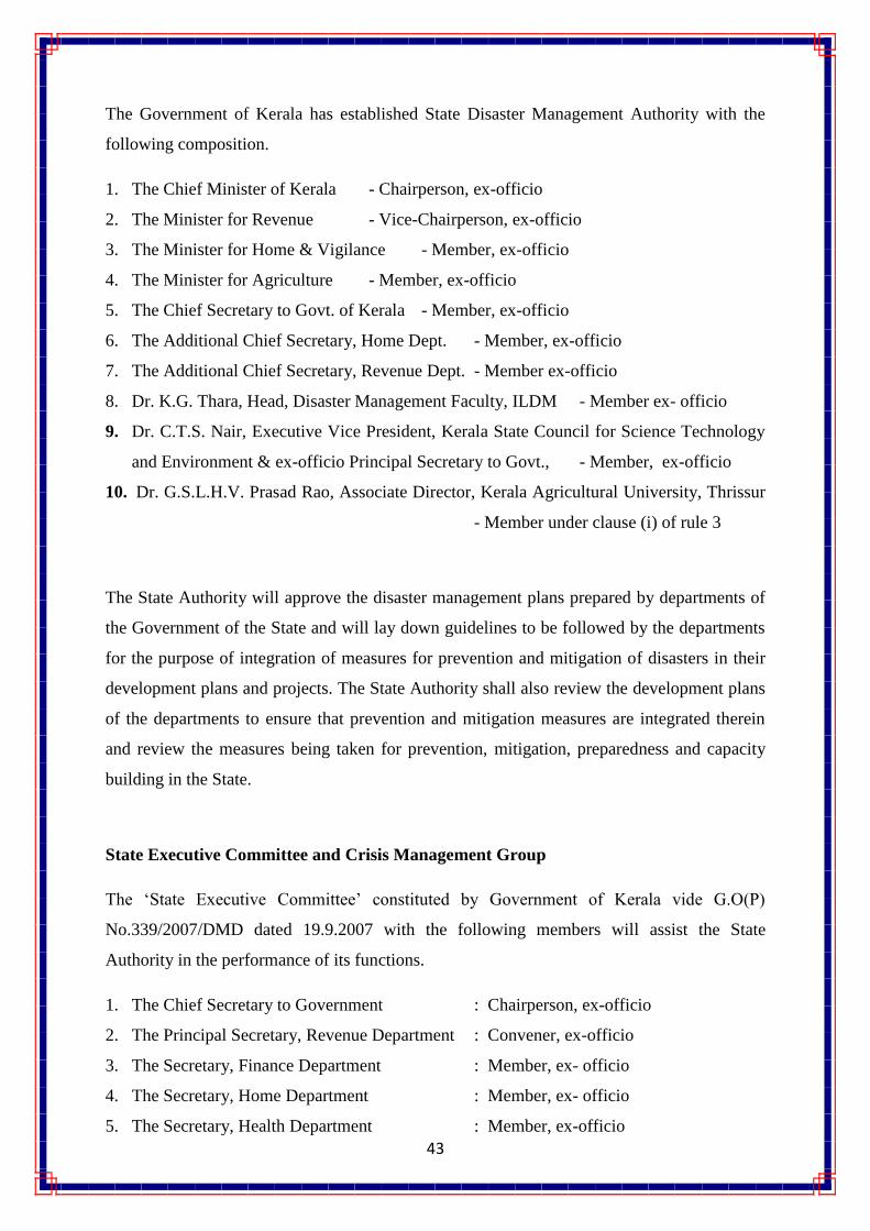
The Government of Kerala has established State Disaster Management Authority with the
following composition.
1. The Chief Minister of Kerala - Chairperson, ex-officio
2. The Minister for Revenue - Vice-Chairperson, ex-officio
3. The Minister for Home & Vigilance - Member, ex-officio
4. The Minister for Agriculture - Member, ex-officio
5. The Chief Secretary to Govt. of Kerala - Member, ex-officio
6. The Additional Chief Secretary, Home Dept. - Member, ex-officio
7. The Additional Chief Secretary, Revenue Dept. - Member ex-officio
8. Dr. K.G. Thara, Head, Disaster Management Faculty, ILDM - Member ex- officio
9. Dr. C.T.S. Nair, Executive Vice President, Kerala State Council for Science Technology
and Environment & ex-officio Principal Secretary to Govt., - Member, ex-officio
10. Dr. G.S.L.H.V. Prasad Rao, Associate Director, Kerala Agricultural University, Thrissur
- Member under clause (i) of rule 3
The State Authority will approve the disaster management plans prepared by departments of
the Government of the State and will lay down guidelines to be followed by the departments
for the purpose of integration of measures for prevention and mitigation of disasters in their
development plans and projects. The State Authority shall also review the development plans
of the departments to ensure that prevention and mitigation measures are integrated therein
and review the measures being taken for prevention, mitigation, preparedness and capacity
building in the State.
State Executive Committee and Crisis Management Group
The ‗State Executive Committee‘ constituted by Government of Kerala vide G.O(P)
No.339/2007/DMD dated 19.9.2007 with the following members will assist the State
Authority in the performance of its functions.
1. The Chief Secretary to Government : Chairperson, ex-officio
2. The Principal Secretary, Revenue Department : Convener, ex-officio
3. The Secretary, Finance Department : Member, ex- officio
4. The Secretary, Home Department : Member, ex- officio
5. The Secretary, Health Department : Member, ex-officio

44
The State Executive Committee will coordinate actions in accordance with the guidelines lay
down by the State Authority and will ensure compliance of the directions issued by the State
Government. The State Executive Committee will implement the State Plan and will act as
the coordinating and monitoring body for management of disasters in the State.
The State Executive Committee will also function as ‗Crisis Management Group‘ under the
chairmanship of Chief Secretary with Principal Secretary of Department of Revenue and
Disaster Management as convenor at the State level in the event of a disaster as a nerve
centre to support, coordinate and monitor crisis management activities related to various
disasters.
The Department of Revenue and Disaster Management
The scope of Department of Revenue has been enhanced to include prevention, mitigation
and preparedness aspects of Disaster Management apart from its traditional responsibility of
relief and rehabilitation and renamed as Department of Revenue and Disaster Management.
The department will be the nodal department for disaster management. The Principal
Secretary to government will act as the State Relief Commissioner. The organizational
structure of the Department dealing with disaster management will be so tailored as to reflect
the change in focus from post-disaster relief and rehabilitation to prevention, mitigation and
preparedness.
District Disaster Management Authorities and District Disaster Management Plans
The District Disaster Management Authorities notified and established by the State
Government in all fourteen districts will act as the district planning, coordinating and
implementing body for disaster management and take all measures for the purposes of
disaster management in the district in accordance with the guidelines laid down by the State
Authority. The District Disaster Management Authorities will prepare District specific
District Disaster Management Plans and coordinate and monitor the implementation of State
and District Plans. The District Authority will issue such instructions to different

45
Departments of the Government in the District on implementation District Disaster
Management Plan and Departmental Disaster Management Plans.
State Nodal Departments and Departmental Disaster Management Plans
The Department of Revenue and Disaster Management will be the nodal department for
management of all types of natural disasters that include geological and hydro-meteorological
disasters. The Department of Home shall be the nodal department for management of
manmade (and human induced) disasters including air and rail accidents. The Department of
Public Health shall be the nodal department for biological (health related), radiological and
nuclear disasters. The Factories and Boilers Department shall be the nodal department for
industrial accidents and the department shall work in tandem with Industries Department in
the event of a disaster. While Agricultural Department deals with drought, pest attacks and
hailstorm; cattle epidemics shall be handled by Animal Husbandry Department. Irrigation
Department shall be the lead agency for disasters related to dam bursts. Public Works
Department and Local Self Government Departments are the nodal agencies for major
building collapses. Forest Department shall be the nodal department for disasters like forest
fire.
Every nodal department of the State Government will prepare a Disaster Management Plan in
conformity with the guidelines issued by State Authority and furnish implementation status
report to the State Executive Committee of State Authority.
State Disaster Response Force
Kerala State has constituted State Disaster Response Force with headquarters at Peerumedu
Taluk in Idukki District for the purpose of specialised response to threatening disaster
situations. A Regional Response Centre of National Disaster Response Force is also set up in
Kozhikode, in addition to the Seasonal Response Centre in Idukki.
Emergency Operation Centres
A State Emergency Operation Centre (EOC) is set up under the nodal department of
Revenue and Disaster Management linked with the office of State Disaster Management
Authority. Its system and procedures are designed in such a way that information can be
promptly assessed and relayed to concerned parties as rapid dissemination contributes to

46
quick response and effective decision making during the emergency. EOC will function
round the clock and will maintain direct linkage with district control rooms through phone,
fax, wireless and internet. The State Disaster Management Authority will ensure that a
comprehensive information network is available for timely collection of hazard-related
information and rapid dissemination of relevant information and alerts/warnings.
Emergency Operation Centres are set up in each district headquarters under the control of
District Collectors for day to day monitoring of preparedness measures and to coordinate
rescue and relief operations.
State Nodal Departments will also establish Emergency Operation Centres and will assign
Nodal Officers for disaster management.
Institute of Land and Disaster Management
The Institute of Land and Disaster Management set up under the Department of Revenue and
Disaster Management will function as the nodal planning and analysis, and training arm of
the State Disaster Management Authority and will be responsible for training and research,
documentation and development of state level information base, generation of technical data
banks, generating short and long-term rehabilitation measures and for imparting appropriate
training to State and District level officials on disaster management. This institute will
promote sharing and dissemination of specialised knowledge on disaster management among
various implementation agencies, NGOs, private sector and the community in the state.
Techno – Legal Frameworks
The state government will follow national building codes and other codes as laid down by
Bureau of Indian Standards. Relevant departments / District administrations / local authorities
shall ensure that existing building bylaws, land use zoning regulations and development
control regulations correspond to the requirements for safe construction as laid down by
various agencies such as Bureau of Indian Standards (BIS) for seismic zone III. Transfer of
disaster resistant construction technology (Disaster resistant designs and construction
practices and retrofitting techniques) by capacity building of construction fraternity (town
planners, engineers, architects, builders and developers and masons) shall be promoted by the
state government.

47
State Disaster Response Fund
The Calamity Relief Funds which was in operation till March, 2010 to meet the expenditure
for providing immediate relief was merged in to State Disaster Response Fund vide
notification G.O (P) No. 498/2010/DMD dated 03-12-2010 on the recommendation of 13‘th
Finance Commission. The fund is maintained in the public account of the state for providing
immediate relief. The State Government will also claim on the National Disaster Response
Fund (previously NCCF) through memorandums for central assistance for relief and
rehabilitation in the event of any calamity of a larger proportion.

48
Chapter V
Preparedness and Capacity Building Measures
Preparedness involves measures that enable the government, communities and
individuals to respond rapidly and effectively to disaster situations and ensure that
communities and services are capable of coping with the effect of disasters.
Roles and responsibilities of important stakeholders
State Disaster Management Authority
The Kerala State Disaster Management Authority will act as the nodal agency for
preparedness and capacity building measures and would monitor the preparedness of the
State to various disasters.
State Disaster Management Authority will develop and constantly update, a Master
Disaster Management Plan for the State in furtherance of the State DM Plan Profile to enable
the State and District administrations, departments and the community to prepare for and to
respond systematically and effectively to disasters. Analyses of different types of hazards and
assessment of vulnerabilities and risks of the State for developing detailed prevention,
mitigation and preparedness measures would be part of State DM Plan. A comprehensive
repository of man power, machinery and other resources would be created, maintained and
easily accessible to the relevant authorities at all times to facilitate quick contact with people
and availability of resources on the onset of a disaster.
Departments of State Government
The departments of the State Government will prepare ‗Departmental Disaster
Management Plans‘ that involve programmes within the routine departmental works for
disaster prevention, mitigation and preparedness and strategies for its successful
implementation. The Departmental Plans will also describe the departmental responsibilities
during various disaster situations and department-level capacity building policy. The nodal
departments will prepare disaster specific DM plans for different types of hazards that keep

49
integration with the functioning of Crisis Management Groups and State EOC. The State
departments shall also formulate ‗Disaster Management Cells‘ within the departments and
shall deploy a senior officer as ‗Nodal Officer for Disaster Management‘. Details of the main
departmental officials (name, designation, and contact details), inventory of departmental
resources (resource, capacity, location etc.) and departmental standard operating procedures
shall also be prepared as part of departmental plans. Standard Operating Procedures that
precisely define how operations are to be carried out, explain what is expected and required
of the department personnel and procedures for evacuation, procurement of essentials,
deployment of resources and such other activities shall be prepared by relevant departments
to ensure effective functioning in the event of disasters.
District Collector / District Disaster Management Authority :
The State Disaster Management Plan imposes that there is a plan for disaster
management for the district. The District Collector shall facilitate and coordinate with local
bodies to ensure that pre-disaster activities in the district are carried out successfully and
ensure appropriate linkage between disaster management activities and regular development
activities. The District Collector shall facilitate training and awareness programmes for
communities and ensure that relevant officials in the district are properly trained in handling
possible disasters in the district.
Local Authorities
Local Authorities are responsible for ensuring compliance to various disaster
management specifications and codes stipulated by relevant agencies based on hazard
zonation and risk and vulnerability assessments. The local authorities shall coordinate
community based disaster preparedness activities of the district.
Non-Governmental Organisations and Private Sector
Civil society organisations, voluntary agencies and local community groups shall
actively participate in preparedness activities of the district and assist the district
administration and local bodies in providing trainings in the pre-disaster stage. The private

50
sector shall ensure compliance to disaster management codes and specifications stipulated by
relevant authorities and shall ensure that the staffs are adequately trained in disaster
management. Corporate sector shall actively involve in awareness generation, training and
research in the field of disaster management. The Industrial Sector would develop and
implement on-site and off-site disaster management plans as part of preparedness and
capacity building.
Preparedness & Capacity Building Programmes
a) Early Warning / Emergency Communication System :
In order to strengthen the emergency response communication capabilities and early
warning facilities of State and District administrations and to enhance coordination between
State, District administrations and villages, VHF based Early Warning System is installed in
295 vulnerable villages in the state with the support of Asian Development Bank and United
Nations Development Programme. This wireless radios system offers a free flow of
communication between District Head Quarters and Village Offices / Taluk Offices. The
wireless radio installed in the villages which is connected to a PA system through an
amplifier, facilitates the communication from District Headquarters to the general public, if
necessary. The PA system installed at the top of the Village Office building can disseminate
warnings or messages from District Administration to a distance of 1.5 KM (radius), enabling
District Collector to directly communicate to the community living in these villages. Other
than disseminating warnings, the system also provides communication facilities between
District Headquarters and Village Offices / Taluk Offices facilitating coordinated response
and relief in the event of a disaster.
b) Community Level Preparedness
The Government of Kerala has implemented a Community Based Disaster Risk
Management Programme in 197 vulnerable villages covering nine coastal villages with the
support of United Nations Development Programme that aimed at building local capacities at
various levels and promoted preparedness. Formation of Community based hazard
prevention, mitigation and preparedness plans and constitution of disaster management
committees and task forces were the main components of the project
c) Training & Capacity Building

51
Institute of Land and Disaster Management under the Department of Revenue and Disaster
Management functions as the nodal training arm of the State Disaster Management Authority. The
institute undertakes training for various governmental agencies, NGOs, public/private sector and the
community in the State with the help of National Institute of Disaster Management.
d) School Suraksha Programme
To generate awareness on disasters at school level, to promote a culture of disaster
preparedness in the school community in the state and to promote disaster management
clubs/teams in schools, Department of Revenue and Disaster Management has initiated a ‘School
Suraksha Programme’ in association with Department of Education. The programme launched in
2010 will cover all the Government Schools in the State. Rs. 1.75 Crores is allocated by Department
of Revenue and Disaster Management for the implementation of the programme.
e) Strengthening / Capacity Building of Search & Rescue Services
The Department of Revenue and Disaster Management has effectively utilised the
provisions in the Calamity Relief Fund to procure equipments necessary for search and
rescue for Fire and Rescue Services in the State. Rs. 20 Crores have been allocated during the
last two years for the same.
f) National Cyclone Risk Mitigation Programme
The Department of Revenue and Disaster Management will undertake construction of
Cyclone Shelters cum- multipurpose community centres in nine coastal districts, shelter belt
plantation & regeneration of mangroves, shelter connectivity and related activities in
vulnerable villages with due provisions for accommodating displaced families with the
support of National Disaster Management Authority and World Bank. The key objectives of
the Project is to create suitable infrastructure to mitigate the effects of cyclones in the coastal
Districts of the State and to reduce the vulnerability of coastal communities to cyclone and
climate hazards through improved access to emergency shelter, evacuation, and protection
against wind storms, flooding and storm surge in high risk areas. An investment proposal

52
worth more than Rs. 200 Crores has been submitted to National Disaster Management
Authority and the project is expected to be launched in 2011.
g) Government of India – United Nations Development Programme Disaster Risk
Reduction Programme
Based on the Disaster Risk Management actions stipulated in the National DM Act (2005) to
be undertaken by DM Institutions at various levels, risk reduction priorities identified in the
Eleventh Five Year Plan, actions highlighted in the Hyogo Framework of Action (HFA) and
lessons learnt from the implementation of GoI-UNDP Disaster Risk Management Programme
(DRM 2002-2009), a Disaster Risk Reduction Programme (DRR 2010-2012) is chalked out
by Ministry of Home Affairs with the support of United Nations Development Programme.
The DRR programme is envisaged to support State Government Programmes and initiatives
by providing critical inputs that would enhance the efficiency and effectiveness of these
efforts.
GOI-UNDP DRR Programme will have two outputs. I) Institutional strengthening & capacity
building for Disaster Risk Reduction to be implemented by NDMA. II) Urban Risk
Management to be implemented by Ministry of Home Affairs. The programme would have
four sub-outputs as follows: Institutional strengthening, Capacity-building for recovery,
Disaster risk reduction and Urban risk management. Rs. 1.3 Crores have been earmarked for
the implementation of the project in three Districts (Idukki, Wayanad & Palackad) and five
Municipal Corporations in year 2010.
h) Capacity Building Programmes under Capacity Building Funds recommended
by Finance Commission
Effective disaster response requires trained manpower to deal with complex situations
where effective and speedy handling can reduce the impact of a disaster on human life and
property. It is necessary to continuously undertake measures to build capacity amongst those
handling response and creating awareness amongst people. The Kerala State has been allotted
Rs. 20 Crores by Central Government on the recommendation of 13‘th Finance Commission
and this amount shall be utilised for taking up activities for building capacity in the

53
administrative machinery for better handling of disasters. The broad Capacity Building Plan
for next four years include strengthening of EOCs that function in 14 District Head quarters,
Setting up GIS Lab facilities for DM, Strengthening of State Disaster Response Force,
installation of Digital Rain Gauge systems in Taluks, preparation of IEC materials, setting up
knowledge Centre, Developing GIS based Critical Facility Information System for districts,
procurement of Search and Rescue equipments, Training and Capacity building of various
stakeholders and preparation/updation of district and state level disaster management plans as
envisaged in the DM Act

54
Chapter V
State Response Plan
The Disaster Response involves emergency search, rescue and relief measures taken in
anticipation of, during and immediately in the aftermath of a disaster to ensure that the effects
of the disaster are minimized. The overall response strategy will vary from level to level of
the disaster (L0, L1, L2, and L3) based on the ability of various authorities to deal with them.
The State will remain in readiness to provide assistance if needed in an L1 specified disaster
that can be managed at the district level. The State will actively participate, mobilise
resources at the state level and will provide assistance to the respective District Disaster
Management Authorities in disasters in the category of L2. Even though there cannot be
water tight compartmentalisation of responsibilities between districts and the State, the
participation of the State will normally be at the L2 level disaster.
Roles and Responsibilities of Stakeholders
State Administration
As and when a crisis situation is developed, the District Collector will flash the ‗first
information‘ to the State Administration / Crisis Management Group and stimulate crisis
management activities under the guidance of State Crisis Management Group. The Principal
Secretary, Department of Revenue and Disaster Management as convenor of State Crisis
Management Group would recommend to the State Government or State Disaster
Management Authority if the event needs to be declared as a state disaster (L2 Disaster)
The Kerala State Disaster Management Authority will facilitate, co-ordinate and monitor the
activities in the response phase. The Kerala State Disaster Management Authority would, if
required, co-ordinate with agencies of other states and other national and international
agencies to supplement the relief being provided.
The Crisis Management Group and Incident Response System at the state level will be
activated in this phase as Chief Secretary / Principal Secretary of respective nodal department
as the Responsible Officer. Each department would perform their respective responsibilities
as per the Emergency Support Function under the Incident Response System.

55
Departments of State Government
The relevant government nodal departments shall carry out search, rescue and immediate
relief operations as per the Departmental Disaster Management Plans and District Disaster
Management Plans under the overall supervision of State Disaster Management Authority.
District Disaster Management Authority
The District Disaster Management Authority headed by the District Collector will activate all
the institutional arrangements for disaster response in this phase as per the District Disaster
Management Plan.
Local Authorities
The Local Authorities including Municipal Corporations, Municipalities and District, Block
and Grama Panchayaths would work in close coordination with State Disaster Management
Authority and relevant government departments in performing the key activities of this phase
catering to the immediate requirements of affected population.
Non-Governmental Organisations and Private Sector
The human, material, technical and financial resources of Non-Governmental Organisations
and the private sector shall be mobilized to provide immediate relief to the affected people.
They shall also support the relief efforts of the State Government through supply of
emergency search and rescue items, hardware items like generators, pumps, industrial
equipments etc. along with deployment of skilled technicians and volunteers.
State Incident Response System for Response
The Incident Response System is an organized system of government departments and other
agencies that are to be worked under a structured pattern for response and immediate
recovery. The Incident Response System provides a structure under which all the line
departments will function in tandem with the District and State Administration and lays down
various tasks that may need to be performed by the existing administrative machinery at

56
various levels. Departments and external agencies are grouped into various ‗Emergency
Support Functions‘ under the system.
The State Administration will provide necessary support to the District Administrations, if
Districts are overwhelmed in any situation, as the initial efforts would always be taken by the
District Administration in any disaster response. In order to clearly demarcate proper
coordination of the various response efforts at the State level with that of the District, the
structure of the Incident Response System in the context of State response is formed and
given below.
The Organisational structure, particularly the HQ Incident Response Team of Incident
Response System at the State level will be activated only in a State level disaster and
Responsible Officer will involve all required Emergency Support Functionaries (ESF) and
Headquarters Incident Response Team (IRT) to support the on-scene Incident Commander
who will work in close coordination with State EOC and report to Responsible Officer.
Emergency Support Functions (ESF)
A crisis situation demands the intervention and assistance of experts from different
departments / fields in order to ensure a quick and effective recovery. Keeping this aspect of
disaster management in view, Emergency Support Functions have been conceptualised to
take care of various response actions. Each Emergency Support Function is headed by a lead
Responsible Officer
(Chief Secretary / Principal
Secretary of Nodal Dept.)
HQ Incident
Response Team
State EOC
INCIDENT
COMMANDER IRT
District - A
INCIDENT
COMMANDER IRT
District - B

57
department and the designated primary agency will be assisted by one or more support
agencies (secondary agencies) and will be responsible for managing the activities of the
Emergency Support Function. Nodal officers of all the ESFs would constitute and employ
Incident Response Team who will accomplish the response actions at the field level.
Similarly supporting agencies would also assign their nodal officers and IRT members will
assist the primary officers during response.
The relevant departments/ agencies shall draw up Emergency Support Function Plans and
constitute Incident Response Teams and designate resources in advance. Pre contract/
agreement can be made for all disaster relief items so as to avoid delays in procuring relief
items after disaster situation.
ESF – 1 Coordination (warning, evacuation, relief, shelter, damage assessment,
NGO/volunteers Coordination)
Primary Functions:
Establishment of evacuation plans / Identification of fastest evacuation routes and all
alternative routes.
Coordinate search and rescue logistics during field operation
Immediate arrangement of food and relief materials during the crisis.
Ensure coordination of activities involved with the emergency provisions of
temporary shelters, emergency mass feeding and bulk distribution of relief supplies to
the disaster victims
Control quality and quantity of food for relief/ Ensure timely distribution
Provide adequate and appropriate shelter to all population / Locate relief camps close
to open traffic and transport links.
Develop alternate arrangements for population living in structures that might be
affected even after the disaster.
Encourage various voluntary agencies and organizations to depute the volunteers /
Gather general youth mass to volunteer / Operation wise categorize the volunteers /
Identify any specialized skills and area of interest among volunteers.

58
Arrange of mass donations of monetary resource, food, clothes, medicines, essential
items, cattle feed, and cattle medicines.
Maintain a record of donations and its supply to the needy area.
In coordination with relevant depts. assess the Number of lives lost, Number of
People Affected, Number of Houses damaged (category wise), Damage of
Infrastructures like School, Hospitals, Govt. Buildings, Road, Electricity, Water
Supply etc.
ESF Primary Agency / Team
Leader
Supporting Agencies/
Nodal Officer
Coordination Revenue & DM / Commissioner
of Land Revenue or Head of
SDMA Secretariat
Police – DGP
Fire & Rescue –
Commandant
ESF – 2 Communication
Primary Functions:
Restore Communication facilities after disaster
Provide emergency communication for response to government: link affected site
with DEOC/DEOC with other Departments etc.
Provide communication facility to affected communities
Coordinate the requirements of temporary telecommunication in affected areas.
ESF Primary Agency / Team
Leader
Supporting Agencies/
Nodal Officer
Communication Police / DGP
BSNL / State Head
Pvt. Tele/mobile
operators, HAM Radio
Operators
ESF – 3 Search & rescue
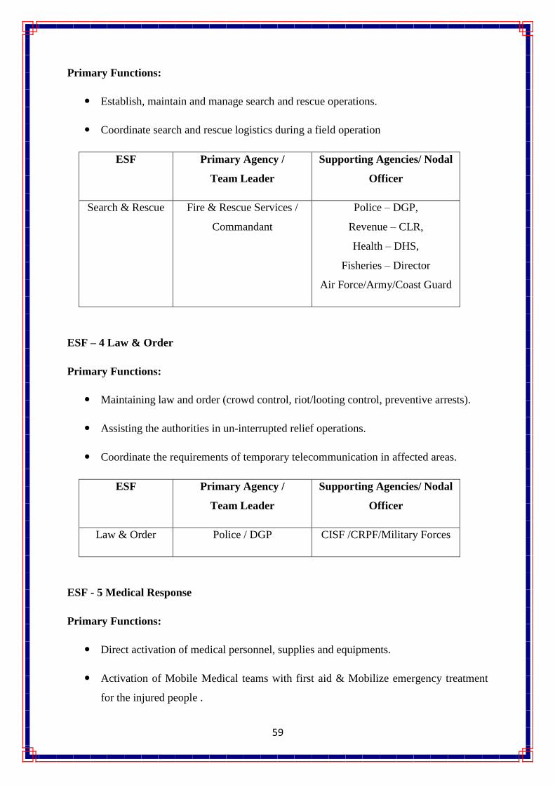
59
Primary Functions:
Establish, maintain and manage search and rescue operations.
Coordinate search and rescue logistics during a field operation
ESF Primary Agency /
Team Leader
Supporting Agencies/ Nodal
Officer
Search & Rescue Fire & Rescue Services /
Commandant
Police – DGP,
Revenue – CLR,
Health – DHS,
Fisheries – Director
Air Force/Army/Coast Guard
ESF – 4 Law & Order
Primary Functions:
Maintaining law and order (crowd control, riot/looting control, preventive arrests).
Assisting the authorities in un-interrupted relief operations.
Coordinate the requirements of temporary telecommunication in affected areas.
ESF Primary Agency /
Team Leader
Supporting Agencies/ Nodal
Officer
Law & Order Police / DGP CISF /CRPF/Military Forces
ESF - 5 Medical Response
Primary Functions:
Direct activation of medical personnel, supplies and equipments.
Activation of Mobile Medical teams with first aid & Mobilize emergency treatment
for the injured people .

60
Appropriate mass vaccination to check the waterborne epidemics.
Set up Trauma Counseling Desks.
Perform medical evaluation and treatment as needed.
Maintain patient tracking system to keep record of all patients treated.
ESF Primary Agency /
Team Leader
Supporting Agencies/ Nodal
Officer
Medical Response Department of Health / DHS Pvt. Hospitals, Ambulance
Services, Blood Banks, Indian
Red Cross, NGOs
ESF – 6 Public Works (debris/road clearance, equipment support)
Primary Functions:
Restore the road communication system / Assess the damage for reconstruction of
road ways
Restore the infrastructure like health centers, school, important buildings,
Initiate the reconstructions unrecoverable important infrastructures
Emergency clearance of Debris
Coordinate and provide manpower and equipments for debris and road clearance
Provide alternative routes, if main routes are affected
Demolish unsafe buildings
ESF Primary Agency /
Team Leader
Supporting Agencies/ Nodal
Officer
Public Works PWD / Chief Engineer Fire & Rescue , LSGD,
Revenue, Forest, MILITERY
SERVICES

61
ESF – 7 Public Information/Help lines/NGO coordination
Primary Functions:
Provide and collect reliable information on the status of the disaster / disaster victims
for effective coordination of relief work
Setting up of toll free numbers for emergency information assistance / Establish help
lines for providing, directing and coordinating logistical operations.
Process and disseminate information / Manage flow of information and warning
dissemination.
Provide a platform for NGO coordination
ESF Primary Agency /
Team Leader
Supporting Agencies/ Nodal
Officer
Public
Information
Public Relations / PRD Doordarsan, AIR, BSNL,
Media, NGOs
ESF – 8 Logistics (Water, Electricity & Transportation)
Primary Functions:
Ensure smooth transportation links
Restoration of power supply or temporary power supply to critical areas.
Facilitate restoration of electricity distribution systems at most affected sites on
priority to help in Search and Rescue operations.
Provide electricity in lifeline buildings.
Delivery of clean drinking water
Transportation of relief/relief parties/affected community.
Ensure quick restoration of drainage system.

62
ESF Primary Agency /
Team Leader
Supporting Agencies/ Nodal
Officer
Logistics Water – KWA / MD Revenue
Electricity – KSEB / CE PWD
Transport- Transport
Dept./Commissioner
KSRTC, Private Bus Owners

63
Annexure I
Emergency Telephone Directory
I. Kerala State Executive Committee / Crisis Management Group
6. The Chief Secretary to Government : Chairperson, ex-officio,
Contact no: 0471-2333147,2327376, Fax no:0471-2327176, Mobile no: 09447773303
7. The Principal Secretary, Revenue Department : Convener, ex-officio,
Contact No: 0471-2325239, Fax no: 0471-2335467, Mobile no: 09447132755
8. The Secretary, Finance Department : Member, ex- officio
Contact no: 0471-2327586, Fax no: 0471-2326990,
9. The Secretary, Home Department : Member, ex- officio
Contact no: 0471-2327451, Fax no: 0471-2327451, Mobile no: 09446440085
10. The Secretary, Health Department : Member, ex-officio
Contact no: 0471-2336602, Fax no: 0471-2336602, Mobile no: 09895033377
II. SDMA Secretariat / Technical Wing,
Address : Revenue Complex, Commissionarate of Land Revenue, Public Office
Building, Opp. to Museum, Thiruvanthapuram-33. : 0471-2324 120, Fax: 2333 198
Designation Emergency Contact Nmber
Secretary 09446313133
Technical Expert 09526454705
Section Officer 09447901994
Clerk 09496204334

64
GOI – UNDP Disaster Risk Reduction Programme
State Project Officer : 09744797371
Programme Coordinator, URR : 09995824251
Documentation & Communication Officer – 09447573494
IT/GIS Specialist - 09746396112
III. DM Nodal Officers of Major departments
Sl.No. Department Nodal Officer
Phone & Fax no.
1. Police
Department
Addl. Director General of
Police( South Zone)
0471- 2323775, Fax: 0471-
2323573, Mobile:
09497999993
1.1 Police
Department
Addl. Director General of
Police (North Zone)
0495-2368500, Fax: 0495-
2369190, Mobile:
09497999998
2. Fire & Rescue
Services
Commandant General 0471-2320868, Fax: 0471-
2320868
3. Health
Department
Director 0471-2303025, Fax: 0471-
2303025, Mobile:
9946105491
4. Agriculture
Department
Additional Director & Head
Soil Survey
0471-2466145, Fax:0471-
2468190,
Mobile09847138143
5. Irrigation
Department
Chief Engineer ( Irrigation &
Administration)
0471-2322927, Fax: 0471-
2322927
State level Emergency Operation Centre (EOC):
2nd
Floor, Revenue Complex, Commissionarate of Land Revenue,
Public Office Building, Opps., to Museum, Thiruvanthapuram,
Contact Nos: 0471 - 2331639, 0471 - 2333198.

65
6. Mining &
Geology
department
Director 0471-2447429, Fax: 0471-
2447429
7. Director of Ports Director 0471-2324842, Fax: 0471-
2324533
8. Animal
Husbandry
Department
Director 0471-2302283, Fax: 0471-
2302283
9. Motor Vehicles
Department
Dy. Transport Commissioner
(South Zone)
0471-2333336, Fax: 0471-
2333336, Mobile:
09539010261
10. Industries &
Commerce
Department
Joint Director 0471-2308721, Fax:0471-
23054493, Mobile:
09895146826
11. Factories &
Boilers
Department
Director 0471-2463597, Fax: 0471-
2477141
12. Panchayat
Department
Director 0471-2323286, Fax:0471-
2323286,
Mobile:09447183286
13. Fisheries
Department
Asst. Director of Fisheries 0471-2304348,
Mobile:09496410944
14. Civil Supplies
Department
Commissioner 0471-2321152, Fax:0471-
2321152, Mobile:
09447744200
15. Social Welfare
Department
Asst. Director 0471-2300672, Fax : 0471-
2300672

66

67