kerala gazette no. 48 dated 6th december 2016. no. 17 of 2016.pdfgovernment of kerala law...
TRANSCRIPT
GOVERNMENT OF KERALA
Law (Legislation-Publication) Department
NOTIFICATION
No. 18980/Leg.Pbn.2/2016/Law.Dated, Thiruvananthapuram, 7th September, 2016.
The following Act of Parliament published in the Gazette of India,Extraordinary, Part II, Section I dated the 26th day of March, 2016 is herebyrepublished for general information. The Bill as passed by the Houses ofParliament received the assent of the President of India on the 25th day ofMarch, 2016.
By order of the Governor,
A. C. FRANCIS,Joint Secretary.
Kerala Gazette No. 48 dated 6th December 2016.PART I Section i

2
THE NATIONAL WATERWAYS ACT, 2016(ACT NO. 17 OF 2016)
AN
ACT
to make provisions for existing national waterways and to provide for thedeclaration of certain inland waterways to be national waterways andalso to provide for the regulation and development of the saidwaterways for the purposes of shipping and navigation and for mattersconnected therewith or incidental thereto.
BE it enacted by Parliament in the Sixty-seventh Year of the Republic ofIndia as follows:
1. Short title and commencement.—(1) This Act may be called the NationalWaterways Act, 2016.
(2) It shall come into force on such date as the Central Government may,by notification in the Official Gazette, appoint.
2. Existing national waterways and declaration of certain inlandwaterways as national waterways.—(1) The existing national waterwaysspecified at serial numbers 1 to 5 in the Schedule along with their limits givenin column (3) thereof, which have been declared as such under the Acts referredto in sub-section (1) of section 5, shall, subject to the modifications madeunder this Act, continue to be national waterways for the purposes of shippingand navigation under this Act.
(2) The regulation and development of the waterways referred to insub-section (1) which have been under the control of the Central Governmentshall continue, as if the said waterways are declared as national waterways underthe provisions of this Act.
(3) The inland waterways specified at serial numbers 6 to 111 in theSchedule along with their limits given in column (3) thereof are hereby declaredto be national waterways for the purposes of shipping and navigation.
3. Declaration as to expediency of control and development by Union ofwaterways specified in Schedule for certain purposes.—Save as provided insub-sections (1) and (2) of section 2, it is hereby declared that it is expedient inthe public interest that the Union should take under its control the regulationand development of the waterways specified in the Schedule for the purposes ofshipping and navigation to the extent provided in the Inland WaterwaysAuthority of India Act, 1985 (82 of 1985).
74

3
4. Amendment of section 2 of Act 82 of 1985.—In the Inland WaterwaysAuthority of India Act, 1985, in section 2, for clause (h), following clause shallbe substituted, namely:—
‘(h) “national waterway” means the inland waterway declared bysection 2 of the National Waterways Act, 2016, to be a national waterway.
Explanation.—If Parliament declares by law any other waterway tobe a national waterway, then, from the date on which such declarationtakes effect, such other waterway—
(i) shall also be deemed to be a national waterway within themeaning of this clause; and
(ii) the provisions of this Act shall, with necessary modifications(including modification for construing any reference to thecommencement of this Act as a reference to the date aforesaid),apply to such national waterway;’.
5. Repeal of certain enactments and saving.—(1) The following Acts,namely:—
(a) the National Waterway (Allahabad-Haldia Stretch of the GangaBhagirathi-Hooghly River) Act, 1982 (49 of 1982);
(b) the National Waterway (Sadiya-Dhubri Stretch of Brahmaputra River)Act, l988 (40 of 1988);
(c) the National Waterway (Kollam-Kottapuram Stretch of West CoastCanal and Champakara and Udyogmandal Canals) Act, 1992 (25 of 1992);
(d) the National Waterway (Talcher-Dhamra Stretch of Rivers,Geonkhali-Charbatia Stretch of East Coast Canal, Charbatia-Dhamra Stretchof Matai River and Mahanadi Delta Rivers) Act, 2008 (23 of 2008); and
(e) the National Waterway (Kakinada-Puducherry Stretch of Canals andthe Kaluvelly Tank, Bhadrachalam-Rajahmundry Stretch of River Godavariand Wazira bad- Vijayawada Stretch of River Krishna) Act, 2008 (24 of 2008);
are hereby repealed.
(2) Notwithstanding such repeal, anything done or any action takenunder the Acts referred to in sub-section (1), in so far as they are in conformitywith the provisions of this Act, shall be deemed to have been done or omittedto be done or taken or not taken under the provisions of this Act.
75

4
THE SCHEDULE(See section 2)
Sl. National Waterways Limits of the National WaterwaysNo.
(1) (2) (3)
1 National Waterway 1 Allahabad-Haldia Stretch of the Ganga—Bhagirathi-Hooghly Rivers with the followinglimits, namely:—
From road bridge at Allahabad across the riverGanga, about 2 kilometres upstream of theconfluence of the rivers Ganga and Yamuna atTriveni to the inland waterway limit on the tidalwaters of the river Hooghly from a line drawnbetween No. 1 Refuge house at the entrance toBaratola river commonly called channel creek, toa position 2.5 kilometres due south of Saugorlighthouse, and then connected to the right orsouth bank at the entrance to the Hijili orRussulpore river, through river Ganga, lockcanal and feeder canal at Farakka riverBhagirathi and river Hooghly.
2 National Waterway 2 Sadiya-Dhubri Stretch of Brahmaputra Riverwith the following limits, namely:—
From a line drawn across the Brahmaputra riverfrom the point on the north bank of the Kundilriver at its confluence with the Brahmaputrariver near Sadiya to the beginning of the riverisland Majuli and therefrom through all thechannels of the Brahmaputra river on eitherside of the river island Majuli up to the end ofthe river island Majuli and then up to theinternational border down stream of Dhubri.
3 National Waterway 3 Kollam-Kozhikode Stretch of West Coast Canaland Champakara and Udyogmandal Canals withthe following limits, namely:—
76

5
The northern limit of the West Coast Canalshall be Kozhikode at Lat 11°13'39"N, Lon75°46'44"E and the southern limit shall be alinedrawn across the Ashtamudi Kayal at a distanceof 100 metres south of Kollam jetty.
The Champakara Canal starting from theconfluence with the West Coast Canal andending at the railway bridge (railway siding forCochin Oil Refinery) near Fertilisers andChemicals Travancore Limited, boat basin.
The Udyogmandal Canal starting from theconfluence with West Coast Canal and endingat the Padalarn road bridge (Eloor-Edayar).
4 National Waterway 4 Kakinada-Puducherry Stretch of Canals and theKaluvelly Tank, Nashik-Bhadrachalam-Rajahmundry Stretch of River Godavari andBridge near village Galagali-Wazirabad-Vijayawada Stretch of River Krishna with thefollowing limits, namely:—
Kakinada-Puducherry canal
(Canal system consisting of Kakinada canal,Eluru canal, Commamur canal and NorthBuckingham canal, portion of the Coovum riverlinking North and South Buckingham canals,South Buckingham canal and Kaluvelly tank)
Northern limit: A line drawn across theKakinada canal parallel to the Jagannadhapuramroad bridge, Kakinada at a distance of 500metres down stream at Lat 16°56'24" N, Lon82°14'20" E;
Southern limit: Junction of East Coast Highwayand Chinnakalawari-Kanakachettikulam road atKanakachettikulam which is the end point ofthe artificial canal link to Kaluvelly tank at Lat20°0'07" N, Lon 79°52'12" E.
(1) (2) (3)
77

6
River Godavari
Western limit: Road bridge on Mumbai-AgraHighway at Nashik across river Godavari atLat 20’0' 07" N, Lon 73°48' 12" E;
Eastern limit: Sir Arthur Cotton barrage acrossriver Godavari at Dowlaiswaram, Rajahmundry atLat 16°56'05"N, Lon 81°45’32" E.
River Krishna
Western limit: Bridge near village Galagali Lat16°25'28"N, Lon 75°26'19" E.
Eastern limit: Prakasam barrage across riverKrishna at Vijayawada at Lat 16°30'18"N,Lon 80°36'23" E.
5 National Waterway 5 Talcher-Dhamra Stretch of Brahmani-Kharsua-Tantighai-Pandua Nala-Dudhei Nala-Kani Dhamra-river system, Geonkhali-CharbatiaStretch of East Coast Canal. Charbatia-DhamraStretch of Matai River and Mahanadi DeltaRivers with the following limits, namely:—
East Coast Canal and Matai river (Consistingof old Hijli tidal canal. Orissa coast canal andMatai river)
Northern limit: Confluence point of Hooghlyriver and Hijli tidal canal at Geonkhali at Lat22°12'20" N, Lon 88°03'07" E;
Southern limit: Confluence of Matai river andDhamra river near Dhamra Fishing harbour atLat 20°47'42" N, Lon-86°53'03" E.
Brahmani-Kharsua-Dhamra river system(Consisting of Brahmani-Kharsua-Tantighai-Pandua Nala-Dudhei Nala-Kani-Dhamra rivers)
(1) (2) (3)
78

7
North-Western limit: Sama1 barrage across riverBrahmani, Talcher at Lat 21°04'26" N, Lon86°08'05" E;
South-Eastern limit: An imaginary line drawnacross Dhamra river at East Point of KalibhanjDian Reserved Forest near Chandnipal at Lat20°46'26" N, Lon 86°57'15" E.
Mahanadi delta rivers (Consisting of Hansuariver, Atharabanki Creek, Nuna nala, Gobri nala,Kharnasi river and Mahanadi river)
(Alternate route-Hansua river enters into Bayof Bengal through northern point of False pointbay, then enters river Kharnasi at southern endof False point bay, river Atharabanki, anorthernly distributory of river Mahanadi)
Northern limit: Confluence of Kharsua river withBrahmani river at Ramchandrapur at Lat20°36'55"N, Lon 86°45'05" E;
Southern limit: An imaginary line in continuationto the Northern break water structure across theentrance channel at Paradip Port at Lat20°15' 38"N, Long 86°40'55" E.
6 National Waterway 6 Aai River:
Upstream of Bridge at Adalguri No. 3 at Lat26°33'32"N, Lon 90°34'01"E to confluence withBrahmaputra river at Lat 26°12'50"N, Lon90°36'24"E (4.7 km upstream of Naranarayan Setuat Jogighopa).
7 National Waterway 7 Ajoy (Ajay) River:Bridge on Morgram-Panagarh State HighwayNo. 14 at Illambazar Lat 23°36'56"N,Lon 87°31'58" E to confluence of river Ajoywith river Bhagirathi at Lat 23°39'23"N,Lon 88°07'57" E at Katwa.
(1) (2) (3)
79

8
8 National Waterway 8 Alappuzha-Changanassery Canal:Boat Jetty, Alappuzha at Lat 9°30'03''N,Lon 76°20'37'' E to Changanassery Jetty at Lat9°26'42''N, Lon 76°31'42'' E.
9 National Waterway 9 Alappuzha-Kottayam Athirampuzha Canal:Boat Jetty, Alappuzha at Lat 9°30'03" N,Lon 76°20'37" E to Athirampuzha market Lat9°40'04" N, Lon 76°31'54" E.
10 National Waterway 10 Amba River:Arabian Sea, Dharamtaar creed near villageRevas at Lat 18°50'15" N, Lon 72°56'31"E to aBridge near Nagothane ST Stand at Lat18°32'20" N, Lon 73°08'0" E.
11 National Waterway 11 Arunawati Aran River System:Bridge on State Highway No. 211 at Lat20°13'33" N, Lon 77°33'23" E to confluence ofArunawati and Aran rivers near Ratanapurvillage at Lat 19°59'31'' N, Lon 78°09'38''E toconfluence of Aran and Penganga riversnear Chimata village at Lat 19°54'08" N, Lon78°12'36" E.
12 National Waterway 12 Asi River:Ganga river confluence at Assi Ghat, Varanasiat Lat 25°17'19"N, Lon 83°0'25"E tonear Newada, Varanasi at Lat 25°16'37"N,Lon 82°58'18" E.
13 National Waterway 13 AVM Canal:Poovar Beach at Lat 8°18'30"N, Lon 77°04'45"Eto Erayumanthurai Bus Stop at Lat 8°14'54"N,Lon 77°09'34"E.
14 National Waterway 14 Baitarni River:Dattapur village at Lat 20°51'45"N,Lon 86°33'30"E to confluence with Dhamra rivernear Laxmiprasad Dia at Lat 20°45'13"N,Lon 86°49'15"E.
(1) (2) (3)
80

9
15 National Waterway 15 Bakreswar Mayurakshi River System:Bakreswar river from Nil Nirjan Dam at Lat23°49’31"N, Lon 87°24’59"E to confluence ofBakreswar and Mayurakshi rivers near Talgramvillage at Lat 23°51'58"N, Lon 88°02'21"E.
Mayurakshi river from Talgram village toconfluence with Dwarka river near Dakshin Hijalvillage at Lat 23°58'22"N, Lon 88°09'21"E.
16 National Waterway 16 Barak River:Lakhipur Ferry Ghat Lat 24°47'18"N,Lon 93°01'16"E to Tuker Gram Lat 24°52'34"N,Lon 92°29'21"E.
17 National Waterway 17 Beas River:Talwara Barrage at Lat 31°57'22"N, Lon75°53'37"E to confluence of Beas and Sutlejrivers near Harike at Lat 31°09'09"N,Lon 74°58'08"E.
18 National Waterway 18 Beki River:Elenagamari Lat 26°38’37"N, Lon 90°59'02"Eto Brahmaputra confluence at Lat 26°14'24"N,Lon 90°47'21"E.
19 National Waterway 19 Betwa River:Rirwa Buzurg Dariya at Lat 25°54'17"N,Lon 79°45'06"E to confluence of Betwa andYamuna rivers near Merapur Daria village at Lat25°55'11"N, Lon 80°13’08"E.
20 National Waterway 20 Bhavani River:Bhavani Sagar Dam, Sathyamangalam at Lat11°28'16"N, Lon 77°06'49"E to confluence ofBhavani and Kaveri rivers at Kaveri river bridgeon Salem-Coimbatore Highway: “NationalHighway-47 Lat 11°25'54"N, Lon 77°41'02"E.
(1) (2) (3)

10
21 National Waterway 21 Bheema River:Barrage (approx 1 km from Hippargi village) atLat 17°09'05"N, Lon 76°46'34"E to confluence ofBheema and Krishna rivers at Gundloor Lat16°24'28"N, Lon 77°17'13"E.
22 National Waterway 22 Birupa Badi Genguti Brahmani River System:Birupa Barrage at Choudwar at Lat 20°30'49"N,Lon 85°55'20"E to Confluence of Birupa andBrahmani rivers near Upperkai Pada village atLat 20°37'36"N, Lon 86°24'19"E includingalternative route from, Samaspur villageLat 20°35’41"N, Lon 86°06'32"E to nearKharagpur village Lat 20°38'28"N, Lon86°17'32"E.
Bramani river from confluence of Birupa andBrahmani rivers near Upperkai Pada village atLat 20°37’36"N, Lon 86°24'19"E to Bramani riverat Katana Lat 20°39'26"N, Lon 86°44'53"E.
23 National Waterway 23 Budha Balanga River:Barrage (approx 300m from Patalipura village) atLat 21°38'13"N, Lon 86°50'53"E to confluence ofBudha Balanga river with Bay of Bengal atChandipur Fishing Port Lat 21°28'12"N,Lon 87’04'12"E.
24 National Waterway 24 Chambal River:Chambal road bridge on National Highway-92Lat 26°41'56"N, Lon 78°56'09"E to confluence ofChambal and Yamuna rivers at Charakpuravillage Lat 26°29'30"N, Lon 79°15'01"E.
25 National Waterway 25 Chapora River:Bride at State Highway No. 124 (1 Km fromManeri village) Lat 15°42'47"N. Lon 73°57'23"Eto Confluence of Chapora river with ArabianSea at Morjim Lat 15°36'33"N, Lon 73°44'01"E.
(1) (2) (3)
82
11
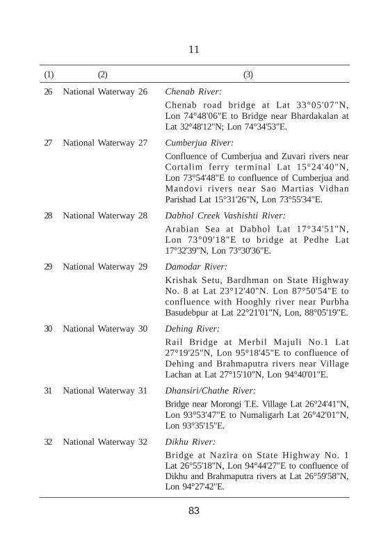
26 National Waterway 26 Chenab River:Chenab road bridge at Lat 33°05'07"N,Lon 74°48'06"E to Bridge near Bhardakalan atLat 32°48'12"N; Lon 74°34'53"E.
27 National Waterway 27 Cumberjua River:Confluence of Cumberjua and Zuvari rivers nearCortalim ferry terminal Lat 15°24'40"N,Lon 73°54'48"E to confluence of Cumberjua andMandovi rivers near Sao Martias VidhanParishad Lat 15°31'26"N, Lon 73°55'34"E.
28 National Waterway 28 Dabhol Creek Vashishti River:Arabian Sea at Dabhol Lat 17°34'51"N,Lon 73°09'18"E to bridge at Pedhe Lat17°32'39"N, Lon 73°30'36"E.
29 National Waterway 29 Damodar River:Krishak Setu, Bardhman on State HighwayNo. 8 at Lat 23°12'40"N. Lon 87°50'54"E toconfluence with Hooghly river near PurbhaBasudebpur at Lat 22°21'01"N, Lon, 88°05'19"E.
30 National Waterway 30 Dehing River:Rail Bridge at Merbil Majuli No.1 Lat27°19'25"N, Lon 95°18'45"E to confluence ofDehing and Brahmaputra rivers near VillageLachan at Lat 27°15'10"N, Lon 94°40'01"E.
31 National Waterway 31 Dhansiri/Chathe River:Bridge near Morongi T.E. Village Lat 26°24'41"N,Lon 93°53'47"E to Numaligarh Lat 26°42'01"N,Lon 93°35'15"E.
32 National Waterway 32 Dikhu River:Bridge at Nazira on State Highway No. 1Lat 26°55'18"N, Lon 94°44'27"E to confluence ofDikhu and Brahmaputra rivers at Lat 26°59'58"N,Lon 94°27'42"E.
(1) (2) (3)
83
12
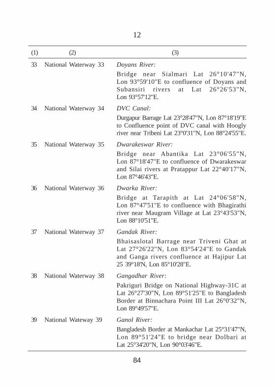
33 National Waterway 33 Doyans River:Bridge near Sialmari Lat 26°10'47"N,Lon 93°59'10"E to confluence of Doyans andSubansiri rivers at Lat 26°26'53"N,Lon 93°57'12"E.
34 National Waterway 34 DVC Canal:Durgapur Barrage Lat 23°28'47"N, Lon 87°18'19"Eto Confluence point of DVC canal with Hooglyriver near Tribeni Lat 23°0'31"N, Lon 88°24'55"E.
35 National Waterway 35 Dwarakeswar River:Bridge near Abantika Lat 23°06'55"N,Lon 87°18'47"E to confluence of Dwarakeswarand Silai rivers at Pratappur Lat 22°40'17"N,Lon 87°46'43"E.
36 National Waterway 36 Dwarka River:Bridge at Tarapith at Lat 24°06'58"N,Lon 87°47'51"E to confluence with Bhagirathiriver near Maugram Village at Lat 23°43'53"N,Lon 88°10'51"E.
37 National Waterway 37 Gandak River:Bhaisaslotal Barrage near Triveni Ghat atLat 27°26'22"N, Lon 83°54'24"E to Gandakand Ganga rivers confluence at Hajipur Lat25 39°18'N, Lon 85°10'28"E.
38 National Waterway 38 Gangadhar River:Pakriguri Bridge on National Highway-31C atLat 26°27'30"N, Lon 89°51'25"E to BangladeshBorder at Binnachara Point III Lat 26°0'32"N,Lon 89°49'57"E.
39 National Wateway 39 Ganol River:Bangladesh Border at Mankachar Lat 25°31'47"N,Lon 89°51'24"E to bridge near Dolbari atLat 25°34'20"N, Lon 90°03'46"E.
(1) (2) (3)
84
13
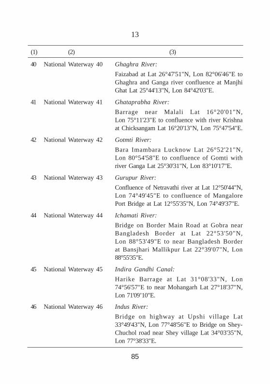
40 National Waterway 40 Ghaghra River:Faizabad at Lat 26°47'51"N, Lon 82°06'46"E toGhaghra and Ganga river confluence at ManjhiGhat Lat 25°44'13"N, Lon 84°42'03"E.
41 National Waterway 41 Ghataprabha River:Barrage near Malali Lat 16°20'01"N,Lon 75°11'23"E to confluence with river Krishnaat Chicksangam Lat 16°20'13"N, Lon 75°47'54"E.
42 National Waterway 42 Gotmti River:Bara Imambara Lucknow Lat 26°52'21"N,Lon 80°54'58"E to confluence of Gomti withriver Ganga Lat 25°30'31"N, Lon 83°10'17"E.
43 National Waterway 43 Gurupur River:Confluence of Netravathi river at Lat 12°50'44"N,Lon 74°49'45"E to confluence of MangalorePort Bridge at Lat 12°55'35"N, Lon 74°49'37"E.
44 National Waterway 44 Ichamati River:Bridge on Border Main Road at Gobra nearBangladesh Border at Lat 22°53'50"N,Lon 88°53'49"E to near Bangladesh Borderat Bansjhari Mallikpur Lat 22°39'07"N, Lon88°55'35"E.
45 National Waterway 45 Indira Gandhi Canal:Harike Barrage at Lat 31°08'33"N, Lon74°56'57"E to near Mohangarh Lat 27°18'37"N,Lon 71'09’10"E.
46 National Waterway 46 Indus River:Bridge on highway at Upshi village Lat33°49'43"N, Lon 77°48'56"E to Bridge on Shey-Chuchol road near Shey village Lat 34°03'35"N,Lon 77°38'33"E.
(1) (2) (3)
85

14
47 National Waterway 47 Jalangi River:Bridge on State Highway No. 14 nearPlashipara at Lat 23°47'47"N, Lon 88°27'09"E toconfluence of Jalangi with Hooghly/Bhagirathirivers at Nabadwip Lat 23°24'39"N, Lon88°22'48"E.
48 National Waterway 48 Jawai-Luni Rivers and Rann of Kutch:Jawal river from Jalore at Lat 25°20'37"N, Lon72°41'09"E to Luni river near Gandhav villageto Rann of Kutchh at Lat23°32'54"N. Lon68°22'27"E.
49 National Waterway 49 Jhelum River:Bridge on highway at Lat 33°49'26"N,Lon 75°03'50"E to Wuler lake, Srinagar atLat 34°21'37"N, Lon 74°36'36"E.
50 National Waterway 50 Jinjiram River:Confluence with Brahmaputra river at TumniLat 25°51'51"N, Lon 89°58'57"E to FulercharPoint. III at Brahmaputra river Lat 25°44'15"N,Lon 89°52'53"E.
51 National Waterway 51 Kabini River:Kabini Dam Lat 11°58'25"N, Lon 76°21'10"E toBeeramballi at Lat 11°56'10"N, Lon 76°14'18"E.
52 National Waterway 52 Kali River:Kodasalli Dam Lat 14°55'08"N, Lon 74°32'07"Eto confluence of Kali river with Arabian Seanear Sadashivgad bridge at Lat 14°50'31"N,Lon 74°07'21"E.
53 National Waterway 53 Kalyan-Thane-Murnbai Waterway, Vasai Creekand Ulhas River:Arabian Sea at Navi Mumbai Lat 18°55'50"N,Lon 72°53'22"E via Ulhas river to bridge onState Highway No. 76 near Malegaon T. WarediLat 19°02'38"N, Lon 73°19'54"E:
(1) (2) (3)
86

15
Bridge on Kalyan-Badlapur road near Kalyanrailway Yard at Kalyan Lat 19°14'06"N.Lon 73°08'49"E to Kalyan Lat 19°15'35"N, Lon73°09'28"E;Vasai Creek from Lat 19°18'54"N toLon 72°47'30"E to Kasheli at Lat 19°13'23"N,Lon 73°0'21“E.
54 National Waterway 54 Karamnasa River:Bridge at Kakarait Lat 25°18'11"N, Lon83°31'38"E to confluence of Karamnasa andGanga rivers at Kutubpur Lat 25°31'06"N,Lon 83°52'47"E.
55 National Waterway 55 Kaveri Kollidam River:Uratchikottai Barrage at Lat 11°29'03"N,Lon 77°42'14"E to confluence of river Kollidamwith Bay of Bengal at Pazhaiyar Lat 11°21'38"N,Lon 79°49'53"E.
56 National Waterway 56 Kherkai River:Dam near Gangia village at Lat 22°45'12"N,Lon 86°05'09"E to confluence with Subarnrekhariver at Jamshedpur Lat 22°50'13"N, Lon86°09'37"E.
57 National Waterway 57 Kopili River:Bridge at Banthai Gaon Tinali Bus Stop atLat 26°10'41"N, Lon 92°13'05"E to confluencewith Brahmaputra river at Chandrapur No. 2Lat 26°15'07"N, Lon 91°56'49"E.
58 National Waterway 58 Kosi River:Kosi Barrage at Hanuman Nagar Lat 26°31'40"N,Lon 86°55'29"E to Confluence of Kosi withGanga river at Kursela Lat 25°24'40"N,Lon 87°15'14"E.
(1) (2) (3)
87

16
59 National Waterway 59 Kottayam-Vaikom Canal:Kottayam, near Kodimatha at Lat 9°34'39"N,Lon 76°31'08"E to Vechoor joining NationalWaterway No. 3 at Lat 9°40'0"N, Lon 76°24'11"E.
60 National Waterway 60 Kumari River:Dam near Amruhasa village at Lat 23°06'37"N,Lon 86°15'51"E to Mukutmanipur Dam at ChiadaLat 22°57'18"N, Lon 86°44'43"E.
61 National Waterway 61 Kynshi River:Bangladesh Border near Mawpyllum Lat25°12'07"N, Lon 91°15'21"E to bridge onNonghyllam-Maweit road at Lat 25°19'35"N,Lon 91°04'07"E.
62 National Waterway 62 Lohit River:Parasuram Kund at 27°52'40"N, Lon 96°21'40"Eto Saikhowa Ghat, Sadiya Lat 27°47'49"N,Lon 95°38'14"E.
63 National Waterway 63 Luni River:Dam at Jaswantpura Lat 26°13'35"N,Lon 73°41'20"E to Barrage near Malipura Lat24°57'04"N, Lon 71°38'02"E.
64 National Waterway 64 Mahanadi River:Sambalpur Barrage at Lat 21°27'34"N,Lon 83°57'50"E to Paradip at Lat 20°19'38"N,Lon 86°40'17"E.
65 National Waterway 65 Mahananda River:Bridge near Gosaipur at Lat 25°26'41"N, Lon88°05'26"E to Bangladesh Border near Adampurat Lat 24°57'17"N, Lon 88°10'59"E.
66 National Waterway 66 Mahi River:Kadana Dam Lat 23°18'22"N, Lon 73°49'37"E toconfluence with Gulf of Khambhat near Kavirailway station Lat 22°10'35"N, Lon 72°30'36"E.
(1) (2) (3)
88

17
67 National Waterway 67 Malaprabha River:Jakanuru at Lat 15°49'51"N, Lon 75°38'54"E toconfluence with river Krishna at KudalasangamaLat 16°12'30"N, Lon 76°04'16"E.
68 National Waterway 68 Mandovir River:Bridge at Usgaon at Lat 15°26'42"N, Lon74°03'12"E to confluence of Mandovi river withArabian Sea at Reis Magos Lat 15°28'32"N,Lon 73°46'46"E.
69 National Waterway 69 Manimutharu River:Manimutharu Dam Lat 8°39'14"N, Lon77°24'47"E to confluence with Tramaraparaniriver near Aladiur Lat 8°41'03"N, Lon 77°26'07"E.
70 National Waterway 70 Manjara River:Singur Dam at Lat 17°44'58"N, Lon 77°55'41"E toconfluence with river Godavari at Kandakurthi atLat 18°49'07"N, Lon 77°52'20"E.
71 National Waterway 71 Mapusa/Moide River:Bridge on National Highway-17 at Mapusa Lat15°35'21"N, Lon 73°49'17"E to confluence pointof Mapusa and Mandovi rivers at PorvorimLat 15°30'20"N, Lon 73°50'42"E.
72 National Waterway 72 Nag River:Bridge near NIT Colony, Nagpur Lat 21°06'17"N,Lon 79°06'03"E to confluence with river Kanhannear Sawangi village at Lat 21°05'38"N,Lon 79°27'54"E.
73 National Waterway 73 Narmada River:Pandhariya at Lat 21°57'10"N, Lon 74°08'27"E toconfluence of Narmada with Arabian Sea at Gulfof Khambhat Lat 21°38'27"N, Lon 72°33'28"E.
(1) (2) (3)

18
(1) (2) (3)
74 National Waterway 74 Netravathi River:Netravathi Dam, Dharmsthala Lat 12°57'55"N,Lon 75°22'10"E to confluence with Arabian seaat Bengre Lat 12°50'43"N, Lon 74°49'29"E.”.
75 National Waterway 75 Palar River:Rail bridge at Virudampattu, Vellore atLat 12°56'14"N, Lon 79°07'30"E to confluencewith Bay of Bengal at SadurangapattinamLat 12°27'52"N, Lon 80°09'13"E.
76 National Waterway 76 Panchagangavali (Panchagangoli) River:Gangoli Port at Lat 13°38'01"N, Lon 74°40'08"Eto Bridge at Badakere at Lat 13°44'50"N,Lon 74°39'15"E.
77 National Waterway 77 Pazhyar River:Bridge near Veeranarayana Mangalam village atLat 8°13'49"N, Lon 77°26'27"E to confluencewith Arabian Sea at Manakudi at Lat 8°05'15"N,Lon 77°29'08"E.
78 National Waterway 78 Penganga Wardha River System:Confluence of Aran and Penganga rivers nearChimata village at Lat 19°54'08"N, Lon78°12'36"E to the confluence of Wardha andPranahita rivers near Ravalli village at Lat19°33'59"N, Lon 79°49'0"E.
79 National Waterway 79 Pennar River:Penna Barrage, Pothireddypalem at Lat14°28'08"N, Lon 79°59'09"E to confluence withBay of Bengal near Kudithipalem at Lat14°35'37"N, Lon 80°11'31"E.
80 National Waterway 80 Ponniyar River:Sathanur Dam at Lat 12°11'0"N, Lon 78°51'01"Eto Cuddalore at confluence of Bay of Bengal atLat 11°46'22"N, Lon 79°47'42"E.
90
19
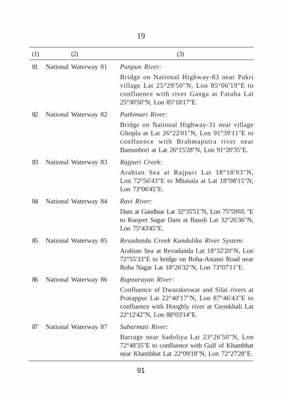
81 National Waterway 81 Punpun River:Bridge on National Highway-83 near Pakrivillage Lat 25°29'50"N, Lon 85°06'19"E toconfluence with river Ganga at Fatuha Lat25°30'50"N, Lon 85°18'17"E.
82 National Waterway 82 Puthimari River:Bridge on National Highway-31 near villageGhopla at Lat 26°22'01"N, Lon 91°39'11"E toconfluence with Brahmaputra river nearBamunbori at Lat 26°15'28"N, Lon 91°20'35"E.
83 National Waterway 83 Rajpuri Creek:Arabian Sea at Rajpuri Lat 18°18'03"N,Lon 72°56'43"E to Mhasala at Lat 18°08'15"N,Lon 73°06'45"E.
84 National Waterway 84 Ravi River:Dam at Gandhiar Lat 32°35'51"N, Lon 75°59'05 "Eto Ranjeet Sagar Dam at Basoli Lat 32°26'36"N,Lon 75°43'45"E.
85 National Waterway 85 Revadanda Creek Kundalika River System:Arabian Sea at Revadanda Lat 18°32'20"N, Lon72°55'33"E to bridge on Roha-Astami Road nearRoha Nagar Lat 18°26'32"N, Lon 73°07'11"E.
86 National Waterway 86 Rupnarayan River:Confluence of Dwarakeswar and Silai rivers atPratappur Lat 22°40'17"N, Lon 87°46'43"E toconfluence with Hooghly river at Geonkhali Lat22°12'42"N, Lon 88°03'14"E.
87 National Waterway 87 Sabarmati River:Barrage near Sadoliya Lat 23°26'50"N, Lon72°48'35"E to confluence with Gulf of Khambhatnear Khambhat Lat 22°09'18"N, Lon 72°27'28"E.
(1) (2) (3)
91

20
88 National Waterway 88 Sal River:Orlim Deusa Bridge Lat 15°13'11"N, Lon73°57'30"E to confluence with Arabian Sea atMobor Lat 15°08'32"N, Lon 73°57'0"E.
89 National Waterway 89 Savitri River (Bankot Creek):Bridge near Sape at Lat 18°05'54"N,Lon 73°20'09"E to Arabian Sea at BankotLat 17°58'47"N, Lon 73°01'45"E.
90 National Waterway 90 Sharavati River:Honnavar Port Sea Mouth at Lat 14°17'56"N,Lon 74°25'27"E to link at highway at GersoppaLat 14°14'15"N, Lon 74°39'06"E.
91 National Waterway 91 Shastri River Jaigad Creek:Sangmeshwar at Lat 17°11'16"N, Lon 73°33'03"Eto confluence with Arabian Sea at Jaigad Lat17°19'12"N, Lon 73°12'39"E.
92 National Waterway 92 Silabati River:Barrage near Shimulia village at Lat 22°34'53" N,Lon 87°38'31"E to confluence of Dwarakeswarand Silai rivers at Pratappur Lat 22°40'17"N,Lon 87°46'43"E.
93 National Waterway 93 Simsang River:Bangladesh Border at Lat 25°11'05"N,Lon 90°39'25"E to bridge on National Highway-62near Nongalbibra Lat 25°27'20"N, Lon 90°42'22"E.
94 National Waterway 94 Sone River:Sone Barrage near Dehri at Lat 24°50'14" N, Lon84°08'03"E to confluence of Sone and Gangarivers at Lat 25°42'15"N, Lon 84°52'02"E.
95 National Waterway 95 Subansiri River:Gerukamukh Lat 27°27'03" N, Lon 94°15'16"E toBrahmaputra confluence at Lat 26°52'25"N,Lon 93°54'31"E.
(1) (2) (3)
92

21
96 National Waterway 96 Subarnrekha River:Chandil Dam at Lat 22°58'29" N, Lon 86°01'14"Eto confluence with Bay of Bengal at Lat21°33'29"N, Lon 87°22'59"E.
97 National Waterway 97 Sunderbans Waterways:(i) Namkhana at Lat 21°45'46"N, Lon 88°13'06"E
to Athara Banki Khal Lat 21°56'57"N,Lon 89°05'32"E;
(ii) Bidya River: Lot No. 124 at Lat 21°54'43" N,Lon 88°41'08"E to near Uttar Danga atLat 22°11'48"N, Lon 88°51'55"E;
(iii) Chhota Kalagachi(Chhoto Kalergachi)River: Near Rajani ferry ghat Lat22°19'57" N, Lon 88°54'21"E to near Nazatat Lat 22°26'05"N, Lon 88°50'12"E;
(iv) Gomar River: Near Ramkrishnapur Lat22°11'53"N, Lon 88°44'42"E to nearGosaba Kheya ghat at Lat 22°10'05"N, Lon88°47'37"E;
(v) Haribhanga River: Bangladesh Border Lat21°53'19"N, Lon 89°01'24"E to confluencewith Jhila river at Lat 21°58'18"N, Lon88°55'08"E;
(vi) Hogla (Holgal)-Pathankhali River: NearParandar Lat 22°12'22" N, Lon 88°40'43"Eto near Sandeshkhai Ferry Ghat at Lat22°21'12"N, Lon 88°52'48"E;
(vii) Kalindi (Kalandi) River: BangladeshBorder at Hingalganj Lat 22°28'08"N,Lon 88°59'46"E to Bangladesh Bordernear Khosbash at Lat 22°24'41"N, Lon88°58’21"E;
(viii) Katakhali River: Bangladesh Border nearBarunhat Lat 22°30'31"N, Lon 88°58'25"Eto Lebukhali ferry at Lat 22°21'45"N,Lon 88°57'30"E;
(1) (2) (3)
93

22
(ix) Matla River: Bay of Bengal at Lat21°33'04" N, Lon 88°38'26"E to Canningferry ghat at Lat 22°18'39"N, Lon 88°40'43"E;
(x) Muri Ganga (Baratala) River: Bay ofBengal near Bisalakshmipur Lat 21°37'52" N,Lon 88°10'0"E to near Kakdwip atLat 21°52'17"N, Lon 88°09'08"E;
(xi) Raimangal River: Hemnagar at Lat22°11'41" N, Lon 88°58'01"E to Raj nagarat Lat 22°33'57"N, Lon 88°56'17"E;
(xii) Sahibkhali (Sahebkhali) River: NearRamapur Lat 22°17'52"N, Lon 88°56'35"Eto Bangladesh Border near Khosbash atLat 22°24'41"N, Lon 88°58'21"E;
(xiii) Saptamukhi River: Bay of Bengal at HenryIsland Lat 21°34'57" N, Lon 88°19'08"Eto near Chintamanipur at Lat 21°51'14"N,Lon 88°18'41"E;
(xiv) Thakurran River: Bay of Bengal at Lat21°33'32" N, Lon 88°27'45"E to Madhabpurat Lat 22°02'52"N, Lon 88°33'28"E;
98 National Waterway 98 Sutlej River:Sunni Road Bridge at Lat 31°14'45"N, Lon77°07'34"E to Harike Dam at Lat 31°08'33"N, Lon74°56'57"E.
99 National Waterway 99 Tamaraparani River:Sulochana Mudalir bridge, Tirunelveli Lat8°43'43" N, Lon 77°42'54"E to confluencewith Bay of Bengal near Punnaikayal atLat 8°38'25"N, Lon 78°07'38"E.
(1) (2) (3)
94
23
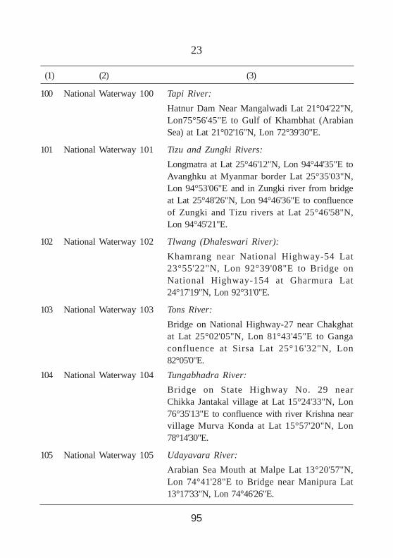
100 National Waterway 100 Tapi River:Hatnur Dam Near Mangalwadi Lat 21°04'22"N,Lon75°56'45"E to Gulf of Khambhat (ArabianSea) at Lat 21°02'16"N, Lon 72°39'30"E.
101 National Waterway 101 Tizu and Zungki Rivers:Longmatra at Lat 25°46'12"N, Lon 94°44'35"E toAvanghku at Myanmar border Lat 25°35'03"N,Lon 94°53'06"E and in Zungki river from bridgeat Lat 25°48'26"N, Lon 94°46'36"E to confluenceof Zungki and Tizu rivers at Lat 25°46'58"N,Lon 94°45'21"E.
102 National Waterway 102 Tlwang (Dhaleswari River):Khamrang near National Highway-54 Lat23°55'22"N, Lon 92°39'08"E to Bridge onNational Highway-154 at Gharmura Lat24°17'19"N, Lon 92°31'0"E.
103 National Waterway 103 Tons River:Bridge on National Highway-27 near Chakghatat Lat 25°02'05"N, Lon 81°43'45"E to Gangaconfluence at Sirsa Lat 25°16'32"N, Lon82°05'0"E.
104 National Waterway 104 Tungabhadra River:Bridge on State Highway No. 29 nearChikka Jantakal village at Lat 15°24'33"N, Lon76°35'13"E to confluence with river Krishna nearvillage Murva Konda at Lat 15°57'20"N, Lon78°14'30"E.
105 National Waterway 105 Udayavara River:Arabian Sea Mouth at Malpe Lat 13°20'57"N,Lon 74°41'28"E to Bridge near Manipura Lat13°17'33"N, Lon 74°46'26"E.
(1) (2) (3)
95

24
(1) (2) (3)
106 National Waterway 106 Umngot (Dwaki) River:Bangladesh Border near Larbamon Lat25°11'07"N, Lon 92°0'54"E to Nongryngkoh atLat 25°19'05"N, Lon 92°02'20"E.
107 National Waterway 107 Vaigai River:Barrage near Anai Patti at Lat 10°05'19"N, Lon77°51'10"E to Viragnoor Dam at Lat 9°53'52"N,Lon 78°10'34"E.
108 National Waterway 108 Varuna River:Road bridge near Kuru at Lat 25°23'15"N. Lon82°44'07"E to Ganga confluence at Saray Mohana,Varanasi Lat 25°19'45"N, Lon 83°02'41"E.
109 National Waterway 109 Wainganga Pranahita River System:Bridge near Chandapur village at Lat 20°0'30"N,Lon 79°47'08"E to confluence of river Godavariat Kaleshwaram Lat 18°49'33"N, Lon 79°54'33"E.
110 National Waterway 110 Yamuna River:Jagatpur (6 km upstream of Wazirabad Barrage)Delhi Lat 28°45'28"N, Lon 77°13'50"E toconfluence of Yamuna and Ganga riversat Sangam, Allahabad at Lat 25°25'24"N,Lon 81°53'20"E.
111 National Waterway 111 Zuari River:Sanvordem bridge Lat 15°16'15"N, Lon 74°07'11"Eto Marmugao Port Lat 15°25'55"N, Lon73°48'13"E.
96