kellogg soil survey laboratory - usda€¦ · • soil system: a recurring group of soils that...
TRANSCRIPT

The
National Soil Survey Laboratory
Is Now The
Kellogg Soil Survey Laboratory

6/4/12 -- Naming of the Kellogg Soil Survey Laboratory

Research Projects at KSSL
• Soil Systems will be a focus of research at the KSSL.

Soil Systems
• Soil system: a recurring group of soils that occupies the landscape from the interstream divide to the stream (Daniels et al., 1999).
• A soil system will have similar soil parent materials, geomorphology, local relief, hydrology, and climate.

Soil Systems
• A few thousand hectares to many hundreds of km2.
• A single MLRA, may contain multiple soil systems due to differences in stratigraphy; parent material, or other landscape characteristics that affect soil properties and distribution.

Goals of Soil System Research
• To improve accuracy and precision of soil maps and interpretations of soil behavior.
• Better understanding and representation of patterns of pedogenesis: – connectivity among soils and soil properties,
topography, and geomorphology, and
– soil, property response to disturbance including agricultural management and climate change.

Active Soil System Projects
• California Bay-Delta Watershed
• N. Great Plains salinity and sodicity

Bay Delta Active Projects
• Sacramento-San Joaquin Rivers Delta (MLRA 16) – Characterization of benchmark soil series (dominantly Histosols) in the fresh water and salt water marshes of the low-laying Delta.
• Central California Coast Range (MLRA 15) – Soil characterization and soil moisture & temperature studies of rangelands, degraded/eroded rangelands, and lands recently converted to vineyards and orchards on the east side of the Coast Range.
• Sierra Nevada Mountains (MLRA 22B) – Soil characterization and soil moisture & temperature studies of montane to alpine ecoregions.

Long range plan: Bay Delta Watershed
• Central Valley Flood Plains and Basins (MLRA 17) – Characterization of selected benchmark soil series on the flood plains and basins of the Sacramento and San Joaquin Valleys.
• Merced/Tuolumne River Terraces (MLRA 17) – Native vs. disturbed cropland soils on terraces and fans with research focus on comparative study of soil hydrology, solute chemistry and reactions, and microbiology.
• Sierra Nevada Foothills (MLRA 18) – Hydropedologic processes and properties in rangeland soils in the foothills interface between agricultural and urban areas of the Valley & Delta and wildlands of the Sierra Nevada Mountains.
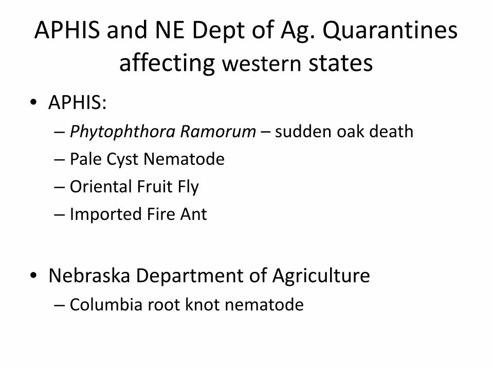
APHIS and NE Dept of Ag. Quarantines affecting western states
• APHIS: – Phytophthora Ramorum – sudden oak death
– Pale Cyst Nematode
– Oriental Fruit Fly
– Imported Fire Ant
• Nebraska Department of Agriculture – Columbia root knot nematode


Current KSSL Projects and Activities

Rapid Carbon Assessment
• Field data collection complete.
• KSSL will analyze QC, organic samples and archive central pedons.
• Data aggregation and analysis is in progress.
• Models produced: – Predicting C from VNIR scans
– Bulk density

VNIR and MIR Spectrometry
• VNIR Spectrometers used in RaCA will remain in MOs.
• Models will be developed for predicting C and other soil properties from VNIR and MIR spectra: calcium carbonate, gypsum, clay content, and other suitable properties.

Mid IR

Gypsum
One spectrum of each 204 samples were used as calibration set
Partial least square (PLS) was used to develop calibration curve.
IR spectra correlate well with gypsum with R2 of 99.75, and the accuracy expressed in root mean square error of estimation (RMSEE) is about 0.956 while in root mean square of cross validation (RMSECV) is 1.11.

Calcium Carbonate Equivalent
One spectrum of each 1163 samples were used as calibration set
Partial least square (PLS) was used to develop calibration curve.
IR spectra correlate well with calcium carbonate equivalent with R2 of 99.04, and the accuracy expressed in root mean square error of estimation (RMSEE) is about 1.29 while in root mean square of cross validation (RMSECV) is 1.37 .

Total Carbon
One spectrum of each 4107 samples were used as calibration set
Partial least square (PLS) was used to develop calibration curve.
IR spectra correlate well with total carbon with R2 of 99.06, and the accuracy expressed in root mean square error of estimation (RMSEE) is about 0.433 while in root mean square of cross validation (RMSECV) is 0.491 .

Estimated Organic Carbon
One spectrum of each 1105 samples were used as calibration set
Partial least square (PLS) was used to develop calibration curve.
IR spectra correlate well with estimated organic carbon with R2 of 97.93, and the accuracy expressed in root mean square error of estimation (RMSEE) is about 0.585 while in root mean square of cross validation (RMSECV) is 0.672 .

EPA National Wetland Condition Assessment
– The National Wetland Condition Assessment (NWCA) is a statistical survey of the quality of our Nation’s wetlands.
– The NWCA is designed to: • Determine the ecological integrity of wetlands at
regional and national scales.
• Build state and tribal capacity for monitoring and analysis.
• Promote collaboration across jurisdictional boundaries.
• Achieve a robust, statistically-valid set of wetland data.
• Develop baseline information to evaluate progress.

NWCA sampling and analysis
• ~ 1250 Sites Sampled by contractors - training by NRCS and State agencies.
• NWCA will analyze – Vegetation – Soils – Hydrology – Water quality – Algae

NWCA sample sites

Soil Analyses of NWCA samples • PSDA • Calcium carbonate equivalent • Total Carbon, Nitrogen and Sulfur C N S • pH 1:1 H20 1:2 .01MCaCl2 • Cation exchange capacity CEC Ca2+ K+ Mg2+ Na+
• Ammonium Oxalate Extraction Al Fe Mn P Si • Electrical Conductivity EC • Dithionite-Citrate Extraction Al Fe Mn • Olsen Phosphorus P • Mehlich Phosphorus P • Trace Elements Ag As Ba Be Cd Co Cr Cu Hg Mn Mo Ni P Pb Sb Se Sn Sr V W Zn • Bulk Density Dbf
KSSL will interpret data. Data will be added to soil characterization database.

Revised Procedure for Submitting Soil Samples, Site Data and Pedon
Descriptons
Spreadsheets and instructions are available for download at NRCS soils website.


• Lab pedon data will be entered and updated directly in NASIS.
• This will replace the SOI8 process.


