kaiser commerce center specific plan - san … commerce center specific plan san bernardino county...
TRANSCRIPT

Kaiser Commerce Center
Specific Plan
San Bernardino County
Economic Development and Public Service Group
Land Use Services Department
Adopted April 13, 1999
Revised January 4, 2007
KAISER COMMERCE CENTER SPECIFIC PLAN ADOPTED MAY 13, 1999 TABLE OF CONTENTS REVISED JULY 3, 2003
i
TABLE OF CONTENTS Page
DIVISION 1. GENERAL PROVISIONS. 1-1
Chapter 1. Introduction. 1-1 Chapter 2. Existing Setting. 1-13
DIVISION 2. PROJECT COMPONENTS. 2-1 Chapter 1. Land Use Plan. 2-1 Chapter 2. Public Services and Facilities. 2-51 Chapter 3. Circulation. 2-67 Chapter 4. Grading, Conservation and Open Space. 2-79 Chapter 5. Seismic Safety/Safety. 2-83
DIVISION 3. ADMINISTRATION. 3-1 Chapter 1. Administration. 3-1
KAISER COMMERCE CENTER SPECIFIC PLAN ADOPTED MAY 13, 1999 TABLE OF CONTENTS REVISED JULY 3, 2003
ii
LIST OF FIGURES Page
1.1 - Regional Location 1-3 1.2 - Project Site 1-4 1.3 - Existing Water Facilities 1-26 1.4 - Existing Sewer Facilities 1-27 2.1 - Land Use Planning Areas 2-2 2.2a - Design Concept - On-Site Landscaping 2-20 2.2b - On-Site Landscaping 2-21 2.2c - On-Site Landscaping 2-22 2.3 - Tree Staking, Guying, and Planting 2-23 2.4 - Industrial Landscaping 2-26 2.5 - Valley Boulevard (South Side) Landscaping 2-27 2.6 - Project Sign Location Plan 2-34 2.7 - Project Sign System Hierarchy 2-35 2.7a - Proposed Median Sign 2-36 2.8 - Proposed Water Facilities 2-53 2.9 - Proposed Sewer Facilities 2-55 2.10 - Proposed Drainage Plan 2-56 2.11 - Flood Hazard Areas 2-57 2.11a - Flood Hazard Areas (with LOMR) 2-58 2.12 - Dry Utilities 2-61 2.13 - Proposed Circulation 2-68 2.14 - Typical Roadway Section - Valley Boulevard 2-69 2.15 - Typical Roadway Sections – Commerce Drive and
San Bernardino Avenue 2-70 2.16 - Proposed Interchange and Roadway Improvements 2-73 2.17 - Conceptual Grading Plan 2-80
KAISER COMMERCE CENTER SPECIFIC PLAN ADOPTED MAY 13, 1999 TABLE OF CONTENTS REVISED JULY 3, 2003
iii
LIST OF TABLES Page
2.A - Land Use Intensity 2-3 2.B - Permitted Uses 2-4 2.C - General Development Standards 2-15 2.D - Kaiser Commerce Center Specific Plan Plant Palette 2-28 2.E - Parking Standards for Industrial Buildings 2-30 2.F - Sign Standards 2-39 2.G - Stationary Source Noise Standards (in dB) 2-43 2.H - Noise Standards for Exposure to Mobile Sources 2-45 2.I - Estimated Water Demand 2-52 2.J - Specific Plan Roadway Improvements 2-71

KAISER COMMERCE CENTER SPECIFIC PLAN ADOPTED MAY 13, 1999 TABLE OF CONTENTS REVISED JULY 3, 2003
iv
LIST OF ORDINANCES AMENDING THE DEVELOPMENT CODE
Ordinance Date of Effective Number Adoption Date 3753 4-13-1999 5-13-1999 3807 11-14-2000 12-14-2000 3847 3-5-2002 4-4-2002 3891 6-3-2003 7-3-2003 3996 12-5-2006 1-4-2007

KAISER COMMERCE CENTER SPECIFIC PLAN ADOPTED MAY 13, 1999
GENERAL PROVISIONS INTRODUCTION REVISED JULY 3, 2003
1-1
Division 1
GENERAL PROVISIONS
Chapters: Page 1. Introduction 1-1 2. Existing Setting 1-13
Chapter 1
INTRODUCTION
Sections: Page
KC1.0105 Specific Plan Area. 1-1 KC1.0110 Purpose of the Specific Plan. 1-2 KC1.0115 Project Objectives. 1-5 KC1.0120 Authority. 1-6 KC1.0125 Validity. 1-6 KC1.0130 Plan Organization. 1-6 KC1.0135 General Requirements. 1-8 KC1.0140 Concurrent Discretionary Approvals. 1-9 KC1.0145 Subsequent Discretionary Approvals. 1-10
KC1.0105 Specific Plan Area.
(a) Regional Location.
The Kaiser Commerce Center Specific Plan is located on a portion of the site of the former Kaiser Fontana steel mill in the southwest portion of San Bernardino County, near the interchange of the San Bernardino (I-10) and Ontario (I-15) freeways (Figure 1.1). The approximately 468 acre project is centrally located within Southern California, approximately 40 miles east of downtown Los Angeles, 20 miles west of downtown San Bernardino, and 30 miles northeast of central Orange County.
(b) Kaiser Commerce Center Specific Plan.
The Kaiser Commerce Center Specific Plan site is located northeast of the San Bernardino Freeway/Etiwanda Avenue interchange. The project site is configured in an “L” shape (Figure 1.2) that is generally bounded by the San Bernardino Freeway to the south and Etiwanda Avenue to the west. The San Sevaine Flood Control Channel runs north-south along the eastern boundary of the site, north of San Bernardino Avenue and through the center of the site’s southern parcels. From San Bernardino Avenue, the eastern boundary of the project site continues south in an irregular manner to Valley Boulevard. Mulberry Avenue forms the eastern boundary of the project site south of Valley Boulevard. The northern boundary of the site is marked by Napa Street (west of the San Sevaine Channel), San Bernardino Avenue (east of the San Sevaine Channel to the eastern project boundary), and Valley Boulevard (to Mulberry Avenue).

KAISER COMMERCE CENTER SPECIFIC PLAN ADOPTED MAY 13, 1999
GENERAL PROVISIONS INTRODUCTION REVISED JULY 3, 2003
1-2
The Kaiser Commerce Center Specific Plan site is within an unincorporated area with Fontana to the north, Ontario to the southwest, and Rancho Cucamonga to the north and west. The site is within the sphere of influence of the City of Fontana. Adopted Ordinance 3753 (1999); Amended Ordinance 3807 (2000); Amended Ordinance 3847 (2002); Amended Ordinance 3891 (2003)
KC1.0110 Purpose of the Specific Plan.
(a) Because the site is within unincorporated San Bernardino County territory, the Kaiser Commerce Center Specific Plan is being filed in accordance with the San Bernardino County Development Code. The project site is unique in that it encompasses a large tract of land under common ownership. It is located close to two intersecting interstate freeways, is served by nearby full freeway interchanges, and is surrounded by heavy industrial uses which are complementary to the uses proposed by this Specific Plan.
(b) During its heyday, the Kaiser Fontana steel mill was the largest private employer in the Inland Empire, employing over 11,000 people. Following the demise of steel-making activities at the mill, the plant fell into a state of disrepair and decay. The severe blighting of the old steel mill, which spread to over 1,000 acres, discouraged business development for miles in each direction along the I-10 and I-15 freeway corridors. This is the very area that was targeted for industrial and commercial development under the County's General Plan and the General Plans of surrounding cities.
(c) The substantial investment that has been made in the development of the California Speedway on the portion of the former Kaiser Fontana steel mill to the east represents an important incentive for business development in surrounding areas. In recognition of the area’s blighted conditions and consequent need for redevelopment activities, as well as recognizing the opportunities presented by the California Speedway, San Bernardino County established a redevelopment project area, within which the Kaiser Commerce Center Specific Plan site is located. Implementation of the Kaiser Commerce Center Specific Plan will complete the process of converting the former steel mill from a derelict site to a productive status, thereby enhancing San Bernardino County's industrial and transportation-related economy, while increasing local employment opportunities.

KAISER COMMERCE CENTER SPECIFIC PLAN ADOPTED MAY 13, 1999
GENERAL PROVISIONS INTRODUCTION
1-3
Figure 1.1
Regional Location
KAISER COMMERCE CENTER SPECIFIC PLAN ADOPTED MAY 13, 1999
GENERAL PROVISIONS INTRODUCTION REVISED JULY 3, 2003
1-4
Figure 1.2
Project Site

KAISER COMMERCE CENTER SPECIFIC PLAN ADOPTED MAY 13, 1999
GENERAL PROVISIONS INTRODUCTION REVISED APRIL 4, 2002
1-5
(d) The purpose of the Kaiser Commerce Center Specific Plan is to assist in the revitalization of the site of the former steel mill. The Specific Plan accomplishes this purpose by providing for the efficient use of land, ensuring compatibility between existing and proposed land uses, customizing development regulations to address the unique needs of the Kaiser Commerce Center properties and the specialized land uses proposed for the site, and by fostering greater economic development and design opportunities than could be achieved through the use of conventional zoning and development standards. In addition to defining appropriate land uses for the project site, the Kaiser Commerce Center Specific Plan provides a thorough, cohesive, and understandable procedure for guiding individual development proposals through the approval process. Adopted Ordinance 3753 (1999); Amended Ordinance 3807 (2000); Amended Ordinance 3891 (2003)
KC1.0115 Project Objectives. The objectives of the Kaiser Commerce Center Specific Plan are as follows:
(a) Continue the transition of abandoned and marginally used facilities which were formerly part of the Kaiser Fontana steel mill into a vibrant, productive mix of employment generating uses. (b) Establish a well balanced and carefully planned community of general and transportation-related industrial and, commercial uses which can take advantage of the site’s excellent highway and rail access. (c) Increase economic opportunities for residents of western San Bernardino County, and assist in correcting a significant imbalance between the area's jobs and housing inventories. (d) As a means of replacing lost military and aerospace jobs and improving the area’s balance between jobs and housing:
(1) Create an industrial development that will provide an array of industrial employment opportunities and provide services needed by the area’s expanding industrial and transportation-related economy.
(2) Continue the process of converting the former Kaiser steel mill site into an attractive, functional, and economically productive entity, thereby providing added business and consumer purchasing power, and a more favorable economic de-velopment climate to spur wide-ranging business expansion.
(3) Enhance the fiscal health of the County, and that of other jurisdic-tions, by revitalizing a once thriving employment center and generating net municipal revenues.

KAISER COMMERCE CENTER SPECIFIC PLAN ADOPTED MAY 13, 1999
GENERAL PROVISIONS INTRODUCTION REVISED DECEMBER 14, 2000
1-6
(e) Eliminate existing blighted areas, which have had a negative impact on the surrounding area, and develop a facility that will enhance the area's image.
(f) Implement the State’s existing Recycling Market Development Zone (RMDZ) designation over the site, facilitating the development of private industry involved in recycling.
(g) Restore civic pride and community identity damaged when the old steel mill shut down.
(h) Assist in the continuing reestablishment of medical benefits for local pen-
sioners, which were lost when the former Kaiser Steel Corporation filed for bankruptcy. Adopted Ordinance 3753 (1999); Amended Ordinance 3807 (2000); Amended Ordinance 3847 (2002)
KC1.0120 Authority. The Kaiser Commerce Center Specific Plan has been prepared in accordance with California Government Code Section 65450 et al., and the applicable ordinances of the County of San Bernardino, and will constitute the zoning for the project site. Land use standards and regulations contained within this document shall govern future development within the boundaries of this Specific Plan. Adopted Ordinance 3753 (1999); Amended Ordinance 3807 (2000) KC1.0125 Validity. The Kaiser Commerce Center Specific Plan is intended to implement the provisions of the County of San Bernardino General Plan, as amended. In addition, the Specific Plan is intended to supplement the provisions of the County of San Bernardino Development Code. In the event of conflict between the provisions of this document and the County’s Development Code and other County development regulations, the provisions of the Kaiser Commerce Center Specific Plan take precedence. Adopted Ordinance 3753 (1999); Amended Ordinance 3807 (2000) KC1.0130 Plan Organization.
(a) The Kaiser Commerce Center Specific Plan provides a framework for development of the Specific Plan area. The plan provides guidance for the review of specific development proposals at the parcel map and site plan approval stages, and is the reference for determining permitted uses, intensity of use, and development standards and requirements.
KAISER COMMERCE CENTER SPECIFIC PLAN ADOPTED MAY 13, 1999
GENERAL PROVISIONS INTRODUCTION REVISED APRIL 4, 2002
1-7
(b) The Specific Plan defines project objectives, as well as regulations and requirements for development of Kaiser Commerce Center Specific Plan. The Specific Plan is organized as follows:
(1) INTRODUCTION: Division 1, Chapter 1 of the Specific Plan gives the location of the Specific Plan, and information regarding the purpose, legal authority, and validity of the Specific Plan.
(2) EXISTING SETTING: Division 1, Chapter 2 of the Specific Plan
provides a summary of existing conditions affecting the future development of the Specific Plan area, including related planning efforts, and physical, environmental, and public facilities and services factors.
(3) LAND USE: Division 2, Chapter 1 includes the overall concept of land uses proposed within the Specific Plan area; a description of each permitted land use, along with general development standards (minimum parcel sizes, building height limits, landscaping, parking, loading, and outdoor storage requirements); regulations for the distribution of land use within the project site; and standards for individual site development within the specific plan area.
(4) PUBLIC SERVICES AND FACILITIES: Division 2, Chapter 2 details plans for water, wastewater, storm drains, public utilities, and community facilities. This Section identifies the agencies which will provide public services and facilities, and provides information on the manner in which construction and continuing maintenance of facilities will be financed.
(5) CIRCULATION: Division 2, Chapter 3 describes circulation and transportation concepts and major components, including vehicular circulation, rail facilities, public transportation, and pedestrian and bicycle facilities.
(6) GRADING, CONSERVATION AND OPEN SPACE: Division 2, Chapter 4 describes the landform modifications activities that will be required to establish proposed uses and construct project access. In addition, this section outlines standards for prevention of water pollution.
(7) SEISMIC SAFETY: Division 2, Chapter 5 addresses seismic/ geologic hazards as well as hazardous waste and materials.
(8) ADMINISTRATION: Division 3, Chapter 1 describes the manner in which the Specific Plan will be implemented, including processing of individual developments and procedures for amending the Specific Plan.
(c) The Kaiser Commerce Center Specific Plan proposes a mix of industrial and commercial uses. No residential development is planned. The project site is within a Regional Industrial area, and there are no existing or planned residential areas adjacent to the site. Thus, a Housing section is not included in this Specific Plan. In addition, there are no scenic highways adjacent to or near the project site that would be affected by development of the Specific Plan. Thus, the Specific Plan does not include a Scenic Highways section. Finally, because noise standards are included as
KAISER COMMERCE CENTER SPECIFIC PLAN ADOPTED MAY 13, 1999
GENERAL PROVISIONS INTRODUCTION REVISED APRIL 4, 2002
1-8
part of a larger set of performance standards in Division 2, Chapter 1, a separate noise section is not provided. Adopted Ordinance 3753 (1999); Amended Ordinance 3807 (2000); Amended Ordinance 3847 (2002) KC1.0135 General Requirements. The following general requirements shall apply to all developments within the Kaiser Commerce Center Specific Plan area.
(a) General Plan Consistency.
Implementation of the Kaiser Commerce Center Specific Plan is intended to carry out the goals and policies contained in the San Bernardino County General Plan, as amended, in an orderly and attractive fashion. Development within the Kaiser Commerce Center Specific Plan area shall, therefore, be consistent with the provisions of the San Bernardino County General Plan.
(b) Relationship Between Specific Plan Development Standards/Criteria and the San Bernardino County Development Code. Development regulations and requirements contained in this document will supplement or replace those of the San Bernardino County Development Code as they might otherwise apply to lands within the Kaiser Commerce Center Specific Plan area. Any regulations or requirements not specifically covered herein shall be subject to the regulations and requirements of the San Bernardino County Development Code.
Unless otherwise specifically approved as part of this Specific Plan, all off-site improvements under the control of the County shall be subject to the San Bernardino County regulations and requirements in effect at the time improvement plans are submitted. Other improvements not under the control of the County (e.g., freeway improvements subject to Caltrans authority, and water lines under the control of the Fontana Water Company), shall be subject to the regulations and requirements of the responsible agency.
If any provision of this document conflicts with the regulations or requirements of the San Bernardino County Development Code, the provisions of this document shall take precedence.
(c) Conformance with Uniform Building and Fire Codes.
All construction within Kaiser Commerce Center Specific Plan shall be in compliance with the Uniform Building Code, Uniform Fire Code, and all other ordinances adopted by the County pertaining to construction and safety features.
(d) Implementation of EIR Mitigation Measures.
The mitigation measures contained in the certified Final EIR for the
Kaiser Commerce Center Specific Plan have been incorporated into this document,

KAISER COMMERCE CENTER SPECIFIC PLAN ADOPTED MAY 13, 1999
GENERAL PROVISIONS INTRODUCTION REVISED APRIL 4, 2002
1-9
and shall, as appropriate, be conditions of approval on all development within the Specific Plan area as determined by the San Bernardino County Director of Land Use Services pursuant to the provisions of CEQA and the County’s rules to implement
CEQA. Appendix A of this document includes a listing of the mitigation measures
contained in the EIR. Environmental assessment requirements for individual projects within the Specific Plan area shall focus on the subjects identified for such requirements in the Kaiser Commerce Center Specific Plan EIR pursuant to CEQA guidelines.
(e) Technical Master Plans for Traffic, Water, Sewer, and Drainage.
Specific requirements for infrastructure improvements are determined by the Technical Master Plans prepared for the Kaiser Commerce Center Specific Plan area. The conclusions of the Technical Master Plans have been included as part of this Specific Plan. The full text of the Technical Master Plans is available under separate cover. Technical Master Plans may be amended over time to ensure the availability of adequate infrastructure and services to the project site, subject to approval of the Director of the County Flood Control/Transportation Agency.
(f) Severability.
If any term, provision, condition, requirement, or portion thereof of this Specific Plan is for any reason held invalid, unenforceable, or unconstitutional, the remainder of this Specific Plan or the application of such term, provision, condition, requirement, or portion thereof to circumstances other than those in which it is held to be invalid, unenforceable, or unconstitutional, shall not be affected thereby; and each other term, provision, condition, requirement, or portion thereof shall be held valid and enforceable to the fullest extent permitted by law. Adopted Ordinance 3753 (1999); Amended Ordinance 3807 (2000); Amended Ordinance 3847 (2002) KC1.0140 Concurrent Discretionary Approvals. In addition to the Specific Plan and its associated EIR, a number of discretionary actions were concurrently requested of the County of San Bernardino or of Caltrans at the time of the original Specific Plan proposal. These are described below.
(a) General Plan Amendment.
The County of San Bernardino’s current land use designation for the project site is Kaiser Commerce Center Specific Plan (KC/SP). Approval of a General Plan Amendment to KC/SP was approved by the County concurrent with this Specific Plan.
(b) Freeway Interchange Reconfiguration.
KAISER COMMERCE CENTER SPECIFIC PLAN ADOPTED MAY 13, 1999
GENERAL PROVISIONS INTRODUCTION REVISED APRIL 4, 2002
1-10
Concurrent with the Specific Plan, Caltrans approval of a freeway interchange reconfiguration was sought. The interchange reconfiguration will be as follows:
(1) Realign and reconstruct Valley Boulevard from east of the SPRR
spur track and extend the road west to proposed Commerce Drive.1
(2) Reconstruct the existing weaving section on westbound I-10
between the Valley Boulevard on-ramp and the Etiwanda Avenue off-ramp as a “braided-ramp” configuration, which will eliminate the westbound weaving movement.
(3) Reconstruct the existing Etiwanda Avenue/I-10 interchange by converting the existing four quadrant full cloverleaf interchange to a partial cloverleaf, retaining the northeast and southwest loop on-ramps and demolishing the northwest and southeast loop off-ramps. The exit ramps from I-10 in each direction will be connected to Etiwanda Avenue at two new signalized intersections. Adopted Ordinance 3753 (1999); Amended Ordinance 3807 (2000); Amended Ordinance 3847 (2002)
KC1.0145 Subsequent Discretionary Approvals. Subsequent to approval of the Specific Plan, a number of discretionary approvals will be sought from the County of San Bernardino. These subsequent approvals are described below. As part of the review process of reviewing future development within the Kaiser Commerce Center Specific Plan area, appropriate analyses will be undertaken to determine needed access improvements, as well as to determine the ”fair share” of the proposed development for needed off-site improvements.
(a) Parcel Maps.
In order to create specific development sites, one or more parcel maps will be submitted to San Bernardino County for review and approval. Requirements for the submittal, review, and approval of parcel maps are included in the San Bernardino County Development Code.
(b) Site Plan Reviews.
Once specific development sites have been created, specific development proposals will be submitted to the County for review pursuant to the provisions of this Specific Plan and the County Development Code.
(c) Infrastructure Financing and Redevelopment Actions.
In order to finance project infrastructure, an array of financing mechanisms may be employed, as set forth in Division 2, Chapter 2 of this Specific Plan. Implementation of financing mechanisms involving assessment districts or use of
1 The extension of Valley Boulevard from Etiwanda Avenue to the proposed Commerce Drive will be
accomplished as part of the development project.
KAISER COMMERCE CENTER SPECIFIC PLAN ADOPTED MAY 13, 1999
GENERAL PROVISIONS INTRODUCTION REVISED APRIL 4, 2002
1-11
redevelopment tax increments will require approval of the San Bernardino County Board of Supervisors and/or the San Bernardino County Redevelopment Agency. Adopted Ordinance 3753 (1999); Amended Ordinance 3807 (2000); Amended Ordinance 3847 (2002)
KAISER COMMERCE CENTER SPECIFIC PLAN ADOPTED MAY 13, 1999
GENERAL PROVISIONS INTRODUCTION REVISED APRIL 4, 2002
1-12
(THIS PAGE INTENTIONALLY LEFT BLANK)

KAISER COMMERCE CENTER SPECIFIC PLAN ADOPTED MAY 13, 1999
GENERAL PROVISIONS EXISTING SETTING REVISED APRIL 4, 2002
1-13
CHAPTER 2
EXISTING SETTING
Sections: Page KC1.0205 Site Conditions and Existing Land Uses. 1-13 KC1.0210 Related Planning and Development Efforts on the
Former Kaiser Steel Mill Site. 1-17 KC1.0215 Existing Circulation. 1-18 KC1.0220 Existing Physical Conditions. 1-19 KC1.0225 Existing Utilities. 1-23
KC1.0205 Site Conditions and Existing Land Uses.
(a) Historical and Existing Land Uses.
(1) Site History.
The Kaiser Fontana steel mill was the creation of industrialist Henry J. Kaiser, who built the integrated steel plant during the early days of World War II. The Fontana plant began operation on December 30, 1942. Originally, the mill was to be located near the ocean, but the United States government decreed that the mill had to be built at least 50 miles inland, where it would be safe from enemy naval gunfire. The Fontana site provided an available water supply; proximity to Kaiser's numerous mines, including Eagle Mountain, via railroad access; a large work force; and an abundance of available, affordable land.
After World War II, Kaiser initiated a series of expansions at the steel plant to supply a wider range of products, including everything from steel plates and pipe to structural shapes, and even tin plates for cans. By the late 1970s, the Kaiser Fontana plant was the largest fully integrated steel mill west of the Mississippi River, producing more than three million tons of finished steel per year. Kaiser Steel Corporation was the largest employer in the area, providing over 11,000 jobs to the community.
Following the historic, 100-day national steel strike in 1959, there was a dramatic increase in the amount of imported steel that was sold in the western United States. Plagued by endless pressure from foreign competition, spiraling costs of upgrading environmental control equipment to meet increasingly stringent standards, and rising labor costs, Kaiser Steel Corporation announced plans for a permanent shutdown of the Fontana steel plant in October 1981.
In 1982, Cuyahoga Wrecking Corporation purchased and removed
a portion of the primary production unit, including three blast furnaces, seven batteries of coke ovens, and the by-product plant, marking the beginning of demolition of the steel mill. By December 1983, the remainder of the plant was closed. In 1984, California Steel Industries, Inc. (CSI) purchased approximately 300 acres of the
KAISER COMMERCE CENTER SPECIFIC PLAN ADOPTED MAY 13, 1999
GENERAL PROVISIONS EXISTING SETTING REVISED DECEMBER 14, 2003
1-14
remaining steel plant and reopened the hot strip mill, plate mill, cold roll mill, and the sheet galvanizing mill. CSI still owns and operates these facilities, which are located immediately southeast of the project site.
The economic vigor that embodied the steel mill and its workers disappeared when the mill shut down in December 1983. For a number of reasons, four years later, in 1987, Kaiser Steel Corporation filed for Chapter 11 bankruptcy, resulting in the loss of pensions and benefits to over 7,000 former steelworkers. A major portion of Kaiser Ventures Inc. (31 percent) is owned by a trust established to provide medical benefits to the former steel workers, many of whom still reside in the area.
In 1988, Kaiser emerged from bankruptcy reorganization as the reorganized successor to Kaiser Steel Corporation under the name Kaiser Steel Resources, Inc. and is now called Kaiser Ventures Inc. (Kaiser). As a new company, Kaiser began preparations for its re-introduction to the local community and the financial world. Taking the limited assets that remained from the reorganization, Kaiser sought industry leaders to help develop its assets into viable, revenue producing businesses. A joint venture agreement between Kaiser and The Lusk Company was the first step Kaiser took in its efforts to establish itself as a new company. The partnership sought to transform the Kaiser Fontana steel mill site into The Inland Empire Commerce Center, which was proposed to include a 14.6-million-square-foot commercial/ industrial park, along with a 360-acre sports and entertainment complex. Proposals for this development were withdrawn in 1993. In 1994, Kaiser and the Penske Corporation announced an agreement to design, construct, and manage the California Speedway on the former site of the Kaiser Fontana steel mill. This 550-acre facility has resulted in the redevelopment of a substantial portion of the old Kaiser Fontana steel mill into a motor sports facility.
(2) Existing On-Site Land Use.
As noted above, demolition of the Kaiser steel making facility was initiated in 1982. Since that time, substantial portions of the former steel mill have been removed, including the area now encompassing the California Speedway. Smaller buildings and facilities have been removed from the Kaiser Commerce Center Specific Plan project site as part of ongoing demolition operations. Remaining within the project site are two large metal industrial buildings, known as the ”mill warehouse” building and the “fabrication” building, which are currently being used by several different companies for storage, distribution, and manufacturing.
KAISER COMMERCE CENTER SPECIFIC PLAN ADOPTED MAY 13, 1999
GENERAL PROVISIONS EXISTING SETTING REVISED JULY 3, 2003
1-15
Along the San Bernardino Freeway, separated by the San Sevaine Creek channel, were two large hills covering approximately 250 acres. The hills are comprised of rock by-products (slag) from the processing of iron ore that were stockpiled during 40 years of steel-making operations. These stockpiles have been referred to as the “west slag pile” and the “east slag pile”.
The west slag pile has been remediated, and the of the east slag pile lies within the area that will added to the Specific Plan with adoption of Amendment No. 2 is currently being remediated. Remediation activities have been ongoing within the former steel mill, including the specific plan area, since 1988. These activities have occurred under the supervision of the DTSC (which is the lead agency for the California Environmental Quality Act [CEQA] purposes for all remediation activities), including technical studies and physical remediation of certain lands within the California Speedway and the West Valley Materials Recycling Facility east of the specific plan area. As of July 2001, all remediation activities within the west slag pile have been completed and the site has been cleared by DTSC. Remediation activities on the portion of the east slag pile included within the Amendment Area have been completed. The balance of the east slag pile requires remediation of industrial wastes subject to a 1988 voluntary Consent Order by the California Department of Health Services (now known as the Department of Toxic Substances Control [DTSC]); therefore remediation and monitoring of this area is underway at this time. Development entitlements were not sought for the east slag pile concurrent with the balance of the site. In order to minimize the risk of undersizing utilities and roadways, project-related technical studies were prepared, including an assumed level of future development on that portion of the east slag pile proposed for inclusion into the Specific Plan.
(3) Surrounding Land Uses.
The Kaiser Commerce Center Specific Plan is adjacent to several industrial and commercial land uses, including the California Speedway, California Steel Industries (CSI), and the West Valley Materials Recovery Facility (WVMRF). The CSI facilities, located to the east, were formerly part of the Kaiser Steel operation, and were sold to CSI as Kaiser operations were being suspended. CSI facilities include the steel plant's rolling and finishing mills, a portion of the open hearth building, and the office complex known as the "campus."
The California Speedway is located immediately north of CSI and east of the project site. The speedway is a 2-mile, tri-oval racing facility set on approximately 550 acres. The speedway has a spectator capacity of approximately 107,000.
KAISER COMMERCE CENTER SPECIFIC PLAN ADOPTED MAY 13, 1999
GENERAL PROVISIONS EXISTING SETTING REVISED JULY 3, 2003
1-16
Lying partially between the speedway and the Kaiser Commerce Center Specific Plan site is the site of the West Valley Materials Recycling Facility (MRF). This facility is currently capable of processing up to 3,500 tons of municipal and non-hazardous commercial solid waste per day.
Parcels to the north, between Napa Street and Arrow Route are
generally industrial in nature, with some residential and institutional uses. Further to the north and east along Arrow Route is a mixture of
existing residential and industrial uses within the County of San Bernardino, and the City of Fontana and its sphere of influence. The San Bernardino County General Plan shows this area as residential and manufacturing. Many of the residential lots in this area are deep, and contain light industrial or repair-related uses associated with the residences along Arrow Route. These residential uses are separated from the project site by a corridor of industrial uses, which are, in turn, separated from the site by a San Bernardino County Flood Control channel.
The northwest corner of the site, as well as the properties west of Etiwanda Avenue, north of Fourth Street, are within the City of Rancho Cucamonga, and are either developed or planned for industrial uses. In addition, San Bernardino County has constructed a jail at the northwest corner of Etiwanda Avenue and Fourth Street. North of the jail, the Inland Empire Utilities Agency has constructed a regional wastewater treatment plant (Regional Plant No. 4). The area adjacent to the west side of the Specific Plan area, along Etiwanda Avenue, is a 600-foot wide Southern California Edison (SCE) utility corridor. Several major SCE utility lines are located within this property.
The Ontario city limits are located across from the SCE property, west of Etiwanda Avenue, south of Fourth Street. This area within Ontario is partially developed with industrial uses. Two specific plans have been approved by the City of Ontario for the area west of Etiwanda Avenue along both sides of Inland Empire Boulevard. The specific plans propose expansion of the industrial use of the properties, along with construction of a small commercial node at the southwest corner of Etiwanda Avenue and Ontario Mills Parkway (formerly Inland Empire Boulevard), along the San Bernardino Freeway at Etiwanda Avenue.
The area south of Kaiser Commerce Center Specific Plan site is partly within the City of Fontana and partly within unincorporated County territory. Within this area is Praxair’s industrial gas plant. Also located within this area is the Sierra Gateway Commerce Center, as well as various freestanding industrial uses.
KAISER COMMERCE CENTER SPECIFIC PLAN ADOPTED MAY 13, 1999
GENERAL PROVISIONS EXISTING SETTING REVISED APRIL 4, 2002
1-17
(4) Existing Easements and Utility Rights-of-Way.
There are several easements that affect the planning and design of the Kaiser Commerce Center Specific Plan. These are discussed briefly below.
Southern California Edison. SCE maintains several easements within the project site. Some of these easements can be abandoned since they were created to provide electricity to the Kaiser Steel mill. However, major electrical easements also exist which cannot be abandoned. These include an easement running parallel to the San Bernardino Freeway in the southern portion of the site. This easement serves CSI, as well as other users. Because the present easement is incompatible with plans to rehabilitate the project site, relocation of the easement and electrical lines is contemplated.
The Gas Company. The Gas Company owns easements for
natural gas lines through the Kaiser Commerce Center Specific Plan area. These lines formerly served the steel plant. The present alignment of these easements is incompatible with the proposed street system; therefore, the natural gas lines will be relocated as part of the project development.
San Bernardino County Flood Control District. The San Bernardino County Flood Control District has an easement for the San Sevaine Channel through the Kaiser Commerce Center Specific Plan area, running in a north-south direction along the western boundary of CSI. It is proposed that this easement be narrowed following improvement of the channel. Adopted Ordinance 3753 (1999); Amended Ordinance 3807 (2000); Amended Ordinance 3847 (2002); Amended Ordinance 3891 (2003)
KC1.0210 Related Planning and Development Efforts on the Former Kaiser
Steel Mill Site. The Kaiser Commerce Center Specific Plan constitutes the final step toward conversion of the former Kaiser steel mill into a vibrant, economically productive community of industrial, commercial, entertainment, office and business park uses. The following identifies recent actions taken to revitalize the former Kaiser steel mill property.
(a) California Speedway and Speedway Business Park.
The California Speedway is a major motor sports facility for hosting NASCAR Winston Cup, Cart Indy Car races, and other premier racing events. The California Speedway consists of a 2-mile, tri-oval track, infield pit area and racing facilities, grandstands, and an adjacent 32,000+ space parking lot. With an initial grandstand spectator capacity of approximately 68,000, the California Speedway has increased its grandstand capacity twice, adding 24,665 seats.
(b) West Valley Material Recovery Facility (WVMRF).

KAISER COMMERCE CENTER SPECIFIC PLAN ADOPTED MAY 13, 1999
GENERAL PROVISIONS EXISTING SETTING REVISED APRIL 4, 2002
1-18
The WVMRF is currently operating immediately adjacent to the northeast corner of the project site. This facility is currently able to process up to 3,500 tons of municipal solid waste per day.
(c) Napa Lots.
This area consists of several rail-served and general industrial lots along the north side of Napa Street, northeast of the Kaiser Commerce Center Specific Plan site. This area is designated Regional Industrial (IR) by San Bernardino County, and is currently being developed under IR development regulations. Adopted Ordinance 3753 (1999); Amended Ordinance 3807 (2000); Amended Ordinance 3847 (2002)
KC1.0215 Existing Circulation.
(a) Regional Circulation.
The project site has excellent regional access; it is located adjacent to the San Bernardino Freeway (I-10), and is close to the Ontario (I-15) and the Pomona (SR-60) freeways. The I-10 freeway is the primary east-west link between the Los Angeles metropolitan area and the central, southern, and eastern portions of the United States. The San Bernardino Freeway is currently an eight-lane facility.
The I-15 freeway provides north-south regional circulation, connecting the Inland Empire to San Diego to the south, and the high desert areas, Las Vegas, Salt Lake City, and beyond to the northeast. The I-15 freeway runs northeast-southwest through the northwest part of the City of Fontana as an eight-lane facility.
The SR-60 freeway is also a major transportation route between Los Angeles to the west and the eastern portion of the Inland Empire metropolitan area. Car pool lanes have recently been added to the freeway west of I-15. The SR-60 freeway is a six-lane facility east of I-15.
The Ontario International Airport is located approximately 6 miles west of the site off the I-10 freeway at Vineyard Avenue.
(b) Local Circulation.

KAISER COMMERCE CENTER SPECIFIC PLAN ADOPTED MAY 13, 1999
GENERAL PROVISIONS EXISTING SETTING REVISED JULY 3, 2003
1-19
At the local level, almost all personal trips in and through the County of San Bernardino are by automobile, and most commercial traffic is by truck. The County has a fairly well developed system of highways and streets that serves existing traffic volumes well, with only a few exceptions at rush hours. Problem areas, however, are expected to mount as more development increases roadway traffic.
Important north-south arterials in the area include (from east to west) Sierra Avenue, Citrus Avenue, Cherry Avenue, Etiwanda Avenue, Milliken Avenue, and Haven Avenue. All of these four-lane highways have interchanges with the I-10.
Important east-west arterials in the project area include (from south to north) Airport Street/Slover Avenue, Valley Boulevard, San Bernardino Avenue/Fourth Street, Arrow Highway, Foothill Boulevard, Baseline Avenue, and Highland Avenue. Valley Boulevard is a four-lane divided arterial located immediately north of I-10, with access to and from that freeway west of Cherry Avenue. San Bernardino Avenue, Arrow Highway, and Foothill Boulevard are regional arterials that run through developed commercial and residential areas. Highland Avenue (State Route 30) and Baseline Avenue are two-lane roads in a mostly undeveloped area. San Bernardino Avenue, Foothill Boulevard, Highland Avenue, and Baseline Avenue all provide access to I-15.
From Jurupa Avenue at the south to Baseline Avenue at the north, is a
well-developed network of local commercial and residential streets. These streets are built in a general grid pattern.
(c) Rail Service.
The Kaiser Fontana steel mill facility utilized an extensive on-site rail system which has maintained connections to the Burlington Northern/Santa Fe (BNSF) Railroad to the north and the Southern Pacific/Union Pacific Railroad to the south. A joint trackage agreement exists between Kaiser and the two rail lines for on-site rail. The jointly owned track is maintained to comply with California Public Utilities Commission and Federal Railroad standards. The remainder of the track is maintained as needed to provide rail service to existing tenants.
Adopted Ordinance 3753 (1999); Amended Ordinance 3807 (2000)
KC1.0220 Existing Physical Conditions.
(a) Topography.
After completion of mass grading operation, the Kaiser Commerce
Center Specific Plan site is essentially level, with an elevation of 1,160 feet above mean sea level (amsl) at the northern boundary sloping to a low point of 1,005 feet amsl at the southwestern corner. This results in a gentle 1.2 percent slope across the site.
KAISER COMMERCE CENTER SPECIFIC PLAN ADOPTED MAY 13, 1999
GENERAL PROVISIONS EXISTING SETTING REVISED JULY 3, 2003
1-20
The only significant topographical feature on-site is the east slag pile, located south of San Bernardino Avenue. The slag pile is approximately 50 to 75 feet higher than the underlying natural ground contours.
(b) Soils.
The Kaiser Commerce Center Specific Plan site is underlain by two soils in the Tujunga Series: a loamy sand and a gravely loamy sand. These soils represent alluvial, granitic deposits washed out of the nearby San Gabriel Mountain foothills. Both soils exhibit slow to very slow runoff and low shrink-swell potential. Native soils have been extensively disturbed from many years of steel making activities. Neither of the on-site soil types presents significant constraint for the proposed development.
(c) Seismicity.
Overall, the southwestern corner of San Bernardino is part of the most seismically active region in the United States. Seismic activity associated with regional fault zones has been the source of large historic earthquakes, and is likely to be the source of future earthquakes that will affect development in the County. The San Jacinto fault has produced three major earthquakes in the last 100 years, of estimated Richter Magnitude (M) 7.0 in 1899, M6.8 in 1918, and M6.3 in 1923. The epicenters were 60 miles, 42 miles, and 24 miles, respectively, southeast of the project site. The San Andreas, Elsinore, Newport-Inglewood, and San Fernando faults generated M6+ earthquakes in 1907, 1910, 1933, and 1971. These faults are located between 14 and 57 miles of the project site. Notable historic earthquakes in the region include: M8.25 Fort Tejon earthquake (1857); M6.3 Long Beach earthquake (1933); M5.9 Whittier Narrows earthquake (1987); M5.8 Sierra Madre earthquake (1991); M6.1 Joshua Tree (1992), M7.5 Landers (1992); M6. Big Bear earthquake (1992), M6.7 Northridge earthquake (1994), and M7.1 Hector Mine earthquake (1999).
Several faults in the project area are capable of generating maximum
probable earthquakes (MPE) of M6.5, these faults are: the Cucamonga fault, 6 miles to the north; the Red Hill fault, 3 miles to the west; the Glen Helen fault, 8 miles to the northeast; and the Newport-Inglewood fault, 44 miles southwest. In addition, the Whittier-Elsinore fault, 18 miles southwest of the site, could generate a M7.0 MPE; the San Jacinto fault, 6 miles northeast, could generate a M8.0 MPE. Earthquakes of these magnitudes are sufficient to create ground accelerations in bedrock and in unconsolidated deposits severe enough to be considered seismic hazards in the vicinity of the proposed project. Previous earthquakes of these magnitudes have caused major damage to structures, foundations, and underground utility lines, as well as major ground failures such as liquefaction and landsliding.
KAISER COMMERCE CENTER SPECIFIC PLAN ADOPTED MAY 13, 1999
GENERAL PROVISIONS EXISTING SETTING REVISED JULY 3, 2003
1-21
The probability of at least one large earthquake (M7 or greater) in one of the major regional fault zones during the next 30 years is at least 60 percent, according to the U.S. Geological Survey. There is approximately a 20 percent chance of an M7.0 earthquake occurring within the San Jacinto fault zone during the next 30 years and approximately 30 percent chance of an M7.5 earthquake occurring within the San Andreas Fault zone during the same time frame. The recent earthquakes on the intersecting Landers and Big Bear faults may have increased the probability of this event by displacing a triangular crustal block with its third side defined by the San Andreas fault, thereby reducing the San Andreas fault’s resistance to rupture.
(d) Hydrology.
The Kaiser Commerce Center Specific Plan generally drains toward the
southwest, and has a number of existing drainage structures on site to control runoff. Presently, storm runoff runs though the site and eventually reaches the County-maintained San Sevaine Channel, which is the primary drainage facility on the project site. Storm runoff from the north is directed to the San Sevaine Channel. Drainage from Napa Street is carried in the street right-of-way, and is directed either to Etiwanda Avenue to the west or toward the San Sevaine channel. The project site is within Zone 1 of the San Bernardino County Flood Control District, which covers Rancho Cucamonga, Ontario, Upland, Montclair, Chino, and portions of Fontana.
In 1958, Kaiser Steel Corporation conducted in-depth hydrology studies, and installed the existing flood control system on the site. This system consists of two major drainage facilities that convey storm water off site: the San Sevaine Channel and the Mulberry Channel. Four other smaller, covered pipelines collect drainage and convey it to the San Sevaine Channel and the Mulberry Ditch. The San Bernardino County Flood District indicates that no recorded flood has caused damage on the Kaiser site.
The San Sevaine Channel parallels the east side of the Kaiser Commerce Center in a north-south direction, north of San Bernardino Avenue and bisects the Specific Plan area south of San Bernardino Avenue. This channel carries runoff from the San Gabriel foothills to the north toward the Santa Ana River to the south. This channel is generally unlined as it passes through the Kaiser property; the San Bernardino County Flood Control District owns an easement along the channel in this location. The County is currently in the process of finalizing a plan to improve the San Sevaine Channel to a fully lined concrete channel. Until the channel is improved downstream, interim onsite detention basins will be required.
(e) Vegetation.
KAISER COMMERCE CENTER SPECIFIC PLAN ADOPTED MAY 13, 1999
GENERAL PROVISIONS EXISTING SETTING REVISED DECEMBER 14, 2000
1-22
The Kaiser Commerce Center Specific Plan contains few native plants because of the intensity and long history of industrial use in the area. Almost the entire project site was occupied by Kaiser industrial equipment or activities, and has been cleared of native vegetation. In areas that were used frequently by Kaiser personnel, even weedy vegetation has not returned subsequent to the plant shut down. There are two remnant windrows of eucalyptus trees on site: along the southern boundary north of the I-10 freeway, and adjacent to the Mulberry Channel Ditch that runs along the east boundary of the southern portion of the site.
Two acres of Sandy Wash are located within the SCE property. No sensitive plant species are expected to occur due to the extent of disturbance experienced on the Kaiser Commerce Center Specific Plan site (i.e., loose, windblown, sandy soil, with very little native vegetation).
(f) Wildlife.
Due to the poor diversity of plants on the site, wildlife is sparse. Because of the disturbed nature of the site, the majority of animal species observed or expected to reside on the site are mammals and birds that can tolerate close human contact. No amphibians were observed at the site at the time the biological surveys were conducted by Pacific Southwest Biological Services, Inc. (July 1990), and only a few species of reptiles were expected to be present in the project area. No sensitive animals species are expected to occur due to the extent of disturbance of soils and native vegetation experienced at the Kaiser Commerce Center Specific Plan site.
(g) Climate.
The West San Bernardino Valley is characterized by warm summers, moderate winters, generally light yearly rainfall occurring mainly from late November to early April, light to moderate winds, and comfortable humidity. Daily temperatures may
vary by up to 50F, with daytime highs of 105F and nighttime lows of 55F. Annual
temperatures range from lows in the mid 30s in the winter to highs over 100F in the summer. Precipitation occurs mainly as a result of Pacific storms that pass through the area between November and April. Annual rainfall varies from 7 to 30 inches, with an average of about 15 inches per year.
Area wind patterns play a significant role in the climate and air quality conditions of the West San Bernardino Valley. Daytime winds are primarily onshore northwesterly breezes, with an average velocity of 5 to 7 miles per hour. Nighttime winds generally travel in the reverse direction, from the mountains toward the ocean, averaging 1 to 2 miles per hour.

KAISER COMMERCE CENTER SPECIFIC PLAN ADOPTED MAY 13, 1999
GENERAL PROVISIONS EXISTING SETTING REVISED JULY 3, 2003
1-23
A seasonal wind pattern, know as the "Santa Ana" winds, significantly affects these wind and climate conditions. During the fall and winter, Santa Ana winds can be expected in excess of 50 mph, and in extreme conditions above 80 mph. These winds are warm and dry, and temporarily relieve the West San Bernardino Valley of air pollutants generated within or outside the West San Bernardino Valley. However, the winds also create unpredictable dust storms in the region. Adopted Ordinance 3753 (1999); Amended Ordinance 3807 (2000); Amended Ordinance 3891 (2003)
KC1.0225 Existing Utilities.
(a) Water.
The Kaiser Commerce Center Specific Plan site is located within the water service area of the Fontana Water Company. Local surface water sources and groundwater basins provide about one-third of the region's water supply. Large surface water sources include the Colorado River and the Santa Ana River system. Important groundwater sources include the Santa Ana Valley Basin system under San Bernardino and Riverside Counties.
As part of the previous steel manufacturing operation, two water supply systems were constructed on site: the industrial system and the domestic (potable) system. These systems were constructed to support the steel manufacturing processes. Because these systems are in incompatible locations for the proposed development, and because the Fontana Water Company is able to serve the proposed development, the existing water system within the Kaiser Commerce Center Specific Plan area has been abandoned, and existing Fontana Water Company facilities have been extended on site.
Domestic water sources for the site include deep wells in the Chino Basin and Lytle Creek areas owned by Fontana Union Water Company, surface water from Lytle Creek, and two wells on the site owned and operated by Kaiser. Currently all water needs are meet by these two Kaiser wells. These existing facilities are shown in Figure 1.3.
(b) Wastewater.
Currently, lands within the Kaiser Commerce Center Specific Plan are
served by the Kaiser domestic wastewater treatment facility. There are also existing municipal sewer facilities adjacent to the project area, which are shown in Figure 1.4. The most important of these is the 24-inch sewer main currently located within Etiwanda Avenue south of Regional Treatment Plant RP-4. This plant, which is located on the west side of Etiwanda Avenue and south of 6th Street, has been designed to intercept flows from the North Fontana area. As a result of completion of Treatment Plant RP-4, flows within the existing 24-inch interceptor line south of the plant will be well below capacity and available for use in conveying wastewater from the site to

KAISER COMMERCE CENTER SPECIFIC PLAN ADOPTED MAY 13, 1999
GENERAL PROVISIONS EXISTING SETTING REVISED JULY 3, 2003
1-24
Treatment Plant RP1.
Kaiser owns and operates a domestic waste treatment plant having 1.0 million gallons per day (mgd) capacity located just east of the Kaiser Commerce Center Specific Plan site (Figure 1.4). This plant provides service to the California Speedway and for the treatment of domestic wastewater generated by CSI and current on site industrial uses via a 12- to 15-inch sewer main that runs from Napa Street, the California Speedway, and the CSI site to the treatment plant. The treated effluent is recycled and used for make-up to CSI's industrial cooling system. This facility is not located within the limits of the Specific Plan.
Also located south of San Bernardino Avenue east of the San Sevaine
Channel is a non-reclaimable waste facility (Figure 1.4). This plant treats industrial wastes from CSI, disposing them to Inland Empire Utilities Agency’s non-reclaimable waste line for further treatment and ultimate disposal by the Los Angeles County Sanitation Districts. The outfall line for this facility runs through the Kaiser Commerce Center Specific Plan site within San Bernardino Avenue. This facility is not located within the limits of the Specific Plan.
(c) Solid Waste Disposal.
The collection and disposal of solid waste generated from the project site
is handled by private haulers under contract to the County.
Planning for solid waste management for the project site is the responsibility of San Bernardino County Solid Waste Management Division. Mid-Valley Landfill in Rialto handles solid waste from the project area.
The WVMRF is currently operating immediately adjacent to the northeast
corner of the project site. This facility is currently able to process up to 3,500 tons of municipal solid waste per day.
(d) Natural Gas.
Natural gas is provided to the site by The Gas Company. The Gas
Company supplies natural gas to nearly all of Southern and Central California. The Gas Company’s primary sources include the El Paso Natural Gas Company and the
Transwestern Pipeline Company. As was the case with other areas of the former Kaiser Fontana steel mill, the site includes an existing private network of natural gas transmission facilities. With the development of the Kaiser Commerce Center Specific Plan, the existing private gas transmission system will be abandoned, and existing facilities in San Bernardino Avenue and Etiwanda Avenue will be used.
(e) Electricity.
Electrical services are supplied to the project site by SCE. Overhead electrical facilities currently exist along Etiwanda Avenue, San Bernardino Avenue, and Valley Boulevard. Power to existing industrial uses is routed via overhead lines located

KAISER COMMERCE CENTER SPECIFIC PLAN ADOPTED MAY 13, 1999
GENERAL PROVISIONS EXISTING SETTING REVISED JULY 3, 2003
1-25
throughout the site. Many of these facilities will require relocation, modification or abandonment to facilitate Kaiser Commerce Center Specific Plan development.
(f) Telephone.
Telephone facilities currently exist along Etiwanda Avenue, San Bernardino Avenue, and Valley Boulevard. Existing industrial uses are provided with telephone service via overhead lines located throughout the site. Many of these facilities will require relocation, modification, or abandonment to facilitate development of the Kaiser Commerce Center Specific Plan. The site will be served by either SBC or GTE.
Adopted Ordinance 3753 (1999); Amended Ordinance 3807 (2000); Amended Ordinance 3847 (2002); Amended Ordinance 3891 (2003)

KAISER COMMERCE CENTER SPECIFIC PLAN ADOPTED MAY 13, 1999
GENERAL PROVISIONS EXISTING SETTING REVISED JULY 3, 2003
1-26
Figure 1.3
Existing Water Facilities
KAISER COMMERCE CENTER SPECIFIC PLAN ADOPTED MAY 13, 1999
GENERAL PROVISIONS EXISTING SETTING REVISED APRIL 4, 2002
1-27
Figure 1.4
Existing Sewer Facilities

KAISER COMMERCE CENTER SPECIFIC PLAN ADOPTED MAY 13, 1999
GENERAL PROVISIONS EXISTING SETTING REVISED APRIL 4, 2002
1-28
(THIS PAGE INTENTIONALLY LEFT BLANK)

KAISER COMMERCE CENTER SPECIFIC PLAN ADOPTED MAY 13, 1999 PROJECT COMPONENTS – LAND USE PLAN REVISED JULY 3, 2003
2-1
Division 2
PROJECT COMPONENTS
Chapters: Page
1 Land Use Plan. 2-1
2 Public Services and Facilities. 2-51
3 Circulation. 2-67
4 Grading, Conservation, and Open Space. 2-79
5 Seismic Safety/Safety. 2-83
Chapter 1
LAND USE PLAN
Sections: Page KC2.0105 Land Use Concept. 2-1 KC2.0110 Permitted Uses. 2-3 KC2.0115 Site Development Standards. 2-15 KC2.0120 Specific Use Development Standards. 2-46
KC2.0105 Land Use Concept. The overall land use concept for the Kaiser Commerce Center is to create an integrated community of general and transportation-related industrial and commercial uses which can take advantage of the site’s excellent highway and rail access. The
project will virtually complete the transition of abandoned and marginally used facilities which were formerly part of the Kaiser Fontana steel mill into a vibrant, productive mix of employment generating uses. The Specific Plan separates the project property into three planning areas: the Freeway Frontage Planning Area, the West End Planning Area, and the Eastern Planning Area (Figure 2.1 and Table 2.A). The Freeway Frontage Planning Area is located north and adjacent to the I-10 freeway and south of the proposed extension of Valley Boulevard. It encompasses approximately 107 acres. The West End Planning Area is located north of the proposed extension of Valley Boulevard and west of the San Sevaine Channel, and it encompasses approximately 299 acres. The Eastern Planning Area is located north of the Valley Boulevard realignment and east of the San Sevaine Channel, and encompasses 62.5 acres (gross).
KAISER COMMERCE CENTER SPECIFIC PLAN ADOPTED MAY 13, 1999 PROJECT COMPONENTS – LAND USE PLAN REVISED JULY 3, 2003
2-2
Figure 2.1
Land Use Planning Areas
KAISER COMMERCE CENTER SPECIFIC PLAN ADOPTED MAY 13, 1999 PROJECT COMPONENTS – LAND USE PLAN REVISED JULY 3, 2003
2-3
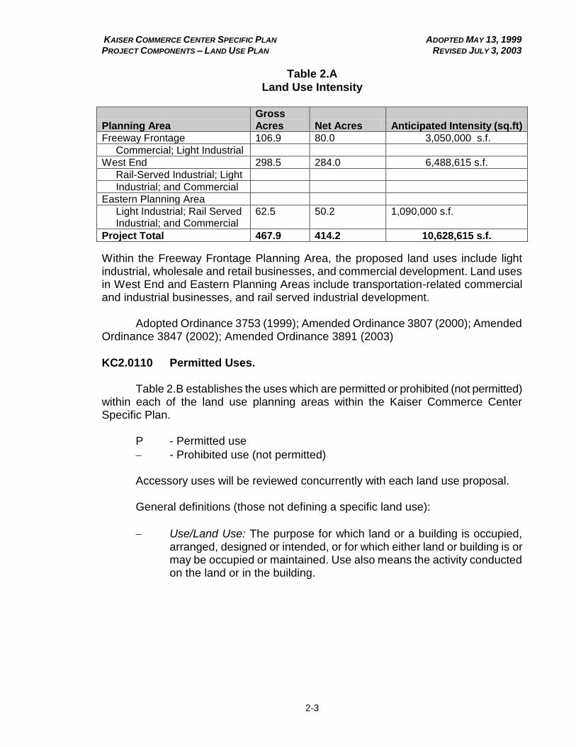
Table 2.A
Land Use Intensity
Planning Area
Gross
Acres Net Acres Anticipated Intensity (sq.ft)
Freeway Frontage 106.9 80.0 3,050,000 s.f.
Commercial; Light Industrial
West End 298.5 284.0 6,488,615 s.f.
Rail-Served Industrial; Light
Industrial; and Commercial
Eastern Planning Area
Light Industrial; Rail Served Industrial; and Commercial
62.5 50.2 1,090,000 s.f.
Project Total 467.9 414.2 10,628,615 s.f.
Within the Freeway Frontage Planning Area, the proposed land uses include light industrial, wholesale and retail businesses, and commercial development. Land uses in West End and Eastern Planning Areas include transportation-related commercial and industrial businesses, and rail served industrial development. Adopted Ordinance 3753 (1999); Amended Ordinance 3807 (2000); Amended Ordinance 3847 (2002); Amended Ordinance 3891 (2003)
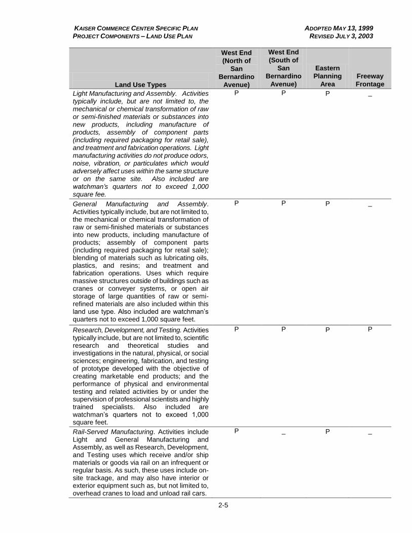
KC2.0110 Permitted Uses. Table 2.B establishes the uses which are permitted or prohibited (not permitted) within each of the land use planning areas within the Kaiser Commerce Center Specific Plan.
P - Permitted use
- Prohibited use (not permitted) Accessory uses will be reviewed concurrently with each land use proposal. General definitions (those not defining a specific land use):
Use/Land Use: The purpose for which land or a building is occupied, arranged, designed or intended, or for which either land or building is or may be occupied or maintained. Use also means the activity conducted on the land or in the building.

KAISER COMMERCE CENTER SPECIFIC PLAN ADOPTED MAY 13, 1999 PROJECT COMPONENTS – LAND USE PLAN REVISED JULY 3, 2003
2-4
Table 2.B
Permitted Uses
Land Use Types
West End
(North of
San
Bernardino
Avenue)
West End
(South of
San
Bernardino
Avenue)
Eastern
Planning
Area
Freeway
Frontage
TRANSPORTATION SERVICES
Heavy Truck Repair. Activities typically include, but are not limited to, maintenance and repair of heavy (commercial) trucks and recreational vehicles, along with the incidental retail sale of goods and services for heavy trucks or recreational vehicles. Uses typically include, but are not limited to, general repair, engine/transmission rebuilding and machine shops, tire sales, trailer maintenance, body repair and painting, and the installation of major accessories, as well as heavy truck and recreational vehicle washing services.
P
P
P
_
Truck Stop. A facility for the sale of diesel fuel, gasoline or other fuels to tractor trucks, along with accessory activities such as the sale of lubricants, accessories or supplies, servicing of tractor trucks or semi-trailers, and parking of tractor trucks and semi-trailers. Accessory uses may also include a truck wash, sleeping accommodations, showers, restaurant, convenience store, and gift shop.
P
P
P
_
Heavy Truck Leasing and Rentals. Activities typically include, but are not limited to the leasing or rental of new or previously owned heavy (commercial) trucks, panel trucks, vans, trailers, or recreational vehicles, including repair and maintenance services as accessory uses. All repair and maintenance operations conducted within the Freeway Frontage Planning Area shall occur within an entirely enclosed building.
P P
P P
MANUFACTURING AND ASSEMBLY USE TYPES
KAISER COMMERCE CENTER SPECIFIC PLAN ADOPTED MAY 13, 1999 PROJECT COMPONENTS – LAND USE PLAN REVISED JULY 3, 2003
2-5
Land Use Types
West End
(North of
San
Bernardino
Avenue)
West End
(South of
San
Bernardino
Avenue)
Eastern
Planning
Area
Freeway
Frontage Light Manufacturing and Assembly. Activities typically include, but are not limited to, the mechanical or chemical transformation of raw or semi-finished materials or substances into new products, including manufacture of products, assembly of component parts (including required packaging for retail sale), and treatment and fabrication operations. Light manufacturing activities do not produce odors, noise, vibration, or particulates which would adversely affect uses within the same structure or on the same site. Also included are watchman’s quarters not to exceed 1,000 square fee.
P P
P _
General Manufacturing and Assembly. Activities typically include, but are not limited to, the mechanical or chemical transformation of raw or semi-finished materials or substances into new products, including manufacture of products; assembly of component parts (including required packaging for retail sale); blending of materials such as lubricating oils, plastics, and resins; and treatment and fabrication operations. Uses which require massive structures outside of buildings such as cranes or conveyer systems, or open air storage of large quantities of raw or semi-refined materials are also included within this land use type. Also included are watchman’s quarters not to exceed 1,000 square feet.
P P
P _
Research, Development, and Testing. Activities typically include, but are not limited to, scientific research and theoretical studies and investigations in the natural, physical, or social sciences; engineering, fabrication, and testing of prototype developed with the objective of creating marketable end products; and the performance of physical and environmental testing and related activities by or under the supervision of professional scientists and highly trained specialists. Also included are watchman’s quarters not to exceed 1,000 square feet.
P P
P P
Rail-Served Manufacturing. Activities include Light and General Manufacturing and Assembly, as well as Research, Development, and Testing uses which receive and/or ship materials or goods via rail on an infrequent or regular basis. As such, these uses include on-site trackage, and may also have interior or exterior equipment such as, but not limited to, overhead cranes to load and unload rail cars.
P _
P _

KAISER COMMERCE CENTER SPECIFIC PLAN ADOPTED MAY 13, 1999 PROJECT COMPONENTS – LAND USE PLAN REVISED JULY 3, 2003
2-6
Land Use Types
West End
(North of
San
Bernardino
Avenue)
West End
(South of
San
Bernardino
Avenue)
Eastern
Planning
Area
Freeway
Frontage
WHOLESALE, STORAGE, AND DISTRIBUTION TYPES Operable Vehicle Storage. Activities typically include, but are not limited to the parking and/or storage of operable vehicles. Typical uses include, but are not limited to fleet storage of automobiles and trucks, storage lots, and recreational vehicle and boat storage.
P P P _
Personal Storage. Activities typically include, but are not limited to storage services and facilities primarily for personal and business effects and household goods with enclosed storage areas having individual access. Typical uses include, but are not limited to mini-warehouses.
P P P P
Wholesale, Storage, and Distribution B Light. Activities typically include, but are not limited to, wholesaling, storage, and warehousing services conducted entirely within enclosed buildings. Also included are watchman’s quarters not to exceed 1,000 square feet.
P P P P
Wholesale, Storage, and Distribution B General. Activities typically include, but are not limited to, warehousing, storage, freight handling, shipping, trucking services; storage and wholesaling from the premises of unfinished, raw, semi-refined products requiring further processing, fabrication, or manufacturing. Outdoor storage is permitted subject to applicable screening requirements. Also included are watchman’s quarters not to exceed 1,000 square feet.
P P P _
Retail and Wholesale in Conjunction with Manufacturing. Activities typically include, but are not limited to, retailing and wholesaling of goods and products manufactured on site. Typical uses include, but are not limited to include furniture manufacturing and sales, computer and electronics assembly and sales, and paper manufacturing and sales, storage, and warehousing services.
P P P P

KAISER COMMERCE CENTER SPECIFIC PLAN ADOPTED MAY 13, 1999 PROJECT COMPONENTS – LAND USE PLAN REVISED JULY 3, 2003
2-7
Land Use Types
West End
(North of
San
Bernardino
Avenue)
West End
(South of
San
Bernardino
Avenue)
Eastern
Planning
Area
Freeway
Frontage Rail-Served Warehousing. Activities typically include Operable Vehicle Storage, and Light or General Wholesale, Storage, and Distribution uses which receive and/or ship materials or goods via rail on an infrequent or regular basis. As such, these uses include onsite trackage, and may also have interior or exterior equipment such as, but not limited to, overhead cranes to load and unload rail cars.
P _ P _
COMMERCIAL USE TYPES Administrative and Professional Offices. Activities typically include, but are not limited to, executive management, administrative, or clerical uses of private and public utility firms. Additional activities include the provision of advice design, information or consultation of a professional nature. Uses typically include, but are not limited to, corporate headquarters; branch offices; data storage, financial records, and auditing centers; architect’s; lawyer’s; insurance sales and claims offices; financial planners; and accountant’s offices.
_ P P P
Agricultural Supplies and Services. Activities typically include, but are not limited to, the retail sales from the premises of feed and grain, fertilizers, pesticides, herbicides, and similar goods. Uses typically include, but are not limited to, feed and grain stores, well drilling and tree service firms. Also included are showrooms and sales of farm equipment.
P P P _
Alcohol Sales, On Site (On-Sale). Activities typically include the sale, subject to required license, of alcoholic beverages for consumption on the premises. Uses typically include restaurants and bar.
P P P P
Automotive Cleaning. Activities typically include the washing and polishing of automobiles. Uses typically include automobile laundries; car washes, excluding self service washes; and automotive detailing.
P P P P
Automotive and Light Truck Repair – Minor. Activities include, but are not limited to automotive and light truck repair, retail sales of goods and services for automobiles and light trucks, and the cleaning and washing of automobiles and light trucks. Uses typically include, but are not limited to general auto repair shops, brake and muffler shops, and car washes.
P P P P

KAISER COMMERCE CENTER SPECIFIC PLAN ADOPTED MAY 13, 1999 PROJECT COMPONENTS – LAND USE PLAN REVISED JULY 3, 2003
2-8
Land Use Types
West End
(North of
San
Bernardino
Avenue)
West End
(South of
San
Bernardino
Avenue)
Eastern
Planning
Area
Freeway
Frontage Automobile and Light Truck Repair - General. In addition to the types of repair operations included as part of Automobile and Light Truck Repair - Light, activities typically include, but are not limited to, automotive body work, painting, installation of major accessories, automobile customizing, and towing facilities.
P P P _
Automotive Rental Agencies. Activities typically include, but are not limited to, the rental from the premises of motor vehicles, with provision for incidental maintenance services.
P P P P
Automotive Sales. Activities typically include, but are not limited to, the retail sale of predominantly new, used, or vintage vehicles together with their incidental maintenance. Typical uses include, but are not limited to, automobile and recreational vehicles sales agencies.
P P P P
Automotive Service Station. Activities typically include, but are not limited to the sale from the premises of goods and the provision of services normally required in the daily operation of motor vehicles, including the principal sale of petroleum products, the incidental sale of replacement items, and the performance of minor repairs. Also included is the washing of automobiles and light trucks.
P P P P
Building Contractor’s Storage Yard. Activities typically include, but are not limited to offices and storage for equipment, materials, and vehicles for contractors who are in the construction trades (e.g., general contractors, framing, plumbing, electrical, roofing, carpentry, etc.).
P P P _
Building Maintenance Services. Activities typically include, but are not limited to, maintenance and custodial services, window cleaning services, disinfecting and exterminating services, and janitorial services.
P P P P
Building Supplies and Sales - General. Activities typically include, but are not limited to, the retail sale or rental from the premises of goods and equipment, including paint, glass, hardware, fixtures, electrical supplies, yard and garden supplies, and lumber and hardware stores. Also included are sales and rental of household and yard tools and equipment, as well as sales of building materials, such as brick, block, sand, and gravel. Outdoor storage may be permitted subject to screening requirements.
P P P P

KAISER COMMERCE CENTER SPECIFIC PLAN ADOPTED MAY 13, 1999 PROJECT COMPONENTS – LAND USE PLAN REVISED JULY 3, 2003
2-9
Land Use Types
West End
(North of
San
Bernardino
Avenue)
West End
(South of
San
Bernardino
Avenue)
Eastern
Planning
Area
Freeway
Frontage
Business Supplies and Sales – Light. Activities typically include, but are not limited to, the retail sale or rental from the premises of goods and equipment, including paint, glass, hardware, fixtures, electrical supplies, yard and garden supplies, and lumber and hardware stores. Also included are sales and rental of household and yard tools and equipment. Outdoor storage of goods such as, but not limited to, lumber, brick, block, nursery stock, and garden supplies may be permitted subject to screening requirements. Within the Freeway Frontage Planning Area, outdoor storage shall be completely screened from view from the I-10 freeway, public streets, and adjacent land uses.
P P P P
Business Supply Retail and Services. Activities typically include, but are not limited to, retail sales; rental or repair from the premises of office equipment, office supplies; and similar office goods.
P P P P
Business Support Services. Activities typically include, but are not limited to, firms rather than individuals of a clerical, employment, or minor processing nature, including multi-copy and blue-print services. The printing of books, other than pamphlets and reports for another firm is excluded from this use type.
P P P P
Communication Services. Activities typically include, but are not limited to, broadcasting and other information relay services accomplished primarily through use of electronic and telephonic mechanisms. Uses typically include, but are not limited to, television and radio studios and telegraph offices.
P P P P
Convenience Sales. Activities typically include, but are not limited to, the retail sales of frequently needed small personal convenience items and professional services that are frequently used. Uses typically include, but are not limited to, convenience markets, drug stores, beauty and barber shops, and dry cleaning establishments.
P P P P
Eating and Drinking Establishments. Activities typically include, but are not limited to, the retail sale from the premises of food or beverages prepared for on-premises consumption. Uses typically include, but are not limited to, restaurants and fast food type services.
_ P P P
KAISER COMMERCE CENTER SPECIFIC PLAN ADOPTED MAY 13, 1999 PROJECT COMPONENTS – LAND USE PLAN REVISED JULY 3, 2003
2-10
Land Use Types
West End
(North of
San
Bernardino
Avenue)
West End
(South of
San
Bernardino
Avenue)
Eastern
Planning
Area
Freeway
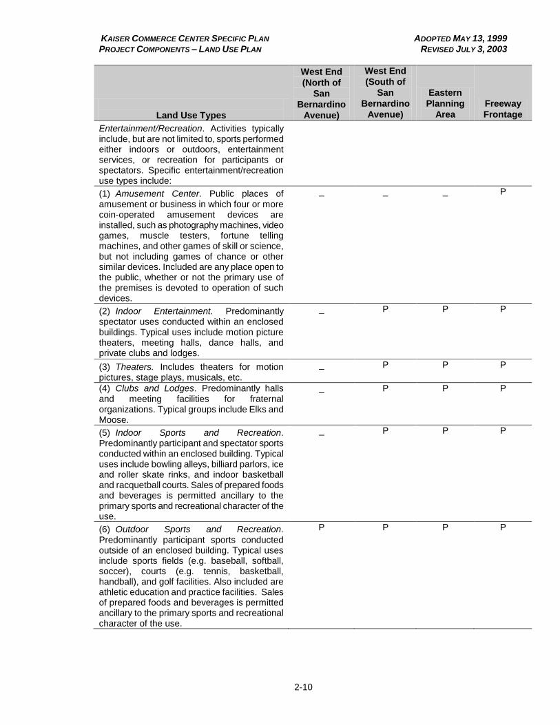
Frontage Entertainment/Recreation. Activities typically include, but are not limited to, sports performed either indoors or outdoors, entertainment services, or recreation for participants or spectators. Specific entertainment/recreation use types include:
(1) Amusement Center. Public places of amusement or business in which four or more coin-operated amusement devices are installed, such as photography machines, video games, muscle testers, fortune telling machines, and other games of skill or science, but not including games of chance or other similar devices. Included are any place open to the public, whether or not the primary use of the premises is devoted to operation of such devices.
_ _ _ P
(2) Indoor Entertainment. Predominantly spectator uses conducted within an enclosed buildings. Typical uses include motion picture theaters, meeting halls, dance halls, and private clubs and lodges.
_ P P P
(3) Theaters. Includes theaters for motion pictures, stage plays, musicals, etc.
_ P P P
(4) Clubs and Lodges. Predominantly halls and meeting facilities for fraternal organizations. Typical groups include Elks and Moose.
_ P P P
(5) Indoor Sports and Recreation. Predominantly participant and spectator sports conducted within an enclosed building. Typical uses include bowling alleys, billiard parlors, ice and roller skate rinks, and indoor basketball and racquetball courts. Sales of prepared foods and beverages is permitted ancillary to the primary sports and recreational character of the use.
_ P P P
(6) Outdoor Sports and Recreation. Predominantly participant sports conducted outside of an enclosed building. Typical uses include sports fields (e.g. baseball, softball, soccer), courts (e.g. tennis, basketball, handball), and golf facilities. Also included are athletic education and practice facilities. Sales of prepared foods and beverages is permitted ancillary to the primary sports and recreational character of the use.
P P P P

KAISER COMMERCE CENTER SPECIFIC PLAN ADOPTED MAY 13, 1999 PROJECT COMPONENTS – LAND USE PLAN REVISED JULY 3, 2003
2-11
Land Use Types
West End
(North of
San
Bernardino
Avenue)
West End
(South of
San
Bernardino
Avenue)
Eastern
Planning
Area
Freeway
Frontage
Extensive Impact Commercial. Activities typically include, but are not limited to those which produce a substantial impact upon the surrounding area. Uses typically include, but are not limited to, outdoor sales and swap meets, amusement parks, and drive-in theaters.
P _ P _
Financial Institutions. Uses typically include, but are not limited to, banks, savings and loans, and credit unions.
_ P _ P
Food and Beverage Sales. Activities typically include, but are not limited to retail sale from the premises of food and beverages for off-premises consumption. Uses typically include markets, mini-markets, liquor stores, and retail bakeries.
P P P P
Health Clubs and Spas. Activities typically include, but are not limited to sport and health-related activities performed either indoors and outdoors. Users typically include, but are not limited to, health clubs, spas, gyms, and tennis clubs.
_ P _ P
Hotels and Motels. Activities typically include, but are not limited to, lodging services to transient guests on a less-than-monthly basis, other than private boarding houses.
_ P _ P
Industrial/Sports Medical and Health Care Services. Activities typically include, but are not limited to, the provision of work- or sports-related therapeutic, preventive, or correctional personal treatment (including out-patient surgical services) by physicians, dentist, and other medical practitioners, as well as the provision of work-related emergency medical treatment.
_ _ _ P
Laundry Services. Activities typically include, but are not limited to, institutional or commercial linen supply and laundry services, dry cleaning plants, rug cleaning, and diaper service laundries.
P P P P
Lumber Yards, Wholesale and Retail. Activities typically include, but are not limited to, storage and sales of lumber and lumber products, including custom milling of specialty wood products. Outdoor storage may be permitted subject to applicable screening requirements.
P P P _

KAISER COMMERCE CENTER SPECIFIC PLAN ADOPTED MAY 13, 1999 PROJECT COMPONENTS – LAND USE PLAN REVISED JULY 3, 2003
2-12
Land Use Types
West End
(North of
San
Bernardino
Avenue)
West End
(South of
San
Bernardino
Avenue)
Eastern
Planning
Area
Freeway
Frontage Nurseries, Wholesale and Retail. Activities typically include, but are not limited to, sales of indoor and outdoor plants, including, but not limited to, trees, shrubs, ground covers, and grass sod, as well as seeds, pots and potting supplies, and growing supplies.
P P P P
Personal Services and Sales. Activities typically include, but are not limited to retail sales of small personal convenience items and professional services which are used frequently by the business community. Uses typically include, beauty and barber shops, florist shops, photography studios, and apparel laundering and dry cleaning agencies.
_ P P P
Processing Facilities. Activities typically include, but are not limited to, collection and processing of recyclable and other materials. Processing means the preparation of materials for efficient shipment or sale by such means as briquetting, grinding, crushing, mechanical or manual sorting, shredding, disassembly, cleaning, melting, stripping, or remanufacturing. Finished materials may be sold on-premises or may be semi-finished or raw materials to be shipped for further manufacture or assembly. Such facilities may involve outdoor storage of materials. All activities and outdoor storage are to be screened from view from public streets.
P P P _
Repair Services. Activities typically include, but are not limited to, repair of such articles as upholstery, furniture, electronic equipment, and large electrical appliances.
P P P P
CIVIC USE TYPES Civic Administration. Activities typically include, but are not limited to, management, administration, or clerical services performed by public, quasi-public, and utility agencies.
_ P P P
Community Education. Typical activities include educational services for adults provided by private institutions. Typical uses include vocational and trade schools.
_ P P P
Cultural Facilities. Activities typically include, but are not limited to, those performed by public and private museums and art galleries, public and private libraries and observatories. Also included are facilities for the performing arts.
_ P P P
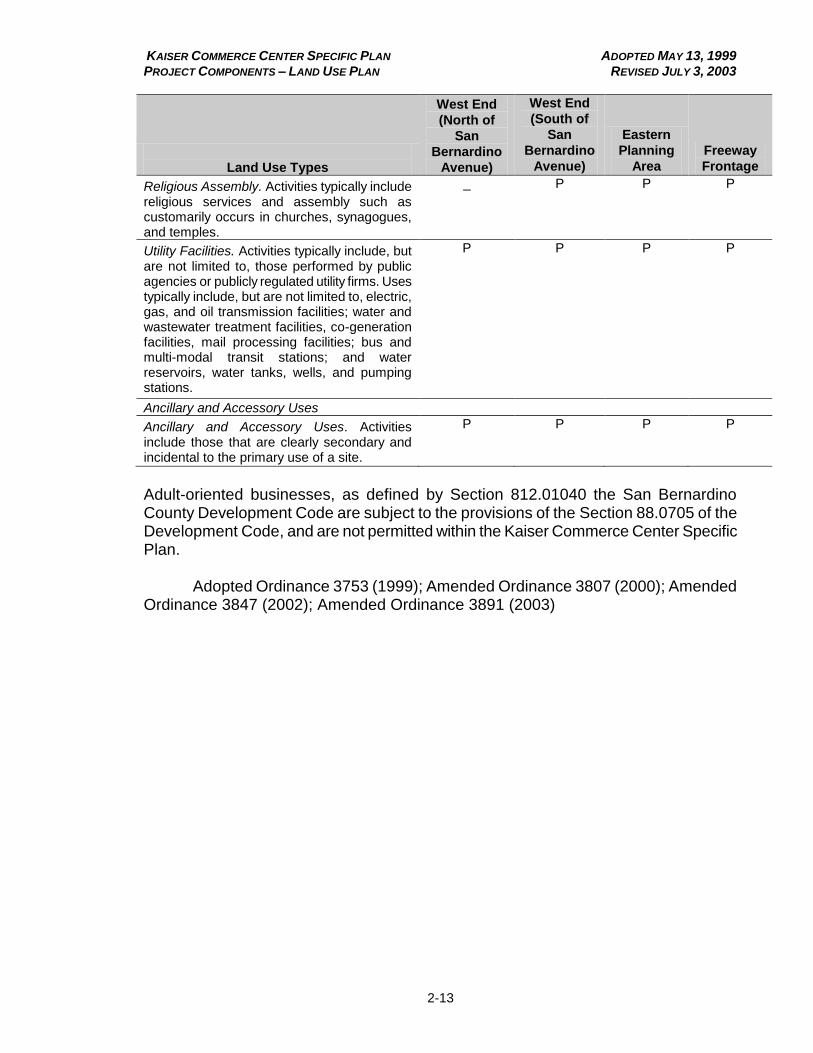
KAISER COMMERCE CENTER SPECIFIC PLAN ADOPTED MAY 13, 1999 PROJECT COMPONENTS – LAND USE PLAN REVISED JULY 3, 2003
2-13
Land Use Types
West End
(North of
San
Bernardino
Avenue)
West End
(South of
San
Bernardino
Avenue)
Eastern
Planning
Area
Freeway
Frontage Religious Assembly. Activities typically include religious services and assembly such as customarily occurs in churches, synagogues, and temples.
_ P P P
Utility Facilities. Activities typically include, but are not limited to, those performed by public agencies or publicly regulated utility firms. Uses typically include, but are not limited to, electric, gas, and oil transmission facilities; water and wastewater treatment facilities, co-generation facilities, mail processing facilities; bus and multi-modal transit stations; and water reservoirs, water tanks, wells, and pumping stations.
P P P P
Ancillary and Accessory Uses Ancillary and Accessory Uses. Activities include those that are clearly secondary and incidental to the primary use of a site.
P P P P
Adult-oriented businesses, as defined by Section 812.01040 the San Bernardino County Development Code are subject to the provisions of the Section 88.0705 of the Development Code, and are not permitted within the Kaiser Commerce Center Specific Plan. Adopted Ordinance 3753 (1999); Amended Ordinance 3807 (2000); Amended Ordinance 3847 (2002); Amended Ordinance 3891 (2003)
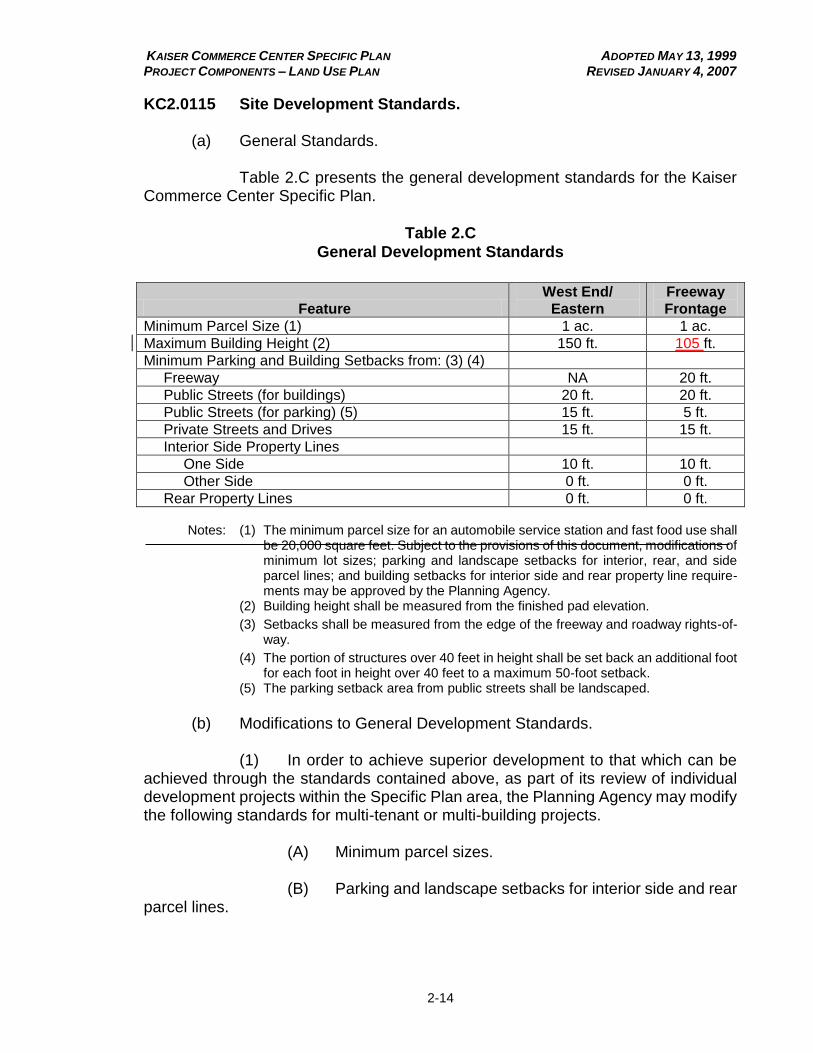
KAISER COMMERCE CENTER SPECIFIC PLAN ADOPTED MAY 13, 1999 PROJECT COMPONENTS – LAND USE PLAN REVISED JANUARY 4, 2007
2-14
KC2.0115 Site Development Standards.
(a) General Standards.
Table 2.C presents the general development standards for the Kaiser Commerce Center Specific Plan.
Table 2.C
General Development Standards
Feature
West End/
Eastern
Freeway
Frontage
Minimum Parcel Size (1) 1 ac. 1 ac.
Maximum Building Height (2) 150 ft. 105 ft.
Minimum Parking and Building Setbacks from: (3) (4)
Freeway NA 20 ft.
Public Streets (for buildings) 20 ft. 20 ft.
Public Streets (for parking) (5) 15 ft. 5 ft.
Private Streets and Drives 15 ft. 15 ft.
Interior Side Property Lines
One Side 10 ft. 10 ft.
Other Side 0 ft. 0 ft.
Rear Property Lines 0 ft. 0 ft.
Notes: (1) The minimum parcel size for an automobile service station and fast food use shall be 20,000 square feet. Subject to the provisions of this document, modifications of minimum lot sizes; parking and landscape setbacks for interior, rear, and side parcel lines; and building setbacks for interior side and rear property line require-ments may be approved by the Planning Agency.
(2) Building height shall be measured from the finished pad elevation.
(3) Setbacks shall be measured from the edge of the freeway and roadway rights-of-way.
(4) The portion of structures over 40 feet in height shall be set back an additional foot for each foot in height over 40 feet to a maximum 50-foot setback.
(5) The parking setback area from public streets shall be landscaped. (b) Modifications to General Development Standards.
(1) In order to achieve superior development to that which can be
achieved through the standards contained above, as part of its review of individual development projects within the Specific Plan area, the Planning Agency may modify the following standards for multi-tenant or multi-building projects.
(A) Minimum parcel sizes. (B) Parking and landscape setbacks for interior side and rear
parcel lines.
KAISER COMMERCE CENTER SPECIFIC PLAN ADOPTED MAY 13, 1999 PROJECT COMPONENTS – LAND USE PLAN REVISED DECEMBER 14, 2000
2-15
(C) Building setbacks for interior side and rear property lines. (D) Parking and landscaping requirements for individual
parcels, except for required landscaping along public streets and private drives.
(2) Where modified standards are permitted by the Planning Agency, all required setbacks along public street frontages shall be met.
(3) Where modified standards are permitted by the Planning Agency, innovative designs such as industrial/ commercial condominiums or ”postage stamp lots” may be utilized. Thus, standards for landscape coverage and number of parking spaces need not be met on a parcel-by-parcel basis. However, each approved phase of development shall contain the required amount of landscaping and number of parking and loading spaces. Where common parking and/or landscape areas are proposed, appropriate easements and covenants, conditions, and restrictions (CC&Rs) shall be established to ensure adequate access throughout the site, and to ensure ongoing maintenance of common facilities.
(4) Although development standards may be modified by the Planning Agency such that each building need not be set back from interior property lines, a minimum building separation equal to Uniform Building Code requirements shall be maintained.
(5) Individual buildings and parcels need not have direct access to a public street; however, sufficient easements and/or reciprocal access agreements shall be recorded to ensure that adequate ingress and egress is available to each lot and building.
(c) Design Concepts.
(1) General Concepts.
Within the Kaiser Commerce Center Specific Plan, site design
should first address the nature and function of the development, building, structure, or feature being considered. Architectural design and details are then, as a rule, expected to be oriented to areas within public view. Landscaping is provided to highlight positive visual features, to screen negative ones, and to provide a cool, pleasant outdoor environment. Design within Kaiser Commerce Center Specific Plan should thus be the result of melding function and form, not one to the exclusion of the other. Consequently, each development plan submittal will be reviewed for its overall design, with allowances for individuality and special functional needs. To facilitate design integrity between the variety of uses within the Kaiser Commerce Center Specific Plan, the following shall be considered:

KAISER COMMERCE CENTER SPECIFIC PLAN ADOPTED MAY 13, 1999 PROJECT COMPONENTS – LAND USE PLAN REVISED DECEMBER 14, 2000
2-16
(A) Site design of commercial, office, and business park type uses should be, where feasible, arranged in such a way as to create opportunities for outdoor plazas and/or courtyards as part of landscaped open spaces.
(B) Structural design and orientation should reflect consideration for energy conservation and efficiency where practical, i.e., the use of skylights for natural lighting, solar orientation, and the use of deciduous trees for winter sunlight and summer shade for glass window areas. Items such as solar water heating or energy co-generation, where practical, are encouraged.
(C) Buildings should maintain simple rectangular forms which can be modified by occasional diagonal or rounded forms.
(D) Entries should not appear as added-on or unrelated elements.
(E) Large smooth, unarticulated surfaces should be avoided where they will be located adjacent to a public right-of-way. The use of sandblasted, ribbed, or exposed aggregate texture treatments for concrete walls adjacent to a public right-of-way is encouraged. Exterior materials requiring high maintenance responsibilities such as stained wood, clapboard, or shingles should be avoided.
(F) Exterior mechanical equipment should be screened or contained within efficient rooftop penthouses. Roof screens should be solid and continuous.
(G) Wall mounted items such as roof ladders, electrical panels, and down spouts should not be located adjacent to public rights-of-way.
(H) Service areas should be simple and efficient, and should
not interfere visually or physically with other building operations. Service areas should not be visible from public rights-of-way.
(I) All existing and new gas, telephone lines, and electrical lines of 12 kV or less within the project and along the adjacent half-width of major arterials (except within the SCE right-of-way along Etiwanda Avenue) shall be placed underground.
(J) All ground-mounted utility appurtenances should be located away from public view or adequately screened. Screening should be of a material complimentary to the structure and/or heavy landscaping and berming.
(K) No utility appurtenances shall be permitted directly within a
pedestrian area.
KAISER COMMERCE CENTER SPECIFIC PLAN ADOPTED MAY 13, 1999 PROJECT COMPONENTS – LAND USE PLAN REVISED JULY 3, 2003
2-17
(L) The use of prefabricated, all metal sheeting of buildings may be permitted under the following circumstances:
(i) Within the Freeway Frontage Planning Area, metal buildings are prohibited.
(ii) Within the West End Planning Area south of San Bernardino Avenue, metal buildings that are within 100 feet of a public street, and which will be visible from a public street are permitted, provided that they are architecturally treated so as not to appear to be a metal building.
(iii) Within the West End Planning Area north of San Bernardino Avenue, metal buildings are permitted.
The use of metal details, such as standing seam metal roofs, within the context of the overall theme of the structure shall be permitted.
(M) Where long, linear walls or fences are needed, a combination of wall/fence along a landscaped berm is encouraged.
(2) West End/Eastern Planning Areas Design Concepts.
The objective of site planning and development within the industrial portions of the Kaiser Commerce Center Specific Plan is to concentrate site landscaping and architectural detail to public views, while promoting the rear and interior sides of sites which are not visible to the public to operate efficiently and free of nonfunctional features. This objective is not intended to reduce landscape and architectural requirements within the industrial area, but instead to more logically orient aesthetic improvements and features to street frontages of parcels for increased visual benefit to the public.
Structures such as storage tanks, cooling towers, etc. should be located at the rear of parcels, and painted with a compatible color to adjacent buildings. The goal of the color selection shall be to decrease public awareness of the structures.
(3) Freeway Frontage Design Concepts.
The site design concept along the freeway frontage is based upon
the "gateway" function of this area. The Freeway Frontage Planning Area is situated adjacent to I-10 freeway, encompassing project entries from Valley Boulevard. As a result, buildings within this area will generally be more oriented to public view than will buildings within the interior of the site. While many of the uses within this area will be primarily industrial in nature, buildings should generally display an office or commercial-like facade to public streets and the freeway. Structures, such as storage
KAISER COMMERCE CENTER SPECIFIC PLAN ADOPTED MAY 13, 1999 PROJECT COMPONENTS – LAND USE PLAN REVISED JULY 3, 2003
2-18
tanks, cooling towers, etc will be reviewed on a site-by-site basis to ensure that they are completely screened from view from the San Bernardino Freeway, public streets, and adjacent land uses.
(d) Landscaping.
(1) The quality environment envisioned for Kaiser Commerce Center Specific Plan will be established, in large part, by its landscape treatment. Landscaping that will be provided within the Kaiser Commerce Center Specific Plan is intended to give structure and identity to the overall project (Figures 2.2a, 2.2b, 2.2c, and 2.3).
Within the Freeway Frontage planning area, the minimum on-site landscape area (including hardscape and pedestrian facilities within parking areas) shall be 10 percent of the net lot area.
Within the West End/Eastern planning areas, the required
landscaping may be concentrated along public street frontages.
(A) A landscape and utilities easement shall be provided for any areas outside of the public right-of-way which are to be maintained by a landscape and lighting district or by a property owners’ association.
(B) Prior to issuance of construction permits, as applicable,
landscape and irrigation construction drawings in conformance with the Kaiser Commerce Center Specific Plan shall be submitted for review and approval by the Planning Agency.
(C) Permanent automatic irrigation systems shall be provided in
all landscaped areas.
(D) All landscaped areas shall be maintained in a healthy and thriving condition, free from weeds, trash, and debris.
(E) Building setbacks which are not used for drive entries,
parking, or approved outdoor uses shall be fully landscaped. All unpaved non-work areas shall be landscaped.
(F) To soften building elevations, a 5-foot wide landscaped area shall be provided adjacent to building elevations which face:
(i) public streets.
(ii) freeway right-of-way. No landscaping shall be required adjacent to the portions of
buildings where loading doors are located.
KAISER COMMERCE CENTER SPECIFIC PLAN ADOPTED MAY 13, 1999 PROJECT COMPONENTS – LAND USE PLAN
2-19
Figure 2.2a
Design Concept - On-Site Landscaping
KAISER COMMERCE CENTER SPECIFIC PLAN ADOPTED MAY 13, 1999 PROJECT COMPONENTS – LAND USE PLAN
2-20
Figure 2.2b
On-Site Landscaping

KAISER COMMERCE CENTER SPECIFIC PLAN ADOPTED MAY 13, 1999 PROJECT COMPONENTS – LAND USE PLAN
2-21
Figure 2.2c
On-Site Landscaping

KAISER COMMERCE CENTER SPECIFIC PLAN ADOPTED MAY 13, 1999 PROJECT COMPONENTS – LAND USE PLAN
2-22
Figure 2.3
Tree Staking, Guying, and Planting
KAISER COMMERCE CENTER SPECIFIC PLAN ADOPTED MAY 13, 1999 PROJECT COMPONENTS – LAND USE PLAN REVISED DECEMBER 14, 2000
2-23
(G) All parking visible from any arterial street shall be shielded by berms (maximum 3:1 slope) and planted with trees, shrubs, and turf.
(H) Curbs, bumpers, and similar permanent devices shall be
provided within parking areas so that parked vehicles do not bump building, screen, landscape, or perimeter walls. All landscape areas are to be delineated with minimum 6-inch concrete curbs.
(I) A maximum of ten spaces shall be permitted between
finger-type planters within parking areas within the Freeway Frontage Planning Area.
Alternatively, a minimum of 5 percent of the parking area shall be landscaped and distributed throughout the parking area. For purposes of this alternative requirement, "parking area" shall include boundary landscaping, except required setback areas. Where this alternative is used, parking area landscaping may not be counted toward requirements for site landscape area.
(J) Planters shall have a minimum clear landscape width of 5
feet. Within parking areas, and unless "diamond planters" are used, planters shall also have a minimum length not more than 6 inches less than the longest abutting parking stall (i.e., 14 feet 6 inches for compact stalls and 18 feet 6 inches for standard stalls), exclusive of curbing, and shall have sufficient room to accommodate tree growth.
(K) Landscaping along public rights of way shall be designed to
aesthetically screen and soften blank walls, parking areas, storage areas, utility boxes, and other non-aesthetic items.
(L) Plant materials within individual landscaped areas shall be
of varieties which utilize like amounts of water. (M) Sprinkler heads located immediately adjacent to parking
areas should be of the "pop-up" variety instead of risers.
(N) The planting of ivy or hedge shrubs along exterior structure and screen walls is encouraged to deter potential graffiti.
(O) Trees used within required landscape areas, including
parking areas, shall have a minimum size of 15 gallons.
(P) All 15-gallon trees shall be staked. All box trees shall be provided with guy wires.
KAISER COMMERCE CENTER SPECIFIC PLAN ADOPTED MAY 13, 1999 PROJECT COMPONENTS – LAND USE PLAN REVISED APRIL 4, 2002
2-24
(2) Industrial Streetscapes. Industrial forms are inherently bulky, with consequent hard lines.
Recognizing this, the landscape concept within the industrial areas of Kaiser Commerce Center Specific Plan, as shown in Figure 2.4, is to take advantage of the buffering and softening capabilities of landscape material. In addition, sites might be used for truck stop, automotive or truck repair, or fleet storage. Thus, with the exception of the south side of Valley Boulevard, the streetscape concept is to create screen landscaping along public rights-of-way. Continuous formal rows of conical evergreen trees interspersed with occasional random groupings of deciduous "color" trees will combine with lower level shrub rows and groundcover to achieve this concept. The result will be a highly functional and aesthetic industrial area, since public frontages and view areas will be naturally screened with evergreen foliage, and the hidden rear and side areas of industrial parcels will be unobstructed for efficient space utilization and vehicular movement.
(3) Valley Boulevard Streetscape (South Side).
Landscaping along the south side of Valley Boulevard will also be
concentrated along public rights-of-way, which will lend identity to the Kaiser Commerce Center Specific Plan. However, because development along the south side of Valley Boulevard in the Freeway Frontage Planning Area will have a different character than in other portions of the site, landscaping along the south side of Valley Boulevard will differ from that found along other streetscapes (see Figure 2.5).
A mixed emphasis of conical evergreen and deciduous varieties will be utilized (Table 2.D). The landscape goal will be to highlight the more articulated buildings present within the Freeway Frontage area, rather than screen them. Random groupings of trees and shrub panels will achieve this effect.

KAISER COMMERCE CENTER SPECIFIC PLAN ADOPTED MAY 13, 1999 PROJECT COMPONENTS – LAND USE PLAN
2-25
Figure 2.4
Industrial Landscaping

KAISER COMMERCE CENTER SPECIFIC PLAN ADOPTED MAY 13, 1999 PROJECT COMPONENTS – LAND USE PLAN
2-26
Figure 2.5
Valley Boulevard (South Side) Landscaping

KAISER COMMERCE CENTER SPECIFIC PLAN ADOPTED MAY 13, 1999 PROJECT COMPONENTS – LAND USE PLAN REVISED APRIL 4, 2002
2-27
Table 2.D
Kaiser Commerce Center Specific Plan Plant Palette
Eve
rgre
en
De
cid
uo
us
He
igh
t
So
uth
we
st
Exp
osu
re
Dro
ug
ht
To
lera
nt
Gro
wth
Ra
te
Se
aso
na
l C
olo
r
Co
mm
en
ts
CONICAL TREES
CUPRESSOCYPARIS LEYLANDII Leyland Cypress 30’ F Wind tolerant
PINUS CANARIENSIS Canary Island Pine 70’ F Wind tolerant PINUS HALEPENSIS Aleppo Pine 40’
F
Wind tolerant
SHRUBS
AGAPANTHUS AFRICANUS Lily of the Nile
18’
F
Summer Blue
Shade tolerant
CEANOTHUS “Julia Phelps” Julia Phelps Ceanothus
5’
F
Spring Blue
Wind tolerant
MOREA IRIDIODES African Iris
M
Spring-Fall White
NERIUM OLEANDER Oleander
12’ F
Spring-Fall White, Pink
Wind, smog tolerant; good
hedge
PITTOSPORUM TOBIRA Mock Orange
15’ M
Spring White
PITTOSPORUM TOBIRA “Wheeler’s Dwarf”
Dwarf Mock Orange
2’ M
Spring White
PLUMBAGO CAPENSIS Blue Cape Plumbago
6’
M
Spring-Winter Blue
RAPHIOLEPIS INDICA India Hawthorn
5’
S
Fall-Spring Pink
Smog tolerant
GROUNDCOVER
ANNUAL COLOR
HEMEROCALLIS “Aztec Gold”
Day Lily
8’
M
Summer, Fall Yellow, Orange
Needs shade
JUNIPERUS SABINA “Tamariscifolia” Tam Juniper 18’
April-June White
LANTANA MONTEVIDENSIS Purple Lantana 2’ F
Spring-Winter Lilac
Smog tolerant
LIRIOPE MUSCARI Lily Turf
8’
M Summer
Lavender
TRACHELOSPERMUM ASIATICUM Asian Jasmine
18’
F
April-June White
TURF
VINCA MAJOR Periwinkle 2’
Lavender Summer
LARGE AND MEDIUM TREES
BRACHYCHITON POPULNEUS Bottle Tree 40’ M Wind tolerant
CHORISIA SPECIOSA Floss-Silk Tree
50’
M
Fall Pink
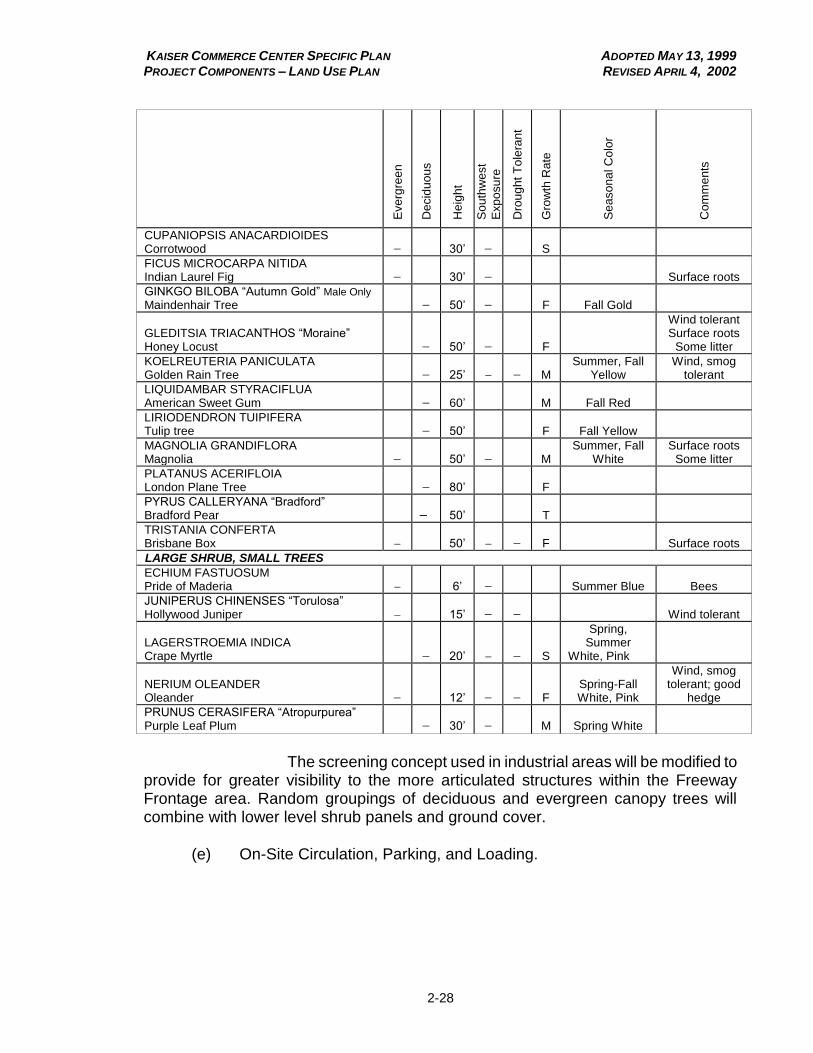
KAISER COMMERCE CENTER SPECIFIC PLAN ADOPTED MAY 13, 1999 PROJECT COMPONENTS – LAND USE PLAN REVISED APRIL 4, 2002
2-28
Eve
rgre
en
De
cid
uo
us
He
igh
t
So
uth
we
st
Exp
osu
re
Dro
ug
ht
To
lera
nt
Gro
wth
Ra
te
Se
aso
na
l C
olo
r
Co
mm
en
ts
CUPANIOPSIS ANACARDIOIDES Corrotwood 30’ S
FICUS MICROCARPA NITIDA Indian Laurel Fig
30’
Surface roots
GINKGO BILOBA “Autumn Gold” Male Only
Maindenhair Tree
50’
F
Fall Gold
GLEDITSIA TRIACANTHOS “Moraine” Honey Locust
50’
F
Wind tolerant Surface roots
Some litter
KOELREUTERIA PANICULATA Golden Rain Tree 25’
M
Summer, Fall Yellow
Wind, smog tolerant
LIQUIDAMBAR STYRACIFLUA American Sweet Gum
60’
M
Fall Red
LIRIODENDRON TUIPIFERA Tulip tree
50’
F
Fall Yellow
MAGNOLIA GRANDIFLORA Magnolia
50’
M
Summer, Fall White
Surface roots Some litter
PLATANUS ACERIFLOIA London Plane Tree
80’
F
PYRUS CALLERYANA “Bradford” Bradford Pear – 50’
T
TRISTANIA CONFERTA Brisbane Box 50’ F Surface roots
LARGE SHRUB, SMALL TREES
ECHIUM FASTUOSUM Pride of Maderia
6’
Summer Blue
Bees
JUNIPERUS CHINENSES “Torulosa” Hollywood Juniper
15’
Wind tolerant
LAGERSTROEMIA INDICA Crape Myrtle
20’
S
Spring, Summer
White, Pink
NERIUM OLEANDER Oleander 12’ F
Spring-Fall White, Pink
Wind, smog tolerant; good
hedge
PRUNUS CERASIFERA “Atropurpurea” Purple Leaf Plum 30’ M
Spring White
The screening concept used in industrial areas will be modified to
provide for greater visibility to the more articulated structures within the Freeway Frontage area. Random groupings of deciduous and evergreen canopy trees will combine with lower level shrub panels and ground cover.
(e) On-Site Circulation, Parking, and Loading.

KAISER COMMERCE CENTER SPECIFIC PLAN ADOPTED MAY 13, 1999 PROJECT COMPONENTS – LAND USE PLAN REVISED JULY 3, 2003
2-29
(1) On-site circulation within individual building sites should be designed for efficient vehicular and pedestrian movement. On-site circulation systems should be logical and easily understood by visitors. For example, where one-way movement is necessary, the design of the circulation system should discourage individuals from entering an exit. In addition, service access routes should not conflict with other on-site circulation routes.
(2) On-site pedestrian walkways should provide direct, safe, and adequate movement paths between parking, open space, and outdoor work/leisure areas and building entrances.
(3) Site lines required for safe automobile movement should be kept clear. Screens and structures should not be located where they would block such site lines, both entering and leaving the individual developments, and the project site. (4) The design and location of entries (curb cuts) for individual development sites should be such that the driver has ample time to perceive them when approaching the site. Intersections and driveway approaches should be kept clear of obstructions such as traffic signal standards and street trees.
(5) Parking spaces and loading zones shall be provided in the number and manner specified in the San Bernardino County Development Code, except for industrial buildings where the standards detailed in Table 2.E shall apply.
Table 2.E
Parking Standards for Industrial Buildings
Parking for Industrial Uses
Kaiser Commerce Center Specific Plan Parking Requirement
per County Code
Industrial Uses, including: Warehouse/ Distribution and Manufacturing Uses
1st 40,000 s.f. 1 space per 1,000 s.f.
1 space per 1,000 s.f. or 1 space for each employee on the largest shift, whichever is greater.
40,000+ s.f. 1 space per 4,000 s.f.
OR 1 space for each employee on the largest shift.
Office Space within Industrial Building
1 space per 200 s.f., OR 1 space for each employee on the largest shift.
1 space per 200 s.f.
(6) Design of parking spaces and on-site circulation standards shall
be in accordance with the San Bernardino County Development Code, except that truck parking stalls shall be clearly striped with single, 4-inch wide stripes on each stall sideline.
KAISER COMMERCE CENTER SPECIFIC PLAN ADOPTED MAY 13, 1999 PROJECT COMPONENTS – LAND USE PLAN REVISED DECEMBER 14, 2000
2-30
(7) Where parking areas are constructed along a street frontage, the following measures should be employed to minimize their visual impact without obstructing views of signs:
(A) Screen parking areas with low berms and landscaping.
(B) Depress parking areas slightly below the grade of the road area, if possible.
(8) Loading areas shall be designed to provide for backing and maneuvering on site and not from or within a public street. Direct loading from a public street shall not be permitted.
(9) Loading and maneuvering areas shall not encroach into parking setback areas.
(10) Loading areas may be permitted facing a public or private street provided they are screened by a combination of screen walls, ornamental landscaping, and/or portions of on-site buildings.
(11) Loading areas and doors not fronting a public or private street
shall be screened from view from the street by solid wing walls constructed of materials such as concrete block, masonry, or brick.
(12) Screen walls and wing walls shall be provided adjacent to loading doors and loading areas and shall be of a compatible material with adjacent buildings, and shall be of sufficient height to provide adequate visual screening. Screen and wing walls shall have a maximum height of 12 feet.
(13) Truck maneuvering areas shall not encroach into required parking stalls and drive aisles and pedestrian access.
(14) On-site truck maneuvering to and from loading areas shall be provided to accommodate the turning radius of a 66-foot extra large semi-trailer (WB-62). With the approval of the County, a greater or lesser turning radius may be required based upon review of a site specific analysis.
(f) Outdoor Manufacturing, Assembly, and Storage.
(1) Manufacturing and assembly operations within the Freeway Frontage Planning Area shall be conducted entirely within an enclosed building and exterior storage shall be completely screened from public view.

KAISER COMMERCE CENTER SPECIFIC PLAN ADOPTED MAY 13, 1999 PROJECT COMPONENTS – LAND USE PLAN REVISED JULY 3, 2003
2-31
(2) Within the West End Planning Area south of San Bernardino Avenue, manufacturing and assembly operations shall be confined within enclosed buildings, and outdoor storage in the West End Planning Area south of San Bernardino Avenue shall be screened from view from public streets.
(3) Within the West End Planning Area north of San Bernardino Avenue and the Eastern Planning Area, manufacturing and assembly operations need not be confined within enclosed buildings. Outdoor storage need not be screened, provided required landscaped setbacks along the street frontage are provided. (4) Where required, outdoor storage shall be adequately screened from public view by an opaque material which is compatible with the materials of adjacent buildings as approved by the County.
(5) The location of outdoor storage areas shall be limited to those areas so indicated on approved site development plans (see Division 3, Chapter 1 - Administration), and shall be subject to the approval of the County.
(6) Outdoor storage shall not be located within areas reserved for off-street parking, loading, or truck maneuvering.
(7) Refuse storage and disposal areas shall be provided within trash
enclosures which are screened on at least three sides from public view by a solid wall which is not less than 6 feet in height. The fourth side shall consist of a solid metal gate painted to match or coordinate with the building (slatted chain link is not acceptable).
(A) Refuse bins shall be provided in sufficient number, and shall be placed in convenient location(s).
(B) All trash shall be deposited in the trash enclosure, and the gate leading thereto shall remain closed except when in use, and shall remain in good working order.
(C) Trash areas shall not be used for storage. The premises shall be kept in a neat and orderly condition at all times, and all improvement shall be maintained in a condition of good repair and appearance.
(g) Walls and Fencing.
Walls and fences serve a major function in the landscape, and will be used to screen automobiles, loading and storage areas, and utility structures. The intent is to keep the walls as low as possible while still performing their screening function.

KAISER COMMERCE CENTER SPECIFIC PLAN ADOPTED MAY 13, 1999 PROJECT COMPONENTS – LAND USE PLAN REVISED APRIL 4, 2002
2-32
(1) Materials.
(A) Walls and fencing constructed within the Kaiser Commerce Center shall be of durable materials, and shall be maintained in good condition at all times.
(B) Walls shall be constructed of concrete block, masonry,
brick, or other similar materials. Decorative fencing may also be constructed, provided that, where it is located adjacent to public street or will be visible from a public right-of-way, it is screened with landscaping.
(C) Chain link fencing along public streets is prohibited.
(2) Configuration.
(A) Where long, linear walls or fences are needed, a combination of wall/fence along a landscaped berm is encouraged.
(B) Screen walls for loading areas shall be located behind building setback lines.
(C) The use of landscaping and offsets in and along screen walls and fences adjacent to the street is encouraged to break up the straight linear pattern of the wall.
(h) Signage.
Signage and graphics will be an important element within the Kaiser Commerce Center Specific Plan. Compatibility of sign size and quality is desired, along with a varied palette of style and character. This combination will enhance the individuality and personality of each individual development within the project area. The purpose of the Kaiser Commerce Center sign standards is to establish a coordinated system of signage for identification of:
the Kaiser Commerce Center as a whole;
multi-tenant complexes; and
individual tenants.
(1) Kaiser Commerce Center Project Identification Signage.

KAISER COMMERCE CENTER SPECIFIC PLAN ADOPTED MAY 13, 1999 PROJECT COMPONENTS – LAND USE PLAN REVISED JULY 3, 2003
2-33
Figure 2.6
Project Sign Location Plan

KAISER COMMERCE CENTER SPECIFIC PLAN ADOPTED MAY 13, 1999 PROJECT COMPONENTS – LAND USE PLAN REVISED JULY 3, 2003
2-34
Figure 2.7 Project Sign System Hierarchy

KAISER COMMERCE CENTER SPECIFIC PLAN ADOPTED MAY 13, 1999 PROJECT COMPONENTS – LAND USE PLAN REVISED JULY 3, 2003
2-35
Figure 2.7a Proposed Median Sign
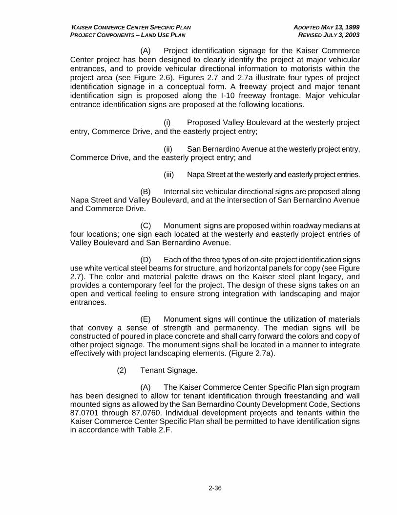
KAISER COMMERCE CENTER SPECIFIC PLAN ADOPTED MAY 13, 1999 PROJECT COMPONENTS – LAND USE PLAN REVISED JULY 3, 2003
2-36
(A) Project identification signage for the Kaiser Commerce Center project has been designed to clearly identify the project at major vehicular entrances, and to provide vehicular directional information to motorists within the project area (see Figure 2.6). Figures 2.7 and 2.7a illustrate four types of project identification signage in a conceptual form. A freeway project and major tenant identification sign is proposed along the I-10 freeway frontage. Major vehicular entrance identification signs are proposed at the following locations.
(i) Proposed Valley Boulevard at the westerly project entry, Commerce Drive, and the easterly project entry;
(ii) San Bernardino Avenue at the westerly project entry,
Commerce Drive, and the easterly project entry; and
(iii) Napa Street at the westerly and easterly project entries.
(B) Internal site vehicular directional signs are proposed along Napa Street and Valley Boulevard, and at the intersection of San Bernardino Avenue and Commerce Drive. (C) Monument signs are proposed within roadway medians at four locations; one sign each located at the westerly and easterly project entries of Valley Boulevard and San Bernardino Avenue.
(D) Each of the three types of on-site project identification signs use white vertical steel beams for structure, and horizontal panels for copy (see Figure 2.7). The color and material palette draws on the Kaiser steel plant legacy, and provides a contemporary feel for the project. The design of these signs takes on an open and vertical feeling to ensure strong integration with landscaping and major entrances.
(E) Monument signs will continue the utilization of materials that convey a sense of strength and permanency. The median signs will be constructed of poured in place concrete and shall carry forward the colors and copy of other project signage. The monument signs shall be located in a manner to integrate effectively with project landscaping elements. (Figure 2.7a). (2) Tenant Signage. (A) The Kaiser Commerce Center Specific Plan sign program has been designed to allow for tenant identification through freestanding and wall mounted signs as allowed by the San Bernardino County Development Code, Sections 87.0701 through 87.0760. Individual development projects and tenants within the Kaiser Commerce Center Specific Plan shall be permitted to have identification signs in accordance with Table 2.F.
KAISER COMMERCE CENTER SPECIFIC PLAN ADOPTED MAY 13, 1999 PROJECT COMPONENTS – LAND USE PLAN REVISED JULY 3, 2003
2-37
(B) For truck stop uses, the following identification signs shall be permitted:
(i) One freestanding sign for primary project
identification and major facilities, with a maximum height of 25 feet and a maximum area of 150 square feet.
(ii) Two freestanding signs per frontage for secondary
project identification and for development sites, with a maximum height of 15 feet and a maximum area of 100 square feet.
(iii) Additional internal site directional and regulatory
signs (Type 3, see Figure 2.7) are permitted subject to approval of Site Development Review.
(iv) Wall signs with a total maximum area of 400 square feet. Total maximum area is for wall signs visible from a public street, not including wall signs for internal facilities within a truck stop.
(C) The following criteria shall apply to all signs within the Kaiser Commerce Center Specific Plan:
(i) The size and number of signs for identification of individual development sites within the Specific Plan area shall be governed by Table 2.F.
(ii) Signs should be of materials which are compatible with exterior building colors, materials, and finishes, and shall be of a high quality of fabrication.
(iii) All owners and/or tenants shall be responsible for the proper maintenance of their signs.
(iv) Signs are to be free of all labels and fabricator's
advertising except for those required by code.
(v) All signs shall conform to the appropriate building and electrical codes, and bear the U.L. label if illuminated. The owner/tenant and contractor shall be responsible for obtaining any and all permits required.
(vi) Owner/tenants will be responsible for the design, fabrication, and installation of individual owner/ tenant signs.
(vii) All permits and fee requirements for signs shall be obtained from the County of San Bernardino, and paid for by the owner/tenant prior to installation.

KAISER COMMERCE CENTER SPECIFIC PLAN ADOPTED MAY 13, 1999 PROJECT COMPONENTS – LAND USE PLAN REVISED JANUARY 4, 2007
2-38
Table 2.F Sign Standards
Sign Type
Sign Configuration
Project Identification
Signage Single Tenant
Site Multi-Tenant
Complex Truck Stops Freestanding Signs for Primary Project Identification and Major Facilities
P1 H 35 NP -- NP -- P H 25
A 300 A 150
Q 1 Q 1 Freestanding Signs for Secondary Project Identification and for Development Sites2, 4
P3 H 15 P H 15 P H 15 P H 15
A 100 A 100 A 100 A 100
Q 13 Q 1FR Q 1FR Q 1FR
Wall NP P R 1:3 P R 1:2 P A 400
Notes: A – Maximum Area (sq.ft.) P – Permitted FR – Per Frontage Q – Quantity H – Maximum Height (ft.) R – Ratio (sign area to building frontage) NP – Not Permitted
1 A Type 1 sign. See Figures 2.6 and 2.7.
2 In addition to the freestanding signs identified in Table 2.FE, additional internal site directional
and regulatory signs (Type 3) are permitted subject to approval of Site Development Review (see Figure 2.7). 3 A Type 2 sign. See Figures 2.6 and 2.7.
4 Also, in coordination with the Redevelopment Agency, a freeway oriented electronic message center no more than 2,330 sq. ft. in area and 105 feet in height may be allowed in the Freeway Planning Area.
(viii) All building-mounted signs shall be constructed so as
not to have exposed wiring, raceways, ballasts, conduit, and transformers.
(ix) Freestanding signs should be incorporated into landscaped berms to minimize visual mass.
(x) All ground mounted signs must be set back from the ultimate curb face and positioned so as not to create a hazard for either pedestrian or vehicular traffic.
(xi) Permanent ground signs shall be fabricated of sturdy, quality materials.
(xii) All wall mounted signs must be constructed of sturdy, quality materials. The height of such signs shall not exceed the height of the building roof line or architecturally integrated parapet wall.
(xiii) All signs shall be maintained in a neat and orderly fashion. Prompt correction of any deficiencies shall be made by the owner/tenant.
KAISER COMMERCE CENTER SPECIFIC PLAN ADOPTED MAY 13, 1999 PROJECT COMPONENTS – LAND USE PLAN REVISED DECEMBER 14, 2000
2-39
(xiv) No sign shall be installed which will impede minimum safe sight stopping distance as per Caltrans Highway Design Manual.
(i) Lighting.
(1) Public Lighting.
Public lighting refers primarily to street lights along public streets. Street lights shall conform, both in type and location, to the standards of the County of San Bernardino at the time of installation. Costs for the maintenance of and energy used in public street lighting will be paid through the formation of a maintenance district or property owners association(s), as approved by the County’s Public Works
Department.
(2) Site Lighting.
The following section addresses illumination of on-site areas for purposes of safety, security, and nighttime ambience, including lighting for parking areas, pedestrian walkways, graphics and signage, architectural and landscape features, shipping and loading areas, and any additional exterior areas. It is recognized that lighting for activities such as sports fields and athletic courts may also be needed within the Specific Plan area. Lighting of such athletic activity areas need only address potential off-site light and glare impacts contained in the Performance Standards of the Kaiser Commerce Center Specific Plan.
(A) A comprehensive lighting plan shall be prepared prior to, or in conjunction with, the submittal of building plans to the County. Said plan shall be approved pursuant to area CC&Rs prior to issuance of building permits.
(B) Lighting sources shall be shielded, diffused, or indirect in
order to avoid glare to pedestrians and motorists. Lighting fixtures should be selected and located to confine the area of illumination to within the site boundaries. To minimize the total number of freestanding light standards, wall-mounted lights should be utilized where feasible and consistent with building architecture.
(C) Parking areas should be lit with shielded, lower intensity light fixtures. Pedestrian walkway lighting should not exceed an overall height of 16 feet. Steps, ramps, and seat walls should be illuminated, wherever possible, with built-in light fixtures.
(D) Shields provided for security lights shall be painted to match the surface to which the fixture is attached. These fixtures shall not project above the fascia or roof lines of the adjacent buildings. Exterior lights should be used to accent entrances and special features. All illumination elements shall have controls to allow their selective use as an energy conservation measure.
(j) Performance Standards.

KAISER COMMERCE CENTER SPECIFIC PLAN ADOPTED MAY 13, 1999 PROJECT COMPONENTS – LAND USE PLAN REVISED DECEMBER 14, 2000
2-40
(1) Applicability.
The performance standards contained herein shall be applied to all development and land uses within Kaiser Commerce Center.
(2) Air Quality.
Any operation or activity which might cause the emission of any smoke, fly ash, dust, fumes, vapors, gases, or other forms of air pollution, which can cause damage to human health, vegetation, or other forms of property, or can cause excessive soiling on any other parcel shall conform to the requirements of the South Coast Air Quality Management District (SCAQMD).
Prior to commencing grading operations, the applicant for any grading permit shall prepare an erosion control and sediment plan for approval by the County of San Bernardino. Access roads within the area being graded shall be kept wet while being used. Alternatively, uncovered soils shall be treated with oil, asphaltic concrete, concrete, or other similar material approved by the County of San Bernardino as a means of dust suppression.
(3) Electrical or Electronic Interference.
No operation or activity shall cause any source of electrical or electronic disturbance that adversely affects persons or the operation of any equipment on any other parcel, and which is not in conformance with the regulations of the Federal Communications Commission.
(4) Thermal Impacts.
No operation or activity shall be permitted to cause a temperature
increase or decrease on any adjacent property in excess of 10oF greater than that
which would occur from the developed site without any ongoing operations or activities.
(5) Light and Glare.
Unless intended as part of a master lighting plan approved by San Bernardino County, no operation, activity, or lighting fixture shall create illumination exceeding 0.5-foot candles on any adjacent property, whether the illumination is direct or indirect light from the source. Glare levels shall be measured with a photoelectric photometer, following standard spectral luminous efficiency curves adopted by the International Commission on Illumination.
KAISER COMMERCE CENTER SPECIFIC PLAN ADOPTED MAY 13, 1999 PROJECT COMPONENTS – LAND USE PLAN REVISED APRIL 4, 2002
2-41
(6) Liquid and Solid Wastes.
All discharges of materials into any public or private street, storm drain, private stream, body of water, or into the ground shall be in accordance with the adopted standards of the County, the California Department of Health Services, Santa Ana Regional Water Quality Control Board, and other governmental agencies having legal jurisdiction, in order to avoid contaminating water supplies, interfering with bacteriological processes in sewage treatment, or otherwise creating a public health hazard.
(A) Liquid waste disposal and runoff control shall be conducted within the guidelines of the Regional Water Quality Control Board.
(B) Disposal of liquid waste must also meet the applicable guidelines of the Department of Public Health, Division of Environmental Health Services and the Office of Building and Safety. Disposal of waste shall comply with the following provisions of the County Code:
(i) Division 1, Chapter 2, Section 31.023
(ii) Division 3, Chapter 3, Sections 33.031-33.0314
(iii) Division 3, Chapter 4, Sections 33.041-33.413
(iv) Division 3, Chapter 5, Sections 33.051-33.059
(v) Division 3, Chapter 6, Sections 33.061-33.0614
(vi) Division 3, Chapter 7, Sections 33.071-33.0717
(C) Hazardous waste handling, transportation, recovery, and disposal shall comply with applicable federal and State laws, as well as with the San Bernardino County Hazardous Waste Management Plan.
(D) Solid waste disposal shall comply with applicable federal and State laws, and shall be regulated as per County Ordinance 1924, as amended by Ordinance 2246 (related to refuse collection).
(E) Other than trash cans located for the convenience of visitors, refuse storage and disposal areas shall be provided within trash enclosures screened on at least three sides from public view, by a solid wall not less than 6 feet in height. The fourth side shall consist of a solid metal gate, as approved by the County (slatted chain link is not acceptable.)

KAISER COMMERCE CENTER SPECIFIC PLAN ADOPTED MAY 13, 1999 PROJECT COMPONENTS – LAND USE PLAN REVISED JULY 3, 2003
2-42
(i) Refuse bins shall be provided in sufficient number, and shall be placed in convenient locations.
(ii) Other than trash cans located for the convenience of visitors, all trash shall be deposited in the trash enclosure, and the gate leading thereto shall remain closed except when in use, and shall remain in good working order.
(iii) Trash areas shall not be used for storage. The premises shall be kept in a neat and orderly condition at all times, and all improvement shall be maintained in a condition of good repair and appearance.
(7) Maintenance of Open Areas.
All open areas shall be landscaped, paved, or treated, and shall be maintained permanently in a dust free condition.
(8) Noise.
Table 2.G describes the noise standard for emanations of noise from any stationary noise source as it affects adjacent properties.
Table 2.G
Stationary Source Noise Standards (in dB)
Affected Land Use (Receiving Noise) County Noise Level (Leq)
Residential/Churches/Schools 55 dBA (7:00 a.m. – 10:00 p.m.)
45 dBA (10:00 p.m. – 7:00 a.m.)
Professional Services 55 dBA anytime
Commercial 65 dBA anytime
Industrial 70 dBA anytime
(A) No person shall operate or cause to be operated any
stationary source of noise at any location or allow the creation of any noise on property owned, leased, occupied, or otherwise controlled by such person, which causes the noise level, when measured on any other property to exceed:
(i) The noise standard specified in Table 2.G for the receiving land use for a cumulative period of more than thirty (30) minutes in any hour.
(ii) The noise standard specified in Table 2.G for the
receiving land use plus 5 dBA for a cumulative period of more than fifteen (15) minutes in any hour.
(iii) The noise standard specified in Table 2.G for the receiving land use plus 10 dBA for a cumulative period of more than five (5) minutes in any hour.
KAISER COMMERCE CENTER SPECIFIC PLAN ADOPTED MAY 13, 1999 PROJECT COMPONENTS – LAND USE PLAN REVISED JULY 3, 2003
2-43
(iv) The noise standard specified in Table 2.G for the receiving land use plus 15 dBA for a cumulative period of more than one (1) minute in any hour.
(v) The noise standard specified in Table 2.G for the receiving land use plus 20 dBA for any period of time.
(B) In locations where the measured ambient noise level exceeds the applicable standard included in Table 2.G, the maximum allowable noise levels specified above shall be applied to the ambient noise level, rather than to the standards contained in Table 2.G.
If the noise exceeding the applicable noise standard or the
ambient noise level consists entirely of impact noise or simple tone noise, each of the noise levels described above shall be reduced by 5 dBA.
The following sources are exempt from the provisions of this section:
(i) Motor vehicles and trains.
(ii) Emergency equipment, vehicles, devices, and activities.
(iii) Temporary construction, maintenance, or demolition activities conducted between the hours of 6:00 a.m. and 7:00 p.m.
(C) Mobile source noise exposure for new commercial development (hotel, motel, retail, offices) within the Kaiser Commerce Center Specific Plan area shall be mitigated to a level that will not exceed the standards outlined in Table 2.G.

KAISER COMMERCE CENTER SPECIFIC PLAN ADOPTED MAY 13, 1999 PROJECT COMPONENTS – LAND USE PLAN REVISED JULY 3, 2003
2-44
Table 2.H
Noise Standards for Exposure to Mobile Sources
Uses Interior1 Ldn Exterior2 Ldn
Hotel, motel 45 603
Retail, eating and drinking establishments 50 N/A
Offices 45 65
Notes:
1 Interior environment excludes bathrooms, kitchens, closets, and corridors.
2 Application of exterior noise standards is limited to office building patios and hotel/motel recreation areas.
3 An exterior Ldn noise level of up to 65 dBA will be permitted provided exterior noise levels have been substantially mitigated through a reasonable application of best available technology, and the interior noise standard is met with windows and doors closed.
(9) Odors.
No operation or activity that emits odorous gases or other odorous
matter in such quantities as to be dangerous, injurious, noxious, or otherwise objec-tionable to a level that is detectable with or without the aid of instruments at or beyond the property within which the odor is created shall be permitted.
Uses shall conform to the applicable requirements of the
SCAQMD.
(10) Vibration.
No operation or activity shall be permitted to cause an earth-borne vibration beyond the property within which the vibration was originally created which produces a particle velocity greater than two-tenths inches per second (0.2"/sec) measured at or beyond the property line.
Vibration velocity shall be measured with a seismograph or other instrument capable of measuring and recording displacement and frequency, particle velocity or acceleration. Readings are to be made at points of maximum vibration along any lot line.
Ground vibration caused by moving vehicles, trains, aircraft, or temporary construction or demolition is exempted from this requirement, as is ground vibration caused by emergency equipment, vehicles, devices, and activities, as well as from temporary construction maintenance, or demolition activities conducted between the hours of 6:00 a.m. and 7:00 p.m.
(11) Water Quality.
All runoff from repair areas, fueling islands, and outdoor storage
areas shall be drained in a controlled manner so as to prevent groundwater and surface water contamination by fuel, oils, and solvents.
(12) Fire Hazards.
KAISER COMMERCE CENTER SPECIFIC PLAN ADOPTED MAY 13, 1999 PROJECT COMPONENTS – LAND USE PLAN REVISED JULY 3, 2003
2-45
Land uses within the Kaiser Commerce Center Specific Plan shall meet the fire hazards performance standards contained in Section 87.0935 of the San Bernardino County Development Code. Storage of combustible solids within the West End and Eastern Planning Areas of the Specific Plan area shall comply with the standards set forth in the Section for storage within the Regional Industrial Land Use District, while lands within the Freeway Frontage portion of the Specific Plan area shall comply with the standards for Aany other land use districts.@
Adopted Ordinance 3753 (1999); Amended Ordinance 3807 (2000); Amended Ordinance 3847 (2002); Amended Ordinance 3891 (2003); Amended Ordinance 3996 (2006)
KC2.0120 Specific Use Development Standards. Certain uses and activities, due to their nature, have the opportunity to create more significant impacts upon the community than others, while certain other uses are sensitive and require a greater level of review than generally available. As a result, specific regulation of these activities and uses is warranted. The purpose of this section is to identify and provide appropriate regulation for such uses.
(a) Antennas.
(1) The installation of antenna(s) which exceed the maximum allowable building height shall be permitted subject to the following limitations:
(A) Any operation of radio transmitting equipment, excluding public service, public safety, or emergency radio services, shall be subject to applicable performance standards for the Kaiser Commerce Center Specific Plan area.
(B) The antenna shall be located atop a building, and may not extend more than 10 feet over the applicable building height limit; provided, however that no antenna shall be greater than 30 feet in height as measured from its base.
(2) Automobile and Truck Repair, Sales, Leasing, and Rental Facilities.
(A) Except as specifically provided herein, repair activities and operation shall be conducted within an enclosed building. Outdoor hoists are prohibited.
(B) The premises shall be kept in a neat and orderly condition at all times, and all improvements shall be maintained in a condition of good repair and appearance. No used or discarded automotive or truck parts or equipment or permanently disabled, junked, or wrecked vehicles may be stored outside of an enclosed building.

KAISER COMMERCE CENTER SPECIFIC PLAN ADOPTED MAY 13, 1999 PROJECT COMPONENTS – LAND USE PLAN REVISED APRIL 4, 2002
2-46
(C) Required parking areas, and public and private streets and alleys shall not be used for the repair or finishing work or storage of vehicles to be repaired or waiting for customer pickup.
(D) All washing, rinsing, or hosing down of vehicles and of the property; storage of vehicles to be repaired; and repair of vehicles shall comply with applicable requirements for vehicle repair facilities. All runoff shall be drained from the site in a controlled manner subject to the approval of the San Bernardino County.
(E) No vehicles to be displayed, rented, leased, or sold shall be parked or stored on any street or alley. In addition, such vehicles shall not be stored or parked within required parking or loading areas.
(b) Automotive Service Stations; Truck Stops.
(1) Minimum Parcel Area.
Notwithstanding the Minimum Parcel Size provisions of this section, a 20,000-square-foot lot may be created for the purpose of developing an automotive service station without the requirement of modifying development standards pursuant to the provisions of this Chapter.
(2) Pump Placement.
Gasoline and diesel pumps shall be placed a minimum of 30 feet from any property line.
(3) Canopies.
Canopies over gasoline and diesel pumps shall be placed a minimum of 20 feet from any property line.
(4) Access and Circulation.
For automotive service stations, no more than one driveway with a maximum width of 48 feet shall be permitted on any one street frontage. For truck stops, a maximum of two driveways into the truck stop facility and two additional driveways into ancillary facilities may be permitted along a street frontage. The width of driveways into truck stops shall be sufficient to allow free movement of trucks into and from the facility. Driveways shall not be located closer than 50 feet from a street intersection, (measured from the beginning and end of the curb return), or 10 feet from an interior side property line. Under no circumstance shall a driveway be permitted to interfere with the movement and safety of vehicular and pedestrian traffic.
(5) Rest Rooms.
(A) Each automotive service station shall provide a men's and women's public rest room which is accessible to the general public, including physically disabled persons, during all hours which the station is open to the public.
KAISER COMMERCE CENTER SPECIFIC PLAN ADOPTED MAY 13, 1999 PROJECT COMPONENTS – LAND USE PLAN REVISED APRIL 4, 2002
2-47
(B) Truck stops may also provide shower and dressing room
facilities.
(6) Air Pump and Water Supply.
At least one air pump and water supply area shall be provided at each automotive service station, and shall be located such that its use will not conflict with on-site vehicular movement.
(7) Ancillary Uses.
Truck stop and automotive service stations may include ancillary food services and retail sales within an enclosed building.
(8) Location of Activities.
All repair and service activities shall be conducted entirely within an enclosed service building, except as follows:
(A) The dispensing of petroleum products, water, oil, and air from pump islands.
(B) Replacement service activities such as wiper blades, fuses, radiator caps, and lamps.
(C) Minor repair work taking less than one hour to perform.
(D) The sale of items from vending machines placed next to the main building in a designated area not to exceed 32 square feet.
(E) Truck scales.
(c) Fast Food Restaurants.
(1) Minimum Parcel Area.
(A) Notwithstanding the Minimum Parcel Size provisions of this section, a 20,000-square foot lot may be created for the purpose of developing a fast food restaurant without the requirement of modifying development standards pursuant to the provisions of this Chapter.
(B) Where drive-through facilities are proposed, sufficient stacking room shall be provided so as to avoid the queuing of automobiles on public or private streets.
(C) Drive through lanes shall be designed so as to maintain access into and from required parking spaces.
KAISER COMMERCE CENTER SPECIFIC PLAN ADOPTED MAY 13, 1999 PROJECT COMPONENTS – LAND USE PLAN REVISED APRIL 4, 2002
2-48
(D) The premises shall be kept in a clean condition, maintaining regular trash pick-up.
(E) Each fast food restaurant shall provide a men's and women's public rest room which are accessible to the general public, including physically disabled persons, during all hours which the restaurant is open to the public.
Adopted Ordinance 3753 (1999); Amended Ordinance 3807 (2000); Amended Ordinance 3847 (2002); Amended Ordinance 3891 (2003)

KAISER COMMERCE CENTER SPECIFIC PLAN ADOPTED MAY 13, 1999 PROJECT COMPONENTS – LAND USE PLAN REVISED APRIL 4, 2002
2-49
(THIS PAGE INTENTIONALLY LEFT BLANK)
KAISER COMMERCE CENTER SPECIFIC PLAN ADOPTED MAY 13, 1999 PROJECT COMPONENTS – PUBLIC SERVICES AND FACILITIES REVISED JULY 3, 2003
2-50
Chapter 2
PUBLIC SERVICES AND FACILITIES
Sections: Page KC2.0205 Introduction. 2-51 KC2.0210 Water Facilities. 2-51 KC2.0215 Sewer Facilities. 2-52 KC2.0220 Storm Drain System. 2-54 KC2.0225 Utilities. 2-60 KC2.0230 Community Facilities. 2-63 KC2.0235 Public Facilities Phasing and Financing. 2-64
KC2.0205 Introduction. The Kaiser Commerce Center Specific Plan identifies those facilities that will be required to serve development of the project site. The following sections summarize the technical water, sewer, and drainage master plans
2 provided in Appendix B, and
describe the backbone infrastructure systems required to serve the project site. Adopted Ordinance 3753 (1999); Amended Ordinance 3807 (2000)
KC2.0210 Water Facilities.
(a) To serve the Kaiser Commerce Center, a new water system will be constructed, and service will be provided by the Fontana Water Company, within whose service area the project site is located. The Fontana Water Company currently maintains water lines in Etiwanda Avenue (16-inch line north of San Bernardino Avenue, 10-inch line to the south), Napa Street (16-inch line), and San Bernardino Avenue (16-inch line).
(b) Water Demand.
The land use data provided in Table 2.I, along with the water consumption factors for the proposed land uses, was used to calculate the future water demand for the Kaiser Commerce Center Specific Plan. Table 2.I indicates that the estimated water demand for the proposed project is 1.12 million gallons per day.
2 Included in the drainage master plan is a hydrology study of the proposed Specific Plan
development.
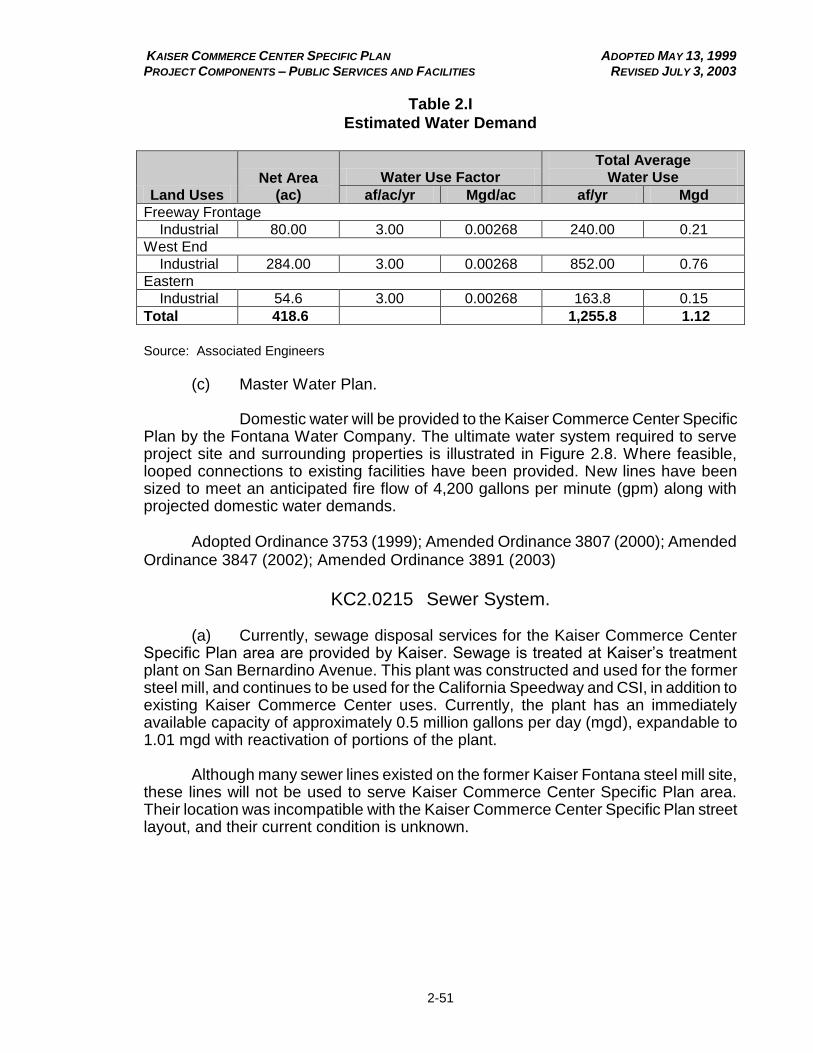
KAISER COMMERCE CENTER SPECIFIC PLAN ADOPTED MAY 13, 1999 PROJECT COMPONENTS – PUBLIC SERVICES AND FACILITIES REVISED JULY 3, 2003
2-51
Table 2.I
Estimated Water Demand
Land Uses
Net Area
(ac)
Water Use Factor
Total Average
Water Use
af/ac/yr Mgd/ac af/yr Mgd
Freeway Frontage
Industrial 80.00 3.00 0.00268 240.00 0.21
West End
Industrial 284.00 3.00 0.00268 852.00 0.76
Eastern
Industrial 54.6 3.00 0.00268 163.8 0.15
Total 418.6 1,255.8 1.12
Source: Associated Engineers
(c) Master Water Plan.
Domestic water will be provided to the Kaiser Commerce Center Specific
Plan by the Fontana Water Company. The ultimate water system required to serve project site and surrounding properties is illustrated in Figure 2.8. Where feasible, looped connections to existing facilities have been provided. New lines have been sized to meet an anticipated fire flow of 4,200 gallons per minute (gpm) along with projected domestic water demands. Adopted Ordinance 3753 (1999); Amended Ordinance 3807 (2000); Amended Ordinance 3847 (2002); Amended Ordinance 3891 (2003)
KC2.0215 Sewer System.
(a) Currently, sewage disposal services for the Kaiser Commerce Center Specific Plan area are provided by Kaiser. Sewage is treated at Kaiser’s treatment plant on San Bernardino Avenue. This plant was constructed and used for the former steel mill, and continues to be used for the California Speedway and CSI, in addition to existing Kaiser Commerce Center uses. Currently, the plant has an immediately available capacity of approximately 0.5 million gallons per day (mgd), expandable to 1.01 mgd with reactivation of portions of the plant.
Although many sewer lines existed on the former Kaiser Fontana steel mill site, these lines will not be used to serve Kaiser Commerce Center Specific Plan area. Their location was incompatible with the Kaiser Commerce Center Specific Plan street layout, and their current condition is unknown.

KAISER COMMERCE CENTER SPECIFIC PLAN ADOPTED MAY 13, 1999 PROJECT COMPONENTS – PUBLIC SERVICES AND FACILITIES REVISED JULY 3, 2003
2-52
Figure 2.8
Proposed Water Facilities
KAISER COMMERCE CENTER SPECIFIC PLAN ADOPTED MAY 13, 1999 PROJECT COMPONENTS – PUBLIC SERVICES AND FACILITIES REVISED JULY 3, 2003
2-53
(b) Sewage Flow. Average wastewater flows generated by Specific Plan development are
determined by multiplying land use acreage by its corresponding sewage generation factor. Estimated wastewater discharge figures for the project area, total 0.981 mgd (see Appendix B).
(c) Master Sewer Plan.
The Kaiser Commerce Center sewer master plan is based on continued
use of the Kaiser Sewage Treatment Plant (Figure 2.9).
Sewer lines will be extended to connect the Specific Plan area to the existing Kaiser Sewage Treatment Plant. This would involve expansion of the plant to accept the additional sewage, along with expansion of sewage disposal/reuse capacity. At the treatment plant, trickling filters will be reactivated. In addition, a tertiary treatment package and automatic flow control devices will be installed. This will bring the plant’s capacity up to 1.01 mgd, which is adequate to support project development
and other demands on the plant (see Appendix B). Adopted Ordinance 3753 (1999); Amended Ordinance 3807 (2000); Amended Ordinance 3847 (2002); Amended Ordinance 3891 (2003)
KC2.0220 Storm Drain System.
(a) Figure 2.10 illustrates those backbone facilities and improvements, based on preliminary design flow calculations, which are necessary to provide drainage and flood protection to the Kaiser Commerce Center Specific Plan site (see hydrology study and drainage master plan contained in Appendix B). The conceptual master plan and local facilities identified below will drain the project site to San Sevaine Channel, a regional facility. Proposed drainage facilities are sized to protect habitable structures from 100-year return frequency runoff. Storm drain lines are sized to carry 10-, 25-, and 100-year peak discharges. Excess of 100-year runoff is proposed to be carried in the roadway and/or roadway/storm drain combination to the nearest regional facility.
The project site is located within the San Sevaine Creek Drainage Fee area. Under County Ordinance 3358, it is subject to payment of drainage fees prior to issuance of any building permit. Because San Sevaine Creek is unimproved, a portion of the site is located within a flood hazard area as defined by the Federal Emergency Management Agency (FEMA), as shown in Figure 2.11. However, the Letter of Map Revision (LOMR) process has been completed to recognize grading improvements made on-site for the San Sevaine Channel which have resulted in removing the site from the flood hazard area, as shown in Figure 2.11a.
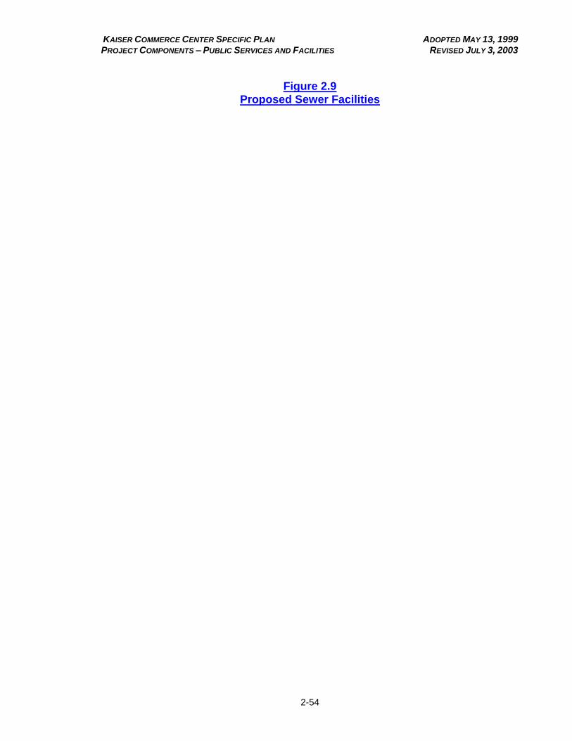
KAISER COMMERCE CENTER SPECIFIC PLAN ADOPTED MAY 13, 1999 PROJECT COMPONENTS – PUBLIC SERVICES AND FACILITIES REVISED JULY 3, 2003
2-54
Figure 2.9
Proposed Sewer Facilities
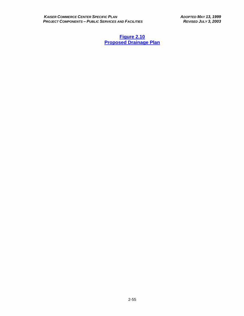
KAISER COMMERCE CENTER SPECIFIC PLAN ADOPTED MAY 13, 1999 PROJECT COMPONENTS – PUBLIC SERVICES AND FACILITIES REVISED JULY 3, 2003
2-55
Figure 2.10
Proposed Drainage Plan

KAISER COMMERCE CENTER SPECIFIC PLAN ADOPTED MAY 13, 1999 PROJECT COMPONENTS – PUBLIC SERVICES AND FACILITIES REVISED JULY 3, 2003
2-56
Figure 2.11
Flood Hazard Areas
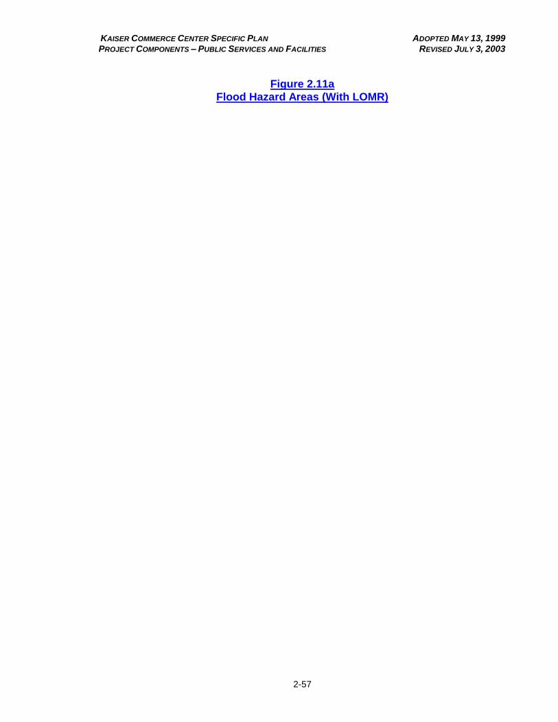
KAISER COMMERCE CENTER SPECIFIC PLAN ADOPTED MAY 13, 1999 PROJECT COMPONENTS – PUBLIC SERVICES AND FACILITIES REVISED JULY 3, 2003
2-57
Figure 2.11a
Flood Hazard Areas (With LOMR)
KAISER COMMERCE CENTER SPECIFIC PLAN ADOPTED MAY 13, 1999 PROJECT COMPONENTS – PUBLIC SERVICES AND FACILITIES REVISED JULY 3, 2003
2-58
(b) Commerce/Valley System.
This system of catch basins and pipes will convey drainage from the low
point in proposed Valley Boulevard and Commerce Drive, and convey these flows to the San Sevaine Channel. Storm runoff is also intercepted prior to flowing down the freeway entrance ramps.
(c) Mulberry System.
This system of catch basins and pipes will convey drainage from the low
point in proposed Valley Boulevard to Mulberry Channel. The channel will be improved to prevent erosion at the point of discharge.
(d) On-Site Basin and Storm Drain.
An on-site detention basin is proposed to mitigate incremental increases
in storm flows until the San Sevaine Channel improvements are completed and connections can be made to the channel. Upon connection to the completed San Sevaine Channel, the detention basin will no longer be required and the detention basin can be filled and developed pursuant to the approved uses in the Specific Plan. As a result if designing individual sites for development, smaller detention areas may be required. Such detention areas may be considered for joint use parking and stormwater detention. Private storm drain systems are proposed to intercept and convey these flows to various public facilities.
(e) San Sevaine Channel Improvements.
Improvements to the drainage channel will be required at points of
connection to mitigate potential erosion concerns. Two connections are proposed.
(f) Caltrans Channel Outlet Structure.
Modification of the Caltrans outlet structure is proposed to provide
drainage for the East Freeway Frontage parcel.
(g) Valley Boulevard Culvert.
A culvert under realigned Valley Boulevard at Etiwanda will be required to
perpetuate existing drainage patterns.
KAISER COMMERCE CENTER SPECIFIC PLAN ADOPTED MAY 13, 1999 PROJECT COMPONENTS – PUBLIC SERVICES AND FACILITIES REVISED DECEMBER 14, 2000
2-59
(h) Other Drainage Improvements.
Given that the capacity of east-west streets to carry storm flows is minimal, parallel storm drain systems are proposed for the east-west alignments of this plan. This condition requires that storm drain facilities service the most upstream drainage areas for even the 10-year return frequency.
Hydrologic information and data utilized to formulate the master plan was
obtained from the San Bernardino County 1986 Hydrology Manual. Pipe sizes proposed are estimated using non-pressure flow. Detailed hydrologic and hydraulic calculations are necessary, and will be conducted at future stages of development, to determine precise pipe and catch basin sizes. The drainage plan for the project site is illustrated in Figure 2.10. Adopted Ordinance 3753 (1999); Amended Ordinance 3807 (2000); Amended Ordinance 3847 (2002); Amended Ordinance 3891 (2003) KC2.0225 Utilities.
(a) Electrical Service.
Electrical service to the Kaiser Commerce Center Specific Plan site will be provided by SCE via the existing overhead distribution system. Development of the Specific Plan area will require the relocation, modification, or abandonment of many of these existing facilities (Figure 2.12).
As part of the development of the Kaiser Commerce Center Specific Plan, the southerly 110 kV easement that currently runs through the center of the parcel located between Valley Boulevard and the San Bernardino Freeway, will be relocated into the north or south parkway of the realigned Valley Boulevard. Relocation of poles on the east side of Etiwanda Avenue may also be required to accommodate anticipated street improvements.
All existing and proposed electrical lines of 12 kV or less within and adjacent to the Kaiser Commerce Center Specific Plan (except lines within the 600-foot SCE property adjacent to Etiwanda Avenue) will be placed underground within dedicated public streets, dedicated public utility easements along streets, or in dedicated easements within private streets.
3 Relocation of existing power poles as well
as utility undergrounding will be installed prior to, or concurrent with, construction of street improvements. Approval from SCE for relocation and undergrounding of utility lines will be required.
3 Large voltage lines and all lines within the SCE property adjacent to Etiwanda Avenue will not be
placed underground

KAISER COMMERCE CENTER SPECIFIC PLAN ADOPTED MAY 13, 1999 PROJECT COMPONENTS – PUBLIC SERVICES AND FACILITIES REVISED JULY 3, 2003
2-60
Figure 2.12
Dry Utilities
KAISER COMMERCE CENTER SPECIFIC PLAN ADOPTED MAY 13, 1999 PROJECT COMPONENTS – PUBLIC SERVICES AND FACILITIES REVISED JULY 3, 2003
2-61
(b) Natural Gas Service.
Natural gas service within the Kaiser Commerce Center Specific Plan will be provided by The Gas Company. To provide adequate service to uses within Kaiser Commerce Center Specific Plan, an on-site system of gas lines will be provided within the proposed realignment of Valley Boulevard, proposed Commerce Drive, and the proposed private drive north of San Bernardino Avenue. All natural gas lines within Kaiser Commerce Center Specific Plan will be placed underground within dedicated public streets, dedicated public utility easements, or in other dedicated easements, as approved by The Gas Company.
(c) Telephone.
To provide adequate telephone service within Kaiser Commerce
Center Specific Plan, an on-site system of telephone lines will be provided within the proposed Valley Boulevard, Commerce Drive, and private drive rights-of-way.
All telephone lines will be placed underground (including adjacent
aboveground lines), and will be placed within dedicated public streets, dedicated public utility easements, or in other dedicated easements. Relocation of existing poles and undergrounding of lines will occur prior to, or concurrent with, the construction of street improvements. The ultimate configuration of telephone facilities may be designed by the project developer or directly by SBC. If designed by the project developer, SBC approval will be required.
(d) Solid Waste Collection and Disposal.
Solid waste collection will be provided by a private contractor. Solid wastes generated within Kaiser Commerce Center Specific Plan will be hauled to the County of San Bernardino facility in Rialto for disposal.
The West Valley Materials Recycling Facility, which will be located adjacent to the Kaiser Commerce Center Specific Plan area, separates recyclable materials from municipal solid waste generated in western San Bernardino County. The remaining non-recyclable solid wastes would then be loaded onto rail cars for disposal.
All development within the Specific Plan area shall comply with the County's Solid Waste Source Reduction and Recycling requirements. Adopted Ordinance 3753 (1999); Amended Ordinance 3807 (2000); Amended Ordinance 3847 (2002); Amended Ordinance 3891 (2003)
KAISER COMMERCE CENTER SPECIFIC PLAN ADOPTED MAY 13, 1999 PROJECT COMPONENTS – PUBLIC SERVICES AND FACILITIES REVISED DECEMBER 14, 2000
2-62
KC2.0230 Community Facilities.
(a) Fire Protection.
The San Bernardino County Fire Department will provide fire protection services to the Kaiser Commerce Center Specific Plan site, which is located within the southwest quadrant Central Valley service area. This quadrant is bounded by Beech Street, Foothill Boulevard, Etiwanda Avenue, and the I-10 Freeway.
The County of San Bernardino General Plan and County Fire Department standards call for achievement of an ISO Class 3 rating for fire protection and the establishment and/or maintenance of four- to five-minute response time throughout the County.
Service to Kaiser Commerce Center Specific Plan will be provided from
the presently planned network of fire stations. However, the present Station No. 73, located on Arrow Highway west of Cherry Avenue, is inadequate and needs significant upgrading.
Throughout the development of Kaiser Commerce Center Specific Plan, emergency access from Etiwanda Avenue will be maintained. Prior to the development of parcels within the Kaiser Commerce Center portion of the site, the existing Gate 8 through to Etiwanda Avenue will be maintained for use by the Fire Department and the Sheriff’s Department.
Discussions with the County Fire Department have indicated that, as the
result of project development, the Department will need additional equipment to provide adequate service to the site. However, the type of equipment that will be needed, as well as the timing of such needs, are dependent upon the type and timing of actual development within the Specific Plan area. Consequently, the project proponent of the Kaiser Commerce Center will be required to enter into a multi-party agreement with the County of San Bernardino, San Bernardino County Redevelopment Agency, and the San Bernardino County Fire Department to ensure that all fire equipment necessary to serve the project is available when it is needed. The agreement will be executed prior to the issuance of the first occupancy permits for the first increment of development within the Specific Plan area. The agreement will identify the precise development threshold for each specific piece of equipment and the method of proposed financing (e.g., developer contribution, property taxes, bond financing, redevelopment funds).
KAISER COMMERCE CENTER SPECIFIC PLAN ADOPTED MAY 13, 1999 PROJECT COMPONENTS – PUBLIC SERVICES AND FACILITIES REVISED JULY 3, 2003
2-63
(b) Police Protection.
The County of San Bernardino Sheriff's Department will provide police protection services to the Kaiser Commerce Center Specific Plan area. The County of San Bernardino has established a standard for the level of police services in its General Plan, of 1.4 sworn officers per 1,000 residents. In addition, capital facilities of two types are provided: community wide headquarters facilities and a series of contact and substation facilities.
The County of San Bernardino Sheriff's Department has indicated that service to Kaiser Commerce Center Specific Plan can be provided from the presently planned network of capital facilities. No specific additional police facilities are required to be installed or modified as part of the build out of the Kaiser Commerce Center Specific Plan. Adopted Ordinance 3753 (1999); Amended Ordinance 3807 (2000); Amended Ordinance 3847 (2002) KC2.0235 Public Facilities Phasing and Financing.
(a) Phasing.
Because of the interrelated nature of site grading, a mass grading program is required. As a result, each of the development areas within the Kaiser Commerce Center Specific Plan will be graded and readied for construction at a single time. Construction of proposed Etiwanda Avenue and Valley Boulevard freeway interchange improvements will commence concurrent with the initiation of the mass grading program. Backbone water, sewer, and drainage infrastructure within the area’s primary roadway system (San Bernardino Avenue, Valley Boulevard extension, Commerce Drive) will also be constructed at a single time once roadways have been graded to their planned grade. Grading of the Kaiser Commerce Center Specific Plan site is currently underway.
Although the specific plan area is subject to drainage fees for the improvement of San Sevaine Creek, which will be paid pursuant to County requirements, regional drainage improvements along this channel might not be ready in time to support initial site development. In the absence of San Sevaine Creek drainage improvements, interim detention basins will be constructed to ensure that capacity of the existing San Sevaine Creek channel is not exceeded.
Once grading and backbone infrastructure are completed, development of individual sites within the Specific Plan area will proceed as the market demands. It is anticipated that internal infrastructure and fine grading within the area north of San Bernardino Avenue will occur at a single time. Internal infrastructure for the freeway frontage area is complete.
KAISER COMMERCE CENTER SPECIFIC PLAN ADOPTED MAY 13, 1999 PROJECT COMPONENTS – PUBLIC SERVICES AND FACILITIES REVISED APRIL 4, 2002
2-64
(b) Financing of Capital Facilities. Public and developer financing will fund the backbone infrastructure. The County of San Bernardino has secured $18.69 million in state and federal transportation funds to pay for the improvements to the Etiwanda Interchange on Interstate 10 and the relocation of Valley Boulevard. These funds will also cover the relocation of power and sewer lines, as well as new utilities, associated with the relocation of Valley Boulevard. Private developer, assessment district, and redevelopment tax increment sources will cover the design and construction of a new Valley Boulevard extension to Etiwanda Avenue, including utility, water and sewer relocations. It is intended that the use of redevelopment tax increments for financing these facilities be maximized. Should tax increments not be sufficient for these purposes, a Mello Roos Community Facilities District and other assessment district financing will be used to the extent that property tax rates to service general property taxes and overall debt burden will not exceed 1.5 percent. Private developer financing will be used for the balance of backbone infrastructure. Payment of drainage fees for San Sevaine Creek improvements, as well as for construction of interim detention basins will be undertaken by the master developer of the specific plan area. Construction of Kaiser sewage treatment plant improvements and internal infrastructure to serve individual sites within the Specific Plan area will be financed by the developer. Adopted Ordinance 3753 (1999); Amended Ordinance 3807 (2000); Amended Ordinance 3847 (2002); Amended Ordinance 3891 (2003)

KAISER COMMERCE CENTER SPECIFIC PLAN ADOPTED MAY 13, 1999 PROJECT COMPONENTS – PUBLIC SERVICES AND FACILITIES REVISED APRIL 4, 2002
2-65
(THIS PAGE INTENTIONALLY LEFT BLANK)
KAISER COMMERCE CENTER SPECIFIC PLAN ADOPTED MAY 13, 1999 PROJECT COMPONENTS – CIRCULATION REVISED JULY 3, 2003
2-66
Chapter 3
CIRCULATION
Sections: Page KC2.0305 Vehicular Circulation. 2-67 KC2.0310 Rail Facilities. 2-76 KC2.0315 Public Transportation. 2-77 KC2.0320 Pedestrian Facilities. 2-77
KC2.0305 Vehicular Circulation.
(a) Roadway needs to serve the project and other development in western San Bernardino County were identified and addressed in the Traffic Impact Analysis prepared for the Kaiser Commerce Center Specific Plan and subsequent traffic impact studies prepared for the Specific Plan area. Based on County of San Bernardino daily design capacities, required roadways were identified, and are illustrated in Figure 2.13. Valley Boulevard, San Bernardino Avenue, and Etiwanda Avenue will be improved to the cross-sections consistent with the San Bernardino County General Plan Transportation and Circulation Map. New public roadways created as part of the Specific Plan will be consistent with the County General Plan, and will be dedicated to the County of San Bernardino. Valley Boulevard, San Bernardino Avenue, Commerce Drive, and local industrial streets will be dedicated to the County for maintenance. Roadways which are abandoned will revert to appropriate landowners.
The ultimate cross-sections of the roadways which will be constructed or improved as part of the Kaiser Commerce Center Specific Plan are illustrated in Figures 2.14 and 2.15. As shown in Figure 2.15, an offset road section is proposed for San Bernardino Avenue in order to avoid costly relocation of existing power poles. Proposed roadway improvements are summarized in Table 2.J, and are detailed below. These planned improvements may be increased to accommodate specific intersection configurations, bus turnouts, and acceleration/deceleration lanes. Ultimate improvements shall be as required by the San Bernardino County Director of Transportation. All improvements shall be consistent with the San Bernardino County General Plan.

KAISER COMMERCE CENTER SPECIFIC PLAN ADOPTED MAY 13, 1999 PROJECT COMPONENTS – CIRCULATION REVISED JULY 3, 2003
2-67
Figure 2.13
Proposed Circulation

KAISER COMMERCE CENTER SPECIFIC PLAN ADOPTED MAY 13, 1999 PROJECT COMPONENTS – CIRCULATION
2-68
Figure 2.14
Typical Roadway Section Valley Boulevard
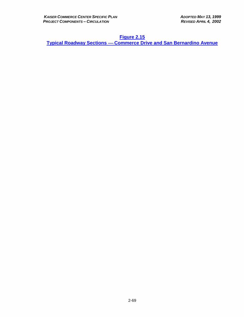
KAISER COMMERCE CENTER SPECIFIC PLAN ADOPTED MAY 13, 1999 PROJECT COMPONENTS – CIRCULATION REVISED APRIL 4, 2002
2-69
Figure 2.15
Typical Roadway Sections Commerce Drive and San Bernardino Avenue
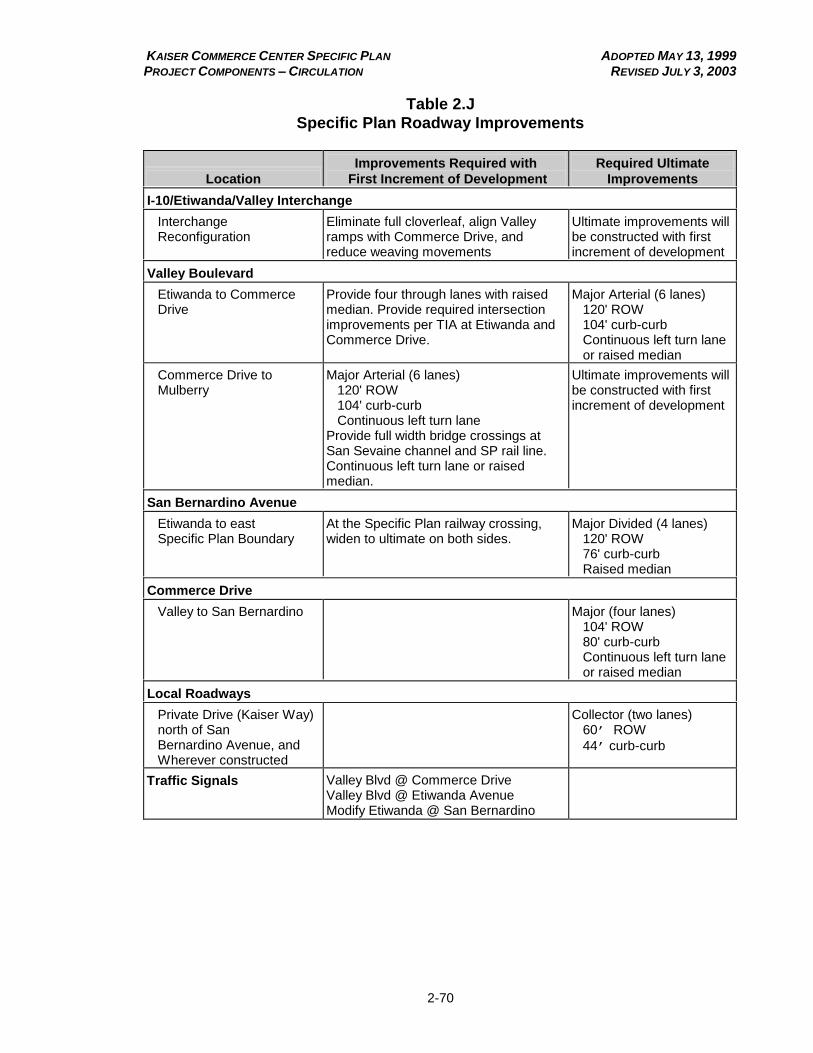
KAISER COMMERCE CENTER SPECIFIC PLAN ADOPTED MAY 13, 1999 PROJECT COMPONENTS – CIRCULATION REVISED JULY 3, 2003
2-70
Table 2.J
Specific Plan Roadway Improvements
Location
Improvements Required with
First Increment of Development
Required Ultimate
Improvements I-10/Etiwanda/Valley Interchange Interchange Reconfiguration
Eliminate full cloverleaf, align Valley ramps with Commerce Drive, and reduce weaving movements
Ultimate improvements will be constructed with first increment of development
Valley Boulevard Etiwanda to Commerce Drive
Provide four through lanes with raised median. Provide required intersection improvements per TIA at Etiwanda and Commerce Drive.
Major Arterial (6 lanes) 120' ROW 104' curb-curb Continuous left turn lane or raised median
Commerce Drive to Mulberry
Major Arterial (6 lanes) 120' ROW 104' curb-curb Continuous left turn lane Provide full width bridge crossings at San Sevaine channel and SP rail line. Continuous left turn lane or raised median.
Ultimate improvements will be constructed with first increment of development
San Bernardino Avenue Etiwanda to east Specific Plan Boundary
At the Specific Plan railway crossing, widen to ultimate on both sides.
Major Divided (4 lanes) 120' ROW 76' curb-curb Raised median
Commerce Drive Valley to San Bernardino
Major (four lanes) 104' ROW 80' curb-curb Continuous left turn lane or raised median
Local Roadways Private Drive (Kaiser Way) north of San Bernardino Avenue, and Wherever constructed
Collector (two lanes) 60’ ROW
44’ curb-curb
Traffic Signals
Valley Blvd @ Commerce Drive Valley Blvd @ Etiwanda Avenue Modify Etiwanda @ San Bernardino

KAISER COMMERCE CENTER SPECIFIC PLAN ADOPTED MAY 13, 1999 PROJECT COMPONENTS – CIRCULATION REVISED APRIL 4, 2002
2-71
(b) Etiwanda Avenue/Valley Boulevard Interchange Improvements.
Currently, the Etiwanda Avenue interchange along the I-10 freeway has a full cloverleaf design, which results in substantial weaving movements within freeway collector/distributor lanes and on the Etiwanda Avenue bridge over the freeway. This is an antiquated design which results in reduced performance of theinterchange. The problematic configuration of the Etiwanda Avenue interchange is further complicated by the short distance between the point at which the westbound I-10 to northbound Etiwanda Avenue free-right off-ramp enters Etiwanda Avenue; it is less than 200 feet from the Ontario Mills intersection. In addition, Valley Boulevard on- and off-ramps add to the weaving movements through the interchange. There is also a potential safety problem along the Valley Boulevard eastbound off-ramp which has an at-grade rail crossing with minimal traffic controls.
Concurrent with formulation of the Kaiser Commerce Center Specific Plan, the Specific Plan applicant, along with Caltrans and the County of San Bernardino, have studied options for reconfiguring the Etiwanda Avenue and Valley Boulevard interchanges, and how such reconfiguration might interface with development of adjacent lands. In order to alleviate potential safety problems at the Etiwanda Avenue/Valley Boulevard interchange, a reconfiguration has been proposed (Figure 2.16). Specific improvements to the interchange include the following:
(1) Realign and reconstruct Valley Boulevard from east of the Union Pacific/Southern Pacific (UP/SP) spur track and extend the road west to proposed Commerce Drive. Valley Boulevard will be improved from the easterly project boundary to Commerce Drive as a six-lane, 120-foot wide arterial.
(2) Reconstruct the existing weaving section on westbound I-10 between the Valley Boulevard on-ramp and the Etiwanda Avenue off-ramp as a “braided-ramp” configuration, which will eliminate the westbound weaving movement.
(3) Reconstruct the existing Etiwanda Avenue/I-10 interchange by converting the existing four quadrant full cloverleaf interchange to a partial cloverleaf, retaining the northeast and southwest loop on-ramps and demolishing the northwest and southeast loop off-ramps. The exit ramps from I-10 in each direction will be connected to Etiwanda Avenue at two new signalized intersections.
(c) Local Roadway Improvements.
Specific roadway improvements included as part of the Kaiser Commerce Center Specific Plan improvement program are outlined below.
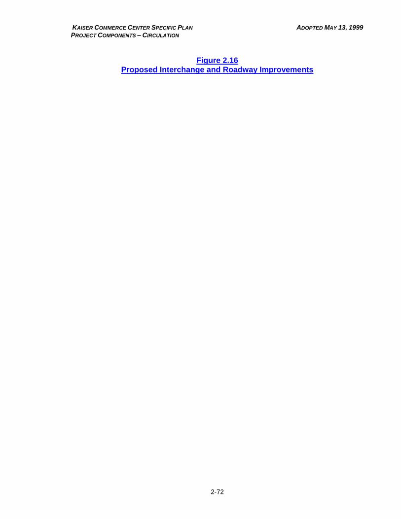
KAISER COMMERCE CENTER SPECIFIC PLAN ADOPTED MAY 13, 1999 PROJECT COMPONENTS – CIRCULATION
2-72
Figure 2.16
Proposed Interchange and Roadway Improvements
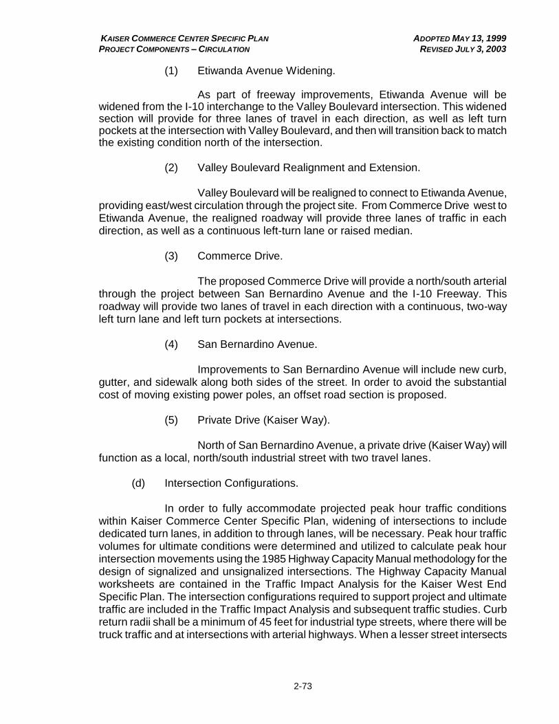
KAISER COMMERCE CENTER SPECIFIC PLAN ADOPTED MAY 13, 1999 PROJECT COMPONENTS – CIRCULATION REVISED JULY 3, 2003
2-73
(1) Etiwanda Avenue Widening.
As part of freeway improvements, Etiwanda Avenue will be widened from the I-10 interchange to the Valley Boulevard intersection. This widened section will provide for three lanes of travel in each direction, as well as left turn pockets at the intersection with Valley Boulevard, and then will transition back to match the existing condition north of the intersection.
(2) Valley Boulevard Realignment and Extension.
Valley Boulevard will be realigned to connect to Etiwanda Avenue, providing east/west circulation through the project site. From Commerce Drive west to Etiwanda Avenue, the realigned roadway will provide three lanes of traffic in each direction, as well as a continuous left-turn lane or raised median.
(3) Commerce Drive.
The proposed Commerce Drive will provide a north/south arterial
through the project between San Bernardino Avenue and the I-10 Freeway. This roadway will provide two lanes of travel in each direction with a continuous, two-way left turn lane and left turn pockets at intersections.
(4) San Bernardino Avenue.
Improvements to San Bernardino Avenue will include new curb,
gutter, and sidewalk along both sides of the street. In order to avoid the substantial cost of moving existing power poles, an offset road section is proposed.
(5) Private Drive (Kaiser Way).
North of San Bernardino Avenue, a private drive (Kaiser Way) will function as a local, north/south industrial street with two travel lanes.
(d) Intersection Configurations.
In order to fully accommodate projected peak hour traffic conditions within Kaiser Commerce Center Specific Plan, widening of intersections to include dedicated turn lanes, in addition to through lanes, will be necessary. Peak hour traffic volumes for ultimate conditions were determined and utilized to calculate peak hour intersection movements using the 1985 Highway Capacity Manual methodology for the design of signalized and unsignalized intersections. The Highway Capacity Manual worksheets are contained in the Traffic Impact Analysis for the Kaiser West End Specific Plan. The intersection configurations required to support project and ultimate traffic are included in the Traffic Impact Analysis and subsequent traffic studies. Curb return radii shall be a minimum of 45 feet for industrial type streets, where there will be truck traffic and at intersections with arterial highways. When a lesser street intersects
KAISER COMMERCE CENTER SPECIFIC PLAN ADOPTED MAY 13, 1999 PROJECT COMPONENTS – CIRCULATION REVISED APRIL 4, 2002
2-74
a collector street, the minimum curb radius may be reduced to 30 feet, if approved by the Fire Department.
(e) Vehicular Access Parameters.
(1) Median Breaks along Arterial Roadways.
Local access, including median breaks, shall be consistent with the San Bernardino County General Plan and Road Planning and Design Standards Manual, and shall be subject to approval by the Director of Transportation. Proposed mid-block median breaks along Etiwanda Avenue, Valley Boulevard, and San Bernardino Avenue include the proposed Commerce Drive/I-10 freeway interchange and up to four full turning movements along Valley Boulevard (two each to the west and east of proposed Commerce Drive at minimum 600-foot intervals) to provide access to adjacent lands. Additional right turn only access points may be established at minimum 300-foot intervals.
Full turning movements along San Bernardino Avenue will occur at the proposed Commerce Drive and private drive. Additional right turn only access points may be established consistent with the County’s Road Planning and Design
Standards Manual.
Full turning movements along Etiwanda Avenue will be limited to Napa Street, San Bernardino Avenue, and Valley Boulevard.
(2) Local Access.
Where driveways within the project site are located along an undivided roadway or a roadway having a two-way left turn lane, full access, including left turns, will be permitted at minimum 300-foot intervals. Driveway locations shall meet the design criteria outlined in the County’s Road Planning and Design
Standards, Section 6, Figure 6-1, and shall be located a minimum of 150 feet from intersections.
(3) Traffic Signals.
Intersections located throughout the site and intersections identified within the project study area by the project’s Traffic Impact Analysis that
warrant traffic signals during the development process shall have such traffic control devices installed by the developer.
KAISER COMMERCE CENTER SPECIFIC PLAN ADOPTED MAY 13, 1999 PROJECT COMPONENTS – CIRCULATION REVISED APRIL 4, 2002
2-75
(4) Development Requirements.
All roadways and intersections within the project, or adjacent to the project, need to be designed and constructed to their ultimate widths as adjoining development occurs, or as per a subsequent phasing program approved by the County. All roadway and intersection improvements are to be consistent with the San Bernardino County General Plan and Development Code, and are subject to approval by the Director of Transportation. All proposed and approved rights-of-way shall be dedicated to the County at project implementation or roadway improvement stage, whichever is first.
(f) Roadway Improvements Financing.
Financing of freeway interchange improvements may come from a combination of ISTEA funds, redevelopment tax increments, community facility district funds, assessment district funds, and/or the master developer [see Division 2, Chapter 2 (pg. 2-59 KC2.0235(b)] for a more detailed discussion of infrastructure financing). Adopted Ordinance 3753 (1999); Amended Ordinance 3807 (2000); Amended Ordinance 3847 (2002); Amended Ordinance 3891 (2003)
KC2.0310 Rail Facilities.
(a) The Kaiser Commerce Center Specific Plan site is served by two rail lines: the Burlington Northern/Santa Fe (BNSF) to the north and the UP/SP railroad to the south. As part of the Kaiser Fontana steel mill facility, an extensive on-site rail system was constructed. This on-site network is jointly owned by Kaiser, UP, and BNSF. Currently, rail service from both lines is available to the Kaiser Commerce Center properties.
(b) The Kaiser Commerce Center Specific Plan retains connections to both the BNSF and UP/SP systems, as shown in Figure 2.13. Rail access to rail-served industrial lots in the area north of San Bernardino Avenue will be via the existing rail line east of the San Sevaine Channel (Figure 2.13). In addition, as part of the reconfiguration of the Valley Boulevard interchange, a grade separation will be constructed at Valley Boulevard, eliminating an existing safety hazard.
(c) On-site spur trackage intended within an individual parcel shall be owned by the property owner, and maintained by the same to the standards of railroad companies. The Kaiser Commerce Center Specific Plan project developer will install all appropriate warning lights, signs, markings and/or crossing gates as required by the County of San Bernardino Office of Surveyor for all rail crossings of vehicular or pedestrian circulation facilities.

KAISER COMMERCE CENTER SPECIFIC PLAN ADOPTED MAY 13, 1999 PROJECT COMPONENTS – CIRCULATION REVISED DECEMBER 14, 2000
2-76
(d) Rail Improvements Financing.
Financing for construction of rail improvements will be undertaken by the master developer and/or other joint owners of the main lead track. Adopted Ordinance 3753 (1999); Amended Ordinance 3807 (2000)
KC2.0315 Public Transportation. Public transportation within western San Bernardino County is provided by Omnitrans. Although no public transportation routes presently exist serving the site, due to the intensity of development, transit routes may be phased into service along the major transportation corridors within and adjacent to the Kaiser Commerce Center Specific Plan site. Corridors which might support fixed-route bus service include Etiwanda Avenue, Valley Boulevard, and San Bernardino Avenue. Turnout locations will be determined at the time of parcel map approval, and will be included in street improvement plans. Design for all bus bays, shelters, and transit appurtenances which are ultimately approved shall comply with applicable Omnitrans design standards. If bus turnouts are required, they will be constructed as part of project roadway improvements. Adopted Ordinance 3753 (1999); Amended Ordinance 3807 (2000)
KC2.0320 Pedestrian Facilities. In addition to vehicular circulation, a pedestrian circulation system will be provided within the Kaiser Commerce Center Specific Plan. Sidewalks will be provided along both sides of all streets within the project site. The minimum width for sidewalks shall be 6 feet. The material for sidewalks shall be concrete, unless an alternative material to provide an enhanced appearance acceptable to both the project sponsor and the County is approved. Sidewalks will be constructed as part of project roadway improvements. Adopted Ordinance 3753 (1999); Amended Ordinance 3807 (2000)
KAISER COMMERCE CENTER SPECIFIC PLAN ADOPTED MAY 13, 1999 PROJECT COMPONENTS – CIRCULATION REVISED DECEMBER 14, 2000
2-77
(THIS PAGE INTENTIONALLY LEFT BLANK)
KAISER COMMERCE CENTER SPECIFIC PLAN ADOPTED APRIL 13, 1999 PROJECT COMPONENTS – GRADING, CONSERVATION AND OPEN SPACE REVISED JULY 3, 2003
2-78
Chapter 4
GRADING, CONSERVATION AND OPEN SPACE
Sections: Page KC2.0405 Grading. 2-79 KC2.0410 Open Space. 2-81 KC2.0415 Conservation of Resources. 2-82 KC2.0420 Water Quality. 2-82
KC2.0405 Grading.
(a) Development of the Kaiser Commerce Center Specific Plan will require the movement of approximately 10.0 million cubic yards of on-site material (slag and native dirt), and 1.0 million cubic yards of off-site material (Figure 2.17). The high exterior walls of the west slag pile were cut down, and slag material was moved to the easterly freeway frontage area (see Figure 2.17). Grading of the project area will be a single operation over a period of approximately 18-24 months. Issuance of a grading permit for project-related freeway interchange improvements and the preparation of building pads and roadways within the Specific Plan area required approval of the I-10/Etiwanda Avenue/Valley Boulevard freeway interchange design by Caltrans and “in-place” funding for the interchange modifications. Grading within the Kaiser Commerce Center Specific Plan is ongoing.
(b) As is now the case with materials from the west slag pile, materials from the east slag pile will be used for on-site fill. There is an existing County permit for the processing of slag for sale and use off site. The Kaiser Commerce Center Specific Plan will implement the reclamation plan for the former mining operation located within the west slag pile by filling the ground with slag, and creating a usable development pad. Additional fill (approximately 1.0 million cubic yards) from approved off-site locations will be required to create building pads and refill the detention basin when its use is no longer required.
(c) The sequencing of grading operations occurring is as follows:
(1) Clearing, grubbing, site preparation, and initial grading of the East
Freeway frontage (Area V on Figure 2.17). The site was prepared to receive engineered fill by the removal of vegetation, existing utilities, and other deleterious materials.
KAISER COMMERCE CENTER SPECIFIC PLAN ADOPTED APRIL 13, 1999 PROJECT COMPONENTS – GRADING, CONSERVATION AND OPEN SPACE REVISED JULY 3, 2003
2-79
Figure 2.17
Conceptual Grading Plan
KAISER COMMERCE CENTER SPECIFIC PLAN ADOPTED APRIL 13, 1999 PROJECT COMPONENTS – GRADING, CONSERVATION AND OPEN SPACE REVISED JULY 3, 2003
2-80
(2) Initial Grading of the West Freeway Frontage parcel (Area IV) including rough grading of adjacent portions of Valley Boulevard. The initial fill was made from on-site slag materials.
(3) Final Grading of Area IV. Excess slag material was exported to Area V and placed as engineered fill. Area IV is now complete. (4) Export slag to Area V. Slag material was exported from the East Slag Pile to Area V.
(5) Initial Grading of Area III including rough grading for Commerce Drive. Initial cuts were made on these parcels in sufficient quantity to help bring Area V to final grade. Approximately 724,500 CY of slag material was exported to complete Area V along with additional slag material exported from the East Slag Pile. Area V is now complete.
(6) Export material from Area I and the East Slag Pile to Area III. (7) Initial grading of Area I. (8) Final grading of Area III. Approximately 150,000 CY of imported
fill was required to bring this area to final grade for building sites. (9) An additional 800,000 CY will be required to be imported to bring
the west side of Area I to a development stage. Additional fill will be required for building pads and landscape berming, up to approximately 8,000 CY for each 50,000 s.f. of building area.
(10) When the detention basin is not longer needed, approximately
75,000 CY of import will be required to fill the basin for development. Adopted Ordinance 3753 (1999); Amended Ordinance 3807 (2000); Amended Ordinance 3847 (2002); Amended Ordinance 3891 (2003)
KC2.0410 Open Space. The Kaiser Commerce Center Specific Plan proposes industrial and commercial development of the site, and, as such, will not create a demand for additional open space or recreational land. Certain types of recreational activities, such as ball fields and court facilities, are permitted uses within the Specific Plan, and could be developed as commercial enterprises or as ancillary uses to on-site industrial development. Adopted Ordinance 3753 (1999); Amended Ordinance 3807 (2000)

KAISER COMMERCE CENTER SPECIFIC PLAN ADOPTED APRIL 13, 1999 PROJECT COMPONENTS – GRADING, CONSERVATION AND OPEN SPACE REVISED APRIL 4, 2002
2-81
KC2.0415 Conservation of Resources. As noted in the Division 1, Chapter 2, Existing Setting, there are no significant or sensitive features or environmental resources within the project site that are in need of protection or preservation. Adopted Ordinance 3753 (1999); Amended Ordinance 3807 (2000); Amended Ordinance 3847 (2002)
KC2.0420 Water Quality. The Kaiser Commerce Center Specific Plan contains several features to protect area water quality. As outlined in the performance standards contained in Division 2, Chapter 1, Land Use Plan, all discharges of materials into any public or private street, storm drain, private stream, body of water, or into the ground shall be in accordance with the adopted standards of the County, the California Department of Health Services, Santa Ana Regional Water Quality Control Board, and other governmental agencies having legal jurisdiction. In addition, all discharges must meet standards of the County Wastewater Code, Pretreatment Program, and Stormwater Run-Off Program. Any use within the Specific Plan area that might use, store, or create hazardous materials will be required to meet all applicable County and State requirements so as to ensure avoidance of potential groundwater contamination. Finally, the development regulations in Division 2, Chapter 1 require that runoff from automotive and repair facilities, as well as outdoor storage areas, be managed in a manner approved by the County. Together, these requirements will adequately protect the area’s water quality.
Adopted Ordinance 3753 (1999); Amended Ordinance 3807 (2000); Amended Ordinance 3847 (2002)

KAISER COMMERCE CENTER SPECIFIC PLAN ADOPTED APRIL 13, 1999 PROJECT COMPONENTS – SEISMIC SAFETY/SAFETY REVISED APRIL 4, 2002
2-82
Chapter 5
SEISMIC SAFETY/SAFETY
Sections: Page KC2.0505 Seismic/Geologic Hazards. 2-83 KC2.0510 Hazardous Waste/Materials. 2-83
KC2.0505 Seismic/Geologic Hazards. Development within Kaiser Commerce Center Specific Plan will comply with the provisions of the Uniform Building Code as adopted by San Bernardino County, as well as with all applicable ordinances of the County. Adopted Ordinance 3753 (1999); Amended Ordinance 3807 (2000)
KC2.0510 Hazardous Waste/Materials. Fuels, oils, solvents, and other materials classified as ”hazardous” will be used within automotive service station, truck stop, repair, and other facilities. In addition, businesses within the Kaiser Commerce Center Specific Plan might utilize, store, or generate hazardous materials incidental to their primary operation. The handling, storage, and management of these materials will meet all of the County's Hazardous Waste Management Plan's requirements, as set forth in the General Plan and all applicable requirements of State and federal law. These requirements relate to the protection of groundwater and air quality, protection of environmentally sensitive areas, and safe transportation of hazardous waste. Building owners and future tenants within the Specific Plan area will be required to comply with all federal, State, and local laws regulating hazardous materials and wastes. Adopted Ordinance 3753 (1999); Amended Ordinance 3807 (2000); Amended Ordinance 3847 (2002)

KAISER COMMERCE CENTER SPECIFIC PLAN ADOPTED MAY 13, 1999 PROJECT COMPONENTS – SEISMIC SAFETY/SAFETY REVISED APRIL 4, 2002
2-83
(THIS PAGE INTENTIONALLY LEFT BLANK)

KAISER COMMERCE CENTER SPECIFIC PLAN ADOPTED MAY 13, 1999
ADMINISTRATION ADMINISTRATION REVISED DECEMBER 14, 2000
3-1
Division 3
ADMINISTRATION
Chapters: Page
1 Administration. 3-1
Chapter 1
ADMINISTRATION
Sections: Page KC3.0105 Development Approval Process. 3-1 KC3.0110 Substantial Conformance. 3-4 KC3.0115 Specific Plan Amendments. 3-6
KC3.0105 Development Approval Process.
(a) Overview.
Preceding chapters of the Kaiser Commerce Center Specific Plan have established permitted land uses, building intensities, circulation plans, technical master plans for services, and other development standards and guidelines. Subsequent to approval of the Specific Plan, implementation will entail the review of various project-wide plans, as well as individual development projects. To ensure compliance with all applicable development standards contained in the Kaiser Commerce Center Specific Plan; applicable provisions of Title 8 of the San Bernardino County Code; and such applicable development standards as may be adopted by the Board of Supervisors from time to time, all proposed development within the Specific Plan area shall be subject to review and approval by San Bernardino County pursuant to the review procedures discussed below.
As set forth below, all construction, alteration, or expansion of uses allowed by the provisions of Table 2.B of this Specific Plan (including new development alteration of existing development, or alteration of previously approved site development) shall require approval of a Site Development Review. The construction, alteration, or expansion of uses which are not specifically listed as being permitted in Table 2.B of this Specific Plan may nevertheless be permitted subject to approval of a Site Development Review, if a determination of Substantial Conformance is also made as provided below. If a determination of Substantial Conformance cannot be made for the construction, alteration, or expansion of uses which are not specifically listed as being permitted in Table 2.B of this Specific Plan, then approval of a Specific Plan Amendment will be required to permit construction, alteration, or expansion of such a use.
(b) Site Development Review.
KAISER COMMERCE CENTER SPECIFIC PLAN ADOPTED MAY 13, 1999
ADMINISTRATION ADMINISTRATION REVISED DECEMBER 14, 2000
3-2
(1) Applicability.
A Site Development Review shall be required to authorize the
construction, alteration, or expansion of every use allowed by the provisions of Table 2.B of this Specific Plan, provided such use complies with all applicable development standards contained in this Specific Plan, applicable provisions of Title 8 of the San Bernardino County Code , and such other applicable development standards as may be adopted by the Board of Supervisors from time to time.
(2) Purpose and Intent.
The Site Development Review procedure is intended to provide a review process that recognizes the level of review by San Bernardino County and other agencies that went into the original approval of the Kaiser Commerce Center Specific Plan. The Site Development Review provides an opportunity to review the design and manner of proposed development, and to ensure that such development meets the requirements of the Kaiser Commerce Center Specific Plan, applicable provisions of Title 8 of the San Bernardino County Code, and such other applicable development standards as may be adopted by the Board of Supervisors from time to time.
(3) Procedures.
Site Development Review shall be subject to the following review procedures in the San Bernardino County Code:
(A) The application shall be subject to the same procedures (including, without limitation, all procedures for notice, findings, and appeal) as the Department Review procedures set forth in Section 83.0301305 et seq. of the County Code.
(B) If the application does not meet the requirements for Department Review as set forth in Sections 83.0301310 and 83.0301315 of the County Code, then the application shall be subject to the same procedures (including, without limitation, all procedures for notice, findings, and appeal) as the Conditional Use Permit procedures set forth in Section 83.030105 et seq. of the County Code; provided, however, that at the time the Planning Officer determines that the Application does not meet the requirements for Department Review, the Planning Officer shall also determine whether the Conditional Use Permit will be reviewed by administrative review or public hearing, as provided in Section 83.030120 of the County Code.
KAISER COMMERCE CENTER SPECIFIC PLAN ADOPTED MAY 13, 1999
ADMINISTRATION ADMINISTRATION REVISED DECEMBER 14, 2000
3-3
(c) Other Review Procedures.
In addition to Site Development Review, a number of other reviews will be necessary in order to implement the Specific Plan. These additional review processes are discussed below.
(1) Projects which involve land uses permitted by Table 2.B of this Specific Plan, which are Group B occupancy as defined by the Uniform Building Code, and which are exempt from CEQA may be reviewed pursuant to the Occupancy Review provisions of the County Development Code (Sections 83.030405 through 83.030415).
(2) Temporary Use Permits may be granted subject to the provisions
of Sections 84.0701 through 84.0745 of the San Bernardino County Development Code provided, however, that a Temporary Use Permit within the Kaiser Commerce Center Specific Plan need not be submitted concurrently with any other application.
(3) Variances may be granted pursuant to the provisions of Section
83.030905 of the San Bernardino County Development Code. (4) If required, Flood Hazard Development Review shall be conducted
pursuant to the provisions of Section 83.0301005 of the San Bernardino County Development Code.
(5) If required, Pre-Construction Inspections shall be conducted
pursuant to the provisions of Sections 83.0301105 through 83.0301120 of the San Bernardino County Development Code.
(6) If required, ABC Licensing-related determinations of ”public
convenience or necessity” shall be conducted pursuant to the provisions of Sections 83.0301505 through 83.0301510 of the San Bernardino County Development Code.
(7) Divisions of land shall comply with the provisions of Chapter 4 of
Title 8 of the San Bernardino County Code. (8) Landscape plans for streetscapes shall be prepared and will be
reviewed by San Bernardino County concurrent with street improvement plans. Adopted Ordinance 3753 (1999); Amended Ordinance 3807 (2000)
KAISER COMMERCE CENTER SPECIFIC PLAN ADOPTED MAY 13, 1999
ADMINISTRATION ADMINISTRATION REVISED APRIL 4, 2002
3-4
KC3.0110 Substantial Conformance.
(a) Determination for Substantial Conformance.
The purpose of Substantial Conformance is to provide a mechanism for
interpretation of the Specific Plan, and which allows flexibility in implementing the Specific Plan. Substantial Conformance allows for determining the appropriateness of land uses that are not specifically listed as being permitted in Division 2, Chapter 1 , as well as for non-substantial modifications to the approved Specific Plan, which do not modify the effect of the approval on surrounding property. Substantial Conformance may include, but is not limited to, inclusion of land uses not listed in Division 2, Chapter 1 of the Specific Plan; modifications that might be necessary to comply with Final Conditions of Approval; or modifications affecting infrastructure, public services and facilities, landscape palette; and other issues. Substantial conformance procedures shall not, however, be used to avoid compliance with adopted development regulations.
Except as otherwise provided below, substantial conformance shall not include significant modifications in the design of the project.
(b) Guidelines for Determination of Substantial Conformance.
Determination of substantial conformance shall be made by the County of San Bernardino Director of Land Use Services or designee.
(1) Permitted Land Uses.
Land uses not listed as permitted in Division 2, Chapter 1 of this Specific Plan may be permitted, subject to a determination of Substantial Conformance, based on the following findings:
(A) the proposed use is compatible with the permitted uses in the Planning Area within which it is proposed;
(B) the proposed use will not create any significant environmental impacts which were not previously addressed in the EIR for the Kaiser Commerce Center Specific Plan;
(C) the proposed use will not substantially increase the severity of any significant environmental impacts which were previously addressed in the EIR for the Kaiser Commerce Center Specific Plan; and
(D) the proposed use is similar to, and no more objectionable than the permitted uses in the Planning Area within which it is proposed.
KAISER COMMERCE CENTER SPECIFIC PLAN ADOPTED MAY 13, 1999
ADMINISTRATION ADMINISTRATION REVISED APRIL 4, 2002
3-5
(2) Development Intensity.
The anticipated intensity of development within the Kaiser Commerce Center Specific Plan is identified in Table 2.A. The development intensity of any particular planning area may be exceeded under the Substantial Conformance provisions of the Specific Plan provided that the overall development intensity of the Kaiser Commerce Center Specific Plan is not exceeded, and that the exceedence of the development intensity for the particular planning area will not result in impacts greater than those anticipated in the EIR prepared for the Specific Plan.
(3) Infrastructure. Modifications to the alignment of roads; creation of local public
and/or private streets; or adjustments to individual infrastructure facilities such as drainage, sewer, and water shall be subject to substantial conformance determinations. Prior to approval of substantial conformance modifications of Specific Plan infrastructure, the Director of Land Use Services or designee shall confer with the Public Works Department, and shall make the finding that the proposed modification will not result in any significant impacts which were not previously addressed and resolved in the processing of the Specific Plan.
(4) Landscaping.
Revisions to the Plant Palette provided in Division 2, Chapter 1
(Table 2.D) may be approved by the Director of Land Use Services or designee as a Substantial Conformance item.
(5) Land Use Approvals.
Specific provisions of land use approvals; architectural details;
landscape palette; building size, height, bulk, and orientation; parking lot layout; and other site plan details may be revised utilizing substantial conformance provisions. In making such a determination, the Director of Land Use Services, or designee, shall be required to find that the revisions requested under substantial conformance are consistent with the provisions of the Specific Plan, and do not create impacts which were not recognized and addressed in the original approval. Adopted Ordinance 3753 (1999); Amended Ordinance 3807 (2000); Amended Ordinance 3847 (2002)
KAISER COMMERCE CENTER SPECIFIC PLAN ADOPTED MAY 13, 1999
ADMINISTRATION ADMINISTRATION REVISED DECEMBER 14, 2000
3-6
KC3.0115 Specific Plan Amendments. Amendments to the Specific Plan shall be required for revisions which are beyond the scope of substantial conformance determinations. Specific Plan amendments are governed by the California Government Code, Section 65500 and the San Bernardino County Development Code. Any Specific Plan amendment proposed for the Kaiser Commerce Center Specific Plan will require review by the County of San Bernardino Planning Commission, and approval by the County Board of Supervisors. Adopted Ordinance 3753 (1999); Amended Ordinance 3807 (2000)