k2k 6 ravenswood road kundabung salvage excavation … · 4.4 stratigraphy and interpretation ......
TRANSCRIPT

Sydney | Central Coast | Illawarra | Armidale | Newcastle | Mudgee | Port Macquarie | Brisbane | Cairns
K2K Project 6 Ravenswood Road, Kundabung
Historical Archaeological Salvage and Monitoring Report
Prepared for NSW Roads and Maritime Services
9 October 2015

K2K Project, 6 Ravenswood Road, Kundabung Historical Archaeological Salvage and Monitoring Report
1
Document control
Project no.: 1702
Project client: Roads and Maritime Services (RMS)
Project office: Grafton
Document description: Historical Archaeological Salvage and Monitoring Report for 6 Ravenswood Road, Kundabung, NSW
Project Director: Cameron Harvey
Project Manager: Fiona Leslie
Authors: Fiona Leslie
Internal review: Cameron Harvey
Document status: Final
Local Government Area: Kempsey
Document revision status
Author Revision number Internal review Date issued
Fiona Leslie D01 Cameron Harvey 18 September 2015
Final Fiona Leslie 9 October 2015
© Niche Environment and Heritage, 2015
Copyright protects this publication. Except for purposes permitted by the Australian Copyright Act 1968, reproduction, adaptation, electronic storage, and communication to the public is prohibited without prior written permission. Enquiries should be addressed to Niche Environment and Heritage, PO Box 2443, Parramatta NSW 1750, Australia, email: [email protected].
Any third party material, including images, contained in this publication remains the property of the specified copyright owner unless otherwise indicated, and is used subject to their licensing conditions.
Cover photograph: Footprint of the timber slab hut with brick floor identified at the subject site
Niche Environment and Heritage A specialist environmental and heritage consultancy.
Head Office Level 1, 19 Sorrell Street Parramatta NSW 2150 All mail correspondence to: PO Box 2443 North Parramatta NSW 1750 Email: [email protected]
Sydney 0488 224 888
Central Coast 0488 224 999
Illawarra 0488 224 777
Armidale 0488 224 094
Newcastle 0488 224 160
Mudgee 0488 224 025
Port Macquarie 0488 774 081
Brisbane 0488 224 036
Cairns 0488 284 743

K2K Project, 6 Ravenswood Road, Kundabung Historical Archaeological Salvage and Monitoring Report
2
Executive summary _________________________________________________________________________________________________________________________________________________________________
This report presents the results of historical archaeological salvage excavation and monitoring at 6 Ravenswood Road (Lot 7 DP1042561), which is situated adjacent to the Pacific Highway near Kundabung, NSW. The location was originally identified by a local resident as the potential site of a former coach station during preparations for the Oxley Highway to Kempsey Pacific Highway Upgrade. Archaeological test excavation was conducted by Niche in April 2015 and confirmed the presence of archaeological relics, including: the remains of a timber slab hut with brick floor, a 15m long open drain, 3 possible rubbish pits and evidence of at least two former fence lines. A research design was subsequently developed to guide further archaeological salvage and monitoring at the site.
The purpose of the investigation was to recover as much information as possible about former occupation and use of the timber slab hut through archaeological excavation, recording and analysis and to confirm the absence, or presence, of any additional relics. Two strategies were employed to achieve this outcome: archaeological salvage of a number of in-situ deposits; and archaeological monitoring of a 10 metre area extending from the current extent of the test excavation.
The results of the investigation have confirmed that archaeological remains at the subject site are significant at a local level for their historical heritage value, research value and rarity. Historical records and the results of the investigation suggest that the slab hut was built between 1835 and 1843 by convicts assigned to William McGarvie, a Scotsman who arrived in Australia in 1828 and was granted grazing land on Piper’s creek. The structural remains confirm that the hut was built into the hillside using timber slabs for the walls, bricks for the floor and bark for the roof. The bricks were likely sourced and transported from Port Macquarie. No evidence of a former fireplace was found at the hut site and no privy (former toilet). This suggests temporary, rather than permanent, occupation. Artefacts recovered from the site demonstrate that the occupants prepared, stored and consumed food and alcohol at the hut and undertook agricultural activities. They were not, however, affluent. No items relating to personal hygiene or grooming and no evidence of children, women or pets occupying the site were found at the site. In general, the assemblage confirms that the occupants of the hut were most likely men who led a very simple life. This supports the 1845 newspaper article’s reference to a hutkeeper and stockman based at Upper Ravenswood Station
In addition to the former slab hut, two significant archaeological features were identified at the subject site: the remains of a small sandstone and brick structure, likely to be an ancillary farm building (possibly a small storage shed for animal feed) and the footprint of a former stockyard / holding yard, which featured a palisade type fence. Artefacts associated with the sandstone and brick floor indicate that occupants of the site consumed food and alcohol, smoked pipes and undertook agricultural activities, including the care of horses. The form and function of the features, in general, support that the hut was likely occupied by a hutkeeper and stockmen and was used to temporarily hold and feed horses, or possibly sheep. The discovery of these additional archaeological relics has not altered our interpretation of the site.
It is recommended that a copy of this report be provided to the Heritage Division, Office and Environment and Heritage, the Department of Planning and Environment, the Macleay River Historical Society, Mr Brian Sowter, local resident and local council libraries. It is also recommended that the RMS communications team publish a story in local print media, or within RMS print media, to inform the general public about the discovery and interpretation of the site.

K2K Project, 6 Ravenswood Road, Kundabung Historical Archaeological Salvage and Monitoring Report
3
Table of Contents _________________________________________________________________________________________________________________________________________________________________
Executive summary ................................................................................................................................ 2
1. Introduction ................................................................................................................................... 8
1.1 Project initiation ............................................................................................................................ 8
1.2 Site location ................................................................................................................................... 8
1.3 Project background........................................................................................................................ 8
1.4 Statutory context ........................................................................................................................... 8
1.5 Aims and scope ............................................................................................................................ 10
1.6 Report outline .............................................................................................................................. 10
1.7 Author and acknowledgements .................................................................................................. 10
2. Summary site history .................................................................................................................... 15
2.1 Preamble ...................................................................................................................................... 15
2.2 Regional history ........................................................................................................................... 15
2.3 Subject site history ...................................................................................................................... 16
2.4 Additional Research ..................................................................................................................... 19
2.5 Summary of key points ................................................................................................................ 20
3. Research design and excavation method ....................................................................................... 21
3.1 Preamble ...................................................................................................................................... 21
3.2 Historical themes ......................................................................................................................... 21
3.3 Research questions ...................................................................................................................... 21
3.4 General strategy and approach ................................................................................................... 22
3.5 Excavation and recording methods ............................................................................................. 23
3.6 Artefact Analysis .......................................................................................................................... 24
3.7 Artefact Repository ...................................................................................................................... 24
4. Excavation results: stratigraphy and interpretation ....................................................................... 25
4.1 Preamble ...................................................................................................................................... 25
4.2 Excavation areas .......................................................................................................................... 25
4.3 Phases of occupation / use .......................................................................................................... 25
4.4 Stratigraphy and interpretation .................................................................................................. 27
4.5 Artefact analysis summary .......................................................................................................... 49
4.6 Discussion .................................................................................................................................... 53
5. Response to research design ......................................................................................................... 55
5.1 Preamble ...................................................................................................................................... 55

K2K Project, 6 Ravenswood Road, Kundabung Historical Archaeological Salvage and Monitoring Report
4
5.2 Response to research questions .................................................................................................. 55
6. Revised significance assessment ................................................................................................... 59
6.1 Preamble ...................................................................................................................................... 59
6.2 Significance assessment criteria .................................................................................................. 59
6.3 Significance assessment .............................................................................................................. 60
6.4 Revised Statement of significance ............................................................................................... 62
7. Conclusions and Recommendations .............................................................................................. 63
7.1 Summary of Excavation Results ................................................................................................... 63
7.2 Synthesis and Conclusions ........................................................................................................... 63
7.3 Recommendations ....................................................................................................................... 64
References ........................................................................................................................................... 65
Annex A: Correspondence from Heritage Division, OEH ......................................................................... 67
Annex B: Detailed Excavation Plans, Areas 1 - 6 .................................................................................... 70
Annex C: Harris Matrix ......................................................................................................................... 82
Annex D: Context Register .................................................................................................................... 83
Annex E: Artefact Catalogue ................................................................................................................. 84
List of Figures
Figure 1: General Location Map. ..................................................................................................................... 11
Figure 2: Site Location. .................................................................................................................................... 12
Figure 3: Plan showing the extent of works proposed within the subject site as part of the K2K Project (Source: RMS 2014) ......................................................................................................................................... 13
Figure 4: Final extent of the excavation areas exposed during the archaeological salvage and monitoring program. .......................................................................................................................................................... 14
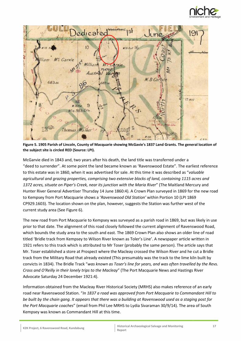
Figure 5. 1905 Parish of Lincoln, County of Macquarie showing McGavie's 1837 Land Grants. The general location of the subject site is circled RED (Source: LPI). .................................................................................. 17
Figure 6. Extract from the 1869 Crown Plan 9408-1604 showing “Ravenswood Old Station” circled in RED (Source: LPI). .................................................................................................................................................... 18
Figure 7. Extract of the 1918 Sub-division Plan for Ravenswood Estate. The general location of the subject site is circled RED (Source: Mitchell Library). .................................................................................................. 19
Figure 8. Location and extent of Excavation Areas (Areas 1 – 6) established at 6 Ravenswood Road, Kundabung during the archaeological salvage and monitoring program. ...................................................... 26
Figure 9: Palisade type fence (Source: Pickard, 2009: 92)............................................................................... 48
K2K Project, 6 Ravenswood Road, Kundabung Historical Archaeological Salvage and Monitoring Report
5
List of Plates
Plate 1: Footprint of the former timber slab hut showing the extent of C013 prior to manual excavation, facing south west. ............................................................................................................................................ 29
Plate 2: Mid-excavation of C022 to expose the brick floor of the former hut, facing west. ........................... 29
Plate 3: Former timber slab hut footprint following excavation of C022, facing south west. Note the disturbed nature of the brick floor, particularly at the southern end (top of the photograph). .................... 30
Plate 4: Ink bottle recovered from C022 (KS064). ........................................................................................... 30
Plate 5: Fragments of a large, handled metal vessel, possibly used for cooking, recovered from C022 (KS043). ............................................................................................................................................................ 30
Plate 6: Metal object, possibly a door or gate hinge, recovered from C022 (KS044). .................................... 31
Plate 7: Assorted fragments of animal bone, including what appear to be teeth, recovered from C022 (KS046). ............................................................................................................................................................ 31
Plate 8: Triangle shaped frog on bricks exposed as part of the floor of the slab hut. .................................... 32
Plate 9: Charcoal remains on the southern boundary of the former hut. ...................................................... 32
Plate 10: Former tree stump [C012} on the western side of the slab hut site. Excavation confirmed that the pit is not a former fireplace. ............................................................................................................................ 33
Plate 11: Timber post adjacent to the brick floor (indicated by the RED arrow). This feature was identified on the western side of the hut footprint adjacent to C012. ........................................................................... 34
Plate 12: View of the drain and sondages looking east towards the hut site. ............................................... 35
Plate 13: View of sondages at the southern end of the drain looking north, towards the drain bend. ......... 35
Plate 14: Sondage F, mid excavation, looking east. Note: Metal strip later identified as a wheel rim. .......... 35
Plate 15: Sondage H on completion of manual excavation. ............................................................................ 35
Plate 16: C004/C005 pre-excavation, looking east.......................................................................................... 36
Plate 17: C004/C005 post-excavation, looking north. ..................................................................................... 36
Plate 18: C023/C024 pre-excavation, looking east.......................................................................................... 36
Plate 19: C023/C024 pre-excavation, looking east.......................................................................................... 36
Plate 20: C044/C045 pre-excavation, looking north ....................................................................................... 37
Plate 21: C044/C045 post-excavation, looking south...................................................................................... 37
Plate 22: Large dish/platter depicting ‘Indian Scenery’ blue transfer print pattern, recovered from Context 004 (KS027) ...................................................................................................................................................... 37

K2K Project, 6 Ravenswood Road, Kundabung Historical Archaeological Salvage and Monitoring Report
6
Plate 23: ‘Indian Scenery’ backstamp, with initials J.C. on rim fragment recovered from Context 004 (KS027). ......................................................................................................................................................................... 37
Plate 24: Brick fill [C064] and linear drain [C066/C067] identified in Area 3, facing south west. The fill was initially thought to be the remains of a second hut site. ................................................................................ 39
Plate 25: The linear drain [C066/C067] identified in Area 3, facing north east. ............................................. 39
Plate 26: The circular pit [C068/C069] exposed at the end of the linear drain [C066/C077], facing south west The pit was filled with shale. ........................................................................................................................... 40
Plate 27: North section of Sondage L in Area 3, showing the depth and contents of C064. .......................... 40
Plate 28: Sondage M, Area 3 - post excavation, facing north west. Note: the moderate frequency of brick. 40
Plate 29: Sondage N, pre-excavation, facing north east. This sondage was positioned at the intersection of C064 and the linear drain [C066/ C067] .......................................................................................................... 41
Plate 30: Sondage N, Area 3 – post excavation, facing north east. The linear drain was found to continue below C064. ..................................................................................................................................................... 41
Plate 31: Machine removal of C064 revealing the underlying drain [C066 / C067], facing south east. ......... 41
Plate 32: Post excavation of C064, facing east. This shows the alignment and length of the underlying drain at the interface with the B horizon clay. ......................................................................................................... 41
Plate 33: Machine excavation in the north west corner of Area 3, facing west. An artefact rich deposit [C074] was found below C001. ........................................................................................................................ 42
Plate 34: Manual excavation of C074, facing west. ......................................................................................... 42
Plate 35: Detail of one brick pads (steps) identified below C074, facing north east. ..................................... 42
Plate 36: The remains of a sandstone and brick outbuilding identified within Area 3, facing south west. .... 42
Plate 37: The former sandstone and brick outbuilding looking north east. Note: the rough, uneven nature of the sandstone floor. ........................................................................................................................................ 43
Plate 38: Assorted clay pipe stem fragments recovered from Context 072 (KS101). ..................................... 43
Plate 39: Clay pipe bowl fragments recovered from Context 072 (KS101). .................................................... 43
Plate 40: Assorted buttons recovered from Context 072 (KS103). ................................................................. 43
Plate 41: Machine excavation to remove the sandstone floor, facing south west. ........................................ 44
Plate 42: On completion of machine excavation. Note: the absence of underlying fill. ................................. 44
Plate 43: North section below the brick pad of the former sandstone outbuilding. The brick and sandstone were embedded into the underlying clay. ...................................................................................................... 44
Plate 44: A rectangular post hole [C129/C130] found below the sandstone floor. ........................................ 44
Plate 45: Rectangular trench [C 127/C128] identified on the western boundary of Area 3, facing south…... 45

K2K Project, 6 Ravenswood Road, Kundabung Historical Archaeological Salvage and Monitoring Report
7
Plate 46: West section of C064 showing an in-situ stump of a former fence post [C081/C082]. ................... 45
Plate 47: Extent of C070 within Area 4, facing north east. ............................................................................. 46
Plate 48: Sondages J and K established to test C070, within Area 4, facing north east. ................................. 46
Plate 49: Sondage J showing a concentration of brick within C070, facing east............................................. 46
Plate 50: Sondage K, facing west, showing C070 with sandstone rubble. ...................................................... 46
Plate 51: Footprint of a former ancillary farm structure, most likely a holding yard, identified within Area 4, facing south east.............................................................................................................................................. 47
Plate 52: Sondage O, positioned in the north west corner of the ancillary structure, facing north east. ...... 47
Plate 53: Sondage O, post excavation, facing south east. ............................................................................... 47
Plate 54: Fragment of a glass stemware drinking vessel recovered from Context 022 (KS049) ..................... 49
Plate 55: Blue pharmaceutical bottle glass fragments recovered from Context 022 (KS047) ........................ 49
Plate 56: A Pecks meat paste condiment bottle recovered during clean up of Context 002 in Area 4 (KS016) ......................................................................................................................................................................... 49
Plate 57: Ceramic fragment depicting the common ‘Willow’ blue transfer print pattern, recovered from Context 022 (KS065) ........................................................................................................................................ 50
Plate 58: The reverse side of the same fragment, with what appears to be ‘=ADAM’ imprinted to the base (KS065) ............................................................................................................................................................. 50
Plate 59: Two fragments of ceramic with a blue, shell-edged and scalloped rim design recovered from the clean up of Context 002 in Area 3 (KS011). ..................................................................................................... 50
Plate 60: Detail view of the ‘Indian Scenery’ pattern on the large dish / platter recovered from Context 004 (KS027) ............................................................................................................................................................. 50
Plate 61: ‘Indian Scenery’ backstamp with the initials J.C. (Joseph Clementson) on a rim fragment recovered from Context 004 (KS027) ............................................................................................................................... 50
Plate 62: Examples of the assorted metal fasteners recovered across the site (KS006) ................................ 51
Plate 63: One of the three horseshoes recovered during the salvage (KS003) .............................................. 51
List of Tables
Table 1: Historical Theme identified by the ARD ............................................................................................. 21
Table 2: Phases of occupation / Use within the subject site ........................................................................... 25
Table 3: Total number of artefacts recovered during the archaeological salvage and monitoring program, by context and fabric type.................................................................................................................................... 51
Table 4: Total number of artefacts recovered during the archaeological testing and salvage investigation (combined assemblage) by context and fabric type. ...................................................................................... 52

K2K Project, 6 Ravenswood Road, Kundabung Historical Archaeological Salvage and Monitoring Report
8
1. Introduction _________________________________________________________________________________________________________________________________________________________________
1.1 Project initiation
Niche Environment and Heritage Pty Ltd (Niche) was commissioned by the NSW Roads and Maritime Services (RMS) to undertake historical archaeological salvage excavation and monitoring at 6 Ravenswood Road, Kundabung, NSW (hereafter referred to as the ‘subject site’ or ‘site’). The location was originally identified by a local resident during preparations for the Oxley Highway to Kempsey Pacific Highway Upgrade (the ‘Project’) as the potential site of a former coach station. A Historical Archaeological Assessment and Research Design (HAARD) was subsequently prepared for the site and archaeological test excavation was conducted by Niche in April 2015.
Initial test excavation of the site confirmed the presence of archaeological relics. These included: structural remains of a timber slab hut with brick floor measuring roughly 4 m2, a 15 m long linear drain, a possible brick manufacture site, 3 possible rubbish pits and evidence of at least two former fence lines (a post-and-rail fence and a timber and wire fence). A research design was subsequently developed to guide further archaeological salvage and monitoring at the site. Following further consultation with the Heritage Division, Office of Environment and Heritage (OEH) and the Department of Planning and Environment (DP&E), archaeological salvage and monitoring was conducted at the site in July 2015.
The following report presents the results of the archaeological salvage and monitoring program.
1.2 Site location
The subject site is located on at No. 6 Ravenswood Road, Kundabung, NSW and the property description is Lot 7 DP1042561. The site is situated approximately 4 km north of the town of Kundabung and 12.8 km south of Kempsey. The location of the site is shown in Figures 1 and 2.
1.3 Project background
The RMS is in the process of upgrading various sections of the Pacific Highway between the Oxley Highway at Port Macquarie and Kempsey. The subject site is located within the ‘Kundabung to Kempsey’ section (the ‘K2K Project’). The Project will essentially involve duplicating the existing highway. As part of the K2K Project, new entrance and exit ramps will be constructed to access the highway. Where possible, existing roads will be used and upgraded. A plan showing the extent of works proposed in the subject site is included as Figure 3.
The Project is a declared Major Project & Critical Infrastructure Project under (former) Section 75 (B & C) of the Environmental Planning and Assessment Act 1979 and was approved by the Minister for Planning and Infrastructure on 8 February 2012.
The RMS was notified of the possible location of a former coach station site by a local resident during preparations for construction of the Project. The site is not listed on local or state heritage registers and was not identified in the Non-Indigenous Heritage Impact Assessment prepared for the Project by South East Archaeology Pty Ltd (2009).
1.4 Statutory context
The Project was approved as a State Significant Development (SSD) by the Minister for Planning and Environment on 8 February 2012. The following Condition of Approval was issued to help manage any non-Aboriginal heritage items unexpectedly identified during construction works:

K2K Project, 6 Ravenswood Road, Kundabung Historical Archaeological Salvage and Monitoring Report
9
B31. As part of the Construction Environment Management Plan for the project required under Condition B30 the Proposal shall prepare and implement the following sub plan(s):
(e) a Construction Heritage Management Sub-plan to detail how construction impacts on Aboriginal and non-Aboriginal heritage will be minimised and managed. The sub-plan shall be developed in consultation with the EPA…..and include, but not necessarily be limited to:
(ii) in relation to non-Aboriginal Heritage:
(i) details of management measures to be carried out in relation to recorded sites (including further heritage investigations, archival recordings and/or measures to protect unaffected sites during construction works in the vicinity), consistent with the Mitigation and Management Strategies listed in Section 9 of the Non-Indigenous Heritage Impact Assessment prepared by South East Archaeology Pty Ltd (dated December 2007);
(ii) procedures for dealing with previously unidentified non-Aboriginal objects (including cessation of works in the vicinity, assessment of the significance of the item(s) and determination of appropriate mitigation measures including when works can re-commence by a suitably qualified and experienced archaeologist in consultation with the Department of Office and Environment and Heritage (Heritage Branch) and assessment of the consistency of any new non-Aboriginal heritage impacts against the approved impacts of the project; and
(iii) non-Aboriginal heritage induction processes for construction personnel (including procedures for keeping records of inductions).
A review of the draft Construction Heritage Management Sub-plan (CHMS) confirmed that the procedure for dealing with previously unidentified non-Aboriginal heritage items was to follow the RMS ‘Unexpected Finds Procedure’, which is entitled ‘Standard Management Procedure: Unexpected Archaeological Finds’ (RMS, July 2012).
In accordance with the draft CHMS, the RMS ‘Unexpected Finds Procedure’ was adopted. The following tasks were completed as part of this process:
• A copy of the HAARD was provided to the Heritage Division, OEH for comment prior to the commencement of test excavation. The proposed methodology was approved.
• On completion of the test excavation, an initial report was prepared for the RMS as required by the ‘Unexpected Finds Procedure’. The report included: a description of the site location and identified relics; a summary historical context; our initial interpretation and assessment of the likely significance of the relics; a summary of the statutory approval and notification requirements; and our initial management recommendations.
• A detailed report on the results of the test excavation was then provided to the Heritage Division, OEH and DP&E. The report included an ARD for additional salvage and monitoring at the site prior to its disturbance during construction. The proposed methodology for salvage and monitoring was approved. A copy of this letter in included in Annex A. The following report aims to satisfy OEH’s standard requirements for a detailed Excavation Report. It has been prepared in accordance with archaeological best practice.

K2K Project, 6 Ravenswood Road, Kundabung Historical Archaeological Salvage and Monitoring Report
10
1.5 Aims and scope
The main aims of the archaeological salvage were to:
• Recover as much information about former occupation and use of the timber slab hut site as possible using techniques of archaeological excavation, recording and analysis.
• Confirm the absence, or presence, of any additional relics that may be associated with the former slab hut within the proposed construction footprint of the Project.
The archaeological investigation involved two strategies:
• Archaeological salvage of a number of in-situ deposits.
• Archaeological monitoring of a 10 metre area extending from the current extent of the test excavation, subject to the project boundary and construction footprint.
Both strategies were employed concurrently. This allowed sufficient time to investigate and record additional archaeological features and deposits present within the proposed construction footprint.
The investigation area was divided into six (6) excavation areas to assist the recording and analysis of archaeological features and deposits.
The location and final extent of the investigation area is shown in Figure 4.
1.6 Report outline
The following report includes:
• A summary site history (Section 2).
• A summary of the Research Design and Excavation Method (Section 3).
• Presentation of the Excavation Results (Section 4).
• A response to the Research Design (Section 5).
• Re-assessment of the Heritage Significance of the site (Section 6).
• Conclusions and Recommendations (Section 7).
1.7 Author and acknowledgements
This report has been prepared by Fiona Leslie (Senior Archaeologist, Niche), with a summary of the artefact assemblage provided by Aleisha Buckler (Archaeologist, Niche). The draft report was reviewed by Cameron Harvey (Heritage Team Leader, Niche).
Research previously conducted by Lydia Sivaraman (Archaeologist, Niche) is summarised in this report.
We would like to acknowledge the support and assistance provided by: Stefan Everingham (RMS Environment Officer); Sam Connor (Project Development Manager) and Aleesha Darlington (RMS Environment Officer).
We would also like to acknowledge the efforts of the archaeology team: Fiona Leslie (Excavation Director and Project Manager), Aleisha Buckler and Adrian Dreyer (Assistant Archaeologists), Kerry Platt (Site Planner) and Cameron Harvey (Project Leader).

K2K Project, 6 Ravenswood Road, Kundabung Historical Archaeological Salvage and Monitoring Report
11
Figure 1: General Location Map.

K2K Project, 6 Ravenswood Road, Kundabung Historical Archaeological Salvage and Monitoring Report
12
Figure 2: Site Location.

K2K Project, 6 Ravenswood Road, Kundabung Historical Archaeological Salvage and Monitoring Report
13
Figure 3: Plan showing the extent of works proposed within the subject site (which is outlined in RED) as part of the K2K Project (Source: RMS 2014)

K2K Project, 6 Ravenswood Road, Kundabung Historical Archaeological Salvage and Monitoring Report
14
Figure 4: Final extent of the excavation areas exposed during the archaeological salvage and monitoring program.

K2K Project, 6 Ravenswood Road, Kundabung Historical Archaeological Salvage and Monitoring Report
15
2. Summary site history _________________________________________________________________________________________________________________________________________________________________
2.1 Preamble
The following site history is summarised from the HAARD prepared by Niche in April 2015. A regional history is also included to provide some additional context to the results of the investigation.
The research involved visiting the following archives:
• Mitchell Library-Search of all Lincoln Parish Plans and Plans or maps of the Kundabung area.
• Lands Department – Historical Land Title search and search of Crown Plans that relate to the site.
• Internet Searches.
• Digital newspaper and picture searches on Trove.
• The Macleay Valley Historical Society was contacted for additional historical information.
2.2 Regional history
Port Macquarie was established as a penal colony in 1823 when convicts were transported by ship from Newcastle (NSW Heritage Council 1996, p59). Early industry of the region was carried out by convicts. Convicts cut cedar from the brushes on the Hastings, Maria and Macleay Rivers. They grew maize for their own consumption and even made some attempts to grow sugar on the Hastings and Wilson Rivers (NSW Heritage Office 1996, pp59-60). With the discovery of lime on Piper’s Creek in 1831, a number of lime kilns were built and were operated by convict labour (Kass 1989, p7). With the removal of the Port Macquarie Penal Station in 1833, land in the region was opened up to free settlers.
2.2.1 Early industry
John Oxley’s Expedition of the Great Dividing Range in 1818 found the Hastings Valley wooded with various timbers, particularly cedar, rosewood and flooded gum. The following year these findings led Governor Macquarie to advise Earl Bathurst (the Secretary of State for the Colony) that Port Macquarie would be a suitable place for banishment and ‘useful because of the good timber it will afford’ (McLachlan 1988, p143). Many varieties of timber were taken from the Hastings Valley, but cedar was the most prized, as it was easily worked and not as hard as other available timbers. Red cedar, in particular, resembled mahogany. Cedar was mostly used for building, fittings and furniture (NSW Heritage Office 1996, p60). It was not long before the cedar on the Hastings Valley was cut out and sought from farther afield.
In April 1827 Captain A. C. Innes, who was Commandant at Port Macquarie, established the first cedar Party in the Macleay Valley. With the Cedar cutters came the shipbuilders. In March 1837 it was reported that there were three shipyards on the Macleay River.
On the Macleay River cedar was mainly cut on the brushes of the lower riverbanks. The rivers provided the transport for the timber; the logs were rolled into the river and floated downstream to ports where they were intercepted and shipped to Sydney (NSW Heritage Office 1996; McLachlan 1988, p143-4). As cedar soon become scarce on and near the riverbanks, the loggers had to look for cedar inland and upslope. The timber became harder to locate and transport. As the timber was cut further from the river, bullocks were used to pull the logs. Eventually the loggers began to log a range of other locally available timbers and more saw mills were established to cut the hard timber. Prior to 1850 there were not many saw mills as the cedar was sawn up by hand in saw pits and then shipped to Sydney (Kass 1989:24). An early sawmill in the Kundabung area was built by C. Cavanagh. It was taken over by d. Weingarth and then L. Everson

K2K Project, 6 Ravenswood Road, Kundabung Historical Archaeological Salvage and Monitoring Report
16
(Kundabung P & C 1959). The O’Leary Brothers operated a later mill near Kundabung until it closed in the 1960’s.
In 1831 an extensive stratum of limestone of superior quality was discovered near Pipers Creek (Kundabung). In 1834 a convict road gang was instructed to build a road from the Hastings River to the limestone outcrop and were instructed to build a lime kiln (Neil 1972: 21). Convicts then made the lime at this quarry.
2.2.2 Settlement and agriculture
Soon after the Port Macquarie Penal Settlement closed in 1830, the land around Kundabung and northward, within the county of Macquarie, was settled. One of the earliest settlers in the area was Enoch Rudder who came to the Macleay district in 1835 with a licence to cut cedar. He established a private town on his land and sold off lots. The town became Kempsey.
Land was opened to agriculturalists in the 1850s and settlements mainly occurred on land along the rivers, but it was not until the Land Alienation Act 1861 that free selection was made available and small farms became more prominent in the region. The Cedar ports along the rivers were revived and town settlements sprung up at these locations. Maize was a successful crop but lost value due to over production. Other crops were tried and failed (NSW Heritage Office 1996, p61).
By 1866 141 acres of sugar cane was growing on the Manning and Hastings River, and then was taken up on the Macleay and Clarence Rivers. To process the cane a number of mills were built ranging from private horse drawn mills to steam powered mills. The Manning Hastings and Macleay Valleys were not suitable for growing sugar as it was growing at too slow a rate. Much production moved further north and when the industry was attacked by gumming disease it all but died out in the region (Moyes et al 1993, pp114-6).
Dairy farming was taken up as an alternative to the sugar industry and from the 1890s onwards became a major industry in the region. Dairy farmers could move away from the rivers to farm and the grass fields needed to feed to cattle were more climatically tolerant than other crops. This successful venture led to villages and towns supporting a greater population, many having their own butter factories (NSW Heritage Office 1996, p62).
2.2.3 Transport
The River systems were the main source of transport for people and goods between Port Macquarie and Kempsey. The original highway from Port Macquarie to Kempsey crossed Smith’s Creek and went past an ‘Old Coach Station’ site. It was constructed in the early 1870s (LPI 1869 CP929.1603).
The Wauchope to Kempsey railway was completed and opened in 1917. Railway construction brought an increase in population, and gave rise to the village of Kundabung.
2.3 Subject site history
The subject site formed part of 689 acres of land first granted to William McGarvie, a Scotsman who arrived in Australia in 1828. McGarvie opened the ‘Australian Station Warehouse’ in Sydney, imported a printing press and began publication of the Sydney Herald. McGarvie sold his interest in the paper soon after its establishment and moved to Port Macquarie. The land on Piper’s Creek (which included the current study area) was an additional grant to his Port Macquarie holdings, where he resided (See Figure 5).
K2K Project, 6 Ravenswood Road, Kundabung Historical Archaeological Salvage and Monitoring Report
17
Figure 5. 1905 Parish of Lincoln, County of Macquarie showing McGavie's 1837 Land Grants. The general location of the subject site is circled RED (Source: LPI).
McGarvie died in 1843 and, two years after his death, the land title was transferred under a “deed to surrender”. At some point the land became known as ‘Ravenswood Estate”. The earliest reference to this estate was in 1860, when it was advertised for sale. At this time it was described as “valuable agricultural and grazing properties, comprising two extensive blocks of land, containing 1115 acres and 1372 acres, situate on Piper's Creek, near its junction with the Maria River” (The Maitland Mercury and Hunter River General Advertiser Thursday 14 June 1860:4). A Crown Plan surveyed in 1869 for the new road to Kempsey from Port Macquarie shows a ‘Ravenswood Old Station’ within Portion 10 (LPI 1869 CP929.1603). The location shown on the plan, however, suggests the Station was further west of the current study area (See Figure 6).
The new road from Port Macquarie to Kempsey was surveyed as a parish road in 1869, but was likely in use prior to that date. The alignment of this road closely followed the current alignment of Ravenswood Road, which bounds the study area to the south and east. The 1869 Crown Plan also shows an older line of road titled ‘Bridle track from Kempsey to Wilson River known as Toler’s Line’. A newspaper article written in 1921 refers to this track which is attributed to Mr Toser (probably the same person). The article says that Mr. Toser established a store at Prospect where the Macleay crossed the Wilson River and he cut a Bridle track from the Military Road that already existed (This presumably was the track to the lime kiln built by convicts in 1834). The Bridle Track “was known as Toser's line for years, and was often travelled by the Revs. Cross and O'Reilly in their lonely trips to the Macleay” (The Port Macquarie News and Hastings River Advocate Saturday 24 December 1921:4).
Information obtained from the Macleay River Historical Society (MRHS) also makes reference of an early road near Ravenswood Station. “In 1837 a road was approved from Port Macquarie to Commandant Hill to be built by the chain gang. It appears that there was a building at Ravenswood used as a staging post for the Port Macquarie coaches” (email from Phil Lee MRHS to Lydia Sivaraman 30/9/14). The area of South Kempsey was known as Commandant Hill at this time.

K2K Project, 6 Ravenswood Road, Kundabung Historical Archaeological Salvage and Monitoring Report
18
‘Ravenswood Estate’ was advertised for sale again in 1878 and was described as land formerly owned by the late David Jones esquire. The property was transferred from S. Baily and others to R.B. Smith and F. T Humphery on the 26 August 1878 (RPA 16975).
In 1907 ‘Ravenswood Estate’ was purchased by Austral Verge, the son of the prominent architect John Verge, who built many prominent buildings in Sydney including Elizabeth Bay House and John Macarthur’s residence in Camden Park (RPA 16975).
On the 3rd March 1909 the road from Port Macquarie to Kempsey was replaced with the new ‘North Coast Road’. This followed the current highway alignment.
A Subdivision Plan for Ravenswood Estate in 1918 shows two huts and horse yards within McGarvies original grant of Portion 10 (Figure 7). The plan is not an accurate survey plan, rather just a sketch of what is located on the land for the purposes of sale. There is no mention of the Old Ravenswood Station.
A more recent description of this site from the MRHS file is a recollection by Sheila and Bill Blackwell. They recall the name Ravenswood and stated “It was a stopover for horse coaches…and a dwelling was there (whether Pub or boarding house they are not sure) but it was an overnight stop too and horses were changed at this post” (MRHS File Ravenswood). The file also noted that Mr Brian Sowter recalled being shown by his father an old morticed fence which was part of a horse yard. He said that “there may have been the remains of an Old building too but the posts were morticed in such a way as to suggest horse yards. One rail end was slipped into the post the other end was dropped in making it horse proof. The creek does not run there now but originally the creek ran through this part which would be a logical place for a building in the early days” (MRHS File Ravenswood).
Figure 6. Extract from the 1869 Crown Plan 9408-1604 showing “Ravenswood Old Station” circled in RED (Source: LPI).

K2K Project, 6 Ravenswood Road, Kundabung Historical Archaeological Salvage and Monitoring Report
19
Figure 7. Extract of the 1918 Sub-division Plan for Ravenswood Estate. The general location of the subject site is circled RED (Source: Mitchell Library).
2.4 Additional Research
Further research of historical newspaper archives on Trove was undertaken following the preparation of the Historical Archaeological Assessment and Research Design (HAARD) and Historical Archaeological Test Excavation Report (Niche 2015). The following primary references provide some interesting insights into the date and nature of occupation at Ravenswood Estate.
The earliest reference to Ravenswood Station is in an article dating to December 1845, which details the pursuit of two bushrangers through the Port Macquarie area. According to The Sydney Morning Herald (8 December 1845:2) article, the bushrangers:
…proceeded to the upper station at Ravenswood, bailed up the stockman and hutkeeper, and sat down and refreshed themselves; after staying there about two hours they took what rations they required and proceeded on their way.
In 1851, a notice published in The Sydney Morning Herald (19 March 1851:3), issued by David Jones, declared the following:
E.W. Rudder, Esq., of Kempsey, McLeay River, as my agent, has full power to let all or any portion of my property in the neighbourhood of Kempsey, known as Ravenswood…to proceed against all parties trespassing thereon, or found destroying or injuring the buildings, stockyards, fences, etc., belonging thereto…
Jones goes on to note that his Ravenswood property “is to let for pastoral and agricultural purposes upon moderate terms” (SMH 19 March 1851:3).
Evidently, Ravenswood was occupied in 1845 by a stockman and hutkeeper and that by 1851 the Estate included buildings, stockyards and fences.

K2K Project, 6 Ravenswood Road, Kundabung Historical Archaeological Salvage and Monitoring Report
20
2.5 Summary of key points
• The subject site is situated in close proximity to the former road from Port Macquarie to Kempsey surveyed as a parish road in 1869. The alignment of this road closely followed the current alignment of Ravenswood Road.
• The subject site is located within what was part of Ravenswood Estate, a property with valuable agricultural and grazing land. The earliest reference to Ravenswood is in a newspaper article dating to December 1845, which details the pursuit of two bushrangers through the Port Macquarie area. This article refers to a stockman and hutkeeper being held up by the bushrangers at the upper station at Ravenswood.
• In 1851, a notice in the Sydney Morning Herald refers to Ravenswood Station having buildings, stockyards and fences.
• Ravenswood Station was first advertised for sale in 1860. A Crown Plan surveyed in 1869 shows the location of ‘Ravenswood Old Station’ to the west of the subject site.
• A later 1918 subdivision plan of the Estate shows 2 huts and a horse paddock. These structures also appear to be located to the west of the subject site.
• Information from the Macleay River Historical Society (MRHS) makes reference to an early road near Ravenswood Station and the use of one of the buildings on the estate as a possible staging post for Port Macquarie coaches.
• Local resident, Mr Brian Sowter, recalled being shown an old morticed fence on the site, which was part of a horse yard, by his father. He also thinks that there may have been the remains of an old building on the subject site too.

K2K Project, 6 Ravenswood Road, Kundabung Historical Archaeological Salvage and Monitoring Report
21
3. Research design and excavation method _________________________________________________________________________________________________________________________________________________________________
3.1 Preamble
The following Archaeological Research Design (ARD) was developed following test excavation of the subject site. Historical themes were identified and a number of research questions were developed to guide the archaeological investigation. These questions focused on the in-situ archaeological deposits and what they could reveal about former occupation and use of the timber slab hut. The research design included a methodology to ensure that the site’s research values were understood and documented in accordance with archaeological best practice.
3.2 Historical themes
Table 1 outlines the historical theme identified as being relevant to the subject site.
Table 1: Historical Theme identified by the ARD
National Theme NSW Theme Local Theme Examples
Building settlements, towns and cities
Accommodation
Activities associated with the provision of accommodation, and particular types of accommodation
Terrace, apartment, semi-detached house, holiday house, hostel, bungalow, mansion, shack, house boat, caravan, cave, humpy, migrant hostel, homestead, cottage, house site (archaeological).
3.3 Research questions
The following research questions are relevant to the former slab hut and its associated archaeological deposits and features. They were used to guide the strategy and archaeological methods employed during the investigation:
• Can archaeological salvage and analysis of in-situ archaeological deposits at the hut site provide any further information on the likely date of its construction and duration of its occupation?
• What is the nature and significance of the artefact rich deposits identified above the in-situ brick floor of the hut? Is this evidence of flood deposition?
• Is there any evidence of a former floor surface in the hut prior to installation of the identified brick floor? Or was the brick floor installed at the same time as construction of the hut? Why was the brick floor established at its current level in relation to the former level of the ground surface?
• Did the hut have a timber fireplace? If so, why were bricks not used for this function?
• Is there a former privy associated with the hut site? If so, what can the analysis of its deposits tell us about former occupants of the hut?
• What can the analysis of artefacts recovered from the linear drain and possible rubbish pits tell us about former occupants of the hut, their activities, diet and lifestyle? Is their evidence of women and children living at the site? Does the assemblage demonstrate wealth?
• How was the hut constructed? How was the vertical timber slabs supported? What information can its construction tell us about the former activities and labour on Ravenswood Estate?

K2K Project, 6 Ravenswood Road, Kundabung Historical Archaeological Salvage and Monitoring Report
22
• Is there evidence of brick making on site? If so, does that provide any insight into the availability of building materials on Ravenswood Estate and the local area?
• Does further exposure of post-holes confirm the orientation and alignment of former fence lines? How does alignment and orientation relate to the former hut site and what can that tell us about its former use?
• Do any other archaeological features or significant deposits survive at the subject site? What additional information can they provide on former occupation and use of the former slab hut? Does their presence change our interpretation of the site?
3.4 General strategy and approach
Archaeological investigation of the subject site was conducted over a nine (9) day period from 13 - 23 July 2015 by a team of skilled archaeologists, including:
• Fiona Leslie, Principal Archaeologist, who was the appointed Excavation Director and Project Manager. Fiona managed and co-ordinated the archaeological investigation.
• Kerry Platt, Surveyor and Archaeologist, who was the appointed Site Planner.
• Aleisha Buckler and Adrian Dreyer, Archaeologists, who assisted Fiona with excavation and recording during the investigation.
The investigation involved two strategies that were employed concurrently:
• Archaeological salvage of a number of in-situ deposits.
• Archaeological monitoring of a 10 metre area extending from the current extent of the test excavation, subject to the project boundary and construction footprint.
The investigation area was divided into six (6) excavation areas to assist the recording and analysis of archaeological features and deposits.
The following subsections outline the approach taken for salvage and monitoring at the site.
3.4.1 Archaeological salvage
The archaeological salvage program involved archaeological excavation and recording of a number of in-situ deposits, employing the methods outlined in Section 3.5. The general approach to the salvage program is summarised below:
• The priority of the salvage was on intact deposits that were considered related to occupation of the former hut. These included the two deposits above the brick floor [C013, C022] and the possible timber chimney deposit abutting the brick floor of the hut [C012]. These fills were manually excavated to their full extent.
• The linear drain fill [C014] was sampled to further investigate the frequency and type of artefacts present. The testing commenced at the intersection of the drain and the footprint of the hut. A 1 metre portion of the drain fill was manually excavated and all artefacts were recovered for cleaning and analysis. Additional 1 metre long test trenches were then excavated at 5 m intervals along the length of the drain. Testing demonstrated a low frequency of artefacts and further testing of the drain was not considered warranted.

K2K Project, 6 Ravenswood Road, Kundabung Historical Archaeological Salvage and Monitoring Report
23
• Excavation of the three possible rubbish pits [C044, C004, C023] focused on the recovery of artefacts and not detailed investigation of the features themselves (i.e. defining their full extent). The salvage of these deposits confirmed that the pits were, in fact, former tree stumps.
3.4.2 Archaeological monitoring
Archaeological monitoring was conducted within a 10 m area extending from the original extent of the test excavation, subject to the project boundary and construction footprint. In the area immediately surrounding the original test excavation area (Area 1) excavation and the removal of surface deposits was undertaken by a 7 tonne backhoe fitted with a batter bucket. The machine was supervised by the Excavation Director at all times. In areas further to the north and south of Area 1, surface deposits were removed using a small grader monitored by the Excavation Director. The grader removed 10 cm layers of the surface deposit to the interface of the A2 horizon and B horizon clay. The backhoe was then used to scrape and clean up the surface of the clay horizon.
Any additional archaeological features identified during monitoring were photographed, planned, manually excavated and recorded following the methods outlined in Section 3.5. Notification of the discovery of additional relics to the DP&E and OEH was not necessary, as all new archaeological features and deposits were found to be associated with the timber slab hut.
3.5 Excavation and recording methods
Standard archaeological excavation and recording methodologies were adopted during the investigation. These included undertaking the following tasks:
• The survey datum used during the test excavation program was re-established in order to record the levels of extant deposits and features.
• Manual excavation and recording of in-situ archaeological deposits identified during the test excavation was undertaken in reverse order of deposition to culturally sterile levels.
• Scaled site plans and profile or cross-section drawings showing the location and final levels of all archaeological deposits and features were prepared, as required. These were keyed to the site datum.
• Six (6) excavation areas were established to assist further recording and analysis of archaeological features and deposits identified during monitoring.
• Additional backhoe excavation and surface grading was undertaken within a 10 m area extending from the primary excavation area. The machine excavation was conducted under the supervision and direction of the Excavation Director. Deposits were removed in 10 cm layers by the backhoe to the level of any archaeological features or deposits or the proposed level of impact, whichever was encountered first.
• Photographic recording of excavation prior to commencement, and on completion, were undertaken. This involved recording of archaeological features using an appropriate photographic scale.
• A standard context recording system was employed. Existing context sheets were annotated to include information relating to the salvage of specific deposits. Any additional contexts were recorded on sequentially numbered proforma context recording sheets and on a summary context register. This form of written documentation was supplemented by preparation of a Harris Matrix showing the stratigraphic relationships between features and deposits.

K2K Project, 6 Ravenswood Road, Kundabung Historical Archaeological Salvage and Monitoring Report
24
• Small sondages (test pits) were manually excavated in various areas to determine the depth and nature of archaeological features and deposits.
• Artefacts retained for further analysis were cleaned off site, sorted according to their fabric classes, bagged and boxed with reference to the context from which they were recovered.
• Excavation was conducted until sufficient information to address the research questions was recovered, to the satisfaction of the Excavation Director.
3.6 Artefact Analysis
Artefact processing was undertaken off site, as follows:
• Artefacts were cleaned and dried.
• Items were then divided into categories according to their type and fabric and, in the case of glass and ceramics, by colour. These were further divided into those which are non-diagnostic and those which require more close consideration.
• Items such as unmarked broken glass, shells, small wooden fragments, metal fragments etc. were weighed and recorded, then discarded.
• Remaining items were retained for analysis and potential research.
Post Excavation Analysis of materials recovered during excavation was undertaken in a secure location by a suitably qualified heritage specialist.
3.7 Artefact Repository
On completion of the artefact analysis and reporting, the artefacts were transferred to the Macleay River Historical Society, who formed an agreement with RMS to provide a safe, long term repository for the assemblage. The assemblage is now available for future comparative analysis and local studies.

K2K Project, 6 Ravenswood Road, Kundabung Historical Archaeological Salvage and Monitoring Report
25
4. Excavation results: stratigraphy and interpretation _________________________________________________________________________________________________________________________________________________________________
4.1 Preamble
The following subsections describe the results of the salvage excavation and monitoring, including detailed descriptions of the soil deposits and archaeological contexts revealed within Areas 1 – 6 (Sections 4.3 -4.9), a summary of artefacts recovered during the investigation (Section 4.10), and a discussion of the results (Section 4.11).
Plans of each excavation area are included in Annex B. A Harris Matrix and a context catalogue showing the stratigraphic relationships between contexts and deposits are included in Annexures C and D. Contexts were numbered sequentially throughout the course of the investigation (i.e. 001, 002. 003 etc). The artefact catalogue is included as Annexure E.
4.2 Excavation areas
Following the establishment of a site datum, six (6) excavation areas were established within the subject site:
• Area 1: constituted the original extent of Area 1 exposed during the test excavation.
• Area 2: constituted the original extent of Area 2 exposed during the test excavation.
• Area 3: was a newly exposed area to the west of Area 1.
• Area 4: was a new area to the north west of Area 1.
• Area 5: was a new area to the north east of Area 1.
• Area 6: was a new area exposed to the south of Areas 1 and 2.
The location and extent of these areas are shown in Figure 8 overleaf.
Small sondages (test pits) were manually excavated to determine the depth and nature of archaeological features and deposits within a number of Areas. The location of these sondages is shown in the detailed excavation plans included in Annex B. These plans also show the extent and numbering of features and deposits and their level, in relation to the Australian Height Datum (AHD).
4.3 Phases of occupation / use
Table 1 lists the various phases of occupation / use used during the on-site investigation. These phases were informed by the historical record and guided by the extent and nature of the relics identified during the test excavation. They continued to be relevant during the salvage excavation and monitoring program. During excavation the stratigraphic relationship between archaeological contexts was recorded and each context attributed to a particular phase, where possible.
Table 2: Phases of occupation / Use within the subject site
Phase ID Phase Description
A Pre European / natural topsoil and subsoil (pre 1830s)
B Construction of the timber slab hut (c1850s)
C Occupation of the timber slab hut (c1850s – 1910s)
D Abandonment of the hut / disuse and demolition (c1910 – 1940s?)
E Cultivation / Grazing (post 1940?)

K2K Project, 6 Ravenswood Road, Kundabung Historical Archaeological Salvage and Monitoring Report
26
Figure 8. Location and extent of Excavation Areas (Areas 1 – 6) established at 6 Ravenswood Road, Kundabung during the archaeological salvage and monitoring program.

K2K Project, 6 Ravenswood Road, Kundabung Historical Archaeological Salvage and Monitoring Report
27
4.4 Stratigraphy and interpretation
4.4.1 Area 1
Area 1 was excavated during archaeological testing of the subject site. The following dot-points provide a summary of the stratigraphy and archaeological features identified during this initial phase of investigation. A full description of the stratigraphy can be found in the test excavation report (Niche 2015a).
• The surface deposits within Area 1 consisted of thick grass [C001] and 100-200mm of compact dark brown silty clay, interpreted as modified A1 horizon topsoil [C002].
• A large concentration of fill was noted below C002. Further machine excavation of the fill revealed a series of fills sitting above a brick paved surface [C011]. These included:
Very compact and waterlogged white / grey mottled clay below C003. This deposit was sterile, varied in thickness and extent and was interpreted as redeposited C horizon clay [C007].
200 mm thick layer of loose west dark brown silty clay with moderate frequency of artefacts including glass, ceramic, metal and brick pieces [C006]. This deposit sat below C007 and was later interpreted as demolition fill.
A distinctive deposit of loose black / dark brown clay silt with very frequent charcoal and wood pieces [C008] below C006. Whole pieces of bark and timber slabs were recovered from this deposit. Its contents and extent suggest that the brick floor was part of a former slab hut that may have been burnt to the ground and collapsed.
An artefact rich black / dark grey clay silt was then identified [C013] above a medium brown clay with occasional artefacts [C022].
• Two footing trenches were identified along the eastern and western boundaries of the brick floor. On the eastern side of the floor the footing trench measured roughly 40 mm and was filled with very compact light grey brown clay with very frequent sandstone rubble and a linear charcoal deposit [C020/C021]. No footing trench was present along the northern boundary of the structure with the bricks embedded directly into sterile B horizon clay [cut C010; C009].
• On the western boundary of the former hut, a medium brown silty clay [C012] was identified below the charcoal and timber rich demolition fill [C008]. Initial interpretation was that the feature may have been a former timber chimney located on the western side of the hut. This feature was further investigated as part of the salvage program.
• A linear drain was identified on the south eastern boundary of the former timber slab hut [C014/C015]. The drain was first identified below the charcoal and timber rich demolition fill [C008]. Further machine excavation found the drain extended more than 15 m to the east and south of the hut. This feature was further tested as part of the salvage program.
• Three possible rubbish pits were also identified within Area 1 below C002 [C004/C005, C23/C024/, C044/C045]. Further investigation of the pit fills formed part of the salvage program.
• A large number of post holes were also identified below C002 within Area 1 [C016/C017, C018/C019, C025/C026, C027/C028, C029/C030 & C032/C033C047/C048, C049/C050, C051/C052, C042 / C043, C040 / C041, C036/C037 & C038/C039]. At least one series of post holes show evidence of a large timber fence installed during occupation of the hut. This fence is shown in the 1918 subdivision plan (Figure 7). Given the limited time available to complete the salvage program it was decided that post hole fills would only be excavated as part of the investigation, if their alignment and/or association with other archaeological features was unclear.
The following sub-sections provide a description and interpretation of the stratigraphy associated with a number of the archaeological features salvaged within Area 1.

K2K Project, 6 Ravenswood Road, Kundabung Historical Archaeological Salvage and Monitoring Report
28
The Timber Slab Hut Site
The footprint of the former timber slab hut was clearly exposed during archaeological test excavation of the subject site (Plate 1). Below the charcoal and timber rich demolition fill [C008] two artefact rich deposits were identified above the brick paved floor [C011]. The first deposit was very compacted fine grained black / dark grey clay silt with frequent artefacts and charcoal flecks [C013]. Manual excavation of this deposit revealed that it was roughly 30 mm thick, although this varied greatly. In some places the deposit was non-existent. Artefacts recovered during the manual excavation of this deposit included 36 fragments of bottle glass, 22 pieces of ceramic and five metal items. The artefacts were typical domestic refuse, with frequent bottle glass and ceramic tableware. The glass included a high frequency of dark green glass from alcohol bottles. The ceramic pieces included broken plates, cups and bowls of blue transfer print designs, with many fragments of the ‘Willow’ and ‘Fibre’ patterns.
The second deposit (below C013) was compact medium brown clay silt with a high frequency of artefacts [C022]. At the northern end of the former hut, this deposit lay directly above an intact brick floor [C011] and was roughly 50 mm thick (Plate 2). Further manual excavation of this deposit towards the centre and southern end of the hut footprint, however, revealed that the underlying brick had been significantly disturbed (Plate 3). The deposit lay above brick pieces and fragments embedded in modified B horizon clay fill [disturbed C011]. 873 artefacts were recovered during the manual excavation of CO22, including: 527 pieces of glass, 253 pieces of ceramic, 58 metal objects and 15 bone fragments. The artefacts included structural remains, including over 40 nails, potential cooking objects and animal bone, items of ceramic tableware and teaware, alcohol and other beverage bottles and at least one drinking glass. The assemblage also included pharmaceutical bottles, ceramic storage vessels and the remains of an ink bottle (Plate 4). The fragments of a large handled metal vessel, possibly used for cooking were found (Plate 5). A metal object resembling a gate or door hinge was also recovered (Plate 6). Fifteen fragments of animal bone were also identified, including what appear to be teeth (Plate 7). The glass was predominately from alcohol bottles, including square gin bottles and mineral waters. One fragment of a stemmed glass drinking cup was found. Ceramic pieces were predominately tableware with assorted transfer prints, including ‘Willow’, ‘Fibre’, and flow blue. At least 7 vessels, most likely plates, were identified. One fragment of bone china teaware was also present.
The position of these artefacts and the disturbed nature of the brick floor suggest that the demolition fills above the hut were compacted and compressed following the burning and collapse of the structure. This explains why the southern portion of the brick floor was more disturbed than the northern end. It was closer to the former ground surface and more heavily impacted by surface activities. The presence of the thick heavy sterile clay [C007] above the demolition fills indicates the later addition of fill to level the ground surface.

K2K Project, 6 Ravenswood Road, Kundabung Historical Archaeological Salvage and Monitoring Report
29
Photos
Plate 1: Footprint of the former timber slab hut showing the extent of C013 prior to manual excavation, facing south west.
Plate 2: Mid-excavation of C022 to expose the brick floor of the former hut, facing west.

K2K Project, 6 Ravenswood Road, Kundabung Historical Archaeological Salvage and Monitoring Report
30
Photos
Plate 3: Former timber slab hut footprint following excavation of C022, facing south west. Note the disturbed nature of the brick floor, particularly at the southern end (top of the photograph).
Photos of artefacts
Plate 4: Ink bottle recovered from C022 (KS064).
Plate 5: Fragments of a large, handled metal vessel, possibly used for cooking, recovered from C022 (KS043).

K2K Project, 6 Ravenswood Road, Kundabung Historical Archaeological Salvage and Monitoring Report
31
Photos of artefacts
Plate 6: Metal object, possibly a door or gate hinge, recovered from C022 (KS044).
Plate 7: Assorted fragments of animal bone, including what appear to be teeth, recovered from C022 (KS046).
The most likely explanation for the deposition of C013 and C022 is flooding and slope-wash during heavy rainfall. Drainage was evidently an issue for the former occupants of the hut given the presence of the 15 m long drain on its south east corner. The 1918 subdivision plan of Ravenswood Estate shows two huts and a horse paddock and these structures generally correspond with the location of archaeological remains identified at the subject site. Brian Sowter, a local land owner, remembers an old morticed horse paddock fence and old bricks in the area where the hut was identified. Historical and anecdotal evidence therefore suggests that the slab hut remained standing long after it was abandoned and only collapsed once it was burnt, possibly by bushfire. The accumulation of flood deposits within the footprint of the hut during this time was inevitable. Flood water and surface run-off would have naturally accumulated above the brick floor. The soil matrix, constituents and texture of C013 and C022 supports this interpretation. Given the colour change between the two deposits, it seems highly likely that soil development had started to occur prior to the burning and collapse of the hut.
If this interpretation is correct, artefacts recovered from C013 and C022 most likely relate to occupation of the hut but are not in-situ, i.e. they were present within surrounding deposits and washed into the footprint of the hut during periods of heavy rainfall and flooding. Whilst the deposits may not be in-situ, their analysis can provide meaningful insights into the history and occupation of the hut during the nineteenth century.
Analysis of artefacts recovered from theses deposits confirms the preparation, storage and consumption of food and alcohol by the occupants of the hut. In general, the assemblage included generic glass and ceramic items, such as plates and bottles, rather than specialised pieces. Very little high-quality china was found, with only one fragment of a stemmed glass drinking cup and no crystal cut tablewares, confirming that the occupants were not affluent. No artefacts relating to personal hygiene or grooming were identified and no evidence of children, women or pets occupying the site were found (i.e. no toys, marbles, pins or animal carcases were present). Whilst some animal teeth were found, very few faunal remains were recovered and any evidence relating to the former diet of the occupants is absent (i.e. no animal bone, pips or shellfish remains). The presence of an ink bottles suggests that the occupants may have had access to writing equipment. The frequency of nails also supports the agricultural setting and history of the hut. In

K2K Project, 6 Ravenswood Road, Kundabung Historical Archaeological Salvage and Monitoring Report
32
general, the assemblage confirms that the occupants of the hut were most likely male workers on Ravenswood Estate that led a very simple life.
Manual excavation within the footprint of the slab hut provided some other interesting insights into its construction and use. The removal of C022 above the brick floor revealed areas of intact and disturbed brick. The additional bricks featured triangular frogs, in addition to the circular ‘thumb print’ frogs, seen during the test excavation (Plate 8). Other archaeological excavations conducted in the Port Macquarie area have recovered similar bricks with ‘circular’ and ‘triangular’ frogs. In particular, bricks with the same frogs were recovered from the c1833 Royal Hotel, Port Macquarie and are believed to have been in use in the Port Macquarie area from the mid-1830s to early 1840s (Appleton, 2004:9).
Two footing trenches were identified along the eastern and western boundaries of the brick floor during the initial test excavation. The footing trench on the eastern side of the brick floor included a linear charcoal deposit. Further, manual excavation of C022 confirmed the absence of any additional footing trenches on the northern and southern boundaries of the hut and continuation of the linear charcoal deposit along its southern boundary, with a distinctive break mid-way along its length (Plate 9). The charcoal is thought to represent the remnants of vertical timber slabs embedded within the footing trench using rubble, or wedged between the brick and adjacent clay section. The vertical timber slabs would have formed the wall of the hut. Based on this interpretation, it is likely that the break in the charcoal deposit represents the former doorway of the hut. Given the depth of the brick floor, in relation to its surrounding deposits, it makes sense that the door was on the southern side of the hut. The brick floor on this side of the hut would have been level with the former ground surface. On the northern side of the hut, the bricks were much lower in the soil profile and an entrance on this side would have been difficult.
Plate 8: Triangle shaped frog on bricks exposed as part of the floor of the slab hut.
Plate 9: Charcoal remains on the southern boundary of the former hut.
Manual excavation on the western side of the hut confirmed that the medium brown silty clay (C012) is not the remains of a former fireplace, as was originally proposed. C012 was identified below the charcoal and timber rich demolition fill [C008] and extended across a 1 m area, intersecting with the boundary of the former hut. Manual excavation of the pit fill confirmed that the irregular shaped pit had been cut during excavation to establish the brick floor (Plate 10). Despite its thick charcoal lining, the irregular shape and stratigraphic relationship of C012 with C011 and the absence of charcoal, ash and other constituents typically found in former chimney deposits, suggest that the feature was a tree stump that was burnt and removed prior to construction of the hut.

K2K Project, 6 Ravenswood Road, Kundabung Historical Archaeological Salvage and Monitoring Report
33
The absence of a permanent fireplace directly associated with the hut is interesting. Whilst patches of burnt clay were identified in close proximity to the hut site, no obvious former campfires were identified. It is possible that post-demolition activities, including ploughing of the subject site, removed any traces of such ephemeral features. This absence of evidence points to cooking activities taking place outside, in more temporary camp fires and supports the idea that the hut was used for temporary, rather than permanent, occupation.
The removal of C012 exposed another interesting feature that may relate to construction of the hut. On the western edge of the brick floor adjacent to the former tree stump, a single rectangular post was found embedded next to the brick (Plate 11). Its position in relation to the brick, suggests that the post was dug immediately after the brick had been laid. It is possible that the vertical timber slabs on this side of the hut may have needed additional support due to the softer deposit within the former tree stump. This interpretation would explain its position, in relation to C012, and its isolation. No other posts were identified within the footprint of the former hut.
Photos
Plate 10: Former tree stump [C012} on the western side of the slab hut site. Excavation confirmed that the pit is not a former fireplace.

K2K Project, 6 Ravenswood Road, Kundabung Historical Archaeological Salvage and Monitoring Report
34
Photos
Plate 11: Timber post adjacent to the brick floor (indicated by the RED arrow). This feature was identified on the western side of the hut footprint adjacent to C012.
The Open Drain
During the test excavation, a 15 m long, 400 mm wide by 350 mm deep trench was identified on the south eastern corner of the hut site leading to the east and then south. The trench terminated in an excavated pit backfilled with C horizon shale [C054 + C055]. The trench fill was found to contain a moderate frequency of artefacts, including ceramic, glass and metal pieces. Initial interpretation was that the trench was an open surface drain excavated following construction of the hut to assist the drainage of water away from the brick floor. Given the length of the drain and its contents, it was decided that a sampling strategy would be adopted to recover additional artefacts. Five [5] 1 m long x 500 mm wide sondages (Sondages E, F, G, H & I) were positioned 4 m apart along its length (Plates 12 & 13).
Excavation of Sondages E, F, G and H revealed a variable frequency of artefacts. Only 2 pieces of glass were identified in Sondage E and 1 piece of metal in Sondage F (Plate 14). Analysis of this piece of metal found that it could be a wheel rim. In contrast, Sondage G contained the highest frequency of artefacts including 52 pieces of glass and 1 piece of ceramic. The glass was predominately dark green alcohol bottle fragments, with only two diagnostic elements (base fragments) found. 10 pieces of glass and 3 ceramic pieces were recovered from Sondage H (Plate 15). The ceramic pieces included blue ‘Willow’ and brown floral transfer prints. Sondage I was abandoned due to time and budget constraints. The artefacts recovered from the drain fill are likely to have washed in following disuse of the hut and are typical of domestic refuse.

K2K Project, 6 Ravenswood Road, Kundabung Historical Archaeological Salvage and Monitoring Report
35
Plate 12: View of the drain and sondages looking east towards the hut site.
Plate 13: View of sondages at the southern end of the drain looking north, towards the drain bend.
Plate 14: Sondage F, mid excavation, looking east. Note: Metal strip later identified as a wheel rim.
Plate 15: Sondage H on completion of manual excavation.

K2K Project, 6 Ravenswood Road, Kundabung Historical Archaeological Salvage and Monitoring Report
36
Possible Rubbish Pits (former tree stumps)
Three possible rubbish pits were identified within Area 1 during the test excavation, two pits to the north of the hut site [C004/C005, C023/C024] and one pit to the south [C044/C045]. All of the pits were irregular in shape and contained a moderate to low frequency of artefacts. Given their size and limited research potential it was decided that the pits would be excavated manually to recover their contents and determine their form and function.
Manual excavation of the pits confirmed their irregular shape and depth (See Plates 16-21). All were lined with charcoal, but their shape and the presence of long linear charcoal rich fills confirmed there that the pits were former tree stumps. Evidently, the trees were removed during and/or after occupation of the hut. Artefacts from the surrounding area had then washed in to the void where the stump had been located.
Artefacts recovered from C004 included pieces of conjoining ceramics, indicating a single refuse episode (Plate 22). Over 20 fragments of earthenware ceramic displayed a blue transfer print pattern. Two backstamps identified this design as ‘Indian Scenery’, with initials J.C (Plate 23). The fragments conjoined to form two items of tableware, one plate and one large dish / platter. C023 contained only dark green alcohol bottle fragments, representing 1 bottle. Similarly, C044 contained very few artefacts, include 2 fragments of unidentified blue transfer print ware. The unstratified context of the artefacts makes any association with former activities at the hut site problematic.
Photos
Plate 16: C004/C005 pre-excavation, looking east.
Plate 17: C004/C005 post-excavation, looking north.
Plate 18: C023/C024 pre-excavation, looking east.
Plate 19: C023/C024 pre-excavation, looking east.

K2K Project, 6 Ravenswood Road, Kundabung Historical Archaeological Salvage and Monitoring Report
37
Photos
Plate 20: C044/C045 pre-excavation, looking north
Plate 21: C044/C045 post-excavation, looking south
Plate 22: Large dish/platter depicting ‘Indian Scenery’ blue transfer print pattern, recovered from Context 004 (KS027)
Plate 23: ‘Indian Scenery’ backstamp, with initials J.C. on rim fragment recovered from Context 004 (KS027).
4.4.2 Area 2
Area 2 was excavated as part of the initial test excavation (See Figure 8). It was positioned adjacent to a levelled area where a local resident had identified bricks and other debris (Plate 18). The surface deposits consisted of thick grass [C001] and 200 mm of compact dark brown silty clay, interpreted as A1 topsoil [C002]. Unlike Area 1, no artefacts were identified during the machine excavation.
Following the removal of this deposit, no areas of fill, or changes in the nature or composition of the subsurface deposit, were noted. The natural subsoils were sterile and no further excavation, or investigation, of the Area was warranted.
During the salvage excavation, the surface of this area was cleaned using the backhoe to expose the B horizon clay [C009]. No archaeological features, or deposits of interest, were noted.

K2K Project, 6 Ravenswood Road, Kundabung Historical Archaeological Salvage and Monitoring Report
38
4.4.3 Area 3
Area 3 was positioned on the west side of Area 1 and directly north of Area 2 (See Figure 8). Excavation in this area was conducted using a backhoe and was monitored at all times by the Excavation Director.
The surface deposits within this area were the same as those seen in Areas 1 and 2. Below the thick grass [C001] was 100-200 mm of compact dark brown silty clay, interpreted as modified A1 horizon topsoil [C002]. Below this, two archaeological features were encountered and are described in the sub-sections below.
Open Drain and Fill
The first feature was identified roughly 5 m to the north west of the hut site in Area 1. Dark grey brown silty clay loam with frequent orange sandstock brick pieces, ceramic and glass fragments [C064] were encountered directly below C002. The edges of the deposit were carefully defined using the backhoe exposing an area of fill measuring 2 m wide by 5 m long (Plate 24). At the southern end of the deposit a linear trench measuring roughly 3 m long by 400 mm wide [C066 / C077] was identified below C002 (Plate 25). The trench was filled with moderately compacted dark grey silty clay loam with occasional artefacts and ran south east terminating at a 1 m wide circular pit filled with C horizon shale [C068/C069], similar to the pit found at the end of the open drain in Area 1 (Plate 26). Given the presence of the drain, initial interpretation was that the brick rich deposit may have been the remains of a second hut site, similar in dimension to the hut found in Area 1. This interpretation seemed quite plausible, given the presence of a second hut shown on the 1912 Subdivision Plan.
Three (3) 500 mm2 sondages (Sondages L, M & N) were subsequently excavated to further investigate the contents of C064 and its relationship with the adjacent drain [C066/C077]. Sondage L was positioned in the south west corner of the area of fill, where the brick pieces appeared quite regular and continuous. Excavation of this sondage revealed that the brick was not as frequent or regular as the surface deposit suggested and the fill was only 150 mm thick and lay directly above the B horizon clay [C009] (Plate 27). Sondage M was positioned in the north eastern half of the area of fill (Plate 28). Excavation of this sondage confirmed the results seen in Sondage L. The fill contained a moderate frequency of sandstock brick, only occasional artefacts, and was roughly 150 mm thick sitting directly above the clay [C009]. Artefacts recovered from C064 included: a few fragments of dark green alcohol bottle glass, unidentifiable metal objects, a small amount of ceramic tablewares (including at least one plate of blue transfer ‘Willow’, one bowl or cup with ‘Fibre’ prints and a piece of blue flow plate), and 7 fragments of window glass. Of interest, this is the only deposit where window glass was found.
The third sondage (Sondage N) was positioned roughly half a metre south east of Sondage L at the intersection of the drain with C064 (Plates 29 & 30). Excavation of this sondage confirmed that the drain fill continued below C064. Further machine excavation to remove C064 revealed that the drain was relatively shallow at its northern end, was orientated north east – south west and measured roughly 5 m in length (Plates 31 & 32).
The continuation of the drain and the contents and relatively shallow nature of C064 confirm that the deposit was highly unlikely to be the remains of a second hut site. It is more likely that fill settled above the drain after the site was abandoned. Why the drain was positioned in this area remains unclear, although given its orientation it was likely used to channel surface water downslope. With the absence of an artefact-rich demolition fill or any structural remains, however, it seems highly unlikely that a second hut site was present in the general area.

K2K Project, 6 Ravenswood Road, Kundabung Historical Archaeological Salvage and Monitoring Report
39
Photos
Plate 24: Brick fill [C064] and linear drain [C066/C067] identified in Area 3, facing south west. The fill was initially thought to be the remains of a second hut site.
Plate 25: The linear drain [C066/C067] identified in Area 3, facing north east.

K2K Project, 6 Ravenswood Road, Kundabung Historical Archaeological Salvage and Monitoring Report
40
Photos
Plate 26: The circular pit [C068/C069] exposed at the end of the linear drain [C066/C077], facing south west The pit was filled with shale.
Photos
Plate 27: North section of Sondage L in Area 3, showing the depth and contents of C064.
Plate 28: Sondage M, Area 3 - post excavation, facing north west. Note: the moderate frequency of brick.

K2K Project, 6 Ravenswood Road, Kundabung Historical Archaeological Salvage and Monitoring Report
41
Photos
Plate 29: Sondage N, pre-excavation, facing north east. This sondage was positioned at the intersection of C064 and the linear drain [C066/ C067]
Plate 30: Sondage N, Area 3 – post excavation, facing north east. The linear drain was found to continue below C064.
Plate 31: Machine removal of C064 revealing the underlying drain [C066 / C067], facing south east.
Plate 32: Post excavation of C064, facing east. This shows the alignment and length of the underlying drain at the interface with the B horizon clay.
Sandstone and brick outbuilding
Five metres to the north west of the open drain, an artefact rich deposit was identified during machine excavation of C001 and C002 (Plate 33). The deposit consisted of very compact dark black/brown deposit [C072] below the grass and roots. Given the concentration of ceramic and glass in the deposit, its edges were defined using a combination of machine and manual excavation. The fill extended across an area of roughly 3 m2. Excavation of the feature then continued manually, to ensure full recovery of the assemblage (Plate 34).
Further manual excavation and removal of the artefact rich fill revealed an underlying layer of sandstone boulders [C073]. The sandstone varied in size, but was regular enough to suggest a former floor. Two brick pads (steps) were found on the edges of the floor, one on the north east side and one on the south west side of the structure (Plate 35). The final structure measured roughly 1.6 m wide by 1.7 m long (Plates 36 & 37).
A large variety of artefacts were recovered from the C072. These included ceramics, structural metal, a horseshoe, clay pipes, buttons and bottle glass from alcohol and mineral waters. Over 60 assorted nails / metal fasteners were found in this deposit and 1 horseshoe, suggesting an agricultural use / function. Seven

K2K Project, 6 Ravenswood Road, Kundabung Historical Archaeological Salvage and Monitoring Report
42
clay pipe fragments were identified, representing at least 4 clay pipes (Plate 38). Seven clothing buttons were also found (Plate 39). These are the only personal items found across the entire subject site. The greatest range of ceramic tablewares was also recovered from this context. A variety of blue transfer print designs were found (including ‘Willow’, ‘Fibre’ and flow blue), and at least 1 ‘Indian Scenery’ plate. Ceramic fragments with a green transfer print were also found within this context (Plate 40).
Further machine excavation revealed that the sandstone floor of the structure was cut [C126] directly into the B horizon clay [C009] (Plates 41, 42 & 43). One rectangular post hole was identified directly below the sandstone [C129/C130]. The post hole measured 280 mm wide by 200 mm long and was filled with moderately compact brown clay fill with charcoal and ironstone inclusions [C129] (Plate 44).
Given the very small size of the structure and the rough nature of its floor, it is likely to have been an ancillary farm building, possibly a small storage shed for animal feed, although the presence of personal items may suggest multiple / changing use. The presence of the floor suggests that whatever was stored in the small outbuilding needed to be kept dry and clean. No post-holes or structural remains were found in close proximity of the structure, although fragments of timber were noted on the southern edge of the sandstone. This may suggest that the above-ground structure was originally timber, with vertical slabs used to support a timber, or iron, roof. The post hole identified directly below the sandstone floor also suggests that the outbuilding may have been a later addition to the site.
Photos
Plate 33: Machine excavation in the north west corner of Area 3, facing west. An artefact rich deposit [C074] was found below C001.
Plate 34: Manual excavation of C074, facing west.
Plate 35: Detail of one brick pads (steps) identified below C074, facing north east.
Plate 36: The remains of a sandstone and brick outbuilding identified within Area 3, facing south west.

K2K Project, 6 Ravenswood Road, Kundabung Historical Archaeological Salvage and Monitoring Report
43
Plate 37: The former sandstone and brick outbuilding looking north east. Note: the rough, uneven nature of the sandstone floor.
Plate 38: Assorted clay pipe stem fragments recovered from Context 072 (KS101).
Plate 39: Clay pipe bowl fragments recovered from Context 072 (KS101).
Plate 40: Assorted buttons recovered from Context 072 (KS103).

K2K Project, 6 Ravenswood Road, Kundabung Historical Archaeological Salvage and Monitoring Report
44
Plate 41: Machine excavation to remove the sandstone floor, facing south west.
Plate 42: On completion of machine excavation. Note: the absence of underlying fill.
Plate 43: North section below the brick pad of the former sandstone outbuilding. The brick and sandstone were embedded into the underlying clay.
Plate 44: A rectangular post hole [C129/C130] found below the sandstone floor.
Other, more general, archaeological features were identified within Area 3. A rectangular trench was identified less than 2 m to the south west of the sandstone and brick outbuilding on the western boundary of the excavation area (Plate 45). The rectangular trench measured 1.2 m long by 0.8 m wide, was cut into the B horizon clay and filled with loose dark/grey silty clay with timber fragments [C127/C128]. No structural remains or artefacts were noted during machine excavation of the feature. Whilst its function is unclear, the absence of artefacts suggests an ancillary agricultural function.
Seven additional post holes were also identified within Area 3. Three (3), relatively shallow rectangular post holes [C082/C083, C084/C085, C086/C087] were identified less than 2 m to the east of the brick rich deposit and drain [C064 + C066/C067]. The post holes were filled with loose medium brown clay silt and identified during excavation of C002. They were not visible at the B horizon interface, so appear to relate to more recent occupation / use of the site. Two (2) small circular post holes were also identified to the north of the sandstone and brick outbuilding [C098/C099 + C096/C097]. The post holes were filled with dark grey/ brown silty clay with a charcoal lining. Similar to the three rectangular post holes, these small circular ones were found during excavation of C002 and appear to be later additions to the site.

K2K Project, 6 Ravenswood Road, Kundabung Historical Archaeological Salvage and Monitoring Report
45
Two much larger rectangular post holes were identified on the northern edge of Area 3 [C076/C077 + C079/ C080/C081]. These post-holes are a continuation of the remains of the large timber fence identified within Area 1. As seen in those post holes, large remnant timber posts stumps were still present within the post holes. The post holes measured roughly 550 mm long and 290 mm wide and were filled with loose medium brown silty clay with frequent ironstone and charcoal inclusions and the remnant timber posts. Of interest, the western most post hole was identified near the edge of the brick rich fill [C064] above the open drain [C066/C067] (Plate 46). Machine excavation and removal of C064, confirmed that the large post hole extended below C064, supporting its interpretation as a later fill, rather than the remnants of a second slab hut.
Plate 45: Rectangular trench [C 127/C128] identified on the western boundary of Area 3, facing south west.
Plate 46: West section of C064 showing an in-situ stump of a former fence post [C081/C082].
4.4.4 Area 4
Area 4 was positioned to the north and north west of Areas 1 and 3. As seen in all other areas, the surface deposits consisted of thick grass and roots [C001]. Below this layer was compact dark silty clay, interpreted as a modified A1 horizon [C002].
In the south western corner of Area 4, a modified A1 horizon with frequent orange sandstock brick pieces, sandstone rubble and occasional ceramic and glass pieces was noted below C001. Further machine and manual excavation exposed a rectangular shaped area of fill measuring roughly 3 m long by 0.8 m wide (Plate 47). Two small sondages were positioned to further test the brick and sandstone rich fill (Plate 48). Sondage J was situated in the northern portion of the fill where the sandstock brick pieces were most frequent (Plate 49) and Sondage K in the southern half of the fill where the sandstone rubble was present (Plate 50). Manual excavation of both sondages confirmed that the brick and sandstone inclusions were embedded in very compact medium brown silty clay [C070]. However, the fill contained very few ceramic or glass pieces and was deposited directly above the sterile B horizon clay [C009]. Machine excavation to remove the fill confirmed the absence of any structural remains, including post holes or footing trenches. The fill was therefore interpreted as a dump, or accumulation of building debris formed as a result of twentieth century agricultural activities, rather than in-situ remains relating to earlier occupation of the site.

K2K Project, 6 Ravenswood Road, Kundabung Historical Archaeological Salvage and Monitoring Report
46
Plate 47: Extent of C070 within Area 4, facing north east.
Plate 48: Sondages J and K established to test C070, within Area 4, facing north east.
Plate 49: Sondage J showing a concentration of brick within C070, facing east.
Plate 50: Sondage K, facing west, showing C070 with sandstone rubble.
Directly north of the building debris, excavation of C002 revealed the footprint of a large rectangular feature measuring 2.5 m wide by 4 m long excavated into the sterile B horizon clay [C009] (Plate 51). Further machine excavation at the surface of C009 uncovered four (4) 260 mm wide footing trenches [C120/C121] connected by four (4) rectangular post-holes, one in each corner [C102/C103, C104/C105, C106/107, C112/C113]. The western most footing trench featured a noticeable break mid-way along its length. The four post-holes varied in size, although two on the western side both measured 520 mm wide by 620 mm long. On the eastern side of the rectangle five additional post holes were recorded, two on the northern side and three on the southern end [C108/C109, C118/C119, C116/117, C114/115, C110/C111]. These post holes appear to have marked the former entrance to the structure. The absence of a linear trench on the eastern side suggests it was an open structure.
A small sondage (500 m2) was positioned in the western corner of the feature to investigate the depth of the linear trench [C120/C121] and its relationship with the adjacent post hole [C102/C103] (Plate 52). Manual excavation of Sondage O revealed that the post hole fill consisted of compacted medium brown clay with frequent charcoal inclusion [C102]. The linear trench was filled with compact dark grey brown silty clay but was relatively shallow, measuring only 160 mm deep (Plate 53). The linear trench cut the large post hole indicating that it was excavated after the post hole trench was dug. One piece of dark green bottle glass and one piece of blue transfer ware were recovered from the post hole fill [C102]. No other artefacts were found in association with this structure.

K2K Project, 6 Ravenswood Road, Kundabung Historical Archaeological Salvage and Monitoring Report
47
Based on the size and shape of the feature, the relationship between the trench and corner post holes and the absence of artefacts associated with former occupation and use, it was interpreted as the remains of an ancillary farm structure, most likely a holding yard for sheep, or horses. The corner post holes and the post holes near the entrance appear to have been excavated first and then a shallow trench dug to support a palisade type fence (Figure 9). The fence is likely to have been constructed using sawn timber slabs held together with wire, embedded into the footing trench and strung between the large corner timber posts. The presence of this ancillary structure supports use of the adjacent timber slab hut by stockmen working on Ravenswood station during the mid-to-late nineteenth century.
Plate 51: Footprint of a former ancillary farm structure, most likely a holding yard, identified within Area 4, facing south east.
Plate 52: Sondage O, positioned in the north west corner of the ancillary structure, facing north east.
Plate 53: Sondage O, post excavation, facing south east.

K2K Project, 6 Ravenswood Road, Kundabung Historical Archaeological Salvage and Monitoring Report
48
Figure 9: Palisade type fence (Source: Pickard, 2009: 92).
Other features identified within Area 4 included: a linear trench and six (6) post holes. The linear trench was identified roughly 1 m south west of the former holding yards and measured roughly 1.5 m long by 600 mm wide. The trench was cut [C101] into the sterile B horizon clay [C009]. Fill consisted of compacted medium brown grey silty clay with frequent charcoal and ironstone inclusions [C100]. Further manual cleaning and assessment, however, revealed a number of linear charcoal rich extensions or ‘arms’. The feature was interpreted as a former tree stump.
The post holes found within Area 4 varied in size and shape. Only one post-hole [C124/C125] appears to be an extension of the large timber fence posts identified within Area 1 and Area 3. This post hole measured 400 mm long by 260 mm wide and was filled with a dark grey silty clay with charcoal stump. It is possible that this former fenceline extended to the north east and connected to the two post holes at the entrance to the former holding yards. One, or possibly two post holes, however, appear to be missing along this alignment making its interpretation difficult.
The other five (5) post holes varied in size and shape. The two (2) post holes found directly adjacent to the rectangular dump of fill [C092/C093, C122/C123) were identified during excavation of C002 and are associated with more recent agricultural activities. Other, more random, post holes [C090/C091, C088/C089, C094/C095] were found below C002, so likely to relate to early occupation of the site, but varied in size and shape. None of these post-holes were similar, or in alignment, and are therefore unlikely to represent early fencelines.
4.4.5 Areas 5 and 6
Area 5 was positioned to the north and east of Area 1 and Area 6 to the south and west. Both areas were bounded by the post and wire fence on the east boundary of the subject site. The surface deposits in both areas were the same as those seen previously: thick grass and roots [C001) above compact dark silty clay, interpreted as a modified A1 horizon [C002].

K2K Project, 6 Ravenswood Road, Kundabung Historical Archaeological Salvage and Monitoring Report
49
Very few archaeological features and/or deposits were identified in Areas 5 and 6. Three large rectangular post-holes were identified in the southern portion of Area 5 [C056/C057, C058/C059, C074/C075]. These post-holes measured roughly 520 mm long and 260 mm wide and were filled with compact medium grey brown silty clay with charcoal patches and timber and brick fragments. The post-holes are an extension to those identified to the south of the hut site in Area 1. Of interest, this former fenceline changes direction. Evidently, the fenceline was positioned close to the south west side of the hut and bounded its southern and northern sides. This same alignment, in relation to the hut, is shown in the 1918 Subdivision Plan.
Two, more recent, rectangular post holes measuring 300 mm wide by 350 mm long were identified in Area 6 [C060/C061, C062/C063]. These post-holes were filled with a compact white gravel and silt with occasional ironstone and were identified during machine excavation of C002. Given their stratigraphic position and contents, they are associated with later agricultural activities.
4.5 Artefact analysis summary
4.5.1 The salvage assemblage
A total of 1509 artefact fragments were recovered from the salvage excavation (Table 3). Glass forms the majority of the assemblage, with most fragments predominantly from assorted alcohol bottles, including beer/wine and gin. Some mineral waters bottles are represented, as well as a fragment of at least one glass stemware drinking vessel (Plate 54). The assemblage also contains at least two possible pharmaceutical bottles (Plate 55).
One complete Pecks meat paste condiment bottle was recovered during the salvage (Plate 56). Peck’s meat spreads were first introduced in England in 1891, and by 1938 they were produced in Australia where they had become a popular export (Olmsted 2015). The assemblage also includes a small number of window glass fragments.
Plate 54: Fragment of a glass stemware drinking vessel recovered from Context 022 (KS049)
Plate 55: Blue pharmaceutical bottle glass fragments recovered from Context 022 (KS047)
Plate 56: A Pecks meat paste condiment bottle recovered during clean up of Context 002 in Area 4 (KS016)
The ceramic assemblage consists primarily of earthenware fragments belonging to assorted items of tableware. Similarly to the test excavation assemblage, most of the ceramic tablewares display blue transfer print designs, with many fragments of the ‘Willow’ pattern represented (Plate 57). One such fragment has an unidentified, imprinted partial backstamp – what appears to be ‘= ADAM’ (Plate 58). Two fragments display a blue shell-edged, scalloped rim design (Plate 59). These fragments are classified using the shell-edged typology in Brooks (2005:41) as even ‘scallop, impressed curved lines’. The peak period of

K2K Project, 6 Ravenswood Road, Kundabung Historical Archaeological Salvage and Monitoring Report
50
production for this type of decoration was between c.1802-1832, however shell edge continued to the end of the nineteenth century (Brooks 2005:41).
Plate 57: Ceramic fragment depicting the common ‘Willow’ blue transfer print pattern, recovered from Context 022 (KS065)
Plate 58: The reverse side of the same fragment, with what appears to be ‘=ADAM’ imprinted to the base (KS065)
Plate 59: Two fragments of ceramic with a blue, shell-edged and scalloped rim design recovered from the clean up of Context 002 in Area 3 (KS011).
At least four ceramic tableware vessels (plates and one large platter / dish) – likely part of a single dinner set – display a blue transfer pattern depicting temples, camels and people (Plate 60). The presence of backstamps (‘Indian Scenery’ with initials J.C.) identifies the pattern as Indian Scenery, manufactured by Joseph Clementson, who operated out of Phoenix Works, in Shelton, Hanley, Staffordshire from c.1839 to 1864 (Godden 1964:150) (Plate 61).
Plate 60: Detail view of the ‘Indian Scenery’ pattern on the large dish / platter recovered from Context 004 (KS027)
Plate 61: ‘Indian Scenery’ backstamp with the initials J.C. (Joseph Clementson) on a rim fragment recovered from Context 004 (KS027)
While blue, floral transfer print designs are the most common, a small number of fragments display brown or green transfer print patterns. Only three fragments of bone china were recovered, likely from cups or other teaware items. A small number of stoneware vessels are also represented in the assemblage, including two large storage vessels, a potential ginger beer bottle, and an ink bottle. Stem and bowl fragments from at least five clay pipes were also recovered. Seven assorted porcelain and mother of pearl buttons were also recovered.

K2K Project, 6 Ravenswood Road, Kundabung Historical Archaeological Salvage and Monitoring Report
51
The metal artefacts recovered were predominately structural fasteners (e.g. nails), but the function of most metal objects could not be determined due to their poor condition (Plate 62). The assemblage contains three horseshoes (Plate 63), and what may be a gate or door hinge, the fragments of wheel rim, and a large handled vessel, possibly used for cooking.
Several pieces of unidentified animal bone, including what appear to be teeth, were also recovered from the salvage. A total of six sandstock brick samples, displaying both circular (thumbprint) and triangle frogs were also recovered during the salvage.
Plate 62: Examples of the assorted metal fasteners recovered across the site (KS006)
Plate 63: One of the three horseshoes recovered during the salvage (KS003)
Table 3: Total number of artefacts recovered during the archaeological salvage and monitoring program, by context and fabric type.
Area Context Glass Ceramic Metal Bone Total
1 002 – Clean up 3 3 1 - 7
1 004 3 33 7 - 43
1 013 36 22 5 - 63
1 014 – Sondage E 2 - - - 2
1 014 – Sondage F - - 1 - 1
1 014 – Sondage G 52 1 - - 53
1 014 – Sondage H 20 3 - - 23
1 022 547 253 58 15 873
1 023 20 - - - 20
1 044 - 2 - - 2
3 002 – Clean up 15 41 4 - 60
3 064 7 25 2 34
3 064 – Sondage M 2 - 1 - 3

K2K Project, 6 Ravenswood Road, Kundabung Historical Archaeological Salvage and Monitoring Report
52
Area Context Glass Ceramic Metal Bone Total
3 066 1 - - - 1
3 072 103 104 65 2 274
4 002 – Clean up 2 19 3 - 24
4 070 2 8 4 - 14
4 070 – Sondage K 9 - 1 - 10
4 102 – Sondage O 1 1 - - 2
Total 825 515 152 17 1509
4.5.2 Combined artefact assemblage (test and salvage excavation)
A total of 1786 artefact fragments were recovered from the site during both the test excavation and salvage (Table 4). Glass forms the majority of the assemblage, followed by ceramic and metal objects, and the occasional fragment of animal bone. The assemblage is typical of domestic refuse, with various food and beverage containers, items of tableware, a small number of pharmaceutical bottles, and some personal and household items. There are also many structural items relating to the built environment, as well as horseshoes and unidentified animal bones, indicating the presence of horses and other animals. The ceramic tableware vessels which display the Indian Scenery backstamp with the initials J.C. are the only artefacts which provide a defined date range of manufacture (from c.1839 to 1864). The site was therefore inhabited from the mid nineteenth century, but not before 1840.
Table 4: Total number of artefacts recovered during the archaeological testing and salvage investigation (combined assemblage) by context and fabric type.
Area Context Glass Ceramic Metal Bone Total
1 002 3 6 1 - 10
1 003 - 2 - - 2
1 004 4 38 7 - 49
1 006 30 27 3 - 60
1 008 - 23 2 - 25
1 013* 45 38 5 - 88
1 014* 140 75 8 - 223
1 022 549 254 58 15 876
1 023 26 - - - 26
1 044 - 5 - - 5
3 002 15 41 4 - 60
3 064* 9 25 3 - 37
3 066 1 - - - 1
3 072 103 104 65 2 274

K2K Project, 6 Ravenswood Road, Kundabung Historical Archaeological Salvage and Monitoring Report
53
Area Context Glass Ceramic Metal Bone Total
4 002 2 19 3 - 24
4 070* 11 8 5 - 24
4 102* 1 1 - - 2
Total 939 666 164 17 1786
*Includes sondages
4.6 Discussion
Archaeological salvage excavation and monitoring at 6 Ravenswood Road, Kundabung, aimed to investigate the former occupation and use of a timber slab hut, thought to be constructed and occupied by workers employed on Ravenswood Station during the mid-to-late nineteenth century. It also aimed to confirm the absence, or presence, of any additional archaeological relics within the proposed construction corridor.
The results of the investigation suggest that the slab hut was likely built between 1835 and 1843 by convicts assigned to William McGarvie, a Scotsmen who arrived in Australia in 1828 and was granted grazing land on Piper’s Creek. The earliest reference to Ravenswood Estate is from a newspaper article dating to December 1845, which details the pursuit of two bushrangers through the Port Macquarie area. Significantly, the article refers to a stockman and hutkeeper being held up by the bushrangers at the upper station at Ravenswood. Artefacts recovered from the site support the mid-to-late nineteenth century occupation of the hut.
The investigation also confirms that the slab hut was constructed using vertical timber slabs embedded within footing trenches, or abutting a hand-laid brick floor excavated into the hillslope. The hut likely featured a bark roof with its entrance on the south west side. It is unclear if the hut featured glass windows. Following construction of the hut, a 15 m long open drain was dug at its south east corner to drain surface water away from the brick floor. Evidently drainage was a problem following its construction. No evidence of a former fireplace has been located within the footprint of the hut. It is therefore plausible that cooking took place outside the hut, although the location of an external fireplace has not been confirmed. A privy, or cess-pit, has not been located to-date. These findings support the idea that the hut was occupied on a temporary, sporadic basis by the workers of Ravenswood Estate.
A significant artefact assemblage has been recovered from deposits above the brick floor of the former hut. These deposits are thought to have been washed into the footprint of the house and provide some significant insights into its former occupation. Analysis of the assemblage has revealed that occupants of the hut prepared, stored and consumed food and alcohol at the site. The occupants, however, were not affluent. Very little high-quality china, only one fragment of a stemmed glass drinking cup and no crystal cut tablewares were found. Only commonplace, generic glass and ceramic items were used, including ceramic plates and bottles, rather than specialised pieces. No items relating to personal hygiene or grooming were recovered from the site and no evidence of children, women or pets occupying the site has been found (i.e. no toys, marbles, pins or pet burials). Whilst some animal teeth were recovered from the deposits, very few faunal remains were found and evidence relating to the former diet of the occupants is absent (i.e. no animal bone, pips or shellfish remains). The presence of an ink bottle may suggest that the occupants had access to writing equipment. The frequency of nails also supports the agricultural use and function of the hut. In general, the assemblage confirms that the occupants of the hut were most likely male workers who led a very simple life. This supports the 1845 newspaper article’s reference to a hutkeeper and stockmen at Upper Ravenswood Station.

K2K Project, 6 Ravenswood Road, Kundabung Historical Archaeological Salvage and Monitoring Report
54
In addition to the former hut, additional relics were located during archaeological monitoring of the subject site. The remains of a very small sandstone and brick outbuilding were found to the north west of the hut site. Artefacts recovered from above the sandstone floor suggest that alcohol and food was being consumed. The presence of the floor itself suggests that whatever was stored in the small outbuilding needed to be kept dry and clean. Of interest, the first personal items were identified in association with this outbuilding, including clay pipe remains and buttons. Given the very small size of the structure and the rough nature of its floor, it is thought to have been an ancillary farm building, possibly a small storage shed for animal feed, although the presence of personal items may suggest multiple / changing use of the outbuilding over time. No post-holes or structural remains were found in close proximity of the structure, although fragments of timber were noted its southern edge. This may suggest that the above-ground structure was originally timber, with vertical slabs used to support a timber, or iron, roof. The post hole identified directly below the sandstone floor also suggests that the outbuilding may have been a later addition to the site, possibly established in the late nineteenth century.
The footprint of a former stockyard, most likely holding yard, was also identified roughly 12 m north of the hut site. Test excavation indicates that the corner post-holes were dug first to establish the corner timber posts. Shallow trenches were then excavated to support a palisade type fence. Very few artefacts were found within, or in close proximity, to the former stockyard. The yard is likely to have been used to hold horses by stockmen working on Ravenswood station during the mid-to-late nineteenth century.
Less than 6 m from the hut site a second open drain and associated artefact-rich fill were found. Despite initial thoughts that the fill may be the remains of a second hut site, further investigation revealed that the fill lay above a former open drain that ran south west towards a man-made sump. Why the drain was positioned in this area remains unclear, although given its orientation it was likely used to channel surface water downslope. With the absence of an artefact-rich demolition fill or any structural remains, however, it seems highly unlikely that a second hut site was present in the general area.
Only one former fenceline was clearly identified during the test and salvage excavations. This fence line was erected on the south west boundary of the former hut and flanked its southern and northern boundaries. The size and shape of the post-holes suggest it was a large post-and-rail timber fence. Of interest, this fence is shown on the 1918 Subdivision Plan and was labelled a ‘horse paddock’. A later fence-line was also evident on the south eastern side of the second open drain and fill.
The investigation found evidence of significant post-depositional processes affecting the condition and integrity of the archaeological remains. The brick floor of the former hut was significantly disturbed by the compaction and compression of overlying demolition fills following the burning and collapse of the former hut. Thick heavy sterile clay was also introduced to fill the voids and level the ground surface. Only the sections of brick floor on the northern side survived the impact of these surface activities. Surprisingly, the sandstone and brick outbuilding, in contrast, was relatively intact. Other dumps of fill, or accumulations of building debris, were found nearby suggesting surface stripping and stockpiling activities. Evidently, later cultivation and grazing activities had varying effects on the archaeological remains, with some sections of the property less affected than others.

K2K Project, 6 Ravenswood Road, Kundabung Historical Archaeological Salvage and Monitoring Report
55
5. Response to research design _________________________________________________________________________________________________________________________________________________________________
5.1 Preamble
The following subsection provides a response to research questions developed for the subject site.
5.2 Response to research questions
Can archaeological salvage and analysis of in-situ archaeological deposits at the hut site provide any further information on the likely date of its construction and duration of its occupation?
Archaeological salvage and analysis of deposits recovered from the hut site has provided some insights into its likely date of construction and duration of occupation. In general, the recovered assemblage was found to be typical of domestic refuse, containing broken fragments of food and beverage containers, tableware items, a small number of pharmaceutical bottles and occasional personal and household items. The only artefacts with a defined date range of manufacture were pieces displaying an ‘Indian Scenery’ backstamp with the initials J.C. This type of ceramic was manufactured between c.1839 to 1896. Given the presence of this ceramic ware, and the absence of other ‘early’ ceramic types, it seems likely that the site was inhabited from the mid-nineteenth century. Many of the ceramic and glass items found at the site were commonplace during the mid-to-late nineteenth century and there is an absence of ‘later’ twentieth century ceramics. The analysis therefore supports abandonment of the hut during the late nineteenth, rather than twentieth, century.
What is the nature and significance of the artefact rich deposits identified above the in-situ brick floor of the hut? Is there evidence of flood deposition?
The artefact rich deposits identified above the in-situ brick floor were, in general, uniform in colour, matrix and texture. The deposit directly below the demolition fill (C013) was darker in colour and contained less artefacts than the underlying deposit (C022). Artefacts contained within C022 were embedded within the underlying brick floor in places. The brick floor itself varied in condition and integrity, with the southern and central portions highly disturbed and fragmentary. The presence of a 15m long open drain at the south east corner of the hut indicates that drainage of surface water was an issue for former occupants.
Based on the nature of the artefact rich deposits, their stratigraphic relationship with the brick floor and later demolition fills, and evidence of drainage issues, the most likely explanation for deposition of C013 and C022 is flooding and slope-wash following abandonment of the hut. Historical and anecdotal evidence suggests that the slab hut remained standing long after it was abandoned and only collapsed once it was burnt by bushfire. The accumulation of flood deposits within the footprint of the hut during this time would therefore haven been inevitable. Flood water and surface run-off would have naturally accumulated above the brick floor.
If this interpretation is correct, artefacts recovered from C013 and C022 most likely relate to occupation of the hut but are not in-situ, i.e. they were present within surrounding deposits and washed into the footprint of the hut during periods of heavy rainfall and flooding. This reduces the significance of the deposits. Analysis of the assemblage, however, can still provide meaningful insights into the history and occupation of the hut during the nineteenth century.

K2K Project, 6 Ravenswood Road, Kundabung Historical Archaeological Salvage and Monitoring Report
56
Is there any evidence of a former floor surface in the hut prior to installation of the brick floor? Or was the brick floor installed at the same time as construction of the hut? Why was the brick floor established at its current level in relation to the former level of the ground surface?
There is no evidence of a former floor in the hut prior to installation of the brick floor. The bricks were laid directly above sterile B horizon clay (C009). The archaeological remains indicate that the vertical timber slab walls of the hut were erected once the brick floor was in place. In some places, it appears that the slabs were wedged directly against the bricks to provide support for the walls.
It is unclear why the brick floor was constructed at its current level, although the majority of archaeological features were found at the interface with B horizon clay, suggesting that at the time of its construction the A1 horizon topsoil was absent. It is evident, from the archaeological record, that the footprint of the hut was dug and levelled into the hill-slope. It is possible that this provided additional support for the walls of the hut and shelter from strong winds. This may have made the structure more stable. The low level of the floor, in relation to the surrounding soils, however, created significant drainage problems and would have made living conditions difficult.
Did the hut have a timber fireplace? If so, why were bricks not used for this function?
No evidence of a former fireplace was found within the footprint of the hut site. Excavation of the feature on the north west side of the hut (C012/C046) confirmed that it was a former tree stump burnt and removed prior to construction of the hut, not the remains of a timber fireplace as was originally thought.
The absence of a fire place within the hut itself suggests that the cooking of food took place outside the hut, although the location of an external fireplace has not been confirmed. It is not clear why bricks were not used to construct a fireplace for the hut. During the mid-nineteenth century, bricks would have been difficult to source and transport to a remote area. It may not have been affordable to build a brick fireplace at the time, or perhaps it was omitted for safety reasons. The absence of a fireplace supports the notion that occupation was temporary and sporadic and most likely by workers on Ravenswood Estate, rather than permanent, continuous occupation.
Is there a former privy associated with the hut site? If so, what can the analysis of its deposits tell us about former occupants of the hut?
No evidence of a former privy was found within the proposed construction site corridor. It is possible that the occupants of the hut established temporary dug-out toilets adjacent to the nearby creek. This also supports the idea that the hut was occupied on a temporary, rather than permanent, basis.
What can the analysis of artefacts recovered from the linear drain and possible rubbish pits tell us about former occupants of the hut, their activities, diet and lifestyle? Is their evidence of women and children living at the site? Does the assemblage demonstrate wealth?
Sampling of the open drain fill recovered a moderate frequency of artefacts typical of domestic refuse, including ceramic, glass and metal pieces. The recovered assemblage was predominately bottle glass, with occasional pieces of blue ‘Willow’ pattern and brown floral transfer ware. A piece of metal thought to be a wheel rim was also identified. The artefacts confirm that the former occupants of the hut consumed food and alcohol and that coaches may have operated nearby. Very little additional information about the diet, or activities of the occupants of the hut, was recoverable.

K2K Project, 6 Ravenswood Road, Kundabung Historical Archaeological Salvage and Monitoring Report
57
Further investigation of the archaeological features thought to be rubbish pits revealed that they were former tree stumps, likely burnt and removed during, and/or after, occupation of the hut. The pits were irregular in shape and depth and contained a moderate to low frequency of artefacts. The artefacts recovered from the former tree stumps included pieces of ceramic and glass that presumably washed in to the void left by the tree stump. Analysis of the artefacts identified over 20 fragments of earthenware ceramic displaying a blue transfer print pattern known as ‘Indian Scenery’, manufactured between c.1839 to 1861. A plate and a large dish / platter were identified and the fragments of 1 bottle. The remains, once again, confirm that food and alcohol were consumed at the hut site, but suggests very little else.
In general, the assemblage recovered from the hut site indicates that its former occupants were not affluent. Very little high-quality china, only one fragment of a stemmed glass drinking cup and no crystal cut tablewares were found. Only commonplace, generic glass and ceramic items were used, including ceramic plates and bottles, rather than specialised pieces. No items relating to personal hygiene or grooming were recovered from the site and no evidence of children, women or pets occupying the site has been found (i.e. no toys, marbles, pins or pet burials). Whilst some animal teeth were recovered from the deposits, very few faunal remains were found and evidence relating to the former diet of the occupants is absent (i.e. no animal bone, pips or shellfish remains). The presence of an ink bottles suggests that the occupants had access to writing equipment. The frequency of nails also supports the agricultural use and function of the hut. In general, the analysis suggests that the hut was occupied by male workers who let a very simple life. This supports the 1845 newspaper article’s reference to a hutkeeper and stockmen occupying Upper Ravenswood Station.
How was the hut constructed? How was the vertical timber slabs supported? What information can its construction tell us about the former activities and labour on Ravenswood Estate?
The hut was constructed using timber slabs for the walls, bricks for the floor and bark for the roof. The footprint of the hut was excavated and levelled by hand into the sterile B horizon clay. Given the slope of the site, excavation was deepest at the northern end. Following the laying of the bricks directly above the clay, the vertical timber slabs were inserted into narrow footing trenches and supported using backfilled clay and rubble or wedged directly against the brick floor. The remains of a timber post on the south west side of the hut, suggests that additional support of the walls was necessary where a former tree stump had been located. It is unclear if the hut featured glass windows. No evidence of a former fireplace was found at the hut site. Following construction of the hut, a 15 m long open drain was dug on its south east side. This suggests that drainage of surface water inside the hut was an issue.
The construction of the hut was relatively simple. Timber and bark would have been plentiful on Ravenswood Estate. It is therefore likely that the hut was constructed by workers of the Estate. The presence of a brick floor, however, is less common. The bricks would not have been easy to source and transport to such a remote area. The bricks were likely made in Port Macquarie and transported to the site, suggesting a carriage route, or horse track, was located nearby. Analysis of the artefacts recovered from the hut site, together with the 1845 newspaper article that refers to a hutkeeper and stockmen, suggests that the hut was temporarily and sporadically occupied by male workers of Ravenwood Estate.
Is there evidence of brick making on site? If so, does that provide any insight into the availability of building materials on Ravenswood Estate and the local area?
There is no evidence of brick making on the site. The bricks found at the hut site are likely to have been transported from Port Macquarie by horse and cart. Bricks featuring both a ‘circle’ and ‘triangle’ frog, as

K2K Project, 6 Ravenswood Road, Kundabung Historical Archaeological Salvage and Monitoring Report
58
seen at the subject site, have been recovered from archaeological excavations in Port Macquarie (Appleton, 2002). The presence of the bricks suggests that William McGarvie, a Scotsmen who arrived in Australia in 1828 and was granted grazing land on Piper’s Creek (including the subject site), was well connected and had access to building materials. McGarvie lived in Port Macquarie during the 1830s and 40s, until his death in 1843, so access to a brickmaker was plausible. The remaining materials used to construct the slab hut were likely sourced from Ravenswood Estate. Timber and bark was readily accessible and were likely processed on site at the time of construction.
Does further exposure of post-holes confirm the orientation and alignment of former fence lines? How does alignment and orientation relate to the former hut site and what can that tell us about its former use?
Only one former fenceline was clearly identified during the archaeological investigation. This fence line was erected on the south west boundary of the former hut and flanked its southern and northern boundaries. The size and shape of the post-holes suggest it was a large post-and-rail timber fence. Of interest, the alignment of this fence matches that shown on the 1918 Subdivision Plan. The area surrounding the hut was labelled a ‘horse paddock’ on the Plan. Given the size of the fence, it was likely used to contain livestock.
Evidence of a short fenceline was found on the southern side of the open drain to the west of the hut site. This fence was added during later occupation of the site and does not appear to relate to former use of the hut.
Do any other archaeological features or significant deposits survive at the subject site? What additional information can they provide on former occupation and use of the former slab hut? Does their presence change our interpretation of the site?
Two other significant archaeological features were identified within the subject site: the remains of a small sandstone and brick structure, likely to be an ancillary farm building (possibly a small storage shed for animal feed), and the footprint of a former stockyard / holding yard.
The archaeological remains support the agricultural history and use of the hut and its occupation by workers of Ravenswood Station. Artefacts recovered from the deposit above the sandstone and brick floor of the small, ancillary farm building included: ceramics, structural metal, a horseshoe, clay pipes, buttons and bottle glass from alcohol and mineral waters. The presence of personal items is surprising, given the size and likely function of the building. The building, however, appears to be a later addition to the site. Very few artefacts were found in association with the former stockyard / holding yard supporting its agricultural use. The form and function of the features, in general, confirm that the hut was likely occupied by a hutkeeper and stockmen and was used to temporarily hold and feed livestock. The discovery of these additional archaeological relics has not altered our interpretation of the site.
Have archaeological relics relating to the early to mid nineteenth century coach station survived at the site? If so, what are their condition, nature, extent and significance?
No remains of an early-to-mid nineteenth century coach station have been identified at the subject site. Such sites typically consist of multiple buildings, including: a stables, coach house and large accommodation building. Given its distance from Kempsey, it is possible that the hut was used as a changing station for horses. However, accommodation for guests would have been limited and temporary, given the absence of stables, a permanent fireplace and privy at the site.

K2K Project, 6 Ravenswood Road, Kundabung Historical Archaeological Salvage and Monitoring Report
59
6. Revised significance assessment _________________________________________________________________________________________________________________________________________________________________
6.1 Preamble
The following subsections outline the criteria used to assess the heritage significance of heritage items in NSW and present a revised significance assessment of the former timber slab hut site and associated remains identified within the subject site.
6.2 Significance assessment criteria
The NSW Heritage Manual, prepared by the former NSW Heritage Office and Department of Urban Affairs and Planning, provides the framework for the following assessment and statement of significance. These guidelines incorporate the five aspects of cultural heritage value identified in the Burra Charter: The Australia ICOMOS Charter for Places of Cultural Significance 1999 (Burra Charter) into a framework currently accepted by the NSW Heritage Council.
(a) An item is important in the course, or pattern, or NSW’s cultural or natural history (or the cultural or natural history of the local area);
(b) An item has strong or special associations with the life or works of a person, or group of persons, of importance in the cultural or natural history of NSW (or the cultural and natural history of the local area);
(c) An item is important in demonstrating aesthetic characteristics and/or a high degree of creative or technical achievements in NSW (or the local area);
(d) An item has a strong or special association with a particular community or cultural group in NSW (or the local area) for social, cultural or spiritual reasons;
(e) An item has potential to yield information that will contribute to an understanding of NSW’s cultural or natural history (or the cultural or natural history of the local area);
(f) An item possess uncommon, rare or endangered aspects of NSW’s cultural or natural history (or the cultural or natural history of the local area);
(g) An item is important in demonstrating the principal characteristics of a class of NSW’s:
Cultural or natural places; or
Cultural or natural environments;
(or a class of the local area’s)
Cultural or natural places; or
Cultural or natural environments.
Assessing Significance for Historical Archaeological Sites and ‘Relics’ (2009) clarifies how the above criteria relate to historical archaeological sites and provides a series of questions for each criterion that assist the assessment of ‘relics’. By using this guideline archaeological sites or ‘relics’ can more easily be assessed it their own right and compared with other sites.
No assessment of Aboriginal cultural heritage values has been undertaken as part of this study.

K2K Project, 6 Ravenswood Road, Kundabung Historical Archaeological Salvage and Monitoring Report
60
6.3 Significance assessment
(a) An item is important in the course, or pattern, or NSW’s cultural or natural history (or the cultural or natural history of the local area);
Archaeological investigation of 6 Ravenswood Road, Kundabung, has confirmed the presence of a former timber slab hut, small ancillary farm building and holding yards below grass and topsoil. The slab hut was likely built between 1835 and 1843 by convicts assigned to William McGarvie, a Scotsman who arrived in Australia in 1828 and was granted grazing land on Piper’s Creek. The earliest reference to Ravenswood Estate is from a newspaper article dating to December 1845, which refers to a stockman and hutkeeper being held up by the bushrangers at the upper station at Ravenswood. The hut was constructed into the hillside using timber slabs for the walls, bricks for the floor and bark for the roof. No evidence of a former fireplace was found at the hut site and no privy (former toilet). Artefacts recovered from the hut site support the mid-to-late nineteenth century occupation of the hut by male workers who led a very simple life. This supports the 1845 newspaper article’s reference to a hutkeeper and stockman at Upper Ravenswood Station.
Based on the results of historical research and archaeological excavation, the site is considered to be significant at a local level for its importance in the cultural history of the local area.
(b) An item has strong or special associations with the life or works of a person, or group of persons, of importance in the cultural or natural history of NSW (or the cultural and natural history of the local area);
The former timber slab hut identified at the subject site is likely to have been built by convicts associated to William McGarvie, a Scotsman who arrived in Australia in 1828 and was granted grazing land on Piper’s Creek. Historical and archaeological evidence suggests it was then occupied by a hutkeeper and stockman who worked on Ravenswood Station. The hut’s association with convicts and William McGarvie is therefore unlikely to be strong or special and there are no other associations worthy of note. The site is therefore not considered to be significant under this criterion.
(c) An item is important in demonstrating aesthetic characteristics and/or a high degree of creative or technical achievements in NSW (or the local area);
The remains of the former hut have some aesthetic value, as an archaeological site that can visually demonstrate former occupation of the site. However, the site, in general terms, is not important for its aesthetic characteristics or high degree of creative or technical achievement in NSW or the local area. The site is therefore not significant in terms of this criterion.
(d) An item has a strong or special association with a particular community or cultural group in NSW (or the local area) for social, cultural or spiritual reasons;
Historical research has not identified any strong or special associations between the former timber slab hut and a particular community or cultural group. The site is not considered to be significant under this criterion.

K2K Project, 6 Ravenswood Road, Kundabung Historical Archaeological Salvage and Monitoring Report
61
(e) An item has potential to yield information that will contribute to an understanding of NSW’s
cultural or natural history (or the cultural or natural history of the local area);
Archaeological investigation of 6 Ravenswood Road, Kundabung, has yielded information that has contributed to our understanding of the history of the site and the local area. Analysis of structural remains has confirmed that construction of the hut was relatively simple. The slab hut was dug into the hillslope and constructed using timber slabs for the walls, bricks for the floor and bark for the roof. The bricks used for brick floor were likely sourced and transported from Port Macquarie. The structural remains also indicate that the entrance to the former hut was on its southern side, that the fireplace was external and that a formal privy was not built nearby. Following construction of the hut, a 15 m long open drain was dug on its south east side. This suggests that drainage of surface water inside the hut was an issue.
Artefacts found at the site were typical of domestic refuse, containing broken fragments of food and beverage containers, tableware items, a small number of pharmaceutical bottles and occasional personal and household items. Analysis of the assemblage has revealed that occupants of the hut prepared, stored and consumed food and alcohol at the site during the mid-to-late nineteenth century. The occupants, however, were not affluent. No items relating to personal hygiene or grooming were recovered from the site and no evidence of children, women or pets occupying the site has been found. Whilst some animal teeth were recovered from the deposits, very few faunal remains were found and evidence relating to the former diet of the occupants is absent. The presence of an ink bottles suggests that the occupants had access to writing equipment. The frequency of nails also supports the agricultural use and function of the hut. In general, the assemblage confirms that the occupants of the hut were most likely male workers who led a very simple life. This supports the 1845 newspaper article’s reference to a hutkeeper and stockmen at Upper Ravenswood Station.
Given that the subject site has been subject to detailed archaeological salvage it no longer has the potential to yield information that will contribute to our understanding of the cultural history of the local area.
(f) An item possess uncommon, rare or endangered aspects of NSW’s cultural or natural history (or the cultural or natural history of the local area);
The former hut site is relatively rare to the local area. Whilst timber slab huts were a common building type constructed in NSW during the nineteenth century, it is unlikely that many of the slab huts built in the Kundabung region during the early-to-mid nineteenth century have survived. The site is therefore relatively uncommon and likely to be significant at a local level under this criterion.
(g) An item is important in demonstrating the principal characteristics of a class of NSW’s:
Cultural or natural places; or
Cultural or natural environments;
(or a class of the local area’s)
Cultural or natural places; or
Cultural or natural environments;

K2K Project, 6 Ravenswood Road, Kundabung Historical Archaeological Salvage and Monitoring Report
62
The archaeological remains of the former timber slab hut demonstrate some of the principal characteristics of the building type; however, it is likely that more intact examples still survive in NSW. The site is therefore not considered to be significant under this criterion.
6.4 Revised Statement of significance
The archaeological remains of a timber slab hut, small ancillary farm building and holding yards identified at 6 Ravenswood Road, Kundabung, are significant at a local level for their historical heritage value, research value and rarity. Historical records and the results of archaeological investigations suggest that the slab hut was built between 1835 and 1843 by convicts assigned to William McGarvie, a Scotsman who arrived in Australia in 1828 and was granted grazing land on Piper’s Creek. The structural remains confirm that the hut was built into the hillside using timber slabs for the walls, bricks for the floor and bark for the roof. The bricks were likely sourced and transported from Port Macquarie. No evidence of a former fireplace was found at the hut site and no privy (former toilet). This suggests temporary, rather than permanent, occupation. Artefacts recovered from the site demonstrate that the occupants prepared, stored and consumed food and alcohol at the hut. No items relating to personal hygiene or grooming were recovered from the site and no evidence of children, women or pets occupying the site has been found. This supports the 1845 newspaper article’s reference to a hutkeeper and stockman at Upper Ravenswood Station.

K2K Project, 6 Ravenswood Road, Kundabung Historical Archaeological Salvage and Monitoring Report
63
7. Conclusions and Recommendations _________________________________________________________________________________________________________________________________________________________________
7.1 Summary of Excavation Results
Archaeological excavation and monitoring at the subject site uncovered a range of archaeological features and deposits that provide insight into the occupation of a remote, rural area near Kempsey during the mid-to-late nineteenth century. The archaeological remains included: a timber slab hut, a small ancillary outbuilding and the footprint of a former holding yard. Other ephemeral features, including a second open drain and later dumps of brick and sandstone fills were also found. The analysis of artefacts associated with these features has provided some significant insights into the lives of former occupants of the site. In general, the investigation confirmed the period of construction and occupation of the timber slab hut, as suggested by the historical record and anecdotal evidence. It also provided new information about the living conditions in remote rural NSW and the lives of the men who worked on Ravenswood Station during the mid-to-late nineteenth century.
7.2 Synthesis and Conclusions
Archaeological investigation of 6 Ravenswood Road, Kundabung, has provided some significant insights into rural occupation of the Kempsey area during the mid-to-late nineteenth century. The major findings of the investigation are summarised below.
• The timber slab hut identified at the subject site is likely to have been built between 1835 and 1843 by convicts assigned to William McGarvie, a Scotsman who arrived in Australia in 1828 and was granted grazing land on Piper’s Creek. The earliest reference to McGarvie’s property is from a newspaper article dating to December 1845, which refers to a stockman and hutkeeper being held up by the bushrangers at the Upper Station at Ravenswood.
• Structural remains confirm that the hut was a simple structure built into the hillside using timber slabs for the walls, bricks for the floor and bark for the roof. The bricks were likely sourced and transported from Port Macquarie and the timber locally available. The former entrance to the hut was on its southern side but no evidence of a former fireplace was found and no privy (former toilet). This suggest that occupation of the hut was temporary and sporadic, rather than permanent and continuous.
• Following construction of the hut a 15 m long open drain was dug on its south east side. Artefacts recovered from the drain fill confirm that the former occupants of the hut consumed food and alcohol and that coaches may have operated nearby.
• Historical and anecdotal evidence suggests that the slab hut remained standing long after it was abandoned and only collapsed once it was burnt by bushfire. This resulted in the accumulation of flood deposits within the footprint of the hut, above the brick floor.
• The analysis of artefacts from flood deposits revealed that occupants of the hut prepared, stored and consumed food and alcohol, may have had access to writing equipment and undertook agricultural activities. They were not, however, affluent. No items relating to personal hygiene or grooming or evidence of children, women or pets occupying the site were found. In general, the assemblage confirms that the occupants of the hut were most likely men who led a very simple life.
• In addition to the slab hut site, the remains of a small ancillary farm building and the footprint of a former holding yard for livestock were found. Artefacts associated with the sandstone and brick floor indicate that occupants of the site consumed food and alcohol, smoked pipes and undertook agricultural activities, including the care of horses.

K2K Project, 6 Ravenswood Road, Kundabung Historical Archaeological Salvage and Monitoring Report
64
• No remains of an early-to-mid nineteenth century coach station have been identified at the subject site. Given its distance from Kempsey, it is possible that the hut was used as a changing station for horses. However, accommodation for guests would have been limited and temporary.
7.3 Recommendations
The following recommendations are made in accordance with our research design to satisfy the requirements of the Heritage Division, OEH and the DP&E.
• The artefact assemblage recovered from the subject site should be transferred to the Macleay River Historical Society, who have agreed to provide a safe, long term repository for the assemblage.
• A copy of this report be provided to the following organisations / individuals: Heritage Division, OEH DP&E Port Macquarie Hastings City Council Library Kempsey Shire Council Library the Macleay River Historical Society, and Mr Brian Sowter, local resident.
• The RMS communications team publish a story in local print media, or within RMS print media, to inform the general public about the discovery and interpretation of the site.

K2K Project, 6 Ravenswood Road, Kundabung Historical Archaeological Salvage and Monitoring Report
65
References _________________________________________________________________________________________________________________________________________________________________
Appleton, J 2002. The report of the archaeological monitoring of site works for a proposed residential development on Lots 1,2 & 3 DP161036, Owen Street, Port Macquarie. Unpublished report to Don Pitkin Pty Ltd.
Australia ICOMOS 2004 The Illustrated Burra Charter: Good Practice for Heritage Places, Deakin University, Burwood Victoria.
Department of Urban Affairs and Planning (1996) NSW Heritage Manual.
Byrnes, J.V. 1969 Australian Dictionary of Biography -William McGarvie. Available online: http://adb.anu.edu.au/biography/mcgarvie-william-2400
NSW Heritage Office 1996 Regional Histories of New South Wales. NSW Government Printer.
Kass, T. 1989 Regional History of the North Coast. NSW Dept of Planning.
Kundabung P&C 1959 Souvenir programme to commemorate the 50th anniversary of the establishment of Kundabung School, then known as Smith's Creek, on 5th July, 1909 : celebrations 14th November, 1959.
McLachlan, I. 1988. A Place of Banishment. Hale and Ironmonger.
Niche Heritage and Environment Pty Ltd 2014 Assessment of Heritage Significance of the Coachman’s Station and Old School House, Kundabung NSW. Draft report prepared for the RMS.
Neil, M. 1972. Valley of the Macleay: the history of Kempsey and the Macleay River district. Sydney : Wentworth Books
Moyes, J. and Mant, G. 1993 A Town Called Port. Moyman Books.
South East Archaeology Pty Ltd (2007) Pacific Highway Upgrade, Oxley Highway to Kempsey- Non Indigenous Heritage: Preliminary Advice on Key Issues on Completion of the field survey. Unpublished report to RTA.
LPI
1869 Plan of the Proposed Line of Road lying between Port Macquarie and Kempsey. Crown Plan 929.1603
1905 Parish of Lincoln, County of Macquarie
RPA (Primary Application) 16975
Title Search Volume 433 Folio 167;
Title Search Volume 2280 Folio131
Title Search Volume 4330 Folio167
Newspaper
The Maitland Mercury and Hunter River General Advertiser Thursday 14 June 1860 page 4

K2K Project, 6 Ravenswood Road, Kundabung Historical Archaeological Salvage and Monitoring Report
66
The Port Macquarie News and Hastings River Advocate Saturday 24 December 1921 page 4
The Port Macquarie News and Hastings River Advocate Friday 25 October 1946
The Port Macquarie News and Hastings River Advocate Friday 19 November 1948 page 2
The Sydney Morning Herald Monday 17 June 1878 page 7
The Sydney Morning Herald 8 December 1845, page 2.
The Sydney Morning Herald 19 March 1951, page 3.
Mitchell Library
1918. sub-division Plan for Ravenswood Estate
Macleay River Historical Society
MRHS File Ravenswood

K2K Project, 6 Ravenswood Road, Kundabung Historical Archaeological Salvage and Monitoring Report
67
Annex A: Correspondence from Heritage Division, OEH _________________________________________________________________________________________________________________________________________________________________
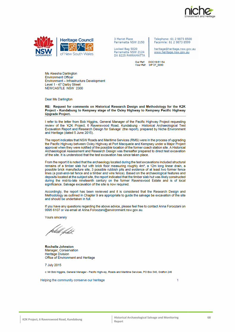
K2K Project, 6 Ravenswood Road, Kundabung Historical Archaeological Salvage and Monitoring Report
68

K2K Project, 6 Ravenswood Road, Kundabung Historical Archaeological Salvage and Monitoring Report
69

K2K Project, 6 Ravenswood Road, Kundabung Historical Archaeological Salvage Report 70
Annex B: Detailed Excavation Plans, Areas 1 - 6 ___________________________________________________________________________________________________________________________________________________________________________________________________________________________________________________

K2K Project, 6 Ravenswood Road, Kundabung Historical Archaeological Salvage Report 71

K2K Project, 6 Ravenswood Road, Kundabung Historical Archaeological Salvage Report 72

K2K Project, 6 Ravenswood Road, Kundabung Historical Archaeological Salvage Report 73

K2K Project, 6 Ravenswood Road, Kundabung Historical Archaeological Salvage Report 74

K2K Project, 6 Ravenswood Road, Kundabung Historical Archaeological Salvage Report 75

K2K Project, 6 Ravenswood Road, Kundabung Historical Archaeological Salvage Report 76

K2K Project, 6 Ravenswood Road, Kundabung Historical Archaeological Salvage Report 77

K2K Project, 6 Ravenswood Road, Kundabung Historical Archaeological Salvage Report 78

K2K Project, 6 Ravenswood Road, Kundabung Historical Archaeological Salvage Report 79

K2K Project, 6 Ravenswood Road, Kundabung Historical Archaeological Salvage Report 80

K2K Project, 6 Ravenswood Road, Kundabung Historical Archaeological Salvage Report 81

K2K Project, 6 Ravenswood Road, Kundabung Historical Archaeological Salvage Report 82
Annex C: Harris Matrix _________________________________________________________________________________________________________________________________________________________________

K2K Project, 6 Ravenswood Road, Kundabung Historical Archaeological Salvage Report 83
Annex D: Context Register _________________________________________________________________________________________________________________________________________________________________

K2K Project, 6 Ravenswood Road, Kundabung Historical Archaeological Salvage Report 84
Annex E: Artefact Catalogue _________________________________________________________________________________________________________________________________________________________________

