juneau international airport terminal reconstruction phase
TRANSCRIPT

Juneau International Airport
Terminal Reconstruction Phase 2 Cultural Resource Evaluation
by Charles M. Mobley
2018
Charles M. Mobley & Associates 200 W. 34th Avenue #534, Anchorage, Alaska 99503 charlesmmobley.com (907) 653-1937 [email protected]
Archaeological Survey Cultural Resource Inventory Historic Building Evaluation Archival and Oral History Research

Juneau International Airport Terminal Reconstruction Phase 2 Cultural Resource Evaluation
1
Executive Summary The City of Juneau in conjunction with the Federal Aviation Administration is renovating the Juneau International Airport (JNU) according to a Terminal Master Plan developed in 2005. The Plan calls for two phases of work. Phase 1 was mostly completed in 2012 and involved renovation and expansion of portions of the building constructed after 1984. Funding is now available from local and federal sources to address Phase 2, involving reconstruction within the same general building footprint of portions built prior to 1984. Approximately 30,500ft2 of the building will be demolished, along with 4,500 ft2 of exterior canopy. Upon completion of Phase 2, the Main Terminal will no longer include operations spaces for small aircraft regional carriers, and instead an adjacent new North Terminal will be built for that function to include much of a current airport parking lot. Seven lots – each between 8,000 ft2 and 10,000 ft2 in area and located immediately north and northwest of the buildings to be demolished -- will eventually be developed and rented for aviation activities. All of the Area of Potential Effect (APE) for the Phase 2 effort is within previously disturbed ground to a depth of approximately eight feet under the building and along utility lines, and approximately three feet under asphalt paved areas. The total affected surface area is less then four acres. In February of 2018 JNU contracted Charles M. Mobley & Associates to assess the effects of FAA actions on historic properties under Section 106 of the National Historic Preservation Act. Airport staff worked closely with Dr. Mobley to provide historic and current photographs, aerial photographs, land surveys, and narrative materials. No fieldwork was involved. This study includes evaluation of the architecture that will be destroyed by the undertaking, as well as evaluation of the archaeological potential of the seven adjacent lots to be developed. The terminal is evaluated as a single building (AHRS number JUN-1269) with modifications made over time referred to as building or construction phases; building evaluation focused on those areas dating to the airport’s 1949, 1958, and 1960 construction phases. The subsequent 1973 construction phase, which is less than 50 years old, was not evaluated. The buildings dating from 1949-1960 will be demolished as part of the renovation. Archaeological evaluation was based on archival information, which indicated that the area of seven lots to be developed has been disturbed at least since WW II, and has since been used for aircraft parking and other aviation functions. The CAA administration and weather functions in the 1950s were handled from a frame building in Lots 5-6, since demolished and asphalted-over. Little expectation of significant buried cultural resources in the APE was raised by the archival research. The 70-, 61-, and 59-year-old construction dates for the 1949-1960 construction at JNU meets the minimum 50-year threshold established by federal guidelines. The three older portions are significant under Criterion A at the local and State level for their critical role in transportation and economic development, under the theme of post-WW II civil and commercial aviation in Alaska, with a 1949-1968 period of significance. The buildings from all three construction periods have integrity of location, setting, and association. However, neither the 1949 building nor the 1958 building exteriors appear as they did during the period of significance, and they lack integrity of design, materials, feeling, and workmanship. The 1960 control tower has integrity of location, setting, and association. However, changes in cladding, window types, and door placement as well as newer contiguous construction immediately south have degraded its integrity of feeling, design, workmanship, and materials to the degree that none of the three buildings have physical integrity relative to the period of significance. It is recommended that the architectural remains of the three construction phases be judged not eligible to the National Register of Historic Places. The proposed undertaking – total demolition of all three buildings and development of seven adjacent lots – is recommended to have no effect on historic properties. Cover: An aerial view looking southwest shows the Juneau International Airport in 2016. The section at a 45o angle to the remainder of the complex was built in 2012, and the two-story portion immediately to the right (north) was built in 1973. The one-story portion at far right, extending north out of the image, was built in 1949. The taller control tower was built in 1987, and the lower, older control tower to its right was built in 1960. The remainder of the building showing at left was built in 1984, 2010, and 2012.

Juneau International Airport Terminal Reconstruction Phase 2 Cultural Resource Evaluation
2
Table of Contents
Executive Summary 1 Table of Contents 2 List of Figures 3 Introduction 4 Project Description 9 Previous Cultural Resource Investigations 12 Architectural Description 12 Probability of Buried Archaeological Resources 15 Historic Context and Significance 18 Integrity 22 National Register Eligibility and Determination of Effect 27 Bibliography 28

Juneau International Airport Terminal Reconstruction Phase 2 Cultural Resource Evaluation
3
List of Figures (with sources)
Cover. Aerial view SW of Juneau International Airport in 2016. Cover (Wikimedia Commons – User Sunnya343) Figure 1. Map of the project region. (JNU) 4 Figure 2. Plan of the Area of Potential Effect (APE). (JNU) 5 Figure 3. Aerial photograph of Juneau airport, August 14, 1948. (Quantum Spatial, Inc.) 6 Figure 4. 1948 plan of airport taxiway. (JNU) 7 Figure 5. 1950 plan of airport taxiway. (JNU) 8 Figure 6. 1952 plan of airport taxiway. (JNU) 9 Figure 7. Aerial photograph of Juneau airport, June 8, 1961. (Quantum Spatial, Inc.) 10 Figure 8. Plan showing dates of construction phases. (JNU) 11 Figure 9. Plan showing seven lots to be leased and developed. (JNU) 11 Figure 10. West elevation of 1949 building, viewed northeast in 1959-69. 13 (Alaska State Library; Fagerson, Williams, Spartz Photograph Collection; asl-P495-068) Figure 11. West elevation of 1958 building, viewed southeast in 1958-73. (JNU) 13 Figure 12. West elevation of 1958 building, viewed northeast in 1960. 14 (“Airport Control Tower Construction” 1963, by Joseph Alexander. Courtesy of the Juneau-Douglas City Museum, JDCM 85.22.350)
Figure 13. East elevation of 1958 building, viewed southwest in 1973. (JNU) 15 Figure 14. West elevation of 1958 control tower, viewed east in 1959-69. 16 (Elmer E. Rasmuson Library, University of Alaska Fairbanks, Ernest H. Gruening Papers, uaf-1976.21.56564) Figure 15. Detail of 1948 aerial photograph. (Quantum Spatial, Inc.) 17 Figure 16. Detail of 1961 aerial photograph. (Quantum Spatial, Inc.) 17 Figure 17. 1960s view of terminal. (Windows Live Photo Gallery 78c88fdde32b98fc01ea72d5d9f7651c) 21 Figure 18. 2018 view west of 1949 building, east elevation. (JNU) 23 Figure 19. 2018 view southwest of 1949 building, east and north elevation. (JNU) 23 Figure 20. 2018 view northeast of 1958 building, west elevation. (JNU) 24 Figure 21. 2018 view southeast of 1958 control tower, west elevation. (JNU) 25 Figure 22. 2018 view northeast of 1958 control tower, west and south elevations. (JNU) 26
Juneau International Airport Terminal Reconstruction Phase 2 Cultural Resource Evaluation
4
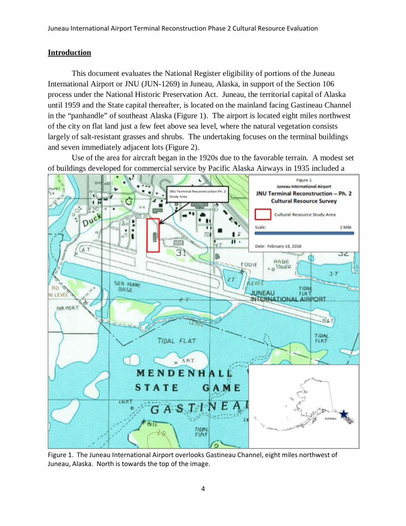
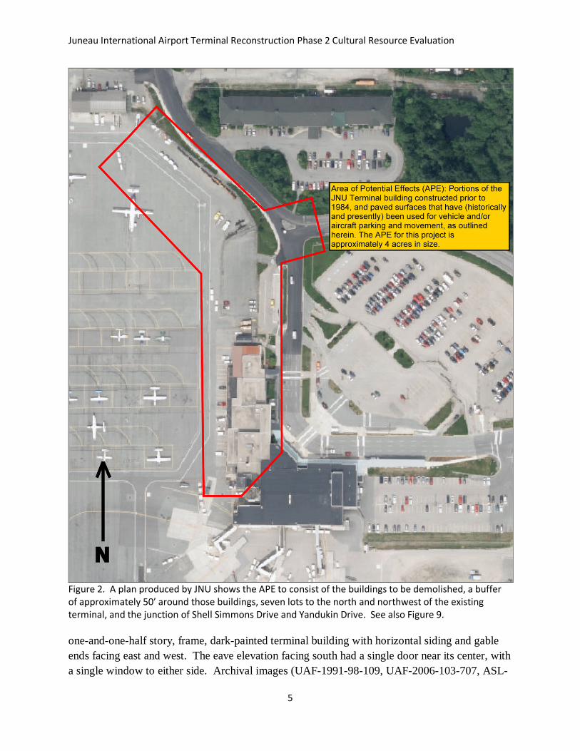
Introduction This document evaluates the National Register eligibility of portions of the Juneau International Airport or JNU (JUN-1269) in Juneau, Alaska, in support of the Section 106 process under the National Historic Preservation Act. Juneau, the territorial capital of Alaska until 1959 and the State capital thereafter, is located on the mainland facing Gastineau Channel in the “panhandle” of southeast Alaska (Figure 1). The airport is located eight miles northwest of the city on flat land just a few feet above sea level, where the natural vegetation consists largely of salt-resistant grasses and shrubs. The undertaking focuses on the terminal buildings and seven immediately adjacent lots (Figure 2). Use of the area for aircraft began in the 1920s due to the favorable terrain. A modest set of buildings developed for commercial service by Pacific Alaska Airways in 1935 included a
Figure 1. The Juneau International Airport overlooks Gastineau Channel, eight miles northwest of Juneau, Alaska. North is towards the top of the image.
Juneau International Airport Terminal Reconstruction Phase 2 Cultural Resource Evaluation
5
Figure 2. A plan produced by JNU shows the APE to consist of the buildings to be demolished, a buffer of approximately 50’ around those buildings, seven lots to the north and northwest of the existing terminal, and the junction of Shell Simmons Drive and Yandukin Drive. See also Figure 9. one-and-one-half story, frame, dark-painted terminal building with horizontal siding and gable ends facing east and west. The eave elevation facing south had a single door near its center, with a single window to either side. Archival images (UAF-1991-98-109, UAF-2006-103-707, ASL-

Juneau International Airport Terminal Reconstruction Phase 2 Cultural Resource Evaluation
6
Figure 3. An aerial photograph taken August 14, 1948 (from which the 1:63,360 USGS topographic map was made), shows WW II-era aircraft revetments (the arced soil disturbances) still in place. P97-561, ASL-P109-28) show the pre-WW II terminal to have been located near the northeast corner of the taxiway. Whether that building survived into the war is unknown; the 1948 aerial

Juneau International Airport Terminal Reconstruction Phase 2 Cultural Resource Evaluation
7
Figure 4. A November 22, 1948 plan of the airport shows the then-new civilian terminal in place at lower right, with the CAA station about 400’ northwest of the terminal. (Figure 3) does not show such a building. Most of the buildings from that era were demolished between 1950 and 1960 (Figures 4-7). Military aviation needs during World War II resulted in expansion to include an airport building and control tower by 1943 (Wahto et al. 2016). Archival photographs (Wahto et al. 2016:8-9) show the present terminal area as disturbed at that time (1943), with a one-story white building located in what is now defined as Lots 5 and 6 of the current undertaking. Construction in 1949, 1958, 1960, 1973, and 1984 developed most of the building footprint forming the current airport terminal in 2018, with a new control tower built in 1987 (Figure 8). Post-war development around the taxiway made use of military buildings and new construction. A plan dated November 22, 1948, shows the then-new terminal building in its present location, along with an L-shaped building immediately to the northwest labeled “CAA CONTROL BLDG” and “WE BLDG” (Figure 4). Northeast of the CAA building was a field of CAA radio towers, and four small sheds were located immediately north of the building. The access road to the airport came in from the north to the northeast corner of the taxiway, where two large buildings were operated by Standard Oil Company. On the west side of the taxiway were several war-era buildings serving various airlines, labeled on the map by their acronyms: ADPD, PAA, PNA, and ABA. PNA, or Pacific Northern Airways, worked out of the double-Quonset hut left from the military effort, in its original location. At the south end of the building alignment was the original stand-alone military control tower, still in place in 1948. Across a

Juneau International Airport Terminal Reconstruction Phase 2 Cultural Resource Evaluation
8
Figure 5. A 1950 plan of the Juneau airport labels the terminal building as Administration Building, and depicts the L-shaped CAA building as two separate unlabeled buildings.

Juneau International Airport Terminal Reconstruction Phase 2 Cultural Resource Evaluation
9
Figure 6. In 1952 when the CAA developed their rule booklet for pilots using the Juneau airport, the three buildings on their plan were the old WW II control tower, the new terminal, and the CAA building. narrow roadway/taxiway to the west was another row of lots, of which several had buildings used by FaWL and AEA (Figure 4). Expansion of civil aviation across post-war Alaska led to the acknowledgment in 1950 of the need for more construction at the Juneau airport, for which plans were made (Toner 1950). The map produced for that analysis labels the 1948 terminal as “ADMINISTRATION BUILDING,” and plots the L-shaped CAA building as two separate buildings (Figure 5). Toner’s (1950) proposal for a hangar and operations building were not realized, and as late as 1952 the airport control tower was the WW II frame stand-alone building directly west across the taxiway from the terminal building (Figure 6). At that time the three primary buildings from the pilot’s perspective were: the control tower, the airport terminal, the CAA radio building – the north/south section, and the CAA weather station – the building’s east/west section (Figure 6). By 1949 the civilian terminal was complete (Figure 7), and considerable development characterized the following decades. Subsequent sections of this report pick up the historical thread in addressing the architectural history of that building and following additions (Figure 8). The location of the CAA building becomes of interest as part of the archaeological consideration. Project Description A Terminal Master Plan developed in 2005 outlined future development in two phases. Phase 1 was mostly completed in 2012 and involved renovation and expansion of portions of the building constructed after 1984. Funding is now available from local and federal sources to

Juneau International Airport Terminal Reconstruction Phase 2 Cultural Resource Evaluation
10
Figure 7. A June 8, 1961 aerial photograph shows the terminal building with the control tower at the southwest corner and the covered concourse extending west. WW II revetments are partly obliterated. address Phase 2, involving reconstruction within the same general building footprint of portions built prior to 1984. Approximately 30,500 ft2 of the building will be demolished, along with

Juneau International Airport Terminal Reconstruction Phase 2 Cultural Resource Evaluation
11
Figure 8. A plan prepared by JNU dates the construction phases comprising the current airport building.
Figure 9. Seven lots west and northwest of the terminal building plus the intervening loading area and street intersection will be leased and developed as part of the Phase II effort. Compare with Figure 2.

Juneau International Airport Terminal Reconstruction Phase 2 Cultural Resource Evaluation
12
4,500 ft2 of exterior canopy. The reconstructed areas will total approximately 18,200 ft2, and the remodeled interior area will encompass 6,000 ft2. Upon completion the Main Terminal will not include operations spaces for small aircraft regional carriers; instead an adjacent new North Terminal will be built for that function over much of a current airport parking lot. Seven lots – each between 8,000 ft2 and 10,000 ft2 in area and located immediately north and northwest of the buildings to be demolished -- will eventually be rented and developed for aviation activities (Figure 9). All of the Area of Potential Effect (APE) for the Phase 2 effort (Figure 2) is within previously disturbed ground to a depth of approximately eight feet under the building and along utility lines, and approximately three feet under asphalt paved areas. Total affected surface area is less than four acres. Previous Cultural Resource Investigations The Terminal Master Plan prepared in 2005 included cultural resource considerations developed from materials prepared by Charles M. Mobley & Associates, but it involved no field investigations. Three asphalt segments of the airport’s original WW II runway were evaluated in 2002 and given AHRS number JUN-924, but they were judged to lack integrity and were not considered eligible to the National Register (Ellis and Huffman 2002). Other features given AHRS numbers as a result of that investigation were: JUN-922 – an overgrown asphalt foundation and dirt road of unknown origin, and JUN-923 –four concrete foundations associated with a propane tank and what was thought to be possibly a generator, all of unknown date (Ellis and Huffman 2002). Six years later a survey in areas considered higher probability for archaeological resources revealed historic features and artifacts (JUN-1074) consisting of: a concrete pad; a bulldozer berm; remnants of a dirt road; an engine block; a possible crankshaft; an aluminum pole imbedded in concrete; and clear and brown glass bottles (Tews and Ellis 2008). The National Register eligibility of the airport terminal building has not heretofore been addressed. No AHRS sites judged eligible to the National Register are within sight of the APE. Architectural Description The combined result of the various building phases since 1949 has been a two-story commercial/ industrial building of modern appearance in the International style. Exterior materials include concrete, brick, steel, enamel-finish wood panels, and plate glass in modular arrangements to form flat walls and roofs with right-angled lines. The oldest existing terminal building was designed by Olson Sands Architects of Juneau. It was begun on July 6, 1948 (Anonymous:3-4), and completed in 1949. It was a 7,700 ft2 one-story building constructed of concrete exterior walls and a wood framed roof assembly. The exterior wall material was painted concrete. The west elevation facing the aircraft parking ramp was considered the front of the building and had a 25’ wide bow window (Figure 10). The east elevation faced an automobile parking lot – approximately where the current 2018 parking lot is
Juneau International Airport Terminal Reconstruction Phase 2 Cultural Resource Evaluation
13
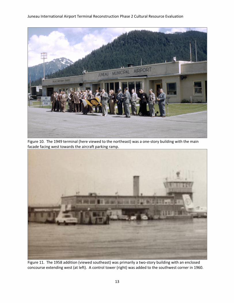
Figure 10. The 1949 terminal (here viewed to the northeast) was a one-story building with the main facade facing west towards the aircraft parking ramp.
Figure 11. The 1958 addition (viewed southeast) was primarily a two-story building with an enclosed concourse extending west (at left). A control tower (right) was added to the southwest corner in 1960.
Juneau International Airport Terminal Reconstruction Phase 2 Cultural Resource Evaluation
14
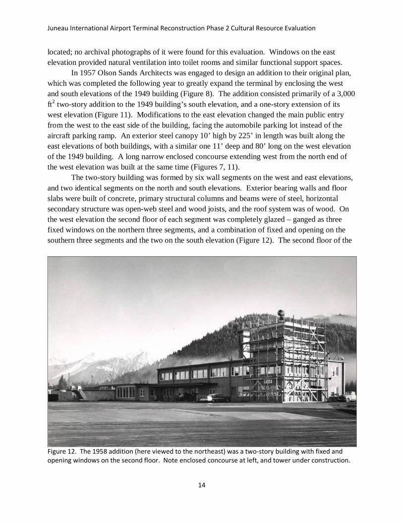
located; no archival photographs of it were found for this evaluation. Windows on the east elevation provided natural ventilation into toilet rooms and similar functional support spaces. In 1957 Olson Sands Architects was engaged to design an addition to their original plan, which was completed the following year to greatly expand the terminal by enclosing the west and south elevations of the 1949 building (Figure 8). The addition consisted primarily of a 3,000 ft2 two-story addition to the 1949 building’s south elevation, and a one-story extension of its west elevation (Figure 11). Modifications to the east elevation changed the main public entry from the west to the east side of the building, facing the automobile parking lot instead of the aircraft parking ramp. An exterior steel canopy 10’ high by 225’ in length was built along the east elevations of both buildings, with a similar one 11’ deep and 80’ long on the west elevation of the 1949 building. A long narrow enclosed concourse extending west from the north end of the west elevation was built at the same time (Figures 7, 11). The two-story building was formed by six wall segments on the west and east elevations, and two identical segments on the north and south elevations. Exterior bearing walls and floor slabs were built of concrete, primary structural columns and beams were of steel, horizontal secondary structure was open-web steel and wood joists, and the roof system was of wood. On the west elevation the second floor of each segment was completely glazed – ganged as three fixed windows on the northern three segments, and a combination of fixed and opening on the southern three segments and the two on the south elevation (Figure 12). The second floor of the
Figure 12. The 1958 addition (here viewed to the northeast) was a two-story building with fixed and opening windows on the second floor. Note enclosed concourse at left, and tower under construction.

Juneau International Airport Terminal Reconstruction Phase 2 Cultural Resource Evaluation
15
east elevation had both fixed and opening windows, and the northernmost section was almost continuously glazed with a bank of fixed windows three panes wide and six tall (Figures 13-14). A chimney for the heating plant protruded through the roof near the center of the building. Modifications in 1958 to the east elevation of the 1949 building consisted of infilling some window openings and applying 3’x9’ enamel-finish (mustard yellow) siding panels. On the west elevation the bow window was removed to accommodate the 2000 ft2 expansion (made of concrete and glass) to the west (Fritz 2018). In 1960 a control tower was built at the southwest corner of the two-story building, replacing a stairway and second-story observation room. The tower formed a third story, with angled glass facing all four cardinal directions (Figure 14). Materials were similar to the 1958 building to create visual compatibility between both constructions, but the metal panels beneath the outward-facing glass was painted or glazed red (see Figure 17). Probability of Buried Archaeological Resources Demolition of the older portions of the terminal will be accompanied by ground disturbance immediately adjacent to the existing building footprint, to include seven small (between 8,000 ft2 and 10,000 ft2 in area) lots that will be leased or rented for future aviation functions (Figure 9). All of the lots’ surfaces are paved and have been so for decades, so archaeological testing was not considered a feasible research avenue. Oral history was also
Figure 13. The east elevation of the 1958 main building (shown here prior to the 1973 addition with the main entrance reversed from the west tarmac side) had both fixed and opening windows.
Juneau International Airport Terminal Reconstruction Phase 2 Cultural Resource Evaluation
16
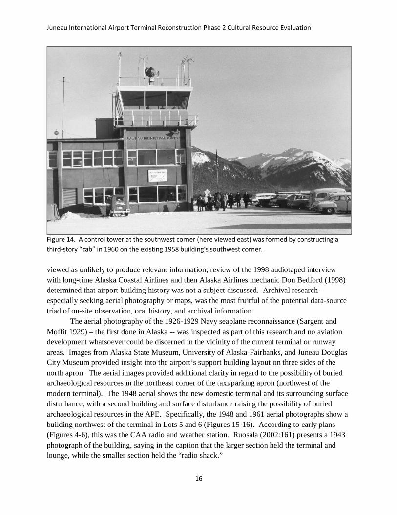
Figure 14. A control tower at the southwest corner (here viewed east) was formed by constructing a third-story “cab” in 1960 on the existing 1958 building’s southwest corner. viewed as unlikely to produce relevant information; review of the 1998 audiotaped interview with long-time Alaska Coastal Airlines and then Alaska Airlines mechanic Don Bedford (1998) determined that airport building history was not a subject discussed. Archival research – especially seeking aerial photography or maps, was the most fruitful of the potential data-source triad of on-site observation, oral history, and archival information. The aerial photography of the 1926-1929 Navy seaplane reconnaissance (Sargent and Moffit 1929) – the first done in Alaska -- was inspected as part of this research and no aviation development whatsoever could be discerned in the vicinity of the current terminal or runway areas. Images from Alaska State Museum, University of Alaska-Fairbanks, and Juneau Douglas City Museum provided insight into the airport’s support building layout on three sides of the north apron. The aerial images provided additional clarity in regard to the possibility of buried archaeological resources in the northeast corner of the taxi/parking apron (northwest of the modern terminal). The 1948 aerial shows the new domestic terminal and its surrounding surface disturbance, with a second building and surface disturbance raising the possibility of buried archaeological resources in the APE. Specifically, the 1948 and 1961 aerial photographs show a building northwest of the terminal in Lots 5 and 6 (Figures 15-16). According to early plans (Figures 4-6), this was the CAA radio and weather station. Ruosala (2002:161) presents a 1943 photograph of the building, saying in the caption that the larger section held the terminal and lounge, while the smaller section held the “radio shack.”

Juneau International Airport Terminal Reconstruction Phase 2 Cultural Resource Evaluation
17
Figure 15. Enlargement of the 1948 aerial (Figure 2) shows a building northwest of the terminal.
Figure 16. Enlargement of the 1961 aerial (Figure 3), with the seven lot locations approximately superimposed, shows a building (since demolished) within the development footprint.
Juneau International Airport Terminal Reconstruction Phase 2 Cultural Resource Evaluation
18
However, there may have been two successive buildings at this location, as the 1948 aerial (Figure 15) shows an L-shaped building also seen in archival photographs (ASL-P121-572 and ASL-P97-576), while the 1961 aerial instead shows what seems to be an L-shaped rectilinear pattern in that area’s soils next to a long narrow building situated about 60’ south (Figure 16). Later archival photographs (AMRC-685-27-1304; and one postcard seen on eBay but since deleted) show a long narrow building. Either the eastward-extending wing of the old building was demolished and the remaining north/south building remained in place (and the soil pattern perceived in the aerial is an illusion), or the east wing was demolished and the north/south building was moved south about 60’, or all of the old CAA building was demolished and a new east/west building was built about 60’ south. Comparison using archival photographs indicates that the newer images show the building with a pair of horizontally placed windows in the south-facing gable end, while the older building had a pair of vertically placed windows in the south-facing gable end. It isn’t clear when the CAA building in its final form was demolished. A November 23, 1955 letter (on file with JNU) from the CAA to the Mayor of Juneau regarding federal involvement in a terminal building expansion made it clear that their current facilities (presumed to be the frame building so labeled in earlier plans) were sufficient, and there was no need to anticipate CAA occupancy in the expanded terminal building. Archival photographs show the building gone and the area paved by 1987 when the new control tower was built. In summary, the probability of prehistoric or early historic remains in the area of Lots 5-6 has been reduced by the construction of the CAA building and its surrounding disturbance zone during WW II. The probability of archaeological remains dating to WW II in the paved portion of the APE -- especially Lots 5-6 -- depends on the extent of building demolition and the degree of soil disturbance when the pavement was laid down. JNU’s current building plans state that the asphalt areas overlay a soil disturbance zone three feet deep, which would reduce the likelihood of WW II remains to be found. If present, such remains would probably be attributable to the CAA building. Thus no archaeological resources are known in the APE, and the probability of finding buried cultural resources of significance during construction is considered low. Historic Context and Significance The historic context for the Juneau International Airport building (JUN-1269) is the framework in which significance is evaluated, which in this case concerns primarily post-WW II civil and commercial aviation in Alaska and the local Juneau area. As such it relates to Criterion A – “an event, a series of events or activities, or patterns of an area’s development” (Secretary of the Interior 1997:7). Early historic exploration of southeast Alaska and Alaska’s coasts further north were necessarily maritime, and ships and boats served Alaska’s transportation needs exclusively until the White Pass and Yukon Railroad was built out of Skagway in 1898, followed by the Alaska Railroad completed in 1923. In the early 1900s most freight and people traveling

Juneau International Airport Terminal Reconstruction Phase 2 Cultural Resource Evaluation
19
to places in Alaska -- like, for example, the mining towns of Juneau and Douglas -- came by way of ocean-going vessels ported in large west coast cities like Seattle, Portland, or San Francisco. As they traveled the Inside Passage of southeast Alaska, this ship traffic helped population centers become established at Ketchikan, Petersburg, Wrangell, and Juneau, and expanded the existing town of Sitka (Raban 1999). Commercial aviation followed the same geographic route and served the same communities. In 1934, Lt. Col. Henry H. “Hap” Arnold, in command of 10 Martin B-10 bombers flying from Washington D.C. to Fairbanks, landed at Juneau and “stated that Juneau should have a good airport as the capital city was the ‘logical and natural’ point of entry for wheel planes coming into the territories” (Ruotsala 1997:116). The elevated tidal flats at the mouth of the Mendenhall River were already in use as an airport for commercial purposes by 1935, with a small frame terminal building serving Pacific Alaska Airways and its successor Pan-American Airways (Anonymous 1948:1). In 1938 Pacific Alaska Airways began airmail service from Juneau to Whitehorse and Fairbanks (Pacific Alaska Airways, Inc. 1938). Military shipping during World War II made use of the Inside Passage to serve the same few towns mentioned above, and to discharge freight at Skagway to be shipped by rail into Yukon Territory and beyond. Air traffic increased as well. The existing Coast Guard base at Ketchikan came under Navy command, and an airport was built 20 miles away at Annette Island. A naval air station was built at Sitka, and another at Kodiak. Military airstrips were built elsewhere, including Gustavus, Yakutat, and Cordova. The military took over the operation of the Juneau airport and expanded the infrastructure during WW II, including lengthening the airstrip to 5000’ using waste rock from Juneau’s AJ Mine (Anonymous 1948:1; Wahto et al 2016). Thanks to military activity, by the end of the war in 1945 Juneau had considerably more infrastructure to support aviation as did all of southeast Alaska and the entire territory of Alaska (Sabbatini 2009:58). “The airfields constructed during the war created the basis for regular air service within the territory/state and connections to the lower 48 states, and to establish Alaska as a great international air center” (Denfeld 1993). Though the U.S. Department of the Navy owned the airport property, the Civil Aeronautics Administration (CAA) operated the Juneau airport after the war until 1948. The CAA had decided to prioritize the Gustavus airport maintenance over the Juneau field, so the City of Juneau voters approved a $50,000 revenue bond issue to supplement $90,000 in Territorial funding for construction of a new terminal building (Anonymous 1948:3). Territorial officials recognized the value of such a facility in enabling more efficient travel to and from the Territorial capital of Juneau, thus making administration of the territory more efficient. Air transportation became even more indispensible to Alaska’s governance with the passage of the Statehood Act and the establishment of a representative state government in 1959. The City had completed the runway extension to 6468’ by 1954 (Wahto et al 2016), and the JNU terminal expansion was completed in 1958, just in time to accommodate state representatives and senators and their staff and constituencies during the following years as they began their travel to and from far-flung parts of the state. More than half of Juneau’s jobs were in government by

Juneau International Airport Terminal Reconstruction Phase 2 Cultural Resource Evaluation
20
1966 (Simpson 1990:47). A building boom took place in Juneau to accommodate the increased governmental activity, which in turn encouraged more commercial air traffic to Juneau. On February 3, 1962, the first commercial jet landed at the JNU – a Pan American Boeing 707-320 (Wahto et al. 2016), assisted by personnel stationed in a new third-story control tower. With a population of only 10,000 in 1964, Juneau anticipated the year’s tourists to number 60,000 (Simpson 1990:48). To the present day, no roads connect Juneau with the rest of the continent, and the only road to Alaska is the long and torturous Alaska Highway. The Alaska Marine Highway began regular service in southeast Alaska soon after statehood, and Juneau continued to prosper not just from its role as the state capital but also in support of the growing tourism industry and local fisheries. As Simpson (1990:48) put it, “tourism took its place as government’s bridesmaid.” Native villages, canneries, logging camps, fishing resorts, individual homesteads, and small communities in southeast Alaska became more integrated by way of aircraft on floats; the floatplane strip contemplated as early as 1948 was partly dredged in 1953-54 (Wahto et al. 2016), and in service by 1960. Juneau became an air and sea transportation hub for southeastern Alaska, serving not just local private and commercial traffic in southeast Alaska but long-distance commercial jets, too. Not only did Pan American’s successor company Alaska Airlines provide regular service to Juneau (Satterfield 1981:175), but at times Wein Airlines and MarkAir did as well. Regulatory oversight continued as the CAA became the Federal Aviation Authority (FAA) in 1958 (Wisniewski 2005:12); throughout Alaska the new agency continued much the same services as before, including providing weather and radio information at Juneau. It is within this historic context that the significance of the Juneau airport terminal (a large building with multiple construction phases but only one AHRS number: JUN-1269) is identified. Since the 1960s the Juneau airport, with its jet-suitable runway and modest terminal building (Figure 17), has been critical to the economic development of southeast Alaska in particular and – in large part through its role in supporting the state’s governance – important to Alaska. This characterization of the Juneau airport terminal in terms of historic theme and period of significance is parallel to that identified in the City’s Historic Preservation Plan, which specifically lists the airport within the theme of “transportation and communication,” with a period of significance potentially extending from 1938 to the “Early Cold War Era” (Gillette 1997:17). Elsewhere in the country, “general aviation airports would most likely fall under one of the four following areas [of significance]: architecture, industry, military, transportation” (Mead & Hunt 2001:36). Typical property types associated with an airport include runways, taxiways, parking areas, control tower, lights and visual navigation infrastructure, hangars, shops, and terminal building (Mead & Hunt 2001:30-31; Newlan 2008:2-1 through 2-3). The four criteria for considering the significance of a property are: a) association with a significant event or pattern of events; b) association with a significant person; c) association with a significant design, style, type, period, or construction method; and d) having the potential to yield information important in prehistory or history (Secretary of the Interior 1997:11-24).
Juneau International Airport Terminal Reconstruction Phase 2 Cultural Resource Evaluation
21
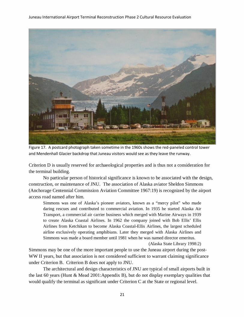
Figure 17. A postcard photograph taken sometime in the 1960s shows the red-paneled control tower and Mendenhall Glacier backdrop that Juneau visitors would see as they leave the runway. Criterion D is usually reserved for archaeological properties and is thus not a consideration for the terminal building. No particular person of historical significance is known to be associated with the design, construction, or maintenance of JNU. The association of Alaska aviator Sheldon Simmons (Anchorage Centennial Commission Aviation Committee 1967:19) is recognized by the airport access road named after him.
Simmons was one of Alaska’s pioneer aviators, known as a “mercy pilot” who made daring rescues and contributed to commercial aviation. In 1935 he started Alaska Air Transport, a commercial air carrier business which merged with Marine Airways in 1939 to create Alaska Coastal Airlines. In 1962 the company joined with Bob Ellis’ Ellis Airlines from Ketchikan to become Alaska Coastal-Ellis Airlines, the largest scheduled airline exclusively operating amphibians. Later they merged with Alaska Airlines and Simmons was made a board member until 1981 when he was named director emeritus. (Alaska State Library 1998:2)
Simmons may be one of the more important people to use the Juneau airport during the post-WW II years, but that association is not considered sufficient to warrant claiming significance under Criterion B. Criterion B does not apply to JNU. The architectural and design characteristics of JNU are typical of small airports built in the last 60 years (Hunt & Mead 2001:Appendix B), but do not display exemplary qualities that would qualify the terminal as significant under Criterion C at the State or regional level.
Juneau International Airport Terminal Reconstruction Phase 2 Cultural Resource Evaluation
22
Criterion A does apply, for the Juneau airport is directly associated with a pattern of events involving the post-WW II civil and commercial aviation in Alaska and the local Juneau area, and the economic development arising from it. This is significant because the economic development of southeast Alaska and Alaska overall – through territorial and state governance – relied on air traffic to and from JNU. Without such facilities as JNU, Alaska’s transportation and economic development would have been severely curtailed, radically changing its character from the current circumstances. JNU is significant under Criterion A for its role in transportation and economic development at the local and State level. JNU is not suggested to be significant at the national level, as it is not considered “of exceptional value in representing or illustrating an important theme in the history of the nation” (Secretary of the Interior 1997:10). The seven criteria considerations (Secretary of the Interior 1997:25-43) do not apply to JNU-1269). The building is not a religious property; it has not been moved from its original location; it is not a birthplace or grave; it is not a cemetery, it is not a reconstructed building, it is not primarily commemorative, and the portions considered here have not achieved significance within the past 50 years. The period of significance is based upon the earliest construction phase of 1949 and the year 50 years ago at the time of this writing -- 1968). The construction dates of 1949, 1958, and 1960 make those building portions 70, 61, and 59 years old in 2018, thus fulfilling the minimum age requirement for National Register eligibility set out by the Secretary of the Interior (1997:41). The next construction phase after the 1960 tower cab was in 1973 – after the arbitrarily defined end-date for the building’s period of significance. The “1938 to early Cold War” period of significance outlined by Gillette (1997:17) was intended to include several of Juneau’s themes and properties beyond just the airport, and the period of sigificance for JUN-1269 is not identical. Integrity The seven criteria used for evaluating the physical integrity of properties being considered for the National Register are: location, setting, association, design, materials, workmanship, and feeling (Secretary of the Interior 1997:44-49). The Juneau International Airport’s 1949-1960 building integrity lies not with the buildings’ interiors but with their exteriors (Figures 18-22). All three remain in the same location they were built, and have integrity of location. All three continue to function as aviation service buildings and retain integrity of setting and association. Consideration of the buildings’ integrity of design, materials, workmanship, and feeling requires comparisons between the current and original conditions. The 1949 building’s west and south elevations and the far west part of the north elevation were completely enclosed by the 1958 construction, and the 1973 construction enclosed the remainder of the original north elevation and the southern third of the east elevation (Figure 8). Only the northern two-thirds of the east elevation remain of the 1949 building. Archival photographs showing its original appearance were not found as part of this research, but the
Juneau International Airport Terminal Reconstruction Phase 2 Cultural Resource Evaluation
23
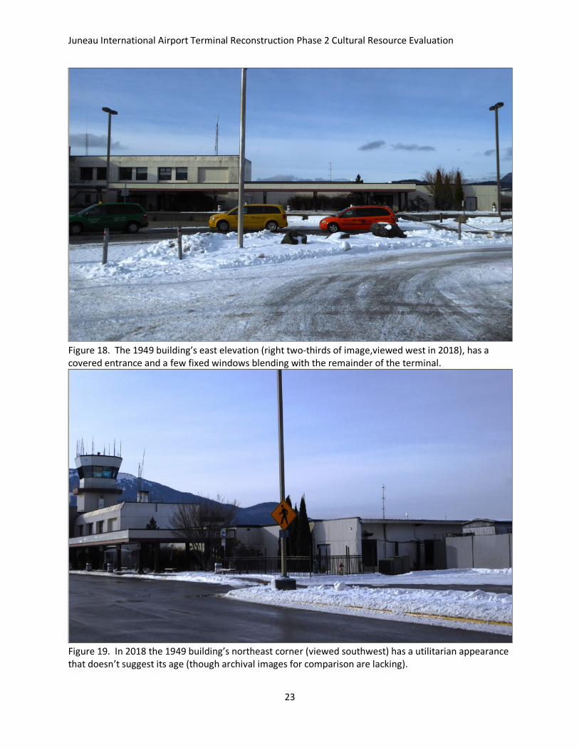
Figure 18. The 1949 building’s east elevation (right two-thirds of image,viewed west in 2018), has a covered entrance and a few fixed windows blending with the remainder of the terminal.
Figure 19. In 2018 the 1949 building’s northeast corner (viewed southwest) has a utilitarian appearance that doesn’t suggest its age (though archival images for comparison are lacking).
Juneau International Airport Terminal Reconstruction Phase 2 Cultural Resource Evaluation
24
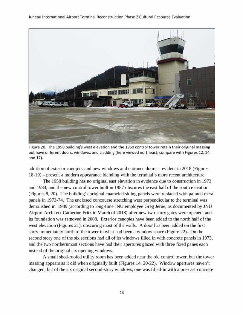
Figure 20. The 1958 building’s west elevation and the 1960 control tower retain their original massing but have different doors, windows, and cladding (here viewed northeast; compare with Figures 12, 14, and 17). addition of exterior canopies and new windows and entrance doors -- evident in 2018 (Figures 18-19) – present a modern appearance blending with the terminal’s more recent architecture. The 1958 building has no original east elevation in evidence due to construction in 1973 and 1984, and the new control tower built in 1987 obscures the east half of the south elevation (Figures 8, 20). The building’s original enameled siding panels were replaced with painted metal panels in 1973-74. The enclosed concourse stretching west perpendicular to the terminal was demolished in 1989 (according to long-time JNU employee Greg Jerue, as documented by JNU Airport Architect Catherine Fritz in March of 2018) after new two-story gates were opened, and its foundation was removed in 2008. Exterior canopies have been added to the north half of the west elevation (Figures 21), obscuring most of the walls. A door has been added on the first story immediately north of the tower in what had been a window space (Figure 22). On the second story one of the six sections had all of its windows filled in with concrete panels in 1973, and the two northernmost sections have had their apertures glazed with three fixed panes each instead of the original six opening windows. A small shed-roofed utility room has been added near the old control tower, but the tower massing appears as it did when originally built (Figures 14, 20-22). Window apertures haven’t changed, but of the six original second-story windows, one was filled-in with a pre-cast concrete

Juneau International Airport Terminal Reconstruction Phase 2 Cultural Resource Evaluation
25
Figure 21. The north and south ends of the 1958 building’s west elevation are now imbedded within newer construction, and only the central portion with the entry – flanked by newer windows – remains (compare with Figures 10-11). panel in 1973-74 and two sets of two have each been replaced with a single fixed pane. Of the six original first-story windows, one was filled in with a concrete panel and one set of two has been replaced with a single fixed pane. Most of the original opening windows have been replaced with vinyl opening windows. The exterior paneling around the bottom of the observation cab was originally red (Figure 17), but now it’s the same color as the rest of the building (Figure 22). To summarize, the integrity of all three buildings under consideration has been affected by subsequent construction. About 30% of the 1949 building’s exterior is visible (Figure 8), and the windows, doors, and cladding don’t match the originals. The 1958 building’s first-floor perimeter has been encapsulated by subsequent construction to leave about 30% remaining visible, with windows, doors, and cladding now changed from the original. The 1958 building’s second story has been completely obscured on the south elevation by subsequent construction, while the other three elevations still show their second stories but with changed windows and cladding. The 1960 control tower is now completely obscured from directly south (compare Figures 17 and 8), displays windows and cladding that have been changed from the original, and is rendered inconspicuous by the newer, taller tower built next to it in 1987.
Juneau International Airport Terminal Reconstruction Phase 2 Cultural Resource Evaluation
26
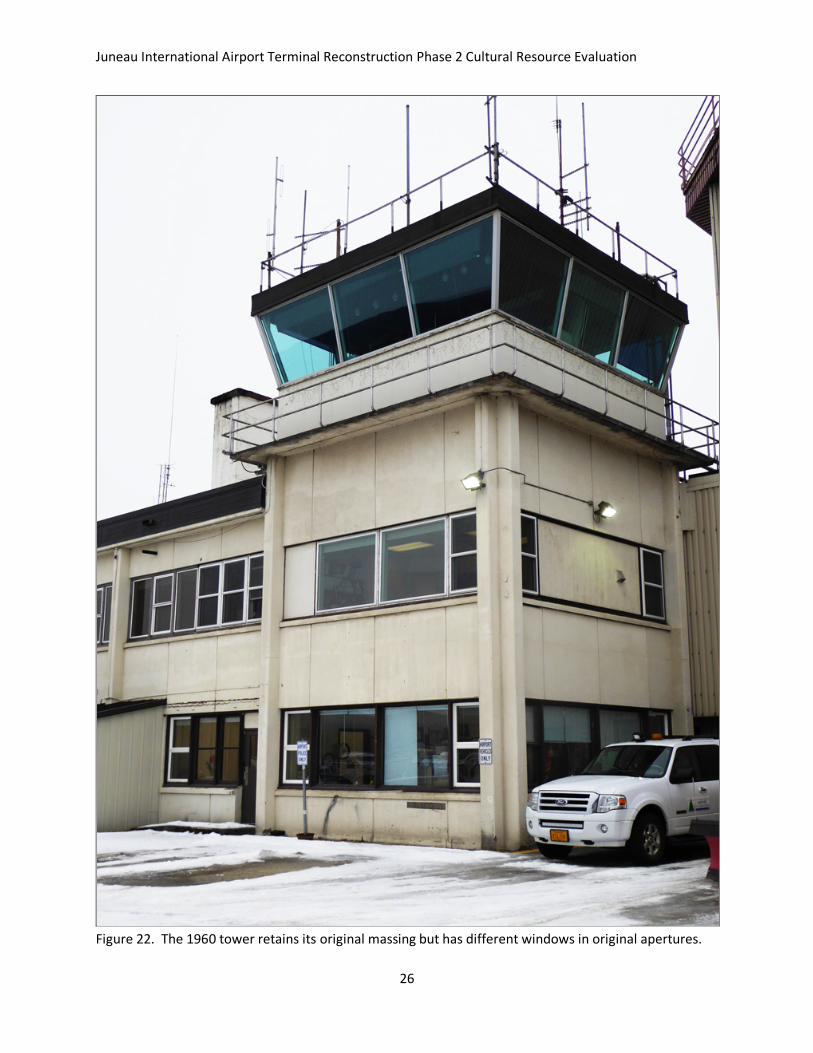
Figure 22. The 1960 tower retains its original massing but has different windows in original apertures.

Juneau International Airport Terminal Reconstruction Phase 2 Cultural Resource Evaluation
27
National Register Eligibility and Determination of Effect The 70-, 61-, and 59-year-old construction dates for the 1949-1960 buildings at JNU meet the minimum 50-year threshold established by federal guidelines, while the 45-year-old age for the portion built in 1973 does not. The three older portions are significant under Criterion A at the local and State level for their critical role in transportation and economic development, under the theme of post-WW II civil and commercial aviation in Alaska, with a 1949-1968 period of significance. The buildings from all three construction periods have integrity of location, setting, and association. However, neither the 1949 building nor the 1958 building appear on the outside as they did during the period of significance, and lack integrity of design, materials, feeling, and workmanship. The 200’ covered concourse present in the 1960s was demolished in 1989. The 1960 control tower has integrity of location, setting, and association, but its integrity of feeling has been lessened by subsequent construction (consider the view visitors had in the 1960s as they landed (Figure 17), compared to that to be had now – see cover). Changes in cladding, window types, and door placement have degraded the 1960 control tower’s integrity of design, workmanship, and materials to the degree that none of the three buildings are considered to have physical integrity relative to the period of significance. It is consequently recommended that the buildings from the three construction phases be judged not eligible to the National Register of Historic Places. In the event that the SHPO judges one or more of the buildings to be eligible to the National Register, then consideration is warranted as to whether the development planned for the seven lots could constitute an adverse effect. Given that Lots 1 and 2 actually contain much of the 1949 and 1958 building footprint (Figure 9), they can’t be developed without demolishing those two buildings, which would be an adverse effect. The details of the proposed development have not been determined, but the conceptual plan shows a new Concourse A serving Lots 1-4 and a new Concourse B serving the other three lots, with Concourse A connecting to the central more modern portion of the terminal. Conceptually Lots 3-4 and 5-7 could be envisioned with the same degree of visual compatibility with older construction as the more modern additions to the south, thus presumably constituting no adverse effect to historic properties, but the leased lots will be privately developed and matters of design style have not yet been considered by JNU. No archaeological resources are known to be present in the APE, and the probability of construction revealing significant cultural deposits is considered low. The information acquired through this investigation leads to the recommendation that the proposed undertaking – total demolition of all three buildings and development of Lots 1-7 – be considered to have no effect on historic properties.
Juneau International Airport Terminal Reconstruction Phase 2 Cultural Resource Evaluation
28
Bibliography
Alaska State Library 1998 Guide to Collection: the Shell Simmons Photograph Collection. Alaska State Library, Juneau. Anchorage Centennial Commission Aviation Committee 1967 Honoring 100 Alaska Bush Pilots. Anchorage Centennial Commission Aviation Committee, Anchorage. Anonymous 1949 Juneau Airport History (date estimated). Document on file, Juneau International Airport. Bedford, Donald 1998 Audiorecording and transcript discussing history of mechanical service for Alaska Coastal Airlines and Alaska Airlines, with Charles M. Mobley, January 20, 1998, Auke Bay, Alaska. University of Alaska-Fairbanks Rasmusson Library Oral History Tape H1998-13 Pt. 1&2. http://jukebox.uaf.edu/site7/interviews/2488 Denfeld, D. Colt 1993 FAA Housing in Alaska: A History and Evaluation. Document prepared by U.S. Army Corps of Engineers Alaska District; on file at the Alaska Office of History and Archaeology, Anchorage. Ellis, Sheri Murray, and Eugenia A. Huffman 2002 Cultural Resource Investigations for the Juneau International Airport Environmental Impact Statement, City and Borough of Juneau. Report prepared by SWCA Environ- mental Consultants, Salt Lake City, for the Federal Aviation Administration and the City and Borough of Juneau. Fritz, Catherine 2018 Juneau International Airport (JNU) – Terminal History. Document prepared February 20, 2018, based on oral history of Greg Jerue and design and as-built drawings from JNU airport files. Document on file, Juneau International Airport, Alaska. Gillette, Gary 1997 Historic Preservation Plan for the City and Borough of Juneau, Alaska. Report prepared by the Community Development Department for the City and Borough of Juneau, Alaska.

Juneau International Airport Terminal Reconstruction Phase 2 Cultural Resource Evaluation
29
Jensen Yorba Lott Architects, Inc. 2005 Airport Master Plan – Terminal Study, Juneau International Airport. Report prepared by Jensen Yorba Lott Architects, Inc., Juneau, Alaska, for the City of Juneau. Mead & Hunt 2001 Nebraska Historic Buildings Survey – General Aviation in Nebraska. Report prepared for the Nebraska State Historical Society State Historic Preservation Office and Nebraska Department of Aeronautics by Mead & Hunt: Engineers, Architects, Scientists, Planners; Madison, Wisconsin. https://www.scribd.com/document/36880491/Nebraska-Airports- History. Newlan, Ralph 2008 General Texas Aviation. Report prepared by Michael Baker, Inc., Coraopolis, Penn- sylvania, for the Texas Department of Transportation, Austin. Pacific Alaska Airways, Inc. 1938 Program: Inaugural Alaska Airmail…May 3, 1938. Document on file (TL685.2.P23 1938 CLIP), Alaska State Library, Juneau. Raban, Jonathan 1999 Passage to Juneau: A Sea and Its Meaning. Pantheon Books, New York. Ruotsala, Jim 1997 Pilots of the Panhandle: Aviation in Southeast Alaska “The Early Years 1920-1935”. Seadrome Press, Juneau. 2002 Alaska Wings: Aviation in Southeast Alaska “The Golden Years 1935-1946”. Seadrome Press, Juneau. Sabbatini, Mark 2009 Alaska’s Many Forms of Transportation. In: Alaska 50, ed. by A.E. Lopez, pp. 50-59. Faircountmediagroup, Tampa Sargent, R.H., and F.H. Moffit 1929 Aerial Photographic Survey in Southeastern Alaska. In: Mineral Resources of Alaska: Report of Progress of Investigations in 1926, ed. by P.S. Smith et al.; pp. 143-160. U.S. Geological Survey Bulletin 797 Satterfield, Archie 1981 The Alaska Airlines Story. Alaska Northwest Publishing Company, Anchorage.

Juneau International Airport Terminal Reconstruction Phase 2 Cultural Resource Evaluation
30
Secretary of the Interior 1997 How to Apply the National Register Criteria for Evaluation. National Register Bulletin
15. Simpson, Sherry 1990 Juneau. Alaska Geographic 17(2). Tews, A., and Sheri Murray Ellis 2008 Results of Presence/Absence Testing for Subsurface and Obscured Archaeological Resources within Higher Probability Areas of the Juneau International Airport, Juneau, Alaska. Report prepared by SCA Environmental Consultants, Salt Lake City, for the Federal Aviation Administration. Toner, Felix J. 1950 Report on Hangar and Operations Building – Juneau Airport. Document on file at Juneau International Airport by Felix J. Toner, Registered Engineer, dated February 25, 1950. Wahto, Patty, Marc Cheatham, Mal Menzies, and Joe Heueisen 2016 Juneau Airport History. Powerpoint file prepared by Juneau International Airport, as modified by Catherine Fritz, February 12, 2018. Wisniewski, Josh 2005 Understanding the Effects of FAA Field Stations on Rural Alaska: Perspectives from Employees and Communities. Report prepared by U.S. Army Corps of Engineers Alaska District for Federal Aviation Administration, Anchorage.