juncture of san andreas transform system and gulf of...
TRANSCRIPT
________________________________________ ~O_C_E_A_N~O_LO~G~IC~A_A_C~T_A~,_'_9_8~' ,~N_._S~P __ !~-------
Juncture of San Andreas Transform sys tem Spreading cenler
Calirornia Gulf
transform system San Andreas faull
and Gulf
of California rift
Système Inmsformam Centre d'accrét iun
Golfe de Californie Faille San Andreas
ABSTRACT
RËSUME
J. C. CroweJJ Dcp.trtment of Geological Sciences, Uni versity of CalifOTllia . Santa Barbara. Calirorni~, 931 06. USA.
T he San Andreas tr<lnsfor m system joins the Gulf of California èîvcrgenl pl:! !e boundary in the Salton Trough rcgion o f Sou theaslern Clt lifornia. Hcrc sever,ll s trands of the system cnd on Ihe southeast a t ac tive spreadi ng ce llIers bc ncath about 6 km of upper Ccnozoic scdirncnls. bolh marine and nonm<irine. NeOlectonic dcformal io n. earthquakcs. gcolherll1lll activity. and volcanicity document Ihese spreading eenter~.
The Eisinore, San Jacinto , and Sail Andreas fault zones, rnembers of the transform syStem. enter the rift from the northwest. and have slieed up the continental m,trgin of the Pacif ie lit hosphcrie plate . T hese ac ti \'c bTltided bel ts of faull s consis t of elongate bloc ks tha t move laleral1y wilh little deformation. or rise or s ink as the s liees move differential1y and rclativcly nort hwes tward. Along the (aul t belts bigh-standing bloeks provide sources for sediments that extend into neaTby depress ions of scver,,1 origins; sornc scdimentar y prisms ha ve becn lalerall yoffset from thcir sou rces. Sdore this pallern of tectonics and sed imcntation dcvelopcd about 4.5 m.y . ago and the present Gulf of Cal ifor nia began 10 open . the San Andreas fnult was already :Ictivc. [t apparently originated during Obl ique pla te con ve rgence 8 o r 10 m.y . ago a[ong the margin!> of a proto-gu lf. Conglomerates of this age have now been off set laterally :\bout ]20 km from their source areas. Before this, beginning about 22 m.y. ago. b:\sin-range tec lOnics prevailcd. The~e
bas ins and thcir surrounding terranes pre-date Ihe San Andreas system in Southeastern California. ln carly Terti,l ry and laIe Cretaceous time , pl aIe convergence prevailed fl nd the region lay ncar the northeas te rn margin of a forear c basin.
OcetHlol. Acta. 1981. Proceedings 26'" International Geol ogical Con j!. ress. Geology of continental margins symposium. Paris, 7-17 Ju[y. 1980, 137-141.
Jo inlUre du sys tème transformant de Sa n Andreas e t du rif t du Golfe de Ca lifornie .
Le système transforman t de San Andreas sc prolonge par la lim ite de la plaque dive rgente d u Golfe de Californie. à la hauleur de ia Dépress ion de Salton. en Californie sud-orientale. Cet endroit corrcspond à la te rminaison de divers linéaments du système ve rs [e Sud-Es t sur des centres d 'accrétion sous environ 6 km de sédiments du Cénozoïque supérieur. marins et continentaux. Déformation tectonique , tremblement s de terre, activité géothermique ct volcanisme caractérisent ces centres d 'accrétion . Les zones de faille s d·Elsinore. San Jacinto et S,Ill Andreas . appar tenant au système transfornmnt , pénètrent la zone de rift p:\r le Nord-Ouest ct ont uécoupé la mMge conti nentale c r la plaque Iilhosphérique pacifiquc . Ces zones de fa illes aClives anas tomosées SOnt co nsti tuées de blocs allongés se déplaçant la téralemen t avec une f;tible déformfltion . sc soulevant ou s'en fonçant lorsque les tranches se déplacent vers le Nord,Oues t en un mouvement re latif différen tiel. Le long des systèmes de faille , les blocs en position haute jouent le rôle de source de sédiments qui sc répandent dans les dépressions proches d ' or igines diverses: certains prismes sédimentaires ont été décalés hnérillement par rapport à leurs sources. Avant que ee régime de tectonique et de sédimentation se développe . il y a 4.5 millions d'a nnées, e t que J"aCl uel Go[fe de Californie commence 11 s'ouvrir. la fa ille San Andreas était
' 37
J . C CRQWELL
déjà active. Elle li été apparemment créée lors d'une convc rgence oblique de plaque s il y a 8 Salton. 10 millions d 'années le long des marge:. d 'un proto-Golfe. Les conglomérats de cet fige ont mllintenant été déplacés latéralement à environ 320 km de leur source. Avant ,eô. début,Hlt il y a 22 millions d 'années, régnait une tec tonique de bassin. Ces bassins el leur~ marges environnantc~ donnent une limite inférieure de l'tLge du système de San Andrc;\s en C"lifornie sud-orientale. A u Tert iaire inférieur et au Crétacé. les plaques convergeaient. et la région étudi~e s 'élend;lit ?L
proximité de la murge nord·e~t d'un bassin .. avnnt-an.: .. .
OcewlOl. Ac/(!. 1981. ACles 26< Congrès International de Géologie. colloque Géologie des marges ,onlinerllales. Paris. 7-17 juil. 1980, 137·141.
INTRO DUCTION
The region where the San Andreas fa ult system meeh the Gu lf of California rift is one of the few pla.ces upon continents today where wc can directly observe the joining o f a transform sys tem with a di vergent plate boundary. Here. a t this complex juncture . prc·ex isting continental rod:. of man y ages and types have been a rched. rifted. s liced. ,md offse t. Segments of thi:. pre·existing tcrrane have bee" carr ied obliquely away from the e .\panding Gulf of California rift as the Pacifie li thosp heric plate has movcd Înexorably northwestward . In this ~ehcme. majnr strand:. of the transform system indude the San JacinlO lmu Elsinore fa ults. as weil as the San Andreas itself. As blocks between these strands move laterally. the y are sq uee<!:ed and uplifted. nr they a re stretched and sag. Sediment~ eroded from uplifled regions spread into nearby deprcssion5 and provide much of th:: cvidence for this changing patlern of cru~lal mubirily. Anu as lht: brucb 1IliU stice~ IIIU V'" i"o;:gularly away fro m the divergent plutc bou ndary in Ihe Gulf. spre"ding centers grow fil depth liS shown by volcanism. seis mic <Ictivit y. and geodetic measurements (Fig.J.
ln thi~ junclllTe region several distinct episodcs in ilS leclOnie evolution arc recognizable. The~e evenh indude: 1) !he deve!opment of Ihe continental crust (rom Precambrian into laIe Me~ol.Oic lime: 2) the transgression uf forearc basin sediment~ upon the deeply erolkd older rock~
in the Eocene: 3) the o rigin of basin-range terrane in the
Miocene; 4) the growth of a proto·Gulf of California occ upied by milrine wa.ters in the late Miocene. and finally 5) the obl ique opening of the present Gulf of California wilh increasing displacements on associated lran~form faults. Events beforc this latest one are associa ted with long·lasting plate convergence along the California margin. whereas unly the last is the Tesult of growth of the ri ft -trans fo rOI ~cheme.
PRE-EXISTING T EKR ANE
Th ree of the evcnts li sled above lOok pllice before Ihere was any inkling of the coming rift-transform system. Ancienl sialic roc ks of the continental cratun were invaded by severa\ arc systems in the Meso7.oic. so thal the deeply eroded lerrane today co nsists largcly of granitÎç ;md gneissic rocks with here lInd there inliers and pendants of sch i ~t.
marble. and quartzi te. The~e me!amorphic roc k" range in age from Precambrîan. approximntely 1670, 1475, lInd 1225 m.y. o ld whe re dllted (Sîlvcr. 1971), lU Crc taceous. and include Paleozoic meta-sedimen ts nnd Mesozoic Greenschi~ 1 bcneath a deforrned rcgionlilthrust sheel. With waning arc \'ok,mi~m in late Cretaceou~ time the region was dcep[y croded 10 rorm li wide~prelld even ~urface. Late Crc tlLccOUS and carly Tertiary seas transgrcs~ed eastward upon this surface and laid down deposits Înlerpreled as tho~e belongÎng to:L forearc ha ... in . Their m:L rgin i ~ depieted on Figure 1 as the: .. cdgc of coastal ~tra t ll" : they arc aho
V. E~Pl.N.TION
';t .1. . '~,.r .. '"
. ~~. , ' '. "
r' •
_. -
-.---_.-. "'N",_ '~'" _., ... .. ,,,_ ... .. ~' .... .. .. _ .... , ... -_ ... -........ -., --"' _ _ +O N
' ... .. _ ..... ......; 'X:::;' -......zo c • __ "
;-:./ '1, , ( ....
136
4MIlON4
Fj~ur" Tet'Iunh' $kelch map of sm,lIu:rnmosl Cnlifomiu. The map shows Ille major /tmlU u/ Ihe Son Andreas IrOllslurm sy~·ltm ntar ilS jundllre lO"irl> ,he ai"erRenl plUIe buundury il! Ille SII/U)!!
TrulIg/I. 1I0.lill IiI! is i"dkultd by stipplilll; Ima in[erred o(·li,·t sp ,eadillll celliers b)' Une pal/erlls sOlllllellsl ul Ille Saltoll Sta . Abbre";mions: SAFZ = Sim Andrtu$ lur,lt ~o",: IH = IlIIlio HiIIs; SMG ~ Splil AlOIllllUin Gorge: /la _ ill[il. led inlurta pUIl'UpMI b(Hill.
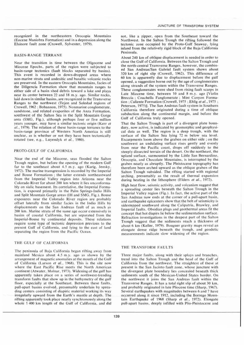
reeognized in the northeas tern Oroeopia Mountains (Eocene Maniobra Formation) and in a depression nlong the El sinore fault zone (C rowell. Sylvester . 1979).
BAS IN- RANGE T ERRA NE
NeM the transition in time be tween Ihe Oligocen.:: and Miocene Epochs, parIS of the region were subjected to basin-range tectonics (fa ult blocks separatcd by basins). Th is event is recorded in down-dropped areas where non-marine s t ra ta and andesÎt ic and bolsallic voleanic rocks are preserved . l n the eas tern Orocopia Mounlains. facie s of the Diligencia Formalion show Ihat mountain ranges to eilher side of a basin shed de bris lowllrd ;1 lake a ud playa nea r its cenle r belween 22 and 18 m.y. ago. Similar rocks . laid down in similar basins, are recogll ized in the Transverse Ranges 10 the nort hwesl (Te jon and Soledud Tegions of Crowel1. 1962; Bohannon . 1975) . Nonmarine conglomcrale. samlsto ne . and related evaporites of Ihe Anza Formation. soulhwesl of the S .. lton Sea in the Split Mountain Gurge area (SMG. Fig.). al though perhaps four o r fi ve million yeilT5 younger. may have a s im ilar tcc tonic origin (Kerr t't al. , 1979). The relation of these bas in-range terranes to the hasin·range province of WeSiern North America is s till unclear. as is whether or not Ihey ha ve been tectonicall y rOlated (see. e.g .. Lu yendyk et !II" 1980).
l'ROTO·G ULF O F CA LI FO RNIA
Near the end of the Miocene . seas flooded the Salton Truugh region . bUI before the opening of the modern Gulf far to the southeast about 4.5 m.y. ago (Karig . Jensky . 1972). The marine lransgression is recorded by the Imperial and Bo use Formations; the latter extends Flortheastward from the Imperial Valle y region into Arizon:, near the Colorado Ri vcr for about 200 km where it lies unconformably on s ialic b"semenl. Its correlati ve . the Impe rial Formation , i~ exposed primarily in the Palm Springs-Indio Hills and Split Mountain Gorge areas (IH and SMG. Fig.). Bouse exposures neM the Colorado Ri ver region (Ire probably orrset laterally from s imi lar r a cie ~ in the lnd io Hills by displacemen ts on the S;m And reas (ault of as much as 200 knl . Marine Slra la of The :<oame age oeeur extensivel y in bas ins of coa~ t a l California , but arc ~ep;lnHed from the Imperial· Bo use by continental deposils. These relations requ ire sorne type of lec to nÎc de pressio n prcvÎous to the preSe nt Gulf of Clli ifo rnia . and Iying to the cas t of land separating the region from the Pacifi e Ocean .
T HE GULF OF CA LIFORN IA
The peninsula of Bajr, Cali fornia began ri ftin g away from mainla ml Mexico about 4.5 rn .y. ago as shown by the arnlngement of magnetic llnornalics 1II1he moulh of the Gulf of California (Larson et al" 19(8). Thi s is the s ite now where the Eas t Pacifi e R i ~c meeh the North American continent (Alwater. Molnar. 1973). Widening of Ihe gulf has apparenll y taken place on fi seri e ~ of northwest-trendi ng transform faul ts that show up in the bathynlCtry of the gulf floor . cspeciall y a t the Soulheasl. Between these fa ulu . pull-'lp'lrt blls ins evol ved. presum,.bly underlain by spre:\ding centers consis ling o f diapiric matcrial worki ng its way irregulnrly upward fro m the Earth 's mllnllc a t dcpth . The rifting apr:l rentl )' look place nearl)' synehronously along the w holc 1 400 km lengt h of Ihe Gulf of Californi:l. and di\!
139
JUNCTURE OF TRANSFORM SYSTEM
nOL like a zipper . open from Ihe Sout heas t toward the Northwest. In the Salton Trough Ihe rifti ng followed the tectonic zone occupied by Ihe l' ro to-Gulf Seaway. Iying inland from the re la tively rigid block of the Baja Calirornia Peninsula.
About 240 km of Oblique displaceme nl is needed in order to dose Ihe Gu lf of California. Between the Salton Trough and the north ·cenlral Transverse Ranges. however. the combin· ed San Andreas/San Gabriel fault system shows llbout 320 km of right slip (Crowell. 1962). This diffe rence of 60 km is apparently duc to displacement before the gulf opencd. a suggestion borne o ut by the "ge o f co nglorncr<ltes ,llong strands of the system within the Transverse Ranges. T hese conglomerates werc shed from rising fa ul t scarps in Late Miocene time. belween 10 and 8 m.y. ago IViolin Srecci:l ; Coache lJa Fanglomerate; MinI Canyon FOTmlll ion ; Caliente Formation (Crowell . 1975 ; Ehlig et iii .. 1975 ; Peterson. 1975»). The San Andreas faul t system in Soulhern Cali fornia thercfore originated during a t ime of Oblique subduction along the continenllli margin . and bcfore the Gulf of California truly opened .
That the Salton Trough is p ~HI of a divergent plate boundary, now <le li ve. is indicated by geomorphic and geophysi. Clii dala as wel1. The region is a deep trough. with the surface of the Salton Sea I)'ing 72 m below sea le vel. Escarpments loom above the graben on either s ide ; on the southweSI an undulali ng surface riscs gently and e venl )' from near the PlIcific coast . d rops off suddenly to the steepl y dissected ter rain of the desert . On t hc oorthe' lst. the upland surfa ce. surmouoled by the Littlc San Bernardino . Orocopia . and Chocolale Mountains, is interrupted by the graben nearl y as abruptly. The Pleis tocene topogmphy has therefore been arched upward Ils Ihe oblique graben of the Salton Trough subsided . The rifting started with regional arching. presumably as the result of thermal e ll p"nsion d uring heating in the li thosphere (Eiders et al .. 1972 ).
High heat flow . seismic activity , and vol canism suggest that a sprc,lding ce nter lies beneath the S"lton T rough in the Imperial Valley region (Fig.). In fa ct. the active p:lrt of the S;m And reas now ends a t the corner of a puIJ-llpan bas in . and ellrl hqullke epiccnters show thal the belt of seismicity is s idestepped southward along the C llipatria. Brawley, <IIld Imperial fault s. Obsidian plug~ a nd geothcrm,llllreas fit thc concept thal hOI diapirs lie below the sedimentation surface . Refraction in vestigations in Ihe deepesl part of the S" lton Trough susses t thal the sedimen l ~ reach a thickness of about 6 km (Keller. 1979). Bouguer gravit y maps reveal an elongatc dense ridge beneath the Irough. a nd gcode lic measurements indicate ~ Iow widcning of the regio n.
T HE TRAN S FORM FAULT$
Three major fault s. :l lo ng wilh thcir spla ys and branches. t rend In lo the Sal t on Trough and the head of the Gulf of Cali fornia from the northwest. The s traighlest of Ihese al present is the San Jacinto fault zone . whose juncture with the divergent plate boundary lies concealed beneath Ihic k sed iments south of the Mexican-United States border. On the northwest il joins the San Andreas huit within the Transverse R:lnges . It has a tOI:ll right s lip of aboul 30 km . and probably originated in laIe Pliocene time (Sharp. 1967). Several ea rthquakes wilh magnit udes belween 6 and 7 have occurred along it since 1912. including the Borrego Mountain Earthquake of 1968 (Sharp et lIl.. 1972). Elongate pull-apart bllsins. deeply infilled with Plio-Pleis tocene and
J C_ CAOWELL
Rece nt continent:.1 sediment ~ are ,Iligned :.Iong its cour~e.
ln ,.ddition, at places dramutic exposures of rault landrorms. incl ud ing scurp~, ~llg~. offset st ream~ and spur ... e,,; .. OCCUT along ils trace .
The San Andreas rnult hound s the Sal ton Trough on the nurtheasl. and branches into tWO strands nèar P;.lm Spring~
(Fig .). These branche~ and the fault 1-One extending to the ~oU\hea~1 as far as the corner uf the spreading center~ in Imperial Valley arc active. as s hown by both fault landforms and sei~micîty . Along the .. ame trend the Sand Hill" ,Ind Aigadones (aulls lI rc nOI now active in as much as fault land forms are not recognized. bul they were pli rI uf a tran~form system in the recent pllSI. and shorlly before the active Impc rial Valley "preflding cenlcrs originated. Toward thc nonhwest, howe ver . in the region between the Mt. San Gorgonio and Mt . SOIn JacinfO (Fig.), the branches of the Som And reas fa ult arc curved and hraided (Allen. 19.57). perhaps as the resull of be ndi ng when the two mou nia in nUls"ifs were upliflcd in Ihe Pleistocene lInd Recent. High upon these massifs lie alluvial remn:lnts. deposi ted when the lerrain was about 2000 m lower (Dihblee . 1975).
Thc Elsinore faul t zone '1lso leads off nOrlhwe~lwanl from a concealed juncture benealh sedjment~ and water in the G ulf of Californill. Where the fault /.One cro~~e~ inlO Ihe ba~emcnt terrane ell~1 of San Diego . it" eour~è b t)b~curc and dbplacement appears 10 fol1ow several irregular ~plays.
Farlher to Ihe norlhwesi. howevcr . its trace is linear. ant.! Paleocene facies arc offse t :Ind. a long wi th the shape and s izc of fin alluviated pull-:lpiHl basin. ~uggè~t right s lip of ncarly 30 km . The leetonie arrangement on tu Ihe nort hwc~t
where il join" the coa~t'II Lo~ Angcle~ I"m~in i ~ s till problcmlltic .
Glher (aults within the region arc reeent[y active and therefore play a role in pre~ent-da y teclonbm. On the e;l\1 are the l'inlo ~Iountain . Olue Cut. Chiri .. co. Saltoll Cree!.. and MammOlh Wash fault s with ea~l-west m:nd~ and Icfl ~Iip of up to 12 km e:tch . They are interpreted a~ either anlilhetic faults in a regional right ~im ple shear sc heme. or more likely . as lcft sl ip te:lr fa lJlt ~ formed as part of Ihe SlruClUre of the Transverse R:InSe~ when the head of the Gulf of California widened . [n contra s!. active f:lult s such a~ the Hidden Spring. C,tlipatria. Brawlcy. and Imperial fit into the ~ impJe shear ~c heme lt~ ~yn thet i c faull s.
DISCUSS ION AND SU~l i\-l A KY
From Ihe in\e~tig;ttion~ described hriefly abo\'e. a tectonic model of recenl deformatiun :lt this juncture is emerging. Thh reccnt deformation i~ :.uperposed upon a teclOnÎC ~ylotenl quile differenl from th:lt operating al prese1ll. lJefore the Mioccne Epoch ohlique subduction at the e01llinenl:l[ margin predominated (Menard. 197K). P<lrt~ of the Sun Andreas sy~telll originatcd during this obl ique ~ubd uction whcn continental s trike ~Iip fault s de\"eloped with an orientation subparallel 10 and weil inland from Ihe ~uhduetion wne. During thi~ plllte cumergence a m3Jor fault probably crossed obliquel y from the torearc ba~in to ih ea~tern margin and off~et Eocene ~horeline far;ie~ "ithin the Trans\er~e Ranges and the regiun 10 Ihe soulhclls l. Il cut obliquel y inlo the clungate proto-Gulf. .1 m,trine aTln underlain by cratonic and lo i:tlic crust. Sub~equenlly. whcn Ihe Gulf of Cal ifornia opened. a new tcclOnic regime wa~ over[)rinlt!d upon a tcrrane alre;ldy l"To~~ed by thi .. m:lJnr fault. and perhaps olhen.
140
As the he:ld of Ihe Gulf of C..lifornia opened ohliquel y. the Slln Andrea~ faul t is pictured as the first and most important transform f;lult at the juncture . Conlinental terr;lnc of the Bltja California Peninsula moved relatively northwe~tward with the Pacifie Pla te. and pu[]ed away fr om mainland Mex ico. This was aecompanied by Ihe growth of a t omple, and ch:lI1ging ~erie s of pull-apart basin~ with Ihcir associated . ~preading diupirs. These events began about .1 • .5 m.y. ago. ltnd s ince that lime spreading centers. pull.apart hasin~. and associated strike-slip and norm:ll-s lip fau1t~ h:l\c come and gone. The ~cheme has resulted in a wide ~ulf . bUI detail~ at depth are vislL"ll ized 1I~ complex in such li IllO\ ing ~y~Ic m.
Such a model aeCOUlIl~ fur thc eharacleriSlic .. of tht! San Andreas on the soulheas t : for the inllcti\'e strand repre~cnt
cd by the S,lI1d Hilis-Algodone" faults. and the new (?l llnd ac ti ve spreading cellIer nùw cvolving beneôlth Imperial Valley.
Sedimen tat ion has gone on continuously as the Saltoll Trough has widened and ilS floor has s tretehed .Ind subsid· cd . The sediment has entered the trough frorn the Colorado River and ilS anceston ôlnd from alluvial ran~ extending b .. ~inward from iu walls. Stnlt;t depo~ited when the trough W'h narrow arc now deeply huried ;I nd no doubt arc far les~ e~ten ~i\e than you nger stmta laid down when the trough wa ~ wider. ~Ioreover . oldcr sediments are now be ing metamorphosed by geolherm.ll ac ti vit y (Muffler. White, 1%9). and arc also heing d i~turbcd al dcplh by volcanic intru~ions (Robinson et al .. 1976). Anolher consequence of deposilion inlo a wideni ng and dccpening trough i ~ Ih.1I beds oUlcropping along the m,l rgin~ today. :tnd e~pee i atty tho~c Jisturbcd near the major fau[b , cOIn not be expected 10 ex tend to depth. Cross section~ drawn through ~uch a region . in ta king into lIecount such a mode!. mU~ 1 show th;\1 the o!der Slrala are more deformed than younger and are inlruded and ahered hy vokank dillpih and arc largety confined 10 the central 70ne of Ihe rift (Crowe11. 1974) . Unconformities abound around the mrtrgin~. but in the central region of the trough none are expected . Stric lly spcaking. Ihere will be place3 where there i ~ no true ba~cmcnt. and wells drilled ncar Ihc trough axis may go di rectly in lO a complex of sedimenb and newly melamor· pho~ed rocks .md volcanic rock s. and on with deplh into upper mantle diapirs consisting of h:l ~ i c and ultr,tgôl~ic igneou~ mas\c,. Frilgmcnh ùr floaten of the h ... ~el11cnt rocb making up the rift lIlarginlo .. rc to bc expcetcd from place to place: these arc v i ~ uali7.ed a~ bloc b and ~Iice~ left hehind as the rirl widened . Only locally and '1long the strctched and atlenu;tted margin~ is there likely 10 he true base ment eonsi~ting of pre-exi~ting ~ ia1ic crust Iying UI1COn· formubly bcnealh the "Iralal infilling.
[)eformôltion and sedimentation along the tran~form LlUlt, leading northwestward fronl the Sal ton Trough foli olV the sehemc 1 refer 10 coltoquiall y :lS ··porpoise structurc" In thb. dongate crustal hlock~ ur ~ Ii c e lo . both within Ihe faul1~ zones such as the San Jacinto . a nd between major faul! ... rbe and fall as they move latcrally. Where f;lult ~ trands converge in map view in wch a conljnuou~l) 1110\ ing system. blocks arc ~quee 7ed Hnd ri~e high to form mountain~ ICro" eli. 1974). Where ~trands diverge . the terrane strelches and ~'Ip. Bloeks when sta nding high ~hed de bri, acros~ fllUItS 10 low-~ tand ing region~. and inlo area~ that form depositio nal basins. }\ ~ la teral movement cOl1tinue ~. .. uch ~edimenb may bc carried wellllwlly from thcir source area. In fact. becau~e ~ource areas for "ome decapitated fanglomcrates ha\e not bccn idenlified. illlll"ly he Ih:!1 the ~ource~, in moving Illtcrally. ha\e ~agged and arc now
burie<! beneuth younger sedime nts . Some o thers may have remained high. a nd have been e roded away. The motion o f the lens-shaped blocks is visual ized a s somewhat like that o f a porpoise as il s wims parai lei tO the fault trace. and rising (lnd s Înking a s it swim~.
The Santa Ros .. Mo untains ;Ire tenlatiyely intepreted as fi
high-st:mding "porpo ise b<lck" belween the northwestern e nd o f the Salton Trough and the San Jacinto faul t zone (Fig.). On the so ulheast Ihis cruslal bloc k dives beneath alluvium. marginalto the Im perial Valley. On the no rthwest the oppos ing massifs of ML San Gorgonio a nd Mt. San Jacinto s tand high. perhaps conslnti ned b y dcformation tha! look place .11 the same time as San Andreas f,lUlt strands werc benl. Pe rhaps the structure he re 1I~ weil is the rcs ull of
REFERENCES
,\lIen C. R . • 1957. San Andreas faull .tone in San Gorsonio Pass. SOluhern California. Geol. 50(". Am. Bull .. 68. 315·350. AI,.-altr T .. Molnar P .. 1973. RelatÎve motion of the Pacifie and North American plates deduccd from sen·flonr spreading in the Atlanlie. Indian. and South Pacifie Oce,ms. in ; Pmeudings. IfclOnÎC" proh/ems of /he San Alrdreas faull s)'sltm , ediled h)' 11. . L. Kuvach f / al . . SlUnford Un i" . Publ .. GeaI. Sd .. 13, 136-1411.
ntl h ~nnon 11. . G .. ' 1975. Mid·Tertiur)' con"lomerutc5 and Their bear· inS on Trans verse Range leClonics . Soulhern Cal ifornia. in ; The Son Andreas Faull in SoU/ hem CalifQm;n. cdilcd b y J . C. Crowell . Cnlif. Di". Mints Geol . • Spu. Rep .. 118. 75·82. (; ro"'fll J . C .. 1962 . Displacemenl alons Ihe SlIn Andreas faul! . California. Grol. 50(". Am .• Stuc. Pop .. 71. 61 p. CfI''''''U J . C., 1974. Or;g;n of LIlle Ccnu~oic basins in Soulhern Cillifornia . in : TUlOn;u and sedimentation. edited b)' W . R. Dickinson , Sec. Eeon. Paltan/ol. ,\/intral .. Spec. Publ .. 22. 190-204.
Crn,.-.. It J . C .• 1975. The Sa n Gabriel fault and Ridl1e Basin : San Alllin'ay Fa ult iu Southtm Colifomi(j . cdited b)' 1. C. Crowell. Crl lif. Di, •. Mi"ts 0/'01 .. Spec. Rtp . . 11 8 . 208·2 19.
<': r .... · .. 11 J . C .. S)''''rs ter A. (; .. 1979. Tu/mrif's uf /he jlllu'wrt betk'tell Ihe 5011 Alldreas fa ull S)'SIfIll a/ld Iht S altou l'rougI!. sou/heas/trll Clllifomia. Dcpl Geol. Sei.. Uni v. California. Santa Barbara. CA 93106. 193 p. I>ihhlH T. W. Jr .. 1975. LaIe Qu,ltermlT)' uplift of The S,m Bernardino Mountains on the San Andrea~ and re laled fa ul!~ in : San Andreas faul t in Southern California. ediled b)' 1. C. Crowell. Calif. Dil'. Millts Oeol .. Sptc. Rep .. 118. 127·135.
• :hIlJ ... . L •• Ehltrt K . W .. Cro .. ·c H. M .. 1975. Offset of the Upper Miocene Caliente and Mini Can)'on fornlations alons the San Gabrie l and San Andreas faults. in ; Sali AI/d'l'lU" Flwl/ ill Sou/hull Colifom;a, çdi ted b)' J . C. Crowell . Ct,lif. 1Jj~ . Minu Gtol . . Spee . Rep .. 118. 83·92.
• : I der~ w. A .• lI.u K. W .• Mcldav T. , Rohln';lIn". T., lI it' hler S .. 1972 . Crllslal spre:lding in S(>uthern California . Sr/ellce. 178, 15·24.
Karlll !)., Jen~ky W .. 1972 . The P""'''· (;ulf "r Catifomia . EIITt/r
141
JUNCTUAE OF TAANSFOAM SYSTEM
local yer tical movements in a predominantl y s irike·s lip rcgime. a tlcst ing to the recc nl Olobili t y o f t hc erust. At (1
s maller scale. ridges and lowlands a lo ng the San Jac into f'lUl t zo ne, fi t the s'IOle YÎsuali za tion . C ha racteristic of this regime. in addi tion. llfe the sed imenl-fi11ed troug hs a lig ncd within s trike·s lip fault zones. inlerpretcd a s infi11 ed pult.aparts. sut h a s those w ithi n the Elsinure a nd San J ,lcin to fault zunes (F ig . . pa).
AcknowledgeOlenls
My investigations o f the teelonies of Southern California during the pas i deeade have largely been supported by grants from the US Natio nal Scie nce Founda lion .
ptaMt. Sei. I.eu .. 17. 169-174 . Kcller H .• 1979. Siruelllrc of Ihe Sallon Trough trom gravit)' and seismic rd raetion data. in ; TUt flllies af tht ju"eture bet"'un /he San AI/dreas fault l ysUm al/d the Salton Trough. sou/heastem Califnrnia. edited b)' J. C. Crowell and A. G. S)'l vester. Dept Geol. Sei .. Uni v. California , Santa lJurbaT:l. CA 93106. 57·64.
Kerr D. R .. PappaJohn S .• f'dtrso Ol C . 1) •• 1979. Neogene stn t;· graphi.: section at Split Mountuin . eAstern San Diego COllnl)' . Catiforn;a, in : Ttc/onies of Ihe jU"f /ure bel WU" the Sa" Alldreas fuul/ S)'SUIII a"d the 5 (.11/0" Trough, Sorilheastull Ca/if a ffi la. edited by J . C. Crowell and A. G. S)'l vester. l)cpt Geol. Sei .. Uni v. California. S .. nta B .. rbara . CA 93106. 111 -124.
I.arson R .. Menard H .• Smith S .. 1968. Gulf of California : a resul! of ocean·fluor spreading and tnlOsform faultinS. Scitl/ce. 161. 781 ·784.
I.uyend)'k H . .... Kammtrll np; M. J .• TrrrC$ R .• 1980. Geometrie model for Neosene crustal rotations in Southern Californiu . Ctol. Soc. Am. Bull .• !II . 211 ·21 7. Menard H. W .• 1978. Fragmentatiun of the Fanllon plate by pi ~o t ing subduction. J. Geo/., 116. 'N·1I 0 . M urlin L. J'. J .. Whltc Il .• : ., 1969. Acti ve memmorphi~m ur Up\X' r Centl:wic sediments in the Slilttln Sel' Geolhermal field and the Salton Trough. SUlithea~ lern Californi .. . Geul. Sat:. Am . Bul/ .• 110. 157·182 . Petcrson M. S., 1975. Geulo!!)' of the C"ache ll l! Fanglomer .. te . in : Sali Alldreas faul t i" Sou/hUI! California. edited b)' J . C. Crowell , c llnf. Dil'. Mines Geol .. Spec. Rep .. 118. 119-126.
Rohlnson l'. T .• Eldus w. A .. Muliler L. J . P .• 1976. QUlllern:lty voleanism ;n the Salton Sea seothermal field . Imperial Valle)' . California . GeaI. Soc . Alli . Bull .. 87. 347·360 .
Sharp R . \ ' •• 1967. San Jacin to faull 1.onc in the peninsular range ~ of Southern California . Geai. Sile. Alli . Bull . . 78. 705·730 .
Sharp M. V. et (.II .• 1972. The Aorreso Muunwin Earthqu:lke nf April 9, 19611 . US GeaI. SUrl' .• Prof . l'up .. 787. 207 p .
Slh'H 1 .. T .• 1971 . l'rublcms of cr)'s tuUine roc ks of the ITlIn sver~t: ranSe ~ labstract] . GeaI. Sm'. Am . Ab.' Ir. P"'HT .. J. 193· 1 ,)~ .
142