july 16 tpr rpp letter rpp letter 080514.pdf · 2014-08-07 · includes average annual daily...
TRANSCRIPT

August 5, 2014
Dear Transportation Planning Region Members,
As you know, the Colorado Department of Transportation is in the process of updating the Statewide Transportation Plan and Long Range Plan to the year 2040. As part of that process, we have asked the Transportation Planning Regions to help identify Strategic Corridors in need of improvement, and define strategies, goals and priorities for those corridors. During meeting #5 of the Statewide Plan Development (SWD) process, the TPRs helped CDOT define priority corridors and identify potential strategies for improvements. In meeting #6, CDOT asked the TPRs to assist in the development of a prioritized list of projects for Regional Priority Funding (RPP). Each of the TPRs requested that CDOT provide additional information regarding the priority corridors, including traffic and safety data, potential additional sources of project funding, and to provide the TPR with a proposed list of RPP funded priority projects.
It is well known that transportation funding in Colorado has not kept pace with needed highway improvements and repairs. Region 5’s highway system is made up of more than 3,566 lane miles of state highways, has 228 bridges, 14 mountain passes over 8,000 feet, and spans 15 counties and two Indian tribal nations. Our highways connect to a vast network of city, county, and tribal roadways. Considering all this, you can begin to get a sense of the complicated puzzle CDOT faces when deciding which projects get done first with our limited funding.
To comply with conditions outlined under the new federal transportation authorization, MAP-21, CDOT has shifted the vast majority of its project prioritization and funding to specific Asset Management Programs. These include major assets like pavement, bridge, culverts, walls, tunnels, signs, etc. Each asset is prioritized for funding on a statewide level, and projects are selected based on quantitative information derived from condition data. Quantitative data includes Average Annual Daily Traffic (AADT), Volume-to-Capacity, Pavement Condition Rating (DL), and Safety (critical crash data, crash severity, density, etc.). RPP funds, however, are intended to address regional needs which are identified and prioritized by the TPR’s through qualitative input. The idea is that our planning partners use their knowledge of the local area to rank and order priorities. This ranking supports local or regional growth strategies, addresses known operational, mobility or safety issues, and promotes economic activity and growth.
Per your request, the Region has drafted a proposed RPP funding plan for the next 10 years. This was accomplished by reviewing the TPR’s identified Priority Corridors, and the proposed project
Planning and Environmental 3803 N. Main Avenue Durango, CO 81301

list that was developed during previous SWP development meetings. Goals and Strategies for these corridors sought to:
maintain the effective and predictable operations of the transportation system,
increase the efficiency of the existing system,
reduce the frequency and/or severity of accidents,
reduce barriers that delay motorists,
support statewide economic development,
improve the quality of tourist related travel experiences, and (if possible)
preserve the existing transportation infrastructure
Attached to this letter are several items for your consideration. Attachment #1 includes the Region’s draft RPP funding plan through 2025 for your review and, hopefully, approval. Attachment #2 contains TPR Profile Sheets and provides demographic, economic, transportation related information about your planning region. Attachment #3 includes the Strategic Corridor Profile Sheets that were developed in collaboration with the TPRs. These provide information on the identified needs of the Region’s priority corridors, and discuss strategies, goals and priorities for addressing those needs. Both of the Corridor Profile Sheets and the TPR Profile Sheets were previously provided to you during earlier SWP meetings.
Projects were prioritized utilizing previously identified corridor deficiencies and proposed solutions. Conceptual project scopes were developed and ranked considering prior prioritization during the previous STIP cycle, roadway design issues, stakeholder concerns, funding constraints, and project readiness. Based on the scope, costs and benefits were determined and compared to further assist in ranking and prioritizing funding.
As you can see, given our limited funding, hard choices need to be made for priorities and what gets funded. Please review and we look forward the discussion at the upcoming TPR meeting.
Sincerely,
Tony Cady
Region Planning & Environmental Manager

ATTACHMENT #1

CDOT Region 5 2025 Fiscally Constrained Plan
CDOT is currently conducting the Project Priority Programing Process (4P) in all Region’s throughout the state. The 4P Process will identify project priorities for the 4 year Statewide Transportation Improvement Program (STIP) and a 10 year Capital Plan. The STIP is a federally required, fiscally constrained program that depicts transportation projects for a minimum of 4 years. The Capital Plan is a 10 year, fiscally constrained plan, which identifies Regionally Significant Projects, Priority Corridors (US 160/US 550), project categories (passing lanes, pull-outs, shoulders, and intersections) and/or specific projects. Both the STIP and Capital Plan will roll forward each year and add a year to the plan through a public process. Figure of the planning timeline: The 4 year STIP is shown in orange, the 10 year Capital Plan in blue, and the Long-Range Plan in grey.
Region 5 is planning on approximately $3.5 M of RPP funding annually through 2025. Therefore, the 10 year (2016-2025) RPP allocation for which project funding is available is $35 million. Historically, the TPR distribution has been approximately 40% to SLVTPR, 40% to SWTPR, and 20% GVTPR.
TPR 10-year Distribution $3.5M x 10=$35M x .40= $14 M = $14M for SLVTPR x .40= $14 M = $14M for SWTPR x .20= $ 7 M = $ 7 M for GVTPR
Total = $35M
4P Schedule
August Individual TPR Meetings Aug-Oct County Meetings Nov Joint TPR meetings to prepare the STIP January The Region will be required to submit a draft STIP Feb TC approves the draft STIP for distribution in Feb and April Draft STIP goes out for public comment May TC approval of STIP

FUNDED PHASE
Projec Location Length Improvement TypeOther Funding
SourcesNotes/Assumptions
1SW: US 160- Four Corners to Archuleta/Mineral County line
Complete interchange connection at US 160/550 US 160 MP 88.4 1.5 milesSafety - Accident reduction/Accident risk prevention Multi-modal - bike and ped Mobility
$91 $1 M N .67/.67 M/M 35000/7100 67166/21427 50/60Surface, FASTER
Funding for ROW and Design
2SW: US 550- New Mexico state line to San Juan/Ouray County border
US 550 "GAP"- CR302 to Sunnyside (half-build) US 550 MP 9-12 3 milesSafety - Accident reduction/Accident risk prevention Mobility
$14 $13 M N 0.34 M 5800 44120 60Surface, FASTER
Needs Shoulders. FONSI completed.
TOTAL $14SW TPR $14
UNFUNDED PHASE
Projec Location Length Improvement Type
1SW: US 160- Four Corners to Archuleta/Mineral County line
Add passing lanes - Bayfield to Durango US 160 MP 96-99 3 milesSafety - Accident reduction/Accident risk prevention Mobility
$22 H N 0.62 M 9600 70444 60Surface, FASTER
Dry Creek Light Passing Lane
2SW: US 491- New Mexico state line to US 160
Add passing lanes, north of Towoac US 491 MP 27-32 5 milesSafety - Accident reduction/Accident risk prevention Mobility
$8 H N 0.36 M 12000 22712 65Surface, FASTER
Shelf for FLAP
3SW: US 550- New Mexico state line to San Juan/Ouray County border
Sunnyside US 550 MP 8-10 2 milesSafety - Accident reduction/Accident risk prevention Mobility
$25 H N 0.34 M 5800 44120 60Surface, FASTER
4SW: US 550- New Mexico state line to San Juan/Ouray County border
US 550 "GAP"- CR302 to Sunnyside (full build-out) US 550 MP 9-12 3 milesSafety - Accident reduction/Accident risk prevention Mobility
$20 M N 0.34 M 5800 44120 60Surface, FASTER
6SW: SH 172- New Mexico line to US 160
Add passing lanes - Elmore's to Ignacio SH 172 MP 9-19 3 milesSafety - Accident reduction/Accident risk prevention Mobility
$7 L N 0.5 M 7700 32255 65Surface, FASTER
7 SW: SH 140- NM border to Hesperus Widen shoulders and bridges SH 140 MP 1-23 23 milesSafety - Accident reduction/Accident risk prevention Mobility Preservation
$15 L N 0.2 M 2400 15623 65Surface, FASTER
8SW: US 160- Four Corners to Archuleta/Mineral County line
Wildlife Mitigation from Mancos to Pagosa US 160 MP 73-144 1 mile* Safety - Accident reduction/Accident risk prevention $3 L N 0.78 H 36000 70444 65Surface,
FASTER, TAP
OTHER FUNDING SOURCES: FASTER Safety, Bridge On‐System, Hot Spot, Traffic Signals, Surface Treatment, Transportation Alternatives.
Priority Corridor Priority Description Estimated Cost
Safety(Y/N)
V/C
SWTPR 4P Planning
DL Max AADT Max VMT SpeedProposed
CDOT RankPriority Corridor Priority Description
Estimated Cost($ M's)
Funded Amount ($ M's)
Project Readiness(H/M/L)
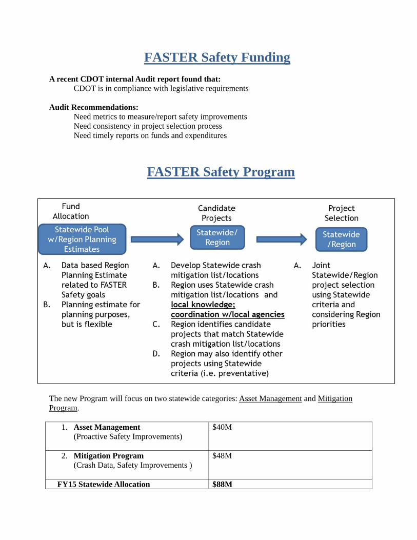
FASTER Safety Funding
A recent CDOT internal Audit report found that: CDOT is in compliance with legislative requirements
Audit Recommendations: Need metrics to measure/report safety improvements Need consistency in project selection process Need timely reports on funds and expenditures
FASTER Safety Program
The new Program will focus on two statewide categories: Asset Management and Mitigation Program.
1. Asset Management (Proactive Safety Improvements)
$40M
2. Mitigation Program (Crash Data, Safety Improvements )
$48M
FY15 Statewide Allocation $88M

FASTER Project Selection Criteria
FASTER Region Funding Target Allocations The Region will request funding for projects from the statewide FASTER pool which meet the Project Selection Criteria according to the following breakdown. FASTER funding will be distributed to the Region’s based on the safety need and the regional target allocation of $48 million. 40% for Intersection Improvements $48M x 40% = $ 19 M 40% for Passing Lanes/Pullouts $48M x 40% = $ 19 M 10% for Shoulder Improvements $48M x 10% = $ 5 M 10% for Engineering Studies and Environmental Compliance $48M x 10% = $ 5 M Total Off-the-top $ 48M

ATTACHMENT #2

Population
1990 2000 2010 2020 2030 2040
59K80K
92K117K
146K171K
Source: US Census Bureau forecasted by DOLA
![
!,
!,
LA PLATA
MONTEZUMAARCHULETA
DOLORESSAN JUAN
£¤160
£¤84
Scenic Byway
Energy Corridor
Railroad
ctive Coal Mine
ki Area
£¤491
£¤550
£¤160 £¤550
£¤160
ake
iver
ort of Entry
Ute Mountain Ute Tribe Boun
The regional transportation system is made up of more than just highways - it also supports movement by bicycle, air, and transit.
Bicycles are accommodated on the shoulders of highways. A four foot paved shoulder is considered to be the minimum width required to provide adequate room for bicyclists. A paved shoulder four feet or greater provides added safety for vehicles and bicycles.
Airports contribute to the mobility of the area. The airports in Durango and Cortez have commercial service. The general aviation airports in Pagosa Springs and Dove Creek provide private aircraft access for recreational and business activities.
Transit is an important component of a multimodal transportation system. Providers in the area offer transportation services to the general public, elderly, disabled, school age children, low-income and Tribal
residents. Intercity bus and resort service is also provided in the region.
Please see the Transit Insert for more detailed information on transit services.
Bridge Condition and Pavement Service Life
Consistent investment is needed to maintain critical infrastructure.
Bridges are generally in good or fair condition. 52% of the region’s 79 bridges are in good condition and 44% of the bridges are in fair condition. Both conditions meet safety and geometry standards. Statewide 96% of the 3,447 bridges are in good or fair condition, which is the same as the 96% in good and fair bridge condition for the region. 4% are in poor condition. It should be noted that a poor bridge is not unsafe; unsafe bridges are closed. A bridge rated poor could, however, be restricted to certain vehicle types or weight restrictions.
Pavement conditions need improvements as 51% have a service life of fi ve years or less. Service Life is a calculation based on a combination of age and expected design life of pavement. With maintenance and minimal treatments, pavement life can be extended. CDOT is currently exploring enhanced road-management methods, including new preservation strategies, to maintain the highest roadway surface grades possible, despite declining revenues.
SOUTHWEST TRANSPORTATION PLANNING REGIONCounties of Archuleta, Dolores, La Plata, Montezuma, San Juan
The Southwest Transportation Planning Region encompasses over 6,500 square miles. The Southern Ute and the Ute Mountain Ute, the State’s only Indian tribes, are located here. The area is known for its scenic beauty, diverse landscapes and cultural resources. With national monuments, national forests, wilderness areas and national historic areas there are numerous outdoor recreation and tourism opportunities. Agriculture also has an important role in this area.
TPR by the Numbers
The Southwest TPR is home to:
91,700 population – 1.8% of the state
1,099 state highway lane miles – 4.8% of the state
2.5 million miles traveled on the state highways daily in 2011 – 2.9% of the state
3 general aviation airports
2 commercial airports
3 Scenic Byways
2 ski areas
21 local and human service transit providers
1 intercity bus provider
Source: CDOT
MULTIMODAL
July 10, 2013
Population and Employment
Population growth is expected to be strong with the current population of 91,700 growing to about 171,500. The annual rate of population growth between 2010 and 2040 is estimated to be 2.1%, which exceeds the annual rate of growth for the state population of 1.5% for the same period.
The region’s economy relies heavily on transportation. Three of the top fi ve industries - Food and Agriculture, Energy and Natural Resources, and Tourism and Outdoor Recreation rely on an effi cient and well-connected transportation system.
[·J
[·
[·
J LA PLATA
MONTEZUMAARCHULETA
DOLORESSAN JUAN
£¤160
£¤84
£¤491
£¤550
£¤160 £¤550
£¤160
J Commercial Airport
Shoulder WidthPaved 4 Feet and Greater
[· General Aviation Airport
Railroad
Less Than 4 Feet or Unpaved
Ute Mountain Ute Tribe Boundary
Southern Ute Tribe Boundary
Source: CDOT
Southwest TPR
Annual Growth Rates Region State 2.1% 1.5%
Top 5 Industries By Employment
Health and WellnessFood and
AgricultureEnergy and
National ResourcesTourism and
Outdoor RecreationInfrastructure
Engineering 3,306
4,154
4,213
4,292
5,721
Source: Offi ce of Economic Development and International Trade
For more information on the Statewide Transportation plan, contact Michelle Scheuerman (303-757-9770 or [email protected])
INFRASTRUCTURE
Good52%
Fair44%
Poor4%
Bridge Condition
Greater than 10 years
6-10 years
5 or fewer years
32%
17%
51%
Pavement Service Life
Source: CDOT
Bicycles, Airports, and Transit
Agricultural
Parks
County Boundary Forest
Southern Ute Tribe Boundary
Ute Mountain Ute Tribe Boundary
Scenic Byway
Energy Corridor
RailroadRiver !,
Active Coal Mine
Ski Area
Lake
Port of Entry
[·
J
[·
[·
JDurango
Cortez
Pagosa Springs
Rico
Bayfield
Mancos
Silverton
Dolores
Dove Creek
Ignacio
LA PLATA
MONTEZUMA
ARCHULETA
DOLORESSAN JUAN
J
D
E
F
County Boundary
Commercial Airport
Railroads
E
With Hatching
Incr
ea
sin
De
cre
asi
n
!(
VPD 2011VPD 2025VPD 2040
Percent Trucks
£¤491
Vehicles Per Day
£¤84
£¤550!(
2,8003,4004,00018%
F
£¤160
£¤160
£¤550
!(
2,1002,8003,400
7%
!(
4,2005,4006,80010%
!(
1,3001,7002,000
11%
!(
3,0004,5006,00012%
!(
5,0006,4007,90012%
!(
5,7007,3009,00010%
!(
6,7008,700
10,8008%
!(
6,5008,300
10,3009%
!(1,9002,2002,600
9%
!(
1,6002,2002,900
11%
[· General Aviation Airport
Southern Ute Tribe Boundary
Ute Mountain Ute Tribe Boundary
Traffi c Congestion
Vehicular travel is projected to have an annual rate of growth of 1.8% between 2011 and 2040, placing increasing strain on the system. This growth rate is the same as the projected annual rate of growth of 1.9% for the state during the same period. This growth will place increasing strain on the transportation system.
Vehicle Miles of Travel (millions daily)
2.22.9
3.7
2011 2025 2040Source: CDOT
Roadway Level of Service (LOS) is a measure of congestion delay. It can be thought of as a grading scale where LOS A is excellent and implies high levels of mobility and ease of maneuverability and LOS F is failure and indicates that the road is experiencing heavy traffi c volumes, signifi cant congestion, and stop-and-go traffi c. LOS A – LOS D is considered acceptable. Travelers will experience Level of Service E/F increase from 16% in 2011 to 55% percent in 2040.
Today’s heavily travelled roadways are expected to see increased congestion levels in the future. The junction of US 160 and US 550 is predicted to be the most congested area in the region in 2025. US 160 in the Pagosa Springs area, between Durango and Mancos and in the Cortez area are predicted to see some congestion. These future congested roadways are indicated by red and orange hatching on the map to the right.
Travel by Level of Service
2011 2025 2040
LOS F
LOS E
LOS D
LOS C
LOS B
LOS A
3%
21%
23%
37%
16%
1% 1%13% 8%
18%16%
31%
20%
26%
38%
11%17%
Source: CDOT
TRAFFIC CONDITIONS
Commodity Production
Commodity exports are expected to have an annual growth rate of 1.2% between 2010 and 2040. To accommodate this growth, the region’s transportation system must be able to effi ciently facilitate freight movements. The top commodities in the region by value include grains, dairy farm products, candy and newspapers.
Value of Commodity Exports
2010 2025 2040
$0.8 M$1.1 M
$1.4 M
Source: IHS Global Insight
Highway Safety
Crash rates are an important indicator of highway safety. In the Southwest region, the average crash rate was 1.57 per million vehicle miles for 2010- 2011, which is lower than the overall state average rate of 1.70 for the same period.
Top Five Crash Types (2010-2011)
Sideswipe -Same Direction
Broadside
Rollover
Rear End
Wild Animal
Source: CDOT
Level of Service(2011) (2025)
A
B
C
D
E
F
E
Roads WithLOS E and F
In 2025 Indicated
With Hatching
Incr
ea
sin
g T
raffi
cD
ecr
ea
sin
g S
pe
eds
F J
County Boundary
Commercial Airport
Railroads
!(
VPD 2011VPD 2025VPD 2040
Percent Trucks
Vehicles Per Day
[· General Aviation Airport
Southern Ute Tribe Boundary
Ute Mountain Ute Tribe Boundary
Truck Traffi c
Truck traffi c makes up 8% of the traffi c in the region. This is lower than the statewide average of 9%. The heaviest truck volumes are on US 160 between Durango and Mancos and south of Cortez. Since trucks are heavier and take up more room on the highway than automobiles, their effects on congestion and pavement and bridge conditions are compounded.
Truck Miles of Travel (millions daily)
0.180.24
0.30
2011 2025 2040
Source: CDOT
Source: CDOT

ATTACHMENT #3
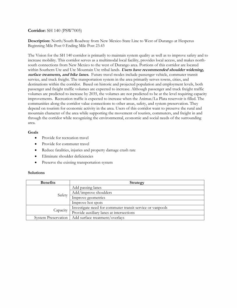
Corridor: SH 140 (PSW7005) Description: North/South Roadway from New Mexico State Line to West of Durango at Hesperus Beginning Mile Post 0 Ending Mile Post 23.43 The Vision for the SH 140 corridor is primarily to maintain system quality as well as to improve safety and to increase mobility. This corridor serves as a multimodal local facility, provides local access, and makes north-south connections from New Mexico to the west of Durango area. Portions of this corridor are located within Southern Ute and Ute Mountain Ute tribal lands. Users have recommended shoulder widening, surface treaments, and bike lanes. Future travel modes include passenger vehicle, commuter transit service, and truck freight. The transportation system in the area primarily serves towns, cities, and destinations within the corridor. Based on historic and projected population and employment levels, both passenger and freight traffic volumes are expected to increase. Although passenger and truck freight traffic volumes are predicted to increase by 2035, the volumes are not predicted to be at the level requiring capacity improvements. Recreation traffic is expected to increase when the Animas/La Plata reservoir is filled. The communities along the corridor value connections to other areas, safety, and system preservation. They depend on tourism for economic activity in the area. Users of this corridor want to preserve the rural and mountain character of the area while supporting the movement of tourists, commuters, and freight in and through the corridor while recognizing the environmental, economic and social needs of the surrounding area. Goals
Provide for recreation travel
Provide for commuter travel
Reduce fatalities, injuries and property damage crash rate
Eliminate shoulder deficiencies
Preserve the existing transportation system
Solutions
Benefits Strategy
Safety
Add passing lanes
Add/improve shoulders
Improve geometrics
Improve hot spots
Capacity Investigate need for commuter transit service or vanpools
Provide auxiliary lanes at intersections
System Preservation Add surface treatment/overlays

Corridor: U.S. 160 (PSW7009) Description: Four Corners to the Archuleta/Mineral County Line, MP 0.0 to MP 155.09 The Vision for the U.S. 160 corridor is primarily to increase mobility as well as to improve safety and to maintain system quality. Portions of the highway are located within Southern Ute and Ute Mountain Ute tribal lands. Portions of highway are within the San Juan Skyway, also designated as an All American Road, and Trail of the Ancients Scenic and Historic Byway. This corridor serves as a multimodal National Highway System facility and serves as the major east-west route through southern Colorado. This segment of the corridor serves destinations both within and outside the region, and makes connections from the Four Corners to the western boundary of Mineral County. It impacts the heart of several towns/cities and provides access to Mesa Verde National Park. Users have requested intersection improvements, wildlife mitigation, bike lanes, widen San Juan River Bridge, improve frontage roads, surface treatments and widen shoulders. Future travel modes include passenger vehicle, local, regional and interregional bus transit (regional), truck freight, bicycle and pedestrian facilities, and aviation. The transportation system in the area primarily serves towns, cities, and destinations within the corridor as well as destinations outside of the corridor. Segments of the US 160 corridor may be a candidate for a future strategic project. Based on historic and projected population and employment levels, both passenger and freight traffic volumes are expected to increase. The communities along the corridor value high levels of mobility, transportation choices, and connections to other areas, safety, and system preservation. They depend on tourism, agriculture, energy and commercial activity for economic activity in the area. Users of this corridor want to preserve the rural, mountain, and agricultural character of the area while supporting the movement of tourists and commuters in and through the corridor and recognizing the environmental, economic and social needs of the surrounding area. The corridor is affected significantly by coalbed methane (CBM) gas exploration and production. Goals
Increase travel reliability and improve mobility (across all modes)
Plan for increased oil and gas production impacts to the road system
Recognize and plan for the potential impact of tribal and other local projects to the road system
Increase transit ridership through increased efficiency, effectiveness, frequency and convenience
Promote environmentally responsible transportation improvement
Solutions
Benefits Strategy
Safety Construct auxiliary lanes (passing, turn, accel/decel)
General safety improvements
Capacity Construct intersection/interchange improvements
Operations Improve ITS incident response, traveler info & traffic management
Transit
Coordinate service among transit providers
Provide and expand transit bus and rail services
Provide inter-modal connections
Environment Improve wildlife crossings
Promote environmental responsibility

Corridor: SH 172 (PSW7010) Description: New Mexico Line North to US 160 Beginning Mile Post 0 Ending Mile Post 24.9 The Vision for the SH 172 corridor is primarily to maintain system quality as well as to improve safety and to increase mobility. This corridor is partially-located within the Southern Ute Indian Reservation and provides local access within the southern La Plata County area. Users have requested intersection improvements. Future travel modes include passenger vehicle, bus (regional), transit, and aviation (Durango-La Plata County Airport). The transportation system in the area primarily serves destinations within the corridor. The corridor provides the primary access to Ignacio and the Southern Ute Tribal Headquarters, the site of a large new casino and hotel, expected to attract large numbers of visitors. Based on historic and projected population and employment levels, both passenger and freight traffic volumes are expected to increase. The communities along the corridor value safety and system preservation. They depend on tourism and freight movements for economic activity in the area. Users of this corridor want to preserve the rural character of the area while supporting the movement of tourists in and through the corridor while recognizing the environmental, economic and social needs of the surrounding area. The corridor is affected significantly by coal-bed methane (CBM) gas exploration and production. Goals
Reduce fatalities, injuries and property damage crash rate
Preserve the existing transportation system
Provide for tourist-friendly travel
Provide for safe pedestrian travel across the highway
Ensure airport facilities are maintained in a safe operating condition and are adequate to meet
existing and projected demands
Solutions
Benefits Strategy
Safety
Construct auxiliary lanes (passing, turn, accel/decel)
Add/improve shoulders
Improve geometrics
Improve hot spots
Capacity Construct intersection/interchange improvements
Transit Expand Transit Service
Aviation Meet airport facility objectives in Airport System Plan
System Preservation Add surface treatment/overlays
Environment Improve wildlife crossings
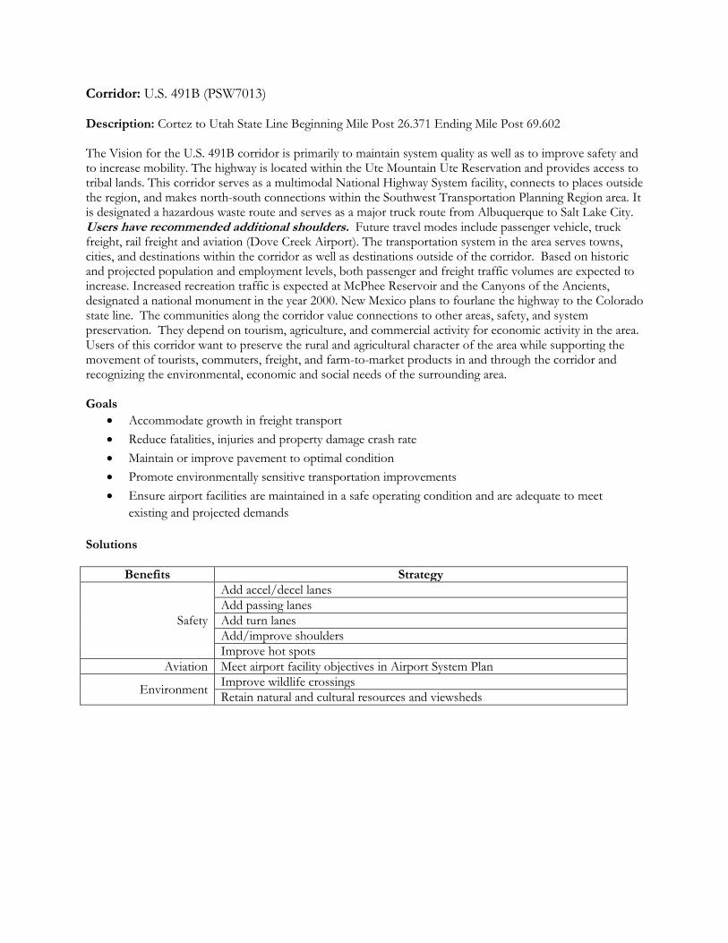
Corridor: U.S. 491B (PSW7013) Description: Cortez to Utah State Line Beginning Mile Post 26.371 Ending Mile Post 69.602 The Vision for the U.S. 491B corridor is primarily to maintain system quality as well as to improve safety and to increase mobility. The highway is located within the Ute Mountain Ute Reservation and provides access to tribal lands. This corridor serves as a multimodal National Highway System facility, connects to places outside the region, and makes north-south connections within the Southwest Transportation Planning Region area. It is designated a hazardous waste route and serves as a major truck route from Albuquerque to Salt Lake City. Users have recommended additional shoulders. Future travel modes include passenger vehicle, truck freight, rail freight and aviation (Dove Creek Airport). The transportation system in the area serves towns, cities, and destinations within the corridor as well as destinations outside of the corridor. Based on historic and projected population and employment levels, both passenger and freight traffic volumes are expected to increase. Increased recreation traffic is expected at McPhee Reservoir and the Canyons of the Ancients, designated a national monument in the year 2000. New Mexico plans to fourlane the highway to the Colorado state line. The communities along the corridor value connections to other areas, safety, and system preservation. They depend on tourism, agriculture, and commercial activity for economic activity in the area. Users of this corridor want to preserve the rural and agricultural character of the area while supporting the movement of tourists, commuters, freight, and farm-to-market products in and through the corridor and recognizing the environmental, economic and social needs of the surrounding area. Goals
Accommodate growth in freight transport
Reduce fatalities, injuries and property damage crash rate
Maintain or improve pavement to optimal condition
Promote environmentally sensitive transportation improvements
Ensure airport facilities are maintained in a safe operating condition and are adequate to meet
existing and projected demands
Solutions
Benefits Strategy
Safety
Add accel/decel lanes
Add passing lanes
Add turn lanes
Add/improve shoulders
Improve hot spots
Aviation Meet airport facility objectives in Airport System Plan
Environment Improve wildlife crossings
Retain natural and cultural resources and viewsheds

Corridor: U.S. 550 (PSW7014) Description: New Mexico State Line to San Juan/Ouray County Line; Beginning Mile Post 0.0 Ending Mile Post 80.523 The Vision for the U.S. 550 corridor is primarily to increase mobility as well as to improve safety and to maintain system quality. The southern portion of the highway is located within the Southern Ute Reservation and provides access to tribal lands. The highway is part of the San Juan Skyway, which was one of the first six routes designated as an All-American Road. This corridor serves as a multimodal National Highway System facility, connects to places within and outside the region, and is the major route providing north-south connections within the Southwest Colorado area. It provides access to public lands. Users have recommended additional passing lanes, slow moving vechile turnouts, converting abandoned rail line into usable trails. Future travel modes include passenger vehicle, local, regional and interregional bus transit, and truck freight. The transportation system in the area serves towns, cities, and destinations within the corridor as well as destinations outside of the corridor. Segments of the U S 550 corridor were identified as candidate projects in the CDOT 2003 Strategic Investment Program and may be a candidate for a future Strategic Projects Program. Based on historic and projected population and employment levels, both passenger and freight traffic volumes are expected to increase. The 2002 average annual daily traffic (AADT) ranged from 1,947 to 32,883 on different segments of the corridor, including 74 to 356 combination trucks, and the projected AADT for 2030 is 2,792 (at Silverton) to 50,377 (north of 14th Street in Durango), including 107 to 669 combination trucks. The communities along the corridor value connections to other areas, safety, and system preservation. They depend on tourism and commercial activity for economic activity in the area. The corridor is affected significantly by coalbed methane (CBM) gas exploration and production. Users of this corridor want to preserve the rural and mountain character of the area while supporting the movement of tourists, commuters, and freight in and through the corridor and recognizing the environmental, economic and social needs of the surrounding area. Goals
Increase travel reliability and improve mobility
Provide for tourist-friendly travel
Coordinate transportation and land use decisions
Support economic development and maintain environment
Improve transit options
Solutions
Benefits Strategy
Safety General safety improvements
Add passing/climbing lanes
Capacity Improve/add intersections/interchanges
Add roadway pullouts for breakdowns, buses and slow vehicles
Operations Improve ITS incident response, traveler info & traffic management
Transit Provide and expand transit bus services
Provide park ‘n’ rides
Bicycle & Pedestrian Provide bicycle/pedestrian facilities
Environment Improve wildlife crossings
Retain natural and cultural resources and viewsheds