jpss atmospheric products and their … atmospheric products and their reprocessing for advancing...
TRANSCRIPT
JPSS Atmospheric Products and Their Reprocessing for Advancing Weather and Climate Applications
Fuzhong Weng
Satellite Meteorology and Climatology DivisionNOAA Center for Satellite Applications and Research

1/30/2017 JPSS-CPO TIM, 1-30-2017 2
Suomi NPP Instruments and Their Applications
Visible Infrared Imaging Radiometer
Suite (VIIRS)
Cross-track Infrared Sounde (CrIS)
Ozone Mapping and Profiler Suite (OMPS)
Advanced Technology Microwave Sounder
(ATMS)
Clouds and the Earth's Radiant Energy System
(CERES)

1/30/2017 JPSS-CPO TIM, 1-30-2017 3
Suomi NPP TDR/SDR Algorithm Schedule
Sensor Beta Provisional ValidatedCrIS February 10, 2012 February 6, 2013 March 17, 2014
ATMS May 2, 2012 February 12, 2013 March 17, 2014OMPS March 7, 2012 March 12, 2013 September 17, 2015VIIRS May 2, 2012 March 13,, 2013 April 17, 2014
Beta• Early release product.• Initial calibration applied• Minimally validated and may still contain significant errors (rapid changes can be expected. Version changes will
not be identified as errors are corrected as on-orbit baseline is not established)• Available to allow users to gain familiarity with data formats and parameters• Product is not appropriate as the basis for quantitative scientific publications studies and applications
Provisional• Product quality may not be optimal• Incremental product improvements are still occurring as calibration parameters are adjusted with sensor on-orbit characterization (versions will be tracked)
• General research community is encouraged to participate in the QA and validation of the product, but need to be aware that product validation and QA are ongoing
• Users are urged to consult the SDR product status document prior to use of the data in publications• Ready for operational evaluation
Validated• On-orbit sensor performance characterized and calibration parameters adjusted accordingly• Ready for use in applications and scientific publications• There may be later improved versions• There will be strong versioning with documentation

1/30/2017 JPSS-CPO TIM, 1-30-2017 4
NWP User Recommendations on ATMS/CrIS SDR Reprocessing from the 2016 NOAA Workshop
• Lunar intrusions in cold calibration should be flagged for whole ATMS time series (ECMWF)
• Lunar intrusion correction should be applied for whole ATMS time series (ECMWF)
• ATMS striping correction algorithms need to be applied for reprocessed data (ECWMF)
• ATMS data stream at temperature sounding channels need to be remapped to AMSUA-like channels (NCEP)
• ATMS channel correlations should be well quantified through reprocessed data (NRL)
• CrIS data can be collocated with VIIRS imager data to assist in cloud-detection (ECMWF)
• CrIS data stream should be generated at both normal and full spectral resolution (NCEP)
1/30/2017 JPSS-CPO TIM, 1-30-2017 5
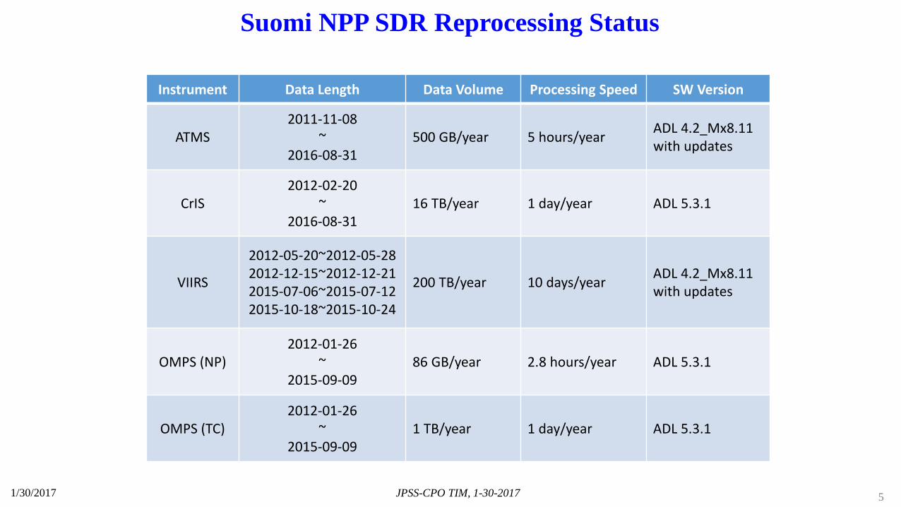
Suomi NPP SDR Reprocessing Status
Instrument Data Length Data Volume Processing Speed SW Version
ATMS2011-11-08
~2016-08-31
500 GB/year 5 hours/year ADL 4.2_Mx8.11 with updates
CrIS2012-02-20
~2016-08-31
16 TB/year 1 day/year ADL 5.3.1
VIIRS
2012-05-20~2012-05-282012-12-15~2012-12-212015-07-06~2015-07-122015-10-18~2015-10-24
200 TB/year 10 days/year ADL 4.2_Mx8.11with updates
OMPS (NP)2012-01-26
~2015-09-09
86 GB/year 2.8 hours/year ADL 5.3.1
OMPS (TC)2012-01-26
~2015-09-09
1 TB/year 1 day/year ADL 5.3.1
1/30/2017 JPSS-CPO TIM, 1-30-2017 6
Suomi NPP SDR Reprocessing Status
Instrument Data Availability at STAR Note
ATMS
Reprocessed TDR/SDR/GEO/data/data246/wchen/ATMS-REP-V0
2.2 degree FOV size resampled TDR from reprocessed TDR/data/data246/gregk/Remap_Reprocess_TATMS/output_remap
Data quality verification performed
CrIS Normal spectral resolution data Data quality verification performed
VIIRS Reprocessed SDR/GEO/Terrain Corrected GEO/data/data263/gregk/VIIRS_SDR
No extended data quality verification performed
OMPS (NP) Reprocessed SDR/GEO/data/data245/gregk
Data migration ongoingData quality verification performed
OMPS(NM) Reprocessed SDR/GEO/data/data245/gregk
Data migration ongoingData quality verification performed

1/30/2017 JPSS-CPO TIM, 1-30-2017 7
ATMS TDR Difference between Reprocessing and Operation
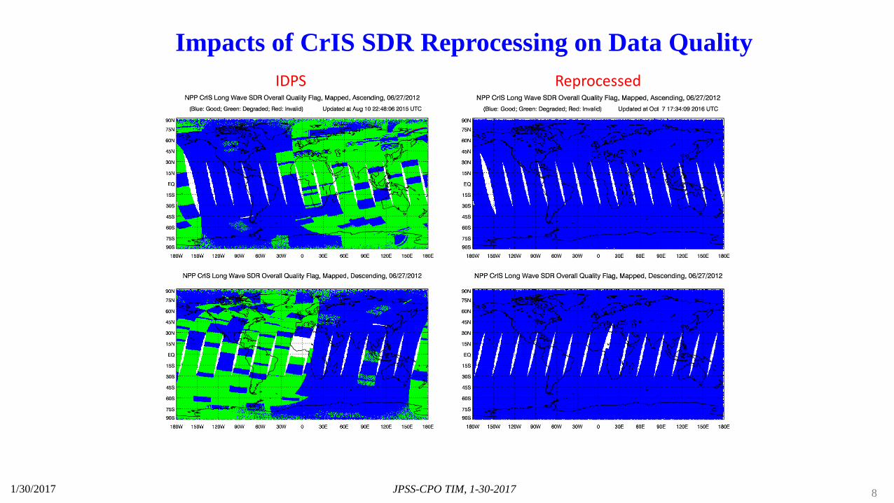
1/30/2017 JPSS-CPO TIM, 1-30-2017 8
IDPS Reprocessed
Impacts of CrIS SDR Reprocessing on Data Quality
Satellite Data Assimilation for Improving Forecasts of Hurricanes and Precipitation: Participants and Partnership
1/30/2017 JPSS-CPO TIM, 1-30-2017 9
1. NOAA Center for Satellite Applications and Research2. NWS/NCEP Environmental Modeling Center3. Joint Center for Satellite Data Assimilation 3. University of Maryland 4. NOAA Atlantic Ocean and Marine Laboratory5. NOAA Joint Polar Satellite Program Office 6. NOAA GOES-R Program Office 7. OAR/ESRL/GSD

Radiance Assimilation in Hurricane WRF Model
• Refine the NCEP Gridpoint Statistical Interpolation (GSI) system (e.g. quality control, bias correction, background covariance) for regional NWP applications
• Increase the HWRF model top to 0.5 hPa for assimilating more upper-air sounding channels from polar-orbiting satellites
• Warm-start running the HWRF with its six hour forecast as the background field
• Perform more experiments on assimilation of surface sensitive channels and cloudy and rain-affected radiances in NWP models
1/30/2017 JPSS-CPO TIM, 1-30-2017 10

HWRF Model and Data Assimilation System
1/30/2017 JPSS-CPO TIM, 1-30-2017 11
Three telescoping model domains:Outer domain: 27 km (fixed, ASDA) Middle domain: 9 km (movable, ASDA)Inner domain: 3 km (movable)
InnerdomainMiddle
domain
Outerdomain
Model Domains
• HWRF version 934 (3 nested domains) and Basin Scale HWRF (in testing)
• HWRF/DA- Higher model top (0.5 hPa, 61 levels)- Warm start (HWRF 6-h forecasts as background)- Asymmetric vortex initialization (VI) - Incremental analysis updates
• Advanced POES and GOES DA- POES sounding instruments:
AMSU, ATMS, CrIS, IASI, AIRS- New Ice Cloud QC for MHS, Double CO2 Cloud QC for CRIS - ABI and AHI imager radiance- Microwave imagers: AMSR2 and GMI- Two-scale microwave FastEM including polarimetric components

AHI Spectral Bands
1/30/2017 JPSS-CPO TIM, 1-30-2017 13
Band SpatialResolution
CentralWavelength Physical Properties
1
Visible1 km
0.47 μm vegetation, aerosol
2 0.51 μm vegetation, aerosol
3 0.5 km 0.64 μm Vegetation, low cloud, fog
4Near
Infrared
1 km 0.86 μm vegetation, aerosol
52 km
1.6 μm cloud phase
6 2.3 μm particle size
7
Infrared 2 km
3.9 μm low cloud, fog, forest fire
8 6.2 μm mid- and upper-level moisture
9 6.9 μm mid-level moisture
10 7.3 μm mid- and lower-level moisture
11 8.6 μm cloud phase, SO2
12 9.6 μm Ozone content
13 10.4 μm cloud imagery, information of cloud top
14 11.2 μm cloud imagery, sea surface temperature
15 12.4 μm cloud imagery, sea surface temperature
16 13.3 μm cloud top height
Himawari-8/9 Imager (AHI)
Weighting Function
Pres
sure
(hPa
)

BiasCRTM,ch09BiasCRTM,ch08
BiasCRTM,ch10 BiasCRTM,ch11
AHIChannels
8-11
Spatial Distribution of AHI O-B Bias (Ocean only)
141/30/2017 JPSS-CPO TIM, 1-30-2017
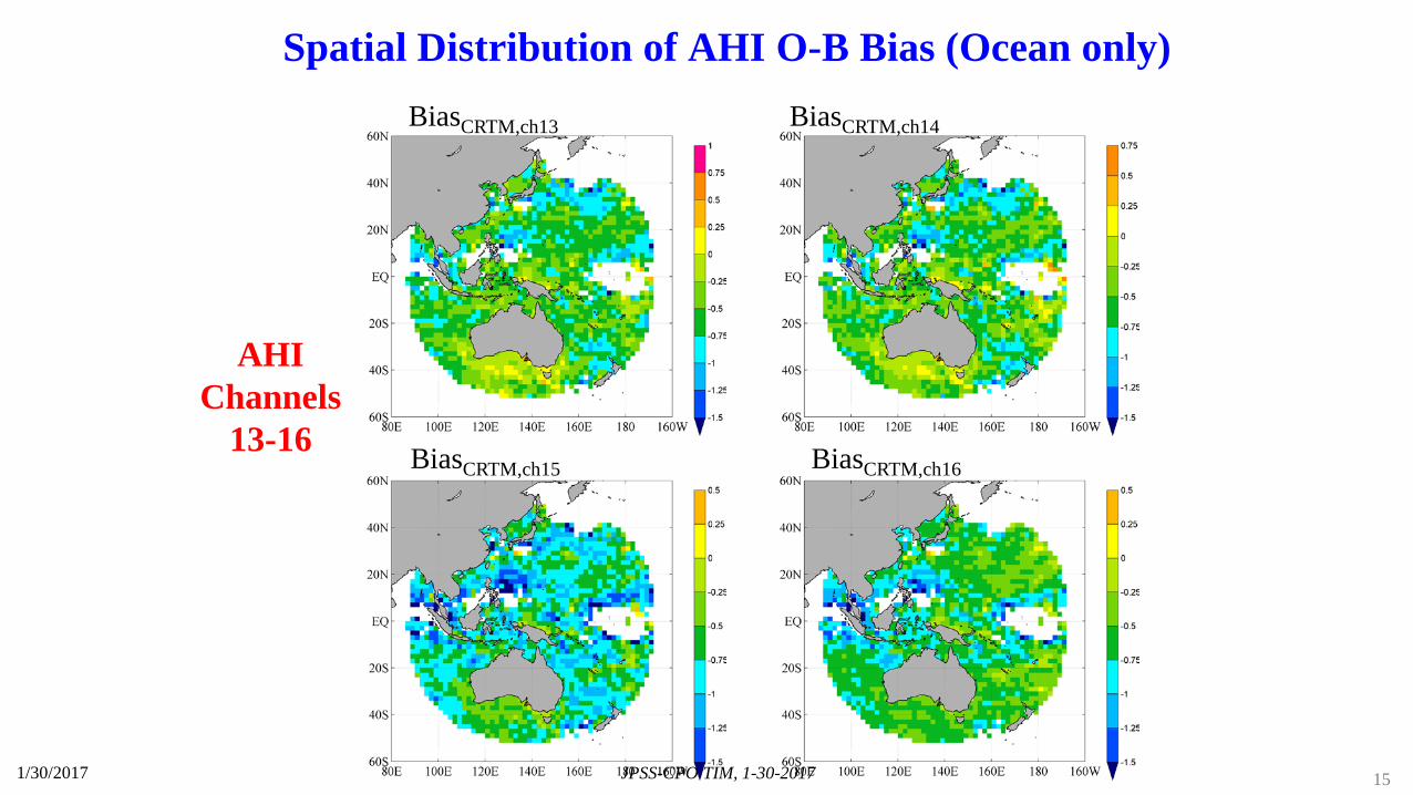
BiasCRTM,ch14BiasCRTM,ch13
BiasCRTM,ch15 BiasCRTM,ch16
AHIChannels
13-16
Spatial Distribution of AHI O-B Bias (Ocean only)
151/30/2017 JPSS-CPO TIM, 1-30-2017

Bia
s and
Std
. Dev
. (K
)
AHI Channel Number
Channel Bias (K) Std. (K)7 0.16 1.468 -0.25 1.169 0.40 1.1110 -0.38 0.8711 -0.68 0.8812 -0.15 0.7113 -0.54 0.9814 -0.51 1.0115 -0.78 1.0116 -0.61 0.71
All clear-sky data with satellite zenith angle being less than 60o are included.
Bias Std. Dev.
Bias and Standard Deviation between AHI Observations and CRTM/ECMWF Simulations (Ocean Only)
161/30/2017 JPSS-CPO TIM, 1-30-2017

Advanced Radiative Transfer Sciences for Satellite Data Assimilation
• Generate the new LUT for CRTM using discrete dipole approximation (DDA) to advance the cloudy and rain-affected radiance assimilation
• Develop a new interface for CRTM to incorporate the polarization capability
• Prepare CRTM readiness for uses of CrIS unapodized radiance data
• Evaluate cloud scattering and absorption table at infrared wavelengths
• Implement NLTE and solar reflection modules in CRTM
• Improve CRTM microwave surface emissivity model
1/30/2017 JPSS-CPO TIM, 1-30-2017 17

CRTM Software Architecture, Sciences and Physical Processes
• Atmospheric gaseous absorption Band absorption coeff trained by LBL spectroscopy data with sensor response
functions Variable gases ( H2O, CO2, O3 etc) . Zeeman splitting effects near 60 GHz
• Cloud/precipitation scattering and emission Fast LUT optical models at all phases including non-spherical ice particles Gamma size distributions
• Aerosol scattering and emission GOCART 5 species (dust, sea salt, organic/black carbon, ) Lognormal distributions with 35 bins
• Surface emissivity/reflectivity Two-scale microwave ocean emissivity Large scale wave IR ocean emissivity Land mw emissivity including vegetation and snow Land IR emissivity data base
• Radiative transfer scheme Tangent linear and adjoints Inputs and outputs at pressure level coordinate Advanced double and adding scheme Other transfer schemes such as SOI, Delta Eddington
1/30/2017 JPSS-CPO TIM, 1-30-2017 18
“Technology transfer made possible by CRTM is a shining example for collaboration among the JCSDA Partners and other organizations, and has been instrumental in the JCSDA success in accelerating uses of new satellite data in operations” – Dr. Louis Uccellini, Director of National Weather Service
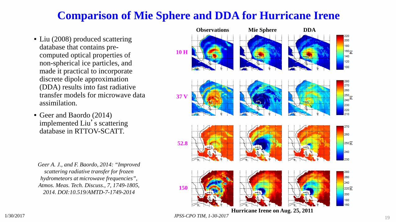
Observations Mie Sphere DDA
10 H
37 V
150
52.8
Geer A. J., and F. Baordo, 2014: “Improved scattering radiative transfer for frozen
hydrometeors at microwave frequencies”, Atmos. Meas. Tech. Discuss., 7, 1749-1805,
2014. DOI:10.519/AMTD-7-1749-2014
Hurricane Irene on Aug. 25, 2011
Comparison of Mie Sphere and DDA for Hurricane Irene
• Liu (2008) produced scattering database that contains pre-computed optical properties of non-spherical ice particles, and made it practical to incorporate discrete dipole approximation (DDA) results into fast radiative transfer models for microwave data assimilation.
• Geer and Baordo (2014) implemented Liu’s scattering database in RTTOV-SCATT.
1/30/2017 JPSS-CPO TIM, 1-30-2017 19

ATMS Observed and Simulated Tb from Mie and DDA
Observations
Ch 2 (31.4 GHz) Ch 22 (183.31±1.0 GHz)Ch 17 (165.5 GHz)
Simulations using
Mie Sphere
Simulations using DDA
176 196 216 236 256(K) 197 217 237 257 277(K) 229 235 241 247 253(K)
• The DDA can correct the over-estimation of scattering by Mie theory at 165 GHz
• The lower frequency channels are mainly affected by water phase clouds, thus the difference between DDA and Mie is not significant
• Scattering effect is not significant for upper-air temperature channels
1/30/2017 JPSS-CPO TIM, 1-30-2017 20
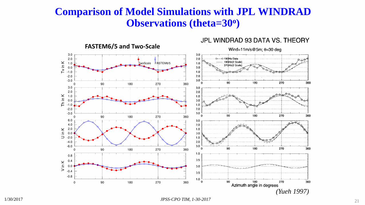
(Yueh 1997)
FASTEM6/5 and Two-Scale
Comparison of Model Simulations with JPL WINDRAD Observations (theta=30o)
1/30/2017 JPSS-CPO TIM, 1-30-2017 21

Summary and Conclusions • JPSS real-time data are assimilated in NCEP NWP models. Societal benefits from satellite data assimilation are
enormous. The large success is made through direct radiance assimilation in global NWP models• JPSS lfe-cycle data reprocessing s important for NWP reanalysis, fixed real-time bugs in instrument calibration and
SDR and improved the SDR algorithms for real-time applications• The approach of using the global DA system for regional NWP applications is challenging. In particular, the
regional NWP have different focuses (e.g. storm track, coastal precipitation). The evaluation of the data impacts on forecasts should be based on the forecasting variables. Also, more fine tunes are required for the quality control, bias corrections
• Satellite data streams from legacy missions were not optimally produced earlier. The lesson learned from SNPP ATMS – O2/H2O sounding channel data in a single data stream resulted in the highest impact on forecasts. Thus, an approach is proposed for combining AMSU-A and MHS data into one data stream for NWP community
• Assimilation of GOES IR imager radiances results in better QPF due to their high spatial/temporal resolutions, and low noises
• Cirrus clouds can cause a large uncertainty in simulating CrIS spectral radiances. The CrIS double CO2 bands can detect vertical distribution of non-opaque clouds, which will further improve the quality control for CrIS data assimilation
• There remain large uncertainties in CRTM for simulating rain-affected radiances and the surface emissivity over land.
1/30/2017 JPSS-CPO TIM, 1-30-2017 22