journal of modern chinese history the shanghai bund in myth and
TRANSCRIPT

PLEASE SCROLL DOWN FOR ARTICLE
This article was downloaded by: [Henriot, Christian]On: 26 May 2010Access details: Access Details: [subscription number 922547001]Publisher RoutledgeInforma Ltd Registered in England and Wales Registered Number: 1072954 Registered office: Mortimer House, 37-41 Mortimer Street, London W1T 3JH, UK
Journal of Modern Chinese HistoryPublication details, including instructions for authors and subscription information:http://www.informaworld.com/smpp/title~content=t777186831
The Shanghai Bund in myth and history: an essay through textual andvisual sourcesChristian Henriota
a Institut d'Asie Orientale (CNRS), University of Lyon, Lyon
Online publication date: 26 May 2010
To cite this Article Henriot, Christian(2010) 'The Shanghai Bund in myth and history: an essay through textual and visualsources', Journal of Modern Chinese History, 4: 1, 1 — 27To link to this Article: DOI: 10.1080/17535651003779400URL: http://dx.doi.org/10.1080/17535651003779400
Full terms and conditions of use: http://www.informaworld.com/terms-and-conditions-of-access.pdf
This article may be used for research, teaching and private study purposes. Any substantial orsystematic reproduction, re-distribution, re-selling, loan or sub-licensing, systematic supply ordistribution in any form to anyone is expressly forbidden.
The publisher does not give any warranty express or implied or make any representation that the contentswill be complete or accurate or up to date. The accuracy of any instructions, formulae and drug dosesshould be independently verified with primary sources. The publisher shall not be liable for any loss,actions, claims, proceedings, demand or costs or damages whatsoever or howsoever caused arising directlyor indirectly in connection with or arising out of the use of this material.

ARTICLE
The Shanghai Bund in myth and history: an essay through textual andvisual sources
Christian Henriot*
Institut d’Asie Orientale (CNRS), University of Lyon, Lyon
The Bund ranks first in any introduction to Shanghai in contemporary guides as a ‘‘mustsee’’ place where one can go to discover the wonders of Shanghai and its now sanitizedand non-controversial past. Current accounts usually point to the bizarre architecturalheritage that the municipal government has lately chosen to turn into a tourist attractionfor domestic and foreign consumption alike. The present paper intends to unveil a muchmore complex and multi-layered history. It relies on a large body of materials, especiallyvisual sources, to document the transformation of an undistinguished space – a riverfront– into a central place of political, social and architectural juxtaposition. This explorationwill start from the earliest visual records of the city, made by Chinese orWestern residentsand travelers and move into the late 1940s. This paper weaves different threads tohighlight the various layers of discourse that ‘‘made the Bund’’ while at the same timeblending textual and visual sources to illustrate its changing nature over time, from acommercial entrepot to a cityscape devoted to finance and leisure.
Keywords: urban; visual; architecture; Shanghai; representation
While Shanghai evokes mixed images of glamour, exoticism, a Sino–Western hybrid, theBund has almost become its metonym par excellence. The Bund ranks first in any introduc-tion to the city in contemporary guides as a ‘‘must see’’ place where one can go to discoverthe wonders of Shanghai and its now sanitized and non-controversial past. Current accountsusually point to the bizarre architectural heritage that the municipal government has latelychosen to turn into a tourist attraction for domestic and foreign consumption alike. Althoughthe Bund fell into relative obscurity after 1949, it returned to life with brightly illuminatedfaçades in the late 1980s and, more recently, with expensive and chic coffee-terraces on topof its ‘‘old’’ buildings.
The present paper aims to tell a different story and to unveil a much more complex andmulti-layered history. It relies on a large body of materials, especially visual sources, todocument the transformation of an undistinguished space – a riverfront – into a central placeof political, social and architectural juxtaposition. This exploration will start from the earliestvisual records of the city made by Chinese or Western residents and travelers and move intothe late 1940s. While brief references will be made to the revolutionary and post-revolutionary period, this essay focuses on the late Qing and Republican periods. In terms
Journal of Modern Chinese HistoryVol. 4, No. 1, June 2010, 1–27
*Email: [email protected]
ISSN 1753-5654 print/ISSN 1753-5662 online# 2010 Taylor & FrancisDOI: 10.1080/17535651003779400http://www.informaworld.com
Downloaded By: [Henriot, Christian] At: 17:25 26 May 2010

of geographical coverage, the focus is on the Bund as an icon, specifically the section of theriverfront that extended southward from Soochow Creek (Suzhouhe) to the border with theFrench Concession.1 Nevertheless, I shall also occasionally enlarge the scope to includethe riverfront of the French section and that of the Chinese walled city.
Previous studies of the Bund have generally focused on its architectural composition andtransformation. Jon Huebner’s paper offered one of the first systematic descriptions of thelast wave of high-rise buildings erected along the Bund in the International Settlement.While Huebner illuminates the nature and significance of these landmarks around whichWesterners construed a collective memory, he does not explore the various ramifications ofthe Bund as a specific space.2 Jeremy Taylor’s take on the Bund starts from an oppositeposture. It examines the Bund as a crucial element of the treaty-port system, a ‘‘spatial formthat emerged not only in Shanghai, but in many other ports open to foreign trade throughoutMainland China, Taiwan and Japan.’’3 Taylor also highlights the major functions –commercial, military, and recreational – of the Shanghai Bund along with other similarareas within their various settings. In his otherwise useful approach, however, Taylor tendsto read too much into the actual function and symbolic meaning of the Bund. That theshaping of these ‘‘bunds’’was tied to theWestern presence is undeniable. But to claim theyhad no precedent in the laying out of waterfronts in Chinese cities is certainly open todebate.
In the case of Canton, the ‘‘Thirteen Factories’’ formed a row of buildings that, beyondtheir façades, matched local building practices and style well before Westerners used theirgunboats to open up other treaty ports.4 Moreover, the formal resemblance between the‘‘bunds’’ built in various places did not translate into the same pattern of power relations andsocial intercourse. A ‘‘bund’’ could simply be aWestern-style waterfront with a large degreeof regulatory power in Chinese hands.5 The Shanghai Bund was a unique example in thatthis ‘‘spatial form’’ was backed up by a full set of strong and largely autonomous Westerndominated institutions (Shanghai Municipal Council, Mixed Court, Volunteer Corps, andMaritime Customs). This paper will weave different threads to highlight the various layers ofdiscourse that ‘‘made the Bund’’ while at the same time blending textual and visual sourcesto illustrate the changing nature of the Bund over time.
A note on sources and method
The present study is based in large part on visual materials, both paintings and photo-graphs. It is only through such sources that one can hope to reconstruct the century-longtransformation of this famous sector of the city, especially when it comes to a study ofarchitectural change. For paintings, I have made intensive use of an issue of Arts of Asia
1By convention, throughout this text, I shall use the original names for places in English for the pre-1949 period. I refer to these places in post-1950 Shanghai by their Chinese names in pinyin translitera-tion. Whenever necessary, I add the current Chinese name in brackets.2Jon W. Huebner, ‘‘Architecture and History in Shanghai’s Central District,’’ Journal of OrientalStudies, vol. 26, no. 2 (1988), 109–222.3Jeremy E. Taylor, ‘‘The Bund: Littoral Space of Empire in the Treaty Ports of East Asia,’’ SocialHistory, vol. 27, no. 2 (2002), 126.4Jonathan A. Farris, ‘‘Thirteen Factories of Canton: An Architecture of Sino–Western Collaborationand Confrontation,’’ Buildings and Landscapes, no. 14 (2007), 67–83.5Chen Yu, ‘‘The Making of a Bund in China: The British Concession in Xiamen (1852–1930),’’Journal of Asian Architecture and Building Engineering, no. 38 (2008), 31–38.
2 Christian Henriot
Downloaded By: [Henriot, Christian] At: 17:25 26 May 2010
devoted to the Bund, with its series of six nineteenth-century views of the Bund.6
Photographs, however, I had to identify and glean from a variety of sources, mostlybooks published before 1949.
Paintings may be considered a questionable source for the historian, at least whentaken as an ‘‘actual’’ source in viewing objects from the past. My approach, however, hasbeen to test the limits of these (superficially) imaginary renderings of the Bund. Of course,there is no reason to question the intent of the painters, most of them anonymous artists, togive a fairly accurate view of the riverfront. Yet, as for drawings and paintings by militarypainters, there is a significant margin for imagination, beautification, and other involuntaryor voluntary distortions. Arguably, the stakes in landscape representations are much lesssalient than when it comes to producing a visual report on a battle or other heroic moments.There is less risk of a major deformation.7 The artists, however, could have simplifiedthe view, or skipped an ugly building or ‘‘improved’’ it with a more decent appearance.While I had access only to the reproductions published in Arts of Asia, the quality washigh enough, especially after digitizing, to allow for close-up examination of individualbuildings.
Photographs, as compared to paintings, provide a more reliable view of reality. Inmy case, I was dealing with panoramic views of the Bund that left no room for‘‘framing’’ the picture. What is in the photograph was there. The issue was to find asmany images as possible that covered the entire Bund through its pre-1949 history. Inthe same way that the riverfront had attracted the eye of painters, photographers alsoendeavored to provide panoramic views of the Bund. They were initially limited intheir attempt by the technology of the time, which did not allow wide-angle shots.Creativity and skill, however, made up for this deficiency as the Bund was oftenphotographed section by section. Eventually, the photographer reconstituted a panora-mic view in the darkroom. These views were taken from the other side of the river,sometimes from a tower, with varying degrees of clarity. A major limitation in terms ofquality was that many of the photographs had been obtained from books. Digital toolsand software, however, helped improve the images.8
In using these visual materials, I had to address several issues. First was the necessity ofcollecting a representative sampling of pictures large enough to be able to see both thetransformation of the Bund over time, and to allow the possibility of comparative views. Itried to build a series that would cover as narrow a time interval as possible. Table 1 showsthat the temporal coverage is quite dense, even if large gaps still exist. Yet all the majortransformations took place during periods that preceded these views by just a few years.
6Eric Politzer, ‘‘The Changing Face of the Shanghai Bund, Circa 1849–1879,’’ Arts of Asia, vol. 35,no. 2 (2005), 64–81.7See Anne-Claude Ambroise-Rendu, ‘‘Du dessin de presse à la photographie (1878–1914): histoired’une mutation technique et culturelle,’’ Revue d’Histoire Moderne et Contemporaine, vol. 39(January–March 1992), 6–28.8Sources of the photographs: Ch-B Maybon and Jean Fredet, Histoire de la Concession française deChanghai [Bund in 1873 & 1876–1878] (Paris: Plon, 1929); Politzer, ‘‘The Changing Face of theShanghai Bund’’ [Bund in 1876]; Arnold Wright, Twentieth Century Impressions of Hong Kong,Shanghai, and Other Treaty Ports of China: Their History, People, Commerce, Industries, andResources [Bund in 1907–1908] (Lloyds Greater Britain Publishing Company, 1908); ShimazuCh�ojir�o, Shanhai annai [Bund in 1893 & circa 1913] (Shanghai: Kinp�usha, 1918); ShanhaiKyory�umindan sanj�ugosh�unen kinenshi [Bund in 1894 & 1937–1938] (Shanghai: ShanhaiKyory�umindan, 1942); Kobori Rintar�o, Natsukashi no Shanhai: shashinsh�u [Bund in 1916–1918](Tokyo: Kokusho Kank�okai, 1984); Virtual Shanghai, ‘‘General View of the Bund and Huangpu Riverfrom Pudong’’ [Bund in 1898–1901].
Journal of Modern Chinese History 3
Downloaded By: [Henriot, Christian] At: 17:25 26 May 2010

While I may have missed a few buildings, I believe almost all the major structures that wereerected along the Bund are included. A second issue was the dating of the paintings and thephotographs. For the former, I relied on the dates provided by Eric Politzer in his Arts of Asiapaper, although I made a careful study of their content to assess their credibility.9
Photographs, in contrast to paintings, rarely came with an indication of the exact year theywere taken. Usually there was a crude indication based on the date of publication (such as‘‘A current view of’’). By going back and forth between the images and the records, from thedate of construction/destruction of the buildings and other items displayed in the photo-graphs, I was able to narrow down the time frame of several pictures.10 Unfortunately, at thisstage, I am unable to pin most of them down to a single year.11
Time frame of the Bund views
The third source I mobilized for this study is comprised of maps. They were useful in severalways. First, because maps sometimes display specific buildings, I was able to ascertain theexistence of buildings at a certain point in time, even if the accuracy of commercial maps issometimes questionable. Second, maps provided the exact location of the buildings repre-sented in the images. The general views of the Bund I used – both paintings and photographs– hardly showed any details about the space between the buildings, even when there was an
Table 1. Time frame of the Bund views.
Paintings Photographs
circa 1849–1850circa 1854circa 1857circa 1862circa 1867–1868circa 1879 1873 and 1876–1878
1893 and 18941898–19001907–190819131916–19181937–1938
9Eric Politzer’s work is based on the use of visual (paintings), cartographic (the 1925 version of the1855 map of the British Settlement and a cadastral map of 1864–1866) and textual (especiallynewspapers and Hong Lists) records. He produced a very careful and well-documented study of thebuildings of the Bund during the 1849–1879 period. His approach was very similar to mine, but in mycase, apart from extending the period of investigation into the twentieth century, the use of GIS-basedmaps allowed me to reconstitute the cadastral lots and location of buildings through time. Politzer,‘‘The Changing Face of the Shanghai Bund,’’ 8010On the buildings of the Bund and their dating, a most useful tool is Peter Hibbard, The BundShanghai: China Faces West (Hong Kong: Odyssey, 2007).11There were three photographs that came with estimated periods or no indication at all: one fromWright, Twentieth Century Impressions (no indication, book published in 1908); Shimazu, Shanhaiannai (‘‘present view’’ of the Bund, book published in 1918); Natsukashi no Shanhai (no date given).The ‘‘internal critique’’ of these documents led to the following dating: respectively 1907–1909;1910–1912; 1914. For a discussion of the dating method, see individual photographs in the VirtualShanghai image database.
4 Christian Henriot
Downloaded By: [Henriot, Christian] At: 17:25 26 May 2010
empty yard. The streets are either not represented or hidden from view both in paintings andphotographs. Perspective also introduced a distortion in assessing which building waswhere, or simply to make sure a building was indeed on the Bund (and not in the back-ground). To overcome this problem, I reconstituted the cadastral lots on maps and tracedtheir transformation over time.12
The textual records were also an essential part, both helpful but also misleading. They arefrequently not accurate, being documents produced well after the period they study.13
Another problem in the written records is that buildings are usually referred to by thename of their occupant rather than by the structure itself. Conversely, some companiesremained on the same spot, but rebuilt their premises two or three times. Finally, somecompanies moved their offices to different locations on the Bund. In other words, one mightbe led to believe there is a new building where there is only a change of owner or tenant. Toavoid assuming a new building where there was only a new tenant, I had to trace theoccupancy of the buildings. The second case – reconstruction of the premises – was ofcourse easier to solve through the visual record, while the ‘‘intra-Bund’’moves were indeedlimited.
By going back and forth between the maps, the images and the textual records onindividual buildings, I built a small database that identified almost every building on theBund and provided a timeline of its transformation. I then matched the transformation of thebuildings over time with the visual sources. There remained a few gaps of minor buildingswhich I was not able to identify.14
The Bund through words and works
The conventional explanation for the use of the term ‘‘Bund’’ is a Hindi word [band]meaning ‘‘embankment.’’ It was part of the general phenomenon of using foreign wordsin the pidgin that served as a lingua franca among merchants in the various ports from Indiato China.15 Some authors argue this was part of a general process of appropriating words
12Sources of the major maps: ‘‘Ground Plan of the Foreign Settlement at Shanghai –North of the YangKang Pang Canal,’’ from a survey by Mr FB Youel RN, 1855; ‘‘Plan of the English Settlement atShanghae’’ (Shanghai: Shanghai Municipal Council, 1864–1866); ‘‘Street Plan of the English, Frenchand American Settlement’’ (London: published for the North China Herald and North China Daily NewOffices, Shanghai, circa 1870); ‘‘Plan de la concession française à Shanghai’’ (Shanghai: Imprimeriede Erhard, 1882); ‘‘Cadastral Plan of the (So-called) English Settlement Shanghai’’ (Shanghai:Shanghai Municipal Council, 1890); ‘‘Street Plan of the British and French Settlements’’ (Shanghai,1900); ‘‘Saishin Shanhai chizu’’ [The NewMap of Shanghai City] (Shanghai: Sh�osuido Sh�oten, 1908);‘‘Street Plan of the Foreign Settlement (Central District) & French Settlement at Shanghai,’’ in TheChronicle and Directory for China, Corea, Japan, the Philippines, Indo–China, Straits Settlements,Siam, Borneo, Malay states, etc. (Hong Kong: ‘‘Daily Press’’ Office, 1895 & 1926); ‘‘Saishin Shanhaichizu’’ [The New Map of Shanghai City] (Osaka: Mainichi shinbunsha, 1932); Shanghai shi hanghaolutu lu [Shanghai Street Directory], 2 vols. (Shanghai: The Free Trading Co. Ltd., 1939–1940).13A case in point is the 1857 picture of the Bund and its labeling by Morse in his 1910 book. Thecaptions have been taken for granted and reproduced in various publications. For a full discussion ofMorse’s captions, see Politzer, ‘‘The Changing Face of the Shanghai Bund,’’ 76–77.14For 1987, I used Shanghai shi shangyong dituce [Shanghai Business Atlas], 7 vols. (Shanghai:Shanghai fanyi chuban gongsi, 1987).15The term came to be used by civil engineers in Shanghai – ‘‘bunding’’ – to designate the action ofplacing sloping stone pavement against an earth bank with a foundation of fascine work and a stonewall at the toe of the sloping pavement. H. von Heidenstam, The Improvement of the Huang Pu River(Shanghai, China) for Ocean Navigation (Brussels: Permanent International Association ofCongresses of Navigation, Office of the Secretary General, 1920), 16.
Journal of Modern Chinese History 5
Downloaded By: [Henriot, Christian] At: 17:25 26 May 2010

from various colonized countries as British imperialism made its progress to the East and to‘‘mark’’ newly conquered spaces with a symbolic meaning.16 How the word ‘‘Bund’’ cameinto usage in Shanghai has not been documented. It appears to have been used quite early,although its adoption as the official name of the riverfront in Shanghai came at a fairly latedate.
Apart from hand-made rough schematic drawings, the earliest extant map of the EnglishSettlement dates from 1855. While all the streets of the settlement bore proper names, theriverfront was still nameless.17 On later maps, as on the 1864–1866 cadastral map,18 the1870 map of the English, French and American settlements19 or the 1890 ‘‘Cadastral plan ofthe (so-called) English settlement’’20 the road was designated as ‘‘Bund or Yangtsze Road,’’reflecting an ambiguity between common usage (Bund) and the official designation estab-lished in 1865.21 Ten years later, however, the riverfront was clearly labeled the ‘‘Bund.’’22
As we do not have maps for the interval, we cannot ascertain when the name became official.Until we find other textual evidence, we can only assume the Bund became the official nameof the riverfront some time around 1900. While there is no doubt that the word was in usemuch earlier and was most probably part of the common language, the absence of designa-tion also points to a change of perception regarding the riverfront when it came to beassociated with a more glamorous image that emerged at a later stage.
The other major designation of the Bund is of course its name in Chinese. It has notchanged since the nineteenth century, and probably earlier, when the term waitan simplydesignated the ‘‘outside bank’’ of the Huangpu River.23 Before Westerners were allowed tosettle in Shanghai on a small strip of land north of the walled city, the riverbank had been inuse for many centuries. Of course, only the section that followed the riverfront along the citywall was actually used as a mooring and transshipment area. The reason for the distinctionbetween an ‘‘outside’’ bank and an ‘‘inner’’ bank is one of geography in relation with thewalled city. The upper stream of any river was called li (internal, inside); the lower streamwas called wai.24 The local Chinese therefore distinguished between the ‘‘inside bank’’(neitan), south of an imaginary line set at Lujiabang Creek and the ‘‘external bank’’ (waitan)north of that line.25 While the southern section hosted warehouses, wharves, and mooringareas, the northern section had very little relevance as it had no specific function besides a‘‘rope walk’’ as we shall see below. The ‘‘active’’ part of the riverfront was named shiliupu
16Taylor, ‘‘The Bund,’’ 129. The argument is debatable. One can also read this linguistic process ofappropriating foreign words as a form of spontaneous hybridization and a practical way of working outa common language. The term ‘‘bund,’’ at least in Chinese, never had an impact on the native language.17‘‘Ground Plan of the Foreign Settlement at Shanghai – North of the Yang Kang Pang Canal.’’18‘‘Plan of the English Settlement at Shanghae.’’19‘‘Street Plan of the English, French and American Settlement’’ (London: published for the NorthChina Herald and North China Daily New Offices, Shanghai, circa 1870).20‘‘Cadastral Plan of the (So-called) English Settlement, Shanghai.’’21In 1865, the SMC adopted the first general scheme that established the names of all roads in thesettlement, with all North–South streets named after Chinese provinces and East–West streets namedafter Chinese cities. The road along the Huangpu was named ‘‘Yangtsze Road.’’ Yuan Xieming,‘‘Gongbuju yu Shanghai luzheng’’ [The Shanghai Municipal Council and Road Policy], Shanghaiyanjiu luncong, no. 2 (1989), 176; Hibbard, The Bund Shanghai, 27–33.22‘‘Street Plan of the British and French Settlements,’’ Shanghai, 1900.23I chose to translate tan as ‘‘bank.’’ The actual meaning is closer to ‘‘beach,’’ which it actually wasuntil the Bund was turned into an embankment by placing wooden posts along the bank. Up to then, atlow ebb, the river withdrew and left a 30-meter wide open mud bank.24Xue Liyong,Waitan de lishi he jianzhu [History and Construction of the Bund] (Shanghai: Shanghaishehui kexueyuan chubanshe, 2002), 2.25Ibid., 3.
6 Christian Henriot
Downloaded By: [Henriot, Christian] At: 17:25 26 May 2010
after the administrative system that divided the walled city and its suburbs into variousdistricts (pu).26
In the French Concession, the word ‘‘Bund’’ never made it into the local official orinformal language. Pidgin notwithstanding, the French stuck to the conventional designationof ‘‘quai’’ (wharf) to name their section of the riverfront. That section was initially verylimited, as it stretched from Yangjingbang Creek, which separated the two settlements, to itsterminus with adjoining Chinese-administered territory along the creek that bordered theTianhougong (Temple of the Queen of Heaven). The riverfront was simply named after theriver, Quai du Whampoo (Whampoo Wharf). In 1861, the French obtained an extension ofthe settlement that included the area south of the initial border down to the canal that flowedout of the Eastern Gate (Dongmen). This was precisely the section of the Chinese Bundcalled ‘‘Shiliupu.’’ To give it more grandeur in French eyes, the riverfront was christened‘‘Quai de France.’’ Eventually, the name ‘‘Quai du Whampoo’’ was dropped and the entiresection was officially called Quai de France. This was part of a general movement in theearly years of the twentieth century that saw the French municipality getting rid of mostreferences to Chinese place names for street designations and replacing them with those oflocal or national luminaries, or with names that highlighted French accomplishmentsoverseas.27
Before the opening of the harbor to foreign trade, the riverbank had no special equipmentor infrastructure for junks or sampans. Although there was an active domestic and interna-tional trade going through Shanghai, ships simply used the riverbank as it was, exceptaround the Eastern gate (Dongmen) where a sort of embankment had been built. Dependingon the time of the day, low tide or high ebb, the river left open a strip of sand (tan). The namein Chinese took its origin from this. The only specific feature was a pathway traced by boatpullers along the riverbank. It was called xiandao, or the ‘‘Rope path (or walk)’’ andconstituted the only way along the river. When Westerners came to Shanghai, the areaalong the river north of the Walled City was just that rope path.28 In the English Settlement,the Land Regulations approved by Chinese authorities prohibited foreigners from buildingright along the river. This was meant precisely to protect the ‘‘rope walk’’ from encroach-ment and allow the passage of the pullers.29 Yet even before the Regulations were signed,foreign residents – actually foreign hongs – had started to consolidate and enlarge theoriginal ‘‘rope walk’’ to twice its official width.30 Obviously technological progress wouldsoon make the use of ropes to pull boats irrelevant, but the rule remained in force. As a result,the riverfront remained free from construction and eventually was transformed into a major1500-meter long thoroughfare.31
By the late 1840s, all the British settlement offered to the viewer was no more than a fewroads that crept into the newly built-up area behind the ‘‘Bund.’’ The early settlement wasbordered by four waterways, with two main rivers, the Huangpu and Soochow Creek in the
26Xue Liyong, Shanghai tan diming zhanggu [Stories about the Place Names of the Shanghai Bund](Shanghai: Tongji daxue chubanshe, 1994), 238–40.27On the history of street names in the French Concession, see the study by J.H. Haan, The Sino–WesternMiscellany, Bseing Historical Notes about Foreign Life in China (no publisher given, 1993).28Ke Zhaoyin and Zhuang Zhenxiang, eds., Shanghai tan yeshi [An Unofficial History of the ShanghaiBund] (Nanjing: Jiangsu wenyi chubanshe, 1993), 8; Xue Liyong, Waitan de lishi he jianzhu, 2.29‘‘Shanghai tudi zhangcheng’’ [Shanghai Land Regulations], in Shanghai gonglu shi [A History ofShanghai Streets], ed. Li Shihua (Shanghai: Renmin jiaotong chubanshe, 1989), 201.30Wu Jiang, Shanghai bai nian jianzhu shi, 1840–1949 [The History of Shanghai Architecture,1840–1949] (Shanghai: Tongji daxue chubanshe, 1997), 47.31Wang Shaozhou, Shanghai jindai chengshi jianzhu [Shanghai Modern City Construction] (Nanjing:Jiangsu kexue jishu chubanshe, 1989), 17.
Journal of Modern Chinese History 7
Downloaded By: [Henriot, Christian] At: 17:25 26 May 2010
East and North respectively, and Defense Creek and the Yangjingbang in theWest and Southrespectively. By any measure, it was no more than a small flake of foreign presence amidst alandscape dominated by rice fields and waterways, next to a sturdy but massive Chinesewalled city. Roads actually ranked high on the agenda for the new settlers. The first proto-municipal organization established for the management of the new land was designed to takecare of ‘‘roads and jetties.’’32 Little was done in terms of actual planning before 1854,although the establishment of lots after November 1843 called for the proper delimitation ofspace between the lots. As early as 1846 the first mud roads were ploughed through the flatland: Barrier Road, Park Lane, Rope Walk Road, and the Bund itself.33 Along the river, themajor endeavor was the construction of jetties. As the Chinese had previously done, foreignships initially simply moored close to jetties from and to which the various goods werecarried by small-boat: ‘‘Early Shanghai knew nothing of wharves alongside which vesselscould load and unload. All this was done from and into native boats in the stream, the cargocoming and going from jetties jutting out from the Bund.’’34
For about two decades, the Bund was largely left in its original state, even if privateinitiative had started to transform it with the addition of jetties. Over time the path along theriver was widened and covered with a mix of ashes and refuse. In an 1849–1850 painting, theriverbank remains pretty much in its ‘‘natural’’ state, even if jetties can be seen protrudingfrom the bank.35 In 1861, pavement was laid along the Bund as part of a general plan toimprove the condition of roads.36 It did not prove satisfactory, however, and one year later,the Shanghai Municipal Council (SMC) decided to build an embankment.37 Consolidationwas achieved by planting wooden posts all along the riverfront, as an 1862 painting and aphotograph of the Customs House show.38 This had the effect of delineating land from watermore sharply and laid the groundwork for further consolidation. One visual source, however,tends to throw this chronology into question. For, in an 1854 painting, the Bund appears tobe carefully lined with wooden posts already.39 I initially questioned the dating of thepicture, but its content makes it clear that the pilings date prior to both an 1857 painting(on which the wooden posts are not visible) and an 1862 painting (on which the woodenposts are in evidence). The textual record will have to be revisited to solve this enigma.
32The ‘‘Committee on roads and jetties’’ was later renamed ‘‘Municipal Council’’ after the signing ofthe Land regulations between the British Consulate and the Shanghai Daotai in 1854. Initially there wasa plan to have all foreign areas – British, American, and French – to come under a single municipalorganization called ‘‘Executive Committee’’ (gongbuju in Chinese). Yet the plan for a single admin-istration failed when the French decided to preserve their autonomy. The ‘‘Executive Committee’’ wasrenamed ‘‘Municipal Council’’ (Shanghai Municipal Council), though the Chinese name remainedunchanged. In the French Concession, the process was very similar with a ‘‘Comité des routes’’ initiallytaking care of the first layout of roads. Maybon and Fredet, Histoire de la Concession française,264–65.33Shanghai gonglu shi, 1989, 27.34Samuel Couling andGeorge Lanning, The History of Shanghai (Shanghai: Kelly &Walsh, 1921), 389.35Arts of Asia, vol. 35, no. 2 (2005), 68–69.36Yuan Xieming, ‘‘Gongbuju yu Shanghai luzheng,’’ 175.37Ke Zhaoyin and Zhuang Zhenxiang, eds., Shanghai tan yeshi, 8.38Arts of Asia, vol. 35, no. 2 (2005), 72–73; ‘‘Customs House,’’ photograph, undated, 2003.R22 Box35, Getty Research Institute. In its early stage, the Bund probably looked like the Bund at Jiujiang forwhich J. Thomson left a good photographic record. J. Thomson, Illustrations of China and its People.A Series of Two Hundred Photographs, with Letterpress Descriptive of the Places and PeopleRepresented, vol. 3 (London: Sampson Low, Marston, Low, and Searle, 1874).39Arts of Asia, vol. 35, no. 2 (2005), 68–69.
8 Christian Henriot
Downloaded By: [Henriot, Christian] At: 17:25 26 May 2010

In an 1867–1868 painting, the northern part of the Bund is already bounded by a moresolid embankment made of stone.40 This reinforcement was done in order to stabilize theland at the mouth of Soochow Creek. As land stabilized, the area was further widened andturned into a public garden.41 The work of filling the area to create the garden started in 1866and was completed in August 1868.42 It is visible in later paintings and photographs of the1870s. By ‘‘bunding’’ the river at the limit at the water level of low tide, under the protectionof the filled-in public garden, the SMC actually reclaimed a very large area outside theoriginal line of the Bund by filling in the space under the jetties.43 Later, the enhancement ofthe Bund also benefited from new technologies. Public lighting came on the heels of theestablishment of the first gas company in 1865. The Bund was among the first streets tobenefit from the new service. Electricity followed not much later, in 1882 and again theBund, along with Nanking Road, were the first to be graced with new electric lamps. Havingbeen built almost entirely on barren land, the appearance of the early streets remained quiteelementary. In 1865, trees were planted along the major arteries, starting with the Bund.44
From the visual sources, however, it seems that the trees took some time before catching theeyes of artists. Their presence became obvious only in mid-1870s photographs or late-1870spaintings.
In the French Concession, work to build a proper embankment started in 1855 on the initialsection of the riverfront. The Small Sword Rebellion had left much of the area in ruins. Afterremoving the rubble and debris, French sailors traced a rough path along the river. A road wasconstructed in 1856 by a group of 200 Christian refugees who were employed as coolies.45
Little progress was made, however, due to the lack of human presence in the FrenchConcession.46 Yet what constituted the French section of the riverbank soon became toosmall to accommodate all the requests for land, warehouses and jetties. In 1860, due to thepressure of private companies for more space along the river, the French consul initiated a newround of negotiations to obtain a stretch of land that ran southward to the Small East gate.Eventually, the extension was granted in 1861, which gave the French Bund an extra 650meters.47 Yet, while more jetties were being constructed, the riverfront remained in a pitifulstate. The French consul, Brenier de Montmorand, described it in 1864 as the following:
A badly drained and hardly leveled ground, often cut by large cracks after heavy rain. Itnarrowed between the low tide mark, a large strip of sand from which the summer sun causedunhealthy exhalations, with a few non-aligned and unassuming houses. In daytime, it lookeddeserted and dreary; at night it was hardly lighted by a few badly kept gas lamps.48
40Ibid., 79–80.41The area where the public garden stands was originally called the ‘‘Consular Flats.’’ It was formed bythe accumulation of mud and silt from the river around the wreck of a small vessel that had sunk nearthe site. Rev. C.E. Darwent, Shanghai. A Handbook for Travellers and Residents (Shanghai: Kelly &Walsh, 1904), 3.42Darwent, Shanghai. A Handbook, 3.43The photographic record documents the gradual process that turned the Bund from a small road into awide area encompassing a road, a space covered with grass and trees, and jetties and pontoons. Theearlier 30-meter long jetties were progressively turned into pathways on the newly reclaimed land. SeeHibbard, The Bund Shanghai, 37–45.44Yuan Xieming, ‘‘Gongbuju yu Shanghai luzheng,’’ 175–76 and 179.45Maybon and Fredet, Histoire de la Concession française, 163–64; ‘‘Fa zujie waitan de di yi tiaomalu’’ [The First Road on the Bund of the French Concession], in Shanghai yanjiu ziliao [ResearchMaterials on Shanghai] (1936; repr., Shanghai: Shanghai shudian, 1984), 345.46Maybon and Fredet, Histoire de la Concession française, 61.47Ibid., 239 and 244.48Ibid., 287–88.
Journal of Modern Chinese History 9
Downloaded By: [Henriot, Christian] At: 17:25 26 May 2010

One of the major impediments to the remodeling of the riverfront was clearly the lack offinancial resources by the FrenchMunicipal Council. The priority was given to dredging andcleaning the creeks and moat along the wall and to removing the trash that had accumu-lated.49 The Messageries Impériales Company built its own wharf by 1863, but serious talksabout improving the riverfront did not start until the following year.50 The French MunicipalCouncil hired a British engineer, Freeman, to build a proper embankment along the northernsection (Quai du Whampoo) of the riverfront. Work started in October 1864, but soon after,in January 1865, a part of the new Bund collapsed, causing a dispute between the Frenchauthorities and the British engineer, which provided an opportunity for sarcastic commentsin the North China Herald.51 Eventually, that section was completed in 1867 with the costborne mostly by a special tax on the lots along the newly built 30-meter wide Bund, whichincluded several floating jetties.52 The southern section was initially simply drained thanksto a new canal and paved, while a new gate (Porte Montauban – Xin beimen) was opened inthe wall to facilitate communication with the walled city.53
The Chinese section of the Bund was the responsibility of local authorities, but littlework was done here until the late nineteenth century. From the various records we have, itseems the anchorage was left much to its original layout, with boats mooring in front of thecity walls and the loading and unloading of the larger junks performed by small craft. Due toits central role as a transshipment harbor between North and South China, and one of themajor outlets for the Jiangnan area, a whole district had developed outside of the walled citysince at least Ming times, as one painting shows.54 By the mid-eighteenth century, there were27 small streets that ran through the area.55 Shanghai received a very high number of boatsand ships of all sizes. On an average year, about 1200–1300 large ships (80–240 tons) and2500–2600 smaller crafts (of less than 80 tons) which handled a total freight of about280,000 tons, cleared the port.56 In 1849, a British visitor noted that ‘‘the suburb on thisside of the river is very extensive and densely populated.’’57
As part of the modernization efforts of late Qing reformers, an arsenal and shipyard, theJiangnan Arsenal, was established south of the walled city. To facilitate traffic, a first effortwas made to improve the road along the Huangpu.58 Work on the Chinese Bund started in1896 and was completed one year later. The road was nine meters wide and had a full lengthof 2412 meters.59 This improvement came with the establishment of the first proto-municipal organs in 1895. As with the ‘‘Committee on Roads and Jetties’’ in the BritishSettlement, the new organ, the South City Roadwork Board (Nanshi malu gongchengju) was
49Ibid., 270.50‘‘Fa zujie waitan de diyige matou’’ [The First Wharf on the Bund of the French Concession], inShanghai yanjiu ziliao, 357.51Maybon and Fredet, Histoire de la Concession française, 288–89; Haan, The Sino–WesternMiscellany, 90.52Maybon and Fredet, Histoire de la Concession française, 289, 295.53Ibid., 238. See picture ‘‘New North Gate (Porte Montauban),’’ China collection, Box 35, GettyResearch Institute.54See reproduction in Sun Ping, ed., Shanghai chengshi guihua zhi [Gazetteer of Shanghai UrbanPlanning] (Shanghai: Shanghai shehui kexueyuan chubanshe, 1999), 56.55Shanghai gonglu shi, 14.56Zhang Zhongmin, ‘‘Qing qianqi Shanghai gang fazhan yanbian xintan,’’ Zhongguo jingjishi yanjiu[Researches in Chinese Economic History], no. 3 (1981), 91.57Henry Charles Sirr, China and the Chinese: Their Religion, Character, Customs and Manufactures:The Evils Arising from the Opium Trade with a Glance at our Religious, Moral, Political, andCommercial Intercourse with the Country (London: W.S. Orr, 1849), 210.58Wu Jiang, Shanghai bai nian jianzhu shi, 1840–1949, 53.59Wang Shaozhou, Shanghai jindai chengshi jianzhu, 491; All about Shanghai, 61.
10 Christian Henriot
Downloaded By: [Henriot, Christian] At: 17:25 26 May 2010

concerned with the construction and maintenance of roads.60 After its renovation, the roadcame under strict supervision including new regulations about taxes, hygiene, traffic, andshop signs.61 Throughout the late Imperial and Republican periods, it remained a bustlingcommercial area and a densely populated quarter. It was, however, an architecturallyundistinguished riverfront, lined with dockyards, warehouses, hospitals, and various ship-ping, timber and rice offices through the 1930s.62
Architectural transformation and change of function (1849–1949)
The status of Shanghai as one of the principal entrepots between Europe and China wasmirrored by the architectural transformation of its waterfront. From its initial period as ameager outpost of mercantile enterprise, the Bund quickly became the main stage forshowcasing the city’s growing stature as a nexus of trade and finance. By tracing the growthof its physical form we can gain some insight as to how the power holders in Shanghai sawthemselves and wanted to be seen by the outside world. The Bund in the InternationalSettlement went through three successive waves of renewal. Of course, the erection of newbuildings did not take place simultaneously with these periods of transformation. Yet in mostlocations, buildings were torn down and reconstructed two to three times. The highly visibletransformation of the Bund skyline, however, entailed much more than a physical renova-tion. It also reflected a deeper change in the economic and social function of the Bund(Figure 1).
From the 1850s to the early 1870s, the Bund was lined with one-story and two-storybuildings. While they may have looked impressive to the newcomer, as Wang Tao recalled,the buildings distinguished themselves more by their style than by their actual height.Chinese temples or guildhalls in the walled city were far more imposing. Many buildingswere simple one-level warehouses. The first generation of buildings was made up ofconstruction that often combined both offices and living quarters. As some companieswere able to acquire large tracks of riverfront, like Dent & Co. or Russel & Co., theyestablished large compounds made up of several buildings. Later, these compounds wereparceled out and gave way to new individual structures.
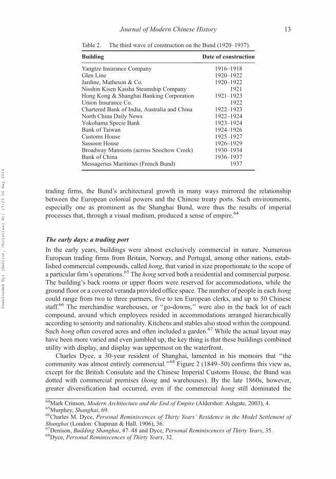
The second wave of construction was spread over a few decades starting from the 1880sto around WWI. There was a double transformation. On the one hand many original lotswere subdivided, opening up space for entirely new buildings. On the other hand, manyexisting edifices underwent their first transformation from their original ‘‘compradoric’’style – a generic Southeast Asian style – to an equally pompous though more massiveappearance. The third and last wave of construction – the one that gave the Shanghai Bundits present allure – took place over a single decade between 1920 and 1929, although a fewmore additions were made in the 1930s. Table 2 lists all the buildings that sprang fromground during these two fateful decades. This spate of construction is a direct reflection ofthe formidable growth and push for modernization that engulfed the city before the secondSino–Japanese war.
60See Mark Elvin, ‘‘The Administration of Shanghai, 1905–1914,’’ in The Chinese City between TwoWorlds, ed. Mark Elvin and William G. Skinner (Stanford, CA: Stanford University Press, 1974),239–62; Jack Gray, ed., ‘‘The Gentry Democracy in Shanghai, 1905–1914,’’ inModern China’s Searchfor a Political Form (London: Oxford University Press, 1969), 41–65.61Yuan Xieming, ‘‘Gongbuju yu Shanghai luzheng,’’ 201.62All about Shanghai, 59 and 61.
Journal of Modern Chinese History 11
Downloaded By: [Henriot, Christian] At: 17:25 26 May 2010

The third wave of construction on the Bund (1920–1937)63
This momentous change is significant because it happened in a unique setting. Whether byformal administrative bodies or in the subtler expression of power embodied by powerful
Figure 1. Map and cross-section of the Bund. See also Figure 2.
63Based on Wu Jiang, Shanghai bai nian jianzhu shi, 1840–1949, 113.
12 Christian Henriot
Downloaded By: [Henriot, Christian] At: 17:25 26 May 2010
trading firms, the Bund’s architectural growth in many ways mirrored the relationshipbetween the European colonial powers and the Chinese treaty ports. Such environments,especially one as prominent as the Shanghai Bund, were thus the results of imperialprocesses that, through a visual medium, produced a sense of empire.64
The early days: a trading port
In the early years, buildings were almost exclusively commercial in nature. NumerousEuropean trading firms from Britain, Norway, and Portugal, among other nations, estab-lished commercial compounds, called hong, that varied in size proportionate to the scope ofa particular firm’s operations.65 The hong served both a residential and commercial purpose.The building’s back rooms or upper floors were reserved for accommodations, while theground floor or a covered veranda provided office space. The number of people in each hongcould range from two to three partners, five to ten European clerks, and up to 50 Chinesestaff.66 The merchandise warehouses, or ‘‘go-downs,’’ were also in the back lot of eachcompound, around which employees resided in accommodations arranged hierarchicallyaccording to seniority and nationality. Kitchens and stables also stood within the compound.Such hong often covered acres and often included a garden.67 While the actual layout mayhave been more varied and even jumbled up, the key thing is that these buildings combinedutility with display, and display was uppermost on the waterfront.
Charles Dyce, a 30-year resident of Shanghai, lamented in his memoirs that ‘‘thecommunity was almost entirely commercial.’’68 Figure 2 (1849–50) confirms this view as,except for the British Consulate and the Chinese Imperial Customs House, the Bund wasdotted with commercial premises (hong and warehouses). By the late 1860s, however,greater diversification had occurred, even if the commercial hong still dominated the
Table 2. The third wave of construction on the Bund (1920–1937).
Building Date of construction
Yangtze Insurance Company 1916–1918Glen Line 1920–1922Jardine, Matheson & Co. 1920–1922Nisshin Kisen Kaisha Steamship Company 1921Hong Kong & Shanghai Banking Corporation 1921–1923Union Insurance Co. 1922Chartered Bank of India, Australia and China 1922–1923North China Daily News 1922–1924Yokohama Specie Bank 1923–1924Bank of Taiwan 1924–1926Customs House 1925–1927Sassoon House 1926–1929Broadway Mansions (across Soochow Creek) 1930–1934Bank of China 1936–1937Messageries Maritimes (French Bund) 1937
64Mark Crinson, Modern Architecture and the End of Empire (Aldershot: Ashgate, 2003), 4.65Murphey, Shanghai, 69.66Charles M. Dyce, Personal Reminiscences of Thirty Years’ Residence in the Model Settlement ofShanghai (London: Chapman & Hall, 1906), 36.67Denison, Building Shanghai, 47–48 and Dyce, Personal Reminiscences of Thirty Years, 35.68Dyce, Personal Reminiscences of Thirty Years, 32.
Journal of Modern Chinese History 13
Downloaded By: [Henriot, Christian] At: 17:25 26 May 2010

riverfront (see 1867–68). The new features included a few banks, the Masonic hall, openedin 1867, and the Shanghai Club, a primarily British social institution established in 1862.69
Maybon’s 1873 photograph of the Bund reveals a well-developed settlement with almost adozen ships anchored in the river, but it still had the appearance of a quiet harbor with fewmajor structures on the riverfront. By the end of the nineteenth century, however, thespacious hongs and other legacies of Shanghai’s early years began to give way to moremodern construction and a wider range of activities.
Consolidation and growth: Shanghai’s second wave
As the pressure on available space increased, a volatile real-estate market and the demand forhousing within the International Settlement provided the background for a second wave ofarchitectural development on the Bund.70 In a 1908 panorama, the scene is completelydifferent. Steam has replaced sail, the buildings are taller, and factories crowd alongSoochow Creek and the stretches of the Huangpu north of the Garden Bridge. Likewise, achange in architecture is apparent as a larger variety of buildings jostle for space on theBund. Limited to six stories in height, the Bund’s large buildings stood on wooden pilingsdriven into the silt. Beginning with the new Shanghai Club building, finished in 1910, majorbuildings used a floating concrete flat in order to overcome the weight restrictions of thearea’s alluvial soils.71
While the Bund’s buildings were not immediately transformed into skyscrapers, asignificant development during this period was the greater diversification of the Bund’scommercial tenants (Figure 2, 1907). Although there had been a banking presence from its
Figure 2. Schematic map of buildings on the Bund (1849–1939).
69Denison, Building Shanghai, 68.70Ibid., 76.71Murphey, Shanghai, 31.
14 Christian Henriot
Downloaded By: [Henriot, Christian] At: 17:25 26 May 2010
earliest days in the form of the Oriental Bank and, from 1865, the Hong Kong and ShanghaiBanking Corporation (HSBC), nonetheless after the turn of the twentieth century financialinstitutions became the largest single type of venture on the Bund. This growth coincidedwith the construction of many new bank buildings (seven establishments altogether). TheHSBC for example moved into larger premises and the first Chinese-run bank – the ImperialBank of China – built an impressive structure on the south Bund in 1897. As the Bundbecame more financial, the loading and unloading of ships moved away from it bothupstream and downstream. Trading companies were replaced by the large internationalshipping companies that brought both goods and people from Europe, America andJapan.72 In addition, the old and unique Central Hotel gave way to the modern PalaceHotel, another significant development linked to tourism. Finally, the German ClubConcordia joined the Shanghai Club on the Bund. By and large, the Bund had taken on anew appearance and function, with buildings geared toward finance and leisure.
The billion-dollar skyline: the apex of the Bund
If we were to take the amount of building on the Bund as a barometer of economic success,then as Shanghai entered the 1920s, business appeared to be booming. By the middle of the1930s, Shanghai’s Bund had reached the apex of its development. Called the ‘‘billion-dollarskyline,’’ the Bund was the proud representative of a city which had turned into a majorregional industrial, financial, and mercantile powerhouse.73 While the second wave ofgrowth during the late nineteenth and early twentieth centuries had filled out the Bund’sempty spaces to make a continuous built-up streetscape, the final period of architecturaldevelopment was of an order and magnitude even larger than its predecessor. Technologicalimprovements, such as the safety elevator, steel frames, and reinforced concrete, combinedwith the increasing demand for office space on Shanghai’s premier business street to createthe grand new buildings that still grace the city’s riverfront.74
Shanghai’s final wave of building definitely reflected the continuing transformation ofits function in the city (Figure 2, 1939). Financial institutions remained the largest group ofbuildings with 11 establishments along the Bund. Playing a similar function in business, onecould now see insurance companies gaining ground on the Bund, while shipping seriouslyreceded. One major addition was the Sassoon House/Cathay Hotel. Two major hotels nowflanked the entrance to Nanking Road, the major commercial artery. Of the original tradingcompanies, only Jardine, Matheson & Co. remained, while at the opposite end of the Bund,the Asiatic Petroleum Company and the William Munts Company figured as the new‘‘trading companies.’’
Obviously the Bund had acquired enormous prestige as the place where any reallyserious company had to establish its headquarters. As a result, by the 1930s the transfigura-tion of the riverfront was spectacular, with the complete abandonment of the originalfunction of shipping and storing goods traveling between China and Europe. Large cargosmade way for ocean liners carrying tourists and would-be settlers. The prominent presenceof banks emphasized the new status of Shanghai as Asia’s major financial center. Still anindustrial center as well in its backyard districts, Shanghai shone with a riverfront dedicated
72In terms of volume of goods and people transported, the most active shipping companies were thoseengaged in the coastal and river trades. Yet they did not figure among the tenants or owners of buildingson the Bund.73See the following paper: ‘‘Shanghai’s New Billion-dollar Skyline,’’ The Far Eastern Review (June1927), 254–55.74Huebner, ‘‘Architecture on the Shanghai Bund,’’ 213.
Journal of Modern Chinese History 15
Downloaded By: [Henriot, Christian] At: 17:25 26 May 2010

to the services – banks, insurance companies, newspapers, clubs, hotels – all of whichcatered to the needs of its enterprising population.
Western and Chinese visions of the Bund
The history of Shanghai has been told many times as a ‘‘success story’’ supposedly dueentirely to Western presence. Without the least hesitation, a 1934 guide of Shanghai boldlystated that ‘‘less than a century ago, Shanghai was little more than an anchorage for junks,with a few villages scattered along the low, muddy banks of the river.’’75 As we shall see inthis section, the ‘‘anchorage’’ and its history is fully part of the mythical reconstruction of animaginary Western view of Shanghai.76 In the same guide, the Bund came first as the‘‘natural starting point for our tour’’ of the city, and it proudly made note of:
The muddy tow-path of fifty years ago which has magically become one of the most striking andbeautiful civic entrances in the world, faced from the West by an impressive rampart of modernbuildings and bounded on the East by the Huangpu river.77
Of course, by the 1930s, the Bund had developed into a complex and sophisticated areawhere work easily overlapped with leisure. ‘‘The handsome boulevard is flanked by a parkspace which extends to the rivers-edge with its unobtrusive landing stages, where tendersbring passengers from great ocean liners.’’78
These self-aggrandizing views of Shanghai byWestern travelers or residents, celebratingthe Bund as a symbol of their success, are part of a myth to which even some Chinese havesubscribed. Cathy Yeh argues that for displaced literati in search of a new identity, Shanghaioffered itself as a ‘‘playground,’’ as a place of ‘‘exoticism,’’ something that threw them offbalance even if, in many ways, the physical surroundings of the early settlement were hardlydifferent from any other Chinese city (except for the neat grid of streets and the majorbuildings on the Bund, all other construction bore the signature of Chinese traditionalarchitecture).79 Nevertheless, if Shanghai came to be represented in a way that magnifiedthis aspect and symbolized Chinese modernity, the way in which Westerners and Chineseperceived and described the city, especially the Bund, differs widely. Whereas the Bundfigures prominently in all Western renditions of Shanghai, Chinese writers were far lesssensitive to its assumed grandeur and glamour. The Western bias, however, was a latedevelopment. Early Western travelers to Shanghai were impressed by the Chinese Bund –obviously the only developed place before Westerners settled in Shanghai – and failed toharbor the prejudices of those who followed their tracks some years later.
The first visitors to Shanghai, Lindsay and Gutzlaff, reached the city in 1832. While theyspent most of their time trying to obtain the right to trade in Shanghai, they did not fail to note
75All about Shanghai, 1934, 176For earlier examination and deconstruction of the ‘‘fishing village’’ and related myths, see KerrieL. MacPherson, A Wilderness of Marshes. The Origins of Public Health in Shanghai, 1843–1893(Oxford: Oxford University Press, 1987); Robert A. Bickers, Britain in China: Community Culture andColonialism, 1900–1949 (Manchester: Manchester University Press, 1999); Linda C. Johnson,Shanghai: From Market Town to Treaty Port (Stanford, CA: Stanford University Press, 1995).77All about Shanghai, 44.78Ibid., 44–45.79Catherine Vance Yeh, ‘‘The Life-Style of Four Wenren in Late Qing Shanghai,’’ Harvard Journal ofAsiatic Studies, vol. 57, no. 2 (1997), 426–28; Catherine Yeh, ‘‘Guides to Paradise: Entertainment inthe Formation of Shanghai’s Identity,’’ in Shanghai Love: Courtesans, Intellectuals, andEntertainment Culture, 1850–1910 (Seattle: University of Washington Press, 2006), 304–40.
16 Christian Henriot
Downloaded By: [Henriot, Christian] At: 17:25 26 May 2010

the brisk trade that was already taking place in the harbor. Lindsay reported quite favorablyon the local facilities:
Commodious wharfs and large warehouses occupy the banks of the river, which is deep enoughto allow junks to come and unload alongside of them; in the middle it has from six to eightfathoms, and is nearly half a mile in breadth.80
CaptainMonfort, traveling through Shanghai in the early 1850s, was impressed by the hustleand bustle in the city and its harbor: ‘‘there is nothing more active and animated than theaspect of the harbor and the wharves of the city.’’81 With the rise of the English Bund, thesefairly positive descriptions of the city and its original Chinese Bund along the walled city,would slowly give way to derogatory comments or simply complete omission.
When one reads through the travel accounts by early travelers to Shanghai, however, itbecomes obvious that the Bund was not yet on their mental map.While a fewwords of praiseare usually said about the British/International Settlement, it is about the buildings, thestreets, and the modern appearance of the place: ‘‘Shanghai [. . .] is laid like a city at home. Itextends along the harbor for the distance of three miles and has a breadth of one mile.’’82 Welearn that the streets are macadamized, drained with brick sewers and illuminated by ‘‘anabundance of public lamps.’’83 The early-1860s visitor then turns his eyes to the houses(although we do not know if it is a general comment or a description of the houses on theBund): ‘‘The residences of the merchants are large and elegantly finished, and admirablyconstructed for comfort. The rooms are high and airy, with windows opening to the surfaceof the floor upon a wide piazza.’’84 The Bund itself is not mentioned as a noteworthy place.
By 1867, a major travel guide on China and Japan made one of the first mentions of theriverfront as the ‘‘far-famed Bund.’’85 The author gives credit to the original tow-path and itspreservation and successive widening for giving Shanghai a ‘‘noble quay along the entirelength of its river-front.’’ A newly arrived German banker expressed the same view: ‘‘Thebeautiful city lay before us. With its lovely quay and high regal palaces, the city made amagnificent impression. This was, however, actually only the English settlement.’’86 Theduplication of similar embankments in other Western settlements is said ‘‘to have made theBund a prominent feature of European progress throughout China.’’ In 1867, however, theriverfront was still lined only with wooden pillars due to ‘‘the high cost of granite in thisalluvial region.’’ At low ebb, a wide mud-bank of about 30 meters extended from the timberfacing the roadway. The tidal movement explains why long sloppy jetties, as can be seen onnineteenth-century paintings, were built to secure an approach at all stages of the tide.87 Bycontrast, the French Bund paled compared to its British neighbor. It was lined with ‘‘build-ings of very inferior description.’’ The French municipality, however, was credited withsuccess in building a permanent embankment with stone. The guide emphasized the‘‘commodious wharves’’ erected by the China Steam Navigation Company and the French
80Report of Proceedings on a Voyage to the Northern Ports of China, in the Ship Lord Hamherst(London: B. Fellowes, 1833), 173.81George Bell, Voyage en Chine du capitaine Montfort avec un appendice historique sur les derniersévénements (Paris: Victor Lecou, 1854), 265.82William L.G. Smith, Observations on China and the Chinese (New York: Carleton, 1863), 122.83Ibid., 12284Ibid., 123.85N.B. Dennys, ed., The Treaty ports of China and Japan (London: Trubner and Co., 1867), 355.86Hermann Wallich, Aus meinem Leben, in: Zwei Generationen im deutschen Bankwesen, 1833–1914(1929; repr., Frankfurt: am Main, 1978), 85–97.87Dennys, The Treaty Ports of China and Japan, 376.
Journal of Modern Chinese History 17
Downloaded By: [Henriot, Christian] At: 17:25 26 May 2010

Messageries Impériales. The Chinese section had already fallen into oblivion: ‘‘Beyond thispoint stretch the crowded tiers of the Chinese shipping.’’88
Close to the turn of the century, the riverfront was taking shape both physically and,above all, in people’s minds. The SMC seems to have decided to preserve the Bund fromturning into a major harbor area. In fact, while jetties and iron pontoons were constructed,actual wharves never developed along the bank. No ships or large vessels were allowed at theBund. They could only moor at a distance and rely on cargo boats for loading and unload-ing.89 In 1897, as he approached Shanghai from the river, a British traveler recollected hisexperience:
In front of the Bund, we look with wonder upon the splendid business houses, that seem likepalaces [. . .] Awalk along the Bund tends to increase the admiration we felt as it seemed to moveby us for inspection, when we looked at it from the poop of the steamer. The first thought thatstrikes one is the magnificence with which everything has been planned.90
This commentary echoes that given byWang Tao upon arriving in Shanghai in 1848. But thecontemporary British traveler continues his description:
The Bund is wide and spacious, and kept in splendid order by the members of the MunicipalCouncil. . . On one side is a broad pathway lined with trees that throw a pleasant shade upon theground and keep off fiery rays of the sun. . . On the other side are the business houses, which arealso residences, and which have been built. . .with such artistic beauty and disregard ofexpense.91
From these descriptions, one can sense that the Bund was beginning to have a separateidentity from the river and from the city itself.92 It existed by itself and stood as the mostconcrete evidence of Western modernity and achievement in Shanghai. With the character-istic enthusiasm of the time, the same author stated that:
There is a profound consciousness in many of them [Englishmen] that England’s mission is toelevate the world. This idea exalts commerce, and drives out the meaner motives in connectionwith it, by surrounding it with beautiful houses, and exquisite gardens, and lines of charmingtrees.93
Some newcomers were even surprised to discover there were Chinese in Shanghai, even onthe Bund. In 1899, on her first trip to Shanghai, a woman traveler wrote:
88Ibid., 383. The walled city is covered in one paragraph that basically dissuades the traveler fromvisiting, ‘‘except as an exemplification of the extreme of native filth and squalor,’’ a regular trope innineteenth-century travel accounts. See Jeffrey N. Dupée, British Travel Writers in China – WritingHome to a British Public, 1890–1914 (Lewiston, NY: E. Mellen Press, 2004), chapter 5.89William R. Kahler, My Holidays in China (Shanghai: unpublished, 1895), 7.90John Macgowan, Pictures of Southern China (London: Religious Tract Society, 1897), 10–11.91Ibid., 13.92Taylor’s interpretation of the Bund as a space per se fails to take into account the historical process ofconstruction of the image/myth of the Bund. The terms did not create the space. The space came to becreated out of necessity in different urban settings that Taylor does not discuss. The extent to which theterm Bund came to acquire a specific meaning must have varied according to the cities, but above all itwas a ‘‘myth-creation’’ process that took place over several decades. It was also a process that tookplace within the Western world with a limited impact on local society. Taylor, ‘‘The Bund.’’93Macgowan, Pictures of Southern China, 12.
18 Christian Henriot
Downloaded By: [Henriot, Christian] At: 17:25 26 May 2010

I was not prepared for the Chinese element being so much en evidence in the foreign settlement.It is not only that clerks and compradors dressed in rich silk on which the characters forhappiness and longevity and the symbols of luck are in numbers on the Bund, and that all theservile classes, as may be expected, are Chinese, but that Chinese shops of high standing. . . aretaking their places in fine streets which run back from the Bund.
Obviously, the first contact with the Shanghai Bund was an eye-opening experience whichshattered – albeit partially – the biased view of the traveler. Her description also gives us asense of the brisk activity along the Bund: ‘‘Single and two-horse carriages and buggies,open and closed, with coachmen and grooms. . . dash along the drive. There are jinrickshasin hundreds, with Chinese runners, and Shanghai wheelbarrows innumerable. . ..’’ All that,however, was due to ‘‘an honest and thoroughly efficient British local administration.’’94
This line of discourse was usually continued and magnified in the following decades. Inthe first Western guide of Shanghai in 1904, the Bund comes first on the list of ‘‘Routes withchief objects of interest.’’ It is described as ‘‘one of the most interesting, famous, andhandsome thoroughfares in the world,’’ with the Shanghai Municipal Council identified asthe valiant designer and protector of public interest which ‘‘fought against all attempts of theshipping interest to construct wharves for shipping’’ thus insuring its continuation as ‘‘thegreat lung and promenade of Shanghai.’’95 It is presented as an area for leisure, even if theauthor also points to the active traffic that takes place on the Bund.96 The Bund is also a placethat extols the apparent cosmopolitan nature of Shanghai. There is movement, there arepeople from all over the world all strolling along the same street.
As waves of travelers and residents moved into Shanghai, the Bund became the mainfocal point, the place that gave Shanghai its identity, while the original city – the city oncesurrounded by a wall and canals – fell into oblivion. That part was unconsciously erasedfrom history. Myth overpowered history. The Bund had come out of nothing:
The splendid Bund, bounded on one side by sightly bank and club, steamboat and insurancebuildings, and on the other by the Whangpoo River, is the city’s pride and glory. It is hard torealize that this wide, white road, humming with life and swept by costly automobiles, was oncenothing but a well trodden tow-path bordering a marsh.97
As seen before, it is true there once was only a towpath, but it connected to a harbor whichhad been bustling for centuries along the walled city. Foreign trade and the development of‘‘foreign Shanghai’’ metaphorically took off when it connected to the tremendous on-goingtrade that was taking place a few miles to the south.
The image of the Bund as a place for leisure and architectural appreciation was takingroot. In his 1920 edition, Darwent had completely rewritten his introduction to the showcasewindow of Shanghai:
The newcomer will observe a most striking difference between the river-front of theInternational Settlement and that of the French Settlement. That of the French Settlement hasbeen captured by commerce; steamers line it, cargo and coolies litter it; it is not pleasant to
94Isabella L. Bird, The Yangtze Valley and Beyond: An Account of Journeys in China, Chiefly in theProvince of Sze Chuan and among the Man-Tze of the Somo Territory (London: J. Murray, 1899),18–19.95Darwent, Shanghai. A Handbook, 1.96Ibid., 5.97Mary Ninde Gamewell, The Gateway to China: Pictures of Shanghai (New York: Fleming H. RevellCompany, 1916), 42.
Journal of Modern Chinese History 19
Downloaded By: [Henriot, Christian] At: 17:25 26 May 2010

promenade. That of the International Settlement is a splendid open space – save for a fewlaunches and cargo-boats moored off it. Its pleasant grassy lawn andwalks, with an unobstructedview across the open water, across which the cool breezes from the sea are wafted and borne inthe heat of summer, make it of untold value to the amenity, the health and beauty of our river-front.98
The tone is almost lyrical. The British Bund was no longer a place for trade and shipping,except for ‘‘a few launches and cargo boats’’ that seem to be there through sufferance. Withstronger words than in the first edition of his guide, Darwent attributed this success to ‘‘themen of a past generation who fought and won the battle for this freedom of the Bundforeshore from all-devouring commerce.’’99 In Darwent’s eyes the genesis of the Bundmanifested epic significance.
By the 1920s, the image of the Bund as the beating heart of the city, where powerful firmscompeted fiercely to build their headquarters, was well established. The competition, in fact,generated a movement for higher and more massive buildings. The shift of attention from the‘‘promenade’’ to the line of buildings started after WWI. In the 1916 edition of the Travelers’Handbook for China, the Bund is praised as ‘‘shaded and inviting,’’ although it also points tothe ‘‘proud buildings for the city’s principal banks and business houses.’’ Yet no singlebuilding is mentioned. In the later editions – 1921, 1925, 1933 – the guide dutifully listed allthe ‘‘notable buildings,’’ updating its business profile along with the transformation of theBund.100 By the beginning of the decade, the technology was available to erect high andheavy structures on Shanghai’s soft and water-filled soil. The 1921 edition of the guidepredicted that ‘‘it is possible that in a few years time the entire Bund frontage will be filledwith six-story buildings.’’101 Reality went well beyond this projection. By 1930 an impress-ive row of buildings took over the entire Bund, creating what a hotel guide called the‘‘billion–dollar skyline.’’102
Neither the French nor the Chinese sections of the Bund were ever able to receive but avery slight, and often derogatory, comment in the writings of British travelers. The Frenchsection partly redeemed itself through its installations. In 1899, the Quai du Whampoo ispraised for its ‘‘fine wharves at which the big Yangtze steamers load and discharge theircargoes and. . . beyond which stretch, far as the eye can reach, the crowded tiers of Chineseshipping.’’103 The southern section of the riverfront retained its image as a place devoted toshipping and storage, even after improvements were made. Except for a fewmajor buildings,like the French consulate or the 1920 rebuilt headquarters of the Messageries Maritimes, onemust admit that the French Bund failed to attract major construction. Further to the south, theChinese Bund was most often overlooked. In 1916, an American resident offered anunusually romantic view: ‘‘The characteristic feature of the Chinese Bund is its boatpopulation. For more than half a mile little boats called sampans. . . line the shore and extendwell into the river.’’104 There were indeed differences between the various sections of the
98Darwent, Shanghai, 1.99Ibid.100Carl Crow, The Travelers’ Handbook for China (Shanghai: Kelly & Walsh, 1916), 86; Crow, TheTravelers’ Handbook, 5th ed. (Shanghai: Kelly & Walsh, 1933), 145–46; Crow, The Travelers’Handbook, 3rd ed. (Shanghai: Dood, Mead & Co., 1921), 106; Crow, The Travelers’ Handbook, 4thed. (Shanghai: Kelly & Walsh, 1925), 139–40.101Crow, The Travelers’ Handbook for China, 3rd ed., 107.102California Directory Association, comp., Tourist Guide to Shanghai–North China (Shanghai:unpublished, 1930), 15, compliments of Hong Kong & Shanghai Hotels Ltd.103Bird, The Yangtze Valley and Beyond, 23.104Gamewell, The Gateway to China, 43.
20 Christian Henriot
Downloaded By: [Henriot, Christian] At: 17:25 26 May 2010

Bund, but as one can see from the visual record, a wide range of activities took place alongthe riverfront. The presentation of the ‘‘English’’ Bund as a place for rest and leisurely walksfails to reflect the actual diversity of the place and its actual role as a bustling workplace.
Compared to Western enthusiasm for the Bund, Chinese records fail to convey a similarsense of fervor. The Bund almost never appears as a central reference point of the city. Evenif it struck the eyes of early travelers – such asWang Tao in 1848 as we shall see below – andwhile it probably impressed scores of Chinese visitors, Chinese city guides glossed over theBund.
In 1848, on his first visit to the city, Wang Tao seems to have been impressed by the rowof buildings along the Bund that he viewed from the river:
As soon as we got up the Huangpu [River], it was all at once a different world. Looking out fromthe boat laid an expanse of mist and water with a forest of masts and sails. All along the bank ofthe river were the houses of foreigners, tall buildings whose roofs seemed to reach to the clouds,with elaborate gates and ornate flags.105
There are two problems with this description of Shanghai in 1848. The first is that the datethat this prose description was written, while unclear, was about three decades after Wangactually took his trip to Shanghai. While he may have kept a diary, his 1891 publication, firstserialized in a newspaper, is the only evidence we have.106 In other words, his memory mayhave been tainted by his more current view of the Bund. The second issue is that visualevidence from contemporary paintings does not fully support the view presented by WangTao. Paintings are of course imaginary re-creations of reality. Yet these paintings wereproduced by local artists, both Chinese and Westerners, who cared less about the latesttrends in painting than in describing what they actually saw.
In this study, I have matched all the paintings with actual photographs and establishedthat these paintings were fairly accurate on all accounts: location of buildings, distribution,general appearances, and so on. If we rely on the first painting known to date from1849–1850, about the time when Wang Tao arrived in Shanghai, there was hardly anythingthat would have impressed a young man fresh from Suzhou, a city of close to one millionpeople at the time.107 There were less than a dozen buildings scattered along the riverbank,from the British consulate to the Russell & Co. compound. None of them could be confusedwith the potential six-story buildings of a later era. Actually, the building of the ChineseImperial Customs appears as the tallest structure on the riverfront.108 The only majordifference was certainly style, but quite opposite to the elegant Chinese Customs structure,Western buildings were sturdy and square, though their colonnades and balconies gave them
105Wang Tao,Man you sui lu [Idle Travel Notes] (Shanghai: Zhu yi tang, 1877), inMan you sui lu tu ji [APictorial Record of Idle Travel Notes], ed. Wang Jiaju (Jinan: Shandong huabao chubanshe, 2004), 23.106Wang Jiaju, introduction to Man you sui lu, by Wang Tao, 6. The only known diary by Wang Taodoes not include anything about his arrival in Shanghai. Wang Tao, Wang Tao riji [Wang Tao Diary](Beijing: Zhonghua shuju, 1987).107There is some disagreement on the size of the population of Suzhou, with F.W. Mote supporting ahigh figure of one million in the 1850s, while W.G. Skinner offers a more conservative estimate of700,000. William G. Skinner, ed., ‘‘Introduction: Urban Development in Imperial China,’’ in The Cityin Late Imperial China (Stanford: Stanford University Press, 1977), 29.108Jeffrey Wasserstrom argues that the twice-rebuilt Maritime Customs became one of the two tallestbuildings in Shanghai and the tallest one on the Bund. Its clock – and chime – set the time for the wholecity, which also contributed to turn the Customs House into an iconic urban landmark. JeffreyWasserstrom, ‘‘A Big Ben with Chinese Characteristics: The Customs House as Urban Icon in Oldand New Shanghai,’’ Urban History, vol. 33, no. 1 (2006), 65–84.
Journal of Modern Chinese History 21
Downloaded By: [Henriot, Christian] At: 17:25 26 May 2010
an airy aspect. The unusual façades may have engendered an element of surprise, especiallythe columns that certainly gave the impression of ‘‘reaching to the clouds.’’ Wang Tao alsonoticed the flags that hung in front of many buildings, either the company flag or the flag ofwhichever country the company represented.109 As to the ‘‘forest of sails and masts,’’ it isunlikely there was such a concentration of vessels in front of the British settlement. Allpaintings tend to show a more sparsely concentrated mooring. And aside from the visualrecord, we know from other records that if any such forest was to be found in 1848, it wasalong the Chinese section of the riverfront, along the walled city. This is where for centuriesthousands of ships had been mooring every year.110
The testimony of Wang Tao has remained the unchallenged view of early-treaty-portShanghai in Western and Chinese literature.111 This image is taken for granted and has beenrepeated up to this day without critical distance.112 Quite interestingly, it is not unlike themythical and romanticized view of the later Bund we have inherited from the 1920s–1930s.What this disjuncture between the recollections ofWang Tao and the visual sources suggests,apart from the issue of a distorted memory, is that the confrontation of textual records, fromwhich historians have elaborated their interpretations both of the appearance of mid-nineteenth century Shanghai and the reaction of a young Chinese literati to this scene,calls for a second and more critical reading of these textual records. While the paintings bythemselves would be a questionable source, their systematic study through time andcomparison with early photographic records actually provides a solid basis for a ‘‘visualreconstruction’’ of the early Bund and an alternative tool through which to reassess textualrecords.
The first image of the Bund Wang Tao recalls actually does not seem to have made alasting impression on him. At least, it failed to attract him for a visit or casual stroll. In thediary he kept at various times between 1858 and 1860, Wang Tao often mentions the variousplaces he went with his friends or by himself. However, the Bund is mentioned only once,after he had taken a trip to Hongkou, across Soochow Creek.113 In other words, apart fromthe initial mention in his recollections, the Bund never became a point of reference in hismental geography of the city. In point of fact, his whereabouts were centered more clearly onthe walled city. A contemporary of Wang Tao, the city guide compiler Ge Yuanxu, wasequally insensitive to the Bund. In the first Chinese city guide that he produced, he made nomention of the Bund, or of any part of the riverfront, although he introduced the reader toshipping and shipping routes from Shanghai. Quite evidently, the Bund failed to strike achord in the mind of the author.114 In fact, one needs to point out that in Chinese textualsources, the ‘‘Bund’’ failed to become the icon that figured so prominently in Westernwriting about the city.
A close examination of Chinese city guides published through the Republican periodconfirms the lack of interest in the Bund. This may be due to their pragmatic approach since
109In the early period of settlement, trade companies often also served in a consular capacity for a givencountry. Jardine, Matheson & Co. displayed the Danish flag; Dent & Co. carried the Portuguese flag;A. Heard & Co. represented Russia. In 1867, Great Britain, France, Spain, Prussia and the United Stateswere the only powers represented by official consuls. Dennys, The Treaty Ports of China and Japan, 380.110Zhang Zhongmin, ‘‘Qing qianqi Shanghai gang fazhan yanbian xintan,’’ 91.111Yuan Xieming, ‘‘Gongbuju yu Shanghai luzheng,’’ 170.112H. McAleavy,Wang T’ao (1828–1890): The Life and Writings of a Displaced Person (London: TheChina Society, 1953), 4; Catherine Vance Yeh, ‘‘The Life-Style of Four Wenren in Late QingShanghai,’’ 423–24.113Wang Tao, Wang Tao riji, 117.114Ge Yuanxu, Hu you za ji [Miscellaneous Notes on Visiting Shanghai] (1876; repr., Shanghai:Shanghai guji chubanshe, 1989).
22 Christian Henriot
Downloaded By: [Henriot, Christian] At: 17:25 26 May 2010
Chinese city guides usually described Shanghai very systematically in every aspect. Theseguides were conceived less to assist foreign tourists, as in the Darwent or All about Shanghaiguides with their ‘‘tours’’ of the various sections of the city, than to introduce the reader to thevarious practical resources which Shanghai offered. The city is defined geographically, but ithas no center to start from. It is divided into various themes (government, industry, andleisure) rather than by districts or areas. Even the photographic record in these guides fails tooffer a glimpse of the Bund. It appears almost furtively in one guide through a picture of thePublic Garden or of theWWIMemorial. There is no way to say whether this was a consciouschoice or simply the result of their editorial structures, but obviously the Bund was not anelement of civic pride in Chinese guides.115 As we shall see below, this may explain why thepost-1949 guides also remained silent about the main promenade of the city. The only fullpresentation of the Bund for tourists that I have found is a special issue of the L€uxing zazhi(China Traveler) of January 1930. In an article devoted to the Bund, the author introducedthe reader to its magnificence, but in poetic language. No superlative here. No mention ofWesterners either. This was ‘‘China modern.’’116
Although the waitan (Bund) was absent from city guides, it eventually came to beassociated with Shanghai as a synonym for the city’s name. The waitan epitomizedShanghai, not necessarily physically, but rather for its lifestyle, attractions and dangers.A 1942 guide, Da shanghai, devotes two short sections to ‘‘tan.’’ One section ‘‘Huangputan’’ presents the Bund as the ‘‘point of origin’’ of the International Settlement, butimmediately proceeds to describe it as the ‘‘Wall Street’’ of the city, with a high concentra-tion of banks from all over the world. No other aspect of the Bund is mentioned, save for theimpressive architecture of these financial establishments. The other sections of the riverfrontare glossed over. In another section the author explains to the traveler the meaning of‘‘Shanghai tan’’ as a metaphor for the city as a whole, a place of pleasure for the rich, afine example of a modern city of the twentieth century, but also full of traps and disillusion-ment.117 In fact, this vision is certainly the one that prevailed, at least through other media. Inmovies, in particular, the Bund often appears in the ‘‘opening credits,’’ along with views ofmodern buildings and department stores.118 Quite clearly, the visual record left a verydifferent imprint about the Bund in people’s minds than did the written sources. There is astriking difference, however, between the Western and Chinese visions of the Bund in the
115This discussion is based on the examination of the following guides: Shanghai zhinan [Guide toShanghai: A Chinese Directory of the Port] (Shanghai: Shangwu yinshuguan, 1909); see also subsequenteditions from 1919, 1920, 1923, 1925, 1926 and 1930; Zhonghua tushu jicheng gongsi bianjisuo, ed.,Shanghai youlan zhinan [A Comprehensive Guide of Shanghai] (Shanghai: Zhonghua tushu jichenggongsi, 1923); Lin Zhen, Shanghai zhinan [Guide of Shanghai] (Shanghai: Shangwu yinshuguan, 1930);Shanghai shenmi zhinan [Secret Guide of Shanghai], 2 vols. (Shanghai: Datong tushushe, no date given);XuWancheng, Huang Jingwan, Shanghai zhinan [Guide of Shanghai] (Shanghai: Guoguang shudian, nodate given); Shen Bojing, Shanghai shi zhinan [Guide of the Shanghai Municipality] (Shanghai:Zhonghua shuju, 1933); Liu Peiqian, ed., Da Shanghai zhinan [Guide of Greater Shanghai](Shanghai: Zhonghua shuju, 1936); Leng Xingwu, Zuixin Shanghai zhinan [New Guide of Shanghai](Shanghai: Shanghai wenhua yanjiushe, 1946); Wang Changnian, ed., Da Shanghai zhinan [Guide ofGreater Shanghai] (Shanghai: Dongnan wenhua fuwushe, 1947).116Sun Enlin, ‘‘Pubin cangsang lu’’ [A Record of the Vicissitudes of River Bank], in Luxing zazhi[China Traveler], vol. 4, no. 1 (1930), 67–73.117Ji Longsheng, Da Shanghai [Greater Shanghai] (Taipei: Nanfang zazhishe, 1942), 11–12, 22–23.The guide presents only a few other major streets in the International Settlement (Nanking, Peking,Foochow, and Fukien Roads).118See for instance Shen nü [Goddess], 1934; Malu tianshi [Street Angel], 1937 or Sanmao liu lang ji[San Mao], 1949.
Journal of Modern Chinese History 23
Downloaded By: [Henriot, Christian] At: 17:25 26 May 2010

twentieth century. While the former wrote about it as an ode to their accomplishments inShanghai, the latter used it to convey a sense of urban modernity.
Epilogue: the Bund in the post-revolutionary period
The glamorous Bund – a glamour that overshadowed amore complex reality as seen before –started to shatter after the takeover by Communist armies in May 1949. The Bund fell intooblivion in revolutionary Shanghai. Even if Chinese travelers coming to the city wouldcertainly make the walk to the Bund and have their picture taken, such opportunities becamerare with the enforcement of a rigid system of control over the movement of the population.Apart from cadres and some technicians, few people were allowed to travel. Trade no longerbrought the flow of merchants that had made Shanghai famous. Foreign visitors were limitedto technicians from the socialist bloc and only very rarely did occasional delegations fromWestern countries set foot in China. Tourism, both domestic and international, just dried up.
The city was required to turn itself from a place where ‘‘consumption’’ dominated – andcorrupted its people – to a ‘‘productive’’ socialist urban entity. The Bund ceased to be amarker of Chinese urban modernity. On the contrary, it came to be seen as a legacy ofWestern colonialism. The buildings were simply taken over by the new authorities. Quitesymbolically, the newmunicipal government and the Party Committee elected to locate theirheadquarters in the building of the Hong Kong and Shanghai Bank. Yet there was nodestruction by the new authorities, as little capital was made available for infrastructuresunder the new regime. The little funding available went to the renovation of slum quartersand the building of workers’ villages.119 Many of the features that make a place a citydisappeared from Shanghai. One can find a reflection of that in the virtual disappearance ofcity guides compared to the several yearly publications to be found before 1949. I was able totrace only two such guides, one for 1957 and the other for 1980 when Shanghai started toregain some clout on the national scene.120 In fact, the 1957 guide amounts to no more thannine pages listing the bus lines and a few places of interest (theaters, cinemas, and sporthalls).
The progressive reopening of the city to travelers, however, took a cautious path withinthe constraining shell of the officially defined ‘‘socialist city.’’ A 1980 guide provides afurther illustration of this perspective. The guide seemed to target the ‘‘serious’’ traveler, onethat came to Shanghai not to enjoy its cityscape or the pleasures a city usually offers, but therelevant places for doing proper business in a socialist nation. The guide was illustrated withadvertisements for industrial hardware and technical gear that an individual would hardlyfind useful. The geography of tourist attractions laid out in the guide offered only a verysmall sample of historical landmarks of genuine Chinese origin (namely Yu Yuan Gardenand Longhua Pagoda) and non-controversial recreational areas (public parks and the zoo).121
The Bund, even under its Chinese name, simply did not exist. Nowhere throughout the textwas there any reference to the riverfront or to any buildings thereon. The termwaitan (Bund)crept in almost inadvertently in the very last pages of the guide in a schematic map of themajor commercial arteries: Nanjing donglu did start from the ‘‘waitan.’’122 A 1987 traffic
119Shanghai shehui kexueyuan jingji yanjiusuo [Institute of Economics, Shanghai Academy of SocialSciences], ed., Shanghai penghuqu de bianqian [The Transformation of Shanghai Slums] (Shanghai:Shanghai renmin chubanshe, 1965).120Shanghai zhinan 1957 [Guide to Shanghai, 1957] (Shanghai: no publisher given, 1957); Shanghaizhinan [Guide to Shanghai] (Shanghai: Shanghai kexue jishu chubanshe, 1980).121Shanghai zhinan, 167–84.122Ibid., 188.
24 Christian Henriot
Downloaded By: [Henriot, Christian] At: 17:25 26 May 2010

guide equally failed to mention the Bund among its various entries. The term waitan appearedonly in relation with Zhongshan Dongyi Lu (East Zhongshan Road, Section one).123
Little was done to maintain or enhance the buildings along the Bund or even to the Bunditself. After the takeover of the city, the municipal government mostly reorganized thewharves and jetties, removing some of them to the south, tearing down scattered buildingsto make way for green space.124 By the mid-1980s, however, the Institute of Urban Planningcame up with a new scheme for the Bund, with the proposal to heighten the riverfront toprevent possible damage from the millennium flood.125 The dyke that runs along theHuangpu was elevated from 5.8 to 6.9 meters and the Bund was turned into a 10-lanehighway. The planned renovation of the Bund was completed in September 1992. Otheradditions were rather cosmetic, like the erection of a statue in the middle of the Bund gardento commemorate the heroes of the revolution in Shanghai and one in honor of the first mayorof Shanghai, Chen Yi, in front of Nanjing Lu.
The municipal Bureau of Urban Planning started to work on a scheme to preserve thebuildings on the Bund by 1984. Basically, it defined the stretch to be protected, from the SuzhouRiver (Soochow Creek) to Yan’an Donglu (Edward VII Avenue), and from the riverfront toHenan Lu. Two years later, 17 buildings were listed as landmarks to be protected. It took anotherfive years for a general scheme to be adopted for the same area, slightly extended to the northernbank of the Suzhou River. Altogether, a total of 40 buildings came under the protective schemeof the Bureau of Urban Planning.126 Finally, in 1993–1995, the Institute of Urban Planningdesigned a plan for the development of the Bund in three sections: the Bund Finance and Tradearea (Waitan jinrongmaoyi qu), the Southern Bund (Nanwaitan qu) and the Northern Bund (Beiwaitan qu). These sections corresponded to the ‘‘original’’ Bund and the French Bund respec-tively. The third section comprised the area known as ‘‘Consular Row’’ before 1949.127
In the 1990s and 2000s, as in the 1930s, the focus remains firmly centered on the ‘‘BritishBund.’’While its buildings are a legacy from Shanghai’s colonial past – something that wasdefinitely erased during the first three decades of the Communist regime – they are nowbeing viewed in a different perspective by the city’s leaders. The city has invested in asumptuous illumination scheme to highlight the buildings on the Bund and to emphasizeShanghai’s glamour. The buildings have been voided of their historical content or substance.The colonial past has been pushed back into the fold of history and only the thin surface of itsheritage, reinterpreted for both domestic and international consumption, is being promoted.The Bund has become a ‘‘heritage’’ in a quasi UNESCO fashion, a set of historicalmonuments worth preserving for their own sake, not necessarily for what they representhistorically but worth preserving for what they convey in the current search of Shanghai for arobust new identity, a renewed identity as the city reconnects with the world in the context ofthe post-Deng reforms. In Shanghai, this re-evaluation was nurtured by a reconstruction ofthe collective memory of the colonial past.128 The Bund buildings were, mutatis mutandis,
123Shanghai shi diming jiaotong zhinan [Guide of Place Names and Communications in the ShanghaiMunicipality] (Shanghai: Shanghai wenhua chubanshe, 1987), 45124Sun Ping, ed., Shanghai chengshi guihua zhi, 468.125Johnson, Shanghai, 27. On the expansion of the Shanghai area, see the series of maps in ZhouZhenhe, Shanghai lishi ditu ji [Historical Atlas of Shanghai] (Shanghai: Shanghai renmin chubanshe,1999), 15–21.126Sun Ping, ed., Shanghai chengshi guihua zhi, 405–7.127Ibid., 469.128On ‘‘Shanghai nostalgia,’’ see Zhang Xudong, ‘‘Shanghai Nostalgia: Postrevolutionary Allegoriesin Wang Anyi’s Literary Production in the 1990s,’’ Positions: East Asian Cultures Critique, vol. 8,no. 2 (2000), 349–87.
Journal of Modern Chinese History 25
Downloaded By: [Henriot, Christian] At: 17:25 26 May 2010

the material blocks that gave reality to a reinvented and sanitized past. This reinterpreted past– actually a de-historicized past – fit both the ambitions of local leaders and the expectationsof the local population to put Shanghai into the forefront of Chinese modernity. Memory, andChina’s economic resurgence, has redefined how the Bund should be viewed and seen.
This study of the Bund was an attempt to explore various ways in which the image of theBund – one could certainly say the ‘‘myth’’ of the Bund – was created in the minds ofWesterners through their writings (travel accounts, city guides, and more), at the same timeas they were transforming the physical appearance of the riverfront. As we observed, theChinese failed to subscribe to this line of self-promotion.While the Bund was ever present ineveryday life for most Chinese in the city, it remained an area that reflected and embodied theWestern presence. The ‘‘myth’’ of the Bund as a genteel area also needs to be revised. It wasin fact a complex location that mixed work and leisure, even if leisure eventually became thedominant theme attached to the Bund. Yet, by using a wide array of visual sources, I haveestablished that the tremendous physical transformation of the riverfront reflected variousstages in the function of the Bund within the city, from a place devoted to loading, unloading,storing and shipping goods to one massively geared toward financial services and seconda-rily leisure. Visual sources provide a solid counterpoint for the deconstruction of the variousforms of discourse on the Bund and its actual transformation, especially the pervasivecontemporary ‘‘myth’’ of the Bund.
Glossary
Bei waitan qu 北外滩区
Chen Yi 陈毅
Daotai 道台
Dongmen 东门
Ge Yuanxu 葛元煦
Gongbuju 工部局
Henan lu 河南路
Hongkou 虹口
Huangpu 黄浦
Jiangnan 江南
Jiujiang 九江
li 里Longhua 龙华
Lujiabang 陆家浜
Nan waitan qu 南外滩区
Nanshi malu gongchengju 南市马路工程局
neitan 内滩
pu 铺
Shiliupu 十六铺
Suzhouhe 苏州河
Tianhougong 天后宫
Waitan jinrong maoyi qu 外滩金融贸易区
waitan 外滩
wai 外Wang Tao 王韬
xiandao 纤道
Xin beimen 新北门
26 Christian Henriot
Downloaded By: [Henriot, Christian] At: 17:25 26 May 2010

Yangjingbang 洋泾浜
Yan’an donglu 延安东路
Yu Yuan 豫园
Zhongshan dongyi lu 中山东一路
Chinese and Japanese Language BibliographyFa zujie waitan de diyige matou ‘‘法租界外滩的第一个码头’’,《上海研究资料》,上海 :上海书店,
1984 年 (1936 年第一版)。Fa zujie waitan de diyitiao malu ‘‘法租界外滩的第一条马路’’,《上海研究资料》,上海: 上海书
店, 1984年 (1936年第一版)。Ge Yuanxu 葛元煦,《沪游杂记》,上海: 上海古籍出版社, 1989年(1876年第一版)。Ji Longsheng 鸡笼生,《大上海》, 台北:南方杂志社, 1942年。
Ke Zhaoyin and Zhuang Zhenxiang 柯兆银、庄振祥编::《上海滩野史》,南京:江苏文艺出版社,1993年。
Kobori Rintar�o 小堀倫太郎, 「懐かしの上海: 写真集」, 東京: 国書刊行会,1984年。
Leng Xingwu 冷省吾,《最新上海指南》,上海: 上海文化研究社, 1946年。
Lin Zhen 林震,《上海指南》,上海: 商务印书馆,1930年。
Liu Peiqian 柳培潜编::《大上海指南》,上海:中华书局,1936年。
Saishin Shanhai chizu《最新上海地図》, 上海:松翠堂書店, 1908年。
Saishin Shanhai chizu《最新上海地圖》, 大阪:毎日新聞社, 1932年。
Shanghai tudi zhangcheng ‘‘上海土地章程’’,《上海公路史》, 上海: 人民交通出版社, 1989年。
Shanghai shehui kexueyuan jingji yanjiusuo 上海社会科学院经济研究所编:《上海棚户区的变迁》,上海:上海人民出版社,1965年。
Shanghai shenmi zhinan《上海神秘指南》,2册,上海:大通图书社。
Shanghai shi diming jiaotong zhinan《上海市地名交通指南》,上海: 上海文化出版社,1987年。
Shanghai shi hanghao lutu lu《上海市行号路图录》,上海: The Free Trading Co. Ltd., 2册,1939–1940年。
Shanghai shi shangyong dituce《上海市商用地图册》,7册,上海:上海翻译出版公司,1987年。
Shanghai zhinan《上海指南》,上海:上海科学技术出版社,1980年。
Shanghai zhinan《上海指南》,上海:商务印书馆,1909年 (第一版)、1919、1920、1923、1925、1926、1930年。
Shanghai Kyory�umindan sanj�ugosh�unen kinenshi《上海居留民団三十五周年記念志》, 上海:上海居留民団,1942年。
Shen Bojing 沈伯经,《上海市指南》,上海:中华书局,1933年。
Shimazu Ch�ojir�o 島津長次郎,「上海案内」,上海:金風社, 1918年。
Sun Enlin 孙恩霖,‘‘浦滨沧桑录’’,《旅行杂志》, 1930年,4卷,1期,67–73页。
Sun Ping 孙平主编:《上海城市规划志》,上海:上海社会科学院出版社,1999年。
Wang Changnian 王昌年编:《大上海指南》, 上海:东南文化服务社, 1947年。
Wang Shaozhou 王绍周,《上海近代城市建筑》,南京:江苏科学技术出版社,1989年。
Wang Tao 王韬,《漫游随录》,王稼句点校:《漫游随录图记》,济南:山东画报出版社,2004年。
——,《王韬日记》,北京,中华书局,1987年。
Wu Jiang 伍江,《上海百年建筑史(1840–1949)》,上海:同济大学出版社,1997年。
Xu Wancheng and Huang Jingwan 许晚成、黄警顽,《上海指南》,上海:国光书店。
Xue Liyong 薛理勇,《外滩的历史和建筑》,上海:上海社会科学院出版社, 2002年。
—— ,《上海滩地名掌故》,上海:同济大学出版社,1994年。
Yuan Xieming 袁燮铭,‘‘工部局与上海路政’’,《上海研究论丛》,1989年,2期,168–205页。
Zhang Zhongmin 张忠民,‘‘清前期上海港发展演变新谈’’,《中国经济史研究》, 1981年,3期,85–94页。
Zhonghua tushu jicheng gongsi bianjisuo中华图书集成公司编辑所编:《上海游览指南》,上海 :中华图书集成公司,1923年。
Zhou Zhenhe 周振鹤,《上海历史地图集》,上海:上海人民出版社,1999年。
Journal of Modern Chinese History 27
Downloaded By: [Henriot, Christian] At: 17:25 26 May 2010