journal of hydrology - san francisco state...
TRANSCRIPT

Journal of Hydrology 519 (2014) 1939–1952
Contents lists available at ScienceDirect
Journal of Hydrology
journal homepage: www.elsevier .com/ locate / jhydrol
Groundwater level response in U.S. principal aquifers to ENSO, NAO,PDO, and AMO
http://dx.doi.org/10.1016/j.jhydrol.2014.09.0690022-1694/� 2014 Elsevier B.V. All rights reserved.
⇑ Corresponding author. Tel.: +1 415 338 6869.E-mail addresses: [email protected] (A.J.M. Kuss), [email protected] (J.J. Gurdak).
Amber Jean M. Kuss a, Jason J. Gurdak b,⇑a University of California, Santa Cruz, Department of Environmental Studies, 1156 High Street, Santa Cruz, CA 95064, USAb San Francisco State University, Department of Earth & Climate Sciences, 1600 Holloway Ave, San Francisco, CA 94132, USA
a r t i c l e i n f o s u m m a r y
Article history:Received 1 March 2014Received in revised form 26 July 2014Accepted 25 September 2014Available online 5 October 2014This manuscript was handled by Peter K.Kitanidis, Editor-in-Chief, with theassistance of Roseanna M. Neupauer,Associate Editor
Keywords:GroundwaterClimate variabilityENSONAOPDOAMO
Groundwater will play an important role in society’s adaptation to climate variability and change. There-fore, it is particularly important to understand teleconnections in groundwater with interannual tomultidecadal climate variability because of the tangible and near-term implications for water-resourcemanagement. Here we use singular spectrum analysis (SSA), wavelet coherence analysis, and lagcorrelation to quantify the effects of the El Niño Southern Oscillation (ENSO) (2–7 year cycle), NorthAtlantic Oscillation (NAO) (3–6 year cycle), Pacific Decadal Oscillation (PDO) (15–25 year cycle), andAtlantic Multidecadal Oscillation (AMO) (50–70 year cycle) on precipitation and groundwater levelsacross the regionally extensive Central Valley, Basin and Range, and North Atlantic Coastal Plain principalaquifers (PAs) of the United States (U.S.). Results are compared to recent findings from a similar climatevariability study of the High Plains aquifer to provide the first national-scale assessment of the effects ofinterannual to multidecadal climate variability on groundwater resources in U.S. PAs. The results indicatethat groundwater levels are partially controlled by interannual to multidecadal climate variability andare not solely a function of temporal patterns in pumping. ENSO and PDO have a greater control thanNAO and AMO on variability in groundwater levels across the U.S., particularly in the western and centralPAs. Findings and methods presented here expand the knowledge and usable toolbox of innovativeapproaches that can be used by managers and scientists to improve groundwater resource planningand operations under future climate uncertainty.
� 2014 Elsevier B.V. All rights reserved.
1. Introduction
Interannual to multidecadal climate variability partiallycontrols precipitation distribution in space and time, drought fre-quency and severity, snowmelt runoff, streamflow, and otherhydrologic processes that profoundly affect surface-waterresources (Ropelewski and Halpert, 1986; Cayan and Webb,1992; Dettinger and Cayan, 1994; Enfield et al., 2001; Ghil, 2002;Dettinger et al., 2000, 2002; McCabe et al., 2004; Labat, 2008,2010; Vicente-Serrano et al., 2011; Ionita et al., 2012). However,the effects of interannual to multidecadal climate variability onrecharge rates and mechanisms and other subsurface hydrologicprocesses that affect groundwater quantity and quality are largelyunknown in most aquifers of the United States (U.S.) (Gurdak et al.,2009) and other regions of the world (Green et al., 2011; Treidelet al., 2012). High-frequency (synoptic to seasonal) climate vari-ability creates short-term hydrologic responses, but groundwater
levels and recharge are partially controlled by complex interac-tions of low frequency (interannual to multidecadal) climatevariability (Dickinson et al., 2004; Hanson et al., 2004; Pool,2005; Fleming and Quilty, 2006; Gurdak et al., 2007; Andersonand Emanuel, 2008; Holman et al., 2009, 2011; Clark et al., 2011;Figura et al., 2011; Perez-Valdivia and Sauchyn, 2011; Tremblayet al., 2011; Venencio and Garcia, 2011; Perez-Valdivia et al.,2012). Improved understanding of the long-term fluctuations ingroundwater availability that is dominated by low frequency cli-mate variability is essential for best informed management andpolicy decisions, particularly within the context of the increasinguse of groundwater for human consumption and irrigation(Wada et al., 2010) and the uncertainty of climate change andrelated impacts on groundwater quantity and quality (Hansonet al., 2006; Holman, 2006; Earman and Dettinger, 2011; Stollet al., 2011; Gurdak et al., 2012).
The complex nature of climate variability on all temporal scales,including interannual to multidecadal is a major obstacle in thereliable identification of global change caused by human activities(Ghil, 2002). Recent discussions about adopting nonstationary

1940 A.J.M. Kuss, J.J. Gurdak / Journal of Hydrology 519 (2014) 1939–1952
models for water-resource risk assessment and planning ismotivated by climate change and natural low-frequency climatevariability (Milly et al., 2008). The four leading atmospheric–oceancirculation systems that affect North American interannual to mul-tidecadal climate variability are the El Niño Southern Oscillation(ENSO), North Atlantic Oscillation (NAO), Pacific Decadal Oscilla-tion (PDO), and Atlantic Multidecadal Oscillation (AMO) (Ghil,2002; McCabe et al., 2004). The timing and phase relation of thesequasiperiodic climate cycles have teleconnections with hydrologicvariability across much of the U.S. (McCabe et al., 2004; Hansonand Dettinger, 2005; Gurdak, 2008).
In this paper we quantify the teleconnections between ENSO,NAO, PDO, and AMO and the groundwater resources of principalaquifers (PAs) along a west–east transect of the U.S. based onobserved anomalies in the Pacific and Atlantic Oceans. PAs areregionally extensive aquifers and aquifer systems of national sig-nificance because of their high productivity or use and are criticallyimportant sources of potable water (USGS, 2003). The primaryobjectives of this paper are to characterize nonstationary patternsin climate variability and lag correlations to spatiotemporal trendsin long-term records of precipitation (55–89 years) and groundwa-ter levels (41–93 years) (Table 1) of the Central Valley aquifer(52,000 km2), Basin and Range aquifer system (700,000 km2), andNorth Atlantic Coastal Plain aquifer system (130,000 km2)(Fig. 1). Some results from these aquifers are compared to majorfindings from a recent and similar climate variability study of theHigh Plains aquifer (450,000 km2) (Gurdak et al., 2007) that islocated in the central U.S. (Fig. 1). This paper is the first to providenational-scale trends on the effects of interannual to multidecadal
Table 1Hydrologic time-series site information.
Study ID Agency site ID Period of record Years N
CV P1 47292 1951–2009 58 696CV GW1 401059122102801 1937–2004 67 128
CV P2 45385 1920–2009 89 1068CV GW2 391028121312501 1947–2003 56 114
CV P3 49200 1926–2009 83 996CV GW3 382458121455801 1951–2004 53 104
CV P4 45032 1927–2009 82 984CV GW4 380238121091301 1962–2004 42 354
CV P5 41244 1940–2009 69 828CV GW5 352228119295201 1937–2004 93 128
BR P1 266779 1950–2009 59 708BR GW1 393737119514801 1966–2007 41 138
BR P2 264950 1931–2009 78 936BR GW2 393310114475001 1948–2006 58 438
BR P3 426135 1941–2009 68 816BR GW3 393143111523301 1935–2007 72 1951
BR P4 262243 1950–2009 59 708BR GW4 361843115161001 1943–2007 64 1847
BR P5 264436 1951–2009 58 696BR GW5 360528115094201 1965–2007 42 1923
NA P1 307633 1938–2009 71 852NA GW1 405308072553101 1945–2006 61 2119
NA P2 307134 1931–2009 78 936NA GW2 405743072425701 1954–2007 53 544
NA P3 283181 1948–2009 61 732NA GW3 402553074271701 1944–2005 61 649
NA P4 72730 1948–2009 61 732NA GW4 391949075410701 1957–2004 47 564
NA P5 188000 1954–2009 55 660NA GW5 382329075263701 1967–2010 43 683
CV, Central Valley; BR, Basin and Range; NA, North Atlantic Coastal Plain; P,precipitation site; GW, groundwater level site; N, number of data points.
climate variability on groundwater resources in U.S. PAs, andadvances current understanding needed for effectivewater-resource management and policy decisions under increasingclimate uncertainty.
2. Background
2.1. Climate variability
Climate variability is characterized in terms of anomalies,which are defined as the difference between the current climateconditions and the mean state, which is representative of ‘‘normal’’conditions that are computed over many years (Hurrell et al.,2003). Natural climate variability occurs on many different spatio-temporal scales and is created due to interplay between multiplevariables including (but not limited to) sea-level pressure (SLP)anomalies, pressure height variations, fluctuations in wind speeds,variations in the Earth’s orbit, and volcanic eruptions (Ghil, 2002).Climate indices are generally created using a variety of anomaliesat different locations, such as changes in the mean distribution ofSLP at two locations, the deviation from mean sea-surface temper-atures (SSTs) at multiple locations, variations in oceanic windstrength, or a combination of multiple variables (Ghil, 2002;Hurrell et al., 2003).
2.1.1. El Niño Southern Oscillation (ENSO)The ENSO is a 2–7 year quasiperiodic phenomenon that results
from large-scale interactions between the tropical and subtropicalportions of the Pacific and the Indian Ocean basins, which results invariations in pressure, temperature, and precipitation patternsthroughout the U.S. and other regions of the world (Ropelewskiand Halpert, 1986; Diaz and Markgraf, 1992; Hanson et al.,2006). We use the Multivariate ENSO Index (MEI) (Wolter andTimlin, 2011) to measure the temporal extent and the phase desig-nation of ENSO (Fig. 2a). The positive (negative) MEI is related tothe positive (negative) ENSO phase. The MEI is based on multiplevariables of the Comprehensive Ocean-Atmospheric Data Set(COADS), and represents a weighted average of SLP, zonal andmeridional winds, SST, air temperature, and total cloudiness(Wolter and Timlin, 2011).
During the positive ENSO (El Niño) phase, the equatorial Pacificexperiences abnormally low SLP in the east and increased SLP inthe west, allowing for the warm waters of the western Pacific tomigrate eastward, thus creating a shift in the jet stream(Ropelewski and Halpert, 1986). A U.S. coast-to-coast continuityof increased precipitation (especially in the winter months ofDecember–February) from North Carolina to California has beenobserved during the positive ENSO phase, with stronger correla-tions in the southwest and central U.S. (Ropelewski and Halpert,1986; Kiladis and Diaz, 1989; Kurtzman and Scanlon, 2007). Dur-ing a negative (La Niña) phase, SLPs increase and SSTs decreasein the eastern equatorial Pacific, creating opposing temperatureand precipitation patterns across the U.S (Ropelewski andHalpert, 1986; Kiladis and Diaz, 1989; Diaz and Markgraf, 1992).Additionally, winter precipitation is generally above-normal inthe Pacific Northwest and below-normal in the SouthwesternU.S. during the negative ENSO phase, while the opposite conditionsare generally observed during the positive ENSO phase (Kiladis andDiaz, 1989). This dipole signature in the winter precipitation of thewestern U.S. is influenced by the phasing of the Pacific DecadalOscillation (PDO) (Brown and Comrie, 2004).
2.1.2. The North Atlantic Oscillation (NAO)The NAO is a north–south dipole of pressure anomalies, with
one anomaly centered over Greenland and the other anomaly

Fig. 1. Map showing the location of the Central Valley, Basin and Range, and North Atlantic Coastal Plain aquifer systems; and the five co-located precipitation andgroundwater level sites in each aquifer (Table 1). Findings from a recent climate variability study of the High Plains aquifer (Gurdak et al., 2007) is used here to complete theeast–west gradient of Principal Aquifers (PAs) across the United States. The findings and site information for the High Plains sites 1–6 is detailed by Gurdak et al. (2007).
Fig. 2. (a) The monthly Multivariate El Niño Southern Oscillation (ENSO) index (Wolter and Timlin, 2011), (b) Hurrell station-based annual North Atlantic Oscillation (NAO)index (Hurrell, 1995), (c) monthly Pacific Decadal Oscillation (PDO) index (Mantua et al., 1997), and the (d) Kaplan SST, unsmoothed Atlantic Multidecadal Oscillation (AMO)index (Enfield et al., 2001).
A.J.M. Kuss, J.J. Gurdak / Journal of Hydrology 519 (2014) 1939–1952 1941
spanning the central latitudes of the Atlantic between 35� and 40�N (Hurrell, 1995). The positive phase NAO is characterized bybelow normal geopotential heights and pressures in the NorthAtlantic and above normal heights and pressures over easternU.S. and western Europe, and vice versa during the negative phaseNAO (Hurrell, 1995). The NAO index (Fig. 2b) is the differencebetween normalized mean winter (December–March) SLP anoma-lies between Lisbon, Portugal and Stykkisholmur, Iceland (Hurrell,1995). The NAO has a dominant quasiperiodic oscillation of3–6 years with a less significant 8–10 year mode (Hurrell et al.,2003). During the positive NAO, enhanced westerly flow acrossthe Atlantic moves warm moist air over Europe and the easternU.S., creating an increase in winter storms (Hurrell, 1995;Ottersen et al., 2001; Hurrell et al., 2003). While the majority ofthe positive precipitation signals are seen in Europe, weaker posi-tive correlations are observed in the eastern U.S. (Hurrell et al.,2003).
2.1.3. The Pacific Decadal Oscillation (PDO)Decadal to interdecadal variability in atmospheric circulation,
specifically the wintertime Aleutian Low pressure system and SSTsfrom 20� N poleward, is often associated with the PDO (Mantuaet al., 1997). The PDO is indexed with monthly northern PacificSST residuals (the difference from the observed anomalies andthe monthly mean global average SST anomaly) (Fig. 2c) (Mantuaand Hare, 2002). Fluctuations in the PDO index over the 20th cen-tury were most energetic in two general periodicities – one from15 to 25 years and the other from 50 to 70 years (Mantua andHare, 2002). In this paper, we evaluate only the 15- to 25-year peri-odicity of the PDO.
The climate anomalies connected to the PDO are somewhatsimilar to the ENSO with comparable shifts in the jet stream(Mantua and Hare, 2002). The positive phases of the PDO are asso-ciated with warm dry periods in the Pacific Northwest and coolwet periods in the southwestern U.S. (Mantua and Hare, 2002).

1942 A.J.M. Kuss, J.J. Gurdak / Journal of Hydrology 519 (2014) 1939–1952
Regime shifts in the PDO also affect the phase and the occurrenceof the ENSO (Brown and Comrie, 2004; Gutzler et al., 2002). Duringthe negative (positive) PDO, there is a greater occurrence of nega-tive (positive) ENSO events (Gutzler et al., 2002).
2.1.4. The Atlantic Multidecadal Oscillation (AMO)The AMO is an atmospheric–ocean phenomenon with a period-
icity of 50–70 years that arises from variations in SSTs in the Atlan-tic Ocean associated with variations in the strength of thethermohaline circulation (Kerr, 2000; Enfield et al., 2001). TheAMO is indexed with a ten-year running mean of Atlantic SSTsfrom 0 to 70� N, with a peak variation of 0.4 �C determining a phaseshift (Fig. 2d) (Enfield et al., 2001). The AMO is associated withvariations in air temperature and precipitation regimes acrossthe U.S., with a positive (negative) phase producing decreased(increased) rainfall (Enfield et al., 2001; McCabe et al., 2004). TheAMO may also modulate the strength and occurrence of NAO(Peings and Magnusdottir, 2014) and ENSO cycles, creating a weak-ened (strengthened) El Niño during the positive (negative) AMOphase (McCabe et al., 2004). Coupled influences of the PDO andthe AMO may also produce extensive spatial and temporal fluctu-ations, with coincident positive AMO and negative PDO increasingthe occurrence of droughts in the U.S. (McCabe et al., 2004).
2.2. Site description
The Central Valley, Basin and Range, and North Atlantic CoastalPlain aquifer systems are located along a west–east transect of thecontiguous U.S. (Fig. 1). The aquifers are generally unconfined andconsist of unconsolidated sand, gravel, and silt, and represent someof the most important groundwater resources in the U.S. for agri-culture, industry, and domestic uses (Maupin and Barber, 2005).McMahon et al. (2006, 2007) and Gurdak et al. (2007) provide adetailed description of the High Plains aquifer (Fig. 1).
The Central Valley aquifer located in California (Fig. 1) is a sin-gle, heterogeneous aquifer system that is generally unconfined inthe upper hundred meters and confined at depth by overlappingdiscontinuous clay beds, primarily in the southern portion(Planert and Williams, 1995; Faunt et al., 2009). Climate is Medi-terranean and Steppe, with hot summers and mild winters(Bertoldi et al., 1991). Approximately 85% of the annual precipita-tion occurs from November to April, with a steady decrease inoverall precipitation from the north (average 584 mm) to the south(average 152 mm) (Bertoldi et al., 1991). Pumping to support irri-gation has affected groundwater levels, with major declines inmuch of the aquifer (Maupin and Barber, 2005).
The Basin and Range aquifer system, located primarily in Ari-zona, California, Nevada, New Mexico, and Utah, includes about120 alluvium-filled basins interspersed between mountain ranges(Fig. 1) (Planert and Williams, 1995). The basins are generallyunconsolidated to moderately consolidated, well to poorly sortedbeds of gravel, sand, silt, and clay deposited on alluvial fans, floodplains, and Pleistocene lakes (Planert and Williams, 1995). The cli-mate is arid, with average annual precipitation ranging fromapproximately 102 to 203 mm in the basins and 406–508 mm inthe mountain ranges (Sheppard et al., 2002). Hot summers andlarge evapotranspiration rates, particularly in lower altitudes, limitrecharge to an estimated 5% of precipitation (Planert and Williams,1995). The Basin and Range aquifer system is ranked 4th among thePAs in terms of total withdrawals, and approximately 81% of with-drawals support irrigated agriculture (Maupin and Barber, 2005).
The North Atlantic Coastal Plain aquifer system, located inDelaware, Maryland, New Jersey, New York, North Carolina, andVirginia consists of six regional unconfined and confined aquifers(Trapp and Horn, 1997). This study focused on wells in the surficialaquifer that consists of unconsolidated sand and gravel and is the
uppermost aquifer in the North Atlantic Coastal Plain aquifersystem (Trapp, 1992). Average annual temperature is 11��C andaverage annual precipitation is 1044 mm (Polsky et al., 2000).The North Atlantic Coastal Plain aquifer system is ranked 13thamong the PAs in terms of total withdrawals (Maupin andBarber, 2005).
3. Methods
The time series evaluated here include the previously men-tioned MEI, NAO, PDO, and AMO indices, groundwater levels(1933–2009) from monitoring wells in the U.S. Geological Survey(USGS) National Water Information System (NWIS) (USGS, 2012),and precipitation data (1920–2009) from NOAA (2012) meteoro-logical stations (Table 1). A total of 5 monitoring wells in each PAwere selected based on the length and completeness of thewater-level records and to represent a range of hydrogeologic con-ditions in the uppermost and unconfined aquifer units. In order toassess interannual to interdecadal climate variability, we selectedwells that had at least 40 years of water-level records (Table 1).Although our site selection criteria required at least annualwater-level values with no multi-year gaps in the records, themajority of the wells have at least quarterly water-level data(Table 1). One long-term (>40 years) meteorological station wasrequired to be co-located within 24 km of each monitoring well.The 5 co-located meteorological stations and monitoring wellswere selected to characterize the general spatial patterns in eachPA and not meant to be an exhaustive representation of theheterogeneity in each PA. The co-located wells and meteorologicalstations are identified by the aquifer name (CV, Central Valley; BR,Basin and Range; and NA, North Atlantic Coastal Plain), location(labeled 1–5 from north to south) (Fig. 1), and site type (P, precip-itation; and GW, groundwater) (Table 1). Because long-termgroundwater pumping records are not publically available, weuse a simulated groundwater-pumping time series (1962–2003)from the Central Valley aquifer that was developed by Fauntet al. (2009) to quantify the effects of interannual to multidecadalclimate variability on groundwater pumping. Simulated ground-water-pumping time series are not publically available for theother PAs in this study.
3.1. Pre-processing
Time series analysis has been used to assess long-term varia-tions in hydrologic variables (Enfield et al., 2001; Hanson et al.,2004, 2006; McCabe et al., 2004; Gurdak et al., 2007). Using datapre-processing methods outlined by Hanson et al. (2004), we inter-polated each time series with a monthly spline to integrate anyirregular sampled records, and then converted these data intocumulative departures series from the period of record using themonthly mean. Next, the residuals of the monthly cumulativedeparture series were obtained by subtracting a regression-fittedlow-order (cubic) polynomial. The overall shape of the low-orderpolynomial represents temporal trends (or responses) in thehydrologic time series to larger climatic cycles or periods ofanthropogenic effects (Hanson et al., 2004). Finally, the residualsare normalized by the historic mean to facilitate statistical compar-isons between various data types and are referred to as normalizeddepartures (unitless). The primary goal of the data-processingsteps is to remove red noise prior to using singular spectrum anal-ysis (SSA) to identify temporal structure in the time series thathave a statistically significant difference from red noise. Thedata-processing steps also remove much of the long-term,multidecadal anthropogenic signals in the groundwater-level timeseries, such as long-term land-use change and the implementation

A.J.M. Kuss, J.J. Gurdak / Journal of Hydrology 519 (2014) 1939–1952 1943
of improved irrigation technology, and annual anthropogenic sig-nals, such as crop rotation and other irrigated-agricultural prac-tices (Hanson et al., 2004; Gurdak et al., 2007). Following thepre-processing steps, the time series were processed using SSA toextract temporal structures from the noisy data and using waveletanalysis to characterize periodicity as a function of time, asdescribed in detail next.
3.2. Singular spectrum analysis (SSA)
Using the methods outlined by Hanson et al. (2004) and Gurdaket al. (2007), we applied the SSA–MTM toolkit (Dettinger et al.,1995; Ghil et al., 2002) for time series frequency analyses usingSSA, which is a modified form of principal component analysis(PCA) in the vector space of delay coordinates for a time series.SSA incorporates a data-adaptive method to analyze short-noisyseries and extract the dominant frequencies of a time series(Vautard et al., 1992). SSA has been widely applied to geophysicaldata sets of various lengths and to identify quasi-periodic oscilla-tions, for example ENSO and other interannual to multidecadalcoupled oceanic–atmospheric phenomenon (Vautard et al., 1992).We used SSA to decompose the detrended and normalized hydro-logic time series into temporal principal components (PCs) thatrepresent the projection of the original time series onto empiricalorthogonal functions (EOFs) (Vautard et al., 1992; Ghil et al.,2002). The phase information of the time series, oscillatory modes,and noise are reconstructed by using linear combinations of thePCs and EOFs to create the reconstructed components (RCs). Noinformation is lost during the reconstruction process because thesum of the individual RCs equals the original time series. The var-iability in most hydrologic time series can be adequately describedin terms of the first 10 RCs (with decreasing variance from one toten) (Hanson et al., 2004).
We applied SSA to identify the first 10 RCs that represent statis-tically significant oscillatory modes within each of the individualclimate index, precipitation, groundwater level, and simulatedpumping time series. The reader is referred to Kuss (2011) forthe SSA results of all 10 RCs for each time series. We used theChi-Squared significance test (Allen and Smith, 1996) on each ofthe first 10 RCs to identify those statistically significant oscillations(Ha) against a red-noise null hypothesis (H0). The SSA–MTM toolkituser guide provides details about the theory and application of Chi-Squared significance test (Dettinger et al., 1995; Ghil et al., 2002).For each individual time series, we group and sum only the statis-tically significant RCs according to the following period ranges:2–7 year (ENSO-like), 3–6 years (NAO-like), 15–25 years (PDO-like),and >25 years (>PDO). PDO fluctuations over the 20th century weremost energetic in two general periodicities – one from 15 to25 years and the other from 50 to 70 years (Mantua and Hare,2002). Here we evaluate only the 15- to 25-year periodicity ofthe PDO. Because the periodicity of the AMO is indistinguishablefrom the lower frequency mode (50–70 years) of PDO variability,we use the naming convention proposed by Hanson et al. (2004)and we refer to all periods of climate variability greater than25 years as greater than PDO (>PDO). By summing RCs based onsimilar period ranges, we create composite RCs that representsthe statistically significant oscillatory modes within each of theraw hydrologic time series that are consistent with ENSO, NAO,PDO, or >PDO periodicity (Hanson et al., 2004; Gurdak et al.,2007). The statistically significant composite RCs are used in allsubsequent wavelet and lag correlations analyses.
3.3. Wavelet analysis
We use wavelet analysis to complement the SSA because manyhydrologic time series are nonstationary and have temporal
variations in both amplitude and frequency that can be analyzedusing wavelet transforms (Torrence and Compo, 1998; Grinstedet al., 2004; Labat et al., 2000; Labat, 2005, 2008; Holman et al.,2011). The use of wavelet coherence can provide important insightin how the strength of groundwater teleconnections varies throughtime (Holman et al., 2011). We applied wavelet analyses on thecomposite RCs from the climate indices, precipitation, and ground-water level time series using a MATLAB script developed byGrinsted et al. (2004) and outlined in Holman et al. (2011). To cal-culate coherence between two series, the wavelet power spectrumof each time series was used (Torrence and Compo, 1998). Impor-tant features of the wavelet power spectrum are identified as sig-nificant at the 5% level, which indicates a 95% confidence level ofcoherence between the two series, identifying the relationbetween climatic and hydrologic variables (Torrence and Compo,1998; Newman et al., 2003; Grinsted et al., 2004; Holman et al.,2011).
We use the continuous wavelet transform (CWT) that is local-ized in time (Dt) and frequency (Dx) to identify the periodicitiesand phases of cycles within a single time series (Grinsted et al.,2004; Holman et al., 2011). For the best balance of time and fre-quency, the Morlet wavelet is used (Torrence and Compo, 1998;Grinsted et al., 2004). The CWT establishes the power spectrumof each precipitation, groundwater level, and climate index beforethe cross-correlation of the series is performed (Grinsted et al.,2004).
After the CWT, we used the cross wavelet transform (XWT) toidentify the cross wavelet power of two time series against thebackground power spectra for each of the series (Torrence andCompo, 1998; Grinsted et al., 2004). Because errors are presentat the beginning and end of the finite wavelet power spectrum, acone of influence (COI) is used to identify the region of the waveletspectrum where these edge effects need to be excluded (Torrenceand Compo, 1998; Grinsted et al., 2004).
While the XWT identifies areas of high common power, thewavelet coherence (WTC) measures the cross-correlation betweentwo series as a function of frequency as a quantity between 0 and 1and identifies spectral coherence of the two series even if there is alow common power when each series is localized in time–fre-quency space (Torrence and Compo, 1998). Although the spectralcoherence of the two series is highlighted, the temporal coherenceis diminished as compared to the XWT (Labat, 2005; Grinsted et al.,2004). In order to test the significance of the WTC, 1000 randomlyconstructed synthetic series are created using Monte Carlo meth-ods (Grinsted et al., 2004).
The three methodological steps of CWT, XWT, and WTC helpestablish the coherence in the temporal viability of the climateindices, precipitation, and groundwater levels. Although the threesteps were necessarily followed, we present only the results anddiscussion on the WTC, which provides the most robust outcomesof interest to the reader (Holman et al., 2011). Kuss (2011) presentsdetailed results and discussion from the CWT and XWT.
3.4. Lag correlations
Correlation coefficients measure the strength of associationbetween two variables (Helsel and Hirsch, 2002) and when a sys-tem has a delayed response to some forcing or a common delayedresponse to an additional variable. To calculate the lag correlationsand their statistical significance, we used the USGS Hydrologic andClimatic Analysis Toolkit (HydroClimATe), which is a computerprogram to assess relations between variable climatic and hydro-logic time-series data (Dickinson et al., 2014). Using a priori expec-tations from regional hydroclimatology documented in theliterature, we report the strongest and statistically significant(95% confidence interval) lag correlation coefficients (unitless)

1944 A.J.M. Kuss, J.J. Gurdak / Journal of Hydrology 519 (2014) 1939–1952
and corresponding phase lags (year) between the climate indicesand composite RCs from the precipitation time series and betweenthe composite RCs from the co-located precipitation and ground-water level time series. As explained by Dickinson et al. (2014),the phase lags between many complex physical processes are gen-erally undetermined, but the lag correlation analysis is valuable inproviding insight into the system without using a dynamic, numer-ical model.
4. Results and discussion
4.1. Hydroclimatic teleconnections with ENSO, NAO, PDO, and >PDO
The results of the SSA indicate that all the hydrologic time seriescontain variations that are partially consistent with ENSO, NAO,PDO, and >PDO. The precipitation and groundwater level time ser-ies in the Central Valley have two dominant modes of variabilityconsistent with PDO and ENSO (Fig. 3a). The amount of varianceattributed to the PDO-like cycle ranged from 26.4% to 83.0% andwas consistently larger in the precipitation (range 38.6–83.0%,average of 68.7%) than the co-located groundwater levels (range26.4–53.1%, average 34.5%) (Fig. 3a). The second largest amountof variance in precipitation and groundwater levels (range7.3–20.5%, average 13.3%) was attributed to the ENSO-like cycles(Fig. 3a). These findings indicate the importance of lower-frequency PDO forcings with lesser controls by ENSO and are
Fig. 3. The percent variance (%) and period (years) of the combined reconstructed compo(a) Central Valley aquifer, (b) Basin and Range aquifer system, and (c) North Atlantic Coassite.
consistent with findings from Gurdak et al. (2007) that groundwa-ter levels can be substantially influenced by PDO variability. NoSSA modes of variability with periodicities consistent with NAOor >PDO were identified in precipitation or groundwater levelssites in the Central Valley (Fig. 3a).
Groundwater levels in the Central Valley aquifer are affected bywithdrawals for irrigation (Faunt et al., 2009). We evaluated theresponse in groundwater pumping to climate variability and to fur-ther explore the hypothesis that groundwater levels are partiallycontrolled by climate variability and are not solely a function oftemporal patterns in pumping. The results of SSA indicate thatno statistically significant RCs are present within the simulatedpumping time series (Faunt et al., 2009), which indicates that thesimulated pumping is not substantially controlled by climate var-iability. A more robust analysis on additional groundwater pump-ing time series is needed to more definitively evaluate pumpingresponses to interannual to multidecadal climate variability. How-ever, it is well documented that agricultural land-use patterns inthe Central Valley are dynamic and may vary gradually or abruptlyin time because of the cumulative effect of urbanization and devel-opment, free-market trends and changing crops types, resourcelimitations, particularly water, and climate variability (Fauntet al., 2009). These complex and changing land-use patterns par-tially control agricultural groundwater demand within the contextof individual farming practices and crop selection. The SSA findingssupport these complexities and indicate that the 2- to 7- and 15- to
nents (RC) for the precipitation and groundwater level time series are shown for thetal Plains aquifer system. GW denotes groundwater site and P denotes precipitation

A.J.M. Kuss, J.J. Gurdak / Journal of Hydrology 519 (2014) 1939–1952 1945
25-year cycles within the groundwater levels are responses toENSO and PDO. The results of the statistically significant lag corre-lations, presented below, further support these teleconnectionswith groundwater levels.
The SSA results from the Basin and Range aquifer system indi-cate multiple modes of variability (Fig. 3b). The PDO-like cyclewas consistently observed as the leading mode of variability inall the sites except for two (BR P2 and BR GW2) and contributedabout 20–77.2% of the variability in all Basin and Range sites(Fig. 3b). At BR P2 and BR GW2, the >PDO contributed to the great-est amount of site variability (66.1% and 47.3%, respectively).Although the length of the time series can be a limiting factor inidentifying low-frequency cycles, BR P2 and BR GW2 have moder-ate record lengths (1931–2009 and 1948–2006, respectively) andmany sites have considerably longer records. Therefore, the lengthof the record does not appear to be a controlling factor in observingthe low frequency >PDO cycle at BR P2 and GW2. The ENSO-likecycle is also observed in all of the Basin and Range sites exceptfor BR GW2, and contributes 5.8–27.1% of the variance in the Basinand Range sites (Fig. 3b). Excluding the BR GW2, the ENSO-likecycle contributes to an average of 13.5% in the variance of the pre-cipitation and groundwater sites (Fig. 3b).
There is an apparent shift in the dominant cycle present in thehydrologic time series of the North Atlantic Coastal Plain as com-pared to the Central Valley and Basin and Range aquifer systems(Fig. 3c). The >PDO cycle is observed at three of the precipitationsites in the North Atlantic Coastal Plain (NAP2, NAP3, and NAP4),and contributes to the greatest amount of variance in each recordwith 63%, 70.7%, and 65.5%, respectively (Fig. 3c). Similar to Basinand Range sites with >PDO-like variations, the record lengths atsites NAP2, NAP3, and NAP4 are not the longest in this study.The North Atlantic Coastal Plain sites have PDO-like cycles thatcontribute about 20–77.7% of the variability (Fig. 3c). A 2- to 7-yearsignal contributes 4.1–51.2% (NA P3 and NA GW2, respectively) ofthe variance at the North Atlantic Coastal Plain sites, and may beattributed to the ENSO or the NAO (Fig. 3c). The ENSO 2- to 7-yearperiodicity is longer than the NAO 3- to 6-year periodicity, but theNAO also has an observed 8- to 10-year periodicity (Kiladis andDiaz, 1989; Hurrell et al., 2003). Previous studies have also showncoherent ENSO effects in the Mid-Atlantic regions of the U.S.(Ropelewski and Halpert, 1986). We use the wavelet analysis andthe lag correlations to identify the relative influence of the ENSOand (or) NAO on the 2- to 7-year cycle in the precipitation andgroundwater levels in the North Atlantic Coastal Plain, as describedbelow.
4.2. Coherence between climate indices, precipitation, andgroundwater levels
The wavelet transforms support the SSA findings and indicatesignificant coherence between ENSO, NAO, PDO, and >PDO in manyof the precipitation and groundwater levels. The WTC from theCentral Valley aquifer (Fig. 4), Basin and Range aquifer system(Fig. 5), and North Atlantic Coastal Plain aquifer system (Fig. 6)are discussed next.
All sites in the Central Valley have moderate to strong (0.5–1)coherence with ENSO in the WTC at the 3- to 7-year period range(Fig. 4a). At CV P1, coherence at the 5% significance level from 3- to7-years in the WTC is predominantly from the early-1970s to themid- to late-1980s, which is consistent with the strong 1976–1977 negative ENSO event and the 1982–1983 extreme positiveENSO event (Fig. 2a). At CV GW1, coherence at the 5% significancelevel from 3 to 7 years in the WTC is from the late-1970s to late-1980s, which is approximately 4- to 5-years lagged behind the5% significance level in the P1 WTC (Fig. 4a) due to the lag betweenthe arrival of precipitation and the travel time of water through the
vadose zone to the water table. The temporal lags between ENSOcoherence in the precipitation and ENSO coherence in the ground-water levels are further quantified in Section 4.3. At sites 1 and 5, a5% significant coherence in the 3- to 7-year periodicity is observedand an approximate 5-year temporal lag in the groundwatercoherence behind the precipitation coherence to ENSO (Fig. 4a).Additionally, moderate to strong coherence is observed at mostsites (with the exception of GW3 and P4), however the results donot show a 5% significant coherence. Moderate to strong coherenceat the 9- to 24-year period is also apparent in the WTC of the pre-cipitation and groundwater levels at all Central Valley sites (withthe exception of GW2, GW3, and P5) (Fig. 4b), which is consistentwith the periodicity of the PDO. The extent of the 5% significance inprecipitation that is consistent with PDO varies across the CentralValley, with no 5% significance found at sites P1, P5, GW2, GW3,and GW4. The northern locations (sites 1 and 2) have more tempo-rally discrete 5% significance that spans the 1970s to 2000s andcenters on the 1980s (Fig. 4b), which was a period of persistentpositive phase PDO (Fig. 2c) associated with cool wet conditionsin the southwestern U.S. Sites 3 and 4 located near the San Fran-cisco Bay and Delta have 5% significance that spans the 1930s topresent day (Fig. 4b). For sites 1–3, the 5% significance level ingroundwater levels that is consistent with PDO tends to be lessapparent, shorter in duration, and often temporally lagged behindthe 5% significance level in the co-located precipitation sites(Fig. 4b). The WTC for NAO and >PDO were not presented becausethe Central Valley precipitation and groundwater levels do nothave statistically significant RCs with periodicities consistent withNAO or >PDO.
Results of the WTC from the Basin and Range aquifer system(Fig. 5) have many similarities to the WTC from the Central Valleyaquifer. All sites in the Basin and Range have moderate to strong(0.5–1) coherence with ENSO in the 3- to 7-year period range(Fig. 5a) and PDO in the 8- to 24-year period range (Fig. 5b). How-ever, unlike the Central Valley, site 2 in the Basin and Range hascoherence with >PDO in the precipitation and groundwater levels(Fig. 5c). The coherence between precipitation and groundwaterlevels and PDO has two general patterns somewhat similar to thosefrom the Central Valley. There is strong coherence at longer (16–25 year) periodicities from about the 1940s and 1950s to presentin sites P2 and GW4, while sites P1, P3, GW3, and P5 have strongcoherence at shorter (8–14 years) periodicities (Fig. 2c). Strongcoherence consistent with >PDO was present at site P2, particularlyfrom the 1940s to 1960s (Fig. 5c), which is consistent with the lastfull positive phase of AMO (Fig. 2d). However, the coherence of the>PDO signal is observed outside the cone of influence. The phasearrows in the precipitation and groundwater level WTC points tothe left (out-of-phase), which is consistent with drought acrossmuch of the U.S. and especially the southwestern U.S. that associ-ated with the positive AMO phase (McCabe et al., 2004).
Results of the WTC from the North Atlantic Coastal Plain aquifersystem (Fig. 6) indicate moderate to strong (0.5–1) coherence withENSO in the 3- to 7-year period range (Fig. 6a) (with the exceptionof GW1 and P2), NAO in the 3- to 7-year period range (Fig. 6b), PDOin the 8- to 24-year period range (Fig. 6c) (with the exception ofGW2), and with >PDO (Fig. 6d). The North Atlantic Coastal Plainsites generally have a greater influence of climate oscillations fromthe Atlantic Ocean than from the Pacific Ocean; including coher-ence with NAO at all 5 sites and with >PDO at 3 sites (Fig. 6band d). Each of the North Atlantic Coastal Plain sites has strongcoherence and in some cases (notably at sites P3 and GW5) 5% sig-nificance level from 2 to 7 years, which is consistent with ENSOand NAO. WTCs were not computed with the NAO in the Basinand Range or the Central Valley due to the low probability ofinfluences from the NAO in the western U.S. (Hurrell et al.,2003). Whereas the Central Valley and Basin and Range sites had

Fig. 4. Wavelet coherence (WTC) between precipitation and groundwater levels at the Central Valley aquifer sites 1–5 and the (a) El Niño Southern Oscillation (ENSO) and (b)Pacific Decadal Oscillation (PDO). Note that spectral power is dimensionless, the thick black lines are the 5% significance level, and the less intense colors indicate the cone ofinfluence (COI). The phase angle (shown with black arrows) identifies the phase relation between two series, with a right-pointing arrow indicating an in-phase relation and aleft-pointing arrow indicating an anti-phase relation, and arrows pointing up or down show that one time series is leading the other by 90� (Grinsted et al., 2004; Holmanet al., 2011). (For interpretation of the references to color in this figure legend, the reader is referred to the web version of this article.)
1946 A.J.M. Kuss, J.J. Gurdak / Journal of Hydrology 519 (2014) 1939–1952
5% significance coherence with ENSO centered on the 1980s, mostof the North Atlantic Coastal Plains have weak to moderate coher-ence during the 1980s (Fig. 6a). Most of the North Atlantic CoastalPlain sites have 5% significance coherence with NAO that is cen-tered on the mid- to late-1980s (Fig. 6b), which is consistent withthe shift from the 1940s to 1970s negative phase to a positivephase in the 1980s with the greatest NAO index values in 1983,1989, and 1990 (Fig. 2b) (Hurrell and Van Loon, 1997). TheseWTC findings indicate relatively less ENSO and relatively moreNAO influence on the precipitation, groundwater levels, andrecharge to aquifers along the North Atlantic Coast as comparedto those aquifers in the western U.S. Moderate to strong coherence(0.5–0.8) with >PDO is more apparent in the precipitation (sites2–4) than groundwater levels of the North Atlantic Coastal Plain,particularly from the 1940s to 1970s (Fig. 6d). Unlike the >PDOcoherence in the Basin and Range, the phase angle in the North
Atlantic Coastal Plain WTC generally are right-pointing indicatingan in-phase relation between the >PDO cycle and the precipitation(Fig. 6d), which is consistent with the less frequent drought asso-ciated with the positive phase AMO along the eastern coast ofthe U.S. (McCabe et al., 2004).
4.3. Lag correlations between climate indices, precipitation, andgroundwater Levels
Results indicate that nearly all of the composite RCs from theprecipitation time series from the selected PAs are statisticallycorrelated (95% confidence interval) with the MEI, NAO, PDO, andAMO indices. These findings are consistent with the well estab-lished hydroclimatology literature presented in the backgroundthat U.S. precipitation spatiotemporal patterns have complexteleconnections to interannual and multidecadal climate variability.

Fig. 5. Wavelet coherence (WTC) between precipitation and groundwater levels at the Basin and Range aquifer system sites 1–5 and the (a) El Niño Southern Oscillation(ENSO), (b) Pacific Decadal Oscillation (PDO), and (c) Atlantic Multidecadal Oscillation (AMO). Note that spectral power is dimensionless, the thick black lines are the 5%significance level, and the less intense colors indicate the cone of influence (COI). The phase angle (shown with black arrows) identifies the phase relation between two series,with a right-pointing arrow indicating an in-phase relation and a left-pointing arrow indicating an anti-phase relation, and arrows pointing up or down show that one timeseries is leading the other by 90� (Grinsted et al., 2004; Holman et al., 2011). (For interpretation of the references to color in this figure legend, the reader is referred to the webversion of this article.)
A.J.M. Kuss, J.J. Gurdak / Journal of Hydrology 519 (2014) 1939–1952 1947
Of the 21 precipitation time series analyzed from the four PAs, 20have composite RCs lag correlated with the MEI (coefficients rangefrom 0.12 to 0.60), 5 have composite RCs lag correlated with NAOindex (coefficients range from 0.13 to 0.27), 19 have composite RCslag correlated with PDO index (coefficients range from 0.14 to0.83), and 8 have composite RCs lag correlated with AMO index(coefficients range from �0.27 to �0.72). Only the composite RCsin precipitation that were significantly correlated to the climateindices were used in the lag correlation analysis between theco-located precipitation and groundwater levels (Fig. 7).
Many Central Valley and Basin and Range co-located precipita-tion and groundwater levels had moderate to strong statisticallysignificant (95% confidence interval) lag correlations (coefficientsrange from 0.5 to 0.9) with composite RCs of similar periodicitiesas ENSO and PDO cycles (Fig. 7a and b). However, only Basin andRange site 2 had statistically significant lag correlations betweenprecipitation and groundwater levels with periodicities similar to>PDO (Fig. 7b). In the Central Valley, the average lag correlationcoefficient between precipitation and groundwater levels consis-tent with ENSO periodicity was 0.5 with an average phase lag of11 years (Fig. 7a). We suggest that the average phase lag is concep-tually equivalent to the average travel time of water in the vadosezone between the arrival of precipitation at land surface and theresponse in the groundwater levels, and the 11-year average phaselag is reasonable given previously reported recharge rate of86–530 mm yr�1 in the Central Valley (Phillips et al., 2007;
Fisher and Healy, 2008; Faunt et al., 2009). Results of thesestatistical analyses provide insight into the physical processes thatinfluence hydroclimatic variability in groundwater levels. Futuremodeling studies are needed to explore how the lag times ofclimate signal at co-location precipitation and groundwater levelsites respond to local vadose zone materials (Gurdak et al., 2007),including the vertical distribution of sand content or layers of clayand the hydrogeologic properties of the saturated aquifer, includ-ing local transmissivity and storativity (Dickinson et al., 2004).
Moderate to strong statistically significant lag correlations coef-ficients between co-located precipitation and groundwater levelscomposite RCs that have periodicities consistent with PDO wereidentified in the Central Valley and Basin and Range (Fig. 7a andb). Interestingly, the range of phase lags (11–27 years) of RCs withperiodicities similar to PDO are generally larger than phase lags(3–14 years) of RCs with periodicities similar to ENSO in the CentralValley (Fig. 7a) and Basin and Range (Fig. 7b). These statisticalresults provide insights into the physical processes that groundwa-ter levels in the western U.S. may have a relatively faster hydro-logic response to ENSO as compared to PDO. The statisticallysignificant phase lags between the co-located precipitation andgroundwater levels in the North Atlantic Coastal Plain ranged from3 to 16 years (Fig. 7c) and are generally much smaller than thecorresponding phase lags for ENSO or PDO in the Central Valleyor Basin and Range aquifers. These statistical results point toimportant differences in hydrologic response to ENSO and PDO in

Fig. 6. Wavelet coherence (WTC) between precipitation and groundwater levels at the North Atlantic Coastal Plain aquifer system sites 1–5 and the (a) El Niño SouthernOscillation (ENSO), (b) North Atlantic Oscillation (NAO), (c) Pacific Decadal Oscillation (PDO), and (d) Atlantic Multidecadal Oscillation (AMO). Note that spectral power isdimensionless, the thick black lines are the 5% significance level, and the less intense colors indicate the cone of influence (COI). The phase angle (shown with black arrows)identifies the phase relation between two series, with a right-pointing arrow indicating an in-phase relation and a left-pointing arrow indicating an anti-phase relation, andarrows pointing up or down show that one time series is leading the other by 90� (Grinsted et al., 2004; Holman et al., 2011). (For interpretation of the references to color inthis figure legend, the reader is referred to the web version of this article.)
Fig. 7. Summary of lag correlation coefficients (unitless) and phase lags (years) forRCs that are significantly (95% confidence interval) correlated with ENSO, NAO,PDO, and >PDO from co-located precipitation and groundwater level site in the (a)Central Valley aquifer, (b) Basin and Range aquifer system, and (d) North AtlanticCoastal Plain aquifer system. Sites are number 1–5 and correspond to Table 1.
1948 A.J.M. Kuss, J.J. Gurdak / Journal of Hydrology 519 (2014) 1939–1952
the western groundwater levels as compared to the responses inthe eastern water levels. These differences may be a function ofthe relatively smaller recharge fluxes in the western aquifers ascompared to recharge fluxes in the eastern aquifers (McMahonet al., 2011), which may help regulate the propagation of theclimate variability signals from land surface in the infiltratingwater to the water table in the recharge flux. Additional numericalmodeling is needed to further explore the controlling physicalprocesses for the observed spatial and temporal differences inthe phase lags of the climate variability signals in the co-locatedprecipitation and groundwater levels.
4.4. National trends
This study provides evidence of important regional and nationalpatterns with respect to the ENSO, NAO, PDO, and >PDO telecon-nections and groundwater level variability across the U.S. Ingeneral, climate oscillations associated with the Pacific Ocean(ENSO and PDO) (Fig. 8a and c) have a greater control than AtlanticOcean oscillations (NAO and AMO) (Fig. 8b and d) on hydroclimaticvariability in PAs across the U.S.
Although ENSO was not the dominant mode of variability in thegroundwater levels (on average 13.3%, 13.5%, and 26.7% in the Cen-tral Valley, the Basin and Range, and the North Atlantic CoastalPlain, respectively (Fig. 3)), ENSO is a statistically significant modeof variability that was observed at all but 1 of the 42 (precipitationand groundwater level) sites, including those in the High Plains(Fig. 8a). Interestingly, there are no statistical differences(a = 0.05, Tukey–Kramer test (Tukey, 1977)) in the strength of lagcorrelations between ENSO and hydroclimatic variability in thePAs (Fig. 8a). Although not statistically significant, the median lagcorrelations coefficients are slightly stronger in the PAs in the

Fig. 8. Distribution of lag correlation coefficients between (a) ENSO, (b) NAO, (c) PDO, and (d) AMO (note that y-axis range is different than (a–c)) and precipitation andgroundwater levels for the Principal Aquifers (PAs) (Central Valley, Basin and Range, High Plains, and North Atlantic Coastal Plain aquifers). For each climate oscillation,aquifers with different letters (A or B) have significantly different lag correlations at a = 0.05 (Tukey–Kramer test). Comparisons only apply across similar climate oscillations.N is number of samples. The lag correlations coefficients for the High Plains aquifer are originally reported by Gurdak et al. (2007).
A.J.M. Kuss, J.J. Gurdak / Journal of Hydrology 519 (2014) 1939–1952 1949
western and central U.S. and slightly weaker in the eastern U.S.(Fig. 8a). These teleconnection patterns are consistent with thewell established coast-to-coast continuity of increased precipita-tion (especially in the winter months of December–February) dur-ing the positive ENSO phase, with stronger correlations in thesouthwest and central U.S. (Ropelewski and Halpert, 1986;Kiladis and Diaz, 1989).
The spatial pattern of PDO teleconnection is somewhat similarto that of ENSO (Fig. 8a and c) in that there are no statistical differ-ences (a = 0.05, Tukey–Kramer test (Tukey, 1977)) in the strengthof lag correlations between PDO and hydroclimatic variability inmost PAs. The exception is that the PDO lag correlations are statis-tically different and weaker in the North Atlantic Coastal Plain thanthe Central Valley, Basin and Range, and High Plains aquifers(Fig. 8c). The strong correlation of ENSO and PDO to hydrologic var-iability in the western U.S. is well corroborated in multiple timeseries of precipitation, streamflow, tree-ring, and groundwaterlevel in previous studies (e.g., Mantua et al., 1997; Hanson et al.,2004; Gurdak et al., 2007; Hanson et al., 2006). The relatively
weaker correlations between PDO and groundwater level variabil-ity in the North Atlantic Coastal Plain aquifer may be related to dif-ferences in the thickness and sediment texture of the vadose zonesand the more arid climate of the western and central PAs that cre-ates strong upward total potential gradients in the vadose zonethat limit downward water flux in response to current climate var-iability (Walvoord et al., 2003; McMahon et al., 2006; Gurdak et al.,2007). These results support our hypothesis that the multidecadalwet periods associated with the positive phase of PDO are moreimportant in creating conditions that are necessary for infiltratingwater to overcome the upward total potential gradients and resultin greater recharge flux in the more arid western and central PAs.In addition to the differences in the strength of PDO teleconnec-tions with precipitation in the eastern versus the western U.S.(Mantua and Hare, 2002; McCabe et al., 2004), the humid climateof the North Atlantic Coastal Plain creates more stable, downwardtotal potentials in the vadose zone that may also lessens theinfluence of lower frequency climate variability from PDO ongroundwater level variability. We also recognized that differences
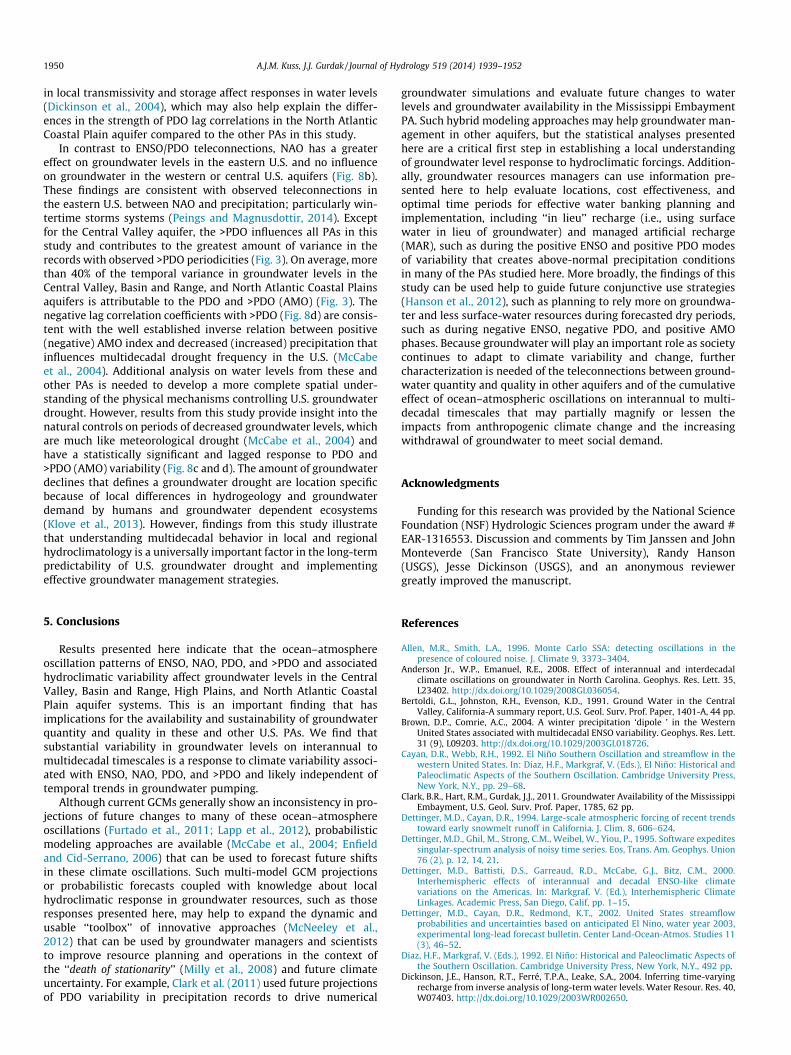
1950 A.J.M. Kuss, J.J. Gurdak / Journal of Hydrology 519 (2014) 1939–1952
in local transmissivity and storage affect responses in water levels(Dickinson et al., 2004), which may also help explain the differ-ences in the strength of PDO lag correlations in the North AtlanticCoastal Plain aquifer compared to the other PAs in this study.
In contrast to ENSO/PDO teleconnections, NAO has a greatereffect on groundwater levels in the eastern U.S. and no influenceon groundwater in the western or central U.S. aquifers (Fig. 8b).These findings are consistent with observed teleconnections inthe eastern U.S. between NAO and precipitation; particularly win-tertime storms systems (Peings and Magnusdottir, 2014). Exceptfor the Central Valley aquifer, the >PDO influences all PAs in thisstudy and contributes to the greatest amount of variance in therecords with observed >PDO periodicities (Fig. 3). On average, morethan 40% of the temporal variance in groundwater levels in theCentral Valley, Basin and Range, and North Atlantic Coastal Plainsaquifers is attributable to the PDO and >PDO (AMO) (Fig. 3). Thenegative lag correlation coefficients with >PDO (Fig. 8d) are consis-tent with the well established inverse relation between positive(negative) AMO index and decreased (increased) precipitation thatinfluences multidecadal drought frequency in the U.S. (McCabeet al., 2004). Additional analysis on water levels from these andother PAs is needed to develop a more complete spatial under-standing of the physical mechanisms controlling U.S. groundwaterdrought. However, results from this study provide insight into thenatural controls on periods of decreased groundwater levels, whichare much like meteorological drought (McCabe et al., 2004) andhave a statistically significant and lagged response to PDO and>PDO (AMO) variability (Fig. 8c and d). The amount of groundwaterdeclines that defines a groundwater drought are location specificbecause of local differences in hydrogeology and groundwaterdemand by humans and groundwater dependent ecosystems(Klove et al., 2013). However, findings from this study illustratethat understanding multidecadal behavior in local and regionalhydroclimatology is a universally important factor in the long-termpredictability of U.S. groundwater drought and implementingeffective groundwater management strategies.
5. Conclusions
Results presented here indicate that the ocean–atmosphereoscillation patterns of ENSO, NAO, PDO, and >PDO and associatedhydroclimatic variability affect groundwater levels in the CentralValley, Basin and Range, High Plains, and North Atlantic CoastalPlain aquifer systems. This is an important finding that hasimplications for the availability and sustainability of groundwaterquantity and quality in these and other U.S. PAs. We find thatsubstantial variability in groundwater levels on interannual tomultidecadal timescales is a response to climate variability associ-ated with ENSO, NAO, PDO, and >PDO and likely independent oftemporal trends in groundwater pumping.
Although current GCMs generally show an inconsistency in pro-jections of future changes to many of these ocean–atmosphereoscillations (Furtado et al., 2011; Lapp et al., 2012), probabilisticmodeling approaches are available (McCabe et al., 2004; Enfieldand Cid-Serrano, 2006) that can be used to forecast future shiftsin these climate oscillations. Such multi-model GCM projectionsor probabilistic forecasts coupled with knowledge about localhydroclimatic response in groundwater resources, such as thoseresponses presented here, may help to expand the dynamic andusable ‘‘toolbox’’ of innovative approaches (McNeeley et al.,2012) that can be used by groundwater managers and scientiststo improve resource planning and operations in the context ofthe ‘‘death of stationarity’’ (Milly et al., 2008) and future climateuncertainty. For example, Clark et al. (2011) used future projectionsof PDO variability in precipitation records to drive numerical
groundwater simulations and evaluate future changes to waterlevels and groundwater availability in the Mississippi EmbaymentPA. Such hybrid modeling approaches may help groundwater man-agement in other aquifers, but the statistical analyses presentedhere are a critical first step in establishing a local understandingof groundwater level response to hydroclimatic forcings. Addition-ally, groundwater resources managers can use information pre-sented here to help evaluate locations, cost effectiveness, andoptimal time periods for effective water banking planning andimplementation, including ‘‘in lieu’’ recharge (i.e., using surfacewater in lieu of groundwater) and managed artificial recharge(MAR), such as during the positive ENSO and positive PDO modesof variability that creates above-normal precipitation conditionsin many of the PAs studied here. More broadly, the findings of thisstudy can be used help to guide future conjunctive use strategies(Hanson et al., 2012), such as planning to rely more on groundwa-ter and less surface-water resources during forecasted dry periods,such as during negative ENSO, negative PDO, and positive AMOphases. Because groundwater will play an important role as societycontinues to adapt to climate variability and change, furthercharacterization is needed of the teleconnections between ground-water quantity and quality in other aquifers and of the cumulativeeffect of ocean–atmospheric oscillations on interannual to multi-decadal timescales that may partially magnify or lessen theimpacts from anthropogenic climate change and the increasingwithdrawal of groundwater to meet social demand.
Acknowledgments
Funding for this research was provided by the National ScienceFoundation (NSF) Hydrologic Sciences program under the award #EAR-1316553. Discussion and comments by Tim Janssen and JohnMonteverde (San Francisco State University), Randy Hanson(USGS), Jesse Dickinson (USGS), and an anonymous reviewergreatly improved the manuscript.
References
Allen, M.R., Smith, L.A., 1996. Monte Carlo SSA: detecting oscillations in thepresence of coloured noise. J. Climate 9, 3373–3404.
Anderson Jr., W.P., Emanuel, R.E., 2008. Effect of interannual and interdecadalclimate oscillations on groundwater in North Carolina. Geophys. Res. Lett. 35,L23402. http://dx.doi.org/10.1029/2008GL036054.
Bertoldi, G.L., Johnston, R.H., Evenson, K.D., 1991. Ground Water in the CentralValley, California-A summary report, U.S. Geol. Surv. Prof. Paper, 1401-A, 44 pp.
Brown, D.P., Comrie, A.C., 2004. A winter precipitation ‘dipole ’ in the WesternUnited States associated with multidecadal ENSO variability. Geophys. Res. Lett.31 (9), L09203. http://dx.doi.org/10.1029/2003GL018726.
Cayan, D.R., Webb, R.H., 1992. El Niño Southern Oscillation and streamflow in thewestern United States. In: Diaz, H.F., Markgraf, V. (Eds.), El Niño: Historical andPaleoclimatic Aspects of the Southern Oscillation. Cambridge University Press,New York, N.Y., pp. 29–68.
Clark, B.R., Hart, R.M., Gurdak, J.J., 2011. Groundwater Availability of the MississippiEmbayment, U.S. Geol. Surv. Prof. Paper, 1785, 62 pp.
Dettinger, M.D., Cayan, D.R., 1994. Large-scale atmospheric forcing of recent trendstoward early snowmelt runoff in California. J. Clim. 8, 606–624.
Dettinger, M.D., Ghil, M., Strong, C.M., Weibel, W., Yiou, P., 1995. Software expeditessingular-spectrum analysis of noisy time series. Eos, Trans. Am. Geophys. Union76 (2), p. 12, 14, 21.
Dettinger, M.D., Battisti, D.S., Garreaud, R.D., McCabe, G.J., Bitz, C.M., 2000.Interhemispheric effects of interannual and decadal ENSO-like climatevariations on the Americas. In: Markgraf, V. (Ed.), Interhemispheric ClimateLinkages. Academic Press, San Diego, Calif, pp. 1–15.
Dettinger, M.D., Cayan, D.R., Redmond, K.T., 2002. United States streamflowprobabilities and uncertainties based on anticipated El Nino, water year 2003,experimental long-lead forecast bulletin. Center Land-Ocean-Atmos. Studies 11(3), 46–52.
Diaz, H.F., Markgraf, V. (Eds.), 1992. El Niño: Historical and Paleoclimatic Aspects ofthe Southern Oscillation. Cambridge University Press, New York, N.Y., 492 pp.
Dickinson, J.E., Hanson, R.T., Ferré, T.P.A., Leake, S.A., 2004. Inferring time-varyingrecharge from inverse analysis of long-term water levels. Water Resour. Res. 40,W07403. http://dx.doi.org/10.1029/2003WR002650.

A.J.M. Kuss, J.J. Gurdak / Journal of Hydrology 519 (2014) 1939–1952 1951
Dickinson, J.E., Hanson, R.T., Predmore, S.K., 2014. HydroClimATe—Hydrologic andClimatic Analysis Toolkit: U.S. Geological Survey Techniques and Methods 4–A9, 49 p, <http://dx.doi.org/10.3133/tm4a9>.
Earman, S., Dettinger, M.D., 2011. Potential impacts of climate change ongroundwater resources – a global review. J. Water Clim. Change 2 (4), 213–229.
Enfield, D.B., Cid-Serrano, L., 2006. Projecting the risk of future climate shifts. Int. J.Clim. 26, 885–895.
Enfield, D.B., Mestas-Nunez, A.M., Trimble, P.J., 2001. The Atlantic MultidecadalOscillation and its relationship to rainfall and river flows in the continental U.S.Geophys. Res. Lett. 28, 2077–2080.
Faunt, C., Hanson, R., Evenson, K., 2009. Groundwater Availability of the CentralValley aquifer, California, U.S. Geol. Surv. Prof. Paper, 1766, 246 pp.
Figura, S., Livingstone, D.M., Hoehn, E., Kipfer, R., 2011. Regime shift in groundwatertemperature triggered by the Arctic Oscillation. Geophys. Res. Lett. 38, L23401.http://dx.doi.org/10.1029/2011GL049749.
Fisher, L.H., Healy, R.W., 2008. Water movement within the unsaturated zone infour agricultural areas across the United States. J. Environ. Quality 37, 1051–1063.
Fleming, S.W., Quilty, E.J., 2006. Aquifer responses to El Nino-Southern Oscillation,southwest British Columbia. Ground Water 44 (4). http://dx.doi.org/10.1111/j.1745-6584.2006.00187.x, 595-599.
Furtado, J.C., Di Lorenzo, E., Schneider, N., Bond, N.A., 2011. North Pacific decadalvariability and climate change in the IPCC AF4 Models. J. Clim. 24 (12), 3049–3067. http://dx.doi.org/10.1175/2010JCLI3584.1.
Ghil, M., 2002. Natural climate variability. In: McCracken, M., Perry, J. (Eds.),Encyclopedia of Global Environmental Change, vol. 1. John Wiley & Sons,Chichester, UK, pp. 544–549.
Ghil, M., Allen, M.R., Dettinger, M.D., Ide, K., Kondrashov, D., Mann, M.E., Roberston,A.W., Saunders, A., Tian, Y., Varadi, F., Yiou, P., 2002. Advanced spectral methodsfor climate time series. Rev. Geophys. 40, 1–41.
Green, T., Taniguchi, M., Kooi, H., Gurdak, J.J., Hiscock, K., Allen, D., Treidel, H.,Aurelia, A., 2011. Beneath the surface of global change: impacts of climatechange on groundwater. J. Hydrol. 405, 532–560. http://dx.doi.org/10.1016/j.jhydrol2011.05.002.
Grinsted, A., Moore, J.C., Jevrejeva, S., 2004. Application of the cross wavelettransform and wavelet coherence to geophysical time series. NonlinearProcesses Geophys. 11 (5), 561–566.
Gurdak, J.J., 2008. Ground-Water Vulnerability: Nonpoint-Source Contamination,Climate Variability, and the High Plains Aquifer. VDM Verlag Publishing,Saarbrucken, Germany.
Gurdak, J.J., Hanson, R.T., McMahon, P.B., Bruce, B.W., McCray, J.E., Thyne, G.D.,Reedy, R.C., 2007. Climate variability controls on unsaturated water andchemical movement, High Plains Aquifer, USA. Vadose Zone J. 6 (3), 533–547.http://dx.doi.org/10.2136/vzj2006.0087.
Gurdak, J.J., Hanson, R.T., Green, T.R., 2009. Effects of Climate Variability onGroundwater Resources of the United States, U.S. Geol. Surv. Fact Sheet, 2009–3074, 4 pp.
Gurdak, J.J., McMahon, P.B., Bruce, B.W., 2012. Vulnerability of groundwater qualityto human activity and climate change and variability, High Plains aquifer, USA.In: Treidel, H., Martin-Bordes, J.J., Gurdak, J.J. (Eds.), Climate Change Effects onGroundwater Resources: A Global Synthesis of Findings and Recommendations.Taylor & Francis Publishing, Baca Raton, FL, pp. 145–167.
Gutzler, D.S., Kann, D.M., Thornbrugh, C., 2002. Modulation of ENSO-based long-lead outlooks of southwestern US winter precipitation by the Pacific DecadalOscillation. Weather Forecast. 17 (6), 1163–1172.
Hanson, R.T., Dettinger, M.D., 2005. Ground water/surface water responses to globalclimate simulations, Santa Clara-Calleguas basin, Ventura, California. J. Am.Water Resour. Assoc. 41 (3), 517–536.
Hanson, R.T., Newhouse, M.W., Dettinger, M.D., 2004. A methodology to assessrelations between climatic variability and variations in hydrologic time series inthe southwestern United States. J. Hydrol. 287 (1), 252–269. http://dx.doi.org/10.1016/j.jhydrol.2003.10.006.
Hanson, R.T., Dettinger, M.D., Newhouse, M.W., 2006. Relations between climaticvariability and hydrologic time series from four alluvial basins across thesouthwestern United States. Hydrogeol. J. 14 (7), 1122–1146. http://dx.doi.org/10.1007/s10040-006-0067-7.
Hanson, R.T., Flint, L.E., Flint, A.L., Dettinger, M.D., Faunt, C.C., Cayan, D., Schmid, W.,2012. A method for physically based model analysis of conjunctive use inresponse to potential climate changes. Water Resour. Res. 48, W00L08, http://dx.doi.org/10.1029/2011WR010774.
Helsel, D.R., Hirsch, R.M., 2002. Statistical Methods in Water Resources, Techn.Water Resour. Invest., Book 4, chapter A3. U.S. Geol. Surv. 522 p.
Holman, I.P., 2006. Climate change impacts on groundwater recharge-uncertainty,shortcomings, and the way forward? Hydrogeol. J. 14, 637–647. http://dx.doi.org/10.1007/s10040-005-0467-0.
Holman, I.P., Rivas-Casado, M., Howden, N.J.K., Bloomfield, J.P., Williams, A.T., 2009.Linking north Atlantic ocean-atmospheric teleconnection patterns andhydrogeological responses in temperate groundwater systems. Hydrol.Process. 23, 3123–3126. http://dx.doi.org/10.1007/s10040-009-0457-8.
Holman, I.P., Rivas-Casado, M., Bloomfield, J.P., Gurdak, J.J., 2011. Identifying non-stationary groundwater level response to North Atlantic ocean-atmosphereteleconnection patterns using wavelet coherence. Hydrogeol. J., http://dx.doi.org/10.1007/s10040-011-0755-9.
Hurrell, J.W., 1995. Decadal trends in the North Atlantic Oscillation: regionaltemperatures and precipitation. Science 269, 676–679.
Hurrell, J.W., Van Loon, H., 1997. Decadal variations in climate associated with theNorth Atlantic Oscillation. Clim. Change 36 (3), 301–326.
Hurrell, J.W., Kushnir, Y., Ottersen, G., Visbeck, M., 2003. An overview of the NorthAtlantic oscillation. In: Hurrell, J.W., Kushnir, Y., Ottersen, G., Visbeck, M. (Eds.),The North Atlantic Oscillation: Climatic Significance and Environmental Impact,Geophys. Monogr. Ser., vol. 134. AGU, Washington, D.C., pp. 1–35.
Ionita, M., Lohmann, G., Rimbu, N., Chelcea, S., 2012. Interannual variability of RhineRiver streamflow and its relationship with large-scale anomaly patterns inspring and autumn. J. Hydrometeorol. 13 (1), 172–188.
Kerr, R.A., 2000. A north Atlantic climate pacemaker for the centuries. Science 288,1984–1985. http://dx.doi.org/10.1126/science.288.5473.1984.
Kiladis, G., Diaz, H.F., 1989. Global climatic anomalies associated with extremes inthe Southern Oscillation. J. Clim. 2 (9), 1069–1090.
Klove, B., Ala-Aho, P., Bertrand, G., Gurdak, J.J., Kupfersberger, H., Kvaerner, J.,Muotka, T., Mykra, H., Preda, E., Rossi, P., Uvo, C.B., Velasco, E., Wachniew, P.,Velazquez, M.P., 2013. Climate change impacts on groundwater and dependentecosystems. J. Hydrol., http://dx.doi.org/10.1016/j.jhydrol.2013.06.037.
Kurtzman, D., Scanlon, B.R., 2007. El Nino-Southern Oscillation and the PacificDecadal Oscillation impacts on precipitation in the southern and central UnitedStates: evaluation of spatial distribution and predictions. Water Resour. Res. 43.http://dx.doi.org/10.1029/2007WR005863.
Kuss, A.J.M., 2011. Effects of Climate Variability on Recharge in Regional Aquifers ofthe United States. M.S. thesis. Dep. of Geosciences, San Francisco State Univ.,San Francisco, Calif.
Labat, D., 2005. Recent advances in wavelet analyses: Part 1. A review of concepts. J.Hydrol. 314 (1–4), 275–288. http://dx.doi.org/10.1016/j.jhydrol.2005.04.003.
Labat, D., 2008. Wavelet analysis of the annual discharge records of the world’slargest rivers. Adv. Water Resour. 31 (1), 109–117. http://dx.doi.org/10.1016/j.advwatres.2007.07.004.
Labat, D., 2010. Cross wavelet analyses of annual continental freshwater dischargeand selected climate indices. J. Hydrol. 385 (1–4), 269–278. http://dx.doi.org/10.1016/j.jhydrol.2010.02.029.
Labat, D., Ababou, R., Mangin, A., 2000. Rainfall-runoff relations for karstic springs.Part II: continuous wavelet and discrete orthogonal multiresolution analyses. J.Hydrol. 238 (3–4), 149–178. http://dx.doi.org/10.1016/S0022-1694(00)00322-X.
Lapp, S.L., St. Jacques, J.M., Barrow, E.M., Sauchyn, D.J., 2012. GCM projections for thePacific Decadal Oscillation under greenhouse forcing for the early 21st century.Int. J. Climatol. 32 (9), 1423–1442, http://dx.doi.org/10.1002/joc.2364.
Mantua, N., Hare, S., 2002. The Pacific Decadal oscillation. J. Oceanogr. 58 (1), 35–44.http://dx.doi.org/10.1023/A:1015820616384.
Mantua, N.J., Hare, S.R., Zhang, Y., Wallace, J.M., Francis, R.C., 1997. A Pacificinterdecadal climate oscillation with impacts on salmon production. Bull. Am.Meteorol. Soc. 78 (6), 1069–1080.
Maupin, M., Barber, N., 2005. Estimated Withdrawals from Principal Aquifers in theUnited States, 2000, U.S. Geol. Surv. Circular, 1279, 46 pp.
McCabe, G.J., Palecki, M.A., Betancourt, J.L., 2004. Pacific and Atlantic Oceaninfluences on multidecadal drought frequency in the United States. Proc. Nat.Acad. Sci. 101 (12), 4136–4141. http://dx.doi.org/10.1073/pnas/0306738101.
McMahon, P.B., Dennehy, K.F., Bruce, B.W., Böhlke, J.K., Michel, R.L., Gurdak, J.J.,Hurlbut, D.B., 2006. Storage and transit time of chemicals in thick unsaturatedzones under rangeland and irrigated cropland, High Plains, United States. WaterResour. Res. 42. http://dx.doi.org/10.1029/2005WR004417.
McMahon, P.B., Dennehy, K.F., Bruce, B.W., Gurdak, J.J., Qi, S.L., 2007. Water-QualityAssessment of the High Plains aquifer, 1999–2004, U.S. Geol. Surv. Prof. Paper,1749, 212 pp.
McMahon, P.B., Plummer, L.N., Böhlke, J.K., Shapiro, S.D., Hinkle, S.R., 2011.Hydrogeol. J. 19 (4), 799–800. http://dx.doi.org/10.1007/s10040-011-0722-5.
McNeeley, S.M., Tessendorf, S.A., Lazrus, H., Heikkila, T., Ferguson, I.M., Arrigo, J.S.,Attari, S.Z., Cianfrani, C.M., Dilling, L., Gurdak, J.J., Kampf, S.K., Kauneckis, D.,Kirchhoff, C.J., Lee, J., Lintner, B.R., Mahoney, K.M., Opitz-Stapleton, S., Ray, P.,South, A.B., Stubblefield, A.P., Brugger, J., 2012. Catalyzing frontiers in water-climate-society research: a view from early career scientists and junior faculty.Bull. Am. Meteorol. Soc. 93 (4), 477–484, http://dx.doi.org/10.1175/BAMS-D-11-00221.1.
Milly, P.C.D., Betancourt, J., Falkenmark, M., Hirsch, R.M., Kundzewicz, Z.W.,Lettenmaier, D.P., Stouffer, R.J., 2008. Stationarity is dead: whither watermanagement? Science 319, 573–574. http://dx.doi.org/10.1126/science.1151915.
Newman, M., Compo, G.P., Alexander, M.A., Center, N.C., 2003. ENSO-forced variability of the Pacific Decadal Oscillation. J. Clim. 16 (23), 3853–3857.
NOAA, 2012. Climate-Radar Data Inventories, 1927 to 2010. National Climate DataCenter, <http://www.ncdc.noaa.gov/oa/ncdc.html>.
Ottersen, G., Planque, B., Belgrano, A., Post, E., Reid, P., Stenseth, N., 2001. Ecologicaleffects of the North Atlantic oscillation. Oecologia 128 (1), 1–14. http://dx.doi.org/10.1007/s004420100655.
Peings, Y., Magnusdottir, G., 2014. Forcings of the wintertime atmosphericcirculation by the multidecadal fluctuations of the North Atlantic Ocean.Environ. Res. Lett. 9. http://dx.doi.org/10.1088/1748-9326/9/3/034018.
Perez-Valdivia, C., Sauchyn, D., 2011. Tree-ring reconstruction of groundwaterlevels in Alberta, Canada: Long-term hydroclimatic variability.Dendrochronologia 29, 41–47, http://dx.doi.org/10.1016/j.dendro.2010.09.001.
Perez-Valdivia, C., Sauchyn, D., Vanstone, J., 2012. Groundwater levels andteleconnection patterns in the Canadian Prairies. Water Resour. Res. 48,W07516. http://dx.doi.org/10.1029/2011WR010930.

1952 A.J.M. Kuss, J.J. Gurdak / Journal of Hydrology 519 (2014) 1939–1952
Phillips, S.P., Green, C.T., Burow, K.R., Shelton, J.L., Rewis, D.L., 2007. Simulation ofMultiscale Ground-Water Flow in Part of the Northeastern San Joaquin Valley,California, U.S. Geol. Surv. Sci. Invest. Rep., 2007–5009, 43 pp.
Planert, M., Williams, J., 1995. Ground water atlas of the United States-California,Nevada. In: Ground Water Atlas of the United States. U.S. Geol. Surv.,Washington, DC.
Polsky, C., Allard, J., Currit, N., Crane, R., Yarnal, B., 2000. The Mid-Atlantic Regionand its climate: past, present, and future. Clim. Res. 14 (3), 161–173. http://dx.doi.org/10.3354/cr014161.
Pool, D.R., 2005. Variations in climate and ephemeral channel recharge insoutheastern Arizona, United States. Water Resour. Res. 41, W11403. http://dx.doi.org/10.1029/2004WR003255.
Ropelewski, C.F., Halpert, M.S., 1986. North American Precipitation andTemperature Patterns Associated with the El Niño/Southern Oscillation(ENSO). Monthly Weather Rev. 114, 2352–2362.
Sheppard, P.R., Comrie, A.C., Packin, G.D., Angersbach, K., Hughes, M.K., 2002. Theclimate of the US Southwest. Clim. Res. 21, 219–238.
Stoll, S., Hendricks Franssen, H.J., Barthel, R., Kinzelbach, W., 2011. What can welearn from long-term groundwater data to improve climate change impactstudies? Hydrol. Earth Syst. Sci. 15, 3861–3875, 105194/hess-15-3861-2011.
Torrence, C., Compo, G.P., 1998. A practical guide to wavelet analysis. Bull. Am.Meteorol. Soc. 79, 61–78.
Trapp, H.J., 1992. Hydrogeologic Framework of the Northern Atlantic Coastal Plainin Parts of North Carolina, Virginia, Maryland, Delaware, New Jersey, and NewYork, U.S. Geol. Surv. Prof. Paper 1404-G, 59 p.
Trapp, H.J., Horn, M., 1997. Groundwater atlas of the United States Delaware,Maryland, New Jersey, North Carolina, Pennsylvania, Virginia, West Virginia. In:Groundwater Atlas of the United States. U.S. Geol. Surv., Washington, DC.
Treidel, H., Martin-Bordes, J.L., Gurdak, J.J. (Eds.), 2012. Climate Change Effects onGroundwater Resources: A Global Synthesis of Findings and Recommendations,International Association of Hydrogeologists–(IAH) - InternationalContributions to Hydrogeology. Taylor & Francis Publishing, Boca Raton, FL.
Tremblay, L., Larocque, M., Anctil, F., Rivard, C., 2011. Teleconnections andinterannual variability in Canadian groundwater levels. J. Hydrol. 410, 178–188. http://dx.doi.org/10.1016/j.jhydrol.2011.09.013.
Tukey, J.W., 1977. Exploratory Data Analysis. Addison-Wesley Publications, ReadingMD, 506 pp.
U.S. Geological Survey (USGS), 2003. Principal aquifers of the 48 conterminousUnited States, Hawaii, Puerto Rico, and the U.S. Virgin Islands, 2003 <http://www.nationalatlas.gov/mld/aquifrp.html>.
U.S. Geological Survey (USGS), 2012. National Water Information System for theNation, 1935 to 2010. U.S. Geol. Surv., <http://waterdata.usgs.gov/nwis/gw>.
Vautard, R., Yiou, P., Ghil, M., 1992. Singular-spectrum analysis: a toolkitfor short, noisy chaotic signals. Phys. D: Nonlinear Phenomena 58 (1–4), 95–126.
Venencio, M.D.V., Garcia, N.O., 2011. Interannual variability and predictabilityof water table levels at Santa Fe Province (Argentina) within the climaticchange context. J. Hydrol. 409. http://dx.doi.org/10.1016/j.jhydrol.2011.07.039, 62-70.
Vicente-Serrano, S.M., Lopez-Moreno, J.I., Gimeno, L., Nieto, R., Moran-Tejeda, E.,Lorenzo-Lacruz, J., Begueria, S., Azorin-Molina, C., 2011. A multiscalar globalevaluation of the impact of ENSO on droughts. J. Geophys. Res. 116, D20109.http://dx.doi.org/10.1029/2011JD016039.
Wada, Y., van Beek, L.P.H., van Kempen, C.M., Reckman, J.W.T.M., Vasak, S., Bierkens,M.F.P., 2010. Global depletion of groundwater resources. Geophys. Res. Lett. 37,L20402. http://dx.doi.org/10.1029/2010GL044571.
Walvoord, M.A., Phillips, F.M., Stonestrom, D.A., Evans, R.D., Hartsough, P.C.,Newman, B.D., Striegl, R.G., 2003. A reservoir of nitrate beneath desert soils.Science 302, 1021–1024.
Wolter, K., Timlin, M.S., 2011. El Niño/Southern Oscillation behaviour since 1871 asdiagnosed in an extended multivariate ENSO index (MEI.ext). Int. J. Climatol. 31(7), 1074–1087. http://dx.doi.org/10.1002/joc.2336.