journal of asian earth sciences - missouri...
TRANSCRIPT

Journal of Asian Earth Sciences 107 (2015) 26–34
Contents lists available at ScienceDirect
Journal of Asian Earth Sciences
journal homepage: www.elsevier .com/locate / jseaes
The tectonic structure of the Song Ma fault zone, Vietnam
http://dx.doi.org/10.1016/j.jseaes.2015.03.0461367-9120/� 2015 Published by Elsevier Ltd.
⇑ Corresponding author at: Department of Earth and Environmental Sciences,National Chung Cheng University, Chiayi 621, Taiwan, ROC. Tel.: +886 52720411x66202; fax: +886 5 2720807.
E-mail address: [email protected] (C.-H. Chen).
Strong Wen a, Yu-Lien Yeh b, Chi-Cha Tang c, Lai Hop Phong d, Dinh Van Toan d, Wen-Yen Chang e,Chau-Huei Chen b,⇑a National Center for Research on Earthquake Engineering, 200, Sec. 3, HsinHai Rd., Taipei 10668, Taiwan, ROCb Department of Earth and Environmental Sciences, National Chung Cheng University, Chiayi, Taiwan, ROCc Subsurface Multi-scale Imaging Lab (SMIL), Institute of Geophysics and Geomatics, China University of Geosciences, 388, Lumo Rd., Wuhan, Hubei 430074, PR Chinad Institute of Geological Sciences, Vietnamese Academy of Science and Technology, Viet Name Department of Natural Resources and Environmental Studies, National Dong Hwa University, No. 1, Sec. 2, Da Hsueh Rd., Shoufeng, Hualien, Taiwan, ROC
a r t i c l e i n f o
Article history:Received 28 April 2014Received in revised form 25 March 2015Accepted 30 March 2015Available online 11 April 2015
Keywords:Song Ma fault zone1D velocity structureVpVs
a b s t r a c t
Indochina area is a tectonic active region where creates complex topographies and tectonic structures. Inparticular, the Song Ma fault zone plays an important role in understanding the mechanism and rev-olution of the collision between the Indian plate and Eurasian plate. In order to have better understandingthe seismotectonic structures of the Song Ma fault zone, a three-year project is proposed to study theseismotectonic structures of crust in this region. The main goal of this project is to deploy temporarybroad-band seismic stations around/near the shear zone to record high quality microearthquakes. Byusing the data recorded by the temporary array and the local seismic network, we are able to conductseismological studies which include using waveform inversion to obtain precise fault plane solutionsof microearthquakes, one-dimensional (1-D) velocity structure of the crust in the region as well as thecharacteristics of seismogeneric zone. From the results of earthquake relocation and focal mechanisms,we find that the spatial distribution of events occurred in Song Ma fault zone forms in several distinctgroups which are well correlated local geological structures and further use to gain insights on tectonicevolution.
� 2015 Published by Elsevier Ltd.
1. Introduction
East Asia is a tectonic active region with interactions amongseveral plates including the Indian plate, the Eurasian plate, thePhilippine Sea plate, the Pacific plate and the Australian plate(see Fig. 1). The tectonic interactions among these plates conse-quently create complex topographies and geological structureswithin and surrounding East Asia. The typical example is the colli-sion between the India and the Eurasia plates, which produced theworld’s highest Himalayas Mountain system and the Tibetan pla-teau. Despite the above, the escape of the Indo-China block inthe southeastern direction commenced 35 Ma ago, and not onlycaused the opening of the South China Sea, but also formed asequence of prominent shear zones (Tapponnier et al., 1982),including the Red River shear zone (RRSZ) in the North Vietnamand Song Ma Fault Zone (SMFZ) (Fig. 1). The most well-known isthe RRSZ located in Northern Vietnam, which plays an important
role in understanding the mechanism and revolution of the aboveintrusion process. The RRSZ is also an important geological bound-ary in East Asia, and numerous studies have been conducted toinvestigate different aspects of the northern segment of the RRSZ,including the morphology and its tectonic significance (Harrisonet al., 1992; Leloup et al., 1999; Morley, 2002; Schoenbohmet al., 2004; Tapponnier et al., 1990).
Comparing with the RRSZ, the characteristics of the SMFZ is notwell known. The SMFZ is located southwest of RRSZ, where isbounded by the Son La fault and the Song Ma fault (Fig. 1). Dinh(1999) proposed that Song Ma terrain is an anticline trendingnorthwest (NW) direction, called the Song Ma Anticlinorium (Tri,1979). The northern part of the Song Ma Anticlinorium is theSong Da fault and is bounded by the Song Ma fault in the south.The petrology of the fault zone is mainly composed of metamor-phic formations which provide strong evidence that the Song MaAnticlinorium is a paleo boundary of the collision between theSouth China Sea plate and the Indochina plate, and the SMFZ actsas a suture zone between the two plates (Tri, 1979; Findlay andTrinh, 1997). In addition, Findlay and Trinh (1997) also proposedthat this sutra zone extended to the Song Horn area in NorthernVietnam. According to a geological survey, the Song Ma fault is a
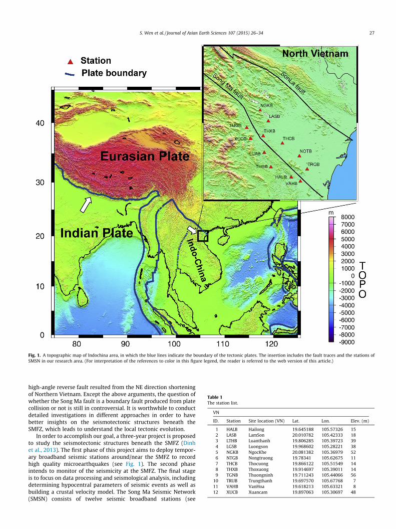
Fig. 1. A topographic map of Indochina area, in which the blue lines indicate the boundary of the tectonic plates. The insertion includes the fault traces and the stations ofSMSN in our research area. (For interpretation of the references to color in this figure legend, the reader is referred to the web version of this article.)
Table 1The station list.
VN
ID. Station Site location (VN) Lat. Lon. Elev. (m)
1 HALB Hailong 19.645188 105.57326 152 LASB LamSon 20.010782 105.42333 183 LTHB Luanthanh 19.806285 105.39723 394 LGSB Luongson 19.968602 105.28221 385 NGKB NgocKhe 20.081382 105.36979 526 NTGB Nongtruong 19.78341 105.62675 117 THCB Thocuong 19.866122 105.51549 148 THXB Thoxuong 19.914697 105.39011 149 TGNB Thuongninh 19.711243 105.44066 56
10 TRUB Trungthanh 19.697570 105.67768 711 VAHB VanHoa 19.618213 105.63321 812 XUCB Xuancam 19.897063 105.30697 48
S. Wen et al. / Journal of Asian Earth Sciences 107 (2015) 26–34 27
high-angle reverse fault resulted from the NE direction shorteningof Northern Vietnam. Except the above arguments, the question ofwhether the Song Ma fault is a boundary fault produced from platecollision or not is still in controversial. It is worthwhile to conductdetailed investigations in different approaches in order to havebetter insights on the seismotectonic structures beneath theSMFZ, which leads to understand the local tectonic evolution.
In order to accomplish our goal, a three-year project is proposedto study the seismotectonic structures beneath the SMFZ (Dinhet al., 2013). The first phase of this project aims to deploy tempor-ary broadband seismic stations around/near the SMFZ to recordhigh quality microearthquakes (see Fig. 1). The second phaseintends to monitor of the seismicity at the SMFZ. The final stageis to focus on data processing and seismological analysis, includingdetermining hypocentral parameters of seismic events as well asbuilding a crustal velocity model. The Song Ma Seismic Network(SMSN) consists of twelve seismic broadband stations (see

Fig. 2. The flowchart representing the data processing, methodology used in thisstudy.
28 S. Wen et al. / Journal of Asian Earth Sciences 107 (2015) 26–34
Table 1). Currently, there are more than 500 earthquakes withmagnitudes ranging from 1.0 to 3.0, recorded by the SMSN.Therefore, one of the pioneer works is to build a seismic catalogwhich can become a solid and valuable database for future applica-tion in earthquake hazard assessments in the SMFZ. By employingthe data, we are able to perform fundamental but very essentialseismological researches, such as studies on determining precisefault plane solutions (via a waveform inversion technique), staticstress transfer, and a three-dimensional (3-D) velocity structureof the region.
2. Geological settings
Northern Vietnam is divided into two regions by the strike-sliptype RRSZ: (1) the southwestern part, which belongs to the old pre-Cenozoic Indochina block; (2) the northeastern part is a portion ofthe South China block with different structural characteristics. Thearc-shape tectonic faults are widely developed in the northeasternregion with a predominantly sub-median direction in the north,while the sub-parallel direction is dominated in the south. In con-trast, most of the main tectonic faults in the southwestern regiontrend in northwest–southeast (NW–SE) direction. The section ofRRSZ in the Northern Vietnam territory spreads along the samedirection and is confined by two fault branches, the Red River faultin the southwest and Song Chay fault in the northwest. One of thesignificant features is that for most of the main structural unitsdeveloped in the northeast region are in isometric shape.However, the strikes of the structures in southwest region aredominated in NW–SE direction.
The SMFZ is another part of the suture zone juxtaposing theIndochina and South China blocks (Chung et al., 1997; Lepvrieret al., 2004). Serpentinite bodies are sporadically exposed alongthe SMFZ in Northern Vietnam. The northwestern extension ofthe SMFZ crosses part of Laos and extends to the north of DienBien. To the south, the SMFZ is bounded by a fault and in contactwith late Triassic non-deformed granite, while the Song Ma blocklocated along the Song Ma fault (SMF) in the southwest and theSon La fault (SLF) in the northeast, which is associated with aprominent uplifted block in the region. The seismic activity in thisblock is active. Two strong earthquakes are with magnitudes (Ms)6.7 and 6.8 occurred between the SLF and SMF zones in 1935 and1983. These two strong earthquakes have caused great damage inthe area, including land-cracking, landslide, and the appearance ofhot water springs. To the north, the SMFZ, a high-angle fault sepa-rates Paleozoic phyllites and amphibolite facies of rocks. Thegeometry of this zone has an elongated shape with an area of 24km2, consisting mainly of broad areas of serpentinite and fine-grained gabbro with rare chromitite (Trung et al., 2006). In addi-tion, the SMFZ is also covered extensively by subtropical veg-etation. Apart from podiform chromitites (ca. 410 m), theoutcrops are rarely exposed (Trung et al., 2006; Thanh et al., 2011).
3. Data processing and methodology
The SMSN along the Song Ma fault has recorded a substantialnumber of seismic data since 2009. By using high quality data ofthe first P- and S-wave arrival readings, preliminary hypocentersfor more 500 local earthquakes were determined using the soft-ware package ANTELOPE. In the ANTELOPE database, an automatedRichter magnitude estimation is carried out in near real time. Thesystem uses a unique magnitude formula for local events (indepen-dently of depth) and is expressed as following:
ML ¼ C0þ log 10ðAÞ þ C1 log 10ðDÞ þ C2 log 10ðDC3þ C4Þ þ C5
ð1Þ
where A is the maximum amplitude, D is the epicentral distanceand C0, C1, C2, C3, C4 and C5 represent coefficients to be determinedby regression (Craiu et al., 2012). All travel time data is then used todetermine hypocentral parameters of seismic events by using theHYPO71 (Lee and Lahr, 1975). The weighting in the inversion pro-cess was assigned to each arrival reading according to the lengthof the error window given to the phase pick and event-station dis-tance (see Fig. 2). For real-time seismic monitoring, we also deter-mined the duration magnitude (Md) for current SMSN catalogueby employing the HYPO71 (Lee and Lahr, 1975) program. The equa-tion for the duration magnitude is expressed as following:
Md ¼ �C1þ C2 log sþ C3Dþ C4h; ð2Þ
where s represents the recording duration; D indicates the epicen-tral distance; h denotes the focal depth; and C1, C2, C3and C4 repre-sent coefficients to be determined by regression. Furthermore, theVELEST program (Ellsworth, 1977; Kissling et al., 1994) was usedto derive a 1-D velocity model as an initial model for relocatingearthquakes and obtaining focal mechanism of each event.Previous studies have shown that Vp/Vs ratio is sensitive to porefluid pressure and the geometry of cracks (Tatham, 1982; Walck,1988; Chen et al., 2001). O’Connell and Budiansky (1974) indicatedthat Vp/Vs decreases with depth since litho-static pressure increasesand results in cracks closing. In this study, we obtained an averageof Vp/Vs ratio is 1.7178 ± 0.0023 from the regression of P-time andS–P time (see Fig. 3) which can invert S-wave velocity simultane-ously in VELEST inversion. The results indicate significant variationsin the Vp/Vs ratio than that obtained from Xuyen and Thanh(1999),who suggested the Vp/Vs ratio is 1.68. As most earthquakes usuallyoccur in active fault zone, Vp/Vs ratio is a key parameter in inter-pretation seismogenic significance in the crust. Previous studiesalso support that the Vp/Vs ratio is related to the fractional volumeof fluid content in a fractured rock (Thurber and Atre, 1993; Graeberand Asch, 1999; Chen et al., 2001). In other words, Vp/Vs ratio can beused to understand the effects of crustal fluids in different stages ofseismic nucleation and growth of fault rupture (Chen et al., 2001;Zhao et al., 2011).

Fig. 3. The regressive relationship between the P-time and S–P time data in theSMSN catalog. An average Vp/Vs ratio (1.7178 ± 0.0023) was obtained in this study.
Fig. 4. The 1D velocity models used for preliminary locations (blue line) and theminimum-error model found with VELEST (red line). The blue line denotes theinitial 1D velocity structure from Xuyen and Thanh (1999), and the red linerepresents the result of our study. (For interpretation of the references to color inthis figure legend, the reader is referred to the web version of this article.)
Table 2The 1-D minimum velocity model.
Layer (km) Vp (km/s) Vs (km/s) Vp/Vs
0–2 4.034 2.463 1.642–4 4.608 3.094 1.494–10 5.187 3.105 1.6710–18 5.653 3.303 1.7118–26 6.292 3.619 1.7426–34 6.334 3.620 1.7534–50 6.866 4.232 1.62
Fig. 5. The panel represents the root-mean-square (RMS) travel time residual anddata variance from the inversion results. The difference in RMS residual and datavariance after the 10th inversion iteration are close to 0.407 s and 0.311 s2,respectively.
S. Wen et al. / Journal of Asian Earth Sciences 107 (2015) 26–34 29
4. Results and discussions
4.1. Minimum 1-D model
Precise earthquake locations are crucial in the interpretation oftectonic and other geophysical issues (Lee and Lahr, 1975; Bullenand Bolt, 1985). The hypocentres of microearthquakes recordedby the SMSN have been determined with a 1-D crustal modelderived from Xuyen and Thanh (1999). The location of seismicevents can be biased due to neglecting of lateral velocity variations.To build a more precise 1-D velocity model in this area, we furtherinverted a set of travel time data including 1,923 P- and S- phasearrivals gathered from 438 evenly-distributed earthquakes. Theevents with a minimum of four P- and S-phase readings wereselected. The overall weighted root mean square (RMS) time resid-ual was less than 0.8 s. Fig. 2 illustrates the flowchart used for dataprocessing. First, we used the ANTELOPE database system to readthe first arrivals of P- and S-waves, and then adopted theHYPO71 program to locate hypocenters of each individual event(see Fig. 4). We further utilized the model derived from Xuyenand Thanh (1999) as initial input velocity model and applied theVELEST program (Kissling et al., 1994) to invert earthquake loca-tions and 1-D velocity structure simultaneously using P- and S-wave travel time data. The spatial distribution of earthquake loca-tions determined from the above scheme is shown in Fig. 4. We ini-tially parameterized the model as a stack of 2-km-thick layers, andthen iteratively simplified the inverted velocity models by couplingwith similar velocities to form the next initial model. After severaliterations with different starting models as well control parame-ters, the minimum 1-D velocity models with minimum RMS misfitand some a priori information obtained from Xuyen and Thanh(1999) were selected.
From the data streams, we observed that a substantial numberof microearthquakes occurred near the fault zones. Obtaining moreprecise hypocenters is profoundly related to an adequate localvelocity model, which needs extensive amount of events to con-struct. Thus, a well-built 1-D velocity structure is not only usefulfor obtaining reasonable and logical event locations but also canbe important in developing 3-D seismic tomography in the future.

30 S. Wen et al. / Journal of Asian Earth Sciences 107 (2015) 26–34
Fig. 4 shows the final optimal 1-D velocity model; the blue lineindicates the initial model (Xuyen and Thanh, 1999), the red linedepicts the final model and the gray lines represent the temporarymodels for each iteration. From the results, we observe that inuppermost crust (<4 km), the inverted velocity value is less thanthat of initial model, which is consistent with the alluvium forma-tions in the subsurface. The Poisson’s ratio in North Vietnam is low,which indicates the lower crust is composed of metasedimentaryrocks with felsic composition instead of being mafic or ultramaficrocks (Zandt and Ammon; 1995; Bai et al., 2010; Huang et al.,
Fig. 6. A map view of earthquake locations after refining the velocity model using VELEbetween the SLF and SMF zones. Seismicity is color coded by depth and the magnitude scthe horizontal and vertical adjustments for the relocated seismic events. (For interpretatversion of this article.)
2013; Nguyen et al., 2013; He et al., 2014). Our results show thatP- and S-wave velocities in the lower crust are in the range of5.6–6.3 km/s and 3.3–3.6 km/s, respectively (Table 2). For the dee-per depths (>26 km), the inverted velocity is greater than that ofthe initial model and also is higher than the average value beneathNorthern Vietnam. The inverted velocity model in this study is wellresolved at depths less than 26 km, but the resolution is poor atdepth greater than 26 km, which is due to the lower ray density.We also calculate the Vp/Vs ratio, and the results indicate thatprominent low Vp/Vs ratios existed in the shallower layers,
ST; (a) The relocated seismicity exhibited clusters (shown as small dotted circles)ales are also illustrated on the map. (b) and (c) present the histograms representingion of the references to color in this figure legend, the reader is referred to the web

Table 3The correction time of station.
ID. Station Correction-time (s)
1 HALB �0.812 LASB �0.753 LTHB �0.694 LGSB �0.725 NGKB �1.066 NTGB 0.007 THCB �0.928 THXB �0.579 TGNB �0.73
10 TRUB 0.0011 VAHB �0.9812 XUCB �0.63
S. Wen et al. / Journal of Asian Earth Sciences 107 (2015) 26–34 31
especially in depths between 2 and 4 km. According to the resultsof Bai et al. (2010) and Huang et al. (2013), mafic or ultramaficrocks distributed along the SMFZ which implies that this areawas a collision zone in the early stage. Therefore, the Vp/Vs ratioexhibits lower values in shallower layers (<10 km). However, highVp/Vs ratios (1.71–1.75) shown at depths greater than 10 km,which could suggest a highly fractured crust or fluid saturatedzone that exhibit slow S-wave velocity than that in the initialmodel (Table 2). Although the Vp/Vs ratio reflects the rock porosity,the degree of fracture and the fluid pressure of a rock, and this ratioalso can be controlled by several factors, such as the composition ofthe rock, pore pressures, temperature, the direction of crack open-ing, and the level of fluid saturation in the rock (Walck, 1988).Fig. 5 shows the results of the root-mean-square (RMS) travel timeresidual and data variance for each iteration step. The two parame-ters can provide a criterion condition to verify the observed seismicarrival times to the predicted arrival times from the inversion pro-cess. From Fig. 5, it can be seen that RMS becomes stable after 10thiteration and the RMS residual and data variance reduction rangefrom 0.737 to 0.407 s and 1.01 to 0.311 s2, respectively. Thehypocenters determined by using the final optimal velocity modelare illustrated in Fig. 6a. The average horizontal shift is 4.56 km forthe epicenters and 3.14 km for focal depths compared with pre-liminary locations. The vertical and horizontal adjustments alsoaccount for a large proportion in small adjustments inFig 6b and c. The above results indicate that lateral velocity varia-tions beneath the fault zone may affect the overall average in focal
Fig. 7. Duration magnitude-local magnitude diagram for events detected and located incalculated via a regression process.
depth and epicenter shifts. Two seismic clusters were evidentlyobserved and located between the SMF and the SLF. It is worth not-ing that one cluster occurred at the bending segment of the SMF (asindicated by the dotted circle in Fig. 6a). Table 2 shows the crustalvelocity model for the Song Ma region. This improved 1-D modeland associated station corrections (Table 3) form a ‘‘stable mini-mum residual dataset’’ that can be used to relocate events occurredin the earlier period and in the future. Our first-build velocitymodel has been used to relocate all earthquakes recorded from2009 in the Song Ma region, which allows us to assemble a unifiedearthquake catalog that is crucial in the development of seismic-hazard models in Vietnam (see Fig. 6).
4.2. The relationship between ML and Md
For monitoring the seismicity beneath the SMFZ, another majortask is to estimate the magnitude of an earthquake. Fig. 7a shows aduration magnitude-frequency relation for our network, which canbe used to estimate our detection threshold and catalog complete-ness. The relatively slope of the magnitude-frequency curve indi-cates that our SMSN earthquake catalog is complete for eventswith magnitudes greater than 2.3. However, event detection isnot complete for events of magnitude lower than 2.3, althoughmany events smaller than this magnitude have been detectedand located. Most of the earthquakes listed in our SMSN catalogare not found in the global catalogs. The application of a multiplelinear regression analysis for the 3846 amplitudes measured bythe selected stations for 438 events (each event is with 3–12recordings for different seismic stations) which the relationderived from ML and coda data gives the duration magnitude Md
(Fig. 7b):
ML ¼ ð0:9607� 0:09648ÞMd þ ð0:3473� 0:09637Þ ð3Þ
This empirical relation is based on events in North Vietnamwith ML determined from ANTELOPE and Md taken from the localcatalog. An empirical relation between ML and Md was obtainedby Nguyen et al. (2011) and is expressed as follows:
ML ¼ 0:955Md þ 0:17� 0:31 ð4Þ
The slop of 0.9607 in Eq. (3) is higher than that in Eq. (4), andthis difference is due to the larger quantity of events used thanthe study by Nguyen et al. (2011). Due to the duration-based
SMSN network. The formula ML = (0.3473 ± 0.09637) + (0.9607 ± 0.09648) Md was

Fig. 8. (a) Full waveform moment tensor inversion for event 20111107 which was located at 19.97 N 105.54E, and a depth of 11 km. The focal mechanisms were obtained byapplying a direct grid search through all possible solutions to determine the global minimum of misfit between the observations and synthetics (the F-K Green functions). Themisfit error was defined by Zhu and Helmberger (1996). The numbers below the wave trace denote the time shifts and the coefficients of cross correction, respectively. (b)Misfit versus depth curves for the waveform inversion, in which the lower misfit value was located at the depth of 11 km.
Fig. 9. An example of the seismic event 20111107(M3.5) and other smaller events to attempt an examination of the relationship between the fault plane solutions and theregional geological structure.
32 S. Wen et al. / Journal of Asian Earth Sciences 107 (2015) 26–34

S. Wen et al. / Journal of Asian Earth Sciences 107 (2015) 26–34 33
magnitude with epicentral distance, Eq. (4) can be applied for mostevents occur in the SMFZ owing to the small or moderate seismic-ity in Northern Vietnam with magnitude less than 5.0.
4.3. The examination of model
From our study, most events are with small magnitudes and afew non-uniformed recordings. The traditional method, such asFPFIT (Reasenberg and Oppenheimer, 1985), used to obtain faultplane solution with P-first motion is failed to perform focal mecha-nism analysis in this area. Therefore, the Cut and Past (CAP)method developed by Zhu and Helmberger (1996) was applied.One major advantage of this technique is that it is capable ofobtaining the focal mechanism of an event only recorded by fewstations. The other advantage is that the CAP method is insensitiveto lateral variation of velocity model (Zhu and Helmberger, 1996).The focal mechanisms are obtained by applying a direct grid searchthrough all possible solutions to determine the global minimum ofmisfit between the observations and synthetics (the F-K Greenfunctions). The misfit error is defined by Zhu and Helmberger(1996), which is based on fitting major waveform phases andignoring phases with small amplitudes. More importantly, withthe above procedure, the CAP technique still can produce a reliablesolution (see Fig. 8). To ensure the robustness of our velocitymodel, we chose a larger seismic event 20111107 (M3.5) whichthe epicenter located near the SMFZ and other much smallerevents with magnitude ranging from 2.5 to 3 to obtain fault planesolutions. The inversion results are shown in Fig. 9. The resultsindicate a normal faulting with NE–SW trending direction for event20111107. In overall, the focal mechanisms for most earthquakesexhibited strike-slip and normal faulting motion in the hangingwall of the SMFZ, which is consistent with the wrench fault systemby Harding et al. (1985). In addition, Osanai et al. (2008) pointedout that the Song Ma fault is a right lateral and north-dipping fault;therefore, our results are well consistent with geological surveyand imply that the SMFZ currently experiences the state of exten-sion. From the spatial distribution of relocated earthquakes, weobserved that most seismic activities are associated with a subfault system in the hanging wall of the SMFZ (see Fig. 9), whichimplies that the SMFZ is still under deformation due to local tec-tonic stress.
5. Conclusions
We developed a more precise 1-D crustal velocity modelsobtained from VELEST inversion, which can be used as a startingmodel for developing 3-D tomography beneath the SMFZ in thefuture studies. Our preliminary results revealed that seismic clus-ters occurred between the SLF and SMF areas, and a prominentearthquake cluster occurred at the bending segment of the SMF.The more realistic 1-D P- and S-wave model that allows us toobtain precise earthquake locations is obtained. Reliable focalmechanisms derived from using the CAP technique for small earth-quakes recorded by only few stations were also demonstrated. Allthese results showed a high correlation with local geological struc-tures and provided new insights on the shallow crustal structure ofthe SMFZ. Furthermore, the results indicate a complex fault systemat different segments of the SMFZ. Building a complete earthquakecatalogue for the earthquake potential assessment in the SMFZ wasalso achieved. As two devastating events with magnitude Ms = 6.7and Ms = 6.8 (in 1935 and 1983 D.C.) had occurred in the faultzones, when and where the next big event will strike Song Ma areastill remains an open question. Therefore, continuous monitoringof crustal activity is crucial and beneficial for future seismic hazardmitigation and reduction in highly populated urban areas. In
addition, the derivation of the stress field and building a 3-D veloc-ity structure to gain better understanding the tectonic structuresand the evolution of the SMFZ is prepared in a separate paper.
Acknowledgements
The authors would like to thank the TEC data center, Taiwan, forproviding ANTELOPE database. Many thanks to two anonymousreviewers for their constructive comments to improve the qualityof the paper. This research is supported by MOST-103-2116-M-194-012 and NSC-102-2116-M-492-004.
References
Bai, L., Tian, X., Ritsema, J., 2010. Crustal structure beneath the Indochina Peninsulafrom teleseismic receiver functions. Geophys. Res. Lett. 37, L24308. http://dx.doi.org/10.1029/2010GL044874.
Bullen, K.E., Bolt, B.A., 1985. An Introduction to the Theory of Seismology, 4 ed.Cambridge Univ. Press, Cambridge, UK.
Chen, C.H., Wang, W.H., Teng, T.L., 2001. 3-D Velocity structure around the sourcearea of the Chi–Chi earthquake, 1999, Taiwan: before and after main shock. Bull.Seismol. Soc. Am. 91, 1010–1027.
Chung, S.L., Lee, T.Y., Lo, C.H., Wang, P.L., Chen, C.Y., Nguyen, T.Y., Tran, T.H., Wu,G.Y., 1997. Intraplate extension prior to continental extrusion along the AilaoShan Red River shear zone. Geology 25, 311–314.
Craiu, M., Craiu, A., Ioneccu, C., Popa, M., Radulian, M., 2012. New local magnitudecalibration for Vrancea (ROMANIA) intermediate-depth earthquakes. RomanianRep. Phys. 64 (4), 1097–1108.
Dinh, V.T., 1999. Correlation of the Red River Fault Zone with gravity, magneticanomalies and seismicity recorded by K2-network in North Vietnam. TheReport of Post Doctor Research at the Institute of Geophysics, National CentralUniversity, Chung-Li, Taiwan.
Dinh, V.T., Chen, C.H., Wen, S., Lai, H.P., Tran, A.V., Nguyen, T.H.Q., Douong, T.N.,2013. The preliminary results of earthquake observation by deployment of thelocal seismic network Guralp-6TD in the region of Thanh Hoa province. J. Sci.Earth 35, 36–46.
Ellsworth, W., 1977. Three Dimensional Structure of the Crust and Mantle Beneaththe Island of Hawaii. PhD Thesis, Massachusetts Institute of Technology.
Findlay, R.H., Trinh, Phan Trong, 1997. The structural setting of the Song Ma region,Vietnam and the Indochina-South China plate boundary problem. GondwanaRes. l, 11–33.
Graeber, F.M., Asch, G., 1999. Three-dimensional models of P wave velocity and P-to-S velocity ratio in the southern central Andes by simultaneous inversion oflocal earthquake data. J. Geophys. Res. 104, 20237–20256.
Harding, T.P., Vierbuchen, R.C., Christie-Blick, N., 1985. Structural styles, plate-tectonic settings, and hydrocarbon traps of divergent (transtensional) wrenchfaults. In: Biddle, K.T., Christie-Blick, N. (Eds.), Strike-slip Deformation, BasinFormation, and Sedimentation, vol. 37. SEPM Special Publication, pp. 51–78.
Harrison, T.M., Wenji, Chen, Leloup, P.H., Ryerson, F.J., Tapponnier, P., 1992. An earlyMiocene transition in deformation regime within the red River fault zone,Yunan, and its significance for Indo-Asian tectonics. J. Geophys. Res. 97, 7159–7182.
He, C.S., Santosh, M., Wu, J., Chen, X., 2014. Plume or no plume: Emeishan LargeIgneous Province in Southwest China revisited from receiver function analysis.Phys. Earth Planet. Inter. 232, 72–78.
Huang, H.H., Xu, Z.J., Wu, Y.M., Song, X., Huang, B.S., Nguyen, L.M., 2013. First localseismic tomography for Red River shear zone, northern Vietnam: Stepwiseinversion employing crustal P and Pn waves. Tectonophysics 584, 230–239.
Kissling, E., Ellsworth, W., Ebert-Phillips, D., Kradolfer, U., 1994. Initial referencemodels in local earthquake tomography. J. Geophys. Res. 99, 19635–19646.
Lee, W.H.K., Lahr, J.C., 1975. Hypo71 (revised): a computer program for determininghypocenter, magnitude, and first motion pattern of local earthquakes. UniteStates Geol. Surv. Open-File Rep. 75–311, 1–116.
Leloup, P.H., Richard, Y., Battaglia, J., Lacassin, R., 1999. Shear heating in continentalstrike-slip shear zones: numerical modeling and case studies. Geophys. J. Int.136, 19–40.
Lepvrier, C., Maluski, H., Van Tich, Vu, Leyreloup, A., Thi, Phan Truong, Van Vuong,Nguyen, 2004. The early Triassic Indosinian orogeny in Vietnam (Truong SonBelt and Kontum Massif); implications for the geodynamic evolution ofIndochina. Tectonophysics 393, 87–118.
Morley, C.K., 2002. A tectonic model for the Tertiary evolution of strike-slip faultsand rift basins in SE Asia. Tectonophysics 347, 189–215.
Nguyen, L.M., Lin, T.L., Wu, Y.M., Huang, B.S., Chang, C.H., Huang, W.G., Le, T.S., Dinh,V.T., 2011. The first ML scale for North of Vietnam. J. Asian Earth Sci. 40, 279–286.
Nguyen, V.D., Huang, B.S., Le, T.S., Dinh, V.T., Zhu, L., Wen, K.L., 2013. Constraints onthe crustal structure of northern Vietnam based on analysis of teleseismicconverted waves. Tectonophysics 601, 87–97.
O’Connell, R.J., Budiansky, B., 1974. Seismic velocities in dry and saturated crackedsolids. J. Geophys. Res. 35, 5412–5426.

34 S. Wen et al. / Journal of Asian Earth Sciences 107 (2015) 26–34
Osanai, Y., Nakano, N., Owada, M., 2008. Collision zone metamorphism in Vietnamand adjacent South-eastern Asia: proposition for Trans Vietnam Orogenic Belt. J.Mineral. Petrol. Sci. 99, 225–241.
Reasenberg, P.A., Oppenheimer, D., 1985. FPFIT, FPPLOT, and FPPAGE: FORTRANcomputer programs for calculating and displaying earthquake fault-planesolutions. U.S.G.S. Open-File Rep. 85, 739.
Schoenbohm, L.M., Whipple, K.X., Burchfiel, B.C., 2004. Geomorphic Constraints onSurface Uplift, Exhumation, and Plateau Growth in the Red River Region. China,Geological Society of America Bulletin, Yunnan Province.
Tapponnier, P., Peltzer, G., Le Dain, A.Y., Armijo, R., Cobbold, P., 1982. Propagatingextrusion tectonics in Asia: new insights from simple experiments withplasticine. Geology 10, 611–616.
Tapponnier, P., Lacassin, R., Leloup, P.H., Scharer, U., Dalai, Zhong, Xiaohan, Liu,Shaocheng, Ji, Lianshang, Zhang, Jiayou, Zhong, 1990. The Alia Shan/Red Rivermetamorphic belt: Tertiary left-lateral shear between Indochina and SouthChina. Nature 343, 431–437.
Tatham, R.H., 1982. Vp/Vs and lithology. Geophysics 47, 336–344.Thanh, N.X., Tu, M.T., Itaya, T., Kwonn, S., 2011. Chromian-spinel compositions from
the Bo Xinh serpentinized ultramafics, Northern Vietnam: Implications ontectonic evolution of the Indochina block. J. Asian Earth Sci. 42, 258–267.
Thurber, C.H., Atre, S.R., 1993. Three-dimensional Vp/Vs variations along the LomaPrieta repture zone. Bull. Seismol. Soc. Am. 83, 717–736.
Tri, T.V., 1979. Geology of Vietnam (the north part). Science and TechnologyPublishing House, pp. 78.
Trung, N., Tsujimori, T., Itaya, T., 2006. Honvang serpentinite body of the Song Mafault zone, Northern Vietnam: a remnant of oceanic lithosphere withinIndochina and South China suture. Gondwana Res. 9, 225–230.
Walck, M.C., 1988. Three-dimensional Vp/Vs variation for the Coso Region,California. J. Geophys. Res. 93, 2047–2052.
Xuyen, N.D., Thanh, T.M., 1999. Defining a peak ground motion attenuationrelationship for Vietnam. J. Earth Sci. 3, 207–213.
Zandt, G., Ammon, C.J., 1995. Continental crust composition constrained bymeasurements of crustal Poisson’s ratio. Nature 374, 152–154. http://dx.doi.org/10.1038/374152a0.
Zhao, D., Yu, S., Ohtani, E., 2011. East Asia: Seismotectonics, magmatism and mantledynamics. J. Asian Earth Sci. 40, 689–709.
Zhu, L.P., Helmberger, D.V., 1996. Intermediate depth earthquakes beneath theIndia-Tibet collision zone. Geophys. Res. Lett. 23, 435–438.