jorc (2012) mineral resources of 10 mt @ 1.3% cu reported
TRANSCRIPT
JORC (2012) Mineral Resources of 10 Mt @ 1.3% Cu reported at the Namibian DorWit Project
Perth, Western Australia - 8 March 2021 – The Board of Noronex Limited (Noronex or the Company) (ASX: NRX) is pleased to report the first JORC 2012 Mineral Resource for the Company’s Namibian copper projects.
Highlights
• Mineral Resources reported for the first time in accordance with JORC (2012) on four deposits
in the Namibian DorWit Project; Malachite Pan, Okasewa, Christiadore and Koperberg.
• The total regional Mineral Resources defined are 10 Mt @ 1.3 % copper. Average silver grade at
Malachite Pan and Okasewa is 6 g/t.
• The MSA Group (Pty) Ltd (MSA) has reported and signed off the Mineral Resource for the
project.
• All deposits are reported at a 0.5% Cu cut-off and constrained within a potential Whittle
optimised open pit shells.
• 85% of Malachite Pan Mineral Resource is classified as an Indicated Resource while the other
deposits are all reported as Inferred Resources.
• Three deposits at the Witvlei Project are located within a 60 kilometre strike length of
prospective stratigraphy, close to infrastructure.
• The airborne EM survey over the complete project area is nearing completion despite COVID
restrictions, a historically wet rainy season and access issues.
The DorWit Mineral Resources
The company engaged The MSA Group (Pty) Ltd (MSA) to report the Mineral Resources for the DorWit
copper deposits in accordance with the JORC Code, 2012 Edition.
The Namibian Projects (The Projects) consist of the Witvlei (EPLs 7028 and 7029) and Dordabis Projects
(EPL 7030). The Namibian Projects have 150,000 metres of reverse circulation and diamond drilling, the
majority of which was drilled between 2005 and 2008 by a previous company West African Gold
Exploration (Namibia) (Pty) (WAGE), which have identified extensive copper mineralisation within the
Kalahari Copper Belt.

The Kalahari Copper Belt (KCB) stretches from central west Namibia through to Botswana and is
characterised by volcanics, volcaniclastics and clastic sediments. Stratabound copper mineralisation found
within the belt is generally associated with reduced, siltstone clastic sequences and volcanic rocks. The
mineralisation is generally hosted in the more porous, finer-grained sedimentary packages.
Malachite Pan, Okasewa and Christiadore deposits form part of the Witvlei Project, which is located within
a 30 kilometre north easterly trending belt of Mesoproterozoic sediments of the Eskadron Formation
comprising altered andesitic breccias, red to grey siltstones and minor limestone (Figure 1).
The Koperberg deposit forms part of the Dordabis project area, which is characterised by a series of north-
easterly trending belts of Mesoproterozoic Sinclair-age volcanoclastic sediments and Damaran age
metasediments (Figure 1).
Figure 1: Map showing Noronex’s Witvlei and Dordabis project areas in the Kalahari Copper Belt
The Witvlei project comprises three deposits and several prospects (Figure 2) over a sixty-kilometre strike
extent within a prospective stratigraphy that has been poorly explored between the known deposits.
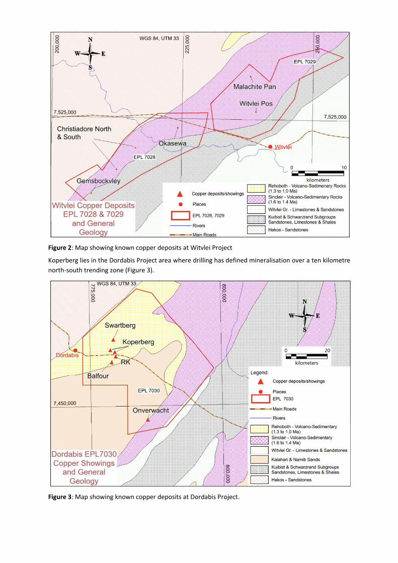
Figure 2: Map showing known copper deposits at Witvlei Project
Koperberg lies in the Dordabis Project area where drilling has defined mineralisation over a ten kilometre
north-south trending zone (Figure 3).
Figure 3: Map showing known copper deposits at Dordabis Project.

The consolidated Mineral Resource for the DorWit Project, reported in accordance with the guidelines of the JORC Code (2012), is shown in Table 1.
Table 1: DorWit Consolidated Mineral Resources at a cut-off grade of 0.5% Cu as at 01 March 2021
Deposit Oxidation
State Classification
Category Tonnes
(Millions) Cu (%)
Ag (ppm)
Cu content (kilo tonnes)
Malachite Pan
Oxide
Indicated 0.11 1.30 7 1.4
Inferred 0.04 1.19 7 0.4
Total 0.15 1.27 7 1.8
Fresh
Indicated 2.81 1.39 8 39.2
Inferred 0.51 1.17 6 6.0
Total 3.32 1.36 8 45.2
All Total 3.47 1.36 7 47.0
Okasewa
Oxide Inferred 0.09 1.24 4 1.1
Fresh Inferred 4.28 1.15 4 49.2
All Total 4.36 1.15 4 50.3
Christiadore
Oxide Inferred 0.02 0.98 - 0.2
Fresh Inferred 0.93 1.62 - 15.0
All Total 0.95 1.61 - 15.2
Total Witvlei (Malachite Pan Okasewa Christiadore)
Oxide
Indicated 0.11 1.30 7 1.4
Inferred 0.14 1.19 - 1.7
Total 0.25 1.24 - 3.1
Fresh
Indicated 2.81 1.39 8 39.2
Inferred 5.72 1.23 - 70.3
Total 8.53 1.28 - 109.4
All Total 8.78 1.28 - 112.5
Koperberg
Oxide Inferred 0.29 1.05 - 3.0
Fresh Inferred 0.91 1.10 - 10.0
All Total 1.19 1.09 - 13.0
Total DorWit
Oxide
Indicated 0.11 1.30 7 1.4
Inferred 0.43 1.10 - 4.7
Total 0.54 1.14 - 6.2
Fresh
Indicated 2.81 1.39 8 39.2
Inferred 6.62 1.21 - 80.2
Total 9.43 1.27 - 119.4
All
Indicated 2.92 1.39 - 40.6
Inferred 7.05 1.20 - 85.0
Total 9.97 1.26 - 125.6 Notes:
1. All tabulated data have been rounded and as a result minor computational errors may occur. 2. Mineral Resources which are not Ore Reserves have no demonstrated economic viability. 3. The Mineral Resource is reported as 100% of the Mineral Resource for the project. 4. The Mineral Resource is reported for mineralisation contained within Whittle optimised pit shells above a cut-off grade of 0.5%
Cu, which is based on a copper price of USD 10,000/t, mining costs of USD 3/t ore and USD 2.5/t waste, processing and treatment costs of USD 13/t (mined), G&A USD 2/t (mined), 3% royalty, 2% sales cost, pit slope 45° oxide and 55° fresh, mining dilution 5%, mining recovery 95%, concentrate recovery 90%.

Witvlei Project
The Witvlei Project is located within a north easterly trending belt of Mesoproterozoic Sinclair Age
sediments (the Eskadron Formation) comprising altered andesitic breccias, red to grey siltstones and minor
limestone. Extensive deformation has resulted in folding about northeast-southwest trending axes, with
fold cores containing exposed basement age rocks (Rehoboth Age) comprising dioritic intrusive, mafic to
intermediate volcanic and volcaniclastic rocks. Copper mineralisation is typically located within argillites
and localised marls within the Eskadron Formation. The prospect areas are covered to a large extent by a
veneer of Tertiary to Quaternary age Kalahari Group sediments.
Malachite Pan
The original Mineral Resource estimate for Malachite Pan was completed in 2012 by MSA and was reported
in accordance with the 2004 Edition of the JORC Code.
Chalcocite is the dominant copper-bearing mineral at Malachite Pan. Subsidiary amounts of covellite (CuS),
bornite (Cu5FeS4), chalcopyrite (CuFeS2) and digenite (Cu9S5) also occur. The mineralogical work,
completed as part of the 2011 metallurgical test work, identified chrysocolla as the most dominant mineral
in oxide mineralisation at Malachite Pan. Oxidation is to a depth of approximately 10 m but reaches a depth
of 50 m in one localised instance. Iron oxides are pervasive at the prospect, including haematite (Fe2O3),
magnetite (Fe3O4) and ilmenite (Fe,TiO2), as well as ankerite (CaCO3(Mg,Fe,Mn)CO3).
The Mineral Resource is based upon drilling completed between 2007 and 2008 by WAGE, which drilled a
total of 362 reverse circulation (RC) holes, 20 diamond drillholes and 26 RC holes with diamond tails at
Malachite Pan for the purpose of defining the Mineral Resource. The holes were generally drilled in a grid
pattern spaced 40 m along strike and 20 m down dip. In 2011, WAGE drilled 20 more diamond holes at the
deposit, ten of which were for the purpose of confirming the Mineral Resource, while the rest were for
metallurgical purposes.
A total of 55 individual mineralised lodes were interpreted, with most of them striking at 300° and dipping
at 45° to the southwest. The three-dimensional wireframes enclose intervals of greater than 2 m with a
copper threshold grade of 0.3%, although the threshold was relaxed in some instances in order to facilitate
modelling of continuous lodes. Mineralisation was generally extrapolated a maximum of 10 m from the
drillholes on the peripheries of the lodes. Leapfrog Geo was used to model a weathered/oxidised boundary
surface, below which the rock is considered fresh. A transitional zone was not modelled due to difficulties
in creating cohesive zones with the data available.
Datamine Studio 3 was used to estimate copper grade, silver grade and density into a three-dimensional
block model. Estimation was completed for each lode only using the data within the individual lode.
Ordinary kriging was used for lodes that were modelled with 50 or more one metre drillhole sample
composites, and inverse distance to the power of two was used for lodes informed by less data.
The amount of drilling has defined the continuity of the larger lodes, within which high- and low-grade
zones are visually discernible at the current drill grid of 40 m by 20 m nominal spacing. Lodes that have
been estimated with drilling data in both the dip and strike directions at the nominal spacing were classified
as Indicated Mineral Resources whereas those with more limited data were classified as Inferred (Table 2).
A cut-off grade of 0.5% copper was used to report the Mineral Resource that is constrained within a Whittle
optimised pit shell (Figure 4).

Table 2: Malachite Pan Mineral Resource at a cut-off grade of 0.5% Cu as at 01 March 2021
Oxidation State Classification
Category
Tonnes
(Millions)
Cu
(%)
Ag
(ppm)
Cu content
(kilo tonnes)
Oxide Indicated 0.11 1.30 7 1.4
Inferred 0.04 1.19 7 0.4
Fresh Indicated 2.81 1.39 8 39.2
Inferred 0.51 1.17 6 6.0
Total 3.47 1.36 7 47.0
Notes: 1. All tabulated data have been rounded and as a result minor computational errors may occur. 2. Mineral Resources which are not Ore Reserves have no demonstrated economic viability. 3. The Mineral Resource is reported as 100% of the Mineral Resource for the project. 4. The Mineral Resource is reported for mineralisation contained within a Whittle optimised pit shell above a cut-off grade of 0.5%
Cu, which is based on a copper price of USD 10,000/t, mining costs of USD 3/t ore and USD 2.5/t waste, processing and treatment costs of USD 13/t (mined), G&A USD 2/t (mined), 3% royalty, 2% sales cost, pit slope 45° oxide and 55° fresh, mining dilution 5%, mining recovery 95%, concentrate recovery 90%.
Table 3 and Table 4 show the sensitivity of the Mineral Resource grade and tonnage to changes in the
cut-off grade.
Table 3: Grade tonnage table for Indicated Resource at Malachite Pan as at 01 March 2021
Cut-off grade (% Cu)
Tonnes (Millions)
Cu (%)
Ag (ppm)
Cu content (kilo tonnes)
0.3 3.14 1.32 7 41.5
0.5 2.92 1.39 8 40.6
0.7 2.59 1.49 8 38.6
1.0 1.94 1.71 9 33.1
Table 4: Grade tonnage table for Inferred Resource at Malachite Pan as at 01 March 2021
Cut-off grade (% Cu)
Tonnes (Millions)
Cu (%)
Ag (ppm)
Cu content (kilo tonnes)
0.3 0.60 1.10 6 6.7
0.5 0.55 1.17 6 6.4
0.7 0.42 1.35 8 5.6
1.0 0.31 1.53 9 4.7

Figure 4: Malachite Pan - Plan view showing drillhole traces, grade shells and pit shell
Figure 5: Cross section looking south-east of Malachite Pan resource drillholes and wireframes
NORONEX – Malachite PanPlan view showing drillhole traces, grade shells and pit shell
February 2021
MinRes
250 m
N
900 mDrillhole traces – light blueOpen pit area - violet mesh0.3% Cu grade shells – grey solids
A
A´
Pit Shell
NORONEX – Malachite Pan. Cross section A-A´ looking south-east showing drillhole traces, model and pit shell
February 2021
MinRes
100 m
170 m
20 m
Drillholes projected into section 10 m clipping either side
A A´

Okasewa
The Mineral Resource at Okasewa has not previously been publicly reported in accordance with an
international Mineral Resource and Reserve reporting code such as JORC. Grade and tonnage models were
completed by WAGE in 2011 and were reviewed by MSA.
Mineralisation at Okasewa occurs as disseminated chalcopyrite and chalcocite predominantly within
massive to banded limestone/marl units with locally developed graphitic partings. Oxidation is to a general
depth of approximately 5 m, with some locally deeper oxidation that reaches a depth of 25 m in one
drillhole.
From 2005 to 2008, WAGE drilled a total of 226 reverse circulation (RC) holes and 8 diamond drillholes at
Okasewa for the purpose of defining the Mineral Resource. The holes were generally drilled in a grid
pattern of 40 m by 40 m with some areas drilled at a spacing of 40 m along strike by 20 m down dip.
A total of 89 sub-parallel east-west striking wireframes were modelled in three broad northeast to
southwest trending zones using Surpac software. The three-dimensional wireframes enclose intervals of
greater than 2 m with a copper threshold grade of 0.3%, although the threshold was relaxed in some
instances to facilitate modelling of continuous lodes. Mineralisation was generally extrapolated to a
maximum of 10 m from the drillholes on the peripheries of the lodes. Leapfrog Geo was used to model a
weathered/oxidised boundary surface, below which the rock is considered fresh. A transitional zone was
not modelled due to difficulties in creating cohesive zones with the data available.
Surpac software was used to estimate copper grades into a three-dimensional block model. Estimation was
completed for each lode only using the data within the individual lode. Inverse distance to the power of
two was employed to estimate the grade using at least 10 one metre drillhole sample composites, and the
average composite copper grade of the lode was applied to lodes informed by less data. The search ellipses
were aligned to the orientation of the mineralisation. The composites were top capped to 4.5% Cu, which
affected three composites. The models were validated by MSA and the copper grade estimates were found
to mimic the trend of the input data and to be globally within 10% relative difference of the average
drillhole data grade. Global silver grade and density value for the deposit were assigned to the block model.
The Mineral Resource was classified in accordance with the 2012 edition of the Australasian Code for
Reporting of Exploration Results, Mineral Resources and Ore Reserves (The JORC Code). All of the Okasewa
Mineral Resource is currently classified at an Inferred level of confidence as the current drilling spacing
(mostly at 40 m by 40 m) is insufficient to assume grade continuity between the intersections, as well as
MSA being unable to assess the precision using the RC field duplicates.
A cut-off grade of 0.5% copper was used to report the Mineral Resource that is constrained within a Whittle
optimised pit shell (Table 5, Figure 6 and Figure 7).

Table 5: Okasewa Mineral Resource at a cut-off grade of 0.5% Cu as at 01 March 2021
Oxidation State Classification
Category Tonnes
(Millions) Cu
(%) Ag
(ppm) Cu content
(kilo tonnes)
Oxide Inferred 0.09 1.24 4 1.1
Fresh Inferred 4.28 1.15 4 49.2
Total 4.36 1.15 4 50.3
Notes: 1. All tabulated data have been rounded and as a result minor computational errors may occur. 2. Mineral Resources which are not Ore Reserves have no demonstrated economic viability. 3. The Mineral Resource is reported as 100% of the Mineral Resource for the project. 4. The Mineral Resource is reported for mineralisation contained within a Whittle optimised pit shell above a cut-off grade of 0.5%
Cu, which is based on a copper price of USD 10,000/t, mining costs of USD 3/t ore and USD 2.5/t waste, processing and treatment costs of USD 13/t (mined), G&A USD 2/t (mined), 3% royalty, 2% sales cost, pit slope 45° oxide and 55° fresh, mining dilution 5%, mining recovery 95%, concentrate recovery 90%.
Table 6 shows the sensitivity of the Mineral Resource grade and tonnage to changes in the cut-off grade.
Table 6: Grade tonnage table for Inferred Resource at Okasewa as at 01 March 2021
Cut-off grade (% Cu)
Tonnes (Millions)
Cu (%)
Ag (ppm)
Cu content (kilo tonnes)
0.3 4.79 1.09 4 52.1
0.5 4.36 1.15 4 50.3
0.7 3.69 1.25 4 46.2
1.0 2.39 1.47 4 35.1
Figure 6: Okasewa - Plan view showing drillhole traces, grade shells and pit shell
NORONEX - OkasewaPlan view showing drillhole traces, grade shells and pit shell
February 2021
MinRes
250 m
Drillhole traces – light blueOpen pit area – violet mesh0.3% Cu grade shells – grey solids
N
A
A’
1,300 m

Figure 7: Cross section looking west of Okasewa drillhole, wireframes and pit shell outline
Christiadore
The Mineral Resource at Christiadore has not previously been publicly reported in accordance with an
international Mineral Resource and Reserve reporting code such as JORC. Grade and tonnage models were
completed by WAGE in 2011 and were reviewed by MSA.
Similarly, to other deposits in the region, observed mineralisation at Christiadore is chalcopyrite and
chalcocite. Oxidation is generally to a depth of between 5 m and 10 m.
From 2007 to 2008, WAGE drilled a total of 32 reverse circulation (RC) holes at Christiadore for the purpose
of defining the Mineral Resource. The holes were generally drilled in a grid pattern of 40 m by 40 m, with
areas to the northeast drilled up to 80 m along strike by 40 m down dip.
A total of 13 sub-parallel mineralisation wireframes were modelled at Christiadore, striking northeast and
dipping southeast. The three-dimensional wireframes enclose intervals of greater than 2 m with a copper
threshold grade of 0.3%, although the threshold was relaxed in some instances to facilitate modelling of
continuous lodes. Mineralisation was generally extrapolated a maximum of 20 m from the drillholes on the
peripheries of the lodes. Leapfrog Geo was used to model a weathered/oxidised boundary surface, below
which the rock is considered fresh. A transitional zone was not modelled due to difficulties in creating
cohesive zones with the data available. Nine historical holes (drilled by FEDSWA in the 1960’s and 1970’s),
were used to interpret the most south-easterly wireframe and depth extension in the most north-easterly
wireframes.
Surpac software was used to estimate copper grade into a three-dimensional block model. Estimation was
completed for each lode only using the data within the individual lode. Inverse distance to the power of
two was used to estimate the grade using at least 10 one metre drillhole sample composites, and the
average composite copper grade of the lode was applied to lodes informed by less data. The search ellipses
were aligned to the orientation of the mineralisation. The composites were top capped to 4.65% Cu, which
affected only one composite. The models were validated by MSA and the copper grade estimates were
found to be globally within 10% relative difference of the average drillhole data grade. The global average
density value for the deposit was assigned to the block model.
The Mineral Resource was classified in accordance with the 2012 edition of the Australasian Code for
Reporting of Exploration Results, Mineral Resources and Ore Reserves (The JORC Code). All the Christiadore
NORONEX – Okasewa - Cross section A-A’ looking west showing drillhole traces, model and pit shell
February 2021
MinRes
100 m
Drillholes projected into section 20m clipping either side
A A’40 m
130 m
Pit shell

Mineral Resource is classified at an Inferred level of confidence due to the current drilling spacing that is
mostly at 40 mm by 40 m which is not adequate to determine continuity of geology and mineralisation, as
well as MSA being unable to assess the precision using the RC field duplicates. The most south-easterly
lode and the depth extension of the most north-easterly lodes, that were estimated mostly with historical
data, were excluded from the current Mineral Resource.
A cut-off grade of 0.5% copper was used to report the Mineral Resource that is constrained within a Whittle
optimised pit shell (Table 7, Figure 8 and Figure 9).
Table 7: Christiadore Mineral Resource at a cut-off grade of 0.5% Cu as at 01 March 2021
Oxidation State Classification
Category Tonnes
(Millions) Cu (%)
Cu content (kilo tonnes)
Oxide Inferred 0.02 0.98 0.2
Fresh Inferred 0.93 1.62 15.0
Total 0.95 1.61 15.2
Notes: 1. All tabulated data have been rounded and as a result minor computational errors may occur. 2. Mineral Resources which are not Ore Reserves have no demonstrated economic viability. 3. The Mineral Resource is reported as 100% of the Mineral Resource for the project. 4. The Mineral Resource is reported for mineralisation contained within a Whittle optimised pit shell above a cut-off grade of 0.5%
Cu, which is based on a copper price of USD 10,000/t, mining costs of USD 3/t ore and USD 2.5/t waste, processing and treatment costs of USD 13/t (mined), G&A USD 2/t (mined), 3% royalty, 2% sales cost, pit slope 45° oxide and 55° fresh, mining dilution 5%, mining recovery 95%, concentrate recovery 90%.
Table 8 shows the sensitivity of the Mineral Resource grade and tonnage to changes in the cut-off grade.
Table 8: Grade tonnage table for Inferred Resource at Christiadore as at 01 March 2021
Cut-off grade (% Cu)
Tonnes (Millions)
Cu (%)
Cu content (kilo tonnes)
0.3 1.06 1.48 15.7
0.5 0.95 1.61 15.2
0.7 0.77 1.84 14.2
1.0 0.65 2.02 13.2

Figure 8: Christiadore - Plan view showing drillhole traces, grade shells and pit shell
Figure 9: Cross section looking north-east of Christiadore drillhole, wireframes and pit shell outline
100 m
NORONEX - ChristiadorePlan view showing drillhole traces, grade shells and pit shell
February 2021
MinRes
Drillhole traces – light blueOpen pit area – violet mesh0.3% Cu grade shells – grey solids
N
A’
A
430 m
NORONEX – Christiadore - Cross section A-A’ looking north-east showing drillhole traces, model and pit shell
February 2021
MinRes
100 m
A A’40 m
160 m
Drillholes projected into section 20m clipping either side
Pit shell

Dordabis Project
The Dordabis project area is characterised by a series of north-easterly trending belts of Mesoproterozoic
Sinclair-age volcanoclastic sediments and Damaran age metasediments (comprising Nosib and Nama
Groups) that are separated by later low angle northeast trending thrust faults formed during the Damaran
Orogeny. The area has had varying intensities and phases of folding (dominated by northeast trending fold
axes), with the Sinclair equivalents displaying the most intense deformation as shown by regional scale
airborne magnetics.
Koperberg
The original Mineral Resource estimate for Malachite Pan was completed in 2012 by MSA and was reported
in accordance with the 2004 Edition of the JORC Code.
At Koperberg, the primary sulphide (chalcocite, Cu2S) is oxidised down to approximately 35 m below
surface and this was the initial target for a previously proposed exploitation of the deposit. Chrysocolla is
the main mineral in the oxide ore, followed by malachite.
Between 2005 and 2008, WAGE drilled a total of 239 RC holes for the purpose of defining the Mineral
Resource. The holes were generally drilled in a grid pattern aligned north-south at 20 mN by 20 mE spacing.
In 2011, WAGE drilled ten diamond holes for metallurgical test work. However, the detailed logs and the
assays for these holes are not available, and MSA is unable to comment on the results of these holes
relative to the current Mineral Resource model.
A total of 38 mineralisation lodes were modelled with strike directions from 290° in the south to 350° in
the north, and a dip of 45° towards the east. The three-dimensional wireframes enclose intervals of greater
than 2 m with a copper threshold grade of 0.3%, although the threshold was relaxed in some instances in
order to facilitate modelling of continuous lodes. Mineralisation was generally extrapolated a maximum of
10 m from the drillholes on the peripheries of the lodes. Leapfrog Geo was used to model a
weathered/oxidised boundary surface below which the rock is considered fresh.
Datamine Studio 3 was used to estimate copper grades and density into a three-dimensional block model.
Estimation was completed for each lode only using the data within the individual lode. Ordinary kriging was
used for lodes that were modelled with 50 or more one metre drillhole sample composites, and inverse
distance to the power of two was used for lodes informed by less data. Density was estimated using inverse
distance to the power of two for all lodes. The search ellipse dimensions were aligned with the modelled
variogram ranges. Capping was not applied to the grade data as no significant outliers were identified. The
models were validated, and the copper grade estimates were found to mimic the trend of the input data
and are globally within 10% relative difference of the average drillhole data grade.
The Mineral Resource was classified in accordance with the 2012 edition of the Australasian Code for
Reporting of Exploration Results, Mineral Resources and Ore Reserves (The JORC Code). All the Koperberg
Mineral Resource is classified at an Inferred level of confidence due to lack of sufficient CRMs
accompanying the drill samples to the laboratory.
A cut-off grade of 0.5% copper was used to report the Mineral Resource that is constrained within a Whittle
optimised pit shell (Table 8, Figure 10 and Figure 11).

Table 8: Koperberg Mineral Resource at a cut-off grade of 0.5% Cu as at 01 March 2021
Oxidation State Classification
Category Tonnes
(Millions) Cu
(%) Cu content
(kilo tonnes)
Oxide Inferred 0.29 1.05 3.0
Fresh Inferred 0.91 1.10 10.0
Total 1.19 1.09 13.0
Notes: 1. All tabulated data have been rounded and as a result minor computational errors may occur. 2. Mineral Resources which are not Ore Reserves have no demonstrated economic viability. 3. The Mineral Resource is reported as 100% of the Mineral Resource for the project. 4. The Mineral Resource is reported for mineralisation contained within a Whittle optimised pit shell above a cut-off grade of 0.5%
Cu, which is based on a copper price of USD 10,000/t, mining costs of USD 3/t ore and USD 2.5/t waste, processing and
treatment costs of USD 13/t (mined), G&A USD 2/t (mined), 3% royalty, 2% sales cost, pit slope 45° oxide and 55° fresh, mining
dilution 5%, mining recovery 95%, concentrate recovery 90%.
Table 9 shows the sensitivity of the Mineral Resource grade and tonnage to changes in the cut-off grade.
Table 9: Grade tonnage table for Inferred Resource at Koperberg as at 01 March 2021
Cut-off grade (% Cu)
Tonnes (Millions)
Cu (%)
Cu content (kilo tonnes)
0.3 1.33 1.02 13.6
0.5 1.19 1.09 13.0
0.7 0.97 1.20 11.7
1.0 0.60 1.42 8.5

Figure 10: Koperberg - Plan view showing drillhole traces, grade shells and pit shell
Figure 11: Cross section looking north of Koperberg drillhole, wireframes and pit shell outline
NORONEX - KoperbergPlan view showing drillhole traces, grade shells and pit shell
February 2021
MinRes
Open Pit Area
250 m
N
500 mDrillhole traces – light blueOpen pit area - violet mesh0.3% Cu grade shells – grey solids
A A´
Pit Shell
NORONEX - KoperbergCross section A-A´ looking north showing drillhole traces, model and pit shell
February 2021
MinRes
50 m
110m
20m
Drillholes projected into section 10 m clipping either side
A A´

Sample Preparation, Assay and Quality Control and Assurance (QAQC)
Where diamond drilling was used, core was longitudinally cut in half using a diamond saw. Generally, one
metre samples were collected continuously through the mineralised zones; however, intervals were
adjusted to as little as 25 cm to honor the mineralisation boundaries. For RC drilling, one metre samples
were collected from the cyclone into a large plastic bag and then split using a riffle splitter to provide a
representative sample of between 1 kg and 2 kg for analyses at the laboratory. The remaining
approximately 4 kg of sample was retained and stored. A small sample was taken from the bag and placed
in a chip tray for visual inspection and logging by the geologist.
Field duplicates were collected for RC drilling to check the quality of sub-sampling. MSA could not assess
field duplicates for Okasewa and Christiadore, as the original sample could not be identified in the
database.
Sample assays were completed at Intertek Genalysis Laboratory Services (Perth) which is an accredited independent commercial laboratory. A four-acid digest with atomic adsorption finish was used for assaying the copper. For silver, a four acid digest and inductively-coupled mass spectroscopy finish was used. Blanks and certified reference materials (CRMs) were inserted within all types of drilling samples. Three
CRM types were used; a high-grade oxide CRM (with a certified value of 3.08% Cu), a medium grade
sulphide CRM (with a certified value of 1.38% Cu) and a low-grade sulphide CRM (with a certified value of
0.9% Cu).
Insertion rates for QAQC are as follows:
Malachite Pan: 2% blanks; 4% field duplicates: 2% CRMs.
Okasewa: 2% blanks; 4% field duplicates: 2% CRMs.
Christiadore: 2% blanks; 1% field duplicates: 1% CRMs.
Koperberg: 3% blanks; 7% field duplicates: 0.12% CRMs.
The blank samples demonstrate minimal contamination in general. The field duplicates for Malachite Pan
and Koperberg shows acceptable precision of within 20% for grades greater than 0.1% Cu. Acceptable
accuracy was also observed with some assays plotting outside the two standard deviation from the
expected values. For example:
Malachite Pan: The high-grade CRM shows a positive bias with 15% of the data plotting outside the 2 times standard deviation of the certified value, while the medium grade CRM shows no bias and the low-grade CRM a slightly positive bias with 6% of the data plotting outside the limits. Okasewa: Assays of high-grade CRMs were within the control limits of two standard deviations from the accepted value; while 2% and 19% of the low- and medium-grade CRM assays were outside the control limits, respectively. Christiadore: Acceptable accuracy is observed with all the CRM assays plotting within the two standard deviation control limits. Koperberg: The samples all plotted within two standard deviations of the certified value with negligible bias observed. The Competent Person is satisfied that the sample assay data are fit for the purposes of Mineral Resource estimation. Where the QAQC was found lacking in detail, this was considered in the Mineral Resource classification.
Competent Person Statement
The Mineral Resource estimate has been prepared under the supervision of by Mr. J.C. Witley (BSc Hons,
MSc (Eng.)) who is a geologist with more than 30 years’ experience in base and precious metals exploration
and mining as well as Mineral Resource evaluation and reporting. He is a Principal Resource Consultant for

The MSA Group (an independent consulting company), is registered with the South African Council for
Natural Scientific Professions (“SACNASP”) and is a Fellow of the Geological Society of South Africa
(“GSSA”). Mr. Witley has the appropriate relevant qualifications and experience to be considered a
“Competent Person” for the style and type of mineralisation and activity being undertaken as defined by
the 2012 Edition of the JORC Code.
On behalf of:
THE MSA GROUP
………………………………………………
J.C. Witley Pr. Sci. Nat.
Principal Mineral Resource Consultant
Airborne EM Survey
Completion of flying the first ever airborne electromagnetic (EM) survey over the majority of the 780 square kilometres tenement package with New Resolution Geophysics (NRG) using their Xcite system is expected shortly.
Progress has been slower than expected due to COVID restrictions, a historically wet rainy season and
access issues. Preliminary results will be provided when available.
– ENDS – Authority: This announcement has been authorised for release by the Board of Directors of Noronex Limited For further information, contact the Company at [email protected] or on (08) 6555 2950
About Noronex Limited Noronex is an ASX listed copper company with advanced projects in the Kalahari Copper Belt, Namibia and in Ontario, Canada that have seen over 170,000m of historic drilling. The 80,000Ha Dorwit Project in Namibia has a current JORC (2012) resource of 10mt @1.3% Cu. The 30,000Ha Onaman Project in Canada has a current JORC (2012) resource of 1.6mt @ 1.6% Cu. The company plans to use modern technology and exploration techniques to generate new targets at the projects and grow the current resource base.

Forward-Looking Statements This document includes forward-looking statements. Forward-looking statements include, but are not limited to, statements concerning Noronex Limited’s planned exploration programs, corporate activities and any, and all, statements that are not historical facts. When used in this document, words such as "could," "plan," "estimate," "expect," "intend," "may”, "potential," "should" and similar expressions are forward-looking statements. Noronex Limited believes that its forward-looking statements are reasonable; however, forward-looking statements involve risks and uncertainties, and no assurance can be given that actual future results will be consistent with these forward-looking statements. All figures presented in this document are unaudited and this document does not contain any forecasts of profitability or loss.

JORC TABLE 1
Section 1 Sampling Techniques and Data (Criteria in this section apply to all succeeding sections.)
Criteria
JORC Code explanation
Commentary
Sampling
techniques •
•
•
•
Nature and quality of sampling (e.g. cut channels, random chips, or specific specialised industry standard measurement tools appropriate to the minerals under investigation, such as down hole gamma sondes, or handheld XRF instruments, etc). These examples should not be taken as limiting the broad meaning of sampling. Include reference to measures taken to ensure sample representivity and the appropriate calibration of any measurement tools or systems used. Aspects of the determination of mineralisation that are Material to the Public Report. In cases where ‘industry standard’ work has been
done this would be relatively simple (e.g. ‘reverse
circulation drilling was used to obtain 1 m samples
from which 3 kg was pulverised to produce a 30 g
charge for fire assay’). In other cases, more
explanation may be required, such as where there is
coarse gold that has inherent sampling problems.
Unusual commodities or mineralisation types (e.g.
submarine nodules) may warrant disclosure of
detailed information.
•
•
•
•
•
Diamond drilling (DD), reverse circulation (RC) drilling and reverse circulation with diamond drilling tails were used to collect samples continuously through the mineralised horizons. Reverse circulation was used to collect 1 m long samples continuously through the potentially mineralised horizons. Riffle splitting was used to provide a 1 kg to 2 kg sample and the residual material was retained. A field copper test to aid visual identification of copper-bearing intervals. The method involves the addition of nitric acid (55% HNO3) to a small sample (approx. 50g) followed by the addition of ammonia (NH3). The solution was mixed and then left to settle, with the resulting colour of the solution indicating the presence of copper (darker blue indicates higher copper grade). The earlier exploration samples were composited into
4 m samples and trucked to Windhoek where they were
assayed at Analytical Laboratory Services in Windhoek. If
the analyses were deemed significant, the retained RC
material was re-sampled at 1 m intervals and forwarded
to Genalysis Laboratories in Johannesburg where they
were prepared for final assay at Genalysis in Perth. Later
reverse circulation used 1 m samples that were sent
directly to Genalysis in Perth. The NQ (47.6 mm diameter) diamond drill cores
identified for sampling were split longitudinally in half
using a diamond saw. A nominal 1 m sample length was
used which was adjusted to honor lithological or
mineralisation boundaries. The minimum sampling
length used was 0.25 m. Drilling and trenches at Malachite Pan were completed
by previous owners. These guided the mineralisation
model to a limited extent and were not used in grade
estimation.
Christiadore used a total of 9 historical holes in the
modelling.

Criteria
JORC Code explanation
Commentary
Drilling
techniques • Drill type (e.g. core, reverse circulation, open-hole
hammer, rotary air blast, auger, Bangka, sonic, etc)
and details (e.g. core diameter, triple or standard
tube, depth of diamond tails, facesampling bit or
other type, whether core is oriented and if so, by what
method, etc).
• Between 2005 and 2008, West African Gold
Exploration (Namibia) (Pty (WAGE) a subsidiary of North
River Resources, who was the previous owner, drilled
the following for the purpose of delineating Mineral
Resources:
Malachite Pan = 362 RC holes, 20 DD and 26 RC with DD
tail holes.
Okasewa = 226 RC holes and 8 DD
Christiadore = 32 RC holes
Koperberg = 239 RC holes • In 2011, WAGE drilled the following additional holes:
Malachite Pan = 20 diamond holes, 10 for Mineral
Resource, while the other 10 were for metallurgical
reasons.
These holes have not been incorporated in the current
Mineral Resource; however, they confirm the modelled
mineralisation and show a similar grade distribution
with some local variability. MSA does not consider that
the inclusion of this data would significantly affect the
current estimate.
Koperberg = 10 diamond holes for metallurgical
reasons.
The detailed logs and the assays for these holes are not
available, and MSA is unable to comment on the results
of these holes relative to the current Mineral Resource
model.
• Drillholes were not orientated.
Drill sample
recovery
•
•
•
Method of recording and assessing core and chip sample recoveries and results assessed. Measures taken to maximise sample recovery and
ensure representative nature of the samples. Whether
a relationship exists between sample recovery and
grade and whether sample bias may have occurred
due to preferential loss/gain of fine/coarse material.
•
•
•
•
Recoveries were not recorded for RC drilling. Diamond drillhole recoveries average >99%. It is not expected that any losses will cause sample bias although this has not been systematically determined. The rocks at the DorWit Project are highly competent
except for the near surface weathered material.
Logging •
•
•
Whether core and chip samples have been geologically and geotechnically logged to a level of detail to support appropriate Mineral Resource estimation, mining studies and metallurgical studies. Whether logging is qualitative or quantitative in nature. Core (or costean, channel, etc) photography. The total length and percentage of the relevant
intersections logged.
•
•
All drill core was logged in detail, and includes information relating to lithology, weathering/oxidation, geotechnical aspects and structural/point data. For RC drilling, a small sample was taken from the bag and placed in a chip tray for logging by the geologist. Nearly 100% of the drilled length has been logged. Logging is qualitative in nature by visual methods.

Criteria
JORC Code explanation
Commentary
Subsampling
techniques
and sample
preparation
•
•
•
•
•
If core, whether cut or sawn and whether quarter, half or all core taken. If non-core, whether riffled, tube sampled, rotary split, etc and whether sampled wet or dry. For all sample types, the nature, quality and appropriateness of the sample preparation technique. Quality control procedures adopted for all subsampling stages to maximise representivity of samples. Measures taken to ensure that the sampling is representative of the in-situ material collected, including for instance results for field duplicate/second-half sampling. Whether sample sizes are appropriate to the grain size
of the material being sampled.
•
•
•
•
Where diamond drilling was used, core was
longitudinally cut in half using a diamond saw. For
metallurgical sampling, the remaining half was
longitudinally split in quarter using a diamond saw.
Generally, one metre samples were collected; however,
intervals were adjusted to as little as 25 cm to honor
the mineralisation boundaries. For RC drilling, one
metre samples were collected from the cyclone into a
large plastic bag and then split using a riffle splitter to
provide a representative sample of between 1 kg and 2
kg for analyses at the laboratory. The remaining
approximately 4 kg of sample was retained and stored.
A small sample was taken from the bag and placed in a
chip tray for visual inspection and logging by the
geologist. Field duplicates were collected for RC drilling to check
the quality of sub-sampling. MSA could not assess field
duplicates for Okasewa and Christiadore, as the original
sample could not be identified in the database. MSA considers that the nature and quality of the sample
preparation technique are appropriate for the style of
mineralisation at the DorWit Project. Sample sizes are appropriate given the fine grained and
disseminated nature of the mineralisation.
•
•
•
Quality of
assay data
and
laboratory
tests
•
•
•
The nature, quality and appropriateness of the assaying and laboratory procedures used and whether the technique is considered partial or total. For geophysical tools, spectrometers, handheld XRF instruments, etc, the parameters used in determining the analysis including instrument make and model, reading times, calibrations factors applied and their derivation, etc. Nature of quality control procedures adopted (e.g. standards, blanks, duplicates, external laboratory checks) and whether acceptable levels of accuracy (i.e. lack of bias) and precision have been established.
•
•
Sample assays were completed at Genalysis (Perth) which is an accredited laboratory. A four-acid digest with atomic adsorption was used for assaying the copper. For silver, mass spectroscopy was used. Blanks and certified reference materials were inserted
within all types of drilling samples. Field duplicates were
used to assess the quality of the RC sub-sampling. Three
CRM types were used; a high-grade oxide CRM (with a
certified value of 3.08% Cu), a medium grade sulphide
CRM (with a certified value of 1.38% Cu) and a low grade
sulphide CRM (with a certified value of 0.9% Cu). The
CRMs were inserted at 2% rate within both RC and DD
samples.

Criteria
JORC Code explanation
Commentary
• Insertion rate for QAQC are as follows:
Malachite Pan: 2% blanks; 4% field duplicates: 2%
CRMs.
Okasewa: 2% blanks; 4% field duplicates: 2% CRMs.
Christiadore: 2% blanks; 1% field duplicates: 1% CRMs.
Koperberg: 3% blanks; 7% field duplicates: 0.12% CRMs.
Generally, contamination is limited, the field duplicates
for Malachite Pan and Koperberg shows acceptable
precision of within 20% for grades greater than 0.1% Cu,
acceptable accuracy was also observed with some assays
plotting outside the two standard deviation from the
expected values. For example:
Malachite Pan: The high grade CRM shows a positive bias with 15% of the data plotting outside the 2 times standard deviation of the certified value, while the medium grade CRM shows no bias and the low grade CRM a slightly positive bias with 6% of the data plotting outside the limits. Okasewa: Assays of high grade CRMs were within the control limits of two standard deviations from the accepted value; while 2% and 19% of the low and medium grade CRM assays were outside the control limits, respectively. Christiadore: Acceptable accuracy is observed with all the CRM assays plotting within the two standard deviation control limits. Koperberg: The samples all plotted within two standard deviations of the certified value with negligible bias observed.
Verification
of sampling
and assaying
•
•
•
•
The verification of significant intersections by either independent or alternative company personnel. The use of twinned holes. Documentation of primary data, data entry procedures, data verification, data storage (physical and electronic) protocols. Discuss any adjustment to assay data.
•
•
•
•
•
•
•
MSA visited the project area in 2008 during which the
drilling processes were checked and the drillhole
database audited.
From 17 to the 21 August 2009, Mike Venter (a
geological consultant at MSA at the time) conducted a
site visit for the purposes of compiling a Competent
Persons Report for the Kalahari Minerals plc deposits.
Mike Hall (who was a Mineral Resource Consultant for
MSA at the time) completed a site visit from 13 to 15
June 2011.
The drilling data including collar, assay, survey logging
data are stored electronically in a Microsoft Access
database.
No adjustments were made to the assay data.
No twin holes were drilled.
No check sampling was carried out.
Location of
data points •
•
•
Accuracy and quality of surveys used to locate drill holes (collar and down-hole surveys), trenches, mine workings and other locations used in Mineral Resource estimation. Specification of the grid system used. Quality and adequacy of topographic control.
•
•
•
•
Collar positions were surveyed using a differential GPS. Coordinates are relative to WGS 84 UTM Zone 34S.
Down-hole survey was completed using Reflex camera
and Deflection / Magsus tool.
Where holes were blocked and surveys could not be
performed, the planned azimuth and dip was applied.
The DorWit Project area has a relatively flat relief. The
topography model was modelled using collar positions
as control points. A more detailed topographic model
will be suitable for advanced mining studies.
Criteria
JORC Code explanation
Commentary

Data spacing
and
distribution
•
•
•
Data spacing for reporting of Exploration Results. Whether the data spacing and distribution is sufficient to establish the degree of geological and grade continuity appropriate for the Mineral Resource and Ore Reserve estimation procedure(s) and classifications applied. Whether sample compositing has been applied.
•
•
Drillhole spacing is at follows: Malachite Pan: 40m along strike and 20m down dip; Okasewa: 40m by 40 m, with some areas drilled at 40 m along strike and 20 m in the down dip direction; Christiadore: 40 m by 40 m spacing with areas to the northeast drilled up to 80 m along strike by 40 m down dip. Koperberg: Aligned north-south at a spacing of 20mN by 20mE. It is the CP’s opinion that drilling is sufficient to establish
continuity of mineralisation and grade consistent with
Indicated or Inferred Mineral Resources depending on
the deposit.
• Compositing to 1 m for Mineral Resource estimation.
Orientation
of data in
relation to
geological
structure
•
•
Whether the orientation of sampling achieves unbiased sampling of possible structures and the extent to which this is known, considering the deposit type. If the relationship between the drilling orientation and
the orientation of key mineralised structures is
considered to have introduced a sampling bias, this
should be assessed and reported if material.
•
•
•
Malachite Pan: The RC holes were drilled sub-vertically
(most of the holes dipping at more than 80°) through
stratiform mineralisation dipping at 45°.
Okasewa: Most of the RC holes were drilled at a dip of
50° to 60° through stratiform mineralisation dipping at
least 60° in the opposite direction. Some holes were
drilled vertically.
Christiadore: Most of the holes were drilled at a dip of
50° to 60° almost perpendicular to the stratiform
mineralisation dipping at 70°.
Koperberg: The holes were drilled sub-vertically (with
most of the holes dipping at more than 80°) through
strataform mineralisation dipping at 45°.
It is the CP’s opinion that the drilling orientation did not
lead to sampling bias.
Sample security
• The measures taken to ensure sample security. • All drilling samples were kept under supervision of WAGE staff at the exploration camp until dispatch. Samples were sent to Windhoek for checking by senior WAGE staff and then road freighted to Genalysis Preparation facility in Johannesburg.
Audits or
reviews • The results of any audits or reviews of sampling
techniques and data. • In 2008, MSA completed an audit on site prior to the
Mineral Resource estimation which comprised the following: - a review of the database, - a review of drillhole data collection protocols and QA/QC systems, - a site based review of the drillhole data and a site visit to the properties, - QA/QC check audits by MSA.
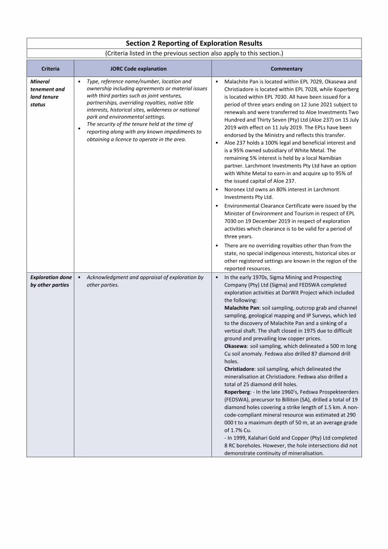
Section 2 Reporting of Exploration Results (Criteria listed in the previous section also apply to this section.)
Criteria
JORC Code explanation
Commentary
Mineral
tenement and
land tenure
status
•
•
Type, reference name/number, location and ownership including agreements or material issues with third parties such as joint ventures, partnerships, overriding royalties, native title interests, historical sites, wilderness or national park and environmental settings. The security of the tenure held at the time of
reporting along with any known impediments to
obtaining a licence to operate in the area.
•
•
Malachite Pan is located within EPL 7029, Okasewa and
Christiadore is located within EPL 7028, while Koperberg
is located within EPL 7030. All have been issued for a
period of three years ending on 12 June 2021 subject to
renewals and were transferred to Aloe Investments Two
Hundred and Thirty Seven (Pty) Ltd (Aloe 237) on 15 July
2019 with effect on 11 July 2019. The EPLs have been
endorsed by the Ministry and reflects this transfer.
Aloe 237 holds a 100% legal and beneficial interest and
is a 95% owned subsidiary of White Metal. The
remaining 5% interest is held by a local Namibian
partner. Larchmont Investments Pty Ltd have an option
with White Metal to earn-in and acquire up to 95% of
the issued capital of Aloe 237.
• Noronex Ltd owns an 80% interest in Larchmont Investments Pty Ltd.
• Environmental Clearance Certificate were issued by the
Minister of Environment and Tourism in respect of EPL
7030 on 19 December 2019 in respect of exploration
activities which clearance is to be valid for a period of
three years.
• There are no overriding royalties other than from the
state, no special indigenous interests, historical sites or
other registered settings are known in the region of the
reported resources. Exploration done
by other parties • Acknowledgment and appraisal of exploration by
other parties. • In the early 1970s, Sigma Mining and Prospecting
Company (Pty) Ltd (Sigma) and FEDSWA completed
exploration activities at DorWit Project which included
the following:
Malachite Pan: soil sampling, outcrop grab and channel
sampling, geological mapping and IP Surveys, which led
to the discovery of Malachite Pan and a sinking of a
vertical shaft. The shaft closed in 1975 due to difficult
ground and prevailing low copper prices.
Okasewa: soil sampling, which delineated a 500 m long
Cu soil anomaly. Fedswa also drilled 87 diamond drill
holes.
Christiadore: soil sampling, which delineated the
mineralisation at Christiadore. Fedswa also drilled a
total of 25 diamond drill holes.
Koperberg: - In the late 1960’s, Fedswa Prospekteerders
(FEDSWA), precursor to Billiton (SA), drilled a total of 19
diamond holes covering a strike length of 1.5 km. A non-
code-compliant mineral resource was estimated at 290
000 t to a maximum depth of 50 m, at an average grade
of 1.7% Cu.
- In 1999, Kalahari Gold and Copper (Pty) Ltd completed
8 RC boreholes. However, the hole intersections did not
demonstrate continuity of mineralisation.

Criteria
JORC Code explanation
Commentary
•
- In 2003, a private prospector, Mr J J Joubert, drilled 24
shallow open-hole percussion holes (for a total of
397 m). The drilling identified oxide material with some
Cu grades over 1% but continuity of mineralisation could
not be demonstrated. Bench scale metallurgical test
work completed on the composited oxide material, from
this drilling campaign, indicated 80% recoveries with “an
acceptable” acid consumption.
All drilling, metallurgical test work and geochemical soil
sampling from 2005 was completed by the previous
operator - West African Gold Exploration (Namibia) (Pty)
(WAGE), a subsidiary of Kalahari Minerals (between )
and North River Resources (NRR) (between ), who were
the owner of the project at the time.
Geology • Deposit type, geological setting and style of
mineralisation. •
•
The Witvlei Project is located within a north easterly trending belt of Mesoproterozoic Sinclair Age sediments (the Eskadron Formation) comprising altered andesitic breccias, red to grey siltstones and minor limestone. Extensive deformation has resulted in folding about north-east south-west trending axes, with fold cores containing exposed basement age rocks (Rehoboth Age) comprising dioritic intrusive, mafic to intermediate volcanic and volcaniclastic rocks. Copper mineralisation is typically located within argillites and localised marls within the Eskadron Formation. The Dordabis Project is characterised by a series of north-easterly trending belts of Mesoproterozoic Sinclair-age volcanoclastic sediments and Damaran age metasediments (comprising Nosib and Nama Groups) that are separated by later low angle northeast trending thrust faults formed during the Damaran Orogeny. The area has had varying intensities and phases of folding (dominated by northeast trending fold axes), with the Sinclair equivalents displaying the most intense deformation as shown by regional scale airborne magnetics.
• Chalcocite is the dominant copper-bearing mineral at
the DorWit Project, with other copper sulphide
mineralisation.
• Chrysocolla is observed as the mineral in the oxide ore
at DorWit, based on observations at Malachite Pan and
Koperberg), with some malachite.
• The mineralisation is stratiform and occurs in numerous
sub-parallel lodes.

Criteria
JORC Code explanation
Commentary
Drill hole Information
•
•
A summary of all information material to the understanding of the exploration results including a tabulation of the following information for all Material drill holes:
o easting and northing of the drill hole
collar o elevation or RL (Reduced Level –
elevation above sea level in metres) of the drill
hole collar
o dip and azimuth of the hole o down
hole length and interception depth o hole length.
If the exclusion of this information is justified on
the basis that the information is not Material and
this exclusion does not detract from the
understanding of the report, the Competent Person
should clearly explain why this is the case.
• Exploration results not being reported.
Data
aggregation
methods
•
•
•
In reporting Exploration Results, weighting averaging techniques, maximum and/or minimum grade truncations (e.g. cutting of high grades) and cut-off grades are usually Material and should be stated. Where aggregate intercepts incorporate short lengths of high-grade results and longer lengths of low-grade results, the procedure used for such aggregation should be stated and some typical examples of such aggregations should be shown in detail. The assumptions used for any reporting of metal
equivalent values should be clearly stated.
• Exploration results not being reported.
Relationship
between
mineralisation
widths and
intercept lengths
•
•
•
These relationships are particularly important in the reporting of Exploration Results. If the geometry of the mineralisation with respect to the drill hole angle is known, its nature should be reported. If it is not known and only the down hole lengths
are reported, there should be a clear statement to
this effect (e.g. ‘down hole length, true width not
known’).
•
•
•
The majority of samples were taken at 1 m lengths. There is no relationship between sample length and grade. Malachite Pan and Koperberg: The average dip of these
mineralisations is 45°; drilling was near vertical which
gives a correction from drilled length to true thickness
of 71%.
Okasewa and Christiadore: The average dip of these
mineralisations is 70° to near vertical; most of the
drilling was almost perpendicular to the mineralisation.
Diagrams • Appropriate maps and sections (with scales) and
tabulations of intercepts should be included for
any significant discovery being reported These
should include, but not be limited to a plan view of
drill hole collar locations and appropriate sectional
views.
• Exploration results not being reported
Balanced
reporting • Where comprehensive reporting of all Exploration
Results is not practicable, representative reporting
of both low and high grades and/or widths should
be practiced to avoid misleading reporting of
Exploration Results.
• Exploration results not being reported.

Criteria
JORC Code explanation
Commentary
Other
substantive
exploration data
• Other exploration data, if meaningful and material,
should be reported including (but not limited to):
geological observations; geophysical survey results;
geochemical survey results; bulk samples – size and
method of treatment; metallurgical test results;
bulk density, groundwater, geotechnical and rock
characteristics; potential deleterious or
contaminating substances.
•
•
•
Soil sampling was completed at the different deposits. Bulk density was not measured, but specific gravity was
measured on selected samples at the laboratory.
Metallurgical test work was carried out at Malachite Pan.
Further work •
•
The nature and scale of planned further work (e.g.
tests for lateral extensions or depth extensions or
large-scale step-out drilling). Diagrams clearly
highlighting the areas of possible extensions,
including the main geological interpretations and
future drilling areas, provided this information is
not commercially sensitive.
• A programme of further work has not yet been defined.
Section 3 Estimation and Reporting of Mineral Resources (Criteria listed in section 1, and where relevant in section 2, also apply to this section)
Criteria
JORC Code explanation
Commentary
Database
integrity •
Measures taken to ensure that data has not been corrupted by, for example, transcription or keying errors, between its initial collection and its use for Mineral Resource estimation purposes. Data validation procedures used.
• MSA completed a database audit in 2008. The 2008 and 2011 collar, survey, geology and assay data were imported into Studio 3 RM, where validation of the data was completed. The validation process consisted of:
- Examining the sample assay, collar survey and
geology data to ensure that the data were
complete for all drillholes,
- examining the de-surveyed data in three dimensions to check for spatial errors,
- checks for “From-To” errors, to ensure that the sample data did not overlap one another or that there were no unexplained gaps between samples.
Site visits •
Comment on any site visits undertaken by the Competent Person and the outcome of those visits. If no site visits have been undertaken indicate why
this is the case.
•
•
•
•
•
MSA conducted a site visit in 2008, where the drilling
activities were observed. From the 17 to the 21 August 2009, Mike Venter (a
geological consultant at MSA at the time) conducted a
site visit for the purposes of compiling a Competent
Persons Report for the Kalahari Minerals deposits. The project area was visited by Mike Hall (a consultant
with MSA at the time) from 13 to 15 June 2011, where
he observed the occurrences and setting of the copper
mineralisation as well as the 2011 drilling.
MSA was satisfied that the procedures and protocols
used in drilling are in line with acceptable industry
practices.
Site visits were not undertaken by the CP for this
Mineral Resource as no site-based exploration activities
are currently taking place. The CP is reliant on site-visits
and audits completed by other CP’s previously
employed by MSA.

Criteria
JORC Code explanation
Commentary
Geological
interpretation •
•
•
•
•
Confidence in (or conversely, the uncertainty of ) the geological interpretation of the mineral deposit. Nature of the data used and of any assumptions made. The effect, if any, of alternative interpretations on Mineral Resource estimation. The use of geology in guiding and controlling Mineral Resource estimation. The factors affecting continuity both of grade and
geology.
•
•
•
•
Sub-parallel wireframes of the mineralised lodes have been modelled for the different Mineral Resources at DorWit Projects. The wireframes were created on a grade basis with no lithological control. The wireframes enclose intervals of greater than 2 m
with a Cu grade of >= 0.3 %, although the threshold
was relaxed in some instances in order to facilitate
modelling of continuous lodes. Mineralisation was
generally extrapolated a maximum between 10 m and
20 m from the drillholes on the peripheries of the
lodes. A model representing the base of weathering was
completed that approximated the base of weathering.
This is not well defined by the RC drilling.
Dimensions • The extent and variability of the Mineral Resource
expressed as length (along strike or otherwise),
plan width, and depth below surface to the upper
and lower limits of the Mineral Resource.
•
•
•
Below are the plan areas and depth that the mineralised lodes extends to at different deposits: Malachite Pan: 600 m by 760 m and depth is 300 m; Okasewa: 1,150 m by 500 m and depth is 230 m; Christiadore: 160 m by 300 m and depth is 190 m; Koperberg: 620 m by 300 m and depth is 160 m. The mineralised lodes have an average thickness of 3 m to 6 m. The maximum depth of the Mineral Resource is the
maximum depth of the conceptual Whittle Pit Shell at
the following deposits:
Malachite Pan: 220 m
Okasewa: 220 m
Christiadore: 160 m
Koperberg:140 m
Estimation and
modelling
techniques
• The nature and appropriateness of the estimation
technique(s) applied and key assumptions,
including treatment of extreme grade values,
domaining, interpolation parameters and
maximum distance of extrapolation from data
points. If a computer
•
•
Estimation for Malachite Pan and Koperberg used
ordinary kriging for lodes that were modelled with 50 or
more one metre drillhole composites, and inverse
distance to the power of two was used for lodes
informed by less data. Density was estimated using
inverse distance to the power of two for all lodes. A
minimum of 3 and a maximum of 10 one metre
composite, with no capping applied. Search ellipses
were the same dimensions and orientation as the
variogram models. Surpac software was used to create
the mineralised lodes, while Datamine Studio 3 software
was used for the mineral resource estimation. Snowden
Supervisor software was used for the geostatistics and
univariate statistical analysis.
Estimation for Okasewa and Christiadore used inverse
distance to the power of two to estimate copper grades
for mineralised lodes, using a minimum number of 10
composites. Where the lodes had less than 10
composites, an average copper grade of the composites
per lode was applied. A top cap of 4.5% Cu and 4.65%
Cu were applied for Okasewa and Christiadore,
respectively. Search ellipses were aligned to the same
orientation as the mineralisation lodes. Global average
density value was assigned to the block model, while
global average silver grade was applied to Okasewa only
due to limited silver grades at Christiadore. Surpac
software was used for all three-dimensional geological
modelling and for Mineral Resource estimation.

Criteria
JORC Code explanation
Commentary
•
•
•
• • •
The following block model sizes were used for the
estimation of grade and density where applicable:
Malachite Pan = 40 mX by 40 mY by 1 mZ
Okasewa = 20 mX by 10 mY by 2 mZ
Christiadore = 20 mX by 20 mY by 2 mZ rotated at -55°
about the Z-axis.
Koperberg = 20 mX by 20 mY by 1 mZ.
Sectional validation plots (SWATH) and global means
confirmed that the model estimates followed the input
data trends and were generally within 10% of the input
data average.
No assumptions in the block model have been made
regarding the recovery of the silver.
Deleterious elements were not estimated.
No reconciliation data are available.
No comparison was made to historical estimates, which
used only historical data that was not incorporated in
this estimate.
Moisture • Whether the tonnages are estimated on a dry basis
or with natural moisture, and the method of
determination of the moisture content.
• Tonnage was estimated on a dry basis.
Cut-off
parameters • The basis of the adopted cut-off grade(s) or quality
parameters applied. • A Mineral Resource cut-off grade of 0.5% Cu was
applied based on the cost and revenue assumptions.
Mining factors
or assumptions • Assumptions made regarding possible mining
methods, minimum mining dimensions and internal
(or, if applicable, external) mining dilution. It is
always necessary as part of the process of
determining reasonable prospects for eventual
economic extraction to consider potential mining
methods, but the assumptions made regarding
mining methods and parameters when estimating
Mineral Resources may not always be rigorous.
Where this is the case, this should be reported with
an explanation of the basis of the mining
assumptions made.
•
•
The mineralisation extends from surface to a depth of the Whittle optimised pit shells: Malachite Pan: 220 m
Okasewa: 220 m
Christiadore: 160 m
Koperberg: 140 m It is assumed that the Mineral Resource is amenable to open-pit mining. The Mineral Resource was constrained within a Whittle optimised pit shell using the following assumptions:
• Mining Cost: Ore 3 USD/t, Waste 2.5 USD/t • Processing Cost: 7 USD/t ROM • G&A: USD 2/t ROM • Refining Cost: USD 6/t ROM • Royalty: 3% • Selling Cost: 2% • Slope angle: 45° Oxide, 55° Fresh • Mining recovery: 95% • Mining dilution: 5% • Processing Recovery 90% • Copper Price: USD 10,000/t

Criteria
JORC Code explanation
Commentary
Metallurgical
factors or
assumptions
• The basis for assumptions or predictions regarding
metallurgical amenability. It is always necessary as
part of the process of determining reasonable
prospects for eventual economic extraction to
consider potential metallurgical methods, but the
assumptions regarding metallurgical treatment
processes and parameters made when reporting
Mineral Resources may not always be rigorous.
Where this is the case, this should be reported with
an explanation of the basis of the metallurgical
assumptions made.
•
•
•
A copper recovery potential study was carried out in 2011 on the nearby Koperberg deposit, which has similar mineralisation to Malachite Pan. The study used a mixed oxide and sulphide composite sample and indicated that a reasonable concentrate grade (25% to 30%) could be produced, 84% of the copper could be recovered by flotation and more than 90% by leaching after roasting. The work was not optimal as it used a mixed oxide and
sulphide sample which will not reflect the mining mix
during production. More definitive work will be required as the project
progresses.
Environmental
factors or
assumptions
• Assumptions made regarding possible waste and
process residue disposal options. It is always
necessary as part of the process of determining
reasonable prospects for eventual economic
extraction to consider the potential environmental
impacts of the mining and processing operation.
While at this stage the determination of potential
environmental impacts, particularly for a
greenfields project, may not always be well
advanced, the status of early consideration of
these potential environmental impacts should be
reported. Where these aspects have not been
considered this should be reported with an
explanation of the environmental assumptions
made.
•
•
MSA is not aware of any environmental factors that can negatively affect the project. Environmental Clearance Certificate was issued by the
MET in respect EPL 7028, 7029 and 7030 on 19
December 2019 in respect of exploration activities
which clearance is to be valid for a period of three
years.
Bulk density •
•
•
Whether assumed or determined. If assumed, the basis for the assumptions. If determined, the method used, whether wet or dry, the frequency of the measurements, the nature, size and representativeness of the samples. The bulk density for bulk material must have been measured by methods that adequately account for void spaces (vugs, porosity, etc), moisture and differences between rock and alteration zones within the deposit. Discuss assumptions for bulk density estimates
used in the evaluation process of the different
materials.
•
•
Specific gravity was determined on selected RC and DD samples at the laboratory using a gas pycnometer. This method is appropriate for nonporous material. The porosity of the fresh rock is negligible. Depth of
weathering is at approximately 10 m depth and the SG
measurements may over-estimate the in-situ bulk
density for this material, which does not form a large
component of the Mineral Resources. SG values were
estimated into the block models using inverse distance
to the power of two for Malachite Pan and Koperberg
and global average density values were assigned for
Okasewa and Christiadore.
Classification •
•
•
The basis for the classification of the Mineral Resources into varying confidence categories. Whether appropriate account has been taken of all relevant factors (ie relative confidence in tonnage/grade estimations, reliability of input data, confidence in continuity of geology and metal values, quality, quantity and distribution of the data). Whether the result appropriately reflects the
Competent Person’s view of the deposit.
•
•
Malachite Pan: The amount of drilling has defined the continuity of the larger lodes, within which high and low grade zones are visually discernible at the current drill grid of 40 m by 20 m nominal spacing. Lodes that have been estimated by drilling data in both the dip and strike directions at the nominal spacing were classified as Indicated Mineral Resources, whereas those with more limited data were classified as Inferred. Okasewa: All of the Okasewa Mineral Resource is currently classified at an Inferred level of confidence as the current drilling spacing (mostly at 40 m by 40 m) is insufficient to assume grade continuity between the intersections, as well as MSA being unable to assess the precision using the RC field duplicates.
Criteria
JORC Code explanation
Commentary

• Christiadore: All of the Christiadore Mineral Resource is classified at an Inferred level of confidence due to the current drilling spacing that is mostly at 40 m by 40 m which is not adequate to determine continuity of geology and mineralisation as well as MSA being unable to assess the precision using the RC field duplicates. The most south-easterly lode and the depth extension of the north-eastern lodes estimated mostly with historical data are excluded from the current Mineral Resource. Koperberg: All the Koperberg Mineral Resource was classified at Inferred level of confidence due to lack of sufficient CRMs accompanying the drillhole samples to the laboratory.
Audits or
reviews • The results of any audits or reviews of Mineral
Resource estimates. • No independent audits of the current estimate have
been completed.
•
•
The Malachite Pan and Koperberg models were
completed in 2012 by MSA, were internally reviewed at
MSA for the purposes of this disclosure.
The Okasewa and Christiadore models completed in
2009 by WAGE were internally reviewed by MSA for the
purposes of this disclosure.
Discussion of
relative accuracy/
confidence
•
•
•
Where appropriate a statement of the relative accuracy and confidence level in the Mineral Resource estimate using an approach or procedure deemed appropriate by the Competent Person. For example, the application of statistical or geostatistical procedures to quantify the relative accuracy of the resource within stated confidence limits, or, if such an approach is not deemed appropriate, a qualitative discussion of the factors that could affect the relative accuracy and confidence of the estimate. The statement should specify whether it relates to global or local estimates, and, if local, state the relevant tonnages, which should be relevant to technical and economic evaluation. Documentation should include assumptions made and the procedures used. These statements of relative accuracy and
confidence of the estimate should be compared with
production data, where available.
•
•
•
The estimates are accurate at a global scale, based on
the swath and global mean validations against the input
data.
Refinement of the models, including more geological
control will improve the local accuracy of the models
suitable for a detailed assessment of technical and
economic evaluation.
These projects are exploration projects and no
production data are available.