jonathan wynne rees - ucl discovery · 2.3.3. new approaches to the interaction of rome and...
TRANSCRIPT
1
Settlement Patterns in Roman Galicia: Late Iron Age – Second Century AD
Jonathan Wynne Rees
Thesis submitted in requirement of fulfilments for the degree of Ph.D. in
Archaeology, at the Institute of Archaeology, University College London
University of London
2012

2
I, Jonathan Wynne Rees confirm that the work presented in this thesis is my own.
Where information has been derived from other sources, I confirm that this has been
indicated in the thesis.
3
Abstract
This thesis examines the changes which occurred in the cultural landscapes of
northwest Iberia, between the end of the Iron Age and the consolidation of the region
by both the native elite and imperial authorities during the early Roman empire. As a
means to analyse the impact of Roman power on the native peoples of northwest
Iberia five study areas in northern Portugal were chosen, which stretch from the
mountainous region of Trás-os-Montes near the modern-day Spanish border, moving
west to the Tâmega Valley and the Atlantic coastal area. The divergent physical
environments, different social practices and political affinities which these diverse
regions offer, coupled with differing levels of contact with the Roman world, form
the basis for a comparative examination of the area.
In seeking to analyse the transformations which took place between the Late
pre-Roman Iron Age and the early Roman period historical, archaeological and
anthropological approaches from within Iberian academia and beyond were analysed.
From these debates, three key questions were formulated, focusing on the Late Iron
Age settlement hierarchy, the impact of the administration of early Roman northwest
Iberia on settlement patterns, and the relationship between the pre-Roman and
Roman-period communication networks
In addressing these issues primarily through the medium of landscape
analyses, but also incorporating material evidence (from epigraphy sources, ceramic
ware as well as other sources), historical and anthropological studies, it was
established that the so-called ‘Castro Culture’ of northwest Iberia was not
homogeneous, but structured according to diverse socio-political and environmental
factors. In the early Roman period, a series of agricultural producers established
themselves in fertile areas, resulting in settlement patterns which were located near
communication routes and markets. Binding the landscape together were a series of
central places, which were often adapted from pre-Roman settlements. Thus, the
region’s pre-Roman traditions coupled with different customs introduced by Rome,
created a fusion of multiple practices, but from an economic perspective northwest
Iberia adopted many of the agricultural systems common in other parts of the Roman
empire.

4
List of Contents
Chapter One.......................................................................................................... 13
1.1. Introduction .................................................................................................... 13
1.2. Outline of Chapters and Structural Development .......................................... 14
1.3. Historical Overview ....................................................................................... 15
1.4. The Study Area .............................................................................................. 18
1.5. Current State of Knowledge: Models and Approaches to the Cultural
Sequence of Northwest Iberia ............................................................................... 21
1.5.1. Late Bronze Age / Early Iron Age (Ninth Century – Sixth Century BC) ... 23
1.5.2. Early Iron Age - Late Iron Age (Sixth Century BC – Second Century BC)
............................................................................................................................... 25
1.5.3. The Late Iron Age / Roman Period (Second Century BC – First Century
BC) ........................................................................................................................ 27
1.5.4. Surplus Production and the Reorganisation of Internal Space in LPRIA
(Late Pre-Roman Iron Age) Northwest Iberia ...................................................... 29
1.5.5. Evidence for Settlement Hierarchies in LPRIA Northwest Iberia .............. 31
1.5.6. Republican Rome and the Citânias ............................................................. 35
1.5.7. The Conquest of Northwest Iberia and the Emergence of the Civitas ........ 41
1.5.8. The Roman State and the Conventus Capitals ............................................ 42
1.5.9. The Road Network and Roman Settlements ............................................... 44
1.5.10. The Demise of the Castro ......................................................................... 45
1.5.11. The Emergence of Villae in the Landscape of Northwest Iberia .............. 45
1.6. Aims ............................................................................................................... 46
Chapter Two. Theoretical Background of the Cultural Sequence of Northwest
Iberia ..................................................................................................................... 49
2.1. Introduction .................................................................................................... 49
2.2. Theoretical Background to Research Question One ...................................... 49
2.2.1. The Theoretical Standpoints Underpinning the Discussion of the Role of
Surplus Production in LPRIA Northwest Iberia ................................................... 50
2.2.2. Critiques of the Models of Late Pre-Roman Society in Northwest Iberia
Advanced by Parcero Oubiña and Sastre Prats ..................................................... 53

5
2.2.2.1. Sastre Prats’ Use of Clastre’s Theory of Egalitarian Societies ................ 54
2.2.2.2. Isolationism during the Late Iron Age? ................................................... 56
2.2.2.3. Surplus Production in Iron Age Northwest Iberia? .................................. 57
2.2.2.4. Evidence of a Warrior Elite and Social Inequality in Iron Age Northwest
Iberia?.................................................................................................................... 59
2.2.2.5. Weaponry in Late Iron Age Northwest Iberia ......................................... 60
2.2.2.6. Summary and List of Objectives for Research Question One..................62
2.3. Theoretical Background to Research Question Two......................................64
2.3.1. The Demise of Castro Society and the Development of Roman Systems of
Authority...............................................................................................................64
2.3.2. ‘Romanisation’. A Defunct Paradigm or a Valuable Contribution to Roman
Studies? ................................................................................................................. 65
2.3.3. New Approaches to the Interaction of Rome and Peripheral Cultures ....... 68
2.3.4. The Emergence of Specialised Activities within Castro Settlements.........70
2.3.4.1. The Archaeological Evidence Underpinning the Development of Early
Roman Centres of Power.......................................................................................72
2.3.4.2. Summary and List of Objectives for Research Question Two.................74
2.4. Theoretical Background to Question Three ................................................... 75
2.4.1. Problems and Limitations of Current Interpretations of the Communication
Systems in Northwest Iberia during the Late Iron Age ........................................ 76
2.4.2. Connectivity and Change. Early Roman Communication Networks..........78
2.4.2.1. The Role of the Communications Network and the Importance of Trade
in the Early Roman Empire ................................................................................... 79
2.4.2.2. Commerce, Communications and Connectivity in the Early Imperial
Era.........................................................................................................................83
2.5. Summary ....................................................................................................... 86
Chapter Three. An Overview of the Five Study Areas ......................................... 88
3.1. Introduction .................................................................................................... 88
3.2. A General Analysis of Northern Portugal and the Study Areas Examined in
this Thesis ............................................................................................................. 88
3.3. The Physical Environment of Northwest Iberia ............................................. 89
3.4. The Human Landscapes, Past and Present: Settlement Patterns, Movement
and Communications............................................................................................. 91
3.5. The Derivation of the Dataset and its Application for Regional Survey
Analysis ................................................................................................................. 93
3.5.1. Introduction ................................................................................................. 93
3.5.2. An Introduction to the Dataset .................................................................... 93
3.5.3. An Evaluation of the Dataset and Comparative Regional Settlement
Analysis ................................................................................................................. 95
6
3.6. A Broad Characterisation of the Dataset ...................................................... 101
3.6.1. Issues with Dating and Site Classification. The Ceramic and Numismatic
Record.................................................................................................................101
3.6.2. Fibulae and Torques. Evidence of Distinct Social Structures and Relocation
within the Landscape?.........................................................................................106
3.6.3. Evidence for and Emerging Elite and Cross-Cultural Contact?................108
3.7. Summary......................................................................................................110
Chapter Four. The Geopolitical and Social Environment of Late Pre-Roman
Northwest Iberia .................................................................................................. 111
4.1. Introduction .................................................................................................. 111
4.2. Sastre Prats, Chiefdoms and Social Evolutionism ....................................... 111
4.3. New Approaches in Understanding Late Pre-Roman Society in Northwest
Iberia. Geopolitical Borders, Social Boundaries and Spatial Divisions ............. 115
4.4. Borders, Boundaries and Models of Late Pre-Roman Society in Northwest
Iberia ................................................................................................................... 118
4.5. Settlement Analysis and Models of Late Castro Society ............................ 122
4.6. Methodological Approach and Analysis ...................................................... 126
4.6.1. Introduction ............................................................................................... 126
4.6.2. An Overview of the Five Study Areas ...................................................... 126
4.6.3. Pre-Roman Northwest Iberia and the Importance of the Physical
Environment ........................................................................................................ 131
4.6.4. The Application of Nearest-neighbour Analysis ...................................... 138
4.6.4.1. Nearest-neighbour Analysis for the Five Study Areas........................... 141
4.6.5. The Application of Thiessen Polygons ..................................................... 144
4.6.5.1. Thiessen Polygon Analysis for the Five Study Areas ............................ 146
4.7. Discussion .................................................................................................... 148
4.8. Conclusions .................................................................................................. 155
Chapter Five. The Landscape of Settlement. Early Roman-Period Structures in
Northwest Iberia .................................................................................................. 158
5.1. Introduction .................................................................................................. 158
5.2. The Theoretical Modelling of Ranked Settlements ..................................... 158
5.2.1. Central Place Theory and the Practical Application of Settlement Ranking
............................................................................................................................. 158
5.2.2. The Development of Rank-Size Population Studies ................................. 159
5.2.3. Roman Settlements of Northwest Iberia ................................................... 160
5.2.4. The Applied Methodology to Examine Settlement Ranking .................... 164
5.3. Methodological Approach and Analysis ...................................................... 167
7
5.3.1. Introduction ............................................................................................... 167
5.3.2. An Overview of the Five Study Areas ...................................................... 168
5.3.3. Thiessen Polygons, Borders and Boundaries ............................................ 177
5.3.3.1. Analysis of Thiessen Polygons, Borders and Boundaries ..................... 177
5.3.4. Roman Northwest Iberia and the Importance of the Physical Environment
............................................................................................................................. 180
5.4. Discussion .................................................................................................... 189
5.5. Conclusions .................................................................................................. 196
Chapter Six. Movement and Communication in Late Iron Age and Roman
Northwest Iberia .................................................................................................. 200
6.1. Introduction .................................................................................................. 200
6.2. The Role of the Roman Arterial Road Network .......................................... 200
6.2.1. The Roman Arterial Road Network and the Compression of Space-Time
............................................................................................................................. 202
6.3. Methodological Approach ............................................................................ 205
6.3.1. Introduction ............................................................................................... 205
6.3.2. The Theory and Practice of Least-Cost Paths ........................................... 206
6.3.3. The Practical Application of Least-Cost Paths and the Roman Road
Network ............................................................................................................... 208
6.4. Analysis ........................................................................................................ 208
6.4.1. Introduction ............................................................................................... 208
6.4.2. The Roman Road network ........................................................................ 209
6.5. Discussion .................................................................................................... 220
6.6. Conclusions .................................................................................................. 227
Chapter Seven. Discussion. Continuity and Change in Northwest Iberia .......... 232
7.1. Introduction .................................................................................................. 232
7.2. Models of Iron Age Society ......................................................................... 232
7.2.1. Violence in Late Castro Society ............................................................... 234
7.2.2. Long-Distance Exchange Networks and the Influence of Neighbouring
Tribal Confederations ......................................................................................... 237
7.2.3. The Settlement Pattern in Northwest Iberia during the Late Iron Age ..... 241
7.2.4. Agricultural Systems in the Late Castro Period ....................................... 246
7.2.5. The Role of Social Structures in Shaping the Late Castro Landscape ..... 248
7.2.6. The Influence of Rome on the Settlement Pattern of Late Pre-Roman
Northwest Iberia .................................................................................................. 253
7.2.7. The Founding of Roman Administrative Centres ..................................... 259
8
7.2.8. The Emergence of Agricultural Centres in Early Roman Northwest Iberia
............................................................................................................................. 260
7.2.9. The Importance of Movement and Communication in Early Roman
Northwest Iberia .................................................................................................. 263
7.3. Settlement Patterns in Northwest Iberia and the Iberian Peninsula.............268
7.3.1. Summary ................................................................................................... 273
Chapter Eight. Conclusion .................................................................................. 274
8.1. Introduction .................................................................................................. 274
8.2. Did a Late pre-Roman Iron Age settlement hierarchy exist in northwest
Iberia?.................................................................................................................. 274
8.3. To what degree did the administration of early Roman northwest Iberia adopt
and exploit the landscape of pre-Roman northwest Iberia, and how did the Roman
settlement structure differ from the pre-Roman Period? .................................... 278
8.4. To what extent did Roman fluvial and terrestrial routes exploit the pre-
Roman communication network and how did this impact on the development of
the Roman settlement structure? ......................................................................... 283
8.5. Further Research .......................................................................................... 287
8.6. Original Contribution to Knowledge. Rome and Cultural Change .............. 288
Bibliography........................................................................................................291
9
List of Illustrations
Figure 1. The administrative boundaries of northwest Iberia between the first and
late third century. .................................................................................................. 19
Figure 2. The territorial boundaries of the province of Gallaecia. ....................... 20
Figure 3. The geographical boundaries of this project.......................................... 21
Figure 4. The five study areas; North, East, South, Chaves and Viana. ............... 22
Figure 5. A reconstruction of a roundhouse at the Late Iron Age castro of São
Lourenço in northern Portugal. ............................................................................. 25
Figure 6. The Early Iron Age settlement of Coto do Castro in Galicia, northwest
Spain...................................................................................................................... 26
Figure 7. The castro of Santa Tegra in northern Portugal. ................................... 27
Figure 8. The castro of Santa Tegra in northern Portugal viewed from above. ... 28
Figure 9. The proposed division of space into ‘familial’ units at the castro of San
Juan de Paluezas in León, Spain. .......................................................................... 29
Figure 10. The Edict of Bierzo............................................................................. 33
Figure 11. The gradual conquest of Iberia by the Roman Republic......................35
Figure 12. Early Roman Hispania. ....................................................................... 36
Figure 13. Supra-familial units at the citânia of Sanfins. ..................................... 38
Figure 14. Division of neighbourhoods into probable familial units at the citânia
of Sanfins. ............................................................................................................. 39
Figure 15. Partitioning of familial units into family nuclei at the citânia of
Sanfins. .................................................................................................................. 39
Figure 16. The administrative division of northwest Hispania. ........................... 43
Figure 17. A fourth century BC Iberian falcata. ................................................... 61
Figure 18. Antenna-type daggers from the castro of Santa Tegra. ....................... 61
Figure 19. The geomorphological landscape of Iberia. ........................................ 89
Figure 20. The principal rivers of northern Portugal and their watersheds. ......... 90
Figure 21. The terrain of northern Portugal. ......................................................... 91
Figure 22. Established differences between Early and Late Iron Age ceramics in
northwest Iberia................................................................................................... 102
Figure 23. Two dwellings from the castro de Lesenho in northern Portugal. .... 106
Figure 24. Vila Boas and oppida-style torques. .................................................. 107
Figure 25. The distribution of longo travessão fibulae and Meseta type brooches.
............................................................................................................................. 109
Figure 26. The granite Toros de Guisando. ........................................................ 110
Figure 27. PRAEN / COROC boundary markers. ............................................... 120
Figure 28. Late pre-Roman settlement patterns in northwest Iberia. .................. 123
Figure 29. Some of the problems of multiscalar patterning. ............................... 139
Figure 30. Boundary lines of the Maddle Farm Project. ..................................... 145
10
Figure 31. Test least-cost paths generated for the Study Area North. ................ 207
Figure 32. The steep canyon walls and passage of the River Douro through Study
Area East. ............................................................................................................ 239
Figure 33. Model representing the Late Iron Age settlement pattern in Study Area
East along the River Douro. ................................................................................ 242
Figure 34. Model representing the Late Iron Age settlement pattern in Study Area
North. .................................................................................................................. 242
Figure 35. Model representing the Late Iron Age settlement pattern in Study Area
Viana. .................................................................................................................. 243
Figure 36. Epigraphic evidence for territorial-based castros civitas groupings..244
Figure 37. Model representing the Late Iron Age settlement pattern in Study Area
South. .................................................................................................................. 248
Figure 38. Model representing the probable Late Iron Age hierarchical settlement
pattern in Study Area Chaves.............................................................................. 249
Figure 39. Two of the four warrior statues found at the castro of Outeiro
Lezenho. .............................................................................................................. 254
11
List of Tables, Charts and Graphs
Table 1. A breakdown of the numbers of settlements in each study area. ............ 94
Table 2. The division of maps according to the grid system. ............................. 127
Table 3. Land Use Capacity for the five study areas. ......................................... 133
Table 4. Percentages of Land Use Capacity for the five study areas. ................. 133
Table 5. Chi-squared analysis for soil types versus site location. ....................... 134
Table 6. Average distance between castro settlements and rivers. ..................... 138
Table 7. The order of hierarchical settlements. ................................................... 167
Table 8. Land Use Capacity for the five study areas. ......................................... 181
Table 9. Percentages of Land Use Capacity for the five study areas. ................. 181
Table 10. Chi-squared analysis for soil types versus site location...................... 182
Table 11. Distance to nearest river and Type 5 rivers for Iron Age / Roman
settlements. .......................................................................................................... 187
Table 12. Gradients for castro settlements, Roman-period castros and Roman
settlements. .......................................................................................................... 188
Table 13 shows the heights for all castro settlements, Roman-period castros and
Roman settlements. ............................................................................................. 189
Table 14. The statistical analysis of the distance between Iron Age sites and the
main Roman roads and Roman settlements and main Roman roads. ................. 219
Chart 1. Land Use Capacity for Iron Age Study Area North. ............................. 135
Chart 2. Land Use Capacity for Iron Age Study Area South. ............................. 136
Chart 3. Land Use Capacity for Iron Age Study Area East. ............................... 136
Chart 4. Land Use Capacity for Iron Age Study Area Chaves. .......................... 137
Chart 5. Land Use Capacity for Iron Age Study Area Viana. ............................ 137
Chart 6. Land Use Capacity for Iron Age and Roman Study Area North. ......... 182
Chart 7. Land Use Capacity for Iron Age and Roman Study Area South. ......... 183
Chart 8. Land Use Capacity for Iron Age and Roman Study Area East. ............ 184
Chart 9. Land Use Capacity for Iron Age and Roman Study Area Chaves. ....... 185
Chart 10. Land Use Capacity for Iron Age and Roman Study Area Viana. ....... 186
Graph 1. Ripley’s K analysis............................................................................... 140
Graph 2. Ripley’s K analysis for Study Area North. .......................................... 141
Graph 3. Ripley’s K analysis for Study Area South. .......................................... 142
Graph 4. Ripley’s K analysis for Study Area East. ............................................. 142
Graph 5. Ripley’s K analysis for Study Area Chaves. ........................................ 143
Graph 6. Ripley’s K analysis for Study Area Viana...........................................144

12
Acknowledgements
I would like to thank those who have been involved in the supervision of
this thesis: my supervisors Andrew Gardner, Stuart Brookes and Andrew Reynolds
for their continual support and feedback without which this work would not been
possible. In addition, a number of people at the Institute of Archaeology have offered
help and support. These include Andrew Bevan, Cyprian Broodbank, Lisa Daniels,
Sue Hamilton, Mark Lake, Kris Lockyear, Michelle Massa, Alessio Palmisano and
Todd Whitelaw.
Those in other institutions who have been equally helpful include Teresa
Carvalho; Helena Carvalho (University of Minho); João Fonte (Instituto de Estudos
Galegos Padre Sarmiento); Guilhermina (University of Minho); the Librarians at the
Instituto Arqueológico Alemán de Madrid; Manuela Martins (University of Minho);
César Parcero Oubiña (Instituto de Estudos Galegos Padre Sarmiento); Francisco
Queiroga (University of Fernando Pessoa); Sande Lemos (University of Minho) and
Rob Witcher (University of Durham).
On a more personal note, I would like to thank my mother for being there;
my long-suffering wife, Jill, who has borne the brunt of my stupid questions; Charley
and CL for their calming influence; my family and in-laws for their support; my
friends Sera Baker for chatting about my research; Sandy for asking me if I was
finished yet; Matt for pretending to be interested; Diane for being interested and my
Spanish friends, above all Luis ‘el coronel’ Garralón for helping me with my
Spanish, showing me unknown archaeological sites and for being fun. I would also
like to thank my friend Nora for her help with solving computer problems.
Lastly, I would like to dedicate this thesis to the memory of my father
Douglas Rees (1930-1992) and my grandmother Amelia Rees (1905-2003) for
inspiring me and in a very Welsh way valuing education.
13
Chapter One
1.1. Introduction
This thesis examines the dynamic changes which occurred in northwest Iberia
between the end of the Iron Age and the consolidation of the region by both the
native elite and imperial authorities during the early Roman empire. The aim of this
work is to understand social, political and cultural changes in the region. Secondary
aims are to understand the nature of pre-Roman complex societies and the social,
economic and political transformation of northwest Iberia under Roman authority
within a wider context.
As a means to analyse the impact of Imperial Rome on the native peoples of
northwest Iberia, five study areas in northern Portugal where chosen. These study
areas stretched from the mountainous region of Trás-os-Montes near the modern-day
Spanish border, moving west to the Tâmega Valley and the Atlantic coastal area. The
divergent physical environments, different social practices and political affinities
which these diverse cultures offer, coupled with differing levels of contact with the
Roman world form the basis for a comparative examination of the region.
In seeking to analyse the transformations which took place between the Late
pre-Roman Iron Age and the early Roman period historical, archaeological and
anthropological approaches from within Iberian academia and beyond were
examined. This generated a series of principal debates through which three key
questions were proposed. First, did a Late pre-Roman Iron Age settlement hierarchy
exist in northwest Iberia? Second, to what degree did the administration of early
Roman northwest Iberia adopt and exploit the landscape of the pre-Roman period,
and how did the Roman settlement structure differ from the pre-Roman Period?
Third, to what extent did Roman fluvial and terrestrial routes exploit the pre-Roman
communication networks and how did this impact on the development of the Roman
settlement structure?
1.2. Outline of Chapters and Structural Development
This thesis is divided into eight chapters.
1. Chapter One begins by presenting a historic overview of the region before
section 1.4 examines in more detail how the study region was derived, sets out its
physical boundaries, and provides a context for those five study areas which will
form the basis of analysis in this thesis. Subchapter 1.5 outlines the cultural sequence
14
from the Late Bronze Age until the early Roman period with the specific aim of
evaluating; (a) the current state of knowledge, models and approaches to settlement
patterns in northwest Iberia between the Late Iron Age and early Roman period; and
(b) where there are inconsistencies in the interpretation of the archaeological record
of the study region. Lastly, section 1.6 identifies and presents the gaps in current
understanding as a series of aims, which are examined in greater detail in Chapter
Two.
2. Chapter Two analyses the theoretical underpinnings of the secondary
literature used to generate the key aims of this work, which are exemplified in the
work of Parcero Oubiña (2000; 2003) and Sastre Prats (2001; 2008), who present
two diametrically-opposed models of Late Iron Age society. In deconstructing the
models of castro society advanced by Parcero Oubiña and Sastre Prats a more
analytical framework is proposed, which emphasises the importance of examining
regional settlement patterns, in conjunction with other archaeological evidence as
well as historical and anthropological studies, as a means to understand late pre-
Roman society. Section 2.3 addresses the settlement structure of early Roman
northwest Iberia, but also evaluates a range of theoretical frameworks applied to
examining change within regions pacified by Roman authorities, particularly the
concept of ‘Romanisation’. Lastly, section 2.4 examines the importance of
movement and communication routes within the Late Iron Age and the early Roman
period, and how such routeways shaped the landscape and subsequent settlement
patterns.
3. Chapter Three provides a more in-depth examination of the five study areas
within the context of modern-day northern Portugal, and investigates the importance
of geomorphology in shaping both ancient and modern-day settlement patterns in the
region. In addition, a critical analysis is made of the datasets employed to examine
the five study areas, particularly the key chronological and archaeological evidence
they impart and how this contributes to or limits our understanding of northwest
Iberia between the Late Iron Age and the early Roman period.
4. Chapter Four examines northwest Iberia during the Late Iron Age and
investigates the importance and benefits of the theoretical concepts of social
evolution, borders and borderlands and in the process deconstructs these theories to
develop a more analytical framework to examine the dynamics of late castro
societies. This reworked theoretical approach is integrated into an applied
15
methodology and statistical tools, among them GIS-based techniques, which are used
to examine the nature of northwest Iberia during the Late Iron Age with the specific
aim of answering the research questions developed at the end of Chapter Two.
5. Chapter Five analyses the settlement patterns of the early Roman period,
but also employs a methodological approach similar to that developed in Chapter
Four and so incorporates an analysis of those indigenous habitations, namely,
Roman-period castros, which continued to be occupied in the first and second
centuries AD. Additionally, the theoretical concepts analysed at the beginning of this
chapter include the nature of settlement studies conducted within northwest Iberia
during the study period and beyond; the practical and theoretical complexity of
regional comparative analysis; and the importance of ranked settlement analysis.
These are all employed to create a more robust and effective methodological
approach.
6. Chapter Six analyses movement and communication both within the Late
Iron Age and the early Roman period and builds on the findings generated from
Chapters Four and Five. Moreover, Chapter Six’s theoretical analysis centres very
much on re-examining the nature of commerce during the Late Iron Age, but above
all during the Roman period, and therefore aims to analyse the connectivity between
settlements and regions and thereby determine their probable role. In providing a
diachronic analysis of movement and communication from the Late Iron Age until
the early Roman period by undertaking an examination of known routeways and
least-cost paths a more detailed picture emerges of the criteria and location of
habitations, as well as the changing settlement pattern.
7. Chapter Seven incorporates and analyses the key concepts and findings
generated in Chapters Four, Five and Six.
8. In Chapter Eight those questions developed at the end of Chapter Two are
addressed along with a discussion of opportunities for further research and this
thesis’ contribution to original knowledge.
1.3. Historical Overview
This section provides a short description of the history of northwest Iberia
from the first millennium BC, when small defended hillforts began to emerge within
the landscape of the region, through to the second century AD, when, following the
16
conquest of native communities, Imperial authorities slowly began to assimilate the
people of the region.
Geographically, northwest Iberia incorporates the modern-day Spanish
provinces of Galicia, western Asturias and western Castilla Y León in addition to the
area of northern Portugal. Historically, the region has been largely isolated from the
remainder of the peninsula on account of the Meseta of central Iberia, which has
acted as a physical barrier denying overland access to the interior and the
Mediterranean beyond. Contact and communication was therefore concentrated
along the coastal regions as manifest between the ninth and six centuries BC, when
seafaring Phoenician merchants exploited their maritime expertise and traded
extensively with northwest Iberia linking the region commercially, culturally and
strategically with the Mediterranean (Cunliffe 1995, 16; 1999; Riva 2005, 207). The
collapse of the Phoenician trade network had an important impact on northwest
Iberia as it limited access to prestigious goods, as well as the exchange of new
practices and ideas, and resulted in economic upheavals within the region as native
peoples competed more intensely for control of scarce resources and their trade
routes (Aubet 1995, 54-55). The open settlement, which had typified the Late Bronze
Age, was in time replaced by small fortified castro settlements where it has been
estimated that the majority of the sites numbered no more than 200 inhabitants by
the Late Iron Age (third century BC – first century BC) (Parcero Oubiña 2003, 281).
The term castro derives from a Portuguese / Spanish reading of the Latin word
castrum, or fortress, used by Roman authorities to describe these structures, and in
the later Medieval period to identify fortified hillforts when registering land
tenancies (Queiroga 2003, 3). Archaeological research has proposed that castro
settlements were positioned in easily defendable locations, with good access to
suitable farmland, and were structurally similar in terms of style, size and assumed
function (these notions are debated vigorously throughout this thesis), and are often
referred to collectively as the ‘Castro Culture’ (Silva 1995, 263).
The spatial organisation and function of these late pre-Roman Iron Age
settlements, while extensively researched, is not fully understood. During the
beginning of the Middle Iron Age (sixth – second centuries BC) it appears that
monumental fortifications were constructed around castro settlements which
provides a means for loosely dating and categorising these sites. Although no
definitive study has been undertaken to calculate the number of fortified castro
17
settlements (problems arise in establishing the area occupied by castro settlements,
in particular to the east of northwest Iberia where a series of tribal confederations
materialised), within the study area (see section 1.4) the number of castros can be
estimated to be between 3,000 to 5,000. A further problem is how we interpret these
castro settlements at a local and supra-local level given the complete absence of
funerary material, domestically produced ceramic ware and the limited number of
intramural small finds.
In recent years, the internal layout, especially the size and structure of
possible ‘familial’ enclosures, of a few well excavated castro settlements has been
examined in great detail, but efforts to extrapolate both intra-settlement and supra-
local relationships from this data have proven to be contentious. In this same way,
the use of early Roman period hospitality pacts, attesting new or renewed covenants
of friendship, are equally controversial. On one hand they provide an insight into the
possible pre-Roman social system, but their limited number means they do not
provide a comprehensive picture of the study region. Another source of information
available to us is martial weaponry which has been employed in recent years as a
means of establishing probable social systems in late castro society, but as with most
forms of material evidence from the period it does not always provide a clear picture
of past activities.
Our understanding of the study area is further complicated by the impact of
Republican Rome in the second century BC which gradually broadened its authority
to encompass the northwest of the peninsular, and in the process encroached upon
the tribal domains of the peoples of late castro society. It has been argued that Rome
acted to subvert many of the local communities it came into contact with and this
may account for the emergence of a series of oppida in the area to the north of the
River Douro (Silva 1995). Further questions arise concerning how early Roman
authorities consolidated their control over northwest Iberia. It has been suggested
that a network of indigenous settlements (civitates) emerged under Roman
authorities to act as administrative, mining and tribal centres (civitas capitals),
around which a series of secondary settlements would subsequently materialise.
While many of these civitas capitals can be clearly identified from the material
record, there is less certainty as to the criteria for their location, or the degree to
which these tribal centres made use of strategic pre-Roman territorial boundaries of

18
neutral space (Lemos pers. comm. 03/03/2008), utilised indigenous communication
routes, or exploited the immediate physical environment.
Overlaying this framework of civitates were three artificially created
conventus or administrative capitals; Asturica Augusta, Lucus Augusti and Bracara
Augusta, which administered their respective territories within northwest Iberia
(Hodgson 2005, 16). These conventus capitals and civitates were linked through a
comprehensive network of roads which have been extensively documented at the
regional scale, but have only been analysed through a Roman-centred historical
narrative. Moreover, the archaeological record is largely silent on such aspects as the
relationship between the arterial road network and fluvial routeways within the Late
Iron Age and early Roman period as archaeologists researching communication and
movement have traditionally focused on establishing the trajectories of Roman roads,
particularly those with milestones. For this reason, we must explore the roles which
the fluvial waterways and the Roman arterial road network played in integrating
native settlements into the emerging Roman settlement pattern, and how indigenous
castro settlements were incorporated into the new social, political and economic
order.
1.4. The Study Area
In defining the domain of research for this thesis, the artificial term, ‘Roman
Galicia’ is employed, which incorporates two important socio-political entities;
encompassing those territorial parameters of the area defined by castro society, and
the subsequent conquest and assimilation of this corner of northern Iberia by
Imperial Rome following the Cantabrian Wars (29-19 BC). In this way, the region
provides an archaeological lens through which to investigate the impact of Roman
authority on Late Iron Age society, and examine how areas away from the
Mediterranean littoral were connected and thereby incorporated into the sphere of
Roman control. The degree of connectivity between regions, and the subsequent
exchange of information and material culture, therefore forms an important area of
investigation in this thesis and such ideas are examined in greater depth later in this
work.
19
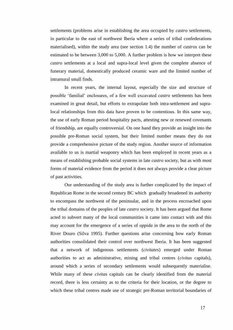
Figure 1. The administrative boundaries (in blue) of northwest Iberia between the
first and late third century AD (Acuña Castroviejo et al. 1976, Ilustraciones).
In establishing the territorial boundaries which constituted ‘Roman Galicia’
three Roman administrative units were considered. The first proposed study area is
the short-lived Roman province of Transduriana which provided military jurisdiction
over northwest Iberia from 7 until 2 BC, but whose precise boundaries are uncertain
(López Barja 2000, 31). A second possible spatial area relates to the period from 2
BC until AD 298 when control of the territory reverted to the province of
Tarraconensis with its administrative capital at Tarraco (modern-day Tarragona in
the north-eastern Spanish province of Catalonia). During this period the region was
divided into three conventus or administrative centres each managing its own
territory (López Barja 2000, 38), as illustrated in Figure 1. A third region is the
Roman province of Gallaecia created from the three conventus in AD 298 and which
preserved the original southern territorial boundaries, while expanding the
administrative domain eastwards and incorporating much of the modern-day Spanish
Principality of Asturias (see Figure 2). For the purposes of this thesis, I shall utilise
the boundaries in existence between 2 BC and AD 298 to constitute ‘Roman
Galicia’, given that the chronology of my study period and the administrative
boundary neatly correlate.

20
Figure 2. The territorial boundaries (in blue) of the province of Gallaecia (Acuña
Castroviejo et al. 1976, Ilustraciones).
In terms of modern geography, the boundaries of my research encompass the
territories of northern Portugal, as well as the Spanish provinces of Galicia,
northwest Castilla y León and western Asturias (see Figure 3). The study area’s
southern boundary, the River Douro (Spanish Duero), flows northwest to Zamora,
where the trajectory follows the River Esla towards the town of Benavente and the
city of León. Northeast of Cistierna, the River Sella completes the eastern boundary
of the study area before draining into the Bay of Biscay, west of the town of Llanes.
Within the geographical boundaries of my research, five study areas were
chosen as the basis for examining the chronological process of change from the Late
Iron Age until the early Roman period, as shown by Figure 4 below. Study Area
North covers the area around Bragança (see Figure 3), while Study Areas South and
East lie further south on the edge of the research region. Study Area Chaves is
located around the fertile Tâmega valley and the modern-day metropolitan centre of
Chaves (Roman Aquae Flaviae), while Study Area Viana is located far to the west
along the Atlantic coast between the Rivers Lima to the south, shown approximately
by the town of Barcelos in Figure 3, and the Minho (Spanish Miño) illustrated by
Caminha, which is located near the mouth of the river and lies on the present-day
border between Portugal and Spain. In terms of the geography of the region, Chapter
21
Three provides greater detail of the geomorphology of northwest Iberia in general
and in particular the five study areas.
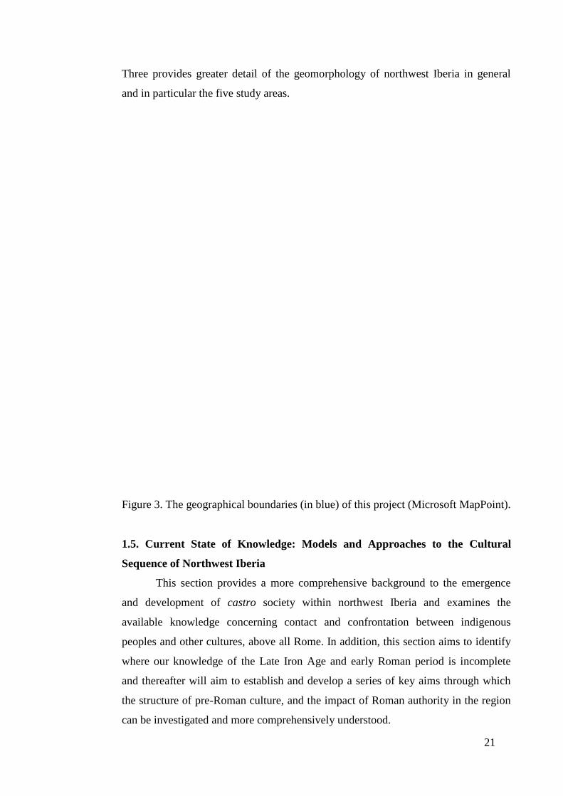
Figure 3. The geographical boundaries (in blue) of this project (Microsoft MapPoint).
1.5. Current State of Knowledge: Models and Approaches to the Cultural
Sequence of Northwest Iberia
This section provides a more comprehensive background to the emergence
and development of castro society within northwest Iberia and examines the
available knowledge concerning contact and confrontation between indigenous
peoples and other cultures, above all Rome. In addition, this section aims to identify
where our knowledge of the Late Iron Age and early Roman period is incomplete
and thereafter will aim to establish and develop a series of key aims through which
the structure of pre-Roman culture, and the impact of Roman authority in the region
can be investigated and more comprehensively understood.

22
Figure 4. The five study areas; North, East, South, Chaves and Viana. Note: green
dots represent Late Iron Age castro settlements; red dots Roman period castros; and
black dots Roman settlements.
The castro society of northwest Iberia has its origins in the first millennium
BC, but its cultures, its identities and practices were multifaceted and in the course of
time constantly evolving. For the sake of simplicity, however, three chronological
phases can be established for the indigenous civilisation of the region:
1) The Late Bronze Age / Early Iron Age (Ninth Century – Sixth Century BC).
2) The Iron Age (Sixth Century BC – Second Century BC).
3) The Late Iron Age / Roman period (Second Century BC – First Century BC).
These time periods encompass the chronologically accepted development of
the hillfort in northwest Iberia until the region was conquered and assimilated under
the control of Rome (González Ruibal 2006-2007; Martins 1990; Parcero Oubiña
2003; Silva 1995). During the period of Roman interaction with the communities in
Iron Age northwest Iberia a further chronological sequence can be proposed which

23
stretches from the Republican period through to the second century AD. Included
within this timeframe are:
(a) The period of contact between Republican Rome and northwest Iberia.
(b) The emergence of civitates.
(c) The development of conventus capitals.
(d) The demise of the castro.
(e) And lastly, the materialisation of villae.
In order to investigate the chronological sequences outlined above I believe
this thesis would benefit from the use of the idea of connectivity. The term itself has
been commonly associated with the Mediterranean basin, and in particular with the
work of Horden and Purcell (2000), as a means to quantify and qualify how regions
may have been linked to one another and so developed. However, I feel that
northwest Iberia created a powerful bond with other cultures which lay outside the
Mediterranean world (see Queiroga’s (2003, 27) discussion on Mediterraneanisation)
and for this reason I propose two forms of connectivity; one which explains the pre-
Roman period, and one which helps clarify the dynamics of the early Roman era.
The exploration of pre-Roman forms of connectivity can be seen in the work of two
academics. The first is Cunliffe (2009), who has employed the term Atlantic
connectivity to explain how Late Bronze Age and Early Iron Age communities were
linked by seagoing communication networks. Such ideas have been expanded on by
Morris (2010, 1) who utilises Cunliffe’s approach and terminology to develop a
theoretical understanding of cross-channel (between modern-day Britain and France)
maritime connectivity from 175/150 BC until AD 409. The second use of the term
reverts to the more traditional interpretation of connectivity as a conceptual
framework as envisaged by Horden and Purcell (2000), which the aforementioned
authors use to investigate how Mediterranean cultures, in this case principally Rome,
impacted on peripheral cultures and how they were drawn into wider commercial,
political and social systems (the theoretical standpoint for this is discussed in greater
detail in section 2.4.4.2).
1.5.1. Late Bronze Age / Early Iron Age (Ninth Century – Sixth Century BC)
24
In examining the chronological sequence of events which led to the
development of Late Iron Age society in northwest Iberia it is important that we
highlight the emergence of a naval and trading superpower, the Phoenicians. This
enterprising culture founded a chain of trading posts in the first millennium BC along
the Mediterranean coastline of Andalucía, and at the mouths of the principal rivers of
the region, which gave access to and controlled important commercial routes into the
interior (Aubet 1995, 49). During this period Phoenicia’s chief trading partner in the
region was the Tartessan Kingdom whose heartland covered the lower Guadalquivir
and Guadiana rivers, a region rich in copper, lead and silver from the Río Tinto
(Keay 1988, 12-13). Chief among these Phoenician trading settlements was Gadir
(modern Cádiz), which, through its strategic location at the boundary between the
Mediterranean and the Atlantic, functioned as a commercial hub providing access to
northwest Iberia and beyond, allowing the procurement of tin and gold for both
domestic consumption and export through Tartessos (Cunliffe 1995, 16).
The ensuing connectivity of northwest Iberia with a wider pan-European
commercial network caused profound economic and social changes within the
region. Wealth and commerce provided a conduit for the exchange of new ideas and
practices, such as the cheavaux-de-frise (defensive structure consisting of a movable
obstacle principally used to obstruct cavalry, and discussed in greater detail in
section 7.2.1) and the roundhouse (Cunliffe 1999, 95, 98), which would form the
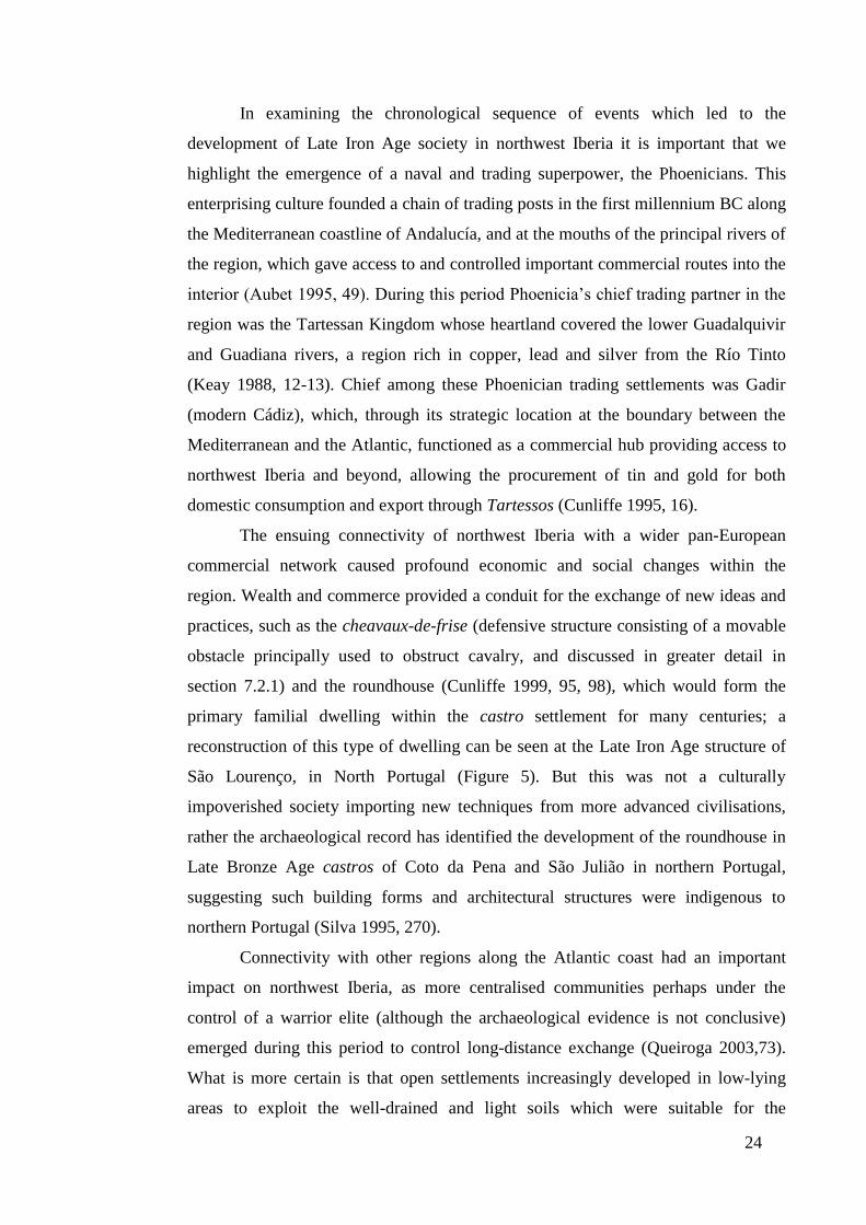
primary familial dwelling within the castro settlement for many centuries; a
reconstruction of this type of dwelling can be seen at the Late Iron Age structure of
São Lourenço, in North Portugal (Figure 5). But this was not a culturally
impoverished society importing new techniques from more advanced civilisations,
rather the archaeological record has identified the development of the roundhouse in
Late Bronze Age castros of Coto da Pena and São Julião in northern Portugal,
suggesting such building forms and architectural structures were indigenous to
northern Portugal (Silva 1995, 270).
Connectivity with other regions along the Atlantic coast had an important
impact on northwest Iberia, as more centralised communities perhaps under the
control of a warrior elite (although the archaeological evidence is not conclusive)
emerged during this period to control long-distance exchange (Queiroga 2003,73).
What is more certain is that open settlements increasingly developed in low-lying
areas to exploit the well-drained and light soils which were suitable for the

25
cultivation of cereals, principally wheat and barley, and raise livestock, thereby
allowing the people of the region to generate surplus produce which could be
presumably traded with other communities (Parcero Oubiña 2003, 274).
Figure 5. A reconstruction of a roundhouse at the Late Iron Age castro of São
Lourenço in northern Portugal (Photo author’s own).
1.5.2. Early Iron Age - Late Iron Age (Sixth Century BC – Second Century BC)
The sixth century BC saw the fall of Tyre and the collapse of the extensive
Phoenician trading network which contributed to many Phoenician trading posts on
the Atlantic coast being abandoned, which in turn severely affected northwest
Iberia’s ability to participate in both the Mediterranean and Atlantic commercial
networks (Aubet 1995, 54-55). As a result of these economic upheavals, it has been
suggested that new fortified castros appeared during the Early Iron Age in prominent
locations, which allowed long-range visual control of the hinterland, often at the
expense of access to good agricultural land (Parcero Oubiña 2003, 281). Natural
elements, for example slopes and outcrops, which typified Early Iron Age castros,
were supposedly replaced by artificial structures such as ramparts and low walls.
These structures limited each community’s movement and perception both externally
26
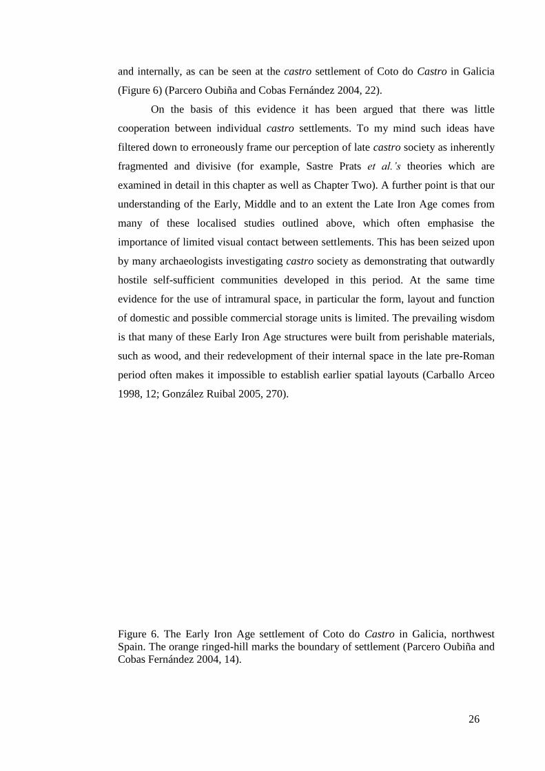
and internally, as can be seen at the castro settlement of Coto do Castro in Galicia
(Figure 6) (Parcero Oubiña and Cobas Fernández 2004, 22).
On the basis of this evidence it has been argued that there was little
cooperation between individual castro settlements. To my mind such ideas have
filtered down to erroneously frame our perception of late castro society as inherently
fragmented and divisive (for example, Sastre Prats et al.’s theories which are
examined in detail in this chapter as well as Chapter Two). A further point is that our
understanding of the Early, Middle and to an extent the Late Iron Age comes from
many of these localised studies outlined above, which often emphasise the
importance of limited visual contact between settlements. This has been seized upon
by many archaeologists investigating castro society as demonstrating that outwardly
hostile self-sufficient communities developed in this period. At the same time
evidence for the use of intramural space, in particular the form, layout and function
of domestic and possible commercial storage units is limited. The prevailing wisdom
is that many of these Early Iron Age structures were built from perishable materials,
such as wood, and their redevelopment of their internal space in the late pre-Roman
period often makes it impossible to establish earlier spatial layouts (Carballo Arceo
1998, 12; González Ruibal 2005, 270).
Figure 6. The Early Iron Age settlement of Coto do Castro in Galicia, northwest
Spain. The orange ringed-hill marks the boundary of settlement (Parcero Oubiña and
Cobas Fernández 2004, 14).
27
1.5.3. The Late Iron Age / Roman Period (Second Century BC – First Century
BC)
By the Late Iron Age, it appears that fortified settlements were still being
founded in prominent and well-defended locations, but the priority was apparently
access to areas capable of supporting intensive farming with lower indices of
summer drought and less risk of winter freezing (Parcero Oubiña and Cobas
Fernández 2004, 22). Concurrent with this development, technological advances
were implemented on the land surrounding the castros, which permitted the
cultivation of rye in winter and millet in the summer, greatly increasing agricultural
production (Criado 1989, 113).
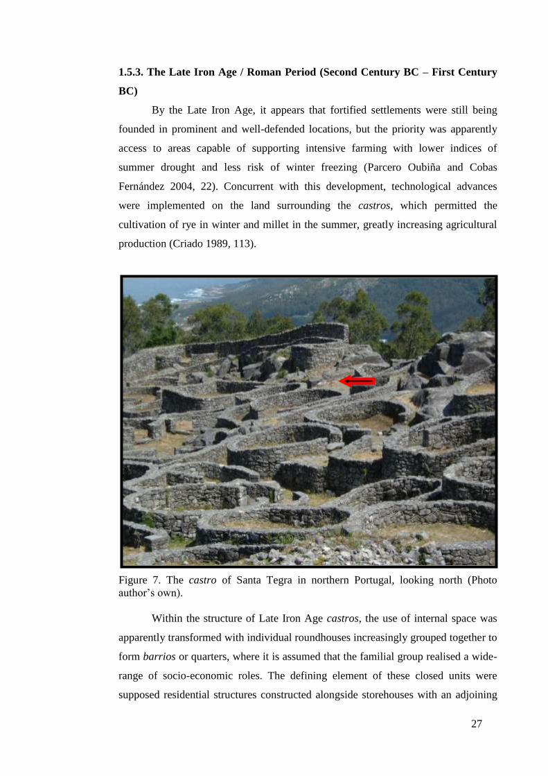
Figure 7. The castro of Santa Tegra in northern Portugal, looking north (Photo
author’s own).
Within the structure of Late Iron Age castros, the use of internal space was
apparently transformed with individual roundhouses increasingly grouped together to
form barrios or quarters, where it is assumed that the familial group realised a wide-
range of socio-economic roles. The defining element of these closed units were
supposed residential structures constructed alongside storehouses with an adjoining

28
central patio, with a similar internal layout proposed for the Late Iron Age castro of
Santa Tegra (Vilas et al. 2006, 38).
Figure 8. The castro of Santa Tegra in northern Portugal viewed from above with
north marked by the top of the diagram (Trümpler 2006, 86).
The castro of Santa Tegra itself is located on the Atlantic coast near the
border between modern-day Portugal and Spain (see Figure 3). Its position on a
promontory jutting out onto the Atlantic coast provided strategic visual access to the
estuary of the Ría de Vigo and its passage inland. Integral to the architectonic
dynamics of Santa Tegra was its outer stone wall, which has been interpreted as
29
serving a dual function by providing the settlement with a 1.6m-wide defence while
defining a spatial boundary limiting internal demographic growth. Within the
settlement, the implication is that the small walls constructed to delimit space acted
to define and create barrios of ‘familial’ enclosures (Vilas et al. 2006, 38). In Figure
7, the northern part of the settlement clearly contains one of these supposed walls
used to demark ‘familial’ space. Its advocates propose that such a boundary ran from
the top right near to the outcrop of rock, which formed the eastern lintel gate, where
the wall curves round to the centre of the image (Vilas et al. 2006, 38). From above
(Figure 8), the purported boundary wall is indicated by the arrow in the top right of
the image.
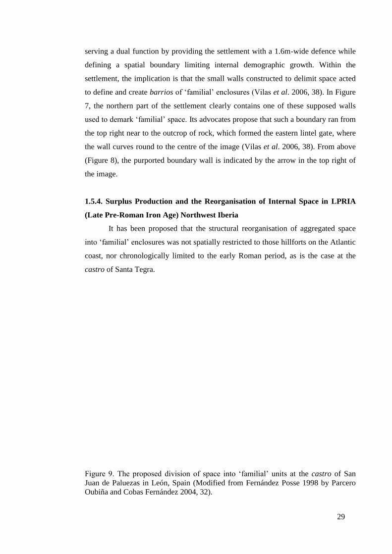
1.5.4. Surplus Production and the Reorganisation of Internal Space in LPRIA
(Late Pre-Roman Iron Age) Northwest Iberia
It has been proposed that the structural reorganisation of aggregated space
into ‘familial’ enclosures was not spatially restricted to those hillforts on the Atlantic
coast, nor chronologically limited to the early Roman period, as is the case at the
castro of Santa Tegra.
Figure 9. The proposed division of space into ‘familial’ units at the castro of San
Juan de Paluezas in León, Spain (Modified from Fernández Posse 1998 by Parcero
Oubiña and Cobas Fernández 2004, 32).
30
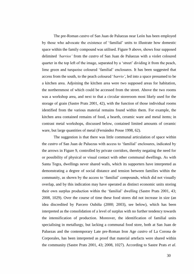
The pre-Roman castro of San Juan de Paluezas near León has been employed
by those who advocate the existence of ‘familial’ units to illustrate how domestic
space within the family compound was utilised. Figure 9 above, shows four supposed
delimited ‘barrios’ from the castro of San Juan de Paluezas with a violet coloured
quarter in the top left of the image, separated by a ‘street’ dividing it from the peach,
lime green and turquoise coloured ‘familial’ enclosures. It has been suggested that
access from the south, to the peach coloured ‘barrio’, led into a space presumed to be
a kitchen area. Adjoining the kitchen area were two supposed areas for habitation,
the northernmost of which could be accessed from the street. Above the two rooms
was a workshop area, and next to that a circular storeroom most likely used for the
storage of grain (Sastre Prats 2001, 42), with the function of those individual rooms
identified from the various material remains found within them. For example, the
kitchen area contained remains of food, a hearth, ceramic ware and metal items; in
contrast metal workshops, discussed below, contained limited amounts of ceramic
ware, but large quantities of metal (Fernández Posse 1998, 62).
The suggestion is that there was little communal articulation of space within
the castro of San Juan de Paluezas with access to ‘familial’ enclosures, indicated by
the arrows in Figure 9, controlled by private corridors, thereby negating the need for
or possibility of physical or visual contact with other communal dwellings. As with
Santa Tegra, dwellings never shared walls, which its supporters have interpreted as
demonstrating a degree of social distance and tension between families within the
community, as shown by the access to ‘familial’ compounds, which did not visually
overlap, and by this indication may have operated as distinct economic units storing
their own surplus production within the ‘familial’ dwelling (Sastre Prats 2001, 43;
2008, 1029). Over the course of time these food stores did not increase in size (an
idea discredited by Parcero Oubiña (2000; 2003), see below), which has been
interpreted as the consolidation of a level of surplus with no further tendency towards
the intensification of production. Moreover, the identification of familial units
specialising in metallurgy, but lacking a communal food store, both at San Juan de
Paluezas and the contemporary Late pre-Roman Iron Age castro of La Corona de
Corporales, has been interpreted as proof that material artefacts were shared within
the community (Sastre Prats 2001, 43; 2008, 1027). According to Sastre Prats et al.
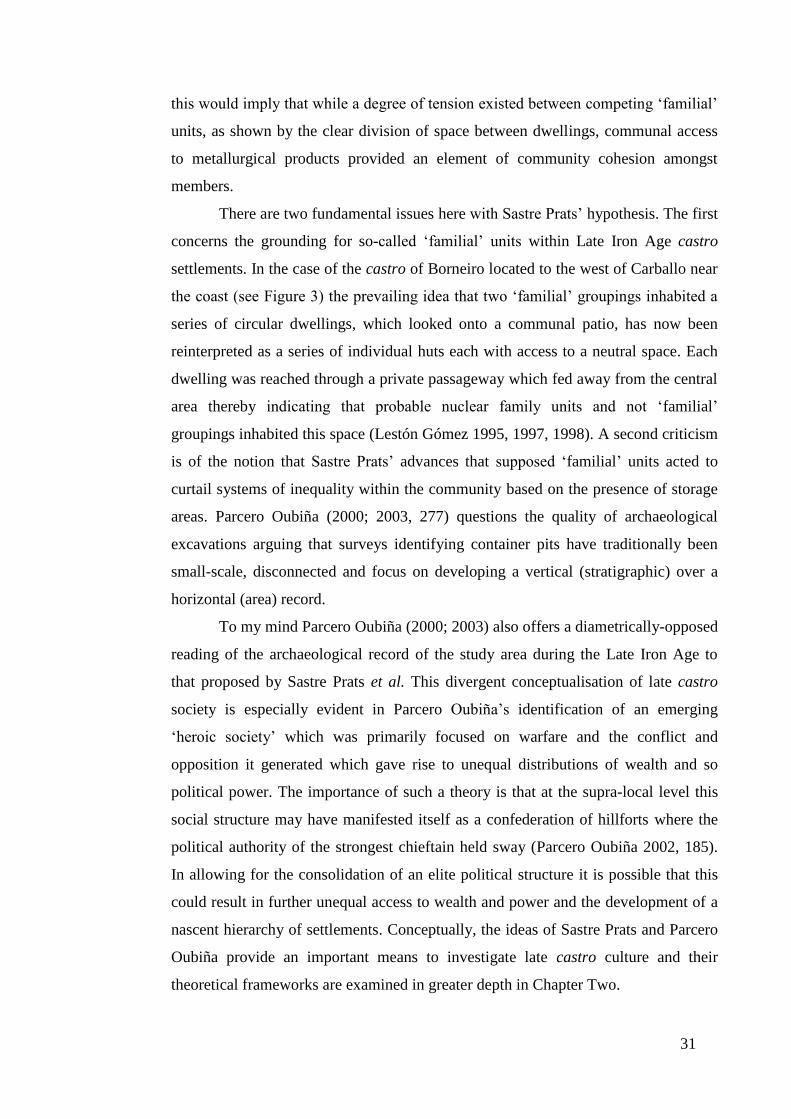
31
this would imply that while a degree of tension existed between competing ‘familial’
units, as shown by the clear division of space between dwellings, communal access
to metallurgical products provided an element of community cohesion amongst
members.
There are two fundamental issues here with Sastre Prats’ hypothesis. The first
concerns the grounding for so-called ‘familial’ units within Late Iron Age castro
settlements. In the case of the castro of Borneiro located to the west of Carballo near
the coast (see Figure 3) the prevailing idea that two ‘familial’ groupings inhabited a
series of circular dwellings, which looked onto a communal patio, has now been
reinterpreted as a series of individual huts each with access to a neutral space. Each
dwelling was reached through a private passageway which fed away from the central
area thereby indicating that probable nuclear family units and not ‘familial’
groupings inhabited this space (Lestón Gómez 1995, 1997, 1998). A second criticism
is of the notion that Sastre Prats’ advances that supposed ‘familial’ units acted to
curtail systems of inequality within the community based on the presence of storage
areas. Parcero Oubiña (2000; 2003, 277) questions the quality of archaeological
excavations arguing that surveys identifying container pits have traditionally been
small-scale, disconnected and focus on developing a vertical (stratigraphic) over a
horizontal (area) record.
To my mind Parcero Oubiña (2000; 2003) also offers a diametrically-opposed
reading of the archaeological record of the study area during the Late Iron Age to
that proposed by Sastre Prats et al. This divergent conceptualisation of late castro
society is especially evident in Parcero Oubiña’s identification of an emerging
‘heroic society’ which was primarily focused on warfare and the conflict and
opposition it generated which gave rise to unequal distributions of wealth and so
political power. The importance of such a theory is that at the supra-local level this
social structure may have manifested itself as a confederation of hillforts where the
political authority of the strongest chieftain held sway (Parcero Oubiña 2002, 185).
In allowing for the consolidation of an elite political structure it is possible that this
could result in further unequal access to wealth and power and the development of a
nascent hierarchy of settlements. Conceptually, the ideas of Sastre Prats and Parcero
Oubiña provide an important means to investigate late castro culture and their
theoretical frameworks are examined in greater depth in Chapter Two.

32
1.5.5. Evidence for Settlement Hierarchies in LPRIA Northwest Iberia
While analysis of the internal dynamics of castro space can help to establish
the social structure of its late pre-Roman inhabitants, such techniques can only reveal
so much about the wider political environment. In establishing whether supra-local
relations existed within the landscape of northwest Iberia, I believe it is important to
examine both the archaeological record and classical sources as a means to
reconstruct how past societies may have operated and communities interacted.
As I outlined earlier in the historical overview (see section 1.3) the material
evidence from Late Iron Age northwest Iberia often provides an ambivalent picture
of the region, and this is very much compounded when we seek to employ classical
sources from the period. Strabo, writing in the late first century BC and early first
century AD, provides our best source for the political affinities and social identity of
the peoples of northwest Iberia during the Late Iron Age. However, the emphasis that
Strabo places on the civilised world, with the Roman empire at its centre, and those
barbarians who had yet to be conquered and incorporated within, has led to questions
about the veracity and accuracy of such work (see Wells 1999 for argument). Recent
archaeological discoveries from pre-Roman northwest Iberia, for example dugout
canoes (see section 2.4.1) and discussed by Strabo (Geographica III.3.7) would
appear to give a degree of credence to his work, but a stringent approach is
nevertheless needed to ensure the veracity of the information contained within
ideologically-driven classical sources.
Where Strabo provides possible evidence of activities which may have led to
inequalities within the region is through the identification of financial transactions
being undertaken using cut-off pieces of beaten silver (Geographica III.3.7). The
presence of these items has been authenticated within the study region with an
elevated number of flattened, folded or cut pieces of precious metal found alongside
Republican Roman and Iberian coinage in Asturias, modern-day northern Spain
(Blázquez Cerrato 2005, 238). Whether such transactions translated into wider
activities which transcended single polities and took on a more supra-local
significance, as Parcero Oubiña (2000; 2003) would have us believe, is altogether
more difficult to substantiate. A key criticism for the use of this form of exchange
stems from the fact there was considerable flexibility of access to such commodities
through local mining or panning meaning that the accumulation of precious metals
could not be monitored or controlled, thereby undermining their primary value as a
33
form of currency (Sánchez Palencia and Fernández Posse 1998). These conclusions
have been reinforced by archaeological evidence which shows that the procurement
of gold through panning as well as silver, iron and copper through mining was
practised at a local and not a provincial level (Fernández Posse et al. 1993, 214-215).
There are nevertheless a series of issues with the ideas proposed above.
Firstly, archaeometallurgical analysis comes from only two settlements, the castros
of San Juan de Paluezas and La Corona de Corporales, located in close vicinity to
one another. We should also highlight that the research of Sánchez Palencia and
Fernández Posse is closely allied to Sastre Prats’ theoretical framework of late castro
society (there is a considerable body of joint work produced by these three
academics). For this reason, limited archaeological evidence investigated along a
possible similar theoretical basis has been used to underpin the argument that self-
sufficient settlements (in this case the castros of San Juan de Paluezas and La Corona
de Corporales) forged their own locally-derived metal, and thereby represented
independent entities, rather than a community embedded into wider systems of
control (Sastre Prats 2008, 1035).
Sastre Prats et al.’s overarching theory that pre-Roman castros were isolated
and self-contained units, has also found favour with historians who argue that the
Cantabrian Wars (29-19 BC) acted as the catalyst for tribal consolidation and social
transformations (González Ruibal 2006, 150; Yanguas 1981, 17). In this respect the
agencies of change are Imperial authorities whose establishment of hegemonic
structures demanding tribute indirectly ensured the emergence of systems of
inequality, as political and economic power began to be concentrated in the hands of
the few. According to this premise the coordination and consolidation of power by a
native elite appear to have created a medium through which the supremacy and
dominance of local chiefdoms was channelled, generating a nascent ranked
settlement pattern (Hodgson 2005, 14).
There are, however, a series of problems with this view, especially the
chronological sequence of events, as demonstrated by hospitality pacts from the
region. These artefacts show that Roman authorities could have played a central role
and overseen the consolidation as well as the restructuring of regional alliances, but
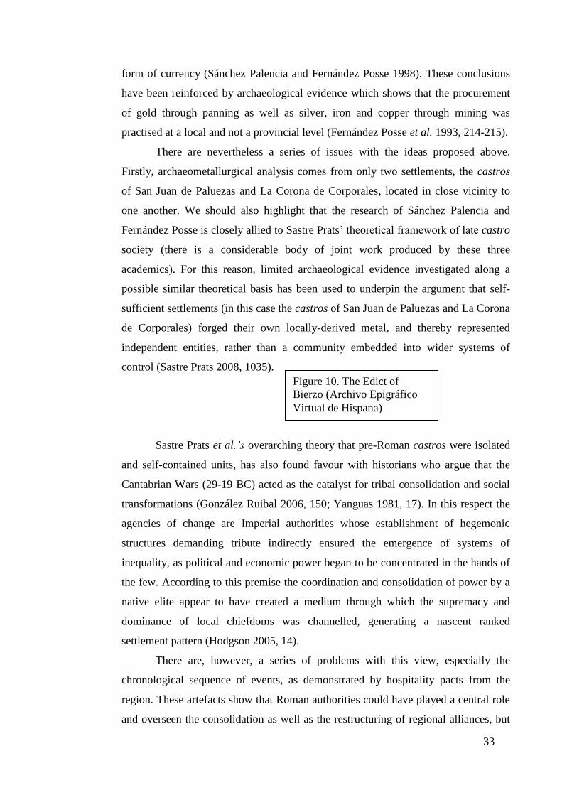
Figure 10. The Edict of
Bierzo (Archivo Epigráfico
Virtual de Hispana)

34
they may also provide an insight into the pre-Roman political framework of the
region. Of particular significance has been the recent discovery of the bronze Edict
of Bierzo (Figure 10, above), which was uncovered 100km west of modern-day León
and dated to 15 BC due to the mention of two Roman consuls at the foot of the text
(Sánchez Palencia and Mangas 2000, 9, 19).
The Edict of Bierzo provides a legislative transfer of the castellani
Aliobrigiacini from the gens Gigurri to the gens Susarri by Roman Imperial
authorities, in recognition of an unstated native initiative. It has been suggested that
the castellani corresponds to a single settlement, most likely a castro, on account of
the presence of the inverted C, ⊃, which is commonly found in epigraphy from
northwest Iberia in the late first century BC and first century AD. Our understanding
of these hospitality pacts is strengthened further by another example, the Edict of
Zoelas from modern-day Bragança (and located within Study Area North). This
artefact dating to AD 27 makes a mention of a gentiliani, representing a single entity,
suggesting that the terms castellani and gentilitas are synonymous with and equate to
single settlement units or castros (Mangas 2000, 50, 52). Of considerable interest is
written evidence that these gentilitas were in turn incorporated into gens and populi
at the civitas (discussed in greater depth in section 1.5.7) or supra-territorial level
(Mangas 2000, 57).
A series of points can be made about these hospitality pacts. The first is that
if the artefacts were deposited in the area to which they refer then a territorial-based
social system appears to have existed towards the west of northwest Iberia, and
kinship-orientated social systems to the east. Moreover, could it be the case that a
hierarchical settlement pattern (for example, the gentilitas / gens / populi and civitas
structure) existed or was developing among the kinship-based peoples of the east? (a
premise which contradicts those ideas advanced by Sastre Prats’ et al. and historians
who see the conquest of the region by Rome as the vehicle of change). This is a
controversial assumption as there are probably no more than ten hospitality pacts in
existence, and we should not rule out other unknown social structures. Lastly, is it
possible that the hospitality pacts, although written in Latin and representing a
‘Roman’ format, illustrate earlier pre-Roman political structures? It is unlikely that
Roman authorities created two social structures in the region unless they had already
existed. And if the hospitality pacts represent pre-Roman political structures was it
35
the case that a hierarchical settlement pattern had already begun to materialise in the
east of the region before its conquest by Rome?
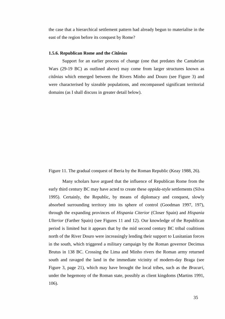
1.5.6. Republican Rome and the Citânias
Support for an earlier process of change (one that predates the Cantabrian
Wars (29-19 BC) as outlined above) may come from larger structures known as
citânias which emerged between the Rivers Minho and Douro (see Figure 3) and
were characterised by sizeable populations, and encompassed significant territorial
domains (as I shall discuss in greater detail below).
Figure 11. The gradual conquest of Iberia by the Roman Republic (Keay 1988, 26).
Many scholars have argued that the influence of Republican Rome from the
early third century BC may have acted to create these oppida-style settlements (Silva
1995). Certainly, the Republic, by means of diplomacy and conquest, slowly
absorbed surrounding territory into its sphere of control (Goodman 1997, 197),
through the expanding provinces of Hispania Citerior (Closer Spain) and Hispania
Ulterior (Farther Spain) (see Figures 11 and 12). Our knowledge of the Republican
period is limited but it appears that by the mid second century BC tribal coalitions
north of the River Douro were increasingly lending their support to Lusitanian forces
in the south, which triggered a military campaign by the Roman governor Decimus
Brutus in 138 BC. Crossing the Lima and Minho rivers the Roman army returned
south and ravaged the land in the immediate vicinity of modern-day Braga (see
Figure 3, page 21), which may have brought the local tribes, such as the Bracari,
under the hegemony of the Roman state, possibly as client kingdoms (Martins 1991,
106).

36
Figure 12. Early Roman Hispania. The coloured dating corresponding to the gradual
‘assimilation’ of Iberia by Roman authorities (Hanson 2008).
The campaign of Decimus Brutus may also have resulted in longer-term
structural changes to the landscape as smaller castro settlements were consolidated
into larger, centrally-controlled citânias located in well-defined territories (Silva
1995, 275). The role that Roman agents such as Decimus Brutus played in reshaping
the cultural landscape north of the River Douro is hard to establish, but it appears
that the development of these oppida-style settlements may have coincided with the
increasing consolidation of power by a few elite families (material evidence for their
existence is discussed below) coupled with new economic practices such as large-
scale mining. We can speculate that these activities would have necessitated large
supplies of labour and specialised communities to mine the ore (Queiroga 2003, 61),
and in the process of generating surplus produce, new systems of inequality would
have emerged as those individuals with skills, connections and power consolidated
their authority.

37
It is also likely that many of the oppida-style structures of Late Iron Age
northern Portugal would have increasingly exploited the fertile surrounding terrain to
feed and accommodate a large population, which may have numbered up to 3,000
inhabitants in the citânia of Sanfins (assuming that each family unit comprised of 10-
20 people, multiplied by the number of settlement pods (Silva 1995, 282)). We can
also assume that these citânia would have exploited a larger territorial expanse than
the smaller hillforts found in the study region (Otegui Pascual 1990, 21-22). To a
degree this can be shown by the large proto-urban settlements of Briteiros, Eiras,
Bagunte, Alvarelhos, Vandoma and Mozinho, which were located near the Atlantic
coast and were all positioned within 25km of their nearest neighbour, a distance
which corresponded to a day’s journey on foot and was thus apparently a key factor
in determining the territorial relationship between these large hillforts (Silva 1995,
275). Spatial analysis would suggest that these large oppida developed from earlier
structures, given the predilection for good visibility and prominence in the landscape
which characterised Early Iron Age settlements. However, there is limited
archaeological evidence for the interaction between these large citânias and rural
farmsteads and smallholdings located within its domain as well as smaller affiliated
settlements perhaps controlling its territorial boundaries.
While the citânias located to the north of the River Douro do not form the
basis of research in this thesis, as they lie outside the five study areas, the
identification of spatial boundaries (with each oppida-style settlements located 25km
from its nearest neighbour), provides a valuable theoretical viewpoint to evaluate
how fortified hillforts may have begun to develop in the study area. This is especially
important in Study Area Chaves where the region demonstrates elements of a nascent
settlement structure with sites of varying size (and which is discussed in greater
detail in Chapter Four). Additionally, the spatial orientation of these large citânias
vis-à-vis other large hillforts also provides a valuable theoretical insight into the
possible development of other indigenous settlements in other regions of northwest
Iberia, in particular the preference for rich agricultural soils at the expense of an
isolated and defendable position towards the Late Iron Age and early Roman period
(Parcero Oubiña and Cobas Fernández 2004, 43), which is a hypothesis which is
examined in Chapter Five of this thesis.
The role Rome played in creating these new central places in northern
Portugal is debateable, but similar processes have been identified in other regions of
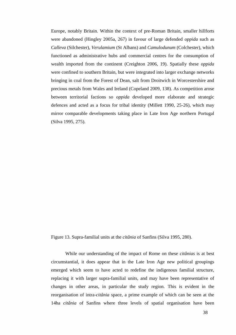
38
Europe, notably Britain. Within the context of pre-Roman Britain, smaller hillforts
were abandoned (Hingley 2005a, 267) in favour of large defended oppida such as
Calleva (Silchester), Verulamium (St Albans) and Camulodunum (Colchester), which
functioned as administrative hubs and commercial centres for the consumption of
wealth imported from the continent (Creighton 2006, 19). Spatially these oppida
were confined to southern Britain, but were integrated into larger exchange networks
bringing in coal from the Forest of Dean, salt from Droitwich in Worcestershire and
precious metals from Wales and Ireland (Copeland 2009, 138). As competition arose
between territorial factions so oppida developed more elaborate and strategic
defences and acted as a focus for tribal identity (Millett 1990, 25-26), which may
mirror comparable developments taking place in Late Iron Age northern Portugal
(Silva 1995, 275).
Figure 13. Supra-familial units at the citânia of Sanfins (Silva 1995, 280).
While our understanding of the impact of Rome on these citânias is at best
circumstantial, it does appear that in the Late Iron Age new political groupings
emerged which seem to have acted to redefine the indigenous familial structure,
replacing it with larger supra-familial units, and may have been representative of
changes in other areas, in particular the study region. This is evident in the
reorganisation of intra-citânia space, a prime example of which can be seen at the
14ha citânia of Sanfins where three levels of spatial organisation have been
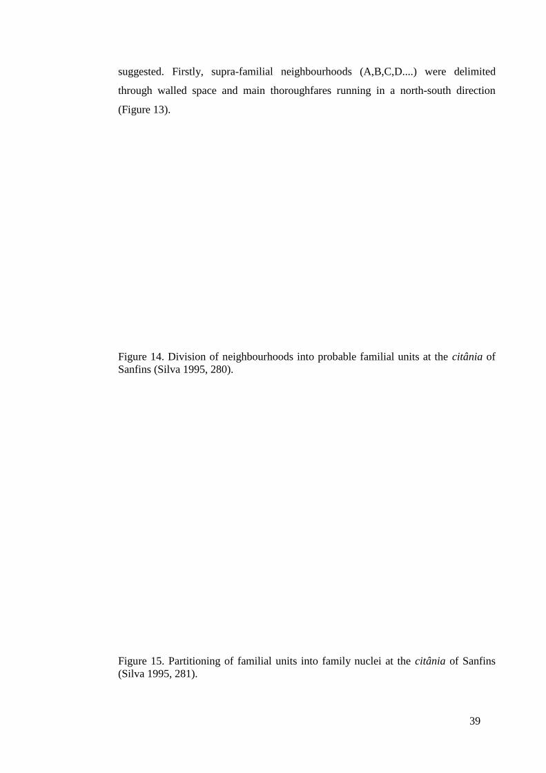
39
suggested. Firstly, supra-familial neighbourhoods (A,B,C,D....) were delimited
through walled space and main thoroughfares running in a north-south direction
(Figure 13).
Figure 14. Division of neighbourhoods into probable familial units at the citânia of
Sanfins (Silva 1995, 280).
Figure 15. Partitioning of familial units into family nuclei at the citânia of Sanfins
(Silva 1995, 281).

40
Secondly, the subdivision of neighbourhoods into possible family units
(Figure 14) is proposed. Thirdly, the partition of extended family units into
individual family dwellings (a,b,c,d) and public space (x1, x2...) can be detected (see
Figure 15). While the family compounds shown in Figure 15 appear to be of a
similar size and by that logic share a similar function, access is more fluid between
some family dwellings at the citânia of Sanfins than others, where walls and huts do
not obstruct movement, suggesting that different sized compounds made up from
individual houses may have existed at the same time.
In one respect the development of orthogonal street divisions enclosing
autonomous modular units has been interpreted as spatial reorganisation in response
to the demands of higher population (Silva 1995, 275). Alternative explanations view
the changes as the breakdown of longstanding Late Iron Age social structures and a
shift to a political order which transcended kinship (Parcero Oubiña and Cobas
Fernández 2004, 44). If this is so it is possible that the restructuring of the internal
floor plan of Sanfins may represent the beginning of inequality as enterprising social
units began to accumulate surplus production. One of the largest domestic
compounds within the citânia is made up of seven buildings with the majority of
these structures square in shape (the exact number is not given in the report) being
interpreted as granaries and warehouses. The presence of a series of round huts for
habitation and the uncovering of a gold torque at the site support the idea that the
compound was not merely a storage area, but instead appears to have been controlled
by an elite grouping (González Ruibal 2006, 155, 162).
Further evidence for elite families in other citânias can be seen at Briteiros
where 15 stones inscribed with the name Camulus have been found, particularly in
an area identified as ritual space (Cardozo 1976). Other inscribed markings of the
Camuli, in the form of pot stamps (González Ruibal 2006, 164), suggest that this
family had risen to prominence through their manufacturing of ceramic ware and
control of associated trade networks. Additional evidence for elite families in the
region occupied by these citânias comes from inscriptions such as the Principe
Coelarnum, the presumed head of the Coelerni, who occupied the territory around
modern-day Braga (CIL 2.2585) (Hodgson 2005, 13). It is possible that warrior
statues (discussed in greater detail in Chapters Two and Seven) found at these
citânias may represent such individuals. In other regions of northwest Iberia,
inscriptions from the early Roman period also testify to a possible prince of the

41
Copori (princips Co[pororum], IRPLugo 34) located in the region around the
conventus of Lucus Augusti (see section 1.5.8), as well as a principis Albionum in
modern-day Asturias (ERA 14). However, questions remain as to whether such titled
families were created by early Roman authorities or date from an earlier period.
1.5.7. The Conquest of Northwest Iberia and the Emergence of the Civitas
The available archaeological evidence outlined above and in section 1.5.5.
would imply that an emerging aristocracy, for example the Camuli and the Coelerni,
played a significant role in consolidating Roman authority through the effective
establishment of new settlement structures and power bases. It has been suggested by
archaeologists and historians alike that these Late Iron Age or early Roman civitates
illustrated the nature of local power structures, and in turn the dominance of the most
important tribal leaders was reflected in the settlement pattern (Wacher 1997, 20), as
evident at Bracara Augusta (modern-day Braga), which embraced the populi of the
region, but reflected the supremacy of the Bracari tribe (Martins et al. 1996, 738;
Queiroga 2003, 78).
How these political units evolved, in particular in the region occupied by the
Bracari, and how they were constituted is, in my opinion, poorly understood. This is
further complicated by one our principal sources of the period, Pliny (N.H. IV) who
does not refer to Late Iron Age or early Roman civitates, but instead to the populi (or
states) that made up the jurisdiction of the Bracari. Alarcão (1988, 31) makes a valid
statement that the native aristocracy who inhabited the region (Pliny makes reference
to the Coelerni who we know from inscriptional evidence were headed by a prince)
may have enjoyed a degree political freedom. In addition, Tranoy (1981, 204) argues
that the epigraphic record supports the view that territorial-based social structures
characterised by the inverted C (see section 1.5.5) demonstrates that native
communities continued to administer their pre-Roman domain. Tranoy (1981, 150-
151) makes an additional point that these native groupings were overseen by
praefecti (Roman administrators). Evidence for this comes from a pact between C.
Antonius Aquilis, Prefect of the First Cohort of the Celiberians, and the
aforementioned Coelerni (AE, 295) as well as the Edict of Bierzo (see section 1.5.5)
which was administered by Legatus (General) Lucio Sestio Quirinal on behalf of the
Emperor Augustus. However, as I have argued in section 1.5.5. the available

42
epigraphic evidence is extremely limited and we must be wary about making broad
assumptions from individual pieces of information.
If civitas networks were loosely administered by a native elite (Orejas et al.
2000, 72) before passing to the direct authority of Roman administrators (a process
common in the Roman world, see Watcher (1997, 242) on the Iceni) then our
knowledge of how and when this happened it virtually nonexistent (Alarcão 1988,
55), and therefore constitutes an important area of study in this thesis. However, we
are fortunate to have the names of some of these civitates and for this reason we can
postulate as to their possible function. The civitas Aurienses, the name of which
testifies to the location’s role as a centre of gold mining, acted as a satellite to the
civitas capital of Aquae Flaviae, and its strategic position on the River Minho would
have provided a means of transporting gold before the arterial road network was
constructed and fully integrated (López Quiroga 2004, 87-88). A second example is
the civitas capital of Bergidum Flavium, situated on a pre-Roman hillfort (Keay
1988, 45), which controlled and regulated regional mining production and whose
name combines the dominant tribe of the region (Bergidum) with a late Roman one
(Flavium).
While we can only speculate that this civitas of Bergidum Flavium continued
to retain a more native element of control, I believe such ideas have a wider
applicability in terms of when and why Roman authorities assumed control of
civitates, and how uniform those changes may have been both spatially and
temporally. Such ideas have an important bearing on how the civitas capitals of the
study region functioned, namely, the civitas Baniensium of Study Area South and the
civitas Zoelarum of Study Area North which are examined later in this thesis.
1.5.8. The Roman State and the Conventus Capitals
Overlaying the patchwork of minor settlements in northwest Iberia, Imperial
authorities superimposed three regional conventus (see Figure 16) with their
respective capitals at Asturica Augusta, Lucus Augusti and Bracara Augusta
(Hodgson 2005, 16).
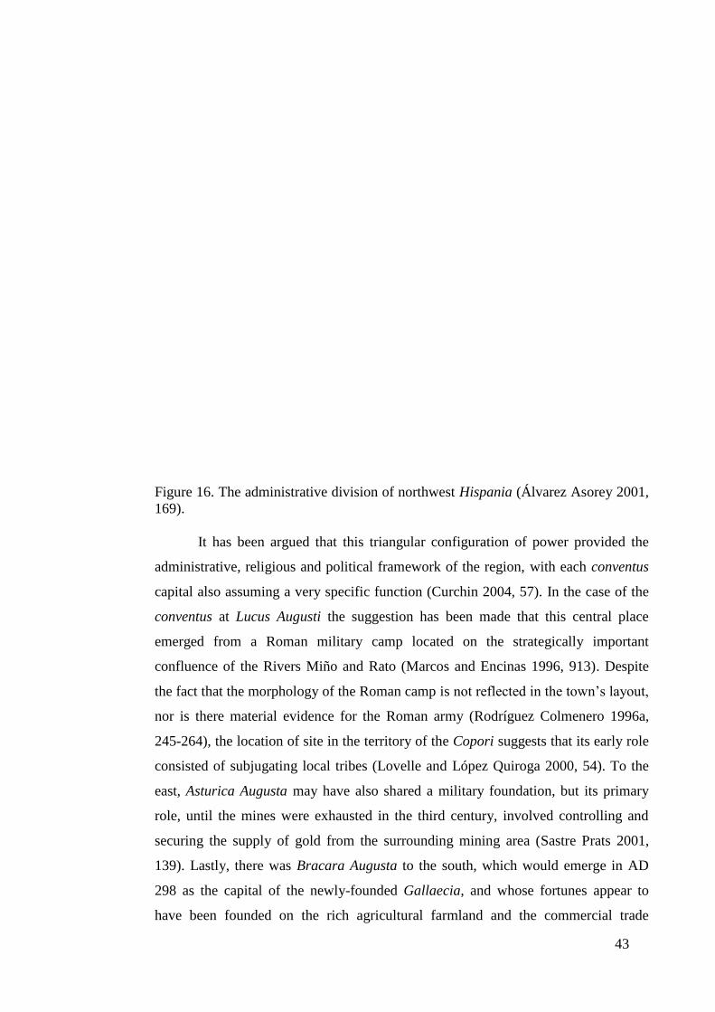
43
Figure 16. The administrative division of northwest Hispania (Álvarez Asorey 2001,
169).
It has been argued that this triangular configuration of power provided the
administrative, religious and political framework of the region, with each conventus
capital also assuming a very specific function (Curchin 2004, 57). In the case of the
conventus at Lucus Augusti the suggestion has been made that this central place
emerged from a Roman military camp located on the strategically important
confluence of the Rivers Miño and Rato (Marcos and Encinas 1996, 913). Despite
the fact that the morphology of the Roman camp is not reflected in the town’s layout,
nor is there material evidence for the Roman army (Rodríguez Colmenero 1996a,
245-264), the location of site in the territory of the Copori suggests that its early role
consisted of subjugating local tribes (Lovelle and López Quiroga 2000, 54). To the
east, Asturica Augusta may have also shared a military foundation, but its primary
role, until the mines were exhausted in the third century, involved controlling and
securing the supply of gold from the surrounding mining area (Sastre Prats 2001,
139). Lastly, there was Bracara Augusta to the south, which would emerge in AD
298 as the capital of the newly-founded Gallaecia, and whose fortunes appear to
have been founded on the rich agricultural farmland and the commercial trade
44
networks which connected the major centres (Curchin 1991, 116; Martins et al. 1996,
738; Morais 2005, 126).
1.5.9. The Road Network and Roman Settlements
Connecting and consolidating the political, social and economic framework
of the conventus capitals and smaller regional centres were a series of Roman roads
(Iglesias Gil 2001, 48). Roman viae with accompanying milestones inscribed with
the Emperor’s name, allow many of the major arterial roads to be dated to the Julio-
Claudian period (AD 14-68) (Viae VXII, XIX and XX), with the Via XVIII dating
from the Flavian era (AD 69-96) (Ferrer Sierra 2002, 115). This would imply that
central places connected by major roads displayed a high degree of connectivity
(such ideas are investigated in Chapter Six), but there still remain questions as to the
authenticity of many of these passageways. This is especially problematic in the case
of milestones used to mark the route which have either been used in later building
projects and have so been found out of context, or had their inscriptions, which
contained the name of the Roman emperor who undertook the building work, eroded
by the weather. Moreover, the archaeological record is almost silent as to the role of
minor Roman roads, the degree to which Roman roads incorporated pre-Roman
routeways, and their impact on the structuring and arrangement of the landscape.
Literary sources attest to pre-Roman roads (Strabo, Geographica III.3.7), which
some have construed as paths linking settlements and regions (Caamaño Gesto
1979), but this may simply be overenthusiastic historians attributing intra-settlement
passageways, such as those which connected communal structures at the citânia of
Sanfins, to longer distance trajectories linking native settlements. Within mining
areas, it has been argued that Roman roads did utilise pre-existing communication
routes, which were integrated into the exploitation of minerals in the region
(Blázquez Martinez 1974, 8), but the detailed archaeological research necessary to
reveal these continuities has been confined to localised studies within specialised
communities. The survival and maintenance of pre-Roman networks, which may
have preserved indigenous settlement patterns, does not imply a rejection of Rome,
but rather suggests that Roman systems and networks had yet to become fully
interconnected with the landscape. For example, the settlement of Magnetum was
integrated into the wider Roman economic network through the River Sousa, but
there are no known Roman roads emanating from this town (López Quiroga 2004,

45
97). For these reasons, the socio-cultural transformation of the landscape appears not
to have been uniform, and may therefore have resulted in pockets of autochthonous
control.
In summary, our understanding of the development and extent of the Roman
communications system remains limited, as does its integration and use in the early
Roman period. The role which the Roman communication system played in linking
communities and central places is essential in recognising how and why early Roman
political and economic structures evolved. It is also important in determining how
native settlements characterised by the castro were incorporated or perhaps excluded
from new activities, and these ideas are addressed in the following section.
1.5.10. The Demise of the Castro
It has been suggested that the demise of the castro society did not result in the
sudden disappearance of hillfort communities, but rather in renewed strategies for the
use of space demanded by the increased centralisation of economic and political
requirements under Roman authority. Nor does it appear that the abandonment of
these fortified structures was a uniform process (Vilas and Valdes 2005, 301), as
many fortified hillforts were adapted towards large-scale mining and agricultural
practices in the early Roman period (Orejas 1994; Sánchez Palencia et al. 2005,
246). Some localised studies have suggested that where native communities had
good geographical access to the agriculturally rich lowlands, such factors may have
played an important role in the continued occupation of castro sites (Martins 1990,
216). In contrast, where castros were unable to generate an agricultural or mining
surplus, tribute or exchange they would most likely have been abandoned (Parcero
Oubiña and Cobas Fernández 2004, 44).
The short discussion above would suggest that the abandonment or continued
occupation of castro communities were strongly allied to their ability to adapt to and
integrate into new Roman economic systems. However, other aspects, for example
the prevailing social structure of native communities (see section 1.5.5), the political
relationship between indigenous peoples and Roman authorities, and resistance to
Imperial Rome may have played an important role in shaping the settlement pattern
of the region, and will constitute areas of investigation in Chapter Four.
1.5.11. The Emergence of Villae in the Landscape of Northwest Iberia
46
Among many of the ideas advanced for the demise of castro settlements was
the relocation of indigenous communities from the uplands to found lowland
settlements, many of which would gradually transform into agricultural centres such
as villae (Perez Losada and Castro Perez 1995, 170). The proliferation of villae
settlements within the landscape may be seen as symbolic of changing agricultural
practices and the adoption of new ideologies within northwest Iberia. In the
countryside working villae were orientated towards the production and marketing of
agricultural surplus (Hingley 1982, 32), while more gentrified villae which were little
more than ostentatious displays of wealth by the urban elite materialised at the edges
of large metropolitan centres (Millett 1990, 92). Evidence for these gentrified villae,
for example, the second century villa on the periphery of Lucus Augusti, which
belonged to the Apana family (as shown by their funerary epitaph, Rodríguez
Colmenero (1997, 83)), is often inconclusive as material remains are difficult to
identify, and thereby establish the settlement’s socio-economic function (Perez
Losada and Castro Perez 1995). Some studies have suggested that villae emerged
near to communication networks (Carvalho 2008. vol. I, 274), while scholars point to
the proliferation of villae near urban settlements (Martins et al. 2005, 288), and the
importance of good farmland and communications over a central location near to an
urban metropolis (Perez Losada and Castro Perez 1995, 169). This would imply that
the decisive factors in the location of villae settlements varied from region to region.
In addition, many of these agricultural powerhouses operated as centres of
production, but also as centralised points of consumption for rural produce (Laurence
1999, 107). For this reason, it appears villae settlements may have fulfilled a wide
range of often contradictory roles which require clarification.
In conclusion, the discussion above provides a new set of questions as to the
role of the villae settlements. Firstly, were villae settled by the communities from
abandoned castro settlements, as discussed in section 1.5.10? Secondly, what was the
relationship between these largely rural agricultural centres and more urban
settlement forms? Thirdly, how did villae settlements differ from region to region?
And fourthly, can we speak of a single villa type or multiple villae, and how can
these attributes be identified within the archaeological record? Questions one, two
and three strongly imply that a study of villae settlements would again benefit from
regional comparative analysis, while the identification and the function of villae is
discussed in greater detail in Chapter Five, ‘The Landscape of Settlement’.
47
1.6. Aims
The purpose of section 1.5 above has been to investigate the cultural
sequence of northwest Iberia from the Late Iron Age until the early Roman period
and in the process examine the archaeological and historical record and identify
where there are gaps in our knowledge of the region. A particular problem in
archaeological interpretation in northwest Iberia is the use of research conducted at a
local level whose findings are often applied to other areas, which has been
compounded by the dearth of provincial studies within the region to analyse and
measure the sequence of change at an intra-regional and regional level. For this
reason, and others raised throughout section 1.5, three research questions were
formulated from my examination of the secondary literature.
Question One. ‘Did a Late pre-Roman Iron Age settlement hierarchy exist in
northwest Iberia?’
This question derives from the argument centred around the work of Parcero
Oubiña and Sastre Prats as to the nature, dynamics and orientation of pre-Roman
society, and whether systems of inequality both within settlements and present at the
supra-local level emerged before the region was pacified by Roman authorities. An
analysis of the theories advanced by Parcero Oubiña and Sastre Prats permits other
questions to be addressed which were highlighted in the analysis of the secondary
literature, namely, how was space divided and administered within the Late Iron Age
landscape?, and what were the locational criteria for castro settlements, particularly
in terms of their access to resources?
Question Two. ‘To what degree did the administration of early Roman northwest
Iberia adopt and exploit the landscape of pre-Roman northwest Iberia, and how did
the Roman settlement structure differ from the pre-Roman Period?’
Such a question addresses the dynamics of pre-Roman settlement structures
and the impact of those changes implemented by Roman authorities. In doing so, it
provides an opportunity for diachronic analysis of spatial and temporal
transformations within northwest Iberia as the region adjusted to a new economic,
social and political order. Within this changing environment, further questions need
to be asked as to how the landscape was exploited within different regions, especially
48
by agricultural centres such as villae, and how agricultural producers were integrated
into the wider settlement pattern.
Question Three. ‘To what extent did Roman fluvial and terrestrial routes exploit the
pre-Roman communication network and how did this impact on the development of
the Roman settlement structure?’
This question expands and consolidates on the first two questions, enabling a
comprehensive understanding of the communication networks which were primarily
utilised during the pre-Roman period, compared with those implemented during
Roman rule. The need to generate surplus to pay tribute or taxes, and to participate in
the Roman economic system, entailed utilising coordinated communication networks
to access Roman-controlled central places, and exchange goods and services. In this
respect, question three aims to move beyond a simple analysis of the communication
system, for example the mapping of the Roman arterial road network, which
characterises previous academic research in the region of northern Portugal, and
instead contextualise the movement and communication of people and goods through
the landscape and settlement patterns of the region.
In order to examine the three questions above in greater detail, Chapter Two
analyses the principal theories underpinning each question with the purpose of
formulating a more comprehensive application of theory and practice to the analysis
of the region of northwest Iberia. As a corollary, this process will also generate a
series of objectives, which will form the basis for the applied methodology employed
in this thesis.
49
Chapter Two. Theoretical Background of the Cultural Sequence of Northwest
Iberia
2.1. Introduction
The focus of Chapter One has been to establish gaps in the chronological
narrative of the events which shaped the castro society, as well as inconsistencies in
our understanding of how the early Roman administration interacted with the
indigenous communities of northwest Iberia. In light of this, a series of principal
questions were developed to analyse the structure and process of change in the study
region during the Late Iron Age and early Roman period. This chapter examines
these key debates in greater detail, with a particular objective to develop the
theoretical frameworks which underpin my approach to the main questions explored
in this work. In the process of deconstructing previous ideas, new perspectives are
discussed and a series of objectives are formulated which shape this thesis’ applied
methodology.
2.2. Theoretical Background to Research Question One
Central to this thesis is the need to develop a comprehensive understanding of
late castro society as a means through which to study the appropriation and
instigation of new systems by Roman and indigenous agents. Embedded within this
narrative is the question of whether a hierarchical settlement pattern existed during
the pre-Roman era, which encapsulates broader thematic concepts, such as
inequality, supra-local power and political hegemony. Of particular importance are
the models of late castro society advanced by Sastre Prats (2001, 2008) and Sánchez
Palencia and Fernández Posse (1998) who propose that mechanisms of control
existed, which prevented the accumulation of surplus wealth within the social
composition of castro settlements, and as a consequence, eliminated the emergence
of nascent political units. Taking a contrary view to that postulated by Sastre Prats et
al., Parcero Oubiña (2000, 2003) has argued that systems of equality were
‘corrupted’ in the Late Iron Age and in their place emerged the social and economic
seeds of unequal access and control of wealth. These divergent views have been
outlined in Chapter One. In this section, their theoretical basis will be further
examined.
50
2.2.1. The Theoretical Standpoints Underpinning the Discussion of the Role of
Surplus Production in LPRIA Northwest Iberia
Recent interpretations of the nature of late pre-Roman societies within
northwest Iberia owe much to the theoretical models advanced by Parcero Oubiña
(2000, 2003) and Sastre Prats (2001, 2008). Their diametrically-opposed narratives
emerge from the analysis of the same material record, but deciphered from very
different theoretical standpoints, influenced by multiple disciplines. From an
archaeological perspective, both models invest heavily in the evidence offered by the
presence of storage units and the placement and construction of single structure
dwellings on a small-scale at two pre-Roman castros, San Juan de Paluezas and La
Corona de Corporales.
The basis for Sastre Prats’ hypothesis incorporates a functionalist-evolutionist
approach which envisages the development of society along a path of increasing
social and political complexity (Bintliff 2008, 1037). Sastre Prats advances a model
that includes the fortified settlements within northern and western Leon, Trás-os-
Montes, western Zamora, Asturias and the interior and north of Galicia.
Differentiated from these isolated structures were more economically dynamic
castros, with some hillforts located along the Atlantic coast having probable
commercial links with southern Iberia, and the proto-urban citânias between the
Rivers Douro and Minho which exhibited a strong social influence from the
encroaching Roman world (Sastre Prats 2008, 1024).
According to Sastre Prats’ reading of the evidence in both the interior and the
littoral region the castro settlements which emerged during the Iron Age began to
adopt more efficient means of production, such as heavier ploughs capable of
working alluvial soil, which allowed small fixed communities to grow millet in the
summer and legumes, barley or wheat in the winter (Parcero Oubiña and Cobas
Fernández 2004; Sastre Prats 2008, 1026). This also coincided with the move from
open Bronze Age settlements to smaller fixed structures, which transformed the
community’s relationship with their immediate environment. In this instance, Sastre
Prats identified the primacy of harvesting which tied the producer to the land through
a system of deferred returns, and in the process reinforced family bonds as surplus
production was fundamental in ensuring the survival of the group. While nuclear
families could operate as self-sufficient entities, illnesses and accidents limited their
ability to continually secure surplus production and guarantee their cycle of survival.
51
Social mechanisms therefore emerged which consolidated the structure and function
of communal groups at the kinship level, thereby ensuring the success of the group
(Meillassoux 1991, 68-91). According to Sastre Prats’ (2008) model such societies
do not operate around classificatory kinship groupings, which according to Morgan
(2007 [1871]) include both lineal (direct ancestors) and collateral kin (siblings’ lineal
kin and their descendants), but instead focus on more restrictive genealogical
kinships, as resources and access to the land are fiercely guarded (Vicent 1998, 830).
A result of these genealogical kinship groupings is the domination of male values
bringing with it acts which are focused around generating symbolic violence
(Meillassoux 1991, 68-91).
Sastre Prats attributes this symbolic violence to the social structure of
‘primitive’ society (Sastre Prats 2008, 1026), which binds the community together,
but manifests itself in two ways. Drawing on the work of the French anthropologist,
Pierre Clastres, she argues that ‘warrior societies’ are entities where a minority of
men continually go to war, reaffirming their identity and seeking prestige. In
‘societies with warriors’, by contrast, all men go to war only when the interests of the
community are threatened (Clastres 1999). In this respect, the community which
generates mechanisms to neutralise the materialisation of a warrior society, in turn
suppresses the emergence of a hierarchical structure exhibiting the unequal division
of resources and power.
In seeking to orientate her hypothesis, Sastre Prats places her model of castro
society firmly within Clastres’ paradigm of ‘societies with warriors’, maintaining
that there is little evidence for pre-Roman weapons, and where such artefacts exist
they would have served as instruments for pillaging and raiding, rather than infantry
charges and duelling (Sastre Prats 2008, 1032-1033). In this sense, no one communal
grouping succeeded in consolidating an unequal share of resources and surplus
production, thereby limiting the accumulation of political power. Consequently, the
community maintained a degree of control over emerging familial political units with
the consolidation of communal needs over group and individual claims, as shown by
the existence of communal metallurgical workshops of the pre-Roman castros of San
Juan de Paluezas and La Corona de Corporales (see section 1.5.4). These specialised
workshops were not affiliated to any one of the familial enclosures, but instead
provided a service at the societal level to ensure and reinforce a communitarian
propensity to shared production (Sastre Prats 2008, 1035).

52
Sastre Prats’ (2008, 1025) model of castro society therefore proposes a
culture, which showed elements of cooperation at the local level, but was hostile to
outside forces, a hypothesis which Parcero Oubiña (2001; 2003) opposes, advocating
within the parameters of a similar functionalist framework that inequality could have
developed within the confined communities of these castro settlements. Parcero
Oubiña utilises a similar historical narrative to Sastre Prats, viewing those improved
productive systems which emerged during the Late Bronze Age as central in
allowing communities to harvest a second crop during the summer. In implementing
such procedures, fortified settlements appear in the landscape as a means of
safeguarding surplus production, ensuring that there were sufficient resources until
the next harvest. Here the hypotheses of Parcero Oubiña (2000; 2003) and Sastre
Prats (2008) diverge, with the former offering a different interpretation of the impact
of surplus produce. Parcero Oubiña (2003, 270) employs the ‘logic of the peasant
economy’, as defined by the Soviet agriculturalist Chayanov, which contends that a
peasant will aim to keep their level of effort, and so production, at a rate which
guarantees their bare necessities. Accordingly, effort is minimised within peasant
society, in contrast to capitalist societies where production and so benefits are
maximised. By this reasoning, it is only through the supply of surplus labour that
conditions of social exploitation can emerge (Chayanov 1986). Where surplus
production does develop it can be seen through the lens of Marx’s Germanic Mode
of Production, where communal access to the means of production becomes
concentrated within the hands of familial units. In Marx’s Germanic Mode of
Production (see Marx’s Formen (1952) [1857-1858]), the term ‘Germanic’ derives
from what he considers an early ethnographic study, Tacitus’ Germania. According
to this model the central features of prehistoric social structures are; (a) the economic
autonomy of the household as an independent centre of production; (b) the coalition
of households into tribal assemblies; (c) the development of hierarchical leadership
from the judicial and military activities of the assembly (Gilman 1995, 239). In this
way, Parcero Oubiña’s model employs the first aspect of Marx’s Germanic Mode of
Production to argue that in satisfying and guaranteeing the needs of these immediate
kinship groupings, a progressive intensification of production occurs in which
unranked, but unequal family segments manifest within the community, which
presumably lead on to stages (b) and (c) as power becomes concentrated in the hands
of the few.
53
According to this view, it is in isolated defended settlements with negative
intergroup reciprocity where the internal dynamics are structured around familial
units that Germanic Modes of Production emerge during prehistory. As a
consequence, new indicators of external wealth emerge which confirm and
consolidate unequal resource and power bases, as coercion and intimidation give way
to militarism and monumentality (Gilman 1995, 239). Parcero Oubiña (2003, 288)
argues that material evidence in the form of portable goods such as metalwork, non-
functional products and objects of consumption, such as wine, indicate the
accumulation of prestige symbols by individual kinship groupings. In concealing the
unequal accrual of wealth within the fortified settlement the community sanctioned a
framework of socially acceptable legitimised violence. Juxtaposing acts of
aggression, symbols of violence emerge within the landscape as monumentalised
signs of warfare consolidating the social organisation around a ‘heroic society’
(Parcero Oubiña and Cobas Fernández 2004, 60). But it is only with the conquest of
Rome that inequality manifest through kinship groupings is replaced by a social
hierarchy where a favoured class of aristocrats emerges with land rights created and
guaranteed by Roman authorities (Parcero Oubiña 2003, 289).
2.2.2. Critiques of the Models of Late Pre-Roman Society in Northwest Iberia
Advanced by Parcero Oubiña and Sastre Prats
The theoretical frameworks advanced by Parcero Oubiña (2003) and Sastre
Prats (2008) lead to very different conclusions as to the social dynamics in progress
between the end of the Bronze Age and the conquest of the region by Roman
authorities. Their theories rest heavily on the interpretation of material evidence from
northwest Iberia combined with anthropological studies conducted through the
observation of modern-day ‘egalitarian’ societies, as well as the reconstruction of
social structures of ancient cultures. This section examines the basis for Parcero
Oubiña’s (2003) and Sastre Prats’ (2008) theoretical application of these
anthropological studies, the nature of the material record and the role of surplus
production as a catalyst for the development of more complex societies. In critiquing
Parcero Oubiña’s (2003) and Sastre Prats’ (2008) notion of late castro society a more
dynamic and integrated approach (incorporating a more regional analysis and
examining social and political interaction, commercial exchange and
communications systems between settlements) for studying northwest Iberia is
54
proposed which provides the basis for those objectives outlined at the end of section
2.2.2.6.
2.2.2.1. Sastre Prats’ Use of Clastre’s Theory of Egalitarian Societies
Underpinning Sastre Prats’ (2008) model of Late pre-Roman Iron Age
northwest Iberia is the notion of an egalitarian society where corporate action serves
to limit the exercise of power (Blanton 1998, 152). Such a theory rests heavily on the
work of Clastres (1994), who identified a series of symbolic, social and economic
activities which characterised the social system of the Guayaki tribes of Paraguay.
This culture’s agricultural system was organised primarily as a subsistence economy,
where surplus was only ever consumed for political purposes on festive occasions by
all members of the tribe (Clastres 1994, 196). At the political level, the tribe was
headed by the chief, who functioned as a figurehead holding no power and
possessing no decision-making capabilities, and whose role within the society was
orientated and controlled by public opinion (Clastres 1994, 37). The Guayaki’s
collective structure was thereby instrumental in ascribing and consolidating social
equality amongst its members, ensuring that no group exerted economic exploitation
over another. In applying the social framework of the Guayaki tribes of Paraguay to
the castro society of northwest Iberia during the Late Iron Age, Sastre Prats makes
the key assumption that non-state societies are by their very nature egalitarian
organisations, which aim to control any emerging social inequality. In this way, the
functionalist-evolutionist approach which Sastre Prats adopts militates against such
societies displaying any of the social structures associated with more complex
organisations, namely, the state, which is characterised by social hierarchies and the
development of power relations (see Clastres 2001, 147).
Other anthropological studies have demonstrated that not all societies
conform to Clastres’ strict socio-political criteria for emerging complex societies. An
analysis of those networks present in precontact Hawai’i (Earle 1977, 227) shows a
political elite who controlled long-distance commercial exchange, in which the lower
orders within society did not participate. In this respect, the social and commercial
systems ensured that the elite maintained their position by receiving a cut of food
traded through their occupation of central nodes of distribution, while at the lower
level of production communal relationships existed between members whose local
production unit, the ahupua’a, permitted a level of economic self-sufficiency (Earle

55
1977, 219). This stemmed from access to marine resources available a day’s journey
from the ahupua’a, but when food production was limited within society then
reciprocal exchange emerged within kinship groupings as individuals shared
resources. As a result, Earle’s (1977) reconstruction of precontact Hawai’i illustrates
that society could be egalitarian, enforced by kinship groupings, but simultaneously
practice commercial exchange, through differentiated centres of power, thus
advancing an alternative model to that proposed by Clastres to explain divergent
societies.
The argument above demonstrates that the use of ethnographic studies
developed by anthropologists such as Clastres studying modern-day egalitarian
cultures, and employed by Sastre Prats (2008) to explain the nature of prehistoric
castro society, rests on a range of simplistic assumptions. Analogous reasoning,
while appearing to offer an insight into the workings of past worlds, has been
criticised, more vocally it should be said since the arrival of New Archaeology.
Binford (1972, 175), a key advocate of New Archaeology, defines the term as
synthesizing procedures and methods with aims and objectives, and where priority be
given to testing general propositions to ensure we make accurate statements about
the past. One of the key criticisms of analogous reasoning is simple and direct
readings of past situations which are used to explain the present, or alternatively
where the present is used to describe the past (Gould and Watson 1982, 446).
Moreover, where direct comparisons can be made then there is often an assumption
that other less verifiable characteristics can be applied. The concern here is that there
is no method for realising nor demonstrating the critical problem of analogous
reasoning, and for this reason interpretive models often become accepted wisdom
(Wylie 2002, 139). It therefore remains to say that Sastre Prats’ (2008) model of the
Late Iron Age in northwest Iberia exhibits many of the problems concerned with
analogous inference, in particular the assumption that late castro society shared two
key attributes with the Guayaki tribes of Paraguay. The first is that that non-state
societies are by their very nature egalitarian organisations, and the second is the
application of Clastres’ (1999) notion of ‘societies with warriors’, where all men go
to war when the interests of the community are threatened (a theme re-evaluated in
Chapter Seven). In my opinion, Sastre Prats does not adequately demonstrate that
late castro society is egalitarian nor that it is inherently non-violent, but rather

56
ascribes many of the characteristics of those societies examined by Clastres to the
Late Iron Age culture of northwest Iberia. .
2.2.2.2. Isolationism during the Late Iron Age?
Sastre Prats reinforces her premise that the prehistoric landscape of northwest
Iberia was inherently egalitarian by evoking the notion that late castro settlements
were politically, economically and socially isolated from one another (2008, 1027).
Once again, Sastre Prats takes her inspiration from another anthropological study, in
this case Sahlins’ (1972) investigation of the Binumarien tribe of the eastern
highlands district of Papua New Guinea, which she argues share many of the
attributes of late castro society. Of particular relevance are the presence of possible
‘familial’ enclosures in late castro society (an idea which was challenged in section
1.5.4), which are also representative of distinct and separate domestic units within
Binumarien society (Hawkes 1977, 474). Among the Binumarien the familial unit
operates what Sahlins (1972) termed the ‘domestic mode of production’, where
households produce all they need directly and exchange what they cannot obtain
indirectly (Sahlins 1972, 83). Consequently, the economic importance and self-
sufficiency of each individual household creates a gradient of social distance
manifest along kinship lines (Hawkes 1977, 474). Binumarien society is therefore
representative of cooperation within the community’s working core, the household,
from which peripheral spheres of reciprocity emanate (Sahlins 2004, 198), with
household transactions marked by positive cooperation, neutral cooperation at the
tribal level and hostility between settlements at the intertribal level (Sahlins 2004,
198).
Sastre Prats (2008, 1029) advances the notion that castro communities, like
Binumarien society, were marked by cooperation at the familial level, but hostility
between neighbouring hillforts would manifest at settlement level through isolated
settlements. However, as I have already argued in section 1.5.4 the presence of
‘familial enclosures’ as well as the social, political and economic structures of
intramural dwellings within castro settlements has not been clearly established. For
this reason, Sastre Prats’ (2008) identification of household units within Binumarien
communities to equate with supposed ‘familial units’ located within late castro
settlements cannot be substantiated, and in my opinion require further analysis. This
is especially relevant where Sastre Prats et al. employ analogous reasoning, in this
57
case Sahlin’s theory of social distance and negative reciprocity, to explain how
supra-settlement relationships may have evolved in Late Iron Age society in
northwest Iberia.
In seeking to redress the limitations of Sastre Prats’ model, I believe it is
important to examine the relationships between late castro settlements at a regional
and supra-regional level. The advantage of such a methodological approach would
provide the means to examine how connected or isolated hillforts were within the
context of Late Iron Age northwest Iberia.
2.2.2.3. Surplus Production in Iron Age Northwest Iberia?
Recent research into a series of hillforts in northwest Iberia suggest that
possible systems of inequality emerged before the arrival of Roman authorities
(thereby challenging the theory that inequality only truly emerged with the granting
of land rights to an emerging indigenous elite (Parcero Oubiña 2003, 289; Sastre
Prats 2008, 1027)). This can be demonstrated by two hillforts, the castro of
Castrovite and the castro of Laias (located respectively in modern-day Pontevedra,
and Orense, see Figure 3, page 21). Large quantities of cereals (wheat, barley and
millet) and acorns found at both sites radiocarbon date the castro of Castrovite to
between the Early Iron Age (eighth to six century BC) and the first century BC,
when it was presumably abandoned (Carballo Arceo 1998, 10-12), and identify a
heightened period of activity at the castro of Laias to between the fourth and third
centuries BC (López González and Álvarez González 1994; 1997; 2001). The
presence of a limited number of domestic dwellings at both sites coupled with a
series of storage areas, in particular at the castro of Laias where a number of storage
huts have been identified (no hearth and considerable quantity of cereal was found in
each unit), strongly imply that these two settlements were orientated around the
exchange and distribution of surplus produce. This has led to the suggestion that both
settlements acted as possible commercial centres during the Middle to Late Iron Age
(Carballo Arceo 1998, 17; González Ruibal 2006-2007, 320). Such ideas are
reinforced by large quantities of acorns found at the sites which may have been used
to make bread for commercial sale (acorn bread was a staple product of the region in
the pre-Roman era, Strabo Geographica III.3.7) or to fatten pigs which continues to
this day in Iberia. A wider picture of commercial activity emerges at the castro of
Castrovite with the presence of stone mills to process large quantities of cereals, the
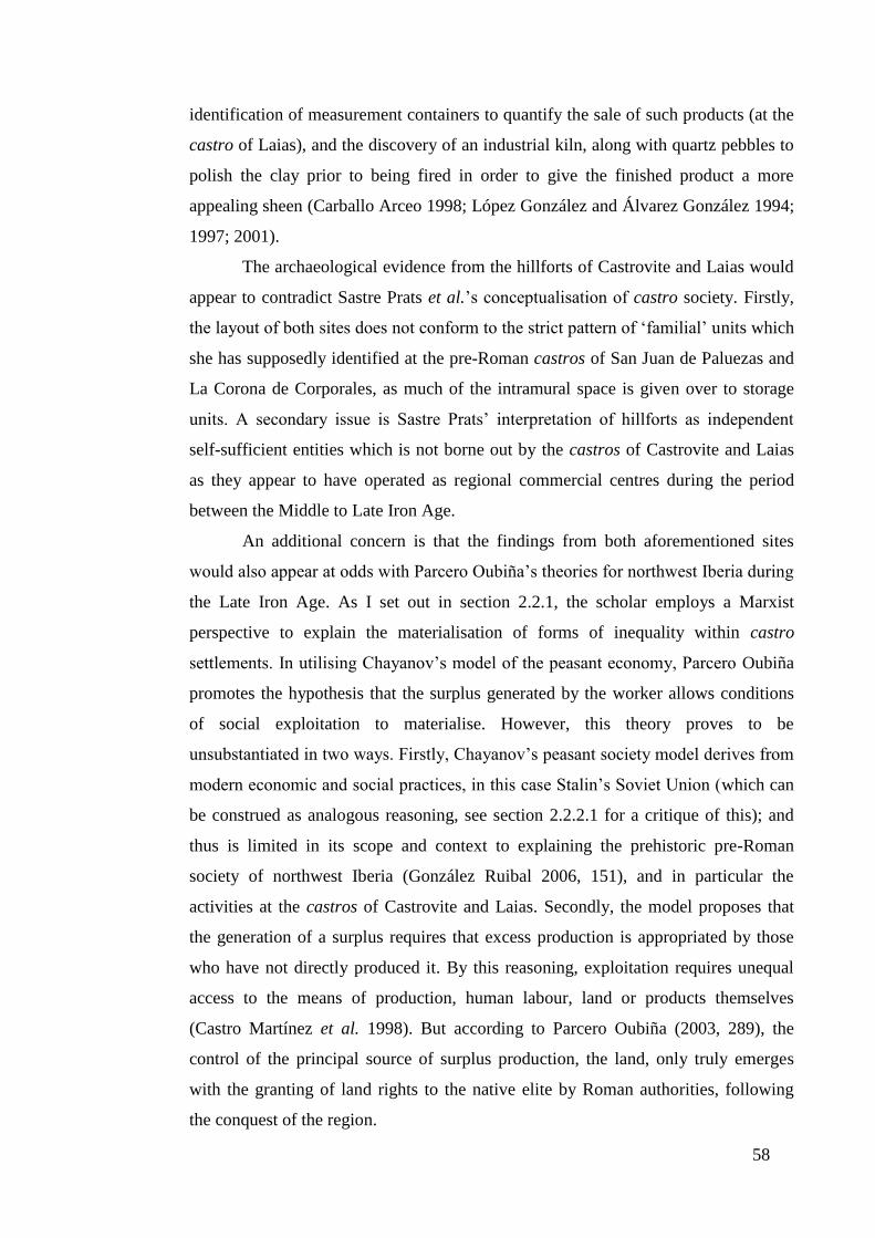
58
identification of measurement containers to quantify the sale of such products (at the
castro of Laias), and the discovery of an industrial kiln, along with quartz pebbles to
polish the clay prior to being fired in order to give the finished product a more
appealing sheen (Carballo Arceo 1998; López González and Álvarez González 1994;
1997; 2001).
The archaeological evidence from the hillforts of Castrovite and Laias would
appear to contradict Sastre Prats et al.’s conceptualisation of castro society. Firstly,
the layout of both sites does not conform to the strict pattern of ‘familial’ units which
she has supposedly identified at the pre-Roman castros of San Juan de Paluezas and
La Corona de Corporales, as much of the intramural space is given over to storage
units. A secondary issue is Sastre Prats’ interpretation of hillforts as independent
self-sufficient entities which is not borne out by the castros of Castrovite and Laias
as they appear to have operated as regional commercial centres during the period
between the Middle to Late Iron Age.
An additional concern is that the findings from both aforementioned sites
would also appear at odds with Parcero Oubiña’s theories for northwest Iberia during
the Late Iron Age. As I set out in section 2.2.1, the scholar employs a Marxist
perspective to explain the materialisation of forms of inequality within castro
settlements. In utilising Chayanov’s model of the peasant economy, Parcero Oubiña
promotes the hypothesis that the surplus generated by the worker allows conditions
of social exploitation to materialise. However, this theory proves to be
unsubstantiated in two ways. Firstly, Chayanov’s peasant society model derives from
modern economic and social practices, in this case Stalin’s Soviet Union (which can
be construed as analogous reasoning, see section 2.2.2.1 for a critique of this); and
thus is limited in its scope and context to explaining the prehistoric pre-Roman
society of northwest Iberia (González Ruibal 2006, 151), and in particular the
activities at the castros of Castrovite and Laias. Secondly, the model proposes that
the generation of a surplus requires that excess production is appropriated by those
who have not directly produced it. By this reasoning, exploitation requires unequal
access to the means of production, human labour, land or products themselves
(Castro Martínez et al. 1998). But according to Parcero Oubiña (2003, 289), the
control of the principal source of surplus production, the land, only truly emerges
with the granting of land rights to the native elite by Roman authorities, following
the conquest of the region.

59
Parcero Oubiña, to my mind, presents a rather confusing interpretation of
late castro society that is allied on one hand to the archaeological record which
suggests that systems of inequality may have emerged (for example the castros of
Castrovite and Laias and section 1.5.4), but also the need to concur with the Marxist
framework he advances. Moreover, the scholar contends that these unequal
partnerships based around familial kinship groupings, and which led to the rise of an
elite warrior class, are only representative within the landscape of the late pre-Roman
period (Parcero Oubiña and Cobas Fernández 2004, 60).
2.2.2.4. Evidence of a Warrior Elite and Social Inequality in Iron Age Northwest
Iberia?
Evidence for an elite warrior culture, which may have subverted systems of
equalities according to Parcero Oubiña, may have been present in the pre-Roman era.
The castro of Saceda located near present-day Orense and Verín (see Figure 3, page
21) and positioned just north of Study Area Chaves, shows a series of dynamic
changes during the Middle Iron Age (around 300 BC as identified by radiocarbon
dating). Not only did the settlement expand considerably (from one to five hectares
as shown by its fortified structures, González Ruibal 2005, 271-272), which may
have corresponded to an increase in population, it also appears that such changes
were allied to an increase in economic activity at the site. Ceramic artefacts produced
at the castro of Saceda have been found in the adjacent fortified settlements, but the
site appears to have had its own blacksmith’s workshop (as shown by pincers, nails,
axes, and a considerable number of iron and bronze artefacts (including bronze
torques) (González Ruibal 2005, 276). More importantly for the discussion here is
the discovery of a series of small finds including gold earrings and silver ingots
(perhaps a by-product of tin mining) which point to the existence of a
gold/silversmiths at the settlement (González Ruibal 2005, 276).
It is possible that a commercial centre existed at the castro of Saceda which
traded metal artefacts. Alternatively, such items may have been employed by
members of the community to work the land and local tin mines, or a mixture of both
scenarios (González Ruibal 2005, 276). Either way, it appears that a high-ranking
group of people resided in the castro of Saceda who had access to prestige gold and
silver items made in situ. Other prestigious artefacts include belt buckles, and longo
travessão fibulae (discussed in greater detail in section 3.6.2), and in particular iron
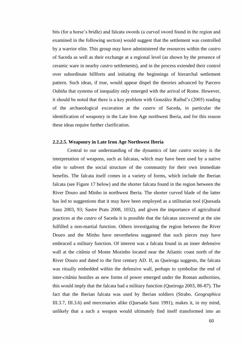
60
bits (for a horse’s bridle) and falcata swords (a curved sword found in the region and
examined in the following section) would suggest that the settlement was controlled
by a warrior elite. This group may have administered the resources within the castro
of Saceda as well as their exchange at a regional level (as shown by the presence of
ceramic ware in nearby castro settlements), and in the process extended their control
over subordinate hillforts and initiating the beginnings of hierarchal settlement
pattern. Such ideas, if true, would appear dispel the theories advanced by Parcero
Oubiña that systems of inequality only emerged with the arrival of Rome. However,
it should be noted that there is a key problem with González Ruibal’s (2005) reading
of the archaeological excavation at the castro of Saceda, in particular the
identification of weaponry in the Late Iron Age northwest Iberia, and for this reason
these ideas require further clarification.
2.2.2.5. Weaponry in Late Iron Age Northwest Iberia
Central to our understanding of the dynamics of late castro society is the
interpretation of weapons, such as falcatas, which may have been used by a native
elite to subvert the social structure of the community for their own immediate
benefits. The falcata itself comes in a variety of forms, which include the Iberian
falcata (see Figure 17 below) and the shorter falcata found in the region between the
River Douro and Minho in northwest Iberia. The shorter curved blade of the latter
has led to suggestions that it may have been employed as a utilitarian tool (Quesada
Sanz 2003, 93; Sastre Prats 2008, 1032), and given the importance of agricultural
practices at the castro of Saceda it is possible that the falcatas uncovered at the site
fulfilled a non-martial function. Others investigating the region between the River
Douro and the Minho have nevertheless suggested that such pieces may have
embraced a military function. Of interest was a falcata found in an inner defensive
wall at the citânia of Monte Mozinho located near the Atlantic coast north of the
River Douro and dated to the first century AD. If, as Queiroga suggests, the falcata
was ritually embedded within the defensive wall, perhaps to symbolise the end of
inter-citânia hostiles as new forms of power emerged under the Roman authorities,
this would imply that the falcata had a military function (Queiroga 2003, 86-87). The
fact that the Iberian falcata was used by Iberian soldiers (Strabo. Geographica
III.3.7, III.3.6) and mercenaries alike (Quesada Sanz 1991), makes it, in my mind,
unlikely that a such a weapon would ultimately find itself transformed into an
61
agricultural tool by Iron Age communities inhabiting northwest Iberia. We should
also acknowledge the poor and fragmented condition of many of falcatas uncovered
due in part to the corrosive soil of the region, as well as the considerable number of
unpublished site reports where these artefacts have been found (Lemos et al. 2011,
191), which makes it difficult to estimate both their number and importance within
the context of northwest Iberia. Probably no more than 50 examples exist and the
majority of these have been found at the aforementioned castro of Saceda and the
oppidum of São Julião, which is located along the Atlantic coast and occupied from
the Bronze Age until the early Roman period (González Ruibal 2005).
Figure 17. A fourth century BC Iberian falcata (2003/114/51. Museo Arqueólogico
Nacional).
The number and probable purpose of other weapons found within the study
region also remains a matter of debate. These include antenna-type daggers, two of
which have been found at the castro of Santa Tegra (see section 1.5.3) and are shown
in Figure 18. In terms of their location antenna-type daggers tend to be found
throughout northwest Iberia during the Late Iron Age, except for the region between
the Rivers Douro and Minho. The dating of these artefacts to the period after the
second century BC suggests that these antenna-daggers were based on similar
Celtiberian designs perhaps brought to northwest Iberia through the gradual
encroachment by Republican Rome (Quesada Sanz 2003). Although some have
interpreted antenna-type daggers as weapons (González García 2009, 70) it is likely
Figure 18. Antenna-type
daggers from the castro of
Santa Tegra (Carballo 1994).

62
that these artefacts were primarily employed as heirlooms, given that their small size
and awkward shape does appear to suit armed combat (González Ruibal 2006, 166).
A third body of evidence pointing to the presence of an elite comprises of
stone statues of warriors, which are largely confined to the oppida settlements of
northern Portugal. The weapons depicted in stone comprise of a small circular
shields (castra), a helmet, a dagger, a pair of spears and decorated items such as
torques. These have been read as symbolising the emergence of a native aristocracy
(González García 2009, 70). Many of the weapons depicted on the stone statues have
yet to be found within the context of the region and this has lead another body of
archaeologists to contend that the swords and shields carved in stone represent
symbolic variations on Roman types (Quesada Sanz 2003, 93). Such a hypothesis
would lend credence to the premise advanced by Parcero Oubiña (2003, 291) that a
‘heroic society’ orientated around acts of symbolic warfare materialised among the
proto-urban citânias in the Late Iron Age. The dating of these warrior statues to
between the mid first century BC and the first century AD (Quesada Sanz 2003, 93),
and subsequent re-use as building material in the first century AD (Calo Lourido
1994), would also support the idea that this ‘heroic society’ if it existed, had already
began to disband around the time Roman forces were pacifying the region. The
question therefore remains as to what preceded this ‘heroic society’ and how and
when systems of inequality emerged within the landscape. As I have already outlined
in section 1.5.6 our knowledge of the citânias of northwest Iberia rests heavily on the
Late Iron Age when a favoured aristocracy had already began to consolidate power.
While the area (the region immediately to the north of the River Douro) where
oppida dominate the landscape falls outside the study region, the origins of systems
of inequality in northwest Iberia have an important theoretical bearing on the process
of change in late castro society.
2.2.2.6. Summary and List of Objectives for Research Question One
The archaeological record of northwest Iberia during the Iron Age, and its
diverse interpretation by scholars studying the region, makes it difficult to
substantiate whether a warrior aristocracy emerged in the pre-Roman period which
corrupted systems of equality. Equally, it is difficult to establish whether late castro
society was more egalitarian or exploitative. Exploitation by its very nature requires
unequal access to the means of production, human labour, land or products

63
themselves (Castro Martínez et al. 1998), and such activities may well have been
present among the hillforts of Saceda, Castrovite and Laias as discussed above.
Nevertheless, while the three aforementioned castros have helped to broaden the
theoretical debate on Iron Age northwest Iberia, their limited number and
geographical location (to the west of northwest Iberia) suggest that a more
comprehensive examination of late castro settlements is needed.
For this reason, this thesis would benefit from an analysis of the available
land use for the castros examined in the five study areas, and the impact that this
resource may have had on their economic wellbeing (and which is discussed and
analysed in Chapter Four). This idea emerges clearly from the debate above
concerning the generation of surplus produce and interconnectivity of hillforts within
the landscape. Such an approach will interrogate Sastre Prats et al.’s interpretation of
the Late pre-Roman Iron Age communities as socially and economically isolated
entities. Such an investigation could also be extended to examine the degree of
isolationism or connectivity between late castro settlements through nearest-
neighbour analysis, which is explored and investigated in detail in Chapter Four.
In examining whether communities were connected through social, economic
and political networks, I believe it is important to analyse whether pre-Roman
hierarchical settlement patterns emerged with late castro society. Possible Iron Age
ranked societies have already been discussed in section 1.5.5 with particular
reference to pre-Roman hospitality pacts, and this debate is expanded in section 4.4
with a more detailed investigation of physical and social boundaries within Late Iron
Age society. These theoretical themes are further explored with the application of
Thiessen polygons as a means to establish possible margins of control, where
distribution centres such as the hillfort of Saceda may have existed, within the study
region, to expand our understanding of late castro society.
In analysing the theoretical basis of northwest Iberia Iron Age a more
integrated approach has been advanced which incorporates models of late castro
society, but includes a more detailed investigation of the social, economic and
political structures across the study region (as outlined in Chapter One) to address the
central question of this section – did a Late pre-Roman Iron Age settlement hierarchy
exist in northwest Iberia? In order to answer research question one the following
steps are proposed as objectives.

64
Did a Late pre-Roman Iron Age settlement hierarchy exist in northwest Iberia?
Objectives:
1. To define the pre-Roman people of northwest Iberia according to the socio-
economic, political and settlement structures of their communities.
2. To analyse the degree to which late pre-Roman settlement structures were
conditioned by environmental, socio-economic and political factors.
3. To examine the arguments advanced by Parcero Oubiña and Sastre Prats as to
whether a nascent pre-Roman settlement hierarchy, orientated around tribal
networks, was evident in the landscape of northwest Iberia.
2.3. Theoretical Background to Research Question Two
This subsection develops the themes established in the previous sections and
focuses on the ways in which Roman authorities exploited and adapted these
indigenous structures following the conquest of the region. In analysing these
interpretations, this section discusses the traditional narrative of the demise of castro
society measured against the subsequent development and possible dominance of
more Roman forms of settlement. Underpinning this theoretical approach is the
value-laden concept of ‘Romanisation’, which traditionally describes the
implementation of change within societies, such as the communities of northwest
Iberia, from an idealised Roman perspective. In recognising the importance of native
agents and culture in the formation of post-conquest societies, the idea of
‘Romanisation’ is explored in more depth with the aim of creating a more balanced
approach which gives a voice to non-Roman actors and provides a more holistic
narrative.
2.3.1. The Demise of Castro Society and the Development of Roman Systems of
Authority
The process of change with the conquest of northwest Iberia by Roman
authorities, as with many of the peripheral provinces of the empire, has traditionally
been represented within academic circles by two separate and divergent disciplines,
with the study of prehistoric and temperate Europe on one hand, and the Roman
world and classical civilisations on the other (Gardner 2007, 33; Wells 1999; 2002,
379). This stance has been reinforced in Iberia by the belief that the Roman conquest
eliminated any vestiges of pre-Roman political authority and indigenous exchange
65
networks (Álvarez Sanchís 2005, 25), and as a result, an artificial cultural dichotomy
has been created which sees the fragmented castro society erased from the historical
record by a more advanced and sophisticated people, the Romans (see Almagro
Gorbea and Ruiz Zapatero (1992, 515)). This narrative advanced by the likes of
Strabo (Almagro Gorbea and Lorrio Alvarado 2004, 6), where the ‘Celtic’ world
could only be civilised through the implementation of a Greco-Roman polis system
(Edmondson 1990, 151) has had a powerful impact on how the region is studied. For
example, Rodríguez Colmenero (1996b, 129), in examining the region centred
around modern-day Lugo in Galicia, Spain, begins his account with Strabo’s
description of the native people, their political affiliations and their settlements
before continuing to chart the emergence of the Roman administrative conventus of
Lucus Augusti. Of equal concern, is the focus by archaeologists and historians of
northwest Iberia on material evidence from Rome over more indigenous forms as
shown by Alarcão’s (1988, vii) catalogue of finds for Roman Portugal. This includes
isolated farms or hamlets where a Roman brick or tile were found, but where
identical material was uncovered within a native hillfort it was not deemed important
enough for publication.
Although in recent years a number of authors have emphasised that the
process of change in northwest Iberia was less ‘Romano-centric’ and owed a lot to
the fusion of native and ‘Roman’ practices (see González Ruibal 2006-2007; Parcero
Oubiña and Cobas Fernández 2004), such perspectives are far from commonplace.
Many scholars investigating the region continue to loosely employ the term
‘Romanisation’, without due explanation of the complex economic, social and
political practices at work, to describe the transformations that occurred from the
Late Iron Age onwards (see Carvalho 2008 vol. I; García Quintela 2002; Queiroga
2003; Lemos 1993 vol. I; Teixeira 1996). This approach has a tendency to emphasise
the archaeological record produced by the elite while ignoring the activities of the
less wealthy and powerful (Hingley 2000, 139), and to highlight the role of Rome as
the disseminator of new practices, which through time are adopted by more primitive
cultures (Creighton 2006, 73).
2.3.2. ‘Romanisation’. A Defunct Paradigm or a Valuable Contribution to
Roman Studies?

66
In seeking to investigate whether a more contemporary redefinition of
‘Romanisation’ can be successfully employed for the purposes of examining
northwest Iberia during the study period, it is imperative that first we examine its
central tenets.
The term ‘Romanisation’ has its origins with the British archaeologist,
Francis Haverfield and his contemporaries, who employed the term in the early
twentieth century as a means of describing the acculturation, integration and
assimilation of peripheral populations during the period of the Roman Republic and
Imperial Rome. In doing so, Haverfield drew upon ideas about colonisation and
empire, particularly in the context of the British empire, as a means to articulate the
policy, impact and long-term consequences of ‘Romanisation’ on those territories
assimilated by Rome (Mattingly 2004, 5). ‘Romanisation’, as perceived by
Haverfield and other academics of the day, was therefore closely aligned with the
dominant themes of early twentieth century imperialism, and as such was constructed
around a series of flawed assumptions. The first entailed that many of the territories
assimilated by Rome lacked any robust indigenous form of culture, thereby
emphasising the superiority of Roman over native systems (Creighton 2006, 9). As a
consequence of the cultural imbalance which was seen to operate between Rome and
those territories which were assimilated into its domain, the central belief of early
advocates of ‘Romanisation’ was in a dissemination and adoption of Roman cultural
practices by grateful provincials (Mattingly 2004, 5). This assumption to my mind is
flawed as it is difficult to substantiate whether Rome imposed its culture (it is often
problematic to establish what is strictly Roman, see Freeman below) and traditions
on those nations it conquered and assimilated. For this reason the underlying
ideology of ‘Romanisation’ can be argued to espouse the control and exploitation of
a foreign power over a native one (Given 2004, 4) when it did not necessarily exist,
and such ideas foster a Romanocentric interpretation at best (Webster 1996, 11), and
an imperialist and racist one at worst (Woolf 1998, 5).
In recent years, historians and archaeologists have attempted to redefine
‘Romanisation’, giving it a more contemporary and less Roman-centred approach,
which could be applied to the study of northwest Iberia. Millett (1990), for example,
revised Haverfield’s model of change in Roman Britain to argue that ‘Romanisation’
within Britannia was not perpetuated solely by Roman authorities, but rather
promoted by indigenous elite groups in the provinces who actively adopted aspects

67
of Roman culture, elements of which spread down through the social hierarchy
(Millet 1990, 117). However, in assigning native actors a more prominent role in the
diffusion and adoption of Roman practices Millett (1990) does not so much rework
Haverfield’s concepts as replace one elite group, Imperial agents, with another, the
native elite, as the disseminators of Romanitas (Mattingly 2004, 6). A second
criticism, and perhaps the key problem with the concept of ‘Romanisation’, is the
nature of those practices adopted and disseminated by the indigenous elite. Freeman
(1993, 443) in critiquing Millett’s (1990) work argues that the author does not
provide a definition of what constitutes ‘Roman material culture’ and for this reason
is unable to identify in ‘Roman’ goods those markers which make them specifically
Roman.
Freeman’s argument is an important one, in particular the problems involved
in how we choose to interpret ‘Roman material culture’ and thereby seek to
understand the process of change during the Roman era. As the basis of his
investigation Freeman (1993, 444) cites the example of villa settlements, which he
recognises as a term which is spatially and temporally dependent upon its context
within the Roman world, but also a phenomenon which reflected pre-Roman social
practices, as shown in southern Gaul where pre-Roman native sites developed into
Roman villae (Greene, 1990, 117). To this variation we can add the assortment of
structures from different settings which constituted a villa. These included the large
villa estates found in Italy and Sicily, the latifundia, which were dependent on slave
labour; the large administrative villae of late fourth century AD Iberia (Curchin
1991, 128); the luxury residential villa described by Pliny the Younger (Plin. Letters.
II, 17); and the more humble agricultural holding. The question therefore remains as
to what constitutes ‘Roman material culture’? Freeman (1993, 445) has argued that
the adjective ‘Roman’ should be removed on the assumption that many so-called
Roman cultural forms were not necessarily Roman in origin. He also adds that the
adoption of these Roman forms did not entail a desire to become Roman, but rather
the need to employ cheaper, better and more technologically advanced methods in
the face of a changing world (Freeman 1993, 444).
The use of an overarching theory such as ‘Romanisation’ presents a series of
problems because of the difficultly in clarifying what constitutes ‘Roman material
culture’ and as a consequence the term often represents different things to different
people (Forcey 1997, 15). As a result our understanding of the new practices that

68
emerged with the meeting of Rome (and the variety of cultures it embodied,
especially in the Roman military) and native communities it came into contact with
becomes over-simplified (see Barrett 1997), and in many ways is a product of more
modern ascribed values and notions (for example Haverfield’s ideas of colonisation
and empire), rather than ancient processes at work. In the following section I shall
propose a more relevant methodological approach which aims to encapsulate how
past societies in this period may have functioned and the transformative processes
they experienced.
2.3.3. New Approaches to the Interaction of Rome and Peripheral Cultures
In light of the brief discussion above, it is clear that more appropriate, flexible
and engaging frameworks need to be employed, which reflect not only the
complexity of the Roman world, but for the sake of this thesis, those societies which
preceded it. Gardner (2007) advocates a more holistic approach to understanding the
nature of contact and acculturation between those communities and forces that were
invested with more Roman and indigenous attributes. At the core are three key
themes: materiality identity, and transformation. In the case of identity a more
sophisticated approach is needed, which moves away from the simplistic binary
oppositions such as Roman versus native (see Brandt and Slofstra 1983) and military
versus civilian (Blagg and King 1984), which are often employed to frame the
archaeological and historical agenda, and instead seek to understand and represent
actors more accurately by introducing more representative categories such as gender,
age, occupation, status, religion and community (for example, see Mattingley’s
(2004) analysis of the ex-Catvellaunian slave Regina (RIB 1065) who was freed by
and married her Syrian merchant / soldier husband, and whose tombstone (an
imitation of one commonly used by elite women in Rome) was found at the military
base of South Shields near Hadrian’s Wall transcends many of the simple
dichotomies of identity listed above). Note: while the theme of identity is discussed
in relation to ‘Romanisation’ it does not constitute an area of investigation in this
thesis given that; (a) there is limited information on the identity of the peoples
inhabiting northwest Iberia; (b) such information does not promote an understanding
of settlement patterns in the study region.
Notions of identity should also incorporate more fluid interpretations of
material culture as a means to understand the multiple processes that have may have

69
taken place. Within the context of Late Iron Age and early Roman northwest Iberia
the presence of large numbers of tegulae (flat roof tiles) and imbrices (roofing joint
tiles) found in castro settlements has often been interpreted rather crudely as
evidence of a process of ‘Romanisation’ (see Queiroga 2003, 29, 55). However, such
building material has been found in specialised agricultural and mining centres which
may have been run by a native aristocracy allied to and sanctioned by Rome
(Sánchez Palencia et al. 2005, 246), as well as in smaller hillforts with perhaps
limited or no contact with Roman authorities. We must not only question to what
extent different members of society (the native aristocracy, those who worked under
them and more isolated communities with little contact with the Roman world)
derived a sense of meaning from the implementation of new ‘Roman’ practices, but
also query whether such procedures were truly ‘Roman’. It is possible that many
inhabitants within northwest Iberia may have simply employed and viewed locally-
produced tegulae and imbrices as an indigenous development which simply provided
better roof insulation.
More fluid interpretations of identity and material culture should also be set
against Gardner’s (2007, 34) third theme, that of transformation. Embedded within
the theory of ‘Romanisation’ is the often unchallenged belief that the adoption of
‘Roman’ practices was absolute and rapid (Churchin 2004; 11; Keay 1996, 147),
whereas in reality many of those changes would often have been taken place over
much longer periods of time (Woolf 1995, 9). This interpretation of change as an
event rather than a process is conditioned by our use of rigid chronological periods,
such as prehistoric, Roman and early medieval, which shape our investigation and
thereby understanding of the archaeological and historical record (Gardner 2007, 33).
While I have employed labels such as the ‘Late Iron Age’ and the term ‘native’ in
this thesis, I have done so for the sake of convenience, while recognising that
practices, identity and material culture often operated independently of our modern-
day compartmentalisation of time. In this way, an underlying tenet of this work is to
recognise and so interpret the broader impact of Rome on native societies, especially
given that the fusion of indigenous and more Roman practices would have varied
from area to area (Haselgrove 1990, 46).
How varied those changes were both spatially and geographically in
northwest Iberia between the Late Iron Age and the early Roman period therefore
remains a core area of analysis. For this reason, the subsequent section investigates
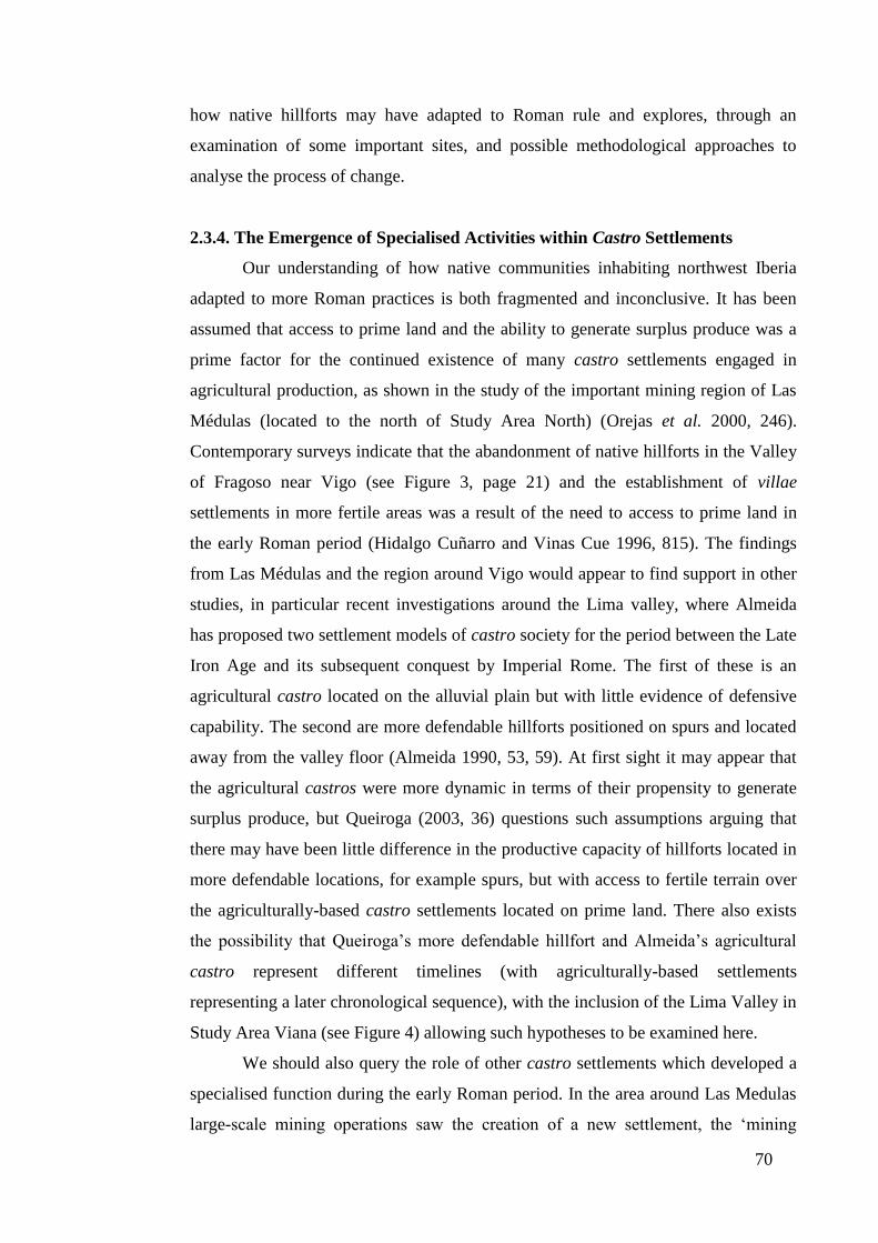
70
how native hillforts may have adapted to Roman rule and explores, through an
examination of some important sites, and possible methodological approaches to
analyse the process of change.
2.3.4. The Emergence of Specialised Activities within Castro Settlements
Our understanding of how native communities inhabiting northwest Iberia
adapted to more Roman practices is both fragmented and inconclusive. It has been
assumed that access to prime land and the ability to generate surplus produce was a
prime factor for the continued existence of many castro settlements engaged in
agricultural production, as shown in the study of the important mining region of Las
Médulas (located to the north of Study Area North) (Orejas et al. 2000, 246).
Contemporary surveys indicate that the abandonment of native hillforts in the Valley
of Fragoso near Vigo (see Figure 3, page 21) and the establishment of villae
settlements in more fertile areas was a result of the need to access to prime land in
the early Roman period (Hidalgo Cuñarro and Vinas Cue 1996, 815). The findings
from Las Médulas and the region around Vigo would appear to find support in other
studies, in particular recent investigations around the Lima valley, where Almeida
has proposed two settlement models of castro society for the period between the Late
Iron Age and its subsequent conquest by Imperial Rome. The first of these is an
agricultural castro located on the alluvial plain but with little evidence of defensive
capability. The second are more defendable hillforts positioned on spurs and located
away from the valley floor (Almeida 1990, 53, 59). At first sight it may appear that
the agricultural castros were more dynamic in terms of their propensity to generate
surplus produce, but Queiroga (2003, 36) questions such assumptions arguing that
there may have been little difference in the productive capacity of hillforts located in
more defendable locations, for example spurs, but with access to fertile terrain over
the agriculturally-based castro settlements located on prime land. There also exists
the possibility that Queiroga’s more defendable hillfort and Almeida’s agricultural
castro represent different timelines (with agriculturally-based settlements
representing a later chronological sequence), with the inclusion of the Lima Valley in
Study Area Viana (see Figure 4) allowing such hypotheses to be examined here.
We should also query the role of other castro settlements which developed a
specialised function during the early Roman period. In the area around Las Medulas
large-scale mining operations saw the creation of a new settlement, the ‘mining
71
hillfort’, which was characterised by a more open settlement plan (hence the removal
of monumental fortifications) thereby allowing for a population increment. A
common view is that this restructuring of the indigenous castro largely preserved the
Late Iron Age settlement pattern, but where the social, economic and political focus
lay at the heart of the Iron Age settlement now its form and function was very much
allied to wider systems of commercial exploitation (Sánchez Palencia 2000). While
the ZAM (Zona Arqueológica de Las Médulas) project remains one of the best
surveyed and studied areas in northwest Iberia, it is not clear how mining settlements
in the study region adapted to new practices in the early Roman period. A cursory
examination of the five study areas suggests that mining was not as important an
activity, in terms of the numbers of Iron Age and Roman settlements dedicated to
processing metals, as it would have been in the region around Las Medulas.
Nevertheless, the role of such commercial activities and its impact in shaping the
settlement pattern is difficult to gauge, especially if we acknowledge that specialised
mining activities may already have been underway among the citânias north of the
River Douro in the period immediately before the conquest of the region (see section
1.5.6). If they existed such exchange mechanisms may well have had a considerable
impact on the dynamics of the regional settlement pattern, in particular the increasing
centralisation of commercial activities, during the Late Iron Age and early Roman
period.
Our fragmented knowledge of exchange extends to other Late Iron Age
communities within northwest Iberia. For example, the castro of Vigo (north of the
River Minho, see Figure 3, page 21) located near the Atlantic coast was founded in
the second century BC, and specialised in the production and trade of garum (fish
sauce), which was in high demand in those areas of Iberia colonised by Rome. The
settlement continued to be occupied, perhaps due to its strategic location on the
Atlantic coast, until the early third century. The castro of Vigo offers a distinct
chronological sequence to other non-specialised castro settlements in the Valley of
Fragoso which were often abandoned in favour of villae settlements in the early
Roman period (as discussed above) (Hidalgo Cuñarro and Vinas Cue 1996, 807-838;
Pereira García and Hidalgo Cuñarro 1999). The degree of connectivity, or isolation,
the castro of Vigo enjoyed in relation to other settlements both along the Atlantic
coast and towards the interior from the Late Iron Age is less certain, perhaps in part
due to the absence of settlement studies conducted in the region.
72
Similar problems are evident at the large hillfort of San Cibrán de Lás which
is located further inland and dates from the second century BC until the second
century AD. An important feature of the settlement are a series of benches near to
one of the main entrances in the interior of the building which has lead to speculation
this space served as a tollgate (Eiroa 1988, 111). The settlement’s limited natural
defences, as well as the large internal space (9.5ha), suggest that San Cibrán de Lás
was purpose-built to accommodate a large population, but uncertainties arise in
determining the exact function of the Late Iron site and its relationship with
surrounding communities. This hillfort may in some way be associated with the
aforementioned castro of Laias (see section 2.2.2.3) whose decline in the first
century BC (López González and Álvarez González 1994; 1997; 2001) and nearby
location (3km to the south of the larger settlement) implies a degree of connection if
not affiliation. Whether this relationship extended to some form of political
attachment with the castro de San Cibrán de Lás constituting a new focal centre for
an as yet unknown social group, is impossible to establish. It is also difficult to
establish the function of this fortified hillfort during the early Roman period and
whether this may have extended to a possible subordinate political, administrative
and commercial centre for those settlements in its vicinity.
2.3.4.1. The Archaeological Evidence Underpinning the Development of Early
Roman Centres of Power
In light of the argument above we can only infer that native settlements would
have been incorporated into an emerging early Roman settlement pattern by fulfilling
some form of political, economic and social activity, although the dearth of regional
studies in northwest Iberia makes it hard to determine what their immediate function
may have been (Celis Sánchez 2002, 13). A more contentious debate concerns the
modification of the space occupied by fortified Iron Age castros and oppida to
establish open central places (hence without monumental defences) during the early
Roman period to exert control over the surrounding hinterland. In the case of
Bracara Augusta the suggestion has been made that that the settlement may have
evolved from a pre-Roman market place or meeting point for surrounding
communities (Lemos pers. comm. 03/03/2008; Tranoy 1981), an idea supported by
the large number of hillforts in the area, among them the citânia of Briteiros (see
section 1.5.6). An alternative view is presented by Alarcão (1988, 12), who points to

73
evidence of a possible pre-Roman settlement at Bracara Augusta in the form of a
circular dwelling (perhaps forming part of larger castro) found beneath a Roman
mosaic floor. However, as Alarcão is careful to acknowledge, the archaeological
excavations supporting the notion of a pre-Roman settlement at Bracara Augusta
were of poor quality and recorded with insufficient care. Our incomplete knowledge
of the adaptation of the Late Iron Age settlement pattern extends to other regions,
among them the area around Aquae Flaviae (which forms part of Study Area
Chaves), where a concentrated number of hillforts are located in close proximity to
the early Roman civitas capital. The suggestion by López Quiroga (2004, 79) that a
pre-Roman settlement lay under Aquae Flaviae is a valid theory, but without more
substantial evidence such ideas constitute little more than speculation.
The archaeological and historical record is equally unclear concerning the
role of early Roman central places, their interconnectivity with surrounding
settlements and how those relationships changed over time. This can be
demonstrated through a short examination of the three conventus capitals found in
the study region; Asturica Augusta, Lucus Augusti and Bracara Augusta, which are
loosely described in academic literature as administrative centres established in the
early Roman era (see, for example, López Quiroga 2004, 127). A more detailed
analysis of these central places suggests that they were continually evolving entities
with contrasting trajectories both in terms of their function and status. Where both
Asturica Augusta and Lucus Augusti evolved from early Roman military camps to
become civic centres, Bracara Augusta appears to have been founded primarily as a
civilian settlement and grew rapidly to become a focal point between the Rivers
Minho and Douro. A rich epigraphic collection points to an imperial cult dedicated to
the Emperor Augustus by the native peoples (for example, Camalo, son of Melgeco
(CIL II, 2426)) who had once inhabited surrounding castros or oppida settlements,
but who had relocated to the new urban centre. The presence of an imperial cult
would imply that during the reign of Augustus (27 BC – AD 14) the town acquired a
civic status above that of a civitas capital (where the town’s charter only allowed
local laws could be applied (Mattingly 2007, 261)). That the settlement gained many
of the attributes of a conventus capital during this period (thereby enabling the town
to administer its hinterland and provide judicial authority) remains a controversial
idea (Martins 2006, 216). A more reasonable interpretation suggests that the
settlement may have acquired Latin rights, or ius Latii, which granted Roman

74
citizenship to magistrates upon holding office and ascribed Latin status to its
inhabitants (Le Roux 1994).
If this represents the sequence of events then it is entirely likely that Bracara
Augusta grew more rapidly both in terms of its economic development and civic
status than the Asturica Augusta and Lucus Augusti, which may have been hampered
by their early Roman role as military installations and limited commercial
opportunities in their respective orbit of influence. In the absence of detailed
archaeological evidence, in particular regional settlement studies, we can also
deliberate as to the changing relationship and degrees of connectivity between other
central places and settlements. Did, for example, vici settlements (small Roman
settlements discussed in greater detail in section 5.2.3) fulfil a subordinate
administrative role to larger centres such as the conventus capitals or did that
responsibility lie with more indigenous structures such as the large castro of San
Cibrán de Lás (as discussed in section 2.3.4)? Furthermore, what was the relationship
between non-agricultural sites (Roman towns and Roman-period castros) and smaller
agricultural (for example villae and Roman-period castros) centres?
2.3.4.2. Summary and List of Objectives for Research Question Two
The focus of the discussion for research question two has very much centred
on the available archaeological evidence and has therefore been orientated around
more established areas of investigation such as the larger castro settlements, hillforts
which showed evidence of specialised activity in the early Roman period and central
places, in particular conventus capitals. In seeking to redress the limitations in our
understanding of the study period an approach is needed which examines the
landscape at a regional level, but also investigates the character of individual
settlements. At the local level, it has been suggested that the agricultural capacity of
native settlements played a pivotal role in securing the continuing occupation of
many castro settlements into the early Roman period. For this reason, this thesis
would benefit from a detailed examination of the land use capacity which would
follow the same methodological procedure to that outlined for Research Question
One (see section 2.2.2.6). A cross-comparative analysis between the land use
capacity generated for Late Iron Age castros and data compiled for Roman-period
castros and ‘Roman’ settlements could then be conducted.

75
Thiessen polygons, generated to address Research Question One, could also
be applied to examine the theory that early Roman settlements may have been
located on the boundaries of Iron Age sites (see discussion in section 2.3.4.1) to exert
control over the landscape. In this way, by incorporating analysis conducted for
Research Question One with the data generated for Research Question Two the
chronological sequence for the pre-Roman period, the founding of Roman-period
castros, and the introduction of Roman settlements can be analysed in greater depth.
This more analytical framework would provide the means to answer Research
Question Two.
To what degree did the administration of early Roman Northwest Iberia adopt
and exploit the landscape of pre-Roman Northwest Iberia, and how did the
Roman settlement structure differ from the pre-Roman Period?
Objectives.
1. To determine the location, type and pattern of early Roman settlement structures in
northwest Iberia and determine the degree to which they were shaped by
environmental, political and socio-economic factors.
2. To explain the continuity and discontinuity of pre-Roman and Roman structures
according to; (a) environmental constraints; (b) location, plan and form of urban and
rural settlements; (c) socio-economic and political factors.
3. To analyse the continuity of pre-Roman structures under the guise of Roman-
period castros, based on their specialised role as centres of mining and / or
agriculture, and the locational criteria for the development of these settlements.
2.4. Theoretical Background to Question Three
How northwest Iberia during the Late Iron Age was integrated into the larger
Roman world constitutes a central theme and area of investigation within this thesis.
Of central importance were communication routes which acted to integrate, or
alternatively distance, native communities and settlements into the new Roman
order. The process of change would therefore have also impacted on existing social
systems and commercial activities, but above all, and bearing in mind the discussion
above on ‘Romanisation’, would have exposed the inhabitants of northwest Iberia to
different technologies and practices. Moreover, the adoption of alternative systems
and procedures would have been dependent on a series of factors, among them: (a)

76
how Roman authorities utilised pre-Roman fluvial and terrestrial routeways; (b) the
degree to which new communication routes bypassed or integrated native forms of
movement within the landscape; and (c) other determinants such as the exploitation
of the environment, and the need to develop a network of administrative hubs and
commercial centres. The following section examines our existing knowledge of
communication routes within northwest Iberia between the Late Iron Age and early
Roman period, and concludes with a series of objectives to guide and focus the
research conducted within this thesis.
2.4.1. Problems and Limitations of Current Interpretations of the
Communication Systems in Northwest Iberia during the Late Iron Age
A dominant feature of late castro society is our incomplete knowledge of
movement within the landscape, and as a consequence, the existence and function of
terrestrial and fluvial routeways. It is very probable that some degree of connectivity
existed between adjoining settlements, in particular among Iron Age hillforts which
engaged in some form of commercial activity such as the castros of Saceda,
Castrovite and Laias (see section 2.2 above), at a political level, for example the
castro of San Cibrán de Lás (see section 2.3.4), or perhaps a combination of social,
economic and political interactions. Whether the trajectory of such passageways
extended to the regional level and how connected they were with surrounding
communities and other networks of movement is difficult to establish.
Recent studies, although limited in number, do allow us to conceptualise how
ancient routeways may have evolved and operated in northwest Iberia during the
Late Iron Age. Of particular relevance are the possible prehistoric origins of a section
of the main Roman road, the Via XIX (as shown by the Antonine Itinerary from third
century AD), which connects Bracara Augusta with the other conventus capitals of
the region, Lucus Augusti and Asturica Augusta. The section of road relevant to the
discussion lies between the River Minho (on the northern boundary of Study Area
Viana) and the Ulla Valley (around modern-day Pontevedra, see Figure 3, page 21).
Along the routeway a series of Late Bronze Age axes have been uncovered as well as
jewellery and swords from the period which the author, González Ruibal (2001, 157-
158), has interpreted as evidence that this was a sacred passageway. During the Early
Iron Age a series of castros can be identified that were established near to many of
these sacred deposits along the length of what would become the Via XIX.
77
There are, in my opinion, a series of issues with González Ruibal’s
interpretation of the archaeological evidence. While the ritual deposition of weapons
in the waterways appears to have been a common practice in northwest Iberia during
the Bronze Age (Bradley 1998, 251), it is hard to ascertain how this impacted on the
settlement pattern in the region. A closer examination of the proposed routeway
shows that its trajectory is drawn from the concentrated number of archaeological
sites located around the River Minho, Redondela and Pontevedra (see Figure 3, page
21). With only a single cache of axes found around the Ulla Valley it appears that the
disparate site finds have been joined up to create a probable ancient passageway
which closely matches the later trajectory of the Via XIX. The case study itself
shows both Early Iron Age, as well as Middle and Late Iron Age sites converging
around the possible routeway (González Ruibal 2001, 158, 163), but the absence of
other hillforts located on the periphery makes it impossible to determine how
important such a passageway may have been in determining the regional settlement
pattern. An alternative viewpoint suggests that the Meridiana depression, along
which the Via XIX runs (Naveiro López 1991, 141), may have played a more
influential role in shaping the path of both the prehistoric and the later Roman
routeway.
Where our knowledge of possible prehistoric routeways has been
strengthened in recent years with respect to fluvial communication systems, in
particular the discovery of a two maritime vessels in the River Lima (which is
located at the centre of Study Area Viana) in 2002-2003. The dugouts, labelled Lima
4 and 5, were each carved from a single tree (Alves and Rieth 2007, 15) and have
been radiocarbon dated to between the fourth and second centuries BC (Alves and
Rieth 2007, 5). Although Lima 5 was never finished, and so not usable, Lima 4
provides the approximate size of such vessels (being carved from a single tree the
size of these boats would have varied in size) with a length of 6.95m (internal length
6.03), and a maximum diameter of 0.88m (Alves and Rieth 2007, 12). The design of
these pirogas (a small flat bottom boat often driven by an oar which continue to be
used in Africa and Asia), within a European context appear to date from the Late
Bronze Age (Arnold 1995, 94-95). The presence of similar pirogas found at Loch
Arthur in Scotland, and dated to between the second century BC and second century
AD (Mowat 1996, 52-53), and the use of the flat bottomed boat in Iron Age southern
Britain (Sherratt 1996), may be symbolic of cultural contact and the exchange of
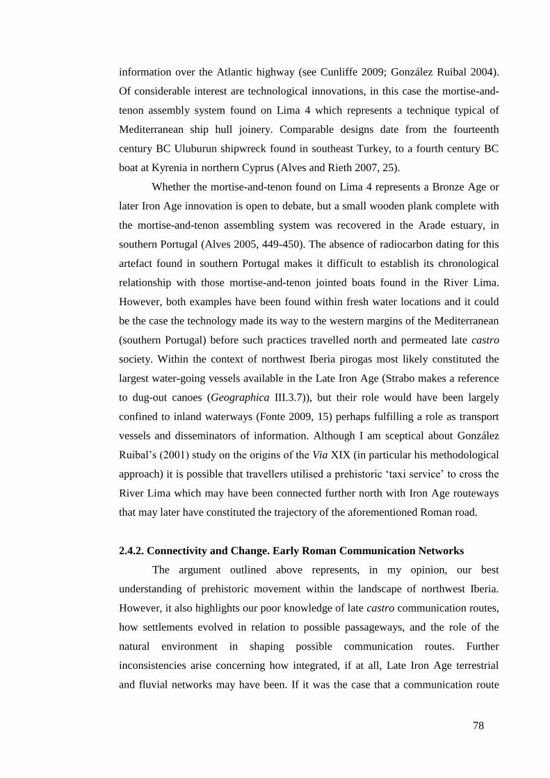
78
information over the Atlantic highway (see Cunliffe 2009; González Ruibal 2004).
Of considerable interest are technological innovations, in this case the mortise-and-
tenon assembly system found on Lima 4 which represents a technique typical of
Mediterranean ship hull joinery. Comparable designs date from the fourteenth
century BC Uluburun shipwreck found in southeast Turkey, to a fourth century BC
boat at Kyrenia in northern Cyprus (Alves and Rieth 2007, 25).
Whether the mortise-and-tenon found on Lima 4 represents a Bronze Age or
later Iron Age innovation is open to debate, but a small wooden plank complete with
the mortise-and-tenon assembling system was recovered in the Arade estuary, in
southern Portugal (Alves 2005, 449-450). The absence of radiocarbon dating for this
artefact found in southern Portugal makes it difficult to establish its chronological
relationship with those mortise-and-tenon jointed boats found in the River Lima.
However, both examples have been found within fresh water locations and it could
be the case the technology made its way to the western margins of the Mediterranean
(southern Portugal) before such practices travelled north and permeated late castro
society. Within the context of northwest Iberia pirogas most likely constituted the
largest water-going vessels available in the Late Iron Age (Strabo makes a reference
to dug-out canoes (Geographica III.3.7)), but their role would have been largely
confined to inland waterways (Fonte 2009, 15) perhaps fulfilling a role as transport
vessels and disseminators of information. Although I am sceptical about González
Ruibal’s (2001) study on the origins of the Via XIX (in particular his methodological
approach) it is possible that travellers utilised a prehistoric ‘taxi service’ to cross the
River Lima which may have been connected further north with Iron Age routeways
that may later have constituted the trajectory of the aforementioned Roman road.
2.4.2. Connectivity and Change. Early Roman Communication Networks
The argument outlined above represents, in my opinion, our best
understanding of prehistoric movement within the landscape of northwest Iberia.
However, it also highlights our poor knowledge of late castro communication routes,
how settlements evolved in relation to possible passageways, and the role of the
natural environment in shaping possible communication routes. Further
inconsistencies arise concerning how integrated, if at all, Late Iron Age terrestrial
and fluvial networks may have been. If it was the case that a communication route

79
ran across the River Lima and followed the trajectory of the later Via XIX, then how
representative were such routeways in other parts of the study region?
What can be said with more conviction is that recognised and important
communication routes, such as the Via XIX, have been used to frame the agenda of
research into both the prehistoric and the Roman period alike. In the case of the latter
time period, the focus of investigation has traditionally centred on the itineraries of
Roman roads, the identification of Roman milestones within their original context,
and the mapping of communication routes between monumentalised central places
(see Rodríguez Colmenero 1976; and the website dedicated to Vias Romanas em
Portugal: Intinerários). Although in recent years, regional studies have emphasised
and analysed the pattern of change between the Late Iron Age and the early Roman
period in a more robust manner (see Amaral (1993); Carvalho (2008 vol I and II);
Lemos (1993 vol I and II); Martins (1990) and Teixeira (1996), these studies are
discussed in greater detail in Chapters Three and Four), there is a tendency for
scholars to read these fluvial and terrestrial routes as functional and unambiguous,
and ascribe them no purpose other than being lines connecting places on the
landscape.
2.4.2.1. The Role of the Communications Network and the Importance of Trade
in the Early Roman Empire
In terms of the Roman communications system it appears that a network of
terrestrial routeways emerged during the Republican era which were consolidated
and expanded during the early Imperial period. Among these developments was a
communication infrastructure which provided a more centralised system of
government with the emperor at its head (Adams 2001, 4). Suetonius (Aug. 49.3)
notes that Augustus stationed men and later carriages at points along military roads
so that he could quickly and easily receive reports in every province. It is therefore
possible that this cursus publicus, or Roman postal system, developed chiefly in
tandem with the construction of military and civilian roads (and therefore constitutes
an area of investigation in this thesis). In this case, it has been argued that the
primary function of the cursus publicus was to act as a conduit for state, military and
official information (Adams 2001, 4), but that role did not extend to the
transportation of commercial products (Kolb 2001, 102).
80
How trade and the movement of freight proliferated during the Roman era,
and the extent to which it utilised an emerging communications network, continues
to be a topic of fierce debate. Our understanding of the pre-modern city and the role,
significance and importance of the communication network which linked urban
centres, has been heavily shaped in recent times by historical, as well archaeological
models. Among these models, Finley (1973) presented a clear and unambiguous
perspective of the ancient world, as a society orientated around the concept of
Weber’s consumer city (see The Agrarian Sociology of Ancient Civilisations, Weber
1976 [1909]), and in the process adopting the idea that capitalism did not emerge
until the Medieval period because of the disincentives offered to power-holders to
generate more competitive technologies (Parkins 1997, 84). Implicit in Finley’s
(1973) theory was a Weberian interpretation of economic activity as subordinate to
the pursuit of status, in this case through agricultural activity, reinforced through the
evidence of the classical texts (Greene 2000, 32). As a consequence, elites invested
in land-based power and consolidated their position through the acquisition and
generation of agricultural produce, and in the Weberian scheme, used this wealth to
pay for their conspicuous consumption within the urban landscape. A corollary of
such deeply entrenched assumptions was the view that bulky agricultural products
were consumed locally, and not traded (Greene 1990, 14), thereby limiting the
commercial role and the use of highways during the early Roman empire. The idea
that goods were costly to transport, in particular where settlements did not have
access to fluvial communication systems, and therefore not economically viable for
exchange was promoted by earlier studies (for example, Yeo’s (1946) wildly
inaccurate reckoning for the distance between Brundisium to Rome (Laurence 1999,
95-96)). Additional calculations based on Diocletian’s edict of maximum prices (see
Duncan-Jones’ (1974, 368) use of the transportation of wheat from Alexandria to
Rome) proved equally inaccurate given that the edict merely established a cost
ceiling for certain products, and not their market value (Curchin 2004, 167). What
the edict did not account for were savings enjoyed by agricultural practitioners
whose access to their own transport and slave labour would have acted to keep costs
down (Spurr 1986, 144-146).
The negative belief advanced by Finley and his adherents of limited
economic integration, cripplingly high transport costs and low levels of connectivity
between settlements (both rural and urban) in the Roman era has been largely
81
dismissed in recent years (see Fentress and Fentress 2001, 206; Horden and Purcell
2000, 146; Laurence 1999; Morris 2003, 30; Squatriti 2002, 270, for the Roman
world, and Lowe 2009, 4, for Roman Iberia). However, the minimalist view put
forward by Finley et al. does encourage us to provide proof of wider economic
interaction, and by that reasoning provide evidence that the use of communication
infrastructure was not confined to state affairs, such as the cursus publicus.
In terms of their commercial capabilities, it is possible to identify a series of
profit-making activities that integrated towns with their immediate hinterland.
Hopkins (1983) identifies a key aspect of rural and urban interaction which involved
the purchase of low-value, high-bulk rural raw materials from rural producers which
were transformed by urban workshops into high-value low-bulk products. In the case
of Pompeii the archaeological record provides a detailed insight of the dynamics of
an early Imperial Roman town where small-scale manufacturing, for example the
production of wool purchased from shepherds in the surrounding countryside, was
brought to the town, where a plentiful supply of human urine and a guaranteed
source of water, allowed for its manufacture (Moeller 1976). Other small-scale
agricultural practices within the urban landscape, such as the production of wine and
the harvesting of olive oil, demonstrated by the remains of olive trees within the
gardens of larger houses such as the House of the Ship ‘Europa’ (Jashemski 1979,
236), attest to other commercial activities within the urban sphere. This produce, in
addition to rurally sourced foodstuffs, would have been sold in the tabernae, or small
businesses, which lined the main thoroughfares into Pompeii (Wallace-Hadrill 1994,
123), to urban dwellers and rural visitors alike. Fast-food offered in the tabernae was
one of a wide range of services available in the town which extended to prostitution
in the backstreets of Pompeii, and currency exchange and financial transactions
offered by tabernae argentariae (moneychangers) in the macellum (market).
The wealth of activities at Pompeii from pottery makers to blacksmiths,
joiners to carpenters suggests that early Imperial towns had a commercially diverse
relationship with their periphery. How important that relationship was, and the
degree to which the Roman road network facilitated that association is altogether
more difficult to interpret. Was Pompeii typical of a small town with trade links
seemingly limited to its orbit of immediate influence, or did that economic
relationship extend to other regions further afield?
82
Our knowledge of ancient trade within small villages and large commercial
centres has been considerably strengthened by the discovery of papyri in Roman
Egypt, which in my opinion provides an invaluable insight into economic activity
which is often not shown by the archaeological record. Two sites, in particular, are of
extreme interest in highlighting the importance of economic activity in this period.
The first is the small village of Karanis located at the northeast corner of the Faiyum
oasis on the west bank of the Nile, and some 90km from modern-day Cairo. The
documentation found at the location attests that the village employed dyers, fullers,
weavers, an embalmer, a necropolis worker, wool-sellers, fish-sellers, vegetable-
sellers, a butcher, a lamb-butcher, wine-sellers, goldsmiths, transporters, shepherds,
cow herders, a doctor, a cobbler, hair-cutters and scribes (Alston 1998, 170).
Karanis’ small population of up to 3,000 (Pompeii’s has been estimated to be around
10,000 (Wallace-Hadrill 1994, 99)) begs the question as whether these small Roman-
era settlements were more vibrant than previously thought. Karanis’ dependence on
grain as a staple crop and the lack of any elite residences at the site implies to a
relatively average settlement. Where Karanis may have had an edge on other
settlements in the region was its position on the main Faiyum to Memphis road. A
registration document from the mid second century AD records that 55 camels and
ten calves, which were owned by eight different people, were in the care of a single
person (Alston 1998, 174). It could be the case that these beasts of burden were
employed to transport goods further afield and this situation may bear similarities
with the ‘archive of Nikanor’, which documents the transport of goods by an
enterprising Roman Egyptian and his transport company, to soldiers posted to the
Red Sea and Eastern Desert. The naming of a certain Philostratos of Panes on the
same document as a possible intermediary (Adams 2007, 214) suggests that the
transportation of goods was a complex affair with a series of individuals in charge of
the caravan at various stages of its journey.
Although Karanis was a small village which principally interacted with
surrounding settlements its role may have extended to and incorporated wider
economic networks, perhaps as a result of its prime location on the Fayum to
Memphis road. At larger centres, for example Oxyrhynchus in Upper Egypt, the
city’s role as the administrative capital of the 19th
nome helped to create an economic
powerhouse in the region. Accounts, census material, receipts, tax returns, invoices,
as well as correspondence on military, administrative, religious, political and above
83
all economic matters from archaeological excavations provide a valuable insight into
the workings at the settlement. Above all, it has been the manner in which the
information has been utilised which has created a picture of different zones of
contact. The first of these zones is the Oxyrhynchite, the area under the immediate
administrative supervision of the settlement, which accounts for 40-50% of all
correspondence. Next is the region at a distance of 90km from Oxyrhynchus, which
accounts for 45% of all non-Oxyrhynchite contact and finally zone three which runs
about 230km to the north and 260km to the south which involved 17% of all non-
Oxyrhynchite correspondence (Alston 1998, 186). This would appear to suggest that
commercial exchange at Oxyrhynchus was tempered by degrees of connectivity
between different regions in Roman Egypt, which has an important bearing on how
we interpret local, regional and supra-regional activity within the Roman empire.
2.4.2.2. Commerce, Communications and Connectivity in the Early Imperial
Era
The findings from the large administrative and commercial centre of
Oxyrhynchus, as well the small and medium-sized towns of Karanis and Pompeii
suggests that these settlements forged a strong symbiotic relationship with their
immediate hinterland and beyond. How representative that relationship was in terms
of the size of settlement (papyri-sourced information from the small town Karanis
shows more evidence of economic activity than archaeological information coming
from the larger settlement at Pompeii), the location of the settlement (Karanis was on
an important routeway), or whether our understanding of these sites is distorted by
the available archaeological and historical evidence, is hard to ascertain. What can be
said with more authority is that trade within the early Roman empire was more
voluminous and pervasive than previously thought (Horden and Purcell 2000, 148).
These conclusions come from many years of archaeological endeavour, but also stem
from Horden and Purcell’s methodological approach to examining the historical and
material evidence. The incorporation of this within the present work would facilitate
a greater understanding of the interrelationship of settlements through their
communications network. Central to Horden’s and Purcell’s (2000) broad theory to
understanding the Mediterranean region, and in particular the Roman empire, is a
fourfold approach. This begins with (1) the notion that a ‘regime of risk’ pervades all
societies and for this reason (2) a series of strategies (diversification of production,

84
storage and redistribution) are employed to cope with poor harvests and other
problems. Within the Mediterranean world these strategies are strongly dependent on
(3) distinct topographic characteristics which results in divergent ‘microregions’
shaped not only by a (4) distinctive communication system, but also the social,
cultural and economic attributes of these spatial units (Horden and Purcell 2000;
Purcell 2003, 10). Binding the ideas of ‘regime of risk’, and strategies that emerge to
cope with it which result in ‘microregions’, is the notion of connectivity. In essence,
connectivity explains how regions cohere and interact according to their individual
attributes, as shown by Roman wheat yields, and to an extent wine and oil
production, which varied from year to year and place to place (Horden and Purcell
2000, 152). This ensured that multiple overlapping ‘microregions’ which were
subject to spatial and temporal change were constantly being redefined.
Consequently, the degree of connectivity between ‘microregions’ ensures that
communities, far from being represented as being frozen in time, can be shown to be
vibrant entities which experience decline and intensification over the course of their
existence (Woolf 2003, 135). This flexible understanding and interpretation of the
Mediterranean world also moves away from analysing geographic entities (for
example states and provinces) and instead seeks to identify multiple regions in the
landscape which vary in importance and size from single settlements to the
Mediterranean itself (Squatriti 2002, 267).
Horden and Purcell’s theory of connectivity provides a valuable tool, in my
opinion, to examine the role of the early communication network in the study region
and its impact (along with other factors such as land use, and geographical features)
on the settlement pattern of the Late Iron Age and early Roman period. However,
there are a series of points that require further clarification if the theory of
connectivity is to be employed in this thesis. The first is the emphasis that Horden
and Purcell place on the importance of salt water communication, in this case the
Mediterranean Sea above terrestrial routeways and freshwater transportation
networks (Squatriti 2002, 267, 277). The focus on salt water communication and
hence connectivity remains a central problem of Horden and Purcell’s argument. In
the case of Oxyrhynchus, its commercial activities were largely limited to Roman
Egypt, and therefore made extensive use of terrestrial and freshwater communication
networks. A further example of the importance of inland transportation systems is
evident in central Hispania where locally grown wheat began to be traded more
85
extensively with neighbouring provinces. It is possible this economic ‘microregion’
took advantage of the River Duero, which was navigable in central Iberia (Strabo
Geographica III, 3, 4), as well as terrestrial routes to transport goods to the coast.
Alternatively, Roman highways, such as the road linking Toletum (modern-day
Toledo, near Madrid) with Corduba in Baetica, may have played a pivotal role in
providing a suitable means for land-based haulage (Curchin 2004, 166).
An additional problem with connectivity concerns how it can be identified
within the archaeological record. By Horden and Purcell’s (2000, 160) own
admission our understanding of ancient trade is often limited to elite exchange, and
as a consequence low level connectivity is difficult to measure. Alston (1998, 165)
makes a similar point when analysing Roman Egypt, and cautions the reader that
surviving evidence, in this case papyri, would not have documented the trade and
exchange in its entirety. This is further complicated, in the case of a large central
place like Oxyrhynchus by the need to distinguish between commercial activity and
administrative communication (Alston 1998, 167). We should acknowledge that
while central places such as Oxyrhynchus were connected at a local and regional
level this may not have been the case with all Roman settlements. Downs (1996, 97),
for example, argues that many Roman settlements in southern Iberia along the
Guadalquivir Valley were not integrated into a wider Mediterranean market
economy, electing instead to conduct more localised exchange.
In seeking to redress these problems I believe it is necessary to develop a
more holistic approach which utilises both terrestrial and fluvial routeways to
examine the degree of connectivity between settlements. In section 2.4.3, I outlined
the importance in generating an understanding of the relationship between routeways
and surrounding communities, which would help us to investigate how connected
settlements were at a local and regional level. However, such an enquiry, in
particular an examination of terrestrial routeways, throws up an additional series of
questions. For example, what was the relationship between settlements and land-
based communication systems? Did early Roman settlements emerge along
established routeways as Strabo (Geographica V.2.10) describes for the Forum
Flaminum, Forum Sempronia and the town of Nuceria located along the Via
Flaminia in Italy? Or was it the case that the Roman arterial road network connected
already established settlements? Or was the reality a combination of these practices?
Information generated for Research Questions One and Two (see sections 2.2 and

86
2.3), in particular the agricultural potential of individual sites and the probable
economic, cultural and political union between settlements (discussed in greater
detail in section 5.2.4), can be used to chart the multiple relationships that may have
existed between settlements in the landscape. These include the identification of
possible routeways which connected agricultural centres with market places, and
extend to identifying the role of administrative and commercial centres in controlling
their hinterland.
To measure the level of connectivity between settlements and ‘microregions’
is impossible, but the presence of five study areas allows comparisons to be made
which help to address the central question of this section. In order to answer this final
research question the following objectives are proposed.
To what extent did Roman fluvial and terrestrial routes exploit the pre-Roman
communication network and how did this impact on the development of the
Roman settlement structure?
Objectives
1. To define the terrestrial and fluvial communication network of pre-Roman and
Roman northwest Iberia.
2. To explain the continuity and discontinuity of the pre-Roman and Roman
communication system against; (a) environmental constraints; (b) the location, plan
and form of urban and rural settlements; (c) socio-economic, political and strategic
factors; (d) its degree of connectivity with the wider Roman world.
3. To explain continuities and discontinuities of the pre-Roman and Roman arterial
road network and fluvial transport system against economic opportunities and
political hegemony.
4. To analyse the role of pre-Roman and Roman structures in determining the
trajectory of Roman roads and the role and importance of Roman communication
routes in shaping the settlement pattern of northwest Iberia.
2.5. Summary
The central feature of this chapter has been to explore the principal debates
outlined at the end of Chapter One and to develop a series of objectives to answer the
three core aims. In exploring the archaeological evidence surrounding the three
research questions, it become apparent that our knowledge of the study area between

87
the Late Iron Age and early Roman period is severely limited. In the case of late
castro society there is evidence that settlements may have been integrated to some
degree at a political or economic level. In this instance, I have proposed terminology
such as connectivity, as a means to analyse the pre-Roman landscape, but it should
be emphasised that this constitutes a very different term to that used to examine the
early Roman landscape. This is because there is little evidence for the integration of
northwest Iberia into the Roman world before its conquest in the first century BC,
and it is my belief that by stressing the importance of the cultural and economic
union of Late Iron Age northwest Iberia and Mediterranean systems of exchange
would result in an erroneous and wasteful exercise. What is evident from the analysis
of the Late Iron Age is to conduct regional comparative analysis to measure and
understand the different processes at work in the landscape. This extends to the
Roman period where late castro structures were being both abandoned and adapted
into the early Roman settlement pattern. In consolidating our understanding of the
study period the final section examines the importance of pre-Roman communication
systems and Roman trade and administrative networks which are examined against
the idea of connectivity, but incorporate data and analysis undertaken for Research
Questions One and Two. In this way, the integrated approach which makes use of
regional comparative analysis is proposed here and examined in greater depth in
Chapters Four, Five and Six, with the express intention of developing a more
comprehensive understanding of the study region from the Late Iron Age until the
early Roman period.
88
Chapter Three. An Overview of the Five Study Areas
3.1. Introduction
This chapter provides an introduction to the five study areas, which will be
used to analyse the changes experienced in northwest Iberia between the Late Iron
Age and early Roman period. In providing a contextual background to the areas of
study section 3.2, briefly examines those regions to be investigated, while the
following sections explore the geomorphology of northwest Iberia, and its role in
shaping the cultural and socio-political structure of the region. Section 3.5, examines
the provenance of the datasets utilised in this thesis, the quality and thoroughness of
the survey information, and the methodological approaches used to analyse the
dataset. In sections 3.6.1 – 3.6.3 the key attributes of the site information are
discussed in greater detail, particularly the dating of individual settlements and their
contribution to providing a political, as well as socio-economic, understanding of
human activity.
3.2. A General Analysis of Northern Portugal and the Study Areas Examined in
this Thesis
Among the many factors which shape societies and their practices, the
physical environment and a community’s access to exploitable resources, natural
communication systems and, in the case of the late castro society, defensible terrain,
played an important role in determining the cultural dynamics of local and supra-
local space. Landscape is rarely uniform and in northwest Iberia, where the interior is
inhospitable, but the coastal areas are fertile and productive, this variability provides
an excellent barometer to examine the changes which took place between the Late
Iron Age and the early Roman period. In seeking to examine the transformation
which occurred at social, political and economic levels five study areas (see
Appendix A for a breakdown of the datasets) were chosen in modern-day northern
Portugal, which would provide the means to conduct a comparative analysis of the
region (see Figure 4). Three of these study areas - Study Areas North, South and East
- derive from the Portuguese province of Trás-os-Montes and the dataset compiled
by Lemos (1993 vol. II). The fourth dataset, Study Area Chaves comes from the
fertile valley to the west around the Roman municipium of Aquae Flaviae, present-
day Chaves, and the dataset assembled by Amaral (1993) and Teixeira (1996).
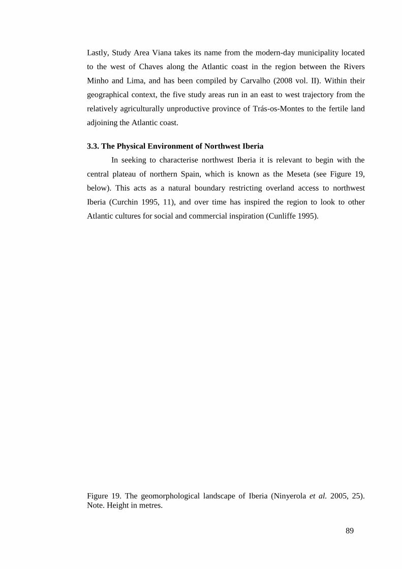
89
Lastly, Study Area Viana takes its name from the modern-day municipality located
to the west of Chaves along the Atlantic coast in the region between the Rivers
Minho and Lima, and has been compiled by Carvalho (2008 vol. II). Within their
geographical context, the five study areas run in an east to west trajectory from the
relatively agriculturally unproductive province of Trás-os-Montes to the fertile land
adjoining the Atlantic coast.
3.3. The Physical Environment of Northwest Iberia
In seeking to characterise northwest Iberia it is relevant to begin with the
central plateau of northern Spain, which is known as the Meseta (see Figure 19,
below). This acts as a natural boundary restricting overland access to northwest
Iberia (Curchin 1995, 11), and over time has inspired the region to look to other
Atlantic cultures for social and commercial inspiration (Cunliffe 1995).
Figure 19. The geomorphological landscape of Iberia (Ninyerola et al. 2005, 25).
Note. Height in metres.
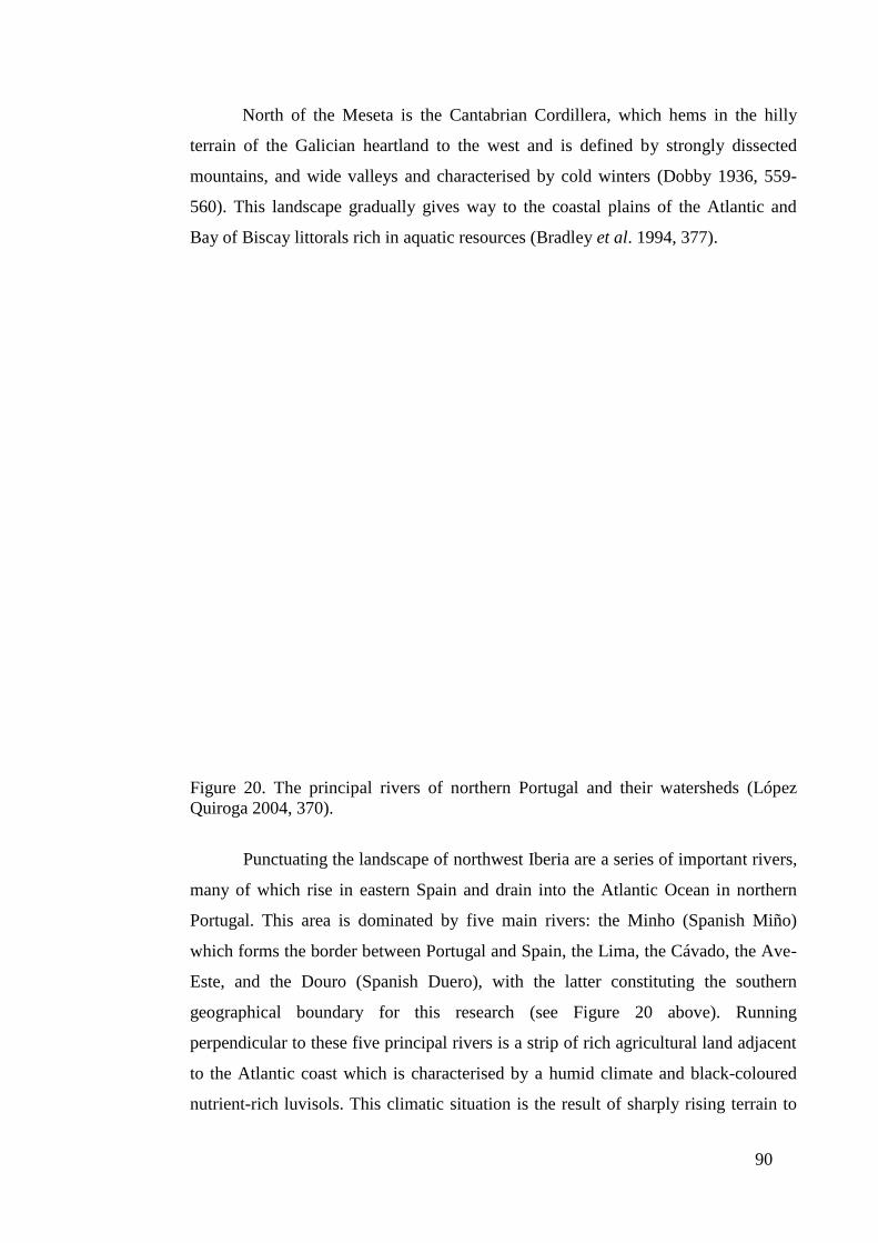
90
North of the Meseta is the Cantabrian Cordillera, which hems in the hilly
terrain of the Galician heartland to the west and is defined by strongly dissected
mountains, and wide valleys and characterised by cold winters (Dobby 1936, 559-
560). This landscape gradually gives way to the coastal plains of the Atlantic and
Bay of Biscay littorals rich in aquatic resources (Bradley et al. 1994, 377).
Figure 20. The principal rivers of northern Portugal and their watersheds (López
Quiroga 2004, 370).
Punctuating the landscape of northwest Iberia are a series of important rivers,
many of which rise in eastern Spain and drain into the Atlantic Ocean in northern
Portugal. This area is dominated by five main rivers: the Minho (Spanish Miño)
which forms the border between Portugal and Spain, the Lima, the Cávado, the Ave-
Este, and the Douro (Spanish Duero), with the latter constituting the southern
geographical boundary for this research (see Figure 20 above). Running
perpendicular to these five principal rivers is a strip of rich agricultural land adjacent
to the Atlantic coast which is characterised by a humid climate and black-coloured
nutrient-rich luvisols. This climatic situation is the result of sharply rising terrain to

91
the east and a series of mountains such as the Penada range (see Figure 21 cross-
section C-D below), which act as a natural amphitheatre trapping the sea moisture on
the coastal plain where the average rainfall reaches 2000mm per annum, in contrast
to the dryer plateaus of northern / central Portugal where the average annual rainfall
drops dramatically to 700-1000mm per annum (Ninyerola et al. 2005, 38-39). In
regulating the movement of humid air towards the interior, the climate, orography
and ecology of the agriculturally rich Atlantic coastal area differs greatly to regions
to the east which are characterised by a dryer, less verdant and harsher landscape
(Ribeiro 1987, 149-150).
Heading inland from the Atlantic coast the terrain rises gradually (see Figure
21 cross-section E-F) until it meets the geological fault of Régua-Verin where a steep
valley has been carved out by the River Tâmega, a tributary of the River Douro (Feio
1951, 193). To the north of the Tâmega Valley is modern-day Chaves (see Figure 3,
page 21), ancient Aquae Flaviae, where the Roman settlement strategically
controlled the surrounding plain and access across the Roman bridge over the River
Tâmega. East of Chaves, the terrain of Trás-os-Montes is dominated by easily eroded
and unproductive soils as well as a series of mountain ranges between 1200 and
1500m in height, which divide and dissect the landscape (Lemos 1993 vol. I, 89).
Figure 21. The terrain of northern Portugal (Queiroga 2003, Illustrations).
3.4. The Human Landscapes, Past and Present: Settlement Patterns, Movement
and Communications
92
As I have already discussed, the unique physical environment of northwest
Iberia has over many millennia played a pivotal role in how the region has interacted
with other cultures. During the Bronze Age there was a high level of connectivity
between northwest Iberia and the coastline which ran from the Mediterranean to the
British Isles, which gradually declined with the demise of Phoenician trade-networks
in the Early Iron Age (Cunliffe 1995; 1999, and see Chapter One). The accessible
corridor along the Atlantic coast, rather than the more mountainous and remote
region of the western Meseta, would see the gradual encroachment of Republican
Rome on those communities located to the north, near the mouth of the River Douro
(Keay 1988, 35). Over time the principal urban settlement in the region, Bracara
Augusta, with its prosperity guaranteed by rich farmland, would become a conventus
capital during the Roman era, and thereafter play a key role in the Christianisation of
the region with a bishopric founded in the late Roman period, and an archbishopric in
the twelfth century. In a similar way, the Roman settlement at Aquae Flaviae,
founded in the fertile Tâmega Valley, would continue as an important settlement into
the medieval period, with Chaves, as it became known, being fought over by Moors,
as well as Christian kingdoms. The fact that Braga and Chaves continue to function
as central places in modern-day northern Portugal illustrates the continuing
importance of their location within the landscape. The same can be said for more
rural settlements, which developed as farming centres such as villae and vici (Roman
villages) during the Roman era, which developed into rural centres taking on the
vestiges of Christian authority within a non-urban environment (López Quiroga
2004, 289-297).
The written and archaeological records demonstrate that Roman towns,
among them Bracara Augusta and Aquae Flaviae, as well as rural sites would
constitute and continue to play a central role in the settlement pattern of northern
Portugal. What is less established is the degree to which Late Iron Age structures
formed the basis for early Roman settlement patterns, communication systems and
the exploitation of the landscape. In seeking to examine the changes between the
Late Iron Age and early Roman periods, the next section analyses the five study
areas in greater detail, and in particular examines the methods used to date individual
settlements and the information they provide as to the socio-economic and political
nature of society.

93
3.5. The Derivation of the Dataset and its Application for Regional Survey
Analysis
3.5.1. Introduction
This section outlines the derivation of the datasets utilised in the analysis of
the five study areas, starting with a breakdown of the type and number of each
settlement present in each dataset. This is followed by a more detailed analysis of the
associated problems of regional survey analysis and an investigation of the data used
in this thesis. As a result, I will examine at a broad level the methodological
approaches used to analyse regional studies, for example GIS-based techniques, and
question how appropriate they may be for use in this study.
3.5.2. An Introduction to the Dataset
The dataset employed in this thesis is divided across five study areas: Study
Areas North, South, East, Chaves and Viana, as shown in Table 1 below (this data is
presented in greater detail, as with all the study areas, in Appendix A, with a list of
coordinates of each site, its chronological sequence and a list of references for each
settlement). In Study Areas North, South and East the dataset is largely drawn from
Lemos’ (1993) unpublished PhD ‘Povomento de Trás-os-Montes Oriental’, which
examined the Late Iron Age and early Roman period in the modern-day Portuguese
province of Trás-os-Montes (note: permission has been granted to use Lemos’ (1993
vol. II) dataset). Among the distinctive features of the three study areas is the
presence of civitas capitals in Study Areas North and South, but an absence of a
civitas capital in Study Area East where two vici settlements may have fulfilled an
administrative and central place function (such ideas are examined in detail in
Chapters Five and Six). Other notable characteristics of Study Areas North, South
and East are the greater number of agricultural producers, in the form of villae and
casals (small rural holdings which fulfilled an agricultural role, but were less
important in size and function (thereby lacking a mill to process cereals, or dolia
storage vats to store and transport produce) than villae holdings and lacked a large
central building to oversee operations, see section 3.6.1 for further detail) in Study
Areas South and East, in sharp contrast to Study Area North. In the fourth region,
Study Area Chaves, the dataset is drawn from the catalogues of two unpublished MA
theses; Amaral’s (1993) study of the Upper Tâmega Valley from the Late Iron Age
until the Roman era; and Teixeira’s (1996) analysis of the area around Aquae Flaviae
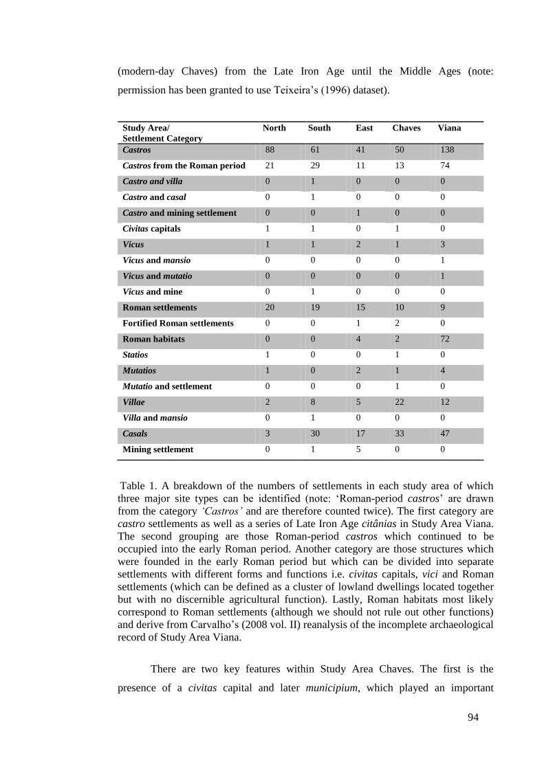
94
(modern-day Chaves) from the Late Iron Age until the Middle Ages (note:
permission has been granted to use Teixeira’s (1996) dataset).
Study Area/
Settlement Category
North South East Chaves Viana
Castros 88 61 41 50 138
Castros from the Roman period 21 29 11 13 74
Castro and villa 0 1 0 0 0
Castro and casal 0 1 0 0 0
Castro and mining settlement 0 0 1 0 0
Civitas capitals 1 1 0 1 0
Vicus 1 1 2 1 3
Vicus and mansio 0 0 0 0 1
Vicus and mutatio 0 0 0 0 1
Vicus and mine 0 1 0 0 0
Roman settlements 20 19 15 10 9
Fortified Roman settlements 0 0 1 2 0
Roman habitats 0 0 4 2 72
Statios 1 0 0 1 0
Mutatios 1 0 2 1 4
Mutatio and settlement 0 0 0 1 0
Villae 2 8 5 22 12
Villa and mansio 0 1 0 0 0
Casals 3 30 17 33 47
Mining settlement 0 1 5 0 0
Table 1. A breakdown of the numbers of settlements in each study area of which
three major site types can be identified (note: ‘Roman-period castros’ are drawn
from the category ‘Castros’ and are therefore counted twice). The first category are
castro settlements as well as a series of Late Iron Age citânias in Study Area Viana.
The second grouping are those Roman-period castros which continued to be
occupied into the early Roman period. Another category are those structures which
were founded in the early Roman period but which can be divided into separate
settlements with different forms and functions i.e. civitas capitals, vici and Roman
settlements (which can be defined as a cluster of lowland dwellings located together
but with no discernible agricultural function). Lastly, Roman habitats most likely
correspond to Roman settlements (although we should not rule out other functions)
and derive from Carvalho’s (2008 vol. II) reanalysis of the incomplete archaeological
record of Study Area Viana.
There are two key features within Study Area Chaves. The first is the
presence of a civitas capital and later municipium, which played an important
95
economic and political role both within the area under its territorial control and
perhaps beyond (and will be examined in greater detail in Chapters Five and Six).
The second point are the far larger number of villae and casals in Study Area Chaves
as a percentage of settlements when compared to the numerically superior number of
agricultural centres in Study Area Viana. The last of the datasets, Study Area Viana,
comes largely from the region between the Rivers Minho and Lima and is
characterised by a more densely occupied Late Iron Age and Roman settlement
pattern than in the other study areas. Additionally, this region, like Study Area
Chaves, appears to have invested heavily in agricultural production, and in a similar
way to Study Area East, may have been administered during the Roman period by a
series of vici and other small settlements (see Table 1 above). The data for Study
Area Viana is drawn from unutilised site information derived from Helena
Carvalho’s (2008) PhD study of the region which involved reanalysing Almeida’s
(1990) dating of the Lima Valley between the Late Iron Age and the early Roman
period. Permission was kindly granted by Helena Paula Abreu de Carvalho in 2008
to utilise the data she did not employ in her own PhD thesis, and this now constitutes
Study Area Viana.
In summary, the five study areas which form the basis of analysis in this
thesis are drawn from a series of catalogues, which represent the wide variety of site
surveys, excavation reports and regional studies. In the following section the
provenance of these archaeological reports, their quality and the thoroughness of the
regional surveys, i.e. Carvalho (2008), Lemos (1993) and Texeira (1996), utilised in
this thesis are examined in greater detail.
3.5.3. An Evaluation of the Dataset and Comparative Regional Settlement
Analysis
A central feature of the regional settlement studies both within northern
Portugal and beyond is the quality of the dataset and the robustness of the
methodological approach used to generate reliable findings. This has become a
problematic issue in recent years, with settlement studies whose datasets vary in
quality and employ different methodological approaches, but which have nonetheless
been combined into larger interregional analytical surveys, as exemplified by two
studies from the 1980s. The first problem is shown in a series of investigations
conducted in western Morocco along the basin of the River Oued Sebou, which
96
sought to equate population density with rural form and function (Euzennat 1985;
Rebuffat 1986). However, it has since been established that few villages appear to
have been founded during the Roman period in a region where archaeologists
expected to find a dense network of Roman settlements (Vallat 1991, 11). In the
second example, Leveau (1984) has compared rural settlements around Caesarea in
Mauretania (present-day Morocco) with two other study areas north of Rome; the
Ager Faliscus, and the Ager Cosanus on the Tyrrhenian coast of central Italy, to
generate a model of territorial size for rural structures. Here, criticism has been made
of the chronological accuracy of Leveau’s material evidence and the subsequent use
of such data to compare and analyse two disparate regions (Vallat 1991, 11).
These problems raise three key questions which can be applied to an
examination of the data employed in this thesis. (1) How thoroughly has the area
been surveyed both in terms of the quality and quantity of data? (2) How accurate is
the chronological sequence of material evidence? (3) How compatible is site
information drawn from different regional datasets and can an interregional study be
effectively undertaken?
In addressing the thoroughness of the regional studies and the quality of site
information from northern Portugal used in this thesis, it is possible to identify three
key periods of archaeological excavation and surveying. The first is the period at the
end of the nineteenth century when excavations were conducted by wealthy
individuals such as Francisco Martins Sarmento, who was the first to excavate the
citânia of Briteiros (see section 1.5.6) and José Leite de Vasconcellos, who mapped
the Bronze and Iron Age landscape between the River Douro and Minho (Queiroga
2003, 3). This work resulted in a great deal of data being collected, which although
incomplete and often inadequately investigated, has been added to and improved on
over time. The second point is the role played by castro settlements which initially
captured the imagination of early archaeologists in the region, such as Sarmento. Not
only were these hillforts clearly identifiable, and often known to the residents living
in the area, but also the cataloguing and excavation of these sites familiarised
archaeologists with less grandiose remnants of Roman settlements such as tegulae
(flat roof tiles), imbrices (roofing joint tiles) and Roman pottery. Over time, the
inventory of Roman sites was added to, and in the period from the 1930s onwards
there was an increasing focus by archaeologists such as F. M. Alves, to J. M. Neto in
the 1970s, and A. P. Lopo, J. A. T. M. Marques, and A. Rodríguez Colmenero in the

97
1980s, on excavating these sites and compiling a more detailed catalogue of ancient
settlements for the region.
The 1980s also marked an important decade in archaeology in northern
Portugal, as a greater emphasis was placed on excavation, data collection and
analysis, much of which was overseen by the University of Porto, the University of
Minho and by regional council and archaeological bodies, such as the Serviço
Regional de Arqueologia da Zona Norte which was active in the area around
northern Trás-os-Montes. During this period of activity catalogues of finds for
northern Portugal were updated (cf. Alarcão 1988; Silva 1986) and improved
techniques of survey and excavation were introduced, including more detailed
stratigraphic analysis and the use of test trenching, surveying, and radiocarbon dating
(see Queiroga 2003, Appendix II). This enabled the re-examination of many sites,
particularly Late Iron Age settlements which continued to be occupied into the early
Roman period, thereby establishing a more robust chronological sequence for
material evidence and the dating of individual sites (see Höck 1980).
Improved surveying techniques in recent years have gone hand in hand with a
greater appreciation of the theoretical pitfalls associated with collecting, processing
and reading the material record. For example, fieldwalking activities have been used
extensively to collect and correlate surface finds in Iberia (see Carreté, Keay and
Millett’s (1995) Survey of the Territory of Tarragona), but such activities can often
provide an incomplete reading of the landscape, especially where vegetation,
woodland, houses, landfills and other impediments may influence the collection of
material evidence (Terrenato 2004, 40). Carvalho has acknowledged in her
fieldwalking activities, that the crops under cultivation play an important role in
determining the quantity and quality of artefacts recovered (2008 vol. I, 298). Lemos
(1993 vol. II, 7) makes similar criticisms about the effectiveness of fieldwalking
activities, and warns about the dangers of cross-contamination in the material record
as mechanised farming increasingly displaces the soil (Yorston et al. 1990, 69). This
is demonstrated by studies conducted on pottery sherds which have shown that
repeated ploughing acts to recycle ceramic finds, and provide different sherd counts
and collections over time (Ammerman 1981, 71; Dunnell 1992; Lloyd and Barker
1981, 291; Taylor 2000). In regions which are subject to more agriculturally-
intensive exploitation, the issue of cross-contamination of the archaeological record
98
has become a very real problem, with sherd-rich earth found to be spread across
fields as a fertilizer (Given 2004, 17).
Improved survey and excavation techniques in conjunction with a greater
awareness of the problems associated with generating and recording information
have seen more accurate information published in recent years. In addition, there is a
greater focus on understanding regional patterns. This is most evident in Carvalho’s
(2008) reanalysis of Late Iron Age and early Roman data from Almeida’s (1996)
investigation of the region between the Minho and the Douro. It is also visible in
Lemos’ (1993 vol. I) incorporation of regional studies, for example Sanches’ and
Santos’ (1987) analysis of the region of Mirandela (Trás-os-Montes), into his
investigation of Trás-os-Montes between the Late Iron Age and early Roman period.
In addressing the first question posed above as to the validity of the site
information used for analysis in this thesis it is thus apparent that the datasets are as
reliable (both in terms of their quality, and thoroughness in identifying Iron Age and
Roman settlements) as they can be. Moreover, the quality of the data also stems from
their constant reappraisal both on the level of individual sites, many of which have
been surveyed various times, but also through their incorporation into regional
studies and more analytical frameworks, which will discussed later in this section.
The second question concerns the validity of the quality of chronological data
employed in this thesis. The discussion above has shown that the quality of recent
excavations, surveys, and general data collection has created regional material which
can be trusted both in terms of its thoroughness and quality. Analysis of excavated
material evidence, particularly pottery containers e.g. amphorae as well as terra
sigillata and coins have allowed surveyors to date some sites to within 25 years (see
section 3.6.1 below).
A secondary issue is how we choose to structure and read settlement
information through the creation of chronological phases, for example the ‘Late Iron
Age’ and ‘early Roman period’. Historians and archaeologists alike have identified
that timeframes may be shaped by preconceived broad phases such as prehistoric,
Greco-Roman and modern (Cunningham and Driessen 2004, 103, and see section
2.3.3), or in other cases by details of the material remains, for example the ceramic
record (Cherry 1983). Evidently, the use of material evidence to provide a local
chronological sequence of events can raise a series of problems, particularly in
utilising various settlement surveys to conduct a comparative study. This can be
99
demonstrated with the Eretum and south Etruria surveys from northern Lazio, Italy,
where inconsistent approaches to ceramic dating compelled those analysing two
studies to create a series of artificial timeframes to examine the data (Witcher 2008,
18). Additionally, the timeframes which archaeologists employ are not limited to
material evidence but may be determined by historical documents and key events
(Alcock 1993, 24), or in the case of northern Portugal the founding of settlement, for
example Bracara Augusta and Aquae Flaviae, where a Roman Emperor or Roman
Imperial dynasty may shape our conceptualisation and so understanding of time.
It could be argued that the common use of terms such as the ‘Late Iron Age’
and the ‘early Roman period’, which are used extensively in this thesis to illustrate
more general patterns, are symptomatic of the problems associated with creating
artificial timeframes. However, one of the key strengths of the data employed for
analysis in this thesis is that it is multifaceted (see sections 3.6.1 – 3.6.3 for a more
detailed discussion) and for this reason no one form of material evidence shapes our
understanding of the passage of time. This thesis argues that the transition between
the Late Iron Age and the early Roman period can be studied as a process which may
have varied between one area and another, and this is a hypothesis which is
examined in this thesis.
Another key strength of the datasets employed in the analysis of the five
study areas is the accuracy with which sites can be dated. Archaeologists surveying,
excavating and cataloguing the landscape of northern Portugal have adopted a
common chronological sequence and methodological approaches which mean that
interregional studies can be effectively undertaken. This is in contrast to other
interregional surveys where the different timelines, practices and objectives of
individual projects have created a series of problems in bringing the information
together (Attema and Van Leusen 2004, 97-98). One institution, the University of
Minho, has played a key role in developing standard recordings of the three
important regional studies of northern Portugal in the period between the Late Iron
Age and the early Roman era (see Carvalho (2008) Lemos (1993) and Martins
(1990)). In two of these studies, namely, Caravalho (2008) and Lemos (1993), both
scholars adopted similar approaches which included: differentiating Late Iron Age
castro settlements from Roman-period ones; recording urban and rural early Roman
settlements; mapping the Roman arterial road network and incorporating the
principal river networks. For the remaining study area, Study Area Chaves, the
100
information included in Teixeira’s (1996) catalogue shares similar techniques and
dating practices to those found in Lemos’ (1993) inventory with many settlements on
the eastern and south-eastern margins of Teixeira’s study area taken from Lemos’
database.
Despite the wealth of good quality site information contained within and
utilised in Lemos’ (1993) and Teixeira’s (1996) studies, particularly in the case of
the latter, the analysis is often limited to observing settlement data rather than
examining it. Lemos does introduce many effective ideas, for example a breakdown
of probable land use (see Lemos 1993 vol. I, 97), but was unable to extend his study
further to examine the relationship between land use and settlement type due to the
limitations of technology. In recent years more effective analytical tools have
become available, such as GIS, which Carvalho (2008), uses in her study to analyse
spatial relationships in the data, such as the distances between the principal Roman
roads and Roman settlements. Other studies in northwest Iberia have also made
extensive use of GIS techniques, for example Strutt (2000) in analysing the Late Iron
Age and early Roman landscape in the Ave Valley Project in northern Portugal (see
sections 4.6 and 7.3) and TAPA (Trabajos de Arqueología del Paisaje) coordinated
by the University of Santiago, Spain, which seeks to measure the impact on
archaeological sites of upgrades to Galicia’s gas pipeline infrastructure.
GIS offers a sophisticated method of managing, analysing and presenting data
(Gillings 2001), and has been strategically employed for analysis within this thesis to
generate nearest-neighbour analysis for Iron Age settlements (see Chapter Four), and
Thiessen polygons, and an examination of land use capacity for both Iron Age and
Roman settlements (see Chapter Five). However, we should be aware of the dangers
of using computer-based analysis, particularly as many of its opponents argue that
they are teleological, and therefore focused primarily on achieving a series of end
goals (Lock 2009, 77; Shanks and Tilley 1987, 124-125, and Tilley 1994, 11, in
critiquing landscape archaeology). While it is not my intention to employ a more
agent-centred investigation in this thesis (there has been limited success in marrying
a more phenomenological methodological approach to computer-based analysis, see
Lock’s (2009, 75) discussion of Van Hove (2004)), I believe it is important to
ascertain how we examine and interpret the archaeological record that is employed in
the analysis of the dataset. For this reason, the following sections seek to provide an
investigation of the strengths and weaknesses of archaeological record in establishing

101
a site classification and sequence of events for the study region, as well as the
theoretical approaches we may use to interpret that data.
3.6. A Broad Characterisation of the Dataset
The section examines the material evidence used to identify settlement forms
(see Table 1 in section 3.5.2) as well as other social, political and economic practices
in the Late Iron Age and early Roman period. The dating and classifying of sites
through pottery remains and numismatic evidence constitutes the first area of
investigation, and the argument here also includes a short discussion on how we
derive an understanding of acculturation from the archaeological evidence. Fibulae
and torques from the Iron Age period are examined in the second section, and in the
subsequent section there is an outline of the material evidence for cross-cultural
contact and elite residences in the pre-Roman era.
3.6.1. Issues with Dating and Site Classification. The Ceramic and Numismatic
Record
In examining the datasets to be used in this thesis it is perhaps appropriate we
begin with the most common and reliable dating technique, ceramic ware and its
various guises from kitchen implements through to commercial containers. Within
the context of the northwest Iberian Iron Age, as in many cultures, pottery can be
differentiated in many ways. As a chronological marker Early Iron Age ceramic ware
was characterised by clay with a high mica content where vessels were crafted by
hand and decorated with rectilinear geometric designs, which were characterised by
limited variation in their design, decorative elements and motifs. These forms and
fabrics differ from those of the Middle Iron Age until the Late Iron Age, where the
principal temper of mica was replaced with quartz, in conjunction with the increasing
use of the potter’s wheel to model the clay. Additionally, potters in this period
increasingly decorated the clay with complex compositions, which utilised curved
geometric elements, greater diversification through the use of strips, and continuous
lines and medallions within border areas. As a result, where Early Iron Age pottery
was characterised by decorative simplicity, later Iron Age plastic forms now exhibit
more complex patterns, which extend to different parts of the vessel such as the rim
and the neck (see Figure 22 below) (Parcero Oubiña and Cobas Fernández 2004, 18).
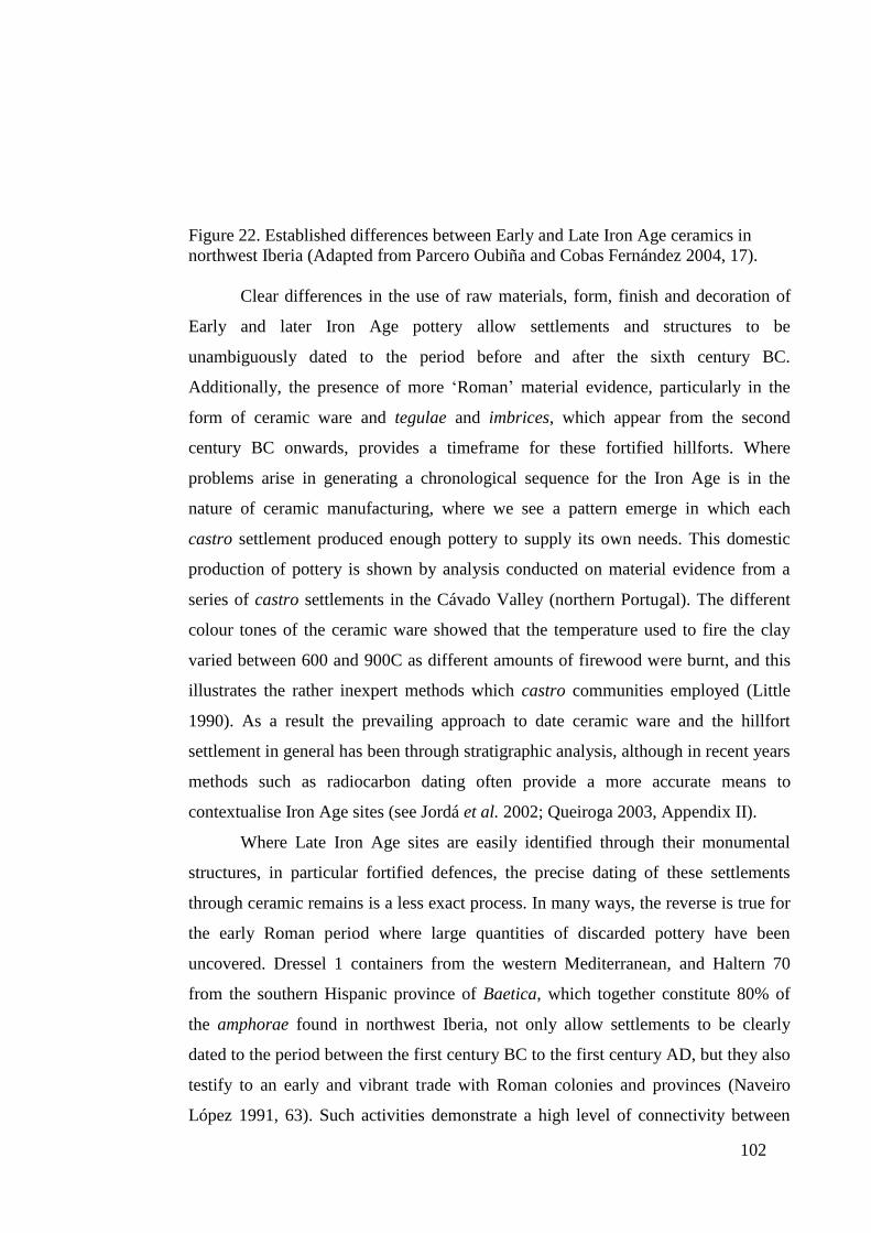
102
Figure 22. Established differences between Early and Late Iron Age ceramics in
northwest Iberia (Adapted from Parcero Oubiña and Cobas Fernández 2004, 17).
Clear differences in the use of raw materials, form, finish and decoration of
Early and later Iron Age pottery allow settlements and structures to be
unambiguously dated to the period before and after the sixth century BC.
Additionally, the presence of more ‘Roman’ material evidence, particularly in the
form of ceramic ware and tegulae and imbrices, which appear from the second
century BC onwards, provides a timeframe for these fortified hillforts. Where
problems arise in generating a chronological sequence for the Iron Age is in the
nature of ceramic manufacturing, where we see a pattern emerge in which each
castro settlement produced enough pottery to supply its own needs. This domestic
production of pottery is shown by analysis conducted on material evidence from a
series of castro settlements in the Cávado Valley (northern Portugal). The different
colour tones of the ceramic ware showed that the temperature used to fire the clay
varied between 600 and 900C as different amounts of firewood were burnt, and this
illustrates the rather inexpert methods which castro communities employed (Little
1990). As a result the prevailing approach to date ceramic ware and the hillfort
settlement in general has been through stratigraphic analysis, although in recent years
methods such as radiocarbon dating often provide a more accurate means to
contextualise Iron Age sites (see Jordá et al. 2002; Queiroga 2003, Appendix II).
Where Late Iron Age sites are easily identified through their monumental
structures, in particular fortified defences, the precise dating of these settlements
through ceramic remains is a less exact process. In many ways, the reverse is true for
the early Roman period where large quantities of discarded pottery have been
uncovered. Dressel 1 containers from the western Mediterranean, and Haltern 70
from the southern Hispanic province of Baetica, which together constitute 80% of
the amphorae found in northwest Iberia, not only allow settlements to be clearly
dated to the period between the first century BC to the first century AD, but they also
testify to an early and vibrant trade with Roman colonies and provinces (Naveiro
López 1991, 63). Such activities demonstrate a high level of connectivity between
103
southern Iberia and the Atlantic coast of northwest Iberia. How the trade and
consumption of more Mediterranean products as well as the flow of ideas shaped the
native communities inhabiting oppida and castro settlements is altogether more
difficult to establish, and this raises a series of issues as to how we can use the
archaeological evidence to identify new processes.
Central to the argument is the cultural fusion and its bearing on how new
settlement forms and networks emerged through new practices within the context of
Late Iron Age and early Roman northwest Iberia. There is a great body of work
concerning the process of acculturation which is very much allied to the discussion
of ‘Romanisation’ in section 2.3.2. It could be said that the theory of ‘Romanisation’,
which advances the notion of the supremacy of Roman practices and their adoption
by peripheral cultures, although conceptually flawed (see section 2.3.2), constitutes
the most prominent theory of acculturation. Other models, for example Webster’s
(2001) theory of creolization challenges the inadequacies of ‘Romanisation’ and
advocates the existence of multiple cultures, but ultimately implies the development
of a single culture. While acculturation may be more easily identified and understood
within some contexts, for example the Roman military (see Mattingly 2011; Okun
1989), it is often more difficult to identify those processes in other fields of study, in
particular to establish a relationship between material culture and cultural processes
(Haselgrove 1990, 46; Jones 1997, 129). Allied to the fact that recent archaeological
and historical studies have shown distinct regional and local practices developing
around the Roman world (see Churchin 2004; González Ruibal 2006-2007, 654;
Revell 2009, 78), I believe it important to distance ourselves from established models
and frameworks and adopt a more fluid approach to identifying the process of
change, as outlined in section 2.3.3.
How we read the material culture constitutes a critical element in the analysis
conducted in this thesis and this can be seen in brief analysis of the ceramic record
from Study Area Viana. In this case the oppidum of Cividade de Âncora (Study Area
Viana, site 12 Note: each settlement within a study area has an individual site
number which is shown in Appendix A) and the nearby vicus settlement 256, large
quantities of Haltern 70 amphorae and southern Gaulish Samian ware demonstrate
that both sites were active between the mid to late first century AD, and
contemporaneous. The archaeological record shows that the Cividade de Âncora was
abandoned during the late first century (Cavalho 2008, vol. II, 91), which may have
104
been a consequence of the increasing importance of the vicus settlement. In this
instance the material record does not tell us any more, but the identification of
another vicus, the vicus vagornicense (site 607, Study Area Chaves. See section 7.2.9
for a more detailed description), shows that this site was most likely colonised and
administered by a native grouping (Teixeira 1996, 98). It is therefore possible that a
community of Cividade de Âncora founded or colonised the nearby vicus settlement
256. In doing so they would have substituted a native dwelling (the Cividade de
Âncora) for more ‘Roman’ style structure, but in all likelihood continued to exert a
degree of administrative and political control as they had had done in the pre-Roman
period. Whether such a process took place cannot be firmly established (and
therefore form an important area of investigation in this thesis), but the cultural
fusion and creation of new practices may have had a profound impact on the
settlement pattern in the study region, in particular if native agents assumed
administrative, economic and social powers.
Where ceramic evidence may help us to understand how the exchange of
ideas and practices created new settlement forms and networks in early Roman
northwest Iberia, it also provides a valuable means to identify the function and size
of other structures, in particular agricultural centres. In the region of the Tâmega
Valley in Study Area Chaves a number of villae settlements have been identified by
large quantities of Roman-style tegulae and imbrices with smaller quantities of
roofing material suggesting the presence of smaller rural sites, for example casals.
This process of identification can be shown by the area tegulae and imbrices cover,
which ranges from 7.1ha in the case of the settlement at the vicus vagornicense, to
2.4ha for villa site 51, and 0.3ha at casal 703 (Teixeira 1996, 98, 10, 104). Larger
villae settlements can again be differentiated from casals through the presence of
dolia, large ceramic vats, and millstones which testify to large-scale agricultural
practices. We are also fortunate that some larger agricultural centres show evidence
of pottery sherds from samian ware and terra sigillata Hispania, which were
manufactured between the middle first and second centuries AD, and allow
settlements to be accurately dated as demonstrated by villae sites 162, 208, 232, 238
and 242 which appear to have been founded between the first half of the first century
to the late second century.
A second form of dating comes from numismatic evidence which can be used
to date settlements and demonstrate probable contact with other cultures further
105
afield. In Study Area Viana a cache of Republican and early Imperial coins have
been found at castro site 102, which would imply the occupation of the site between
109/108-104 BC (Centeno 1977, 94, 99), as well as an Iberian denarius found at
castro site 1 and dated to 73 BC (Carvalho 2008. vol. II, 133). How we chose to
interpret the presence of these artefacts within the context of northwest Iberia is
altogether more difficult. The coins could represent the vestiges of trade networks
with other regions and therefore served their primary purpose as a means of
transaction. Alternatively, it is possible that individuals employed as mercenaries or
auxiliary soldiers in the Roman army (for example, during the Lusitanian Wars in the
second century BC (Millett 2001, 167; Queiroga 2003, 98)) returned to their
communities with coinage, where these items may have taken on a symbolic value in
the absence of any evidence of indigenous forms of minted currency in the region
(see section 1.5.5). Both scenarios do nevertheless indicate that northwest Iberia was
becoming increasingly drawn into the ambit of the Mediterranean world in the pre-
conquest period, where trade as well as returning soldiers would have provided a
means to familiarise native peoples with central Mediterranean societies (Wells
1999, 47). How widespread such practices were or how they impacted on native
communities is difficult to ascertain, and thereby forms an additional area of
investigation in this thesis.
It is during the early Roman period, with the introduction of a monetary
system, that numismatic evidence is best employed as a means to establish the
chronological sequence of the region. Moreover, coins from the period can be readily
employed in conjunction with Roman pottery and tiles to establish the chronological
sequence of a settlement. In the case of villa 390 in Study Area East the discovery of
an as from the reign of Emperor Vitellius (AD 69) and early terra sigillata hispanica
suggest the complex floor plan of the luxury residence was built shortly after the area
was occupied by Roman authorities (Lemos and Marcos 1985, 143-148). As I shall
discuss in greater detail in section 5.3.3.1 the timeframe offered here provides a clear
opportunity to examine how the landscape and practices of northwest Iberia
transformed (over the course of a few generations) from the Iron Age to the early
Roman period.
3.6.2. Fibulae and Torques. Evidence of Distinct Social Structures and
Relocation within the Landscape?
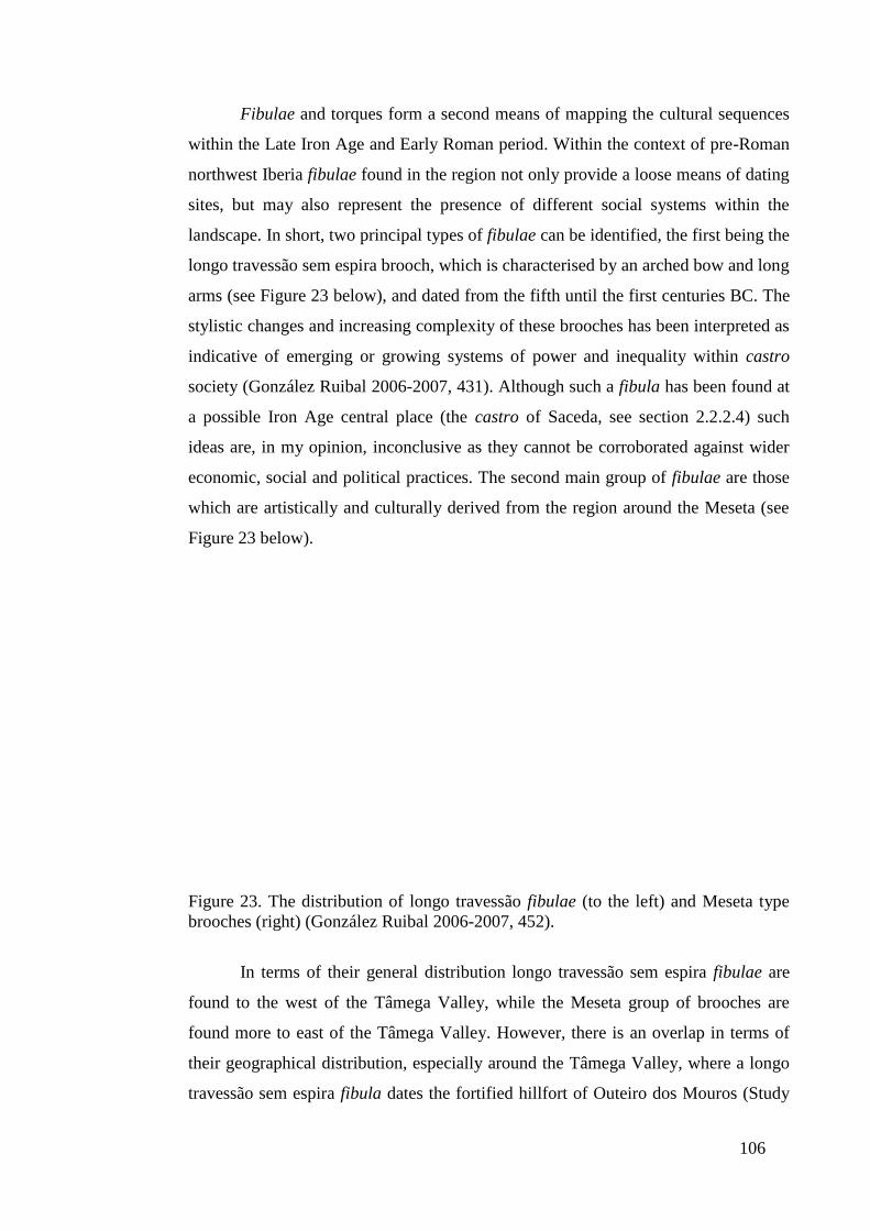
106
Fibulae and torques form a second means of mapping the cultural sequences
within the Late Iron Age and Early Roman period. Within the context of pre-Roman
northwest Iberia fibulae found in the region not only provide a loose means of dating
sites, but may also represent the presence of different social systems within the
landscape. In short, two principal types of fibulae can be identified, the first being the
longo travessão sem espira brooch, which is characterised by an arched bow and long
arms (see Figure 23 below), and dated from the fifth until the first centuries BC. The
stylistic changes and increasing complexity of these brooches has been interpreted as
indicative of emerging or growing systems of power and inequality within castro
society (González Ruibal 2006-2007, 431). Although such a fibula has been found at
a possible Iron Age central place (the castro of Saceda, see section 2.2.2.4) such
ideas are, in my opinion, inconclusive as they cannot be corroborated against wider
economic, social and political practices. The second main group of fibulae are those
which are artistically and culturally derived from the region around the Meseta (see
Figure 23 below).
Figure 23. The distribution of longo travessão fibulae (to the left) and Meseta type
brooches (right) (González Ruibal 2006-2007, 452).
In terms of their general distribution longo travessão sem espira fibulae are
found to the west of the Tâmega Valley, while the Meseta group of brooches are
found more to east of the Tâmega Valley. However, there is an overlap in terms of
their geographical distribution, especially around the Tâmega Valley, where a longo
travessão sem espira fibula dates the fortified hillfort of Outeiro dos Mouros (Study
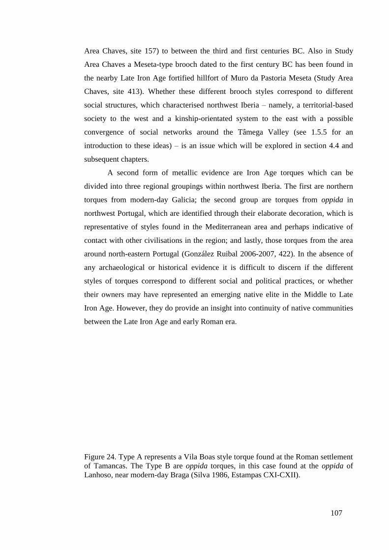
107
Area Chaves, site 157) to between the third and first centuries BC. Also in Study
Area Chaves a Meseta-type brooch dated to the first century BC has been found in
the nearby Late Iron Age fortified hillfort of Muro da Pastoria Meseta (Study Area
Chaves, site 413). Whether these different brooch styles correspond to different
social structures, which characterised northwest Iberia – namely, a territorial-based
society to the west and a kinship-orientated system to the east with a possible
convergence of social networks around the Tâmega Valley (see 1.5.5 for an
introduction to these ideas) – is an issue which will be explored in section 4.4 and
subsequent chapters.
A second form of metallic evidence are Iron Age torques which can be
divided into three regional groupings within northwest Iberia. The first are northern
torques from modern-day Galicia; the second group are torques from oppida in
northwest Portugal, which are identified through their elaborate decoration, which is
representative of styles found in the Mediterranean area and perhaps indicative of
contact with other civilisations in the region; and lastly, those torques from the area
around north-eastern Portugal (González Ruibal 2006-2007, 422). In the absence of
any archaeological or historical evidence it is difficult to discern if the different
styles of torques correspond to different social and political practices, or whether
their owners may have represented an emerging native elite in the Middle to Late
Iron Age. However, they do provide an insight into continuity of native communities
between the Late Iron Age and early Roman era.
Figure 24. Type A represents a Vila Boas style torque found at the Roman settlement
of Tamancas. The Type B are oppida torques, in this case found at the oppida of
Lanhoso, near modern-day Braga (Silva 1986, Estampas CXI-CXII).
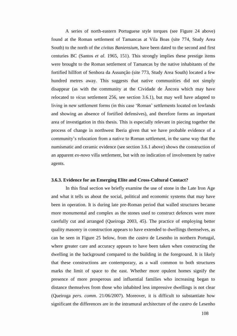
108
A series of north-eastern Portuguese style torques (see Figure 24 above)
found at the Roman settlement of Tamancas at Vila Boas (site 774, Study Area
South) to the north of the civitas Baniensium, have been dated to the second and first
centuries BC (Santos et al. 1965, 151). This strongly implies these prestige items
were brought to the Roman settlement of Tamancas by the native inhabitants of the
fortified hillfort of Senhora da Assunção (site 773, Study Area South) located a few
hundred metres away. This suggests that native communities did not simply
disappear (as with the community at the Cividade de Âncora which may have
relocated to vicus settlement 256, see section 3.6.1), but may well have adapted to
living in new settlement forms (in this case ‘Roman’ settlements located on lowlands
and showing an absence of fortified defensives), and therefore forms an important
area of investigation in this thesis. This is especially relevant in piecing together the
process of change in northwest Iberia given that we have probable evidence of a
community’s relocation from a native to Roman settlement, in the same way that the
numismatic and ceramic evidence (see section 3.6.1 above) shows the construction of
an apparent ex-novo villa settlement, but with no indication of involvement by native
agents.
3.6.3. Evidence for an Emerging Elite and Cross-Cultural Contact?
In this final section we briefly examine the use of stone in the Late Iron Age
and what it tells us about the social, political and economic systems that may have
been in operation. It is during late pre-Roman period that walled structures became
more monumental and complex as the stones used to construct defences were more
carefully cut and arranged (Queiroga 2003, 45). The practice of employing better
quality masonry in construction appears to have extended to dwellings themselves, as
can be seen in Figure 25 below, from the castro de Lesenho in northern Portugal,
where greater care and accuracy appears to have been taken when constructing the
dwelling in the background compared to the building in the foreground. It is likely
that these constructions are contemporary, as a wall common to both structures
marks the limit of space to the east. Whether more opulent homes signify the
presence of more prosperous and influential families who increasing began to
distance themselves from those who inhabited less impressive dwellings is not clear
(Queiroga pers. comm. 21/06/2007). Moreover, it is difficult to substantiate how
significant the differences are in the intramural architecture of the castro de Lesenho
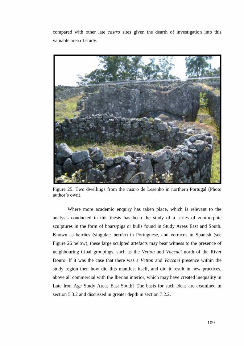
109
compared with other late castro sites given the dearth of investigation into this
valuable area of study.
Figure 25. Two dwellings from the castro de Lesenho in northern Portugal (Photo
author’s own).
Where more academic enquiry has taken place, which is relevant to the
analysis conducted in this thesis has been the study of a series of zoomorphic
sculptures in the form of boars/pigs or bulls found in Study Areas East and South.
Known as berrões (singular: berrão) in Portuguese, and verracos in Spanish (see
Figure 26 below), these large sculpted artefacts may bear witness to the presence of
neighbouring tribal groupings, such as the Vetton and Vaccaei north of the River
Douro. If it was the case that there was a Vetton and Vaccaei presence within the
study region then how did this manifest itself, and did it result in new practices,
above all commercial with the Iberian interior, which may have created inequality in
Late Iron Age Study Areas East South? The basis for such ideas are examined in
section 5.3.2 and discussed in greater depth in section 7.2.2.
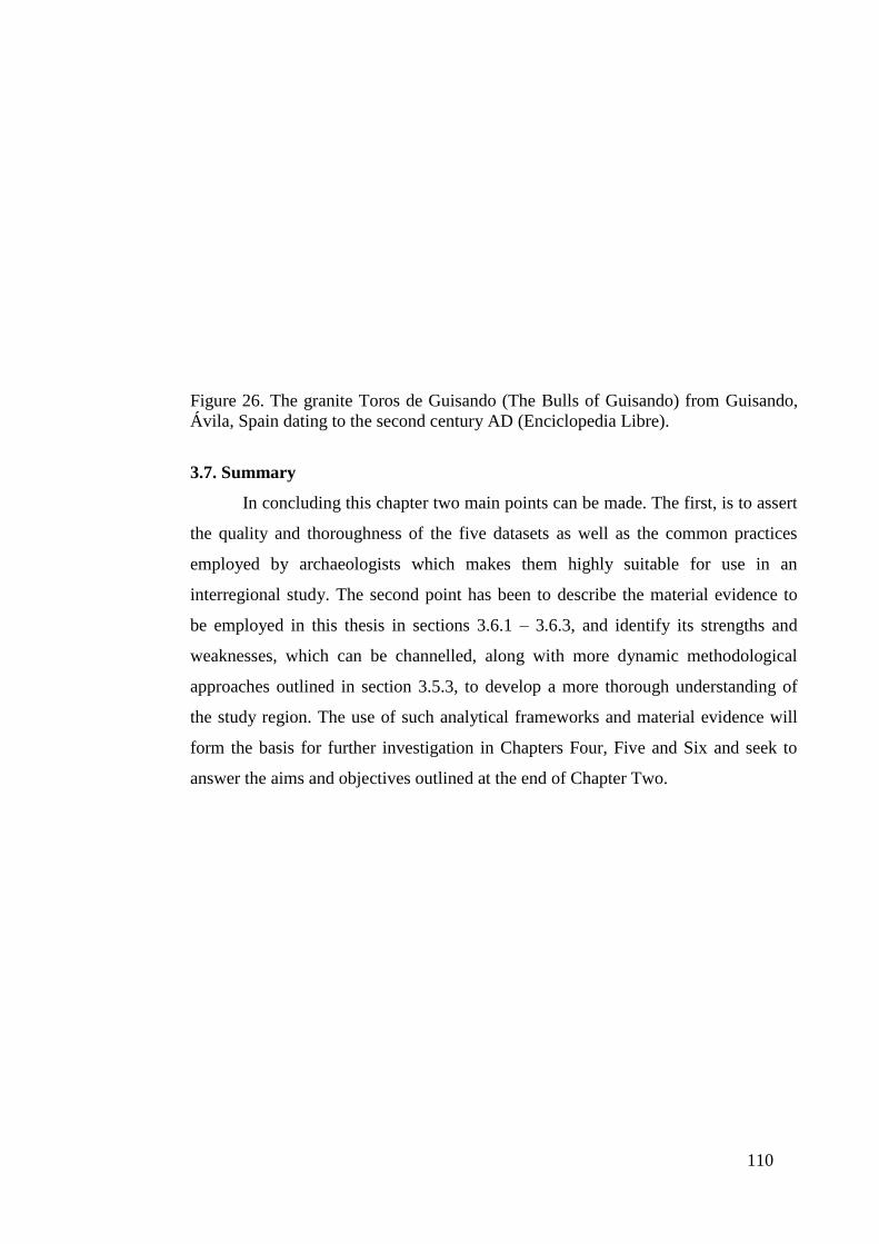
110
Figure 26. The granite Toros de Guisando (The Bulls of Guisando) from Guisando,
Ávila, Spain dating to the second century AD (Enciclopedia Libre).
3.7. Summary
In concluding this chapter two main points can be made. The first, is to assert
the quality and thoroughness of the five datasets as well as the common practices
employed by archaeologists which makes them highly suitable for use in an
interregional study. The second point has been to describe the material evidence to
be employed in this thesis in sections 3.6.1 – 3.6.3, and identify its strengths and
weaknesses, which can be channelled, along with more dynamic methodological
approaches outlined in section 3.5.3, to develop a more thorough understanding of
the study region. The use of such analytical frameworks and material evidence will
form the basis for further investigation in Chapters Four, Five and Six and seek to
answer the aims and objectives outlined at the end of Chapter Two.
111
Chapter Four. The Geopolitical and Social Environment of Late Pre-Roman
Northwest Iberia
4.1. Introduction
As the first of three analytical studies, this chapter provides a detailed
examination of settlement patterns and their relationship to socio-political structures
and commercial activities in the five study areas during the Late Iron Age period. In
seeking to develop the theoretical basis of this investigation, the concept of the
chiefdom as well as theories of social evolution (an approach which measures
societal development along a scale of ‘progress’) are explored, given that they form
an integral part of Sastre Prats’ (2008) model of late castro society. A second area of
investigation examines the concept of borders, which I define as the recognised
interface between two bodies (Ratzel 1897, 59) and how theories of group
boundaries (the margins of an area of influence) can be applied to the analysis of the
Late Iron Age in northwest Iberia. These themes are employed in conjunction with
the empirical analysis conducted in this work to address the first aim of this research
outlined in Chapter One, namely, ‘Did a Late pre-Roman Iron Age settlement
hierarchy exist in northwest Iberia?’
4.2. Sastre Prats, Chiefdoms and Social Evolutionism
A central theme which emerges in Sastre Prats’ hypothesis (2001; 2008), and
one which provides a framework for her model of northwest Iberia during the Late
Iron Age, is the idea that hillfort settlements were elements of chiefdom societies
(2008, 1022, 1024), and thus representative of one stage on an evolutionary scale of
human progress. Sastre Prats’ use of theories of social evolution have been critiqued
and commended in equal measure. Parcero Oubiña (2003, 269), for his part has
distanced himself from what he terms a functionalist-evolutionist perspective, while
Bintliff (2008, 1036), in the comments following Sastre Prats’ 2008 article, extols the
social evolutionist perspective she advances, and Earle (2008, 1038), in the same
section, supports the notion of chiefdoms and more complex state systems. The
central importance of social evolution and the chiefdom which Sastre Prats (2008)
employs to advance her argument require further examination. Although Sastre Prats
does not directly define a chiefdom, her mention of tribal societies as forerunners of
chiefdoms (2008, 1024), suggests that her use of the term derives from Service’s
(1962, 149) evolutionary scale of human progress, which begins with bands, which
112
evolve into tribes, then chiefdoms and finally states. Within these developmental
stages, Service envisaged chiefdoms as residential groups, where economic, social
and religious activities became concentrated into the hands of chiefs with ascribed
status of succession and rules and taboos, which structured their differentiated
identities. This in turn allowed chiefs to control the means of production through
redistributive actions thereby further consolidating their position (Service 1962, 149).
However, there exist a series of key problems with the notion of social evolutionary
theory and its implementation by Sastre Prats (2008).
The first critique to be made of the model of chiefdoms and the notion of
societal progress is that they are simply outdated, as the theories which underpin
them derive from the work of nineteenth century anthropologists. Two of the more
influential models of social evolution were Morgan’s Ancient Society (1974 [1877])
which argued for a classificatory system based largely on technological development
(Conn 2004, 210), and Spencer’s (1876) theory of societal development which
advanced the notion of economic determinism (Sanderson 1990, 26). Where both
models converged was in presenting a western mandate which promoted a table of
progress and would continue to influence archaeological thought, whether explicitly
or indirectly, until the present day (Chapman 2003, 34). In this respect, the theories
of social evolution which Sastre Prats (2001; 2008) employs are very much
embedded in the psyche of nineteenth century ideas of cultural superiority, albeit
modified and incorporated into a more modern agenda which incorporated key
elements of New Archaeology and its associated practices.
A key aspect of New Archaeology (see section 2.2.2 for a definition) was the
positivist agenda it promoted, which is evident in the underlying philosophy of
Sahlins’ and Service’s (1960) model. In this case, Sahlins and Service adopted
White’s Law of Cultural Dominance (1943) which affirmed a progressive view of
more complex cultural entities outcompeting simpler ones through the use of better
and more efficient technology. Such a theory also promoted the concept of general
evolution where cultures passed through a stage-by-stage process (Yoffee 2005, 12).
Consequently, by adopting the principal arguments of Sahlins’ and Service’s (1960)
model of social evolution, Sastre Prats (2001; 2008) is constricted to ascribed stages
of development, for example band, tribe, chiefdom and state, as well as the need for a
community or culture to conform to the characteristics of that stage of society as laid
down in the model. To this effect Sastre Prats (2001; 2008), may be indirectly

113
committing a similar mistake which has been identified in other archaeological
research that of seeking to uphold the validity of the Law of Cultural Dominance
(Pauketat 2007, 20). This is perhaps best illustrated in Sastre Prats’ diachronic
analysis of food storage space in late castro settlements (see section 1.5.4), which
Sastre Prats (2008, 1029) argues remained a constant size over time, and thereby
indicating that once an agrarian system had been consolidated that fed the ‘familial’
unit it remained stable. Only with the conquest of the region by Roman forces and
the reallocation of land did more intensive farming techniques emerge generating
surplus produce which could be bartered or sold. Through the granting of land rights
by Roman authorities inequality would begin to emerge within castro society and
this would see the beginning of hierarchical social systems as some individuals,
notably the elite, consolidated their economic and social positions (Sastre Prats 2008,
1027). Consequently, the model promoted by Sastre Prats behaves in a similar
manner to White’s Law of Cultural Dominance as late castro communities are
replaced by more complex settlements during the early Roman period.
A further point emerges from White’s Law of Cultural Dominance (1943)
and his unilinear law of societal development (i.e. a stage-by-stage process that
societies pass through), which has come under attack from those providing
alternative readings of social evolution. Steward’s (1955) multilinear approach
proposed that societies evolved along many lines and thereby suggested that a culture
at a lower stage of development could leapfrog more developed societies. Steward’s
specific evolutionary views were incorporated into Sahlins’ and Service’s theory of
social evolution (Service 1960, 33), albeit as a marginal idea, but they do not appear
to have translated into mainstream use, as in the case of unilinear evolution. There
are issues with the multilinear approach, most notably the need to classify societies
according to an ideal type (Yoffee 2005, 7, 20), which is a problem that can be
ascribed equally to unilinear and multilinear theories of social evolution. However,
Steward’s (1955) hypothesis does question one of the central beliefs of unilinear
social evolution, that is the need to interpret societal development along one series of
stages, which is an approach that Sastre Prats (2008, 1024) appears to embrace.
Steward’s (1955) multilinear approach and White’s unilinear reading of
social development also betray wider problems in the classification of societies used
to measure change, and this is evident in their application to archaeological practices.
During a formative period in the 1960s, when new theories of social evolution were

114
being proposed, two theories rose to prominence. The first is the aforementioned
hypothesis advanced by Sahlins’ and Service’s (1960) model which rested very much
on an economically-determined classification. The second was a later hypothesis
suggested by Fried (1967) which emphasised a more political approach (Chapman
2003, 36; Pauketat 2007, 22). Over time Sahlins’ and Service’s (1960) and Fried’s
(1967) models would become distorted in their use as archaeologists began to
incorporate elements of both theories. These would include redefining chiefdoms as
organisational and productive entities through a functionalist perspective (see
Peebles and Kus 1977), the interplay of demographic analysis and environmental
determinism (the hypothesis that physical geography rather than social conditions
determine a culture) to interpreting the rise of chiefdoms (see Carneiro 1973), and
increasingly the identification of chiefdom types; for example, Renfrew’s (1974)
individual and group-orientated chiefdoms, identified through material evidence and
conceived along the lines of Service’s (1962) economically-determined model.
Renfrew’s chiefdoms are also illustrative of the need to equate theory with practice
and where societal types, especially chiefdoms, did not fit the anthropological and
archaeological record new types were created (Chapman 2003, 41; DeMarrais et al.
1996, 16; Pauketat 2007, 19; Yoffee 2005, 20).
The identification of ideal chiefdom types is not borne out by the
archaeological and anthropological record, as the underlying characteristics of these
societies are far from uniform. Moreover, the idea of a chiefdom as a stage of
development along a social evolutionary path appears to be a flawed one, with
cultures often exhibiting varying paths of progress. For this reason, I believe it is
important to distance ourselves from the ill-defined term chiefdom and its association
with ideas of social progress which are demarcated by general theories, which often
cannot be applied to examining the workings of real cultures, as I have already
discussed above with reference to Sastre Prats’ hypothesis of late castro society
(2001; 2008). We should also acknowledge that while Parcero Oubiña (2003, 269)
distances himself from social evolutionary theory, he too proposes that inequality
only truly emerged with the granting of land rights by Roman authorities to native
actors. In this argument, it is only with the assimilation of the region by Rome that
more dynamic communities develop in northwest Iberia. However, we must question
whether ‘native’ and ‘Roman’ represent stages of progress, as Revell (2009, 6) has
stressed in her discussion of ‘Romanisation’. The debate as to whether systems of
115
social inequality emerged before the conquest of the region by Roman forces
represents a core theme in this thesis, given that unequal access to political and
economic influence can often be translated into hierarchical patterns of settlement at
the communal, local and regional level. Consequently, such ideas are explored in the
following section with explicit emphasis on other practices, which may have created
forms of inequality in late castro society.
4.3. New Approaches in Understanding Late Pre-Roman Society in Northwest
Iberia. Geopolitical Borders, Social Boundaries and Spatial Divisions
In seeking to develop a more thorough understanding of Late pre-Roman Iron
Age society in northwest Iberia, this section turns to borders and boundaries and the
use of space as a means to interpret the relationships between individuals and their
community, as well as wider contact at a regional level. The term community can be
defined as a group of people who have a sense of shared belonging through
communal rituals which act to unite members (Cohen 1985, 8). In this respect a
community can be seen to constitute part of a settlement, as Fernández Posse (1998,
62) and Sastre Prats (2001, 42) have proposed, but may extend to incorporate other
settlements (which can be seen, within the context of the Iron Age world, as the
development of a tribal society as multiple families or communities are linked by a
common culture as well as shared religious, economic, social and blood ties and
often with a recognised leader). In order to investigate how communities can be
identified within the landscape this section begins with an examination of borders
and boundaries within Late Iron Age southern Britain. Here, the material and
symbolic culture, particularly the presence of ceramic and numismatic evidence,
which were not in widespread use in northwest Iberia during the Late Iron Age, tell
us a great deal about possible ethnic groupings (and which can be defined as a group
of people whose shared practices and social relationships create a culturally
distinctive unit which is different from other groups with whom they have a
minimum of regular interaction (Eriksen 1993, 12)). These ideas of spatial division
are then applied to an examination of late castro society where a more robust
theoretical approach is proposed to analyse communal groupings.
Within the context of southern Britain in the Late Iron Age, tribal boundaries
can be inferred from the spatial analysis of ceramic artefacts and numismatic
evidence. Coins were already in widespread use in the south of the island by the
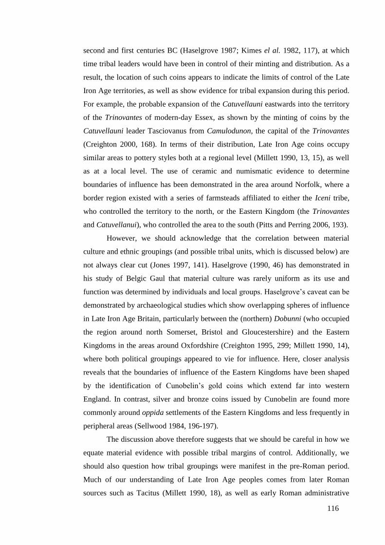
116
second and first centuries BC (Haselgrove 1987; Kimes el al. 1982, 117), at which
time tribal leaders would have been in control of their minting and distribution. As a
result, the location of such coins appears to indicate the limits of control of the Late
Iron Age territories, as well as show evidence for tribal expansion during this period.
For example, the probable expansion of the Catuvellauni eastwards into the territory
of the Trinovantes of modern-day Essex, as shown by the minting of coins by the
Catuvellauni leader Tasciovanus from Camulodunon, the capital of the Trinovantes
(Creighton 2000, 168). In terms of their distribution, Late Iron Age coins occupy
similar areas to pottery styles both at a regional level (Millett 1990, 13, 15), as well
as at a local level. The use of ceramic and numismatic evidence to determine
boundaries of influence has been demonstrated in the area around Norfolk, where a
border region existed with a series of farmsteads affiliated to either the Iceni tribe,
who controlled the territory to the north, or the Eastern Kingdom (the Trinovantes
and Catuvellanui), who controlled the area to the south (Pitts and Perring 2006, 193).
However, we should acknowledge that the correlation between material
culture and ethnic groupings (and possible tribal units, which is discussed below) are
not always clear cut (Jones 1997, 141). Haselgrove (1990, 46) has demonstrated in
his study of Belgic Gaul that material culture was rarely uniform as its use and
function was determined by individuals and local groups. Haselgrove’s caveat can be
demonstrated by archaeological studies which show overlapping spheres of influence
in Late Iron Age Britain, particularly between the (northern) Dobunni (who occupied
the region around north Somerset, Bristol and Gloucestershire) and the Eastern
Kingdoms in the areas around Oxfordshire (Creighton 1995, 299; Millett 1990, 14),
where both political groupings appeared to vie for influence. Here, closer analysis
reveals that the boundaries of influence of the Eastern Kingdoms have been shaped
by the identification of Cunobelin’s gold coins which extend far into western
England. In contrast, silver and bronze coins issued by Cunobelin are found more
commonly around oppida settlements of the Eastern Kingdoms and less frequently in
peripheral areas (Sellwood 1984, 196-197).
The discussion above therefore suggests that we should be careful in how we
equate material evidence with possible tribal margins of control. Additionally, we
should also question how tribal groupings were manifest in the pre-Roman period.
Much of our understanding of Late Iron Age peoples comes from later Roman
sources such as Tacitus (Millett 1990, 18), as well as early Roman administrative
117
structures (civitates) formed from tribal groupings. However, it is likely that in the
pre-Roman period the identities and territorial control of these Iron Age people was
much more fluid (Mattingly 2007, 56). This can be demonstrated by the Dobunni
where sub-divisions within the ceramic and numismatic record suggest that the tribe
may have been divided into two groupings in the Late pre-Roman Iron Age; the
northern Dobunnic and the southern Dobunnic. The reasoning behind a division in
Dobunnic territory is based on the presence of south Glastonbury ware 2-5, which
extends to the valley of the River Avon, but not beyond into northern Dobunnic
territory (Sellwood 1984, 200-201). Within this possible southern Dobunnic realm,
coins minted with the name Corio have been uncovered, with coins inscribed with
the name Bodov found further north and perhaps representing northern Dobunnic
territory (Sellwood 1984, 193). Whether Corio and Bodov were important and
influential Dobunni clan leaders who united against external threats or conversely
represent the fragmentation of once larger tribal grouping is difficult to establish. An
examination of another tribal grouping, the Brigantes of northern England, would
lend credence to the idea that these large tribal groupings were divided into smaller
domains. Creighton (2006, 34) has effectively employed Tacitus’ account of events
(Ann 12.32) to argue that when Queen Cartimandua divorced her husband Venutius,
he gathered support from disaffected clans to invade her territory. This would
suggest that some Late Iron Age tribes in Britain were made up of smaller territorial
units. Support for Creighton’s hypothesis can be found with Frere (1987, 46) and his
identification of a series of pagi (sub-divisions of the civitas, Millett 1990, 150) from
the period after the invasion, whose names incorporate probable Late Iron Age
groupings, such as the Lopocares from around Corbridge, and who may have
constituted one of the clans which made up the larger Brigantes tribe.
In contrast to the looser affiliations of the Brigantes, and possibly the
Dobunni, the Durotriges, who occupied the territory around Dorset appear to have
functioned as a tighter political unit with their centre, the hillfort of Maiden Castle,
which may have constituted the residence of their most important clan leader (Millett
1990, 28). It has also been argued that the Durotriges were more culturally unified
than the tribal groupings which they bordered and this unity is visible not only in
distinct forms of coin design and pottery, but also in burial practices. Where the
Durotriges practiced inhumation their neighbouring tribe, the Atrebates, located to
the east in Hampshire, cremated their dead (Blackmore et al. 1979, 102). It can be
118
argued that the Durotriges sought to consolidate their ethnic identity by establishing
a series of shared values which distinguished them from neighbouring tribes in
response to the need to protect their territory and commercial interests. This would
appear to suggest that ethnic identity and tribal cohesion may have been more
defined in some Late Iron Age groupings than others, and as Hill (2011, 252) argues
we should not necessarily see these tribes as fixed units, but rather envisage them as
more fluid entities which were shaped by time and changing circumstances.
Moreover, as Hill elaborates the activities of a social group were not so clear cut, and
it may have been the case that members, or communities of the Durotriges may have
been participated in other political, economic or religious associations.
Three key themes emerge from the examination of tribal boundaries in
southern Britain which can be applied to the analysis of late castro society. The first
point is to acknowledge how we use material evidence to envisage Late Iron Age
boundaries, and in the process avoid creating false divisions between communities,
which did not exist in antiquity. A second consideration is that some tribes, for
example the Durotriges, may have been more politically cohesive than other social
groupings, but that does not mean their activities were exclusively limited to the
religious, political and economic networks established by this tribal confederation. A
final point is the fabric of tribal groupings in Britain during the Late Iron Age which
appear to have been clan-based, but where there was scope for considerable
flexibility as shown by the tribe uniting, particularly in times of war. These three
points form the basis of analysing Late Iron Age borders, boundaries and models of
Late Pre-Roman society in northwest Iberia in the following section.
4.4. Borders, Boundaries and Models of Late Pre-Roman Society in Northwest
Iberia
As I have already discussed, material evidence in the form of coinage is
absent in late castro society (aside from coinage from other areas such as coins from
the Roman Republic and Iberian states prior to their assimilation by Rome), and
pottery production and consumption was largely confined to individual settlements.
Textually-driven sources are also limited with both Strabo (see Geographica Book
III) and Pliny providing a series of lists of Late Iron Age tribal units which formed
the basis for later civitas groupings, but with little detail as to how these social
structures evolved, or their relationship with one another.
119
In reconstructing probable boundaries and borders during the late castro
period there are, however, a series of other material artefacts which we can access.
The first are fibulae brooches discussed in section 3.6.2, with longo travessão sem
espira fibulae normally found to the west of the Tâmega Valley, while the Meseta
group of brooches are found more to east of the Tâmega Valley. In terms of their
geographical distribution it would appear that the River Tâmega formed a boundary,
albeit a fluid one (González Ruibal 2006-2007, 452), with a Meseta-style fibulae
uncovered to the west of the Tâmega Valley (Study Area Chaves Map 4, site 413).
Whether the two brooch styles represented different social structures which
characterised northwest Iberia – namely, a territorial-based society to the west and a
kinship-orientated system to the east, with a possible convergence of social networks
around the Tâmega Valley – is an idea which I suggested in Chapter Three. The
evidence provided by fibulae brooches is interesting, but as I have already
acknowledged above in the discussion on tribal boundaries in Late Iron Age Britain,
material evidence does not always correlate to ethnic groupings and can often present
an erroneous view of possible powerbases and divisions in the landscape.
A second form of material evidence, and one which appears to lend credence
to the idea that the Tâmega Valley formed the boundary between territorial-based
social systems to the west and a kinship-orientated social structure to the east, is the
epigraphic record. Kinship-based social systems were characterised by lineages and
families or gentilitates and gentes as shown by an inscription from a member of the
Zoelae tribe or confederation, which encompassed the region around northern Trás-
os-Montes. The inscription refers to Araus, son of Ablaecaenus, from the Desonsi
family (gentilitas) from the tribe (gens) of the Zoelas (CIL II 2633), and
commemorates the political treaties between the Desonsi and Tridiavi, thereby
testifying to a hierarchical kinship system, which incorporated the family, supra-
familial units and lastly a tribal confederation. This suggests that a corresponding
allegiance based on kinship ties, can be expected to exist at the familial, supra-
familial and tribal levels, with the latter providing the basis for the civitas Zoelarum.
Of considerable interest in our understanding of kinship-based social systems
are a series of four granite stones found near the River Outeiro Jusão, a tributary of
the Tâmega Valley, with the symbols PRAEN and COROC carved on opposing sides
each stone (CIL, II, 2489, see Figure 27 below).

120
Figure 27. One of the PRAEN / COROC boundary markers found near the River
Outeiro Jusão, a tributary of the Tâmega Valley (Rodríguez Colmenero 1988a, 15).
The names PRAEN and COROC have been interpreted as supra-familial
groupings structured along kinship lines who inhabited the nearby fortified hillfort of
Crastas de Santiago (Study Area Chaves, site 548, Map 4) (Silva 1981-1982, 87-88)
along the eastern bank of the River Tâmega. This lends support to the idea that the
Tâmega Valley may have formed a boundary between kinship groupings to the east
and territorial-based social systems to the west. At a local level, the PRAEN /
COROC inscriptions have been variously interpreted as a means to establish borders
between settlements (Tranoy 1981, 375), as divisional markers guaranteeing control
and access to agricultural land (Silva 1986, 276). The dating of these stones to
between the mid to late first century AD (Silva 1986, 275; Teixeiro 1996, 81), is
based on the assumption that they relate to the partition of the land with the
consolidation of Roman authority in the region and the establishment of a new civitas
capital, Aquae Flaviae. However, research conducted for this thesis strongly suggests
that an important native settlement preceded the latter, most likely under the control
of the Turodi (see 5.3.3.1 for a more detailed discussion). Within this context the
PRAEN / COROC inscriptions take on a new meaning and are indicative of emerging
121
systems of control in the pre-Roman landscape, as competing groups established
boundary markers and tangible spatial borders.
A second type of boundary marker can also be identified from the early
Roman period and is characterised by an inverted ⊃ and generally found to the west
of northwest Iberia, as I outlined in section 1.5.5. Further evidence for these
territorial-based social systems are shown by the carving STP / ) INT COM CI I
from the territory of the interamniense within the Conventus of Gallaecia
Bracarensis, which has been interpreted as S(altus) T(erritorium) P(ublicum) /
(castelli) Int (...?) COM(prehensus) CI(vitate) I(nteramniese). This suggests that
individual castro settlements negotiated their own territorial boundaries within the
larger civitas network (Pereira Menaut 1983, 174), thereby gaining a level of judicial,
administrative and so political freedom (Pereira Menaut 1983, 176, and see section
1.5.7). The importance of this inscription lies in what it tells us about the emergence
of larger civitas networks, in this case the interamniense, and how smaller territorial
units, the castellum, were already incorporated into larger social structures under
Roman authority. However, such an inscription also asks additional question about
the social structure of the study region and in particular the changes which the region
might have experienced between the Late Iron Age and early Roman period.
The first issue concerns where lineage and territorial-based structures
operated, with the former traditionally occupying the region to the west of a buffer
zone stretching from eastern Asturias down through eastern Trás-os-Montes (see
Figure 3, page 21), and the latter to the east of that divide (Mangas and Olano 1995,
18-20). In recent years this interpretation has been re-evaluated with the recent
discovery of the bronze Edict of Bierzo (see section 1.5.5), which has been dated to
15 BC on account of the two Roman consuls mentioned at the foot of the text
(Sánchez Palencia and Mangas 2000, 9, 19). The central text of the Edict of Bierzo
provides a legislative transfer of the castellani Aliobrigiacini from the gens Gigurri
to the gens Susarri by Roman Imperial authorities, in recognition of an unstated
native initiative. This edict not only demonstrates that kinship and territorial-based
systems operated in the same region, but that both social structures appear to operate
in conjunction with one another. This is particularly relevant in the case of the
boundary markers PRAEN and COROC, which are more characteristic of the
kinship-based social structures found to the east of northwest Iberia, but are located

122
in a region where territorial-based structures would be the accepted norm. A second
problem is evident from the Edict of Zoelas from Bragança (northern Trás-os-
Montes), and dated to AD 27, where the terms castellani and gentiliani are
synonymous with and equate to single settlement units or castros (Mangas 2000, 50,
52). In this sense, there appears to be little organisational difference between
territorial and kinship-based social system other than the term used, with hillforts
incorporated into larger populi or civitas networks to the west of northwest Iberia,
while to the east of the region the kinship-based gentiliani/gens/supra-regional
groupings ultimately gave way to civitas organisations during the early Roman
period. This therefore begs the question as to why different Roman authorities
employed different terms, for example, castellum and populi to the west and
gentiliani and gens to the east, to describe social systems which would appear to
have shared key characteristics by the early Roman period. A logical explanation
would be to assume that during the Late Iron Age the principal attributes of these two
social groupings were actually very different, and this hypothesis will be examined in
greater detail in analysis and discussion conducted in this chapter.
4.5. Settlement Analysis and Models of Late Castro Society
We are also fortunate in that our understanding of late castro society is not
limited to these hospitality pacts between neighbouring settlements and tribes, but
also extends to settlement analysis conducted in northwest Iberia. From a
methodological point of view, and the results it generates, Martins’ (1990) research
into the long-term settlement patterns of the area between the Cávado and Ave rivers
provides a valuable insight into boundaries and areas of control in northern Portugal,
between the Bronze and Late Iron Age. For her analysis, Martins divided settlements
into three categories. Type A, represent fortified castros dating from the Bronze Age
until the early Roman period occupying strategic spurs overlooking fluvial
boundaries in the valley below (see Figure 28 below). Type B, dating from the Early
Iron Age, consisted of fortified hillforts, which were predominately located on small
hills. Lastly, Type C, Late Iron Age fortified castros were orientated towards
agricultural land and located on small rises near the valley floor.

123
Figure 28. Settlement patterns in late pre-Roman northwest Iberia. Type A castros
are shown as boxed circles. The passage of the Rivers Cávado and Ave are in black
and tessellated Thiessen polygons in grey (Martins 1990, 215).
Martins argues that during the Early Iron Age population pressure
encouraged the colonisation and creation of Type B castros at the territorial
periphery of Type A settlements, which were more suited to farm the resources of the
valley below. In turn Type C settlements, located at the periphery of Type A castros,
would emerge sometime during the second century BC to exploit the rich alluvial
land along the valley edge more effectively (see Figure 28). Martins therefore
presents a landscape of political dependency with Type A castros consuming those
surpluses generated by Type B and C structures, and concludes that a hierarchical
settlement pattern existed in the region in the Late Iron Age period, while others have
interpreted such relationships in terms of political and economic segmentation
(Sastre Prats 2001, 45).
In defence of Martins’ (1990) premise that fortified hillforts may have shared
social and economic functions, the existence of other Iron Age castros located within

124
close proximity suggest an element of cooperation between adjacent settlements. In
Cerdedo in the Spanish province of Pontevedra, two castros known collectively as
Os Castros de Quireza and dating from the Middle Iron Age (sixth century BC –
second century BC), are separated by one hundred metres, with one structure
occupying a more dominant geographical position than the other (Parcero Oubiña
2001). A second example dating from the Middle to Late Iron Age (sixth century BC
– first century BC) is the pair of castros of Retén and Iria in Padrón, La Coruña,
which shared adjacent defensive walls (Puente Míguez and Ruibal del Castillo 1978,
158). The presence of closely adjacent structures may have represented a series of
strategies centred around the need to consolidate and coordinate resources, as well as
to provide collective strategies in the face of potential external hostilities. It is also
possible that population pressures demanded that new settlements be founded in a
similar manner to Martins’ (1990) study.
In seeking to understand how fortified hillforts interacted with one another
there has in recent years been a move towards more computer-based analysis, which
not only allows a considerable amount of data to be examined, but also quick and
efficient analysis to be undertaken. A relevant example of a regional study of this
type is the Ave Valley Project (see Strutt 2000), which examined a similar study area
as Martins (1990), between the Rivers Ave and Cávado in northern Portugal, and
utilised GIS applications and quantitative processes to analyse the settlement pattern
of the Late Iron Age landscape through a series of tests. The first involved
cataloguing the geological location of hillfort sites and thereafter analysing their
observed and expected values by using a chi-squared test at a 0.05 significance level.
The rejection of the null hypothesis showed that the castros were not distributed
evenly across the landscape and were predominantly located on granite outcrops. The
second area of analysis concerned the topographical location of the fortified hillforts
with the largest grouping, 17 out of 24, located on hilltops, in conjunction with an
analysis of the gradient of the land with 19 of 24 castros positioned on gradients of
zero to four degrees (Strutt 2000, 126). The findings from the Ave Valley Project
therefore demonstrate that granite hilltop locations provided the optimum location
for castro settlements displaying the need to employ defence strategies (Strutt 2000,
131). While it is not my intention to analyse the correlation between the Late Iron
Age settlements and geological position within the landscape, as the information
would not tell us a great deal about late castro society, I believe this thesis would
125
benefit from a similar methodological approach, comparing late castro settlements
and their relationship with the productive capacities of the landscape (see section
3.5.3 for an introduction to Lemos’ (1993) land use capacity). An additional area of
investigation conducted by the Ave Valley Project which would prove advantageous
would be an analysis of the slope angle of settlements. In both cases, a comparative
approach between the Late Iron Age and early Roman period would yield important
results and provide a valuable insight into how communities transformed and adapted
to the landscape during this period.
One aspect of research which requires further investigation is the use of
viewshed analysis as a means to identify boundaries and settlement affiliations,
which was used extensively in the Ave Valley Project. The problems and limitations
of such an approach are best explained by Fábrega Álvarez’s (2005) analysis of the
diachronic sequence of development and change from the Early Iron Age into the
Roman period in northern Galicia, Spain. Employing a methodological approach
which rests heavily on the use of GIS-generated viewsheds, the study concluded that
during the Late Iron Age a confederation of castros emerged in the region around the
Rías (river valleys characteristic of the region), characterised by supra-local affinities
manifest in intersettlement visibility and corridors of accessibility (Fábrega Álvarez
2005, 146). Pivotal to the analysis conducted in the study was the castro of Ladrido
dating from the first century BC until the first century AD, which occupied a
strategic position with visual access to all contemporary surrounding hillforts
(Fábrega Álvarez 2005, 144). While the findings of such a study appear valid, often
the methodology has been the subject of wider concerns, which have been levied at
similar investigations, notably Carballo Arceo’s (1993, 63) use of viewshed analysis
to identify the clustering of Iron Age sites, which the author interpreted as
demonstrating mutually beneficial socio-economic relations. The first criticism
centres around the notion that intersettlement visibility demonstrates that single or
multiple sites enjoyed a degree of cooperation, but where in reality the founding of
new settlements and the need for accessible agricultural land, especially in the Late
Iron Age, would have made settlements more visible to one another. A second issue
concerns the presence of Early, Middle and Late Iron Age settlements, where the
criteria, whether visual, defensive or strategic were inherently different (Sastre Prats
2001, 44, see sections 1.5.2 and 1.5.3 for a breakdown of the location of castro
settlements between the Early and Late Iron Age). In this respect, it is important to

126
be aware that while settlements may have been contemporary during one period in
time, for example those Late Iron Age settlements which Fábrega Álvarez (2005)
discusses, their origins are often difficult to identify, and as such may have
corresponded to different time periods and practices.
In summary, the studies discussed above demonstrate a series of theoretical
issues and methodological problems in seeking to investigate how Late Iron Age
settlements interacted. Where the argument has proven to be consistent is in the use
of borders and boundaries, epigraphic evidence and environmental analysis as a
means to examine late castro society, which will all provide the basis for the
development of the applied methodology in this chapter.
4.6. Methodological Approach and Analysis
4.6.1. Introduction
The applied methodology employed in this chapter incorporates the key
themes of the Late Iron Age discussed in Chapter Two and earlier in this chapter.
Sastre Prats’ (2008, 1029) hypothesis that fortified hillforts of the Late Iron Age
were isolated entities with no demonstrable evidence of intersettlement cooperation
(see section 2.2.1 for a more detailed discussion) is examined through nearest-
neighbour analysis. This is discussed in greater detail in section 4.6.4, and provides a
means to examine Sastre Prats’ premise that late castro communities were physically
and so socially and economically disconnected from one another. The presence of
possible hierarchical settlement patterns in conjunction with the identification of
border and boundaries is undertaken through an examination of tessellated polygons,
and is discussed in section 4.6.5, with analysis of the five study areas explored in
section 4.6.5.1. The third main area of investigation is land use capacity which
provides a means to establish where Late Iron Age settlements were situated and
evaluate their relationship with the landscape, both in terms of agricultural and
possible strategic concerns. The examination of land use capacity (section 4.6.3)
follows a brief analysis of each study area which is outlined below.
4.6.2. An Overview of the Five Study Areas
This section presents an introduction to the five study areas which are
examined in the following order; Trás-os-Montes North, Trás-os-Montes South,
Trás-os-Montes East, Chaves and Viana. Maps 1-5 provide a brief analysis of each
127
study area, while a detailed examination of individual hillfort settlements, their
surrounding environment and land use capacity is discussed with reference to Maps
6-10. Graphs 1-6 provide an investigation of nearest-neighbour analysis and Maps
11-20 illustrate possible settlement borders and boundaries represented by tessellated
Thiessen polygons. All maps discussed in this chapter are to be found in Maps in
Volume II of this thesis, as well as on the CD-ROM included at back of the thesis.
For reasons of clarity when discussing the maps, each has been divided into a
grid system (table 2). These nine grid areas will be used when making a reference to
a specific site or topographic feature and its corresponding position within the map.
Top left Top centre Top right
Centre left Centre Centre right
Bottom left Bottom centre Bottom right
Table 2. The division of maps according to the grid system.
Study Area Trás-os-Montes North (hereafter Study Area North) is
characterised by unproductive land, a limited fluvial network and a cold climate
during the winter months. Map 1 shows the Late Iron Age castros and the river
system plotted onto the map, where river Types 1-3 were deemed to be streams,
which would dry up during the summer, Type 4 small rivers, Types 5-7 medium size
rivers and Type 8 large rivers such as the River Douro, which were navigable during
all seasons. Within Study Area North the River Sabor runs to the left of the River
Maçãs on the right of Map 1, while a mountainous spine, beginning with the Serra de
Nogueira in the top centre of the diagram and running south, dissects the region in
two. As a result, while castro settlements are located along the margins of
mountainous territory in Study Area North, there are few examples of hillforts
located in an elevated position with the exception of sites 168 (bottom centre) and 28
(top middle).
The position of and possible relationship between castro settlements can be
inferred from Map 1. In the bottom right of the diagram a cluster of four castro sites
are visible, located around the River Sabor, with castros 45 and 46 to the west of the
river and 97 and 461 to the east. It is likely that this area constituted a river crossing
perhaps linked to long-distance trade controlled by settlements 46 and 97, which are
128
separated by a distance of 500m. Whether sites 46 and 45, and 97 and 461, which
were each separated by a distance of 1400m, were mutually dependent cannot be
firmly established, although their close location to one another is strongly indicative
of an interdependent relationship. In the top centre of Map 1 settlements 255, 254
and 232 are clustered along the path of the river suggesting a degree of political
cooperation, which may have incorporated shared security as well as the harvesting
of fluvial resources and gold panning. Lastly, within the landscape the close location
of series of castro settlements, namely, sites 67 and 65, and 30 and 31 in the centre, 6
and 8 in the centre right and 234 and 235, 263 and 225, and 265 and 228 in the centre
left of Map 1, are indicative of a level of cooperation between Iron Age hillforts.
Study Area Trás-os-Montes South (hereafter Study Area South) is heavily
influenced by the River Douro, which runs east-west and marks the southern margin
of the study area. The region is further delineated by two smaller rivers, the Tua
located in the centre of Map 2 and the River Sabor which is positioned in the bottom
right of the diagram. Between these two rivers in the centre and bottom of Map 2 is
an elevated plateaux sparsely populated with a series of castro settlements (sites 530,
532, 535, 539 and 764) positioned along its outer edge. Location in proximity to
major rivers does not appear to have been a priority with only one settlement (site
691 in the bottom centre) situated on the River Douro, site 680 on the River Sabor
(centre right), sites 837 and 839 on the River Rabaçal (top left), and 823 (centre left)
on the River Pinhão. Where castro settlements were not immediately located next to
the river, they occupied strategic geographical positions, such as site 835 (centre)
positioned on a spur in the land above the River Rabaçal, which permitted control of
the valley below, site 822 (centre) centred on a crook on the River Tua, and sites 600
and 601 located near to the River Tua.
In contrast to Study Area North, only two sites 661 and 662 (bottom right),
located at a distance of approximately 600m apart, display any evidence of shared
systems of control. Rather where there is a concentration of hillforts to the left of
Map 2 distributed between the Rivers Rabaçal and Pinhão, which appear to be
divided into two groupings with sites 829, 826 and 815, forming the southern
boundary of the northerly group, and sites 823, 825 and 802, located to the south of
this formation. In the latter grouping, the larger of the settlements, the large fortified
castro of Castelo de Vilarelho (site 802), in the centre left of the diagram, as with
many of larger hillforts in the region boasted visual access and so probable control

129
over the hills and valleys, which extends down the River Douro (Lemos 1993 vol. II,
476).
Study Area Trás-os-Montes East (hereafter Study Area East) is dominated by
the River Douro, which forms the south-eastern margin for this study area (note: the
River Douro running from the bottom left to the top right of Study Area East, forms
the study region border and modern-day frontier between Portugal and Spain).
Within Study Area East three categories of settlement are visible on Map 3. Firstly,
those castros which are located along the River Douro, namely, sites 585, 573 and
357 (centre bottom), 430 and 419 (centre), and 328, 327, 340, 304 and 321 (top
right). Then there are the hillfort settlements positioned alongside other fluvial
routeways, shown by sites 509 (centre left) and 172 and 353 (centre top) located
along the River Sabor, sites 160, 184 and 185 on the River Azibo (top left), sites 587
and 589 (bottom left) on a major tributary of the River Douro, and castros 672 and
572 on tributaries of the River Sabor occupying a strategic view and possible control
over the valley below. Thirdly, there are those settlements which were not located
near to any major rivers, exemplified by sites 391 (centre), 302 (centre) and 178 (top
centre), which may have been positioned according to other criteria, for example,
access to good agricultural land and terrestrial routeways.
Study Area Chaves is located to the west of Trás-os-Montes and its principal
geographical feature is the River Tâmega, which flows from modern-day Galicia
south through Chaves, Roman Aquae Flaviae, after which its course narrows before
it joins the River Douro. The river’s trajectory can be seen on Map 4 running from
the top centre down to the bottom left of the diagram. Despite the rich agricultural
land offered by the Tâmega Valley, the need for hillfort communities to locate in
defendable areas meant that only four castros have been identified positioned
alongside the River Tâmega, sites 419, 423, 505 and 506 (centre left), all of which
congregate around a small cluster of settlements to the left near the River Terva.
These include sites 155, 402, 408 and 416, which may have operated as small-scale
mining centres in the Late Iron Age (Teixeira 1996, 166), as well as a mine (site 410)
and a local mining settlement (site 411), which operated here during the early Roman
period. It is therefore possible that sites 419, 423, 505 and 506 located on the left
bank of the River Tâmega interacted with the pre-Roman mining community centred
around sites 155, 402, 408 and 416, to ship the cargo elsewhere.
130
Positioned to the right of the River Tâmega is a spine of high land, the Serra
da Padrela, which runs from the top right down to the bottom centre of Map 4. As
with Study Area North, a series of castros were located along the margin of the
mountainous territory, where the gradient provided an element of defence, but also
permitted access to the richer agricultural lowlands. Within Study Area Chaves a
series of settlements beginning with site 301 (top centre), sites 706 and 719 (bottom
centre), and site 328 (top right) can be seen to fulfil this function, occupying the
margins of the highland. The size, and so perhaps the function of these castros varied
from 2.8 ha for site 715 (bottom centre) and 2.4 ha for site 719 (Lemos 1993 vol. II,
553-554, 509-511), to less than a hectare for sites 706 and 709 (bottom centre).
To the right of Study Area Chaves a series of castros are located near to the
River Rabaçal and its tributaries. In the top right a cluster of hillfort settlements (sites
340, 342 and 346) are located around a bend in the River Rabaçal. Further south lies
a collection of castros at a distance of between 300m (site 606) to between 1000 to
2000m (sites 603, 609, 614, 616) from the River Calvo, while below that site 805 is
170m from the River Torto. This suggests that sites 346 (top right), 606 (centre
right), 805 (bottom right), and sites 419, 423, 505 and 506 (centre left) located on the
River Tâmega, may have utilised the river network for a range of activities from
strategic purposes, perhaps as a barrier against raiding from adjoining settlements, to
agricultural exploitation.
The final region to be examined, Study Area Viana, is positioned alongside
the Atlantic Ocean and is dissected by a series of major rivers. The River Minho
(Spanish Miño) forms part of the present border between Portugal and Spain and
provides the northern limit for this study area. Map 5 also shows the path of tributary
rivers, in this case the River Coura (centre left) which joins with the River Minho
before it reaches the ocean. In the centre of the diagram is another major waterway,
the River Lima, and below that forming the southern limits of this study, and only
visible in the bottom right of this diagram is the River Cávado. Locating adjacent to
these rivers was apparently not of prime importance for Late Iron Age communities,
although there appear to have been a few exceptions such as site 103 (top centre),
site 59 (centre right) and site 126 (centre left). Rather, castro settlements are grouped
in the prime land and rich soils adjoining the coast, while avoiding the less
productive highlands around the Serra de Agra (centre left) as well as the
mountainous region to the east, especially the Serra da Peneda (top right). Within the
131
landscape there are several clusterings of settlements, most notably sites 11, 108 and
109 (centre left), sites 114, 115 and 121 (bottom left), 64, 70, 80 and 81 (centre) and
above that 47, 51 and 52 (centre). Other than these major clusters, the neighbouring
castros are closely grouped in twos, for example, sites 66 and 67 (centre), 77 and 95
(centre bottom) and 29 and 37 (centre top).
4.6.3. Pre-Roman Northwest Iberia and the Importance of the Physical
Environment
This section examines the role of the productivity of the land, as well as
analysing the importance of the fluvial network, to determine the pattern and
structure of castro settlements within the five study areas. In investigating the
relationship between castro settlements and their surrounding environment, the Iron
Age dataset for each study area was projected onto a land use capacity for northern
Portugal, which derived from a digital map, at a scale of 1:1,000,000 obtained from
modern-day agricultural surveys undertaken by the Portuguese Serviço de
Reconhecimento e Ordenamento Agrário (SROA). The SROA survey presents three
principal land Types; A, prime agricultural land; C, extensive agricultural land where
cultivation required more energy than prime agricultural land; and F, forested and
wooded land, which have been used by others investigating the relationship between
the physical environment and Late Iron Age communities (see Lemos 1993 vol. I,
97, 105, 135, 169).
As I have already discussed in section 3.5.3 Lemos’ (1993) investigation of
land use capacity was severely limited by the availability of statistical tools which
have become more readily available in recent years, and are employed in this study.
In the paragraph below there is a brief description of the general characteristics of
land use capacity for each study area. Thereafter, Table 3 presents the total land area
of each soil type, and Table 4 shows the percentage breakdown of soil type against
the percentage of settlements located on that soil type. Table 5, shows the results of
chi-squared analysis, which shows the difference between the observed and expected
numbers of settlements located on different soil types. In presenting a brief
breakdown of the general characteristics of each study we begin with the land use
capacity of Study Area North (see Map 6). This region is heavily forested, shown by
the yellow (Type F) colouring, but with little prime agricultural land, illustrated in
blue (Type A). A number of castro settlements are located on the boundary of land
132
types especially Type A and F combinations such as site 124 (top right), site 133
(centre right) and 6 (centre right).
In Study Area South, the land use capacity can be divided into two categories.
To the top and the right of Map 7 the landscape is heavily forested, but to the left of
the diagram, especially in the region bordering the River Douro, the terrain is
characterised by extensive agricultural land (Type C) shown in red, as well as
intensive agricultural land coupled with forested areas (Type A+F) illustrated in
brown. Where Type C and A+F land use predominates in the centre left of the
diagram, there is also a corresponding clustering of Iron Age settlements.
The land use capacity of Study Area East (Map 8) is more similar to Study
Area North than Study Area South with a large expanse dominated by forests (Type
F). Where intensive agricultural land is present (Type A) in the landscape it does not
appear to have been an important factor in determining the positioning of castro
settlements, with many hilltop communities choosing instead to locate on mixed land
providing intensive agricultural use and forest (Type A+F).
Map 9 shows the land use capacity for Study Area Chaves. The region is
dominated by the Tâmega Valley, and the rich Type A agricultural land shown in
blue can be seen running from the top centre down to the centre of the diagram.
Castro settlements generally occupy the hillier region surrounding the valley,
especially Type A+F terrain. In contrast to Study Areas North, South and East, fewer
settlements are located on purely forested land (Type F), which occupies a smaller
overall area in Study Area Chaves relative to Study Areas North, South and East.
Lastly, Study Area Viana (Map 10) shows a fragmented land use capacity,
with Type A and F predominating towards the Atlantic Ocean, and Type C and F
characteristic of the hillier and more mountainous territory towards the east.
Correspondingly, castro settlements are located within or near to intensive
agricultural land (Type A), especially along the Lima valley (centre and centre left,
Map 10).
Table 3 below presents an analysis of the relationship between castro
settlements and their surrounding environment. This information is broken down into
the total area and number of castro settlements which occupied each soil type, and
their total value is shown in the penultimate column. For example, in Study Area
North Type A prime agricultural land represents 101.8km2 of the 1766km2 total
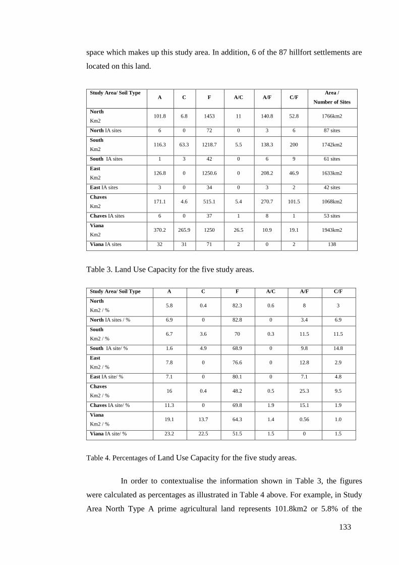
133
space which makes up this study area. In addition, 6 of the 87 hillfort settlements are
located on this land.
Study Area/ Soil Type A C F A/C A/F C/F
Area /
Number of Sites
North
Km2 101.8 6.8 1453 11 140.8 52.8 1766km2
North IA sites 6 0 72 0 3 6 87 sites
South
Km2 116.3 63.3 1218.7 5.5 138.3 200 1742km2
South IA sites 1 3 42 0 6 9 61 sites
East
Km2 126.8 0 1250.6 0 208.2 46.9 1633km2
East IA sites 3 0 34 0 3 2 42 sites
Chaves
Km2 171.1 4.6 515.1 5.4 270.7 101.5 1068km2
Chaves IA sites 6 0 37 1 8 1 53 sites
Viana
Km2 370.2 265.9 1250 26.5 10.9 19.1 1943km2
Viana IA sites 32 31 71 2 0 2 138
Table 3. Land Use Capacity for the five study areas.
Study Area/ Soil Type A C F A/C A/F C/F
North
Km2 / % 5.8 0.4 82.3 0.6 8 3
North IA sites / % 6.9 0 82.8 0 3.4 6.9
South
Km2 / % 6.7 3.6 70 0.3 11.5 11.5
South IA site/ % 1.6 4.9 68.9 0 9.8 14.8
East
Km2 / % 7.8 0 76.6 0 12.8 2.9
East IA site/ % 7.1 0 80.1 0 7.1 4.8
Chaves
Km2 / % 16 0.4 48.2 0.5 25.3 9.5
Chaves IA site/ % 11.3 0 69.8 1.9 15.1 1.9
Viana
Km2 / % 19.1 13.7 64.3 1.4 0.56 1.0
Viana IA site/ % 23.2 22.5 51.5 1.5 0 1.5
Table 4. Percentages of Land Use Capacity for the five study areas.
In order to contextualise the information shown in Table 3, the figures
were calculated as percentages as illustrated in Table 4 above. For example, in Study
Area North Type A prime agricultural land represents 101.8km2 or 5.8% of the
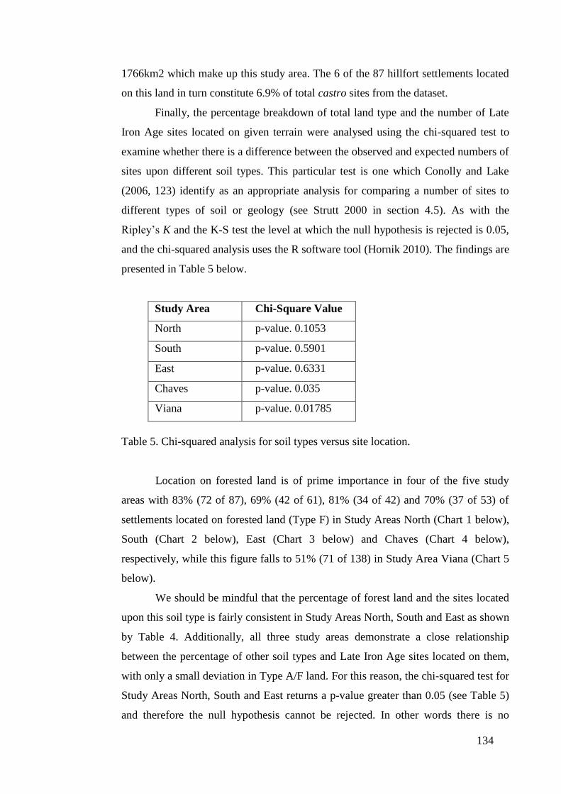
134
1766km2 which make up this study area. The 6 of the 87 hillfort settlements located
on this land in turn constitute 6.9% of total castro sites from the dataset.
Finally, the percentage breakdown of total land type and the number of Late
Iron Age sites located on given terrain were analysed using the chi-squared test to
examine whether there is a difference between the observed and expected numbers of
sites upon different soil types. This particular test is one which Conolly and Lake
(2006, 123) identify as an appropriate analysis for comparing a number of sites to
different types of soil or geology (see Strutt 2000 in section 4.5). As with the
Ripley’s K and the K-S test the level at which the null hypothesis is rejected is 0.05,
and the chi-squared analysis uses the R software tool (Hornik 2010). The findings are
presented in Table 5 below.
Study Area Chi-Square Value
North p-value. 0.1053
South p-value. 0.5901
East p-value. 0.6331
Chaves p-value. 0.035
Viana p-value. 0.01785
Table 5. Chi-squared analysis for soil types versus site location.
Location on forested land is of prime importance in four of the five study
areas with 83% (72 of 87), 69% (42 of 61), 81% (34 of 42) and 70% (37 of 53) of
settlements located on forested land (Type F) in Study Areas North (Chart 1 below),
South (Chart 2 below), East (Chart 3 below) and Chaves (Chart 4 below),
respectively, while this figure falls to 51% (71 of 138) in Study Area Viana (Chart 5
below).
We should be mindful that the percentage of forest land and the sites located
upon this soil type is fairly consistent in Study Areas North, South and East as shown
by Table 4. Additionally, all three study areas demonstrate a close relationship
between the percentage of other soil types and Late Iron Age sites located on them,
with only a small deviation in Type A/F land. For this reason, the chi-squared test for
Study Areas North, South and East returns a p-value greater than 0.05 (see Table 5)
and therefore the null hypothesis cannot be rejected. In other words there is no

135
significant difference between the observed location of Iron Age sites on soil types,
and the expected location of Iron Age sites on soil types.
Chart 1. LUC (Land Use Capacity) for Study Area North (left) and site distribution
during the Late Iron Age (right). The data used in Charts 1-5 comes from Table 4.
Nevertheless, Study Areas Chaves and Viana return p-values less than 0.05
(see Table 5), thereby rejecting the null hypothesis, while demonstrating that there is
considerable deviation between the observed and expected values when conducting
the chi-squared test. In Study Area Chaves this deviation is greatest on forested land
which makes up 48.2% of the total land, but constitutes the location of 69.8% of Iron
Age settlements, as shown on Table 4. A similar relationship can be seen with Type
A land (16% versus 11.3%) and A/F terrain (25.3% against 15.1%), as shown on
Chart 4 below. This would suggest that castro settlements in this region actively
sought out forested land for livestock wood pasture and / or fuel, or alternatively
because of the defensive capabilities it might have offered. It is certainly the case that
fewer hillforts were located on Type A land, which predominated around the fertile,
but largely indefensible Tâmega Valley.
A 6% C
0%
F 82%
A/C 1%
A/F 8% C/F
3%
Study Area North LUC Breakdown A
7%
F 83%
A/F 3%
C/F 7%
Study Area North LUC Iron Age
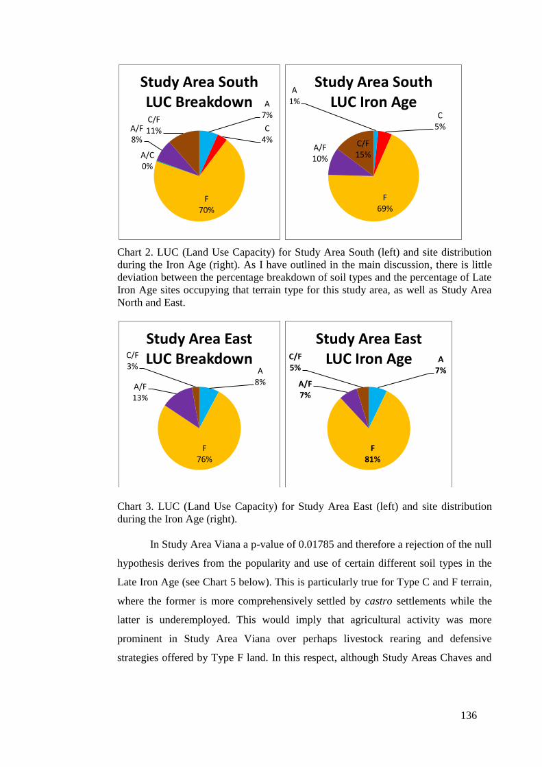
136
Chart 2. LUC (Land Use Capacity) for Study Area South (left) and site distribution
during the Iron Age (right). As I have outlined in the main discussion, there is little
deviation between the percentage breakdown of soil types and the percentage of Late
Iron Age sites occupying that terrain type for this study area, as well as Study Area
North and East.
Chart 3. LUC (Land Use Capacity) for Study Area East (left) and site distribution
during the Iron Age (right).
In Study Area Viana a p-value of 0.01785 and therefore a rejection of the null
hypothesis derives from the popularity and use of certain different soil types in the
Late Iron Age (see Chart 5 below). This is particularly true for Type C and F terrain,
where the former is more comprehensively settled by castro settlements while the
latter is underemployed. This would imply that agricultural activity was more
prominent in Study Area Viana over perhaps livestock rearing and defensive
strategies offered by Type F land. In this respect, although Study Areas Chaves and
A 7%
C 4%
F 70%
A/C 0%
A/F 8%
C/F 11%
Study Area South LUC Breakdown
A 1%
C 5%
F 69%
A/F 10%
C/F 15%
Study Area South LUC Iron Age
A 8%
F 76%
A/F 13%
C/F 3%
Study Area East LUC Breakdown A
7%
F 81%
A/F 7%
C/F 5%
Study Area East LUC Iron Age

137
Viana display a statistically significant concentration of settlements in certain areas,
they do so for different reasons.
Chart 4. LUC (Land Use Capacity) for Study Area Chaves (left) and site distribution
during the Iron Age (right).
Chart 5. LUC (Land Use Capacity) for Study Area Viana (left) and site distribution
during the Iron Age (right).
Lastly, access to water sources for the five study areas (see Table 6 below) is
shown in two formats. Firstly, the nearest river source and secondly the distance to
navigable Type 5 rivers and above. These rivers retained water during the summer
months and were capable of supporting small river craft during wetter seasons. This
data was generated by plotting and measuring distance from individual settlements to
the river systems using ArcGis 9.2, and the calculations for each study area are
presented in Appendix B.
A 16%
C 0%
F 48% A/C
1%
A/F 25%
C/F 10%
Study Area Chaves LUC Breakdown
A 11%
F 70%
A/C 2%
A/F 15%
C/F 2%
Study Area Chaves LUC Iron Age
A 19%
C 14%
F 64%
A/C 1%
A/F 1% C/F
1%
Study Area Viana LUC Breakdown
A 23%
C 23%
F 52%
A/C 1%
C/F 1%
Study Area Viana LUC Iron Age

138
Study Area / River Type Nearest River Source
(metres)
Distance to Type 5 River
(metres)
North 345 5390
South 441 3905
East 256 4740
Chaves 286 7155
Viana 322 5346
Table 6. Average distance between a castro and (a) all rivers and (b) Type 5 rivers.
The distance to the nearest available water source varies from 256m in Study
Area East to 441m in Study Area South, although it should be noted that the southern
and eastern boundaries of Study Area East are formed by the River Douro, along
which a series of hillforts are positioned. This fact also explains the low cumulative
distance of Study Area East, relative to the other study areas, to Type 5 rivers. In this
analysis, Study Areas North, South and Viana all show similar figures, but Study
Area Chaves deviates from this pattern showing an average distance of 7155m from
castro settlements to Type 5 rivers. The implications of these findings will be
considered below in section 4.7.
4.6.4. The Application of Nearest-neighbour Analysis
Nearest-neighbour analysis is the second principal form of analysis conducted
in this chapter as a means to investigate the spatial configuration of late castro
settlements within the landscape. As a statistical tool, nearest-neighbour analysis was
first developed within the field of ecology (see Clark and Evans (1954)) and
thereafter by geographers in the 1960s and 1970s before being taken up by
archaeologists for the purpose of settlement analysis (see Hodder and Hassall
(1971)).
In more recent years, nearest-neighbour analysis has been used effectively to
examine the diachronic settlement patterns of large hillforts in southern Spain
between the sixth century BC and the first century BC. The findings from this study
showed that the average distance between third and fourth level sites, that is the
distance between a site and its third and fourth closest neighbour, increased between
the sixth century BC and the second century BC. The researchers conducting this
139
study interpreted this trend as evidence of economic instability within the region
during this period, as the competition for scarce resources resulted in the population
concentrating in larger hillforts (Ruiz Rodríguez et al. 1991, 31-32). For this reason,
the study undertaken by Ruiz Rodríguez et al. (1991) provides a useful template for
the analysis conducted in this thesis, above all, in identifying clusters of settlements
at multiple levels, which can be illustrative of settlement, tribal or regional
boundaries.
An additional use of nearest-neighbour analysis can be seen in the study of
Early Neolithic Magoules (settlement mounds which housed small village
communities) in eastern Thessaly, Greece, which was conducted in conjunction with
Thiessen polygons to create equidistant boundaries between settlements. The
findings were that Magoules structures showed a statistically significant level of
clustering around terrain which was neither prone to flooding nor too dry (Perlès
1999, 52). This analysis suggests nearest-neighbour analysis provides a means to
examine the relationship between the settlement pattern and the environment, which
will be pursued later in this chapter.
Figure 29. Some of the problems of multiscalar patterning (Conolly and Lake 2006,
166).
It is nevertheless important to acknowledge that as a statistical tool, nearest-
neighbour analysis has limitations, and statisticians have demonstrated that how we
read and interpret the results which are generated can have a bearing on our findings.
For example, in Figure 29 above the analysis initially identifies eight clusters within
the dataset (1-8). However, there is also a higher order settlements, shown by A, B,
C, as well a micro clustering of those points located in A3 (see enlarged panel to the

140
right) would not necessarily be detected by the statistical technique (Conolly and
Lake 2006, 166).
One technique which overcomes the inherent problems presented by nearest-
neighbour analysis is the Ripley K test, which identifies the relative aggregation and
segregation of point data at different spatial scales. Ripley’s K-function defines the
expected number of neighbours in a circular radius r, at arbitrary points in the
distribution. The K-distribution thereafter provides a cumulative frequency of
average point intensity at predetermined intervals of r (Bevan and Conolly 2006,
221), and can be efficiently and accurately calculated using statistical tools such as
the R software tool (Hornik 2010). A pilot study conducted for this thesis using the
settlement data from Late Iron Age settlements in Study Area North, demonstrates
how the test was conducted. Ripley’s K-function was employed using ArcGis 9.2
and calculated over 40 bands, which correlated at spatial intervals of 100m and
measured against 999 randomly generated permutations. To ensure that the analysis
was not biased, outer boundary values were simulated or mirrored against available
spatial data, to provide a more realistic calculation.
Graph 1. Ripley’s K analysis.
The formatted data presented above as Graph 1, shows the observed values
(ObservedK, red line) positioned against the expected values (ExpectedK, blue line).
0
1000
2000
3000
4000
5000
6000
1 3 5 7 9 11 13 15 17 19 21 23 25 27 29 31 33 35 37 39
Y-AXIS
X-AXIS. METRES (100)
GRAPH 1. TEST RIPLEY'S K
ExpectedK
ObservedK
LwConfEnv
HiConfEnv
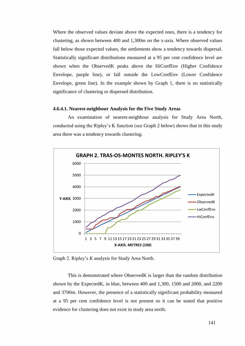
141
Where the observed values deviate above the expected ones, there is a tendency for
clustering, as shown between 400 and 1,300m on the x-axis. Where observed values
fall below those expected values, the settlements show a tendency towards dispersal.
Statistically significant distributions measured at a 95 per cent confidence level are
shown when the ObservedK peaks above the HiConfEnv (Higher Confidence
Envelope, purple line), or fall outside the LowConfEnv (Lower Confidence
Envelope, green line). In the example shown by Graph 1, there is no statistically
significance of clustering or dispersed distribution.
4.6.4.1. Nearest-neighbour Analysis for the Five Study Areas
An examination of nearest-neighbour analysis for Study Area North,
conducted using the Ripley’s K function (see Graph 2 below) shows that in this study
area there was a tendency towards clustering.
Graph 2. Ripley’s K analysis for Study Area North.
This is demonstrated where ObservedK is larger than the random distribution
shown by the ExpectedK, in blue, between 400 and 1,300, 1500 and 2000, and 2200
and 3700m. However, the presence of a statistically significant probability measured
at a 95 per cent confidence level is not present so it can be stated that positive
evidence for clustering does not exist in study area north.
0
1000
2000
3000
4000
5000
6000
1 3 5 7 9 11 13 15 17 19 21 23 25 27 29 31 33 35 37 39
Y-AXIS
X-AXIS. METRES (100)
GRAPH 2. TRAS-OS-MONTES NORTH. RIPLEY'S K
ExpectedK
ObservedK
LwConfEnv
HiConfEnv

142
Graph 3. Ripley’s K analysis for Study Area South.
Graph 4. Ripley’s K analysis for Study Area East.
The dispersed settlement visible in the landscape of Study Area South (see
4.6.2) is also replicated in the Ripley’s K test (Graph 3). While it is not statistically
significant, in other words the ObservedK is not smaller in value than the
LwConfEnv value, the ObservedK is lower than the ExpectedK between 600 and
0
1000
2000
3000
4000
5000
6000
1 3 5 7 9 11 13 15 17 19 21 23 25 27 29 31 33 35 37 39
Y-AXIS
X-AXIS. METRES (100)
GRAPH 3. TRAS-OS-MONTES SOUTH. RIPLEY'S K
ExpectedK
ObservedK
LwConfEnv
HiConfEnv
0
2000
4000
6000
8000
10000
12000
14000
16000
18000
20000
1 3 5 7 9 11 13 15 17 19 21 23 25 27 29 31 33 35 37 39
Y-AXIS
X-AXIS. METRES (100)
GRAPH 4. TRAS-OS-MONTES EAST. RIPLEY'S K
ExpectedK
ObservedK
LwConfEnv
HiConfEnv

143
1400 and 1500 and 2700m. This would suggest that the hillforts in Study Area South
are more dispersed over certain distances than a standard random distribution of
settlements.
The Ripley K test conducted for Study Area East (Graph 4) shows that the
ObservedK correlates closely to the ExpectedK, but with a slight tendency towards a
dispersed distribution at 700m. After 2800m the settlement structure shows small
evidence of clustering but the pattern for Study Area East as a whole, is one of
random distribution.
In Study Area Chaves the Ripley’s K test (Graph 5) shows that the
ObservedK closely follows the ExpectedK, and only above 2000m do the settlements
show a propensity to cluster.
Graph 5. Ripley’s K analysis for Study Area Chaves.
The clustering of settlements visible in Map 5 (see section 4.6.2) are also
reflected in the Ripley’s K test for Study Area Viana (Graph 6). At 500m, there is a
statistically significant spatial clustering where the ObservedK value in red touches
the HiConfEnv (the Higher Confidence Envelope), represented by the purple line.
From 500 up to 4000m there is tendency towards clustering, which is visible in the
graph where the value of the ObservedK continues above that of the ExpectedK.
0
1000
2000
3000
4000
5000
6000
1 3 5 7 9 11 13 15 17 19 21 23 25 27 29 31 33 35 37 39
Y-AXIS
X-AXIS. METRES (100)
GRAPH 5. CHAVES. RIPLEY'S K
ExpectedK
ObservedK
LwConfEnv
HiConfEnv

144
Graph 6. Ripley’s K analysis for Study Area Viana.
In summary, it is only Study Area Viana that demonstrates a statistically
significant evidence of clustering which can be measured at a 95 per cent confidence
level.
4.6.5. The Application of Thiessen Polygons
Thiessen polygons constitute the second methodological application
employed to analyse settlement interaction, hierarchical structures and to identify the
presence of borders and boundaries within the Late Iron Age landscape of northwest
Iberia. Thiessen polygons are created by ascribing an area to each point in the
dataset, whereby that tessellated space is closer to a specific point than any other, and
as an applied methodology have been used for multiple forms of analysis. These
include the identification of territorial divisions in Neolithic Britain (Renfrew 1976),
regional catchment areas in Roman Britain (Hodder and Hassall, 1971), and the
locational criteria for Early Neolithic Magoules in eastern Thessaly, Greece, where
tessellated space was analysed in conjunction with nearest-neighbour analysis (Perlès
1999, 52).
0
1000
2000
3000
4000
5000
6000
1 3 5 7 9 11 13 15 17 19 21 23 25 27 29 31 33 35 37 39
Y-AXIS
X-AXIS. METRES (100)
GRAPH 6. VIANA. RIPLEY'S K
ExpectedK
ObservedK
LwConfEnv
HiConfEnv
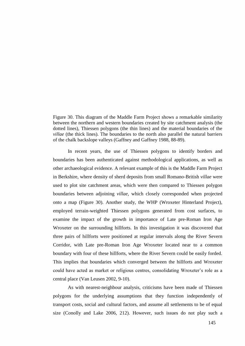
145
Figure 30. This diagram of the Maddle Farm Project shows a remarkable similarity
between the northern and western boundaries created by site catchment analysis (the
dotted lines), Thiessen polygons (the thin lines) and the material boundaries of the
villae (the thick lines). The boundaries to the north also parallel the natural barriers
of the chalk backslope valleys (Gaffney and Gaffney 1988, 88-89).
In recent years, the use of Thiessen polygons to identify borders and
boundaries has been authenticated against methodological applications, as well as
other archaeological evidence. A relevant example of this is the Maddle Farm Project
in Berkshire, where density of sherd deposits from small Romano-British villae were
used to plot site catchment areas, which were then compared to Thiessen polygon
boundaries between adjoining villae, which closely corresponded when projected
onto a map (Figure 30). Another study, the WHP (Wroxeter Hinterland Project),
employed terrain-weighted Thiessen polygons generated from cost surfaces, to
examine the impact of the growth in importance of Late pre-Roman Iron Age
Wroxeter on the surrounding hillforts. In this investigation it was discovered that
three pairs of hillforts were positioned at regular intervals along the River Severn
Corridor, with Late pre-Roman Iron Age Wroxeter located near to a common
boundary with four of these hillforts, where the River Severn could be easily forded.
This implies that boundaries which converged between the hillforts and Wroxeter
could have acted as market or religious centres, consolidating Wroxeter’s role as a
central place (Van Leusen 2002, 9-10).
As with nearest-neighbour analysis, criticisms have been made of Thiessen
polygons for the underlying assumptions that they function independently of
transport costs, social and cultural factors, and assume all settlements to be of equal
size (Conolly and Lake 2006, 212). However, such issues do not play such a

146
prominent role within the context of northwest Iberia during the Late Iron Age,
where communication routes (particularly terrestrial ones) are largely unknown
(Naveiro López, 1991) and our knowledge of the social and cultural sequence is
often limited. The use of Thiessen polygons has been successfully applied to the
study of the region along the strategic River Cávado, and as a means to identify
smaller hillforts positioned at the boundaries of these larger castros’ territorial
control (Martins 1990, see section 4.5). In examining the visual relationship between
possible boundaries and borders within the landscape, this investigation utilises
multiple scales of Thiessen polygons, which can be broken down into: (a) tessellated
analysis for all settlements; (b) for medium and large sites; (c) and for large sites
only.
4.6.5.1. Thiessen Polygon Analysis for the Five Study Areas
The finding from the use of Thiessen polygons for Study Area North (Map
11) did not show any discernible patterns, with the trajectory of river networks
located within the hillfort’s immediate territory, rather than forming the boundaries
between individual hillforts. For large hillforts, namely, sites 273 (top left), 108
(bottom centre), and 100 (bottom right), and their territorial margins shown by red
tessellated Thiessen polygons, the only recognisable border area is that dividing sites
273 and 108 where a series of hillforts, sites 207, 78, 95 and 38 are located along the
red boundary lines. For medium and large hillforts (Map 12) a series of settlements
can be found on the boundary areas shown in blue. These include those smaller
castros, sites 75 and 42 located around the larger hillfort site 78 (centre), and those
settlements 232, 254, 255 and 231 positioned at the periphery of control of site 105
(top centre). Given that two medium-sized hillforts, sites 78 and 105, shared a
boundary where the smaller castro, site 75, was located is also significant.
Thiessen polygon analysis conducted for all castro settlements in Study Area
South (Map 13) does not provide any conclusive findings, other than the short
boundary created by the path of the river between sites 545 and 835, 542 and 836,
and 542 and 600 in the centre of the map. Thiessen polygons conducted for large
hillfort 608 (top right), 607 (centre right), 613 (top centre), 806 (bottom centre), 814
(centre left) and 802 (bottom left) are shown in red on Map 14. Of significance is site
613 with a series of hillforts (from right to left), sites 615, 775, 600, 848 and 843,
located on its peripheral territory, while around medium-sized hillfort 600, can be
147
found a series of smaller castros 601, 733 and 542. A series of smaller castros are
located at the territorial margins of large hillforts, for example 848 and 826 (centre
left), and at the margins of medium-sized castros, sites 545, (bottom centre) and 764
(bottom right), but the dominant pattern shows smaller hillforts located on the
boundaries of medium-sized castros. For site 613, these are 626, 842 and 901; for
608, medium-sized hillfort 602; for 607, sites 611, 740 and 755; for 806, 532 and
600; for 814, medium-sized castro 815; and for 802, medium-sized settlement 825.
This would suggest the dominant partner was a large hillfort with one to three
medium-sized settlements located within its territorial boundaries.
In Study Area East, Thiessen polygons drawn for all settlements (Map 15) do
not seem to correlate to geographical boundaries. The territorial margins of medium
and large-scale hillforts (Map 16) show the same interesting results; castro site 573
(bottom centre) occupies the boundary, shown in blue, between two medium-sized
castros, sites 357 and 585. In the same way, site 374 (centre) is positioned on the
margin between middle-sized hillforts 572 and 354. There were no conclusive
findings for the two large-sized castros, their Thiessen polygons are shown in red.
In Study Area Chaves Thiessen polygons applied to all castro settlements
(Map 17) showed possible fluvial boundaries between sites 614 and 616 (centre
right) and 342 and 346 (centre right). Thiessen polygons formatted for large and
medium-sized castros show two clear patterns (Map 18). To the east are a series of
large hillforts, sites 320, 340, 603 and 614, but only two medium-sized castros 301
and 346 are located within the respective territorial boundaries of large-sized castros,
possibly fulfilling a subservient role. In contrast, the territory of large castro 715
(bottom centre) contains medium-sized castros 545 and 548, large castro 719
(bottom centre) medium-sized castros 722 and 805; large castro 402 (centre left)
four medium-sized castros 155, 505, 416 and 419; and lastly, large castro 201 (top
left) contains medium-sized castros 157, 158 and 160. In this sense, the settlement
pattern of a series of medium-sized hillforts located within the territorial boundaries
of large-scale castros is similar to those findings generated from the western region
of Study Area South; note that Study Area Chaves is spatially positioned
immediately above the western part of Study Area South. In contrast, the less
structurally complex region of eastern Study Area Chaves where large castros
dominate their territory with few medium-sized castros is more typical of Study Area
North. Evidence for the territorial domain of these large-scaled castros is visible
148
along the River Tâmega, where the boundaries between site 201 to the west of the
river, and sites 603 and 715 formed along the trajectory of the waterway. Large
hillfort 603 also appears to have been a central place for surrounding small castros
with sites 258, 261, 314, 355 and 609 positioned on its margins. Nevertheless, with
respect to medium-sized castro 416 (centre left) a series of smaller hillforts 413, 412
and 404 are located on the edge of its territorial boundary. In summary, large-sized
castros appear to have controlled the landscape with a series of medium and smaller-
scaled hillforts located at their territorial margins, and where the trajectory of large
rivers formed intersettlement boundaries.
Lastly, Study Area Viana showed no evidence of the territorial control of
larger castro settlements visible in Study Area Chaves. Thiessen polygon analysis
conducted for the study area as a whole suggests that boundaries may have existed
along important waterways, notably, the River Lima, which runs from the bottom left
to the centre right of Map 19, where the path of the river provides a boundary
between castro settlements.
4.7. Discussion
This section brings together the findings outlined above and suggests some
important themes within late pre-Roman society in northwest Iberia, and incorporates
the theoretical concepts of isolationism, the importance of environmental factors, and
the consolidation and negotiation of borders and boundaries, which were discussed in
depth at start of this chapter. In order to present a coherent argument, this section
breaks down the structure of the established five study areas, and reconnects the data
to highlight five regions which exhibit shared characteristics, especially with regard
to their settlement pattern and ultimately their hierarchical structure.
The first region to be discussed is Study Area North, which is characterised
by three large castro settlements and a series of medium-sized hillforts. Structurally,
these large settlements do not exhibit any strategic domination of their hinterland
given that: (a) large hillforts 100 and 108 (bottom right) appear isolated from
surrounding settlements; and (b) the remaining large castro 273 (top left) may have
functioned more as a medium-sized structure. This is borne out by Thiessen polygons
created for medium-sized settlements, which show a series of smaller castros 231,
232, 254 and 255 along the border area shared with the adjacent medium-sized
castro 105 (see Map 12). Furthermore, the role of medium-sized castros within the
149
landscape of Study Area North can be further established in the bottom right of Map
12 where a pair of medium and small castros are located either side of the River
Sabor, and sites 30 and 31 are located within 500m of each other, with the former
being a medium-sized castro and the latter a smaller structure. Nevertheless, smaller
hillforts are not always found at the peripheral margins of control of medium-sized
castros, especially towards the southern area of Study Area North. Additionally,
within the landscape there is considerable evidence for connectivity between smaller
castros within 1000m of each other, and located away from large and medium-sized
hillforts, whose communities most likely invested in mutually beneficial actions
orchestrated along strategic and economic lines.
This complex and multifaceted picture of settlement patterns within Study
Area North is arguably representative of the systems of kinship and lineage which
existed towards the eastern region of late pre-Roman northwest Iberia and are
manifest in inscriptions and other archaeological evidence from the period. Within
this region, social groupings orientated around the family and then the supra-familial
units of gentilitates and gentes, as shown in the inscription which referred to Araus,
son of Ablaecaenus, from the Desonsi family (gentilitas) from the tribe (gens) of the
Zoelas (CIL II 2633), which testifies to a hierarchical social structure (see section
4.4). In this way, medium-sized castros exhibit a degree of territorial and so political
and economic control over smaller hillforts. At the same time, the presence of two
smaller castro sites within 1000m of each other, might be indicative of the flexibility
of the social structure of the region, which gave a voice to individual communities,
as shown above with the Desonsi inscription, where the clustering of two or more
hillforts may have given rise to shared economic, social and political benefits. This
grouping of small castros is evident in the Ripley’s K analysis of the region, where
there is a tendency for sites to cluster between 500 and 1400m, but this is juxtaposed
within the landscape with the possible regional control of smaller hillforts by
medium-sized ones.
The northern portion of Study Area East and the eastern section of Study
Area South represent the second region which can be identified characterised by a
series of large and medium-sized castros, which dominate their territorial boundaries
and present a largely dispersed settlement pattern. Within Study Area South, large-
sized castros 607 and 608 and medium-sized castros 611 and 620, as well as 414 and
672 in Study Area East, occupy large territorial space, with few smaller castros

150
within their boundaries. Furthermore, at the eastern and south-eastern margins of
Study Area South the landscape is dominated by smaller castros, which are largely
dispersed within the landscape, as shown by the Ripley K test (Graph 2).
The paucity of settlements within the area to the east of Study Area South and
that space to the north of Study Area East cannot be explained through the physical
geography of the region. Where only a limited number of castro settlements were
positioned around the bifurcation of the River da Vilariça and the River Sabor in the
Late Iron Age (for position see site 664, bottom right, Map 2), during the early
Roman period Imperial authorities invested heavily in this strategic area locating the
civitas capital (civitas Baniensium) at the confluence of the two rivers. Furthermore,
in the area around the civitas capital, there was a dense network of villae and farms
showing the region to be fertile and capable of supporting a central place as well as a
series of satellite towns. As a result, during the Late Iron Age, this space represents a
buffer area sandwiched between the large hillforts found in the west of Study Area
South and the castros located along the River Douro shown in Study Area East,
which means the area is characterised by isolated hillfort settlements, and thus
indicative of those models of castro society advanced by Sastre Prats (2001; 2008).
As such, hillfort settlements may have been dispersed within the landscape, perhaps
to ensure a level of economic and political isolation, through which systems of social
equality and so economic parity were maintained within the community.
In the third region, the central and southern part of Study Area East, a series
of large to medium-sized castros played an important role within the landscape.
Many of those medium-sized castros were located on principal waterways, for
example, sites 503 and 509 on the River Sabor, which would have given access to the
River Douro to the southwest and northwards to Study Area North. The location of
smaller settlements within or at the border of the territorial hinterland of medium-
sized castros, suggests that these entities may have shared political, economic and
social systems, in common with many of those hillforts in Study Area North, as
previously discussed.
Positioned along the River Douro were a series of fortified sites giving their
occupants access to the river’s resources, and providing visual control of the
waterway, and therefore greater defensive control. A secondary function for these
castros came with their strategic location at the edge of the principal waterway of
northwest Iberia, permitting their communities to engage in long-distance exchange
151
along the river’s trajectory. In a westerly direction, these castros may have been
integrated into a wider Atlantic exchange network (Naveiro López 1991), but the
dearth of hillforts located near to or along the River Douro’s trajectory in Study Area
South strongly suggests that the commercial activities were more orientated towards
the east and the large castro settlement of Villalcampo. Located outside the study
region to the northeast of Study Area East, this hillfort controlled the strategic
confluence of the Rivers Duero (Portuguese Douro), which snaked east into the
Iberian interior, and the River Esla (see Figure 3, page 21), which marks the easterly
boundary of this thesis’ study area. Dating from the second century BC (Esparza
Arroyo 1987, 375-376), Villalcampo occupied a strategic location at the edge of a
series of tribal confederations of the region, the Asturs, the Vettones and the Vaccaei,
who controlled the abundant deposits of gold, tin, copper and iron within their
respective territories and provided access to the Iberian interior (Esparza Arroyo
1983-1984, 136). Integrated into these long-distance exchange networks were those
castros located inland, but connected to those hillforts on the River Douro through
possible overland trails or more probably fluvial networks, which provided access
through the River Sabor and its tributaries to the regions in the interior. This trade
may have been coordinated by those castros upstream given the presence of one
medium-sized and one small castro either side of the River Sabor in Study Area
North, sites 45 and 46 on the left bank and 97 and 461 on the right (bottom right,
Map 1). However, the strategic control of both banks of the River Sabor would
suggest some sort of crossing point incorporating long-distance exchange with
communities to the east.
Study Area Chaves and the area located immediately below it, the western
part of Study Area South, constitute the fourth regional area, which is characterised
by large castros often with medium-sized castros located within their territorial
boundaries. Of notable significance are a series of large castros, notably sites 613
and 814 in Study Area South and 201 and 402 in Study Area Chaves, along whose
boundaries a series of medium-sized and smaller castros are located. In terms of their
position, these large hillforts occupy strategic positions within the landscape which
are not dependent upon the natural defences offered by principal rivers, but where
affiliated medium to smaller-sized castros locate at the river edge as seen with sites
806 and 814 in Study Area South. Similar levels of connectivity are replicated in
Study Area Chaves, with a series of large hillforts located around the periphery of the
152
Tâmega Valley, but again with subordinate castros positioned at the margin of their
territorial boundaries. This can be seen with large hillfort 402 (centre left, Map 4),
which occupied an area rich in gold deposits, where two medium-sized castros
punctuated by two smaller ones are located on the left bank of the River Tâmega,
within strategic access of the large castro to the west. It is possible to conclude that
these four castros, and the only settlements located adjacent to the river in Study
Area Chaves, fulfilled some sort of economic role, possibly the transportation of gold
or other materials, with the medium-sized castros offering a degree of security to the
bordering smaller hillforts.
In Study Area Chaves margins of territorial control seem to have played an
important role in consolidating corporate enterprise managed by large fortified
settlements, whether manifest in natural geographical phenomena as with the
boundary created by the large hillfort 201 to the west of the River Tâmega and 603
and 715 to the east in Study Area Chaves, or the positioning of small castros (sites
615, 843 and 848) and medium-sized hillforts (sites 600 and 775) along the margins
of the large hillfort 613 in Study Area South. In this respect, the settlement patterns
shown in this region replicate the findings of Martins (1990) study of the region
between the Cávado and Ave rivers, where fluvial networks formed the borders
between large hillforts positioned inland from major waterways, and with smaller
castro structures located along their terrestrial margins of control. Established
borders of control would have existed between competing large settlements, and can
be seen to symbolise those settlements represented by the inverted ⊃ within the
epigraphic record of the Late pre-Roman Iron Age society within northwest Iberia,
where the borders and boundaries of individual structures were reinforced and
tangible within the landscape. Moreover, in Study Area Chaves the territorial-based
social system, shown by the inverted ⊃ within the epigraphic record, may have acted
to bind communities together in a more cohesive manner than in Study Areas North
and East, where borders may not have been so firmly established or controlled and
society was more integrated through constantly renegotiated kinship relations. It is
therefore possible that the kinship-based social systems in northwest Iberia were
more representative of those looser clan affiliations shown by the Brigantes and the
Dobunni in Late Iron Age Britain (see section 4.3). Whereas those communities
whose identity centred around the settlement, shown by the inverted ⊃ within the

153
epigraphic record, may have been more characteristic of the Durotriges of southern
Britain during the Late Iron Age who were more culturally unified against
neighbouring tribes. However, where the Durotriges differentiated themselves from
the neighbouring Atrebates through distinct forms of coin design, pottery and burial
practices (Blackmore et al. 1979, 102), the archaeological record of Study Area
Chaves does not allow such comparisons to be made. Unlike other regions in Europe
during the Late Iron Age, coins were not used as a medium of currency in northwest
Iberia (see section 1.5.5), and the complete absence of burial sites within late castro
society (see section 7.2.1) further limits our understanding of possible ethnic
differences between communities and regions. Where pottery is present in large
quantities each castro settlement produced enough ceramic ware pottery to supply its
own needs (see section 3.6.1), and therefore the identification of exchange networks
and regional alliances is difficult to establish.
Where Study Areas North, South, East and Chaves have been shown to
display different strategies and systems, their relationship with their immediate
environment is similar. All four study areas show a tendency for settlements to locate
on forested land, as illustrated by land use capacity analysis. This suggests that: (a)
the defensive capabilities of this less hospitable landscape continued to represent a
key criterion in the location of castro settlements; and (b) there was a need to harvest
the resources which the forested land offered, and providing access to feed for
livestock was a key priority. Such findings are representative of recent studies of
castro settlements from the Middle Iron Age, where hillforts from the Middle Iron
Age were positioned at the boundary of productive / forested land (Fábrega Álvarez
2005, 129), which permitted greater agricultural production (Parcero Oubiña 2000,
2001). In the case of Study Chaves, where the null hypothesis is rejected for the chi-
squared test (see section 4.6.5), there is a statistically significant number of
settlements located on forested land, which make up 48.2% of the total land, but
constitutes the location of 69.8% of Iron Age settlements. While access to the
resources contained within forested land may have been important, as it was in Study
Areas North, South and East, it is also likely that defensive strategies played a major
role in the location of castro settlements at the periphery of the fertile Tâmega Valley
(see Map 9). It is possible that larger hillforts located on poorer land may have relied
on the castros positioned on their periphery, over which they had a degree of
154
influence, to supply them with resources, in particular foodstuffs from the River
Tâmega.
In the last region to be examined, Study Area Viana, the patterns observed
with the other study areas is reversed, with a preference towards locating on
agricultural land as shown by the p-value of 0.01785 for the chi-squared test. The
preference shown for good quality agricultural land is also visible where hillforts
located in the rich fertile region adjoining the Atlantic ocean, and away from the less
hospitable and elevated terrain to the east. This would suggest that agricultural
activity was more prominent in Study Area Viana over perhaps livestock rearing and
defensive strategies offered by Type F land, as demonstrated in Study Area Chaves.
The importance of agricultural practices can be shown by the Ripley’s K test (Graph
6), with settlement agglomeration evident at the 500m mark, and representative of
high level of connectivity between hillforts closely grouped together such as sites 64,
70, 80 and 81 (centre), where the settlements were given over to agricultural
production (Almeida 2003a), as well as harvesting salt from the salt flats built up
near the ocean as in site 112 (bottom left) (Carvalho 2008 vol. II, 131). In investing
in the land, many castros located near to their primary resources, and in doing so,
located at a lower altitude in less defensive positions.
Study Area Viana was also more inherently dynamic and integrated into the
wider Mediterranean world than the other four regions, as shown by the caches of
Republican and Imperial Roman coinage found in hillfort settlements. 38 Republican
denarii dated to the first century BC were found in site 1 (bottom left, Map 5), and a
cache of 37 coins unearthed at site 72 (bottom centre) among which were four
Republican denarii, with the remainder dating from the period of the Emperor
Augustus (27 BC-AD 14). While the dating of such coin finds does not prove the
presence of Roman authorities, it is indicative of practice-based connections
conceived from the periphery where experiences from outside permeate and connect
with those members and institutions within (Wenger 1998, 117). In this sense,
contact whether directly or indirectly with agents, structures and practices outside the
immediate area, increasingly shaped the society of this region.
In identifying the impact of external influences, internal dynamics, or both,
the territorial boundaries of medium and large-scale castros do not show any
discernible pattern of control with the landscape, but tessellated Thiessen polygons
around the River Lima suggest that margins of control conceived by individual

155
hillforts were located along the periphery of the waterway. This strongly suggests the
presence of independent castros, or confederations of mutually-cooperative hillforts
orchestrated around agricultural activities, where energy was invested in the
economic activities, but where political or social allegiance to those elites who
inhabited the larger hillforts varied within the region. This is borne out by the
presence of three large metropolitan centres, or citânias, represented by Cividade de
Âncora (site 12, Map 5, bottom left), the Citânia de Santa Luzia (site 133, Map 5,
bottom left) and the castro da St. Da Vista (site 39, Map 5, top right), whose
territorial domain is similar to those citânias located further south, would have
encompassed a radius of 25km, an area insufficient to have controlled the whole of
Study Area Viana.
For this reason, this Late Iron Age landscape adjoining the Atlantic coast is
best perceived as representing multiple communities, some independent, others
operating as mutually beneficial communities and lastly, those settlements within the
ambit of larger hillforts, whose dominance with the assimilation of the region by
Roman authorities, would be reinforced as they acted as geographical and political
central places for the creation of tribal groupings and ultimately civitas settlements.
4.8. Conclusions
In summary, a series of points can be made about the settlement patterns,
systems and practices of late pre-Roman northwest Iberia.
1. The empirical analysis conducted in this chapter strongly suggests that we should
not speak of a single recognised ‘Castro Culture’ but of multiple castro
communities, which occupied different spatial settings, but within which existed
overlapping practices and systems. Study Areas North and Viana therefore exhibit
similar settlement patterns in the clustering of communities, but the activities of
those peoples who lived on the agriculturally rich vein of land along the Atlantic
coast were strongly orientated towards generating economic surplus, where the
presence of outside agents in the form of merchants, and Roman authorities in the
adjoining province of Lusitania, helped forment economic activity. In contrast, the
emergence of castro settlements within close proximity of each other in Study Area
North, while partially conditioned by its geographical immediacy to economic
opportunities to the east, was predominantly constituted through lineage-based social
structures.

156
2. Sandwiched between Study Areas North and Viana, a different social structure
emerged around the region of Study Area Chaves and the western section of Study
Area South, characterised by dominant large-scale hillforts, which controlled their
hinterland and the economic opportunities they offered through smaller castro
settlements located on their territorial borders. Geographically denied territorial
access to the Atlantic coast through a series of mountain ranges and isolated from
those waterways around which were orientated the economic activities of the hillforts
perched along the River Douro in Study Area East, a nascent hierarchical system
emerged with larger settlements located at a distance from major rivers, but with
subordinate castros often located at the margins of waterways, where resources and
fluvial transport networks could be accessed. The presence of smaller castros along
the boundary areas of larger hillforts suggests that territory was delimited and
controlled, and is strongly symbolic of those settlements located to the west of pre-
Roman northwest Iberia, where territorial borders were tangible, recognised and
enforced, in contrast to those boundaries manifest in Study Area North, where a
lineage-based social structure probably emerged.
3. Of equal importance within the landscape of pre-Roman northwest Iberia were
economic opportunities which shaped their respective cultures and are evident in the
landscape of Study Areas North and East, as well as Study Area Viana. Nevertheless,
the provenance and the nature of commercial operations may have had a contrasting
impact on both regions, with Study Area Viana drawn into the ambit of commercial
control provided by the Roman, and in turn, Mediterranean world, while Study Areas
East and North were more likely integrated into long-distance exchange systems
which centred on the interior of the Iberian peninsula. In this respect, their role in
shaping both societies was inherently different, with Study Area Viana beginning to
be moulded by Rome economically, and so socially and politically, while in Study
Areas East and North, the commercial activities do not appear to have a
corresponding impact, as shown by a more dispersed and therefore more politically-
independent settlement pattern.
4. The communities which existed in late pre-Roman northwest Iberia were therefore
multifaceted and complex, adopting a series of practices and systems which were
conditioned by the physical geography, the economic benefits they offered, and the
political systems they adopted and advanced. In this way we should move away from
the narrow concept of isolationism forwarded by Sastre Prats (2001; 2008)

157
characterised by systems, which negated the emergence of inequality with the
community while ensuring a collective voice which remained hostile to outside
forces. Equally, we should be sceptical of Parcero Oubiña’s (2003) ‘heroic society’,
which envisions systems of inequality conditioned by Roman authority and the
emergence of new systems which placed economic and political power in the hands
of a small elite. In this sense, castros were representative of integrated and isolated
structures, entities which were both hostile and cooperative, and settlements which
invested and did not invest in commercial activities. Above all, they were different,
with divergence marked not only between regions, but also among adjoining
settlement structures.
158
Chapter Five. The Landscape of Settlement. Early Roman-Period Structures in
Northwest Iberia
5.1. Introduction
This chapter examines the changes which transpired between the late pre-
Roman era, as discussed in the previous chapter, and the early Roman period. In
doing so, the themes and analytical frameworks developed in the previous chapter
will be extended, but also new concepts will be incorporated, which can be applied to
the investigation of northwest Iberia under Imperial rule. The first part of this chapter
focuses on developing a ranked settlement structure which can be applied to
examining the hierarchical settlement pattern that emerged in the early Roman
period. It should also be acknowledged that ranked settlement structures are
discussed in this chapter, and not in the previous chapter, as they reflect the
hierarchical order of villages, towns and central places in early Roman northwest
Iberia which was not overtly present during the Late Iron Age. The first area of
investigation is a brief examination of Central Place Theory which has been used as a
means to provide a hierarchical order to settlements of different size and function
(see Smith (1976)). This is followed by a short investigation of settlement analysis
based upon classificatory systems of population size. Finding Central Place Theory
and demographic settlement analysis limited in scope and application, a more
thorough methodological approach is proposed in section 5.2.4 which acknowledges
the uniqueness of early Roman sites in northwest Iberia, and provides a framework to
analyse the settlement structure. The second half of this chapter follows the same
pattern to the previous one in setting out a methodological approach, reviewing and
discussing those findings, and lastly, providing a series of concluding remarks.
5.2. The Theoretical Modelling of Ranked Settlements
5.2.1. Central Place Theory and the Practical Application of Settlement Ranking
The first methodological approach to be examined is Christaller's Central
Place Theory (1933) which made a series of statements concerning the relationship
between site structure and function. The first assumption was the notion that higher
ranked settlements became central places to lower-order structures. A second
principal belief was that these structures inhabited an isotropic landscape, that is to
say a perfectly even terrain, where the cost of movement is the same irrespective of
the direction one is travelling in (Smith 1976, 12-25). Both ideas outlined above are
159
hard to substantiate in the real world. Firstly, because the landscape is rarely
isotropic (a point which emerges among the varied topological features of northwest
Iberia, see section 3.3), and secondly the notion that higher ranked settlements,
usually based on size, offered a wider range of functions, and thereby became centres
to lower-order places (and which would appear to put a precedent on population size
over other determinants of central places, for example, religious sites e.g. Delphi, in
ancient Greece, and the small but important ecclesiastical capital of Wales, St
David’s (Rihll and Wilson 1991, 63)). Another critical issue with the practical
application of Central Place Theory is the need to adhere to Christaller’s framework
to make sense of and validate empirical finds. This is perhaps best demonstrated by
Hodder and Hassall’s (1971) analysis of the spacing and ranking of walled towns
within southern and central Roman Britain, where settlement patterns generated from
the research were redrawn by Hodder and Hassall (1971, 404) to more closely
replicate Christaller’s (1933) hypothetical models of hierarchical settlement
structures (Hingley 1989, 3). It could be argued that Hodder and Hassall’s study was
conceived in an era when a dominant theme was the positivist methodology which
demanded that theory is not contaminated by the data and thereby delivers a clean
hypothesis (Hodder and Hutson 2003, 207). Nevertheless, the limited use of Central
Place Theory, especially in recent archaeological research, and its flawed conceptual
framework strongly suggests that such a methodological approach cannot deliver a
robust understanding of the raw data.
5.2.2. The Development of Rank-Size Population Studies
In a similar way, we must also question the use of other theoretical
approaches to investigate settlement patterns, namely rank-size analysis, which
proposed that settlement size was directly related to higher order functions (Johnson
1980). As I have already argued in section 5.2.2 population size does not always
equate to a settlement’s importance. Further problems arise in the material record,
which is rarely complete, and so does not provide the archaeological tools to
establish the population, nor the population density of ranked settlement structures
(Drennan 1987, 309; Hassan 1981, 264; Rihll and Wilson 1991, 69). Efforts to
overcome the shortcomings of rank-size approach have been proposed, which
include Kosse’s (1990) development of a hierarchical classification of settlements
according to their demographic size. There are, however, additional problems with

160
this approach. This is particularly evident in the tiered settlement hierarchies Kosse
promotes (and which resemble stages of social evolution as critiqued in section 4.2),
and the simple fact that certain settlements do not conform to her model. An example
of this is the citânia of Sanfins in northern Portugal where the estimated population
of 3,000 (Silva 1995, 275, see section 1.5.6) means that the large hillfort should head
a four or five tiered ranked settlement pattern, but where archaeological excavations
have yet to locate any subordinate sites.
Although the theory underpinning rank-size classificatory systems is, in my
opinion flawed, it does highlight one of the central problems of settlement analysis,
our limited knowledge of past societies. This is an issue endemic to the Roman world
where too little is known about most Roman towns to assess their function (Bekker-
Nielsen 1989, 5), and thereby assign them a position within hierarchical settlement
patterns. Moreover, the problems in defining a Roman site have been further
complicated in recent years as archaeologists have not only employed new
expressions (often within the scope of their research) to describe Roman towns, but
in turn have been increasingly confronted by the bewildering array of terms. Hanley
(2000, 6) notes that the terms used for small Roman settlements include; village,
small town, vicus, larger rural settlement, lower-order settlement, lowest-order
market centre, non-villa settlement, native settlement, roadside settlement, local
centre, local market centre, proto-urban centre, hamlet and nucleated settlement, with
the most commonly used term being village, small town and vicus.
5.2.3. Roman Settlements of Northwest Iberia
Hanley (2000) forces us to recognise that Roman settlements did not
correspond to the neat categorisation envisaged by many archaeologists, but rather
adapted to internal needs and external pressure over time. Additionally, within the
Roman empire, which encompassed a period of half a millennium, the range of
different cultures which Imperial Rome dominated had a further impact in
differentiating one regional landscape from another. For this reason, it is important to
acknowledge the individual characteristics of early Roman settlements in northwest
Iberia, which would have been shaped by a particular blend of indigenous Iron Age
practices and the needs of Imperial administrative control.
Early Imperial northwest Iberia differed markedly from the Roman provinces,
which had already been established at the time of the conquest. Many had been
161
incorporated under the control of Rome at a much earlier date, and for this reason
may have demonstrated a greater level of assimilation into Roman economic, social
and cultural practices. Within northwest Iberia following the end of the Cantabrian
Wars (29-19 BC), three conventus capitals - Asturica Augusta, Lucus Augusti and
Bracara Augusta - were established, which provided regional judicial and
administrative control for the region (Hodgson 2005, 16, see section 1.5.8), but were
incorporated into the province of Tarraconensis and administered from its capital,
Tarraco, modern-day Tarragona near Barcelona (Keay 1988, 174). Unlike other
more developed provinces in Hispania, notably Baetica (approximately modern-day
Andalusia in Spain), coloniae settlements did not develop within the region. Why
coloniae materialised in Roman Britain, which was incorporated into the Roman
empire at a similar time to northwest Iberia, but not within northwest Iberia itself
cannot be firmly established. However, the presence of civitas capitals and civitas
towns, which operated as commercial and administrative centres under the conventus
capitals, suggests that the local indigenous aristocracy, working in conjunction with
Imperial authorities, managed the administrative and judicial needs of these nascent
settlements (Alarcão 1998, 51). What can be more definitively stated is that the pace
of change within Imperial northwest Iberia ensured that the status and therefore
function of some of these settlements was one of sudden change (for example
Bracara Augusta as discussed in section 2.3.4.1). Of central importance in the
investigation of the study region were early Roman civitas capitals which may have
fulfilled a range of rapidly evolving functions. These included the civitas Baniensium
(Study Area South, site 667), located at the confluence of the Rivers da Vilariça and
Sabor, to the probably less commercial and strategic civitas Zoelarum (Study Area
North, site 43), which was equidistant between the prosperous municipium of Aquae
Flaviae to the west, and those settlements located towards the interior (Lemos 1993
vol. II, 64-70). Despite the differences in the size and status of these settlements, the
civitas Baniensium, the civitas Zoelarum and the municipium of Aquae Flaviae
appear to have fulfilled a similar role and functioned as central places for their
immediate territory, a premise which will be examined in greater detail later in this
chapter.
Dependent upon these metropolitan centres were a series of smaller
settlements, among them vici (see section 3.6 for a discussion vici settlements),
which have been identified through classical sources as well the epigraphic record

162
(Curchin 1991, 123-124). It is also important to acknowledge that the use of the term
vicus within Roman northwest Iberia refers to a small town, and not an
administrative unit of a large urban centre (Hornblower and Spawford 2003, 1598) as
is found elsewhere in Spain, for example Roman Cordoba (vicus Hispanis, Spanish
quarter; vicus Forensis, Roman quarter) (Curchin 1991, 124). Outside of Roman
Iberia, particularly in the north of the empire, the term vicus was more closely
associated with a civilian settlement emerging next to an auxiliary fort (Salway 1981,
591; Wilson 2002, 499). Within Roman Iberia, the names ascribed to the various vici
settlements often identified their role and key attributes (Wightman 1976, 60), such
as the vicus Cuminarius, which derived its name from trade in the valuable cumin
seed, and which has been identified on the Roman road between Laminium and
Titulcia (central Iberia) (Itin. Ant. 445.6) (Curchin 2004, 106). Other vici, for
example, the vicus Vagornica (Almeida 1982, 69-70) or alternatively the vicus
Lovagornica (Rodríguez Colmenero 1987, 17, 66), suggest that the term vicus
represented an established identity and function for these small settlements.
Where vici shared a similar function to settlements elsewhere in the empire,
was their role as villages or small rural towns, especially in the less developed
regions of central, western and north-western Iberia (Curchin 1985, 330-332), where
they were integrated within the Roman arterial road network (Laurence 1999, 28;
Wightman 1976, 61). While these vici functioned as centres from which to access
surrounding productive farmland (Curchin 2004, 97; Lemos 1993 vol. II, 324), and
as provincial markets (Alarcão 1988, 43; Curchin 1991, 125), how they integrated
into the wider settlement pattern is not fully understood. Some argue that vici
administered sub-divisions of the civitas, the pagi (Millett 1990, 150), and perhaps
provided a means for local aristocrats to preserve a degree of influence and
importance (see Drinkwater 1985, for Roman Gaul), while others (Curchin 1991,
125) envisage pagi and vici as two separate and distinct entities. However, it is likely
that vici fulfilled a series of subordinate roles on behalf of larger towns, such as the
collection of taxes (Curchin 1991, 66), and for this reason they may have occupied a
position both in terms of importance and function below that of a civitas (Mattingly
2007, 171).
Also investing heavily in agricultural production were villa settlements (see
section 3.6.1 for an identification of villae from the material evidence), whose
traditional function was one of production of rural surplus, which could be

163
exchanged or sold at market. Nevertheless, it is important to define what we mean by
the term villa, especially given that the term possessed multiple meanings to the
Romans themselves (Percival 1976, 13). Classical authors, such as Varro (RR. 2, 10,
6) and Columella, a first century native of Gades, modern-day Cadiz, southern Spain
(RR. 12, 15, 1), distinguish between working and storage elements (villa rustica and
fructuaria) and the residential dwelling (villa urbana). Here, the importance of good
soil and climate (Cato. De. Agric.1.3), and the need to be near a road network (Varro
RR.1.16.2-3), to ensure access to the local town (Plin. N.H.17.28), are all emphasised
by Roman writers. Cato’s assertion ‘Let not the villa want a farm, nor the farm want
a villa’ (Cato. De. Agric. 1.4.8), highlights the dual role hard work and industry
played in framing Roman aristocrats’ conceptualisation of villae settlements (Reay
2005). While many rural estates did share many of the attributes mentioned by these
authors other grander residential villae existed during the early Roman empire, with
little or no agricultural function, such as Pliny the Younger’s (AD 61-112) detailed
description of his suburban seaside residence at Laurentum (Plin. Letters. II, 17).
Characteristic of southern Italy and Sicily, the latifundia, or large slave plantations of
the first century AD, did not take hold in Iberia, but instead large villa complexes,
the villa urbana, emerged during the fourth century as miniature consumers and
producers (Curchin 1991, 128), while some larger-estates functioned as private
fiefdoms under their aristocratic owners, such as the Roman villa at Olmeda,
northern Spain, which garrisoned a fully equipped private army (Keay 1988, 194).
This discussion above would therefore suggest that villae within the Roman
empire as a whole can be classified according to their function as rural agricultural
estates, latifundia, residential villae (as described by Pliny the Younger), and rural
palaces, which functioned as administrative centres, such as the late Roman Villa of
Carranque near Madrid, whose owner, the Prefect Maternus Cinigius, was uncle to
and minister in the Emperor Theodosius’ (347-395) administration (Parque
Arqueológico de Carranque). The majority of villae settlements within the landscape
of Roman northwest Iberia during the first and second centuries AD would have been
simple agrarian centres, with a minority being residential villae (Amaral 1993;
Carvalho 2008; Lemos 1993; Perez Losada and Castro Perez 1995). Nevertheless,
the size and importance of these rural producers would have differed slightly from
one settlement to the next. Certainly, within southern Etruria different architectural
units were not always present within the same architectural complex, or easily
164
identifiable (Potter 1980, 74). Nor were they uniform in their size and function as
was the case with upland and lowland villae of southern Etruria on account of the
economic diversity in cultivating different crops (Potter 1980, 76). The dichotomy of
upland and lowland villae not only question the assumption of a single agricultural
villa type, but also raises the issue of the distinction between villa and farm. The
Ager Cosanus Survey of the 1970s classified only the most elaborate buildings as
villae (Dyson 1981), which if applied to Romano-British villae would relegate them
to mere farms (Greene 1990, 89). Additionally, over the course of time many farms
and pre-Roman rural structures would have been redesigned and taken on the form of
a villa estate consisting of working and storage elements (villa rustica and
fructuaria), and the residential dwelling (villa urbana). With reference to early
Imperial northwest Iberia, the dichotomy of farm versus villa is best illustrated with
the abandonment of castros from the early first century AD, and the colonisation of
more manageable terrain and productive land within the vicinity (Perez Losada and
Castro Perez 1995, 170). That is not to say those inhabitants who abandoned their
fortified hillforts immediately colonised purpose-built villae, but rather that some
humble structures developed into more complex rural structures over time, as shown
by the proliferation of villae in the rich agricultural area around Bracara Augusta, in
the second century AD (Martins et al. 2005, 288). Where this thesis aims to build on
the discussion above is through a local examination as well as comparative regional
analysis of agricultural centres, the villae, and smaller rural holdings such as casals
identified by Roman roofing tiles, which may have operated as small farming
communities. In addition to this, dating of Roman artefacts, particularly ceramic
ware, as discussed in section 3.6.1, provide the means to firmly identify a
chronological sequence of change for both early Roman agricultural centres, and also
surrounding castro settlements, given that the communities of these abandoned
hillforts may have gone on to populate nearby ‘Roman-style’ settlements (see section
3.5.2 for a definition).
5.2.4. The Applied Methodology to Examine Settlement Ranking
In light of the discussion above two clear points emerge. The first is the
unsuitability of Central Place Theory and rank-size analysis to measure and analyse
both the local and regional variation of settlement patterns from the Late Iron Age
into the early Roman era, as shown in the previous section 5.2.3. The second core

165
issue, is the need to formulate a means to correlate, identify and examine the
settlements contained within the five datasets. Settlement ranking in the form of a
hierarchy of settlement function and chronological sequence, rather than simply size,
would offer an effective means to define and examine the sites, but to proceed, a
series of key concepts must be addressed. Firstly, we must acknowledge that the
structure of settlements transformed over time in response to the changing political,
economic and social needs of the region’s inhabitants. Chronological frameworks
often present an episodic interpretation of settlement, and also conceal the dynamic
nature of continuously changing circumstances, whether for emerging settlements, or
those in decline. In addressing the need to present these temporal and spatial
changes, in this thesis I acknowledge the presence of multiple processes within the
landscape, where the abandonment of fortified hillforts and the development of more
‘Roman-style’ structures, may not have been uniform either within or across regions.
For this reason a more detailed analysis of the material record for individual
settlements is necessary, as discussed in sections 3.6.1 – 3.6.3, to establish whether
the chronological sequence of events varied at a regional or even local level.
Lastly, in devising a ranked settlement pattern, we should be mindful of the
strict categories which are applied to Roman structures, especially when we talk of
architectural size, consumption and economic and social functions (Witcher in
press). Villae and vici present two very different types of settlement, but when
discussed from an economic perspective appear to share common attributes as
producers of agricultural surplus and market locations. Equally, the function of
mansiones, or Roman roadside inns (Mattingly 2007, 259), was very different to that
of villae, but in terms of their respective size and possible function, both structures
may have been remarkably similar.
I therefore reject those narrow hierarchical orders (see Barker 1995; Greene
1990, 126; Ponsich 1974), and instead seek to recognise that broader relationships
existed between settlements, particularly within the context of administrative control
and agricultural producers. In the absence of conventus capitals, the settlement
hierarchy (see Table 7) is headed by the central urban administrative units of the
region, the municipia (the civitas capital and later municipium of Aquae Flaviae is
identified through epigraphic evidence, see section 5.3.2) and civitas capitals (an ara
with the name identifies the name and location of the civitas Baniensium (Lemos
1993 vol. II, 354); while evidence for the civitas Zoelarum comes from Tranoy
166
(1981, 52), as well as GIS-based analysis, see sections 6.5 and 7.2.2). Below these
large central places are positioned the vici as possible subordinate administrative
centres and collectors of tax and arbitrators of rural affairs. As I outlined in section
3.6.1 the archaeological record these settlements have been identified from
inscriptions which mention the term vicus, sherd-scatters of tegulae and imbrices
which are more extensive than those of villae, and lastly the presence of material
evidence (at villae there is considerable presence of dolia, mills and storage
containers which testify to agricultural activities which are not present at vici
settlements (Carvalho 2008 vol. II; Lemos 1993 vol. I; Texeira 1996)). Below the
vici, are Roman towns and Roman habitats (vici, and Roman town and habitats have
been differentiated on account of larger quantity of imbrices and tegulae found at the
former, as well as epigraphic evidence) which appear to have operated as non-
agricultural settlements (see section 3.5.2). It is also important to acknowledge that I
have previously described vici sites as small rural towns and villages (the latter term
is commonly employed by archaeologists to describe vici, see Curchin 1991, 66), and
yet have placed them above Roman town and habitats in terms of importance within
the settlement ranking. This stems from my belief that vici sites operated as
important administrative, economic and cultural centres and therefore may have
performed a more important role than Roman towns, which is a hypothesis that is
examined in each of the five study areas.
Alongside Roman towns and habitats can be placed mansiones and military
barracks, the statio. Two military sites (12 in Study Area North and 813 in Study
Area Chaves) have been identified from their relatively isolated position in relation
to other Roman settlements, at strategic points in the road network, and in the case of
site 12 the large numbers of inscriptions were found at the settlement including one
dedicated to Calpurnio Reburrino, a cavalryman in the Ala Flavia II (Lemos vol. II,
41). These places were most likely coordinated from metropolitan centres, such as
conventus capitals, and whose function was very much linked to Imperial state
affairs. Below these structures can be found mutationes, or horse relay stations for
the cursus publicus, which were positioned between larger mansiones (Mattingly
2007, 259), but were of a smaller size, suggesting that mutationes fulfilled a
subordinate role in terms of the range of services offered by the larger mansiones
(Smith 1987, 17). The identification of mutationes comes principally from their
location along major Roman roads. In the same way mansiones are identified from

167
their strategic location along major Roman roads, but where their function may have
been allied to a villae which would have provided supplies for travellers (for
example, the large villae/mansio 663 in Study Area South), and vicus/mansio site
252 located on a strategic crossroads of two main Roman roads where large
quantities of tegulae and imbrices have been found (Carvalho 2008 vol. II, 124)).
Alternative settlements were rural centres such as villae and Roman-period
castros which appear to have shared a similar function as centres of agricultural
production, although such a hypothesis constitutes an element of the core analysis for
this work. All the villae bar one showed a similar function as agricultural centres (see
section 3.6.1) with the exception to this being the luxury villa at site 390 in Study
Area South. However, we should not rule out the presence of a villa rustica or some
agricultural holding attached to this villa urbana and for this reason all villae were
included in one category. Below villae and Roman-period castros can be found
farms, which were probably worked by an extended family or a small community,
and can be identified from the centuriation of the landscape in Study Area Chaves
(see Rodríguez Colmenero 1997, 125-133). Our best means to identify these farms is
through casals which are small sheds or small farm dwellings which can be
differentiated from larger agricultural centres (villae) on account of the limited
scatter of imbrices and tegulae (see section 3.6.1) and the absence of agricultural
storage units (e.g. dolia) and other agricultural implements (e.g. mills).
Site Hierarchy
Major towns, e.g. civitates capitals and municipia
Large villages, e.g. vici
Roman settlements, Roman habitats, mansiones, statio, villae, castros and
Roman-period castros
Mutationes
Farms
Casals and farms.
Table 7. The order of hierarchical settlements.
5.3. Methodological Approach and Analysis
5.3.1. Introduction
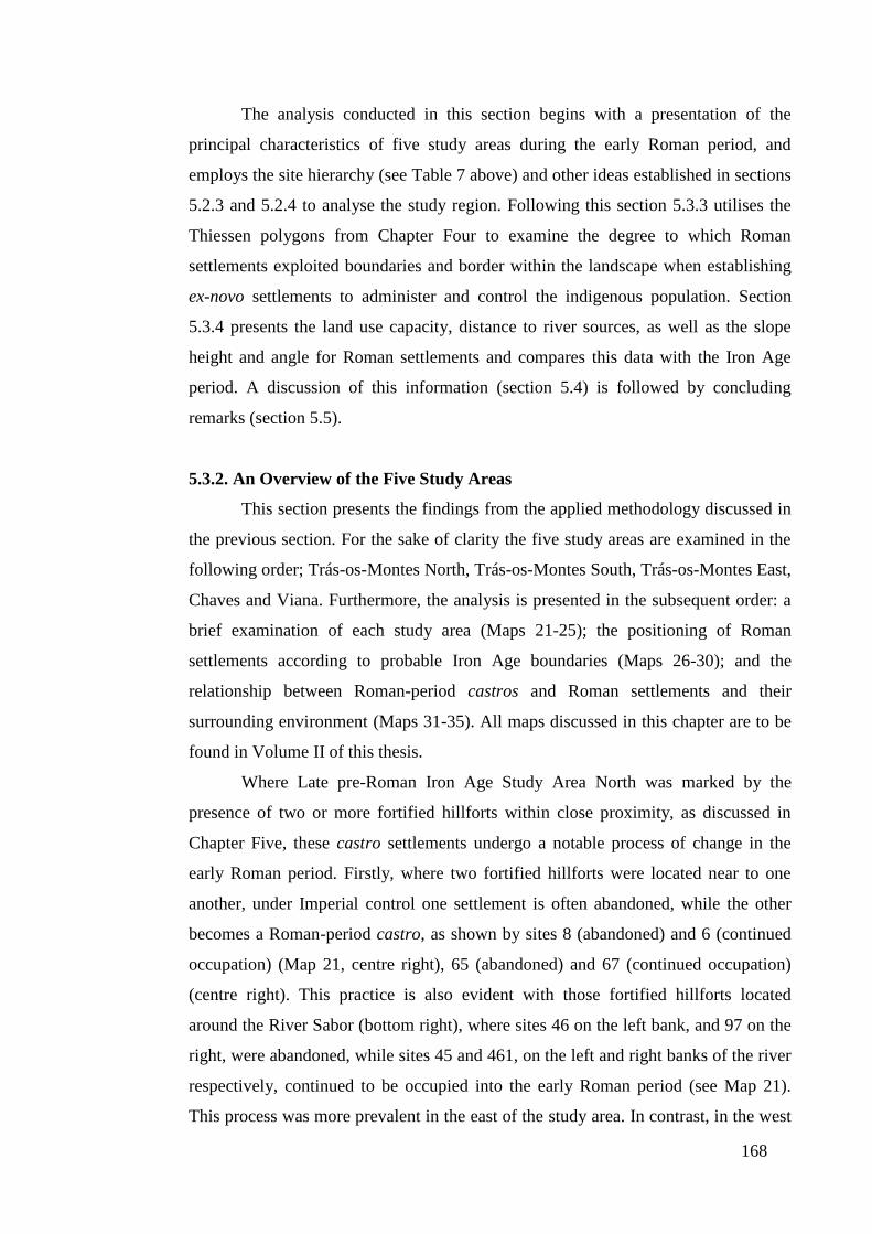
168
The analysis conducted in this section begins with a presentation of the
principal characteristics of five study areas during the early Roman period, and
employs the site hierarchy (see Table 7 above) and other ideas established in sections
5.2.3 and 5.2.4 to analyse the study region. Following this section 5.3.3 utilises the
Thiessen polygons from Chapter Four to examine the degree to which Roman
settlements exploited boundaries and border within the landscape when establishing
ex-novo settlements to administer and control the indigenous population. Section
5.3.4 presents the land use capacity, distance to river sources, as well as the slope
height and angle for Roman settlements and compares this data with the Iron Age
period. A discussion of this information (section 5.4) is followed by concluding
remarks (section 5.5).
5.3.2. An Overview of the Five Study Areas
This section presents the findings from the applied methodology discussed in
the previous section. For the sake of clarity the five study areas are examined in the
following order; Trás-os-Montes North, Trás-os-Montes South, Trás-os-Montes East,
Chaves and Viana. Furthermore, the analysis is presented in the subsequent order: a
brief examination of each study area (Maps 21-25); the positioning of Roman
settlements according to probable Iron Age boundaries (Maps 26-30); and the
relationship between Roman-period castros and Roman settlements and their
surrounding environment (Maps 31-35). All maps discussed in this chapter are to be
found in Volume II of this thesis.
Where Late pre-Roman Iron Age Study Area North was marked by the
presence of two or more fortified hillforts within close proximity, as discussed in
Chapter Five, these castro settlements undergo a notable process of change in the
early Roman period. Firstly, where two fortified hillforts were located near to one
another, under Imperial control one settlement is often abandoned, while the other
becomes a Roman-period castro, as shown by sites 8 (abandoned) and 6 (continued
occupation) (Map 21, centre right), 65 (abandoned) and 67 (continued occupation)
(centre right). This practice is also evident with those fortified hillforts located
around the River Sabor (bottom right), where sites 46 on the left bank, and 97 on the
right, were abandoned, while sites 45 and 461, on the left and right banks of the river
respectively, continued to be occupied into the early Roman period (see Map 21).
This process was more prevalent in the east of the study area. In contrast, in the west

169
of the region, clusters of castro settlements were abandoned en masse during the
early Roman period, for example, sites 234 and 235, 225 and 263 (centre left), 228
and 265 (centre), and the set of three fortified hillforts 232, 254 and 255.
Furthermore, in the far west of Study Area North, only a few fortified hillforts
continued as Roman-period castros (see sites 252, centre left; 210 and 630, bottom
left), in a region where few Roman settlements were established. Only in the north of
the study area did a cluster of castro settlements, sites 258, 273 and 282 (top left),
and 213 and 248 (top centre), continue to exhibit a Late pre-Roman Iron Age
settlement pattern.
Within the region as a whole, Roman-period castros showed a tendency to
occupy the peripheral space of Study Area North, for example site 241 (top left), 166
(bottom centre), 136 (bottom centre), 113 (centre right), while Roman structures
showed a tendency to concentrate in the area between the River Sabor to the right of
the study area, and the River Rabaçal (near to site 226, centre left) to the left. At the
heart of the Roman settlement pattern was the civitas capital of the local tribe, the
Zoelae (Lemos 1993 vol. II, 64-70) (centre, site 43), around which a series of
clustered satellite Roman settlements emerged, for example sites 29, 33 and 36 to the
west, 52, 56 and 59 to the north, and 51, 53 and 87 to the northeast. Within the orbit
of control of the civitas capital and located 12km to the northeast a vicus settlement
(site 17, top right) was established, and most probably populated from abandoned
castros 16, 73, 117, 118, located five or so kilometres to the west. Other important
Roman structures included the statio, or military barracks (site 12, centre right),
located at the strategic junction on the main Roman via, and a mutatio (site 257, top
centre), which was also positioned at the northern bifurcation of the Roman highway.
This process of change within Study Area North was not uniform. A series of
Iron Age castro sites were abandoned in preference for Roman settlements, for
example sites 30 and 31 for settlement 29 (centre), and Iron Age site 2 for nearby
Roman settlement 1. However, a considerable number of Roman-period castros
located in the vicinity of Roman settlements, for example sites 45 and 47 (bottom
right), 60 and 63 (centre right), and 252 and 253 (top left). This strongly suggests
that these Roman-period castros functioned as dynamic settlements during the early
Roman period, after which they were slowly vacated in favour of more ‘Roman-
styled’ structures. The colonisation of the lowland was not confined solely to
establishing Roman settlements, but also farming communities, as shown by the
170
abandonment of Iron Age site 75, and the location of a casal (site 74, top centre), less
than 1km away. Nevertheless, the founding of new agricultural centres through the
relocation of indigenous communities appears to have been limited in practice, as
well in number, with only two villae, located to the south of the civitas capital (sites
102 and 125, bottom centre), contained within the study area.
Study Area South presents a very different set of changes to those evident in
Study Area North. While the close proximity of sites 661 and 662 (Map 22, bottom
right), replicates a similar settlement pattern to that found in Study Area North, with
one site (662) being abandoned, while the other (site 661) continued as a Roman-
period castro. Within the region as a whole there is no discernible pattern for the
abandonment or continued occupation of Iron Age hillforts. Some castros located
near to rivers were vacated, for example sites 822 (bottom left), 545 (centre) and 835
(centre), while others such as sites 600 (centre) and 611 (centre) were not.
Additionally, while many fortified hillforts located away from the fluvial network
were abandoned, such as 532 (bottom centre) and 613 (top centre), others, for
example sites 608 (top right) and 901 (top centre), continued to operate as Roman-
period castros. Nevertheless, to the west of the Rivers Tua (running north to the left
of vicus 549, centre), and Rabaçal (Iron Age site 835 is located on a bend on this
river, centre), the Iron Age settlement pattern remained intact with many fortified
hillforts adapting to become Roman-period castros. Moreover, all of the large hillfort
settlements in this area, sites 806, 802 and 814 continued to be occupied in the early
Roman period, in contrast to other large hillforts within the region, sites 607 (top
right) and 613 (top centre), which were abandoned during the Roman era. Where
large hillfort site 608 (top right) continued to operate as a Roman-period castro, its
relative isolation from both Iron Age and Roman settlements alike, may have ensured
that it continued to be inhabited during the early Roman period.
As with Study Area North, fortified hillforts were abandoned in favour of
lowland Roman settlements, for example abandoned castro 680 and Roman
settlement 681 (bottom right), abandoned hillforts 607, 638 and Roman settlement
and mine 637 (top right), as well as abandoned castro 664 (bottom right) located near
the civitas capital. In tandem with Study Area North, many Roman-period castros
prospered until the first or second centuries AD, after which the community begin to
colonise ‘Roman-style’ settlements, as shown by the close proximity of Roman-
period castros and Roman settlements 842 and 844 (top centre), 773 and 774, 535
171
and 553 (bottom centre), and 740 and 741 (centre right). However, in contrast to
Study Area North, where the Roman settlements concentrated around the civitas
capital and the region between the River Sabor and River Rabaçal, in Study Area
South a more complex pattern emerges. Firstly, to the west of the Rivers Tua and
Rabaçal, a series of fortified hillforts adapted to become Roman-period castros,
while to the south in the first and second centuries a network of casals, villae and
Roman settlements emerged within the landscape. Here, the close proximity of these
Roman settlements and agrarian centres to the Rivers Douro and Tua would have
provided a cheap and effective means of transporting goods and products to
neighbouring provinces and beyond. To the east, the presence of a vicus settlement
(site 549, centre), may have acted as an administrative centre for local agricultural
settlements, while possibly providing some form of administrative control along with
Roman settlement 830 (centre left), over the native communities located to the
northwest.
In Study Area South, another agglomeration of Roman settlements can be
seen in the centre of Map 22 where a villa, site 772, two Roman settlements 735 and
774, and two casals 770 and 771 are located within an area of 7km2. Of considerable
interest here is Roman settlement 744 where a granite berrão, a zoomorphic structure
in the form of boar/pig (see section 3.6.3) as well as a series of gold torques similar
in style and form to those in Figure 24 (section 3.6.2) were found, which now form
part of the collection of the Museu Nacional de Arqueologia in Lisbon. The dating of
these torques to the Middle Iron Age (sixth century BC – second century BC),
suggests that they were brought from the nearby Roman-period castro (site 773)
probably when the hillfort was abandoned, but this is assumption is very based on the
relative distance between settlements 773 and the Roman settlement of Tamancas
(site 744), which are located a few hundred metres apart. With respect to the torques
(I shall discuss the berrãos in greater detail in Chapter Seven) their presence within a
‘Roman’ context suggests that these gold artefacts most likely continued to play an
important symbolic role for their owner/s during the early Roman period, as they had
done for previous generations in the Iron Age.
In the bottom right of the diagram, a cluster of Roman settlements along with
a casal were established between 1.5 and 3km from the River Douro. Farther north
are two casals, sites 641 and 644, which probably supplied the workers of the nearby
iron ore mine (site 640), while Roman settlement 655, located on the Douro, most
172
likely functioned as an entrepôt for the shipment of ore. To the north of this mining
area is the civitas capital (the civitas Baniensium), located on the strategic confluence
of the Rivers da Vilariça and Sabor, and within 5km of the River Douro. Integrated
into the settlement pattern was the main road, which ran north and joined with the
Roman via whose trajectory linked the civitas Zoelarum in Study Area North with
Aquae Flaviae to the west. Peppered around this Roman highway a series of casals
and villae emerged, which would have supplied the civitas capital and nearby Roman
settlements, and utilised both the main Roman road and the River Douro to transport
their produce. The trajectory of the Roman road continued north running close to a
series of mines, sites 627, 730 and 760 (centre right).
Study Area East is dominated by the River Douro and the River Sabor, which
provided for three distinct zones of occupation during the Late pre-Roman Iron Age.
The first of these was the area close to the River Douro along which a series of
fortified hillforts were located during the Late pre-Roman Iron Age, but abandoned,
with the exception of medium-sized castro 430 (Map 23, centre), during the early
Roman period. Secondly, in the region between the River Douro and the Sabor
further inland, where a series of Iron Age structures dominated the Iron Age
landscape, three fortified hillforts, sites 391, 323 and 302 (top right) continue as
Roman-period castros, as do a cluster of fortified hillforts, sites 358, 364, 374, 386,
389 and 426 (centre), of which 364, 386 and 426 are medium-sized castros. As with
the area to the west of Study Area South, the Iron Age settlement pattern appears to
have been preserved, with a small enclave of medium-sized hillforts located in the
centre of the diagram, perhaps continuing to exert an element of control over the
smaller Iron Age structures in this area. Furthermore, the close proximity of these
hillforts to the main Roman road implies that this terrestrial routeway may have
played an important role in preserving this network of indigenous settlements.
Equally, the abandonment of those hillforts on the tributaries of the River Sabor
suggest the fluvial network now played a secondary role to terrestrial forms of
communication in the early Roman period. Within the region to the north of the
River Sabor, a few Roman structures emerged adjacent to Iron Age ones, for
example, Roman settlement 159 adjoining castro site 160 (top left) and fortified
hillfort 512 next to casal 516 (top left), but there was also a process of ex-novo
Roman settlements being established adjacent to the river system (see sites 173 and
377, top left).
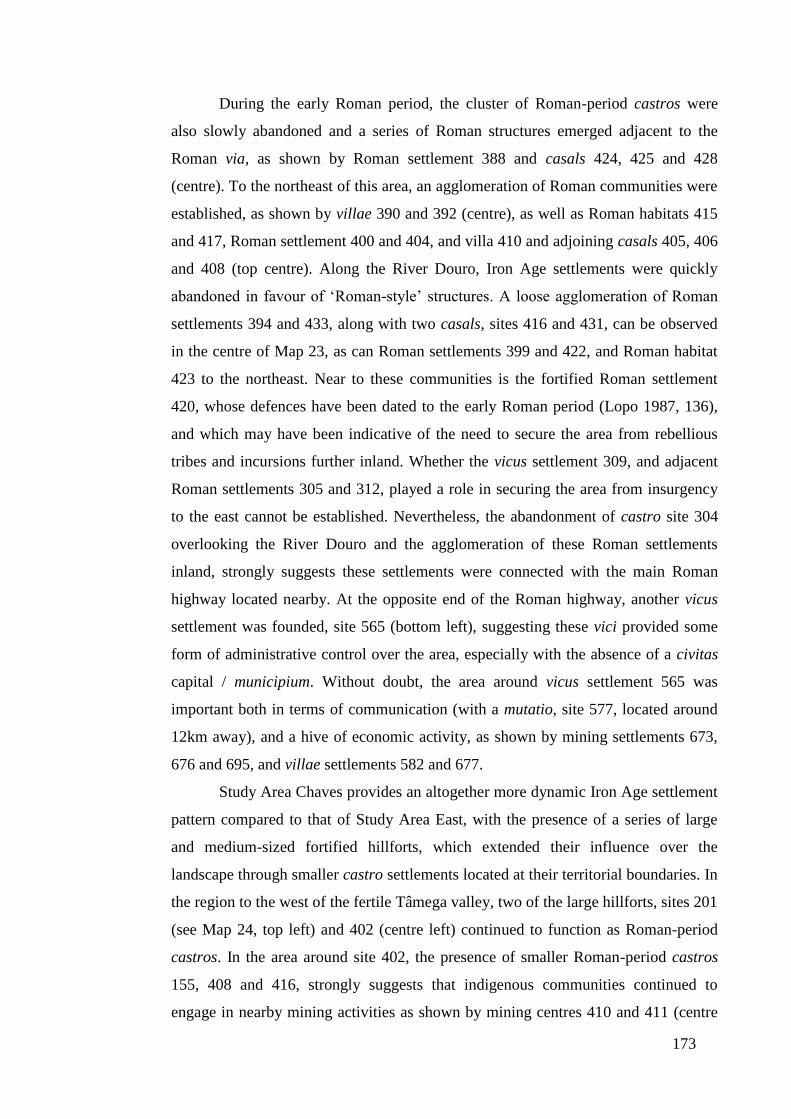
173
During the early Roman period, the cluster of Roman-period castros were
also slowly abandoned and a series of Roman structures emerged adjacent to the
Roman via, as shown by Roman settlement 388 and casals 424, 425 and 428
(centre). To the northeast of this area, an agglomeration of Roman communities were
established, as shown by villae 390 and 392 (centre), as well as Roman habitats 415
and 417, Roman settlement 400 and 404, and villa 410 and adjoining casals 405, 406
and 408 (top centre). Along the River Douro, Iron Age settlements were quickly
abandoned in favour of ‘Roman-style’ structures. A loose agglomeration of Roman
settlements 394 and 433, along with two casals, sites 416 and 431, can be observed
in the centre of Map 23, as can Roman settlements 399 and 422, and Roman habitat
423 to the northeast. Near to these communities is the fortified Roman settlement
420, whose defences have been dated to the early Roman period (Lopo 1987, 136),
and which may have been indicative of the need to secure the area from rebellious
tribes and incursions further inland. Whether the vicus settlement 309, and adjacent
Roman settlements 305 and 312, played a role in securing the area from insurgency
to the east cannot be established. Nevertheless, the abandonment of castro site 304
overlooking the River Douro and the agglomeration of these Roman settlements
inland, strongly suggests these settlements were connected with the main Roman
highway located nearby. At the opposite end of the Roman highway, another vicus
settlement was founded, site 565 (bottom left), suggesting these vici provided some
form of administrative control over the area, especially with the absence of a civitas
capital / municipium. Without doubt, the area around vicus settlement 565 was
important both in terms of communication (with a mutatio, site 577, located around
12km away), and a hive of economic activity, as shown by mining settlements 673,
676 and 695, and villae settlements 582 and 677.
Study Area Chaves provides an altogether more dynamic Iron Age settlement
pattern compared to that of Study Area East, with the presence of a series of large
and medium-sized fortified hillforts, which extended their influence over the
landscape through smaller castro settlements located at their territorial boundaries. In
the region to the west of the fertile Tâmega valley, two of the large hillforts, sites 201
(see Map 24, top left) and 402 (centre left) continued to function as Roman-period
castros. In the area around site 402, the presence of smaller Roman-period castros
155, 408 and 416, strongly suggests that indigenous communities continued to
engage in nearby mining activities as shown by mining centres 410 and 411 (centre
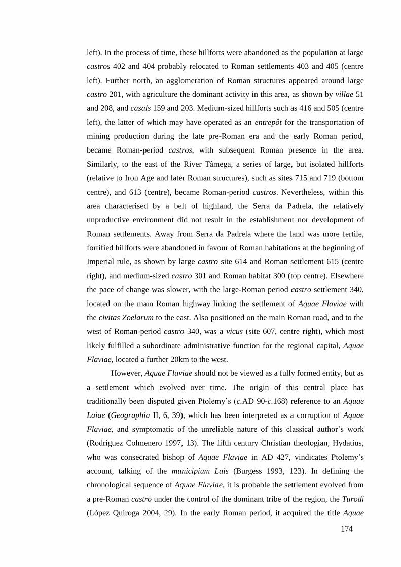
174
left). In the process of time, these hillforts were abandoned as the population at large
castros 402 and 404 probably relocated to Roman settlements 403 and 405 (centre
left). Further north, an agglomeration of Roman structures appeared around large
castro 201, with agriculture the dominant activity in this area, as shown by villae 51
and 208, and casals 159 and 203. Medium-sized hillforts such as 416 and 505 (centre
left), the latter of which may have operated as an entrepôt for the transportation of
mining production during the late pre-Roman era and the early Roman period,
became Roman-period castros, with subsequent Roman presence in the area.
Similarly, to the east of the River Tâmega, a series of large, but isolated hillforts
(relative to Iron Age and later Roman structures), such as sites 715 and 719 (bottom
centre), and 613 (centre), became Roman-period castros. Nevertheless, within this
area characterised by a belt of highland, the Serra da Padrela, the relatively
unproductive environment did not result in the establishment nor development of
Roman settlements. Away from Serra da Padrela where the land was more fertile,
fortified hillforts were abandoned in favour of Roman habitations at the beginning of
Imperial rule, as shown by large castro site 614 and Roman settlement 615 (centre
right), and medium-sized castro 301 and Roman habitat 300 (top centre). Elsewhere
the pace of change was slower, with the large-Roman period castro settlement 340,
located on the main Roman highway linking the settlement of Aquae Flaviae with
the civitas Zoelarum to the east. Also positioned on the main Roman road, and to the
west of Roman-period castro 340, was a vicus (site 607, centre right), which most
likely fulfilled a subordinate administrative function for the regional capital, Aquae
Flaviae, located a further 20km to the west.
However, Aquae Flaviae should not be viewed as a fully formed entity, but as
a settlement which evolved over time. The origin of this central place has
traditionally been disputed given Ptolemy’s (c.AD 90-c.168) reference to an Aquae
Laiae (Geographia II, 6, 39), which has been interpreted as a corruption of Aquae
Flaviae, and symptomatic of the unreliable nature of this classical author’s work
(Rodríguez Colmenero 1997, 13). The fifth century Christian theologian, Hydatius,
who was consecrated bishop of Aquae Flaviae in AD 427, vindicates Ptolemy’s
account, talking of the municipium Lais (Burgess 1993, 123). In defining the
chronological sequence of Aquae Flaviae, it is probable the settlement evolved from
a pre-Roman castro under the control of the dominant tribe of the region, the Turodi
(López Quiroga 2004, 29). In the early Roman period, it acquired the title Aquae
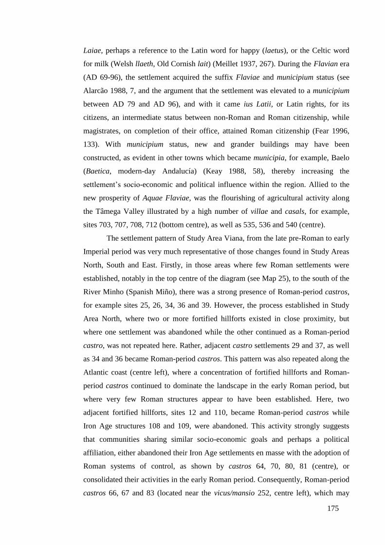
175
Laiae, perhaps a reference to the Latin word for happy (laetus), or the Celtic word
for milk (Welsh llaeth, Old Cornish lait) (Meillet 1937, 267). During the Flavian era
(AD 69-96), the settlement acquired the suffix Flaviae and municipium status (see
Alarcão 1988, 7, and the argument that the settlement was elevated to a municipium
between AD 79 and AD 96), and with it came ius Latii, or Latin rights, for its
citizens, an intermediate status between non-Roman and Roman citizenship, while
magistrates, on completion of their office, attained Roman citizenship (Fear 1996,
133). With municipium status, new and grander buildings may have been
constructed, as evident in other towns which became municipia, for example, Baelo
(Baetica, modern-day Andalucía) (Keay 1988, 58), thereby increasing the
settlement’s socio-economic and political influence within the region. Allied to the
new prosperity of Aquae Flaviae, was the flourishing of agricultural activity along
the Tâmega Valley illustrated by a high number of villae and casals, for example,
sites 703, 707, 708, 712 (bottom centre), as well as 535, 536 and 540 (centre).
The settlement pattern of Study Area Viana, from the late pre-Roman to early
Imperial period was very much representative of those changes found in Study Areas
North, South and East. Firstly, in those areas where few Roman settlements were
established, notably in the top centre of the diagram (see Map 25), to the south of the
River Minho (Spanish Miño), there was a strong presence of Roman-period castros,
for example sites 25, 26, 34, 36 and 39. However, the process established in Study
Area North, where two or more fortified hillforts existed in close proximity, but
where one settlement was abandoned while the other continued as a Roman-period
castro, was not repeated here. Rather, adjacent castro settlements 29 and 37, as well
as 34 and 36 became Roman-period castros. This pattern was also repeated along the
Atlantic coast (centre left), where a concentration of fortified hillforts and Roman-
period castros continued to dominate the landscape in the early Roman period, but
where very few Roman structures appear to have been established. Here, two
adjacent fortified hillforts, sites 12 and 110, became Roman-period castros while
Iron Age structures 108 and 109, were abandoned. This activity strongly suggests
that communities sharing similar socio-economic goals and perhaps a political
affiliation, either abandoned their Iron Age settlements en masse with the adoption of
Roman systems of control, as shown by castros 64, 70, 80, 81 (centre), or
consolidated their activities in the early Roman period. Consequently, Roman-period
castros 66, 67 and 83 (located near the vicus/mansio 252, centre left), which may
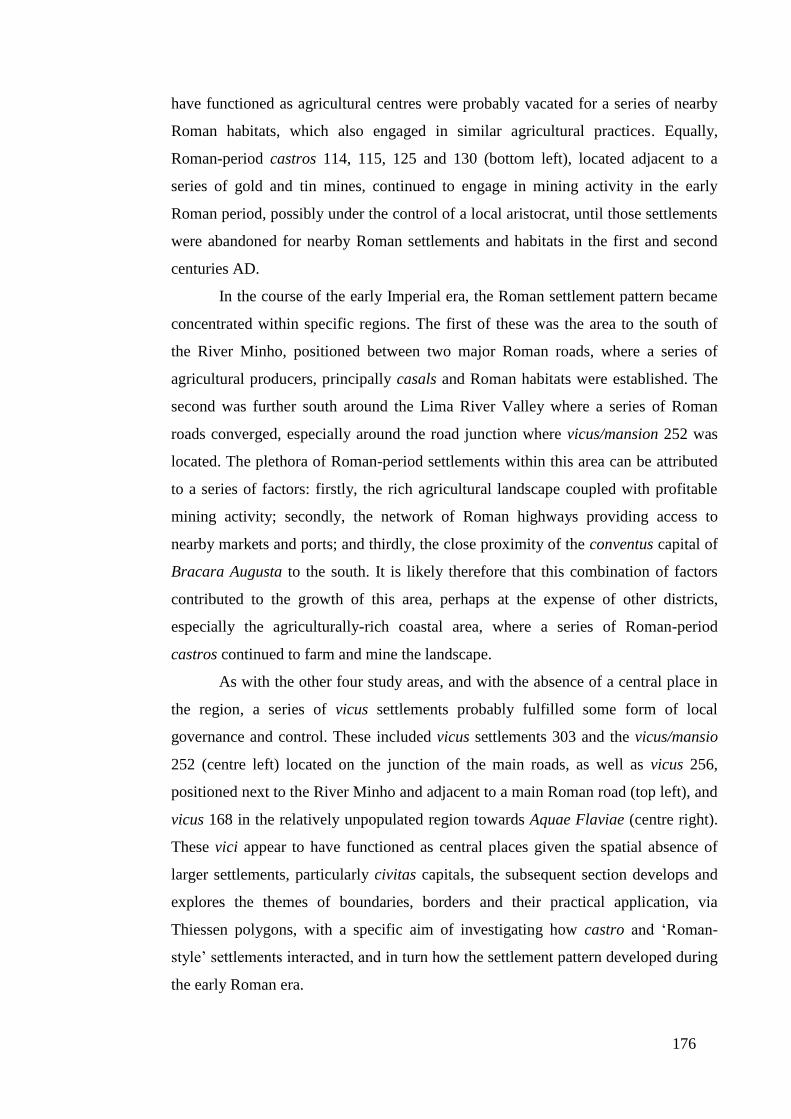
176
have functioned as agricultural centres were probably vacated for a series of nearby
Roman habitats, which also engaged in similar agricultural practices. Equally,
Roman-period castros 114, 115, 125 and 130 (bottom left), located adjacent to a
series of gold and tin mines, continued to engage in mining activity in the early
Roman period, possibly under the control of a local aristocrat, until those settlements
were abandoned for nearby Roman settlements and habitats in the first and second
centuries AD.
In the course of the early Imperial era, the Roman settlement pattern became
concentrated within specific regions. The first of these was the area to the south of
the River Minho, positioned between two major Roman roads, where a series of
agricultural producers, principally casals and Roman habitats were established. The
second was further south around the Lima River Valley where a series of Roman
roads converged, especially around the road junction where vicus/mansion 252 was
located. The plethora of Roman-period settlements within this area can be attributed
to a series of factors: firstly, the rich agricultural landscape coupled with profitable
mining activity; secondly, the network of Roman highways providing access to
nearby markets and ports; and thirdly, the close proximity of the conventus capital of
Bracara Augusta to the south. It is likely therefore that this combination of factors
contributed to the growth of this area, perhaps at the expense of other districts,
especially the agriculturally-rich coastal area, where a series of Roman-period
castros continued to farm and mine the landscape.
As with the other four study areas, and with the absence of a central place in
the region, a series of vicus settlements probably fulfilled some form of local
governance and control. These included vicus settlements 303 and the vicus/mansio
252 (centre left) located on the junction of the main roads, as well as vicus 256,
positioned next to the River Minho and adjacent to a main Roman road (top left), and
vicus 168 in the relatively unpopulated region towards Aquae Flaviae (centre right).
These vici appear to have functioned as central places given the spatial absence of
larger settlements, particularly civitas capitals, the subsequent section develops and
explores the themes of boundaries, borders and their practical application, via
Thiessen polygons, with a specific aim of investigating how castro and ‘Roman-
style’ settlements interacted, and in turn how the settlement pattern developed during
the early Roman era.
177
5.3.3. Thiessen Polygons, Borders and Boundaries
In analysing the impact of the early Roman administration on late pre-Roman
communities, this chapter utilises the multiscalar Thiessen polygons generated in the
previous chapter for all castro settlements, medium and large hillforts and large
hillforts. Firstly, this information is utilised to examine the degree to which Roman
settlements were located within the landscape to administer and control the
indigenous population, as well as to exploit neutral territory, when establishing ex-
novo settlements (see section 1.5.7). Secondly, Roman period boundary markers
found in Study Area Chaves are analysed against tessellated polygons to investigate
how fortified hillforts were organised in the early Imperial landscape, and to examine
how those borders and boundaries changed with the emergence of Roman
settlements.
5.3.3.1. Analysis of Thiessen Polygons, Borders and Boundaries
Analysis of the impact of early Roman systems of control and administration
on the late pre-Roman landscape was conducted by projecting the early Roman
settlement pattern over the multiscalar tessellated Thiessen polygons generated in the
previous chapter. In Study Area North, as with the other study areas, the
abandonment of castro settlements and the subsequent colonisation of adjacent
space, often in the form of a Roman settlement or agricultural centre, did not provide
any notable change in the landscape. Where change is more evident, is in the
establishment of ex-novo settlements, especially the civitas capital, site 43 (Map 26,
centre), and vicus site 17 (top right), which are both positioned on the boundaries of
medium-sized castros. Nevertheless, it is important to acknowledge that the civitas
capital may have functioned as a pre-Roman central place (discussed in greater detail
in the Chapter Six), and for this reason, will exhibit the spatial characteristics of a
pre-Roman settlement. Equally, we must query whether Roman settlements 5 (top
right), and 226 (centre left), were positioned along Iron Age boundaries or next to
established rivers, or both. Other Roman settlements, sites 80 (bottom right) and 137
(bottom centre), are both positioned at the territorial limits of small castro
settlements, but it is difficult to establish any coherent pattern here. In contrast, villae
settlements 102 and 125 (bottom right), and casals 264 and 269 (centre left), are all
located on or near to boundaries generated from small fortified hillforts. It is
therefore possible that neighbouring communities pooled their resources in the early
178
Roman period, and in abandoning their fortified settlement established agricultural
centres on their territorial boundaries.
As with Study Area North, a series of casals in Study Area South (Map 27)
can be found at the territorial boundaries of Iron Age settlements, notably sites 770
and 771 (centre right), and site 739 (centre). Nevertheless, other casals and villae
within the region are often found away from Iron Age boundaries, suggesting that
agricultural centres did not necessarily emerge on the margins of abandoned Iron
Age settlements, as seen in Study Area North. However, to the east of Map 27, where
few Roman structures were established and where the pre-Roman settlement pattern
continued to be dominated by large Roman-period castros, sites 802, 806 and 814
(bottom left), the location of Roman settlement 830, at the junction of the multiscalar
Thiessen polygons, suggests the settlement fulfilled a strategic role. To the southeast
of site 830, vicus settlement 549, is also located on the boundary of medium-sized
hillfort 532 and large castro 806, suggesting the vicus functioned as an
administrative centre, providing strategic control over the region, especially given
the absence of a civitas capital in the area.
In Study Area East (Map 28), a more complex settlement pattern emerges
with a series of Roman settlements positioned at boundary points, for example, 324
(top right), 404 (top centre) and 377 (top left), and Roman habitats 417 and 423 (top
right) and 560 (bottom left), but equally, other Roman settlements and habitats can
be found located away from possible boundaries. In the case of agricultural centres,
however, a greater number are located at the margins of Iron Age territory. This can
be shown in the top centre of the diagram, where all castros were abandoned in the
early Roman period, but where a cluster of casals 405, 406, 408 and villa 410,
emerged along those pre-Roman boundaries generated from all Iron Age settlements
(in black) or medium and large hillforts (in blue). This practice is further repeated to
the south where two villae, sites 390 and 392, are located on the boundaries of a
series of abandoned fortified hillforts. In other regions, notably in the centre of the
diagram, a similar pattern emerges with a series of casals, sites 381, 382, 425 and
426, all positioned near to the boundaries of Roman-period castros. This suggests, as
with Study Area North, that in the early Roman period fortified hillforts were
abandoned with multiple communities establishing agricultural centres along original
pre-Roman territorial margins. Within these regions the pace of change varied with
casals and villae becoming established throughout the early Roman period.

179
Moreover, many of these structures most likely developed over time from farms to
villae, while others did not. In the case of villa 390 (centre), the early terra sigillata
hispanica and an as from the period of Emperor Vitellius (AD 69), dates the
structure to between the mid to late first century. The villa appears not to have
developed from a simple earlier structure, but rather to have been a purpose-built
luxury residence, as shown by the structure’s columns and established floorplan
(Lemos and Marcos 1985, 143-148).
In Study Area Chaves (Map 29), only a few structures are positioned on Iron
Age boundaries. Among these is vicus settlement 607 (centre right), which is located
on those tessellated Thiessen polygons generated for medium-sized and large castro
settlements. The vicus in this study area may have functioned as an administrative
and strategic centre for the nearby centre at Aquae Flaviae, and thereby fulfilled a
similar role to the vicus settlement in Study Area South, which most likely operated
as a subordinate settlement to the adjacent civitas capital. Other structures grouped
around spatial boundaries can be found in the bottom centre of the diagram, with a
series of casals 703, 707, 708, 712, 713, and to the west casal 705 and villa 704.
However, the limited number of early Roman settlements located on the territorial
margins of Iron Age hillforts suggests that other criteria may have been responsible
for the clustering of these agricultural producers, such as terrestrial communication
systems and the quality of the land.
Lastly, contained within Map 29 are a series of boundary markers. The first
(site 213, centre left), is a divisional marker recorded on a granite stone with the
inscription TERM(inus) / CL. While the divisional markers are Roman in origin,
Terminus being the Roman god who protected boundary markers, it is possible these
territorial delineators established by Roman administrators represent Late Iron Age
margins of control. Certainly, the location of the inscription itself closely
corresponds with the computer-generated Thiessen polygon for all settlements (in
black), suggesting that the inscription was a territorial divider between two adjacent
hillforts. Similarly, site 515 (centre), adjacent to the River Tâmega, represents the
location where a series of four granite stones were found, each with the carved
inscription PRAEN and COROC (CIL II, 2489) on opposing sides, as discussed in
detail in section 4.7. While these boundary markers correspond to a series of
Thiessen polygons generated for all settlements, it is more likely the inscriptions
represented the territorial divisions of the medium-sized hillforts located further

180
south, sites 548 and 505 (Silva 1986, 275). Of considerable interest therefore is the
exact location of these boundary markers, given that they are not positioned
equidistant between both castro settlements, but offset to the north. While the
inscribed granite markers are located at the boundary of three settlements, sites 261,
505 and 548, a fourth, would help to explain why four stone markers were
constructed, each inscribed with the names PRAEN and COROC on opposite sides.
That fourth settlement may have been the site which would become Aquae Flaviae,
and which was most likely a pre-Roman oppidum (Ptol. II, 6, 39). Nevertheless, the
exact layout of the inscribed stones is not known, and whether they radiated out as
points on a compass or took another form cannot be established. What can be
established is that medium-sized castros strategically dominated the landscape, as
suggested in the previous chapter, and that supra-familial groupings, such as the
PRAEN and COROC, represent two of these lineage-based communities. A third
boundary marker, site 803, can be found at the bottom centre of Map 29, on a granite
stone with the word TERMIN(us) inscribed at the centre, with the text OBILI(um)
facing east, and TREB(ilium) facing west. According to Rodríguez Colmenero (1987,
641-642), this boundary marker located near to a level four river relates to the
familial grouping of the Teburos or Treilios and the Obilios, and may be
representative of competing kinship groupings.
The final region to be examined here, Study Area Viana (Map 30), does not
present any coherent relationship between Iron Age boundaries and early Roman-
period settlements and agricultural centres. Additionally, in contrast to Study Areas
North, South and Chaves where vicus settlements were located on the territorial
boundaries of fortified hillforts, the early Imperial settlement pattern is more
representative of two spatial concentrations, one to the south within access of
Bracara Augusta and the other to the north near the River Minho, with each region
heavily integrated and reliant on the Roman arterial road network.
5.3.4. Roman Northwest Iberia and the Importance of the Physical Environment
This section examines the role of the productivity of the land and the
importance of the fluvial network in determining the pattern and structure of early
Roman settlements within the five study areas. In many ways, the scheme of analysis
follows a similar trajectory to the previous chapter, Chapter Four, and makes
extensive use of the different soil types to establish how; (a) different practices

181
emerged between the Late Iron Age and early Roman period; and (b) how the five
study areas differed in their adaption to Roman agricultural and commercial needs.
As with the analysis conducted in Chapter Four, Table 8 presents a breakdown of soil
versus total area, but in this case for Roman sites.
Study Area/ Soil Type A C F A/C A/F C/F Area / Number of Sites
North
Km2 101.8 6.8 1453 11 140.8 52.8 1766km2
North Roman sites 2 0 17 1 6 3 29 sites
South
Km2 116.3 63.3 1218.7 5.5 138.3 200 1742km2
South Roman sites 6 6 38 0 5 8 63 sites
East
Km2 126.8 0 1250.6 0 208.2 46.9 1633km2
East Roman sites 4 0 41 0 6 1 52 sites
Chaves
Km2 171.1 4.6 515.1 5.4 270.7 101.5 1068km2
Chaves Roman sites 24 0 21 1 20 13 79 sites
Viana
Km2 370.2 265.9 1250 26.5 10.9 19.1 1943km2
Viana Roman sites 65 20 60 2 0 1 148
Table 8. Land Use Capacity for the five study areas.
These Figures were then converted into percentages as shown in Table 9 below.
Study Area/ Soil Type A C F A/C A/F C/F
North
Km2 / % 5.8 0.4 82.3 0.6 8 3
North Roman sites / % 6.9 0 58.6 3.4 20.7 10.3
South
Km2 / % 6.7 3.6 70 0.3 11.5 11.5
South Roman site/ % 9.5 9.5 60.3 0 7.9 12.7
East
Km2 / % 7.8 0 76.6 0 12.8 2.9
East Roman site/ % 7.7 0 78.8 0 11.5 1.9
Chaves
Km2 / % 16 0.4 48.2 0.5 25.3 9.5
Chaves Roman site/ % 30.3 0 26.6 1.3 25.3 16.4
Viana Km2
/ % 19.1 13.7 64.3 1.4 0.56 1.0
Viana Roman site/ % 44.9 13.5 40.5 1.4 0 0.7
Table 9. Percentages of Land Use Capacity for the five study areas.
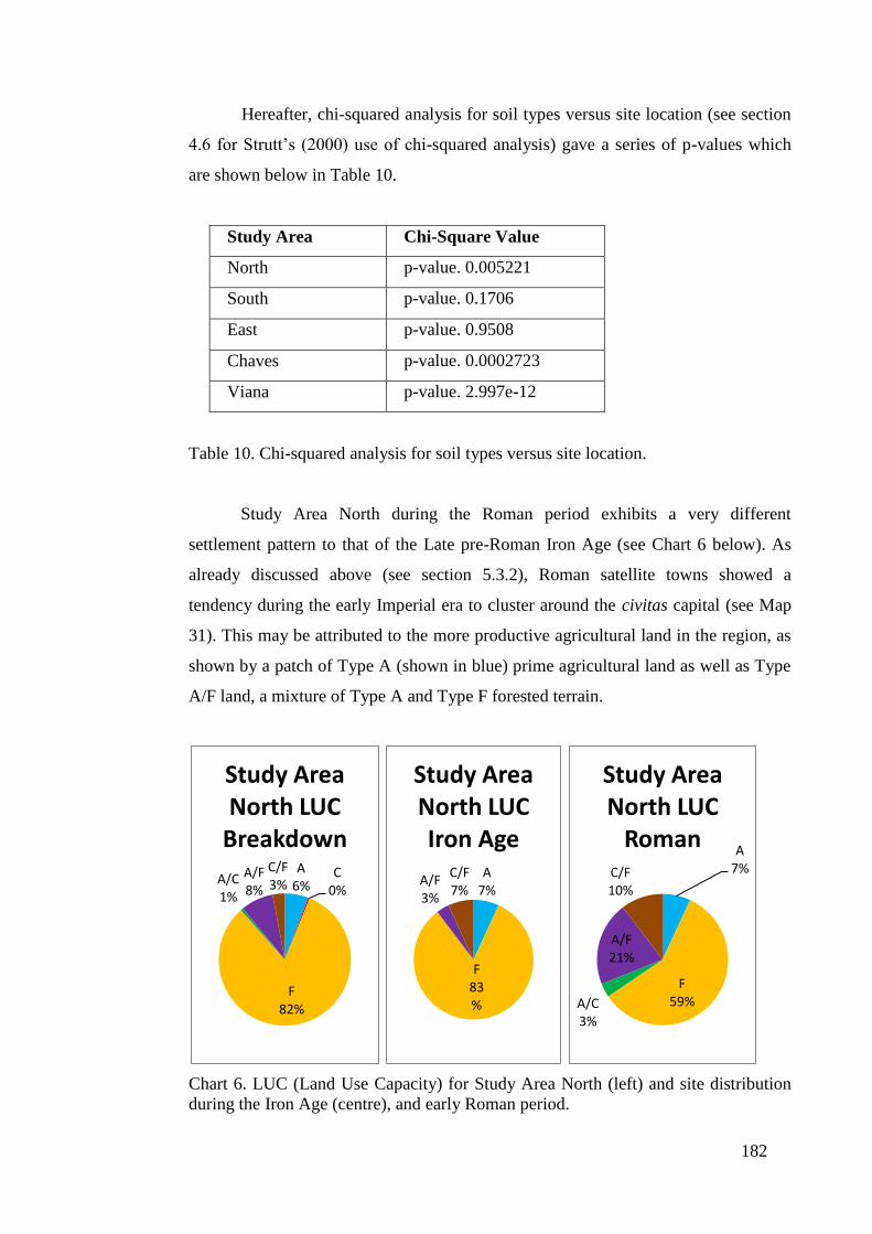
182
Hereafter, chi-squared analysis for soil types versus site location (see section
4.6 for Strutt’s (2000) use of chi-squared analysis) gave a series of p-values which
are shown below in Table 10.
Study Area Chi-Square Value
North p-value. 0.005221
South p-value. 0.1706
East p-value. 0.9508
Chaves p-value. 0.0002723
Viana p-value. 2.997e-12
Table 10. Chi-squared analysis for soil types versus site location.
Study Area North during the Roman period exhibits a very different
settlement pattern to that of the Late pre-Roman Iron Age (see Chart 6 below). As
already discussed above (see section 5.3.2), Roman satellite towns showed a
tendency during the early Imperial era to cluster around the civitas capital (see Map
31). This may be attributed to the more productive agricultural land in the region, as
shown by a patch of Type A (shown in blue) prime agricultural land as well as Type
A/F land, a mixture of Type A and Type F forested terrain.
Chart 6. LUC (Land Use Capacity) for Study Area North (left) and site distribution
during the Iron Age (centre), and early Roman period.
A 6%
C 0%
F 82%
A/C 1%
A/F 8%
C/F 3%
Study Area North LUC
Breakdown A
7%
F 83%
A/F 3%
C/F 7%
Study Area North LUC Iron Age
A 7%
F 59% A/C
3%
A/F 21%
C/F 10%
Study Area North LUC
Roman

183
Chart 6, shows that only 59% (17/29) of Roman structures are located on
forested land (Type F), in comparison with 83% (72/87) of Iron Age hillforts (note
that data for a comparative analysis of Iron Age and Roman settlements conducted
for the five study areas comes from Table 4 in section 4.7.3 and Table 9 above,
respectively). Consequently, a greater percentage of Roman sites are located on Type
A/F land (21%), in comparison to only 3% of Iron Age sites. Roman settlements
locating next to Type A/F land make up 45% of the dataset, while this figure falls to
32% for Iron Age settlements.
Of considerable interest is the chi-squared analysis which returned a p-value
of 0.005221 and therefore rejects the null hypothesis. This is a result of the extensive
use of agricultural land, particularly Type A/F, which makes up 8% of the total land
in Study Area North but represents 21% of land utilised in the early Roman period.
The same can be said for Type A/C and C/F terrain, which results in a reduction of
the use of Type F land. This suggests that the civitas Zoelarum, and the Iron Age
settlement on this site, may have made extensive use of the limited good quality land
in the area and explains why a series of satellite towns developed around the civitas
capital. However, good farming land is limited in Study Area North and this may
justify why the region never appeared to prosper.
Chart 7. LUC (Land Use Capacity) for Study Area South (left) and site distribution
during the Iron Age (centre), and early Roman period.
A 7%
C 4%
F 70%
A/C 0%
A/F 8%
C/F 11%
Study Area South LUC
Breakdown A
1% C
5%
F 69%
A/F 10%
C/F 15%
Study Area South LUC Iron Age
A 9%
C 10%
F 60%
A/F 8%
C/F 13%
Study Area South LUC
Roman
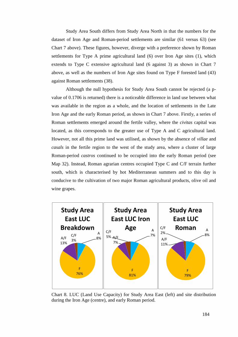
184
Study Area South differs from Study Area North in that the numbers for the
dataset of Iron Age and Roman-period settlements are similar (61 versus 63) (see
Chart 7 above). These figures, however, diverge with a preference shown by Roman
settlements for Type A prime agricultural land (6) over Iron Age sites (1), which
extends to Type C extensive agricultural land (6 against 3) as shown in Chart 7
above, as well as the numbers of Iron Age sites found on Type F forested land (43)
against Roman settlements (38).
Although the null hypothesis for Study Area South cannot be rejected (a p-
value of 0.1706 is returned) there is a noticeable difference in land use between what
was available in the region as a whole, and the location of settlements in the Late
Iron Age and the early Roman period, as shown in Chart 7 above. Firstly, a series of
Roman settlements emerged around the fertile valley, where the civitas capital was
located, as this corresponds to the greater use of Type A and C agricultural land.
However, not all this prime land was utilised, as shown by the absence of villae and
casals in the fertile region to the west of the study area, where a cluster of large
Roman-period castros continued to be occupied into the early Roman period (see
Map 32). Instead, Roman agrarian centres occupied Type C and C/F terrain further
south, which is characterised by hot Mediterranean summers and to this day is
conducive to the cultivation of two major Roman agricultural products, olive oil and
wine grapes.
Chart 8. LUC (Land Use Capacity) for Study Area East (left) and site distribution
during the Iron Age (centre), and early Roman period.
A 8%
F 76%
A/F 13%
C/F 3%
Study Area East LUC
Breakdown A 7%
F 81%
A/F 7%
C/F 5%
Study Area East LUC Iron
Age A 8%
F 79%
A/F 11%
C/F 2%
Study Area East LUC Roman
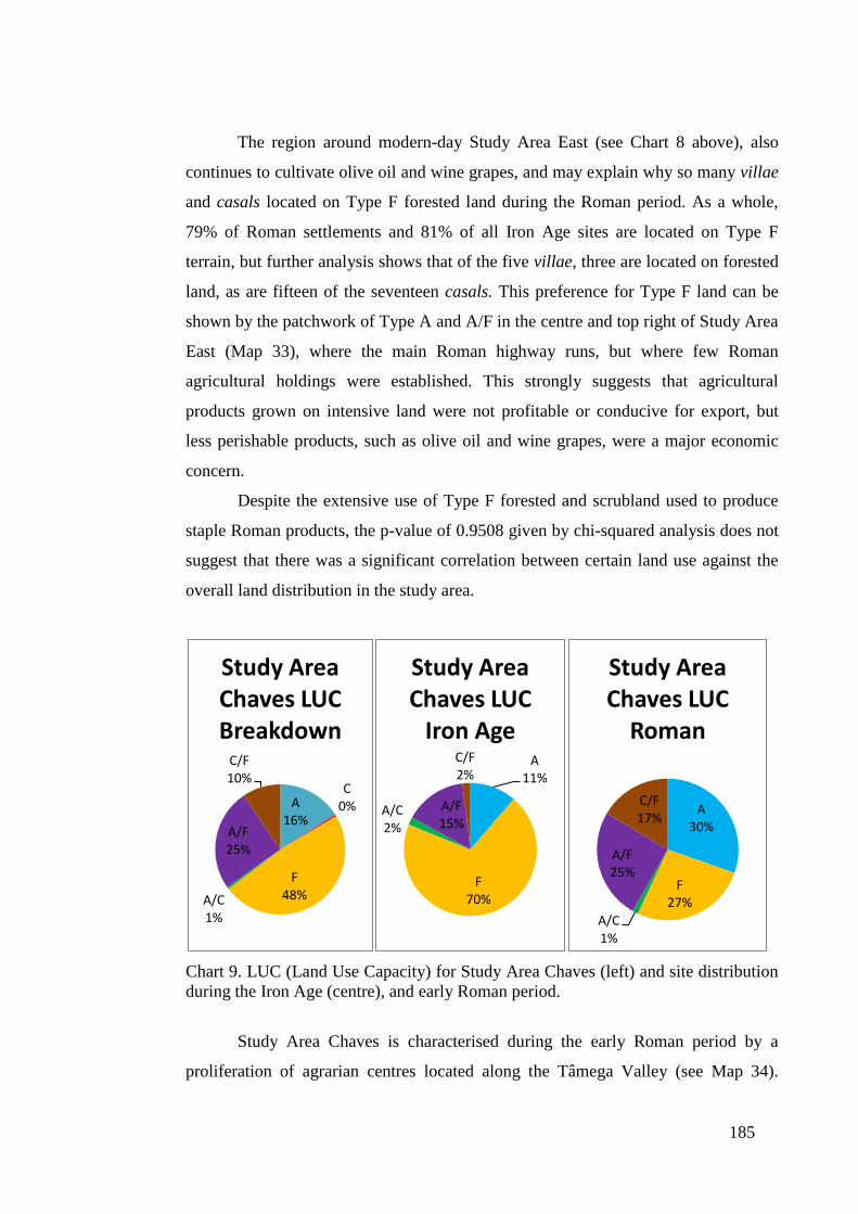
185
The region around modern-day Study Area East (see Chart 8 above), also
continues to cultivate olive oil and wine grapes, and may explain why so many villae
and casals located on Type F forested land during the Roman period. As a whole,
79% of Roman settlements and 81% of all Iron Age sites are located on Type F
terrain, but further analysis shows that of the five villae, three are located on forested
land, as are fifteen of the seventeen casals. This preference for Type F land can be
shown by the patchwork of Type A and A/F in the centre and top right of Study Area
East (Map 33), where the main Roman highway runs, but where few Roman
agricultural holdings were established. This strongly suggests that agricultural
products grown on intensive land were not profitable or conducive for export, but
less perishable products, such as olive oil and wine grapes, were a major economic
concern.
Despite the extensive use of Type F forested and scrubland used to produce
staple Roman products, the p-value of 0.9508 given by chi-squared analysis does not
suggest that there was a significant correlation between certain land use against the
overall land distribution in the study area.
Chart 9. LUC (Land Use Capacity) for Study Area Chaves (left) and site distribution
during the Iron Age (centre), and early Roman period.
Study Area Chaves is characterised during the early Roman period by a
proliferation of agrarian centres located along the Tâmega Valley (see Map 34).
A 16%
C 0%
F 48% A/C
1%
A/F 25%
C/F 10%
Study Area Chaves LUC Breakdown
A 11%
F 70%
A/C 2%
A/F 15%
C/F 2%
Study Area Chaves LUC
Iron Age
A 30%
F 27%
A/C 1%
A/F 25%
C/F 17%
Study Area Chaves LUC
Roman
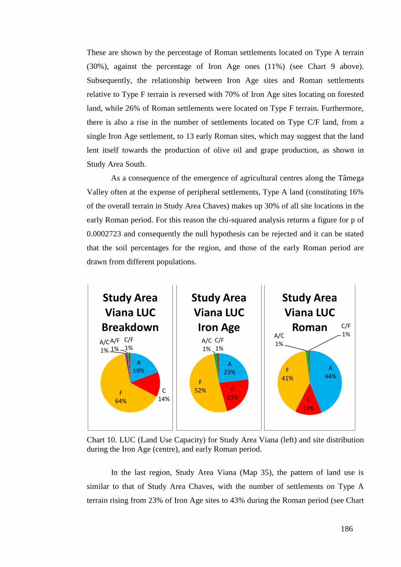
186
These are shown by the percentage of Roman settlements located on Type A terrain
(30%), against the percentage of Iron Age ones (11%) (see Chart 9 above).
Subsequently, the relationship between Iron Age sites and Roman settlements
relative to Type F terrain is reversed with 70% of Iron Age sites locating on forested
land, while 26% of Roman settlements were located on Type F terrain. Furthermore,
there is also a rise in the number of settlements located on Type C/F land, from a
single Iron Age settlement, to 13 early Roman sites, which may suggest that the land
lent itself towards the production of olive oil and grape production, as shown in
Study Area South.
As a consequence of the emergence of agricultural centres along the Tâmega
Valley often at the expense of peripheral settlements, Type A land (constituting 16%
of the overall terrain in Study Area Chaves) makes up 30% of all site locations in the
early Roman period. For this reason the chi-squared analysis returns a figure for p of
0.0002723 and consequently the null hypothesis can be rejected and it can be stated
that the soil percentages for the region, and those of the early Roman period are
drawn from different populations.
Chart 10. LUC (Land Use Capacity) for Study Area Viana (left) and site distribution
during the Iron Age (centre), and early Roman period.
In the last region, Study Area Viana (Map 35), the pattern of land use is
similar to that of Study Area Chaves, with the number of settlements on Type A
terrain rising from 23% of Iron Age sites to 43% during the Roman period (see Chart
A 19%
C 14%
F 64%
A/C 1%
A/F 1%
C/F 1%
Study Area Viana LUC
Breakdown
A 23%
C 23%
F 52%
A/C 1%
C/F 1%
Study Area Viana LUC Iron Age
A 44%
C 13%
F 41%
A/C 1%
C/F 1%
Study Area Viana LUC
Roman
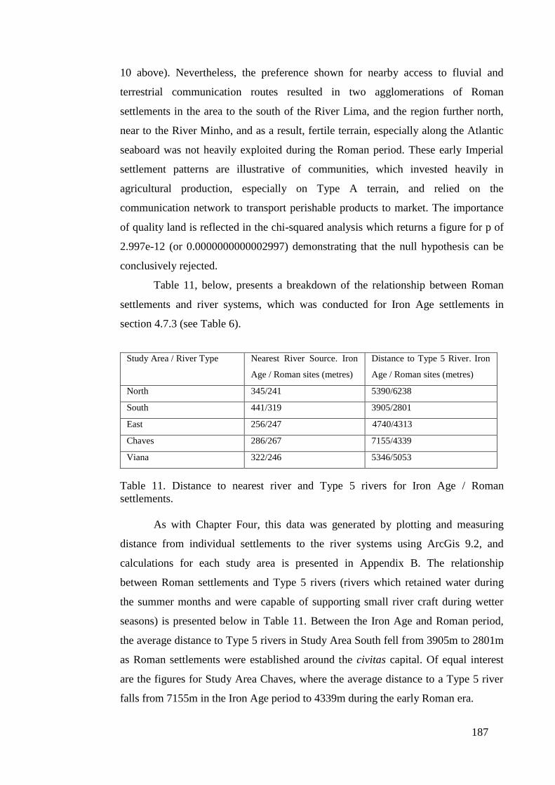
187
10 above). Nevertheless, the preference shown for nearby access to fluvial and
terrestrial communication routes resulted in two agglomerations of Roman
settlements in the area to the south of the River Lima, and the region further north,
near to the River Minho, and as a result, fertile terrain, especially along the Atlantic
seaboard was not heavily exploited during the Roman period. These early Imperial
settlement patterns are illustrative of communities, which invested heavily in
agricultural production, especially on Type A terrain, and relied on the
communication network to transport perishable products to market. The importance
of quality land is reflected in the chi-squared analysis which returns a figure for p of
2.997e-12 (or 0.0000000000002997) demonstrating that the null hypothesis can be
conclusively rejected.
Table 11, below, presents a breakdown of the relationship between Roman
settlements and river systems, which was conducted for Iron Age settlements in
section 4.7.3 (see Table 6).
Study Area / River Type
Nearest River Source. Iron
Age / Roman sites (metres)
Distance to Type 5 River. Iron
Age / Roman sites (metres)
North 345/241 5390/6238
South 441/319 3905/2801
East 256/247 4740/4313
Chaves 286/267 7155/4339
Viana 322/246 5346/5053
Table 11. Distance to nearest river and Type 5 rivers for Iron Age / Roman
settlements.
As with Chapter Four, this data was generated by plotting and measuring
distance from individual settlements to the river systems using ArcGis 9.2, and
calculations for each study area is presented in Appendix B. The relationship
between Roman settlements and Type 5 rivers (rivers which retained water during
the summer months and were capable of supporting small river craft during wetter
seasons) is presented below in Table 11. Between the Iron Age and Roman period,
the average distance to Type 5 rivers in Study Area South fell from 3905m to 2801m
as Roman settlements were established around the civitas capital. Of equal interest
are the figures for Study Area Chaves, where the average distance to a Type 5 river
falls from 7155m in the Iron Age period to 4339m during the early Roman era.
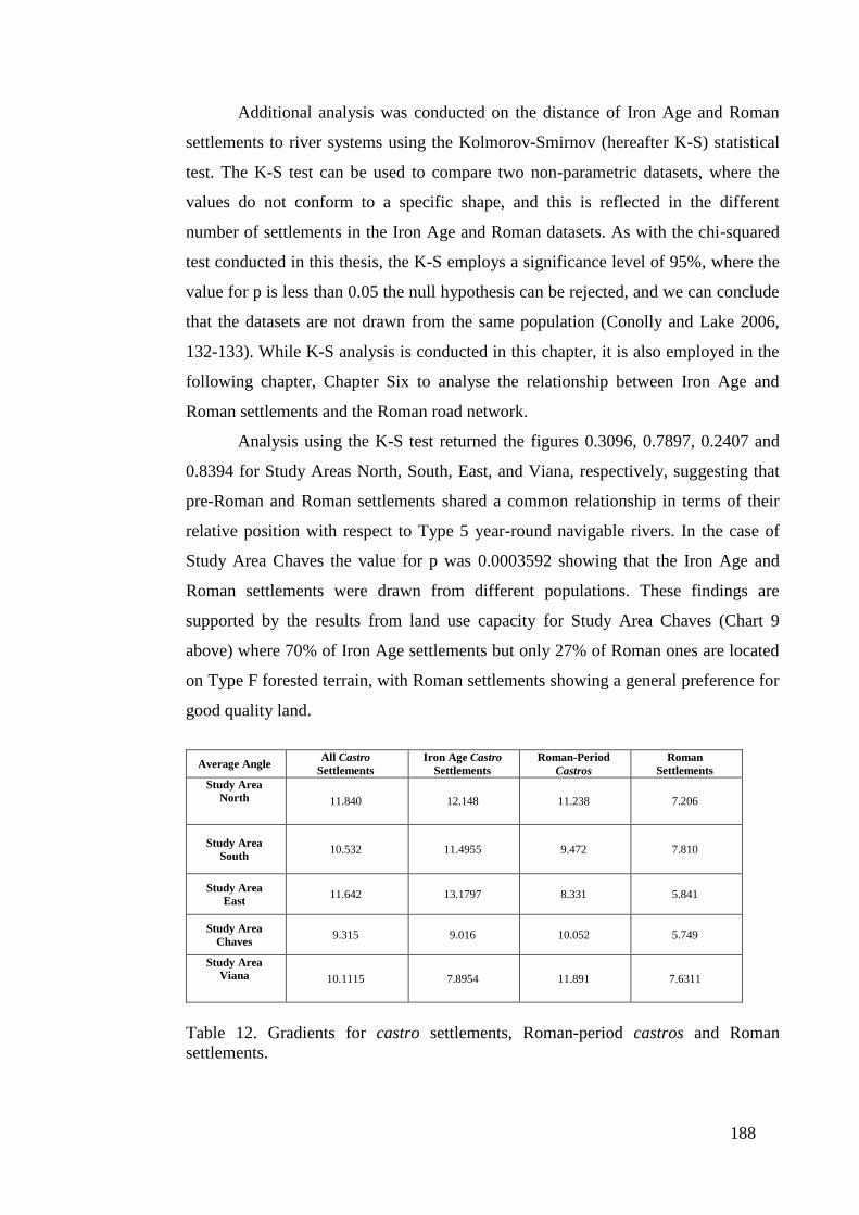
188
Additional analysis was conducted on the distance of Iron Age and Roman
settlements to river systems using the Kolmorov-Smirnov (hereafter K-S) statistical
test. The K-S test can be used to compare two non-parametric datasets, where the
values do not conform to a specific shape, and this is reflected in the different
number of settlements in the Iron Age and Roman datasets. As with the chi-squared
test conducted in this thesis, the K-S employs a significance level of 95%, where the
value for p is less than 0.05 the null hypothesis can be rejected, and we can conclude
that the datasets are not drawn from the same population (Conolly and Lake 2006,
132-133). While K-S analysis is conducted in this chapter, it is also employed in the
following chapter, Chapter Six to analyse the relationship between Iron Age and
Roman settlements and the Roman road network.
Analysis using the K-S test returned the figures 0.3096, 0.7897, 0.2407 and
0.8394 for Study Areas North, South, East, and Viana, respectively, suggesting that
pre-Roman and Roman settlements shared a common relationship in terms of their
relative position with respect to Type 5 year-round navigable rivers. In the case of
Study Area Chaves the value for p was 0.0003592 showing that the Iron Age and
Roman settlements were drawn from different populations. These findings are
supported by the results from land use capacity for Study Area Chaves (Chart 9
above) where 70% of Iron Age settlements but only 27% of Roman ones are located
on Type F forested terrain, with Roman settlements showing a general preference for
good quality land.
Average Angle All Castro
Settlements
Iron Age Castro
Settlements
Roman-Period
Castros
Roman
Settlements
Study Area
North
11.840 12.148 11.238 7.206
Study Area
South 10.532 11.4955 9.472 7.810
Study Area
East 11.642 13.1797 8.331
5.841
Study Area
Chaves 9.315 9.016
10.052
5.749
Study Area
Viana
10.1115 7.8954 11.891 7.6311
Table 12. Gradients for castro settlements, Roman-period castros and Roman
settlements.

189
Table 12, provides the findings of the average gradient upon which all castro
settlements, Roman-period castros and Roman settlements were situated. Roman
settlements in each of the five study areas are positioned along less steep gradients
than all castro settlements and Roman-period castros. However, in Study Areas
Chaves and Viana, Roman-period castros are located on steeper gradients than all
castro settlements, and illustrate that while lower gradient castros were quickly
abandoned in favour of Roman-styled settlements and habitats, in more inhospitable
areas with hillier terrain Roman-period castros continued to function in the absence
of Roman settlements.
Lastly, Table 13 shows the heights for all castro settlements, Roman-period
castros and Roman settlements, and demonstrates a similar pattern found in the
analysis of slope angle. Roman settlements are located at the lowest elevation but
Roman-period castros in Study Areas North, East, Chaves and Viana are positioned
higher than the collective grouping of Iron Age settlements. Again, this is illustrative
of Iron Age castros being abandoned in favour of Roman settlements in areas of
lower elevation, but where Roman-period castros continued to operate in hillier and
more elevated terrain.
Average Height All Castro
Settlements
Iron Age Castro
Settlements
Roman-Period
Castros
Roman
Settlements
Study Area
North 772 812 828 739
Study Area
South 565 566 555 388
Study Area
East 594 560 680 595
Study Area
Chaves 651 637 699 571
Study Area
Viana 213 214 215 162
Table 13 shows the heights for all castro settlements, Roman-period castros and
Roman settlements.
5.4. Discussion
This section brings together the findings outlined above and seeks to explain
the impact of Imperial Rome on the landscape of northwest Iberia. In doing so, this
discussion provides a chronological argument as to the process of change in the
region, incorporating the data and evidence for Iron Age site patterns examined in
190
Chapter Four, and analysing it against the emergence of Roman-period castros and
more enduring Roman settlements alike. The themes considered in the previous
chapter as relating to the nature of pre-Roman northwest Iberia; namely, the social
organisation of the region, the role of the environment and of borders and
boundaries, as well as concepts derived from this chapter, specifically, the
development of the Roman hierarchical settlement structure and the role of
individual settlements within that order, are also addressed here.
The changes which were already underway in the Late pre-Roman Iron Age
in the landscape of northwest Iberia, were not uniform throughout the region. Firstly,
in Study Area North, the juxtaposition of two fortified hillforts often resulted in one
site becoming abandoned during the early Roman period, while the other became a
Roman-period castro, as shown in Map 21 by sites 8 (abandoned) and 6 (continued
occupation) (centre right), 65 (abandoned) and 67 (continued occupation) (centre
right). Whether this was a deliberate policy by Imperial authorities within the region
to consolidate resources and instigate more effective practices is difficult to establish.
The different political system based on lineages and families, gentilitates and gentes
in the eastern region of pre-Roman northwest Iberia, and orientated around a kinship-
based social system, strongly suggests that hillfort settlements located in close
proximity may have shared mutually-beneficial political and social structures.
Therefore, with their gradual assimilation into Imperial control, the communities of
these fortified hillforts may have actively decided to merge their population into a
single settlement. In Study Area Viana, where a more territorially-based settlement
pattern has been proposed, with communities representative of social organisation
based around the territorial control of the castellum (shown by the inverted ⊃ in
indigenous inscriptions (Pereira 1983)), the process of change during the early
Roman period was altogether different. Where two or more fortified hillforts existed
in close proximity to one another, these castro settlements were often abandoned en
masse, as shown by fortified hillforts 64, 70, 80, 81 (Map 25, centre), and 108 and
109 (Map 25, centre left), in contrast to other site groupings where two adjacent
fortified hillforts became Roman-period castros, for example, 29 and 37 (Map 25,
top right) and 12 and 110 (Map 25, centre left). This implies that Late pre-Roman
Iron Age communities in Study Area Viana, may have shared similar socio-
economic goals and perhaps a central political affiliation, but continued to invest in

191
the importance of their settlement, rather than those wider kinship-based systems and
regional affiliations seen in Study Area North. In this way, pockets of Iron Age
hillforts were abandoned as new economic and social systems emerged during the
early Roman period, but concurrent with these developments adjacent castro
settlements, more often located along a patchwork of emerging Roman settlements
and habitats, continued to be inhabited into the first and second centuries AD.
Indigenous settlement patterns also continued largely uninterrupted during
the first and second centuries AD, at the periphery of Roman central places as shown
in Study Areas North (Map 21, top left), South (Map 22, top left), East (Map 23,
centre) and Viana (Map 25, centre left and top right). The reasons for the continued
existence of these Late pre-Roman Iron Age settlement patterns are both numerous
and complex, and embedded in the economic and political systems which emerged in
the early Roman period. In Study Area North, the continued occupation of castro
settlements in the northwest of the region was a direct result of the consolidation of
the area around the civitas capital (site 43, Map 21, centre), where a series of Roman
satellite settlements emerged to provide agricultural products for this metropolitan
centre. The greater investment in generating agricultural surplus from the relatively
fertile landscape around the civitas capital can be seen from land use capacity
analysis. Here a greater proposition of Roman settlements were located on
agricultural land (see Chart 6) than Iron Age sites, with 59% of Roman settlements
positioned on Type F forested land, in comparison to 83% of Iron Age hillforts. In
this way, the settlement pattern of Study Area North during the early Roman period
is strongly indicative of a core region characterised by a fertile lowland area around
the civitas capital, while a series of Roman-period castros locating on more elevated
terrain and steeper land inhabited the periphery.
In Study Areas South, Viana and to an extent in Study Area East, there was
also a continuation of the pre-Roman settlement patterns, but the reasons for the
continued occupation of these areas by indigenous peoples were very distinct. To the
west of Study Area South, a series of large castro settlements, sites 806, 802 and
814, continued to exert control over the landscape largely bereft of Roman centres of
power, with the civitas Baniensium (Study Area South, site 667), located some 33km
to the east, and Aquae Flaviae 51km to the north. The relative isolation of these
Roman-period castros to the west of Study Area South, as with the continued
occupation of those Iron Age structures in Study Area North, was probably
192
representative of regions of indigenous control where settlements continued to be
administered by native leaders. By reinforcing local centres, instead of creating new
structures, where the economic and political outlay would be substantial, Roman
authorities were able to administer outlying provinces more effectively, and in the
passage of time communities may have adopted more Roman-orientated social,
economic and political practices (Queiroga 2003, 39). In the case of Study Area East,
the continued existence of a series of adjacent native settlements, which were
juxtaposed between the two vicus administrative centres in the region (Map 23, sites
309 top right, and 565 bottom left), most likely ensured that this area was
administered in some shape and form by indigenous leaders, but under the ultimate
supervision of Imperial Rome.
In Study Area Viana, the continued occupation of fortified hillforts ensured
that pre-Roman settlement patterns in the northeast of the region and along the
Atlantic coast remained largely intact in the early Roman period. In other areas, a
dense network of Roman settlements and agrarian centres emerged within the
landscape along the River Coura, thereby providing a gateway to the interior, as well
as to the Atlantic Ocean along the River Minho. This area also benefited from being
strategically placed between two Imperial highways. Further south, a concentration
of Roman structures emerged along the southern bank of the River Lima, where a
series of interlaced terrestrial routeways were constructed (see Map 25). These
communities invested heavily in agricultural products (as shown by the K-S test
result), such as wheat and other types of grain, which had been grown in the region
since the Late Bronze Age (Parcero Oubiña and Cobas Fernández 2004, 22), and in
this way access to cheap and effective transportation, as well as the marketplace,
constituted important criteria in the location and success of early Roman settlements.
In Study Area Chaves, a similar process emerged with a series of agrarian
producers becoming established along the River Tâmega during the Roman period.
Nevertheless, we must be mindful that many of these systems and practices
developed over generations and that the process of change was by no means uniform.
This change can be best shown by the region around the future municipium of Aquae
Flaviae, where the late pre-Roman landscape was dominated by a series of medium
and large castros. Within this area, two medium-sized fortified hillforts, Crastas de
Santiago, site 548 (see Map 34, centre) south of the River Tâmega, and Castro da
Curalha, site 505, north of the River Tâmega, dominated the landscape. Within this
193
territory, a series of early Roman period boundary markers established the respective
territorial control of two supra-familial units, the PRAEN and COROC, and as such
may have represented earlier pre-Roman divisions within the landscape. Of further
importance was the location of these boundary markers, which were not positioned
equidistant to sites 505 and 548, but located further north where a convergence of
multiple territorial divisions generated from tessellated Thiessen polygon analysis of
sites 505, 548 and 261 are clearly visible. If Ptolemy’s account is credible
(Geographia. II, 6, 39), a pre-Roman oppidum, possibly a central place of the Turodi
tribe, existed in the area where Aquae Flaviae would emerge. This pre-Roman
oppidum can therefore be incorporated into the already established triangular
boundary, and explain why four inscribed boundary markers were employed to mark
the territorial divisions between settlements. Where the archaeological record is
silent is how these inscribed stones were positioned, but it is possible to speculate
that they represented the divisional markers of smaller settlements, which were
incorporated within larger kinship groupings, the PRAEN and COROC.
In this area, a regional capital, Aquae Laiae (Ptolemy. Geographia II, 6, 39),
was established at the start of the first millennium, which would be renamed Aquae
Flaviae in the Flavian era and advanced to municipium status. In the period between
the establishment of Aquae Laiae and Aquae Flaviae, those nearby medium-sized
hillforts, such as sites 505 and 548, evolved to become Roman-period castros, and
became more engaged in agricultural and mining activities. Concurrent with these
developments, was the establishment of a series of agrarian centres, which were
located at the periphery of the Tâmega Valley, and unlike the larger Roman-period
castros had better and closer access to Type A prime agricultural land. These
changes in the settlement pattern are shown by the percentage of Roman settlements
located on Type A terrain (30%), against the percentage of Iron Age ones (11%), and
as a consequence only 26% of Roman settlements were positioned on Type F, where
the figure had been 70% in the pre-Roman period. As with Study Area Viana, the
River Tâmega became a vital conduit through which to transport goods to market,
above all perishable ones, which established Aquae Laiae as an economic
powerhouse in the region, while consolidating and creating a ‘microregion’ (see
section 2.4.2.2 for an outline of ‘microregions’ and connectivity) of agrarian centres
positioned along the Tâmega Valley. As shown by the K-S analysis, the settlement
pattern changed dramatically, as the Late pre-Roman Iron Age structures located on
194
the periphery of the Tâmega Valley were replaced by early Roman period
settlements located near to the fertile valley plain.
In other study areas, the transformation from the late pre-Roman period to the
first and second centuries AD, was more embedded in the indigenous social and
political structure, as well as the economic opportunities open to the peoples who
inhabited these regions. While many of the communities of Iron Age castros
relocated to adjacent Roman settlements in Study Areas North and East, a different
set of processes were responsible for the establishment of agrarian centres. In Study
Area North (Map 26), a series of villae settlements, sites 102 and 125 (bottom right),
and casals 264 and 269 (centre left), emerged on the margins of Iron Age
boundaries. These practices may reflect the collective activities of neighbouring
communities who shared a common kinship, and united in the face of a changing
world to combine resources. Such structural changes were not confined to Study
Area North, but are also visible in the landscape of Study Area East (Map 27), where
a cluster of casals 405, 406, 408 and villa 410 (top centre), and casals 381, 382, 425
and 426 (centre) were located around the Iron Age boundaries, a process which is
repeated further south with villae 390 and 392, on the boundaries of a series of
abandoned castros.
While the similar patterns of emerging Roman agrarian centres in Study
Areas North and East may reflect parallel pre-Roman political and social structures,
their respective environments were very different. The terra quente terrain and
climate, characterised by scorching summers, which dominates the region around the
River Douro played an important role in the location of casals and villae. Of the five
villae, three are located on Type F forested land, while this relationship occurs with
fifteen of the seventeen casals, which may reflect agricultural producers investing
heavily in olive oil and grape production during the early Roman period, and thereby
demonstrating a high degree of connectivity with other regions in the Roman world,
where such products were in demand. These agricultural practices found in Study
Area East, may also have been representative of the proliferation of Roman agrarian
centres in the bottom left of Study Area South, where a series of villae and casals are
located on Type C/F agricultural / forested land. However, where the two regions
differ is their use of transport with Study Area South utilising the River Douro as a
conduit to ship produce, while Study Area East invested heavily in the main Roman
highway. In this way, the communication routes utilised in the Late Iron Age and the

195
early Roman period were reversed, with land-based communication playing a greater
role in Study Area East, and an incremental investment in fluvial passage in Study
Area South. The reasons for this are not clear, but the inaccessible and elevated
terrain around the River Douro in Study Area East may have made access difficult
and costly during the early Roman period.
The use of the fluvial network is also reflected in Study Area South in the
area around the civitas capital (civitas Baniensium), which was positioned on the
strategic confluence of the Rivers da Vilariça and Sabor and within a 5km distance of
the River Douro (Map 22). While the position of the early civitas may have
incorporated nearby native tribal groupings, its location reflects the agenda of
Imperial Rome in creating and integrating this central place into the wider Roman
economic, political and social system. In this way, the civitas Baniensium provided
strategic control over the mining centres located to the south along the River Douro,
as well as administering those mining settlements and industries positioned in the
bottom left of Study Area East. As with Study Area Viana, the creation of a Roman
road running adjacent to the River da Vilariça, provided access along the valley for
agricultural centres and strategically linked the region to Aquae Flaviae in Study
Area Chaves and the civitas Zoelarum, in Study Area North.
Functioning alongside the civitas Baniensium in a strategic and administrative
capacity was vicus settlement 565 (Study Area East, bottom left), and while its role is
open to speculation, the absence of a central place in the form of a civitas or a
municipium strongly indicates that this site fulfilled an important administrative or
strategic function. In Study Area East, these vici settlements are found at the extreme
ends of the study area and located near to the main Roman road. In Study Area
North, vicus settlement 17, and 549 in Study Area South, are positioned on the
boundaries of medium-sized fortified hillforts, and in the case of the latter, its close
location to the cluster of Roman-period castros suggests its initial function may have
been to monitor indigenous self-rule in the region. In a similar way, vicus settlement
607, in Study Area Chaves, positioned on the boundary of a medium-sized castro
and near to the main Roman road, as well as vicus settlement 168 in Study Area
Viana (Map 25, centre right) may have fulfilled a comparable role, providing a
strategic and administrative role in their respective regions. Moreover, we should not
assume that the transition between pre-Roman and Imperial rule was a smooth one,
with fortified settlements 420 (Study Area East, centre) located on the River Douro,
196
and site 850 (Study Area Chaves, bottom centre) positioned to the north of the cluster
of those Roman-period castros to the west of Study Area South. In other areas, vici
settlements were adapted to the needs of the region, with a series of vici in Study
Area Viana, which incorporated a mansion (site 252), a mutatio (site 200), as well as
vicus settlement 303, all positioned along or at important junctions of the main
Roman roads. This role also extended to economic activity with vicus settlement 552
(Study Area South, centre bottom), located near to a mining community along the
River Douro, but whether this settlement incorporated a strategic function is difficult
to establish.
5.5. Conclusions
In summary, a series of points can be made about the settlement patterns,
systems and practices, and the chronological developments, which defined early
Roman northwest Iberia.
1. The analysis conducted in this chapter strongly reinforces the findings relating to
pre-Roman northwest Iberia discussed in the previous chapter, as to the nature of
indigenous social structures. With the assimilation of the region and the gradual
consolidation of Imperial authority, the hillfort, which characterised communal
living, was abandoned. This process was not uniform either chronologically or
regionally, but rather these settlements were abandoned, or continued as Roman-
period castros dependent on a range of factors. In Study Area North, where two
hillforts existed adjacent to one another, there was a tendency for one to be
abandoned, while the other continued to be inhabited as a Roman-period castro. In
Study Area Viana, which was also represented by clusters of fortified hillforts, the
processes were different, with nearby Iron Age settlements being abandoned en
masse at the end of the Late pre-Roman Iron Age, or continuing to be occupied well
into the early Roman period. This corroborates the conclusions made in the previous
chapter that we should not speak of a single recognised ‘Castro Culture’, but of
multiple castro communities, and furthermore, this supports the argument that
different social structures existed within the landscape of late pre-Roman northwest
Iberia. Consequently, the occupation of pockets of Roman-period castros in Study
Area Viana, suggests that local communities continued to invest in a social structure
which was socially motivated and politically orientated around the hillfort. In
contrast, in the region around Study Area North, where resources were consolidated

197
and two castros often became one, a kinship-based lineage, which emphasised supra-
familial and intertribal affinity ensured an altogether different process of change.
2. Where all the study areas demonstrated a similar settlement pattern was in the
preservation of pockets or regions of autonomous rule in the early Roman period.
However, the reasons for the continued existence of these pre-Roman communities
was not uniform. In Study Areas North, South and East, Imperial authorities appear
to have reinforced local centres and indigenous control, instead of creating new
settlements and thereby minimising the economic and political outlay in
administering the region, which would concur with the general hypothesis advanced
by Queiroga (2003, 39), and discussed in section 5.4. However, closer analysis of the
cluster of Roman-period castros in Study Area East located near to the main Roman
road, reveals that they appear to have been more integrated into the emerging early
Roman settlement pattern than the largely isolated group of hillforts to the west of
Study Area South. In the case of the cluster of Roman-period settlements in Study
Area South, their continued occupation may therefore be more illustrative of native
communities which lay at the periphery of the Roman commercial and trade network.
The previous point is supported to a degree by the changes in Study Area Viana
during the Late Iron Age and early Roman period, where the continuity of the pre-
Roman settlement pattern was largely dependent on the economic needs fashioned by
early Roman society. In this way, Roman-period castros continued to be occupied
where they had access to the communication system, established markets and trading
centres, but were often abandoned in more peripheral areas,
3. The importance of fertile land, an efficient and cost effective communications
system and local markets in the form of metropolitan centres shaped the landscape of
Roman northwest Iberia. In Study Area Chaves, where large and medium-sized
castros were located at the periphery of the Tâmega Valley, and controlled the
landscape through a series of smaller affiliated fortified hillforts, this system began to
break down under Imperial authority. In the first and second centuries AD, a series of
agrarian centres were established along the fertile Tâmega Valley, which not only
consolidated the economic importance of the civitas capital of Aquae Laiae and
ensured that it was promoted to municipium status in the Flavian era, but also
provided further impetus for agricultural development in the region. In this way, the
river network illustrates the high degree of connectivity between ‘microregions’ of
agricultural producers and their access to principal markets, while the Roman arterial
198
road system integrated those strategic and administrative centres. In Study Area
South, both a fluvial and terrestrial communication system were utilised in the area
around the civitas Baniensium, to secure the profitable mining centres to the south
and the east, as well as to provide a cost-effective transport system to the settlements,
and agricultural centres, which grew up along this strip of fertile land.
In the less productive regions such as Study Area North, where Iron Age
fortified hillforts were spread across a large spatial domain, during the early Imperial
era Roman settlements became sandwiched between the River Sabor to the right and
the River Rabaçal to the left of the study area. The reasons for this ‘concertina’ in the
early Roman period settlement pattern can be attributed to the patchwork of low-
lying fertile land on which the civitas capital was located, and those satellite towns,
which emerged to serve this central place.
4. In Study Area East, the main Roman highway played an important role in
orientating Roman-period settlements, but other processes also shaped the settlement
pattern, especially with regard to the establishment of agricultural centres. As with
Study Area North, the indigenous kinship-based social structure, which characterised
this eastern region of northwest Iberia, served to consolidate resources and found
farming communities on the territorial boundaries of their pre-Roman settlements.
However, the greater number of casals and villae found in Study Area East, in
contrast to Study Area North, suggests that these agricultural centres further south
were more successful owing to the hotter climate, which was conducive to the
production of olive oil and wine grapes. Additionally, the profitability of these staple
Roman period products also shaped the landscape to the west of Study Area South.
Where a series of Roman-period hillforts occupied the fertile terrain further north, a
concentration of agrarian centres were established further south along the banks of
the River Douro, which not only provided the landscape for the production of olive
oil and wine grapes, but also the means to ship these communities for export.
5. Where the communities were physically distant from those civitas capitals in
Study Areas North, South and East and the municipium of Aquae Flaviae, vici
fulfilled an important dual function, providing strategic as well as regional
administration. However, unlike larger centres such as civitas capitals and municipia,
which could equally be located near the large waterways or the terrestrial
communications system, vici were positioned near to or along the Roman road
network perhaps to monitor indigenous activity within the region. Moreover, the role
199
of these small settlements also encompassed secondary functions, and in the
agricultural heartland of Study Area Viana, vici settlements were integrated into the
cursus publicus, or Roman public postal system, through mansiones and mutationes.
For this reason, we must readdress our traditional interpretation of vici as simply
small settlements and instead entertain the notion that these Roman-period structures
played an important role within the landscape, at least in early Roman northwest
Iberia.
200
Chapter Six. Movement and Communication in Late Iron Age and Roman
Northwest Iberia
6.1. Introduction
This work examines movement and communication in northwest Iberia in the
Late Iron Age, and how these systems were exploited, and subsequently adapted by
Roman authorities in the early Imperial era. In doing so, this research builds on the
themes and analytical frameworks developed in the two previous chapters, but
incorporates a very different methodological approach to examine the nature of
observed changes. Central to this chapter is the earlier discussion concerning the
minimalist view promoted by Finley et al. that trade was limited to small-scale
exchange at a local level was found to be erroneous (see section 2.4.2.1), and instead
a more dynamic approach was implemented which seeks to examine the existence of
‘microregions’ and their degree of connectivity with the wider Roman world (see
section 2.4.2.2). Where a detailed account of Late Iron Age movement in northwest
Iberia was undertaken (see section 2.4.1) the same cannot be said about early
Imperial communication routes, in particular terrestrial routeways. For this reason,
these routeways are discussed in much greater detail in this chapter with the aim of
establishing the different passageways available in the early Roman period, and how
such networks may have impacted on the study region. The second part of this
chapter develops the methodological approach for the analysis of movement and
communication in northwest Iberia between the Late Iron Age and early Roman
period. The final section of this chapter outlines the results, reviews and discusses the
findings, and lastly, provides a series of concluding remarks.
6.2. The Role of the Roman Arterial Road Network
The Roman communication system was far from uniform in the quality,
speed and direction of passage it provided, and was shaped not only by the topology
of the region, the needs of its people and the empire as a whole, but also by the pre-
Roman terrestrial and fluvial routeways that Rome inherited. In differentiating the
multitude of roads and passageways available to the inhabitants of the Roman
empire, it is perhaps best to begin with the information encapsulated in the Emperor
Justinian’s codification of Roman law. Although written in the sixth century, this
document encapsulates many of the decrees, rulings and structures from earlier in the
Roman empire, and so provides a valuable picture of the early Roman road network
201
(Davies 2002, 67), and a means to establish the degree of connectivity between
settlements and regions. The Codex Justinianus establishes three types of routes; an
iter, where neither a beast nor vehicle could pass; an actus, where a beast can pass;
and a via, which had to be wide enough for either a beast or a vehicle (Code of
Justinian, 8.1.13). Clearly, the size of the road was an important, if not the most
important factor in determining access and so passage through the Roman landscape.
Vehicles during the course of the Roman empire are likely to have varied in size,
although their average wheel-base width has been calculated to be around 4.75 pedes
(Piggott 1992, 35), with a pes equivalent to 11.6in or 0.296m (Davies 2002, 67).
Examples of carriages found at Pompeii, which correspond to a timeline within the
scope of this thesis, had wheel bases of 4.75 and 5 pedes, which increased to 6 and
6.25 pedes with the inclusion of wheel-hubs (Tsujimura 1991, 61). Where the Code
of Justinian refers to the passage of ‘a vehicle’, and so one-way traffic, along the via,
it seems likely that the necessary width need only be around 7 pedes, with the width
of road widened slightly where a wagon needed to negotiate a tight turn (Tsujimura
1991, 74).
If the main roads of the Roman empire, the viae, were only wide enough to
allow one-way travel, then it must be assumed that the flow of traffic was inherently
slow, thereby increasing the cost of land transport, and perhaps in the process
limiting the degree of connectivity between points on the map. However, recent
studies of 488 principal roads in Roman Britain have shown the width of their
metalled surface, that is where stones and gravel are used to construct a firm and
well-drained surface, to average 22 pedes (Davies 2002, 73). Such space would not
only have provided passage for two-way traffic, but may have also allowed faster
and lighter vehicles, as well as mounted horsemen, additional room to pass slower
moving traffic. The width of these main roads in Roman Britain also reflected the
administrative and strategic needs of the province. Watling Street, for example, with
the highest average metalled width of 34 pedes, constituted perhaps the most
important road in southern Britannia, linking the strategic coastal settlement of
Richborough with London and Wroxeter. The value of this trajectory is also
confirmed by the third century Antonine Itinerary, which lists a series of itineraries
passing along Watling Street and thereafter developing new routes, especially north
towards Hadrian’s Wall. Nevertheless, Watling Street, as a main road within a
civilian space, was an anomaly in terms of the width of its metalled surface, with a
202
trend for wider routeways shown in the north of England, where military activity was
more prevalent (Davies 2002, 75).
While northwest Iberia was largely pacified following the Cantabrian Wars
(29-19 BC) (Keay 1988, 44), many of the early Roman roads, which were
constructed in the region, were of military origin (Yanguas 2002, 84). Early Roman
roads, within the context of this study, are shown by a milestone found near Soeira
along the northern viae linking the civitas Zoelarum (Study Area North, site 43) with
Aquae Flaviae (Study Area Chaves, site 2) (Lemos 1993 vol. I, 312), which most
probably dates from 3-2 BC during the reign of the Emperor Augustus (27 BC-AD
14). A second milestone located to the west of Aquae Flaviae on the Antonine
Itinerary XVII linking Bracara Augusta with Aquae Flaviae and Asturica Augusta,
corresponds with AD 44 in Emperor Claudius’ reign (AD 41-54) (Teixeira 1996, 19).
While the so-called Augustan milestone may date to the early first century, and is
discussed in greater detail below, the second from the reign of Claudius, suggests a
possible military route running east from Study Area North towards Study Area
Chaves. If a military road did connect the modern-day regions of eastern and western
Trás-os-Montes, further questions remain as to the chronological development and
inclusion of the civitas Zoelarum, as well as the Roman central place which would
become into Aquae Flaviae, into this nascent communication system.
6.2.1. The Roman Arterial Road Network and the Compression of Space-Time
Undoubtedly military roads played an important role in the pacification of
Rome’s enemies. Nevertheless, the vast majority of communication routes which
arose in those regions administered by Rome, had an altogether more practical usage
and modest origin. Roman roads, the viae publicae, linked major settlements, but
also incorporated local roads, viae vicinales, as well as private and estate roads, viae
privatae. Access to the latter, the viae privatae, was often restricted by landholders
who were responsible for their upkeep, while viae vicinales, which were minor
public roads, were built and maintained by the local community (Siculus Flaccus
146L). Where these viae publicae and viae vicinales differed was often in their size,
level of maintenance, and their importance, with the former incorporating the cursus
publicus, or Roman public postal system (as introduced in section 2.4.2.1), its
affiliated mansiones and mutationes, and the presence of barracked soldiers along the
route (as discussed in section 5.2.4). For the official traveller the viae publicae

203
offered food, lodgings and a change of horse at the mansiones and mutationes
(Mattingly 2007, 259), but for the official and non-official alike, the security offered
by armed soldiers was undeniably a benefit, especially with documented activity of
bandits operating along many established communication routes (Curchin 1991, 180;
Laurence 1999, 178; Wells 1984, 232-233). In spite of the benefits offered by the
viae publicae, its most prominent advantage was the direct route it offered between
major settlements, in contrast to the viae vicinales, which often connected minor
towns, as well as leading to farms and villages (Code of Justinian, Dig. 43.7.3).
Overland transportation was therefore far from uniform within the early
Roman empire and dependent on a series of factors, among them the quality of the
road surface, the width of the road, the connectivity of the routeways and the security
and services offered to travellers. The most effective and important routeways, the
viae publicae, had the added benefit of compressing space-time between settlements,
allowing lightly-loaded horse-drawn vehicles, such as a raeda, to cover as much as
100 miles in a single day (Suet. Jul.57). As a result, the speed of communication was
often less between urban structures, than surrounding satellite settlements, which
often had to rely on indirect and poorly maintained roads. The compression of space
as a container of social power, also entailed that these Roman highways created new
forms of authority and control within society, and over the long-term produced new
challenges and practices, which would stimulate a diverse range of social, cultural
and political responses (Harvey 1990, 255). The changes fostered by the compression
of space-time were constantly evolving, as the conduits of change, the Roman
highways, brought with them a multitude of different people each with an individual
story.
The viae publicae also impacted on those major urban centres which they
passed through, inspiring the construction of civil monuments to impress travellers,
while the inhabitants of such towns and cities also sought to engage travellers at a
social, economic and religious level (Laurence 1999, 154). Furthermore, these social,
economic and religious activities were not confined to a single space or urban centre,
but embedded in an affiliated social system, which was stretched across time and
space. In contrast to less complex societies structured around kinship, and where
most transactions required a physical presence, or what Giddens terms high
presence-availability (Giddens 1981, 4-5, 66-67), more sophisticated societies, such
as the Roman empire, created a series of mechanisms which connected
204
geographically-distant space. Consequently, the Roman emperor was physically tied
to a point in space, but his presence-availability could be enhanced through his image
on coins, his statue presiding over civic monuments, and the presence of the imperial
cult in metropolitan centres (Creighton 2006, 81). While the emperor benefited
ideologically from stretching time and space, so commercial networks employed
agents at key locations, often established along well-connected terrestrial routeways,
for the purposes of processing, managing and marketing produce (Greene 1990, 166-
167). In this way, networks of power and influence, whether ideologically or
commercially driven, became allied to the space-time distanciation created by the
Roman arterial roads linking these settlements, which in turn created hierarchies of
information (Morley 1997, 49).
Giddens’ concepts of high-presence availability, hierarchies of information
and the compression of space-time should not be seen as concepts solely applied to
large states, such as the Roman empire, but apply equally to other timeframes.
During the Late Iron Age, the gradual encroachment of Rome, and its subsequent
conquest of foreign territory, had a direct impact on the relationships between native
settlements and the negotiation of political and commercial rights. Within the context
of late pre-Roman southern Britain, trade networks were predominantly focused in a
north-south direction with raw materials, such as iron and coal from the Forest of
Dean, precious metals from central Wales or Ireland, and salt from Droitwich
(Worcestershire), being transported along waterways to oppida settlements further
south. The dating of these oppida to the early first century suggests that a series of
strategic centres among them Verlamion, the north Oxfordshire Grim’s Ditch and
possibly Bagendon began to emerge in the late pre-Roman period. How connected
these oppida were, and the degree to which they utilised a probable pre-Roman
Akeman Street which ran in an east-west trajectory is difficult to ascertain.
Nevertheless, with the founding of Akeman Street during the Roman period a slow
and deliberate process of change began. The Late Iron Age settlement of Verlamion
became the Roman centre of Verulamium, but other transformations to the west of
Akeman Street were altogether slower. The elite located at Grim’s Ditch and
Bagendon would, over the course of time, be involved in establishing the civitas
capital of the Dobunni tribe, Corinium Dobunnorum, modern-day Cirencester
(Copeland 2009, 139).
205
In this case, the Late Iron Age society which was characterised by the
oppidum, was affected by a linear trajectory, in the form of Akeman Street, running
through the territory of the Catuvellauni and Dobunni peoples, thereby compressing
space-time between those settlements located along its path. Nevertheless, the nature
of that space-time was not uniform, with Iron Age communities often continuing to
exist within the same bounded space their ancestors had occupied a generation
before. In time, some urban communities adopted Roman practices, but the degree of
change would have been more prevalent in those communities which were integrated
along Akeman Street and its subsidiary roads (Copeland 2009, 141). Such a
hypothesis therefore offers a valuable insight into the role of communication routes
between the Late Iron Age and early Roman period, particularly the consolidation of
certain Late Iron Age structures as centres of Roman authority and the Roman
arterial road network which connected them, at the expense of those indigenous
settlements which were located at the physical and so cultural periphery of Roman
influence. In this way, the Roman road network and communication system in
general provides a means to examine the role it played in shaping both native and
more ‘Roman-style’ settlements, which is explained in greater detail in the following
section.
6.3. Methodological Approach
6.3.1. Introduction
Akeman Street provides an archaeological illustration of those social,
economic and political changes which occurred over centuries, but were very much
ingrained in the movement of goods and people between spatial settings. The study
also demonstrates that pre-Roman terrestrial and fluvial communication routes
worked in unison. In the same way, we should also acknowledge that waterways
played a prominent role in the early Roman period as shown by the transportation of
staple goods (as demonstrated by the transportation of wheat from Alexandria to
Rome, see section 2.4.2.1), but also in terms of the geography of a region (for
example, the connectivity provided by the River Nile which linked important
commercial centres, such as Oxyrhynchus, see section 2.4.2.1). Where our
knowledge of movement, in particular commercial exchange, is altogether more
limited is how terrestrial and fluvial communication networks were integrated (see
section 2.4.2.2 and how wheat produced in central Iberia was transported elsewhere)

206
into the wider Roman world. In order to examine these ideas it is first important to
examine the available methodological approaches which could be used to analysis
the communication systems of the study region.
6.3.2. The Theory and Practice of Least-Cost Paths
In providing a context for the analysis of Late Iron Age movement and the
subsequent early Roman communication system in northwest Iberia, this section
examines the use of new analytical models developed from computer software to
map, measure and examine expressions of movement across the landscape through
the implementation of least-cost paths (see section 3.5.3 for an introduction to
computer-based analysis). In aiming to replicate as closely as possible the pattern of
human movement across the landscape, practitioners of least-cost path analysis have
developed algorithmic software, which can be compared against known routeways.
Bell and Lock (2000), in investigating the path that both ran through and near to a
series of Iron Age forts located along the Ridgeway in southern Oxfordshire, found
the initial computer-generated least-cost path falling off the steep descent before later
ascending to rejoin the path. The initial computer-generated path proved to be
unrealistic in terms of its trajectory and the physical cost it offered, given that the
route required a traveller to descend and ascend the slope either side of the ridge,
rather than follow the established path offered by the Ridgeway. This was amended
by rewriting the algorithms and turning the descent into an ascent creating a resultant
pathway which adhered to the ridge (Bell and Lock 2000, 92).
Other more comprehensive studies have used a multifaceted approach to
recreate the landscape and its communication routes. Madry and Rakos (1996),
sought to recreate routeways in the Arroux valley in the Burgundy region of France,
by replicating the conditions for known roads, which closely adhered to a
combination of features, namely, the visibility of the route from surrounding
hillforts; close positioning to narrow ridge crests; least change in elevation along the
ridgeline, as well as other cultural and environmental factors (Madry and Rakos
1996, 110-111). With the computer software producing accurate replications of
known segments of roads, cost-surface analysis was applied to other locations within
the study area, where the archaeological record was more limited. This procedure
revealed the importance of the pre-Roman town of Toulon-sur-Arroux as a transport
hub, which has led to the reappraisal of its commercial and strategic role within the
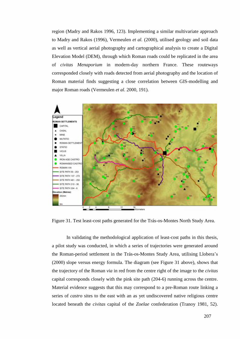
207
region (Madry and Rakos 1996, 123). Implementing a similar multivariate approach
to Madry and Rakos (1996), Vermeulen et al. (2000), utilised geology and soil data
as well as vertical aerial photography and cartographical analysis to create a Digital
Elevation Model (DEM), through which Roman roads could be replicated in the area
of civitas Menaporium in modern-day northern France. These routeways
corresponded closely with roads detected from aerial photography and the location of
Roman material finds suggesting a close correlation between GIS-modelling and
major Roman roads (Vermeulen et al. 2000, 191).
Figure 31. Test least-cost paths generated for the Trás-os-Montes North Study Area.
In validating the methodological application of least-cost paths in this thesis,
a pilot study was conducted, in which a series of trajectories were generated around
the Roman-period settlement in the Trás-os-Montes Study Area, utilising Llobera’s
(2000) slope versus energy formula. The diagram (see Figure 31 above), shows that
the trajectory of the Roman via in red from the centre right of the image to the civitas
capital corresponds closely with the pink site path (204-6) running across the centre.
Material evidence suggests that this may correspond to a pre-Roman route linking a
series of castro sites to the east with an as yet undiscovered native religious centre
located beneath the civitas capital of the Zoelae confederation (Tranoy 1981, 52).
208
Where the Roman road bifurcates, its southern trajectory is closely matched by the
least-cost path in green (site path 210-38).
6.3.3. The Practical Application of Least-Cost Paths and the Roman Road
Network
Combining the insights of the pilot study outlined above with those
conducted by Bell and Lock (2000), Madry and Rakos (1996), and Vermeulen et al.
(2000), permitted the development of a methodology to map possible terrestrial
communication routes between known settlements. For the purpose of analysis, a
series of least-cost paths were generated from the periphery of each study area to
ensure that computer-based trajectories were not site-biased. An external software
system, Hawth’s Tools, was used to create a series of points at 5000 metre intervals
around ArcGis generated shapefiles for each study area. Using the friction map
created using Llobera’s (2000) relative (human) energy expenditure versus slope
formula, a cost-surface was produced for each point and a series of least-cost paths
were created between adjacent positions on the three other sides of the shapefile.
By projecting these least-cost paths and the established Roman road network
on a digital interface, a four-stage analysis can be conducted. Firstly, the importance
of the optimum paths can be examined against existing pre-Roman sites and
settlement patterns. Secondly, the aforementioned analysis can be examined further
against the known Roman arterial road system and Roman central places. Thirdly, in
dating the Roman road network, a more detailed analysis can be undertaken as to
whether: (a) Imperial authorities utilised possible indigenous central places in
developing the early Roman settlement pattern; (b) to what extent the location of
these native settlements fashioned the Roman road network and subsequent
settlement pattern; (c) or if, Roman roads linked up strategically-located ex-novo
Roman centres. Fourthly, the Kolmorov-Smirnov (or K-S) test (see section 5.3.4),
was used to examine the statistical relationship between pre-Roman and Roman
settlements and the established Roman road network.
6.4. Analysis
6.4.1. Introduction
In this section, for the sake of consistency the five study areas are examined
in the following order; Trás-os-Montes North, Trás-os-Montes South, Trás-os-

209
Montes East, Chaves and Viana. The analysis includes an examination for each study
area of the least-cost paths, and the Roman arterial road network (Maps 36-40), and
lastly the results for the K-S tests conducted on the relationship between the Iron Age
and Roman settlements and the Roman road system. All maps discussed in this
chapter are to be found in Volume II of this thesis.
6.4.2. The Roman Road network
Analysis of Study Area North during the Late pre-Roman Iron Age shows
that a series of castro settlements were positioned on the most cost-effective
terrestrial routes. These include sites 96 (Map 36, bottom right), 9 and 69 (centre
right), 124 (top right), 28, 57, 216 and 213 (top centre), and 241 (top left). There
appears to be no discernible relationship with regards to their chronological standing;
that is to say their Iron Age / Roman period status, and their position within the
landscape. However, a clear pattern emerges if the civitas capital (site 43, centre),
was built upon a pre-Roman religious / administrative centre for the Zoelae tribe
(Tranoy 1981, 52), with those castros located at its periphery possibly controlling the
passage of people and commerce along the route, towards this native central place.
Furthermore, least-cost paths running from the north (see site 57), to the east of site
43 and south past site 137 (bottom centre), as well as a second optimum route
running northwest from site 124 (top right), to the south of site 43, and continuing in
a southwest direction, strengthens the argument for a tribal centre located at this
space. Such a theory is given further credence as the pre-Roman space at site 43, was
also linked by a least-cost path running east, around which castro sites 69, 9 and 8
were positioned.
With the establishment of Imperial Roman control in the region of Study
Area North, the strategic routeway and least-cost path linking the probable tribal
centre at site 43, with those fortified hillforts, 69, 9 and 8, became a Roman road.
Other stretches of established Roman road also emerged along least-cost pathways,
notably, the route south guarded by a statio (site 12, centre right), as well as large
tracts of road between the newly established civitas capital, the civitas Zoelarum
(Study Area North, site 43), and site 630 (bottom left), where the route heads south
to the civitas Baniensium in Study Area South. Nevertheless, the northern trajectory
of the bifurcated Roman highway, while appearing superfluous and negotiating the
uneven topography between the civitas capital and sites 252 and 253 (centre left),
210
provided a means to link up with an optimum routeway heading southwest (see site
251), and thereafter west to the civitas capital / municipium of Aquae Flaviae.
Additionally, those Roman satellite towns, located to the far north of the civitas
capital (sites 52, 56 and 59), to the north (sites 51, 53 and 87), to the west (sites 29,
33 and 36) and the south (sites 121 and 127), were all located near to least-cost paths,
which may have functioned as secondary roads to access the civitas Zoelarum. Also
of interest is the vicus settlement (site 17), and the adjoining Roman town (site 5),
located to the northeast of the civitas capital, where a series of least-cost paths
converge, suggesting that the vicus settlement may have operated to monitor the
passage of people, as well as offering a cost-effective route to market for surrounding
communities. To the south of Study Area North, Roman town 137, and villae
settlement 102 and 125 were both located along multiple least-cost paths, strongly
suggesting that these sites took advantage of passing trade as well as opportunities to
take their produce to market. Given that large sections of the Roman road network
follow an optimum routeway, many of these cost-effective corridors could have
constituted local roads, viae vicinales, built and maintained by local magistrates, or at
the very least established routeways.
As with Study Area North, in Study Area South (Map 37) a series of hillfort
settlements are located on least-cost paths. These include sites 690 and 710 (bottom
right), 508, 519 and 680 (centre right), 608 and 620 (top right), 838 (top left) and
802, 814, 815 and 828 (centre left). Again, there appears to be no correlation
between the proximity of a hillfort to a least-cost path and its Iron Age / Roman
period status. Nevertheless, to the west of Study Area South where a series of large
and medium-sized castros dominated the landscape, large hillforts 802, 806 and 814,
were all linked by a series of least-cost paths. Of importance here was medium-sized
castro 815, which occupied a strategic position at the junction of various optimum
routeways connecting large hillforts 802, 806 and 814, and which had a commanding
view over the valley of the River Tinhela below (Teixeira et al. 1990). It is therefore
possible that the cost-effective passages, which linked hillforts 802, 806, 814 and
815, played an important role in their continued occupation into the early Roman
period.
In the north and east of Study Area South, where medium and large hillforts
were more isolated, their continued use into the early Roman period was again allied
to their proximity to least-cost paths. Where optimum routeways were remote, as

211
with large castros 607 (top right) and 613 (top centre), those hillforts were
abandoned, while site 608 (top right) with a least-cost path running near continued as
a Roman-period castro. With medium sized hillforts, sites 600 (centre), 611 (centre
right), 620 (top centre), 842 (top centre) and 740 (centre right), their close proximity
to least-cost paths may have ensured the survival of their communities into the early
Roman period. In contrast, 626 (top centre) and 775 (centre), which were relatively
isolated from optimum routeways, may have been abandoned because of their
isolation from communication routes. Lastly, sites 901 and 532 are anomalies to the
rule, with the former continuing to be occupied during the early Roman period, but
distant from any least-cost path, and the latter an abandoned Iron Age castro on a
routeway which may have connected the west and the east regions of Study Area
South.
Unlike Study Area North, which exhibits a complex series of Roman roads,
within the context of Study Area South (map 37), only a single highway, a via
publica, exists. However, this routeway provides a strategic passage linking the
River Douro with the civitas Zoelarum to the northeast, and Aquae Flaviae to the
northwest. Furthermore, its trajectory closely follows one of a series of cost-efficient
routes which snake their way north. The other, which begins at the civitas capital, the
civitas Baniensium (site 667, bottom right) and follows a north-westerly route past
villa settlement 772 (centre) before progressing north to the west of Roman-period
castro 615 (top right), was clearly not a sufficiently important route. The reasons for
locating the principal Roman road along the river valley were probably threefold:
firstly, to access the prime agricultural land along the valley to ensure that
transportation costs were kept to a minimum; secondly, to allow for a more efficient
means of supplying the civitas capital with food and other amenities, as well as
transporting goods further afield. This would have been of considerable importance
for seasonal traffic as river levels dropped during the summer and rose in the winter.
As a result, those engaging in the movement of goods had the option of utilising the
river or the road as a way of reducing transportation costs. Lastly, the route of the
main Roman road provides commercial and strategic access to the mines located to
the north and south of the civitas capital, allowing for mined ore and precious metals
to be safely transported elsewhere.
Asides from the principal Roman road linking the civitas Baniensium with the
civitas Zoelarum and Aquae Flaviae, it is likely that secondary routes played a key

212
role in linking important settlements in Study Area South. While a series of
agricultural centres can be found on these computer-generated least-cost paths,
especially in the area to the north of the civitas capital, and the region to the west of
Study Area South along the River Douro, many Roman towns appear to have
operated as strategic centres in controlling and monitoring the movement of peoples
and goods, especially in the early Roman period. In the centre right of Map 37,
Roman settlement 681, replaces abandoned castro site 680, positioned along a
strategic passageway emanating from the western region of Study Area East (see
Map 23), an area rich in mining activity. To the west of Study Area South, a second
Roman settlement (site 830) is found at the junction of various cost-efficient routes,
where its role may have been to monitor the cluster of Roman-period castros further
west, and curtail and confine the activities of those larger hillforts, which utilised the
pathways which converged on Roman hillfort 815. Whether the founding of this
Roman settlement was a deliberate act by Roman authorities is difficult to establish.
Nevertheless, the location of Roman settlement 830 at the territorial boundaries of
large Roman-period hillfort 806 (as discussed in section 5.3.3.1), and medium-sized
Roman-period castro 815, strongly suggests that this early Roman structure fulfilled
an administrative function.
Unlike Study Area North, the two vici settlements in Study Area South do not
appear to have exploited least-cost pathways. Rather their position within the
landscape may have corresponded to other criteria, such as the need to administer the
space to the west of the civitas capital, and thereby command a central location, as
with vicus settlement 549 (centre left), or the need to control the mining activity of a
given area, as with vicus 552 (bottom centre).
In Study Area East (Map 38; note that the network of lines to the right of
diagram and the River Douro represent the residue of the least-cost path analysis),
there appears to be little direct relationship between the location of pre-Roman
castros and least-cost paths. Large hillfort 391 (Map 38, top right), which is located
near to a series of cost-effective routeways continued to be occupied into the early
Roman period, while the second large castro in the region, site 327, located on the
River Douro (top right) was abandoned in the Late Iron Age. Roman-period castros
302 and 323, in the top right of the diagram, may also have benefited from the
proximity of an optimum routeway, which connected the two sites to the established
Roman road. Nevertheless, other castro sites were not as well integrated into these
213
cost-effective pathways, which may have contributed to the abandonment of many
hillforts in the region, and explain the low numbers of Roman-period castros in
Study Area East. Equally, the lack of any least-cost paths running though the cluster
of Roman-period castros in the centre of the diagram, may have been a key reason
why indigenous forms of control, coupled with the absence of any Roman
settlements, defined this area.
It can also be seen that many Iron Age communities did not chose to locate
on these cost-effective thoroughfares, especially those pathways which ran from the
northwest to the southeast of the region. Here the trajectory of the main Roman road
loosely follows the route of a series of least-cost paths, particularly the path running
from the south of villa settlement 392 (centre), to the area east of casal 425 (centre).
Also of interest is the vicus settlement located to the top right of the diagram and
2.8km from the main Roman road, which may have taken advantage of nearby
optimum routeways to access surrounding settlements, as well as the early Imperial
highway. This vicus settlement, along with other Roman settlements, such as 329
(top right), 324 (top right), 173 and 451 (top centre), 394 (centre), and 422 and 433
(centre right), appear to have been positioned along a series of least-cost paths in a
similar fashion to those Roman settlements in Study Area South. Nevertheless, it is
unlikely that they fulfilled a strategic function, as with site 830 in Study Area South
(Map 37, centre left), whose inhabitants probably monitored the cluster of indigenous
settlements in the west of the region, but rather took advantage of these cost-effective
corridors to move more effectively through the landscape.
Clearly, the principal Roman road provided the main means of
communication in Study Area East, but it is also likely that secondary roads played
an important role. Among these, Roman mining settlements 695 and 676 were
located on a least-cost path, which snaked northwest and linked up with Roman
settlement 681 (Map 37, centre right), as discussed above, thereby providing a secure
route for the transportation of mined ore. Other secondary roads are, however, less
visible in the landscape. The linear trajectory of casals 405 and 408, villa 410,
Roman settlements 400 and 404 and possibly Roman habitat 404 in the top centre of
Map 38, strongly suggests that these sites were linked to the principal Roman
highway by a secondary road. In the absence of any visible optimum paths, it is
likely that other factors, such as the propensity to cultivate olive oil and vines on this
forested land / scrubland, constituted the principal reason to construct and maintain

214
such a route. If this is true, it is likely that the upkeep for the path came from a
centrally-administered apparatus controlled by magistrates living in nearby towns,
along with more privately funded enterprises symbolised by the villa settlements and
the smallholdings shown by casals.
In Study Area Chaves (Map 39), all large castro settlements located to the
east of the Tâmega Valley are to be found near least-cost paths, perhaps replicating
the pattern found in the western region of Study Area South (located to the south of
the Study Area Chaves diagram), where large hillforts made extensive use of these
cost-effective routeways. To the east of the Tâmega Valley large castros 320 (top
right) and 603 (centre right) are positioned on least-cost paths, which may have been
a contributing factor to their foundation, as well as their continued occupation during
the early Roman period. The other large hillfort, site 340 (centre right), also
continued to be occupied during the early Imperial era, but its location on what
would become the northern Roman highway along with castro sites 342, 314 and
258 may suggest that a pre-Roman road ran along this path. While a cost-efficient
path along this route is absent, the presence of a route linking a series of castro sites
leads to a possible pre-Roman central place at the site that would become Aquae
Flaviae. Such a scenario is not dissimilar to Study Area North, where the pre-Roman
pathway followed a least-cost pathway and along which a series of castro sites led to
a possible pre-Roman central place of the Zoelae tribe. In the Roman period, the pre-
Roman centre would become the civitas capital and the pathway would be converted
into a via publica. Other large hillforts, notably 715 (bottom centre), continued to be
occupied into the early Roman period, despite being a considerable distance from
any least-cost paths, while 614 (centre right) located near to main Roman highway
was abandoned and a Roman settlement, site 615, was established nearby.
With medium-sized castros, site 346 (centre right) near to the via publica was
abandoned in the Late Iron Age, as was 722 (bottom centre) located on a series of
optimum routeways, and site 301 (top centre) located a little distance from a series of
least-cost paths. In contrast, site 548 (centre) was located far away from any
optimum routeway and via publica, as was 805 (bottom centre), which was
positioned near a level four river, and continued to be occupied into the early Roman
period. In this way, it is difficult to find any pattern to the location or continued
occupation of medium-sized fortified hillforts in the Roman period and their
relationship with possible routeways in the landscape. However, the optimum
215
pathway may have played a role in the foundation and continued use of some larger
Roman-period castros.
To the west of the Tâmega valley, all three large hillforts, 54 (top centre), 201
(top left) and 402 (centre left), are characterised by their remote location to least-cost
paths. Of these large hillforts only site 402, and perhaps the nearest of the three
settlements to a least-cost path, continued as a Roman-period castro. Of the medium-
sized hillforts, 155 (centre left), 158 (top left) and 505 (centre), also became Roman-
period castros, but were relatively isolated from cost-effective routeways. In
contrast, other medium-sized hillforts, 157 (top left), 160 (centre left) and 419 (centre
left), all within easy access of an optimum routeway and the via publica were
abandoned during the Late Iron Age. This would suggest that during the early
Roman period, the communication network had a strong impact in terms of new
ideas and practices on those communities, which were linked or had access to least-
cost paths. Where indigenous settlements and their inhabitants were not integrated
into this cost-effective network, native practices and forms of living may have
continued to predominate although the material culture of these Roman-period
hillforts does not record whether their communities were actively hostile to more
Roman forms of authority, or merely continued to reside on the periphery of more
established Roman settlements.
A final point of interest with respect to the Late Iron Age landscape are the
similarities between Study Area Chaves and Study Area South in both the presence
of large and medium-sized hillforts and the possible hierarchical settlement pattern
that entailed. Nevertheless, these regions do not appear to have exhibited shared
concerns, given that the system of least-cost paths which originate from Study Area
South, do not provide a logical route into and through Study Area Chaves. This is
especially relevant for those large hillforts to the west of Study Area South as
discussed above, which continued to be occupied into the early Roman period. Of
importance here is medium-sized castro 815, which may have operated as a
communications hub for other hillforts in the area, given its strategic location at a
junction of various optimum pathways. The journey north into Study Area Chaves
from hillfort 815 could have been achieved in three ways. Firstly, it is possible to
negotiate a route which criss-crosses a series of interlocking passageways from site
815 in Study Area South, which join those multiple least-cost paths whose
trajectories begin at the civitas Baniensium, past villa settlement 772 (see Map 37,
216
centre), and head north to emerge from alongside abandoned hillfort 806 (Map 39,
bottom right). A second route originates next to hillfort 815 in Study Area south and
curves round to pass by medium-sized abandoned castro 722 in Study Area Chaves
(Map 39, bottom centre). And lastly, there is a route which crosses the River Tâmega
and links up with medium-sized sized hillfort 419 (Map 39, bottom left).
While two of the three routes above link the cluster of hillforts located around
site 815 with two medium-sized castros in Study Area Chaves, there is no evidence
to suggest the two areas were practically unified for strategic, commercial or political
reasons. Rather, where the western region of Study Area South joins with the
southern area of Study Area Chaves, there are a discernible lack of Iron Age
structures, with 843, and medium-sized castros 842 and 901 (Map 37, top left)
seemingly occupying a frontier area and operating as border towns. Furthermore,
with the establishment of Imperial control in the region of Study Area Chaves, the
foundation of a Roman fortified settlement, site 850 (bottom centre), may have been
a conscious act by the authorities to control the activities of the cluster of Roman-
period hillforts in the western region of Study Area South. This is especially relevant
given that those medium-sized castros which controlled the least-cost paths
emanating from the south were abandoned during the Late Iron Age.
As discussed in Chapter Five, the River Tâmega played a central role in
orientating and developing Roman agricultural production and in turn shaping the
settlement pattern for the region as a whole. Nevertheless, the Roman road network
played an equally important role, but one which was more strongly fashioned around
the strategic needs of the area. As argued above, the most northerly of the two
western-bound viae publicae emanating from Study Area North did not pursue
available least-cost paths, but followed a trajectory which would link the civitas
Zoelarum and Aquae Flaviae along the shortest possible distance, and so provide a
higher degree of connectivity between the two central places. In the case of the
second western-bound via publica emanating from Study Area North, its trajectory
closely adheres to available least-cost paths as it links up with the Roman highway
running north from the civitas Baniensium in Study Area South. Thereafter, this via
publica proceeds in a south-westerly route before heading north to cross the River
Rabaçal, near to the strategic statio outpost, before heading northeast towards Aquae
Flaviae. When analysed further, both these Roman highways, which converged at
Aquae Flaviae, may have offered very different forms of communication. In the case
217
of the former, the shortest path offered by this via publica between civitas Zoelarum
and Aquae Flaviae, entailed a northerly crossing of the River Rabaçal, where the
easterly land approach records a slope angle of 27 degrees. In contrast, the steepest
angle recorded along the southern crossing into Study Area Chaves, returns an angle
of only 16 degrees. To what extent this impacted on the transportation of produce is
difficult to establish. However, it is likely that heavier loads in negotiating the
journey between the civitas Zoelarum and Aquae Flaviae may have taken the longer,
but more manageable southern route.
While there is little evidence for Roman secondary roads in Study Area
Chaves, it is probable that the communities within the region took full advantage to
locate their settlements on the optimum trajectories. Among these are those least-cost
paths to the north of Aquae Flaviae, which may have been utilised by agricultural
producers, in conjunction with the adjacent River Tâmega, to transport their goods to
market. Also of interest is a least-cost path, which runs alongside villa settlement 60
(top centre), casal 203 (top centre), villae 208 (top left) and 162 (centre left) and
Roman settlement 163 (centre left). Other agricultural producers, such as villae 650
(bottom left), 418 and 704 (bottom centre), 315 (top right) and 523 (centre) can all be
found on visible cost-efficient routeways. In the case of casals 540, 536 and 535
(centre), their linear position within the landscape, strongly suggests they were linked
by a secondary route, which may have crossed the River Tâmega to incorporate
villae sites 514, 504 and 503. Again, a similar pattern can be seen in the bottom
centre of Study Area Chaves, where a secondary road may have run through the
cluster of casals, sites 703, 707, 708, 712 and 713 (bottom centre), to provide access
elsewhere.
Where Roman settlements in the adjacent Study Area North were positioned
on least-cost paths to provide surplus produce and services for the civitas capital, the
same cannot be said for Study Area Chaves, where Roman settlements emerged next
to Iron Age hillforts, which were themselves physically distant from optimum
routeways. However, the vicus settlement, site 607 (centre right), appears to conform
to the vicus settlement in Study Area North and the most northerly of those in Study
Area East, site 309, and is located on a series of cost-efficient pathways, but within a
few kilometres of the main Roman road.
In the last region to be analysed, Study Area Viana (Map 40), there appears to
be little discernible relationship between the least-cost paths which criss-cross the
218
landscape and the location of Late Iron Age settlements. This is evident along those
optimum routes which hug the Atlantic coast (Map 40, bottom left), but where many
of the hillfort settlements are located further inland exploiting the rich agricultural
land. Again the cluster of Late Iron Age and Roman-period castros positioned in the
top right of the diagram, do not appear to be arranged within the landscape to exploit
the least-cost paths. It is therefore likely that land use capacity was a more important
criteria for the location of these fortified hillforts than the accessibility provided by
optimum routes. This can also be shown by the trajectory of Antonine Itinerary XIX,
which ran from one conventus capital, Bracara Augusta to another, Asturica
Augusta, and whose trajectory passes to the left of the vicus and mansio settlement
252 (bottom centre) before heading north past the cluster of abandoned hillforts, 70,
64, 81 and 80 (centre). Running parallel to Via XIX and to the left of vicus and
mutatio settlement 75 is a least-cost path, which would have provided a more
suitable route for this Roman highway, with the highest gradient of 12 degrees, but
most gradients falling between two and five. In contrast, the highest gradient along
the Via XIX is 20 degrees, with average gradients perhaps between five and ten. The
reasons for adopting the actual path of the Via XIX and not the least-cost path, which
would have aided the transportation of goods and movement of people, appear to be
influenced by the patches of rich Type A and C farmland which the Roman highway
crosses (see Map 10). In contrast, the least-cost path negotiates a route through Type
F forested land / scrubland. Where the Via XIX follows an optimum route further
north to the east of Roman-period castro 54, the trajectory again passes over and
through additional concentrations of Type A prime farmland. Whether the route of
Via XIX was designed to link up those fortified hillforts, which continued to be
occupied into the early Roman period cannot be established; nor can the probability
that this section of the Via XIX followed an established native routeway (see section
2.4.1).
Elsewhere in Study Area Viana, the Roman road network appears to have
utilised optimum communication routes, as is the case with the Roman pathway
which follows the east-west trajectory of the River Lima (note; vicus/mansio
settlement 252 is located along this passageway). Another route further inland, and
which passes alongside Roman-period castro 57 (centre), also appears to have
utilised a series of cost-efficient pathways embedded within the landscape.
Nevertheless, it is perhaps vicus settlement 168 (centre right), which is of most
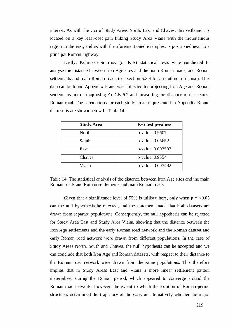
219
interest. As with the vici of Study Areas North, East and Chaves, this settlement is
located on a key least-cost path linking Study Area Viana with the mountainous
region to the east, and as with the aforementioned examples, is positioned near to a
principal Roman highway.
Lastly, Kolmorov-Smirnov (or K-S) statistical tests were conducted to
analyse the distance between Iron Age sites and the main Roman roads, and Roman
settlements and main Roman roads (see section 5.3.4 for an outline of its use). This
data can be found Appendix B and was collected by projecting Iron Age and Roman
settlements onto a map using ArcGis 9.2 and measuring the distance to the nearest
Roman road. The calculations for each study area are presented in Appendix B, and
the results are shown below in Table 14.
Study Area K-S test p-values
North p-value. 0.9607
South p-value. 0.05652
East p-value. 0.003597
Chaves p-value. 0.9554
Viana p-value. 0.007482
Table 14. The statistical analysis of the distance between Iron Age sites and the main
Roman roads and Roman settlements and main Roman roads.
Given that a significance level of 95% is utilised here, only when p = <0.05
can the null hypothesis be rejected, and the statement made that both datasets are
drawn from separate populations. Consequently, the null hypothesis can be rejected
for Study Area East and Study Area Viana, showing that the distance between the
Iron Age settlements and the early Roman road network and the Roman dataset and
early Roman road network were drawn from different populations. In the case of
Study Areas North, South and Chaves, the null hypothesis can be accepted and we
can conclude that both Iron Age and Roman datasets, with respect to their distance to
the Roman road network were drawn from the same populations. This therefore
implies that in Study Areas East and Viana a more linear settlement pattern
materialised during the Roman period, which appeared to converge around the
Roman road network. However, the extent to which the location of Roman-period
structures determined the trajectory of the viae, or alternatively whether the major

220
roads established the early Roman settlement pattern is a more complex question and
is addressed in the following section.
6.5. Discussion
The analysis outlined above strongly suggests that the persistence of pre-
Roman movement and communication was more prevalent in some areas than others,
and goes some way to dispel the hypothesis developed by Sastre Prats (2008) and
outlined in Chapter Two. Such a theory proposes that Late Iron Age society in
northwest Iberia was predominantly characterised as internally ‘antidivisional’, but
more importantly for this discussion, externally ‘antiunificational’ (note while the
terms ‘antidivisional and ‘antiunificational’ are not English words they are employed
by Sastre Prats in her 2008 English language paper on Late Iron Age northwest
Iberia and hence included here), and thereby hostile to peripheral communities.
Nevertheless, the close proximity of a more socially and politically dynamic culture
in the western Meseta suggests that these communities may have had an impact on
the societies which inhabited northwest Iberia. Cross-cultural interaction and
regional connectivity are evident in those optimum paths generated for Study Area
North, which ran from the region to the west of the Meseta, along a route of Late
Iron Age castros, sites 6, 8, 9, 69, towards a possible pre-Roman religious centre of
the Zoelae tribe (Tranoy 1981, 52), where a civitas capital, the civitas Zoelarum,
would be established in the early Roman period. The importance of this route can be
further substantiated by the passage of the Roman road, which closely follows the
least-cost path, as well as the statio and its position at the junction of two optimum
routes, one which led east, and the other to the southeast. Adjoining the territory of
the Zoelae were the Vaccaei, a tribal confederation whose principal settlements,
according to Ptolemy (Geographia, II. 5. 6), writing in the second century AD,
included Helmantica/Salmantica (modern-day Salamanca), Arbucala (Zamora),
Pincia or Pintia (Padilla de Duero-Valladolid) and Intercantia (Paredes de Nava).
The close proximity of these oppida to the territory of the Zoelae (see Figure 3, page
21), and more importantly their subjugation by Rome in the early second century BC
(Livy, 40.47.1; 40.50.6), strongly suggests that certain communities, notably the
Vaccaei, bordering this region of Roman control, would have had contact with the
Late Iron Age societies, among them the Zoelae, on the periphery of northwest
Iberia. Of further significance are references made to wheeled vehicles of the
221
Vaccaei during the campaign by Sempronius Gracchus in 179 or 178 BC, which
refer to wagons (plaustra) placed in a circle for defensive purposes (Frontinus,
Stratagems 4.7.33). In establishing that such wheeled transportation was utilized by
the Vaccaei prior to their conquest by Rome, we can also infer that pre-Roman roads
were established to facilitate their movement, and that one of these routes may have
originated in Vaccean territory and headed west to link up with a possible pre-Roman
religious centre of the Zoelae. Such an exchange route would have brought with it
new ideas and practices, but above all it would have brought those peoples who lived
on the periphery of castro society into the cultural sphere of the Vaccaei, and
thereafter Republican Rome, following their pacification in the mid second century
BC. Additionally, we should also acknowledge that the Vaccean culture and social
practices were very different from the systems of equality suggested by Sastre Prats
(2008) for the people who constituted the so-called ‘Castro Culture’. While there is
little evidence for a social structure in the Vaccean settlement pattern (they occupied
oppida, which functioned as independent city-states), the excavation of complex
burials, at Pintia, modern-day Las Ruedas, in the area east of Valladolid (see Figure
3, page 21), also establishes the existence of a Vaccean social stratum. The contents
of Tomb 75, which contain intricate and highly prized metal objects and weaponry,
as well as a sophisticated saddle with a bone handle, probably represented the grave
goods of a Vaccean chief or leader. Other less ornate grave goods characterised by
imported weaponry symbolised a less wealthy elite, while the lowest rank of burials
were marked by an absence of treasured possessions (Sanz Mínguez et al. 2003). In
this way, the Late pre-Roman Iron Age Vaccaei developed a complex social
hierarchy characterised by unequal access to wealth and resources, whose ideas and
practices would have no doubt influenced to a greater or lesser extent those peoples
located at the margin of their territory, among them the Zoelae.
In other regions of pre-Roman northwest Iberia, contact with outside cultures
would have been more limited because of the cultural buffer provided by
neighbouring societies, as well as the geographical limitations of accessing the
interior. This is visible in the western region of Study Area South, where native
settlements, especially the large fortified hillforts, were physically isolated from the
River Douro to the south. There also appears to have been limited interaction
between these large castro settlements and the medium-sized hillforts in the south of
Study Area Chaves, which were connected by existing cost-efficient routeways.

222
Further analysis, which shows a paucity of settlements in the region between where
Study Areas South and Chaves join, strongly suggests that a buffer territory was
established between the two regions. In form and structure such a hypothesis
corresponds with a reconstruction of territorial boundaries, which may have existed
in the region to the south of the Serra da Nogueira and the Serra de Bornes,
corresponding to the area equidistant between Study Areas North and East, where a
strip of land running east to west is largely devoid of castro settlements. Lemos
(1993 vol. I, 490), proposes that this territory marked the southern limits of the
Zoelae confederation, supporting his hypothesis by affirming that no Zoelae
epigraphy has been found south of the Serra de Bornes. Such an assertion is further
supported by the existence of the indigenous Baniensis, who occupied the territory
further south, and whose capital, the civitas Baniensium, was established during the
early Roman era. The presence of a boundary would support the argument that this
space between the Zoelae and the Baniensis was negotiated at a tribal level, between
kinship-based confederates, and not by territory-based systems shown by the
castellum, or individual hillfort, which were more representative of those
communities found to the west and north of pre-Roman northwest Iberia.
Consequently, the absence of hillforts between the west of Study Area South and the
south of Study Area Chaves, is strong corroboration that competing kinship-based
groups made up from multiple supra-familial units established a regional boundary in
this area.
With the occupation of northwest Iberia by Rome, these tribal boundaries
quickly lost their importance as the landscape was restructured by Imperial agents
with the aid of the local elite. Within the context of Study Area North, the pre-
Roman religious centre for the Zoelae tribe became the seat of their civitas capital,
the civitas Zoelarum. While such an action may be seen as a deliberate policy to
replace native structures of control with Roman ones, in much the same way as late
Roman Christians, such as the Bishop of Tours, would build churches on the ground
of consecrated pagan temples (vita XIII, On the Life of St. Martin), the position of
the civitas capital also took advantage of those strategic least-cost paths embedded
into the landscape. Many of these optimum communication routes ran through or
near to the civitas Zoelarum and would be exploited by local communities who
founded satellite towns to supply the civitas capital. Other least-cost paths, especially
the route which ran west along castro settlements 6, 8, 9 and 69 (see Map 36, centre
223
left), which extended into Vaccaei territory to the east, were altogether more
important, and this one may have represented one of the earliest Roman roads in the
region. A Roman milestone found near Soeira (see Map 36, site 257, centre), on the
northern route east from the civitas Zoelarum, with the weathered inscription
TRIB(uncial) POT(estate) XXI, has been attributed to the years 3-2 BC of Augustus
(27 BC-AD 14), although it could equally apply to another long-serving Emperor
(Alarcão 1988, 40; Lemos 1993 vol. II, 461). However, firmer dating can be
provided by a milestone inscribed with the name of the Emperor Augustus and found
west of Aquae Flaviae along the Via XVII of the Antonine Itinerary. While this is
not conclusive evidence that a Roman highway ran east from Aquae Flaviae during
the Augustan period, it does suggest that such an established routeway existed. The
prime importance of the civitas Zoelarum and its surrounding territory was not solely
economic or political, but also strategic, and during the Cantabrian Wars (29-19 BC),
and the delicate peace which ensued, terrestrial communication with the western
Meseta would have provided a vital gateway to northwest Iberia for both soldier and
civilian alike. Further evidence that the northern passageway west from the civitas
Zoelarum was an early military road, is evident where the road avoids those optimum
pathways utilised by the more southern route, and instead negotiates a more direct
route west and criss-crosses the mountainous terrain, before linking up with a more
cost-effective trajectory heading southwest after castro site 251 (Map 36, centre left).
Where this Roman highway heads west towards Aquae Flaviae and crosses the River
Rabaçal, slope angles as high as 27 degrees are recorded, in contrast to the longer
and more southerly route west, were the gradient is a more manageable 16 degrees.
As a result, the more northern of the two routes would have incurred greater financial
outlay, as well as making the transportation of heavy loads cumbersome and costly.
Nevertheless, the undoubted advantage of this route was to squeeze space-time
thereby creating quicker and more efficient journey times between the outlying
civitas Zoelarum and the more economic and strategically important Aquae Flaviae.
With the compression of time and space between central places, the Roman
road network both within early Roman northwest Iberia and the Roman empire as a
whole, fashioned an ideological divide between those native communities integrated
into the Roman sphere of control and those detached from it (Witcher 1998, 63).
However, the degree of that ideological divide created by the Roman road network
was far from uniform and varied from one region to another. In Study Area East, the

224
Iron Age settlement pattern, which had been divided into three spatial zones (the area
along the River Douro, the region between the River Douro and the River Sabor to
the north and the area around the River Sabor and beyond), now became compressed
along a single Roman highway running northeast to southwest. The importance of
this single Roman road can be illustrated by the Kolmorov-Smirnov test, which
shows that the Iron Age and Roman settlements, with respect to their distance from
the Roman road, were drawn from different populations. In other words, Roman
settlements were orientated around the major Roman road, while Iron Age
settlements were not. The second region to reject the null hypothesis for the
Kolmorov-Smirnov test is Study Area Viana, where large clusters of Roman-period
castros continued to be occupied along the Atlantic coast and towards the interior.
This was in sharp contrast to the river basin around the River Lima and the region to
the south towards Bracara Augusta, which were heavily populated by Roman
settlements and agricultural centres and interconnected through a network of Roman
roads.
However, the Kolmorov-Smirnov test does not fully explain the intricate and
complex relationship between Iron Age and Roman settlements and the arterial
Roman road network. In Study Area Viana, a disproportionate number of Roman
settlements located in the Lima Valley (Map 40, centre) are clustered around the
network of roads, while in other areas, especially those towards the interior, few
settlements are found. Equally, in Study Area East, where the Roman settlement
pattern was redrawn around the main Roman road, the physically distant fortified
hillforts were abandoned, but a cluster of castros (Map 38, centre), near to the
principal communication route in the region and equidistant between two vici
settlements, continued to be occupied.
The pattern of clusters of Roman-period castros positioned away from the
Roman central places, but located near to a major Roman road, is not confined to
Study Area East alone. In Study Area North, a loose grouping of hillforts from the
early Roman era are represented in the area along the more northerly route west. This
would confirm that some native communities in Study Areas East and North, which
continued to occupy fortified hillforts and exhibit a degree of indigenous control,
albeit under Imperial authority, were very much integrated into the early Roman
communication system. However, in other areas, such as the western region of Study

225
Area South, those communities were physically distant from the established Roman
road network, and the power-bases the viae publicae connected.
It is also probable that many pre-Roman sites played a central role in
orientating the subsequent Roman settlement pattern. How the Roman arterial road
network developed, and whether it linked already established central places, or was
instrumental in creating the early first century landscape, constitutes an altogether
more difficult question. In the case of Study Area North, Imperial agents exploited an
existing central place, the religious centre of the Zoelae, and in conjunction with
established indigenous routeways, both expanded and constructed a clear trajectory
for the viae publicae. In all likelihood, the civitas Zoelarum was founded at the same
time that those early Roman roads were being constructed to transport troops. In
doing so, Roman authorities and the native elite began to dismantle indigenous social
structures and tribal affinities, and bring those peoples under central control. As with
the civitas capital of Bracara Augusta, it is also probable that other tribal
confederations, or territorial units, were incorporated into this newly-founded space,
but the Zoelae, whose name and territory constituted the civitas, became the
dominant native partner. In other study areas, notably Study Area Chaves, it is
apparent that the trajectory of the Roman road was strongly influenced by the
location of a possible pre-Roman central place on the site which would later be
occupied by Aquae Flaviae (as discussed in section 5.4). Consequently, Roman
authorities repeated the same policy they had realised with the civitas Zoelarum by
constructing a Roman central place over a probable native one, and in the process
quickly establishing Imperial hegemony over the region. The secondary advantage of
the location of Aquae Flaviae, for the native community and Roman authorities
alike, was its position along a series of least-cost paths from the east, and the lower
water level at this point would have facilitated the crossing of the River Tâmega.
In other study areas, the existing pre-Roman structures did not play such an
important role in defining the Roman settlement pattern, as with Study Area East,
where the native settlement pattern was strongly orientated around a series of
waterways, and their fluvial networks. The construction of the via publica in this
region does not appear to have exploited any existing indigenous communication
routes connecting native settlements, but rather, Imperial authorities utilised those
available cost-efficient passageways within the landscape to map and construct the
main Roman highway. Thereafter two vici, one at either end of this communication

226
route, were founded to provide for the administrative and strategic needs of the
region.
In Study Area South, a more complex pattern emerges, with the civitas
Baniensium established at the strategic and commercially important confluence of
the Rivers da Vilariça and the Sabor. The location of the civitas Baniensium also
took advantage of optimum pathways adjoining the valley basin of the River da
Vilariça, to provide a route north to join with the southern trajectory of the Roman
highway heading west from the civitas Zoelarum to Aquae Flaviae. Nevertheless, the
course of this route north from the civitas Baniensium was not solely conditioned by
the lay of the land, and the availability of cost-efficient passageways, but also
representative of the strategic and commercial needs of the region. Where the Roman
road would logically deviate to the west and run past villa 772, or along another
optimum passageway near Roman-period castro 611 (Map 37, centre), the route
instead heads north through a cluster of mining sites 730, 760 and 627, thereby
affirming the importance of mining activity within the region, over cost-efficient
routeways. Such practices are repeated in Study Area Viana, where the logical route
of the Via XIX would be to follow a least-cost path with low average gradients and a
maximum of 12 degrees, in contrast to the actual trajectory of the Via XIX where
average gradients are between five and ten degrees, with a maximum of 20. Without
doubt, the actual path of the Via XIX would have presented difficulties for the
haulage of goods, particularly on steep slopes where rudimentary braking systems
and slow moving tractions animals would have made such journeys more dangerous,
longer and therefore more costly. While it could be suggested that this section of the
Via XIX integrated a series of Roman-period castros into the Imperial transport
network, it is more likely the route took advantage of the patchwork of prime Type A
and C farmland.
While viae publicae dominated the landscape and linked up the major
metropolitan centres, local roads or viae vicinales, as well as private and estate roads,
viae privatae, also played an important role in integrating local communities into the
Roman arterial road network. In the absence of epigraphic evidence and
archaeological remains to substantiate the nature of these routeways, it is impossible
to discern where the majority of these local roads ran, nor to identify whether they
were viae vicinales under the responsibility of local magistrates, or viae privatae
owned by private estates. Nevertheless, the linear pattern of agricultural settlements
227
in Study Area East (Map 38, top centre) and Study Area Chaves, where casals 540,
536 and 535 (centre) may have been linked by a bridge or fordable route across the
River Tâmega to villae sites 514, 504 and 503, strongly suggests the presence of
secondary roads. In the case of those agricultural centres located on a series of least-
cost paths to the north of Aquae Flaviae, there may have been a degree of
connectivity between these terrestrial routes and adjoining waterways, thereby
allowing access to these fluvial networks. This strongly suggests that both terrestrial
and fluvial communication routes were interchangeable, and seasonal factors as well
as the direction of travel may have played an important role in the use of one form of
transportation over another.
It is therefore important that we move away from the strict dichotomy of
fluvial and terrestrial transportation, as well as established major roads versus
secondary routes and pathways. Many of the actors undertaking daily activities
would have utilised a myriad of different communication routes in their movement
around the landscape, as illustrated by the location of vici settlements. The position
of these small administrative and commercial centres on least-cost paths but within a
few kilometres of the main Roman highway, as shown by Study Areas North, East,
Chaves and Viana, demonstrates the interconnection of pathways and established
routeways. It is also probable that these vici sites monitored and controlled
communication routes through the landscape, especially if those optimum
passageways constituted trackways (calles) for the large-scale movement of animals
from one area to another. So important were these calles that they were known as
calles publicae, or set routes, and were officially recognised and therefore subject to
regulation by the state (Varro R.R. 2.1.16 and 2.9.6-7). In this sense, the vicus site 17
in Study Area North (Map 36, top right) and vicus settlement 168 (Map 40, centre
right) in Study Area Viana, were both positioned at the margin of the mountainous
terrain towards the east, and may have operated as a strategic outpost to monitor
indigenous activity, as well as manage interregional transhumance, in the early
Roman period.
6.6. Conclusions
In summary, a series of points can be made about the nature and importance
of the pre-Roman communication routes and central places in northwest Iberia, and
228
their role in defining the Roman arterial road network and the early Imperial
settlement pattern.
1. The presence, use and impact of passageways in northwest Iberia during the late
pre-Roman period was very much constrained and conditioned by the geography of
the region, as well as the juxtaposition of neighbouring tribal confederations and
Roman authorities. This is especially true of the Vaccaei, who were pacified by
Republican Rome in the second century BC, and undoubtedly had contact, possibly
extending to commercial exchange, with the Zoelae in Study Area North. The
existence of four fortified hillforts, two on either side of the River Sabor (see section
4.7.2), supports the idea that trade networks between modern-day Trás-os-Montes
most likely extended into the central Iberian peninsula, through the western Meseta.
This further substantiates the existence of a routeway further north, which connected
Vaccaei territory with a possible pre-Roman religious centre of the Zoelae. The
consequences of this passageway would not only have brought with it new ideas and
practices, but more significantly would have generated considerable profits for those
individuals who controlled these networks of exchange, and access to prestige goods.
The continuity of such systems over the short-term would have created inequality
within the community, and over the longer term hierarchical social systems, with a
prominent elite.
2. However, political, social and above all commercial links with adjoining
communities were not uniform within pre-Roman northwest Iberia. In the western
region of Study Area South, where a cluster of large hillforts would continue to be
occupied into the early Roman period, the archaeological evidence strongly suggests
that this community had isolated itself from neighbouring tribal and territorial
affiliations. Firstly, the settlements in this region do not appear to have utilised the
River Douro, preferring instead to locate away from it. Secondly, there appears to be
a border area, characterised by the presence of a few medium-sized hillforts between
the southern area of Study Area Chaves, and the western area of Study Area South.
Located on the periphery of this borderland, these medium-sized settlements appear
to have occupied territory near to least-cost paths, suggesting their function was to
provide an element of strategic control. Equally, these medium-sized castros may
have functioned to administer and control commercial activity. Either way, the
proposed boundary between these communities of western Study Area South and the
southern area of Study Area Chaves, are representative of other tribal borderlands for

229
other cultures in the region. It is therefore probable that two tribal kinship-based
groupings, much like the Zoelae, created and consolidated a loose boundary along
the margins of their respective territorial concerns.
3. With the pacification of northwest Iberia, established routeways and pre-Roman
central places were exploited by Roman authorities. In Study Area North, the
passageway west from the Meseta was transformed into a major road, a via publica,
while a civitas capital was established on the space occupied by the pre-Roman
central place of Zoelae. This confirms that the Iron Age community who inhabited
this space and Imperial agents alike recognised the political and economic-benefits of
the existing road and settlement patterns, which exploited a series of well-defined
least-cost paths. Furthermore, by constructing a civitas capital on a pre-existing
native structure, Roman agents were able to control the strategic junction, where the
Roman road bifurcates, and so command control over the region as a whole. Such a
policy was not limited to Study Area North, but was also visible in Study Area
Chaves, where the optimum route west crossed the River Tâmega at the location
controlled by a probable Iron Age settlement of the Turodi (see Chapter 5.5.2), and
where a series of Roman central places would emerge culminating in the municipium
of Aquae Flaviae.
4. The construction of the Roman arterial road network was also a gradual and
continuous process in northwest Iberia, as in the Roman empire as a whole. In Study
Area North, the early date of the northern route west from civitas Zoelarum lends
support to the view that this was a military road which linked the eastern Meseta with
Study Area Chaves and beyond. The military provenance of this passage is apparent
in the mountainous terrain and the steep gradients this road negotiates, where a more
cost-effective routeway, which would become the southern route west from the
civitas Zoelarum, was available further south. The benefit of such a financial outlay
for the Roman authorities was to compress space-time and offer a faster, although
more expensive, route between strategic central places. Whether the road was ever
used for its original purpose, to provide a temporal advantage for the transportation
of troops and supplies, as well as logistical information, is difficult to establish.
Nevertheless, with the pacification of the region, such a route may not have benefited
long-distance hauliers, who may have utilised the longer but more cost-efficient
southerly route.

230
5. While the construction of the Imperial road network and the establishment of
Roman central places in Study Areas North and Chaves was very much orientated
towards exploiting pre-existing routeways and tribal centres, Study Areas East, South
and Viana illustrate a series of very different decisions. In Study Area East, where
the native settlement pattern was strongly orientated around a series of waterways,
the main Roman road followed a series of least-cost paths which ran inland from the
River Douro. With a clear absence of indigenous structures located on these least-
cost paths, it is impossible to establish how the via publica exploited this optimum
route. What can be said with more certainty is the chronology of this major
communication route, with the foundation of two vici settlements at either end of the
via publica, was undoubtedly a later addition. In other regions, notably, Study Area
South, it is likely that the civitas Baniensium was located at the strategic confluence
of the Rivers da Vilariça and the Sabor, and thereafter a major Roman road was
constructed.
6. The impact of these established Roman highways on native communities varied
from one region to another. In Study Areas North and East, clusters of native
communities in the early Roman period who continued to live in fortified hillforts,
can be found near to established viae publicae. In other areas, notably, the western
region of Study Area South and those more isolated regions such as Study Area
Viana, there does not seem to have been a deliberate policy of isolating these native
people. Rather the economic needs and the logistics of transporting goods, dictated
that agricultural and non-agricultural settlements be located near to good
communication routes, and within easy access to market. In Study Area South, the
impetus was altogether different, with the civitas Baniensium established to control
the confluence of the River Douro and Sabor and monitor the mining activities in the
region, which subsequently gave rise to a series of smaller agricultural and non-
agricultural settlements to supply the local area and the civitas capital.
7. Where no waterway or main Roman road was present, secondary roads were
constructed by local towns or private estates to provide a level of connectivity
between different areas to help in the transportation of goods and exchange of
information. The relative isolation of many of these secondary roads linking multiple
agricultural producers, from larger Roman settlements and urban areas, points to
long-distance haulage, and the existence of regional exchange networks. It is also
likely that these agricultural producers utilised a multitude of different transport
231
routes, from fluvial to overland passage, as well as trails, paths, secondary roads, and
major highways.
8. In acknowledging that movement employed multiple communication routes within
the landscape of early Roman northwest Iberia, the location of vici settlements at the
margins of multiple least-cost paths and within a few kilometres of a major Roman
road, now take on an additional meaning. While such settlements are likely to have
operated as strategic outposts to monitor indigenous activity, they may also have
functioned to coordinate and manage transhumance along established pathways. As
Varro establishes (R.R. 2.1.16), unregistered flocks being taken to summer pastures
were reported to the tax-collectors because they contravened Roman law. In this
respect, vici settlements, which were located away from civitas capitals, may have
operated as tax collectors for those shepherds utilising centuries-old summering
pasture.
232
Chapter Seven. Discussion. Continuity and Change in Northwest Iberia
7.1. Introduction
This discussion brings together the key themes arising from the discussion of
and empirical data examined in the three core analytical chapters of this thesis. In
incorporating the principal findings of Chapters Four, Five and Six, this work also
seeks to draw upon other analytical frameworks, particularly those developed in
Chapter Two, to generate a clear understanding of the changes evident in the
landscape and settlement pattern of northwest Iberia between the Late Iron Age and
the early Roman period. In doing so, the principal aim of this chapter is to discuss the
most fundamental research findings of this study, and provide a means to answer the
key aims and objectives generated at the beginning of this thesis, and addressed in
the subsequent chapter.
7.2. Models of Iron Age Society
At the outset of this thesis, two competing and diametrically-opposed
theoretical frameworks were outlined as providing the current basis of understanding
for Late pre-Roman Iron Age society in northwest Iberia. The first of these two
theories is the model put forward by Parcero Oubiña (2003), which seeks to explain
change, and above all the emergence of systems of inequality, as a consequence of
native reaction to the arrival of Rome. However, as a basis for understanding the
nature of castro society, Parcero Oubiña’s (2003) hypothesis draws heavily on the
regions, which had close contact with Roman authorities, and in this respect, the
argument he presents is more relevant to those communities located along the
Atlantic coast. For this reason, I shall incorporate Parcero Oubiña’s (2003) model of
castro society later in this chapter, when discussing the nature of my study areas
located near to the Atlantic coast, particularly Study Area Chaves and Viana. The
second hypothesis, advocated by Sastre Prats (2008, 1023-1024) proposes a model of
late castro society, which encompasses the region of northern and western León,
western Zamora and most importantly, for the sake of this thesis, the region of Trás-
os-Montes (see Figure 3, page 21), which is represented in this thesis through Study
Areas North, South and East.
Underpinning Sastre Prats’ (2008) model is the identification of a series of
‘familial’ enclosures which are interpreted as evidence of social distance and tension
between family groups and thereby limited the accumulation of surplus produce and

233
the consolidation of power (see section 2.2.1). As I have argued there are
inconsistencies with the identification of these storage units (see section 1.5.4 and
2.2.2.3), the identification of ‘familial’ units (see section 1.5.4) and the consolidation
of surplus production and power in pre-Roman northwest Iberia (see sections 2.2.2.3
and 2.2.2.4). Moreover, the theoretical framework that Sastre Prats et al. advance is
not convincingly represented in the empirical research conducted for the study area.
In comparing Sastre Prats’ (2008) model against the empirical evidence
generated in this thesis for the Late Iron Age settlement pattern of Trás-os-Montes,
as well as other available archaeological evidence, a series of problems emerge.
Firstly, the findings from Study Area North, which falls into Sastre Prats’ (2008)
geographically-determined zone of isolated and independent fortified hillforts,
illustrate that many Late Iron Age castros existed within close proximity of one
another. Possible cooperation between adjacent hillforts can be seen in the early
Roman period, where the Late Iron Age settlement pattern broke down and one
castro was often abandoned, while the other continued to be occupied as a Roman-
period castro. The relationship between these neighbouring hillforts can additionally
be seen in Study Area North where Roman agricultural centres, the villae and casals,
began to emerge on the margins of Iron Age boundaries (on lower ground where the
gradient of the land was less steep (see Tables 12 and 13, see section 5.3.4), as
communities with a common ideology began to share their resources and manpower.
While these activities may at best reflect the close economic cooperation between
adjacent hillforts, they may also symbolise more ingrained and important shared
concerns, which perhaps extended as far as political affiliation. The notion of
political cooperation between individual settlements is not based solely upon analysis
of Study Area North, but also finds support from other evidence, notably epigraphic
evidence from the early Roman period, and more specifically the Edict of the Zoelas,
recording a treaty between two hillfort communities. This hospitality pact, dating to
AD 27, affirms the renewal of an undisclosed declaration of friendship between the
gentilitates Tridiuorum and Desoncorum who both belonged to the gens Zoelarum,
or the Zoelae tribe. Here the term gentilitas probably equates to a single settlement or
castro (Mangas 2000, 50, 52), and thereby supports the argument conceived from
Study Area North that close cooperation and a high degree of connectivity existed
between individual hillforts, which were in turn incorporated into a larger tribal
entity, the Zoelae, through lineage and kinship-based ties (see sections 4.4 and 4.7).

234
The political affiliations which existed between the as yet unidentified
hillforts of the Tridiuorum and Desoncorum, as well as other neighbouring castros
located within close proximity to one another, as shown by the analysis of Late Iron
Age structures in Study Area North, are likely to have extended to include mutually-
beneficial strategic concerns. While the Edict of the Zoelas dates from the period
after the conquest of the region by Imperial forces (AD 27), the friendship concluded
between two communities was in the process of being renewed (Sastre Prats 1998,
65). This demonstrates that an earlier treaty existed between the Tridiuorum and
Desoncorum, which may have been initiated during the Late Iron Age, when
indigenous forms of governance and control administered the landscape. The
question therefore remains as to why friendship pacts existed between neighbouring
hillforts and why these castro settlements, within the context of Study Area North,
were often found within close proximity of one another. I believe the basis of that
friendship was to provide a strategic answer to conflict and the threat of violence
within the region.
7.2.1. Violence in Late Castro Society
The suggestion that the Late pre-Roman Iron Age communities in parts of
northwest Iberia were engaged in orchestrated warfare, is nevertheless a moot issue.
A second fundamental argument within Sastre Prats’ (2008) model of castro
settlements in the region to the west of the Meseta concerns the nature of conflict
between competing fortified hillforts, in particular her interpretation of Clastres
(1999) to argue that late castro society was not inherently violent. Her argument that
belligerent activity was largely confined to pillaging and small-scale raiding is
problematic, especially in Trás-os-Montes where a series of large and organised
tribal confederacies, such as the Vaccaei and the Vettones, were located on their
borders. A more logical interpretation would suggest that castro settlements needed
advanced weaponry of the day to defend themselves against these larger, more
organised and experienced tribal groupings.
One interesting aspect about the study region is evidence for cheavaux-de-
frise (see section 1.5.1 for introduction), or defensive structures used to obstruct
cavalry, present in a number of fortified hillforts in northern Portugal. Cheavaux-de-
frise (singular: cheval-de-frise) can be found at: sites 4, 27, 30, 82, 100, 228, 235 in
Study Area North; sites 327, 336, 357, 364, 393, 487, 509, 573 in Study Area East;
235
as well as large hillfort 802, located to the west of Study Area South (see Lemos
1993 vol. II). Cheavaux-de-frise structures have also been discovered as far west as
Study Area Chaves, at sites 155 and 160, but at other locations, for example sites
335, 413 and 603, their identification continues to be debated (Teixeira 1996, 61, 70,
97). The majority of cheavaux-de-frise within the study region have been located in
Study Areas North and East, leading to the suggestion that the inspiration for such
defences originated in the Meseta (Fonte 2008, 18). In addition to cheavaux-de-frise
many settlements incorporated multiple ditches (Fonte 2008, 22), but how the
defensive structures operated continues to be debated. Ruiz Zapatero (2003) argues
that the stones of the cheavaux-de-frise designed to impede movement were located
too close to the defensive walls for archers to effectively eliminate attackers. Such a
hypothesis is in my opinion invalid, as attackers do not necessarily need to be slowed
down below as they can be shot with an arrow, and secondly, other weapons, for
example the spear (rock art near the citânia of Sanfins shows a horseman hunting
deer with a spear (Queiroga 2003, 59)), may have been used along the defensive
walls. Another theory put forward by Moret (1991, 11-12) is that cheavaux-de-frise
were initially constructed to impede warriors on foot rather than cavalry charges,
arguing that mounted horsemen appeared at a later date. However, Moret’s (1991)
study focuses on the Meseta region where the dating of settlements through burials
and other means is more precise. Certainly, there is no firm evidence as to when
mounted horsemen were present in Study Areas North and East, and the study region
as whole.
Material evidence for the existence of military hardware in Late Iron Age
northwest Iberia is, however, lacking. This is perhaps due to the nature of the caustic
soil in the region, which consumes both organic matter, leaving little evidence of
osteological remains for both humans and animals, while also corroding non-organic
forms, such as metal weaponry (González Ruibal 2006, 159; Parcero Oubiña 2003,
291; Queiroga 2003, 58, and see section 2.2.2.5). An additional consideration is the
complete absence of burial sites within the context of Late Iron Age northwest Iberia
(Martins pers. comm. 03/03/2008), which suggests that extramural internment, where
both organic and non-organic material (possibly in the form of weaponry) may have
been broken down over the passing of time. We should also consider how burials
were conducted among castro communities. In the case of the Vaccaei, funerary
practices testify that those who died from old age were burned, while those slain in
236
battle were regarded as noble, and cast to the vultures for excarnation (Aelian X, 22).
If such activities were commonplace amongst neighbouring castro communities, this
would go some way to explain the absence of burial sites within the region during the
Iron Age.
In adopting a comparative approach, it is interesting to note that many of the
issues confronting scholars, especially those examining violence in northwest Iberia
during the Iron Age, are present within the context of Iron Age Britain. Of particular
importance is the nature of the Iron Age, which has been traditionally depicted as
agrarian and by this very premise peaceful, as the assumption has been that farmers
do not engage in violence (Hill 1996, 8). Other scholars, notably Sharples (1991),
have implied that some level of violence must have existed in Iron Age Wessex, but
his argument is tempered by the limited number of weapons found within the
landscape. Nevertheless, the absence of evidence is not evidence of absence, as
weapons rarely appear to have been deposited where they could be preserved, a fact
borne out by the limited number of Republican and Imperial weapons unearthed
(Bishop and Coulston 1993). James (2007, 161), develops this discussion further and
argues that scholarly interpretation of Iron Age Britain rests on a series of simplistic
assumptions and omissions, which emphasise the passive nature of the period and
reflect modern-day distaste for violence, and so depict society as having been
composed of small-scale egalitarian communities. The widespread pacification of the
past, particularly in British archaeology, and which may have provided both an
inspiration and direction for Sastre Prats’ (2008) hypothesis of an egalitarian and
predominantly non-violent society (see Hill (1996) for a non-violent Iron Age), has
in recent years been questioned (see Keeley 1996; Sharples 1991). James (2011, 132-
133) contends that this demilitarisation of the British Iron Age and hillfort
settlements stems partly from a more postprocessaulist agenda, which took hold at
the end of the twentieth century and stressed ideology and symbolism over martial
functions and violence (see Hill (1995, 55)). Consequently, there has been little
investigation both in terms of research and excavation into the carnage and brutality
which may have characterised the Iron Age (James 2011, 135-138). More recent
discoveries of Iron Age hillfort, such as the Fin Cop in the English Peak District,
would appear to justify James’ (2007; 2011) hypothesis. In this case, the limestone
geology of the region has preserved a series of mass graves lying outside the
settlement, which point to a large-scale massacre of the Iron Age inhabitants of Fin
237
Cop (BBC News. 18/04/2011). How widespread such violence was in Iron Age
Britain, or northwest Iberia during this period is impossible to establish, but it does
suggest that hillforts and their fortifications were not simply symbolic structures but
served a very real function to protect their inhabitants.
Other forms of archaeological evidence present in Late Iron Age northwest
Iberia contribute to our understanding of the region. These include stone warrior
statues complete with a dagger and a shield (see section 2.2.2.5), found generally
among those citânias located between the Rivers Douro and Minho, and which may
represent depictions of Late Iron Age warriors, who invested in a political economy
strongly orientated around war (González Ruibal 2006, 155). Textually-derived
evidence would seem to affirm the presence of organised conflict with Strabo’s
account of native light-armed soldiers, heavily armed soldiers, and cavalry organised
by those communities inhabiting the region of northwest Iberia during the Late Iron
Age (Geographia III, 3, 7). We should acknowledge that although Strabo (c-63 BC-
AD 24), wrote the Geographia following the conclusion of the Cantabrian Wars (29-
19 BC), his source for much the Iberian Peninsula was another classical writer,
Poseidonius (135-51 BC) (Ellis 1998, 49-50), and in this respect Geographia may
reflect the dynamics of castro society in the first century BC before the pacification
of the region by Rome.
7.2.2. Long-Distance Exchange Networks and the Influence of Neighbouring
Tribal Confederations
The armed warriors alluded to by Strabo, imply that hillfort communities
were more than capable of defending themselves against hostile forces. In the case of
those castro settlements in Study Areas North and East, the use of violence, or
equally the threat of violence, may have been deployed by castro communities to
protect long-term exchange networks emanating from the east. In Study Area North,
the most northern of these terrestrial routeways connected a possible religious centre
of the Zoelae (Tranoy 1981, 52), the future civitas Zoelarum (Study Area North, site
43), along a series of optimum pathways, with the Meseta and the Vaccaei and the
Vettones to the east, as discussed in section 6.5. Located along this least-cost path
were a series of Late Iron Age fortified hillforts, which may have provided strategic
support in controlling and monitoring the passage of people and goods. Further south
in Study Area North, four castro settlements, with one medium-sized castro and one
238
small castro on either side of the River Sabor, appear to have monitored an important
river-crossing, which again may have linked the modern-day Trás-os-Montes with
those tribal confederations to the east. In terms of the general settlement pattern of
Study Area North, the presence of two castros on either side of the river crossing
suggests that these settlements operated as closely affiliated communities with
perhaps the medium-sized castro the dominant partner (see sections 4.7.2 and 4.8).
Certainly, the abandonment of one hillfort either side of the river and continued
occupation of the other during the early Roman period, may imply that there was an
element of shared economic as well as political concerns (see discussion 5.4). The
excavation and analysis of the circular defensive wall has shown that many of these
hillforts were small; they held no more than 200 occupants (Alarcão 2003, 25;
Lemos 1993 vol. I, 199), with the population of medium-sized hillforts rising to
between 250 and 1000 inhabitants (Lemos 1993 vol. I, 199). The limited number of
warriors each castro settlement could supply (Almagro Gorbea and Lorrio Alvarado
2004, 89-90), would therefore have obliged these communities to share their
resources in order to provide for their security, particularly weapons and mounted
horsemen which required a high initial cost and subsequent maintenance. In the case
of those two communities located on either bank of the River Sabor, payment
collected from the possible passage of goods or people would have provided the
necessary capital for providing security for the settlements. Where other less
economically-dynamic settlements arose, political co-operation would have been an
absolute necessity to provide a united front against a changing and often violent
world.
Further evidence for long-distance exchange networks are evident along the
River Douro in Study Area East, where a series of castro settlements were positioned
along those steep cliffs carved by the passage of the river (see Figure 32 below).
Given the complete absence of Late Iron Age settlements located along the River
Douro in Study Area South to the west, it is likely that these castro sites located
along the River Douro in Study Area East, were affiliated in some way with the
second century BC large fortress of Villalcampo (see section 4.7). Located at the
strategic confluence of the Rivers Duero (Portuguese Douro), and the River Esla (see
Figure 3, page 21), this large settlement was positioned on the possible territorial
margins of the aforementioned Vettones to the southeast and the Vaccaei to the
northeast (Esparza Arroyo 1987). The importance of these boundaries located around
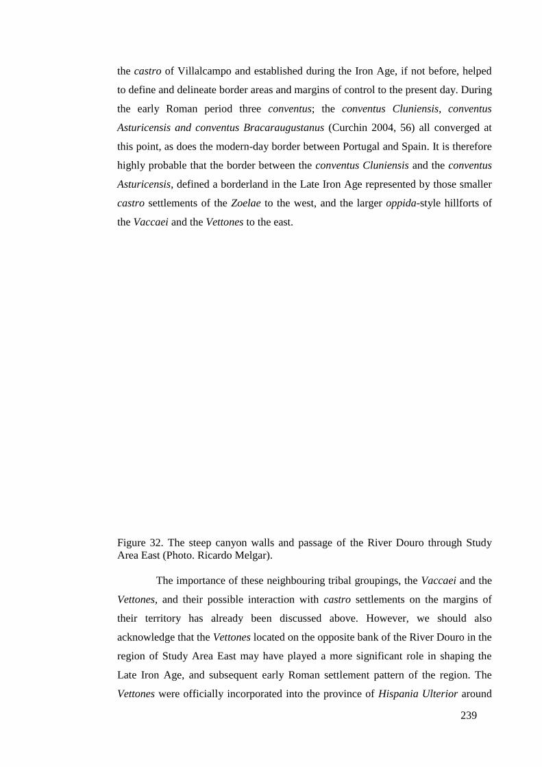
239
the castro of Villalcampo and established during the Iron Age, if not before, helped
to define and delineate border areas and margins of control to the present day. During
the early Roman period three conventus; the conventus Cluniensis, conventus
Asturicensis and conventus Bracaraugustanus (Curchin 2004, 56) all converged at
this point, as does the modern-day border between Portugal and Spain. It is therefore
highly probable that the border between the conventus Cluniensis and the conventus
Asturicensis, defined a borderland in the Late Iron Age represented by those smaller
castro settlements of the Zoelae to the west, and the larger oppida-style hillforts of
the Vaccaei and the Vettones to the east.
Figure 32. The steep canyon walls and passage of the River Douro through Study
Area East (Photo. Ricardo Melgar).
The importance of these neighbouring tribal groupings, the Vaccaei and the
Vettones, and their possible interaction with castro settlements on the margins of
their territory has already been discussed above. However, we should also
acknowledge that the Vettones located on the opposite bank of the River Douro in the
region of Study Area East may have played a more significant role in shaping the
Late Iron Age, and subsequent early Roman settlement pattern of the region. The
Vettones were officially incorporated into the province of Hispania Ulterior around
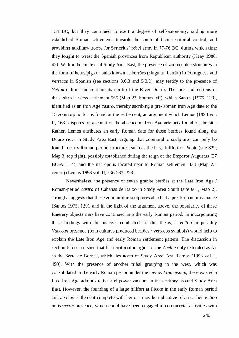
240
134 BC, but they continued to exert a degree of self-autonomy, raiding more
established Roman settlements towards the south of their territorial control, and
providing auxiliary troops for Sertorius’ rebel army in 77-76 BC, during which time
they fought to wrest the Spanish provinces from Republican authority (Keay 1988,
42). Within the context of Study Area East, the presence of zoomorphic structures in
the form of boars/pigs or bulls known as berrões (singular: berrão) in Portuguese and
verracos in Spanish (see sections 3.6.3 and 5.3.2), may testify to the presence of
Vetton culture and settlements north of the River Douro. The most contentious of
these sites is vicus settlement 565 (Map 23, bottom left), which Santos (1975, 129),
identified as an Iron Age castro, thereby ascribing a pre-Roman Iron Age date to the
15 zoomorphic forms found at the settlement, an argument which Lemos (1993 vol.
II, 163) disputes on account of the absence of Iron Age artefacts found on the site.
Rather, Lemos attributes an early Roman date for those berrões found along the
Douro river in Study Area East, arguing that zoomorphic sculptures can only be
found in early Roman-period structures, such as the large hillfort of Picote (site 329,
Map 3, top right), possibly established during the reign of the Emperor Augustus (27
BC-AD 14), and the necropolis located near to Roman settlement 433 (Map 23,
centre) (Lemos 1993 vol. II, 236-237, 328).
Nevertheless, the presence of seven granite berrões at the Late Iron Age /
Roman-period castro of Cabanas de Baixo in Study Area South (site 661, Map 2),
strongly suggests that these zoomorphic sculptures also had a pre-Roman provenance
(Santos 1975, 129), and in the light of the argument above, the popularity of these
funerary objects may have continued into the early Roman period. In incorporating
these findings with the analysis conducted for this thesis, a Vetton or possibly
Vaccean presence (both cultures produced berrões / verracos symbols) would help to
explain the Late Iron Age and early Roman settlement pattern. The discussion in
section 6.5 established that the territorial margins of the Zoelae only extended as far
as the Serra de Bornes, which lies north of Study Area East, Lemos (1993 vol. I,
490). With the presence of another tribal grouping to the west, which was
consolidated in the early Roman period under the civitas Baniensium, there existed a
Late Iron Age administrative and power vacuum in the territory around Study Area
East. However, the founding of a large hillfort at Picote in the early Roman period
and a vicus settlement complete with berrões may be indicative of an earlier Vetton
or Vaccean presence, which could have been engaged in commercial activities with

241
local communities. Lastly, the idea briefly discussed above that vicus settlement 565
was not a pre-Roman structure because, (a) no Late Iron Age material evidence was
found at the site, and more importantly, (b) no fortifications were uncovered (Lemos
1993 vol. II, 163), puts forward the idea that open settlements (without defensive
walls) did not exist in the Late Iron Age. However, the identification of a vicus at
Santa Marta de Lucenza (Ourense, Galicia) with evidence of an Iron Age settlement
(Rodríguez Colmenero 1976), demonstrates the existence of open settlements within
northwest Iberia during the Iron Age and questions the number of as yet unidentified
pre-Roman open settlements which may have developed as early Imperial
settlements.
7.2.3. The Settlement Pattern in Northwest Iberia during the Late Iron Age
If the people in Study Areas North and East did invest heavily in commercial
activity with their neighbours, both regions achieved this aim in very different ways,
as shown by their distinct settlement patterns. This is especially evident when
comparing the location of hillfort settlements along the River Douro in Study Area
East, with the castro sites in Study Area North, and in turn may indicate the presence
of very different social structures in the two study areas. In the case of Study Area
East, the hillfort settlements are positioned at intervals of 2 to 6km along the River
Douro (see Figure 33 below), which implies that its inhabitants enjoyed a degree of
political and economic autonomy (see section 4.8). In this respect, the model of an
isolated castro developed and championed by Sastre Prats (2008, see section 2.2.1),
could be applied to the socio-political makeup of these settlements, which appear to
be physically isolated from one another. Nevertheless, we should also acknowledge
that several of these cliff-top settlements may have been affiliated to some degree in
the Late Iron Age with those tribal confederations (the Vettones or Vaccaei, see
previous section) on their borders. This region still presents a sharp contrast to the
settlements in Study Area North, many of which were located in close proximity to
one another (see Figure 34 below) and represented communities, which probably
shared economic and political affinities bound together by established kinship ties.
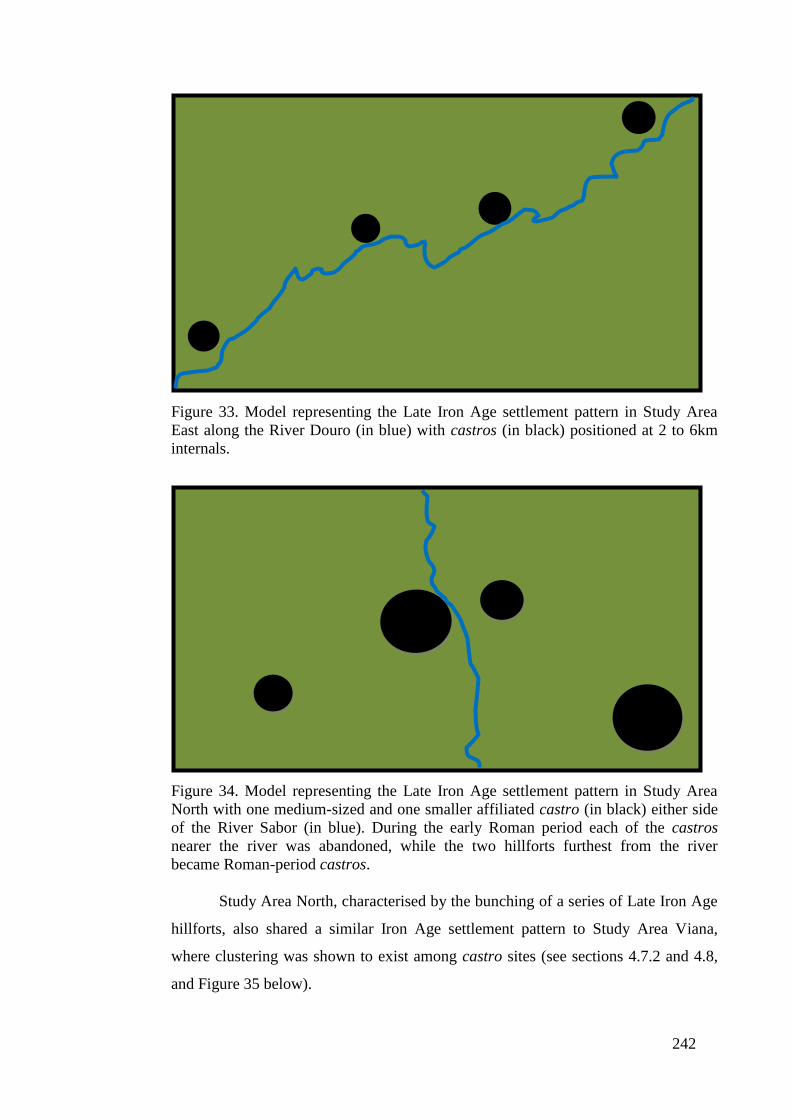
242
Figure 33. Model representing the Late Iron Age settlement pattern in Study Area
East along the River Douro (in blue) with castros (in black) positioned at 2 to 6km
internals.
Figure 34. Model representing the Late Iron Age settlement pattern in Study Area
North with one medium-sized and one smaller affiliated castro (in black) either side
of the River Sabor (in blue). During the early Roman period each of the castros
nearer the river was abandoned, while the two hillforts furthest from the river
became Roman-period castros.
Study Area North, characterised by the bunching of a series of Late Iron Age
hillforts, also shared a similar Iron Age settlement pattern to Study Area Viana,
where clustering was shown to exist among castro sites (see sections 4.7.2 and 4.8,
and Figure 35 below).
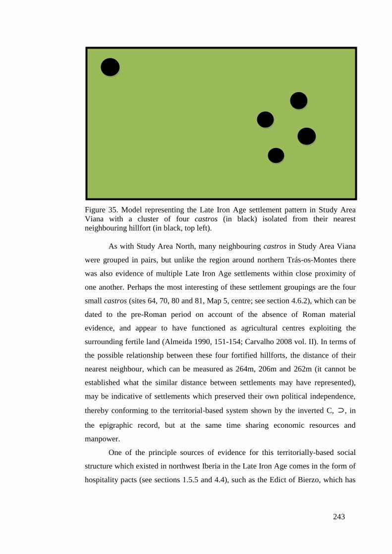
243
Figure 35. Model representing the Late Iron Age settlement pattern in Study Area
Viana with a cluster of four castros (in black) isolated from their nearest
neighbouring hillfort (in black, top left).
As with Study Area North, many neighbouring castros in Study Area Viana
were grouped in pairs, but unlike the region around northern Trás-os-Montes there
was also evidence of multiple Late Iron Age settlements within close proximity of
one another. Perhaps the most interesting of these settlement groupings are the four
small castros (sites 64, 70, 80 and 81, Map 5, centre; see section 4.6.2), which can be
dated to the pre-Roman period on account of the absence of Roman material
evidence, and appear to have functioned as agricultural centres exploiting the
surrounding fertile land (Almeida 1990, 151-154; Carvalho 2008 vol. II). In terms of
the possible relationship between these four fortified hillforts, the distance of their
nearest neighbour, which can be measured as 264m, 206m and 262m (it cannot be
established what the similar distance between settlements may have represented),
may be indicative of settlements which preserved their own political independence,
thereby conforming to the territorial-based system shown by the inverted C, ⊃, in
the epigraphic record, but at the same time sharing economic resources and
manpower.
One of the principle sources of evidence for this territorially-based social
structure which existed in northwest Iberia in the Late Iron Age comes in the form of
hospitality pacts (see sections 1.5.5 and 4.4), such as the Edict of Bierzo, which has
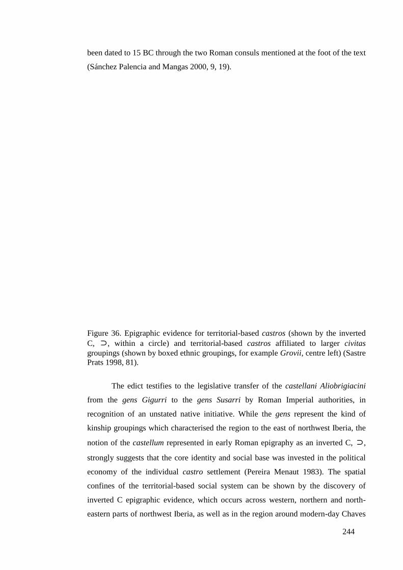
244
been dated to 15 BC through the two Roman consuls mentioned at the foot of the text
(Sánchez Palencia and Mangas 2000, 9, 19).
Figure 36. Epigraphic evidence for territorial-based castros (shown by the inverted
C, ⊃, within a circle) and territorial-based castros affiliated to larger civitas
groupings (shown by boxed ethnic groupings, for example Grovii, centre left) (Sastre
Prats 1998, 81).
The edict testifies to the legislative transfer of the castellani Aliobrigiacini
from the gens Gigurri to the gens Susarri by Roman Imperial authorities, in
recognition of an unstated native initiative. While the gens represent the kind of
kinship groupings which characterised the region to the east of northwest Iberia, the
notion of the castellum represented in early Roman epigraphy as an inverted C, ⊃,
strongly suggests that the core identity and social base was invested in the political
economy of the individual castro settlement (Pereira Menaut 1983). The spatial
confines of the territorial-based social system can be shown by the discovery of
inverted C epigraphic evidence, which occurs across western, northern and north-
eastern parts of northwest Iberia, as well as in the region around modern-day Chaves

245
shown on Figure 36 above as Aquae Flaviae. Evidence for territorial-based power
structures can be broken down further to incorporate; (a) hillforts which solely
exhibited an inverted C in their epigraphic representation, and (b) castro settlements,
which contained a reference to an inverted C as well as the affiliated civitas, or tribal
grouping to which the castro belonged. These two territorial social structures are
shown on Figure 36 above.
The location of the four small castros (sites 64, 70, 80 and 81, Map 5), in the
territory of the Levni and Sevrbi along the Atlantic coast and the Coelerni (as
discussed in sections 1.5.6 and 1.5.7) and Quarquerni towards the interior (Figure
36, bottom left), suggests that these four hillforts were not incorporated into larger
territorial groupings, such as the civitas, and therefore may have operated as
independent settlements. This is in contrast to the social structure further north, and
in the area outside of Study Area Viana (see Figure 36, centre left), where epigraphic
evidence shows a single castro settlement was affiliated to a supra-regional body, the
Grovii (CIL II, 774), one of the twenty-four states (or tribal units) that would emerge
under the jurisdiction of the Bracari (Pliny N.H. IV; Carvalho 2008 vol. II, 130-131),
and later become incorporated into the conventus Bracaraugustanus. Nevertheless,
there is a central flaw with the methodological approach used to generate the ethnic
and political boundaries of Late Iron Age northwest Iberia. This approach was based
on the central and straightforward assumption that if an individual was buried outside
their homeland, then funerary inscriptions made references to their origin and tribal
affiliation, whereas if a person dies in their homeland only minor ethnic references
are included (Pereira Menaut and Santos Yanguas 1980, 122-126). As a result, if an
important individual was buried within their homeland and an inscription was
erected, the material evidence would identify the minor ethnic grouping, but not the
supra-regional body to which the castro settlement was affiliated (Sastre Prats 1998,
83).
It is therefore likely that many of the castro settlements in Study Area Viana
in the Late Iron Age were beginning to become associated or incorporated to some
degree within large social structures present within the region, but this information
was not unrecorded on tombstones. During this period, the presence and activities of
Republican Rome in the region to the south of the River Douro may have acted to
consolidate tribal groupings. Of particular importance were the campaigns of
Decimus Brutus around 138 BC, which in common with Caesar’s second expedition

246
to Britain in 54 BC, had the ultimate effect of securing the cooperation of native
kings and chiefdoms, and the tribes they represented for the purposes of Rome
(Almeida 1983, 187; Gilliver 2002, 49). In the region between the Rivers Douro and
Minho, the cataclysmic short-term defeat of various tribal units by Brutus’ army
would dramatically shape the historical patterns of northwest Iberia acting to create
and consolidate centres of power, and commercial activity under the control of
prominent families. Among these large hillforts, three citânias emerged within Study
Area Viana, as discussed in section 4.8: castro da St. Da Vista (site 39, Map 5,
bottom left), Citânia de Santa Luzia (site 133, Map 5, bottom left) and Cividade de
Âncora (site 12, Map 5, bottom left). The latter of these large hillforts has been dated
to the period between the first century BC and the reigns of the Emperors Tiberius
and Claudius (AD 14-54) (Hawkes 1971, 283-286), suggesting that many of the
smaller hillforts may have been incorporated into the sphere of control of these larger
emerging citânias over the course of time. However, whether these large hillforts
represented the central place of the tribal confederations, such as the Levni and
Sevrbi as shown by epigraphic evidence (see Figure 36, bottom left), is not
demonstrated by the available archaeological evidence. Additionally, the degree of
authority they had over many of those physically distant smaller hillforts, in
particular the four small agricultural castro settlements discussed above, is also
difficult to establish with the available material evidence. What can be determined is
that over time individual hillforts in Study Area Viana would become incorporated
into one of the twenty-four states (or tribal units) under the jurisdiction of the
dominant tribal grouping of the region, the Bracari (Pliny N.H. IV; Carvalho 2008
vol. II, 130-131).
7.2.4. Agricultural Systems in the Late Castro Period
What can be established with more certainty in Study Area Viana, is the
manner of exploitation of the physical environment by these Late Iron Age
communities. This extended from the salt-producing castros located near to the
Cividade de Âncora, through to hillfort communities taking advantage of maritime,
agricultural and mining-based opportunities the region offered. In the Late Iron Age,
competition for fertile terrain was fierce with castro settlements showing a tendency
to locate on or around prime agricultural land and the rich soils adjoining the coast of
the Atlantic Ocean (see section 4.6.3 and Chart 5 for analysis, and section 4.7 for

247
discussion), while avoiding the less productive highland around the Serra de Agra
(Map 5, centre left), as well as the mountainous region of the Serra da Peneda, to the
east of the study area.
The location of those castro settlements in Study Area Viana within verdant
and productive zones and very much aligned to generating economic surplus, was in
sharp contrast to the other study areas examined in this thesis, which often
demonstrated a range of different strategies, among them a tendency to establish
defended settlements on forested land. The reasons for locating on non-agricultural
land appears to have reflected two key priorities. The first concern was the defensive
capabilities offered by locations on steeper gradients, which favoured scrub / forested
land over prime agricultural terrain. The second factor would have been the need to
harvest the resources which scrub / forested land offered for the inhabitants of the
settlement, as well as providing wood pasture access as feed for the community’s
livestock. Located immediately adjacent to many of these sites was land suitable for
agricultural purposes, which reflects the findings of recent studies of castro
settlements from the Middle to Late Iron Age, where hillforts were positioned at the
boundary of productive / forested and scrubland (Fábrega Álvarez 2005, 129). In this
respect, these Late Iron Age castros, in contrast to Early Iron Age sites, were
beginning to exploit more fertile soils with a lower incidence of summer drought,
and less possibility of freezing, which would provide for greater agricultural
production (Parcero Oubiña and Cobas Fernández 2004, 26-27). At the same time,
many of these hillfort settlements were located away from good agricultural land,
which may have reflected the lack of suitable farming land within a given region, but
more importantly a preference for defence over agricultural production (see sections
4.6.2 and 4.7). As a result, those communities which choose defence over
agricultural production may have struggled to generate surplus wealth and so create
more economically-dynamic and socially-complex societies, which had begun to
emerge in regions such as Study Area Viana.
The strategy of locating away from prime agricultural land and exploiting less
fertile but defensible terrain can be shown in Study Area South, where only a limited
number of Late Iron Age castro settlements developed around the confluence of the
River da Vilariça and the River Sabor (see Figure 37 below, and discussed in section
4.7).
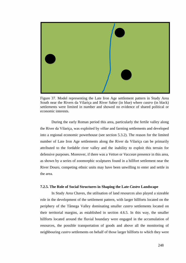
248
Figure 37. Model representing the Late Iron Age settlement pattern in Study Area
South near the Rivers da Vilariça and River Sabor (in blue) where castro (in black)
settlements were limited in number and showed no evidence of shared political or
economic interests.
During the early Roman period this area, particularly the fertile valley along
the River da Vilariça, was exploited by villae and farming settlements and developed
into a regional economic powerhouse (see section 5.3.2). The reason for the limited
number of Late Iron Age settlements along the River da Vilariça can be primarily
attributed to the fordable river valley and the inability to exploit this terrain for
defensive purposes. Moreover, if there was a Vetton or Vaccean presence in this area,
as shown by a series of zoomorphic sculptures found in a hillfort settlement near the
River Douro, competing ethnic units may have been unwilling to enter and settle in
the area.
7.2.5. The Role of Social Structures in Shaping the Late Castro Landscape
In Study Area Chaves, the utilisation of land resources also played a sizeable
role in the development of the settlement pattern, with larger hillforts located on the
periphery of the Tâmega Valley dominating smaller castro settlements located on
their territorial margins, as established in section 4.6.5. In this way, the smaller
hillforts located around the fluvial boundary were engaged in the accumulation of
resources, the possible transportation of goods and above all the monitoring of
neighbouring castro settlements on behalf of those larger hillforts to which they were

249
allied. The River Tâmega, formed the boundary between these large competing
structures in the same way that the Rivers Cávado and Ave, further west, also acted
as a frontier between large Iron Age settlements (Martins 1990, see sections 4.6 and
4.8). However, the nascent hierarchical settlement pattern was not uniform
throughout Study Area Chaves as I established in Chapter Four, but appears to have
been more developed to the west of the River Tâmega, where medium-sized castros
may have acted as subordinate structures to larger hillforts, while at the same time
other independent medium-sized hillforts may have begun to develop their own
territorial hierarchy (see section 4.6.5.1).
Figure 38. Model representing the probable Late Iron Age hierarchical settlement
pattern in Study Area Chaves where large castro site (black square) controlled
medium-sized and small castros (black circular) located on the River Tâmega (in
blue).
To the east of the Tâmega Valley, the corresponding settlement pattern was
more orientated towards larger hillforts with a series of smaller castro sites located at
their territorial margins (see Figure 38 above). The area directly to the east of the
Tâmega Valley, was further characterised by a series of medium-sized Iron Age
hillforts, which most likely acted as independent concerns given the general absence
of other settlements on or within their territorial margins. As result, the settlement
pattern of Study Area Chaves shows an emerging hierarchical organisation to the
west, but the development of a less structurally complex model towards the east of

250
the region, which is more symbolic of those intersettlement relationships found
between fortified hillforts in Study Area North (see section 4.8)
The different settlement structures which materialised in Study Area Chaves
in the Late Iron Age can best be explained through the presence of kinship and
territorial-based social systems as shown by epigraphic material, as well as the
activities and influence of Roman authorities and an emerging native political elite in
the area between the Rivers Douro and Minho. Within Study Area Chaves, four
Roman inscriptions, each displaying an inverted C, ⊃, testify to the existence of a
territorial-based social structure in the region. Three of these funerary inscriptions
are found to the east of the River Tâmega, with the first (CIL II 2494) sculpted on a
boulder near to the small hillfort of 606 (Map 19, centre right), while a second
inscription (CIL II 2480), dated to the late first century AD (Le Roux 1982, 250) was
found between castro sites 548 and 715 and gives the name of a settlement as
Iureobriga / Tureobriga (Map 19, centre). A third inscription has been identified at
the Late Iron Age hillfort and Roman-period castro of Cigadonha de Monsalvarga
(site 800, Map 19, bottom centre), although doubts remain as to its authenticity given
the difficulty in reading the weatherworn inscription (Lemos 1993 vol. II, 574-575;
Rodríguez Colmenero 1988a, 190). Lastly, to the west of the River Tâmega a single
funerary inscription (CIL II 2484), was found near to Late Iron Age castro site 415
(Map 19, centre left).
The information presented above strongly suggests that the region to the west
of the Tâmega Valley was structured along territorial-based social systems, and this
is further supported by other inscriptions, each featuring an inverted ⊃ symbol found
in the region around Bracara Augusta (see Figure 36, bottom left). Consequently, it
is probable that a territorial-based social system stretched from Bracara Augusta
along the Atlantic coast to the region west of the Tâmega Valley, strongly influenced
the settlement pattern of western Study Area Chaves, where a nascent hierarchical
settlement pattern emerged as large hillfort settlements located on the periphery
controlled those small settlements located at the valley’s edge.
In eastern Study Area Chaves, the interrelationship between castro
settlements was altogether more complex. The presence of four granite stones each
engraved with the names PRAEN and COROC (CIL, II, 2489) on opposing sides,
have been interpreted as representing supra-familial groupings, and therefore suggest
251
that a kinship-based social system existed along the eastern margins of the Tâmega
Valley (see section 4.4). Similar functions have been proposed for these inscribed
stones, as establishing borders between settlements (Tranoy 1981, 375), and / or
guaranteeing control and access to agricultural land (Silva 1986, 276). Moreover, the
presence of a series of tessellated Thiessen polygons converging at the place where
these four granite stones were uncovered, implies that these division markers
correspond to four settlements, among them fortified hillfort 548 (Map 29, centre;
see section 5.3.3.1). This points to a kinship-based social system in the area to the
north of site 548, but juxtaposing these familial groupings with a territorial-
orientated structure in the region between sites 548 and 715, as shown by the
aforementioned funerary inscription displaying an inverted C, ⊃ (CIL II 2480). Silva
(1981-1982, 87-88), has sought to explain the anomaly of a kinship-based structure
within the accepted area of territorial-based social systems as relating to a series of
families which were relocated to Study Area Chaves during the early Roman period.
However, we must question the motives or benefits of replacing an assumed Late
Iron Age territorial-based system in the region around the Tâmega Valley with a
social structure oriented around familial groupings and tribal affiliations. Certainly,
there is further evidence for a kinship grouping in the region as shown by a terminus,
or Roman boundary (site 803, Map 29, bottom centre), to the southeast of the
PRAEN and COROC inscriptions, which testifies to two familial groupings, the
Treburos or the Trebilios and the Obilios, possibly from the early Roman period
(Rodríguez Colmenero 1987, 641-642). This would suggest that a patchwork of
lineage-orientated and territorial-based social systems competed for the landscape of
eastern Study Area Chaves (see section 4.8). As a result, these competing systems
produced a settlement pattern which was both characteristic of the area controlled by
the tribal confederacy of the Zoelae to the east with interdependent communities but
no visible hierarchy, as well as large hillforts controlling those smaller castros on
their territorial margins, as shown by the region to the west of the River Tâmega.
In western Study Area South, immediately below Study Area Chaves, a
similar settlement pattern emerges to that found west of the River Tâmega with large,
and in some cases medium-sized castros, controlling smaller hillforts located at their
territorial margins (see section 4.6.5.1 for analysis). Further similarities between
western Study Areas South and Chaves exist in their exploitation of the landscape
252
with many of the fortified hillforts in both regions located on the boundary of
agricultural terrain, as well as forested and scrubland (see section 4.6.3), as shown by
other Late Iron Age hillfort communities within northwest Iberia (Fábrega Álvarez
2005, 129; Parcero Oubiña and Cobas Fernández 2004, 27). In the case of western
Study Area South, access to prime agricultural land for the purposes of farming and
forested / scrubland for harvesting, fuel and feed for animals may partially explain
why the area to the south near to the River Douro remained largely unoccupied
during the Late Iron Age. An alternative hypothesis is that these communities sought
to isolate themselves from outsiders, thereby creating a physical distance between
their settlements and those cultures which utilised the River Douro to transport
people, goods and ideas. This premise is supported by the absence of castro sites to
the immediate north of western Study Area South, and bears similarities to the region
between Study Areas North and East, where a strip of land running east to west is
largely devoid of castro settlements. Lemos (1993 vol. I, 490) has interpreted this
borderland area as the southern limits of the Zoelae confederation, and argues that
the absence of Zoelae material evidence to the south of this buffer area corroborates
his line of reasoning. A further piece of evidence that a border area existed between
western Study Area South and eastern Study Area Chaves are the trajectory of least-
cost paths, which do not appear to provide a direct passage between the two regions.
Where optimum routeways snake their way north from western Study Area South,
medium-sized castro settlements in eastern Study Area Chaves are often found near
or alongside these least-cost paths, which indicate that these passageways may have
been controlled for strategic and / or commercial reasons in the Late Iron Age period
(see section 6.4.2).
It is therefore probable that a border area existed between western Study Area
South and eastern Study Area Chaves, which replicated the strip of land devoid of
settlements marking the southern margins of the Zoelae confederation further east,
and represented a borderland between two kinship groupings. The existence of a
border between two kinship groupings can be supported by two pieces of
archaeological evidence. Firstly, the presence of familial grouping and kinship
structures demonstrated by the existence of a Terminus, or Roman boundary in the
southern part of eastern Study Area Chaves (site 830, Map 29, bottom centre).
Secondly, among the territorial-based social system of western Study Area Chaves,
as well as the territorial and kinship-orientated structure of eastern Study Area

253
Chaves, there are no discernible border areas between these settlements. This line of
reasoning strongly suggests that border areas devoid of castro settlements are
negotiated and develop between competing kinship groupings as determined by the
southern territorial margins of Zoelae control.
7.2.6. The Influence of Rome on the Settlement Pattern of Late Pre-Roman
Northwest Iberia
The nature of a possible kinship-based grouping in western Study Area South
in many ways partially vindicates the hypothesis advanced by Sastre Prats (2008,
1025) that castro settlements were inherently isolated and fiercely independent.
While such a rationale was rejected for individual settlements in Study Area North
(see section 4.7), such a model can be applied more successfully on a regional scale,
where western Study Area South appears to have been physically isolated itself from
those communities to the north in eastern Study Area Chaves, as well as the strategic
River Douro to the south. Similar issues emerge in applying Parcero Oubiña’s (2003)
model of Late Iron Age society in northwest Iberia to the information generated in
this thesis. A central tenet of Parcero Oubiña’s (2003, 290) model is the belief that
late castro society was shaped and created through contact with Roman authorities.
A fundamental problem with this assumption is that contact between Rome and
individual communities, as well as tribal groupings, was by no means uniform in the
period before the region was pacified in the late first century BC (see the discussion
on the castros of Castrovite, Laias and Saceda in sections 2.2.2.3 and 2.2.2.4).
Moreover, where Rome had greatest contact with castro communities was in the
region between the Rivers Douro and Minho through the aforementioned campaigns
of Decimus Brutus in the second century BC (see section 7.2.3), and later with the
gradual encroachment and influence of Rome in the adjoining province of Lusitania
(Almeida 1983, 187). A direct result of the activities and influence of Roman agents
was the emergence of a warrior elite, which acted to consolidate both resources and
territory, which led to larger and more centralised communities orientated around
ethnic groupings (Silva 1995, 275). As I have discussed in the previous section, it is
probable that these oppida-style hillforts located in the region between the Rivers
Douro and Minho were orientated around territorial-based social systems. However,
their size and the settlement pattern they exhibited is not replicated further east in
western Study Area Chaves, where similar territorial-based social systems were also
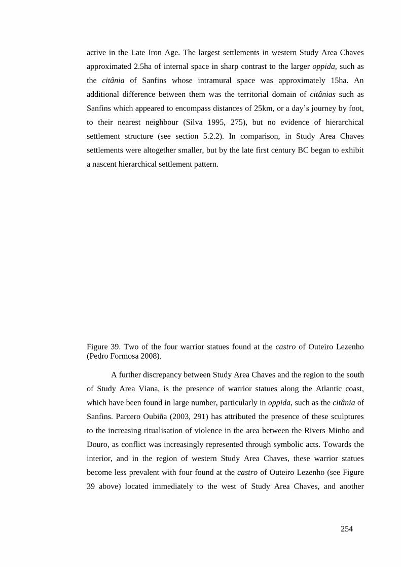
254
active in the Late Iron Age. The largest settlements in western Study Area Chaves
approximated 2.5ha of internal space in sharp contrast to the larger oppida, such as
the citânia of Sanfins whose intramural space was approximately 15ha. An
additional difference between them was the territorial domain of citânias such as
Sanfins which appeared to encompass distances of 25km, or a day’s journey by foot,
to their nearest neighbour (Silva 1995, 275), but no evidence of hierarchical
settlement structure (see section 5.2.2). In comparison, in Study Area Chaves
settlements were altogether smaller, but by the late first century BC began to exhibit
a nascent hierarchical settlement pattern.
Figure 39. Two of the four warrior statues found at the castro of Outeiro Lezenho
(Pedro Formosa 2008).
A further discrepancy between Study Area Chaves and the region to the south
of Study Area Viana, is the presence of warrior statues along the Atlantic coast,
which have been found in large number, particularly in oppida, such as the citânia of
Sanfins. Parcero Oubiña (2003, 291) has attributed the presence of these sculptures
to the increasing ritualisation of violence in the area between the Rivers Minho and
Douro, as conflict was increasingly represented through symbolic acts. Towards the
interior, and in the region of western Study Area Chaves, these warrior statues
become less prevalent with four found at the castro of Outeiro Lezenho (see Figure
39 above) located immediately to the west of Study Area Chaves, and another
255
figurine found at Monte do Crasto near to Vila Pouca de Aguiar (see Figure 3, page
21).
The similarity in style and form of these warrior statues found at the oppida
along the Atlantic coast, such as Sanfins, and the castro of Outeiro Lezenho, and the
notion of social institutions built around an emerging warrior elite has led some to
propose that the River Tâmega formed a cultural and political frontier (González
Ruibal, 2006-2007, 447). Evidently, we should acknowledge different histories for
those peoples along the Atlantic coast compared with the area of western Study Area
Chaves, which despite the shared territorial-based social system of the region may
have acted to shape local identities and settlement patterns. Certainly, along the
Atlantic coast between the Rivers Minho and the Douro, as well as in the area
possibly controlled by the Vaccaei bordering Study Areas East and North, large
oppida emerged in response to increasing centralisation of commercial activity in
response to the encroaching Roman military machine, the consolidation of scarce
resources, and the burgeoning population of these oppida as people moved from rural
to urban settings (Álvarez Sanchís 2005, 273; Silva 1995).
As a result, the different settlement patterns created and shaped by different
historical events, social structures, and environmental opportunities and constraints,
the assimilation of northwest Iberia by Rome and the process of change would vary
from region to region. In Study Area North, which had evolved independently of the
peripheral influence of Rome, the transformations within the landscape were very
much influenced by the dominant kinship-based social structure of the locality.
Firstly, where two fortified hillforts were located in close proximity, one was often
vacated while the other continued as a Roman-period castro (see section 5.4). The
presence of neighbouring castros in other regions of northwest Iberia during the Iron
Age was not uncommon, although the reasons for fragmentation within the
community and the foundation of a secondary settlement are difficult to establish
(González Ruibal 2006-2007, 310). However, the increased cultivation of more
fertile terrain in Study Area North, shown by castro settlements locating on the
periphery of productive agricultural and forested / scrubland may have provided the
means to increase the population of these small hillforts. With defensive walls a
symbol of prestige within the community and their preservation limiting the hillfort’s
size (Queiroga 2003, 46), additional ex-novo settlements were often established
nearby, which may have shared strategic concerns, economic opportunities and

256
perhaps a degree of political union. As epigraphic evidence from the early Roman
period has shown, these political and social affiliations lasted well beyond the second
century AD (Mangas 2000; Sastre Prats 1998), when the remaining Roman-period
castros were probably being abandoned or remodelled as ‘Roman-styled’
settlements. As a result, those political affiliations between neighbouring Late Iron
Age hillforts not only ensured the community could concentrate their resources into
one Roman-period castro, it also shaped the later rural settlement pattern as villae
settlements and farming communities emerged on the territorial boundaries of
abandoned castro sites (see section 5.4).
Along the Atlantic coast a similar pattern of settlements to those found in
Study Area North emerged within the landscape with clusters of Late Iron Age
castros investing in agricultural and mining activities. Exactly how these
communities interacted cannot be proven, but the territorial-based social system
which existed in Study Area Viana implies that individual settlements were more
independent and outwardly hostile to outsiders. Nevertheless, from the late second
century BC, castro settlements were increasingly incorporated into populi, a social
superstructure associated with ethnic groupings, which evolved into civitas units.
While there is no epigraphic evidence of civitas groupings (see Figure 36) within
Study Area Viana this does not refute the existence of regional organisations within
this space. Equally, we must acknowledge that the social and political
transformations of this region were neither uniform nor constant and it is therefore
possible that individual castro settlements were incorporated into the larger civitas
system over the process of time. In this sense, the socio-political system which
operated in Study Area Viana may be compared to pre-contact Hawaii where the
paramount ruler controlled the exchange of prestige goods and the allocation of
territorial units to subordinate chiefs. However, these elite activities did not impact
on those agents engaged in subsistence activities, with little evidence for
redistribution by local chiefs (Earle 1977). Consequently, fortified hillforts in Study
Area Viana may have been politically affiliated to the citânias in the region, but
economically dependent and strategically entwined with neighbouring castro
settlements. The disintegration or survival of local power structures may explain why
clusters of fortified hillforts continued as Roman-period castros, while other groups
of Late Iron Age settlements were abandoned en masse.
257
In Study Area Chaves, which constituted a borderland between the largely
kinship-based social structure towards the east and those territorial divisions
orientated around the castro, a complex settlement pattern emerged with the
disappearance of indigenous hillforts. To the west of the Tâmega Valley, many
castro sites were abandoned in favour of nearby Roman settlements, suggesting that
the community relocated to lower ground and areas of more productive and
accessible terrain (see Map 24 and section 5.3.2). This pattern would imply that the
territorial boundaries established around these fortified hillforts in the Late Iron Age,
if not before, continued to exercise importance within the psyche of the community.
It is therefore interesting to note that in the region of eastern Study Area Chaves, a
similar pattern is repeated, where a number of Iron Age castros are vacated in favour
of ex-novo Roman settlements located in close proximity, which corroborate the
argument presented above that there was no clear boundary between territorial-based
social systems and those communities built around lineage and kinship ties.
Epigraphic evidence in the form of stone granite territorial markers found
near to the eastern banks of the River Tâmega testify to the presence of two supra-
familial units, the PRAEN and the COROC who occupied nearby castro settlements.
It is probable that these territorial markers date from the early Roman period
(Teixeira 1996, 81), during which time the landscape was being formally allocated to
those indigenous and non-indigenous communities now under Roman authority
(Parcero Oubiña 2003, 290; Sastre Prats 2008, 1027). How prominent these
territorial markers were in the early Roman period, with the transition from
indigenous rule to governance by the native elite and their Roman overlords is hard
to ascertain, but they appear to be more frequent in Study Area Chaves than the other
study areas. In the case of the fertile Tâmega Valley with the rich farmland and
opportunities it offered, the PRAEN and COROC boundary markers can be seen to
represent intense competition over securing prime agricultural territory (see section
5.4). An additional consideration is the location of those kinship-based groupings
represented by the PRAEN and COROC boundary markers, which were sandwiched
between a largely territorial-based social structure in the region towards the Atlantic
coast, but with pockets of castro-centred structures in eastern Study Area Chaves.
With the absence of any substantial tribal grouping in Study Area Chaves, for
example the Zoelae, the PRAEN and the COROC may have occupied a hostile
environment where large populi and civitas organisations, such as the Turodi, who

258
would be renamed and emerge as the Aquiflavienses (Tranoy 1977, 232-233), would
begin to consolidate their position in the first century BC and first century AD.
Moreover, if the municipium of Aquae Flaviae was constructed on an oppidum and
central place of the Turodi, an idea supported by Alarcão (1998, 6-7), then the
familial groupings of the PRAEN and the COROC may have begun to function more
like those castro settlements found to the west of the Tâmega Valley, where
individual fortified hillforts fiercely guarded their territorial borders in the absence of
any supra-familial kinship structure.
As discussed above, a kinship-based social structure most probably occupied
the region from the centre of the Study Area Chaves down to the south-eastern
corner of the study area, where further evidence of familial-based systems are
evident through boundary marker 803 (Map 24). What is especially evident is the
continued occupation of many of these castro sites into the early Roman period, but
also the general absence of Roman structures in the region, which showed a tendency
to cluster around the Tâmega Valley (see section 5.3.2 for an overview, 5.3.4 for
analysis and 5.4 for discussion). This settlement pattern continues south to the region
of western Study Area South, where a series of large fortified hillforts with their
subordinate medium-sized and smaller castro settlements dominated the landscape in
the early Roman period. The continued occupation of these fortified hillforts,
especially the larger castros, demonstrates that the Late Iron Age settlement structure
was largely unaltered during the early Imperial period, and most probably illustrates
the early Roman policy of reinforcing local centres instead of creating new
structures, where the economic and political outlay would be substantial. In this way,
Roman authorities were able to administer outlying provinces more effectively and
with the passage of time many of these native communities would adopt more
Roman-orientated social, economic and political practices (Queiroga 2003, 39).
Nevertheless, we should acknowledge that pockets of possible indigenous control
shared very different characteristics. In the case of western Study Area South, the
community of Roman-period castros was very much isolated from the Roman urban
centres and the satellite towns and agricultural communities which emerged in their
orbit (see section 6.6). However, in the case of Study Area Viana, and particularly in
Study Area East (Map 38, centre), where a pocket of Roman-period hillforts can be
found near to the principal Imperial road network, indigenous communities

259
inhabiting Iron Age dwellings appear to have integrated well into the emerging early
Roman settlement pattern (see section 5.4).
7.2.7. The Founding of Roman Administrative Centres
In Study Area South, as a whole, social activity and political power began to
shift away from the isolated cluster of hillforts to the west and concentrate around the
newly founded civitas Baniensium located towards the east. From a commercial
perspective, the location of civitas Baniensium at the confluence of the Rivers da
Vilariça and Sabor connected the urban centre through the nearby River Douro with
other prominent settlements, thereby allowing heavy loads to be transported along
this established river network. Also integrated into this fluvial transportation system
were a series of agricultural producers located along the fertile valley of the River da
Vilariça, to the north of the civitas Baniensium, who utilised the river network to
transport their goods to market (see section 5.4). Further north, where the River da
Vilariça narrowed and may not have provided a perennial water source capable of
transporting goods, the main Roman road running alongside the aforementioned river
(see section 6.4.2) would have provided a secure, albeit a more expensive method of
transportation (see section 6.2.1). Also located along the main Roman highway and
connected to the civitas Baniensium, were a series of mines, where ore was most
probably refined on site before being transported south to the civitas capital for
shipment elsewhere along the River Douro (see section 5.4). A further cluster of
mining activity to the south of the civitas Baniensium near to the River Douro
testifies to the importance of this waterway, which would have been employed by
commercial agents to reduce transportation costs and augment profits.
From a strategic perspective, the civitas Baniensium would have provided a
means to centralise the disparate tribes in the region, such as the Banienses and the
Interamici, who appear on several inscriptions and may have occupied the area to the
north of Study Area South with their capital at S. Juzenda (Sanches and Santos 1987,
39-42). Over the longer term the civitas Baniensium would have provided a strategic
base, as well as an administrative centre and commercial market, for mining
activities taking place within its immediate territory and beyond. This is evident in
the least-cost path, which begins to the north of the civitas Baniensium and runs in a
south-easterly direction crossing the River Sabor and heading towards a series of
mining communities located on this optimum route in Study Area East (Map 38,
260
bottom left, see section 6.4.2). A castro settlement was located at the point where
this passageway crosses the River Sabor and was abandoned in the early Roman
period in favour of a nearby Roman settlement. It is therefore probable this pathway
was actively utilised in the Late Iron Age and secured by Imperial agents to provide a
terrestrial routeway east towards western Study Area East. Moreover, the high level
of connectivity offered by this least-cost path and a series of other optimum routes
emanating from the area around the confluence of the Rivers da Vilariça and Sabor
(whose paths converged around mining centres 676 and 695), enabled the civitas
Baniensium to exert a degree of control over western Study Area East, where Roman
administrative and strategic authority was limited to vicus settlement 565.
However, we should not discount the role played by vicus 565 in shaping the
landscape of Study Area East. As I have argued above in section 7.2.2, vicus
settlement 565 may have operated as a pre-Roman centre for either the Vettones or
Vaccaei, who occupied the land immediately to the south and the east of Study Area
East. While no fortifications have been found on this site, leading Lemos (1993 vol.
II, 162-164) to question Santos’ (1975, 55-69) assertion that the settlement was
founded in the Iron Age, we must acknowledge that it was not uncommon to find vici
established upon open Iron Age settlements within the region of northwest Iberia
(González Ruibal 2006-2007, 321). In this way, a possible Iron Age site in the form
of a Vettones or Vaccaei central place at site 565, may have provided the basis for the
subsequent Roman settlement pattern in the region, given the key attributes the
settlement afforded. Firstly, it was located upon a series of least-cost paths emerging
from the northwest of the study area (see Map 38, see section 6.4.2), where another
vicus settlement was established in the early Roman period, as shown by an as from
the reign of Tiberius (AD 14-37) (Centeno 1987, 133-134). Consequently, it is
probable that vicus settlement 565 played a key role in establishing the route of the
main Roman highway, which began at site 565, and followed a series of optimum
pathways towards the northwest of the study area and the second vicus settlement at
site 309. A second advantage of the location of vicus settlement 565, was its close
proximity to the mining settlements to the west, which it may have administered in
conjunction with the civitas Baniensium.
7.2.8. The Emergence of Agricultural Centres in Early Roman Northwest Iberia

261
These strategic and communicative benefits offered by the Roman road
network and the two vicus settlements in Study Area East, also translated into
commercial opportunities for Roman agricultural producers, who began to exploit the
landscape to establish farming communities and villae settlements. Where the Iron
Age settlement pattern was divided between the castro settlements situated along the
River Douro, between the River Douro and Sabor and along the tributaries of the
River Sabor, Roman settlements, in particular agricultural producers now began to
locate along the vicinity of the main Roman highway (see section 6.5). Not only did
the principal communication route enable farming communities to transport their
goods to market, it also ran through forest / scrubland, which provided ideal terrain
for many of the staple crops of the Roman economy, among them olive oil.
Consequently, three of the five villae sites and fifteen of the seventeen casals are
found on Type F, forested / scrubland, and there appears to have been an active
policy among the farming community in this ‘microregion’ not to exploit the more
fertile terrain of the region (see section 5.3.4). This strongly suggests that agricultural
products grown on intensive land were not profitable given the small population of
Study Area East, and the absence of large central places, nor conducive for export, in
direct contrast to less perishable products, such as olive oil and wine grapes, which
were a major economic concern within the Roman empire. Furthermore, Roman
northwest Iberia was gradually integrated more effectively into the wider Roman
world through established communication systems and commercial centres where
agents could trade and negotiate on behalf of agricultural producers, which allowed
regions to invest in and benefit from economies of scale. In this way, the
connectivity offered by the River Douro and the suitability of the land may have
encouraged agricultural producers in Study Area East to develop products such as
olive oil and wine at the expense of other key goods such as cereals, where
production was concentrated more towards central Hispania (Curchin 2004, 166;
Keay et al. 2000, 205, and section 2.4.2.2).
A similar settlement pattern to that found in Study Area East was replicated
in south-western Study Area South with a concentration of villae and casals along
the River Douro. Given the absence of Roman settlements in south-western Study
Area South, the agricultural centres exploited the principal waterway in the region,
the River Douro, to transport their products to market. The importance of the River
Douro as an effective conduit of goods and people can be seen with the continued

262
occupation of a fertile pocket of land by the cluster of castro settlements to the north
in western Study Area South. While the archaeological record shows that these
hillforts continued to be inhabited into the early Roman period, there is no evidence
the area was developed by large-scale agriculturalists and farmers from the second
century onwards. Rather, villae and casals appear to have exploited the two key
interdependent attributes of south-western Study Area South. The first was the
proximity of the River Douro and the second the terrain, which was characterised by
scrub and forested land as well as soil suitable for extensive farming. Consequently,
the area provided the means to produce staple crops such as olive oil, wine grapes
and nuts, which could be effectively transported to market utilising the River Douro
(see section 5.4).
The importance of cost-effective access to market for the agricultural
producers is also visible in the landscape of Study Area Viana, where a series of
Roman settlements and adjoining casals and villae emerged within the landscape.
The position of these farming communities, located around the River Lima (bottom
left, Map 25) as well as the River Coura (centre, Map 25) demonstrates the
importance of these river valleys, which would have provided not only fertile land,
but also the means to utilise the waterways to transport their produce elsewhere.
Additionally, the Roman arterial road network further integrated these pockets of
intensive agricultural production into the wider landscape, thereby providing a secure
transportation system regardless of the season (see section 6.5). Section 6.4.2, and a
detailed analysis of the trajectory of Via XIX, demonstrated that main Roman roads
incorporated prime agricultural land into their trajectory, often at the expense of
negotiating more level but less fertile terrain. Within Study Area Viana, the
concentration of settlements around the Lima valley, especially to the south of the
river, illustrates that both the agricultural centres and adjoining Roman habitats were
heavily orientated to supplying the region to the south, constituting the conventus
capital of Bracara Augusta and its satellite towns (see section 6.5). In the area
around the River Coura, the road network and the waterways, among them the River
Minho, would have provided the means to supply markets elsewhere. As a result, the
fertile areas once inhabited in the Late Iron Age, but without access to large river
valleys, such as the centre north of Study Area Viana, or physically distant from key
markets, for example the area along the coast between the Rivers Minho and Lima,
were not colonised in the Roman period.

263
Although there is considerable variation between the landscape, terrain and
agricultural produce and crop yields of Study Area Viana and the south-western
region of Study Area South and Study Area East, all three regions display similar
settlement structures with agricultural centres gravitating towards communication
routes and / or large markets. This pattern is again replicated in Study Area Chaves
with a large number of villae and casals located immediately around the fertile
Tâmega Valley, and no doubt utilising the River Tâmega to supply the central place
which would be renamed Aquae Flaviae in the late first century AD. In many
respects the River Tâmega operated very much as a commercial concern allowing
agricultural producers to ship their goods to market, in contrast, to the strategic role
of the Roman arterial road network, which connected Aquae Flaviae with other
regional centres within northwest Iberia. In the light of new archaeological evidence
it is probable that an element of the Legio VII, which would later be garrisoned
further north and subsequently give its name to the modern-day settlement of León,
was stationed at the site that would develop into Aquae Flaviae. Finds ranging from a
Roman bronze coin dated to 27 BC and featuring the bust of the Emperor Augustus,
to ceramic containers inscribed with ‘Legio VII’ testify to a military presence around
Largo do Arrabalde in Chaves (Roman Aquae Flaviae). The strategic importance of a
possible Roman garrison at this site can be illustrated by the River Tâmega located
150m to the southeast where a Roman bridge still stands, which may have replaced a
yet older wooden structure (Teixeira 1996, 133). Moreover, the close proximity of
the Roman garrison at Largo do Arrabalde to the Via XVII, which linked Bracara
Augusta with the military camp and later conventus capital Asturica Augusta (Sastre
Prats 2001, 139), suggest that the settlement which would develop into Aquae
Flaviae was established by the Roman military during the Cantabrian Wars (29-19
BC) (Diarioatual, 28 06 2011).
7.2.9. The Importance of Movement and Communication in Early Roman
Northwest Iberia
The garrison on the banks of the River Tâmega may also have been
connected through a Roman military road in the late first century BC to the civitas
Zoelarum in Study Area North. This can be demonstrated by the two roads which
emanate eastwards from the Tâmega Valley, with the southern route following a
series of least-cost paths and smoother gradients suitable for the movement of heavy

264
loads, such as agricultural produce, in contrast to the steeper angles, but shorter
distance negotiated by the more northerly of the two routes. A milestone found along
this northerly passage and most probably dating to 3-2 BC (see section 6.2.3),
implies that this road may have had a military origin, and connected a Roman
garrison along the River Tâmega with an Imperial presence at the site of the civitas
Zoelarum, where an early Roman inscription dates the site to 2 BC, during the reign
of Augustus (Lemos 1993 vol. II, 69). In turn, the Roman military road followed a
least-cost path east towards the Meseta and towards more established Imperial
domains, which would have provided logistical support as well as supplies of goods
and personnel, in order to pacify and gradually incorporate northwest Iberia into the
wider Roman empire (see section 6.5).
Consequently, the Roman road network began to link possible military
garrisons and Roman centres of power, which would act to consolidate the
immediate area and provide a Roman presence in the area. Nevertheless, whether
there was a conscious policy by Roman authorities to break the control of tribal
groupings, such as the Turodi whose central place may have occupied the future site
of Aquae Flaviae (Tranoy 1977, 232-233), and the Zoelae of Study Area North, or if
these sites simply developed from Roman military garrison towns with subsequent
approval and encouragement from Imperial authorities, is more difficult to ascertain.
Certainly, in some regions of northwest Iberia, most notably Study Area South, it
appears that the civitas Baniensium, although established within or near to the
territory of the Banienses tribe, was essentially an ex-novo settlement aimed at
securing the strategic waterways and passage to the River Douro, as well as the
mining activity of the region. Nevertheless, despite the strategic importance of the
waterways around the civitas Baniensium, it does appear that these fluvial networks
operated more as commercial arteries, connecting disparate regions both within
northwest Iberia and beyond, as shown by the concentration of agricultural activity
around the Tâmega Valley in Study Area Chaves and the Lima Valley in Study Area
Viana. In contrast, established overland routeways functioned more as strategic
concerns linking emerging centres such as Aquae Laiae (a possible pre-Flavian
Aquae Flaviae) with other regional capitals, which had the effect of shrinking space-
time between urban structures. This had the effect of consolidating those regional
centres often established through garrisoned troops (Aquae Laiae), the need to secure

265
lucrative mining activity (civitas Baniensium), and secure supply routes (civitas
Zoelarum) (see section 6.5).
The interconnectivity provided by the Roman arterial road network meant
that early civitas Baniensium was more effectively connected to the more physically
distant Aquae Laiae through the existing major Roman road network, than to
neighbouring settlements, such as the cluster of Roman-period castros in western
Study Area South. Consequently, where agricultural production showed a tendency
to concentrate in areas adjacent to important markets with good communication
routes, so principal urban structures linked by the Roman arterial road network
would have shared information, as well as new ideas and practices. The net effect of
this circulation of new ideas would have been the creation of hierarchies of
information (Morley 1997, 49), where urban structures built upon their regional
supremacy as communication and administrative hubs (see section 6.2.3). However,
we should not assume that all regional centres were equal in terms of their provincial
importance. Some regional centres, for example the civitas Zoelarum, appear to have
been little more than strategically located settlements controlling and monitoring
their immediate territorial domain, and in the process securing the passage of goods
and people from the western Meseta to those areas to west of Study Area North.
Furthermore, the Roman towns in Study Area North appear to have operated as
satellite settlements with many located on least-cost paths, which gravitated towards
the civitas Zoelarum, enabling them to effectively supply the regional centre with
agricultural produce and the raw materials needed to survive. In contrast to the
civitas Zoelarum, a more dynamic regional centre, such as the possible early Roman
settlement at Aquae Laiae, would have consolidated its role as an important
administrative and political entity through its commercial activities, leading to the
settlements being renamed Aquae Flaviae and acquiring municipium status in the late
first century AD (Alarcão 1988, 7). Although artefacts testifying to commercial
activity are lacking within Aquae Flaviae, on account of the limited excavation
undertaken at modern-day Chaves, archaeological evidence in the form of a 70cm
diameter stone mill found on Rua (Road) de Maria Rita, suggest important urban
enterprises (for processing rural products) in an area where most stone mills found in
the region are between 45 and 55cm in diameter (Amaral 1993, 21, 124). The
presence of industrial-scale stone mills also implies small-scale manufacturing
activities, highlighted by Hopkins (1983), where low-value, high bulk rural raw

266
materials were purchased and transformed by urban workshops into high-value, low-
bulk products. Aquae Laiae and to a greater degree Aquae Flaviae, demonstrate a
high level of connectivity with the surrounding hinterland and thereby provide a
central place where products could be sold and also refined for sale elsewhere. In this
sense, Aquae Flaviae operated in a similar way to other successful Roman centres,
for example Oxyrhynchus (see section 2.4.2.1), in both stimulating a ‘microregion’
agricultural centres located along the River Tâmega, but also deriving its success
from the produce that flowed into town.
In spite of the difference in size, importance and commercial activities of
these dynamic regional centres in Roman northwest Iberia such as Aquae Flaviae,
and less successful administrative focal points, for example the civitas Zoelarum,
common features can be identified across the five study areas between the settlement
pattern of these large urban structures and their relationship with smaller vici sites. In
the case of Study Area North, the vicus settlement (Map 36, top right) is located
away from the main Roman road along a junction of least-cost paths (see section
6.4.2). This is a feature repeated for the vicus vagornicense (site 607, Map 39, centre
right) which was positioned on a series of optimum pathways near to the principal
Roman road to the east of Aquae Flaviae. This would strongly suggest that these vici
functioned as administrative centres for the larger urban settlements in the region.
Moreover, their location on least-cost pathways adjacent to major roads, a scenario
repeated in Study Area Viana with vicus settlement 168 (centre right, Map 40)
positioned at the margins of the mountainous area to the east, and vicus 329 in Study
Area East (top right, Map 38), indicates that these sites may have controlled pre-
Roman communication routes and / or transhumance trackways (see section 6.5).
More established transhumance routeways were officially recognised as calles
publicae in the Roman era and subject to regulation by the state (Varro R.R. 2.1.16
and 2.9.6-7), and therefore the vici positioned along their route may have acted as a
market place for sale of livestock. This point concurs with classical sources, notably
Festus (508L), who distinguished vici acting as rural marketplaces. Moreover,
Festus’ (508L) assertion that these small vici settlements elected annual magistrates
(Stek 2009, 142, 145), and the presence of Roman inscriptions testifying to pre-
Roman ethnic groupings, such as the aforementioned vicus vagornicense (Teixeira
1996, 98), in Study Area Chaves (site 607, Map 39, centre right) and the vicus
Labr(enses?), (Lemos 1993 vol. I, 393) site 549, overseeing the cluster of Roman-
267
period castros in western Study Area South (see Map 37), implies that these vici sites
constituted formal Roman settlements administered by pre-Roman ethnic groupings
(see section 3.6.1). In this way, many of these vici may have operated as small civitas
capitals, housing the collective remnants of local tribes, whose political elite now
administered as Roman magistrates. Moreover, in the same way that civitas capitals
differed in form and function, it is likely that these vici settlements performed a
multitude of different tasks. It is probable that one native grouping established at the
vicus Labr(enses?) (site 549, Map 22) monitored the cluster of Roman-period
hillforts located to the west of Study Area South. In contrast, another vicus settlement
(site 552, bottom centre, Map 37), dating to the first century AD, and located along
the River Douro may have functioned as an important centre for mining activity in
the region, and the nearby modern-day settlement of Santa Maria may have served as
a forum to conduct commercial activity in the absence of any large and accessible
urban centre. A similar pattern emerges in Study Area East, where vici 565 and 309,
located at either end of the study area, as well as vicus 552 in southern Study Area
South, provided the means to administer the domain, where it is likely that the region
could neither support a large urban centre nor was one needed. Such was the
flexibility of these small administrative centres that their role in Study Area Viana,
extended to incorporating elements of the cursus publicus as with vicus/mansion (site
252, centre left, Map 40) and the nearby vicus/mutatio (site 200) (see sections 5.4
and 6.5).
In conclusion, the landscape of northwest Iberia illustrates a pre-Roman
culture which was varied in its social, political and economic practices, which were
in turn shaped by surrounding forces, and in particular Rome, whose influence would
be paramount in determining the structure and settlement pattern of the region. In
many respects, Roman authorities adapted and modified native approaches, but they
also introduced new practices into the region, for example, large-scale agricultural
production, which can be identified in other regions assimilated under Roman
control. It therefore remains to conclude this chapter with a brief analysis of how
Late Iron Age and early Roman northwest Iberia was comparable to other cultures,
and therefore provide some context to help identity the key features and practices of
the region.
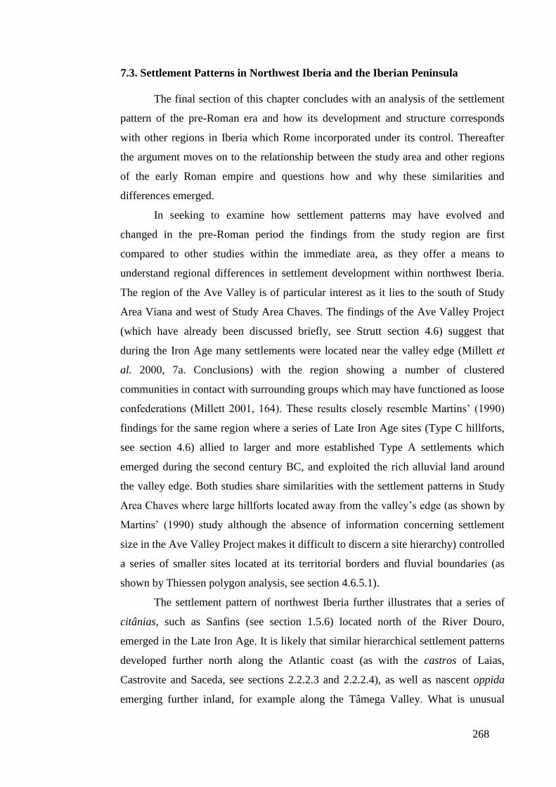
268
7.3. Settlement Patterns in Northwest Iberia and the Iberian Peninsula
The final section of this chapter concludes with an analysis of the settlement
pattern of the pre-Roman era and how its development and structure corresponds
with other regions in Iberia which Rome incorporated under its control. Thereafter
the argument moves on to the relationship between the study area and other regions
of the early Roman empire and questions how and why these similarities and
differences emerged.
In seeking to examine how settlement patterns may have evolved and
changed in the pre-Roman period the findings from the study region are first
compared to other studies within the immediate area, as they offer a means to
understand regional differences in settlement development within northwest Iberia.
The region of the Ave Valley is of particular interest as it lies to the south of Study
Area Viana and west of Study Area Chaves. The findings of the Ave Valley Project
(which have already been discussed briefly, see Strutt section 4.6) suggest that
during the Iron Age many settlements were located near the valley edge (Millett et
al. 2000, 7a. Conclusions) with the region showing a number of clustered
communities in contact with surrounding groups which may have functioned as loose
confederations (Millett 2001, 164). These results closely resemble Martins’ (1990)
findings for the same region where a series of Late Iron Age sites (Type C hillforts,
see section 4.6) allied to larger and more established Type A settlements which
emerged during the second century BC, and exploited the rich alluvial land around
the valley edge. Both studies share similarities with the settlement patterns in Study
Area Chaves where large hillforts located away from the valley’s edge (as shown by
Martins’ (1990) study although the absence of information concerning settlement
size in the Ave Valley Project makes it difficult to discern a site hierarchy) controlled
a series of smaller sites located at its territorial borders and fluvial boundaries (as
shown by Thiessen polygon analysis, see section 4.6.5.1).
The settlement pattern of northwest Iberia further illustrates that a series of
citânias, such as Sanfins (see section 1.5.6) located north of the River Douro,
emerged in the Late Iron Age. It is likely that similar hierarchical settlement patterns
developed further north along the Atlantic coast (as with the castros of Laias,
Castrovite and Saceda, see sections 2.2.2.3 and 2.2.2.4), as well as nascent oppida
emerging further inland, for example along the Tâmega Valley. What is unusual
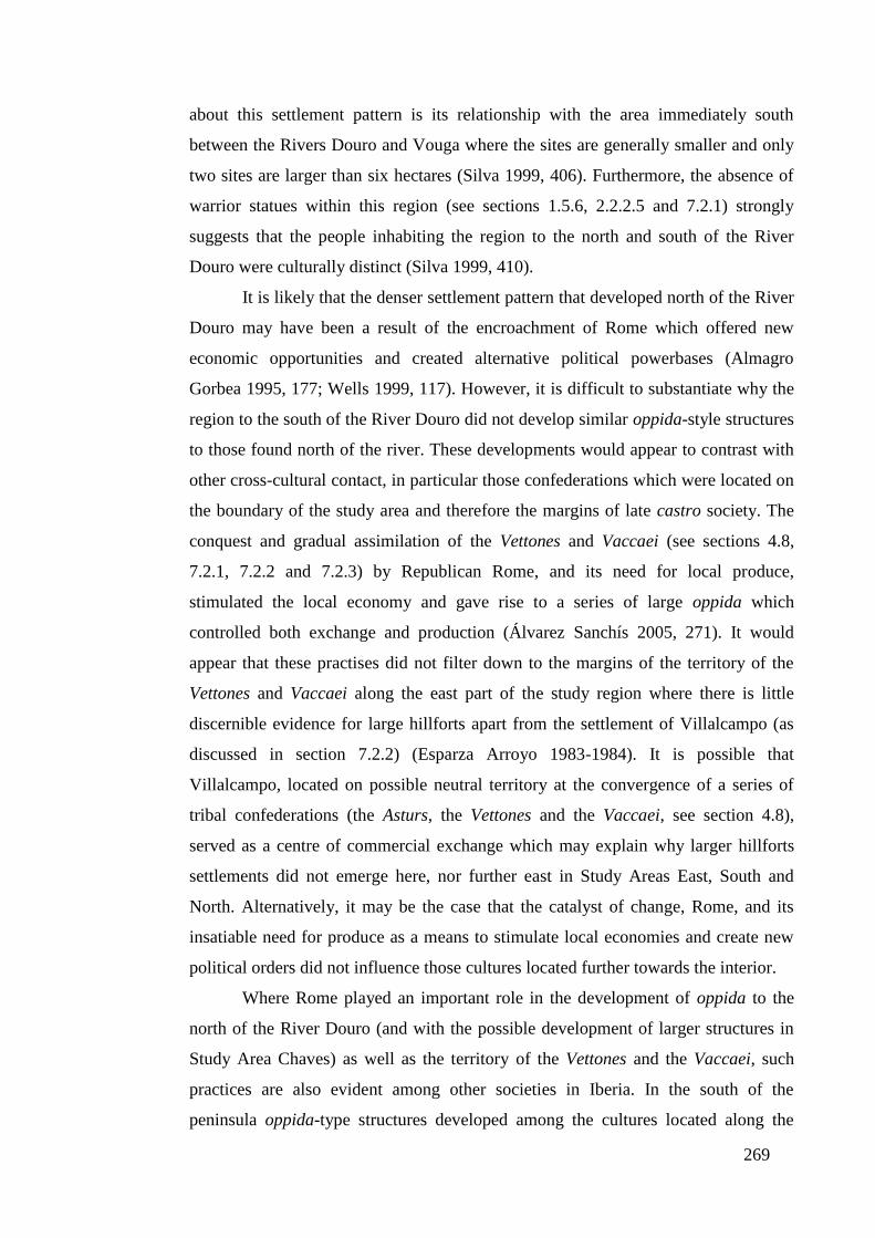
269
about this settlement pattern is its relationship with the area immediately south
between the Rivers Douro and Vouga where the sites are generally smaller and only
two sites are larger than six hectares (Silva 1999, 406). Furthermore, the absence of
warrior statues within this region (see sections 1.5.6, 2.2.2.5 and 7.2.1) strongly
suggests that the people inhabiting the region to the north and south of the River
Douro were culturally distinct (Silva 1999, 410).
It is likely that the denser settlement pattern that developed north of the River
Douro may have been a result of the encroachment of Rome which offered new
economic opportunities and created alternative political powerbases (Almagro
Gorbea 1995, 177; Wells 1999, 117). However, it is difficult to substantiate why the
region to the south of the River Douro did not develop similar oppida-style structures
to those found north of the river. These developments would appear to contrast with
other cross-cultural contact, in particular those confederations which were located on
the boundary of the study area and therefore the margins of late castro society. The
conquest and gradual assimilation of the Vettones and Vaccaei (see sections 4.8,
7.2.1, 7.2.2 and 7.2.3) by Republican Rome, and its need for local produce,
stimulated the local economy and gave rise to a series of large oppida which
controlled both exchange and production (Álvarez Sanchís 2005, 271). It would
appear that these practises did not filter down to the margins of the territory of the
Vettones and Vaccaei along the east part of the study region where there is little
discernible evidence for large hillforts apart from the settlement of Villalcampo (as
discussed in section 7.2.2) (Esparza Arroyo 1983-1984). It is possible that
Villalcampo, located on possible neutral territory at the convergence of a series of
tribal confederations (the Asturs, the Vettones and the Vaccaei, see section 4.8),
served as a centre of commercial exchange which may explain why larger hillforts
settlements did not emerge here, nor further east in Study Areas East, South and
North. Alternatively, it may be the case that the catalyst of change, Rome, and its
insatiable need for produce as a means to stimulate local economies and create new
political orders did not influence those cultures located further towards the interior.
Where Rome played an important role in the development of oppida to the
north of the River Douro (and with the possible development of larger structures in
Study Area Chaves) as well as the territory of the Vettones and the Vaccaei, such
practices are also evident among other societies in Iberia. In the south of the
peninsula oppida-type structures developed among the cultures located along the
270
Guadalquivir Valley at the periphery of the Tartessian civilisation from the fifth
century BC (Ruiz Rodríguez et al. 1991, 31). However, while this process may have
begun before the arrival of Rome around the late third century BC it appears to have
accelerated thereafter. In the area around the modern-day Spanish province of
Extremadura a powerful military elite emerged in the late first century AD, perhaps
as a consequence of the Lusitanian Wars (155-139 BC), and established a series of
oppida to further their military and commercial needs (Berrocal Rangel 2005, 486-
488). Further east in the region around modern-day Valencia in eastern Spain a
similar process of change was underway with the agricultural landscape increasingly
allied to large oppida centres operated by a native Iberian elite, which functioned as a
centre of refuge in times of crises, but also as centres of exchange and redistribution
(Grau Mira 2011, 163-167). Parallel developments were taking place further north
among the communities along the central Catalonia coast where a well-defined
ranked settlement pattern developed from the fourth century BC. Such a settlement
pattern may have been strongly influenced by the commercial and strategic needs of
the region which was heavily integrated into Mediterranean exchange networks,
acting as agents for commerce emanating from Rome and Greece and directed
towards the Iberian interior (Miret et al. 1991, 47).
The rise of increasingly centralised settlement systems characterised by
oppida-type structures appears to have been a result of dynamic civilisations located
on the periphery, which acted to stimulate economic activity as well as create new
political orders. Rome played a pivotal role in this process (Wells 1999, 117) as it
slowly extended its influence from southern and eastern Iberia towards the interior of
the peninsula. In areas such as the Guadalquivir Valley in southern Hispania, native
civilisations once assimilated by Rome were adapted to wider pan-Mediterranean
systems of control. Larger oppida and central places such as Obulco, Urso and
Gades, which had played key regional roles, continued to perform a similar function
under Roman control, while smaller oppida within the indigenous settlement pattern
evolved into vici settlements, fulfilling a commercial role, while acting as
administrative subordinates to larger towns (Choclán Sabina and Castro López 1986-
1987).
In northwest Iberia, in particular in the study region, the absence of a network
of large central places (perhaps due in part to the limited influence of Rome) meant
that smaller settlements were often adapted to become Roman centres of power. For

271
example a possible oppidum of the Turodi became Aquae Flaviae (see sections 4.5,
5.3.2, 5.4 and 7.2.6) and the religious centre of the Zoelae became the future civitas
Zoelarum (see sections 5.2.3, 5.3.2 and 6.5), while other focal points, in particular
the civitas Baniensium (see section 6.5), appear to have been founded by Imperial
authorities. As Tranoy and Le Roux argue, the early Roman cities of northwest Iberia
functioned as administrative and political extensions of Rome and acted not only to
control the surrounding indigenous communities, but also as a means to integrate
disparate peoples into a wider Roman political system (Le Roux and Tranoy 1983-
1984, 200; Tranoy 1981, 190). It should be said that Le Roux and Tranoy highlight
the importance of the administrative and judicial functions of these nascent Roman
centres (Queiroga 2003, 11) over their commercial activities and roles within the
emerging settlement hierarchy. This is especially relevant to the vici of the study
region which show evidence of having been managed by native communities who
most likely provided an element of administrative control (for example the two vici
settlement in Study Area East, see section 5.3.2), and acted as hubs for the cursus
publicus (see section 5.5), but also provided an important role as market places (see
section 7.2.9).
The assimilation of peripheral cultures by Rome into wider Mediterranean
commercial networks had a diverse and dynamic impact on settlement structures
creating a fusion of different native and ‘Roman’ practices. In the case of the
Zamzam region of modern-day Libya, native hilltop villages continued to be
occupied alongside more Roman-style dwellings in the more fertile lowlands (Barker
and Jones 1980-1981). The continued occupation of hilltop sites is also reflected in
Roman Italy, and particularly the Ager Cosanus study, centred around the Roman
town of Cosa, northwest of Rome, where small hilltop sites from the Republican
period survived well into the Imperial era (Greene 1990, 108). This would appear to
contrast with the study region, especially the western part of Study Area South,
where a cluster of castro settlements occupying a patchwork of prime agricultural
land continued to be inhabited perhaps into the second century AD. The low level of
connectivity in this area, as shown by the absence of an effective communication
network and nearby ‘Roman’ central places to sell its goods probably contributed to
preserving native practices among these communities.
In other regions, for example the region of southern Etruria to the north of
Rome, where a dense network of villae and farming communities emerged during the
272
early Imperial period (Dyson 1978, 262), the high level of interconnectivity tied rural
producers and urban consumers together. Such activities are representative of Study
Area Viana, and particularly the area around the fertile Lima Valley with its
excellent terrestrial and fluvial communication system, where a high density of villae
and casals emerged, and displaced native castro settlements, to supply metropolitan
centres such as Bracara Augusta. The communities producing perishable products
needed accessible markets and when they were not present did not thrive. This may
well have been the case with the early Roman communities located around the fertile
lowlands of the Ave Valley where the density and size of sites in inferior to those
found in the region of Catalonia in northeast Spain with the important Roman
settlement of Tarraco (the capital of the conventus Tarraconensis), as shown by the
Tarragona Survey (Carreté et al. 1995; Millett et al. 2000, 7. Conclusions). Similar
practices appear to have taken place in the study region where pockets of fertile land
were not extensively exploited. These include the small fertile region to the northeast
of Study Area East where few agricultural centres developed, perhaps on account of
the limited number of towns in the area, and the aforementioned productive region in
western Study Area South which was largely isolated from Roman centres.
Where perishable products may have constrained regional development, it
was not the case with staple products produced throughout the Roman empire. As
Horden and Purcell (2000) make clear (see section 2.4.4.2) the interplay of geology,
soils and the climate that made up the Mediterranean world had a powerful impact on
regional development. Demand for staple Roman products played a strong role in
shaping the settlement pattern of the Guadalquivir Valley in southern Hispania
where villae occupied higher land which favoured olive cultivation. This was
supplemented by cereal producting farms which occupied the low-lying fertile plain
with urban settlements squeezed onto escarpments and terrain not necessarily
conducive for agricultural practices (Ponsich 1974). The Guadalquivir Valley
demonstrates similarities with those ‘microregions’ of agricultural centres located
along the River Douro in Study Area East and South which invested heavily in olive
oil production and grape cultivation. Moreover, both regions were heavily dependent
on river networks (the River Guadalquivir in the Guadalquivir Valley and the River
Douro in the study region) to transport their produce, in a similar way to the large
nucleated rural sites that produced olive oil and which emerged along the northern
African coast and made ready use of the Mediterranean sea to transport their produce

273
(see the Ksar el-Guellal site which covered in the region of 53ha and incorporated 20
industrial olive presses (Mattingly and Hitchner 1995, 192)).
The landscape of early Imperial Rome was therefore very much a product of
the interconnectivity between ‘microregions’ and the commercial opportunities such
relationships offered which subsequently played a strong role in shaping the
individual nature of regional settlement patterns. For example, in the densely
populated countryside of central Roman Gaul, it has been argued that the villa was
the principal unit of production while vici manufactured and distributed goods
(Leday 1980). This model would appear to contrast with the findings from the five
study areas where vici served a function as marketplaces and distribution centres, but
fulfilled a primary role as administrative centres for large urban settlements.
Additional evidence shows that villae played an important and central function in
more fertile areas, for example, Study Areas Chaves and Viana, but that role may
have diminished in importance in other areas as shown by Study Area North, where
few agricultural settlements have been identified.
7.3.1. Summary
In summarising this section, a series of points can be made which help us
understand the study region from the Late Iron Age through to the early Roman
period. Central to the development of the late castro society was the presence of
peripheral cultures, chief among them Rome, which acted to stimulate economic
activities, create new political orders and more centralised settlement patterns as
shown by oppida-styled structures. Settlement pattern analysis and archaeological
research would suggest that these activities were more profound in those areas
located along or near to the Mediterranean basin. These changes did not permeate
into Late Iron Age northwest Iberia and for this reason the development of a
hierarchical Roman settlement pattern may have taken longer to come into being
than other regions assimilated by Rome. However, while the study region was
shaped by the fusion of Late Iron Age practices, the pre-Roman settlement pattern
and the needs of early Roman administrators, it appears that northwest Iberia shared
many of the characteristics of other regions assimilated by Rome. This is particularly
relevant in the inclusion of the study region into a wider commercial realm and can
be seen by the development of ‘microregions’ strongly orientated around generating
surplus produce which was transported to other regions in the Roman world.

274
Chapter Eight. Conclusion
8.1. Introduction
This final chapter is divided into three sections. The first section addresses
the research questions and objectives generated from an analysis of the principal
debates concerning settlement patterns in late pre-Roman and early Roman northwest
Iberia and listed at the end of Chapter Two. For the sake of clarity and expediency,
the objectives contained within each research question are answered in sequence and
thereafter there is a general summing-up. In the last part of this chapter, section 8.5
explores further avenues of research, while section 8.6 outlines this thesis’ original
contribution to knowledge.
8.2. Did a Late pre-Roman Iron Age settlement hierarchy exist in northwest
Iberia?
Objective One. To define the people of northwest Iberia according to the socio-
economic, political and settlement structures of their communities.
Although each castro community was ostensibly different from another in terms
of the size, structure and position of their fortified settlement, relative to the
surrounding landscape, which would have influenced daily routines and practices,
such as farming and food gathering, general traits can be identified, which shaped
the regional activities of the pre-Roman peoples who inhabited northwest Iberia.
Perhaps the most important of these were two different social structures, with
kinship-orientated groupings inhabiting the eastern region of northwest Iberia and
territorially-based social units occupying the area to the west, as shown by
epigraphic evidence. The research conducted in this thesis has been successful in
establishing that a series of overlapping lineage and territorially-based social
systems converged around the Tâmega Valley in Study Area Chaves, with the
former largely occupying the area to the east, and the latter the region to the west
of the River Tâmega (see section 4.7). The findings from Thiessen polygon
analysis (see section 4.6.5.1 for the analysis and section 4.7 for the discussion),
suggest that a more developed hierarchical settlement pattern emerged on the west
bank of the Tâmega Valley where large hillforts dominated smaller fortified
settlements located on their territorial margins, particularly along the River
Tâmega. As a result, to the west of Study Area Chaves, power may have became
275
increasingly centred in the hands of an indigenous elite who emerged to govern
alongside Roman authorities with the pacification of the region by Imperial
forces. In contrast, the research conducted in Chapter Four and Five show that the
area immediately to the east of the Tâmega Valley is characterised by a patchwork
of territorial and lineage-based social systems (see section 7.2.5), with the latter
becoming the dominant social structure in eastern Study Area Chaves, and Study
Areas North, South and East, where a less developed hierarchical settlement
pattern emerged.
Analysis of the five study areas has shown that overlapping the framework of
socio-political kinship and territorial-based structures were communities which
invested strongly in economic activities. These included not only those hillforts
farming the area around the fertile Tâmega Valley in Study Area Chaves (see
section 4.6.5.1 for analysis, and section 4.7 and 7.2.5 for discussion) but also
those castros along the Atlantic coast, which exploited not only the prime
agricultural land of the region, but also took advantage of their proximity to
maritime resources to generate surplus produce (see section 4.6.3 and Chart 10
with chi-squared analysis and discussion in section 7.2.4).
In other areas, notably Study Areas East and North, the findings from an analysis
of the communication system and settlement patterns point to long-distance
exchange with other castro communities as well as the large tribal confederations
on the border areas of northwest Iberia (see discussion 4.7 and 7.2.2).
The argument presented above suggests we can therefore speak of multiple social
practices within the study region. Epigraphic evidence, as well as analysis carried
out in section 5.3 suggests that within territorial-based hillforts activities were
very much centred around the settlement’s members, whereas in kinship-
orientated communities were integrated into wider supra-communal relationships
at settlement and / or tribal level. Additional forms of group affiliation overlay
these two regional social systems with long-distance exchange evident among the
communities of Study Area East and North (see section 4.7), which may have
incorporated elements of Vaccaei and Vetton culture, for example the zoomorphic
berrões found in both regions (see section 7.2.2). Analysis on Study Area Viana
shows that this region was economically active and that communities generated
surplus produce (see section 7.2.4). This may have come about through the
276
construction of new practices in the region through greater connectivity with the
Mediterranean world, as shown by the large numbers of Iberian and the Roman
Republican coins in the region (see section 3.6.1).
Objective Two. To analyse the degree to which late pre-Roman settlement structures
were conditioned by environmental, socio-economic and political factors.
The findings from analysis conducted in Chapter Four, suggest that commercial
activity around Study Areas East and North played an important part in shaping
the relationship between individual castros and their immediate landscape, and
therefore helped to define the settlement structure in many areas. In the case of
Study Area East, a series of castro settlements were located on the high cliffs
overlooking the River Douro, which provided not only an extra element of
security against hostile concerns, but also fluvial access to other regions (see
discussion 4.7 and 7.2.2).
Archaeological studies also suggest that castro settlements were being
progressively shaped by increased agricultural production from the Middle Iron
Age onwards. Over the long-term, the number of people inhabiting these small
fortified settlements rose and they founded new fortified hillforts nearby, thereby
preserving the symbolic importance of the original intramural space and walled
structure (see section 4.5). Evidence for castro settlements located in close
proximity to one another has been shown from analysis conducted in Study Area
North (see section 4.6.2). In this instance, kinship ties were preserved and good
relations established between these adjacent hillforts which probably shared
resources, particularly military apparatus and manpower, to preserve and protect
their interests (see section 7.2.1), which may have extended to commercial
exchange with other tribal units (see section 4.6.2, and the evidence for two
settlements either side of the River Sabor controlling a possible the river crossing
of a trade route).
Analysis conducted in this thesis for other regions, such as Study Area Viana,
suggests that economic activity began to increasingly shape the landscape with
clusters of small hillforts investing in farming, mining and the gathering and
harvesting of maritime resources beginning to define the region (see discussion
4.7). It is also possible that these groupings of late pre-Roman castros, like the

277
fortified hillforts in Study Area North, represented communities which were to
some degree affiliated along political and economic lines, sharing defensive
concerns as well as pooling resources to maximise commercial activity (see
section 7.2.3). In this respect, the political and economic union of these clusters of
small settlements may have represented a united front against the activities of
larger hillforts, especially in Study Area Viana, where larger social units, the
populi and civitates, possibly grouped around citânias, began to emerge (see
section 7.2.6).
Commercial and political concerns were also important in shaping the
communities of Study Area East, as shown by analysis conducted in section 4.6.
Of particular relevance were neighbouring tribal confederations, the Vaccaei and
the Vettones, who may have founded open settlements in the region, which were
then subsequently occupied in the early Roman period and later emerged as vici
settlements. The Vaccaei and Vettones may also have controlled the fertile region
around the confluence of the River da Vilariça and the River Sabor in Study Area
South where an examination of landscape showed the terrain offered limited
opportunities to build defensible structures and where few castro settlements
emerged in the Late Iron Age (see section 4.7). It is therefore possible that a
Vetton or Vaccean presence in Study Areas East and South, was a primary reason
why spatial analysis undertaken in Chapter Four shows a cluster of castro
settlements emerged in western Study Area South, located away from the
principal transport network, the River Douro, and largely isolated from
surrounding settlements (see sections 4.7 and 7.2.4)
Objective Three. To examine the argument advanced by Parcero Oubiña and Sastre
Prats as to whether a nascent pre-Roman settlement hierarchy, orientated around
tribal networks, was evident in the landscape of northwest Iberia.
Of the five study areas analysed in this thesis, only Study Area Chaves could be
judged to display any semblance of a nascent hierarchical settlement pattern.
However, it is difficult to establish whether smaller hillforts located on the
periphery of larger castro settlements were affiliated concerns or forcefully
subject to some form of control (see section 4.6.5.1 for analysis and 4.7 for
discussion). Moreover, this ranked settlement pattern does not appear to represent

278
the social structure of the whole region, where a territorial-based system existed to
the west of the River Tâmega, and a kinship-orientated structure prevailed to the
east (as I have already established above in Objective One), but may have been
shaped by competition over agricultural and mining resources. In this sense, the
settlement structure of Study Area Chaves and associated activities which suggest
growing inequality contradict Parcero Oubiña’s (2003) notion that contact with
Rome created an elite, and thus inequality (see section 1.5.4), within the castro
community.
Equally, while Sastre Prats’ (2008) model of isolated castro settlements (see
section 2.2.1) is evident from analysis of fortified hilltop settlements located along
the River Douro in Study Area East, and at a regional level with the community of
hillforts in western Study Area South, it cannot be applied to other areas. This is
most notable in Study Area North and Viana, which despite their different social
structure developed clustered settlements in response to commercial, political and
social concerns (see section 4.7 for a discussion of analysis conducted above).
To sum up this first research question, an examination of the five study areas
showed that only the fertile region of Study Area Chaves displayed any evidence of a
nascent hierarchical settlement pattern, with environmental factors playing a more
prominent role than social structures. Furthermore, Parcero Oubiña’s (2003) and
Sastre Prats’ (2008) models can be seen as limited in their scope as explanations of
Late Iron Age society in northwest Iberia, and other investigations, conducted
primarily in Chapter Four, have shown that each study area, and often regions within
study areas, are fundamentally different at a political, social and commercial level.
For this reason, we must acknowledge that multiple castro cultures existed, each
shaped by multiple features.
8.3. To what degree did the administration of early Roman northwest Iberia
adopt and exploit the landscape of pre-Roman northwest Iberia, and how did
the Roman settlement structure differ from the pre-Roman Period?
Objective. One. To determine the location, type and pattern of early Roman
settlement structures in northwest Iberia and determine the degree to which they
were shaped by environmental, political and socio-economic factors.
279
Environmental and commercial factors placed an important role in shaping the
early Roman landscape, which was particularly evident in Study Area Chaves,
where recent surveys suggest a small military camp evolved into a regional
economic and administrative centre, the municipium of Aquae Flaviae. In other
regions, notably Study Area South, analysis conducted in Chapter Five suggests
there was a conscious policy to establish a strategic centre, the civitas Baniensium,
to: (a) administer the surrounding tribal groupings and provide a central place for
their activity; (b) develop the profitable fertile terrain and mining activity in the
region; (c) monitor and provide control for mining activity and also in the
adjoining region of Study Area East (see section 5.3.2 for analysis and 5.4 for
discussion).
Located near to these central places were vici settlements, which may have been
established by the indigenous elite with the primary function of administering
outlying areas on behalf of civitas capitals and municipia. In the case of Study
Area East, vici settlements formed the most important centres in the region, as
shown by the variety of roles they may have fulfilled e.g. acting as points on the
cursus publicus (Roman postal service). An examination of the study area shows
vici settlements in Study Area East were connected by the main Roman road (see
section 6.4.2) and probably played a critical role in administrating the region.
Further analysis in Study Area North, demonstrates the vicus settlement may have
been positioned on an established Iron Age routeway and therefore acted to
control the passage of people and livestock as well as offering a market for the
sale of surplus produce (see section 6.4.2).
Located around these central places were a series of satellite towns and
agricultural producers (as shown by a brief analysis of each study area in section
5.3.2). In the case of Aquae Flaviae, the intense agricultural production along the
Tâmega Valley contributed to the economic and subsequent social and political
success of the settlement. In other areas, particularly in Study Area North, the
relatively poor soil, inaccessible and costly transportation routes, and limited local
demand for produce, given the small number of settlements in the region, acted to
contract the settlement pattern around the civitas Zoelarum (as established in the
analysis of land use capacity in section 5.3.4).

280
Where other areas offered lower cost transportation, especially the region around
the River Douro in Study Area East and the southwest area of Study Area South,
an investigation of the study region showed that agricultural producers exploited
the land to produce staple goods such as wine grapes and olive oil (see section
5.3.2 for an overview, section 5.3.4 for an analysis of the agricultural landscape
and section 5.4 for a discussion). As with Study Area North, few central places
developed in the southwest area of Study Area South and Study Area East, with
the limited exploitation of prime agricultural land suitable for growing a wide
variety of products demonstrating the restricted demand for such food items.
In other regions such as Study Area South, Viana and Chaves, the Roman
settlement pattern increasingly clustered around fertile regions, such as the Lima
Valley in Study Area Viana and the Tâmega Valley, as agricultural producers
responded to: (a) commercially-accessible markets and settlements; and (b) cost-
effective transportation networks, especially waterways to transport bulky
agricultural produce (see 5.3.2 for an overview and 5.4 for a discussion).
Objective Two. To explain the continuity and discontinuity of pre-Roman and
Roman structures according to: (a) environmental constraints; (b) location, plan and
form of urban and rural settlements; (c) socio-economic and political factors.
As I have outlined above, the analysis conducted in this thesis shows demand and
transportation increasingly shaped the rural landscape of the study region, and had
the effect of compressing the early Roman settlement pattern around a series of
central places and transport networks (discussed in greater detail in answer to
research question three below). This pattern was especially evident in Study Area
Viana, where castros from the Roman period continued to be occupied in
northwest and western regions of the study area. In the case of the latter, the
harvesting of the salt marshes and rich marine life, as a principal form of
economic activity, does not appear to have continued once the fortified hillforts
were abandoned in the first and second centuries AD (see section 5.4).
The process of abandonment of these castro settlements was therefore dependent
on a variety of factors, as demonstrated by an examination of the five study areas.
In Study Area North, where two Iron Age hillforts had existed in close proximity,
one was abandoned during the early Roman period, while the other continued to

281
be occupied, affirming the close kinship-based ties between adjacent
communities. Moreover, during the first and second centuries AD, the close
proximity of Roman-period castros to villae and Roman settlements, as shown in
the analysis of the study region, suggests that many of these Late Iron Age
settlements relocated to lower ground to found new agricultural settlements. This
is demonstrated by the presence of a series of torques found in a Roman
settlement 744, in Study Area South, which probably came from the nearby
abandoned Roman-period castro 773 (see section 5.3.2). Further investigation
using Thiessen polygon analysis (see section 5.3.3.1), shows that villae and casals
in Study Areas North and East were established on shared territorial boundaries of
Late Iron Age hillforts, suggesting that kinship ties played an important role in the
pre-Roman period, and continued to exert a strong social influence during the
early Roman period.
To the west, in Study Area Viana, an analysis of the transformations among Late
Iron Age communities appears to have been more abrupt with entire clusters of
castros either abandoned or continuing to be occupied during the early Roman
period (see section 5.3.2 and the discussion in 5.4). As such, this may reflect the
pace of change in the region, where epigraphic evidence points to social groupings
which were increasingly merging to form populi and civitas units (see section
1.5.5), but also new commercial opportunities brought about the rapid emergence
of Bracara Augusta and its affiliated satellite towns to the south.
Where continuity appears to have been more established between the Late Iron
Age and early Roman period is through the location of central places. This is
shown by Aquae Flaviae where recent excavations suggesting the site developed
from a first century BC military camp (see section 7.2.8) located on a possible
Iron Age oppidum of the Turodi tribe (see sections 4.4 and 5.3.2). Similar
activities are evident in Study Area North, where analysis suggests that a possible
religious centre of the Zoelae became the civitas Zoelarum, and in Study Area
East with vici settlements possibly developing from open settlements established
by the Vaccaei and the Vettones in the Late Iron Age (see sections 5.3.2 for an
analysis and 5.4 for a discussion). In this sense, the founding of Roman
settlements on Iron Age central places could be seen as a deliberate policy to
establish an element of strategic and political control over late castro tribal

282
groupings. Equally, the continued occupation of these Iron Age centres can seen
as a testament to their location along important communication routes, as shown
by studies of Aquae Flaviae, which controlled the access of a strategic crossing of
the River Tâmega (section 7.3). Detailed analysis conducted in Chapter Six also
reveals that other central places, for example the civitas Zoelarum and vici
settlements in Study Area East, all of which were positioned on cost-effective
pathways on which Roman roads were established (see discussion 6.5).
Objective Three. To analysis the continuity of pre-Roman structures under the guise
of Roman-period castros, based on their specialised role as centres of mining and or
agriculture, and the locational criteria for the development of these settlements.
No definite model can be proposed for the continued occupation of castro
settlements into the early Roman period. An examination of the study area during
the early Roman period, suggests that the cluster of hillforts in western Study
Area South, which was isolated from Aquae Flaviae to the northwest and the
civitas Baniensium to the east, most likely contributed to continued occupation of
many of these native settlements (see section 6.6). In other study areas, Roman-
period castros continued to operate in those regions which were detached from the
main focus of commercial activity during the early Roman era, as shown by Study
Area Viana (see section 5.3.2). However, not all Roman-period castros continued
as peripheral concerns with clusters of hillforts in central Study Area East and the
area to the northwest of Study Area North, positioned near to the main Roman
road (see section 6.5). Why the communities of these hillforts did not relocate and
establish Roman settlements on lower ground may be associated with more robust
practices which emerged among kinship-based communities during the Late Iron
Age, and which continued to play an important role in the early Roman period
(see section 7.2.6).
Where mining activity was practiced during the Late Iron Age, related settlements
were often abandoned in preference for Roman settlements located on lower
gradients, as is evident in western Study Area Chaves, where increased production
required greater manpower and hence new and larger settlements (see Table 12,
section 5.3.4). Consequently, it appears that pre-Roman mining was limited in
283
scope and application and it was only in the Roman period that much mining
activity was introduced to certain regions, for example Study Area South.
To sum up, early Roman authorities established central places on existing
Late Iron Age sites, but as the analysis in this thesis has shown many of these
settlements already exploited and controlled strategic communication routes. In
addition to this, it also appears there existed an early Imperial policy of creating
central places as shown by civitas Baniensium. Whereas the settlement pattern of the
Late Iron Age is more focused around the individual hillfort and its members, in the
early Roman period the landscape is more orientated around commercial agricultural
practices and access to markets.
8.4. To what extent did Roman fluvial and terrestrial routes exploit the pre-
Roman communication network and how did this impact on the development of
the Roman settlement structure?
Objective One. To define the terrestrial and fluvial communication network of pre-
Roman and Roman northwest Iberia.
Classical sources, archaeological studies and the analysis conducted in this thesis
have all demonstrated that the River Douro forms the dominant waterway in
northwest Iberia providing a border, as well as a fluvial passageway to the Iberian
interior to the east and the Atlantic Ocean to the west. A series of key rivers
connect to the River Douro, among them the Sabor in Study Area South and the
Tâmega in Study Area Chaves. Study Area Viana was shaped by a series of
waterways, which run through its territory, among them the Rivers Lima and to
the north the River Minho.
The Roman road network complements the river system, providing adjoining
passage as in the case of the River Lima in Study Area Viana, and the River da
Vilariça, which runs north past the civitas Baniensium in Study Area South.
However, the principal role of the arterial roads was to provide a quick and
effective means of connecting the main Roman centres to one another, and in this
way analysis of the Roman road network in the study region shows that it
addressed strategic concerns over commercial needs (see discussion 6.5).
284
Objective Two. To explain the continuity and discontinuity of the pre-Roman and
Roman communication system in terms of: (a) environmental constraints; (b) the
location, plan and form of urban and rural settlements; (c) socio-economic, political
and strategic factors; (d) its degree of connectivity with the wider Roman world.
Little is known of the exact nature of movement during the pre-Roman era,
however, least-cost path analysis would suggest that most cost-efficient routeways
became established during the Late Iron Age, if not before. This is especially
visible in Study Area East, where the two vici settlements, and possible pre-
Roman structures, were connected through a series of optimum routeways, on
which a Roman road was later constructed. Equally, in Study Area North the
civitas Zoelarum, which may have functioned as a tribal centre for the Zoelae, was
connected to the east along an optimum pathway, which became an established
Roman via around the turn of the first millennium (see section 6.4.2 for analysis
and 6.5 for a discussion). However, not all earlier terrestrial routeways were
utilised by the Romans, as can be shown by the river crossing over the River
Sabor in Study Area North, which appears to have fallen into disuse in the early
Roman period (see section 4.6.2).
During the late castro period, pre-Roman sites used fluvial networks as defensive
barriers rather than as a means of movement, as shown by an examination of
Study Area Chaves and the north of Study Area East (see section 4.6.2). However,
in the case of those settlements located along the River Douro in Study Area East,
their proximity to tribal confederations located on the River Douro may again
point to long-distance exchange facilitated along established and easily negotiable
waterways (see section 4.7).
In contrast, analysis has shown that these fluvial networks were extensively
employed in the Roman period to export mining ore and agricultural produce,
particularly along the Rivers Douro, Tâmega and Lima. In doing so, the
waterways provided the connectivity to establish multiple ‘microregions’
throughout the study area. Along the River Tâmega a symbiotic relationship
developed between the agricultural centres located along the valley’s edge and the
burgeoning commercial centre that would become Aquae Flaviae. In contrast, in
Study Areas East and South where a dense network of villae and casals emerged
which produced staple products such as olive oil and wine for export elsewhere in
285
the Roman empire, a smaller number of minor central places materialised. In
addition to this the road network, which strategically linked the Roman central
places, provided another communication route if the river was inaccessible or
offered only a limited seasonal passage (see discussion 6.5).
Objective Three. To explain continuities and discontinuities of the pre-Roman and
Roman arterial road network and fluvial transport system against economic
opportunities and political hegemony.
Perhaps the most important aspect of the Roman road network was to strategically
connect Roman central places, the majority of which were founded on important
pre-Roman sites (see 6.5 for the civitas Zoelarum and 7.2.6 for Aquae Flaviae).
This is especially symbolic in Study Area North, where an investigation of the
northern Roman road negotiated a shorter passage than the southern route, but
over steeper terrain suggesting it was built during the pacification of the region by
Imperial forces (see discussion 6.5). While such a route may not have been
suitable for all forms of transport, especially traction animals pulling large loads,
it did have the desired effect to condense space and time and favour troop
movement and thereafter civilian passage. In this respect, the Roman road
network functioned to connect large central places, which profited from newer
practices and ideas and thereby benefited from greater commercial activity, which
over the longer term would consolidate the importance of these settlements.
The Roman arterial road network therefore functioned to provide political rule
over the most important and economically viable regions. Where major Roman
roads were absent, such as in western Study Area South, it is possible that many
of these settlements were self-administered, but under Roman supervision. Over
the course of time these communities would abandon their fortified hillforts and
settle in the lowlands, where more Roman-orientated settlements were established.
Objective Four. To analyse the role of pre-Roman and Roman structures in
determining the trajectory of Roman roads and the role and importance of Roman
communication routes in shaping the settlement pattern of northwest Iberia.
In many instances the Roman settlement pattern simply exploited existing
indigenous sites and natural pathways, which can be seen in the investigation of
286
Study Area East, in section 6.5 where two vici and possible pre-Roman structures
are joined by a series of optimum routeways. A similar blueprint is also visible in
Study Area North, where a probable native centre became the civitas Zoelarum
and a Roman road was established along the pre-Roman routeway.
Further analysis in section 5.3.2, suggests that Aquae Flaviae was established on a
pre-Roman oppida and near a crossing point on the River Tâmega, and that a
possible pre-Roman terrestrial communication route existed, which connected the
site with Bracara Augusta to the west and the civitas Zoelarum to the east, as
argued in section 6.5.
An analysis of Study Area South, points to civitas Baniensium being an ex-novo
site, which extensively exploited the surrounding river network, above all the
River Douro, to transport agricultural produce as well as metal ores to market, as
established in section 6.4.2. In this respect, the civitas Baniensium represents a
regional centre which was established in response to early Roman administrative
and commercial needs. An examination of the early Roman communication
systems in section 6.4.2 shows that the road which snaked north from the civitas
Baniensium to connect with the civitas Zoelarum to the northeast and Aquae
Flaviae to the northwest, was in all probability established at the same time in the
late first century BC, or early first century AD.
Lastly, while many of the Roman central places appear to have been constructed
on pre-Roman structures which utilised native pathways (as discussed above), the
opposite is true for smaller settlements, particularly agricultural producers, who
showed a tendency to locate close to fluvial communication routes. This can be
seen extensively in analysis conducted in section 6.5 for Study Areas South,
Viana and Chaves. The exception to this rule was in Study Area East, where the
main Roman road ran along a series of least-cost paths and offered farming
communities in the region a cost-effective means to transport their produce to
market.
To sum up, the people of pre-Roman northwest Iberia appear to have
exploited elements of the fluvial network, but the development and use of an
indigenous road network was limited to a series of pathways. During the Roman era
the Roman road network strategically connected the major Roman towns, while the
287
waterways operated more as a commercial concern, allowing produce to be
efficiently and cheaply transported.
8.5. Further Research
While this thesis provides an important template and methodological
approach to conduct a comparative diachronic analysis of regional settlement
patterns, it also suggests a number of other potential future directions.
Firstly, other regions should be examined within Iberia, particularly the
Roman mining area known as Las Médulas, in the modern-day province of León,
Spain, whose data remains the property of the Spanish academic division, CSIC, and
which was requested, but not available for use. Moreover, although datasets are
available for many regions in northern Portugal, the same cannot be said for
northwest Spain, where research into the Late Iron Age and early Roman periods
show a tendency to focus on small study areas. Without doubt there has been a
division in academic practices between northern Portugal and northwest Spain,
which is slowly being reconciled, but closer cooperation and shared practises would
enable catalogues of settlements and finds to be produced and subsequently
examined.
Secondly, more attention should be paid to intramural excavations of castro
settlements. Sastre Prats’ (2008) theory of castro society as discussed in sections
1.5.4 and 2.2.2, rests firmly on a few excavated settlements and it would be
especially relevant if these internal structures could be found in other fortified
hillforts in the region of León and beyond.
Thirdly, more emphasis should be placed on identifying possible burial sites,
whether extra or intramural, to establish the degree to which, if any, a warrior class
or members of society invested in warfare as a means to defend their territory and /
or establish an element of control over neighbouring communities. A greater
emphasis on locating and excavating burial sites would prove very beneficial in
providing additional information about Late Iron Age social structures in northwest
Iberia.
Fourthly, more analysis and excavation is needed for the region bordering
Study Areas South and East where a Vetton and / or a Vaccean presence may have
been established in the Late Iron Age. Moreover, it is possible that open settlements,
perhaps affiliated to the Vettones or the Vaccaei, may have existed in the Late Iron
288
Age, and locating such structures would require a different methodological approach,
given that the majority of Late Iron Age sites are fortified settlements and for this
reason easily identifiable.
Finally, and in respect to the early Roman period, fieldwalking as conducted
by Keay and Millett in the late 1980s for the Ager Tarraconensis project in northeast
Spain (see Carreté et al. 1995), would provide the means to cheaply and effectively
catalogue small finds and augment our knowledge of the settlements. This is
especially relevant within the context of the countryside where farming communities
can be identified through the presence of imbrices and tegulae (Roman roof tiles).
This data could then be utilised against least-cost paths to generate a more complete
understanding of the workings and configuration of the rural landscape.
8.6. Original Contribution to Knowledge. Rome and Cultural Change
This thesis provides not only a valuable contribution to our general
understanding of the processes which characterised Late Iron Age and early Roman
northwest Iberia, but also presents a more detailed insight through an analysis of the
settlement pattern as to how new practices and the use of power transformed the
region. By examining five distinct study areas with different physical attributes and
challenges, each of which was shaped to a greater or lesser degree through its contact
with Rome and other neighbouring tribal confederations, the pace of change can be
measured and analysed within the context of the region as a whole. As a result of
employing a regional comparative analysis, this thesis builds on those regional
studies conducted in Trás-os-Montes (Lemos 1993), the area around the River
Cávado (Martins 1990) and Aquae Flaviae (Amaral 1993; Teixeira 1996).
The incorporation of other methodological approaches, namely, GIS and
computer-based analysis, have also allowed me to examine the landscape of
northwest Iberia in greater detail than previous studies. This has not only generated a
more accurate understanding of the landscape of northwest Iberia, but also permitted
more specific and dynamic questions to be addressed. While the models of the Late
Iron Age in northwest Iberia advanced by Parcero Oubiña (2003) and Sastre Prats
(2008) provide a valuable insight into pre-Roman northwest Iberia, the concepts they
advance do not fully explain late castro society. Rather, analysis conducted in this
thesis has shown that we should speak of multiple castro societies which were
shaped by a series of factors, among them; the environment; the political and social
289
structure; contact with neighbouring tribes and Roman authorities; and long-distance
commercial exchange. In addition to this, territorial and kinship-based social
structures ensured that different types of activities and settlement structures
developed within the landscape. In this way, within some areas territorial-based
castros showed evidence of pooling their resources and demonstrated support for a
nascent settlement hierarchy, while other cultures, especially those towards the east
of the Tâmega Valley, opted to isolate themselves from surrounding hillforts. The
diverse nature of late castro society, in conjunction with a pace of change which was
neither spatially nor temporally uniform, would play an important role in
transforming the study region in the early Roman period.
The notion that early Roman northwest Iberia was shaped largely by a native
elite at a provincial level (see Downs 2000, 209), or through a native elite acting
alongside Imperial agents (see Millett 1990), is not reflected in the examination of
the study region. Rather, the analysis conducted in this thesis points to multiple
practices, which emerged during the early Roman period with native communities
existing in isolation (western Study Area South), alongside Roman communication
systems (Study Area East), but also the emergence of new settlements during this
period. This demonstrates that the activities of the people of northwest Iberia during
this period (and during the Roman empire as a whole) were both multiple and fluid
(Revell 2009, 23), but also requires that we begin to employ more flexible concepts
of the past (see Gardner 2007, Chapter One, for a criticism of Romanisation; and
Hingley’s (2005b, 118-120) suggestion that the Roman empire and its culture cannot
be effectively understood through the framework of ‘globalisation’).
Where the impact of Rome can be seen at work in the study region, is through
the theme of connectivity, where the peoples of the region could participate in the
wider social and commercial activities offered by the Roman empire. In Study Area
East, agricultural producers of olive oil and wine grapes emerged along
communication routes as seen in other Roman provinces (see section 7.3). Moreover,
the export of goods in Study Area East, also ensured the region was devoid of large
settlements. However, heightened levels of connectivity also existed at the local level
as demonstrated by the multitude of agricultural centres located along the Tâmega
Valley which benefited from a strong symbiotic relationship with Aquae Flaviae and
helped this settlement to develop into an important regional centre. The economic
exploitation at both a local and regional level was largely the result of the way in
290
which Rome devised policies to suit its own interests (see Mattingly 2011, xx). Early
Roman authorities employed a range of powers to pacify local ethnic groups and
create new centres, for example the civitas Baniensium, which would act to exploit
its immediate surroundings. Subordinate to these Roman central places were a series
of vici settlements, which acted as minor administrative hubs and markets, but were
strategically connected, along with other principal Roman centres of the study region
to an extensive Roman road network. In this sense, the early Imperial landscape was
increasingly shaped by Roman power strategies, shown by economic exploitation,
the founding of strategic centres and an integrated communication system which had
much in common with many other provinces assimilated by Rome at a similar time.
Where the study region differs from other provinces in the Roman empire is the
identification of distinctive local and regional practices shown by the regional
comparative settlement analysis conducted in this thesis.
291
Bibliography
It should be noted that the referencing of Spanish authors who traditionally have two
surnames is as follows. Where a Spanish author refers to their two surnames, for
example, Sastre Prats (2001), they are referenced in this way. When a Spanish author
only uses their first name in an English language publication, for example Sastre
(2008), they are referenced as Sastre Prats (2008) to ensure continuity. In the same
way where a Spanish author uses hyphenated surname in an English language
publication, for example González-Ruibal (2006), the surname is presented as two
according to Spanish custom. Lastly, where a Spanish author has chosen to use a
single surname, for example Mangas (2000) in Spanish language publication, or
alternatively in a British one, for example Aubet (1995), they are presented in this
way.
Acuña Castroviejo, F., Arias Vilas, F., Balil, A., Blanco Freixeiro, A., Díaz y Díaz,
M. C., Mañanes, T., Torres, C and Vázquez Varela, J. M. (eds.)., 1976. La
Romanizacion de Galicia: Cuaderos del seminario de studios cerámicos de
sargadelos 16. La Coruña, Spain.
Adams, A., 2001. Introduction. In: A. Adams and R. Laurence (eds.), Travel and
Geography in the Roman Empire. London: Routledge, 1-6.
AE: Gagé, J., Le Glay, M., Pflaum, H-G and Wuilleumier, P., 1973. L’Année
Épigraphique. Paris.
Aelian., 1958-1959. On Animals. Three volumes, tr. A. F. Scholfield. Harvard: Loeb
Classical Library.
Afonso, B., 1981. A Cerâmica Artesanal no Distrito de Bragança. Sua diversidade e
extinção gradual, Brigantia 1, 79-97.
Afonso, B., 1984a. Mineração e Presença Romana nas aldeias de França e de
Guadramil, Revista de Guimarães 94, 430-437.
Afonso, B., 1984b. Património Arqueológico na Aldeia de Castro Vicente. Estelas
Funerárias, Brigantia 4/4, 679-688.
Afonso, B., 1985. Uma Notícia Arqueológica. Mais Estelas Funerárias, Brigantia
5/2-4, 695-701.
Afonso, B., 1990. Vestígios arqueológicos do passado, Brigantia 10/4, 211-214.
Aires, F., 1991. Curral de Vacas. Alguns subsídios para a sua história, Revista Aquae
Flaviae 5, 52-89.
Alarcão, J., 1988. Roman Portugal, volume II. Fasc 1 Porto, Bragança & Viseu.
Warminster, England: Aris and Phillips.
292
Alarcão, J., 1998. Ainda sobre a Localização dos Populi do Conventus
Bracaraugustanus, Anales de Arqueologia Cordobesa 9, 51-58.
Alarcão, J., 2003. A organização social dos povos de NW e N da Península Ibérica
nas épocas pré-romana e romana, Conimbriga 42, 5–115.
Alcock, S. E., 1993. Graecia Capta: The Landscapes of Roman Greece. Cambridge:
Cambridge University Press.
Almagro Gorbea, M and Ruiz Zapatero, G., 1992. Palaeoethnology of Iberian
Peninsula: State of Knowledge and Future Perspectives. In: M. Almagro Gorbea and
G. Ruiz Zapatero (eds.), Paleoetnología de la Peninsula Ibérica. Madrid:
Universidad Complutense, 501-517.
Almagro Gorbea, M and Lorrio Alvarado, A. J., 2004. War and society in the
celtiberian world. E-Keltoi: Journal of Interdisciplinary Celtic Studies 6, 73-112.
Almeida, C. A. B., 1979. A rede viária do Conventus Bracaraugustanus – via
Bracara-Asturicam Quarta, Minia 2/3, 61-163.
Almeida, C. A. B., 1982. Nova e importante ara a Júpiter (Fiães, Valpaços),
Arqueologia 5, 69-70.
Almeida, C. A. B., 1983. O Castrejo sob o domínio romano, a sua transformação. In:
G. Pereira Menaut (ed.), Estudos de cultura castrexa e de historia antiga de Galicia.
Santiago de Compostela, Spain: University of Santiago, 187-198.
Almeida, C. A. B., 1990. Proto-história e Romanização da Bacia Inferior do Lima.
Centro de Estudos Regionais, Estudos Regionais 7-8. Viana do Castelo, Portugal.
Almeida, C. A. B., 1996. Povoamento romano do litoral entre Cávado e Minho.
Doctoral thesis. Porto, Portugal: Faculdade de Letras da Universidade do Porto.
Almeida, C. A. B., 2003a. Alterações no povoamento indígena no início da
romanização. Ponto da situação no Conventus Bracaraugustanus, Boletín Auriense
33, 77-93.
Almeida, C. A. B., 2003b. Povoamento romano do litoral minhoto entre Cávado e
Minho. Doctoral thesis in prehistory and archaeology. Edição do Autor.
Alston, R., 1998. Trade and the city in Roman Egypt. In: H. Parkins and C. Smith
(eds.), Trade, Traders and the Ancient City. New York: Routledge, 168-202.
Álvarez Asorey, R., 2001. El límite de seperación entre el Conventus Lucensis y el
Bracarensis a partir del studio de los miliarios de la vía XIX del Itinerario de
Antonino. Larouco 3. Spain: Grupo Arqueolóxico Larouco, 169-176.
Álvarez Sanchís, J. R., 2005. The Celts in the Iberian Peninsula. E-Keltoi: Journal of
Interdisciplinary Celtic Studies 6, 255-285.
293
Alves, F., 2005. Apontamento sobre um fragmento de tábua de casco de navio
dotado do sistema de fixação por encaixe-mecha-respiga, típico da antiguidade
mediterrânica, descoberto em 2002 no estuário do rio Arade, Revista Portuguesa de
Arqueologia 8/2, 449-457.
Alves, F and Rieth, E., 2007. As pirogas 4 e 5 do rio Lima, Trabalhos do CNANS 21.
Lisbon: IPA.
Alves, F. M., 1918. Memórias Arqueológico-Históricas do Distrito de Bragança 4.
Alves, F. M., 1934. Memórias Arqueológico-Históricas do Distrito de Bragança 9.
Alves, F. M., 1938. Achados Arqueológicos Inéditos. Revista de Arqueologia 3, 225-
227.
Alves, F. M., 1947. Memórias Arqueológico-Históricas do Distrito de Bragança 11.
Alves, F. M and Amado, A. M., 1968. Vimioso. Notas Monográficas. Coimbra,
Portugal: Junta Distrital de Bragança.
Amaral, P., 1993. O Povoamento romano no Vale Superior do Tâmega.
Permanencias e mutações na humanização de uma paisagem. Unpublished MA
thesis. Minho, Portugal: University of Minho.
Ammerman, A. J., 1981. Surveys and archaeological research. Annual Review of
Anthropology 10, 63-88.
Andrade, A. J., 1984. Uma Villa Romana em Vale de Ferreiros, Brigantia 4/4, 647-
662.
Araújo, J. R., 1962. Caminhos velhos e pontes de Viana e de Ponte de Lima. Viana
do Castelo, Portugal.
Araújo, J. R., 1982. Os miliários da estrada romana de Braga a Tuy, O Distrito de
Braga 5/9, Second Series, 121-246.
Archivo Epigráfico Virtual de Hispania. Retrieved on 01 October 2011 from World
Wide Web: http://www.ucm.es/info/archiepi/aevh/singulares/edicto_de_augusto.html
Arnold, B., 1995. Pirogues monoxiles d'Europe centrale. Construction, typologie,
evolution (vol. 1), Archéologie Neuchateloise 20. Musée Cantonal d' Archéologie,
Neuchatel.
Attema, P and Van Leusen, M., 2004. Intra-regional and Inter-regional Comparison
of Occupation Histories in Three Italian Regions: The RPC Project. In: S. E. Alcock
and J. F. Cherry (eds.), Side-by-Side Survey. Comparative Regional Studies in the
Mediterranean World. Oxford: Oxbow, 86-100.
294
Aubet, M. E., 1995. From Trading Post to Town in the Phoenician World. In: B.
Cunliffe and S. Keay (eds.), Social complexity and the Development of Towns in
Iberia. Oxford: Oxford University Press, 47-65.
Baptista, A. M., 1985. A estátua-menir da Ermida, O Archeologo Português 4/3.
Baptisita, J. D., 1990. Via Prima. A Via Imperial Romana de Braga/Astorga. Bracara
Augusta - Aquae Flaviae, Revista Aquae Flaviae 3, 135-182.
Barker, G., 1995. A Mediterranean Valley: Landscape Archaeology and Annales
History in the Biferno Region. London: Leicester University Press.
Barker, G. W. W and Jones, G. D. B., 1980-1981. The UNESCO Libyan valleys
surveys 1980, Libyan Studies 12, 9-48.
Barradas, L. A., 1956. Vias Romanas das Regiões de Chaves e Bragança. Revista de
Guimarães 66/1-2, 160-240.
Barrett, J. C., 1997. Romanization: a critical comment. In: D. J. Mattingly (ed.),
Dialogues in Roman imperialism. Power, discourse, and discrepant experience in the
Roman Empire. Journal of Roman archaeology. Supplementary Series Number 23.
Oxbow Books: Oxford, 51-64.
BBC News. Retrieved on 30 July 2011 from World Wide Web:
http://www.bbc.co.uk/news/science-environment-13082240
Beça, C., 1915. Estudos Arqueológicos do Major Celestino Beça, O Arqueólogo
Português 1/20, 74-106.
Bekker-Nielsen, T., 1989. The Geography of Power. Studies in the Urbanization of
Roman North-West Europe. Oxford: BAR International Series 477.
Bell, T and Lock, G., 2000. Topographic and cultural influences on walking the
Ridgeway in later prehistoric times. In: G. Lock (ed.), Beyond the Map: Archaeology
and Spatial Technologies. Amsterdam, The Netherlands: IOS Press, 85-100.
Berrocal Rangel, L., 2005. The Celts of the Southwestern Iberian Peninsula. E-
Keltoi: Journal of Interdisciplinary Celtic Studies 6, 481-496.
Bevan, A. and Conolly, J., 2006. Multi-scalar Approaches to Settlement Pattern
Analysis. In: G. Lock and B. Molyneaux (eds.), Confronting Scale in Archaeology:
Issues of Theory and Practice. New York: Springer, 217-234.
Binford, L. R., 1972. The new archaeology – an American archaeologist gives his
own opinion, The Listener 87, 174-176.
Bintliff, J., 2008. Comments. In: I. Sastre Prats (ed.), Community, Identity, and
Conflict. Iron Age Warfare in the Iberian Northwest, Current Anthropology 49/6,
1036-1037.
295
Bishop, M. C and Coulston, J. C. N., 1993. Roman Military Equipment. London:
Batsford.
Blackmore, C., Braithwaite, M and Hodder, I., 1979. Social and Cultural Patterning
in the Late Iron Age in Southern England. In: B. C. Burnham and J. Kingsbury
(eds.), Space, Hierarchy and Society: Interdisciplinary Studies in Social Area
Analysis. Oxford: BAR.
Blagg, T. F. C. and King, A. C. (eds.),. 1984. Military and Civilian in Roman Britain.
Oxford: BAR.
Blanton, R. E., 1998. Beyond Centralisation. Steps Toward a Theory of Egalitarian
Behavior in Archaic States. In: G. Feinman and J. Marcus (eds.), Archaic States.
Sante Fe: SAR Press, 135-172.
Blázquez Cerrato, C., 2005. Vias de Comunicacion y Circulacion Monetaria en al
Meseta Norte y el Noroeste. In: C. Fernandez Ochoa and P. Garcia Diaz (eds.),
Unidad y diversidad en el Arco Atlantico en epoca romana. III Coloquio
Internacional de Arqueologia en Gijon. Gijon, 28, 29 y 30 septiembre 2002. Oxford:
BAR International Series 1371, 235-244.
Blázquez Martinez, J. M., 1974. Ciclos y temas dela historia de España: La
Romanización. Spain: Ediciones Istmo.
Bradley, R., 1998. Invisible Warriors – Galician weapon carvings in their Iberian
context. In: R. Fábregas Valcarce (ed.), A Idade do Bronce en Galicia: Novas
perspectivas. A Coruña, 243-258.
Bradley, R., Criado, F. and Fábregas Valcarce, R., 1994. Rock Art Research as
Landscape Archaeology: A Pilot Study in Galicia, North-West Spain, World
Archaeology 25, 374-390.
Brandt, R and Slofstra, J., 1983. Roman and native in the Low countries: spheres of
interaction. Oxford: BAR International Series 184.
Burgess, R. W., 1993. The Chronicle of Hydatius and the Consularia
Constantinopolitana. Oxford: Clarendon Press.
Caamaño Gesto, J. M., 1979. Aportaciones al studio de las monedas de la caetra: Las
monedas de la Collección Blanco Cicerón (La Coruña), BAur 9, 67-76.
Calo Lourido, F., 1994. A plástica da cultura castrexa galego-portuguesa. A Coruña,
Spain: Fundación Pedro Barrié de la Maza.
Carballo Arceo, L. X., 1993. Espacio e povoamento castrexo de Galiza. In:
Asociación Galega de Historiadores (eds.), Concepcións espaciais e estratexias
territoriaias na Historia de Galica. Santiago de Compostela, Spain, 55-82.
Carballo Arceo, L. X., 1994. Catálogo dos materiais arqueolóxicos do museu do
Castro de Santa Trega: Idade do Ferro. A Guarda, Spain: Padroado do Monte de
Santa Trega.

296
Carballo Arceo, L. X., 1998. A agricultura en Castrovite (Orazo, A Estrada) durante
a Idade do Ferro. A Estrada. Miscelánea Histórica e Cultural 1, 9-25.
Cardozo, M., 1976. Citânia de Briteiros e castro de Sabroso. Guimarães, Portugal:
Sociedade Martins Sarmento.
Carreté, J. M., Keay, S and Millett, M., 1995. A Roman Provincial Capital and its
Hinterland. The Survey of the Territory of Tarragona 1985-1990. Journal of Roman
Archaeology Supplementary Series 15. Michigan, USA: JRA.
Carvalho, H. P. A., 2008. O povoamento romano na fachada occidental do
Conventus Bracarensis. Volume I. Texto. Unpublished doctoral thesis. Minho,
Portugal: University of Minho.
Carvalho, H. P. A., 2008. O povoamento romano na fachada occidental do
Conventus Bracarensis. Volume II. Catálogo. Unpublished doctoral thesis. Portugal:
University of Minho.
Castro Martínez, P. V., Gili, S., Lull, V., Micó, R., Rihuete, C., Risch, R. and
Sanahuja Yll, Ma. E., 1998. Teoría de la producción de la vida social: Mecanismos
de explotación en el sudeste ibérico, Boletín de Antropología Americana 33, 25-77.
Cato, M. P., 1934. On Agriculture, tr. W. D. Hooper. Harvard: Loeb Classical
Library.
Celis Sánchez, J., 2002. Notas sobre las Etapas de la Cultura en el Bierzo. In: J.
Antonio Balboa De Paz., I. Dias Alvarez and V. Fernandez (eds.), Actas de las
Jornadas sobre Castro Ventosa. Cacabelos-Leon 4-6 Octubre de 2002.
Ayuntamineto de Cacabelos, Ponferrada, 13-33.
Centeno, R. M. S., 1977. O tesouro de denarii do Alto do Corgo, concelho de
Valença, Conimbriga 16.
Centeno, R., 1987. Circulação Monetária no Noroeste de Hispânia até 192. Porto,
Portugal.
Chapman, R., 2003. Archaeologies of Complexity. London: Routledge.
Chayanov, A. V., 1986. The Theory of Peasant Economy. In: D. Thorner., B. Kerblay
and R. E. F. Smith (eds.). Madison, Wisconsin: University of Wisconsin Press.
Cherry, J. F., 1983. Frogs around the pond: perspectives on current archaeological
survey projects in the Mediterranean region. In: D. R. Keller and D. W. Rupp (eds.),
Archaeological Survey in the Mediterranean Area. Oxford: BAR International Series
155, 375-416.
Choclán Sabina, C and Castro López, M., 1986-1987. Ciudad y territorio en la
Campiña de Jaén. In: Homenaje al Profesor Marcelo Vigil, Studia Historica.
Salamanca, Spain: University of Salamanca, 145-160.

297
CIL: Hübner, E., 1892. Corpus Inscriptionum Latinarum. Volume II et
Supplementum. Berlin.
Clark, P and Evans, F., 1954. Distance to Nearest Neighbor as a Measure of Spatial
Relationships in Populations, Ecology 35, 445-453.
Clastres, P., 1994. Society Against the State. New York: Zone Books.
Clastres, P., 1999. Archéologie de la violence: La guerre dans les societies
primitives. France: Éditions de l’Aube.
Clastres, P., 2001. Chronicle of the Guayaki Indians, tr. P. Auster. London: MIT
Press.
Code of Justinian., 2009. The Digest of Justinian, Volume 2, tr. A. Watson (ed.).
USA: University of Pennsylvania Press.
Cohen, A. P., 1985. The Symbolic Construction of Community. London: Tavistock.
Collingwood, R. G and Wright, R. P., 1965. The Roman Inscriptions of Britain. Vol
I. Inscriptions on Stone. Oxford: Oxford University Press.
Columella., 1989. De Re Rustica: Books X-XII, Volume 3, tr. E. S. Forster and E. H.
Heffner. Harvard: Loeb Classical Library.
Conn, S., 2004. History's Shadow: Native Americans and Historical Consciousness
in the Nineteenth Century. Chicago: University of Chicago Press.
Conolly, J and Lake, M., 2006. Geographic Information Systems in Archaeology.
Cambridge: Cambridge University Press.
Copeland, T., 2009. Akeman Street. moving through Iron Age and Roman
landscapes. Stroud, England: The History Press.
Creighton, J., 1995. Visions of Power: Imagery and Symbols in Late Iron Age
Britain, Britannia 26, 285-301.
Creighton, J., 2000. Coins and power in Late Iron Age Britain. Cambridge:
Cambridge University Press.
Creighton, J., 2006. Britannia. The creation of the Roman province. Oxford:
Routledge.
Criado, F., 1989. Asentamiento megalítico y asentamineto castreño: una propuesta de
síntesis, Gallaecia 11, 109-127.
Cunha, N. A., 1979. No Alto Minho, Paredes de Coura. Portugal: Câmara Municipal
de Paredes de Coura.
298
Cunliffe, B., 1995. Diversity in the landscape: The Geographical Background to
Urbanism in Iberia. In: B. Cunliffe and S. Keay (eds.), Social complexity and the
Development of Towns in Iberia. Oxford: Oxford University Press, 5-28.
Cunliffe, B., 1999. Atlantic Sea-ways, Revista de Guimarães (volume especial), 93-
105.
Cunliffe, B., 2009. A Race Apart: Insularity and Connectivity, Proceedings of the
Prehistoric Society 75, 55-64.
Cunningham, T and Driessen, J., 2004. Site by Site: Combining Survey and
Excavation Data to Chart Patterns of Socio-political Change in Bronze Age Crete. In:
S. E. Alcock and J. F. Cherry (eds.), Side-by-Side Survey. Comparative Regional
Studies in the Mediterranean World. Oxford: Oxbow, 101-113.
Curchin, L. A., 1985. Vici and Pagi in Roman Spain, Revue de Etudes Anciennes, 87,
327-343.
Curchin, L. A., 1991. Roman Spain. New York: Barnes and Nobel Books.
Curchin, L. A., 2004. The Romanization of Central Spain. London: Routledge.
Davies, H., 2002. Roads in Roman Britain. Stroud, England: Tempus.
DeMarrais, E., Castillo Butters, J. L and Earle, T. K., 1996. Ideology, Materialization
and Power Strategies, Current Anthropology 37/1, 15-31.
Diarioatual. Retrieved on 28 June 2011 from World Wide Web:
http://diarioatual.com/?p=20917
Diocletianus., 1826. An Edict of Diocletian: Fixing a Maximum of Prices
Throughout the Roman Empire, A.D. 303, tr. unknown. Kessinger Publishing.
Dobby, E. H. G., 1936. Galicia: A Little-Known Corner of Spain, Geographical
Review 26, 555-580.
Downs, M., 1996. ‘Romanization’ in Southern Spain: A Regional Study of Iberian
and Roman Settlement in the Guadalquivir Valley. Indiana University.
Downs, M., 2000. Refiguring colonial categories on the Roman frontier in southern
Spain. In: E. Fentress (ed.), Romanization and the City: Creation, Transformations,
and Failures, Journal of Roman Archaeology, Supplementary Series 38, 197-210.
Drennan, R. D., 1987. Regional demography in chiefdoms. In: R. D. Drennan and C.
Uribe (eds.), Chiefdoms in the Americans. Lanham, USA: University Press of
America, 307-23.
299
Drinkwater, J. F., 1985. Urbanisation in the Three Gauls: some observations. In: F.
Grew and B. Hobley (eds.), Roman Urban Topography in Britain and the Western
Empire. London: Council for British Archaeology, 39-55.
Duncan-Jones, R. P., 1974. The Roman Economy: Quantitative Studies. Cambridge:
Cambridge University Press.
Dunnell, R. C., 1992. The notion site. In: J. Rossignol and L. Wandsnider (eds.),
Space, Time, and Archaeological Landscapes. New York: Plenum Press, 21-41.
Dyson, S. L., 1978. Settlement Patterns in the Ager Cosanus: the Wesleyan
University Survey 1974-1976, Journal of Field Archaeology 5, 251-268.
Dyson, S. L., 1981. Settlement reconstruction in the ager cosanus and the Albegna
valley: Wesleyan university research 1974-1979. In: G. Barker and R. Hodges (eds.),
Archaeology and Italian society: prehistoric, Roman and medieval studies. Oxford,
BAR, 251-268.
Earle, T. K., 1977. A reappraisal of redistribution. In: T. K. Earle and J. Ericson
(eds.), Exchange Systems in Prehistory. New York: Academic, 213-232.
Earle, T. K., 2008. Comments. In: I. Sastre Prats (ed.), Community, Identity, and
Conflict. Iron Age Warfare in the Iberian Northwest, Current Anthropology 49/6,
1037-1038.
Edmondson, J., 1990. Romanization and urban development in Lusitania. In: T. F. C.
Blagg and M. Millett (eds.), The Early Roman Empire in the West. Oxford: Oxbow,
151-78.
Eiroa, J. J., 1988. La Cultura Castreña del Noroeste de la Península Ibérica 15 años
después, Anales de Prehistoria y Arqueología 4, 111-123.
Ellis, P. E., 1998. The Celts: A History. New York: Caroll & Graf.
Encarnação, J. D., 1975. Divindades Indígenas sob o Domínio Romano em Portugal.
Lisbon: INCM.
Enciclopedia Libre. Retrieved on 05 September 2011 from World Wide Web:
http://enciclopedia.us.es/index.
ERA: Diego Santos, F., 1959. Epigrafia Romana de Asturias. Oviedo, Spain.
Eriksen, T, H., 1993. Ethnicity and Nationalism. Anthropological Perspectives, Pluto
Press, London.
Esparza Arroyo, A., 1980. Nuevos Castros con piedras hincadas en el borde
occidental de la Meseta. Actas do I Seminário de Arqueologia do Noroeste
Peninsular (Guimarães 1979) 2, 71-86.

300
Esparza Arroyo, A., 1983-1984. Los castros de Zamora Ocidental y Trás-os-Montes
Oriental: habitat y cronologias, Portugália 4-5, 131-146.
Esparza Arroyo, A., 1987. Los Castros de la Edad del Hierro de Zamora Occidental.
Zamora, Spain.
Euzennat, M., 1985. Plaine et montagne en Tingitanie méridionale. In: Actes du III
Colloque d’Historie et d’Archéologie de l’Afrique du Nord. Montpellier, 254-376.
Fábrega Álvarez, P., 2005. Poblamiento y territorio en la Edad del Hierro en la
comarca de Ortegal (A Coruña, Galicia), Complutum 16, 125-148.
Fear, A. T., 1996. Rome and Baetica: Urbanisation in Southern Spain. c.50BC-
AD150. Oxford: Clarendon Press.
Feio, M., 1951. Notas geomorfológicas. VI - A depressão de Régua-Verin,
Comunicações dos Serviços Geológicos de Portugal 32/1, 181-222.
Fentress, J and Fentress, E., 2001. The Hole in the Doughnut. The Corrupting Sea: A
Study of Mediterranean History by Peregrine Horden and Nicolas Purcell, Past &
Present 173, 203-219.
Fernandes, J. L., 1985. Murça. História. Gentes. Tradições. Mirandela, Portugal:
Câmara Municipal de Murça.
Fernández Posse, M. D., 1998. La investigación protohistórica en la Meseta y
Galicia. Col. Arqueología Prehistórica 1. Madrid, Spain: Síntesis.
Fernández Posse, M. D., Montero, I., Sánchez Palencia, F. J and Rovira, S., 1993.
Espacio y metalurgia en la Cultura Castreña: La zona arqueológica de Las Médulas,
Trabajos de Prehistoria 50, 197-220.
Ferrer Sierra, S., 2002. El Decurso de la Via Nova. In: J. Antonio Balboa De Paz., I.
Dias Alvarez and V. Fernandez (eds.), Notas sobre las Etapas de la Cultura en el
Bierzo, Actas de las Jornadas sobre Castro Ventosa. Cacabelos, Leon 4-6 Octubre
de 2002. Spain, 115-130.
Finley, M. I., 1973. The Ancient Economy. London: Chatto & Windus.
Fontes, L. F. O., 1992. Inventário dos Sítios e Achados Arqueológicos do Concelho
de Boticas. Braga, Portugal.
Fonte, M. M., 2008. Sistemas Defensivos Proto-Hisóricos de Tras-os-Montes
Ocidental, Cuadernos de Estudio Gallegos 55/121, 9-29.
Fonte, M. M., 2009. Lesenho e Aquae Flaviae: Dois Modelos de Assentamento
Central e Duas Lógicas Locacionais de Época Pré-Romana e Romana.
Departamento de Historia I Facultade de Xeografía e Historia. Universidade de
Santiago de Compostela.
301
Forcey, C., 1997. Beyond Romanization: technologies of power in Roman Britain.
In: K. Meadow., C. Lemke and J. Heron (eds.), TRAC 96: Proceedings of the Sixth
Annual Theoretical Roman Archaeology Conference Sheffield 1996. Oxford: Oxbow,
15-21.
Freeman, P. W. M., 1993. ‘Romanization’ and Roman material culture, Journal of
Roman Archaeology 6, 438-45.
Frere, S, S., 1987. Britannia: A History of Roman Britain. London: Routledge &
Kegan Paul.
Fried, M. H., 1967. The Evolution of Political Society: An Essay in Political
Anthropology. New York: Random House.
Frontinus., 1989. Stratagems, tr. C. E. Bennett. Harvard: Loeb Classical Library.
Gaffney, C. F and Gaffney, V. L., 1988. Some Quantitative Approaches to Site
Territory and Land Use from the Surface Record. In: J. L. Bintliff., D. A. Davidson
and E. G. Grant (eds.), Conceptual Issues in Environmental Archaeology. Edinburgh:
Edinburgh University Press, 83-90.
Garcia, J. M., 1991. Religiões Antigas de Portugal. Aditamentos e observações às
Religiões da Lusitânia de Leite de Vasconcelos. Fontes Epigráficas. Lisbon,
Portugal: INCM.
García Quintela, M. V., 2002. La organización socio-política de los populi del
Noroeste de la Península Ibérica. Un estudio de antropología política histórica
comparada. Trabajos de Arqueología del Paisaje, Laboratorio de Arqueología y
Formas Culturales, CSIC, Santiago de Compostela, Spain.
Gardner, A., 2007. An Archaeology of Identity. Soldiers and Society in Late Roman
Britain. California: Left Coast Press.
Giddens, A., 1981. A Contemporary Critique of Historical Materialism. London:
Macmillan Press.
Gillings, M., 2001. The utility of the GIS approach in the collection, management,
storage and analysis of surface survey data. In: J. Bintliff., M. Kuna and N. Venclova
(eds.), The Future of Archaeological Field Survey in Europe. Sheffield, England:
Sheffield Academic Press, 105-120.
Gilliver, K., 2002. Caesar’s Gallic Wars: 58-50BC. Oxford: Osprey Publishing.
Gilman, A., 1995. Prehistoric European Chieftains. Rethinking German Societies. In:
T. Douglas and G. M. Feinman (eds.), Foundations of Social Inequality. London:
Plenum Press, 235-251.
Given, M., 2004. Mapping and Manuring: Can We Compare Sherd Density Figures?:
The RPC Project. In: S. E. Alcock and J. F. Cherry (eds.), Side-by-Side Survey.
Comparative Regional Studies in the Mediterranean World. Oxford: Oxbow, 13-21.
302
Gomes, C. A., 1979. O Castro de Alvora, Cadernos Vianenses 3.
González García, F, J., 2009. Between Warriors and Champions: Warfare and Social
Change in the Later Prehistory of North-Western Iberian Peninsula, Oxford Journal
of Archaeology 28/1, 59-76.
González Ruibal, A., 2001. Camino del Tiempo. Orígenes protohistóricos de la Vía
XIX. Larouco 3. Spain: Grupo Arqueolóxico Larouco, 157-167.
González Ruibal, A., 2004. Facing Two Seas: Mediterranean and Atlantic Contacts
in the North-West Iberia in the First Millenium, Oxford Journal of Archaeology 23/3,
287–317.
González Ruibal, A., 2005. El Castro de Saceda y la Jerarquización Territorial de la
Segunda Edad del Hierro en el Noroeste Iberíco, Zephyrus 58, 267-284.
González Ruibal, A., 2006. House societies vs. kinship-based societies: An
archaeological case from Iron Age Europe, Journal of Anthropological Archaeology
25, 144-173.
González Ruibal, A., 2006-2007. Galaicos. Poder y comunidad en le Noroeste de la
península Ibérica (1200 a.C–50 d.C) Volume II. Brigantium 19. A Coruña, Spain:
Museo Arqueolóxico e Histórico. Castelo de San Antón.
Goodman, M., 1997. The Roman World: 44BC-AD180. London: Routledge.
Gould, R. A and Watson, P. J., 1982. A Dialogue on the Meaning and Use of
Analogy in Ethnoarchaeological Reasoning, Journal of Anthropological Archaeology
1, 355-381.
Grau Mira, I., 2011. Landscape Dynamics, Political Processes, and Social Stategies
in the Eastern Iberian Iron Age In: T. Moore and X-L. Armada (eds.), Atlantic
Europe in the First Millennium BC: Crossing the Divide. Oxford: Oxford University
Press, 153-170.
Greene, K., 1990. The archaeology of the Roman economy. Berkeley, USA:
University of California Press.
Greene, K., 2000. Technological Innovation and Economic Progress in the Ancient
World: M. I. Finley Re-Considered, The Economic History Review 53/1, 29-59.
Guerra, L. F., 1899-1900. Os castelos de Fraião e Pena da Rainha, O Archeólogo
Português 5.
Hanley, R., 2000. Villages in Roman Britain. England: Shire Publications Ltd.
Hanson, B. C. N., 2008. Wikipedia. Retrieved from World Wide Web on 14
February 2008: http://en.wikipedia.org/wiki/Hispania
Harvey, D., 1990. The Condition of Postmodernity. Oxford: Blackwell.
303
Haselgrove, C., 1987. Iron Age Coins in South-East England. The Archaeological
Context. Oxford: BAR British Series.
Haselgrove, C., 1990. The Romanization of Belgic Gaul: some archaeological
perspectives. In: T. F. C. Blagg and M. Millett (eds.), The Early Roman Empire in
the West. Oxford: Oxbow, 45-71.
Hassan, F. A., 1981. Demographic Archaeology. In: M. B. Schiffer (ed.), Advances
in Archaeological Method and Theory. New York: Academic Press, 230-264.
Hawkes, C. F. C., 1971. North-Western Castros: excavation, archaeology and
history, Congresso Nacional de Arqueologia. Coimbra, Portugal.
Hawkes, K., 1977. Co-Operation in Binumarien: Evidence for Sahlins's Model, Man
12/3/4, New Series, 459-483.
Hidalgo Cuñarro, J. M and Viñas Cue, R., 1996. El Vigo romano y su problematica.
R. Rodriguez Antonio (ed.), Los Origines de la Cuidad en el Noroeste Hispanico.
Actas del Congreso Internacional. Lugo 15-18 de Mayo 1996. Spain, 807-838.
Hill, J. D., 1995. How should we study Iron Age societies and hillforts? A contextual
study from southern England. In: J. D. Hill and C. G. Cumberpatch (eds.), Different
Iron Ages: Studies on the Iron Age in Temperate Europe. Oxford: BAR International
Series 602, 45-66.
Hill, J. D., 1996. Weaving the strands of a new iron age, British Archaeology 17, 8-9.
Hill, J. D., 2011. How did British Iron Age Society Work? In: T. Moore and X-L.
Armada (eds.), Atlantic Europe in the First Millennium BC: Crossing the Divide.
Oxford: Oxford University Press, 242-263.
Hingley, R., 1982. Roman Britain: The Structure of Roman Imperialism and the
Consequences of Imperialism on the Development of a Peripheral Province. In: D.
Miles (ed.), The Romano-British Countryside. Studies in Rural Settlement and
Economy. Oxford: BAR British Series 103(1), 17-53.
Hingley, R., 1989. Rural Settlement in Roman Britain. London: Seaby.
Hingley, R., 2000. Roman officers and English gentlemen. London: Routledge.
Hingley, R., 2005a. Settlements in Britannia. In: C. Fernandez Ochoa and P. Garcia
Diaz (eds.), Unidad y diversidad en el Arco Atlantico en epoca romana. III Coloquio
Internacional de Arqueologia en Gijon. Gijon, 28, 29 y 30 septiembre 2002. Oxford:
BAR International Series 1371, 267-78.
Hingley, R., 2005b. Globalising Roman Culture. Unity, diversity and empire.
Oxford: Routledge.
Hipólito, M. C., 1960-1961. Dos Tesouros e Moedas Romanas em Portugal,
Conimbriga 2 and 3.

304
Höck, M., 1980. Corte estratigráfico no Castro de S. Juzenda. Actas do I Seminário
de Arqueologia do Noroeste Peninsular 2. Guimarães, 55-70.
Höck, M and Coelho, L., 1972. Materiais Metálicos da Colecção Arqueológica do
Museu Abade de Baçal em Bragança, O Arqueólogo Português 3, 219-251.
Hodder, I and Hassall, M., 1971. The Non-Random Spacing of Romano-British
Walled Towns, Man 6/3, New Series, 391-407.
Hodder, I and Hutson, S., 2003. Reading the Past. Cambridge: Cambridge University
Press.
Hodgson, N., 2005. The Military Frontiers of Hispania and Britannia: Success and
Failure. In: C. Fernandez Ochoa and P. Garcia Diaz (eds.), Unidad y diversidad en el
Arco Atlantico en epoca romana. III Coloquio Internacional de Arqueologia en
Gijon. Gijon, 28, 29 y 30 septiembre 2002. Oxford: BAR International Series 1371,
13-18.
Hopkins, K., 1983. Models, ships and staples. In: P. Garnsey and C. R. Whittaker
(eds.), Trade and famine in classical antiquity. Cambridge: Cambridge Philological
Society, 84-109.
Horden, P. and Purcell, N., 2000. The Corrupting Sea. A Study of Mediterranean
History. Oxford: Blackwell Publishers.
Hornblower, H and Antony, S., 2003. The Oxford classical dictionary. Oxford:
Oxford University Press.
Hornik, K., 2010. R. Retrieved on 15 June 2010 from World Wide Web:
http://CRAN.R-project.org/doc/FAQ/R-FAQ.html
Iglesias Gil, J. M., 2001. Vias de communicacion y transporte: El problema en el
norte de la Hispania Romana. Larouco. Spain: Grupo Arqueolóxico Larouco, 47-62.
Instituto Geográfico do Exercito website. Retrieved on 2 January 2007 from World
Wide Web: http://www.igeoe.pt/
IRPLugo: Arias, F., Le Roux, P and Tranoy, A., 1979. Inscriptions Romaines de la
Province de Lugo. Paris.
James, S., 2007. A bloodless past: the pacification of Early Iron Age Britain. In: C.
C. Haselgrove and R. E. Pope (eds.), The Earlier Iron Age in Britain and the Near
Continent. Oxford: Oxbow, 160-173.
James, S., 2011. Interpretive Archaeologies, Violence and Evolutionary Approaches.
In: E. E. Cochrane and A. Gardner (eds.), Evolutionary and Interpretive
Archaeologies. California: West Coast Press, 127-149.
Jashemski, W. M. F., 1979. The Gardens of Pompeii: Herculaneum and the Villas
Destroyed by Vesuvius. New York: Caratzas Brothers.
305
Johnson, G. A., 1980. Rank-Size Convexity and System Integration: A View from
Archaeology, Economic Geography 56/3, 234-247.
Jones, S., 1997. The Archaeology of Ethnicity. Constructing identities in the past and
present. London: Routledge.
Jordá Pardo, J. F., Mestres Torres, J. S., García Martínez, M., 2002. Arqueología
castreña y método científico: nuevas dataciones radiocarbónicas de Castro del San
Chuis (Allande, Asturias), Croa 12, 17-36.
Keay, S., 1988. Roman Spain. London: British Museum Publications.
Keay, S., 1996. La romanizaión en el sur y el levanter de España hasta la época de
Augusto. In: J. M. Blázquez and J. Alvar (eds.), La Romanización en Occidente.
Madrid, Spain: Editorial Actas, 147-177.
Keay, S., Creighton, J and Remesal Rodríguez, J., 2000. Celti (Peñaflor): The
Archaeology of a Hispano-Roman Town in Baetica. Oxford: Oxbow.
Keeley, L. H., 1996. War Before Civilisation: The Myth of the Peaceful Savage. New
York: Oxford University Press.
Kimes, T., Haselgrove, C and Hodder, I., 1982. A Method for the Identification of
the Location of Regional Cultural Boundaries, Journal of Anthropological
Archaeology 1, 113-131.
Kolb, A., 2001. Transportation and communication in the Roman state: the cursus
publicus. In: A. Adams and R. Laurence (eds.), Travel and Geography in the Roman
Empire. London: Routledge, 95-105.
Kosse, K., 1990. Group size and societal complexity: thresholds in long-term
memory, Journal of Anthropological Archaeology 9, 275-303.
Laurence, R., 1999. The Roads of Roman Italy. Mobility and Cultural Change.
London: Routledge.
Leday, A., 1980. La campagne à l’époque romaine dans le centre de la Gaule: villas,
vici et sanctuaries dans la cite de Bituriges Cubi. Oxford: BAR International Series
73.
Le Roux, P., 1982. L'Armée Romaine et L'Organization des Provinces Ibériques.
Paris: Diffusion de Boccard.
Le Roux, P., 1994. Bracara Augusta, ville Latine, in Actas do I Congresso de
arqueologia Peninsular, Trabalhos de Antropologia e Etnologia 34/1-2. Porto: SPAE,
229-241.
Le Roux, P and Tranoy, A., 1983-1984. Villes et Fonctions Urbaines dans le Nord-
Ouest Hispanique sous Domination Romaine, Actas do Colóquio Inter-Universitário
de Arqueologia do Noroeste, Portugalia 4-5, New Series, 199-207.
306
Lemos, F. S., 1984. Relatório das sondagens de Vale de Ferreiros II.
Lemos, F. S., 1993. Povoamento romano de Trás-os-Montes oriental. Volume I.
Unpublished doctoral thesis. Minho, Portugal: University of Minho.
Lemos, F. S., 1993. Povoamento romano de Trás-os-Montes oriental. Volume II.
Unpublished doctoral thesis. Minho, Portugal: University of Minho.
Lemos, F. S., Cruz, G., Fonte, J and Valdez, J., 2011. Landscape in the Late Iron Age
of Northwest Portugal. In: T. Moore and X-L. Armada (eds.), Atlantic Europe in the
First Millennium BC: Crossing the Divide. Oxford: Oxford University Press, 187-
204.
Lemos, F. S and Marcos, D., 1985. O Habitat romano da Fonte do Sapo - Penas
Róias (Mogadouro), Cadernos de Arqueologia 2/1, 143-147.
Lestón Gómez, M., 1995. Traballos de limpeza, acondicionamento e consolidación
do castro ‘A Cidá’ de Borneiro. Campaña de 1995. Informe inédito depositado en el
Servicio de Arqueoloxía de la Xunta de Galicia.
Lestón Gómez, M., 1997. Traballos de limpeza, acondicionamento e consolidación
do castro ‘A Cidá’ de Borneiro. Campaña de 1997. Informe inédito depositado en el
Servicio de Arqueoloxía de la Xunta de Galicia.
Lestón Gómez, M., 1998. Traballos de limpeza, acondicionamento e consolidación
do castro ‘A Cidá’ de Borneiro. Campaña de 1998. Informe inédito depositado en el
Servicio de Arqueoloxía de la Xunta de Galicia.
Leveau, P., 1984. Caesarea de Maurétanie et Ses Campagnes. Rome: Ecole
Française.
Little, G. M., 1990. The technology of pottery in Northwestern Portugal during the
Iron Age. Braga, Portugal: Cadernos de Arqueologia.
Livy., 2000. The Dawn of the Roman Empire: Books 31-40, tr. J. C. Yardley. Oxford:
Oxford University Press.
Llobera, M., 2000. Understanding movement: a pilot model towards the sociology of
movement. In: G. Lock (ed.), Beyond the Map: Archaeology and Spatial Techniques.
Amsterdam: IOS Press, 65-84.
Lloyd, J and Barker, G. W. W., 1981. Roman settlement in rural Molise: problems of
archaeological survey. In: G. W. W. Barker and R. Hodges (eds.), Archaeology and
Italian Society. Oxford: British Archaeological Reports, 375-416.
Lock, G., 2009. Archaeological Computing Then and Now: Theory and Practice,
Intentions and Tensions, Archeologia e Calcolatori 20, 75-84.

307
López Barja, P., 2000. La Provincia Transduriana. In: F. J. Sanchez-Palencia and J.
Mangas (eds.), El Edicto del Bierzo. Spain: Fundación Las Médulas, 31-45.
López González, L. F and Álvarez González, Y., 1994. Memoria de la actuación
arqueológica de urgencia en el conjunto romano de ‘As Laise’. Cenlle, Ourense,
Spain.
López González, L. F and Álvarez González, Y., 1997. Informe preliminar de la
actuación arqueológica en el conjunto romano de ‘As Laise’. Cenlle, Ourense, Spain.
López González, L. F and Álvarez González, Y., 2001. La secuencia cultural del
ascentamiento de Laias: evolución espacial y funcional poblado. Proto-histórico da
Península Ibérica. ADECAP 1999. Porto, 533-539.
López Quiroga, J., 2004. El Final De La Antiguedad En La Gallaecia: La
Transformación De Las Estructuras De Poblamiento Entre Mino Y Duero, Siglos V
Al X. Spain: Fundación Pedro Barrié de la Maza.
Lopo, A. P., 1987. Apontamentos Arqueológicos. Braga, Portugal.
Lovelle, M. R and López Quiroga, J., 2000. El Poblamiento Rural en Torno a Lugo
en la Antiguedad al Feudalismo. Cuadernos de Estudios Gallegos XLVII/133.
Santiago de Compostela, Spain.
Lowe, B., 2009. Roman Iberia: Economy, Society and Culture. London: Duckworth
& Co. Ltd.
Madry, S and Rakos, L., 1996. Line-of-sight and cost surface techniques for regional
archaeological research in the Arroux river valley. In: H. D. G. Maschner (ed.), New
Methods, Old Problems: Geographical Information Systems in Modern
Archaeological Research. Illinois: Southern Illinois University Center for
Archaeological Investigations, 104-126.
Mangas, J., 2000. Castellum, Gens y Civitas. En el edicto de Augusto (15 a. C.). In:
F. J. Sanchez-Palencia and J. Mangas (eds.), El Edicto del Bierzo. Augusto y el
Noroeste de Hispania. Spain: Fundación Las Médulas, 47-62.
Mangas, J and Olano, M., 1995. Nueva inscripción latina. Castella y castellani del
área astur, Gerión 13, 339–347.
Marcos, D. and Encinas, S., 1996. Lucus Augusti. Cuidade Imperial. La Coruña,
Spain: Ponte.
Marques, J. A. T. M., 1985. Castros do concelho de Monção. Porto, Portugal.
Martins, J. P., 1984a. Inventário de sítios com interesse arqueológico do concelho de
Chaves. Portugal.
Martins, J. P., 1984b. Breves notas sobre a região do Alto Tâmega. Chaves,
Portugal: Comissão Regional de Turismo do Alto Tâmega.

308
Martins, J, P., 1987. Santo Estevão (Chaves) - Memórias Antigas, Notícias de
Chaves 24/4.
Martins, J. P., 1993. Os castros do concelho de Chaves. Chaves, Portugal: Câmara
Municipal.
Martins, M., 1990. O povoamento proto-histórico e a romanizaçao da bacia do
curso médio do rio Cávado. Minho, Portugal. University of Minho.
Martins, M., 1991. O Povoado de Santo Ovidio (Fafe). Resultados dos trabalhos
realizados entre 1980-1984. Monho, Portugal: University of Minho.
Martins, M., 2006. Bracara Augusta: a Roman town in the Atlantic Area. In: L. Abad
Casal., S. Keay and S. Ramallo Asensio (eds.), Early Roman Towns in Hispania
Tarraconensis. USA: Journal of Roman Archaeology, Supplement 62, 213-222.
Martins, M., Delgado, M., Lemos, F. S and Cunha, A., 1996. Bracara Augusta capital
da Gallaecia meridional: Historia, urbanismo e arquitectura. In: R. Rodriguez
Antonio (ed.), Los Origines de la Cuidad en el Noroeste Hispanico. Actas del
Congreso Internacional. Lugo 15-18 de Mayo 1996. Spain, 735-749.
Martins, M., Lemos, F. S and Perez Losada., 2005. O Povoamento Romano no
Territorio dos Galaicos Bracarenses. In: C. Fernandez Ochoa and P. Garcia Diaz
(eds.), Unidad y diversidad en el Arco Atlantico en epoca romana. III Coloquio
Internacional de Arqueologia en Gijon. Gijon, 28, 29 y 30 septiembre 2002. Oxford:
BAR International Series 1371, 279-296.
Marx, K., 1952 [1857-1858]. Formen die der Kapitalistischen Produktion
vorhergehen (Pre-Capitalist Economic Formations). Retrieved on 01 December
2008 from World Wide Web
http://www.marxists.org/archive/marx/works/1857/precapitalist/index.htm
Mattingly, D. J., 2004. Being Roman: expressing identity in a provincial setting,
Journal of Roman Archaeology 17, 5-25.
Mattingly, D. J., 2007. An Imperial Possession. Britain in the Roman Empire.
London: Penguin.
Mattingly, D. J., 2011. Imperialism, Power and Identity. New Jersey: Princeton
University Press.
Mattingly, D. J and Hitchner, R. B., 1995. Roman Africa: An Archaeological
Review, Journal of Roman Studies 85, 165-213.
Meillassoux, C., 1991. Femmes, graniers et capitaux. Paris: L’Harmattan.
Meillet, A., 1937. Introduction à l’étude comparative des langues indo-européennes.
Paris.
309
Melgar, R., Google Earth. Retrieved on 30 July 2011.
Melo, M. F. S., 1967. Arqueologia do concelho de Ponte de Lima. Lisbon, Portugal.
Microsoft MapPoint. Retrieved on 10 December 2008 from World Wide Web:
http://maps.live.com/default.aspx?wip=2&v=2&style=r&rtp=~&&msnurl=home.asp
x?%26redirect%3dfalse&msnculture=en-US
Millett, M., 1990. The Romanization of Britain. An Essay in Archaeological
Interpretation. Cambridge: Cambridge University Press.
Millett, M., 2001. Roman Interaction in Northwest Iberia, Oxford Journal of
Archaeology 20/2, 157-170.
Millett, M., Queiroga, F., Strutt, K., Taylor, J. and Willis, S., 2000. The Ave Valley,
northern Portugal: an archaeological survey of Iron Age and Roman settlement.
Internet Archaeology 9.
Miranda Júnior, A., Santos, J. N and Santos Júnior, J. R., 1986. Castros do Concelho
de Boticas, Trabalhos de Antropologia e Etnologia 24/ 3, 401-451.
Miret, M., Sanmartí, J and Santacana, J., 1991. From Indigenous Structures to the
Roman World: Models for the Occupation of Central Coastal Catalunya. In: G.
Barker and J. Lloyd (eds.), Roman Landscapes. Archaeological Survey in the
Mediterranean Region. London: British School at Rome, 47-53.
Moeller, W. O., 1976. The Wool Trade of Ancient Pompeii. Leiden, The Netherlands:
Brill.
Moita, I., 1966. A toponímia castreja. Distribuição e significado, Lucerna 5.
Morais, A. T., 1990. Monografia de Calheiros e Moreira de Lima. Ponte de Lima,
Portugal.
Morais, C., 1988. Roteiro de Vila Flor. Câmara Municipal de Vila Flor, Portugal.
Morais, R., 2005. Producao e Comercio de Ceramicas em Bracara Augusta. In: C.
Fernandez Ochoa and P. Garcia Diaz (eds.), Unidad y diversidad en el Arco
Atlantico en epoca romana. III Coloquio Internacional de Arqueologia en Gijon.
Gijon, 28, 29 y 30 septiembre 2002. BAR International Series 1371, 125-138.
Moreira, M. A. F., 1981. A Cristianização do Conventus Bracaraugustanus,
Caminiana 5.
Moreira, M. A. F., 1982. A romanização do litoral do Alto Minho, Caminiana 6.
Moret, P., 1991. Les Fortifications de l’Âge du Fer dans la Meseta Espagnole:
Origine et Diffusion des Techniques de Construction, Melange de la Casa de
Velásquez 27/1, 5-43.

310
Morgan, L. H., 1974. Ancient Society, or Researches in the Lines of Human Progress
from Savagery through Barbarism to Civilisation. Massachusetts, USA: Peter Smith
[Originally published 1877].
Morgan, L. H., 2007. Systems of Consanguinity and Affinity of the Human Family.
Washington: Smithsonian Institute. [Originally published 1871]. Retrieved on 05
August 2010 from World Wide Web:
http://www.archive.org/details/systemsofconsang00morgrich
Morley N., 1997. Cities in context: urban systems in Roman Italy. In: H. M. Parkins
(ed.), Roman Urbanism. Beyond the Consumer City. London: Routledge, 42-58.
Morris, I., 2003. Mediterraneanisation, Mediterranean Historical Review 18/2, 30-
55.
Morris, F. M., 2010. North Sea and Channel Connectivity during the Late Iron Age
and Roman Period (175/150 BC – AD 409). Oxford: BAR International Series 2157.
Mourinho, A. M., 1977. Arula romana a Júpiter aparecida em Lagoaça, Freixo de
Espada à Cinta, Trabalhos de Antropologia e Etnologia 23/1, 167-175.
Mourinho, A. M., 1988., Epigrafia Latina Aparecida Entre Sabor e Douro desde o
Falecimento do Abade de Baçal-1947, Brigantia 6/7, 3-34 and 101-133.
Mowat, R., 1996. The Logboats of Scotland. Oxbow Monograph 68. Oxford.
Museo Arqueólogico Nacional. Retrieved on 28 June 2011 from World Wide Web:
http://man.mcu.es/
Naveiro López, J. L., 1991. El Comercio Antiguo en El N.W Peninsular.
Monografías Urxentes do Museu 5. A Coruña, Spain: Museu Arqueolóxico.
Neto, J. M., 1975. O Leste do território bracarense. Torres Vedras.
Ninyerola, M., Pons, X and Roure, J. M., 2005. Atlas climático digital de la
Península Ibérica. Metodología y aplicaciones en bioclimatología y geobotánica.
Barcelona, Spain: Universitat Autònoma de Barcelona.
Okun, M. L., 1989. An Example of the Process of Acculturation in the Early Roman
Frontier, Oxford Journal of Archaeology 8/1, 41-54.
Oliveira, E. P., 1994. Levantamento arqueológico do concelho de Vila Nova de
Cerveira, Minia 2, Third Series.
Orejas, A., 1994. Les populations de zones minières du nord-ouest de la Péninsule
Ibérique, Dialogues d’Histoire Ancienne 20/1, 245-281.
Orejas, A., Sastre Prats, I., Sánchez Palencia, F. J and Plácido, D., 2000. El edicto de
Augusto del Bierzo y la primera organización romana del Noroeste peninsular. In: F.
311
J. Sanchez-Palencia and J. Mangas (eds.), El Edicto del Bierzo. Augusto y el
Noroeste de Hispania. Spain: Fundación Las Médulas, 63-112.
Otegui Pascual, R., 1990. Estrategias e identidad: un estudio antropológico sobre la
provincia de Teruel. Teruel: Instituto de Estudios Turolenses, Diputación Provincial
de Teruel.
Parcero Oubiña, C., 2000. Tres para dos. Las formas de poblamiento en la Edad del
Hierro del Noroeste ibérico, Trabajos de Prehistoria 52/1, 75-95.
Parcero Oubiña, C., 2001. La construcción del paisaje social en la Edad del Hierro
del Noroeste Ibérico. Unpublished doctoral thesis. Santiago de Compostela, Spain:
Departmento de Historia I. Facultade de Xeografía e Historia. Universidade de
Santiago de Compostela.
Parcero Oubiña, C., 2002. La construcción del paisaje social en la Edad del Hierro
del noroeste ibérico, Col. Monografías Ortegalia 1. Santiago de Compostela, Spain:
Fundación F.M. Ortegalia.
Parcero Oubiña, C., 2003. Looking forward in anger: social and political
transformations in the Iron Age of the north-western Iberia Peninsular, European
Journal of Archaeology 6, 267-299.
Parcero Oubiña, C and Cobas Fernández, I., 2004. Iron Age Archaeology of the
Northwest Iberian Peninsula. E-Keltoi: Journal of Interdisciplinary Celtic Studies 6,
1-72.
Parkins, H. M., 1997. The ‘consumer city’ domesticated? The Roman city in élite
economic strategies. In: H. M. Parkins (ed.), Roman Urbanism. Beyond the
Consumer City. London: Routledge, 83-111.
Parque Arqueológico de Carranque. Retrieved on 04 January 2012 from World Wide
Web: http://www.patrimoniohistoricoclm.es/parque-arqueologico-de-carranque/
Pauketat, T. R., 2007. Chiefdoms and Other Archaeological Delusions. USA:
Altamira Press.
Pedro Formosa., 2008. Retrieved on 26 June 2011 from World Wide Web:
http://pedraformosa.blogspot.com/2008/09/escavaes-arqueolgicas-no-castro-de.html
Peebles, C and Kus, S., 1977. Some archaeological correlates of ranked societies,
American Antiquity 42, 421-448.
Percival, J., 1976. The Roman Villa. An Historical Introduction. London: Batsford.
Pereira, F. A., 1923-1924. Rascunho de velharias de Entre-Lima-e-Minho, O
Archeologo Português 26.
Pereira, F. A., 1929-68. Cinegética e arqueologia. I. O Coto da Pena, O Archeologo
Português.

312
Pereira, F. A., 1938. Páginas inéditas, Revista de Guimarães 48, 277-282.
Pereira, F. A., 1941. Páginas inéditas, Revista de Guimarães 51, 312-330.
Pereira Menaut, G., 1983. Las comunidades galaico-romanas. Hábitat y sociedad en
transformación. In: G. Pereira Menaut (ed.), Estudos de Cultura Castrexa e Historia
Antiga de Galicia. Santiago de Compostela, Spain: Universidade de Santiago de
Compostela Instituto de Estudos Galegos Padre Sarmiento do CSIC, 199–212.
Pereira Menaut, G and Santos Yanguas, J., 1980. Sobre la romanización del Noroeste
de la Península Ibérica: las inscripiciones con mención del origin personal, SANP 3,
117-130.
Pereira García, E and Hidalgo Cuñarro, J. M., 1999. Dos modelos de habitat castreño
en el Val do Fragoso: Castro de Vigo e Isla de Toralla. Actas do Congreso de Proto-
historia europea vol. 1. Volumen especial de la Revista de Guimaraes, 431-450.
Perez Losada, F and Castro Perez, L., 1995. Arqueloxía e Arte na Galcia
Prehistorica e Romana, Edicions do Museu Arqueolóxico e Histórico de A Coruña.
Spain.
Perlès, C., 1999. The Distribution of Magoules in Eastern Thessaly. In: P. Halstead
(ed.), Neolithic Society in Greece. Sheffield: Sheffield Academic Press, 96-108.
Piggott, S., 1992. Wagon, Chariot and Carriage, Symbol and Status in the History of
Transport. New York: Thames and Hudson.
Pinto, A. C., Rodrigues, M., Rebanda, N and Gomes, P., 1988. Escavações
Arqueológicas da Igreja de S. Mamede (Torre de Moncorvo) - Notícia Preliminar,
Arqueologia 17, 231-234.
Pires, A., 1963. O Concelho de Macedo de Cavaleiros. Junta Distrital de Bragança,
Portugal.
Pitts, M and Perring, D., 2006. The Making of Britain’s First Urban Landscapes: The
Case Study of Late Iron Age and Roman Essex, Britannia 37, 189-212.
Pliny., 1989. Natural History: Books XVII-XIX, Volume 5, tr. H. Rackham.
Harvard: Loeb Classical Library.
Pliny the Younger., 1989. Letters: Books I-VII, tr. B. Radice. Harvard: Loeb
Classical Library.
Ponsich, M., 1974. Implatation rurule antique sur le Bas-Guadalquivir. Madrid,
Spain: Laboratoire d’archéolgie de la casa de Velázquez.
Ponte, S., 1984. Fíbulas de sítios a Norte do rio Douro, Lucerna, Volume de
Homenagem a D. Domingos de Pinho Brandão. Porto, Portugal: Centro de Estudos
Humanísticos.
313
Potter, T. W., 1980. Villas in South Etruria: Some Comments and Contexts. In: K.
Painter (ed.), Roman Villas in Italy. Recent excavations and research. British
Museum Occasional Papers 24. London: British Museum.
Ptolemy, C., 2000. Geographia, tr. J. L. Berggren and A. Jones. Princeton: Princeton
University Press.
Puente Míguez, A and Ruibal del Castillo, J. M., 1978. Castros en el entorno de
Padrón (La Coruña), Gallaecia 2, 135-164.
Purcell, N., 2003. The Boundless Sea of Unlikeness? On Defining the
Mediterranean, Mediterranean Historical Review 18/2, 9-29.
Queiroga, F. M. V. R., 2003. War and Castros. New approaches to the northwestern
Portuguese Iron Age. Oxford: BAR International Series 1198.
Quesada Sanz, F., 1991. En torno al origen y procedencia de la falcata ibérica. In: J.
Remesal and O. Musso (eds.), La presencia de material etrusco en la Península
Ibérica. Barcelona, Spain, 475-541.
Quesada Sanz, F., 2003. Espejos de Piedra? Las imágenes de armas en las estatuas de
los guerreros llamados galaicos, Madrider Mitteilungen 44, 87-112.
Ratzel, F., 1897. Politische Geographie. Munich: Oldenburg.
Reay, B., 2005. Agriculture, Writing, and Cato's Aristocratic Self-Fashioning,
Classical Antiquity, 24/2, 331-361.
Rebuffat, R., 1986. Recherches sur le bassin du Sebou (Maroc). Compes Rendus des
séances del’Academie de Inscriptions et Belles-Lettres.
Renfrew, C., 1974. Beyond a subsistence economy: the evolution of social
organisation in prehistoric Europe. In: C. B. Moore (ed.), Reconstructing complex
societies: an archaeological colloquium. Supplement to the bulletin of the American
School of Oriental Research 20. Ann Arbor.
Renfrew, C., 1976. Before Civilisation: The Radiocarbon Revolution and Prehistoric
Europe. Harmondsworth: Pelican.
Revell, L., 2009. Roman Imperialism and Local Identities. Cambridge: Cambridge
University Press.
Ribeiro, O., 1987. Portugal o Mediterrâneo e o Altântico. Portugal: Livraria Sá Da
Costa Editora.
Rihll, T. E, and Wilson, A. G., 1991. Modelling settlement structures in ancient
Greece: new approaches to the polis. In: J. Rich and A. Wallace-Hadrill (eds.), City
and Country in the Ancient World. London: Routledge, 59–95.
314
Riva, C., 2005. The Culture of Urbanization in the Mediterranean c.800-600. In: B.
Cunliffe and R. Osborne (eds.), Mediterranean Urbanisation 800–600 BC. London:
Proceedings of the British Academy, 203-232.
Rodríguez Colmenero, A., 1976. Poblado romano de Santa Marta de Lucenza.
Noticiario Arqueológico Hispánico, Arqueología 4, 151-202.
Rodríguez Colmenero, A., 1987. Aquae Flaviae. I. Fontes epigráficas. Chaves,
Portugal: Câmara Municipal de Chaves.
Rodríguez Colmenero, A., 1988a. Aquae Flaviae I. Fontes Epigráficas. Apêndice
fotográfico. Recentíssima Adenda Epigráfica. Portugal: Câmara Municipal de
Chaves.
Rodríguez Colmenero, A., 1988b. Nuevos termini territoriales entre unidades
gentilicias galaico-romanas. In G. Pereira Menaut (ed.), Actas do 1 Congreso
Peninsular de Historia Antigua, volume II. Santiago de Compostela, Spain, 271-289.
Rodríguez Colmenero, A., 1989. Vestígios urbanísticos de Aquae Flaviae, Revista
Aquae Flaviae 2, 133-139.
Rodríguez Colmenero, A., 1996a. La integración de la Gallaecia en los dominios
romanos: fases de su conquista. In: A. Rodríguez Colmenero (ed.), Lucus Augusti. I.
El Amanecer deuna Ciudad. Spain: Fundación Pedro Barrié de la Maza, 245-264.
Rodríguez Colmenero, A., 1996b. Pueblos Prerromanos del Convento Juridico
Lucense: Organización Sociopolitica y Distribución Territorial. In: A. Rodríguez
Colmenero (ed.), Lucus Augusti. I. El Amanecer deuna Ciudad. Spain: Fundación
Pedro Barrié de la Maza, 129-242.
Rodríguez Colmenero, A., 1997. Aquae Flaviae II. Chaves, Portugal: Câmara
Municipal de Chaves.
Ruiz Rodríguez, A. R., Molinos, M., and Castro López, M., 1991. Settlement and
Continuity in the Territory of the Guadalquivir Valley (6th
Century BC – 1st Century
AD). In: G. Barker and J. Lloyd (eds.), Roman Landscapes. Archaeological Survey
in the Mediterranean Region. London: British School at Rome, 29-36.
Ruiz Zapatero, G., 2003. Las Fortificaciones de la Primera Edad del Hierro en la
Europa Templada. In: N. Alonso E., Junyente., A. Lafuente and J. B. López (eds.),
Chevaux-de-frise i Fortificació en la Primera Edat del Ferro Europea. Lleida, Spain,
13-34.
Sahlins, M. D., 1972. Stone Age Economics. USA: Aldine.
Sahlins, M. D., 2004. Stone Age Economics. (Revised edition). London: Routledge.
Sahlins, M. D and Service, E. R. (eds.)., 1960. Evolution and Culture. University of
Michigan Press: Ann Arbor.
315
Salway, P., 1981. Roman Britain. Oxford: Clarendon Press.
Sanches, M and Santos, B. C. T., 1987. Levantamento Arqueológico do concelho de
Mirandela, Portugália 2/8, 17-56.
Sánchez Palencia, F. J., (ed.), 2000. Las Médulas (León). Un paisaje cultural en la
Asturia Augustana. León, Spain: Instituto Leonés de Cultura.
Sánchez Palencia, F. J. and Fernández Posse, M. D., 1998. El Beneficio del oro por
las comunidades prerromanas del noroeste peninsular. In: G. Delibes (ed.), Minerales
y metals en la Prehistoria Reciente. Algunos testimonios de su explotación y laboreo
en la Península Ibérica, Studia Archaeologia 88. Valladolid, Spain, 227-246.
Sánchez Palencia, F. J and Mangas, J., 2000. Presentación. In: J. F. Sanchez-Palencia
and J. Mangas (eds.), El Edicto del Bierzo. Spain: Fundación Las Médulas, 7-10.
Sánchez Palencia, F. J., Mangas, J. and Orejas, A., 2005. Asturia Augusta. Spain:
Fundación Las Médulas.
Sanderson, K. S., 1990. Social Evolution: A Critical History. Oxford: Blackwell.
Santos Júnior, J. R., 1975. A cultura dos berroes proto-históricos no Nordeste de
Portugal, Revista de Guimarães 85, 127-132.
Santos Júnior, J. R., 1978. Estação arqueológica do Olival das Fragas. Quinta da
Terrincha-Vilarica-Moncorvo, Trabalhos de Antropologia e Etnologia 23/2-3, 235-
251.
Santos Júnior, J. R., 1980. O Castelo dos Mouros, Castro do Monte de S. Paulo e a
sua Calçada de Alpajares (Freixo de Espada-à-Cinta), Trabalhos de Antropologia e
Etnologia 23/4, 373-391.
Santos Júnior, J. R., 1983. A Derruída ou Vila Velha de Santa Cruz da Vilariça,
Trabalhos de Antropologia e Etnologia 24/3, 538-548.
Santos Júnior, J. R., Rodrigues, J and Freire, O., 1965. O torques de Vilas Boas (Vila
Flor), Revista de Guimarães 75, 137-152.
Sanz Mínguez, C., Gallardo Miguel, Ma A., Velasco Vázquez, J., Sanz Mínguez, C
and Velasco Vázquez, J. (eds.)., 2003. Pintia. Un oppidum en los confines orientales
de la región vaccea. Investigaciones arqueológicas vacceas, romanas y visigodas
(1999-2003). Vallodolid, Spain: Universidad de Valladolid.
Sastre Prats, I., 1998. Formas de dependencia social en el Noroeste peninsular.
(Transición del Mundo Prerromano al Romano y Época Altoimperial). Spain:
Instituto de Estudios Bercianos.
Sastre Prats, I., 2001. Las Formaciones sociales rurales de la Asturia romana.
Madrid, Spain: Ediciones Clásicas.

316
Sastre Prats, I., 2008. Community, Identity, and Conflict. Iron Age Warfare in the
Iberian Northwest, Current Anthropology 49/6, 1021-1051.
Service, E. R., 1962. Primitive Social Organisation: An Evolutionary Perspective.
New York: Random House.
Sellwood, L., 1984, Tribal boundaries viewed from the perspective of numismatic
evidence. In: B. W. Cunliffe and D. Miles (eds.), Aspects of the Iron Age in Central
Southern Britain. Oxford: Oxford University Committee for Archaeology, 191–204.
Shanks, M and Tilley, C., 1987. Social Theory and Archaeology. Oxford: Polity
Press.
Sharples, N., 1991. Warfare in the Iron Age of Wessex, Scottish Archaeological
Review 8, 79-89.
Sherratt, A., December 1996. Linking Wessex with three rivers Avon, British
Archaeology 20.
Siculus Flaccus., 1913. Corpus Agrimensorum Romanorum, tr. C. Thulin. Teubner.
Silva, A. C. F., 1981-1982. Novos dados sobre a organização social castreja,
Portugalia 2-3, New Series, 83-94.
Silva, A. C. F., 1986. A Cultura Castreja no Noroeste de Portugal. Portugal: Paços
de Ferreira.
Silva, A. C. F., 1995. Portuguese Castros: Evolution of the Habitat and the Prototype
Urbanization Process’ Iberia. In: B. Cunliffe and S. Keay (eds.), Social complexity
and the Development of Towns in Iberia. Oxford: Oxford University Press, 263-289.
Silva, M. F. M., 1994. O povoamento proto-histórico e a romanização da bacia
superior do Rio Coura: estudo, restauro e divulgação, (Cadernos de Arqueologia,
Monografias 2). Paredes de Coura, Portugal: Câmara Municipal de Paredes de
Coura.
Silva, A. M. S. P., 1999. Aspectos territoriais da ocupação castrejana Região do
Entre Douro e Vouga, Revista de Guimarães, Volume Especial I, 403-429.
Smith, C. A., 1976. Regional economic systems: linking geographical models and
socioeconomic problems. In: C. A. Smith (ed.), Regional Analysis. Volume I.
Economic Systems. London: Academic Press, 3-63.
Smith, R. F., 1987. Roadside Settlements Lowland Britain. Oxford: BAR British
Series 157.
Soeiro, T., 1984. Monte Mózinho. Apontamentos sobre a ocupação entre Sousa e
Tâmega em época romana. Penafiel, Portugal.
Spencer, H., 1876. Descriptive Sociology. New York: Appleton.
317
Spurr, M. S., 1986. Arable Cultivation in Roman Italy, c. 200BC- c. AD 100.
London: Society for the Promotion of Roman Studies.
Squatriti, P., 2002. Review Article: Mohammed, the early medieval Mediterranean,
and Charlemagne, Early Medieval Europe 2/3, 263-279.
SROA. Atlas Ambiente., Retrieved 01 May 2010 from World Wide Web:
http://www.iambiente.pt/atlas/dl/download_carta.jsp
Stek, T., 2009. Cult Places and Cultural Change in Republican Italy. Amsterdam:
Amsterdam University Press.
Steward, J. H., 1955. Theory of Culture Change: The Methodology of Multilinear
Evolution. Illinois: University of Illinois Press.
Strabo., 1923. The Geography of Strabo Book 3, tr. H, L, Jones. London:
Heinemann.
Strutt, K., 2000. Use of GIS for Regional Archaeology Analysis: the application of
computer-based techniques on Iron Age and Roman settlement distribution in North-
West Portugal. In: G. Fincham., G. Harrison., R. Holland and L. Revell (eds.), TRAC
99: Proceedings of the Ninth Annual Theoretical Roman Archaeology Conference
Durham 1999. Oxford: Oxbow, 118-41.
Suetonius., 1957. The Twelve Caesars, tr. R, Graves. London: Penguin.
Sulpitius Severus., 1894. On the Life of St. Martin, tr. A. Roberts. Retrieved from
World Wide Web on 19 March 2011: http://www.users.csbsju.edu/~eknuth/npnf2-
11/sulpitiu/lifemart.html
Tacitus, C., 1996. The Annals of Imperial Rome, tr. M. Grant. London: Penguin
Books.
TAPA (Traballos en Arqueoloxía da Paisaxe). Retrieved from World Wide Web on
09 March 2011:
http://www-gtarpa.usc.es/descarga/CapaTapa/Tapa/TAPA.pdf
Taylor, J., 2000. Cultural depositional processes and post-depositional problems. In:
R. Francovich., H. Patterson and G. Barker (eds.), Extracting Meaning from
Ploughsoil Assemblages. Oxford: Oxbow, 16-26.
Teixeira, R., 1996. De Aquae Flaviae a Chaves: Povoamento e organização do
território entre a Antiguidade e a Idade Média Dissertação de Mestrado em
Arqueologia. Unpublished MA thesis. Minho, Portugal: University of Minho.
Teixeira, R., Amaral, P and Rodrigues, M., 1990. PROZED - 10 - Património
Arqueológico, Comissão de Coordenação da Região Norte. Porto, Portugal:
Comissão de Coordenação da Região Norte.
318
Terrenato, N., 2004, Sample size matters. The paradox of global trends and local
surveys. In: S. Alcock and J. Cherry (eds.), Side-by-Side Survey: Comparative
Regional Studies in the Mediterranean World. Oxford: Oxbow, 36-48.
Tilley, C., 1994. The Phenomenology of Landscape. Oxford: Berg.
Tranoy, A., 1977. A propos des Callaeci de Pline. Épigraphie et peuplement,
Bracara Augusta 31, 225-233.
Tranoy, A., 1981. La Galice Romaine. Paris.
Tranoy, A., 1983. Remarques sur la permanence et les mutations dans la Galice
antique: le rôle des villes. In: Seminario de Arqueologia do Noroeste. Madrid, Spain:
Ministerio de Cultura, Dirección General de Bellas Artes y Archivos, Subdirección
General de Arqueología y Etnografía, 193-201.
Trümpler, C., (ed.), 2006. The Past From Above. London: Francis Lincoln.
Tsujimura, S., 1991. Ruts in Pompeii – The Traffic System in the Roman City,
Opuscula Pompeiana 1, 58-90.
Vallat, J-P., 1991. Survey Archaeology and Rural History – A Difficult but
Productive Realtionship. In: G. Barker and J. Lloyd (eds.), Roman Landscapes.
Archaeological Survey in the Mediterranean Region. London: British School at
Rome, 10-17.
Van Hove, D., 2004. Time and experience: taskscapes within GIS, Internet
Archaeology 16. Retrieved 02 January 2011 from World Wide Web:
http://intarch.ac.uk/journal/issue16vanhove_index.html.
Van Leusen, P. M., 2002. Chapter 16. WHP Case Studies in Visibility and Friction.
Retrieved 12 August 2008 from World Wide Web:
http://dissertations.ub.rug.nl/FILES/faculties/arts/2002/p.m.van.leusen/ch16.pdf
Varro, M. T., 1934. On Agriculture, tr. W. D. Hooper. Harvard: Loeb Classical
Library.
Vasconcellos, J. L., 1913. Religiões da Lusitânia. Volumes I. II. III. Lisbon.
Vermeulen, F., Antrop., Hageman, B and Wiedemann, T., 2000. Ancient Roads and
Fields in Northwestern Gaul – A GIS-Based Analysis. In: Z. Stančič and T.
Veljanovski (eds.), Computing Archaeology for Understanding the Past. CAA 2000.
Oxford: Bar International Series 931, 187-196.
Viana, A., 1932. Justificação para um cadastro de monumentos arqueológicos para
o estudo da Arqueologia do Alto Minho. Arquivo do distrito de Viana do Castelo,
Portugal.
Vicent, J., 1998. La prehistoria del modo tributario de producción, Hispania 58/3,
823-839.
319
Vilas, F. A., Lima, J., Lemos, F. S and Pedreira Moreira, J. E., 2006. Guía dos
Castros da Galiza e Noroeste de Portugal. Galicia, Spain: Xunta de Galicia.
Vilas, F. A and Valdes, A. V., 2005. El Poblamiento Romano en el Territorio de los
Galaicos Lucenses. In: C. Fernandez Ochoa and P. Garcia Diaz (eds.), Unidad y
diversidad en el Arco Atlantico en epoca romana. III Coloquio Internacional de
Arqueologia en Gijon. Gijon, 28, 29 y 30 septiembre 2002. Oxford: BAR
International Series 1371, 297-308.
Wacher, J. S., 1997. The Town of Roman Britain. London, Batsford Ltd.
Wallace-Hadrill, A., 1994. Houses and Society in Pompeii and Herculaneum. New
Jersey: Princeton University Press.
Weber, M., 1976. The Agrarian Sociology of Ancient Civilisations, tr. R. I. Frank.
London: NIB [Originally published 1909].
Webster, J., 1996. Roman imperialism and the post-imperial age. In: J. Webster and
N. Cooper (eds.), Roman Imperialism: Post-Colonial Perspectives. Proceeds of a
symposium held at Leicester University in November 1994. Leicester: School of
Archaeological Studies University of Leicester, 1-19.
Webster, J., 2001. Creolizing the Roman Provinces, American Journal of
Archaeology 105/2, 209-225.
Wells, C., 1984. The Roman Empire. London: Fontana Press.
Wells, P. S., 1999. The Barbarians Speak: How the Conquered Peoples Shaped
Roman Europe. Princeton: Princeton University Press.
Wenger, E., 1998. Communities of practice. Learning, meaning, and identity.
Cambridge: Cambridge University Press.
White, L. A., 1943. Energy and the Evolution of Culture, American Anthropologist
45, 335-56.
Wightman, E., 1976. Le Vicus dans le contexte de l'administration et de la Societé
Gallo-Romaine: Quelques Refléxions. Actes du Colloque Le Vicus Gallo-Roman.
Paris, 59-64.
Wilson, J. A. R., 2002. A Guide to the Roman Remains in Britain. London:
Constable.
Witcher, R. E., 1998. Roman roads: phenomenological perspectives on roads is the
landscape. In: C. Forcey., J. Hawthorne and R. Witcher, (eds.), TRAC 97.
Proceedings of the Seventh Annual Theoretical Roman Archaeology Conference
Nottingham 1997. Oxford: Oxbow, 60-70.
320
Witcher, R. E., 2008. (Re)surveying Mediterranean Rural Landscapes: GIS and
Legacy Survey Data, Internet Archaeology 24. Retrieved from World Wide Web on
15 July 2011: http://intarch.ac.uk/journal/issue15/wheatley_index.html
Witcher, R. E., In press. That From A Long Way Off Look Like Farms: The
Classification of Roman Sites. In: P. Attema and G. Schörner (eds.), Comparative
Issues in the Archaeology of the Roman Rural Landscape. Journal of Roman
Archaeology Supplement.
Woolf, G., 1995. The Formation of Roman Provincial Cultures. In: J. Metzler., M.
Millett., N. Roymans and J. Slofesa (eds.), Integration in the Early Roman West.
Luxembourg: Musée National d’Histoire et d’Art, 9-18.
Woolf, G., 1998. Becoming Roman. The Origins of provincial civilization in Gaul.
Cambridge: Cambridge University Press.
Woolf, G., 2003. A Sea of Faith?, Mediterranean Historical Review 18/2, 126-143.
Wylie, A., 2002. Thinking from Things. Essays in the Philosophy of Archaeology.
California: University of California Press.
Yanguas, N. S., 1981. El Ejercito Romano y la Romanizacion de los Astures,
Asturlibros. Oviedo, Spain.
Yanguas, N. S., 2002. Las Vias Romanas de Asturias: Arterias para la Explotacion
de la Mineria del Oro. In: J. Antonio Balboa De Paz., I. Dias Alvarez and V.
Fernandez (eds.), Notas sobre las Etapas de la Cultura en el Bierzo, Actas de las
Jornadas sobre Castro Ventosa. Cacabelos-Leon 4-6 Octubre de 2002. Spain, 83-
114.
Yeo, C. A., 1946. Land and sea transport in imperial Italy, Transactions of the
American Philological Association 77, 221-244.
Yoffee, N., 2005. Myths of the Archaic State: Evolution of the Earliest Cities, States
and Civilizations. Cambridge: Cambridge University Press.
Yorston, R., Gaffney, V. L and Reynolds, P. R., 1990. Simulation of artefact
movement due to cultivation, Journal of Archaeological Science 17, 67-83.